sss10 proceedings 030 - ucl ·...
TRANSCRIPT
SSS10 Proceedings of the 10th International Space Syntax Symposium
A Natapov, S Kuliga, R C Dalton & C Hölscher Building circulation typology and space syntax predictive measures
30:1
030
Building circulation typology and space syntax predictive measures Asya Natapov Faculity of Architecture and Town Planning, Technion-‐Israel Institute of Technology, Haifa 32000, Isarel [email protected] Saskia Kuliga Institute of Computer Science and Social Research, Centre of Cognitive Science, University of Freiburg, Freiburg, Germany [email protected]‐freiburg.de Ruth Conroy Dalton Faculty of Engineering and Environment, Northumbria University, Newcastle upon Tyne, United Kingdom [email protected] Christoph Hölscher Department of Humanities, Social and Political Science, Swiss Federal Institute of Technology Zurich (ETH), Zurich, Switzerland [email protected]
Abstract
Spatial layout planning, especially designing floor plans and circulation systems for efficient navigation and orientation, is one of the most ubiquitous and complex problems in architectural design. In this article, we implement a graph-‐based method for the systematic modification of the circulation system of an existing, prominent architectural case (the Amsterdam Municipal Orphanage designed by Aldo van Eyck). While preserving the spatial organization of the existing building, we systematically and fundamentally redesign its circulation pattern into three distinctive, circular circulation archetypes which are highly comparable to an existing building layout in their topological structure, but contain different geometric properties. Axial line analysis and visibility graph analysis are conducted and the resulting graphs are summarized using the property of intelligibility, which provides a measure of (expected) ease of navigation and generates intuitive hypotheses for future studies in these artificially created environments. The article works towards creating a link between different forms of building circulation and potential ease of wayfinding based on spatial analyses and is relevant for human-‐centred architectural design and building usability research.
Keywords Spatial cognition, circulation system, wayfinding and navigation, graph-‐based spatial representation, research for architectural design.

SSS10 Proceedings of the 10th International Space Syntax Symposium
A Natapov, S Kuliga, R C Dalton & C Hölscher Building circulation typology and space syntax predictive measures
30:2
1. Introduction
Building circulation and user behaviour
The design of spatial configuration, finding a satisfactory arrangement of functional elements according to certain objectives and constraints, is required at almost every scale of architectural practice. This task is complex, considers multiple criteria, and is often ill defined (see, e.g., Zimring and Craig, 2001).
Building circulation is a key organizing mechanism of layout and communication space as it connects exterior and interior areas and reflects the overall spatial organization of the building. The circulation system is often referred to as a “skeleton” that forms the supporting structure of the building (e.g. Jiang & Liu, 2010, p. 545). Its efficiency depends on making the destination evident to the user (groups), so that users can easily direct their movement towards their goals. Thus, circulation reveals in a powerful way how patterns of space and configuration affect users through movement.
Existing methods for circulation planning are based on analyses of the physical abilities of different user groups (physical strength, age, disabilities, etc.), which set architectural standards for the dimensions of ceilings, doorways, windows, steps, and the like (Neufert and Neufert, 2000). According to Hillier (1996), spatial configuration influences human movement flows (the behaviour of people moving through space and the decisions they make). Several investigations in the field of spatial cognition pointed to the impact of layout organisation on both wayfinding performance and users’ cognitive representation of real-‐world spatial information (e.g., O’Neill, 1991a; 1991b; Gärling et al., 1986, Gärling et al., 1983; Weisman, 1981). Yet there is still a gap in understanding the relationship between architectural circulation design and users' ease of wayfinding. An analytical approach to architectural layout requires an investigation of possible circulation systems or spaces in which people move and find their way.
Aims of this research
We intend to create a link between building circulation and expected ease of wayfinding, based on spatial analyses via space syntax. Such a link will be able to assist designers to anticipate the cognitive abilities and limitations of building users and to assist in understanding what factors are responsible for inadequacies in “building usability” (how well a building supports and fits the purpose it was designed for, the absence of user frustration and beyond that, a satisfying user experience1).
We report the initial results of the interdisciplinary collaborative effort of cognitive science researchers and architects and hope that this work may serve as discussion point for future interdisciplinary collaboration that investigates the link between architectural design and human behaviour. The paper investigates what kind of spatial representations and spatial measures are relevant for identifying hypotheses for future wayfinding and navigation studies in different circulation archetypes by comparing outcomes from spatial analyses. We aim to contribute methodologically and theoretically to the debate on how a set of building layouts can be analysed, and to discover whether there are morphologically identifiable types that concur with the circulation.
The paper is structured as follows: First, we briefly review the background on the existing circulation typology. Then, based on a prominent architectural case (the Amsterdam Municipal Orphanage designed by Aldo van Eyck, 1960), we implement a graph-‐based method for the systematic modification of its circulation system, transforming it into the distinct geometrical pattern of a circular circulation archetype. This graph-‐method allows us to control and to preserve the spatial organization of the existing building, while altering its circulation pattern, and thereby generating
1 The concept of “building usability” is not fully defined yet in research; for discussion see for example Krukar and Dalton, 2012.

SSS10 Proceedings of the 10th International Space Syntax Symposium
A Natapov, S Kuliga, R C Dalton & C Hölscher Building circulation typology and space syntax predictive measures
30:3
redesigns that are highly comparable in their topological structure to the original building, yet pose different challenges to a (hypothetical) user in these building types. The results are three different layouts that are topologically similar whilst being geometrically and visually distinct from the original layout. To assess navigation properties of the new generated layouts, we represent them according to space syntax axial line and visibility graph methods and summarize the resulting graphs by analysing their intelligibility values (the correlation between local and global spatial properties of the layout). We conclude the paper by comparing the intelligibility of the different circulation systems and refer to lines of related research that we are currently conducting.
Circulation patterns
The majority of real world architectural settings are not based on a single pattern of navigation, but comprise a combination of circulation patterns that can be constructed from various geometric rules or by combining elements from the different types. There is no firmly established circulation typology; it has been defined rather informally in architectural literature (Clark and Pause, 2005; Ching, 1996; Arthur and Passini, 1992; von Meiss, 1986; Cousin, 1980a). For example, Passini (1996) suggests that gestalt or 'good, primal form' (Koffka, 1935; Köhler, 1929) of spatial organization contributes to wayfinding performance. A ‘good form’ of the circulation system (e.g. a square, a cross, an L-‐shape) can support understanding the complexity of the layout as soon as the person notices the specific single-‐shape as an underlying ordering principle; this in turn can inform and thus support wayfinding behaviour (Passini, 1996). Montello (2007) also argued that layouts which resemble a 'good form' may be easier to understand; i.e. single, simple-‐shape layout patterns would thus be easier to cognitively process.
Physical characteristics of circulation systems can be categorised with the following primal forms: linear, circular, networks or other. In this paper we focus on one family of circulation typology-‐circular layouts and construct three illustrative examples based on roundabout movement. The layouts are built on the basis of continuous movement in one direction around a central element and include radial, concentric and compound circulation forms (Figure1). Our work in progress is intended to compare additional circulation types.
(a) (b) (c)
Figure 1: Circulation typology: (a) concentric circulation; (b) radial circulation; (c) compound circulation.
Spatial representation, measures and analyses
The space syntax method (Hillier and Hanson, 1984b) has introduced formalized, graph-‐based accounts of layout configuration into architectural analysis. Initially, space syntax measures, such as integration and connectivity, appear to correlate strongly with the distribution of aggregated pedestrian flows within an urban setting (Hillier et al., 1993).
Following arguments by Dalton and Hölscher (2007), we seek to extend current space syntax analyses from the level of the society and aggregated movement analysis (as proposed by Hillier & Hanson, 1984b) to individual cognitive information-‐processing and behaviour of certain user groups
SSS10 Proceedings of the 10th International Space Syntax Symposium
A Natapov, S Kuliga, R C Dalton & C Hölscher Building circulation typology and space syntax predictive measures
30:4
(e.g. as in Haq & Zimring, 2003; Dalton, 2003). As Dalton and Hölscher (2007) argued, this link between architectural and cognitive-‐psychological research can support developing an enhanced understanding of the question of how space syntax analyses capture phenomena that relate to individual cognition. In this paper, space syntax is used as a basis for discussing (on a theoretical level) how users might understand spatial complexity, visibility, legibility and intelligibility; with the aim of understanding which space syntax measures are particularly supportive for building designers.
Some concepts of space syntax representations must be introduced, before we move towards the spatial architectural analysis of circulation layouts that is presented as main part of this paper.
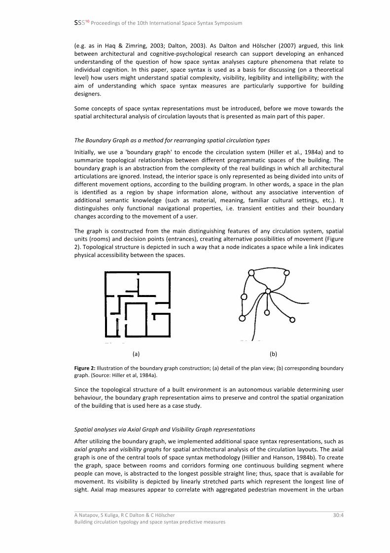
The Boundary Graph as a method for rearranging spatial circulation types
Initially, we use a 'boundary graph' to encode the circulation system (Hiller et al., 1984a) and to summarize topological relationships between different programmatic spaces of the building. The boundary graph is an abstraction from the complexity of the real buildings in which all architectural articulations are ignored. Instead, the interior space is only represented as being divided into units of different movement options, according to the building program. In other words, a space in the plan is identified as a region by shape information alone, without any associative intervention of additional semantic knowledge (such as material, meaning, familiar cultural settings, etc.). It distinguishes only functional navigational properties, i.e. transient entities and their boundary changes according to the movement of a user.
The graph is constructed from the main distinguishing features of any circulation system, spatial units (rooms) and decision points (entrances), creating alternative possibilities of movement (Figure 2). Topological structure is depicted in such a way that a node indicates a space while a link indicates physical accessibility between the spaces.
(a) (b)
Figure 2: Illustration of the boundary graph construction; (a) detail of the plan view; (b) corresponding boundary graph. (Source: Hiller et al, 1984a).
Since the topological structure of a built environment is an autonomous variable determining user behaviour, the boundary graph representation aims to preserve and control the spatial organization of the building that is used here as a case study.
Spatial analyses via Axial Graph and Visibility Graph representations
After utilizing the boundary graph, we implemented additional space syntax representations, such as axial graphs and visibility graphs for spatial architectural analysis of the circulation layouts. The axial graph is one of the central tools of space syntax methodology (Hillier and Hanson, 1984b). To create the graph, space between rooms and corridors forming one continuous building segment where people can move, is abstracted to the longest possible straight line; thus, space that is available for movement. Its visibility is depicted by linearly stretched parts which represent the longest line of sight. Axial map measures appear to correlate with aggregated pedestrian movement in the urban
SSS10 Proceedings of the 10th International Space Syntax Symposium
A Natapov, S Kuliga, R C Dalton & C Hölscher Building circulation typology and space syntax predictive measures
30:5
context (Read, 1999; Hiller et al., 1993; Peponis et al., 1989) and with route choices in the building context (Haq and Zimring, 2003; Peponis et al., 1990).
The visibility graph is defined as a set of points distributed in space, whereby the points serves as the nodes in the graph and indivisibility connections as the edges of the graph (Turner et al., 2001; Turner and Penn 1999). These syntactic methods have been used to study how the spatial structure of the building relates to patterns of spatial use (Turner et al., 2005; Peponis et al., 1998; Hillier and Hanson, 1984).
Intelligibility as concept for expected ease of wayfinding
The implementation of graph techniques to represent building layouts allows us to investigate their morphology by calculating graph measures. Building layouts can be compared by the property of intelligibility, established in space syntax theory. Intelligibility is a correlation between local and global spatial properties of the layout; it summarizes their relationships (Hillier and Hanson, 1984).
A local property of each element in the graph is represented by the connectivity measure. Connectivity captures the number of nodes that interconnect a given node, i.e. the number of direct visual connections, or how many destinations can be seen from each axial line within given geometrical conditions of the layout. The global measure is integration, which determines the relative importance of a space within the graph and captures how many steps are required to access every other node from a given node. Integration is defined by the average length of the shortest paths to the particular node from all the other nodes in the graph. For example, if one location is not be directly visible from another, but is visible via a third location, then we say that it is indirectly visible through an intermediate location. The more integrated lines with short distances to others contain bigger integration. While connectivity (a local property) shows how much one can directly see from one point location, integration (a global property) shows how much one can see both directly and indirectly from one point location.
Previous studies have indicated that intelligibility can be a fundamental feature in human navigation and wayfinding (e.g., Turner, 2007; Haq and Zimring, 2003; Hillier, 1996; Peponis et al., 1990). Highly intelligible environments are expected to facilitate navigation, because most paths lead to, or through, ‘central’ locations and local visual cues give an indication of global structure. Low intelligibility indicates that ‘central’ locations may lie on fewer, less connected paths. Thereby, there is, arguably, a mismatch between local cues and overall configurational structure, and this makes navigation difficult, because users have to find the limited number of correct paths while local inferences cannot be made. By analysing the intelligibility of various building circulation types we can link space syntax with cognitive science which claims that spatial configuration has an impact on some aspects of human activity in terms of spatial cognition and movement behaviour (Hölscher and Brösamle, 2007; Kim and Penn 2004; Hillier 1996).
We use this concept of intelligibility in order to compare the layouts' potential ease of wayfinding, which in our paper is meant to be an approximation of wayfinding complexity for the user based on spatial analyses. Further empirical behavioral testing is needed to verify this assumption; for this paper, however, we continue with theoretical assumptions as a path towards our future studies.
2. Methods
Case study
The Amsterdam Municipal Orphanage (Figure 3), designed by Aldo van Eyck in 1955-‐57 and built in 1958-‐60, is used as a case study for this work.
Strauven (2007) described the building as being composed of a regular grid-‐based geometry which results in a ‘readable’ layout pattern, no matter where one would be standing in the building. Her

SSS10 Proceedings of the 10th International Space Syntax Symposium
A Natapov, S Kuliga, R C Dalton & C Hölscher Building circulation typology and space syntax predictive measures
30:6
assumption of layout legibility appears similar to Montello’s (2007) arguments (that single, simple-‐shape patterns might be easier to comprehend). Although the modular, dome-‐like structures almost show a pattern language, the building layout may be challenging in terms of understanding how layout is composed: many of the clustered modules are viewable from the main hallway (through glazed walls), but cannot be accessed easily (often, only one corridor leads into such a clustered structure).
In the real, existing building, furniture, colours and landmarks most likely support layout comprehension and wayfinding. Yet in the virtually redesigned, unfurnished models2 we aim to use in future work, once a user enters such a cluster of rooms and turns a few times, orientation may be less intuitive. This decentralized separation of clustered structures arose from van Eyck’s building programming that aimed to address the needs of children of different ages who would be living in the orphanage (Kultermann, 1993, p. 138). Strauven (2007, p.8) noted that “these units also represent a striking example of Van Eyck’s view that architecture should, just like man, breathe in and out”. According to Balters (2011), Van Eyck aimed at breaking down the ‘hierarchy of spaces’ and for this purpose arranged clearly-‐defined spatial modules with in-‐between places at which user interaction could take place. The result is a "small world within a large one" (Kultermann, 1993), a polycentric “tiny city”, “with an articulation of large and small, inside and outside” (Ligtelijn, 1999, n.p.).
(a) (b)
Figure 3: Amsterdam Municipal Orphanage. Aldo van Eyck: (a) aerial view, (b) ground floor plan (Source: Ligtelijn, 1999).
The grid-‐structure of the orphanage arose late, in the final design stage, when the domes were implemented (Strauven, 2007). Van Eyck’s early sketches, however, showed several other circulation types: such as a spiraling, shell-‐like layout, an almost circular, zigzag formation, and an elimination of the circuit in one case (for images of these sketches, consult Strauven, 2007, p.10-‐13).
Readjusting the existing structure towards a spiralling, or possibly circular movement that appeared in early sketches of Van Eyck’s work is highly interesting from both a psychological (in terms of expected spatial complexity and wayfinding challenges) as well as from an architectural viewpoint (as the modular, in our view almost ‘lego-‐like’ structure of the building supported the process of keeping clusters intact, while substantially altering the general circulation type).
2 Scarce virtual environments without furniture, different colours schemes etc., as to measure the effect of layout geometry in isolation from such orientation aids.

SSS10 Proceedings of the 10th International Space Syntax Symposium
A Natapov, S Kuliga, R C Dalton & C Hölscher Building circulation typology and space syntax predictive measures
30:7
Encoding building circulation by topological boundary graph
Based on the original plan of the orphanage, we built a boundary graph by simplifying the building plan to main programmatic spaces (rooms). Then these programmatic spaces were identified and assigned ID-‐numbers. Figure 4 shows a non-‐georeferenced visualization of the constructed boundary graph, where the biggest node represents the main circulation space; the corridors and the smaller remaining nodes stand for the rest of the spaces. The graph is visualized in the network analysis package Gephi (Jacomy et al., 2009).
Figure 4: Non-‐coordinated graph of the original building. The biggest node represents the main circulation space, the corridors and the remaining smaller nodes stand for the rest of rooms.
Redesign process: circulation modification and resulting layouts
In this section we describe the process of the systematic transformation of the case study original layout. We developed three circular archetypes that are based on the topological structure of the existing building. The underlying topological structure supports the validity of comparing the archetypes: the three different layouts are topologically similar, but geometrically and visually distinct (Figure 5). In the next step, all the layouts are assessed with the spatial analysis according to different space syntax methods.
(a) (b) (c)
Figure 5: Circulation modifications: (a) concentric circulation; (b) radial circulation and (c) compound circulation.
The first layout forms a concentric type, where the underlying organizational principle is to create concentric circulation while keeping the existing order of the topological relations (Figure 5a). The central courtyard is not accessible and the corridors are organized in a loop around the focal courtyard. Additionally, all the connections within the clusters of the small units are arranged circularly as often as possible.

SSS10 Proceedings of the 10th International Space Syntax Symposium
A Natapov, S Kuliga, R C Dalton & C Hölscher Building circulation typology and space syntax predictive measures
30:8
The next layout is a radial circulation system. In the concentric circulation, a real building would have a strange “dysfunctional space” in the middle; therefore in this radial layout we have changed the proportions of the main lobby to transform it into a large, accessible courtyard around which all remaining units are organized (Figure 5b). This pattern is related to focal organization, wherein all other units are perceptually accessible, at least partially. The main courtyard operates as a strong organizing feature that could provide people with a sense of orientation, if they remember which door goes to which cluster (however, after some turning around, this might be difficult). Here, paths potentially lead via the central courtyard, which might give an indication of the building’s global structure (that is blocked in the concentric layout (a), and partially blocked in the compound layout (c) due to the closed walls of the inner room).
The last circular type is a compound layout obtained from the rearrangement of the first two types (Figure 5c). Here one would enter the building with a ramp and then go down towards the middle, where one would enter a room from which three doors depart to the round circulation hallway, around and along which all remaining rooms are organized.
3. Results: Spatial analysis of the comparability of the redesigns
In this section, we examine space syntax measures using DepthmapX (Turner, 2001; Varoudis, 2012) in order to highlight potential wayfinding differences in the developed circulation types.
Axial Map and Intelligibility measurement
Using the axial map technique, visibility of the lines of sight is depicted (Figures 6, 7 and 8 show axial maps of the three discussed layouts). The maps are generated manually: first, the longest visible line is drawn, followed by the second longest etc., until interconnected axial lines cover the entire space. Reduction is implemented until the axial map consists of the longest and yet the smallest number of axial lines.
(a) (b)
Figure 6: (a) Axial map of the concentric circulation system, coloured by connectivity (high by red and low by blue); (b) Axial map of the concentric circulation system, coloured by integration (high by red and low by blue).

SSS10 Proceedings of the 10th International Space Syntax Symposium
A Natapov, S Kuliga, R C Dalton & C Hölscher Building circulation typology and space syntax predictive measures
30:9
(a) (b)
Figure 7: (a) Axial map of the radial circulation system, coloured by connectivity (high by red and low by blue); (b) Axial map of the radial circulation system, coloured by Integration (high by red and low by blue).
(a) (b)
Figure 8: (a) Axial map of the compound circulation system, coloured by Connectivity (high by red and low by blue). (b) Axial map of the compound circulation system, coloured by Integration (high by red and low by blue). Green lines represent the ramp connections between the upper and the lower floors.
The connectivity graph is built from lines as nodes and their intersections as links in the graph. To analyse this graph, we use two well-‐established measures: connectivity and integration that can lead to insights into structural visibility properties of individual axial lines in the layout.

SSS10 Proceedings of the 10th International Space Syntax Symposium
A Natapov, S Kuliga, R C Dalton & C Hölscher Building circulation typology and space syntax predictive measures
30:10
Once the graph of the building morphology is created and measures of spatial characteristics are calculated, the graphs are summarized using the property of intelligibility. Figure 2 outlines a comparison of intelligibility between the developed circulation systems in order to indicate which spatial organisation would be the optimal for building navigation.
.58 .49 .56
(a) (b) (c)
Figure 9: Intelligibility measure of the axial representation: (a) concentric circulation; (b) radial circulation; (c) compound circulation.
Visibility graph analysis (VGA) and Intelligibility measurement
Our second analysis is based on the visibility graph in order to explore the general trends of similarities and differences among the layouts and to show if and how visibility properties such as connectivity and integration values can make distinctions for (expected) ease of wayfinding among buildings with different circulation types. Figures 9, 10 and 11 show the connectivity and integration measures of the four discussed layouts respectively.
(a) (b)
Figure 10: (a) VGA of the concentric circulation system, coloured by Connectivity (high red and low blue); (b) VGA of the concentric circulation system, coloured by Integration (high red and low blue).

SSS10 Proceedings of the 10th International Space Syntax Symposium
A Natapov, S Kuliga, R C Dalton & C Hölscher Building circulation typology and space syntax predictive measures
30:11
(a) (b)
Figure 11: (a) VGA for the radial circulation system, coloured by Connectivity (high red and low blue); (b) VGA for the radial circulation system, coloured by Integration (high red and low by blue).
(a) (b)
Figure 12: (a) VGA for the compound circulation system, coloured by Connectivity (high red and low blue); (b) VGA for the compound circulation system, coloured by Integration (high red and low blue). Green lines represent a ramp between the upper and the lower floors.
Figure 13 summarizes a comparison of intelligibility properties in the VGA of three circulation systems under examination; the values differ with the radial circulation being most intelligible, and the concentric and compound layout as most difficult.

SSS10 Proceedings of the 10th International Space Syntax Symposium
A Natapov, S Kuliga, R C Dalton & C Hölscher Building circulation typology and space syntax predictive measures
30:12
.32 .81 .36
(a) (b) (c)
Figure 13: Intelligibility measure of the visibility graph representation: (a) concentric circulation; (b) radial circulation; (c) compound circulation.
4. Discussion of the results
Table 1 summarizes the results of the intelligibility measurement across two different spatial representations and in respect to three different circulation systems. Our first observation is related to reliability and comparability of the results achieved through two different spatial representations, axial and visibility graphs. The concentric and compound layouts, when represented by axial lines and by visibility graph, show relatively similar intelligibility scores, with a maximum difference of .26 and .20, respectively. However, in the radial layout, the difference is maximal; namely .32. The lack of the correlation between two spatial representations raises an interesting question of representation reliability.
Table 1: Intelligibility measurements.
Concentric Radial Compound
VGA .32 .81 .36
Axial Map .58 .49 .56
The intelligibility values of axial and visibility graphs show controversial results: For instance, according to the VGA representation, the radial layout has the highest intelligibility (.81), i.e. it is the most coherent and the easiest of the layouts. Previous empirical studies in space syntax have established intelligibility threshold equal to .50 (Hillier and Hanson, 1984). The system is considered to be "intelligible" if the correlation value between connectivity and integration measures is greater than .50 and "unintelligible" if the value is lower. In our sample, the same radial layout is not intelligible when measured by the axial map since it has a value less than .50. We observe a similar inconsistency in the concentric and compound layouts; they have relatively high intelligibility scores when measured by axial lines (.58 and.56 accordingly), yet lower than the intelligibility threshold when measured by the visibility graph (.32 and.36). However, it is worth noting that intelligibility is subject to a size effect and therefore, it is extremely difficult to interpret intelligibility measures for systems with fewer than 50 spaces (our samples are above this threshold).
Our second observation is related to comparison between three types of the circulations: according to VGA, the highest intelligibility is demonstrated by the radial layout (.81). The concentric layout has the lowest intelligibility score (.32) and the compound layout has a score close to the concentric (.36). When represented by the axial lines, all three layouts have similar results, while the concentric and the compound are among the most intelligible (.58 and .56) and the radial is the lowest and almost unintelligible (with the score of .49).

SSS10 Proceedings of the 10th International Space Syntax Symposium
A Natapov, S Kuliga, R C Dalton & C Hölscher Building circulation typology and space syntax predictive measures
30:13
5. Conclusions
In this paper the redesign of the existing circulation layout and systematically redesigned archetypes are investigated via spatial analyses that provide an estimation of expected ease of wayfinding. Starting from a prominent architectural case, the Amsterdam Municipal Orphanage designed by Aldo van Eyck (1955-‐1960), we established a method for layout modification based on the preservation of topological connections between programmatic spaces, whilst completely transforming navigational space. As the result of our systematical redesign, three geometrically and visually distinct and topologically similar circular layouts with radial, concentric and compound circulation were created. Keeping the topological space structure of the building in a comparable manner provides a systematic method for demonstrating the validity of the comparison between the different layouts in terms of objective description and not just in terms of a mere subjective interpretation.
Following ideas posed by Dalton and Hölscher (2007), we attempted to address (expected) cognitive complexity of distinct circulation systems based on space syntax analysis, in order to reveal which type of circulation layout produces the most accessible and the most intelligible space.
Spatial representations predicting wayfinding
The decision of which representation (axial graph or VGA) to trust more in the given spatial problem depends on several factors: since the focus of our analysis is the understanding of expected complexity of wayfinding, we focus our analyses on the relation of each representation to expected ease of wayfinding. Jiang and Liu (2010) outlined that the axial map representation resembles a skeleton of a building layout, and Kim and Penn (2004) found that axial lines do in fact correspond with certain cognitive measures, such as sketch maps drawn by people. Furthermore, Dalton (2001; 2003) linked axial lines to cognitive functions by introducing angular analysis of axial maps and argued that people tend to use minimal angular deviations to navigate between locations. In addition, the axial representation is strongly associated with route choices by building visitors both in unguided exploration and in directed search tasks wayfinding behaviour (Haq and Zimring, 2003; Peponis et al., 1990); it may express the connective structure of spaces in a building.
However, the axial representation has a higher degree of space reduction in comparison to the visibility graph. The visibility graph analysis provides a more fine grained representation of architectural space, as it appears to represent the environment in more accurate way: it is more detailed than axial lines, as it describes visual information conveyed to observers from any location that is directly visible without obstruction. Turner (2003) argued that human movement (of someone with natural vision) is probably more related to the visibility graph and less to the axial line representation. Desyllas and Duxbury (2003) systematically compared both representations and found that pedestrian movement in an urban setting indeed corresponds well to VGA-‐visibility measures (probably due to larger visual reach), but less so with axial line representation.
In our sample, the intelligibility values of the three circulations gleaned by means of the VGA are different from those achieved by axial maps. We assume that visibility graph values correlate with behavioural traits on the building level, although this conclusion needs further investigation and evaluation by experiments that include actual wayfinding in the discussed layouts. The need for empirical evaluation appears urgent in respect to the controversial results of the radial layout and we are currently gathering behavioural data to address these questions.
Wayfinding in the systematically redesigned environments
The intelligibility comparison demonstrates a general hierarchy and could be theoretically related to the possible paths of navigation available in each building. We reviewed the process and progress of arriving at these circular layouts several times with several spatial cognition researchers and in the light of finding a circular representation that could potentially be used as a systematic design variation in Virtual Reality behavioural testing. The three layouts are syntactically similar in their axial map structure, but reveal differences in intelligibility, or expected ease of wayfinding.

SSS10 Proceedings of the 10th International Space Syntax Symposium
A Natapov, S Kuliga, R C Dalton & C Hölscher Building circulation typology and space syntax predictive measures
30:14
Additionally, we could intuitively formulate “hotspots” where spatial structure can pose wayfinding challenges in each layout: for instance, the radial layout suggests a clear reference pointing to the central court, while the rest of the directions could be explored from the centre and in respect to the centre. In the concentric layout, which has a lower intelligibility score in the VGA analysis, routes could be formed by following some structural order that minimizes the deviations. However, wayfinding could be difficult since the possible trajectories have to follow a closed curve with a constant rotation. In the compound layout, in the addition to the rotation, wayfinding may be impaired by the need to manoeuvre between the levels of the building. Making the theoretical assumptions presented in this paper more “tangible” requires further analysis; e.g. via a combination of sequential isovist analysis and wayfinding task analysis, to arrive at a more defined wayfinding decision model in these layouts.
Since the axial and visibility graph definitions are derived from purely spatial constraints, it would seem natural to suggest that the overriding factor in human movement is the physical constraints of the space. However, it is worth remembering that both spatial representations present a simplifying assumption that the origins and destinations in the path a person takes can be ignored, because there are so many potential origin-‐destination pairs in the building.
Actual real-‐world situations are dramatically different and the circulation patterns could be related to other real-‐world aspects: for example, people could follow other people; they could be attracted or distracted by perceptual stimuli (e.g., where retail is located: auditory and olfactory cues); they differ in their individual cognitive skills; real-‐world environments usually contain additional external information, such as signage; or they might be following architectural-‐programmatic requirements.
Thus, the results of this paper raise interesting questions for further research: How does layout configuration influence actual human behaviour; and is there a correlation between wayfinding performance and spatial representations, such as axial and visibility graphs? How can particular programmatic requirements relate to the architectural function of the building influence wayfinding in various circulation systems?
Limitations of this work
In their current form, our results are based on syntactic analysis and expert assessments of the layouts in relation to their potential wayfinding challenges. This means that behaviour validation of our assumptions is highly necessary to understand how building users will actually behave. We are currently conducting a virtual reality study that investigates user behaviour in these systematically generated layouts. However, as these models are currently designed to be minimalistic (devoid of landmarks, furniture etc.) and large-‐scale (meaning that locations cannot be view from a single vantage point), it may be difficult for users to remember locations and find their way towards them. We hope that future results from these studies can shed light on actual complexity and navigability in these building redesigns, which could then be linked to further spatial analyses, in order to validate the assumptions of “ease of wayfinding” that were presented in this article.
As adaptability and sustainability of buildings become more important, and buildings' circulation becomes increasingly complex, the question of what defines a building spatially, what unites or separates buildings within and across typologies comes at the right time. In its early days, space syntax’s methods contributed a theoretical concept for thinking about building spatial layout and connecting building morphology to building functionality. This preliminary study reflects theoretical rationale in the architectural-‐research field, such as the concept of planning the most visible path and an efficient circulation by expanding the link between human behaviour and spatial conditions. By adding experimental evidence in future studies, it will become applicable for several practical design purposes such as functional planning, checking egress regulations and working towards predicting wayfinding challenges.

SSS10 Proceedings of the 10th International Space Syntax Symposium
A Natapov, S Kuliga, R C Dalton & C Hölscher Building circulation typology and space syntax predictive measures
30:15
References
Arthur, P. and Passini, R. (1992), Wayfinding-‐People, Signs, and Architecture: McGraw-‐Hill, New York. Balters, S. (2011), ‘AD Classics: Amsterdam Orphanage / Aldo van Eyck, 26 Aug 2011’. Accessed online, on
January, 24, 2015, via ArchDaily, http://www.archdaily.com/?p=151566 Ching, F. D. K. (1996), Architecture Form Space and Order. (2nd edition): New York: Van Nostrand Reinhol. Clark, R. H. and Pause, M. (2005), Precedents in architecture: Hoboken, N.J: Wiley. Cousin, J. (1980a), L'espace vivant: Montreal: Les Presses de I'Universite de Montreal. Conroy Dalton, R. (2003), ‘The secret is to follow your nose: Route path selection an angularity’. In Environment
and Behavior, Vol. 35(1), p.107-‐131. Dalton, N. (2001), ‘Fractional configurational analysis and a solution to the Manhattan problem’. In Peponis, J.
Wineman, J. Bafna, S. (eds.), Proceedings of the 3rd International Symposium on Space Syntax, Atlanta: Georgia, Georgia Institute of Technology.
Dalton, R. and Hoelscher, C. (2007), ‘Understanding Space: the nascent synthesis of cognition and the syntax of spatial morphologies’. In: Space Syntax and Spatial Cognition -‐ Proceedings of the Workshop, 24 September -‐ 28 September 2006, Bremen.
Desyllas, J. and Duxbury, E. (2003), ‘Axial Maps and Visibility Graph Analysis pedestrian movement’. Symposium A Quarterly Journal In Modern Foreign Literatures.
Gärling, T. Lindberg, C. M. and Book, A. (1986), ‘Reference systems in cognitive maps’. In Journal of Environmental Psychology, Vol. 6, p. 1-‐18.
Gärling, T. Lindberg, E. and Mäntylä, T. (1983), ‘Orientation in Buildings: Effects of Familiarity, Visual Access, and Orientation Aids’. In Journal of Applied Psychology, Vol. 68 (1), p. 177-‐186.
Haq, S. and Zimring, C. (2003). ‘Just Down the Road a Piece: the Development of Topological Knowledge of Building Layouts’. In Environment and Behavior, Vol. 35(1), p.132-‐160.
Hillier, B. (1996). Space is the Machine, Cambridge University Press: Cambridge. Hillier, B., Hanson, B. and Peponis, J. (1984a). ‘What do we mean by building function?’, in Designing for
Building Utilisation, Ed. J Powell (Spon, London), 61-‐72. Hillier, B. and Hanson, J. (1984b), The Social Logic of Space, Cambridge University Press: Cambridge. Hillier, B., Penn, A., Hanson, J., Grajewski, T. and Xu, J.(1993), ‘Natural movement: or configuration and
attraction in urban pedestrian movement’. In Environment and Planning B: Planning and Design, Vol. 20 (29), p. 66-‐178.
Hölscher, C. and Brösamle, M. (2007), ‘Capturing indoor wayfinding strategies and differences in spatial knowledge with Space Syntax’. In Kubat, A.S., Ertekin, Ö., Güney, Y. I. and Eyübolou, E. (eds.), Proceedings, 6th International Space Syntax Symposium, İstanbul: ITU Faculty of Architecture.
Jacomy, M., Bastian, M. and Heymann, S. (2009). ‘Gephi: An Open Source Software for Exploring and Manipulating Networks’. In Proceedings of the Third International AAAI Conference on Weblogs and Social Media (ICWSM'09), in American Journal of Sociology, p. 361-‐362.
Jiang, B. and Liu, X. (2010), 'Automatic generation of the axial lines of urban environments to capture what we perceive'. In International Journal of Geographical Information Science. Vol. 24(4), p. 545 — 558.
Kim, Y. O. and Penn, A. (2004), ‘Linking the space syntax of cognitive maps to the spatial syntax of the environment’. In Environment and Behavior. Vol. 36(4), p. 483–504.
Koffka, K. (1935). Principles of gestalt psychology, New York: Harcourt Brace Javanovich. Köhler, W. (1929). Gestalt psychology, New York: Liveright. Krukar, J., and Conroy Dalton, R. (2012), Towards a Unified Model of Building Usability. In: 22nd International
Association People-‐Environment Studies (IAPS) Conference, Glasgow, UK. Kultermann, U. (1993), Architecture in the 20th Century. New York: Van Nostrand Reinhold, p. 138. Ligtelijn, V. (1999). Aldo van Eyck, works, Birkhäuse. Lynch, K. (1960). The image of the city, Cambridge, MA: MIT Press. Montello, D. (2007). ‘The contribution of space syntax to a comprehensive theory of environmental psychology’,
In: Koch, D., Marcus, L. and Steen, J. (eds.), Proceedings of the Seventh International Space Syntax Symposium, Stockholm: Royal Institute of Technology.
Neufert E. and Neufert, P. (2000), Architects' data, 3rd English Edition. Blackwell Sciences. O’Neill, M. J. (1991a), ‘Effects of signage and floor plan configuration on wayfinding accuracy’. In Environment
and Behavior. Vol. 23, p. 553-‐574. O’Neill, M. J. (1991b), ‘Evaluation of a conceptual model of architectural legibility’. In Environment and Behavior.
Vol. 23(3), p. 259–284. Passini, R. (1996). ‘Wayfinding design: logic, application and some thoughts on universality’, In Design Studies.
Vol. 17(3), p. 319-‐331. Peponis, J., Zimring C. and Choi, Y. K. (1990). ‘Finding the building in wayfinding’. In Environment and Behaviour.
Vol. 22, p. 555-‐590. Peponis, J., Winerman, J., Rashid, M., Bafna, S. and Hong Kim, S. (1998), ‘Describing plan configuration according
to the covisibility of surfaces’, In Environment and Planning B: Planning and Design. Vol. 25, p. 693–708.

SSS10 Proceedings of the 10th International Space Syntax Symposium
A Natapov, S Kuliga, R C Dalton & C Hölscher Building circulation typology and space syntax predictive measures
30:16
Peponis, J., Hadjinikolaov, E., Livieratos, C. and Fatouros, D.A. (1989), ‘The spatial core of urban culture’. In Ekistics. Vol. 56, p. 43-‐55.
Read, S. (1999), ‘Space syntax and the Dutch city’. In Environment and Planning B: Planning and Design, Vol. 26, p. 251-‐264.
Strauven, F. (2007), ‘Aldo van Eyck – Shaping the New Reality From the In-‐between to the Aesthetics of Number’. CCA study centre mellon lectures (May 24, 2007) Accessed online, on April 16 2015, via http://www.cca.qc.ca/system/items/1947/original/Mellon12-‐FS.pdf?1241161450
Turner, E. (2007), ‘Perception and Intelligibility in the context of spatial syntax and spatial cognition: reading an unfamiliar place out of cognitive maps’, In Kubat, A.S., Ertekin, Ö., Güney, Y. I. and Eyübolou, E. (eds.), Proceedings, 6th International Space Syntax Symposium, İstanbul: ITU Faculty of Architecture
Turner A., Penn A., and Hillier B. (2005), ‘An algorithmic definition of the axial map’, In Environment and Planning B: Planning and Design, Vol. 32, p. 425 – 444.
Turner, A. (2003), ‘Analysing the visual dynamics of spatial morphology’. In Environment and Planning B: Planning and Design, Vol. 30(5), p. 657–676.
Turner, A. (2001), ‘DepthMap: A Program to Perform Visibility Graph Analysis’. In: Peponis, J., Wineman, J. and Bafna, S. (eds.), Proceedings of the Third International Space Syntax Symposium, Atlanta, U.S.A: Georgia Institute of Technology.
Turner, A., and Penn, A. (1999). ‘Making isovists syntactic: isovist integration analysis’, In: Major, M. D. and Amorim, L. (eds.), Proceedings of the Second International Space Syntax Symposium, Brazilia: Universidade deBrasilia,
Van Eyck, A. (1960). Architect of: The Amsterdam Municipal Orphanage, which was used as a case-‐study in this work.
Varoudis T. (2012), 'depthmapX Multi-‐Platform Spatial Network Analysis Software’, Version 0.30 OpenSource, http://varoudis.github.io/depthmapX/
von Meiss, P. (1986), De la forme au lieu. Lausanne: Presses Ploytechniques Romandes. Weisman, J. (1981), ‘Evaluating Architectural Legibility: Way-‐finding in the Built Environment’, In Environment
and Behavior, Vol. 13, ( 2) p. 189-‐204. Zimring, C., and Craig, D.L. (2001), Chapter 7: Defining Design between Domains: An Argument for Design
Research a la Carte. In: Eastman, C., Newstetter, W., and McCracken, M. (Eds.), Design Knowing and Learning: Cognition in Design Education: Cognition in Design Education. Elsevier, p. 125-‐146.