spice commissioning protocol - world meteorological ... · site commissioning protocol pyramid...
TRANSCRIPT

NEPAL
WMO SPICE SITE COMMISSIONING PROTOCOL
PYRAMID LABORATORY
Site Manager: Elisa Vuillermoz [email protected] Assistant Intern: Antonella Senese [email protected] Ev-K2-CNR Via San Bernardino 145 - Bergamo (Italy)
SPICE Site Commissioning Protocol – PYRAMID (NEPAL)(December 2014) Page 1
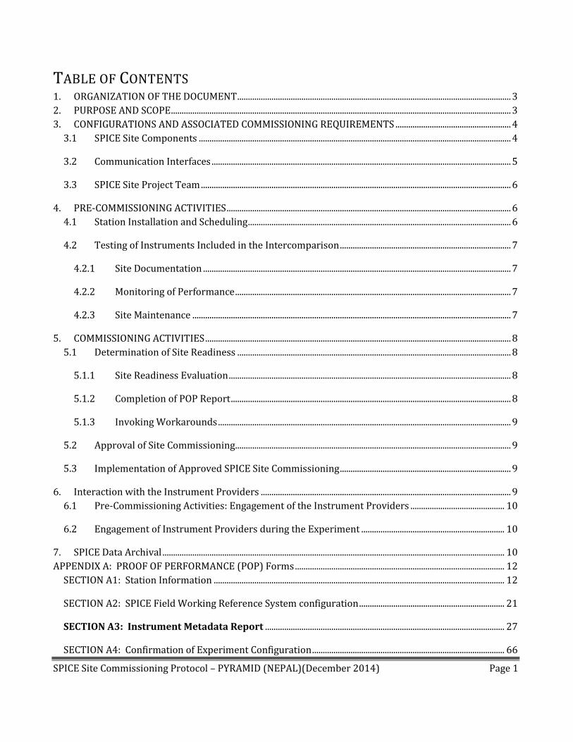
TABLE OF CONTENTS 1. ORGANIZATION OF THE DOCUMENT ................................................................................................................................ 3
2. PURPOSE AND SCOPE ............................................................................................................................................................... 3
3. CONFIGURATIONS AND ASSOCIATED COMMISSIONING REQUIREMENTS ...................................................... 4
3.1 SPICE Site Components .................................................................................................................................................. 4
3.2 Communication Interfaces ............................................................................................................................................ 5
3.3 SPICE Site Project Team ................................................................................................................................................. 6
4. PRE-COMMISSIONING ACTIVITIES ..................................................................................................................................... 6
4.1 Station Installation and Scheduling ........................................................................................................................... 6
4.2 Testing of Instruments Included in the Intercomparison ................................................................................ 7
4.2.1 Site Documentation ................................................................................................................................................ 7
4.2.2 Monitoring of Performance ................................................................................................................................. 7
4.2.3 Site Maintenance ..................................................................................................................................................... 7
5. COMMISSIONING ACTIVITIES ............................................................................................................................................... 8
5.1 Determination of Site Readiness ................................................................................................................................ 8
5.1.1 Site Readiness Evaluation .................................................................................................................................... 8
5.1.2 Completion of POP Report ................................................................................................................................... 8
5.1.3 Invoking Workarounds ......................................................................................................................................... 9
5.2 Approval of Site Commissioning ................................................................................................................................. 9
5.3 Implementation of Approved SPICE Site Commissioning ................................................................................ 9
6. Interaction with the Instrument Providers ..................................................................................................................... 9
6.1 Pre-Commissioning Activities: Engagement of the Instrument Providers ............................................ 10
6.2 Engagement of Instrument Providers during the Experiment ................................................................... 10
7. SPICE Data Archival ................................................................................................................................................................ 10
APPENDIX A: PROOF OF PERFORMANCE (POP) Forms .................................................................................................. 12
SECTION A1: Station Information ........................................................................................................................................ 12
SECTION A2: SPICE Field Working Reference System configuration .................................................................... 21
SECTION A3: Instrument Metadata Report ................................................................................................................ 27
SECTION A4: Confirmation of Experiment Configuration .......................................................................................... 66

SPICE Site Commissioning Protocol – PYRAMID (NEPAL)(December 2014) Page 2
TEST 1: Instrument Calibration and Checks ............................................................................................................... 66
TEST 2: Instrument Validation ......................................................................................................................................... 66
TEST 3: Site-to-archive Transfer Validation ................................................................................................................ 66
SECTION A5: Site Documentation Checklist ..................................................................................................................... 69
APPENDIX B: SPICE DATA LEVELS AND DATASETS ......................................................................................................... 70
APPENDIX C: ACRONYMS AND ABBREVIATIONS .............................................................................................................. 71
SPICE Site Commissioning Protocol – PYRAMID (NEPAL)(December 2014) Page 3
1. ORGANIZATION OF THE DOCUMENT
The Commissioning Protocol is organized into four parts:
1. The site components, data transfer and sharing pathways, and project organizational
structure are outlined in Section 3;
2. The site commissioning procedures, including pre-commissioning activities and the
Interaction with the Instrument Providers, Sections 4 to 6;
3. SPICE Data Archive, Section 7.
4. Appendix A: the template for the Proof of Performance (POP) Report, in which all site
configuration details and commissioning activities are documented.
Appendix B outlines the SPICE Data Levels and Data Sets, and Appendix C includes a list of acronyms used
throughout the document.
The first two sections are intended to provide background information on the commissioning process
within the scope of the SPICE project, while the Appendix A contains the forms which are required to be
filled out as part of the commissioning of the site. Once completed, these forms become the Commissioning
Report.
The SPICE data archive section outlines the requirements regarding the SPICE data levels and datasets and
the planned strategy for the archival of SPICE data to a central location(s).
2. PURPOSE AND SCOPE
This document is prepared by the WMO SPICE IOC. It outlines the procedures for post-installation testing
and commissioning of the sites participating in the WMO SPICE experiment and documents the
responsibilities for each aspect of the commissioning process.
Commissioning of a WMO SPICE site refers to the act of “turning it on” and marking the start of the
collection of the “official” observations and measurements from the instruments included in the
intercomparison (reference, instruments under test, ancillary measurements), and their archival on the
designated Site Data Archive.
For this purpose, each site will designate a location for the Site Data Archive, which must protect the
integrity of the intercomparison data.
End-to-end data quality and integrity for each instrument on each SPICE site will be verified before the
commissioning can take place. It is essential that:

SPICE Site Commissioning Protocol – PYRAMID (NEPAL)(December 2014) Page 4
Only agreed upon instruments are to be installed, in an accepted and standardized configuration;
Each component be properly tested, and its performance verified, prior to commissioning;
The transfer of instrument data to the Site Data Archive is validated and the archive secured.
Various individuals and organizations are referred to in this document as having responsibilities.
SPICE IOC
SPICE Project Team
SPICE Data Analysis Team
Site Manager
Site (SPICE) Project Team
ER refers to the Evaluation Representative, an individual named by the SPICE IOC
IR, the Installation Representative, is identified by the Site Manager, responsible for the site
configuration.
Instrument Providers
3. CONFIGURATIONS AND ASSOCIATED COMMISSIONING
REQUIREMENTS
3.1 SPICE SITE COMPONENTS
The SPICE Components include the following components:
Field working reference systems (R4):
- Snow on the ground data from manual density record (performed according to the AINEVA
protocol, see www.AINEVA.it).
Data output frequency to be transfer to NCAR: 1 measurement per snowfall event once a day
- Snow data on the ground from 4 graduated stakes (installed on 1st June 2014 near the
permanent automatic weather station). Graduated stake features cm graduations.
Data output frequency to be transfer to NCAR: 1 measurement every hour during a snow fall
event.
- Snow on the ground data from hourly camera observations of the graduated stake taken
both by an automatic camera and by local personnel. Photography and video equipment are
useful for recording and archival of site conditions.
Data output frequency to be transfer to NCAR: 1 picture every hour.
Instruments under test provided by the host:
- Snow on the ground data from 2 Sommer sonic ranger USH-8 sensors (one already present at
the AWS and one installed in May 2014)

SPICE Site Commissioning Protocol – PYRAMID (NEPAL)(December 2014) Page 5
Data output frequency to be transfer to NCAR: 1 value every minute.
Ancillary measurements(active since October 2000 and recorded by an automatic weather station
called AWS1 Pyramid, see http://www.evk2cnr.org/cms/en/share/monitoring-stations):
Precipitation occurrence /rain
Atmospheric pressure
Air Temperature
Relative humidity
Wind speed/direction at 5 m height;
Soil temperature (-5 cm and -20 cm)
Soil Moisture
Soil heat flux
Net radiation (SW and LW)
For the SPICE experiment at the Pyramid International Laboratory Observatory site the sample interval we
applied is 1 min for both the standard meteorological parameters and snow depth data. We applied such
interval since it seems adequate to the SPICE instrument we installed. The data loggers are two E-logs (Lsi-
Lastem).
A constant presence of local staff guarantees that in case the tele-transmission of the acquired data should
be interrupted for a few period, the local staff will provide to store all data without losses until the
maintenance activities will be performed.
3.2 COMMUNICATION INTERFACES
AWS1 Pyramid is connected with radio communication link. Data transfer is automatically done by radio
modem to AWS data receiving server. Data is then uploaded to Italian server via VSAT connection and
visualized on web site (limited graphic visualisation). Real time data are downloaded with 10 minutes
interval.
For the SPICE Experiment after downloading, data will be subjected to a quality check and validation and
will be firstly stored in the SHARE data base and then periodically (every four months) sent to SPICE data
base. Moreover is available a web cam showing general view toward valley which image are updated on
the server every 3 minutes.
During the snowfall, local technicians would regularly check (every hour) the snow level signed on the
graduated rod and at the same time they will take a picture.
Data coming from the manual observations will be sent to Italy office and then sent periodically (every
month) to SPICE data base.

SPICE Site Commissioning Protocol – PYRAMID (NEPAL)(December 2014) Page 6
3.3 SPICE SITE PROJECT TEAM
- Elisa Vuillermoz is the AWS at the Pyramid International Laboratory Observatory site manager. She’s
coordinator of scientific activities promoted by Ev-K2-CNR Association (Bergamo, Italy) in particular she
is responsible of the SHARE – Stations at High Altitude for Research on the Environments- project. PhD in
Earth Sciences at University of Milan.
- Antonella Senese, post doc scientist, takes care AWS data processing, quality check and validation
according to the SHARE protocol
.-Daniele Bocchiola, Assistant professor of Mountain Hydrology at Department of Civil and Environmental
Engineering (DICA) at Politecnico di Milano, is responsible of the set up of a hydrological modelling
framework for Koshi Basin (Kumbu Valley, Nepal).
-Giacomo Agrillo, fellowship at Institute of Atmospheric Sciences and Climate (ISAC) of the Italian National
Research Council(CNR). He is in charge for the execution of QC/QA for the AWS data as well as data
processing and analysis in the framework of the SHARE and NextData Projects.
- Gian Pietro Verza and Marcello Alborghetti, both technicians at Ev-K2-CNR Committee, are responsible of
the periodic quality check and maintenance activities of SHARE AWS network, including the AWS installed
at Pyramid. They are also responsible of data transmission in real time from AWS to Pyramid server.
- 9 Local technicians (Laxman Adhikari, Kaji Bista, Pema Sherpa, Tenzing Chhottar Sherpa, Lhakpa Tshering
Sherpa, Lakpa Tenzi Sherpa, Sarki Dorjee Tamang, Tshering Dorjee Sherpa, Sonam Tharkey), are responsible
of manual observations and work in synergy with the Ev-K2-CNR technician to guarantee the right working
of the stations.
4. PRE-COMMISSIONING ACTIVITIES
The pre-commissioning activities are an integral part of the process of ensuring the quality of the
experiment. The following sections detail the pre-commissioning activities ensuring that site infrastructure
and procedures are properly managed and documented.
4.1 STATION INSTALLATION AND SCHEDULING
The AWS Pyramid is already installed and has been running since October 2000, even if different
experimental set-up were adopted throughout the years.
Snow data have measured since 2002 by a ultrasonic snow depth ranger Sommer USH-8. For SPICE
experiment this sensor will continue to work and it will be put beside by a graduated rod to measure the
snow level.
The 4 graduated rods were installed near the permanent AWS in June 2014.
In the same period, an additional new ultrasonic snow depth ranger Sommer USH-8 was installed in May
2014 in order to compare the results of the sensors.

SPICE Site Commissioning Protocol – PYRAMID (NEPAL)(December 2014) Page 7
4.2 TESTING OF INSTRUMENTS INCLUDED IN THE INTERCOMPARISON
The testing of instruments is conducted by the SPICE Site Project Team. Based on the results, the Site
Manager will determine the readiness of instruments and the site for the formal phase of the experiment.
4.2.1 SITE DOCUMENTATION
Technical documentation for each SPICE component will include, but not limited to, the site layout,
instruments details and configuration, data collection (including the data format), number of similar
instruments, installation details, maintenance standards.
Specific information on the Site Documentation is provided in Appendix A.
4.2.2 MONITORING OF PERFORMANCE
The Site Manager established a simple procedure for monitoring the performance of the instruments:
- every day AWS data will be visually inspected by using an NRT data delivery/plotting system
- every day is scheduled a AWS data check after the daily downloading.
- every 3 minutes the web cam image is updated.
During the snowfall, local technician every hour will sign the snow level read on the graduated rod and will
take a picture. In this case, every day, data coming from manual observations will be sent to researchers
and compared with the snow level sensor data.
In the case the remote downloading would be impossible data from the AWS will be manually downloaded
once a day by local technicians, and transferred to the research groups.
In the case data quality checking would reveal errors or problems, local technician will perform a technical
intervention with the remote assistance of the research groups.
A monthly report of ordinary check and special technical intervention will be produced and stored in the
SPICE data base.
4.2.3 SITE MAINTENANCE
The SPICE Site Manager and technicians ensure regular check of data and guarantee the timely intervention
in case of sensor malfunctioning in order to limit the periods of data outage.

SPICE Site Commissioning Protocol – PYRAMID (NEPAL)(December 2014) Page 8
5. COMMISSIONING ACTIVITIES
The SPICE POP Report documents the status of the site operation at the start of the intercomparison.
5.1 DETERMINATION OF SITE READINESS
This sub-section details the activities to be conducted following the installation of instruments, and which
are completed prior to the official start of the SPICE experiment on the site.
5.1.1 SITE READINESS EVALUATION
The Site Manager will initiate the evaluation of the SPICE Site and will provide to the IOC adequate notice
of the SPICE site commissioning.
The IOC will name a representative (the ER) to conduct the evaluation of the Site Documentation prepared
by the Site Manager. The ER will work with the Site Manager on the evaluation of the POP Report.
The site readiness evaluation should be sufficient to ensure proper operation of all instruments and
interfaces. The assessments will include:
Satisfactory performance of the field reference system(s).
Satisfactory performance of each instrument under test.
Satisfactory performance of instruments providing ancillary measurements.
Satisfactory performance of site communication components and interfaces.
Satisfactory performance of the data transmission to the Site Data Archive;
Proper functioning of service backup capabilities for that particular site, if available.
Maintenance capacity.
5.1.2 COMPLETION OF POP REPORT
The SPICE Site POP Report documents the readiness of the site and is approved by the IOC.
The POP Report includes:
A form for recording station information and configuration, including the site layout;
A form for documenting the configuration of SPICE field working reference configurations,
including both manual and automatic measurements;
SPICE Site Commissioning Protocol – PYRAMID (NEPAL)(December 2014) Page 9
Forms for recording the specifications of instruments under test and instruments used to provide
ancillary measurements ;
Details of tests conducted for instrument data validation;
Details of tests conducted for end-to-end data validation;
A checklist for all additional documentation to be recorded and submitted ;
A table for recording commissioning milestones.
The Site Manager will provide the POP Report to the IOC, for final review.
5.1.3 INVOKING WORKAROUNDS
A workaround is a temporary solution to a system limitation that requires special attention and will be
removed eventually. Any workarounds will be documented and included as part of the POP Report. Each
work-around will be tracked as an open item until resolved.
5.2 APPROVAL OF SITE COMMISSIONING
The Site Manager will notify and update the IOC on the organization and completion of the tests outlined
in Appendix A. Once all tests results are verified, the IOC and the Site Manager will agree on the start date
of the formal experiment on the site.
In case some of the instruments under test are not ready for the start of the experiment as planned
(currently Nov. 15, 2012), the experiment could commence in steps, provided that all field references and
key ancillary parameters (wind speed and direction, temperature) have been commissioned.
Commissioning of additional instruments would follow as their configurations are finalized; this will allow
for their inclusion in the experiment as early as feasible, with no compromise to the data quality. The Data
Analysis Team will take into consideration the commissioning data for each instrument.
5.3 IMPLEMENTATION OF APPROVED SPICE SITE COMMISSIONING
Upon commissioning, the site will commence the official collection of the SPICE project dataset and
ancillary measurements/observations.
6. INTERACTION WITH THE INSTRUMENT PROVIDERS
Instrument Providers are responsible for the delivery of their instruments to the SPICE Sites and for
supporting the Site Managers in verifying their proper functioning before and during SPICE.
SPICE Site Commissioning Protocol – PYRAMID (NEPAL)(December 2014) Page 10
6.1 PRE-COMMISSIONING ACTIVITIES: ENGAGEMENT OF THE INSTRUMENT PROVIDERS
During the installation, the Site Manager or a representative will engage the Instrument Provider regarding
the preparation of their instruments, to ensure the operation within recommended standards.
The Site Manager would confirm with the Instrument Provider the functioning of the instrument prior to
the commissioning of the site. This could be done by the sharing of instrument and/or ancillary data and
pictures, coordinated site visits, or any other method agreed upon by the two parties.
The Site Manager should be able to indicate in the Commissioning Report the confirmation from the
Instrument Provider that the instrument operates as expected.
6.2 ENGAGEMENT OF INSTRUMENT PROVIDERS DURING THE EXPERIMENT
During the experiment, each Instrument Provider will be given access to the unprocessed output from its
own instrument(s), and a minimum set of corresponding ancillary data consisting of air temperature,
relative humidity, and wind speed. These data are provided only for ensuring the proper functioning of the
instruments, and will neither be reported nor published prior to publication of the SPICE Final Report.
The Site Manager will coordinate the data transfer to the Instrument Provider(s), including such aspects as
the frequency, methodology, etc. It is desired that this data transfer is in place prior to the start of the
experiment. The Instrument Provider is expected to alert the Site Manager in the event that a malfunction
of an instrument is noted, and provide support to the Site Project team (including site visits), if needed, to
address the failure.
The Instrument Providers could visit the intercomparison sites, after prior arrangements are made with
the Site Manager.
7. SPICE DATA ARCHIVAL
The SPICE Project Team will establish and maintain a SPICE Archive on at least one SPICE designated Server
where the Site Intercomparison Datasets and the Input Documentation will be stored. This will facilitate
the preparation of data for the individual and comparative data analysis and the preparation of the Final
Report. A description of the data levels and datasets for SPICE, as currently defined, is provided in Appendix
B.

SPICE Site Commissioning Protocol – PYRAMID (NEPAL)(December 2014) Page 11
The National Centre for Atmospheric Research (NCAR), USA, will host the SPICE Archive and provide quick
view capabilities of (near) real time data. Options for a second SPICE Archive are being explored by
Environment Canada, Canada.
Each Site Manager will work towards preparing the transfer of Level 1 and Level 2a datasets to the SPICE
Archive(s). The IOC will provide to the Site Managers the requirements regarding the data transfer
to enable the preparation of datasets (format change, setup of data uploads/availability, etc…)
The data transfer between the Site Data Archive and the SPICE Archive is expected to be established and
validated within 3 months of the official start of the experiment, and implemented based on site specific
conditions and limitations.

SPICE Site Commissioning Protocol – PYRAMID (NEPAL)(December 2014) Page 12
APPENDIX A: PROOF OF PERFORMANCE (POP) FORMS
SECTION A1: STATION INFORMATION
Station name AWS1 Pyramid
Reference town Lobuche/SoluKhumbu/ Nepal
Station latitude 27°57’32.17”N;
Station longitude 86°48’47.23”E
Station elevation in metres 5050 m a.s.l.
FIGURE 1: Location (red point) of the AWS1 Pyramid.
The AWS1 Pyramid (Figs. from 1 to 8) was installed on September 2000 and data of standard
meteorological parameters are available from October 1, 2000. Later, in 2004 the station has been
equipped with additional sensors including the ultrasonic snow level measurement. From the installation
time, the AWS1 Pyramid was regularly checked both from local technicians and from Italian technicians in
order to guarantee the regular operation.
The AWS is currently equipped with two loggers, both E-log (LSI-Lastem). In the following the
configuration currently in use is described.

SPICE Site Commissioning Protocol – PYRAMID (NEPAL)(December 2014) Page 13
The E-log1, installed on a pole of 5 m height records the following parameters: air temperature and relative
humidity, atmospheric pressure, wind speed and direction, total precipitation and global solar radiation.
The E-Log2, installed on a pole of 2 m height, records the following parameters: four components of the
radiation budget (longwave in and out, shortwave in and out), soil temperature ( at -5 and -20 cm), soil
moisture and heat flux (at -5 cm) and snow level.
Power is supplied by two solar panels (40 Watt) and a lead gel battery; the battery voltage over time is
recorded by the data-logger. The battery-only power supply in the present configuration is estimated in
excess of 2 months, with the solar panels permanently obscured by snow accumulation and accounting for
low temperature operation and self-discharge. Data points, sampled at 60-second intervals and averaged
by data-loggers over a 60-minute time period for most of the sensors (see the fourth column in Table 1),
are recorded in the flash memory card, including the basic distribution parameters (minimum, mean,
maximum, and standard deviation values). Wind data are sampled every 5 seconds, and then processed to
obtain an hourly data set of information, including minimum, maximum and average speed, and dominant
wind direction. The AWS is online through reliable UHF radiomodem link. The radio we use are synthesized
radio modem devices, handling point to point serial communication, working in UHF band (380 - 470 MHz)
in half-duplex manner; the transfer speed ranges from 300 to 38.400 bit/sec and the modulation in air is
equal to 19.200 bps (25 kHz channel) or 9.600 bps. The number of covered channels corresponds to a total
band of 2 MHz at ±1 MHz from the chosen frequency.

SPICE Site Commissioning Protocol – PYRAMID (NEPAL)(December 2014) Page 14
FIGURE 2: AWS Pyramid.
SPICE Site Commissioning Protocol – PYRAMID (NEPAL)(December 2014) Page 15
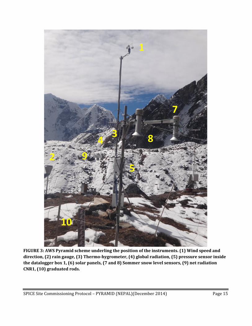
FIGURE 3: AWS Pyramid scheme underling the position of the instruments. (1) Wind speed and
direction, (2) rain gauge, (3) Thermo-hygrometer, (4) global radiation, (5) pressure sensor inside
the datalogger box 1, (6) solar panels, (7 and 8) Sommer snow level sensors, (9) net radiation
CNR1, (10) graduated rods.
SPICE Site Commissioning Protocol – PYRAMID (NEPAL)(December 2014) Page 16
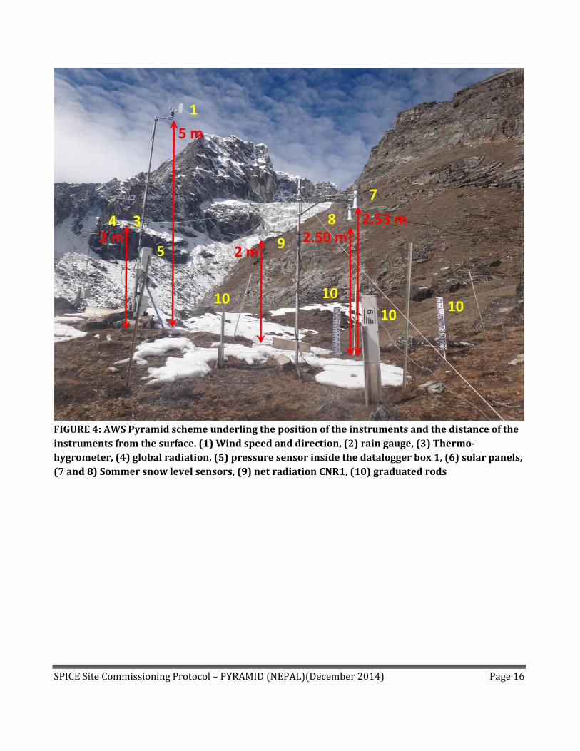
FIGURE 4: AWS Pyramid scheme underling the position of the instruments and the distance of the
instruments from the surface. (1) Wind speed and direction, (2) rain gauge, (3) Thermo-
hygrometer, (4) global radiation, (5) pressure sensor inside the datalogger box 1, (6) solar panels,
(7 and 8) Sommer snow level sensors, (9) net radiation CNR1, (10) graduated rods
SPICE Site Commissioning Protocol – PYRAMID (NEPAL)(December 2014) Page 17
1 2
3 4
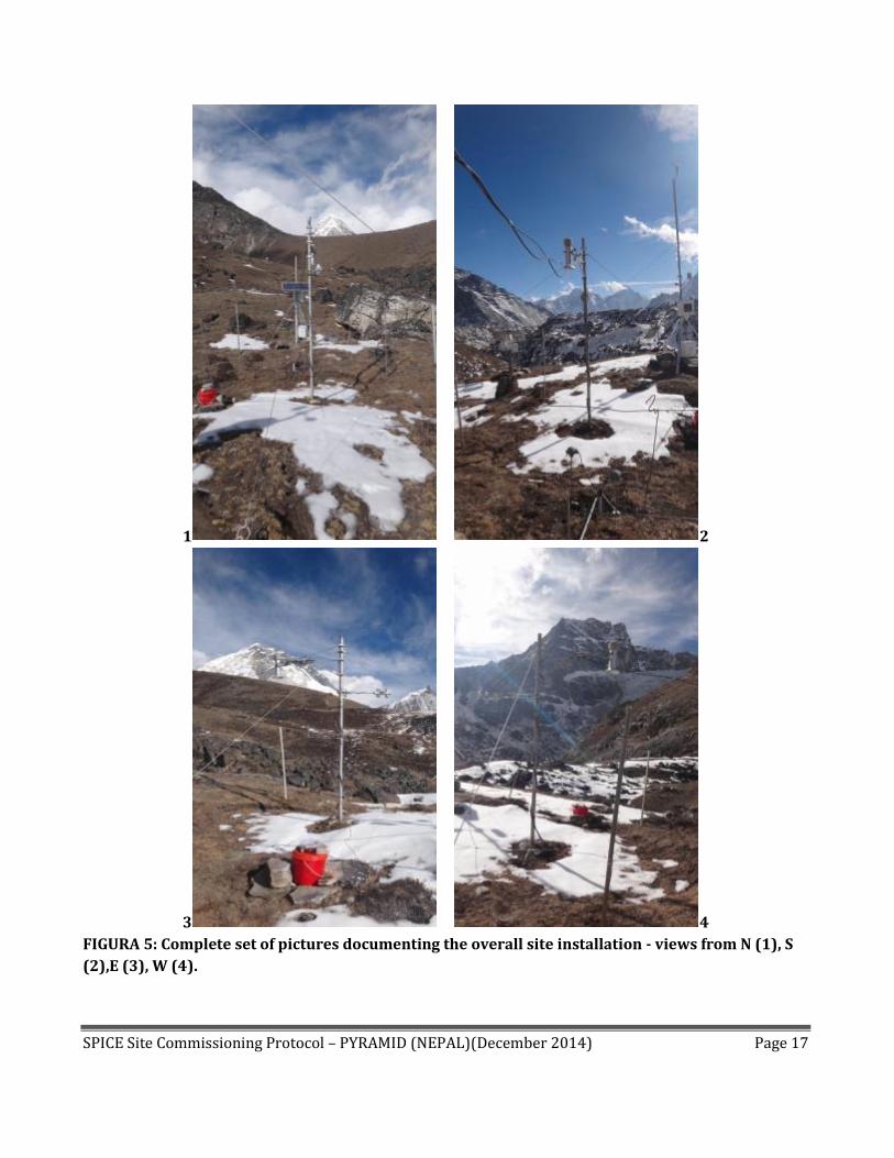
FIGURA 5: Complete set of pictures documenting the overall site installation - views from N (1), S
(2),E (3), W (4).
SPICE Site Commissioning Protocol – PYRAMID (NEPAL)(December 2014) Page 18
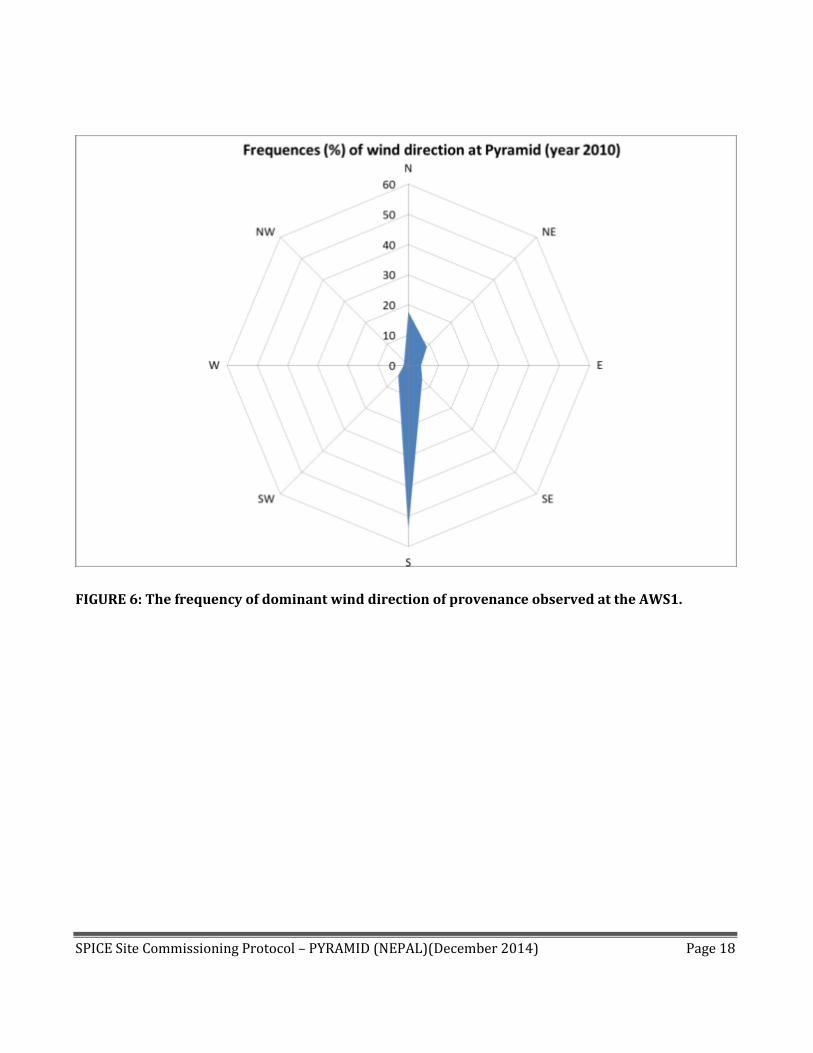
FIGURE 6: The frequency of dominant wind direction of provenance observed at the AWS1.

SPICE Site Commissioning Protocol – PYRAMID (NEPAL)(December 2014) Page 19
FIGURE 7: Sky view of AWS1 Pyramid instruments installed on the pole with E-Log1 logger. The
instrument are marked with numbers:(1) wind speed and direction, (2) rain gauge, (3) thermo-
hygrometer, (4) global radiation, (5) pressure sensor inside the datalogger box , (6) solar panels.

SPICE Site Commissioning Protocol – PYRAMID (NEPAL)(December 2014) Page 20
FIGURE 8: Sky view of AWS1 Pyramid instruments installed on the pole with E-log2 logger. (7) snow
level, (8) net radiometer CNR1, (9) Datalogger E-log

SPICE Site Commissioning Protocol – PYRAMID (NEPAL)(December 2014) Page 21
SECTION A2: SPICE FIELD WORKING REFERENCE SYSTEM CONFIGURATION
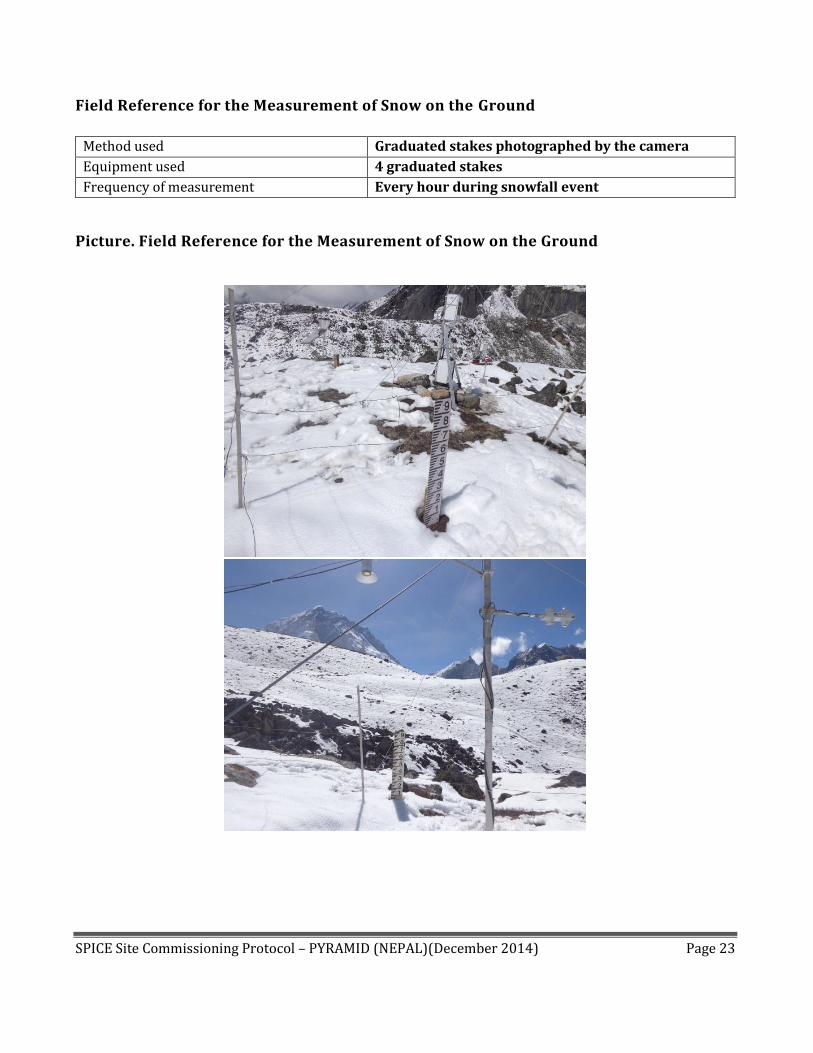
Field Reference for the Measurement of Snow on the Ground
Method used Snow density
Equipment used Following AINEVA protocol
Frequency of measurement Every snowfall event
Picture. Field Reference for the Measurement of Snow on the Ground
FIGURE 9: Detailed pictures of a field snow density survey close the AWS1 Pyramid. The thickness
(hsnow) and the snow density (snow) are measured for estimating the snow water equivalent of each
layer:
𝑆𝑊𝐸 = ℎ𝑠𝑛𝑜𝑤 ∙𝜌𝑠𝑛𝑜𝑤𝜌𝑤𝑎𝑡𝑒𝑟
Table. Field Calibration for the Measurement of Snow on the Ground
Not Available

SPICE Site Commissioning Protocol – PYRAMID (NEPAL)(December 2014) Page 22
48h Observation Table. Field Reference for the Measurement of Snow on the Ground
Snow on the ground data collected by a snow pit close the AWS1 Forni carried out on 1st June 2014:
Sample N° Date Time
HN (cm)
Check SWEN ?
SWEN (g) HS1 (cm)
HS2 (cm)
HS3 (cm) HS4 (cm)
Temp (°C)
1 06/01/2014 08:00 13 yes 170 16(north) 10(east) 14(west) 13(south) 0.3
2 06/01/2014 09:00 13 yes 150 14(north) 9(east) 13(west) 13(south) 0.56
3 06/01/2014 10:00 15 yes 120 14(north) 9(east) 13(west) 12(south) 0.4
4 06/01/2014 11:00 12 yes 155 163(north) 8(east) 12(west) 12(south) 0.4
5 06/01/2014 12:00 12 yes 160 13(north) 8(east) 11(west) 11(south) 0.5
6 06/01/2014 13:00 13 yes 155 12(north) 7(east) 11(west) 10(south) 0.2
7 06/01/2014 14:00 12 yes 130 11(north) 7(east) 10(west) 10(south) 0.2
SPICE Site Commissioning Protocol – PYRAMID (NEPAL)(December 2014) Page 23
Field Reference for the Measurement of Snow on the Ground
Method used Graduated stakes photographed by the camera
Equipment used 4 graduated stakes
Frequency of measurement Every hour during snowfall event
Picture. Field Reference for the Measurement of Snow on the Ground
SPICE Site Commissioning Protocol – PYRAMID (NEPAL)(December 2014) Page 24
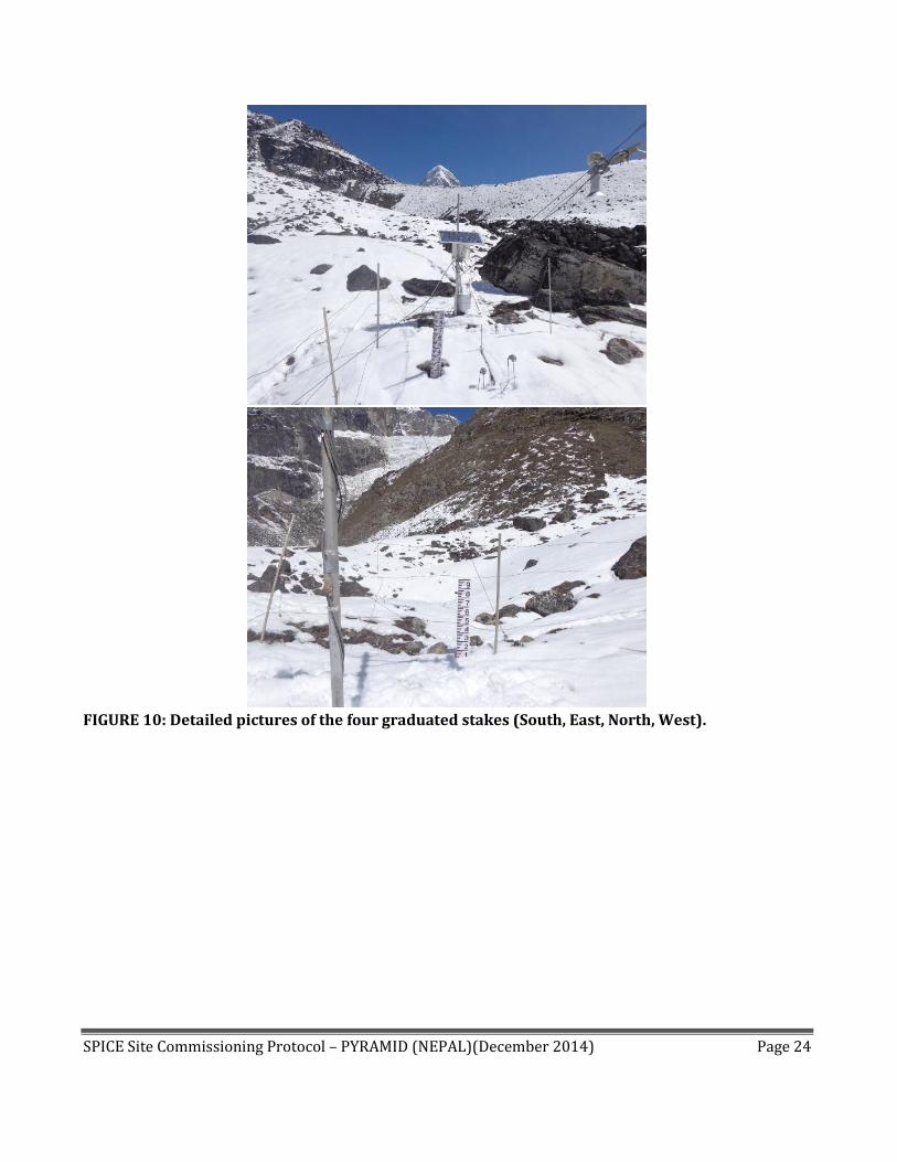
FIGURE 10: Detailed pictures of the four graduated stakes (South, East, North, West).

SPICE Site Commissioning Protocol – PYRAMID (NEPAL)(December 2014) Page 25
FIGURE 11: Detailed picture hourly taken by the local staff (on the left) and by the automatic camera
(on the right).
Table. Field Calibration for the Measurement of Snow on the Ground
Not Available
48h Observation Table. Field Reference for the Measurement of Snow on the Ground
Snow on the ground data collected from 4 graduated stakes close the AWS carried out on 19th October 2014:
TIME Graduated rod 1
(East) Graduated rod 2
(West) Graduated rod 3
(North) Graduated rod
4 (South)
Additional information
(if any)
07:00
Snow Level (cm) 2cm Picture n° 1
Snow Level (cm) 12cm Picture n° 2
Snow Level (cm) 10cm Picture n° 3
Snow Level (cm) 8cm Picture n° 4
08:00
Snow Level (cm) 2cm Picture n° 1
Snow Level (cm) 12cm Picture n° 2
Snow Level (cm) 10cm Picture n° 3
Snow Level (cm) 8cm Picture n° 4
09:00 Snow Level (cm) 2cm
Snow Level (cm) 8cm
Snow Level (cm) 10cm
Snow Level (cm) 8cm

SPICE Site Commissioning Protocol – PYRAMID (NEPAL)(December 2014) Page 26
Picture n° 1
Picture n° 2
Picture n° 3
Picture n° 4
10:00
Snow Level (cm)2cm Picture n° 1
Snow Level (cm)8cm Picture n° 2
Snow Level (cm) 10cm Picture n° 3
Snow Level (cm) 8cm Picture n° 4
11:00
Snow Level (cm) 1cm Picture n° 1
Snow Level (cm)8cm Picture n° 2
Snow Level (cm) 8cm Picture n° 3
Snow Level (cm) 8cm Picture n° 4
12:00Pm
Snow Level (cm) :- 1cm Picture n° :-1
Snow Level (cm) 7cm Picture n° :- 02
Snow Level (cm) 8cm Picture n° 3
Snow Level (cm) :- 8cm Picture n° :- 4
13:00
Snow Level (cm):- NO snow around Picture n° :- 1
Snow Level (cm) 4cm Picture n°:-2
Snow Level (cm) ):- No snow around Picture n° :- 3
Snow Level (cm) 8cm Picture n° :- 4
14:00
Snow Level (cm) :- No snow around Picture n° :- 1
Snow Level (cm) No snow around Picture n°:- 2
Snow Level (cm) :- No snow around Picture n° :-3
Snow Level (cm) 8cm Picture n° :- 4
15:00
Snow Level (cm) :- NO snow around Picture n°:- 1
Snow Level (cm) NO snow around Picture n°:-2
Snow Level (cm) :- NO snow around Picture n° :- 3
Snow Level (cm) 8cm Picture n° :- 4
16:00
Snow Level (cm) No snow around Picture n° :- 1
Snow Level (cm) No snow around Picture n° :- 2
Snow Level (cm) :- No snow around Picture n° :- 3
Snow Level (cm) 8cm Picture n° -4
17:00
Snow Level (cm) :- No snow around Picture n°:-1
Snow Level (cm) NO snow around Picture n° :- 2
Snow Level (cm) :- No snow around Picture n° :- 3
Snow Level (cm) 7cm Picture n°:- 4
SPICE Site Commissioning Protocol – PYRAMID (NEPAL)(December 2014) Page 27
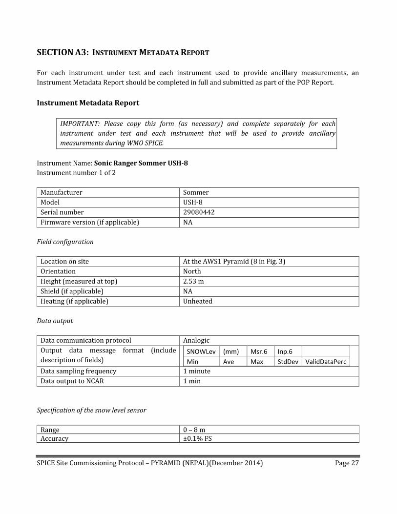
SECTION A3: INSTRUMENT METADATA REPORT
For each instrument under test and each instrument used to provide ancillary measurements, an
Instrument Metadata Report should be completed in full and submitted as part of the POP Report.
Instrument Metadata Report
IMPORTANT: Please copy this form (as necessary) and complete separately for each
instrument under test and each instrument that will be used to provide ancillary
measurements during WMO SPICE.
Instrument Name: Sonic Ranger Sommer USH-8
Instrument number 1 of 2
Manufacturer Sommer
Model USH-8
Serial number 29080442
Firmware version (if applicable) NA
Field configuration
Location on site At the AWS1 Pyramid (8 in Fig. 3)
Orientation North
Height (measured at top) 2.53 m
Shield (if applicable) NA
Heating (if applicable) Unheated
Data output
Data communication protocol Analogic
Output data message format (include
description of fields) SNOWLev (mm) Msr.6 Inp.6
Min Ave Max StdDev ValidDataPerc
Data sampling frequency 1 minute
Data output to NCAR 1 min
Specification of the snow level sensor
Range 0 – 8 m Accuracy ±0.1% FS

SPICE Site Commissioning Protocol – PYRAMID (NEPAL)(December 2014) Page 28
Instrument Picture.
FIGURE 12: Detailed picture of the Sommer sonic ranger 1 (in the yellow circle).

SPICE Site Commissioning Protocol – PYRAMID (NEPAL)(December 2014) Page 29
Field calibration (if any).
Date -18/11/2014
1st Test 104cm
Time Sommer
10:13 106.4
10:14 106.4
10:15 106.4
10:16 106.4
10:17 106.4
2nd Test 123cm
Time Sommer
10:26 126.1
10:27 126.2
10:28 126.2
10:29 126.1
10:30 126.2
10:31 126.3
3rd Test 7cm
Time Sommer
11:15 8.2
11:16 8
11:17 8
11:18 8.1
11:19 8.1
11:20 8.1

SPICE Site Commissioning Protocol – PYRAMID (NEPAL)(December 2014) Page 30
48h Plot.
FIGURE 13: Plot showing a test with 48h of Sommer 1 readings recorded from 16th to 17th November
2014.

SPICE Site Commissioning Protocol – PYRAMID (NEPAL)(December 2014) Page 31
Instrument Name: Sonic Ranger Sommer USH-8
Instrument number 2 of 2
Manufacturer Sommer
Model USH-8
Serial number 37120859
Firmware version (if applicable) NA
Field configuration
Location on site At the AWS1 Pyramid (7 in Fig. 3)
Orientation North
Height (measured at top) 2.50 m
Shield (if applicable) NA
Heating (if applicable) Unheated
Data output
Data communication protocol Analogic
Output data message format (include
description of fields) SNOWLev2 (m) Msr.8 Inp.6
Min Ave Max StdDev ValidDataPerc
Data sampling frequency 1 minutes
Data output to NCAR 1 min
Specification of the snow level sensor
Range 0 – 8 m Accuracy ±0.1% FS

SPICE Site Commissioning Protocol – PYRAMID (NEPAL)(December 2014) Page 32
Instrument Picture.
FIGURE 14: Detailed picture of the Sommer sonic ranger 2 (in the yellow circle).

SPICE Site Commissioning Protocol – PYRAMID (NEPAL)(December 2014) Page 33
Field calibration (if any).
Date -18/11/2014
1st Test 104cm
Time Sommer
10:11 101.7
10:12 101.7
10:13 101.7
10:14 101.7
10:15 101.7
10:16 101.7
10:17 101.7
2nd Test 123cm
Time Sommer
10:27 121.3
10:28 121.3
10:29 121.2
10:30 121.2
10:31 121.2
3rd Test 7cm
Time Sommer
11:16 4.4
11:17 4.4
11:18 4.4
11:19 4.3
11:20 4.2

SPICE Site Commissioning Protocol – PYRAMID (NEPAL)(December 2014) Page 34
48h Plot.
FIGURE 15: Plot showing a test with 48h of snow depth recorded by the Sommer 2 from 16th to 17th
November 2014.
SPICE Site Commissioning Protocol – PYRAMID (NEPAL)(December 2014) Page 35
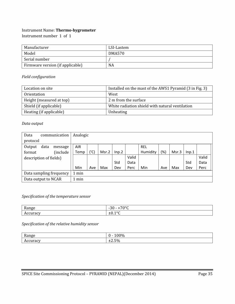
Instrument Name: Thermo-hygrometer
Instrument number 1 of 1
Manufacturer LSI-Lastem
Model DMA570
Serial number /
Firmware version (if applicable) NA
Field configuration
Location on site Installed on the mast of the AWS1 Pyramid (3 in Fig. 3)
Orientation West
Height (measured at top) 2 m from the surface
Shield (if applicable) White radiation shield with natural ventilation
Heating (if applicable) Unheating
Data output
Data communication
protocol
Analogic
Output data message
format (include
description of fields)
AIR Temp ('C) Msr.2 Inp.2
REL Humidity (%) Msr.3 Inp.1
Min Ave Max Std Dev
Valid Data Perc Min Ave Max
Std Dev
Valid Data Perc
Data sampling frequency 1 min
Data output to NCAR 1 min
Specification of the temperature sensor
Range -30 - +70°C Accuracy ±0.1°C
Specification of the relative humidity sensor
Range 0 - 100% Accuracy ±2.5%

SPICE Site Commissioning Protocol – PYRAMID (NEPAL)(December 2014) Page 36
Instrument Picture.
FIGURE 16: Detailed picture of the thermo-hygrometer.
Field calibration (if any).
The calibration was performed by the manufacturer.
SPICE Site Commissioning Protocol – PYRAMID (NEPAL)(December 2014) Page 37
48h Plot.
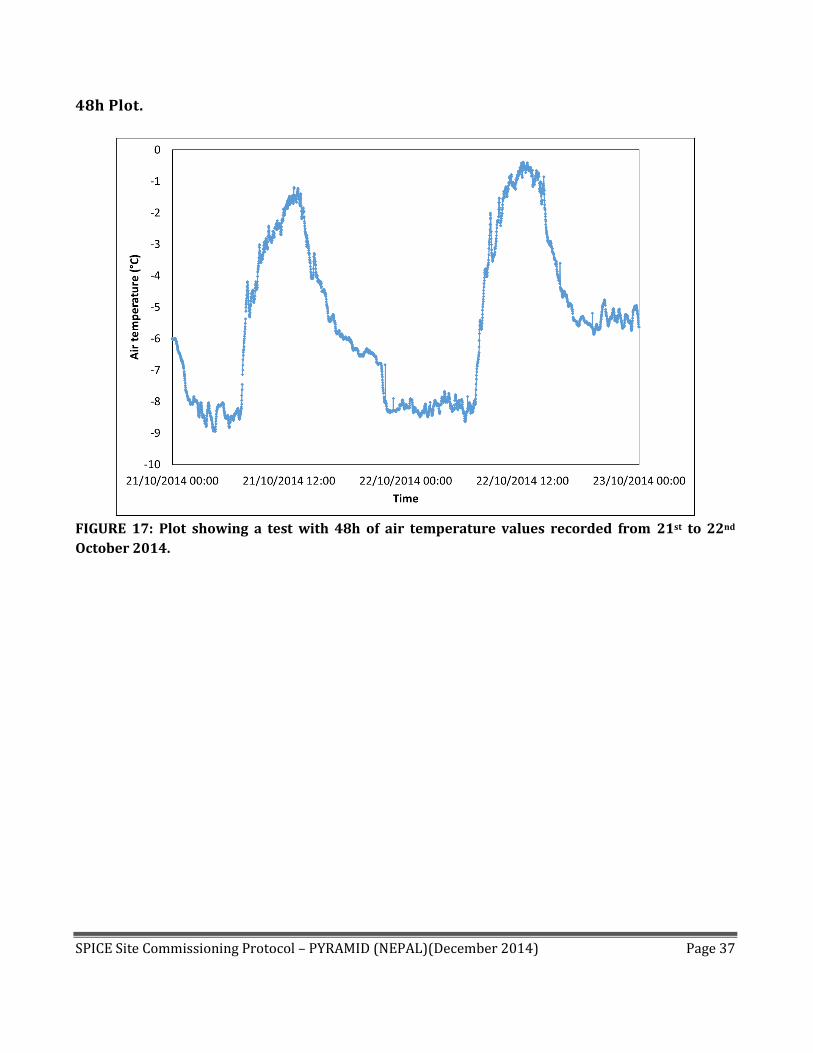
FIGURE 17: Plot showing a test with 48h of air temperature values recorded from 21st to 22nd
October 2014.

SPICE Site Commissioning Protocol – PYRAMID (NEPAL)(December 2014) Page 38
FIGURE 18: Plot showing a test with 48h of relative humidity values recorded from 21st to 22nd
October 2014.
SPICE Site Commissioning Protocol – PYRAMID (NEPAL)(December 2014) Page 39
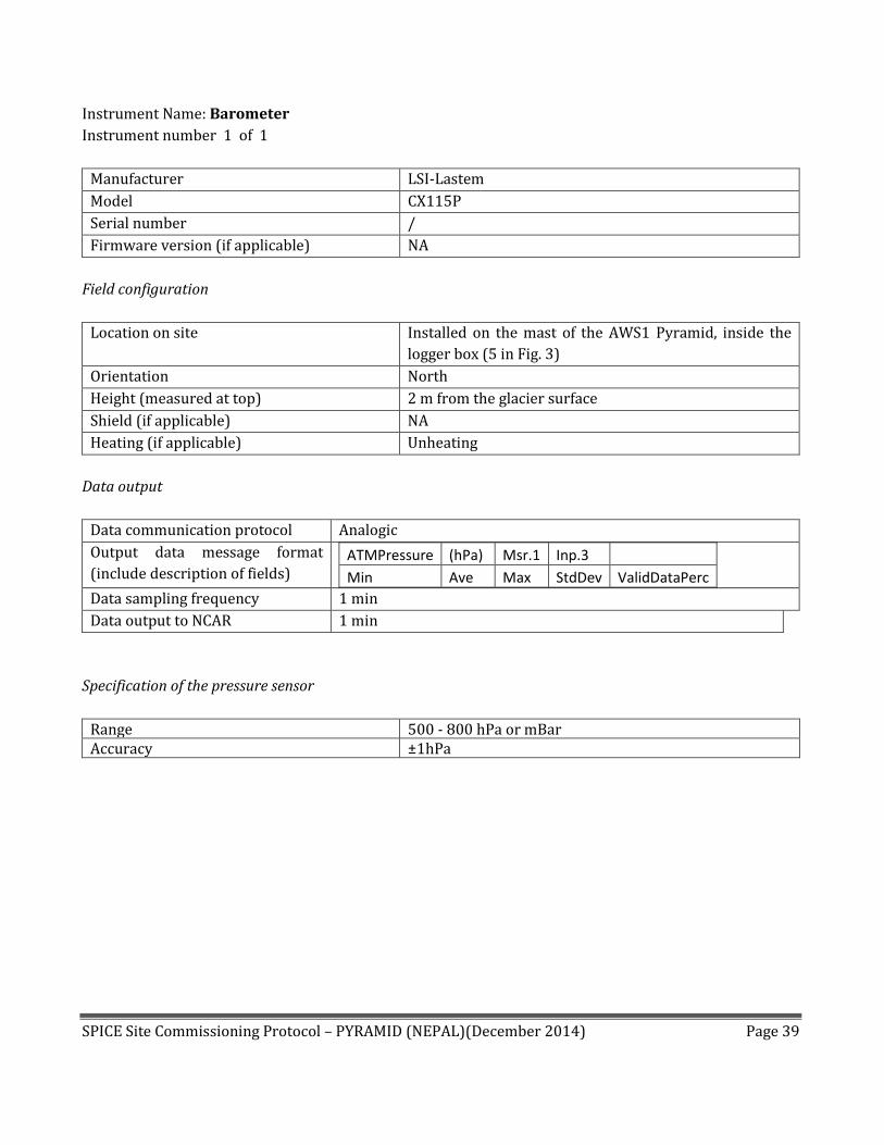
Instrument Name: Barometer
Instrument number 1 of 1
Manufacturer LSI-Lastem
Model CX115P
Serial number /
Firmware version (if applicable) NA
Field configuration
Location on site Installed on the mast of the AWS1 Pyramid, inside the
logger box (5 in Fig. 3)
Orientation North
Height (measured at top) 2 m from the glacier surface
Shield (if applicable) NA
Heating (if applicable) Unheating
Data output
Data communication protocol Analogic
Output data message format
(include description of fields) ATMPressure (hPa) Msr.1 Inp.3
Min Ave Max StdDev ValidDataPerc
Data sampling frequency 1 min
Data output to NCAR 1 min
Specification of the pressure sensor
Range 500 - 800 hPa or mBar Accuracy ±1hPa
SPICE Site Commissioning Protocol – PYRAMID (NEPAL)(December 2014) Page 40
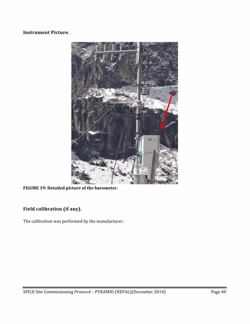
Instrument Picture.
FIGURE 19: Detailed picture of the barometer.
Field calibration (if any).
The calibration was performed by the manufacturer.
SPICE Site Commissioning Protocol – PYRAMID (NEPAL)(December 2014) Page 41
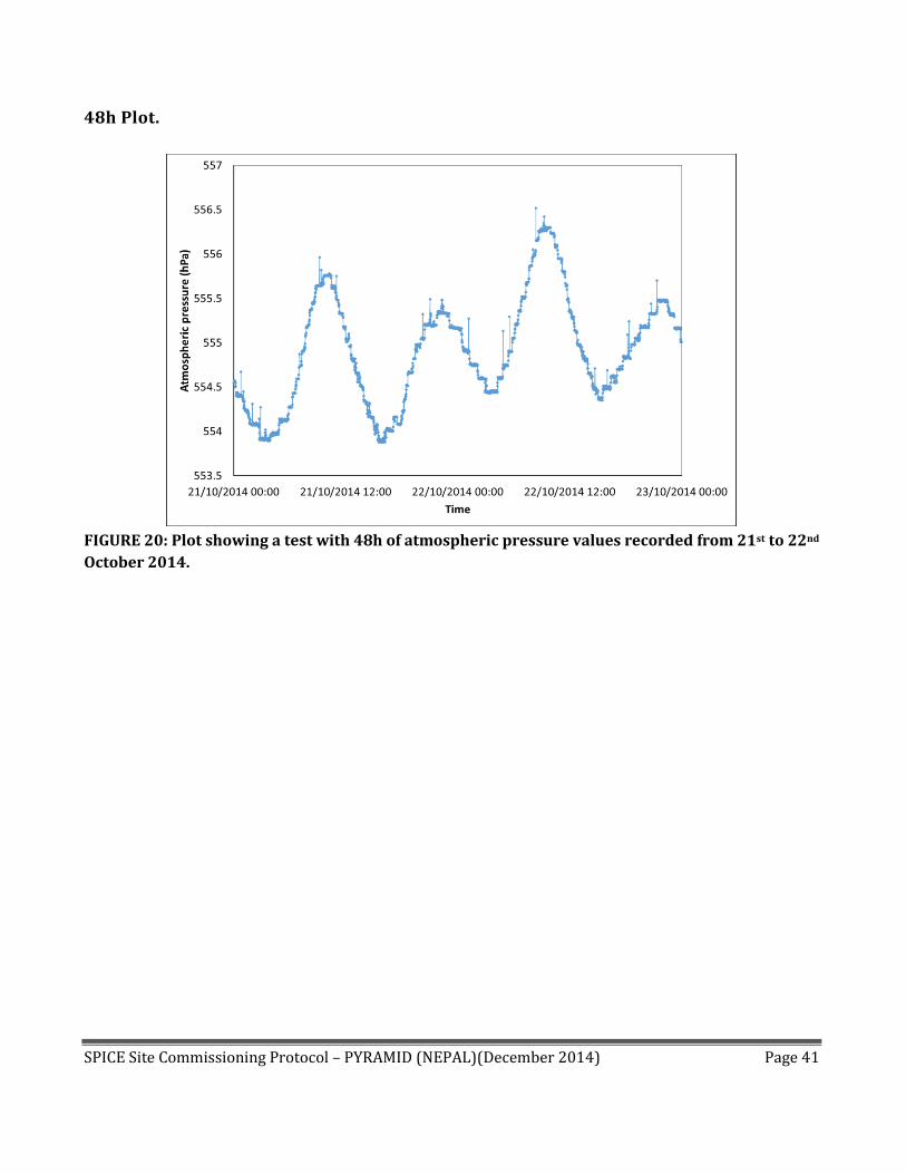
48h Plot.
FIGURE 20: Plot showing a test with 48h of atmospheric pressure values recorded from 21st to 22nd
October 2014.

SPICE Site Commissioning Protocol – PYRAMID (NEPAL)(December 2014) Page 42
Instrument Name: Soil heat flux
Instrument number 1 of 1
Manufacturer LSI-Lastem
Model DPE260
Serial number /
Firmware version (if applicable) NA
Field configuration
Location on site At the AWS1 Pyramid
Orientation /
Height /
Shield (if applicable) NA
Heating (if applicable) Unheating
Data output
Data communication protocol Analogic
Output data message format (include description
of fields) ThermFlux (W/m2) Msr.9 Inp.7
Inst Ave StdDev ValidDataPerc
Data sampling frequency 1 min
Data output to NCAR 1 min
Specification of the pressure sensor
Range <2000 W/m2 Accuracy ±3%

SPICE Site Commissioning Protocol – PYRAMID (NEPAL)(December 2014) Page 43
Instrument Picture.
FIGURE 21: Detailed picture of the soil heat flux sensors.
Field calibration (if any).
The calibration was performed by the manufacturer.

SPICE Site Commissioning Protocol – PYRAMID (NEPAL)(December 2014) Page 44
48h Plot.
FIGURE 22: Plot showing a test with 48h of soil heat flux values recorded from 21st to 22nd October
2014.

SPICE Site Commissioning Protocol – PYRAMID (NEPAL)(December 2014) Page 45
Instrument Name: Soil moisture
Instrument number 1 of 1
Manufacturer LSI-Lastem
Model /
Serial number /
Firmware version (if applicable) NA
Field configuration
Location on site At the AWS1 Pyramid
Orientation /
Height /
Shield (if applicable) NA
Heating (if applicable) Unheating
Data output
Data communication protocol Analogic
Output data message format
(include description of fields) Permettivit ('C) Msr.7 Inp.7
Inst Ave StdDev ValidDataPerc
Data sampling frequency 1 min
Data output to NCAR 1 min
SPICE Site Commissioning Protocol – PYRAMID (NEPAL)(December 2014) Page 46
Instrument Picture.
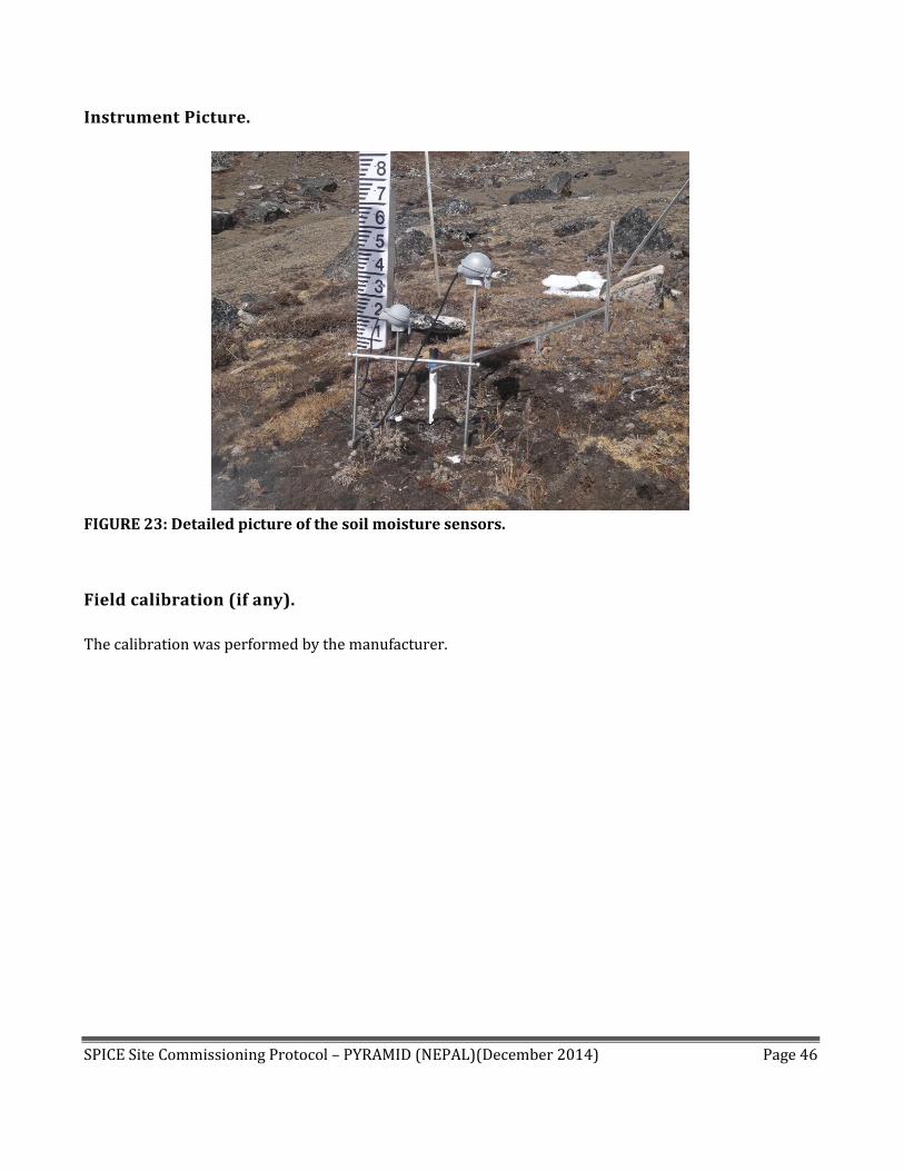
FIGURE 23: Detailed picture of the soil moisture sensors.
Field calibration (if any).
The calibration was performed by the manufacturer.

SPICE Site Commissioning Protocol – PYRAMID (NEPAL)(December 2014) Page 47
48h Plot.
FIGURE 24: Plot showing a test with 48h of soil moisture values recorded from 21st to 22nd October
2014.

SPICE Site Commissioning Protocol – PYRAMID (NEPAL)(December 2014) Page 48
Instrument Name: Soil temperature
Instrument number 1 of 1
Manufacturer LSI-Lastem
Model /
Serial number /
Firmware version (if applicable) NA
Field configuration
Location on site At the AWS1 Pyramid
Orientation /
Height -5 and -20 cm into the soil
Shield (if applicable) NA
Heating (if applicable) Unheating
Data output
Data communication protocol Analogic
Output data message format
(include description of fields)
Upper SOIL ('C)
Msr.9
Inp.7
Lower SOIL ('C)
Msr.10 Inp.8
Min Ave Max
Std Dev
Valid Data Perc Min
Ave Max
Std Dev
Valid Data Perc
Data sampling frequency 1 min
Data output to NCAR 1 min

SPICE Site Commissioning Protocol – PYRAMID (NEPAL)(December 2014) Page 49
Instrument Picture.
FIGURE 25: Detailed picture of the soil temperature sensors.
Field calibration (if any).
The calibration was performed by the manufacturer.

SPICE Site Commissioning Protocol – PYRAMID (NEPAL)(December 2014) Page 50
48h Plot.
FIGURE 26: Plot showing a test with 48h of upper (-5 cm) soil temperature values recorded from
21st to 22nd October 2014.

SPICE Site Commissioning Protocol – PYRAMID (NEPAL)(December 2014) Page 51
FIGURE 27: Plot showing a test with 48h of lower (-20 cm) soil temperature values recorded from
21st to 22nd October 2014.

SPICE Site Commissioning Protocol – PYRAMID (NEPAL)(December 2014) Page 52
Instrument Name: Global Solar Radiation
Instrument number 1 of 1
Manufacturer Kipp and Zonen
Model CM6B
Serial number 004569
Firmware version (if applicable) NA
Field configuration
Location on site Installed on the mast of the AWS1 Pyramid (4 in Fig. 3)
Orientation South
Height (measured at top) 2 m from the surface
Shield (if applicable) NA
Heating (if applicable) Unheating
Data output
Data communication protocol Analogic
Output data message format (include
description of fields) GLOBALRad (W/m2) Msr.7 Inp.5
Min Ave Max StdDev ValidDataPerc
Data sampling frequency 1 min
Data output to NCAR 1 min
Specification of the solar radiation sensor
Range 0-2000 W/m2 Accuracy /
SPICE Site Commissioning Protocol – PYRAMID (NEPAL)(December 2014) Page 53
Instrument Picture.
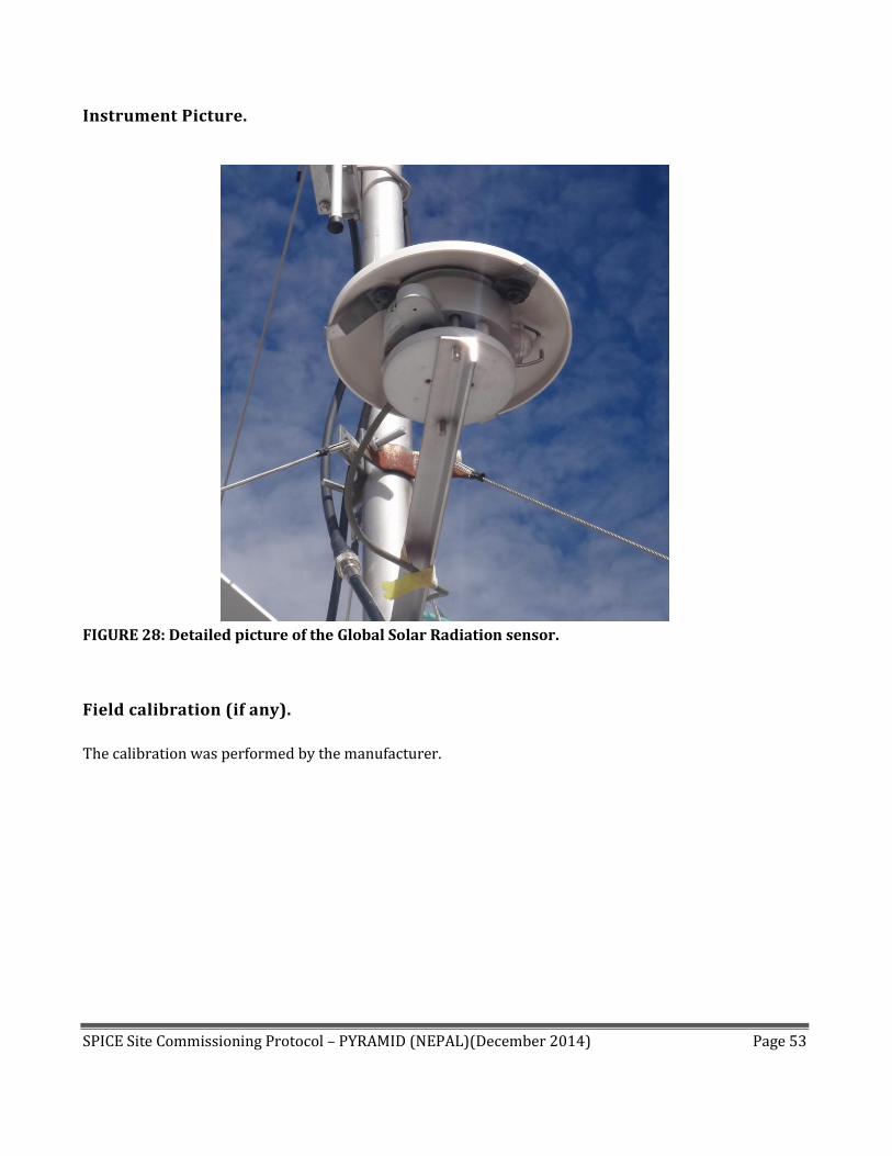
FIGURE 28: Detailed picture of the Global Solar Radiation sensor.
Field calibration (if any).
The calibration was performed by the manufacturer.

SPICE Site Commissioning Protocol – PYRAMID (NEPAL)(December 2014) Page 54
48h Plot.
FIGURE 29: Plot showing a test with 48h of global solar radiation values recorded from 21st to 22nd
October 2014.

SPICE Site Commissioning Protocol – PYRAMID (NEPAL)(December 2014) Page 55
Instrument Name: Net Radiometer
Instrument number 1 of 1
Manufacturer Kipp and Zonen
Model CNR1
Serial number 020435
Firmware version (if applicable) NA
Field configuration
Location on site Installed on the mast of the AWS2 Pyramid (9 in Fig. 3)
Orientation South
Height (measured at top) 2 m from the surface
Shield (if applicable) NA
Heating (if applicable) Unheating
Data output
Data communication protocol Analogic
Output data message format (include description of fields)
SW IN (W/m^2) Msr.1 Inp.1
SW OUT (W/m^2) Msr.2 Inp.3
LW IN (W/m^2) Msr.3 Inp.2
LW OUT (W/m^2) Msr.4 Inp.4
TEMPCNR1 ('C) Msr.5 Inp.5
Inst
Min
Ave
Max
StdDev
ValidDataPerc
Inst
Min
Ave
Max
StdDev
ValidDataPerc
Inst
Min
Ave
corretta
Max
StdDev
ValidDataPerc
Inst
Min
Ave
corretta
Max
StdDev
ValidDataPerc
Min
Ave
Max
StdDev
ValidDataPerc
Data sampling frequency 1 min
Data output to NCAR 1 min
Specification of the solar radiation sensor
Range 0-25 mV Accuracy ±10% on daily totals
Specification of the infrared radiation sensor
Range ±5 mV Accuracy non linearity: < 1%

SPICE Site Commissioning Protocol – PYRAMID (NEPAL)(December 2014) Page 56
Instrument Picture.
FIGURE 30: Detailed picture of the net radiometer.
Field calibration (if any).
The calibration was performed by the manufacturer.

SPICE Site Commissioning Protocol – PYRAMID (NEPAL)(December 2014) Page 57
48h Plot.
FIGURE 31: Plot showing a test with 48h of incoming solar radiation values recorded on 21st and
22nd October 2014.
SPICE Site Commissioning Protocol – PYRAMID (NEPAL)(December 2014) Page 58
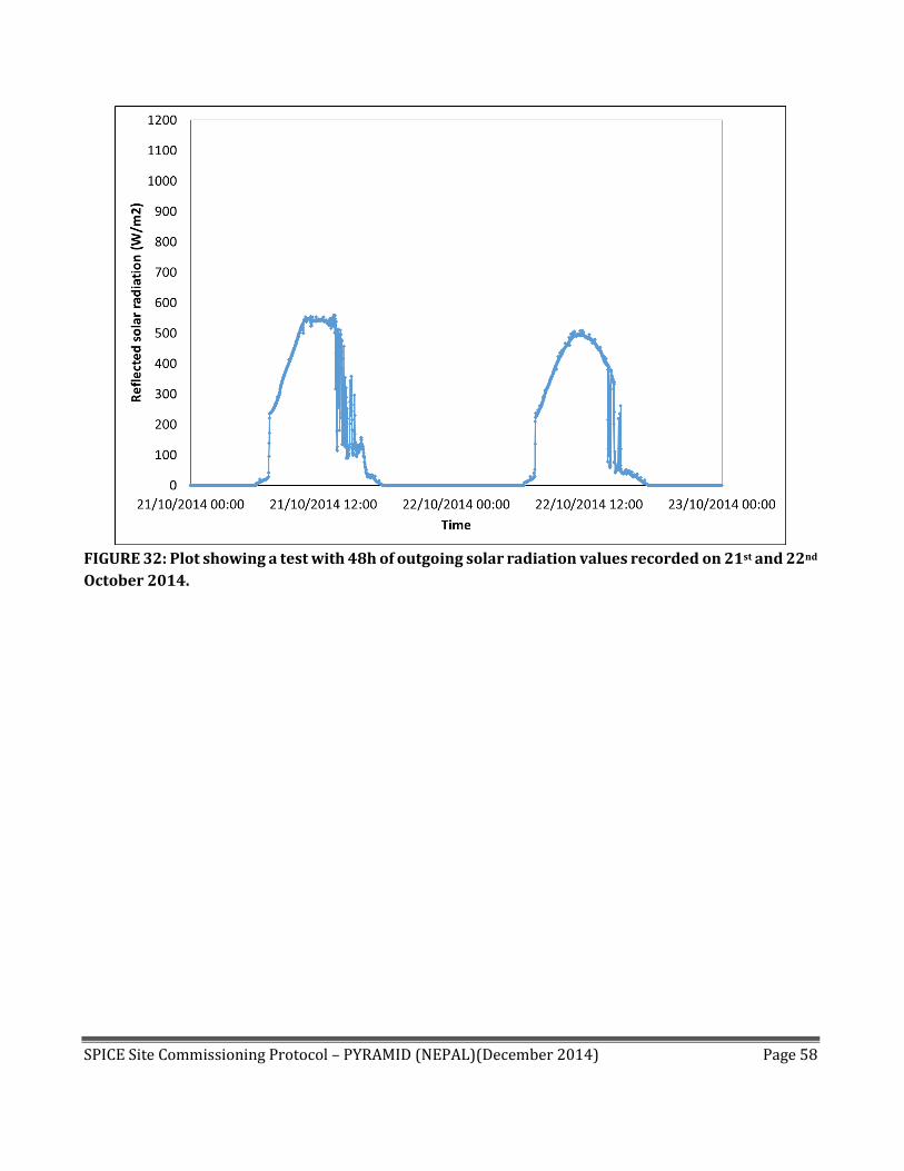
FIGURE 32: Plot showing a test with 48h of outgoing solar radiation values recorded on 21st and 22nd
October 2014.

SPICE Site Commissioning Protocol – PYRAMID (NEPAL)(December 2014) Page 59
FIGURE 33: Plot showing a test with 48h of incoming infrared radiation values recorded on 21st and
22nd October 2014.
SPICE Site Commissioning Protocol – PYRAMID (NEPAL)(December 2014) Page 60
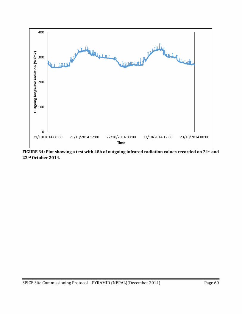
FIGURE 34: Plot showing a test with 48h of outgoing infrared radiation values recorded on 21st and
22nd October 2014.

SPICE Site Commissioning Protocol – PYRAMID (NEPAL)(December 2014) Page 61
Instrument Name: Pluviometer
Instrument number 1 of 1
Manufacturer LSI-Lastem
Model DQA035
Serial number /
Firmware version (if applicable) NA
Field configuration
Location on site Installed on the mast of the AWS1 Pyramid (2 in Fig. 3)
Orientation South
Height (measured at top) 1.5 m from the glacier surface
Shield (if applicable) NA
Heating (if applicable) Unheating
Data output
Data communication protocol Impulse sensor with reading of counts
Output data message format (include
description of fields) RAIN (mm) Msr.6 Inp.10
Tot ValidDataPerc
Data sampling frequency 1 min
Data output to NCAR 1min
Specification of the liquid precipitation sensor
Range 180 mm/hr Accuracy 0-1 mm/min: 1%
1-3 mm/min: 2% 3-5 mm/min: 4% 5-10 mm/min: 8%
SPICE Site Commissioning Protocol – PYRAMID (NEPAL)(December 2014) Page 62
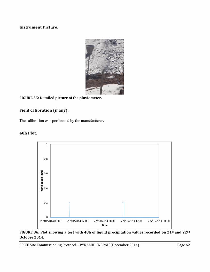
Instrument Picture.
FIGURE 35: Detailed picture of the pluviometer.
Field calibration (if any).
The calibration was performed by the manufacturer.
48h Plot.
FIGURE 36: Plot showing a test with 48h of liquid precipitation values recorded on 21st and 22nd
October 2014.
SPICE Site Commissioning Protocol – PYRAMID (NEPAL)(December 2014) Page 63
Instrument Name: Anemometer
Instrument number 1 of 1
Manufacturer Lsi-Lastem
Model DNA022
Serial number /
Firmware version (if applicable) NA
Field configuration
Location on site Installed on the mast of the AWS1 Pyramid (1 in Fig. 3)
Orientation NA
Height (measured at top) 5 m from the glacier surface, on the top of the mast
Shield (if applicable) NA
Heating (if applicable) Unheating
Data output
Data communication
protocol
Analogic
Output data message
format
Wind DIR (>)
Msr.4
Inp.4
Wind SPEED (m/s)
Msr.5
Inp.9
PrevDir
RisDir
RisVel
Std Dev Dir
Calm Perc
Valid Data Perc Min Ave
Max
Std Dev
Valid Data Perc
Data sampling frequency 1 min
Data output to NCAR 1 min
Specification of the wind speed sensor
Range 0-60 m/s Accuracy ±0.1 m/s
Specification of the wind direction sensor
Range 0- 360° Accuracy ±1% FS

SPICE Site Commissioning Protocol – PYRAMID (NEPAL)(December 2014) Page 64
Instrument Picture.
FIGURE 37: Detailed picture of the anemometer.
Field calibration (if any).
The calibration was performed by the manufacturer.
SPICE Site Commissioning Protocol – PYRAMID (NEPAL)(December 2014) Page 65
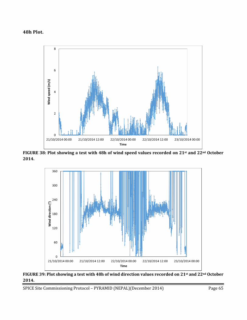
48h Plot.
FIGURE 38: Plot showing a test with 48h of wind speed values recorded on 21st and 22nd October
2014.
FIGURE 39: Plot showing a test with 48h of wind direction values recorded on 21st and 22nd October
2014.

SPICE Site Commissioning Protocol – PYRAMID (NEPAL)(December 2014) Page 66
SECTION A4: CONFIRMATION OF EXPERIMENT CONFIGURATION
TEST 1: INSTRUMENT CALIBRATION AND CHECKS
The Site Manager will organize the check and calibration of each instrument included in the experiment (as
part of the reference, or as an instrument under test). The check sheets and calibration results will be
included in the designated areas of Sections A2 and A3.
The calibration and check of the WG used as part of the reference will be conducted based on the
guidelines adopted by the SPICE IOC.
The calibration and check of the instruments under test will be conducted as specified by the
manufacturer prior to the installation on the SPICE site, as well as following the installation in the
field.
TEST 2: INSTRUMENT VALIDATION
After the field installation of each instrument (both those that are part of the reference and those that are
instruments under test), at the minimum, a continuous 48 hour data set of the entire test setup will be
stored and examined as an indication of instrument performance. The data sets for each instrument
included in the intercomparison will be reviewed for data integrity and representativeness, against the
predefined data format.
The evaluation of the instrument performance at this stage will be conducted using the 48 hour time series
plots provided in Sections A2 and A3. The readiness state of each instrument will be reported in the
Instrument Data Validation table below.
Any discrepancies will be investigated, addressed, and documented. Following the resolution of the
discrepancies, the 48-hour end to end (e2e) test will be repeated. Notes, plots, logs, will be appended to the
POP table of the reference/instrument under test, and the readiness state and date will be updated in the
Instrument Data Validation table.
TEST 3: SITE-TO-ARCHIVE TRANSFER VALIDATION
Once the transfer of site data files to the SPICE Data Archive at NCAR has been initiated, compare the site data with those received at the SPICE Data Archive for a 24 hour period to ensure that no errors occurred during archival or transmission. If any errors occur, log them and following the resolution of the discrepancies, repeat the 24-hour validation test. When the Test 3 is passed mark the check box YES in the Instrument Data Validation table below (this means that they have been also validated), with the starting date of the data transfer.

SPICE Site Commissioning Protocol – PYRAMID (NEPAL)(December 2014) Page 67
If Test 3 is not passed at the time of the Commissioning Report tick the checkbox NO and provide the expected date. (Plots, datasets, errors logs, referred to Test 3 are NOT included in this document but archived by the site manager if further tests or analysis are required),
IMPORTANT:
Test 2 and Test 3 may be conducted simultaneously, depending on the site configuration.
Instrument Data Validation
Instrument Readiness
(if Yes, indicate the
date)
Data transfer to NCAR
archive (Test 3)
(If the answer is No
report the expected
date)
Comments
The historic dataset isn’t
available as the Forni
Glacier is located in a
remote area, then a more
detailed analysis couldn’t
be performed.
Sommer sonic ranger
USH-8
Yes No
Date: 1st May 2014
Yes No
Date: December 2014
Global solar radiation Yes No
Date: 1st May 2014
Yes No
Date: December 2014
Pluviometer Yes No
Date: 1st May 2014
Yes No
Date: December 2014
Thermo-hygrometer Yes No
Date: 1st May 2014
Yes No
Date: December 2014
Anemometer Yes No
Date: 1st May 2014
Yes No
Date: December 2014
Sonic Ranger Campbell
SR50
Yes No
Date: 1st May 2014
Yes No
Date: December 2014
Soil temperature Yes No
Date: 1st May 2014
Yes No
Date: December 2014
Soil moisture Yes No
Date: 1st May 2014
Yes No
Date: December 2014

SPICE Site Commissioning Protocol – PYRAMID (NEPAL)(December 2014) Page 68
Soil heat flux Yes No
Date: 1st May 2014
Yes No
Date: December 2014
Net radiation Yes No
Date: 1st May 2014
Yes No
Date: December 2014

SPICE Site Commissioning Protocol – PYRAMID (NEPAL)(December 2014) Page 69
SECTION A5: SITE DOCUMENTATION CHECKLIST
A Site Documentation Checklist is provided below to track the inclusion of requisite documentation, data
plots, and photos in sections A1 to A4.
Site Documentation Checklist
Site information and layout (Section A1)
Included
Complete set of pictures documenting the
overall site installation - views from N, E, S, W
(Section A1)
Included
Details of manual measurement procedure
(Section A2)
Included Not Applicable
Instrument Metadata Reports for all
instruments under test and all instruments
used to provide ancillary measurements
(Section A3)
Included
Calibration results and check sheets for all
instruments (Sections A2, A3)
Included Not Applicable
Instrument data validation:, 48h time series
plots (Sections A2, A3)
Included Not Applicable
Instrument data validation table (Section A4)
Included Not Applicable
48h Instrument data validation: discrepancy
reports (Section A4)
Included Not Applicable
Pictures of installations of all reference
instruments, instruments under test, and
instruments used to provide ancillary
measurements (Sections A2, A3)
Included Not Applicable
End-to-end data validation (Section A4; see
Instrument data validation table).
Full (all gauges) Partial (some gauges)
No Not yet Applicable
SPICE archive end-to-end data validation:
discrepancy reports (Section A4)
Yes No Not yet Applicable
Details of any workarounds (Sections A2, A3,
A4)
Included Not Applicable
SPICE Site Commissioning Protocol – PYRAMID (NEPAL)(December 2014) Page 70
APPENDIX B: SPICE DATA LEVELS AND DATASETS Details of the different levels of data and associated datasets for SPICE are included below. The present
document addresses only data up to and including Level 2a. Data of higher levels, and the associated datasets,
are tentatively defined here for completeness.
Data Levels:
Level 1 data: are those collected as the output of each individual instrument, which have been converted
into geophysical measurements (e.g. weight, mass, intensity), generally with high temporal resolution, and
before any significant data quality control has been applied. A Level 1 dataset contains data from only one
instrument at one site.
Level 2a data: are time-synchronized data resulting from the sampling, averaging or some other signal/data
processing having been applied to Level 1 data from an individual instrument in order to separate signal
from noise. These data have not been quality controlled, and should be used only for monitoring an
instrument’s status. A Level 2a dataset contains data from only one instrument at one site.
Level 2b data: are time-synchronized Level 2a data after a basic data quality control procedure has been
applied. Basic data quality flags for validity and quality have been added. Missing records have been
created and filled with a missing data quality indicator. A Level 2b dataset contains data from only one
instrument at one site.
Level 3 data: derived by combining and further processing all Level 2b datasets from a site. At this level,
advanced and multiple instrument data quality techniques have been applied. A Level 3 dataset contains
data from all instruments at an individual site.
Level 4 data: derived after performing an intercomparison of the Level 3 data from one or more sites, taking
into account snow climatology, wind regimes, temperatures, etc., and where applicable, differences in
these from one site to another.
Datasets:
SPICE Site Dataset: A dataset comprising all Level 1, 2a, 2b and 3 datasets from that Intercomparison Site.
SPICE Intercomparison Dataset: this is the Level 4 dataset that combines the Level 3 data from all SPICE
intercomparison sites. The Project Team will develop the SPICE Intercomparison Dataset using the Level 3
datasets from each Intercomparison Site. It contains summary Level 3 data and intercomparison data for
all instruments and all sites.
The SPICE Dataset: The total SPICE dataset including all SPICE Site Datasets, Site Documentation and
Instrument Documentation for all participating sites and instruments, the SPICE Intercomparison Dataset,
and all SPICE analysis and assessment documentation.
SPICE Site Commissioning Protocol – PYRAMID (NEPAL)(December 2014) Page 71
APPENDIX C: ACRONYMS AND ABBREVIATIONS DFIR Double-Fence Intercomparison Reference
e2e End-to-end
ER Evaluating Representative
IOC International Organizing Committee
IR Installation Representative
NCAR National Center for Atmospheric Research (USA)
POP Proof of Performance
QC Quality control
R0 Working field reference configuration 0: manual or automatic precipitation gauge in bush
R1 Working field reference configuration 1: manual precipitation gauge in DFIR
R2 Working field reference configuration 2: automatic weighing gauge in DFIR
R3 Working field reference configuration 3: two automatic weighing gauges;
one shielded (single-Alter), one unshielded
SPICE Solid Precipitation Intercomparison Experiment
SWE Snow water equivalent
WG Weighing gauge
WMO World Meteorological Organization