south african notices to mariners 14 ntm.pdf · annual summary of south african notices to mariners...
TRANSCRIPT

SOUTH AFRICAN
NOTICES TO MARINERS October 2014 EDITION
PUBLISHED MONTHLY
BY THE
HYDROGRAPHIC OFFICE
CAPE TOWN
CONTENTS I Explanatory Notes and Index
II SAN Notices to Mariners. Updates to Standard Navigational Charts
III SAN Charts and SAN HO Publications - New Charts / Editions
IV Corrections to SAN HO Publications
V Corrections to SA List of Lights and Radio Services
VI Reprints of Radio Navigational Warnings
IMPORTANT
Mariners are requested to inform the Hydrographer, Private Bag X1, Tokai 7966, immediately of the discovery
of new dangers, or changes or defects in aids to navigation and of shortcomings in South African charts or
publications. Copies of form SAN HO-16, which is a convenient form on which to send in a report, is available
on www.sanho.co.za and from any Official Chart Agent or the reproduction at the end of Section VI of the
monthly edition of Notices to Mariners.
In addition to postal methods, the following additional communication facilities are available :
Notices to Mariners Web site : Web : http://www.sanho.co.za
Urgent navigational information : E-mail : [email protected]
(24 Hour Service) Fax : +27 21 787 2228
Other navigational information : Fax : +27 21 787 2233
(0730 - 1600 Mon - Fri) Phone : +27 21 787 2445/2444
E-mail : [email protected]
General information : Phone : +27 21 787 2408
(0730 - 1600 Mon - Fri)
Captain A. Kampfer
Hydrographer, SA Navy
NAVAREA VII Co-ordinator
Monthly Edition
October 2014
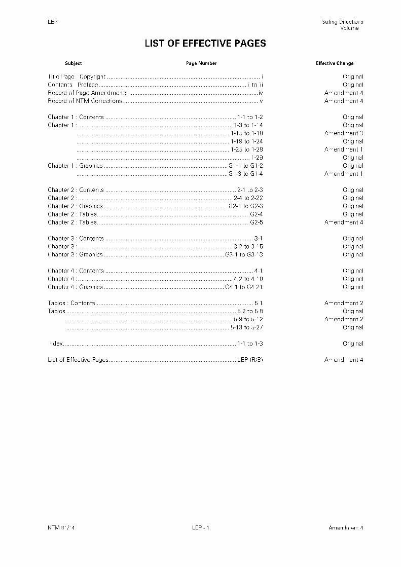
I
INDEX OF CHARTS AND PUBLICATIONS AFFECTED
SAN Charts Notices Pages
57 85 6
132 86 6
133 86 6
1004 (INT 2612) 83 6
1017 84 6
1032 (INT 7572) 86 6
SC 12 86 6
International Charts Notices Pages
INT 2612 83 6
INT 7572 86 6
SAN Publications Notices Pages
Annual Summary of South African Notices to Mariners – 2014 Edition 89 10, 12
Catalogue and Indexes of SAN Charts and Publications (SAN HO-3) – 2011 Edition 90 12, 14
South African Sailing Directions Volume I (SAN HO-21) 91 14
SA List of Lights and Radio Signals (SAN HO-1) – 2011 Edition 92 16
SAN Charts – New Charts / Editions Notices Pages
SAN MZ 1 87 10
SAN 2054 88 10
SAN Publications – New Publications / Editions Notices Pages
Nil.
SAN Charts and Publications – Permanently Withdrawn Notices Pages
Nil.
Spheroid / GPS Positions
All positions quoted in these Notices are referred to the WGS Spheroid, unless otherwise indicated.
On chart scales of 1: 150 000 and smaller, positions from GPS receivers set to WGS 84 may be plotted directly
on these charts. Mariners are warned that insertion of Clarke 1880 (or other) positions on Automatic Plotters
which are set to WGS 84 Spheroid can result in inaccurate navigation practices.
Temporary and Preliminary Notices
These are indicated by (T) or (P) after the notice number. These are printed on one side of the paper in order that
they may be cut and filed and are placed at the end of Section II. To assist in filing, the year is indicated after the
notice number. Information from these notices is not included on charts before issue; charts should be
updated in pencil on receipt.
Permanent Notices
Permanent corrections in Section II are marked by a star adjacent to the notice number to indicate that the notice
is based on original information. Periodic lists of permanent corrections pertaining to affected navigational charts
and publications are published annually and copies may be obtained from the Hydrographic Office or through a
Chart Agent.
2
Monthly Edition
October 2014
I cont/…
Chart Corrections
Further details are contained in NP100 The Mariner‟s Handbook which should be consulted for the correct
procedures of filing, inserting and noting all types of corrections on nautical charts and other hydrographic
Publications. The Handbook may be obtained from Admiralty Chart Agents in Cape Town and Durban. Consult
SAN HO-6 for Symbols and Abbreviations used on SAN Charts and NP735 for an illustrated explanation of the
IALA Maritime Buoyage System.
Provision of Notices to Mariners
These Notices are gratis and may be obtained on request from the Hydrographic Office or through the approved
Chart Agents. Additional copies required of “block” chart corrections can also be obtained through the above
procedure. This publication is maintained electronically for each monthly Notice to Mariners and can be
downloaded from www.sanho.co.za/notices/xxxx series.htm (xxxx being the current year).
Radio Navigational Warnings
See Note at the start of Section VI.
GUIDANCE NOTES FOR VIEWING AND PRINTING NOTICES USING
ADOBE ACROBAT
For optimum results when viewing and printing material from the PDF digital files please note the following:
When printing data from the files, ensure the Fit to Page icon in the Adobe Acrobat print menu is switched off
before printing. Otherwise large text pages will be compressed, or large size Blocks may not fit the chart.
If printing text or monochrome NM Blocks, the minimum specification is an Inkjet or good quality Laser
Postscript printer with at least 6 MB of memory. (NB. If using a Postscript printer, ensure the Postscript printer
driver is installed).
For printing Colour NM Blocks the minimum specification of printer is a good quality Ink Jet/Laser printer with
300 dpi resolution or greater.
If using certain types of Ink Jet printer ensure the setting is set to Dithered screening not Pattern screening.
Printed colour copies should be compared with the colour image on screen to ensure that all the colours have
reproduced correctly. Printer property resolution and ink density may need to be increased or adjusted to obtain
the best results.
Ensure the Colour Ink Cartridge is in accordance with the printer manufacturers specifications. Minimum paper
specification for printing Colour NM Blocks is International paper size A4, thickness/weight 80 gms paper. (The
same paper as used for NM Blocks in the NM Monthly). NB. (Ensure the paper quality is in accordance with the
Printer manufacturers specifications).
The Hydrographer does not accept any liability for the display and
printing of these digital Notices to Mariners on the user’s equipment.

3
Monthly Edition
October 2014
I cont/…
TEMPORARY NOTICES AND PRELIMINARY NOTICES
In force 05 November 2014
CANCELLED NOTICES
93(T)/13 Chart SAN 1017
TEMPORARY NOTICES
2013 Series
48(T)/13 RSA Offshore Mossel Bay Current meters and buoy.
Charts SAN 81 (INT 7510), 82 (INT 7520), 122,
123, 1020 (INT 7521)
79(T)/13 RSA Port of Richards Bay Wreck.
Charts SAN 1032 (INT 7572), 1033 (INT 7571),
SC 12
2014 Series
30(T)/14 Namibia Port of Walvis Bay Racon.
Charts SAN 52, 73 (INT 2610), 90 (INT 2051),
1004 (INT 2612), 1005 (INT 2613)
31(T)/14 Namibia Oranjemund Racon.
Charts SAN 54, 76 (INT 2640), 113
65(T)/14 Namibia W of Knoll Point Foul ground.
Chart SAN 74 (INT 2620)
PRELIMINARY NOTICES
2014 Series
Nil.
SUMMARY OF SAN CHARTS AND PUBLICATIONS
PERMANENTLY WITHDRAWN
Nil.
ERRATUM
Nil.

4
Monthly Edition
October 2014
I cont/…
SA NAVY SAN CHARTS OF SOUTH AFRICA AND NAMIBIA THAT ARE REFERRED TO THE
WGS 84 SPHEROID
1002 (INT 2631) 1004 (INT 2612) 1005 (INT 2613) 1010 (INT 2671) 1011 (INT 2673)
1012 (INT 2672) 1013 (INT 2681) 1014 (INT 2682) 1020 (INT 7521) 1024 (INT 7531)
1025 (INT 7532) 1026 (INT 7533) 1027 (INT 7541) 1030 (INT 7561) 1031 (INT 7562)
1032 (INT 7572) 1033 (INT 7571) 2003 (INT 7745) 2004 (INT 9056)
1003 1015 1016 1017 1021 2051 2053 2054 3001
SC 3 SC 5 SC 9 SC 12
SA NAVY SAN CHARTS OF SOUTH AFRICA AND NAMIBIA THAT IS REFERRED TO THE
CLARKE 1880 SPHEROID
1. Corrections to be applied to positions obtained from GPS satellite receivers (based on the Global Positioning
System (WGS 84) spheroid) for plotting on SAN nautical charts based on the Clarke 1880 (mod) spheroid.
LARGE SCALE CHARTS
CHART SHIFTS (m)
NUMBER Latitude Longitude
SAN 1009 -16 64
SAN 1022 -12 48
SAN 1029 -37 26
1 : 150 000 AND SMALLER SCALE CHARTS
Positions obtained from a GPS Receiver can be plotted directly on these charts as the shift is negligible.

5
Monthly Edition
October 2014
I cont/…
MISCELLANEOUS
1. Mariners are advised that the primary and most reliable means of communication with the Hydrographic
Office for all URGENT navigational correspondence is via facsimile to number : +27 21 787 2228.
2. Current and archived South African Notices to Mariners are available in PDF format on website
http://www.sanho.co.za
GENERAL: SA NAVY HYDROGRAPHIC OFFICE CONTACT DETAILS
1. Mariners and interested parties are advised to take note of the SA Navy Hydrographic Office 24 hour service
contact details. This will assist to prevent late action being taken on important navigational information.
2. The relevant contact details can be found on the front page of the monthly Notices to Mariners, as well as at
website www.sanho.co.za.
MERCHANT VESSEL VOLUNTARY REPORTING SCHEME AND SECURITY RELATED
INFORMATION TO MARINERS
IMPORTANT: UPDATED VERSION (Previous update: May 2013 NTMs).
1. Mariners and interested parties are advised to take note of the NAVAREA IX Message 092 regarding the
Merchant Vessel Voluntary Reporting Scheme. More detail is provided on page 21 and 22 of this Notice to
Mariners.
CAUTION REGARDING USE OF ECDIS IN STANDARD DISPLAY MODE AND OPERATING
ANOMALIES IDENTIFIED WITHIN ECDIS
IMPORTANT: UPDATED VERSION (Previous update: October 2012 NTMs).
1. Mariners and interested parties are advised to take note of the caution regarding the use of ECDIS in
standard display mode, the IHO notice regarding the importance of the visual inspection of passage plans and
important issues regarding displayed information of certain versions. This includes certain display anomalies
with relevant advice. More detail is provided from pages 23 to 27 of this Notice to Mariners.

6
Monthly Edition
October 2014
II
83* NAMIBIA – West Coast – Port of Walvis Bay –Leading light, leading line and legend.
Source: NAMPORT
SAN 1004 (INT 2612) [Previous Update – 77/14]
1. Delete: in approximate position 22° 57.17' S 14° 29.40' E
2. Delete: in approximate position 22° 57.38' S 14° 28.87' E
3. Delete: ------------ extending to the east of 2. above.
84* SOUTH AFRICA – South West Coast – Simon’s Bay – Obstruction.
Source: Hydrographer
SAN 1017 [Previous Update – 41/14]
1. Insert: in positions a. 34° 11.004' S 18° 26.972' E
b. 34° 11.038' S 18° 27.098' E
85* SOUTH AFRICA – South Coast – Offshore Sedgefield - Well.
Source: Hydrographer.
SAN 57 [Previous Update – 42/14]
1. Insert: in position 35° 39.9' S 22° 44.4' E
86* SOUTH AFRICA - East Coast – Port of Richards Bay – Foul ground.
Source: Hydrographer (Previously issued as CNW 554 of 2014)
SAN 132 [Previous Update – 76/14]
1. Insert: in position 28° 52.93' S 32° 12.20' E
SAN 133 [Previous Update – 76/14]
2. Insert: in position 28° 52.93' S 32° 12.20' E
SAN 1032 (INT 7572) [Previous Update – 76/14]
3. Insert: in position 28° 52.93' S 32° 12.20' E
SAN SC 12 [Previous Update – 76/14]
4. Insert: in position 28° 52.93' S 32° 12.20' E
5. Anchor lost in above position.

7
Monthly Edition
October 2014
IIA
LIST OF TEMPORARY AND PRELIMINARY NOTICES TO MARINERS ISSUED
BY THE ANGOLAN MINISTRY OF TRANSPORT IN FORCE
Important Notice: Mariners are advised that positions for Angolan Notices are referred to the WGS 84
Spheroid. Caution is therefore advised when plotting positions on large scale British Admiralty charts that are
not based on the same spheroid.
Nil prior to these Notices.
2013 Series
Nil.

8
Monthly Edition
October 2014
IIB
LIST OF TEMPORARY AND PRELIMINARY NOTICES TO MARINERS ISSUED
BY THE MOZAMBIQUE INSTITUTE OF HYDROGRAPHY AND NAVIGATION
(INAHINA) IN FORCE
Mariners are advised to consult the monthly Notices to Mariners as published by INAHINA.
Contact details:
Instituto Nacional De Hidrografia E Navegacão
Av. Karl Marx 153-5/12
P.O. Box 2089
Maputo
Mozambique
Tel: 43 01 86/8
Fax: (258)-(1)-43 01 85-42 86 70
Telex: 6-619-Maputo-Mozambique
E-mail: [email protected]
IIIB
CHARTS AND PUBLICATIONS – NEW CHARTS/ EDITIONS ISSUED BY THE
MOZAMBIQUE INSTITUTE OF HYDROGRAPHY AND NAVIGATION
CHART 16304 PORTO DA BEIRA – NEW EDITION
Scale : 1: 15 000 (19°50‟S)
Limits : Latitudes : 19° 47'00" S - 19° 54'00" S Longitudes : 034° 45' 30"E - 034° 51' 36"E
Projection : Mercator
Spheroid : WGS 84
This chart replaces the previous version of the same number.

9
Monthly Edition
October 2014
IIC
LIST OF TEMPORARY AND PRELIMINARY NOTICES TO MARINERS ISSUED
FOR MADAGASCAR IN FORCE
Important Notice: Mariners are advised that positions for Madagascar Notices are referred to the WGS 84
Spheroid. Caution is therefore advised when plotting positions on large scale British Admiralty charts that are
not based on the same spheroid.
Nil prior to these Notices.
2013 Series
Nil.

10
Monthly Edition
October 2014
III
SAN HO CHARTS AND SAN HO PUBLICATIONS - NEW CHARTS/ EDITIONS
87/14 NEW CHART
1. SAN MZ 1 MARITIME ZONES
Published Date : 31 October 2014
Scale : 1: 7 250 000
Limits : Latitudes : 25° 00'00" S - 52° 30'00" S Longitudes : 010° 00' 00"E - 059° 50' 39"E
Projection : Mercator
Spheroid : WGS 84
2. This chart depicts information concerning existing maritime zones and straight baselines and South Africa‟s
Extended Economic Zone claim. It is now available from official Chart Agents.
88/14 NEW CHART
1. SAN 2054 VANDERKLOOF DAM
Published Date : 31 October 2014
Scale : 1: 30 000
Limits : Latitudes : 29° 56' 00"S - 30° 06' 12"S Longitudes : 024° 43' 00"E - 024° 52' 42"E
Projection : Mercator
Spheroid : WGS 84
2. This is the third dam chart in a series of charts produced for navigation on inland waters and is now available
from official Chart Agents.
SAN HO CHARTS AND SAN HO PUBLICATIONS – PERMANENTLY
WITHDRAWN
Nil.
IV
CORRECTIONS TO SAN HO PUBLICATIONS
89/14 ANNUAL SUMMARY OF SOUTH AFRICAN NOTICES TO MARINERS
– 2014 EDITION
Page ii Under heading IMPORTANT
Delete: “or telex : 95 527946 (ANS BACK : NAVY SA),”
Page iii, Para 17.
Amend: Shark Nets – Kwazulu-Natal Coast to read: Shark Nets
Page 8 Under heading Urgent Navigational Information (24 Hour Service)
Delete: Telex : 95 527946 (ANS BACK: NAVY SA)
Page 35
Replace existing page with accompanying page.

11
Monthly Edition
October 2014
BLANK PAGE

12
Monthly Edition
October 2014
IV cont/….
89/14 cont./
Page 56
Replace: Existing paragraphs with new paragraphs below:
10. The preferred means of ship to shore communication for pre-arrival/pre-entry information reports is via an email to [email protected]. If Inmarsat C is used, the ship‟s officer can confirm receipt by selecting the option “request delivery confirmation” on the ship‟s terminal. A ship‟s agent can also confirm receipt 6 hours after transmission by contacting Cape Town Radio on the help line 0800 222 208. 11. Cape Town Radio will accept a forwarded e-mail message from a ship‟s agent, provided the agent confirms receipt of the e-mail with Cape Town Radio - Cape Town Radio will not forward an e-mail message to the MRCC without this confirmation. When e-mail is used, reports must not be sent as e-mail attachments but must be in the e-mail body text because the Cape Town Radio IT system strips attachments from e-mails. Cape Town Radio‟s e-mail address is [email protected].
Page 61
Replace: Existing paragraphs with new paragraphs below:
14. The preferred means of ship-to-shore communication for pre-arrival/pre-entry information reports is via an email to [email protected]. If Inmarsat C is used, the ship‟s officer can confirm receipt by selecting the option “request delivery confirmation” on the ship‟s terminal. A ship‟s agent can also confirm receipt 6 hours after transmission by contacting Cape Town Radio on the help line 0800 222 208. 15. Cape Town Radio will accept a forwarded e-mail message from a ship‟s agent (provided the agent confirms receipt of the e-mail with Cape Town Radio). Cape Town Radio will not forward an e-mail message to the MRCC without this confirmation. When e-mail is used, reports must not be sent as e-mail attachments, but must be in the e-mail body text because the Cape Town Radio IT system strips attachments from e-mails. Cape Town Radio‟s e-mail address is [email protected].
Page 66 and 69
Delete:
90/14 CATALOGUE AND INDEXES OF SAN CHARTS AND PUBLICATIONS (SAN HO-3)
– 2011 EDITION
Page i add new entry after SAN 3002:
Insert: SAN MZ 1……………………….R 107.00
Page 2 Under heading add new entry after SAN 2053:
Insert: SAN 2054……………………….25
Under heading add new
entry after SAN 3002:
Insert: SAN MZ 1……………………….25
Page 25
New entry after SAN 3001:
Insert: SAN MZ 1 (column Chart No)
Maritime Zones (column Chart Title)
7 250 000 (column Scale 1:)
Oct 2014 (column Published Date)

13
Monthly Edition
October 2014
BLANK PAGE

14
Monthly Edition
October 2014
IV cont/…. 90/14 cont./
Page 25
New entry after SAN 2053:
Insert: SAN 2054 (column Chart No)
Vanderkloof Dam (column Chart Title)
30 000 (column Scale 1:)
Oct 2014 (column Published Date)
Page 47
Replace existing page with new page.
91/14 SOUTH AFRICAN SAILING DIRECTIONS VOLUME 1 (SAN HO-21) – 2005 EDITION
Pages iv to v Replace existing pages with new pages.
Pages G2-5 Replace existing page with new page (retain existing page G2-4).
Page LEP - 1 Replace existing page with new page.

15
Monthly Edition
October 2014
BLANK PAGE

16
Monthly Edition
October 2014
V
CORRECTION TO SA LIST OF LIGHTS AND RADIO SIGNALS - SAN HO-1
- 2011 Edition
92/14 SECTION 1 - LIGHTS AND FOG SIGNALS
Page 12 Z5506 and Z5506
1: Delete: Heading and light entries in toto. (columns 1 to 8)
Page 47
1. Delete :
Amend : to read
Page 79
1. Insert: New paragraph after existing paragraph 9:
3. Renumber existing paragraphs 10 to 14 to read 11 to 15.

17
Monthly Edition
October 2014
BLANK PAGE

18
Monthly Edition
October 2014
VI
NAVAREA VII Bulletins and Coastal Navigational Warning Messages
in force as at 1030 UTC on 05 November 2014
See Annual NM 3/2014. Broadcast Warnings are available at Port Offices and remain valid until cancelled or
until superseded by this and/or other broadcast bulletins. These are also available in digital format on website:
http://www.sanho.co.za. The website version is only updated during normal working hours. See front cover for
contact information.
NAVAREA VII MESSAGES
Nil Prior to these Messages
2014 Series
204 Indian Ocean - SW Sector - Port of Maputo - Channel Buoy laying /repositioning.
205 Indian Ocean - Port of Maputo - Limited depth in channel.
206 South Atlantic Ocean - NE Sector - Offshore Angola - Accommodation barge in location.
208 Indian Ocean - SW Sector - Port of Maputo - Buoys positions.
209 Indian Ocean - SW Sector - Port of Maputo - Survey operations.
218 South Atlantic Ocean - NE Sector - Offshore Angola - Restricted area.
253 South Atlantic Ocean - NE Sector - Vessel moored.
292 Indian Ocean - SW Sector - Port of Nacala - New buoy positions.
293 Indian Ocean - SW Sector - Port of Pemba - New buoy positions.
295 Indian Ocean - SW Sector - Port of Quelimane - New buoy positions.
304 South Atlantic Ocean - NE Sector - Survey operations - Ramform Valiant.
307 South Atlantic Ocean - NE Sector - Anchor gear left.
318 Indian Ocean - SW Sector - Port of Maputo - Buoy off station.
322 South Atlantic Ocean - NE Sector - Marine Mining Vessels List.
326 South Atlantic Ocean - NE Sector - Drilling operations - MV Explorer.
327 South Atlantic Ocean - NE Sector - Surveying operations - Polarcus Amani.
329 South Atlantic Ocean - NE Sector - Surveying operations - Ramform Vanguard.
338 South Atlantic and Indian Ocean Sectors - Rig List.
342 Indian Ocean - SW Sector - Rocket carrier elements.
343 South Atlantic Ocean – Vessel reported missing.
COASTAL NAVWARNING MESSAGES
2014 Series
290 RSA - South-West Coast - Simon's Bay - Buoy deployed.
292 RSA - South West Coast - False Bay - Buoy and Racon off station.
320 RSA - South West Coast - False Bay - Octopus lines.
391 RSA - East Coast - Offshore Durban - Diving operations.
433 RSA - South West Coast - West of Saldanha - Underwater operations.
440 RSA - South West Coast - False Bay - Target structure deployed.
480 RSA - South West Coast - False Bay - Buoy deployed.
504 Namibia - Offshore Orange River Mouth - Anchor gear left.
535 Namibia - Walvis Bay - Leading light removed.
536 Namibia - Offshore Orange River Mouth - Marine Mining Vessels List.
539 Namibia - Offshore Alexander Bay to Port Nolloth - Drilling operations - MV Explorer.
554 RSA - East Coast - SE of Richards Bay - Anchor lost.
591 RSA - South Coast - Offshore Mossel Bay - Flaring Operations.

19
Monthly Edition
October 2014
VI
ANNEX A
USA Government Special Warning in force 18 December 2001
SPECIAL WARNING NUMBER 120 WORLDWIDE
1. Due to recent events in the Middle East and the American Homeland, U.S. Forces worldwide are operating at
a heightened state of readiness and taking additional defensive precautions against terrorists and other potential
threats. Consequently, all aircraft, surface vessels, and sub-surface vessels approaching U.S. Forces are requested
to maintain radio contact with U.S Forces on bridge-to-bridge channel 16, international air distress (121.5 MHz
VHF) or MILAIR distress (243.0 MHz UHF).
2. U.S. Forces will exercise appropriate measures in self-defence if warranted by the circumstances. Aircraft,
surface vessels, and sub-surface vessels approaching U.S. Forces will, by making prior contacts as described
above, help make their intentions clear and avoid unnecessary initiation of such defensive measures.
3. U.S. Forces, especially when operating in confined waters, shall remain mindful of navigational
considerations of aircraft, surface vessels, and sub-surface vessels in their immediate vicinity.
4. Nothing in the Special Warning is intended to impede or otherwise interfere with the freedom of navigation
or overflight of any vessel or aircraft, or to limit or expand the inherent self-defence rights of U.S. Forces. This
Special Warning is published solely to advise of the heightened state of readiness of U.S. Forces and to request
that radio contact be maintained as described above (Issued 16 Nov 2001).

20
Monthly Edition
October 2014
VI
ANNEX A/cont...
USA Government Special Warning in force 20 March 2003
SPECIAL WARNING NUMBER 121 PERSIAN GULF
1. Coalition Naval Forces may conduct military operations in the Eastern Mediterranean Sea, Red Sea, Gulf of
Aden, Arabian Sea, Gulf of Oman and Arabian Gulf. The timely and accurate identification of all vessels and
aircraft in these areas are, critical to avoid the inadvertent use of force.
2. All vessels are advised that coalition Naval Forces are prepared to exercise appropriate measures in self-
defense to ensure their safety in the event they are approached by vessels or aircraft. Coalition Forces are
prepared to respond decisively to any hostile acts or indications of hostile intent. All maritime vessels or
activities that are determined to be threats to Coalition Naval Forces will be subject to defensive measures,
including boarding, seizure, disabling or destruction, without regard to registry or location. Consequently,
surface vessels, sub-surface vessels and all aircraft approaching Coalition Naval Forces are advised to maintain
radio contact on Bridge-to-Bridge channel 16, International Air Distress (121.5 MHZ VHF) or Military Air
Distress (243.0 MHZ UHF).
3. Vessels operating in the Middle East, Eastern Mediterranean Sea, Red Sea, Gulf of Oman, Arabian Sea and
Arabian Gulf are subject to query, being stopped, boarded and searched by US/Coalition warships operating in
support of operations against Iraq. Vessels found to be carrying contraband bound for Iraq or carrying and/or
laying Naval mines are subject to detention, seizure and destruction. This notice is effective immediately and
will remain in effect until further notice.

21
Monthly Edition
October 2014
VI
ANNEX A/cont...
USA Government Special Warning in force 11 March 2005
SPECIAL WARNING NUMBER 122 EAST AFRICA
1. The US Government has received unconfirmed information that terrorists may attempt to mount a maritime
attack using speedboats against a western ship - possibly in East Africa. No additional information is available
on the planning, timing or intended targets of the maritime attack. This notice is effective immediately and will
remain in effect until further notice.
USA Government Special Warning in force 11 November 2005
SPECIAL WARNING NUMBER 123 EAST AFRICA
1. Due to continuing conditions of armed conflict and lawlessness in Somalia and waters off its coast, mariners
are advised to avoid the port of Muqdisho (Mogadishu) and to remain at least 200 nautical miles distant from the
Somali coast. The US government does not have an embassy in Somalia and cannot provide services to US
citizens.
2. Recent vessel hijackings off the east coast of Somalia demonstrate that pirates are able to conduct at sea
hijackings from as far south as Kismaayo (Chisimayu) (00-22S), though vessels are advised to transit no closer
than 02-00S, to as far north as Eyl (08-00N), and out to a distance of 170 miles. The first known attempt to
hijack a cruise vessel occurred in November 2005. All merchant vessels transiting the coast of Somalia, no
matter how far offshore, should increase anti-piracy precautions and maintain a heightened state of vigilance.
Pirates are reported to have used previously hijacked ships as bases for further attacks.
3. Another reported pirate tactic has been to issue a false distress call to lure a ship close inshore. Therefore,
caution should be taken when responding to distress calls keeping in mind it may be a tactic to lure a vessel into
a trap.
4. Victimized vessels have reported two to three (2-3) speedboats measuring six to nine meters (6-9m) in length.
Each vessel has a crew of three to six (3-6) armed men with AK-47s and shoulder launched rockets, which are
opening fire on vessels in broad daylight in order to intimidate them into stopping.
5. To date, vessels that increase speed and take evasive maneuvers avoid boarding while those that slow down
are boarded, taken to the Somali coastline, and released after successful ransom payment, often after protracted
negotiations of as much as 11weeks.
NAVAREA IX 092 OF 2009
1. A Merchant Vessel Voluntary Reporting Scheme has been established to increase security, provide anti-
piracy support and to maintain the freedom of navigation to all vessels in the Indian Ocean, Arabian Sea, Persian
Gulf, Gulf of Aden and the Red Sea.
2. Merchant vessels operating in these areas are strongly encouraged to liaise with the military authorities
below. Any vessel or owner/operator/manager, which chooses not to report may delay any military assistance in
the event of an incident and will not receive an updated threat assessment.
3. All vessels should send position reports to both:
a. UK Maritime Trade Operation, Dubai
E-mail: [email protected]
Tel: +971 50 552 3215
Fax: +971 4 306 5710
Telex: (51) 210473

22
Monthly Edition
October 2014
NAVAREA IX 092 OF 2009/cont...
b. Maritime Liaison Office, Bahrain (Marlo)
E-mail: [email protected]
Tel: +973 3940 1395
4. In return, vessels will receive passage guidance, recommended routing, as well as the latest threat assessment
from MTO, Dubai.
5. All masters are advised to ensure that prior to sailing through or entering the region, that the
owners/operators/managers have registered the vessel with the Maritime Security Centre, Horn of Africa
(MSCHOA), http://www.mschoa.eu.
6. The website offers group transit information in the Gulf of Aden and best management practice for vessel self
protection.
Tel: +44 1923 958545.
SECURITY RELATED INFORMATION TO MARINERS
About Admiralty Security Related Information to Mariners
1. Admiralty Maritime Security Planning Charts (Q Series) should be maintained so that they are fully up-to-
date with the latest security-critical navigational information. The Admiralty Security Related Information to
Mariners (SRIM) service provides all of the data you need to maintain the Q Series charts as well as additional
security related information which will aid passage planning.
Promulgation of Corrections to Q Series Planning Charts
2. These charts will be updated/corrected using the established United Kingdom Hydrographic Office Notices to
Mariners process.
Promulgation of Security Related Information to Mariners (SRIM)
3. New threats, embargo, exclusion zones and specific advice will be promulgated using the Security Related
Information to Mariners (SRIM) and can be viewed by clicking on the relevant Q Chart Tab.
The SRIM for each chart will be sequentially numbered and identified by a unique title as follows:
Q6XXX/yr/zzz (e.g.Q6011/12/001) meaning the first SRIM of 2012 for chart Q6011.
Data assurance
4. The data and information within the Security Related Information to Mariners (SRIM) is compiled and
validated by government and military officials directly involved within the operation and often trained by the
UK Fleet AWNIS Unit. Where possible any safety critical information will be promulgated by the World Wide
Navigational Warning System (WWNWS).
Availability
5. Admiralty Security Related Information to Mariners is provided free of charge on this website
http://www.ukho.gov.uk/ProductsandServices/MartimeSafety/Pages/SRIM.aspx
23
Monthly Edition
October 2014
CAUTION REGARDING USE OF ECDIS IN STANDARD DISPLAY MODE
1. Mariners are advised of a potentially serious issue that has come to light relating to the way ECDIS displays
and operates with some shoal soundings, marked as "reported" on paper charts that will not be visible when
operating in the base or standard display modes and that may not trigger automatic grounding alarms in any
display mode, even if their depth is less than the vessel safety depth set in the ECDIS. This is due to a specific
manner of encoding these particular shoal soundings within S-57.
2. All ENCs produced by SANHO have been corrected where such soundings occur in navigable waters, beyond
the first safety depth contour depicted in these ENCs.
3. As a precaution, mariners are alerted to this issue via NAVAREA warnings that have been transmitted in
most regions. The text of the warning as broadcasted is as below. Updated information on this issue will be
provided as it becomes available.
4. Mariners navigating beyond South African ENC coverage must consult the various promulgated notifications
released by the ENC producer nations, covering this issue.
5. Mariners are advised that ECDIS may not display some isolated shoal depths when operating in “base or
standard” mode. Route planning and monitoring alarms for these shoal depths may not always be activated. To
ensure safe navigation and to confirm that a planned route is clear of such dangers, mariners should visually
inspect the planned route and any deviations from it using ECDIS configured display “all data”. The automated
voyage planning check function should not be solely relied upon. The International Hydrographic Organisation
(IHO) is leading technical action to resolve this matter. Further information will be available through Notices to
Mariners.
6. Display Anomalies in some ECDIS. Mariners are advised that the International Hydrographic Organization
(IHO) check data set shows that some ECDIS systems fail to display some significant underwater features in the
standard display mode. The use of this check data set, issued through ENC service providers and available from
the IHO website www.iho.int, to check the operation of ECDIS is strongly recommended. JRC has confirmed
that certain versions of JRC ECDIS fail to display some types of wreck and obstructions, including stranded
wrecks, in any display mode. Where JRC ECDIS is in use, paper charts should be the primary means of
navigation until the ECDIS has been proved to operate correctly.
7. See www.jrc.co.jp/eng/product/marine/whatsnew/20120313/index.html for further information.

24
Monthly Edition
October 2014
VI
ANNEX A/cont...
VISUAL INSPECTION OF PASSAGE PLANS
8. As previously notified by NAVAREA warning, mariners using ECDIS are reminded not to rely solely on
automated voyage planning and monitoring checks and alarms. Some ECDIS appear only to undertake route
check functions on larger scale ENCs and therefore alarms might not activate. This may not be clearly indicated
on the ECDIS display. Mariners should always undertake careful visual inspection of the entire planned route
using the „other / all‟ display mode to confirm that it, and any deviations from it, is clear of dangers.
9. Recent preliminary investigation indicates that some ECDIS may not display certain combinations of chart
features and attributes correctly and on rare occasions may fail to display a navigationally significant feature.
This appears to be caused by anomalous behaviour in some ECDIS software, especially early versions. The
existence of such anomalies highlights the importance of maintaining ECDIS software to ensure that operational
capability and reliability are maintained. It is recommended that appropriate checks are made with the equipment
manufacturer. This is of particular importance where ECDIS is the only source of chart information available to
the mariner.
10. The International Hydrographic Organization (IHO) is investigating these matters in consultation with
ECDIS equipment manufacturers. Further information will be made available through Notices to Mariners and
within the UK element of the README.TXT file included on ENC service media.
OPERATING ANOMALIES IDENTIFIED WITHIN ECDIS
1. The Sub-Committee on Safety of Navigation, at its fifty-eighth session (2 to 6 July 2012), was tasked by the
Maritime Safety Committee at its ninetieth session to circulate further guidance or information that becomes
available on operating anomalies identified within ECDIS to supplement the guidance in MSC.1/Circ.1391, and
has developed the attached information for the guidance of all concerned.
2. Member Governments are invited to bring the attached information, in the annex and appendix, to the
attention of all concerned and, in particular:
a. ensure that mariners are aware of the potential for some ECDIS to exhibit display and alarm
behaviour anomalies;
b. alert mariners to the characteristics of these anomalies;
c. note the list of the currently identified anomalies and related advice;
d. alert the maritime community to the existence and use of the International Hydrographic
Organization (IHO) Data Presentation and Performance Check (DPPC) dataset and to ensure that all
installed ECDIS and training equipment is checked; and
e. continue to observe the guidance in MSC.1/Circ.1391 dated 7 December 2010 in particular to
encourage vessels under their flag to report anomalies with sufficient detail on the ECDIS equipment
and ENCs to allow analysis.
Introduction
1. The following information and guidance is provided to assist all those involved in the use of ECDIS.
ECDIS anomalies
2. A number of ECDIS operating anomalies have been identified. Due to the complex nature of ECDIS, and in
particular because it involves a mix of hardware, software and data, it is possible that further anomalies may
exist.

25
Monthly Edition
October 2014
VI
ANNEX A/cont...
3. These anomalies are particularly apparent in ECDIS units that have been built and type-approved to ECDIS
Performance Standards (resolution A.817(19), as amended), (i.e. before 2009). However, ECDIS units type-
approved to the revised ECDIS Performance Standards (resolution MSC.232(82)) are still vulnerable to the
limitations in appendix, item 5(a).
4. An ECDIS anomaly is an unexpected or unintended behaviour of an ECDIS unit which may affect the use of
the equipment or navigational decisions made by the user.
5. Examples include, but are not limited to:
a. failure to display a navigational feature correctly, such as:
• navigation areas recently recognized by IMO such as PSSA (Particularly Sensitive Sea Area)
and ASL (Archipelagic Sea Lanes);
• lights with complex characteristics; and
• underwater features and isolated dangers;
b. failure to detect objects by "route checking" in voyage planning mode;
c. failure to alarm correctly; and
d. failure to manage a number of alarms correctly.
6. The existence of such anomalies highlights the importance of maintaining ECDIS software to ensure that
operational capability and reliability are maintained in accordance with SN.1/Circ.266/Rev.1. It is recommended
that appropriate checks are made with the equipment manufacturer. This is of particular importance where
ECDIS is the only source of chart information available.
7. A list of the known anomalies with advice, and information on whether or not the DPPC dataset checks for
each anomaly, is in the appendix.
IHO ECDIS Data Presentation and Performance Check (DPPC) dataset
8. IHO has produced an ECDIS DPPC dataset that allows mariners to check some important aspects of the
operation of their ECDIS. This dataset contains two fictitious ENC cells which navigating officers can load into
their ECDIS units to assess operating performance and to determine whether there may be any display anomalies
that either need to be remedied or otherwise managed in the way that the ECDIS is operated. If the check
highlights a problem, the accompanying guidance notes with the check dataset offer suggested courses of action.
The check dataset and accompanying instructions can be obtained from ENC service providers, or can be
downloaded from the IHO website at:
www.iho.int/srv1/index.php?option=com_content&view=article&id=585:news&catid=166:1news-
links&Itemid=828.
LIST OF ECDIS APPARENT OPERATING AND DISPLAY ANOMALIES (NOT IN PRIORITY
ORDER)
In the following list, items 1, 2, 3, 4, 5(b), 6, 7, and 11 are checked by the IHO DPPC dataset dated November
2011:
1. Inability to correctly display symbols for recently-approved IMO features such as ASLs or PSSAs
(SN.1/Circ.266/Rev.1 refers) – ECDIS equipment that does not have the latest version of the IHO Presentation
Library installed will, instead of displaying the correct symbol, either show question marks (?) or nothing at all.
In some cases the ECDIS may fail to load an ENC that includes such data. An ECDIS retains its type approval
certificate regardless of the version of the Presentation Library installed.
Workaround – interrogate any "?" symbol displayed using the "pick report" or refer to paper charts and/or
publications.

26
Monthly Edition
October 2014
VI
ANNEX A/cont...
2. Incorrect display of foul areas and obstructions in some ECDIS equipment – some ECDIS models do not
show some underwater features in Standard display mode as expected (however they do activate appropriate
alarms). These features are only displayed when the "All" or "Other" display mode is used. Also in some cases
different symbols are used to depict these features.
Workaround – use Mode "All" or "Other".
3. On some occasions some stranded/dangerous wrecks and obstructions may not display in any mode; it is
believed that this is limited to some ECDIS versions from a single manufacturer who has now produced a
software amendment to resolve the problem.
Workaround – use paper charts.
4. An object that falls on a contour line may fail to display in "Standard" Mode in some ECDIS equipment.
Workaround – use Mode "All" or "Other".
5. Small (point) land areas, especially those depicted only on small scale (usage band 1 and 2) ENCs may not
always be clearly displayed and do not always activate alarms in route planning or route monitoring modes in
some ECDIS equipment:
a. it is possible for small land features to be obscured by other chart detail such as names or contour
labels; and
b. some ECDIS equipment may not conduct route checks on small scale ENCs and may not therefore
provide an appropriate warning. Where this is the case the land area may not be detected by the "look-
ahead" function during route monitoring.
Workaround – careful manual inspection of the largest scale ENC available.
Due to the limitations of ECDIS referred to in 5(a) above, mariners (even those using the most modern systems)
should always undertake careful visual inspection of the entire planned route using the "Other/All" display mode
to confirm that it, and any deviations from it, are clear of dangers.
6. Incorrect display of the coloured arcs of light sectors – some ECDIS may not display the coloured arcs of
complex lights as intended. This is especially prevalent where the sectors straddle 0/360deg (North).
Workaround – use "pick report" function to check light sectors.
7. Some early models of ECDIS are unable to display correctly time-variable data encoded in ENCs. For
example features with Date Start and Date End attributes used for the implementation of new Traffic Routeing
measures in ENCs may not be depicted correctly; the result being that both old and new instances are displayed
simultaneously. Tests for this were not included in IEC61174 Ed1.
Workaround – use "pick report" function to determine Start/End date/time.
8. Tidal stream data not available in usable form – some early models of ECDIS only provide a comma-
separated list of values which is difficult to interpret and use.
Workaround – use Tidal Stream Atlases external to ECDIS.
9. Display of anchorage, berth and channel names may not be easily visible to the mariner and the radius of a
maximum swinging circle may not be shown.
Workaround – use "All" or "Other" display mode and "pick report" function to obtain swinging circle
information; VTS/Port Authority communications will be able to clarify any necessary names.

27
Monthly Edition
October 2014
VI
ANNEX A/cont...
10. Three hundred and sixty degree landfall lights not always prominent in comparison to shorter range sector
lights.
Workaround – mariners to be aware – use "pick report" to verify light characteristic.
11. ENCs may include certain shoal soundings, especially reported depths, which have been encoded in such a
way that they do not display in "Standard" Mode and might not activate an alarm even where the depth is less
than the safety contour setting. Most Hydrographic Offices have reported to the IHO that they have updated the
relevant ENCs to ensure that significant depths are displayed in Standard Mode.
Workaround – operate in a display Mode where all soundings are shown.
12. Areas of foul ground that have no known depth value may be depicted in some ECDIS as isolated dangers
and shown in "Standard" mode; this can result in unnecessary screen clutter.
Workaround – no workaround for clutter problem, mariners to be aware and use "pick report" function to
determine if the feature is a danger.
13. Where ECDIS includes an option to show isolated dangers in waters shoaler than the safety contour value
the symbology used may vary between manufacturers.
Workaround – mariners to be aware and to use "All" or "Other" Mode when operating in such areas.
14. Screen clutter can be a problem when displaying smaller scale ENCs for areas where larger scale coverage is
also loaded in ECDIS. This can be more apparent when the user zooms out. This is due to a combination of each
manufacturer's ENC loading strategy and the individual ENC producer's encoding policy. Where HOs use
SCAMIN (scale minimum) attributes on chart features then this problem is minimized. The intention of the IHO
standard is that ECDIS should not display ENC data which has a compilation scale significantly different from
the display scale in use. Improvements could be made, in future, by adopting a standardized ENC loading
strategy based on a scale range defined within the ENC.
Workaround – the situation can be improved through use of the standard display mode during voyage
monitoring and appropriate (but not over) use of the zoom function. This technique has been included in the
IMO 1-27 Model Course syllabus.
15. In some ECDIS equipment the text for some notes in the ENC may be truncated or not displayed at all, and
therefore is not available to the mariner.
Workaround – no workaround available; mariners should advise ENC service providers where they observe this
problem.
16. Unnecessary alarms and indications – feedback from mariners shows that ECDIS can produce excessive and
distracting alarms. This is due to a combination of the interpretation of the requirements of the ECDIS
Performance Standards and the ENC encoding. Some control over the number of alarms and indications is
available to the mariner in ECDIS built to the revised Performance Standards (resolution MSC.232(82)) but this
is not always recognized.
Workaround – the methods available to minimize alarms are included in the IMO 1-27 Model Course syllabus.

SOUTH AFRICAN NAVY HYDROGRAPHIC OFFICE
HYDROGRAPHIC NOTE SAN HO-16
For the reporting of navigational dangers and changes (ver 2011.1)
observed at sea by mariners navigating beyond harbours
GENERAL LOCALITY

SOUTH AFRICAN NAVY HYDROGRAPHIC OFFICE
HYDROGRAPHIC NOTE SAN HO-16
For the reporting of navigational dangers and changes (ver 2011.1)
observed at sea by mariners navigating beyond harbours
INSTRUCTIONS 1. This form and its instructions have been designed to help both the sender and the recipient. It should be used, or followed
closely, whenever appropriate. Form SAN HO-16a lists the information required for South African Sailing Directions and
should be used as an aide memoir to this form if necessary. Mariners are requested to notify the Hydrographer of the South
African Navy, when new or suspected dangers to navigation are discovered, changes observed in aids to navigation, or
corrections to publications seen to be necessary. The Mariner’s Handbook (NP 100) Chapter 8 gives general instructions.
The provisions of international and national laws should be complied with when forwarding such reports.
2. When a position is defined by sextant angles or bearings (true or magnetic being specified) more than two should be used
in order to provide a check. Distances observed by radar should be quoted if available. Latitude and longitude should only be
used specifically to position the details when they have been fixed by astronomical observations or GPS and a full description
of the method, equipment and datum (where applicable) used should be given.
3. A cutting from the largest scale chart is the best medium for forwarding details, the alterations and additions being shown
thereon in red. When requested, a new copy will be sent in replacement of a chart that has been used to forward information,
or when extensive observations have involved defacement of the observer‟s chart. If it is preferred to show the amendments
on a tracing of the largest scale chart (rather than on the chart itself) these should be in red as above, but adequate details
from the chart must be traced in black ink to enable the amendments to be fitted correctly.
4. When soundings are obtained and a paper echo sounding trace is available, the echo sounding trace should be marked with
times, depths, etc., and forwarded with the report. It is important to state whether the echo sounder is set to register depths
below the surface or below the keel; in the latter case the vessel‟s draught should be given. Time and date should be given in
order that corrections for the height of the tide may be made where necessary. The make, name and type of the echo sounder
should also be given.
5. Modern echo sounders frequently record signals from echoes received back after one or more rotations of the stylus have
been completed. Thus with a set whose maximum range is 500m, an echo recorded at 50m may be from depths of 50m, 550m
or even 1050m. Soundings recorded beyond the set‟s nominal range can usually be recognized by the following:
(a) the trace being weaker than normal for the depth recorded,
(b) the trace passing through the transmission line,
(c) the feathery nature of the trace.
As a check that apparently shoal soundings are not due to echoes received beyond the set‟s nominal range, soundings should
be continued until reasonable agreement with charted soundings is reached. However, soundings received after one or more
rotations of the stylus can still be useful and should be submitted if they show significant differences from charted depths.
6. Reports which can not be confirmed or are lacking in certain details should not be withheld. Shortcomings should be
stressed and any firm expectation of being able to check the information on a succeeding voyage should be mentioned.
7. Reports of shoal soundings, uncharted dangers and navigational aids out of order should, at the mariner‟s discretion, also
be made by radio to the nearest coast radio station. The draught of modern tankers is such that any uncharted depth under 30
metres may be of sufficient importance to justify a radio message.
8. Port information should be forwarded on Form SAN HO-16a together with Form SAN HO-16. Where there is insufficient
space on the form an additional sheet should be used.
Note : An acknowledgement or receipt will be sent and the information then used to the best advantage which may mean
immediate action or inclusion in a revision in due course. When a Notice to Mariners is issued, the sender‟s ship or name is
quoted as authority unless (as sometimes happens) the information is also received from other authorities. Further
communication should only be expected when the information is of outstanding value or has unusual features.

SOUTH AFRICAN NAVY HYDROGRAPHIC OFFICE
HYDROGRAPHIC NOTE SAN HO-16a
For the reporting of navigational dangers and changes (ver 2011.1)
observed at sea by mariners concerning ports and harbours
Name of Port/Harbour
General Remarks Principle activities and trade. Latest population figures and date. Number of ships or tonnage handled per year. Maximum size of vessel handled. Copy of Port Handbook (if avail).
Anchorages Designation, depths, holding ground, shelter afforded.
Pilotage Authority for requests. Embark position. Regulations
Directions Entry and berthing information. Tidal streams. Navigational aids.
Tugs Number available.
Wharves and Quays Names, numbers or positions & lengths. Depths alongside.
Cargo Handling Containers, lighters, Ro-Ro etc.
Repairs Hull, machinery and underwater. Shipyards. Docking or slipping facilities. (Give size of vessels handled or dimensions.) Divers.
Rescue and Distress Salvage, Lifeboat, Coastguard, etc.

Supplies Fuel (with type, quantities and methods of delivery) Fresh water (with method of delivery and rate of supply) Provisions.
Services Medical. De-ratting. Garbage and slops. Ship chandlery, compass adjustment, tank cleaning, hull painting.
Communication Nearest airport or airfield. Port radio and information service. (with frequencies and hours of operating)
Port Authority Designation, address, telephone,
e-mail address and website.
Views Photographs (where permitted) of the approaches, leading marks, the entrance to the harbour etc.
Additional Information


SOUTH AFRICAN NOTICE TO MARINERS
NO 17 OF 2014
Former Notice No 17/2013 is cancelled.
KWAZULU-NATAL COAST, Shark Nets
1. The Sharks Board presently deploys nets at 38 beaches along the coastline of KwaZulu-Natal, ranging from Richards
Bay to Port Edward. See listing below for details.
2. The shark safety gear consists of different types, including shark nets and drumlines and are installed at all protected
beaches. Historically these nets comprised of panels of 106 metres in length with a 6.2 metre drop and are referred to as
“single nets”. However, it has been found that “double nets” (213.5 metres) and, in some cases “triple nets” (304.8 metres)
are more stable in certain areas. Various configurations are used. Single nets are secured by 2 x 35kg anchors (one on each
end of the net), double nets by 4 x 35kg anchors (two on each end) and triple nets by 6 x 35kg anchors (three on each end).
3. All nets are manufactured from polyethylene rope and twine and are indicated by a red marker buoy at each end (See
Diagram 1). The nets are laid approximately 20 metres apart and parallel to the coastline between 200 and 400 metres
offshore in approximately 11 to 15 metre water depth.
4. Drumlines consist of a large red buoy and a baited hook, which is anchored and marked by a yellow anchor marker buoy.
The drumlines are set adjacent to the shark nets and at the same distance offshore.
5. Vessels passing these beaches are advised to sail at least 1 nautical mile offshore to allow for safe passage.
6. Following is a list of netted beaches from north to south :
Diagram 1
WESTERN CAPE, Shark Net
7. A single shark net will be deployed and retrieved from October to May, close inshore in the Fish Hoek Bay area between 9AM and 5PM
as weather permits as follows:
a. During October - Weekends, school holidays and public holidays.
b. November to March - Deployed daily.
c. 01 April to 03 May - Weekends, school holidays and public holidays.
35
NORTH COAST
Richards Bay……….5 x D, 1 x S, 3 x DL
(N of Harbour Entrance)
Zinkwazi ...................... 5 x D
Blythedale .................... 2 x D
Salt Rock ..................... 3 x D Thompsons Bay ........... 2 x D
Ballito Bay/Clark Bay . 5 x D
Westbrook ................... 2 x D Umdloti ....................... 2 x D
Umhlanga Rocks ......... 6 x D
DURBAN
Durban .......................... 17 x T
(N of Harbour Entrance)
Ansteys Beach ............. 2 x T
Brighton Beach ............ 1 x T
UPPER SOUTH COAST
Isipingo Beach .............. 2 x D
Amanzimtoti ................ 9 x D
Warner Beach .............. 3 x D Winklespruit ................ 2 x D
Karridene ..................... 2 x D
Umgababa..................... 2 x D Scottburgh ................... 4 x D
Park Rynie ................... 2 x D
S = Single
D = Double
T = Triple
DL = Drumline
LOWER SOUTH COAST
Hibberdene ................... 1 x D, 4 x DL Umzumbe ..................... 1 x D, 4 x DL
Banana Beach .............. 1 x D, 4 x DL
Sunwich ....................... 1 x D, 4 x DL Southport ...................... 1 x D
Umtentweni ................. 1 x D, 4 x DL
St Michael‟s ................. 1 x D, 4 x DL Uvongo ........................ 1 x D, 4 x DL
Margate ......................... 3 x D, 12 x DL
Ramsgate/Skiboat Bay .. 2 x D, 4 x DL Southbroom ................. 1 x D, 4 x DL
Umkobi/Marina Beach . 1 x D, 4 x DL
San Lameer ................... 1 x D, 4 x DL Trafalgar ....................... 1 x D, 4 x DL
Glenmore ...................... 1 x D, 4 x DL
Leisure Bay ................... 1 x D, 4 x DL T O Strand .................... 1 x D, 4 x DL
Port Edward .................. 1 x D, 4 x DL