some results of a multiple ship survey of the gulf stream
TRANSCRIPT
Full Terms & Conditions of access and use can be found athttps://www.tandfonline.com/action/journalInformation?journalCode=zela19
Tellus
ISSN: 0040-2826 (Print) 2153-3490 (Online) Journal homepage: https://www.tandfonline.com/loi/zela19
Some Results of a Multiple Ship Survey of the GulfStream
F. C. Fuglister & L. V. Worthington
To cite this article: F. C. Fuglister & L. V. Worthington (1951) Some Results of a Multiple ShipSurvey of the Gulf Stream, Tellus, 3:1, 1-14, DOI: 10.3402/tellusa.v3i1.8614
To link to this article: https://doi.org/10.3402/tellusa.v3i1.8614
© 1951 The Author(s). Published by Taylorand Francis Group LLC
Published online: 15 Dec 2016.
Submit your article to this journal
Article views: 104
View related articles
S V E N S K A G E O F Y S I S K A F O R E N I N G E N
VOLUME 3 , NUMBER I Te L 1 u s FEBRUARY 1951
A Q U A R T E R L Y J O U R N A L OF G E O P H Y S I C S
Some Results of a Multiple Ship Survey of the Gulf Stream*
By F. C . FUGLISTER and L. V. WORTHINGTON, Woods Hole Oceanographic Institution
(Manuscript received 18 December, 1950)
Introduction
The first multiple ship survey of the Gulf Stream Area between Cape Hatteras and the Grand Banks of Newfoundland took place during the period from the 6th to the 23rd of June 1950. The survey was given the code name “Operation Cabot” by the U. S. Navy Hydrogra hic Ofice which acted as head- quarters &ring the planning and operational phases of the survey. The civilian scientist in charge of the technical phases of the program was Dr RICHARD H. FLEMING, Director, Division of Oceanography, U. S. Navy Hydrographic Ofice.
The purpose of Operation Cabot were :
(a) To obtain a synoptic plot of the Gulf Stream’s path between Cape Hatteras and the Grand Banks;
(b) to determine the rate of change in the position of the Gulf Stream;
(c) to measure the surface velocities of the Gulf Stream;
(d) to observe what effect the Gulf Stream has on the conditions in the lower atmosphere ;
(e) to observe the formation and some of the history of the eddies presumably formed when a larger “meander” or “wave” in the Gulf Stream is cut off;
(f) to obtain . observations of the Gulf * Contribution N o 548 from the Woods Hole Oceano-
This research was sponsored by the Office of Naval graphic Institution.
Research under contract N6 onr--277, T. 0. I. 1-006782
Stream from a plane and from ships simultaneously.
The following groups took part in the survey. U. S: Navy Hydrographic Ofice, Washing- ton, D. C.
U. S. S. SAN PABLO (AGS-30); Captain, A. J. PETERSON Comdr. USN.; Scientist in Charge, Dr R. H. FLEMING. This vessel acted as flagship for the fleet and Dr FLEMING was task unit chief scientist. U. S . S . REHOBOTH (AGS-so); Cap- tain, R. V. R. BASSET, Jr, Comdr. USN; Scientist in Charge, ROBERT ABEL. Two PB4Y-z Aircraft; Pilots Ensign F. M. GLAZIER, USNR and Lt J. G. STEWART, USNR; Scientific Observer, W. V. KIEL-
Naval Research Establishment, Halifax, Nova Scotia. H.M.C.S. N E W LISKEARD; Captain, Lt W. W. Maccoll, R.C.N.; Scientist in Charge, Dr WILLIAM L. FORD.
U. S. Fish and Wildlife Service, Washington, D. C. ALBATROSS 111; Captain, JOHN COLLINS; Scientist in Charge, V. B. COLTON.
Woods Hole, Mass. R/V ATLANTIS; Captain, ADRIAN LANE; Scientist in Charge, MARTIN POLLAK. R/V CARYN; Captain, JOHN PIKE; Scientist in Charge, Dr B. H. KETCHUM.
HORN.
Woods Hole Oceanographic Institution,
2 F. C. FUGLISTER AND L. V. WORTHINGTON
Atlantic Occanographic Group, St. Andrcws, New Brunswick. Thc original plans called for the participa- tion of the CNAV WHITETHROAT. Because of last minute dificultics the WHITETHROAT was unable to join in the survey. Dr H. B. HACHEY and Dr L. M. LAUZIER of thc organization hclpcd to plan tlic opcration and Dr LAUZIER was on the scientific staff aboard tlic NEW LISKEARD.
Scripps Institution of Oceanography, La Jolla, Calif. Dr WALTER MUNK of this organization hclpcd plan the operation and was on the Scicntific Staff of tlic flagship.
U. S. Navy Offkc of Naval Research, Wash- ington, D. C. Lt Comdr. R. L. DAHLOFF and J. K. KNAUSS of this organization helpcd plan the opera- tion. Lt Comdr. DAHLOFF was chief meteoro- logist ot the task unit.
Although not an intcgral part of Operation Cabot the work done by the U. S. Coast Guard Rescarch Vessel EVERGREEN, whilc on routinc Ice Patrol for the International Ice Patrol, contributcd valuable data. Dr FLOYD SOULE was Scientist in Charge -m die EVERGREEN. Operation Cabot was a splendid example of
cooperative effort and credit for the succcss of the survey must be distributed among all thc many scientists and scamen who took part.
Operational plans
The planncrs of Operation Cabot wcrc faced with a new type of oceanographic investigation. Not only werc six ships and a plane itivolvcd but ncw instruments for ob- taining data with ships undcrway were to be used. A very large amount of data was to be collccted and, although much of it would be collccted automatically by seamen tccli- nicians, the scientific staffs would be kcpt busy supervising and cvaluating thc results.
Oceanographic surveys have traditionally been made according to a prc-arranged plan, and in an area such as tlic one under considera- tion, the measurements have been planncd along “s~ctions” or at points on a “grid”. Recent survcys of thc Gulf Strcam (ISELIN and FUGLISTER, 1948) have indicated that such a
method is inlicrcntly wasteful of tiiiic and effort where answers to specific qucstions arc sought, bccausc ~iiany stations do not provide pcrtinent information. Ncverthcless, dctailed plans and instructions wcrc formulated for Opcratioii Cabot. This was done primarily bccausc it was fclt that without suclj pre- arranged plans the success of the survcy would bc etitircly dependent on successful communications. Considering tlic variety of ships and cquipnicnt itivolvcd depcndablc coiiimuiiicatiotis wcre by no mcans certain. Also thc planncrs rcalizcd that if communica- tions wcrc successful tlic flagship could alter the plans during the opcration as niight bc dcsirablc.
Bricfly the plans for the survcy wcrc as follows. The first phasc was to bc a general rcconnoitcriiig of the Gulf Stream from Cape Hattcras to thc Grand Banks. The ships would be dcploycd approximately 150 miles apart along thc Gulf Strcam, zig-zagging into and out of thc current and underway continuously. Bathythcrmograpli, Loran, and wcathcr data wcrc to bc obtained at half-hour intervals. Surface current nicasurctncnts were to be made every hour with the Geomagnetic Elcctrokincto~raph (VON ARX rgso), hereafter rcfcrred to as the GEK. Positions of the Stream wcrc to bc traiismittcd cvery six hours to thc flagship.
Thc scco-nd phasc was to consist of simultanc- ous “sections” of hydrographic stations along prcarrangcd meridians of longitude. Bathy- thermograph, Loran, and weathcr observations WCK also to bc made along the “sections”.
Phase threc was to be a detailed study of a rcstricted area dctcrmincd by tlic results of ilic first two phases.
Throughout thc operation continuous sonic depth records werc to be made, and a track chart maintained with the depth records re- fcrcnced to the track chart by hourly markings.
Fortunatcly communications were very nearly perfect during the entirc operation. The first phase of the operation went off as schcduled and thc scientific staff aboard the flagship was able to plot the position of the Gulf Stream from off Capc Hatteras to 50’ west longitude. For the remainder of the Opera- tion the flagship directed the movements of all vessels and the pre-arranged plans werc in a large part discardcd.

SOME RESULTS OF A MULTIPLE SHIP SURVEY OF THE GULF STREAM 3
An enormous amount of data wcrc collcctcd during the 17 days of the survey and the prcscnt paper will cover only a portion of thc rcsults.
Definition of terms
Early in the planning and operational stagcs of Operation Cabot it became evident that precise definitions were needed for the various tcrms used in association with the Gulf Stream. The frequent refercnccs to the “cold wall”, “cdge of the Stream”, “warm corc” and “front” led to a certain amount of confusion and misunderstanding. The term “inncr cdge” was most frequently used and most variously interpreted. This confusion is caused primarily bccause, although the words “Gulf Stream” denote a current, thcy also imply a distinct water mass and sccondarily becausc water masses that may be motionless arc includcd as part of the Stream because they lic bclow a surface current.
Since the Gulf Strcam is a boundary or front in the western North Atlantic betwecn the slope water and the Sargasso Sea we may define it as follows; it is a continuous band stretching from the continental shelf off Ca e Hatteras to the 50th meridian of longi-
land. This band consists of a pronounced pressure gradient betwecn the warm highly saline water to the south and thc colder fresher water to the north. Using this defini- tion then, the inner and outer limits or edges of the Gulf Stream can be defined as the points where this pressure gradient becomes zero. These points can be located only if deep, closely spaced temperature and salinity data are obtained and the cross current prcssure gradients calculated. Also, because of the largc eddies found both north and south of the Stream, any section made across the area must be long enough to ascertain whether or not more than one pronounced pressure gradient exists. If only one is found it defines the Gulf Stream, but if more than one are located then the position of the Stream cannot be determined by that single section.
Not to be confused with the inner or left hand edge of the Stream is the tempcrature- salinity boundary at the surface. This generally abrupt change that occurs to the left of the
warm core” may or may not coincide with
tu B e, south of the Grand Banks of Newfound-
“
the left hand edge of the Gulf Stream as defined above. This applies also to the color boundary and the long thick lines of Sargas- sum frequently seen on the surface; all of these surface phenomcna are apparently associated with shear zoncs to the left of the “warm core” but thcy are not necessarily coincident with the left hand or inner edge of the Gulf Stream.
The “warm core” is defincd here as that part of thc Gulf Stream containing water warmcr than the water at the same depth to the right, facing down stream, of the current. This “warm core” is generally 300 to 400 meters deep with the maximum temperature anomalies at a depth of about 100 meters.
The word “front” is considered synonymous with the pronounced pressure gradient and therefore with the Gulf Stream itself.
The term “cold wall” dates back to 1845 and is still frequently used to denote the “inner cdge of the Stream” or, according to CHURCH (1937), “the temperature gradient between the slope water and the Gulf Stream”. Accord- ing to these definitions it could equally well be called the “warm wall” though in neither case do we have anything resembling a wall. This temperature gradient exists at &&rent depths across the entire width of the Gulf Stream and therefore cannot be considered as something separate or adjoining the Stream. Because of the misleading connotations of the term “cold wall” it will not be used in this paper.
Synoptic charts
O n this survey no attempt was made to locate, precisely, the inner and outer edges of the Gulf Strcam. The area covered is shown in fig. I. It is obvious that to obtain closcly spaced, deep hydrographic stations over this large area, in the limited time available, was impossible even with six ships. However a study of recent surveys show that the limits of the Stream can be determined with a fair degree of accuracy from the temperature structure in the upper zoo meter layer. A temperature-depth profile across the Stream shows the following characteristics ; facing down stream the left hand edge of the Stream coincides with the point where the temperature at zoo meters reaches a minimum or levels off.
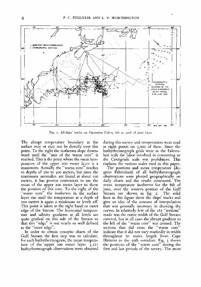
4 F. C. FUGLISTER AND L. V. WORTHINGTON
The abrupt temperature boundary at the surface may or may not be directly over this point. To the right the isotherms slope down- ward until the “axis of the warm core” is reached. This is the point where the mean tem- perature of the upper 200 meter layer is a maximum. Actually the “warm core” reaches to depths of 300 to 400 meters, but since the maximum anomalies are found at about 100 meters, it has proven convenient to use the mean of the upper 200 meter layer to show the position of this core. To the right of the “warm core” the isotherms in the surface layer rise until the temperature at a depth of 200 meters is again a minimum or levels off. This point is taken as the right hand or outer edge of the Stream. The horizontal tempera- ture and salinity gradients at all levels are quite gradual on this side of the Stream so that this “edge” is not nearly so well defined as the “inner edge”.
In order to obtain synoptic charts of the Gulf Stream the first step was to calculate, for each bathythermogram, the mean tempera- ture of the upper 200 meter layer. 3,521 bathythermograph observations were obtained
during this survey and temperatures were read at eight points on 3,000 of these. Since the bathythermograph grids were in the Fahren- heit scale the labor involved in converting to the Centigrade scale was prohibitive. This explains the various scales used in this pa er.
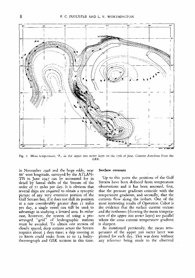
The positions and mean temperature pde- grees Fahrenheit) of all bathythermograph observations were plotted geographically on daily charts and the results contoured. The mean temperature isotherms for the 8th of June, over the western portion of the Gulf Stream are shown in fig. 2. The solid lines in this figure show the ships’ tracks and give an idea of the amount of interpolation that was generally necessary in drawing the curves. In relatively few of the 165 “sections” made was the entire width of the Gulf Stream covered, but in all cases the abrupt gradient to the left of the “warm core” was crossed. The sections that did cross the “warm core” indicate that it did not vary markedly in width throughout its entire length from Cape Hatteras to the 50th meridian. Fig. 3 shows the positions of the “warm core” during the first and last periods of the survey. The most

5 SOME RESULTS OF A MULTIPLE SHIP SURVEY OF THE GULF STREAM
Fig. 2. Mean temperature, OF., in the upper zoo meter layer of the Gulf Stream, on the 8th of June 1950.
striking feature of this chart is, of course, the two large waves and the deep trough separating them in the center of the area. After the 12th of June the chief emphasis of Operation Cabot was to observe the changing conditions in and around this trough. As shown in the figure, the trough eventually “broke off” from the Stream forming, as it did so, an elongated cyclonic eddy to the south.
Although Operation Cabot was the first survey to cover the entire distance from off Cape Hatteras to 50’ west longitude, other shorter surveys, show that large waves in the Gulf Stream may occur over a wide range of longitude and that conditions, such as those found on “Cabot” are not exceptional. Fig. 4 is a composite picture, showing the positions of the maximum horizontal temperature gra-
Fig. 3 . Positions of the “warm core” of the Gulf Stream during the first and last periods of Operation Cabot.
dient at a depth of IOO meters, as obtained on all Gulf Stream surveys made since 1946. Be- sides the numerous large waves, this diagram shows another elongated, cyclonic eddy cen- tering at 66” west similar to the one found on Operation Cabot.
The variable positions of the major waves in the Stream is stressed here because, during Operation Cabot, there was a strong feeling aboard the flagship that the bottom topo- graphy, near 39” north, 61’ west, was the primary cause of the deep trough that existed in this area. Further investigation may show that the series of ridges and seamounts in this Iocality always affect the course of the Gulf Stream, but the occurrence of large waves and eddies in regions where the bottom is relatively flat indicates that bottom topo- graphy must be of secondary importance 3n the formation of such phenomena.
Temperatures of the warm core
Throughout the entire length of the Gulf Stream the mean temperature of the upper 200 meter layer in the warm core was greater than 68” F. An unpublished technical. report by FUGLISTER on the monthly average tempera- tures in the region south of the Stream and north of Bermuda shows the mean temperature for this layer in June to be 67.8’ F. Since the Stream moves in an easterly direction for a

6 F. C. FUGLISTEK AND L. V. WORTHINGTON
Fig. 4. Positions of thc tiiaxi~iiiini C ~ O S T - C L I ~ ~ C I ~ ~ tcinpcraturc gradicntc at a dcpth of IOO mcters, from all survcys, 1946 tu 1950.
distance of about 1,200 miles it is evident that it must transport over this cntirc distance water from more southcrly latitudes.
The incaii tcnipcratnrc a t thc axis of the “warm core” ranged from 68.3” F. to 75.5’ F. As can be seen in fig. 2 tlicsc tctiipcraturcs did not decrease unifornily down strcam but what might be called “gobs” of wariiicr water showed up at intervals along the Stream. These “Sobs” were obscrvcd as far cast as the 57th meridian. The niorc consistent teiiipcratures on citlicr side of the “warni core” indicate that thcsc “gobs” arc not caused by internal wave action. If this is true tlicn thcse iiiasscs of warnicr water, appearing a t intervals in the Strcam, niay be evidence of a pulsing action in tlic currcnt which in turn may have a bearing on the formation o f waves and cddics. Tlic pulsing could con- ceivably bc caused by short period variations in the strength of the Trades or in variations
in tlic barometric pressure over the Gulf of Mexico. If a series of temperature sections, say two a day for a period of a month, could bc run across the Straits of Florida some of thcse spcculations could bc checked. An exami- nation of existing bathythermograph sections in tlic Florida current between Key Wcst and Cape Canaveral has not rcvcaled any “gobr)’ but it is not possible, in view of the inadequacy of tlic data, to concludc that they do not occur thcrc.
Rate of change in the position of the Stream
In the first period of the survcy four ships entered tlic Gulf Stream off Cape Hattcras at 14 hour intervals. During this interval the Stream shifted, at this point, at a rate of 4.5 niiles a day toward the southcast. Nuinerous

SOME RESULTS OF A MULTIPLE SHIP SURVEY OF T H E GULF STREAM 7
Fig. 5. Positions of thc Gulf Strcani in thc wcstcrn portion of the survey at the beginning and end of the operation. Mean tcnipcrature, 'F., of the upper zoo meter layer, for rhc Srh of June solid lines; for the zIst and zznd of
June dashed lines.
sections made near 7 2 O west showcd that the crest of the first wave in the path of the Stream moved toward the east at a rate of approximately 11 miles per day. The overall change in positions of the western portion of the Stream, from the 8th to the zznd of June, is shown in fig. 5 . The daily synoptic charts, of the mean temperature in the upper 200 nietcr layer, show that all the changing positions of the Stream can be accounted for by lateral movements of not over 11 miles per day. The synoptic charts for the 18th and 19th of June, for the region around the trough (see fig. 6 b), may at first glance indicate a lateral movement more rapid than 11 miles per day if the motion is considered as a north- south one. Actually the water on either side of the trough converged at a rate less than I I miles pcr day in cutting off the cyclonic eddy to the south.
Various changes in the Gulf Stream posi- tion, are shown in fig. 5 , 6 a, and 6 b. Considering the huge volume of the Stream, this shifting of its position by as much as 11 miles per day must produce large vertical motions in the water masses adjacent to the Stream. Although the evidence for these shifts in the Stream is based on observations of the upper zoo meter layer, a sufficient number of deep stations were made during Cabot and other recent Gulf Stream surveys to show that the water at least down to 2,000 meters is affected.
Because of the above measurements it is now possible to evaluate, with more confi- dence, the results of earlier Gulf Stream surveys made with single ships. The changes in positions of the Stream as found by the Canadian Research Vessel NEW LISKEARD
Fig. 6 a. Positions of the Gulf Stream, 10th to 15th June. Shaded areas denote a incan temperature in the upper zoo meter layer of less than 65" F. Thin line is 68" F. isotherm. Small numbers indicate the maximum observed
values of the warin core.
Fig. 6 b. Positions of the Gulf Stream, 16th to 20th June. Shaded areas denote a mean temperature in the upper ZOO meter layer of less than 65' F. Thin line is 68" F. isotherm. Small numbers indicate the maxiniuni
obscrvcd values of the warn] core.
8 F. C. FUGLISTER AND L. V. WORTHINGTON
‘ Y
a1 .,. Fig. 7. Mean temperature, ‘F., in the upper zoo meter layer on the ~ 7 t h of June. Current directions from the
GEK.
in November 1948 and the large eddy, near 66” west longitude, surveyed by the ATLAN- TIS in June 1947 can be accounted for in detail by lateral shifts of the Stream of the order of 11 miles per day. It is obvious that several ships are required to obtain a synoptic picture of any very extensive portion of the Gulf Stream but, if it does not shift its position at a rate considerably greater than 11 miles per day, a single vessel can still be used to advantage in studying a limited area. In either case, however, the system of using a pre- arranged “grid” of hydrographic stations must be avoided. To obtain one section of closely spaced, deep stations across the Stream requires about 3 days time; a ship moving at 10 knots could make from 10 to I4 bathy- thermograph and GEK sections in this time.
Surface currents
Up to this point the positions of the Gulf Stream have been deduced from temperature observations and it has been assumed, first, that the pressure gradients coincide with the temperature gradients, and secondly, that the currents flow along the isobars. One of the most interesting results of Operation Cabot is the evidence that the surface current vectors and the isotherms (showing the mean tempera- ture of the upper 200 meter layer) are parallel where the cross current temperature gradient is sharpcst.
As mcntioned previously, the mean tem- perature of the upper 200 meter layer was plotted for each day. This was done without any refercnce being made to the observed
SOME RESULTS OF A MULTIPLE SHIP SURVEY OF THE GULF STREAM 9
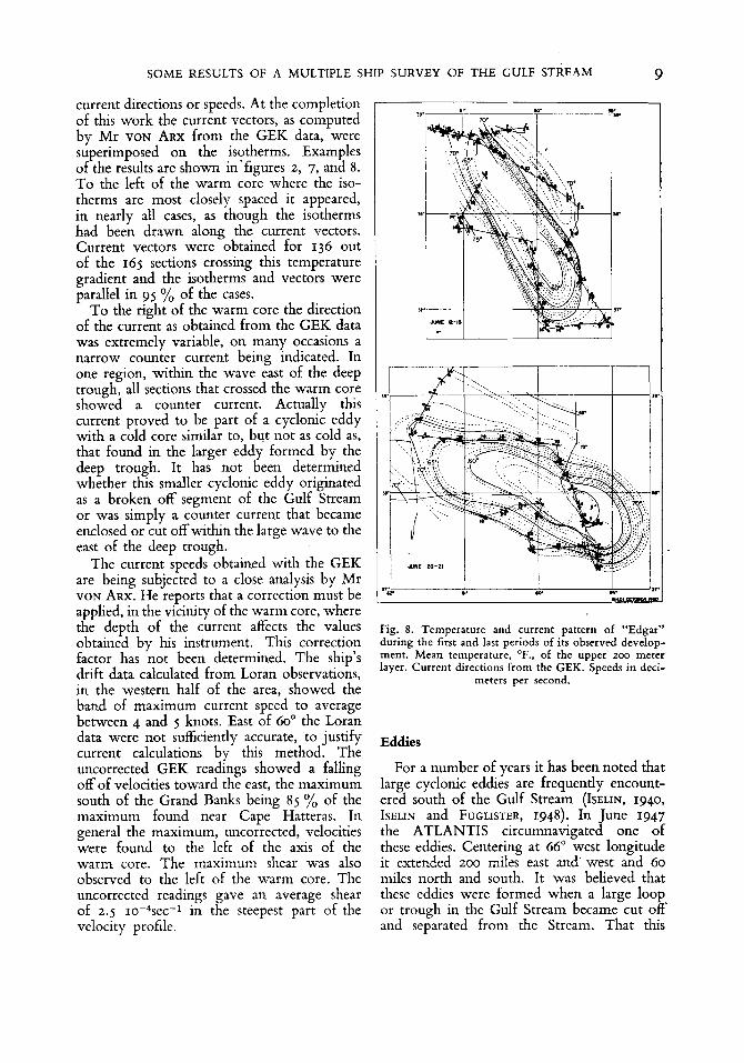
current directions or speeds. At the completion of this work the current vectors, as computed by Mr VON ARX from the GEK data, were superimposed on the isotherms. Examples of the results are shown in'figures 2, 7, and 8. To the left of the warm core where the iso- therms are most closely spaced it appeared, in nearly all cases, as though the isotherms had been drawn along the current vectors. Current vectors were obtained for 136 out of the 165 sections crossing this temperature gradient and the isotherms and vectors were parallel in 95 yo of the cases.
To the right of the warm core the direction of the current as obtained from the GEK data was extremely variable, on many occasions a narrow counter current being indicated. In one region, within the wave east of the deep trough, all sections that crossed the warm core showed a counter current. Actually this current proved to be part of a cyclonic eddy with a cold core similar to, but not as cold as, that found in the larger eddy formed by the deep trough. It has not been determined whether this smaller cyclonic eddy originated as a broken off segment of the Gulf Stream or was simply a counter current that became enclosed or cut off within the large wave to the east of the deep trough.
The current speeds obtained with the GEK are being subjected to a close analysis by Mr VON ARX. He reports that a correction must be applied, in the vicinity of the warm core, where the depth of the current affects the values obtained by his instrument. This correction factor has not been determined. The ship's drift data calculated from Loran observations, in the western half of the area, showed the band of maximum current speed to average between 4 and 5 knots. East of 60" the Loran data were not sufficiently accurate, to justify current calculations by this method. The uncorrected GEK readings showed a falling off of velocities toward the east, the maximum south of the Grand Banks being 85 % of the maximum found near Cape Hatteras. In general the maximum, uncorrected, velocities were found to the left of the axis of the warm core. The maximum shear was also observed to the left of the warm core. The Uncorrected readings gave an average shear of 2.5 10-*see-1 in the steepest part of the velocity profile.
1 I 1
Y
Fig. 8. Temperature and current pattern of "Edgar" during the first and last periods of its observed develop- ment. Mean temperature, O F . , of the upper 200 meter layer. Current directions from the GEK. Speeds in deci-
meters per second.
Eddies
For a number of years it has been noted that large cyclonic eddies are frequently encount- ered south of the Gulf Stream (ISELIN, 1940, ISELIN and FUGLISTER, 1948). In June 1947 the ATLANTIS circumnavigated one of these eddies. Centering at 66" west longitude it extended 200 miles east and west and 60 miles north and south. It was believed that these eddies were formed when a large loop or trough in the Gulf Stream became cut off and separated from the Stream. That this
I 0 F. C . FUGLISTER AND L. V. WORTHINGTON
was indeed tlic case is shown by the obscrva- tions made on Opcration Cabot.
The day by day changcs in the Gulf Stream’s coiirsc in and around tfic trough at 6i0 west longitude arc shown in fig. 6 a and 6 b. In thesc figures tlic water with a nican tan- pcrature, in thc upper 200 meter layer, of lcss than 6j0 F. is indicated by shading. Thc hcavy linc is the 65’ F. isotherm, thc light linc the 68” F. isotherm. The light lincs arc the approximate boundaries of tlic warm core. The niaxiniuiii surface currents wcre observed wherc thesc two isotherms (the 65’ and 68”) are shown close togcthcr, in other words thc maximum spceds appcarcd to tlic left of the warm corc. Dctails of thc tcinpcrature and current pattern arc shown in fig. 7 and 8.
For how long a pcriod the trough cxisted bcforc tlic 10th of J L I I ~ C is not known but it is surprising that, considering the narrowncss of the “neck”, it took ninc days for it to brcak off. During this pcriod tlic long narrow “neck” was nicandcring on a relatively small scale and tlic temperature characteristics in the cold central portion wcrc continuously chang- ing. Since thcrc is comparatively little hori- zontal flow associatcd with the cold corc these temperature changcs must indicate vertical motion. On three occasions temperature profiles across the “neck” indicated that it was about to break off but each time subse- quent obscrvations showed thc recurrence of colder water in the upper 200 meter layer. Thc final- occlusion in this shallow layer occurred on tlic 19th of June and on tlic 20th a deep hydrographic station showed that thc break had occurred a t all levels.
Even bcforc it broke off, thc eddy, which was christcncd “Edgar” during the cruise, started to turn so that at tlie end of the survey its niajor axis was oriented cast and wcst.
Thc sinallcr cyclonic eddy northcast of “Edgar” was crossed six times. Details of its size and shape arc lacking but there is cnongh cvidcncc to show that during the pcriod it shrunk in size and inovcd steadily toward tlic northwcs t.
The following questions concerning tlicsc eddies wcre left unanswered by Operation Cabot. Do thc eddies once they have broken away from tlic Strcani move, and if so in what direction? How long do they last?
Are elongated eddies typical? Do elongated cddics eventually break up into smaller, inore nearly circular I I I ~ S S C S ? Is there any preferred point o f origin? If i,t is assumed that the region wherc “Edgar” was formed is such a “pre- ferred point of origin”, because of thc ridges and seainounts, then the detached cddics must frcquently niovc in an upstrcain dircction, sincc tlicy liavc been found as far wcst as 73O wcst longitude. If on the other hand we assume that tlic dctaclicd cddics remain motionless or move down stream then it is cvcn more difi- cult to explain how an eddy such as “Edgar” could be formed in the relatively confined area near Cape Hatteras or south of it. All tlie available data show that thc Gulf Stream does not start to nicandcr until after it leaves the continental shelf at Hatteras.
An envclopc drawn about the curves shown in fig. 4 indicatcs that it is not until thc Strcaiii reaches at least as far cast as thc 70th meridian tliat waves largc enough to form an cddy could dcvclop. hidccd, such an envclopc would iiiakc it appear that, if waves of the size of those found on Operation Cabot are necessary to form an eddy, then they do not develop until the Stream reaches close to thc longitudc whcrc “Edgar” was formed.
Thcsc considerations combined with what is known of the bottom topography indicate that thc eddies formed by tlic Gulf Stream originatc to the cast of 63’ west longitude and after being detached move in an upstream direction.
Possible branching of the Gulf Stream
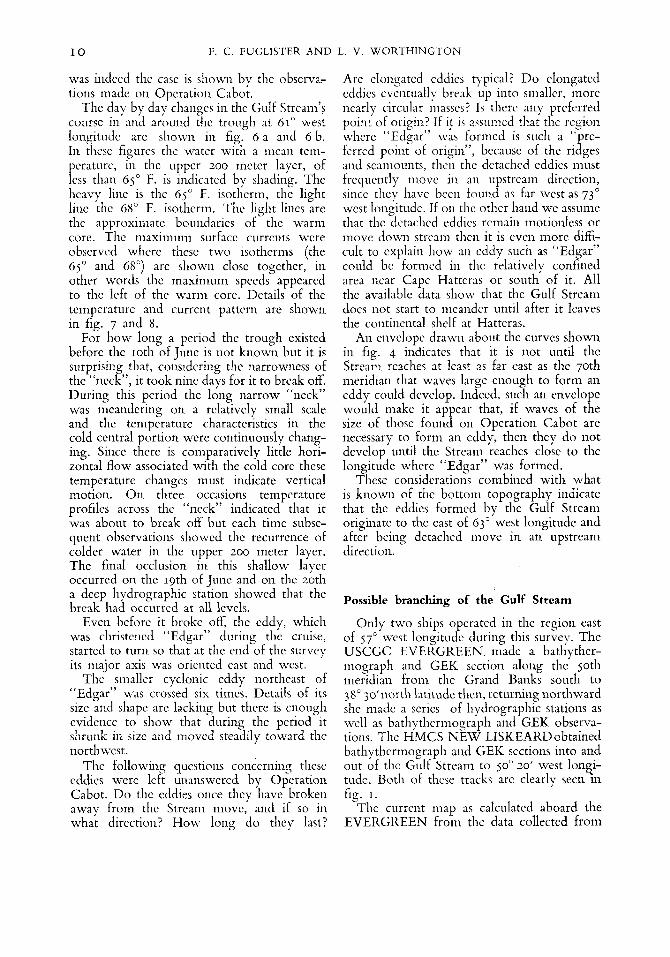
Only two ships operated in tlic region east of 57‘ wcst longitude during this survcy. Thc USCGC EVERGREEN made a bathyther- mograph and GEK section along thc Soth nieridian from tlie Grand Banks south to 38” 3o’iiorth latitude then, returning northward she inadc a scrics of hydrographic stations as well as bathytlicriiiograyli and GEK observa- tions. The HMCS NEW LISKEARDobtaiiicd bathythermograph and GEK scctions into and out of the Gulf Stream to 50‘ 20’ west lon6i- tudc. 130th of these tracks arc clearly seen in fig. I.
The current niap as calculated aboard the EVERGREEN froin the data collected from
SOME RESULTS OF A MULTIPLE SHIP SURVEY OF THE GULF STREAM I 1
thc 9th to thc 20th of June is shown in fig. 9. At about 4zG north the EVERGREEN crosscd a warm currcnt flowing toward the east. This current was, in cvcry rcspcct, similar to thc currcnt that thc Ice Patrol finds ncar this latitude cach ycar. This current is rcfcrrcd to as thc North Atlantic current (SOULE, 1938). Continuing south the EVERGREEN crossed a minor counter currcnt near 40' north and thcn at 3 9 O it cntercd another easterly stream. Tlircc days latcr the NEW LISKEARD showcd that thc Southernmost current was thc Gulf Stream which she had followed con- tinuously from thc wcst.
hi August and again in September 1949 thc Gulf Stream was located by the ATLANTIS at thc 39th parallel south of the Grand Banks. An unpublishcd chart of the average depth of the IOO C. isotherm in the North Atlantic indicates that the Gulf Stream is south of 40° at this longitudc. On the basis of these data and thc rccords of the Ice Patrol it seems evident that at 50' west longitudc there are always two easterly currents of major magni- tude, onc gcnerally located near 4 1 O north the other at about 39' north. According to tlic definition givcn for the Gulf Stream it is quite cvident that the southernmost current is the Stream. The data from Operation Cabot shows clearly that it forms part of a continuous current rcaching from Cape Hat- teras to joo wcst longitudc. What then is the origin of the current to the north and in what way are thesc two current related? Is the one to the north a band or a branch of the Gulf Stream or is it cntirely independent of thc Stream?
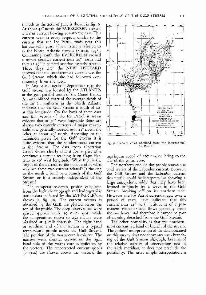
The tcmpcraturc-depth profile calculated from the bathythcrmograpli and hydrographic station data collcctcd by the EVERGREEN is shown in fig. 10. The current vectors as obtained by the GEK are plotted across the top of thc profile. Thc deep observations wcrc spaccd approximately 30 milcs apart whilc the teniperatures down to 2 jo meters wcrc obtained at j milc intervals. The right hand or southcrn end of thc scction is a typical tempcraturc profile across the Gulf Stream. The position of the warm corc is cvidcnt. Thc narrow wcak counter current on the rieht hand side of tlic warm core is indicated by thc vcctors. Thc uncorrected current speeds (an 'sec) arc shown above the vectors, the
Fig. 3. Current chart obtained from the Intcrnational Ice Patrol.
maximum speed of 167 cm/scc being to the lcft of the warm corc.
Thc northern end of the profile shows the cold watcrs of the Labrador current. Between the Gulf Strcam and the Labrador current this profile could be interpreted as showing a large anticyclonic eddy that may have been formcd originally by a wave in the Gulf Strcam brcaking off on its northcrn side. Howevcr the Ice Patrol current maps, over a period of years, have indicated that this currcnt ncar 41' north latitude is of a pcr- nianent character and flows generally from thc northwest and therefore it cannot be part of an cddy dctached from thc Gulf Strcam.
Thc other possibility is that the northcrn- most current is a band or branch of tlic stream. Thc authors' intcrprctation of tlic data obtained on this survey does not show any such brancli- ing of thc Gulf Stream although, bccausc of the relative scarcity of observations east of the 58th meridian, it does not precludc tlic possibility. Thc most simple interpretation is

12 F. C. FUGLISTER AND L. V. W O R T H I N G T O N
I000 \ n
0 , . x1 .o M"TIC.L l l L E S
WRT" - SOJTM . - ~ -. .. __ .. . . .. ~~~~
1200 . m -T- EPIST WEST EAST
GULF STREIM LABRADOR "WARM. CURRENTS wno, D C I W E R 1 9 M
Fig. 10. Temperature, "F., profile from the Grand Banks south on thc 50th meridian. Bascd on combined bathy- thermograph and hydrographic data. Current directions from GEK and vclocities in ccntimctcrs per second. Scc
fig. 9 for station positions.
that the northernmost current coincides with the pressure gradient between the slope water and Labrador current water and the two easterly currents at jo" west are independent of each other.
Other observations
The continuous sonic depth records obtained during the survey have been turned over to the U. S. Navy Hydrographic Oflice to be incorporated in their bottom topography charts. During the cruise the U.S.S. SAN PABLO surveyed two scamounts not shown on the Hydrographic Offce charts. The first located at approximately 38" 54' north and 60" 28' west had a least depth of 725 fathoms. This was tentatively named San Pablo Seamount. Thc second at approximately 37" 29' north and 59" 52' west was flat-topped
with an elongated zone some 8 miles long and 3 miles wide, and less than 700 fathoms. The minimum recorded depth was 675 fathoms. This was tentatively named Cabot Seamount. Both seamounts were explored by running at least three sections across them on different headings. The seamount shown on the charts at approximately 39" 00' north and 61'00' west was found to have depths somewhat less than indicated and that it too was flat-topped at a depth of about 500 fathoms.
Some excellent colored photographs showing shear zones, long thick lines of Sargassum, abrupt changes in wave types, clouds and color changes associated with the Gulf Stream were obtained from the aircraft. The reports of the Stream's positions, based on such visual evidence, were gencrally in close agrceinent with shipboard observations. The abrupt changes in the appcarance of the sea

SOME RESULTS OF A MULTIPLE SHIP SURVEY OF THE GULF STREAM I 3
surface did not however always coincide with the inner edge of the Gulf Stream as defined in this paper. Although dye marker experi- ments carried out by the plane showed clearly that the visual boundary was both a velocity discontinuity and a line of convergence, the ships’ observations showed that there may be more than one such surface boundary, none of which necessarily coincide with the inner edge of the Stream.
Near 41’ 00’ north 63’ 00‘ west, while following a long dense line of Sargassum, the plane encountered the U.S.S. SAN PABLO as it was crossing from south to north through the line of weed. The temperature-depth profile as obtained by the ship on this section is shown in fig. 11. The line of Sargassum indicated convergence at the sea surface. Visual observations of the ship’s wake and GEK data showed that there was an abrupt change in velocity at this line but both the temperature profile and the GEK showed that the ship was still in the current after it had passed to the north side of the weed. Fig. I I shows that the line of Sargassum was about 5 miles from the abrupt temperature change at the surface and about 20 miles from the “inner edge” of the Gulf Stream as defined by the pressure gradient.
Color differences associated with the Gulf Stream were apparent to the plane only in the westernmost area, west of 71’ west longitude. East of this point lines of weed, differences in wave type, and formations of “typical” Gulf Stream cumulus clouds had to be dep.ended upon to locate the Stream. Neither the cumulus clouds nor the weed were always present and the wave patterns, of course, depended on the wind velocities and were most pronounced with moderate winds blowing against the current. In general, visual observations failed to identify the Stream east of the 65th me- ridian.
The authors hope that Mr KIELHORN, the observer on the lane, or the Hydrographic Ofice will publis! a complete report on the aircraft participation in O eration Cabot reproducing some of the exce lr ent photographs obtained .
The large amount of weather data collected by the pIanes and shi s during the survey have not as yet been stuxied. These data, the sea surface temperature data and more details of
Fig. 11. Temperature profile across the Gulf Stream, 10th of June 1950.
the surface current data will form the basis of future reports.
Summary
Operation Cabot, the first oceanographic survey of its kind to date was successful mainly because :
(a) Communications were maintained be- tween all ships and the flagship throughout the survey, enabling the staff aboard the flagship to direct and coordinate the move- ments of the various vessels as the synoptic picture of the Gulf Stream developed.
(b) Instruments for taking numerous and rapid measurements were available; Loran for navigation, the bathythermograph for water temperatures, the geomagnetic electrokineto- graph for current velocities, and the planes for visual observations of the Gulf Stream’s positions.
(c) Highly qualified scientific personnel were available to man the six ships and the plane.
In this paper the Gulf Stream has been defined as the continuous band, reaching from the continental shelf off Cape Hatteras to the 50th meridian, where a pronounced pressure gradient exists between the warm, highly saline water to the south and the colder, fresher water to the north. The inner and outer edges of the Stream are the points where this pressure

14 F. C. FUGLISTER A N D L. V. W O R T H I N G T O N
gradient bccoiiics zero. Abrupt cliangcs in teinperaturc and current vclocities that occur at the surfacc do not necessarily coincide with thcsc boundarics.
Daily synoptic plots of thc Gulf Strcain show that thc currcnt may shift its position at a rate of 11 milcs per day. Two synoptic plots of thc Strcam are shown, one for the first and one for the last periods of the survey. The outstanding feature of thc first plot is thc two largc wavcs separated by a deep trough ncar 61" west. The sccond plot shows that thc trough bccanic cut off and formed a cyclonic cddy south of tlic Gulf Stream. Thc brcaking off of thc trough was observcd in detail and coiifirmcd the thcory that tlie large cyclonic eddies frequently found south of thc Gulf Strcam are formcd in this manner.
A smaller, weaker cyclonic cddy was observed to tlic East of the deep trough. Although it is assumcd that this cddy was formed in tlic sanic manner as the larger one, it is pointed out that it may be a portion of the counter currcnt found on the outer side of the Stream, that bccamc cnclosed and cut off within tlic largc wavc cast of tlie dccp trough.
Eddics are probably always formcd when the waves in the Gulf Strcam reach a ccrtain optimum sizc. It is cstimated that tlic wavcs caiinot bccoinc largc cnough to form eddies wcst of longitudc 70' and probably not west of longitude 63". Thcrc is the further possibility that the wavcs only rcach this critical sizc in regions whcre ridgcs in the bottom topo- graphy affect the course of the Stream.
Therc is cvidcncc that the cyclonic cddies broken off to tlic south of the Stream movc in a westcrly or upstrcam dircction.
Thc surfacc currciits arc shown to flow parallel to thc isotlicrms whcre these isothcrms are closcly spaccd in thc region to tlic lcft of the warm corc of thc Gulf Stream. In the right hand portion of this corc thc currcnt dircctioiis arc variablc, frequently showing a narrow wcak countcr current.
Temperatures of thc warm core indicatc that thc Gulf Stream transports watcr from south of Cape Hattcras to tlic longitudc of thc Grand Banks, thc mcan tempcraturc of thc uppcr 200 nictcr layer decrcasing approxi- mately 6" F. ovcr this 1,200 inilc distance. Gobs" of warnicr watcr, possibly indicating
a pulsing action in tlic Strcam, wcrc found at intervals in the warm corc from Capc Hattcras to 57' wcst longitudc.
To tIic south of the Grand Banks two eastcrly currcnts arc found and thc southern one is shown to be the Gulf Strcam. No evideiicc was obtained on this survey to show that tlic northcrly currcnt was in any way connected with the Gulf Stream.
I ,
Acknowledgements
Obviously this, or any otlicr paper to be published dcaliiig with Opcration Cabot owes its existcncc to the efforts of tlic scientists and scanicn who took part in the survey. Thc authors wish to thank tlmc inen, and also Dr ROSSBY of the University of Chicago. Dr ISELIN and Mr STOMMEL of the Woods Hole , Occauographic Institution for their many helpful suggestions. Thanks arc also duc to Miss EVANGELINE TOLLIOS and Mr COLUMBUS ISELIN Jr who did such a fine job of plotting and calculating.
R E F E R E N C E S
VON ARX, WILLIAM S., 1950: An Elcctroniagnetic Mcthod for Measuring thc Velocities of Ocean Currcntc froin a Ship Under Way. P o p s iri Pliysicol Oceomyoplry nrrd h.f~~teorology. Vol. XI, 3, pp. 1-62.
CHURCH, PHIL. E., 1937: Teniperaturcs of the Western North Atlantic from Therniograph Records. Publ. Scierit$qric, 4, pp. 1-32,
ISELIN, C. O'D., 1940: Preliminary Report on Long- Period Variations in the Transport o f the Gulf
Strrtam Systeiii: Pqwrs i t i Physicnl Orenrtoyopliy orrd
ISELIN, C. O'D, and FUGLISTER, FREDERICK C., 1948: Sonic Rcccnt Developments in thc Study of the Gulf Stream. Scors Foirrrd., Joirr. M o r . Rcs., 7, 3 , pp. 3 17-329.
SDULE, FLOYD M., 1938: Occanography Excerpt from Intcrnational Ice Observation and Ice Patrol Service in thc North At!antic Occan, Season of 1937. U. S. Const Giiard Brit!., 27, pp. 71-126.
.bfC'fCOr~JlOfy, 8 , I , pp. 1-40,