gulf stream note #2 2017 - marion bermuda race · 2017-05-25 · 1 gulf stream note #2‐ 2017 the...
TRANSCRIPT

1
Gulf Stream Note #2‐ 2017 The Gulf Stream in the Vicinity of the Rhumb Line Newport to Bermuda May 24, 2017 An Analysis of Conditions
W. Frank Bohlen Mystic, Connecticut Bohlen @uconn.edu Since the first week in May satellite views of the Gulf Stream in the vicinity of the Newport-Bermuda rhumb line have been persistently limited by cloud cover. These conditions have provided graphic illustration of the need to begin study of conditions likely to be encountered during trips to or from Bermuda well before the departure date. With little more than a week to the start of the Bermuda 1-2 Race we were fortunate to get a relatively clear view of the Stream on the 19th (Fig.1). We were particularly interested to see how the main body meander and the cold core ring both affecting the rhumb line in early May (as discussed in Note #1) had changed. The image of 19 May shows the inshore boundary of the Stream crossing the rhumb line at a near right angle from west to east at a point approximately 210 nm from Newport. There is only slight indication of meandering across the rhumb line with the deep feature present in early May apparently displaced 60nm to the east (Fig.1). Further down the track towards Bermuda there is some slight indication of a cold core ring in the vicinity of 35o N 68o 15’ W or very close to the position observed in early May. Since this ring had over the past few months displayed a westerly drift this lack of significant movement over the past few weeks suggests that the feature was slowed by Stream associated flows making it subject to entrainment. Examination of the results of the altimetry based circulation model for the 21st (remember two days delay required for data processing) provides some evidence of this with a coherent ring centered near 35o N 68o 15’ N surrounded by a current field affecting nearly 250nm of the rhumb line (Fig.2). The ring itself represents a small portion of the affected area making it clearly subject to entrainment. The U.S.Navy/NOAA data for this period (Fig.3) provide no indication of a cold core ring adjacent to the rhumb line but rather show a significant lobe along the southern limits of the main body of the Stream along 37o N quite representative of an entrained feature. Flows along the northern margin of this lobe will tend to be east to west with an abrupt change to west to east near 37oN 68o 30’W.
The cloud cover that clearly briefly during 19 to 21 May has returned to limit views of the Stream over the past few days. Examination of the altimetry based model results shows continued erosion/entrainment of the cold core ring. By the 24th of May (Fig.4) the ring as a discrete stand-alone feature had disappeared. What remains is a relatively large U-shaped region centered on the rhumb line and extending to the southeast from the main body of the Stream for approximately 210 nm. Flows to the southeast dominate an area 60 nm to the west of the rhumb line while flows to the north and west dominate east of the rhumb line (Fig.4). In its present form the flow pattern clearly favors a course on or just to the west of the rhumb line for boats heading
2
to Bermuda. It will be interesting to see if this pattern holds for the next two weeks. In addition the rapid and substantial changes observed over the past weeks makes clear the need for boats returning from Bermuda to carefully monitor Stream conditions in order to avoid foul currents and/or an adverse sea state in the vicinity of the Gulf Stream.

Figure 1 Daily Composite Satellite SST Image ‐ May 19, 2017Black Line shows Rhumb Line Newport‐Bermuda
https://rucool.marine.rutgers.edu/
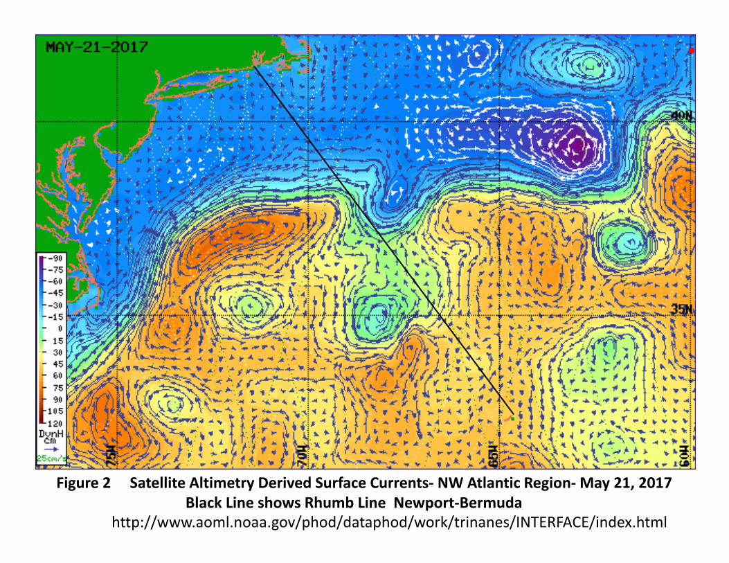
Figure 2 Satellite Altimetry Derived Surface Currents‐ NW Atlantic Region‐May 21, 2017Black Line shows Rhumb Line Newport‐Bermuda
http://www.aoml.noaa.gov/phod/dataphod/work/trinanes/INTERFACE/index.html

Figure 3 USN/NOAA Northwest Atlantic Ocean Features Analysis May 23, 2017https://ecowatch.ncddc.noaa.gov/JAG/Navy/data/satellite_analysis/gsnofa.gif?id=3110

Figure 4 Satellite Altimetry Derived Surface Currents‐ NW Atlantic Region‐May 24, 2017Black Line shows Rhumb Line Newport‐Bermuda
http://www.aoml.noaa.gov/phod/dataphod/work/trinanes/INTERFACE/index.html