some aspects regarding the territorial evolution … · of michael the brave, during his campaigns...
TRANSCRIPT

GEOGRAPHIA N
APOCENSIS AN. V
I , nr.
1/20
12
http:/
/geog
raphia
napo
censis
.acad
-cluj.
ro
Geographia Napocensis Anul VI, Nr. 1, 2012
65
SOME ASPECTS REGARDING THE TERRITORIAL EVOLUTION OF ODORHEIU SECUIESC TOWN
ADRIAN NIŢĂ1, GHEORGHE ROŞIAN2
ABSTRACT. – Some Aspects Regarding the Territorial Evolution of Odorheiu Secuiesc Town. By its geographical position, in a large depression on an intensely circulated valley corridor, Odorheiu Secuiesc town represented an important center among the settlements in the East of Transylvania. Since the relief was not a major restrictive factor, in the territorial evolution of the town the major role was played by its economical development and growth of the number of inhabitants. Along the centuries the settlement received important liberties, turning into an important administrative, commercial and education center. By the economical point of view, while in the other towns in the area the agriculture still represented the major weight, in Odorheiu Secuiesc intensely developed the crafts. For all that, the industrial development of the town took place only in the last half of the century, times when the town also experienced the most intense territorial extension.
Key-Words: relief, river terraces, town, industry, development.
1. The Archaeological Evidence The first settlement on the territory of
Odorheiu Secuiesc town is dating since the Aeneolithic. A layer of the Ariuşd-Cucuteni culture was discovered in Bud Fortress situated downstream the actual town, on the namesake hill, on the right bank of Târnava Mare River. The layer was overlapped by traces of habitation since the period of transition to the Bronze Age (Coţofeni Culture), the Bronze Age (Wietenberg culture), the first part of the Iron Age (Hallstatt) and the Dacians Age (The Archaeological Repertory of The Harghita County, 2000, p. 168 – 169). Though it is possible that some of these fortifications were older, the investigated elements belong to Dacians times (1st century B.C. – 1st century A.D.). Those times the fortress was intensively inhabited and it also represented a refuge place for the inhabitants of the large settlement at the foothills. When conquered, the fortification was destroyed by the Romans. Over its walls, in the 11th – 12th century were built up the ones of the medieval fortress (Bud Fortress), also with inhabiting traces.
The Roman settlement, with military and civil characteristics, developed about two kilometers upstream, underneath the actual town center. Moreover, in most cases the built area of the settlements in vicinity, documentary attested in the 14th century, overlaps the settlements of the Roman times. Like the Dacian settlement downstream, the Roman one had a large surface too, a sign of its high regional importance yet since then. The settlement had also thermae, considering the numerous pipe tubes discovered. The military constructions were represented by two towers found in the actual built up area of the town, and, most likely, a camp (castrum). Based on some archeological indirect evidence, the camp had existed on the place where in 1562 was built the second medieval fortress (Bató, 1998, p. 77).
Over the Roman settlement were discovered inhabiting traces dating since the 4th – 5th, 6th – 7th, 9th – 12th centuries, the 13th century and newer (The Archaeological Repertory of The Harghita County, 2000, p. 167 – 172). By the 7thcentury the Slavic element penetrated the area.
1 „Babeş-Bolyai” University, Faculty of Geography, Gheorgheni University Extension, Gheorgheni, Grădina Csiki,535500, Harghita County, Romania, e-mail: [email protected] 2 „Babeş-Bolyai” University, Faculty of Environmental Science and Engineering, Cluj-Napoca, Fântânele street, no. 30,400294, Cluj County, Romania, e-mail: [email protected]
GEOGRAPHIA N
APOCENSIS AN. V
I , nr.
1/20
12
http:/
/geog
raphia
napo
censis
.acad
-cluj.
ro
Adrian Niţă, Gheorghe Roşian
66
Romanian-Slavic cultural elements (Ipoteşti-Cândeşti culture) were archaeological identified in neighboring settlements, as Eliseni, Şimoneşti or Filiaş (The Archaeological Repertory of the Harghita County, 2000). Since then date both the name of Bud Fortress (from the Slavic name Budimir) and the name of the town, firstly attested as Vduorod/Oduorhel (from the Slavic dvor, meaning enclosed place). Both names indicate that during those times the settlement represented the residence of a local ruler, preserving its regional importance.
2. The Documentary Attestation and the Urban Evolution
Although the Odorhei Seat (Sedes judiciaria) is mentioned earlier in the documents (1301), the first documentary attestation of Odorheiu Secuiesc human settlement is in the 1332 – 1334 Papal bulls. During The Kingdom of Hungary the settlement is the Szeklers main administrative, military and juridical center: in 1357 it holds the first Diet of Szeklers, in the 15th century it sheltered the Szeklers Captain headquarter and starting 1505 there was established a court of appeal for all the settlements in the Szeklers seats. „It is assumed that Odorheiu Secuiesc would have been also the center of the Telegd Catholic Archdeaconate, which included the most of the Szeklers area” (Pál, 1999, p. 37). In 1485 the settlement is mentioned for the first time as fair (oppidum), the document mentioning older liberties, probably obtained from Sigismund of Luxemburg, the king who at the beginning of the century had started a policy of supporting and developing the towns in Transylvania.
In 1557 the town was exempt from tax, excepting those for the Ottoman Empire and in 1559 it was removed from the authority of Odorhei Seat. In the times of Gabriel Bethlen prince, the Szekler fairs received a new economic impulse. Except Târgu Mureş town, all the fairs had to pay a flat tax to the Ottoman Empire rather than a differentiated one. For all that, the main economic role among the Szeklers towns was for Târgu Mureş; Odorheiu Secuiesc town established itself more like an administrative and spiritual center.
After the Szeklers Rebellion in 1562, close to the center of the town and partially on the
former Roman camp, the princes of Transylvania built up „The Szekler Attacked Fortress”, for a better supervision of the people. Its homologous in the Carpathian depressions in the East of Transylvania was „The Szekler Lied Fortress”, built up at Leţ, in the Braşov Depression. Both fortresses were demolished by the Szeklers, allies of Michael the Brave, during his campaigns of conquest in Transylvania. The one in Odorheiu Secuiesc was built up again by the princes until the first half of the 17th century, in order to be destroyed for good during the Kuruk Rebellion.
Consequence of the important administrative function of the town, it developed intensely the fair (attested in 1592) and the crafts here. In the medieval times the crafts were directly linked to processing agricultural resources in the area, especially the animal ones.
Starting the times of the Principality of Transylvania, Odorheiu Secuiesc became one of the main education centers in the Transylvanian Depression. The beginning of the education in the town, in the 15th century, seems to be connected to the Dominican monastery here. At the end of the next century was established the basis of Reformed education too. In 1591, besides the Jesuits Order, was organized the Roman Catholic education. In 1871 was founded the third superior school, The Superior Real Studies School. „The last two decades of the 19th century were prolific in founding new schools. Those times Odorheiu Secuiesc consolidated its «town of the schools» status; there were founded different schools of specialties. Except the elementary schools and the three superior schools mentioned, in 1880 was founded The Crafts and Trade School, in 1884, The Girls School, middle school with four classes, in 1893, The State Industrial School for Clay and Stone Processing. In 1889, 179 disciples were attending the night classes of the apprentice school.” (Pál, 1999, p. 312).
After 1848 the town was equipped with a new hospital (the first one dated since the beginning of the 18th century), in 1868 with a royal courthouse, and after the territorial administrative reorganization it became the capital town of Odorhei County (1876). Although Odorheiu Secuiesc consolidated its position as an important cultural and administrative center and in 1888 it was connected to the railway network, the
GEOGRAPHIA N
APOCENSIS AN. V
I , nr.
1/20
12
http:/
/geog
raphia
napo
censis
.acad
-cluj.
ro
SOME ASPECTS REGARDING THE TERRITORIAL EVOLUTION OF ODORHEIU SECUIESC TOWN
67
industry barely managed to pass the crafts stage. At the beginning of the 20th century the industry in Odorheiu Secuiesc was represented especially by factories processing local agricultural resources (alcohol, beer and a slaughterhouse) or producing timber, tile and brick.
The important administrative function made that, by the beginning of the 20th century, the town to advance edilitarely by paving some streets (35 streets, namely 91.6 thousands sqm) and sidewalks (15 sidewalks in surface of 11.6 thousands sqm), by planning a public park and The Szejke Spa, by introducing the electricity (1908), the public lighting (a 4 km network) and the sanitation service (Pál, 1999). During 1890 – 1892 was built up the town hall, a symbol of the municipality, in eclectic style.
The real industrial development of Odorheiu Secuiesc town took place in the postwar period, during the communist regime. The big industrial units were developed on the foundations of the traditional craft unions, organized after World War II. The main factories built were „The Furniture Factory”, „The «Tehnoutilaj» Enterprise” (producing machinery and equipment for food industry), „The Garment Factory”, „The Enterprise of Molds and Castings of Iron”, „The Thread Enterprise and The Cotton Mill”. After 1990 were founded new industrial units, some of them by separation from the older ones, with activities in lumbering, production of refrigeration equipment, glass making (including technical glass), plastics production, ready-made clothes, printing industry, informatics.
3. The Territorial Evolution
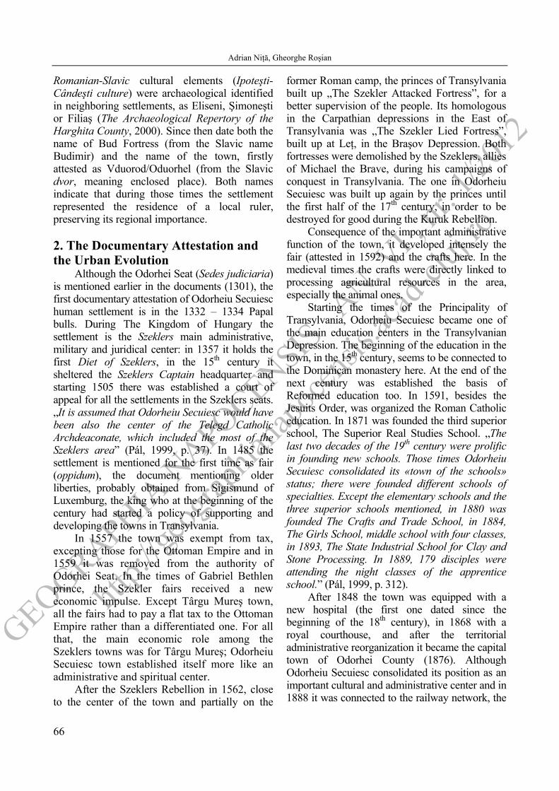
The high age and importance of the town led to a complex territorial evolution. The actual center overlaps the Roman settlement, developed on the first two terraces of Târnava Mare River. Still, the intense inhabiting afterwards made the archaeological evidence pretty scattered.
Similar to the other towns in Târnava Mare Corridor, in Odorheiu Secuiesc too the territorial evolution was considerably influenced by relief. By the position in the Odorheiu Secuiesc Depression, the territory of the town presents a specific relief; the landform consist of leveling surfaces and erosive and structural stands (with inter-stream role), slopes, river terraces and the meadow.
From the point of view of geomorphology, the Odorhei Depression is a typical Subcarpathian one. Upstream (in the East) it is delimited by ridges and erosive and structural stands, specific to the volcanic conglomerates plateau: the hills Piatra Tarcăi, 886 m, Dealul Mare, 851 m, and Cherţu, 670 m (Mac, 1972). Downstream (in the West), it is delimited by the hills Rez, 933 m, and Pietriş, 839 m. Since the surface of the depression is positioned at 480 – 500 m, the hills dominate it by 300 – 400 m.
In the gradual extent of the settlement, the meadow, the river terraces and the lower sector of the slopes presented high importance.
450
500
550
600
650
0 1 2 3 4 5
Târnava Mare River
H (m)
L (km)
SN
Center of OdorheiuSecuiesc Town
■
Fig. 1. Transverse Geomorphologic Profile, on Târnava Mare Valley, at Odorheiu Secuiesc. Among the most favorable landforms for
human activities stand out the Târnava Mare River terraces. Their position in the Odorhei Depression
is as follows: t1 4 – 6 m, t2 8 – 15 m, t3 18 – 24 m, t4 50 – 65 m, t6 75 – 85 m, t7 100 – 120 m (Mac, 1972). Still, it should be noted that they are

GEOGRAPHIA N
APOCENSIS AN. V
I , nr.
1/20
12
http:/
/geog
raphia
napo
censis
.acad
-cluj.
ro
Adrian Niţă, Gheorghe Roşian
68
unequally developed and poorly preserved. The exception is the 50 – 65 m terrace which, besides its considerable spatial extent, has also a bilateral development.
Transversally [Fig.1], one can observe the asymmetry of the corridor, with a more inclined slope on the right.
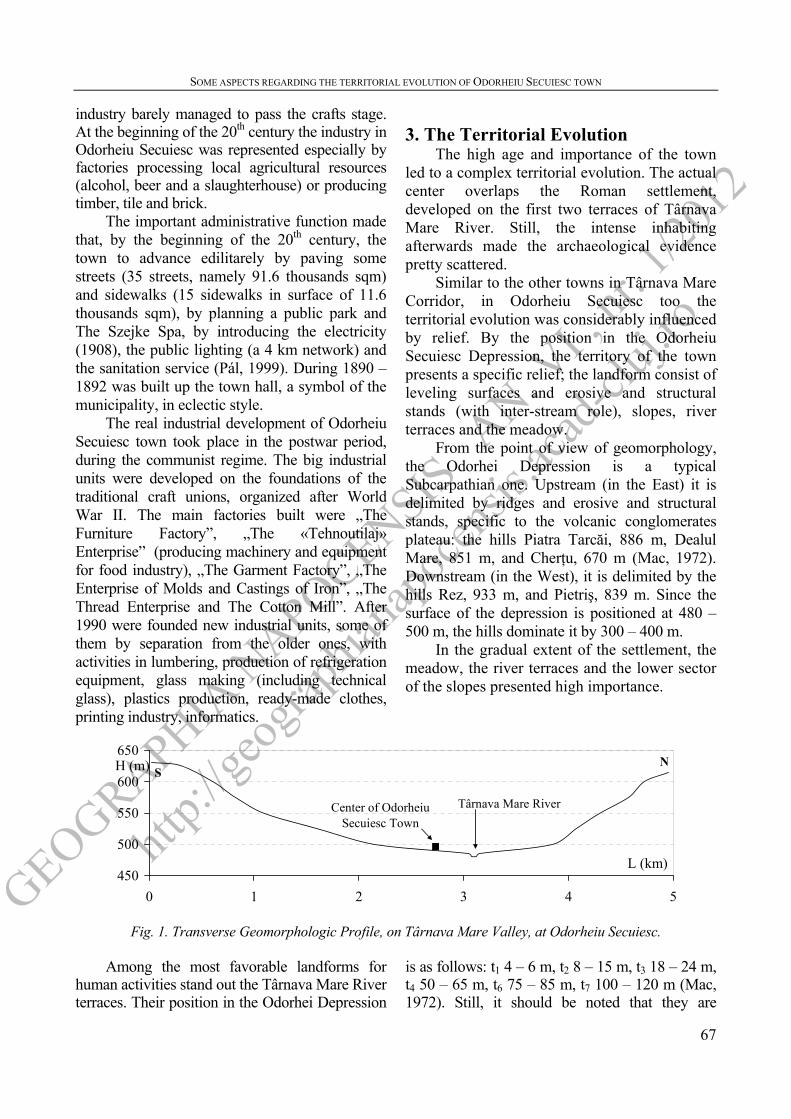
In 1571 and 1577 the villages Gyárosfalva (documentary attested in 1567 and positioned in close vicinity of the town on the road towards Cristuru Secuiesc town) and Sântimbru
(developed South-East from the center, on the older road towards Miercurea-Ciuc town) were moved into town. Most likely, the 13th century chapel in the south of the town, placed at the contact between Dealu Mare Hill slopes and Târnava Mare River terraces, preserved until nowadays, represented the center of Gyárosfalva village. The archaeological traces of a church on Dealu Mare Hill, on the right bank of Varga valley, indicate the central area of Sântimbru village [Fig.2].
Fig. 2. The Territorial Evolution of Odorheiu Secuiesc Town.
About Czibrefalva village, attested in 1566,
the documents tell also that in 1620 was moved into town. It is also very likely that the village
was positioned on right bank of Târnava Mare River, downstream Odorheiu Secuiesc, at the foothills of Cicer Hill. Due to lack of

GEOGRAPHIA N
APOCENSIS AN. V
I , nr.
1/20
12
http:/
/geog
raphia
napo
censis
.acad
-cluj.
ro
SOME ASPECTS REGARDING THE TERRITORIAL EVOLUTION OF ODORHEIU SECUIESC TOWN
69
archaeological evidence to indicate its exact position, we can only compare it with the other two villages on the right of the valley (Sâmbăteni and Cădişeni), and assume that, most likely, it was on Buda (Cetăţii) Valley [Fig.2]. Similar to Sâmbăteni and Cădişeni villages, if Czibrefalva would have developed on the main valley, it would have been exposed to flooding; also, the slopes between the tributary valleys would have been too steep.
On the Austrian topographic maps at the end of 18th century are represented Odorheiu Secuiesc town, Sâmbăteni, Beclean and Cădişeni villages and Siménfalva hamlet (between Odorheiu Secuiesc and Beclean). Odorheiu Secuiesc was a town with a complex structure, where, in addition to the main center (in the area of the Franciscan and Reformed churches and the fortress), one can see two secondary cores. One is in the area of the Greek-Catholic church, were the rectangular streets indicate larger possibilities of territorial planning; most likely, there were displaced the villagers from Gyárosfalva village. On the same reasoning, the secondary core at the older entrance in the town from Miercurea-Ciuc direction (the intersection of the streets Sântimbru, Sfântu Ioan and Roziei) might represent the area where were displaced the inhabitants of Sântimbru village, or even the downstream part of the village. The disorganization of the streets (tentacular structure) is attributed to the more restrictive relief, a hillside area.
Sâmbăteni village, attested in 1497 and positioned at the confluence of Valea Albă and Pârâu Sărat creeks, on the road towards Praid, was annexed to the town in 1895. Beclean village, attested in 1505, developed upstream on the left bank of Târnava Mare River, on the first two terraces. It was an elongated village on the road towards Zetea village; its downstream part had been previously an independently village, Siménfalva de Sus. Cădişeni village, attested in 1566, developed on the opposite bank, on the Busniac creek, tributary of Târnava Mare River [Fig.2]. The difficult relief conditions, similar to the ones in Sâmbăteni, imposed an irregular texture to the village.
Until 1910 those settlements evolved separated territorially. Especially Odorheiu
Secuiesc extended along Târnava Mare River, upstream and downstream as well.
Between the World Wars, consequence of putting the Vânători – Odorheiu Secuiesc railway into use (1888), the new construction concentrated in the area between Odorheiu Secuiesc and Sâmbăteni (on the right bank of Târnava Mare River). The economic units developed in vicinity of the railway, on the left bank of Târnava Mare River. Also, the extent of the town upstream and downstream of Beclean village led to territorial unification of the two settlements.
Due to its pronounced industrialization, in the post-war period took place the most intense extent of the town. The industrial areas were located in the lower area of the town, near Târnava Mare River. Upstream were placed industrial units in the branch of clothing and construction, in Beclean area, but the largest industrial platform developed on Cădişeni Field, and in between Târnava Mare River and the new national road towards Miercurea-Ciuc town, near the railway station. On the right bank of the river (Cădişeni Field) the main unit, „Tehnoutilaj” Enterprise, was established in 1959. Starting 1971, upstream, in its continuation, were added „The Thread Enterprise and The Cotton Mill” and „The Enterprise of Molds and Castings of Iron”. On the left side of the river developed „The Furniture Factory”.
Downstream were placed units in light industries branches, especially of textiles (in 1959 was established The Garment Factory). After 1990 there was added a new unit for producing refrigeration equipment.
On the south-facing hills on the right of Târnava Mare River (Cicer Hill and Cetatea Bud Hill) were organized important orchards, especially apple and plum ones.
In the future, the industry and constructions area will extend especially on Cădişeni Field (between the actual industry zone and the former Cădişeni and Beclean villages) and at the upstream entrance of the town. The area downstream will be reserved for light industry and services.
Such industrial units were supported by a large number of workers, attracted from surrounding area. In order to shelter them were
GEOGRAPHIA N
APOCENSIS AN. V
I , nr.
1/20
12
http:/
/geog
raphia
napo
censis
.acad
-cluj.
ro
Adrian Niţă, Gheorghe Roşian
70
built up block of flats districts, outside the historical areas of the town. The largest district, Beclean, was built up on the terraces underneath the Tabăra Saşilor Hill (the lower area of Dealu Mare Hill), near the industrial platform upstream. On the same hill, east from the historic center, emerged the Taberei district. To support the industries and the services in the south of the town were built up the districts Kuvar and Insulei. Important reorganizations of the territory took place in neighborhood of the railway station where were built up the hospital and the clinics, and downstream Sâmbăteni district, where was built up a sports base. North from the same district developed the tourism zone, around the older Szejke Spa, where starting 2008 functions also the Mineral Water Museum.
In the future, the housing area will develop on the Târnava Mare River terraces, especially on the ones on the left of the valley, less inclined and with better preserved top surfaces. Considering the opened landslides and the many areas with landslide risk on the hillsides above the terraces, the extension of the town in these areas will not be allowed.
4. Conclusions
Odorheiu Secuiesc town passed through several stages of evolution, as follows:
• The pre-Roman settlement developed on the valley underneath the fortress on Bud Hill. There, the majority of the archaeological findings belong to Dacians times (1st century B.C. – 1st century A.D.). Like all the Dacian fortresses in the Roman Dacia, that one was destroyed too during the Roman Conquer.
• The Roman settlement represents the hearth which on developed the actual town, positioned on the first two terraces of Târnava Mare River. The roman administration introduced a better territorial planning, concentrating the numerous small Dacian settlements in larger less numerous ones. According to the archaeology, Odorheiu Secuiesc was the main settlement in the area.
• The medieval settlement developed on the former Roman one. The oiconym reminds the existence of a medieval ruler here. At the beginning of the 2nd millennium in these areas were colonized the Szeklers. Once more, the
importance of the settlement is proved by setting here the main administrative and juridical center of the Szeklers.
• In another stage, towards the end of the Medieval Age, the authorities got involved in order to increase the economical importance of the town. For the growth of the number of inhabitants and extension of its territory, during a couple of centuries several rural settlements in vicinity were moved into town.
• In the modern times, the town and the neighboring rural settlements extend, covering more and more of the free space which separated them. The territorial unification between Odorheiu Secuiesc town and the three rural settlements in vicinity (Sâmbăteni, Beclean and Cădişeni) took place between the two world wars.
• The most important territorial extension of the town took place after World War II, consequence of the pronounced industrialization.
For the most, the settlement developed on Târnava Mare River terraces, especially on the first two. The villages Sâmbăteni and Cădişeni developed on the affluent valleys on the right. In the future, the town will cover more of the terraces since the hillsides above are already affected by landslides or present an important landslide risk.
References [1] BATÓ, A. (1998), Problematica castrului
roman de la Odorheiu Secuiesc (jud. Harghita), Angustia, 3, Sfântu Gheorghe, p. 77 – 82.
[2] MAC, I. (1972), Subcarpaţii Transilvăneni dintre Mureş şi Olt. Studiu Geomorfologic, Editura Academiei, Bucureşti.
[3] NYÁRÁDI ZS., SÓFALVI A. (2006), Raport de săpătura arheologică – Sântimbru, Cronica cercetărilor arheologice din România, CIMEC.
[4] PÁL, JUDITH (1999), Procesul de urbanizare în scaunele secuieşti în secolul XIX, Edit. Presa Universitară Clujeană, Cluj-Napoca.
[5] POP, GR. (2001), Depresiunea Transilvaniei, Editura Presa Universitară Clujeană, Cluj-Napoca.
[6] * * (2000), Repertoriul arheologic al judeţului Harghita, Editura Carpaţii Răsăriteni, Sfântu Gheorghe.