soil erosion leads to environmental ... sheet, rill, and gully etc. it is observed that land...
TRANSCRIPT

International Journal of Geology, Earth & Environmental Sciences ISSN: 2277-2081 (Online)
An Open Access, Online International Journal Available at http://www.cibtech.org/jgee.htm
2014 Vol. 4 (2) May-August, pp. 38-50/Dutta
Research Article
© Copyright 2014 | Centre for Info Bio Technology (CIBTech) 38
SOIL EROSION LEADS TO ENVIRONMENTAL DEGRADATION IN
KANKSA BLOCK OF BARDDHAMAN DISTRICT: A PEDO-
GEOMORPHIC STUDY USING USLE MODEL
*Shyamal Dutta
Department of Geography, Gadadharpur Bazar Junior High School,
P.O. Gadadharpur RS, Birbhum, West Bengal 731234
*Author for Correspondence
ABSTRACT
Destruction of the earth’s biosphere is taking place on an unprecedented scale in present days. By the erosion of topsoil, fertile regions of India are being converted into barren deserts - badlands. Estimation of
soil loss and identification of erosion risk area for the implementation of best management practice is
central to success of soil conservation programme. The present research work focuses on the application
of most widely used Universal Soil Loss Equation (USLE) and remotely sensed data to determine soil erosion from different first order basins in Kanksa Block of Barddhaman District, West Bengal.
Maximum erosion rate is found in the north-western corner of the study area, at a rate of 56 tons per
hectare per year and this area is mostly affected by deforestation. A long stretch, from Bankati (east) to Jagannathpur (west), in the northern extremities of the area is affected by multiple erosional processes
like sheet, rill, and gully etc. It is observed that land degradation is occurred due to unwanted
anthropogenic activities mainly in terms of deforestation for murrum quarrying, encroachment of active flood plain by grazing and agricultural activities with irrigation practices and urbanization. Estimating soil
loss and its spatial extent, some cost-effective and sustainable measures are suggested, which can be
implemented in the watershed management programme.
Keywords: Soil Erosion, Universal Soil Loss Equation (USLE), Deforestation, Murrum Quarrying and
Watershed Management
INTRODUCTION
In our present age, the destruction of the earth’s living cover is taking place on an unprecedented scale.
By the erosion of soil, fertile regions are being converted into barren deserts. It is likely that the area thus laid waste within living memory is nearly a million square miles, while an even larger area is approaching
desert conditions (Dowsett, 1944). Soil erosion from land areas is widespread and adversely affects all
natural and human-managed ecosystems, including agriculture and forestry. For that reason, soil erosion
ranks as one of the most serious environmental problems in the world. Its effects are pervasive, and its damages are long lasting (Pimentel et al., 1995a). Although soil erosion has occurred throughout history,
it has intensified as expanding human populations, coupled with their diverse activities, intrude further
into natural ecosystems. Erosion degrades soil quality in natural, agricultural, and forest ecosystems, thereby reducing the productivity of the land. As a result, the diversity of plants, animals, and microbes is
diminished. Ultimately, the stability of entire ecosystems is threatened (Pimentel et al., 1995a). Soil loss
for erosion is a natural phenomenon in soil dynamics, influenced by climate, soil intrinsic properties, and
morphology, that can both trigger and enhance the process. Anthropogenic activities, like inappropriate agricultural practices, deforestation, overgrazing, forest fires and construction activities, may exert a
remarkable impact on erosion processes or, on the other hand, contribute to soil erosion mitigation
through a sustainable management of natural resources. The phenomena is also exacerbated by socio economical dynamics and land management policies in developing or emerging countries, by global
change and the interactions between these planetary issues. Erosion measurement may involve assessment
of the current rate of soil erosion or that of the historic cumulative soil erosion. Choice of the method for field or in situ assessment of the current rate of soil erosion depends on the type of soil erosion to be
monitored and there is wide ranges of techniques used (Lal, 1994b). A quantitative assessment is needed
International Journal of Geology, Earth & Environmental Sciences ISSN: 2277-2081 (Online)
An Open Access, Online International Journal Available at http://www.cibtech.org/jgee.htm
2014 Vol. 4 (2) May-August, pp. 38-50/Dutta
Research Article
© Copyright 2014 | Centre for Info Bio Technology (CIBTech) 39
to infer on the extent and magnitude of soil erosion problems so that sound management strategies can be
developed on a regional basis. Several soil erosion models exist with varying degree of complexity.
Numerous predictive empirical models and physical based models are developed to assess soil erosion precisely in the hill slopes and catchments in international levels. The first attempt to develop a soil loss
equation for areas such as hill slopes and fields was that of Zingg (1940). Similar empirical equation was
developed by Horton (1945) and Ellison (1947). Smith and Whitt (1948) added more factors into Zingg’s equation to incorporate the influence of cover and management. But based on more reliable and gettable
soil and land use database, W.H. Wischmeier and D.D. Smith (1972 and 1978) had been developed the
Universal Soil Loss Equation, applying in Alps Mountain which is slightly modified form of Musgrave
(1947). Douglas (1976), Kirkby (1976), Morgan (1976), Cooke and Doornkamp (1978), Gerrard (1981), Hudson (1981), Parsons (2005), Stone and Hilborn (2000), Blanco and Lal (1998, 2001, 2008) have
focused their research on the modelling of soil erosion, erosion factors and erosion risk, incorporating
different types of models. Morgan (1986 and 2005) has mentioned several methods and models of soil erosion estimation, focusing more on USLE and Morgan, Morgan and Finney method. At regional level,
Jha and Kapat (2003, 2009, and 2011), Ghosh and Bhattacharya (2012), Ghosh and Guchhait (2012)
predicted the erosion rate of lateritic soils of the Birbhum District using USLE model. Some of the researchers estimated soil loss from catchment areas for measuring basin wise sediment production rate
and related fluvio-geomorphological studies (Jain and Kothyari, 2000; Jain et al., 2001; Suresh et al.,
2004). The technology of Remote Sensing (RS) and Geographical Information System (GIS) is gaining
importance as a powerful tool in the management of information in agriculture, natural resources assessment, environmental protection and conservation (Javed et al., 2009; Mani and Chakravorty, 2007).
There is considerable potential for the use of GIS technology as an aid to soil erosion inventory with
reference to soil erosion modelling and erosion hazard assessment. The present investigation is concerned with the assessment of soil loss in Kanksa block of Barddhaman
district, West Bengal which is situated in the Ajay Damodar Interfluve based on pedogeomorphic as well
as land use parameters of first order stream basins by incorporating USLE method. In present research
scenario, application of RS & GIS has useful advantages for soil erosion rate assessment with proper management planning.
Objectives
The chief objectives of this Pedo-geomorphic study are as follows: 1. To find out the influences of environmental settings and morphogenetic processes on the soil erosion;
2. Predicting annual rate of soil loss based on 175 first order basin sites using USLE and GIS;
3. Identifying the productive or usable areas that are likely to be affected and the effective areas that have been moderately or severely damaged by the processes of soil erosion and
4. Suggesting the suitable and sustainable measures of soil conservation and wasteland reclamation to
check the land degradation processes.
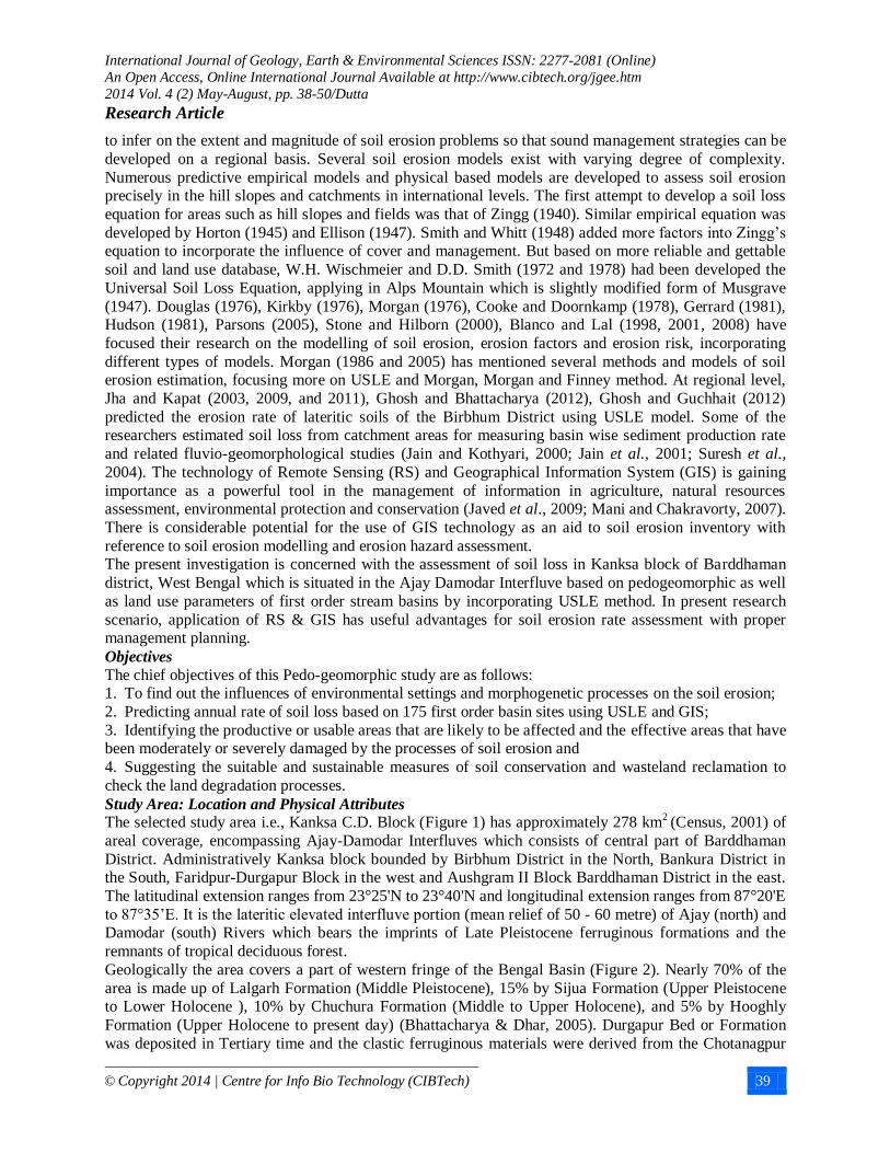
Study Area: Location and Physical Attributes The selected study area i.e., Kanksa C.D. Block (Figure 1) has approximately 278 km
2 (Census, 2001) of
areal coverage, encompassing Ajay-Damodar Interfluves which consists of central part of Barddhaman
District. Administratively Kanksa block bounded by Birbhum District in the North, Bankura District in the South, Faridpur-Durgapur Block in the west and Aushgram II Block Barddhaman District in the east.
The latitudinal extension ranges from 23°25'N to 23°40'N and longitudinal extension ranges from 87°20'E
to 87°35’E. It is the lateritic elevated interfluve portion (mean relief of 50 - 60 metre) of Ajay (north) and Damodar (south) Rivers which bears the imprints of Late Pleistocene ferruginous formations and the
remnants of tropical deciduous forest.
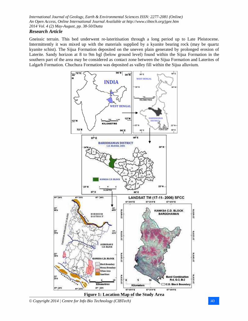
Geologically the area covers a part of western fringe of the Bengal Basin (Figure 2). Nearly 70% of the
area is made up of Lalgarh Formation (Middle Pleistocene), 15% by Sijua Formation (Upper Pleistocene to Lower Holocene ), 10% by Chuchura Formation (Middle to Upper Holocene), and 5% by Hooghly
Formation (Upper Holocene to present day) (Bhattacharya & Dhar, 2005). Durgapur Bed or Formation
was deposited in Tertiary time and the clastic ferruginous materials were derived from the Chotanagpur
International Journal of Geology, Earth & Environmental Sciences ISSN: 2277-2081 (Online)
An Open Access, Online International Journal Available at http://www.cibtech.org/jgee.htm
2014 Vol. 4 (2) May-August, pp. 38-50/Dutta
Research Article
© Copyright 2014 | Centre for Info Bio Technology (CIBTech) 40
Gneissic terrain. This bed underwent re-lateritisation through a long period up to Late Pleistocene.
Intermittently it was mixed up with the materials supplied by a kyanite bearing rock (may be quartz
kyanite schist). The Sijua Formation deposited on the uneven plain generated by prolonged erosion of Laterite. Sandy horizon at 8 to 9m bgl (below ground level) found within the Sijua Formation in the
southern part of the area may be considered as contact zone between the Sijua Formation and Laterites of
Lalgarh Formation. Chuchura Formation was deposited as valley fill within the Sijua alluvium.
Figure 1: Location Map of the Study Area
International Journal of Geology, Earth & Environmental Sciences ISSN: 2277-2081 (Online)
An Open Access, Online International Journal Available at http://www.cibtech.org/jgee.htm
2014 Vol. 4 (2) May-August, pp. 38-50/Dutta
Research Article
© Copyright 2014 | Centre for Info Bio Technology (CIBTech) 41
Figure 2: Geology and Lithology of Kanksa Block, Barddhaman (GSI, 2001)
The central upland part of the area is occupied by Lalgarh formation and is covered by a thin veneer of
latosol, which is underlain by laterite in the form of lateritic concretions and hard crust (Bhattacharya &
Dhar, 2005). The southern and northern parts of the area on either flank of lateritic upland of Lalgarh formation are covered by alluvial deposits of Sijua and Chuchura formations. Soil profile over all the
units is not well developed. The Lalgarh formation, which forms lateritic upland in the area, is covered by
latosol having thickness of 0.3 to 1 metre. The colour of the soil is light grey to light brownish grey (Bhattacharya & Dhar, 2005). The thin soil cover of the Sijua formation is grey to yellowish grey in
colour and contains caliches of various sizes ranging from 2mm-8cm across. The soil cover of Chuchura
formation is immature, partly oxidized, with ferruginous patches and grey to brownish grey in colour. As per USDA (1960) soil classification system the main texture of soils is sandy loam, loamy sand and silty
loam having erodibility factor (K) of 0.3 to 0.5 (NBSS & LUP, 2005)
The study area is an inter-fluvial lateritic upland between Ajay River and Damodar River. As it is a
highland (> 50 metre) many small but important streams (Kunur Nadi and Tumuni Nadi) and numerous
rills and gullies are bifurcated from this region. Damodar and Ajay river water mainly flow along the thalweg lines with depth of water upto1m during the summer months. It has been found that in pre-
Monsoon the average depth of ground water level is greater than 6 metre (April, 2003) and in post-
Monsoon the level is near about 5 metre (November, 2003).
Forest land cover class exclusively lies in the lateritic Lalgarh surface area and constitutes about 25% of
the study area. Study of the recent imageries reveals that the forest land is peripherally reduced with time. The area was once covered with mixed deciduous forest but now due to expansions of agriculture,
irrigation and urban settlements only some patches are remained as Protected Forest (PF), such as
Durgapur PF, Ukhra PF, and Bilaspur PF etc. It is mainly represented by dense to fairly dense mixed jungle of mainly Sal trees. Locally eucalyptus plantation is also made. Total forest area in Kanksa Block
is 6238.7 i.e., 23.43% to total area (Census, 2001) which was 7183.9 hec (i.e., 26.97%) in 1991.
The climate of the study area has been identified as sub-humid and sub-tropical monsoon type, receiving
mean annual rainfall of 1000-1300mm.According to agro-ecological regionalization study area belongs to
Hot-dry sub-humid region (NBSS & LUP, 2005). This area is identified as ‘Tropical Wet-Dry Savanna
International Journal of Geology, Earth & Environmental Sciences ISSN: 2277-2081 (Online)
An Open Access, Online International Journal Available at http://www.cibtech.org/jgee.htm
2014 Vol. 4 (2) May-August, pp. 38-50/Dutta
Research Article
© Copyright 2014 | Centre for Info Bio Technology (CIBTech) 42
Morphogenetic Region’ where the chief dominant pedogeomorphic processes are mod-max chemical
weathering mainly in wet season, moderate physical weathering, mod-max mass wasting, max fluvial
erosion, mod-max fluvial processes (rain-splash, sheet wash, rill and gully erosion), and Laterisation (Chorley et al., 1984). The monsoonal and cyclonic rainfall (maximum intensity of 21.51-25.51
mm/hour) is the most forceful climatic variable operative in this typical lateritic badland, causing
excessive erosion through rain-splash, overland flow and sub-surface flow.
MATERIALS AND METHODS
Soil erosion is the detachment and transportation of soil material from one place to another through the
action of water in motion or by the beating action of the raindrops. Soil loss is the soil moved off a
particular field or slope. Soil loss due to erosion vary under different land uses in addition to quality of soil and intensity of climatic parameters especially rainfall and temperature.
Universal Soil Loss Equation (USLE)
The Universal Soil Loss Equation (USLE) is the most widely used and accepted erosion prediction model
for estimating of long term average annual soil loss from a specified in specified cropping and management systems. The equation predicts the soil loss due to sheet or rill erosion under specified
conditions. It enables to determine the land management and erosion rate relationships for a wide range of
rainfall, soil, slope, crop and management conditions and to select alternative cropping and management combination which limit erosion rates to acceptable levels of rill erosion. Soil loss for a site is a product
of five factors, which are mentioned below:
A= R×K×LS×C×P
Where,
A= soil loss per unit area (tones/ha/year).
R= the erosivity factor to account for the erosive power of rainfall, related to the amount and intensity of
rainfall over the year (NBSS, 2005)
K=the soil erobility factor to account for the soil loss rate in tones/ha erosion index unit plot. It ranges
from less than 0.1 for the least erodible soil to approaching 1.0 in the worst possible case depending on texture, structure, organic matter content and permeability (NBSS, 2005)
LS= the topographic factor to account for the length and steepness of the slope; the longer the slope, the
greater the volume of surface run off, the steeper the slope, the greater is its velocity, LS=1.0 on a 9%
slope, 22.1 metre long
C= the cover and management to account for the effects of vegetative cover and management techniques
which reduce the rate of the soil loss, so in the worst case when none are applied, C= 1.0 whereas in an ideal case when there is no loss, C would be zero and
P= the support and conservation practices factor to account for the effects of soil conservation measures.
Application of Methods and Techniques
The employed models and its application in the given study area are briefly described as follows. The
databases used in USLE equation have been generated from soil resource mapping, landuse-land cover mapping as well as topographic expression of the study area. Remote Sensing (RS) and Geographical
Information System (GIS) techniques have been used here to prepare maps and to get information and
data for the analysis part. Mainly Global Mapper 14.2, Map Info 7.0, ERDAS Imagine 9.1, Arc GIS 9.3
software are used here. SRTM (full form) data (2005) with 30 metres resolution has been applied for preparing micro level topography with five-metre contour interval for demarcation of 175 basin coverage
of first order streams (Figure 3). Length of the Slope (m) and Average Slope(%) of that first order streams
taken as slope length and slope gradient to calculated the Topographic factor (LS) of the mentioned equation from SRTM data using Global Mapper 14 (Figure 4).

International Journal of Geology, Earth & Environmental Sciences ISSN: 2277-2081 (Online)
An Open Access, Online International Journal Available at http://www.cibtech.org/jgee.htm
2014 Vol. 4 (2) May-August, pp. 38-50/Dutta
Research Article
© Copyright 2014 | Centre for Info Bio Technology (CIBTech) 43
Figure 3: Surface Elevation of the Study Area and First Order Stream Basin taken as unit of Study
of Soil Erosion Estimate
Figure 4: Application of Global Mapper v.14.2 in Analysis
In this section two main operating functions are employed two identify the rainfall erosivity factor (R)
and Topographic factor (LS). These are as follows:
1. EI30 (Rainfall Erosivity Factor, R) = 79+0.363X, where X=Rainfall in mm.
International Journal of Geology, Earth & Environmental Sciences ISSN: 2277-2081 (Online)
An Open Access, Online International Journal Available at http://www.cibtech.org/jgee.htm
2014 Vol. 4 (2) May-August, pp. 38-50/Dutta
Research Article
© Copyright 2014 | Centre for Info Bio Technology (CIBTech) 44
As this Ajay-Damodar interfluve region belongs to Hot-dry-sub humid Agro ecological region (NBSS &
LUP, 2005) the annual rainfall is 1300mm.
Therefore, EI30 (Rainfall Erosivity Factor, R) = 79+0.363 x 1300= 550.9
2. LS (Topographic Factor)= (l/22.13)m
(0.065 + 0.045 S + 0.0065 S2)
In case of stream no. 1 where, slope length= 376.42m., slope gradient =11.99% and m=0.5 for >5% slope
Therefore, LS= (376.42/22.13)0.5
(0.065 + 0.045*11.99 +0.0065*11.992) =6.35
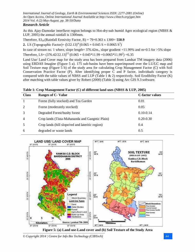
Land Use/ Land Cover map for the study area has been prepared from Landsat TM imagery data (2006)
using ERDAS Imagine (Figure 5 a). 175 sub-basins have been superimposed over the LU/LC map and Soil Texture map (Figure 5 b) of the study area for calculating Crop Management Factor (C) with Soil
Conservation Practice Factor (P). After identifying proper C and P factor, individuals category is
compared with the table values of NBSS and LUP (Table 1 & 2) respectively. Soil Erodibility Factor (K) after matching with table values giver by Robert (2000) (Table 3) using Arc GIS 9.3 software.
Table 1: Crop Management Factor (C) of different land uses (NBSS & LUP, 2005)
Class Ranges of C- Value C-factor values
1 Forest (fully stocked) and Tea Garden 0.01
2 Forest (moderately stocked) 0.05
3 Degraded Forest/bushy forest 0.10-0.14
4 Crop lands (Tista-Mahananda and Gangetic Plain) 0.20-0.30
5 Crop lands (hill slope/red and lateritic region) 0.4
6 degraded or waste lands 0.5
Figure 5: (a) Land use-Land cover and (b) Soil Texture of the Study Area

International Journal of Geology, Earth & Environmental Sciences ISSN: 2277-2081 (Online)
An Open Access, Online International Journal Available at http://www.cibtech.org/jgee.htm
2014 Vol. 4 (2) May-August, pp. 38-50/Dutta
Research Article
© Copyright 2014 | Centre for Info Bio Technology (CIBTech) 45
Table 2: Soil Conservation Practice Factor (P) of different land uses (NBSS & LUP, 2005)
Class Ranges of P- Value P-factor values
1 Terracing 0.1
2 Contour Bunding 0.2
3 Field Bunding (nearly level land) 0.30-0.40
4 Field Bunding (gently sloping and undulating lands; active flood plains) 0.5
5 Tea cultivation (hill slopes)/ forest land/ cultivated/fallow 0.70-1.0
Table 3: Soil erodibility (K) Values (Robert, 2000)
Class Soil textural class Average K-
factor Class Soil textural class
Average
K-factor
1 Clay 0.22 10 Loamy very fine Sand 0.39
2 Clay Loam 0.3 11 Sand 0.02
3 Coarse sandy Loam 0.07 12 Sandy Clay Loam 0.2
4 Fine sand 0.08 13 Sandy Loam 0.13
5 Fine Sandy Loam 0.18 14 Silt Loam 0.38
6 Heavy Clay 0.17 15 Silt Clay 0.26
7 Loam 0.3 16 Silty Clay Loam 0.32
8 Loamy Fine Sand 0.11 17 Very Fine Sand 0.43
9 Loamy Sand 0.04 18 Very Fine Sandy Loam 0.35
RESULTS AND DISCUSSIONS
In this study we have recorded all the necessary parameters for 175 first-order streams to measure soil
erosion rate with the help of USLE model. An erosion rate zone map has been prepared (Figure 6). There we have considered five classes (Table: 4) to depict erosion rate zones like Very High (>30 t ha
-1 y
-1),
High (20-30 t ha-1
y-1
), Medium (10-20 t ha-1 y
-1), Low (5-10 t ha
-1 y
-1) and Very Low (<5 t ha
-1 y
-1).
Table 4: Soil erosion rate in First Order Stream Basin in Kanksa Block
Erosion rate (t ha-1
y-1
) No. of First order basin % No. of basin
<5 136 77.7
5-10 20 11.4
10-20 8 4.6
20-30 4 2.3
>30 7 4
Total 175 100
Maximum Erosion rate-55.99 t ha-1
y-1
(Basin No. 1)
Minimum Erosion rate-0.04 t ha-1
y-1
(Basin No. 174 and 175)
Maximum Erosion rate-4.76 t ha-1 y
-1
Fact depicted that among the sample basins, about 4% falls under very high erosion rate zone. There
highest erosion rate is over 55.99 t ha-1
y-1
at ‘1’ number sample basins. It indicates that the high risk of

International Journal of Geology, Earth & Environmental Sciences ISSN: 2277-2081 (Online)
An Open Access, Online International Journal Available at http://www.cibtech.org/jgee.htm
2014 Vol. 4 (2) May-August, pp. 38-50/Dutta
Research Article
© Copyright 2014 | Centre for Info Bio Technology (CIBTech) 46
soil erosion found in the mainly in the north-western part Kanksa block. Maximum portion (77.7%) of the
study area falls under the very low rate of soil erosion zone (Table 4), which indicates better opportunity
for a proper land use planning and agricultural practices.
Figure 6: Spatial distribution of Soil erosion Risk and its relation to deforestation due to Land
Quarrying mainly in the North-Western corner of the Study Area

International Journal of Geology, Earth & Environmental Sciences ISSN: 2277-2081 (Online)
An Open Access, Online International Journal Available at http://www.cibtech.org/jgee.htm
2014 Vol. 4 (2) May-August, pp. 38-50/Dutta
Research Article
© Copyright 2014 | Centre for Info Bio Technology (CIBTech) 47
(a)
(b) (c)
Figure 7: Effect of Deforestation due to Murrum Quarrying: (a) Formation of Rill in Laterite
Quarried Region of Bangram (GSI, 2005) (b) Formation of Gully near Kanksa 2No. Colony Region
& (c) Eroded Soil Open the Root of Tree in the Study Area
Figure 8: Soil erosion along the Bank of Kunur near Domra due to Agricultural Practices and
Grazing activity in active Floodplain region

International Journal of Geology, Earth & Environmental Sciences ISSN: 2277-2081 (Online)
An Open Access, Online International Journal Available at http://www.cibtech.org/jgee.htm
2014 Vol. 4 (2) May-August, pp. 38-50/Dutta
Research Article
© Copyright 2014 | Centre for Info Bio Technology (CIBTech) 48
A long stretch from Bankati in the east to Jagannathpur in the west in the northern extremities of the area
is affected by multiple erosional processes like sheet, rill, gully etc. Soil erosion in terms of sheet, rill and
gully erosion is mainly in the upper part of the study area is mainly due to deforestation for land quarrying activities (Figure 7 a and b). On the contrary erosion is prominent along the bank of Kunur
River in the middle portion of the study area is mainly due to agricultural expansion and grazing practices
in the active flood plain region (Figure 8). Sheet flow is prevalent particularly in the laterite upland like north of G.T.Road where latosol is loamy in
nature especially around Gopalpur, Kanksa Rajkusum and Garadah. Gully and rill erosion is prevalent on
both banks of the tributary nala of Kunur extending from Tilakdanga to Dhoadanga where the tributary
joins Kunur (Figure 7 c).
Conclusion
The top soils of this region are gradually washing away and the soils become highly acidic. Soil erosion
due to naturally active processes occurs in the area in the form of sheet flow, rill and gully erosion and bank erosion. USLE model was developed as a tool to guide soil conservation planning and not for use as
a research technique (Morgan (2005). So in this study a proper management strategy is needed for
minimize the high soil erosion risk. From the above analysis it is clear that rain-splash, rill, inter-rill and gully erosion along with bank erosion should get special and separate attention to take urgent steps in
conservation practices. Since erosion of lateritic soil is a natural process it cannot be prevented totally in
this geo-climatic region, but it can be reduced to an accepted rate. Sustainable land management practices
are urgently required to reduce the soil erosion rate. Agricultural activities and irrigational practices should continue with improvements through terracing, practicing crop rotation, improved agro- forestry
practices. Vegetation provides protection against scouring and minimizes the erosion risk by reducing
flow velocity.
Figure 9: Use of rock dam and plantation Forestry to check Gully Erosion in Kanksa
Afforestation programmes mainly in the abandoned quarried areas (e.g. Kanksa, Bangram etc.) and also
in the wasteland should be incorporated. To stop the gully retreat and gully erosion proper management
such as rock dam (Figure 9) in gully head, small loose dam (0.2-0.4m. height) made from locally available materials (e.g., wooden planks, basalt rock), re-vegetation in upstream segments of gullies
should be practiced.

International Journal of Geology, Earth & Environmental Sciences ISSN: 2277-2081 (Online)
An Open Access, Online International Journal Available at http://www.cibtech.org/jgee.htm
2014 Vol. 4 (2) May-August, pp. 38-50/Dutta
Research Article
© Copyright 2014 | Centre for Info Bio Technology (CIBTech) 49
REFERENCES
Bhattacharya AK and Dhar N (2005). A Report on Geo-Environmental Appraisal in Durgapur-
Panagarh Urban Area and Its Environs for developmental Activities within Asansol-Durgapur Development Authority Area, District Barddhaman, W.B., Geological Survey of India, Eastern Region,
Kolkata.
Blanco H and Lal R (2008). Principles of Soil Conservation and Management (New York: Springer).
Chorley RJ, Schumm SA and Sugden DE (1985). Geomorphology (Methuen and Co. Ltd., London,
New York).
Cooke RU and Doornkamp JC (1978). Geomorphology in Environmental Management (Oxford:
Clarendon Press).
Douglas I (1976). Erosion Rates and Climate: Geomorphological Implications. In: Geomorphology and
Climate, London. edited by Derbyshire E (John Wiley & Sons) 269-285.
Dowsett JM (1944). Soil Erosion. Journal of the Royal African Society 43(170) 29-39.
Gerrard AJ (1981). Soil and Landforms: An Integration of Geomorphology and Pedology (London:
George Allen & Unwin).
Ghosh S and Bhattacharya K (2012). Multivariate erosion risk assessment of lateritic badlands of
Birbhum (West Bengal, India): A case study. Journal of Earth System Science 121(6) 1441–1454.
Ghosh S and Ghosh S (2003). Land Degradation Due to Indiscriminate ‘Murrum’ Extraction near
Durgapur Town, West Bengal. In: Land Degradation and Desertification. edited by Jha VC (Rawat
Publication, India) 257-258.
Ghosh S and Guchhait SK (2012). Soil Loss Estimation through USLE and MMF Methods in the
Lateritic Tracts of Eastern Plateau Fringe of Rajmahal Traps, India. Ethiopian Journal of Environmental Studies and Management (EJESM) 5(4 Suppl 2) 529-541.
Horton RE (1945). Erosional Development of Streams: Quantitative Physiographic Factors. In: River
and River Terraces. edited by Dury GH (London: MacMillan) 117-163.
Hudson NW (1984). Soil Conservation (London: English language Book Society).
Jain MK and Kothari UC (2000). Estimation of soil erosion and sediment yield using GIS. Hydrological Sciences Journal 45(5) 771-786.
Jain SK, Kumar S and Varghese J (2001). Estimation of Soil Erosion for a Himalayan Watershed Using GIS Technique. Water Resources Management 15 41–54.
Javed A, Khanday MY and Ahmed R (2009). Prioritization of sub-watersheds based on Morphometric
and land use analysis using remote sensing and GIS techniques. Journal of the Indian Society of the Remote Sensing 37 261-274.
Jha MK and Paudel RC (2010). Erosion Predictions by Empirical Models in a Mountainous Watershed of Nepal. Journal of Spatial Hydrology 10(1) 89-102.
Jha VC and Gupta K (2003). Land Degradation in Tropical Lands: A Case Study. In: Land Degradation
and Desertification. Edited by Jha VC (Jaipur: Rawat Publications) 279-290.
Jha VC and Kapat S (2003). Assessment of Soil Erosion and Degraded Land; A Case Study of Dumka
Subdivision, Jharkhand. In: Land Degradation and Desertification. Edited by Jha VC (Jaipur: Rawat Publications) 156-178.
Jha VC and Kapat S (2003). Gully Erosion and its Implications on Land Use: A Case Study of Dumka
Block, Dumka District, Jharkhand. In: Land Degradation and Desertification. edited by Jha VC (Jaipur: Rawat Publications) 156-178.
Jha VC and Kapat S (2009). Rill and Gully Erosion Risk of Lateritic Terrain in South Western Birbhum District, West Bengal, India, Sociedade & Natureza, Uberlandia 21(2) 141-158. Available: http://
www.doaj.org/doaj?func=abstract&id=469836.
Jha VC and Kapat S (2011). Degraded Lateritic Soils Cape and Land Uses in Birbhum District, West Bengal, India. Sociedade & Natureza, Uberlandia 23(3) 545-558. Available:
http://www.seer.ufu.br/indec.php/sociedadenatureza/article/download/pdf
International Journal of Geology, Earth & Environmental Sciences ISSN: 2277-2081 (Online)
An Open Access, Online International Journal Available at http://www.cibtech.org/jgee.htm
2014 Vol. 4 (2) May-August, pp. 38-50/Dutta
Research Article
© Copyright 2014 | Centre for Info Bio Technology (CIBTech) 50
Kirkby MJ (1976). Hydrological Slope Models: The influence of Climate. In: Geomorphology and
Climate London. edited by Derbyshire E (John Wiley & Sons) 247-267.
Lal R (1994). Soil Erosion Research Methods. In: Soil water Conservation Society (St. Lucie Press:
Delray Beach, FL).
Lal R (2001). Soil Degradation by Erosion. Land Degradation & Development 12 519-539. doi: 10.1002ldr.472
Mani P and Chakravorty B (2007). Remote Sensing based sedimentation study of Maithon reservoir. Journal of the Indian Society of the Remote Sensing 35(1) 118-120.
Morgan RPC (1976). The Role of Climate in the Denudation System: A Case Study from West
Malaysia. In: Geomorphology and Climate, edited by Derbyshire E (John Wiley & Sons, London) 317-341.
Morgan RPC (2005). Soil Erosion and Conservation. 3rd edition (Blackwell Science: Oxford).
Morgan RPC and Duzant JH (2008). Modified MMF Model for Evaluating Effects of Crops and
Vegetation Cover on Soil Erosion. Earth Surface Processes & Landforms 32 90-106. doi:
10.1002/esp.1530.
Morgan RPC and Nearing MA (2011). Handbook of Erosion Modelling (New York: Wiley-Blackwell).
Musgrave G (1947). The quantitative evaluation of factors in water erosion, a first approximation.
Journal of Soil and Water Conservation 2(3) 133-138.
Parsons AJ (2005). Erosion and Sediment Transport by Water on Hillslopes. In: Encyclopedia of Hydrological Sciences. edited by Anderson MG (John Wiley & Sons Ltd, London) 1199-1205.
Pimentel D, Harvey C, Resosudarmo P, Sinclair K, Kurz D, McNair M, Crist S, Sphpritz L, Fitton
L, Saffouri R and Blair R (1995a). Environmental and economic costs of soil erosion and conservation benefits. Science (Washington DC) 2(67)1117-23.
Sarkar D, Nayak DC, Duta D and Dhyani BL (2005). Soil Erosion of West Bengal (NBSS & LUP, NBSS Publ.117, Nagpur).
Smith DD and Whitt DM (1948). Evaluating soil losses from field areas. Agricultural Engineering 29
394-396.
Stone RP and Hilborn D (2000). Universal Soil Loss Equation. Available: http://www.
omafra.gov.on.ca/english/engineer/facts/00-001.pdf.
Wischmeier WH and Smith DD (1958). Rainfall energy and its relationship to soil loss. Transactions of
the American Geophysical Union 39 285-91
Wischmeier WH and Smith DD (1972). Predicting Rainfall-Erosion Losses from Cropland East of the
Rocky Mountains. USDA, Agricultural Handbook No. 282, 1-46.
Wischmeier WH and Smith DD (1978). Predicting Rainfall Erosion Losses – A Guide to Conservation
Planning. USDA, Agricultural Handbook No. 537, 1-51.
Zingg AW (1940). Degree and length of slope as its affects soil loss in runoff. Agricultural Engineering 21 59-64.