smithville park - duluth · smithville park summary and overview smithville park is a relatively...
TRANSCRIPT
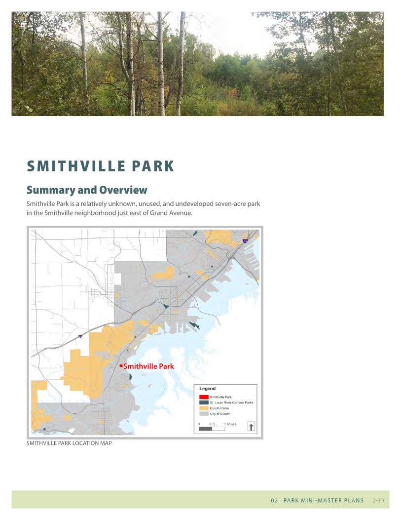
S m i t H v i l l e pa r kSummary and overviewSmithville Park is a relatively unknown, unused, and undeveloped seven-acre park in the Smithville neighborhood just east of Grand Avenue.
2 - 19 02: PA R K M I N I - M A S T E R P L A N S
SMITHvILLE PARK LOCATION MAP
smithville Park
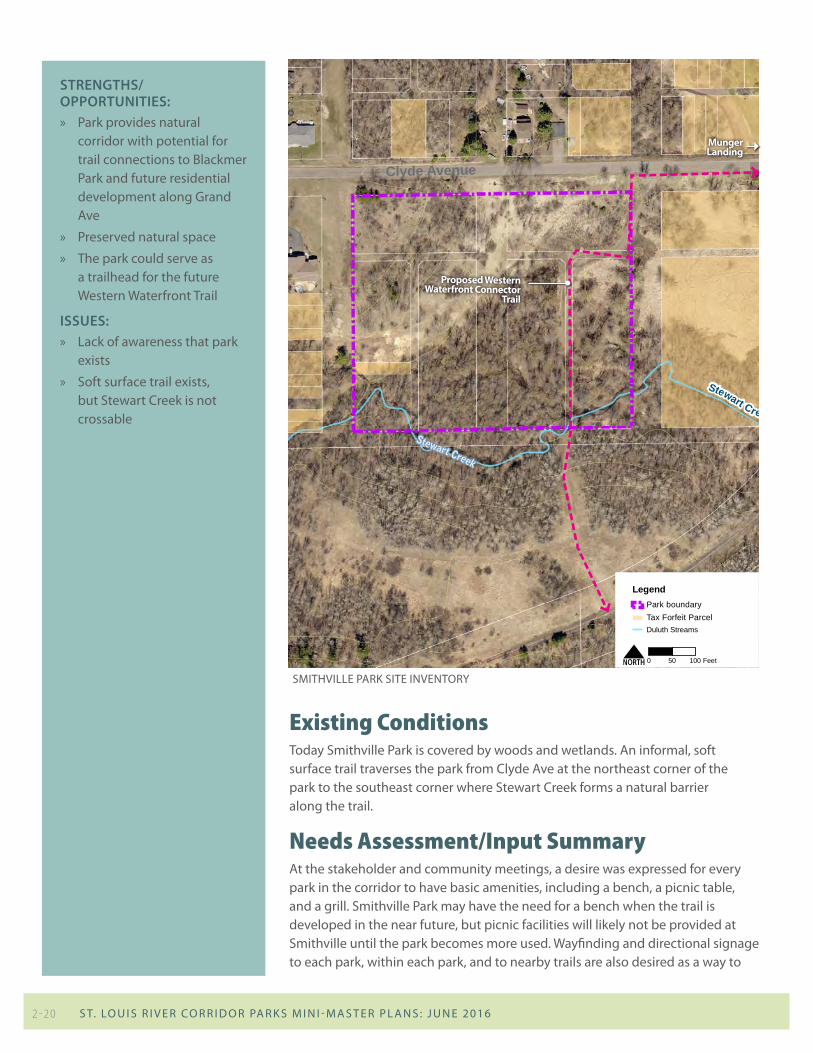
existing conditionsToday Smithville Park is covered by woods and wetlands. An informal, soft surface trail traverses the park from Clyde Ave at the northeast corner of the park to the southeast corner where Stewart Creek forms a natural barrier along the trail.
SMITHvILLE PARK SITE INvENTORY16 St. Louis River Corridor NEIGHBORHOOD PARKS MINI MASTER PLANS FACILITY INVENTORY AND EVALUATION 17DRAFT 11.18.15 DRAFT 11.18.15
Stewart Creek
0 10050 Feet
LegendPark boundaryTax Forfeit ParcelDuluth Streams
N
SMITHVILLE PARK SMITHVILLE PARK
Clyde Avenue
Stewart Creek
ABOUT THE PARK
EXISTING RECREATION FACILITIES
Play areas and Courts Fields PiCniCking trails other
Play equiPment Football Pavilion unPaved (Gated oFF)
basketball soccer shelter Paved
tennis soFtball tables horseshoe baseball Grills winter sPorts
bocce ball hockey rink
volleyball recreation center Pleasure skatinG
other buildinG sleddinG hill
tyPe: cross-country skiinG
USER CONVENIENCES / SUPPORT FACILITIES
benches Fire rinG restrooms Parking
bike rack GarbaGe can indoor restrooms on-street (not siGned)
bleacher liGhtinG oFF-street
drinkinG Fountain FlaG # hdcP sPaces
dumPster Plaques not Present
\
name smithville reCreation area
address Clyde avenue
neiGhborhood morgan Park
classiFication undeveloPed Parkland
acreaGe 7.0
•Proposed Western Waterfront Connector Trail and proposed Stewart Creek Trail to run through site
•Munger Landing to the east (DNR boat launch)•Park is currently undeveloped
EXISTING CONDITIONS
Proposed Western Waterfront Connector
Trail
Munger Landing
strengths/oPPortunities: » Park provides natural
corridor with potential for trail connections to Blackmer Park and future residential development along Grand Ave
» Preserved natural space
» The park could serve as a trailhead for the future Western Waterfront Trail
issues: » Lack of awareness that park
exists
» Soft surface trail exists, but Stewart Creek is not crossable
needs assessment/input SummaryAt the stakeholder and community meetings, a desire was expressed for every park in the corridor to have basic amenities, including a bench, a picnic table, and a grill. Smithville Park may have the need for a bench when the trail is developed in the near future, but picnic facilities will likely not be provided at Smithville until the park becomes more used. Wayfinding and directional signage to each park, within each park, and to nearby trails are also desired as a way to
2 - 20 S T. LO u I S R I v E R CO R R I D O R PA R K S M I N I - M A S T E R P L A N S : J u N E 2016
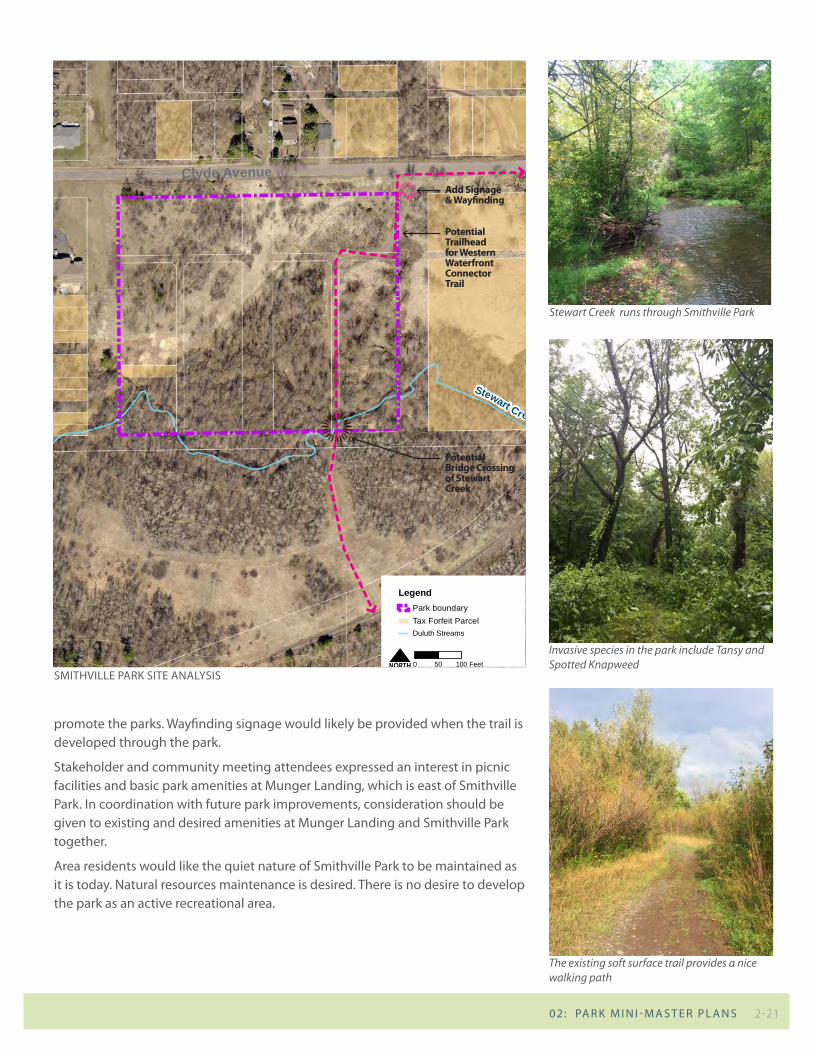
SMITHvILLE PARK SITE ANALYSIS
Stewart Creek runs through Smithville Park
Invasive species in the park include Tansy and Spotted Knapweed
The existing soft surface trail provides a nice walking path
promote the parks. Wayfinding signage would likely be provided when the trail is developed through the park.
Stakeholder and community meeting attendees expressed an interest in picnic facilities and basic park amenities at Munger Landing, which is east of Smithville Park. In coordination with future park improvements, consideration should be given to existing and desired amenities at Munger Landing and Smithville Park together.
Area residents would like the quiet nature of Smithville Park to be maintained as it is today. Natural resources maintenance is desired. There is no desire to develop the park as an active recreational area.
18 St. Louis River Corridor NEIGHBORHOOD PARKS MINI MASTER PLANS FACILITY INVENTORY AND EVALUATION 19DRAFT 11.18.15 DRAFT 11.18.15
Stewart Creek
0 10050 Feet
LegendPark boundaryTax Forfeit ParcelDuluth Streams
N
SMITHVILLE PARK SMITHVILLE PARKSITE OBSERVATIONS
OPPORTUNITIES
NOTES & COMMENTS
•Recommend basic data collection including vegetative inventory and wetland delineation to be used to guide future park programming
•Design a formalized path with crossing of Stewart Creek and connections to boat launch/future development
•Install signage/wayfinding directing visitors to development and boat launch
•Trailhead potential here for W.W.T.•Invasive species management along the existing trails including
tansy and spotted knapweed
•Key stakeholders: » River Corridor Coalition » Morgan Park Community Club
•Planned residential development to southwest•Future improvements (roadway/trail along rail-beds)•There is a proposed trail alignment•Upper lot at boat landing should be part of park•Boat landing - DNR does capital work, city does day to day
maintenance (regarding parking lot)
•Flooding impacts near entry point along Clyde Ave•Connection back to WWT/ Munger Landing along Clyde Ave•Primarily passive open space•Poor quality vegetation•Wet throughout•No way to cross Stewart Creek
OPPORTUNITIES
Clyde AvenueAdd Signage & Wayfinding
Potential Bridge Crossing of Stewart Creek
Potential Trailhead for Western Waterfront Connector Trail
2 - 21 02: PA R K M I N I - M A S T E R P L A N S
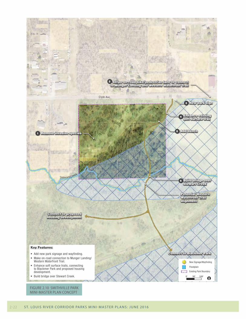
Figure 2.10 smithviLLe park mini-master pLan concept
Clyde Ave
Potential Western Waterfront Trail alignment
Connect to proposed housing development
Connect to Blackmer Park
Stewart Creek
Swenson Ave
Floodplain
[0’ 50’ 100’
Smithville Park
Existing Park Boundary
New Signage/Wayfindingk
Stripe on-road bike/pedestrian lane to connect to Munger Landing and Western Waterfront Trail
2
New park sign3
Remove invasive species1Add bench5
Enhance existing soft surface trail
4
Build bridge over Stewart Creek
6
Key Features:
• Add new park signage and wayfinding. • Make on-road connection to Munger Landing/
Western Waterfront Trail.• Enhance soft surface trails, connecting
to Blackmer Park and proposed housing development.
• Build bridge over Stewart Creek.
2 - 22 S T. LO u I S R I v E R CO R R I D O R PA R K S M I N I - M A S T E R P L A N S : J u N E 2016
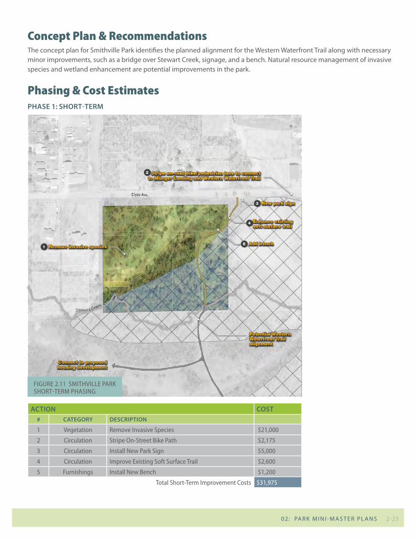
concept plan & recommendationsThe concept plan for Smithville Park identifies the planned alignment for the Western Waterfront Trail along with necessary minor improvements, such as a bridge over Stewart Creek, signage, and a bench. Natural resource management of invasive species and wetland enhancement are potential improvements in the park.
phasing & cost estimatesPhAse 1: short-term
Action cost# cAtegory descriPtion
1 vegetation remove invasive species $21,000
2 circulation stripe on-street bike path $2,175
3 circulation install new park sign $5,000
4 circulation improve existing soft surface trail $2,600
5 Furnishings install new bench $1,200
total short-term improvement costs $31,975
Figure 2.11 smithviLLe park short-term phasing
2 - 23 02: PA R K M I N I - M A S T E R P L A N S
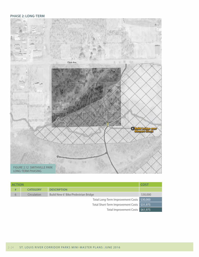
PhAse 2: long-term
Action cost# cAtegory descriPtion
6 circulation build new 6' bike/pedestrian bridge $30,000
total Long-term improvement costs $30,000
total short-term improvement costs $31,975
total improvement costs $61,975
Figure 2.12 smithviLLe park Long-term phasing
2 - 24 S T. LO u I S R I v E R CO R R I D O R PA R K S M I N I - M A S T E R P L A N S : J u N E 2016