small reserves bush fire management plan · project name wingecarribee shire council small reserves...
TRANSCRIPT
W S C S m al l R e ser ve s B us h F i r e M a na g em e n t P l a n
Draft for Comment
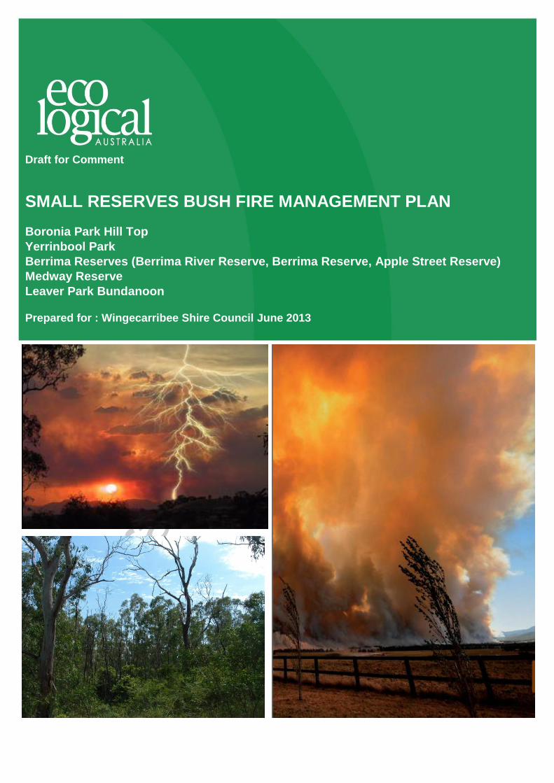
SMALL RESERVES BUSH FIRE MANAGEMENT PLAN
Boronia Park Hill Top
Yerrinbool Park
Berrima Reserves (Berrima River Reserve, Berrima Reserve, Apple Street Reserve)
Medway Reserve
Leaver Park Bundanoon
Prepared for : Wingecarribee Shire Council June 2013
W S C S m a l l R e ser ve s B us h F i r e M a na g em e n t P l a n
© E CO LO G ICA L A U S T RA L IA P T Y LT D ii
DOCUMENT TRACKING
Item Detail
Project Name Wingecarribee Shire Council Small Reserves Bush Fire Management Plan
Project Number 13SGBBUS-0019
Project Manager
Julie Holden
02 4201 2265
8/128 Island Point Road, St Georges Basin NSW 2540
Prepared by Julie Holden
Reviewed by Rod Rose
Approved by Rod Rose
Status Draft for Public Comment
Version Number 1
Last saved on 1 July 2013
This report should be cited as ‘Eco Logical Australia 1 July, 2013. Small Reserves Bush Fire
Management Plan. Prepared for Wingecarribee Shire Council.’
ACKNOWLEDGEMENTS
This document has been prepared by Eco Logical Australia Pty Ltd with assistance from those
community members who participated in the public meetings and provided information afterwards, Rural
Fire Service Brigade members and staff.
Disclaimer
This document may only be used for the purpose for which it was commissioned and in accordance with the contract between Eco
Logical Australia Pty Ltd and Wingecarribee Shire Council. The scope of services was defined in consultation with Wingecarribee
Shire Council, by time and budgetary constraints imposed by the client, and the availability of reports and other data on the
subject area. Changes to available information, legislation and schedules are made on an ongoing basis and readers should
obtain up to date information.
Eco Logical Australia Pty Ltd accepts no liability or responsibility whatsoever for or in respect of any use of or reliance upon this
report and its supporting material by any third party. Information provided is not intended to be a substitute for site specific
assessment or legal advice in relation to any matter. Unauthorised use of this report in any form is prohibited.
Template 10/05/13

W S C S m a l l R e ser ve s B us h F i r e M a na g em e n t P l a n
© E CO LO G ICA L A U S T RA L IA P T Y LT D iii
Contents
Abbreviations............................................................................................................................................ i
1 Introduction and background.................................................................................................... 2
1.1 Planning framework ...................................................................................................................... 2
1.1.1 Rural Fires Act 1997 (RF Act) and Rural Fires Regulation 2008 (RF Reg) ................................. 2
1.1.2 Wingecarribee Bush Fire Risk Management Plan........................................................................ 3
1.1.3 Wingecarribee Local Environment Plan 2010 (WLEP) ................................................................ 3
1.1.4 Local Government Act 1993 (LG Act) .......................................................................................... 6
1.2 Objectives ..................................................................................................................................... 6
1.3 Limitations of the Plan .................................................................................................................. 6
1.4 Residual risk ................................................................................................................................. 6
2 Bushfire hazard analysis ........................................................................................................... 7
2.1 Fire intensity analysis ................................................................................................................... 7
2.1.1 Vegetation formation .................................................................................................................... 8
2.1.2 Slope ............................................................................................................................................. 8
2.2 Climate change ............................................................................................................................. 8
2.3 Assets at risk ................................................................................................................................ 9
2.3.1 Human settlement assets ............................................................................................................. 9
2.3.2 Environmental assets ................................................................................................................. 10
2.4 Key Threatening Processes ....................................................................................................... 13
2.5 Culturally significant assets ........................................................................................................ 13
2.6 Recreational use and facilities .................................................................................................... 13
3 Bushfire risk analysis .............................................................................................................. 15
4 Bushfire risk management ...................................................................................................... 17
4.1 Fire management zones ............................................................................................................. 17
4.2 Asset protection zones ............................................................................................................... 20
4.2.1 Vegetation / fuel management prescription within Asset Protection Zones ............................... 20
4.3 Access and fire trails .................................................................................................................. 21
5 Protection of environment and cultural sites ........................................................................ 23
5.1 Fuel / vegetation reduction operations ....................................................................................... 23
5.2 Fire regimes for biodiversity conservation .................................................................................. 23
5.3 Threatened species management .............................................................................................. 24
5.3.1 Threatened fauna safeguards .................................................................................................... 24
5.3.2 Threatened flora safeguards ...................................................................................................... 25
5.3.3 Notes on Bushfire Environmental Assessment Code and threatened species .......................... 25

W S C S m a l l R e ser ve s B us h F i r e M a na g em e n t P l a n
© E CO LO G ICA L A U S T RA L IA P T Y LT D iv
5.4 Weed management .................................................................................................................... 30
5.5 Protection of cultural sites .......................................................................................................... 30
5.5.1 Historic heritage .......................................................................................................................... 30
5.5.2 Indigenous heritage .................................................................................................................... 31
6 Fire management actions for the Reserves ........................................................................... 31
7 Environmental assessments and permit requirements ....................................................... 36
8 Monitoring, review and evaluation.......................................................................................... 36
8.1 Monitoring and evaluation .......................................................................................................... 36
8.2 Review of the plan ...................................................................................................................... 36
References ............................................................................................................................................. 37
Appendix 1: Bushfire risk assessments ............................................................................................. 38
Appendix 2: Community consultation ................................................................................................ 54

W S C S m a l l R e ser ve s B us h F i r e M a na g em e n t P l a n
© E CO LO G ICA L A U S T RA L IA P T Y LT D v
List of tables
Table 1: LEP zoning of the reserves .......................................................................................................... 4
Table 2: Vegetation formations within the Reserves using Keith (2004) ................................................... 8
Table 3: Built assets within and adjoining the Reserves ............................................................................ 9
Table 4: Threatened fauna species recorded within 2km of the Reserves (Source: Bionet. June 2013) 11
Table 5: Threatened flora species recorded within 2km of the Reserves ................................................ 12
Table 6: Recreational use of the Reserves .............................................................................................. 14
Table 7: Likelihood description ................................................................................................................. 15
Table 8: Consequence description ........................................................................................................... 15
Table 9: Risk rating .................................................................................................................................. 15
Table 10: Analysis of risk factors.............................................................................................................. 16
Table 11: Bushfire risk reduction strategies and actions ......................................................................... 17
Table 12: Description of bushfire management zones ............................................................................. 18
Table 13: Zones........................................................................................................................................ 19
Table 14: Asset Protection Zones ............................................................................................................ 20
Table 15: Fire vehicle specifications ........................................................................................................ 21
Table 16: Fire trails strategic importance classification ........................................................................... 21
Table 17: Fire regime guidelines for conservation of biodiversity (after NPWS 2004) ............................ 24
Table 18: Threatened fauna considerations ............................................................................................. 26
Table 19: Fire management safeguards (practices to avoid) for threatened fauna ................................. 28
Table 20: Threatened flora considerations ............................................................................................... 29
Table 21: Safeguards when carrying out fire management activities in sites containing exotic plant
species ..................................................................................................................................................... 30
Table 22: Management strategies for fire related threats to Indigenous sites ......................................... 31
Table 23: Summary of fire management actions – Berrima Reserves: Apple St ..................................... 32
Table 24: Summary of fire management actions – Berrima Reserves: Berrima Reserve ....................... 32
Table 25: Summary of fire management actions – Berrima Reserves: Berrima River Reserve .............. 32
Table 26: Summary of fire management actions – Berrima Reserves: River Bend Reserve .................. 33
Table 27: Summary of fire management actions – Medway Reserve ..................................................... 33

W S C S m a l l R e ser ve s B us h F i r e M a na g em e n t P l a n
© E CO LO G ICA L A U S T RA L IA P T Y LT D vi
Table 28: Summary of fire management actions – Boronia Park Hilltop ................................................. 34
Table 29: Summary of fire management actions – Yerrinbool Park ........................................................ 35
Table 30: Summary of fire management actions – Leaver Park, Bundanoon ......................................... 35
Table 31: Bushfire Risk Assessment – Berrima Reserves: Apple St ....................................................... 38
Table 32: Bushfire Risk Assessment – Berrima Reserves: Berrima Reserve ......................................... 40
Table 33: Bushfire Risk Assessment – Berrima Reserves: Berrima River Reserve ................................ 42
Table 34: Bushfire Risk Assessment – Berrima Reserves: River Bend Reserve .................................... 44
Table 35: Bushfire Risk Assessment – Medway Reserve ....................................................................... 46
Table 36: Bushfire Risk Assessment – Boronia Park, Hilltop .................................................................. 48
Table 37: Bushfire Risk Assessment – Yerrinbool Park .......................................................................... 50
Table 38: Bushfire Risk Assessment – Leaver Park, Bundanoon ........................................................... 52

W S C S m al l R e ser ve s B us h F i r e M a na g em e n t P l a n
© E CO LO G ICA L A U S T RA L IA P T Y LT D i
Abbreviations
ABBREVIATION DESCRIPTION
APZ Asset Protection Zone
BEAC Bushfire Environmental Assessment Code
BFMC Bush Fire Management Committee
BFRMP Bush Fire Risk Management Plan
EEC Endangered Ecological Com munity
ELA Eco Logical Australia
FDI Fire Danger Index
FI Fire Intensity
KTP Key Threatening Process
LMZ Land Management Zone
OEH Office of Environment and Heritage
SFAZ Strategic Fire Advantage Zone
WBFRMP Wingecarribee Bush Fire Risk Management Plan
WLEP Wingecarribee Local Environment Plan
WSC Wingecarribee Shire Council

W S C S m al l R e ser ve s B us h F i r e M a na g em e n t P l a n
© E CO LO G ICA L A U S T RA L IA P T Y LT D 2
1 Introduction and background
This Bushfire Management Plan (the Plan) was prepared for Wingecarribee Shire Council (WSC) under
contract by Eco Logical Australia Pty Ltd (ELA). The Plan describes the objectives, strategies and works
program for bushfire management years 2013 to 2018 within the following Reserves (collectively
referred to as ‘the Reserves’ in this Plan):
Berrima Reserves
o Apple Street Reserve
o Berrima Reserve
o Berrima River Reserve
o River Bend Reserve
Boronia Park, Hilltop
Leaver Park, Bundanoon
Medway Reserve, Medway
Yerrinbool Park, Yerrinbool
It also provides the framework for bushfire management beyond 2018 and is accompanied by two
poster style plans.
1.1 Planning framework
1.1.1 Rural Fires Act 1997 (RF Act) and Rural Fires Regulation 2008 (RF Reg)
The Rural Fires Act 1997 (RF Act) provides for:
(i) the prevention, mitigation and suppression of bushfires in rural fire districts;
(ii) co-ordination of bushfire mitigation and suppression across all of NSW;
(iii) the protection of people from injury, death and property from damage arising from fires; and
(iv) the protection of the environment.
Under Section 63 (1) (a) of the RF Act, ‘local authorities’ such as Wingecarribee Shire Council have a
duty to take all practicable and notified steps (if any) to prevent fire occurring on land under their care
and control and to minimise the risk of a fire spreading on or from their land.
The RF Act also requires local authorities to direct owners or occupiers of private land to undertake
bush fire hazard reduction works where these are identified as being required. However, as with the
majority of Councils across the state, Wingecarribee Shire Council has entered into an arrangement
where this work is undertaken by the NSW Rural Fire Service and Fire and Rescue NSW.
Section 50 of the RF Act establishes the requirement for Bush Fire Management Committees (BFMCs)
in each Local Government Area that contains some portion of a rural fire district. Part 3 of the Rural
Fires Regulation 2008 (RF Reg) outlines the constitution, membership and functions of a BFMC
including the requirements for Local Government participation.

W S C S m al l R e ser ve s B us h F i r e M a na g em e n t P l a n
© E CO LO G ICA L A U S T RA L IA P T Y LT D 3
1.1.2 Wingecarribee Bush Fire Risk Management Plan
A Bush Fire Risk Management Plan (BFRMP) describes the level of bush fire risk across an area. The
BFRMP identifies assets within the community at risk from bush fire, assesses the level of risk to those
assets and establishes treatment options to deal with the risk and the agency or the entity responsible
for carrying out those treatments.
Wingecarribee Bush Fire Risk Management Plan (WBFRMP) currently identifies some bushfire
mitigation actions which are within the Reserves. These have been reviewed in the context of this
planning process and included in the individual Reserve Plans where they contribute to the objectives
of each reserve and the aims of the Bushfire Management Plan.
The WBFRMP is currently under review and will incorporate Wollondilly LGA. The review is due for
completion towards the end of 2013.
1.1.3 Wingecarribee Local Environment Plan 2010 (WLEP)
The Wingecarribee Local Environment Plan 2010 (WLEP) has been developed under Division 5 of the
NSW Environmental Planning and Assessment Act 1979 (EP&A Act). The WLEP provides
environmental planning provisions for land in Wingecarribee Shire in accordance with the relevant
standard environmental planning instrument under section 33A of the EP&A Act.
The LEP zoning of the Reserves is shown below in Table 1.
In the absence of specific Reserve Plans of Management, the zoning is used as a surrogate for
management intent for each Reserve.

W S C S m al l R e ser ve s B us h F i r e M a na g em e n t P l a n
© E CO LO G ICA L A U S T RA L IA P T Y LT D 4
Table 1: LEP zoning of the reserves
Zoning Zone Name Zone Objectives
Berrima Reserves: Apple Street Reserve
RE1 Public Recreation
To enable land to be used for public open space or recreational purposes.
To provide a range of recreational settings and activities and compatible land uses.
To protect and enhance the natural environment for recreational purposes.
To enable ancillary development that will encourage the enjoyment of land zoned for open space.
R5 Large Lot Residential
To provide residential housing in a rural setting while preserving, and minimising impacts on, environmentally sensitive locations and scenic quality.
To ensure that large residential lots do not hinder the proper and orderly development of urban areas in the future.
To ensure that development in the area does not unreasonably increase the demand for public services or public facilities.
To minimise conflict between land uses within this zone and land uses within adjoining zones.
To provide a restricted range of opportunities for employment development and community facilities and services that do not unreasonably or significantly detract from:
(a) the primary residential function, character and amenity of the neighbourhood, and
(b) the quality of the natural and built environments.
Berrima Reserves: Berrima Reserve
E3 Environmental Management
To protect, manage and restore areas with special ecological, scientific, cultural or aesthetic values.
To provide for a limited range of development that does not have an adverse effect on those values.
To encourage the retention of the remaining evidence of significant historic and social values expressed in existing landscape and land use patterns.
To minimise the proliferation of buildings and other structures in these sensitive landscape areas.
To provide for a restricted range of development and land use activities that provide for rural settlement, sustainable agriculture, other types of economic and employment development, recreation and community amenity in identified drinking water catchment areas.
To protect significant agricultural resources (soil, water and vegetation) in recognition of their value to Wingecarribee’s longer-term economic sustainability.
Berrima Reserves: Berrima River
E2 Environmental Conservation
To protect, manage and restore areas of high ecological, scientific, cultural or aesthetic values.
To prevent development that could destroy, damage or otherwise have an adverse effect on those values.

W S C S m al l R e ser ve s B us h F i r e M a na g em e n t P l a n
© E CO LO G ICA L A U S T RA L IA P T Y LT D 5
Zoning Zone Name Zone Objectives
Reserve
Berrima Reserves: River Bend Reserve
E2 Environmental Conservation
Detailed above
Boronia Park, Hilltop
RE1 Public Recreation
Detailed above
Leaver Park, Bundanoon
RU2 Rural Landscape
To encourage sustainable primary industry production by maintaining and enhancing the natural resource base.
To maintain the rural landscape character of the land.
To provide for a range of compatible land uses, including extensive agriculture.
To provide opportunities for employment-generating development that is compatible with, and adds value to, local agricultural production through food and beverage processing and that integrates with tourism.
Medway Reserve, Medway
E2 Environmental Conservation
Detailed above
R2 Low Density Residential
To provide for the housing needs of the community within a low density residential environment.
To enable other land uses that provide facilities or services to meet the day to day needs of residents.
Yerrinbool Park, Yerrinbool
E2 Environmental Conservation
Detailed above

W S C S m al l R e ser ve s B us h F i r e M a na g em e n t P l a n
© E CO LO G ICA L A U S T RA L IA P T Y LT D 6
1.1.4 Local Government Act 1993 (LG Act)
The boundaries of the Reserves in the Plan include Crown Land, which is largely under the care and
control of Wingecarribee Shire Council and also includes some adjacent unformed road reserves. The
exception to this is Berrima Reserve, which is under the care and control of a community trust. Under
Division 1 of the Local Government Act 1993 (LG Act), this public land is usually classified as either
community or operational land.
1.2 Object ives
The aim of this Bushfire Management Plan is to provide the best possible life, property and
environmental protection within the broader management objectives of the Reserves.
The general objectives of the Plan are:
Protection of life and property within and adjoining the Reserves; and the
Conservation of biodiversity, landscapes, visual amenity and water quality.
The specific objectives are to:
Provide bushfire management zones for development of bushfire strategy and programs;
Reduce bushfire ignitions;
Minimise the spread of bushfires in the Reserves and the potential impact of these on assets;
Provide appropriate fire regimes and hazard reduction activities to avoid detrimental impacts on
species, communities, populations and culturally significant assets;
Provide management that is consistent with the Wingecarribee Bush Fire Risk Management
Plan;
Provide a 5 year operational works program.
1.3 Limitations of the Plan
Design of mitigation measures around existing development is often complicated and constrained.
Unlike new development which must meet current best practice bushfire protection, existing
development is typically unable to meet such standards. It is also typically not possible to reduce the
risk to that achieved by new development through substantial modification of adjoining bushland areas
such as with wide Asset Protection Zones (APZ). This is because the remnant bushland often has
significant environmental constraints, such as steep lands with possible geotechnical problems,
threatened species, endangered ecological communities and other environmental considerations.
A risk-based approach has therefore been used in this Plan so that the bushfire risk is reduced to the
lowest level possible under the biophysical and socio-economic constraints of the locality.
1.4 Residual r isk
Residual risk is defined as the bushfire risk that remains after the implementation of bushfire risk
reduction measures. It is acknowledged that despite the bushfire protection measures within this Plan,
bushfire risk to life and property will remain and bushfires will continue to threaten life and property to
some extent. It is simply not possible, without major environmental and/or financial impact, to provide
complete protection for life and property located in bush fire prone areas. Research shows that the most
effective bushfire protection measures for life and property occurs on and immediately abutting a
W S C S m al l R e ser ve s B us h F i r e M a na g em e n t P l a n
© E CO LO G ICA L A U S T RA L IA P T Y LT D 7
building; this Plan does not address these locations as they typically occur beyond the Reserves’
boundaries on private property.
2 Bushfire hazard analysis
This chapter describes the bushfire risks to the Reserves through GIS and a field based analysis of the
bushfire hazard, and a review of assets at risk.
2.1 Fire intensity analysis
Analysis of the predicted Fire Intensity (FI) for the Reserves has been modelled using GIS. Among
other uses, the mapped output allows spatial ranking of the landscape according to FI under the most
problematic fire winds from the north to south-west sector. The FI model can also be used to better
understand the bushfire risk profile of the Reserves in combination with other risk assessment tools
such as proximity to refuges, fire catchments, bushfire frequency/likelihood, ignition potential,
suppression capacity and impact/damage potential.
The FI map enables fire fighters and fire planners to glean FI which influences rate of spread, risk to fire
fighters or visitors, fire control line feasibility and the relative bushfire risk across the landscape. The FI
map is based on peak fuel loads predicted in Planning for Bushfire Protection (NSW RFS 2006a).
The FI model has the following inputs:
Slope (in degrees)
Vegetation classified into groups and predicted fuel loads (t/ha) based upon maximum fuel
loads
Fire weather represented by a Fire Danger Index (FDI) of 100 (which is a day of
‘catastrophic’ fire weather on the fire weather warning system) this represents worst case
scenario
A direction of fire spread under the FDI 100 as follows:
o north to south-west aspect recognised as uphill fire run
o south-west to south-east aspects recognised as a traversing fire run i.e. level, and
o north to south-east recognised as downhill fire run
GIS rules utilised the slope, vegetation and aspect inputs (described above) and fire behaviour formula
of McArthur Mk 5 (1962).
The fire intensity map output is shown in the accompanying poster plans. It shows that if wildfire occurs
under an FDI 100 there are few areas within the Reserves where the fire will be at an intensity that is
controllable by firefighters (i.e. <4,000 kW/m). The map may also be used as a surrogate to bushfire
risk (NB: it assumes winds from the north to south-west sector) with the higher fire intensity localities
representing areas where fire control may be more difficult or dangerous. It is emphasised, however,
that most of the Reserves have the potential to carry fire in any year at intensity well beyond the
controllability of fire-fighters. The fire intensity analysis map is included on the accompanying poster
style plans.

W S C S m al l R e ser ve s B us h F i r e M a na g em e n t P l a n
© E CO LO G ICA L A U S T RA L IA P T Y LT D 8
2.1.1 Vegetation formation
Vegetation formations were assessed according to Keith (2004). The majority of vegetation falls under
the dry sclerophyll forest (shrubby subformation) classification with some wet sclerophyll forest also
present.
Table 2: Vegetation formations within the Reserves using Keith (2004)
Vegetation Type Keith Vegetation Formation
Bundanoon Sandstone Woodland Dry Sclerophyll Forest (Shrubby Subformation)
Hawkesbury Sandstone Woodland Dry Sclerophyll Forest (Shrubby Subformation)
Mittagong Sandstone Woodland Dry Sclerophyll Forest (Shrubby Subformation)
Nattai Sandstone Gully Forest Wet Sclerophyll Forest (Shrubby Subformation)
Wingecarribee Woodland Dry Sclerophyll Forest (Shrubby Subformation)
Southern Highlands Shale Woodland (EEC) Dry Sclerophyll Forest (Shrubby Subformation)
The vegetation classifications used reflect the fire regime applied by neighbouring landholders where a
bushfire management plan is in place to ensure consistent management across the landscape.
2.1.2 Slope
Slope was assessed across the site using a 10 m digital elevation model.
2.2 Climate change
Changes in global climate have the potential to significantly impact bushfire behaviour in Australia.
Currently the effect of climate change on bushfire risk is not fully understood and in particular, predicting
the impacts of climate change in specific regions or at the individual site level is very complex and
difficult.
Some of the most thorough and current research on the issue comes from a CSIRO publication in
collaboration with the Bushfire Cooperative Research Centre and Australian Bureau of Meteorology
Hennessy et al. (2005). This paper uses statistical modelling and landscape simulation to provide a
number of predictions, some of which are relevant to this study, including:
Changes to bushfire behaviour over the next 50 years are likely to be greatest inland, and
relatively less significant along the coast;
An increase of between 1 to 6 days per year of Very High or Extreme Forest Fire Danger
Index days in Sydney by 2050; and
The window available for prescribed burning in Sydney may shift and narrow by 2 to 3
weeks.
It is not clear what the effects of climate change will bring for the Reserves specifically, however as
indicated in the second point above, an increase in the number of days when extreme fire behaviour
could occur may significantly increase the risk of bushfire damage of the Reserves (through intensity
and extent of wildfire) and pose a greater risk to adjoining property through a greater risk of higher
W S C S m al l R e ser ve s B us h F i r e M a na g em e n t P l a n
© E CO LO G ICA L A U S T RA L IA P T Y LT D 9
intensity bushfire attack. With an assumption of increased wildfire this plan takes a conservative
approach to prescribed burning.
2.3 Assets at risk
Bushfire, bushfire management, and bushfire suppression activities all have the potential to adversely
impact the built and environmental assets in and around the Reserves. Damage or destruction of these
assets may have major economic, social, and environmental consequences.
2.3.1 Human settlement assets
Bushfire attacks built assets through flame contact, wind, radiant heat, smoke and burning debris.
Evidence indicates ember attack is responsible for most bushfire related house fires.
Burning debris can cause spotting well beyond the fire ground and ignite buildings beyond those
adjoining the Reserve. Radiant heat can impair fire fighting operations, the health of residents and
damage or destroy buildings.
Flames restrict fire fighting operations, provide piloted ignition to building elements and threaten the
health of residents and their capacity to evacuate the area. Smoke may affect the health of nearby
residents, especially the elderly and those with or susceptible to respiratory disorders.
Bushfire protection planning should aim to prevent flame contact, reduce radiant heat to below the
ignition thresholds for various elements of a building, minimise the potential for embers to cause
ignition, and reduce the effects of smoke on residents and fire fighters.
There are few assets within the Reserve boundaries with most risk exposure to assets being related to
those assets located on or adjacent to the Reserve boundaries.
Table 3: Built assets within and adjoining the Reserves
Reserve Assets within
Reserve Assets Adjoining Reserve
Berrima Reserves
Apple Street Berrima RFS Station
Residential area to the south (approx. 40 houses)
Individual houses to the north
Scout camp to the west
Berrima Reserve None Residential houses (3) East of Sutton Street
Berrima River Reserve
Stream gauge assets
Individual houses to the west, on Bowen St
River Bend Reserve None Individual houses (3) on Berrima Drive
Boronia Park Hilltop Soccer and Tennis club buildings
Residential areas to the south, north and west Sewer pump station to the north
Leaver Park Bundanoon None Sandstone Quarry to the north
Individual houses to the south
Medway Reserve
Medway None
Water supply infrastructure for Medway Dam to the south
Residential area of Medway to the north east
Yerrinbool Park Yerrinbool None
Houses on Cascade Ave, Cascade Cres, Alpine Rd, Simla Rd, Sierra St.
Baha’i Centre.

W S C S m al l R e ser ve s B us h F i r e M a na g em e n t P l a n
© E CO LO G ICA L A U S T RA L IA P T Y LT D 10
2.3.2 Environmental assets
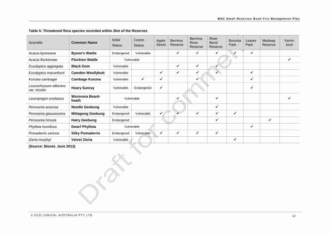
Table 4 details the threatened species which have been recorded within 2km of the Reserves and need
to be considered in any fire mitigation or management decision making process.
Section 5 of this Plan details management actions for these species.

W S C S m al l R e ser ve s B us h F i r e M a na g em e n t P l a n
© E CO LO G ICA L A U S T RA L IA P T Y LT D 11
Table 4: Threatened fauna species recorded within 2km of the Reserves (Source: Bionet. June 2013)
Scientific Common Name NSW
Status
Comm
Status
Apple Street
Berrima Reserve
Berrima River Reserve
River Bend Reserve
Boronia Park
Leaver Park
Medway Reserve
Yerrin-bool
Anthochaera phrygia Regent Honeyeater Endangered
Callocephalon fimbriatum
Gang-gang Cockatoo Vulnerable
Calyptorhynchus lathami
Glossy Black-Cockatoo
Vulnerable
Cercartetus nanus Eastern Pygmy-possum
Vulnerable
Chalinolobus dwyeri Large-eared Pied Bat Vulnerable
Daphoenositta chrysoptera
Varied Sittella Vulnerable
Dasyurus maculatus Spotted-tailed Quoll Vulnerable Endangered
Heleioporus australiacus
Giant Burrowing Frog
Vulnerable
Miniopterus schreibersii oceanensis
Eastern Bentwing-bat
Vulnerable
Mormopterus norfolkensis
Eastern Freetail-bat Vulnerable
Mixophyes balbus Stuttering Frog Endangered Vulnerable
Myotis macropus Southern Myotis Vulnerable
Ninox strenua Powerful Owl Vulnerable
Petroica boodang Scarlet Robin Vulnerable
Petroica phoenicea Flame Robin Vulnerable
Phascolarctos cinereus Koala Vulnerable
Pseudophryne australis Red-crowned Toadlet Vulnerable
Pteropus poliocephalus Grey-headed Flying-fox
Vulnerable
Tyto tenebricosa Sooty Owl Vulnerable
W S C S m al l R e ser ve s B us h F i r e M a na g em e n t P l a n
© E CO LO G ICA L A U S T RA L IA P T Y LT D 12
Table 5: Threatened flora species recorded within 2km of the Reserves
Scientific Common Name NSW
Status
Comm
Status
Apple Street
Berrima Reserve
Berrima River Reserve
River Bend Reserve
Boronia Park
Leaver Park
Medway Reserve
Yerrin-bool
Acacia bynoeana Bynoe's Wattle Endangered Vulnerable
Acacia flocktoniae Flockton Wattle Vulnerable
Eucalyptus aggregata Black Gum Vulnerable
Eucalyptus macarthurii Camden Woollybutt Vulnerable
Kunzea cambagei Cambage Kunzea Vulnerable
Leucochrysum albicans var. tricolor
Hoary Sunray Vulnerable Endangered
Leucopogon exolasius Woronora Beard-heath
Vulnerable
Persoonia acerosa Needle Geebung Vulnerable
Persoonia glaucescens Mittagong Geebung Endangered Vulnerable
Persoonia hirsuta Hairy Geebung Endangered
Phyllota humifusa Dwarf Phyllota Vulnerable
Pomaderris sericea Silky Pomaderris Endangered Vulnerable
Zieria murphyi Velvet Zieria Vulnerable
(Source: Bionet. June 2013)

W S C S m al l R e ser ve s B us h F i r e M a na g em e n t P l a n
© E CO LO G ICA L A U S T RA L IA P T Y LT D 13
2.4 Key Threatening Processes
In March 2000, the NSW Scientific Committee, established through the Threatened Species
Conservation (TSC Act) 1995, made a final determination to support a proposal to list “High frequency
fire resulting in the disruption of life cycle processes in plants and animals and loss of vegetation
structure and composition” as a Key Threatening Process (KTP) on Schedule 3 of the Act. This KPT is
an important consideration in all fire-prone habitats in New South Wales, although the likelihood of
occurrence of high frequency fire is currently greatest in coastal and tablelands habitats and where
bushland joins urban areas.
The NSW Scientific Committee (2001) recognised that in the Southern Highlands Shale Woodlands
community the number of species and the above-ground composition of species will change with time
since fire, and may also change in response to changes in fire frequency.
Bushfire regimes, bushfire suppression and bushfire management activities also have the potential to
exacerbate weed problems. Weed invasion is a threatening process affecting the Southern Highlands
Shale Woodlands community. Weed species typically respond well to the exposed, nutrient rich, and
competition-free conditions following fire. Bushfire management activities may allow these and other
weeds to penetrate new areas and increase the density of existing infestations. As such, appropriate
vegetation management before and after fire is required to mitigate this risk. This is discussed later in
Section 5.3.
2.5 Culturally signif icant assets
River Bend Reserve at Berrima is included on the NSW Heritage Register as part of the Berrima
Internment Group, being the location of a First World War Prisoner of War camp. It was here that the
Germans interned at the Berrima gaol built a large complex of huts and other items such as watercraft,
boatsheds, mooring posts, jetties and bridges to facilitate their daytime activities while in detention
Evidence of the huts that remain on site covered by the Bushfire Management plan includes numerous
stone rubble platforms and retaining walls on which huts would have been constructed (NSW OEH
2011).
Individual indigenous heritage sites are not identified in this plan rather safeguards to be applied if to
indigenous heritage sites should they be identified, are provided in Table 15.
The Reserves do not have comprehensively surveyed Indigenous cultural heritage site data and as the
dense vegetation may conceal artefacts this plan has adopted a precautionary approach and contains
measures and guiding principles to protect unknown aboriginal sites within the Reserves. These
measures are detailed within Indigenous heritage, Section 5.5.2 of this report.
2.6 Recreat ional use and faci l it ies
The types of use, characteristics of users and the administration of the activities are important
considerations for the management of bushfire risk to the participants of theses recreational uses within
the Reserves.
Table 6 below details the recreational uses within each of the Reserves which have been considered in
this Plan.

W S C S m al l R e ser ve s B us h F i r e M a na g em e n t P l a n
© E CO LO G ICA L A U S T RA L IA P T Y LT D 14
Table 6: Recreational use of the Reserves
Reserve Recreational Uses
Berrima Reserves: Apple Street None formally provided
Berrima Reserves: Berrima Reserve Berrima Sports
Berrima Reserves: Berrima River Reserve Walking tracks, fishing
Berrima Reserves: River Bend Reserve Walking tracks and adjoining scout camp
Boronia Park, Hilltop Soccer fields, Tennis courts
Leaver Park, Bundanoon None formally provided
Medway Reserve, Medway None formally provided
Yerrinbool Park, Yerrinbool None formally provided
W S C S m al l R e ser ve s B us h F i r e M a na g em e n t P l a n
© E CO LO G ICA L A U S T RA L IA P T Y LT D 15
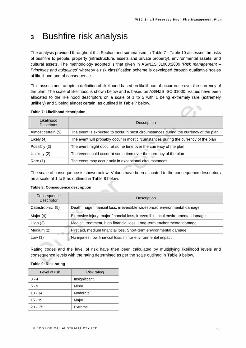
3 Bushfire risk analysis
The analysis provided throughout this Section and summarised in Table 7 - Table 10 assesses the risks
of bushfire to people, property (infrastructure, assets and private property), environmental assets, and
cultural assets. The methodology adopted is that given in AS/NZS 31000:2009 ‘Risk management –
Principles and guidelines’ whereby a risk classification scheme is developed through qualitative scales
of likelihood and of consequence.
This assessment adopts a definition of likelihood based on likelihood of occurrence over the currency of
the plan. The scale of likelihood is shown below and is based on AS/NZS ISO 31000. Values have been
allocated to the likelihood descriptors on a scale of 1 to 5 with 1 being extremely rare (extremely
unlikely) and 5 being almost certain, as outlined in Table 7 below.
Table 7: Likelihood description
Likelihood Descriptor
Description
Almost certain (5) The event is expected to occur in most circumstances during the currency of the plan
Likely (4) The event will probably occur in most circumstances during the currency of the plan
Possibly (3) The event might occur at some time over the currency of the plan
Unlikely (2) The event could occur at some time over the currency of the plan
Rare (1) The event may occur only in exceptional circumstances
The scale of consequence is shown below. Values have been allocated to the consequence descriptors
on a scale of 1 to 5 as outlined in Table 8 below.
Table 8: Consequence description
Consequence Descriptor
Description
Catastrophic (5) Death, huge financial loss, irreversible widespread environmental damage
Major (4) Extensive injury, major financial loss, irreversible local environmental damage
High (3) Medical treatment, high financial loss, Long-term environmental damage
Medium (2) First aid, medium financial loss, Short-term environmental damage
Low (1) No injuries, low financial loss, minor environmental impact
Rating codes and the level of risk have then been calculated by multiplying likelihood levels and
consequence levels with the rating determined as per the scale outlined in Table 9 below.
Table 9: Risk rating
Level of risk Risk rating
0 - 4 Insignificant
5 - 9 Minor
10 - 14 Moderate
15 - 19 Major
20 - 25 Extreme
W S C S m al l R e ser ve s B us h F i r e M a na g em e n t P l a n
© E CO LO G ICA L A U S T RA L IA P T Y LT D 16
Table 10 below provides an analysis of the risk factors. The risk assessments presented in Appendix 1
indicate that, over the currency of the Plan, threats to life, property, heritage and environmental
attributes of the Reserves have a moderate to significant risk and will require appropriate risk
management.
Table 10: Analysis of risk factors
Risk Factor Analysis of the risk factor
1. The likelihood of human and natural fire ignitions, as influenced by time, space and demographics.
Natural ignitions within the Reserves may occur.
Human induced ignitions are known to be relatively more frequent at the urban / bushland interface and the accessibility of the Reserves makes ignitions more likely.
Ignition caused by fires elsewhere in the landscape may occur.
2. The potential spread and severity of a bushfire, as determined by surrounding land uses, fuel, topography and weather conditions.
The Reserves are located on the juxtaposition of residential development and large conservation areas.
Where the Reserves adjoin conservation areas these are managed under Fire Management Strategies however the continuity of bushfire prone vegetation in association with widespread moderately steep slopes may result in uncontrollable fire intensities under winds from any direction. Where steep slopes occur in the Reserves this may result in rapid rates of spread and at times difficult fire control.
The Reserves may be exposed to strong north-westerly and southerly winds. Given the continuity of vegetation, wind and slope will be the primary determinant of the direction of fire spread.
3. The proximity of assets vulnerable to bushfire and likely bushfire paths.
Residential dwellings and associated structures directly adjoin parts of some Reserves. The majority of these assets have some set back from the Reserve boundaries although some would not meet contemporary standards. Most yards are reasonably managed in a fuel reduced state, however a detailed assessment of this has not occurred and it is certain that some improvement to properties could occur.
Historic sites (WWI internment hut sites within Berrima River Bend Reserve) exposed to bushfire attack.
The Southern Highlands Shale Woodland (EEC) covers part of the site at Medway Reserve. Inappropriate fire regimes may threaten this and other vegetation types in the reserves.
4. The vulnerability of assets, or their capacity to cope with, and recover from bushfire.
Few of the surrounding residential dwellings have been constructed in accordance with Planning for Bushfire Protection 2001 or 2006 and AS 3959 - Construction of Buildings in Bushfire Prone Areas. These older buildings are more vulnerable to bushfire attack than buildings constructed since 2001.
The WWI sites are considered to be fire resistant (as it is a site rather than building remnants) however they remain vulnerable to bushfire mitigation actions (i.e. earthmoving equipment).
Fire may impact threatened species and communities.
Fire events may exacerbate weed invasion.

W S C S m al l R e ser ve s B us h F i r e M a na g em e n t P l a n
© E CO LO G ICA L A U S T RA L IA P T Y LT D 17
4 Bushfire risk management
Bushfire risk management aims to reduce both the likelihood and consequences of bushfires. Broad
strategies to achieve this aim are summarised in Table 11 and detailed in the following subsections.
Implementation of these strategies helps minimise the risk to natural assets within the Reserves and
built assets within and adjoining the Reserves. However as no development in a bush fire prone area
can be guaranteed to be entirely safe from bushfires, providing an acceptable level of protection and a
tolerable residual risk, is to some extent a compromise between the level of threat, inconvenience,
dangers, ability or practicality of implementation and costs (financial and environmental) involved in
providing the protection.
Typically the best outcomes are achieved where neighbouring properties and Reserve managers co-
operate to provide bushfire protection measures.
Table 11: Bushfire risk reduction strategies and actions
Strategy Actions
Avoid the risk Building and development controls and prohibiting certain developments near hazards
Reduce the hazard Reduce the level of fuel available to burn in a bushfire
Manual clearing of bushfire fuels and provision of asset protection zones
Reduce unplanned ignition Local bushfire education and extension programs
Communications regarding Total Fire Ban days and burn permits
Reduce vulnerability Establishment and maintenance of Asset Protection Zones for the protection of built assets in and around the Reserve
Development and implementation of cooperative and complementary fire management strategies with neighbours and adjoining residences
Understand and accept residual risk
Manage with early detection and fire suppression operations
Maintenance of existing access routes to facilitate suppression of fires
4.1 Fire management zones
Fire management zones are based on the location of assets, surrounding land managers bushfire
mitigation measures, topography, land use, potential bushfire hazard and risk (Section 4 above). Fire
management zones are separated into the following categories based on the Bushfire Environmental
Assessment Code (BEAC) (NSW RFS 2006) and WBFRMP:
Asset Protection Zone (APZ)
Land Management Zone (LMZ)
Strategic Fire Advantage Zone (SFAZ)
Zones have been identified and mapped across the Reserves to provide a planning framework upon
which the protection of life, property and the environment can be improved. A description of each of
these zones is provided in Table 12 and details of the zones applied in this plan are provided in Table
13.

W S C S m al l R e ser ve s B us h F i r e M a na g em e n t P l a n
© E CO LO G ICA L A U S T RA L IA P T Y LT D 18
Table 12: Description of bushfire management zones
Zone Objective Description Fuel management strategies
Asset Protection Zone
(APZ)
Aims to protect human life, property
and highly valued public assets and
values.
It is an area immediately surrounding a
development managed to reduce the
bushfire hazard to an acceptable level.
APZs exist within other zones around
specific built assets.
The width of the APZ will vary with slope and building
construction standard.
Fine fuel in ground and shrub layers are not to exceed 4
tonnes/ha.
Fuel managed by slashing, selective shrub clearing, trail
construction or burning.
Strategic Fire Advantage
Zone
(SFAZ)
To provide for strategic containment
of wildfires which will reduce the
speed and intensity of bushfires,
and reduce the potential for spot fire
development. They are also used
to provide safe access for bushfire
operations and to assist with
implementing fire management
activities.
Usually adjacent to infrastructure (e.g.
management trails, roads, walking tracks
and cleared boundaries) for the purpose of
adding depth to the effectiveness of these
features.
They can also be located in strategic areas
to reduce the spread of wildfire and aid
suppression e.g. near known ignition points
and narrow vegetated corridors.
Fine fuel in ground and shrub layers should not exceed 8-
12 tonnes/ha.
Maximum 8 tonnes/ha of fine fuels in ground and shrub
layers is commonly used as a level for which the fire
intensity expected will not impact on any adjacent
developments or assets.
Fuel management by slashing, selective shrub clearing,
trail construction or prescribed burning.
Land Management Zone
(LMZ)
To manage bushfires to meet land
management objectives where
Asset Protection or Strategic Fire
Advantage Zones are not
appropriate or necessary.
Areas that are primarily managed for
conservation, aesthetic, or water catchment
purposes.
Undertake prescribed (ecological) burning programs
primarily for biodiversity conservation purposes, however
the spatial pattern of burning should also provide some
fire control advantage where possible

W S C S m al l R e ser ve s B us h F i r e M a na g em e n t P l a n
© E CO LO G ICA L A U S T RA L IA P T Y LT D 19
Table 13: Zones
Reserve Zone Fire Management Objectives
Berrima Reserves: Apple Street
Asset Protection Zone To protect adjacent houses to the north and south, and RFS building
Strategic Fire Advantage Zone To mitigate wildfire movement and compliment the life and property protection within the adjoining APZ
Berrima Reserves: Berrima Reserve Land Management Zone To maintain fire regimes predominantly within biodiversity thresholds using mid-long range fire intervals
Berrima Reserves: Berrima River Reserve
Asset Protection Zone To protect houses to the west
Land Management Zone
To maintain fire regimes predominantly within biodiversity thresholds using mid-long range fire intervals
To burn this zone to create a mosaic of fire ages across the landscape that helps mitigate wildfire movement and provide a diversity of fire age classes in vegetation communities
Berrima Reserves: River Bend Reserve Land Management Zone
To maintain fire regimes predominantly within biodiversity thresholds using mid-long range fire intervals
To protect cultural sites
Boronia Park, Hilltop
Asset Protection Zone To protect houses which border the Park
Strategic Fire Advantage Zone To mitigate wildfire movement and compliment the life and property protection within the adjoining APZ
Leaver Park, Bundanoon Land Management Zone Maintain fire regimes using mid to long-range fire intervals
Medway Reserve, Medway
Asset Protection Zone To protect built assets (Medway Hall)
Strategic Fire Advantage Zone To reduce intensity of fire impacting on adjacent houses
Land Management Zone
To maintain fire regimes predominantly within biodiversity thresholds using mid-long range fire intervals
To conserve the Endangered Ecological Community
Yerrinbool Park, Yerrinbool
Asset Protection Zone To protect built assets
Strategic Fire Advantage Zone
To burn this zone to create a mosaic of fire ages across the landscape that helps mitigate wildfire movement and provide a diversity of fire age classes in vegetation communities
To maintain fire regimes using short to medium fire intervals
W S C S m al l R e ser ve s B us h F i r e M a na g em e n t P l a n
© E CO LO G ICA L A U S T RA L IA P T Y LT D 20
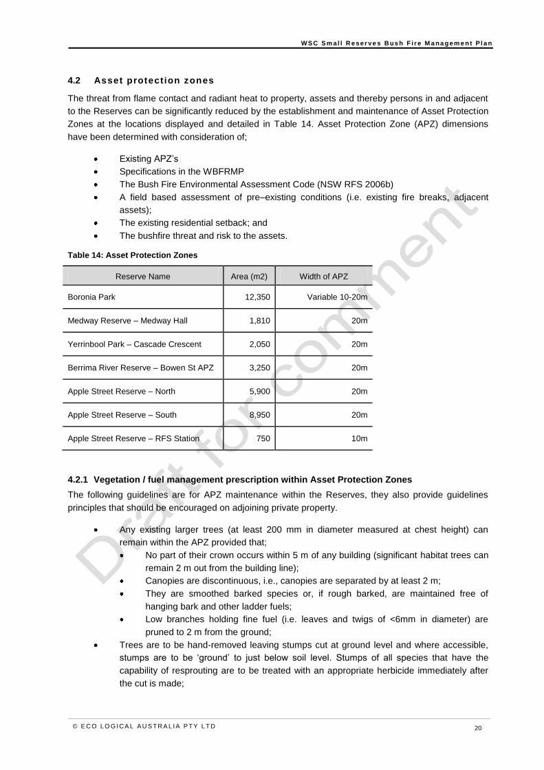
4.2 Asset protection zones
The threat from flame contact and radiant heat to property, assets and thereby persons in and adjacent
to the Reserves can be significantly reduced by the establishment and maintenance of Asset Protection
Zones at the locations displayed and detailed in Table 14. Asset Protection Zone (APZ) dimensions
have been determined with consideration of;
Existing APZ’s
Specifications in the WBFRMP
The Bush Fire Environmental Assessment Code (NSW RFS 2006b)
A field based assessment of pre–existing conditions (i.e. existing fire breaks, adjacent
assets);
The existing residential setback; and
The bushfire threat and risk to the assets.
Table 14: Asset Protection Zones
Reserve Name Area (m2) Width of APZ
Boronia Park 12,350 Variable 10-20m
Medway Reserve – Medway Hall 1,810 20m
Yerrinbool Park – Cascade Crescent 2,050 20m
Berrima River Reserve – Bowen St APZ 3,250 20m
Apple Street Reserve – North 5,900 20m
Apple Street Reserve – South 8,950 20m
Apple Street Reserve – RFS Station 750 10m
4.2.1 Vegetation / fuel management prescription within Asset Protection Zones
The following guidelines are for APZ maintenance within the Reserves, they also provide guidelines
principles that should be encouraged on adjoining private property.
Any existing larger trees (at least 200 mm in diameter measured at chest height) can
remain within the APZ provided that;
No part of their crown occurs within 5 m of any building (significant habitat trees can
remain 2 m out from the building line);
Canopies are discontinuous, i.e., canopies are separated by at least 2 m;
They are smoothed barked species or, if rough barked, are maintained free of
hanging bark and other ladder fuels;
Low branches holding fine fuel (i.e. leaves and twigs of <6mm in diameter) are
pruned to 2 m from the ground;
Trees are to be hand-removed leaving stumps cut at ground level and where accessible,
stumps are to be ‘ground’ to just below soil level. Stumps of all species that have the
capability of resprouting are to be treated with an appropriate herbicide immediately after
the cut is made;

W S C S m al l R e ser ve s B us h F i r e M a na g em e n t P l a n
© E CO LO G ICA L A U S T RA L IA P T Y LT D 21
Smaller trees (i.e. less than 200 mm in diameter), shrubs, fallen trees and tree-limbs and
stumps are to be removed and continuously suppressed;
All shrubs and tree saplings are to be removed off-site or mulched, but all native grasses
within the Reserves are to remain in-situ wherever possible; and
Minimal ground fuel is to be maintained to include either mown grass or bare ground or
less than 3 tonnes per hectare of fine fuel (i.e. material of <6 mm in diameter).
4.3 Access and f ire trails
In a bushfire planning context, roads and trails perform a variety of functions, they can:
Facilitate evacuation
Provide access for fire crews for direct fire attack
Function as control lines for prescribed burning
Function as control lines for back-burning
In NSW, fire trails are classified using a vehicle carrying capacity and strategic importance classification
as specified in the NSW Bushfire Co-ordinating Committee policy (BFCC 2007). The vehicle carrying
capacity classification is based on the details shown in Table 15 and the strategic importance
classification is detailed in Table 16, below.
Table 15: Fire vehicle specifications
Trail & Vehicle
Classification Weight
Ground
Clearance Width Height Turning Circle
Category 1 15,000kg 310mm 2800mm 4000mm 22m Diameter
Category 7 7,000kg 215mm 2600mm 3200mm 17m Diameter
Category 9 3,700kg 220mm 2200mm 2600mm 16m Diameter
Table 16: Fire trails strategic importance classification
Category Description
Essential
This is a fire trail without which fire response and suppression in an area would be severely
compromised. All reasonable efforts must be made to ensure that this trail is trafficable to
the agreed vehicle carrying capacity at all times. Sudden problems such as tree falls and
land slips should be rectified as soon as identified. This trail should be checked on
occasions throughout each year, and particularly before the commencement of bush fire
season.
Physical barriers to vehicle access must not be deliberately installed, unless they are
readily broached by fire fighters. That is, a locked gate with key access for fire fighters
would be acceptable; fixed bollards, felled trees, piles of rock and the like would not be
acceptable, as the obstruction cannot be removed by a fire fighting crew without additional
machinery.
Important
This is a fire trail that is required for fire management. If this trail was unusable due to
temporary circumstances, other trails could be used to contain a fire, albeit with some loss
of fire management efficiency. This trail should be trafficable to the agreed vehicle carrying
capacity at all times. This trail should be checked before the commencement of the local
bush fire season.

W S C S m al l R e ser ve s B us h F i r e M a na g em e n t P l a n
© E CO LO G ICA L A U S T RA L IA P T Y LT D 22
Category Description
Dormant This is a track or trail that has been used at some time in the past, but where there is no
requirement for it to be constantly maintained in a trafficable state.
This Plan does not recommend the establishment of any additional access tracks, however it is
recommended that the existing tracks and access points are continued to be maintained and identifies
some areas for improvement of access availability.

W S C S m al l R e ser ve s B us h F i r e M a na g em e n t P l a n
© E CO LO G ICA L A U S T RA L IA P T Y LT D 23
5 Protection of environment and cultural sites
The Plan has identified operational guidelines to reduce impacts on the environment which are to be
followed when carrying out the activities identified in the Plan. These operational guidelines are detailed
in the following subsections.
5.1 Fuel / vegetat ion reduct ion operat ions
During the establishment and maintenance of APZs within the Reserve, the following tree and
vegetation clearing and management operations should be followed to protect soils, landscape features,
and conservation values:
Scrub cutters and hand tools are the most satisfactory equipment for hazard reduction
operations. Only this type of minimum impact equipment should be used;
Threatened flora species or endangered ecological communities under the TSC Act (1995)
must not be removed or damaged. In order to minimise the risk of damage to these species
or communities, surrounding vegetation is to be removed by hand only;
The use of bulldozers or other track type machinery should not be permitted;
Cut vegetative material (with the exception of noxious and environmental weeds) and
ground fuel, leaves, bark, twigs, grass tussocks etc. may be mulched and spread to help
prevent weed invasion and soil erosion;
Removal by hand is permissible on all slopes while mowing will not be undertaken on
slopes greater than 15 degrees.
5.2 Fire regimes for biodiversity conservation
An objective of this Bushfire Management Plan is to ‘Provide appropriate fire regimes and hazard
reduction activities to avoid detrimental impacts on species, communities, populations and culturally
significant assets’. Management of fire is therefore guided by the following general biodiversity
conservation principles:
Groups of plant and animal species respond similarly to fire according to characteristics of
their life history
Depending on the attributes of individual species, variation in components of the fire
regime may facilitate local species extinctions (Keith 1996)
It is not necessary to individually specify fire regimes for the conservation of every species
and an overview of the requirements for broad groups of species can be applied.
Requirements for most plant species can be summarised on the basis of a small number of
groups
Flora are commonly categorised into three broad groups based on their response to fire
(Naveh 1975):
o ‘Obligate seed regenerators’ generally regenerate only by seed
o ‘Obligate re-sprouters’ generally regenerate solely by re-sprouting
o ‘Facultative re-sprouters’ regenerate by seed and re-sprouting

W S C S m al l R e ser ve s B us h F i r e M a na g em e n t P l a n
© E CO LO G ICA L A U S T RA L IA P T Y LT D 24
Plant and animal communities are inextricably linked. Plants form an important component
of habitat for animals
A diversity of fire regimes may be needed to maintain biodiversity. This means that over
time, there is a place for fires of high, moderate and low intensity, frequency and size.
Extinctions may be likely when fire regimes of relatively fixed intensity, frequency and
extent prevail without variation
Much of the vegetation within the Reserves is highly adapted to fire.
Table 17 provides fire regime guidelines for the major groups of vegetation within the Reserves applied
in this Plan. As a variable fire regime within these guidelines is required to avoid a decline in
biodiversity it is important to vary the fire frequency, intensity, season and pattern of burn within the
guidelines for each vegetation group identified in Table 17.
Table 17: Fire regime guidelines for conservation of biodiversity (after NPWS 2004)
Community A decline in biodiversity is predicted if there is
Dry sclerophyll forests:
Hawkesbury Sandstone Woodland
Bundanoon Sandstone Woodland
Mittagong Sandstone Woodland
Wingecarribee Woodland
Southern Highlands Shale Woodland (EEC)
3 consecutive fires, with each of the fires less than 7 years apart
no fire for more than 30 years
successive fires that totally scorch or consume the tree canopy
successive fires that do not consume more than 8-10 t/ha of surface fuel
Wet sclerophyll forest:
Nattai Sandstone Gully Forest
more than one fire every 25 years
no fire for 60 years
successive fires that totally scorch or consume the tree canopy
5.3 Threatened species management
5.3.1 Threatened fauna safeguards
The major effects of fire on animals are through changes to their habitat and the availability of food,
shelter and breeding sites (Williams & Gill 1995). Thus, the effect of fire regimes on the habitat
requirements of animals is significant.
Although further research is required, it appears necessary to ensure a diversity of age classes in
appropriate vegetation types for the maintenance of animal species (Williams & Gill 1995). Whilst
endeavouring to provide this, care must be taken to avoid unnecessary, severe impact on animals when
implementing these guidelines. Burning a large proportion of available habitat; burning during breeding
seasons; or burning prior to the dispersal of young, may have a long-term detrimental effect on isolated
animal populations. The availability of nectar flow from flowering plants is another important
consideration for both vertebrate and invertebrate species. It is desirable that any individual fire, or the
combination of fires within a short period of time, should not completely burn the local extent of a
vegetation community or habitat type.
Specific safeguards for threatened fauna species are provided at Table 19 are also provided on the
poster plans.

W S C S m al l R e ser ve s B us h F i r e M a na g em e n t P l a n
© E CO LO G ICA L A U S T RA L IA P T Y LT D 25
5.3.2 Threatened flora safeguards
Where the fire regime requirements of an individual threatened species are known, and particularly
where requirements differ from the regime to be applied to the surrounding vegetation, site-specific fire
management strategies may be required. The Bushfire Environmental Assessment Code (BEAC)
provides some guidance on threatened flora safeguards, as detailed in
5.3.3 Notes on Bushfire Environmental Assessment Code and threatened species
The Bushfire Environmental Assessment Code (BEAC) provides a streamlined environmental
assessment process for use by issuing authorities and certifying authorities in determining bush fire
hazard reduction certificates. It does not provide guidelines for landscape level fire management
planning. Accordingly, where the BEAC specifies conditions relating to a particular species, they are
noted here for consideration when implementing works, however there are also additional provisions in
the safeguards detailed below be adopted as part of the Plan.
W S C S m al l R e ser ve s B us h F i r e M a na g em e n t P l a n
© E CO LO G ICA L A U S T RA L IA P T Y LT D 26
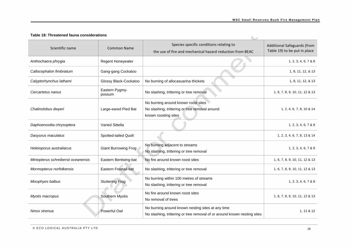
Table 18: Threatened fauna considerations
Scientific name Common Name Species specific conditions relating to
the use of fire and mechanical hazard reduction from BEAC
Additional Safeguards (from Table 19) to be put in place
Anthochaera phrygia Regent Honeyeater 1, 2, 3, 4, 6, 7 & 8
Callocephalon fimbriatum Gang-gang Cockatoo 1, 8, 11, 12, & 13
Calyptorhynchus lathami Glossy Black-Cockatoo No burning of allocasuarina thickets 1, 8, 11, 12, & 13
Cercartetus nanus Eastern Pygmy-possum
No slashing, trittering or tree removal 1, 6, 7, 8, 9, 10, 11, 12 & 13
Chalinolobus dwyeri Large-eared Pied Bat
No burning around known roost sites
No slashing, trittering or tree removal around
known roosting sites
1, 2, 4, 6, 7, 8, 10 & 14
Daphoenositta chrysoptera Varied Sittella 1, 2, 3, 4, 6, 7 & 8
Dasyurus maculatus Spotted-tailed Quoll 1, 2, 3, 4, 6, 7, 8, 13 & 14
Heleioporus australiacus Giant Burrowing Frog No burning adjacent to streams
No slashing, trittering or tree removal 1, 2, 3, 4, 6, 7 & 8
Miniopterus schreibersii oceanensis Eastern Bentwing-bat No fire around known roost sites 1, 6, 7, 8, 9, 10, 11, 12 & 13
Mormopterus norfolkensis Eastern Freetail-bat No slashing, trittering or tree removal 1, 6, 7, 8, 9, 10, 11, 12 & 13
Mixophyes balbus Stuttering Frog No burning within 100 metres of streams
No slashing, trittering or tree removal 1, 2, 3, 4, 6, 7 & 8
Myotis macropus Southern Myotis No fire around known roost sites
No removal of trees 1, 6, 7, 8, 9, 10, 11, 12 & 13
Ninox strenua Powerful Owl No burning around known nesting sites at any time
No slashing, trittering or tree removal of or around known nesting sites 1, 11 & 12
W S C S m al l R e ser ve s B us h F i r e M a na g em e n t P l a n
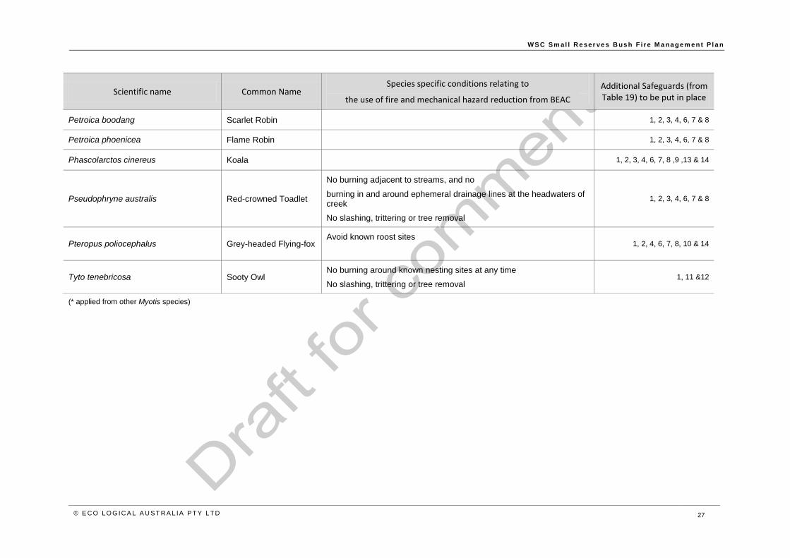
© E CO LO G ICA L A U S T RA L IA P T Y LT D 27
Scientific name Common Name Species specific conditions relating to
the use of fire and mechanical hazard reduction from BEAC
Additional Safeguards (from Table 19) to be put in place
Petroica boodang Scarlet Robin 1, 2, 3, 4, 6, 7 & 8
Petroica phoenicea Flame Robin 1, 2, 3, 4, 6, 7 & 8
Phascolarctos cinereus Koala 1, 2, 3, 4, 6, 7, 8 ,9 ,13 & 14
Pseudophryne australis Red-crowned Toadlet
No burning adjacent to streams, and no
burning in and around ephemeral drainage lines at the headwaters of creek
No slashing, trittering or tree removal
1, 2, 3, 4, 6, 7 & 8
Pteropus poliocephalus Grey-headed Flying-fox Avoid known roost sites
1, 2, 4, 6, 7, 8, 10 & 14
Tyto tenebricosa Sooty Owl No burning around known nesting sites at any time
No slashing, trittering or tree removal 1, 11 &12
(* applied from other Myotis species)

W S C S m al l R e ser ve s B us h F i r e M a na g em e n t P l a n
© E CO LO G ICA L A U S T RA L IA P T Y LT D 28
Table 19: Fire management safeguards (practices to avoid) for threatened fauna
Safeguard option Where possible, in locations of known populations and/or core habitat:
Safeguard 1 Avoid fire regimes beyond fire interval thresholds of the native vegetation communities making up the species habitat.
Safeguard 2 Avoid burning more than 30% of the local habitat of the species in any year
Safeguard 3 Avoid size of each burn patch being >50% of the smaller home range of the species
Safeguard 4 Avoid actual area burned being >75% of the total area within a burn perimeter
Safeguard 5 Avoid burning a small total area where post-fire herbivore overgrazing is a concern
Safeguard 6 Avoid lighting up more than 50% of the burn perimeter and allow fire to spread in a single direction. Avoid situations resulting in
converging fire lines with no escape routes.
Safeguard 7 Avoid burning in breeding season. If a number of species with different breeding seasons occur in the burn area, avoid the
breeding season of the most fire sensitive species.
Safeguard 8
Avoid high intensity fire by minimising the size of wildfires, ignition times during mid-day, ignition during higher fire danger
periods and if possible suppressing wildfires prior to it affecting the population. Prescribed burning may be appropriate to reduce
nearby fuel loads in the direction from which wildfire is expected.
Safeguard 9 Avoid scorching the over-storey canopy during prescribed burning
Safeguard 10 Avoid placing infrastructure (e.g. temporary utilities, re-routing trails, etc.) within habitat or near nesting and roosting sites
Safeguard 11 Avoid felling hollow-bearing trees during mop-up and control line construction
Safeguard 12 Avoid burning known den trees and roost sites during prescribed burning
Safeguard 13 Avoid felling feed trees during mop-up and control line construction
Safeguard 14 Avoid predation by, or competition with, feral animals (in areas where they occur) by implementing appropriate feral animal
control measures in conjunction with the prescribed burning

W S C S m al l R e ser ve s B us h F i r e M a na g em e n t P l a n
© E CO LO G ICA L A U S T RA L IA P T Y LT D 29
Table 20: Threatened flora considerations
Scientific Common Name
Species specific conditions relating to
the use of fire and mechanical hazard reduction from BEAC
Berrima Reserve
Acacia bynoeana Bynoe's Wattle No fire more than once every 7 years No slashing, trittering or tree removal
Acacia flocktoniae Flockton Wattle No fire more than once every 7 years No slashing, trittering or tree removal
Eucalyptus aggregata Black Gum No BEAC requirements therefore the surrounding vegetation regime to be applied
Eucalyptus macarthurii Camden Woollybutt No BEAC requirements therefore the surrounding vegetation regime to be applied
Kunzea cambagei Cambage Kunzea No fire more than once every 7 years No slashing, trittering or tree removal
Leucochrysum albicans var. tricolor
Hoary Sunray No BEAC requirements therefore the surrounding vegetation regime to be applied
Leucopogon exolasius Woronora Beard-heath No BEAC requirements therefore the surrounding vegetation regime to be applied
Persoonia acerosa Needle Geebung
No fire more than once every 13 years
No burning mid-winter
No slashing, trittering or tree removal
Persoonia glaucescens Mittagong Geebung No BEAC requirements therefore the surrounding vegetation regime to be applied
Persoonia hirsuta Hairy Geebung No BEAC requirements therefore the surrounding vegetation regime to be applied
Phyllota humifusa Dwarf Phyllota No fire more than once every 7 years No slashing, trittering or tree removal
Pomaderris sericea Silky Pomaderris No fire No slashing, trittering or tree removal
Zieria murphyi Velvet Zieria No fire more than once every 10 years
No slashing more frequently than every 10
years, and no trittering or tree removal

W S C S m al l R e ser ve s B us h F i r e M a na g em e n t P l a n
© E CO LO G ICA L A U S T RA L IA P T Y LT D 30
5.4 Weed management
Where fuel/vegetation reduction and access maintenance works occur, all vehicles and machinery likely
to disturb the soil should be cleaned prior to, during and after these activities to reduce the spread of
weeds.
As bushfires may exacerbate weed infestations, it is recommended that weed control occurs within 6
months of any bushfire. Table 21 outlines safeguards to reduce the spread of weeds during fire
management activities.
Table 21: Safeguards when carrying out fire management activities in sites containing exotic plant species
Potential impact Possible safeguards (or ameliorative measures) to mitigate the impact
Exotic seeds introduced on machinery and boots during fire management activities
Wash down all vehicles and machinery likely to disturb the soil prior to, during and after APZ maintenance, prescribed burning or trail maintenance activities.
Vehicles and machinery regularly used in wildfire suppression should be thoroughly cleaned on a regular basis.
Carry out weed management following the fire management activities.
Weed distribution and abundance increased as a result of fire management activities
Carry out weed control following the fire management activities.
Avoid movement through weed infested areas.
Wash down all vehicles and machinery that are likely to disturb the soil during prescribed burning or trail maintenance activities.
Environmental conditions that favour the expansion of exotic species are created by fire regimes
Minimise size of burn areas by slashing or other (non-fire) fuel reduction.
Delay burning if burning at the proposed time will exceed fire interval threshold.
Whenever possible, avoid scorching the overstorey canopy during prescribed burning.
5.5 Protect ion of cultural sites
5.5.1 Historic heritage
The Berrima Internment historic site at River Bend Reserve includes evidence of the WWI huts; these
are numerous stone rubble platforms and retaining walls on which huts would have been constructed
(NSW OEH 2011) and as such are not vulnerable to bushfire itself. They may however be damaged by
heavy machinery and accordingly an exclusion area for heavy machinery is included in the Bushfire
Management Plan.

W S C S m al l R e ser ve s B us h F i r e M a na g em e n t P l a n
© E CO LO G ICA L A U S T RA L IA P T Y LT D 31
5.5.2 Indigenous heritage
Table 22 details management strategies to mitigate bushfire threat to known, or any other newly
discovered, indigenous cultural sites.
Table 22: Management strategies for fire related threats to Indigenous sites
Site types Threats Management Strategies
Scarred and/or carved trees
Destruction by fire or damage to bark layers. Threat may originate from wildfire and prescribed burns.
Avoid prescribed burning in known locations.
Where prescribed burning is unavoidable, fuel should be cleared around identified trees prior to burn. Loose leaf litter and low ground cover is to be manually cleared by raking for 10 m around the tree.
Incident Controllers and Incident Management Teams are to be informed of known locations. The use of earthmoving equipment around known sites is to be avoided or closely scrutinised.
Known sites are to be examined as soon as possible after the passage of the fire and embers and smoulder to be immediately extinguished.
Art
Grinding grooves
Rock engravings
Smoke damage and exfoliation of rock layers
Clear vegetation from around the art so the potential for flame contact during wildfire is reduced. However avoid removal of vegetation that may provide protection from weathering and security.
Avoid prescribed burning in known locations.
Where prescribed burning is unavoidable, fuel should be cleared from in, on, and around all identified sites. Fuel clearing must not damage the site.
Incident Controllers and Incident Management Teams are to be informed of known locations. The use of earthmoving equipment around known sites is to be avoided or closely scrutinised. Bushfire fighting foam should not be used within 20 m of art sites. If windy the distance should be extended to 50 m.
Middens
Artefacts
Deposits
Damage through inappropriate or unplanned fire suppression activities e.g. construction of containment lines via earthmoving equipment.
Accelerated erosion.
The earth around known sites is to remain intact. Any surface impact adjacent to a site must be returned to its previous state.
Incident Controllers and Incident Management Teams are to be informed of known locations. The use of earthmoving equipment, vehicles and heavy equipment must not be used on or within these sites unless a path exists that will not damage sites.
6 Fire management actions for the Reserves
Table 23 to Table 30 detail the recommended actions for WSC to undertake over the next 5 years.
These measures have been derived from the policy and legislative obligations, from research and risk
assessment and stakeholder consultation.
The actions works are designed to strategically reduce the bushfire risk to life, property and the
environment. However, even if perfectly implemented the actions will not eliminate the bushfire risk and
effective preparedness, response and recovery to bushfire will always be essential. All strategies and
actions are interconnected to build an effective bushfire management outcome; if one is not completed
it may significantly reduce the effectiveness of others, some of which may be critical.

W S C S m al l R e ser ve s B us h F i r e M a na g em e n t P l a n
© E CO LO G ICA L A U S T RA L IA P T Y LT D 32
Table 23: Summary of fire management actions – Berrima Reserves: Apple St
SFAZ
Fire Interval Indicative Prescribed burn year Comments
Maintain fire regimes using mid-range fire intervals
Avoid successive fires at intervals less than 7 years
Avoid fire exclusion for period greater than 15 years
2014 - 2020
Area is can be burnt within the plan timeframe.
Will exceed upper biodiversity threshold in the life of this plan if not burnt.
APZ Maintain 20m APZ around RFS station, and houses on northern and southern boundaries at location shown in poster plan, to standard specified in Section 4.2.1 (note that tree density can be retained and the understorey is to be managed appropriately)
Access Ensure fire trail at location shown in poster plan is maintained at Category 1 standard as detailed in Section 4.3 of this plan
Table 24: Summary of fire management actions – Berrima Reserves: Berrima Reserve
LMZ
Fire Interval Indicative Prescribed burn year Comments
Maintain fire regimes using mid-long range fire intervals
Avoid successive fires at intervals less than 10 years
Avoid fire exclusion for period greater than 30 years
2014 - 2020
Area is long unburnt and can be burnt within life of plan to maintain biodiversity thresholds.
Will exceed upper biodiversity threshold in the life of this plan if not burnt.
Table 25: Summary of fire management actions – Berrima Reserves: Berrima River Reserve
LMZ
Fire Interval Indicative Prescribed burn year Comments
Maintain fire regimes using mid to long-range fire intervals
Avoid successive fires at intervals less than 10 years
Avoid fire exclusion for a period greater than 30 years
2014 - 2020 except area in SE burnt in 2012
This area has a history of mosaic burning, and this zoning allows for a continuation of this burn pattern.
APZ Maintain Bowen St APZ at location shown in poster plan, to standard specified in Section 4.2.1
Access Ensure fire trails at locations shown in poster plan are maintained according to Section 4.3 of this plan
Recreational Use
Fishing
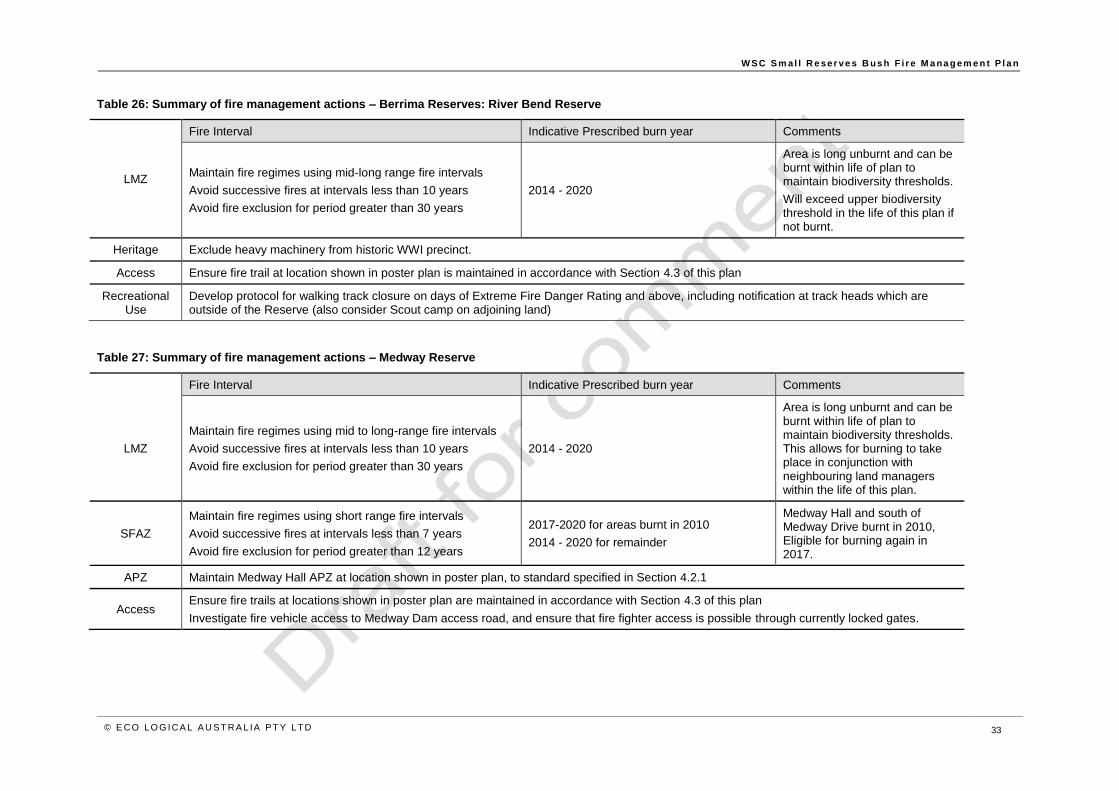
W S C S m al l R e ser ve s B us h F i r e M a na g em e n t P l a n
© E CO LO G ICA L A U S T RA L IA P T Y LT D 33
Table 26: Summary of fire management actions – Berrima Reserves: River Bend Reserve
LMZ
Fire Interval Indicative Prescribed burn year Comments
Maintain fire regimes using mid-long range fire intervals
Avoid successive fires at intervals less than 10 years
Avoid fire exclusion for period greater than 30 years
2014 - 2020
Area is long unburnt and can be burnt within life of plan to maintain biodiversity thresholds.
Will exceed upper biodiversity threshold in the life of this plan if not burnt.
Heritage Exclude heavy machinery from historic WWI precinct.
Access Ensure fire trail at location shown in poster plan is maintained in accordance with Section 4.3 of this plan
Recreational Use
Develop protocol for walking track closure on days of Extreme Fire Danger Rating and above, including notification at track heads which are outside of the Reserve (also consider Scout camp on adjoining land)
Table 27: Summary of fire management actions – Medway Reserve
Fire Interval Indicative Prescribed burn year Comments
LMZ
Maintain fire regimes using mid to long-range fire intervals
Avoid successive fires at intervals less than 10 years
Avoid fire exclusion for period greater than 30 years
2014 - 2020
Area is long unburnt and can be burnt within life of plan to maintain biodiversity thresholds. This allows for burning to take place in conjunction with neighbouring land managers within the life of this plan.
SFAZ
Maintain fire regimes using short range fire intervals
Avoid successive fires at intervals less than 7 years
Avoid fire exclusion for period greater than 12 years
2017-2020 for areas burnt in 2010
2014 - 2020 for remainder
Medway Hall and south of Medway Drive burnt in 2010, Eligible for burning again in 2017.
APZ Maintain Medway Hall APZ at location shown in poster plan, to standard specified in Section 4.2.1
Access Ensure fire trails at locations shown in poster plan are maintained in accordance with Section 4.3 of this plan
Investigate fire vehicle access to Medway Dam access road, and ensure that fire fighter access is possible through currently locked gates.

W S C S m al l R e ser ve s B us h F i r e M a na g em e n t P l a n
© E CO LO G ICA L A U S T RA L IA P T Y LT D 34
Table 28: Summary of fire management actions – Boronia Park Hilltop
Fire Interval Indicative Prescribed burn year Comments
SFAZ 1
Maintain fire regimes using short range fire intervals
Avoid successive fires at intervals less than 7 years
Avoid fire exclusion for periods greater than 10 years
2014 - 2018
Burning Priority Areas
Reserve to be burned within thresholds
Where possible burn zones in different years to create mosaic
In deciding zones to burn give priority to zones in the following order: 1,2,3,4.
This allows for burning to take place in conjunction with neighbouring land managers.
SFAZ 2
Maintain fire regimes using short range fire intervals
For Woodland:
Avoid successive fires at intervals less than 7 years
Avoid fire exclusion for periods greater than 12 years
For Wet Sclerophyll Forest:
Avoid successive fires at intervals less than 25 years
Avoid fire exclusion for periods greater than 40 years
2014 - 2018
SFAZ 3
Maintain fire regimes using short range fire intervals
Avoid successive fires at intervals less than 7 years
Avoid fire exclusion for periods greater than 12 years
2015 - 2019
SFAZ 4
Maintain fire regimes using mid-range fire intervals
Avoid successive fires at intervals less than 7 years
Avoid fire exclusion for periods greater than 15 years
2014 - 2018
APZ Maintain Boronia Ave and Stanley St APZ at location shown in poster plan, to standard specified in Section 4.2.1
Access
Ensure fire trails at locations shown in poster plan are maintained in accordance with Section 4.3 of this plan
Investigate neighbour agreement for fire trail where it is located on private properties
Investigate linking fire trail to sewer pump station access road, and formalising this (reduced reliance on trail on private properties)
Evacuation Prepare Evacuation Plan for soccer fields. This must consider peak numbers, fire danger rating, time to evacuate, notification system and fires nearby.

W S C S m al l R e ser ve s B us h F i r e M a na g em e n t P l a n
© E CO LO G ICA L A U S T RA L IA P T Y LT D 35
Table 29: Summary of fire management actions – Yerrinbool Park
Fire Interval Indicative Prescribed burn year Comments
SFAZ
Maintain fire regimes using mid-range fire intervals
For woodland: Avoid successive fires at intervals less than 7 years
Avoid fire exclusion for periods greater than15 years
For Wet Sclerophyll Forest:
Avoid successive fires at intervals less than 25 years
Avoid fire exclusion for periods greater than 60 years
2014 – 2020 except area in SW burnt in 2012 Burn currently approved by RFS for 2014
APZ Establish and maintain APZ at Cascade Cres location shown in poster plan, to standard specified in Section 4.2.1
Table 30: Summary of fire management actions – Leaver Park, Bundanoon
LMZ
Fire Interval Indicative Prescribed burn year Comments
Maintain fire regimes using mid to long-range fire intervals
Avoid successive fires at intervals less than 10 years
Avoid fire exclusion for periods greater than 30 years
2014
Last burnt in 1982/83, will exceed upper biodiversity threshold in the life of this plan if not burnt.
W S C S m al l R e ser v . e s B u s h F i r e M a na g em e n t P l a n
© E CO LO G ICA L A U S T RA L IA P T Y LT D 36
7 Environmental assessments and permit requirements
The environmental assessment for the proposed works within the APZs may be obtained using the
Bush Fire Environmental Assessment Code (BFEAC) (RFS 2006b) and the Hazard Reduction
Certificate process. As a Public Authority, Council may prepare and certify its own Hazard Reduction
Certificates for APZ works on land under its care and control.
The environmental assessment for any future proposed works within the Southern Highlands Shale
Woodland EEC or within any of the Land Management Zones will need to be undertaken in the form of
a Flora and Fauna Assessment. This may result in a Review of Environmental Factors including 7 part
tests of significance where required.
8 Monitoring, review and evaluation
All strategies and plans must have mechanisms that show that progress is being made in successfully
completing the prescribed actions. It is also necessary to determine the effectiveness of the plan and
efficiency of individual or collective actions.
8.1 Monitoring and evaluation
Monitoring for management purposes should therefore be carried out to ensure that the actions listed in
Tables 16 to 23 are being carried out and the objectives are being achieved.
8.2 Review of the plan
A complete evaluation, review and updating of the plan should occur after five years. The review
should;
Consider whether the plan has achieved the objectives set out in Section 1.1;
Re-assess the strategies and environmental safeguards in light of current research and
management best practice; and
Re-assess the strategies taking into account the legislative changes, financial constraints,
social philosophies, improvements in bushfire protection and suppression, and changes in
vegetation.
Annual reviews of the plan may be done when preparing annual work programs. Small changes to the
actions and strategies may occur within the plan without formally discussing the changes with
stakeholders. Matters that require a more significant variation should be discussed with any affected
stakeholders.

W S C S m a l l R e ser ve s B us h F i r e M a na g em e n t P l a n
© E CO LO G ICA L A U S T RA L IA P T Y LT D 37
References
Bushfire Co-ordinating Committee (BFCC) Policy Number 2/2007 Fire Trails. Available online:
http://www.rfs.nsw.gov.au/file_system/attachments/State/Attachment_20070816_6C227A5C.pdf
Keith, D.A. 1996. Fire-driven mechanisms of extinction in vascular plants: a review of empirical and
theoretical evidence in Australian vegetation. Proceedings of the Linnean Society of New South Wales
116, 37-78.
Keith, D. 2004. Ocean Shores to Desert Dunes, Department of Environment and Conservation (NSW),
Hurstville.
Hennessy, K., Lucas, C., Nicholls, N., Bathols, J., Suppiah, R., and Ricketts, J. (2005) Climate Change
impacts on fire-weather in south-east Australia. CSIRO Marine and Atmospheric Research, Aspendale,
Victoria, Available online:
http://laptop.deh.gov.au/soe/2006/publications/drs/pubs/334/lnd/ld_24_climate_change_impacts_on_fire
_weather.pdf
McArthur, A.G., 1962. Fire behaviour in Eucalypt Forests. Commonwealth Department of National
Development, Forestry and Timber Bureau. Leaflet 107. Paper submitted to the Ninth Commonwealth
Forestry Conference. India. 1968.
Naveh, Z. 1975. The evolutionary significance of fire in the Mediterranean region. Vegetatio 29, 199-208
NPWS (NSW National Parks and Wildlife Service), 2004. Guidelines for Ecologically Sustainable Fire
Management. NSW Biodiversity Strategy.
NSW Rural Fire Service (NSWRFS) 2006a. Planning for Bushfire Protection: A guide for Councils,
Planners, Developers and Home Owners http://www.rfs.nsw.gov.au/dsp_content.cfm?cat_id=1009
NSW Rural Fire Service (NSWRFS) 2006b. Bush Fire Environmental Assessment Code for New South
Wales http://www.rfs.nsw.gov.au/file_system/attachments/State/Attachment_20060201_50568EEE.pdf
NSW Scientific Committee. 2001. Southern Highlands Shale Woodlands in the Sydney Basin Bioregion
– endangered ecological community listing. Available online:
http://www.environment.nsw.gov.au/determinations/SouthernHighlandsShaleWoodlandsSydneyEndCo
mListing.htm
NSW Office of Environment and Heritage. 2012, Southern Highlands Shale Woodlands in the Sydney
Basin Bioregion – profile. Available online:
http://www.environment.nsw.gov.au/threatenedSpeciesApp/profile.aspx?id=10766
NSW Office of Environment and Heritage. 2011, Berrima Internment Group Heritage Listing. Available
online: http://www.environment.nsw.gov.au/heritageapp/ViewHeritageItemDetails.aspx?ID=5051583
Williams, J. E., and Gill, A. M., 1995. Impact of fire regimes on the forests of eastern New South Wales.
In NSW National Parks and Wildlife Service Forest Issues

W S C S m al l R e ser v . e s B u s h F i r e M a na g em e n t P l a n
© E CO LO G ICA L A U S T RA L IA P T Y LT D 38
Appendix 1: Bushfire risk assessments
Table 31: Bushfire Risk Assessment – Berrima Reserves: Apple St
Vulnerability Criteria Consequence
(A) Likelihood
(B)
Level of risk
(A x B)
Rating
Key considerations
Reserve is located NW of township area immediately adjacent to group of approximately 50 houses to the south-east
Scout camp access traverses through the reserve
Rural Fire Service station located in the reserve
Private properties are accessed directly through the Reserve
The Reserve is small, but proximal to large extent of forested area within the landscape
Vegetation community is well represented in protected area within region
No known cultural heritage sites
Life
Populated area where the combination of threat and vulnerability expose a community to a significant likelihood of fatalities and major injuries.
5 3 15 Major
Less likely to be fatalities or major injuries due to the presence of attributes which afford some protection. 4 1 4 Insignificant
Loss of life or major injury highly unlikely. Medical/hospital treatment may be required. 3 2 6 Minor
Minor injuries only - first aid treatment. No major injuries or fatalities likely. 2 2 4 Insignificant
No injuries or fatalities likely. 1 4 4 Insignificant
Property (infrastructure, assets and private property)
Extensive and widespread loss of property. Major impact across a large part of the community and region. Long term external assistance required to recover.
5 2 10 Moderate
Localised damage to property. Short-term external assistance required to recover. 4 3 12 Moderate
Short-term damage to individual assets. No external assistance required to recover. 3 3 9 Minor
Inconsequential or no damage to property. Little or no disruptions to the community. 1 4 4 Insignificant

W S C S m al l R e ser ve s B us h F i r e M a na g em e n t P l a n
© E CO LO G ICA L A U S T R A L IA P T Y LT D 39
Vulnerability Criteria Consequence
(A) Likelihood
(B)
Level of risk
(A x B)
Rating
Environment
Local extinctions of native species. 4 1 4 Insignificant
Irreversible damage to the environment. 4 1 4 Insignificant
Long-term damage to the environment over a landscape scale. 4 2 8 Minor
Short-term, localised damage to the environment. 2 3 6 Minor
Minor environmental impact. 1 5 5 Minor
Cultural Sites
Loss and/or irreversible damage to sites or objects of national, state or regional significance. 5 1 5 Minor
Extensive damage to sites or objects of national, state, regional or local significance requiring major external assistance.
4 1 4 Insignificant
Short-term damage to individual objects. Short term external assistance required to repair. 3 1 3 Insignificant
Short-term, localised damage to a small number of sites, objects and the cultural landscape. 2 2 4 Insignificant
Minor impact on sites or items which are repairable with little to no external assistance. 1 3 3 Insignificant

W S C S m al l R e ser ve s B us h F i r e M a na g em e n t P l a n
© E CO LO G ICA L A U S T R A L IA P T Y LT D 40
Table 32: Bushfire Risk Assessment – Berrima Reserves: Berrima Reserve
Vulnerability Criteria Consequence
(A) Likelihood
(B)
Level of risk
(A x B)
Rating
Key considerations
Managed lands to the west
Public access to the Reserve is unrestricted
Fishing is a popular recreational use
The large sportsground cleared area facilitates access
The Reserve is small, but proximal to large extent of forested area within the landscape
Vegetation community is well represented in protected area within region
No known cultural heritage sites
Life
Populated area where the combination of threat and vulnerability expose a community to a significant likelihood of fatalities and major injuries.
5 2 10 Moderate
Less likely to be fatalities or major injuries due to the presence of attributes which afford some protection. 4 2 8 Minor
Loss of life or major injury highly unlikely. Medical/hospital treatment may be required. 3 2 6 Minor
Minor injuries only - first aid treatment. No major injuries or fatalities likely. 2 2 4 Insignificant
No injuries or fatalities likely. 1 4 4 Insignificant
Property (infrastructure, assets and private property)
Extensive and widespread loss of property. Major impact across a large part of the community and region. Long term external assistance required to recover.
5 2 10 Moderate
Localised damage to property. Short-term external assistance required to recover. 4 2 8 Minor
Short-term damage to individual assets. No external assistance required to recover. 3 3 9 Minor
Inconsequential or no damage to property. Little or no disruptions to the community. 1 4 4 Insignificant
Environment
Local extinctions of native species. 4 1 4 Insignificant
Irreversible damage to the environment. 4 2 8 Minor
Long-term damage to the environment over a landscape scale. 4 2 8 Minor

W S C S m al l R e ser ve s B us h F i r e M a na g em e n t P l a n
© E CO LO G ICA L A U S T R A L IA P T Y LT D 41
Vulnerability Criteria Consequence
(A) Likelihood
(B)
Level of risk
(A x B)
Rating
Short-term, localised damage to the environment. 2 3 6 Minor
Minor environmental impact. 1 5 5 Minor
Cultural Sites
Loss and/or irreversible damage to sites or objects of national, state or regional significance. 5 1 5 Minor
Extensive damage to sites or objects of national, state, regional or local significance requiring major external assistance.
4 1 4 Insignificant
Short-term damage to individual objects. Short term external assistance required to repair. 3 1 3 Insignificant
Short-term, localised damage to a small number of sites, objects and the cultural landscape. 2 2 4 Insignificant
Minor impact on sites or items which are repairable with little to no external assistance. 1 3 3 Insignificant

W S C S m al l R e ser ve s B us h F i r e M a na g em e n t P l a n
© E CO LO G ICA L A U S T R A L IA P T Y LT D 42
Table 33: Bushfire Risk Assessment – Berrima Reserves: Berrima River Reserve
Vulnerability Criteria Consequence
(A) Likelihood
(B)
Level of risk
(A x B)
Rating
Key considerations
Existing fire trail
Access restricted by locked gates
Few properties on boundary, and those are on the NW side
Reserve is SE of the township (ie on the low threat side)
Water gauging assets within the Reserve
Recreational walking tracks utilised within Reserve
Vegetation community is well represented in protected area within region
No known cultural heritage sites
Life
Populated area where the combination of threat and vulnerability expose a community to a significant likelihood of fatalities and major injuries.
5 2 10 Moderate
Less likely to be fatalities or major injuries due to the presence of attributes which afford some protection. 4 2 8 Moderate
Loss of life or major injury highly unlikely. Medical/hospital treatment may be required. 3 2 6 Minor
Minor injuries only - first aid treatment. No major injuries or fatalities likely. 2 2 4 Insignificant
No injuries or fatalities likely. 1 4 4 Insignificant
Property (infrastructure, assets and private property)
Extensive and widespread loss of property. Major impact across a large part of the community and region. Long term external assistance required to recover.
5 2 10 Moderate
Localised damage to property. Short-term external assistance required to recover. 4 3 12 Moderate
Short-term damage to individual assets. No external assistance required to recover. 3 3 9 Minor
Inconsequential or no damage to property. Little or no disruptions to the community. 1 4 4 Insignificant
Environment
Local extinctions of native species. 4 2 8 Minor
Irreversible damage to the environment. 4 2 8 Minor
Long-term damage to the environment over a landscape scale. 4 3 12 Moderate
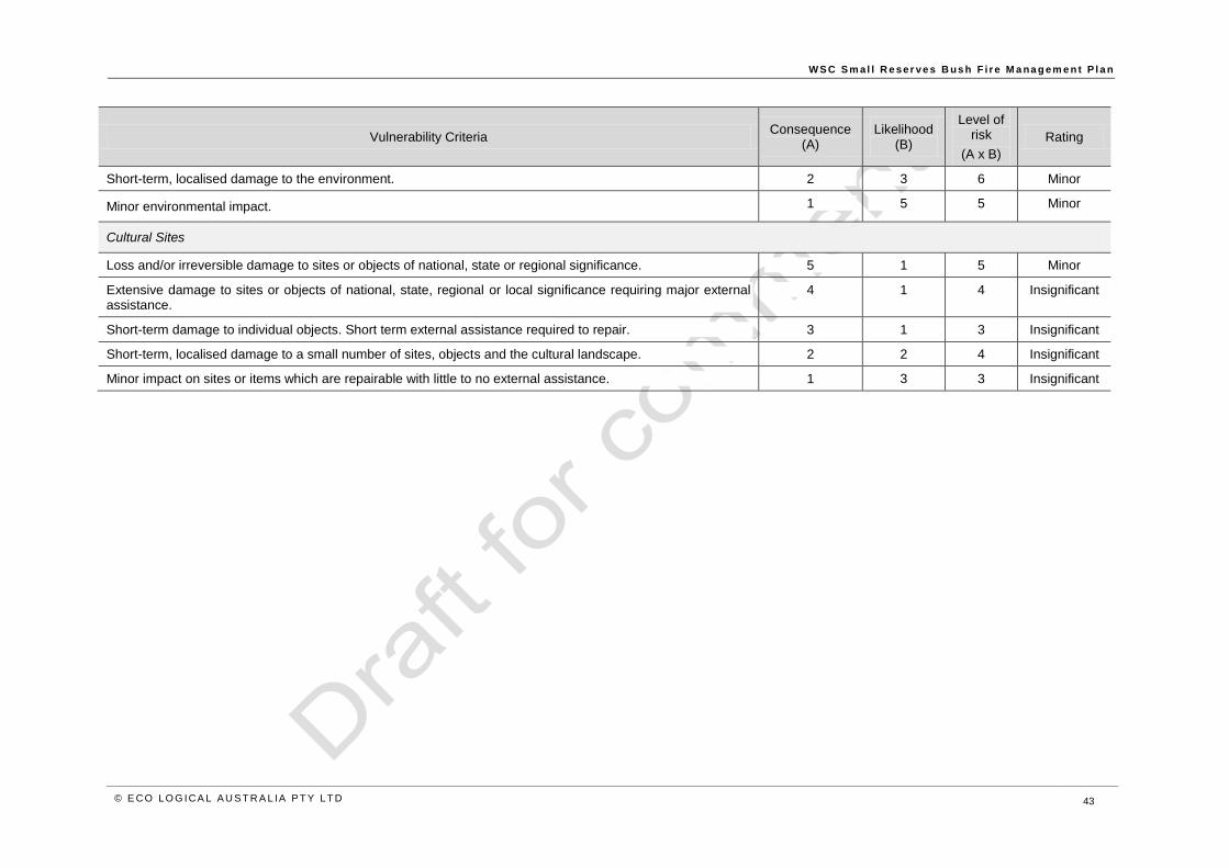
W S C S m al l R e ser ve s B us h F i r e M a na g em e n t P l a n
© E CO LO G ICA L A U S T R A L IA P T Y LT D 43
Vulnerability Criteria Consequence
(A) Likelihood
(B)
Level of risk
(A x B)
Rating
Short-term, localised damage to the environment. 2 3 6 Minor
Minor environmental impact. 1 5 5 Minor
Cultural Sites
Loss and/or irreversible damage to sites or objects of national, state or regional significance. 5 1 5 Minor
Extensive damage to sites or objects of national, state, regional or local significance requiring major external assistance.
4 1 4 Insignificant
Short-term damage to individual objects. Short term external assistance required to repair. 3 1 3 Insignificant
Short-term, localised damage to a small number of sites, objects and the cultural landscape. 2 2 4 Insignificant
Minor impact on sites or items which are repairable with little to no external assistance. 1 3 3 Insignificant

W S C S m al l R e ser v . e s B u s h F i r e M a na g em e n t P l a n
© E CO LO G ICA L A U S T RA L IA P T Y LT D 44
Table 34: Bushfire Risk Assessment – Berrima Reserves: River Bend Reserve
Vulnerability Criteria Consequence
(A) Likelihood
(B)
Level of risk
(A x B)
Rating
Key considerations
Good emergency access road network
Public access to the Reserve is unrestricted
Walking track network facilitates public recreational access
Small number of dwellings on boundary
WWI cultural sites
Vegetation community is represented in protected area within region
Life
Populated area where the combination of threat and vulnerability expose a community to a significant likelihood of fatalities and major injuries.
5 2 10 Moderate
Less likely to be fatalities or major injuries due to the presence of attributes which afford some protection. 4 1 4 Insignificant
Loss of life or major injury highly unlikely. Medical/hospital treatment may be required. 3 2 6 Minor
Minor injuries only - first aid treatment. No major injuries or fatalities likely. 2 2 4 Insignificant
No injuries or fatalities likely. 1 4 4 Insignificant
Property (infrastructure, assets and private property)
Extensive and widespread loss of property. Major impact across a large part of the community and region. Long term external assistance required to recover.
5 2 10 Moderate
Localised damage to property. Short-term external assistance required to recover. 4 3 12 Moderate
Short-term damage to individual assets. No external assistance required to recover. 3 3 9 Minor
Inconsequential or no damage to property. Little or no disruptions to the community. 1 4 4 Insignificant
Environment
Local extinctions of native species. 4 2 8 Minor
Irreversible damage to the environment. 4 2 8 Minor
Long-term damage to the environment over a landscape scale. 4 3 12 Moderate
Short-term, localised damage to the environment. 2 3 6 Minor

W S C S m al l R e ser ve s B us h F i r e M a na g em e n t P l a n
© E CO LO G ICA L A U S T R A L IA P T Y LT D 45
Vulnerability Criteria Consequence
(A) Likelihood
(B)
Level of risk
(A x B)
Rating
Minor environmental impact. 1 5 5 Minor
Cultural Sites
Loss and/or irreversible damage to sites or objects of national, state or regional significance. 5 1 5 Minor
Extensive damage to sites or objects of national, state, regional or local significance requiring major external assistance.
4 1 4 Insignificant
Short-term damage to individual objects. Short term external assistance required to repair. 3 1 3 Insignificant
Short-term, localised damage to a small number of sites, objects and the cultural landscape. 2 2 4 Insignificant
Minor impact on sites or items which are repairable with little to no external assistance. 1 3 3 Insignificant
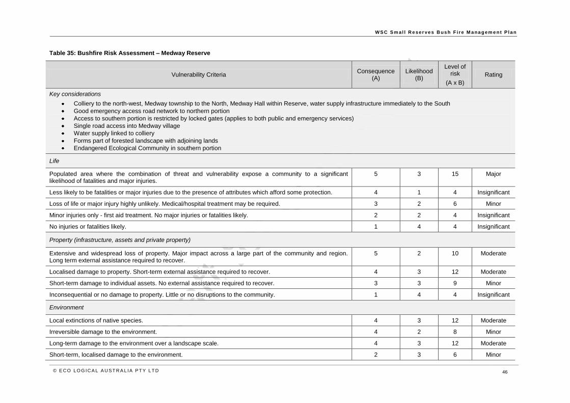
W S C S m al l R e ser ve s B us h F i r e M a na g em e n t P l a n
© E CO LO G ICA L A U S T R A L IA P T Y LT D 46
Table 35: Bushfire Risk Assessment – Medway Reserve
Vulnerability Criteria Consequence
(A) Likelihood
(B)
Level of risk
(A x B)
Rating
Key considerations
Colliery to the north-west, Medway township to the North, Medway Hall within Reserve, water supply infrastructure immediately to the South
Good emergency access road network to northern portion
Access to southern portion is restricted by locked gates (applies to both public and emergency services)
Single road access into Medway village
Water supply linked to colliery
Forms part of forested landscape with adjoining lands
Endangered Ecological Community in southern portion
Life
Populated area where the combination of threat and vulnerability expose a community to a significant likelihood of fatalities and major injuries.
5 3 15 Major
Less likely to be fatalities or major injuries due to the presence of attributes which afford some protection. 4 1 4 Insignificant
Loss of life or major injury highly unlikely. Medical/hospital treatment may be required. 3 2 6 Minor
Minor injuries only - first aid treatment. No major injuries or fatalities likely. 2 2 4 Insignificant
No injuries or fatalities likely. 1 4 4 Insignificant
Property (infrastructure, assets and private property)
Extensive and widespread loss of property. Major impact across a large part of the community and region. Long term external assistance required to recover.
5 2 10 Moderate
Localised damage to property. Short-term external assistance required to recover. 4 3 12 Moderate
Short-term damage to individual assets. No external assistance required to recover. 3 3 9 Minor
Inconsequential or no damage to property. Little or no disruptions to the community. 1 4 4 Insignificant
Environment
Local extinctions of native species. 4 3 12 Moderate
Irreversible damage to the environment. 4 2 8 Minor
Long-term damage to the environment over a landscape scale. 4 3 12 Moderate
Short-term, localised damage to the environment. 2 3 6 Minor

W S C S m al l R e ser ve s B us h F i r e M a na g em e n t P l a n
© E CO LO G ICA L A U S T R A L IA P T Y LT D 47
Vulnerability Criteria Consequence
(A) Likelihood
(B)
Level of risk
(A x B)
Rating
Minor environmental impact. 1 5 5 Minor
Cultural Sites
Loss and/or irreversible damage to sites or objects of national, state or regional significance. 5 1 5 Minor
Extensive damage to sites or objects of national, state, regional or local significance requiring major external assistance.
4 1 4 Insignificant
Short-term damage to individual objects. Short term external assistance required to repair. 3 1 3 Insignificant
Short-term, localised damage to a small number of sites, objects and the cultural landscape. 2 2 4 Insignificant
Minor impact on sites or items which are repairable with little to no external assistance. 1 3 3 Insignificant

W S C S m al l R e ser ve s B us h F i r e M a na g em e n t P l a n
© E CO LO G ICA L A U S T R A L IA P T Y LT D 48
Table 36: Bushfire Risk Assessment – Boronia Park, Hilltop
Vulnerability Criteria Consequence
(A) Likelihood
(B)
Level of risk
(A x B)
Rating
Key considerations
Residential area to the western, south-western and north-western boundaries
Public infrastructure (sewer pumping station) adjacent
Established APZ along Boronia Avenue/Stanley St
Established fire trail network
Soccer and tennis facilities within Reserve
Adjacent to protected area (Bargo River SCA)
Vegetation community is well represented in protected area within region
Life
Populated area where the combination of threat and vulnerability expose a community to a significant likelihood of fatalities and major injuries.
5 3 15 Major
Less likely to be fatalities or major injuries due to the presence of attributes which afford some protection. 4 1 4 Insignificant
Loss of life or major injury highly unlikely. Medical/hospital treatment may be required. 3 2 6 Minor
Minor injuries only - first aid treatment. No major injuries or fatalities likely. 2 2 4 Insignificant
No injuries or fatalities likely. 1 4 4 Insignificant
Property (infrastructure, assets and private property)
Extensive and widespread loss of property. Major impact across a large part of the community and region. Long term external assistance required to recover.
5 2 10 Moderate
Localised damage to property. Short-term external assistance required to recover. 4 3 12 Moderate
Short-term damage to individual assets. No external assistance required to recover. 3 3 9 Minor
Inconsequential or no damage to property. Little or no disruptions to the community. 1 4 4 Insignificant
Environment
Local extinctions of native species. 4 2 8 Minor
Irreversible damage to the environment. 4 2 8 Minor
Long-term damage to the environment over a landscape scale. 4 3 12 Moderate
Short-term, localised damage to the environment. 2 3 6 Minor
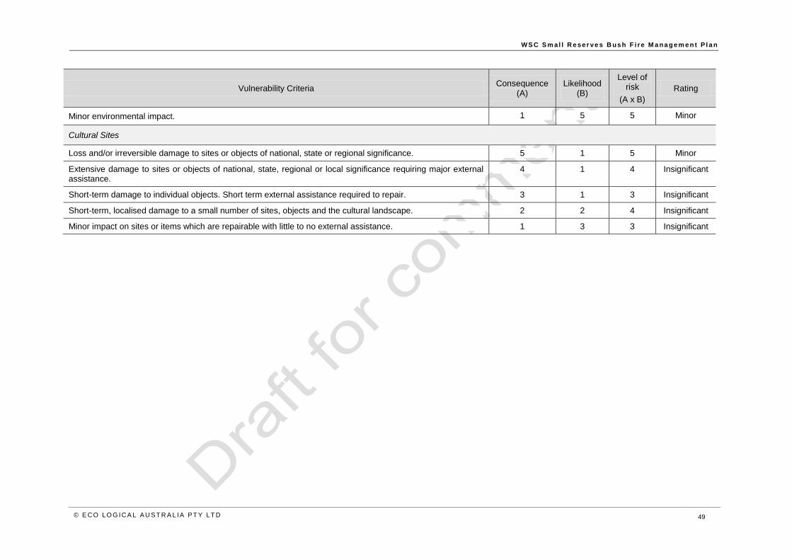
W S C S m al l R e ser ve s B us h F i r e M a na g em e n t P l a n
© E CO LO G ICA L A U S T R A L IA P T Y LT D 49
Vulnerability Criteria Consequence
(A) Likelihood
(B)
Level of risk
(A x B)
Rating
Minor environmental impact. 1 5 5 Minor
Cultural Sites
Loss and/or irreversible damage to sites or objects of national, state or regional significance. 5 1 5 Minor
Extensive damage to sites or objects of national, state, regional or local significance requiring major external assistance.
4 1 4 Insignificant
Short-term damage to individual objects. Short term external assistance required to repair. 3 1 3 Insignificant
Short-term, localised damage to a small number of sites, objects and the cultural landscape. 2 2 4 Insignificant
Minor impact on sites or items which are repairable with little to no external assistance. 1 3 3 Insignificant

W S C S m al l R e ser ve s B us h F i r e M a na g em e n t P l a n
© E CO LO G ICA L A U S T R A L IA P T Y LT D 50
Table 37: Bushfire Risk Assessment – Yerrinbool Park
Vulnerability Criteria Consequence
(A) Likelihood
(B)
Level of risk
(A x B)
Rating
Key considerations
Residential area to the east
Located in landscape between township and adjacent protected area (Bargo River SCA) and township
No access within the Reserve
SW Yerrinbool access is single road (Cascade Cres) which passes adjacent to Reserve
No known cultural heritage sites
Life
Populated area where the combination of threat and vulnerability expose a community to a significant likelihood of fatalities and major injuries.
5 3 15 Major
Less likely to be fatalities or major injuries due to the presence of attributes which afford some protection. 4 1 4 Insignificant
Loss of life or major injury highly unlikely. Medical/hospital treatment may be required. 3 2 6 Minor
Minor injuries only - first aid treatment. No major injuries or fatalities likely. 2 2 4 Insignificant
No injuries or fatalities likely. 1 4 4 Insignificant
Property (infrastructure, assets and private property)
Extensive and widespread loss of property. Major impact across a large part of the community and region. Long term external assistance required to recover.
5 3 15 Major
Localised damage to property. Short-term external assistance required to recover. 4 3 12 Moderate
Short-term damage to individual assets. No external assistance required to recover. 3 3 9 Minor
Inconsequential or no damage to property. Little or no disruptions to the community. 1 4 4 Insignificant
Environment
Local extinctions of native species. 4 2 8 Minor
Irreversible damage to the environment. 4 2 8 Minor
Long-term damage to the environment over a landscape scale. 4 2 8 Minor
Short-term, localised damage to the environment. 2 3 6 Minor
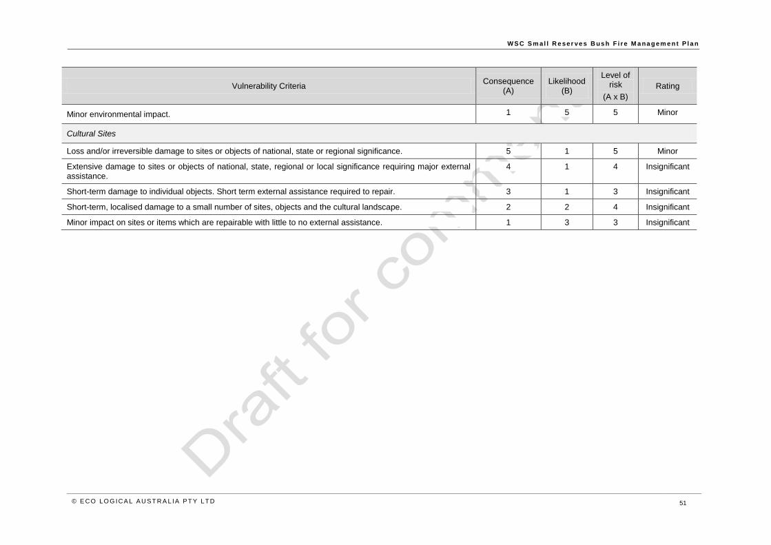
W S C S m al l R e ser ve s B us h F i r e M a na g em e n t P l a n
© E CO LO G ICA L A U S T R A L IA P T Y LT D 51
Vulnerability Criteria Consequence
(A) Likelihood
(B)
Level of risk
(A x B)
Rating
Minor environmental impact. 1 5 5 Minor
Cultural Sites
Loss and/or irreversible damage to sites or objects of national, state or regional significance. 5 1 5 Minor
Extensive damage to sites or objects of national, state, regional or local significance requiring major external assistance.
4 1 4 Insignificant
Short-term damage to individual objects. Short term external assistance required to repair. 3 1 3 Insignificant
Short-term, localised damage to a small number of sites, objects and the cultural landscape. 2 2 4 Insignificant
Minor impact on sites or items which are repairable with little to no external assistance. 1 3 3 Insignificant

W S C S m al l R e ser ve s B us h F i r e M a na g em e n t P l a n
© E CO LO G ICA L A U S T R A L IA P T Y LT D 52
Table 38: Bushfire Risk Assessment – Leaver Park, Bundanoon
Vulnerability Criteria Consequence
(A) Likelihood
(B)
Level of risk
(A x B)
Rating
Key considerations
Quarry to the north
Numerous threatened species
Located in landscape adjacent to protected area (Morton NP)
Single road through the Reserve
SW Yerrinbool access is single road (Cascade Cres) which passes adjacent to Reserve
No known cultural heritage sites
Life
Populated area where the combination of threat and vulnerability expose a community to a significant likelihood of fatalities and major injuries.
5 2 10 Moderate
Less likely to be fatalities or major injuries due to the presence of attributes which afford some protection. 4 1 4 Insignificant
Loss of life or major injury highly unlikely. Medical/hospital treatment may be required. 3 2 6 Minor
Minor injuries only - first aid treatment. No major injuries or fatalities likely. 2 2 4 Insignificant
No injuries or fatalities likely. 1 4 4 Insignificant
Property (infrastructure, assets and private property)
Extensive and widespread loss of property. Major impact across a large part of the community and region. Long term external assistance required to recover.
5 2 10 Moderate
Localised damage to property. Short-term external assistance required to recover. 4 3 12 Moderate
Short-term damage to individual assets. No external assistance required to recover. 3 3 9 Minor
Inconsequential or no damage to property. Little or no disruptions to the community. 1 4 4 Insignificant
Environment
Local extinctions of native species. 4 2 8 Minor
Irreversible damage to the environment. 4 2 8 Minor
Long-term damage to the environment over a landscape scale. 4 3 12 Moderate
Short-term, localised damage to the environment. 2 3 6 Minor

W S C S m al l R e ser ve s B us h F i r e M a na g em e n t P l a n
© E CO LO G ICA L A U S T R A L IA P T Y LT D 53
Vulnerability Criteria Consequence
(A) Likelihood
(B)
Level of risk
(A x B)
Rating
Minor environmental impact. 1 5 5 Minor
Cultural Sites
Loss and/or irreversible damage to sites or objects of national, state or regional significance. 5 1 5 Minor
Extensive damage to sites or objects of national, state, regional or local significance requiring major external assistance.
4 1 4 Insignificant
Short-term damage to individual objects. Short term external assistance required to repair. 3 1 3 Insignificant
Short-term, localised damage to a small number of sites, objects and the cultural landscape. 2 2 4 Insignificant
Minor impact on sites or items which are repairable with little to no external assistance. 1 3 3 Insignificant

W S C S m al l R e ser v . e s B u s h F i r e M a na g em e n t P l a n
© E CO LO G ICA L A U S T RA L IA P T Y LT D 54
Appendix 2: Community consultation
As a part of the Wingecarribee Small Reserves Bushfire Management Plan project, a community
consultation process was undertaken.
This community consultation process aimed to obtain public input and feedback on analysis,
alternatives and decisions. Council undertook to keep the public informed, listen and acknowledge
concerns and aspirations, and provide feedback on how public input has influenced decisions. This
approach is consistent with the ‘consult’ approach under the International Association for Public
Participation (IAP2) spectrum.
This approach builds knowledge, understanding, support and capacity. This is important as fire
management strategies are more likely to be implemented successfully if they are owned and supported
by the community.
This community consultation process comprised the following:
Community meetings
o Berrima, Monday 13th May
o Yerrinbool, Tuesday 14th May
The community meetings were open invitation events communicated by
o Written invitations send by mail to adjacent residents and key stakeholders
o Media release and notification in Council Notices in local media
o Notification on Council website
Surveys posted out to neighbours of Leaver Park
Notification of exhibition period of Draft Plan.
Summary of Outcomes from Community Consultation
The community meetings were structured as an information session presented by Eco Logical Australia
followed by question and answer session, with questions encouraged throughout the information
session. The meetings were very well attended, with 35 attendees at Berrima and 47 attendees at
Yerrinbool. The sessions ran for approximately 1.5 hours of presentation, followed by the opportunity to
discuss specific issues or seek further information from the presenters or Council representatives
informally afterwards. The issues presented below were raised in both the formal and informal
consultation processes.
The community information sessions were presented by Rod Rose and Julie Holden from Eco Logical
Australia, with Karen Guymer and Ian Perkins representing Wingecarribee Shire Council.
The information session (Powerpoint presentation) provided background on bushfire science and
behaviour, displayed and interpreted preliminary bushfire behaviour modelling for the Reserves,
introduced bushfire risk mitigation measures likely to be included in the plan and provided guidance for
attendees on actions they can take to mitigate bushfire risk in their individual situations.

W S C S m al l R e ser ve s B us h F i r e M a na g em e n t P l a n
© E CO LO G ICA L A U S T RA L IA P T Y LT D 55
General themes in the community input were a perceived reduction in hazard reduction burning taking
place in the Reserves compared to previous burning activities and that as the reserves make up a small
portion of the landscape, management of the surrounding lands (ie. National parks, colliery) is critical to
the success of bushfire mitigation measures put in place within the Reserves.
Specific issues raised are detailed below. Note these have been summarised and categorised into
topics, rather than providing a list of individual comments. Also note that some of these are beyond the
scope of issues which will be resolved by this plan; they are however reported here to ensure a full
record of issues identified is communicated to Council.
Single road access to SW Yerrinbool and Medway and concerns about the impact on this on
the ability for fire response personnel to access the areas in the event of a fire and concerns
about community evacuation capacity should the roads be blocked
Concerns about standards of fire coverage at Medway as there is no longer a RFS brigade
Community awareness at Medway, particularly considering a large proportion of new residents
with little awareness of bushfire as a threat have moved into the area
Low levels of community participation in RFS brigades (raised by numerous contributors at
Yerrinbool meeting)
Water supply at Medway and availability for fire fighting response due to reliance on colliery
Concerns about Colliery stockpile and bushfire risk posed by it to Medway residents
A number of concerns were raised regarding management of fire trails
o Perception that some fire trails are poorly maintained (resolved during session with
clarification by Council on what are and are not fire trails)
o Use of fire trails by dirt bikes and 4WD
o Link between access and ignition likelihood
Conflicts between tree protection requirements and tree removal for bushfire mitigation, raised
at both Berrima and Yerrinbool sessions
Difficultly in negotiating with public land managers for bushfire mitigation works to be completed
where they are neighbours (National Parks).
These issues raised by the community have been utilised as one of the resources to inform the
recommendations of the actions for each of the Reserves in this Bushfire Management Plan.

W S C S m al l R e ser ve s B us h F i r e M a na g em e n t P l a n
© E CO LO G ICA L A U S T RA L IA P T Y LT D 56
HEAD OFFICE
Suite 4, Level 1
2-4 Merton Street
Sutherland NSW 2232
T 02 8536 8600
F 02 9542 5622
SYDNEY
Level 6
299 Sussex Street
Sydney NSW 2000
T 02 8536 8650
F 02 9264 0717
ST GEORGES BASIN
8/128 Island Point Road
St Georges Basin NSW 2540
T 02 4443 5555
F 02 4443 6655
CANBERRA
Level 2
11 London Circuit
Canberra ACT 2601
T 02 6103 0145
F 02 6103 0148
NEWCASTLE
Suites 28 & 29, Level 7
19 Bolton Street
Newcastle NSW 2300
T 02 4910 0125
F 02 4910 0126
NAROOMA
5/20 Canty Street
Narooma NSW 2546
T 02 4476 1151
F 02 4476 1161
COFFS HARBOUR
35 Orlando Street
Coffs Harbour Jetty NSW 2450
T 02 6651 5484
F 02 6651 6890
ARMIDALE
92 Taylor Street
Armidale NSW 2350
T 02 8081 2681
F 02 6772 1279
MUDGEE
Unit 1, Level 1
79 Market Street
Mudgee NSW 2850
T 02 4302 1230
F 02 6372 9230
PERTH
Suite 1 & 2
49 Ord Street
West Perth WA 6005
T 08 9227 1070
F 08 9322 1358
WOLLONGONG
Suite 204, Level 2
62 Moore Street
Austinmer NSW 2515
T 02 4201 2200
F 02 4268 4361
GOSFORD
Suite 5, Baker One
1-5 Baker Street
Gosford NSW 2250
T 02 4302 1220
F 02 4322 2897
DARWIN
16/56 Marina Boulevard
Cullen Bay NT 0820
T 08 8989 5601
BRISBANE
PO Box 1422
Fortitude Valley QLD 4006 T 07 3503 7193
1300 646 131 www.ecoaus.com.au