site options: high level review - bathnes · site options: high level review ... 9 may 2013 ....
TRANSCRIPT
Site Options: High Level Review
Document: 1 Version: 2
Bath Eastern Park and Ride Sites
Bath and North East Somerset Council
9 May 2013
Halcrow Group Limited
Elms House, 43 Brook Green, London W6 7EF
tel +44 20 3479 8000 fax +44 20 3479 8001
halcrow.com
Halcrow Group Limited is a CH2M HILL company
Halcrow Group Limited has prepared this report in accordance with
the instructions of client Bath and North East Somerset Council for the client’s sole and
specific use.
Any other persons who use any information contained herein do so at their own risk.
© Halcrow Group Limited 2013
Site Options: High Level Review
Bath Eastern Park and Ride Sites
Bath and North East Somerset Council
9 May 2013

Bath Eastern Park and Ride Options: High Level Review
Document history
Site Options: High Level Review
Bath Eastern Park and Ride Sites
Bath and North East Somerset Council
This document has been issued and amended as follows:
Version Date Description Created by Verified by Approved by
1.0 06/02/2013 DRAFT David Lear
James Purkiss
Simon Murray
John Sreeves
Paul Harper
David Lear David Lear
2.0 09/05/2013 FINAL David Lear David Lear David Lear
Bath Eastern Park and Ride Options: High Level Review
Contents
1 Introduction 1
1.1 Background 1
1.2 Site Options Considered 1
1.3 Scope of Investigation 1
1.4 Planning Appraisal Methodology 2
1.5 Potential Parking Capacities 3
1.6 Structure of Report 4
2 Site A: Land East of A4/A46 Junction - Avon Rugby Club 5
2.1 General Description 5
2.2 Highway Access 5
2.3 Flood Risk 6
2.4 Landscape and Visual 7 2.4.1 Landscape 7 2.4.2 Visual 9
2.5 Planning and Land Constraints 9 2.5.1 Agriculture & Land Use 9 2.5.2 Biodiversity 9 2.5.3 Community Infrastructure & Transport 10 2.5.4 Cultural heritage and built environment 10 2.5.5 Pollution prevention 10
2.6 Potential Business Case 10
3 Site B: Land West of Mill Lane 12
3.1 General Description 12
3.2 Highway Access 12
3.3 Flood Risk 13
3.4 Landscape and Visual 13 3.4.1 Landscape 13 3.4.2 Visual 14
3.5 Planning and Land Constraints 15 3.5.1 Agriculture & Land Use 15 3.5.2 Biodiversity 15 3.5.3 Community Infrastructure & Transport 15 3.5.4 Cultural heritage and built environment 16 3.5.5 Pollution prevention 16
3.6 Potential Business Case 16
4 Site C: Charmy Down 17
Bath Eastern Park and Ride Options: High Level Review
4.1 General Description 17
4.2 Highway Access 17
4.3 Flood Risk 18
4.4 Landscape and Visual 19 4.4.1 Landscape 19 4.4.2 Visual 20
4.5 Planning and Land Constraints 20 4.5.1 Agriculture & Land Use 20 4.5.2 Biodiversity 20 4.5.3 Community Infrastructure & Transport 20 4.5.4 Cultural heritage and built environment 20 4.5.5 Pollution prevention 21
4.6 Potential Business Case 21
5 Site E: Bathford 22
5.1 General Description 22
5.2 Highway Access 22
5.3 Flood Risk 23
5.4 Landscape and Visual 23 5.4.1 Landscape 23 5.4.2 Visual 24
5.5 Planning and Land Constraints 24 5.5.1 Agriculture & Land Use 24 5.5.2 Biodiversity 24 5.5.3 Community Infrastructure & Transport 24 5.5.4 Cultural heritage and built environment 25 5.5.5 Pollution prevention 25
5.6 Potential Business Case 25
6 Site F: Land East of Mill Lane: ‘Application’ Site 26
6.1 Background and Current Position 26
7 Site G: Lansdown Park and Ride 27
7.1 General Description 27
7.2 Highway Access 27
7.3 Flood Risk 28
7.4 Landscape and Visual 28 7.4.1 Landscape 28 7.4.2 Visual 29
7.5 Planning and Land Constraints 29 7.5.1 Agriculture & Land Use 29 7.5.2 Biodiversity 29

Bath Eastern Park and Ride Options: High Level Review
7.5.3 Community Infrastructure & Transport 29 7.5.4 Cultural heritage and built environment 29 7.5.5 Pollution prevention 30
7.6 Potential Business Case 30
8 Site H: Bathampton Junction 31
8.1 General Description 31
8.2 Highway Access 32 8.2.1 General 32 8.2.2 Bridge Engineering Works/Issues 33
8.3 Rail Engineering Works 36 8.3.1 Permanent Way: Track 36 8.3.2 Signalling 36 8.3.3 Telecommunications 37 8.3.4 Operations 37 8.3.5 Possession Strategy 37 8.3.6 Estimated Cost 37
8.4 Flood Risk 38
8.5 Landscape and Visual 38 8.5.1 Landscape 38 8.5.2 Visual 39
8.6 Planning and Land Constraints 40 8.6.1 Agriculture & Land Use 40 8.6.2 Biodiversity 40 8.6.3 Community Infrastructure & Transport 41 8.6.4 Cultural heritage and built environment 41 8.6.5 Pollution prevention 41
8.7 Potential Business Case 41
9 Site I: Land South of Box Bridge 42
9.1 General Description 42
9.2 Highway Access 42
9.3 Flood Risk 43
9.4 Landscape and Visual 43 9.4.1 Landscape 43 9.4.2 Visual 44
9.5 Planning and Land Constraints 44 9.5.1 Agriculture & Land Use 44 9.5.2 Biodiversity 44 9.5.3 Community Infrastructure & Transport 44 9.5.4 Cultural heritage and built environment 45 9.5.5 Pollution prevention 45
9.6 Potential Business Case 45
Bath Eastern Park and Ride Options: High Level Review
10 Option Sites: Summary Comparison 46
10.1 Overview 46
11 Overview 47
11.1 Conclusions and Recommendations 47 11.1.1 Site A: Land East of A4/A46 Interchange 47 11.1.2 Site B: Land West of Mill Lane 47 11.1.3 Site C: Charmy Down 47 11.1.4 Site E: Bathford 48 11.1.5 Site G: Lansdown Park and Ride 48 11.1.6 Site H: Bathampton Junction 49 11.1.7 Site I: Box Bridge 50
Appendices
A: Land Designations / Relevant Policy Extracts
B: Constraints Plans
C: Site H - Bridge Engineering
D: Site H - Rail Engineering

Bath Eastern Park and Ride Options: High Level Review
Doc no: 1 Version: 2 Date: 9 May 2013 Project code: 204269.AI.00.09 Filename: Bath Eastern P&R HLR_FINAL Report 090513 Rev2
MASTER.doc
1
1 Introduction
1.1 Background
Bath and North East Somerset (B&NES) are seeking an independent review of
potential Park and Ride sites on the east side of Bath. Work on a number of sites has
already been examined by officers in the past. However, the purpose of this
commission is to seek a ‘second opinion’ on these sites and to examine other options
which have not been considered to date.
A potential site on land to the east of Mill Lane at Bathampton Meadows was
approved by B&NES in May 2009 as part of the ‘Bath Package’ transport measures for
the city. There was considerable local opposition to this site on visual/landscape and
ecological grounds at the time and, in 2011, the plans for this site were shelved as part
of measures to reduce costs associated with the Bath Package. This site; termed Site F,
is included within this high level review of other sites for reference/comparison
purposes only. Considerable work on the landscape and environmental impacts
associate with this site have been documented and debated in the past; and it is not
intended to re-produce it in this report.
1.2 Site Options Considered
Figure 1.1 shows the location of the ‘alternative’ sites considered in this review. These
are as follows:
• Site A: Batheaston: SE corner of A4/A46 Junction;
• Site B: A4 Batheaston Bypass: west of Mill Lane;
• Site C: A46 Charmy Down;
• Site E: A363 Bathford;
• Site F: Bath Package - Application Site: For Comparison Purposes Only;
• Site G: Expansion of Lansdown P&R - additional to proposed Bath Package
expansion;
• Site H: Bathampton Junction; and
• Site I: Land south of railway: Box Bridge.
An area of land termed the ‘Gatehouse’ site (Site D) on the A4 to the east of the A363
junction was originally included. However, following a pre-meeting with B&NES and
Parish Councillors it was agreed that this site should be excluded from further
consideration.
1.3 Scope of Investigation
As mentioned earlier the scope of this review is ‘high level’; with the aim of
dismissing site options above which are clearly impractical or infeasible and
identifying those worthy of further more detailed examination. This scope has
included consideration of:
• Highway access. In the case of Site H this report assesses the engineering
feasibility/cost of constructing a new bridge through the Great Western (GW)
Bath Eastern Park and Ride Options: High Level Review
Doc no: 1 Version: 2 Date: 9 May 2013 Project code: 204269.AI.00.09 Filename: Bath Eastern P&R HLR_FINAL Report 090513 Rev2
MASTER.doc
2
main-line rail embankment; and a secondary bridge under the A4 Batheaston
Bypass as part of a grade-separated junction;
• Planning & land issues;
• Flood risk;
• Landscape impacts;
• Feasibility of operating a cost-effective bus service; and
• Consideration of any other potential construction issues or problems.
This review does not consider detailed ecological impacts; or include habitat surveys.
Critically it does not make any assessment as to the potential patronage which
particular ‘alternative’ sites may achieve. This will clearly be critical to the business
case of any site chosen to serve the A4 and A363 corridors on the east of Bath; but
estimating this would require detailed modelling model work outside the defined
scope of this review. However, for sites remote from eastern corridor (Sites C and G)
comment is made on the potential attractiveness to drivers currently using the A4
and A363 using journey time/delay data obtained from the Strat-E-GIS database.
1.4 Planning Appraisal Methodology
The construction of any new park and ride site or extension of an existing one and its
attendant facilities will require a planning application to be submitted for
determination by the relevant local planning authority (LPA). In seven of the eight
sites, the relevant LPA is Bath & North East Somerset Council itself (referred to as
Regulation 3 applications). However, Site I falls outside of the authority area and a
planning application for that site would be determined by Wiltshire Council.
Different local planning policies are also in force for this LPA, as explained below.
The planning policy section of this study is therefore based on three key planning
principles, as follows:
i) various bodies are tasked with identifying and designating sites, land or assets
which for one reason or another should be preserved, protected or enhanced;
ii) the English development plan system transposes the aims of the designating
bodies into planning policies to protect designated sites, land or assets; and
iii) according to section 38(6) of the Planning & Compulsory Purchase Act 2004, each
LPA must, when determining planning applications, have regard to the
development plan in force, unless material considerations indicate otherwise.
Designated sites, land or assets have, for the purposes of this study, been broken
down into the following themes:
• Agriculture and land use;
• Biodiversity;
• Community infrastructure and transport;
• Cultural heritage and built environment;
• Flooding;
Bath Eastern Park and Ride Options: High Level Review
Doc no: 1 Version: 2 Date: 9 May 2013 Project code: 204269.AI.00.09 Filename: Bath Eastern P&R HLR_FINAL Report 090513 Rev2
MASTER.doc
3
• Landscape; and
• Pollution prevention.
Planning policies relating to designated sites were retrieved in the main from the
following documents:
• National Planning Policy Framework, published March 2012;
• Saved policies from Bath & North East Somerset Local Plan, adopted October
2007; and
• Saved policies from North Wiltshire Local Plan 2011, adopted June 2006 (within
which Site I falls).
Where relevant, primary and secondary legislation which protects designated sites
(such as the Planning (Listed Buildings and Conservation Areas) Act 1990) has also
been included.
The list of land designations covered by this appraisal and relevant policy extracts
relating to them are set out in Appendix A.
Appendix B contains various ‘Constraints’ plans which are referred to as appropriate
in discussing the flood risk, landscape/visual and planning/land issues associated
with the various sites.
The Bath & North East Somerset Local Plan also contains a specific policy relating to
the development of park and ride sites (Policy T.22). This states that:
The Council will safeguard land shown on the Proposals Map for Park and Ride purposes at
Lambridge, Bath, adjacent the A4. The expansion of existing Park and Ride schemes or the
development of additional sites will be permitted if there would be no unacceptable impact on:
i. the environment with particular reference to the policies relating to the Green Belt,
Areas of Outstanding Natural Beauty, the open countryside, the World Heritage
Site; and the need to minimise light pollution;
ii. agricultural, nature conservation, water environment and archaeological interests;
iii. the amenities of local residents;
iv. other public transport provision;
v. the surrounding road network and its capacity to safely accommodate potential traffic
generation and, in addition;
vi. provision is made for the needs of those with impaired mobility and for the safety and
security of all users.
1.5 Potential Parking Capacities
This review does not include the indicative design of the potential layout of the Park
and Ride facility on each site; critically the potential parking capacities which might
be achieved in each case. Apart from the actual parking bays the land area available
will need to accommodate the bus turning area; amenity building, access roads/aisles
and landscaping areas. The more difficult the site is in terms of shape and/or the
extent of ‘screening’ needed will clearly affect what parking capacity can be achieved.
Bath Eastern Park and Ride Options: High Level Review
Doc no: 1 Version: 2 Date: 9 May 2013 Project code: 204269.AI.00.09 Filename: Bath Eastern P&R HLR_FINAL Report 090513 Rev2
MASTER.doc
4
In order to make an assessment at this stage the typical number of spaces/hectare
achieved at the other existing Park and Ride sites in Bath has been used, in addition
to the parking density that would have been achieved at the proposed Bathampton
Meadows site. The relevant data obtained is set out below:
• Bathampton Meadows: 1400 spaces/11.87ha;
• Odd Down Park and Ride: 1230/4.2ha - Bath Package expansion;
• Lansdown Park and Ride: 880/2.92ha - Bath Package expansion
• Newbridge Park and Ride: 1000/3.95ha - Bath Package expansion
(Environmental Statement - July 2009)
The typical ‘median’ parking density obtained from these sites is 210 spaces/ha. This
has been used to gauge the parking capacity of the option sites where ‘at-grade’
provision is proposed. The exception to this is Site H: Bathampton Junction; where a
three deck multi-storey car park (MSCP) is envisaged.
1.6 Structure of Report
Following this Introduction the subsequent main sections of this report are set out as
follows:
• Section 2: Site A Review;
• Section 3: Site B Review;
• Section 4: Site C Review;
• Section 5: Site E Review;
• Section 6: Site F;
• Section 7: Site G Review;
• Section 8: Site H Review;
• Section 9: Site I Review;
• Section 10: Summary Comparison; and
• Section 11: Overview

Bath Eastern Park and Ride Options: High Level Review
Doc no: 1 Version: 2 Date: 9 May 2013 Project code: 204269.AI.00.09 Filename: Bath Eastern P&R HLR_FINAL Report 090513 Rev2
MASTER.doc
5
2 Site A: Land East of A4/A46 Junction - Avon Rugby Club
2.1 General Description
Figure 2.1 shows the extent of land considered as Site A; which is largely to the east
and adjacent to the A4/A46 interchange. Most of the land is in the ownership of Avon
Rugby Club; the exceptions being a small area of rough pasture adjacent to the A46
embankment on the east side and the land west of the A46. The latter can be accessed
via a shared footpath/cycle linkage under the A46 main-line carriageway and slip-
road bridges spanning the River Avon. However, there is no current provision for
vehicular access under the bridge.
The level land most suitable for parking is associated with the rugby playing fields
and the adjacent tarmac strip currently used for this purpose. However, during the
site visit a person associated with Avon RFC advised that the sloping land between
the existing area used for parking and the rear boundary of the properties fronting
London Road had been used for parking in the past. As such, some of this land could
be utilised for Park and Ride parking spaces; although a landscaped buffer is likely to
be needed to reduce the impact on the adjacent residential properties.
2.2 Highway Access
The existing access to Avon RFC is via a steep narrow roadway running down the
line of the slope as shown in Photo 2.1 below. The major-minor ‘priority’ junction
with London Road West has poor visibility to the left due to the adjoining residential
property. This view to the left is further obstructed by on-street parking which occurs
in front of the residential dwellings fronting this section of London Road West.
However, driver visibility to the right is satisfactory as indicated in Photo 2.2.
Photo 2.1 Existing Access Road Photo 2.2 Visibility ‘Envelope’ to the Right
Apart from the sub-standard visibility to the left the level area in the vicinity of the
junction bell-mouth only extends 5-6m back from the kerb-line; after which the steep
up-grade section of the access road is reached. Whilst this provides a sufficient level
waiting area for a car; it would not for an emerging bus. As such, bus drivers could
experience difficulty in emerging from the junction due to the ‘gap’ time in priority
traffic needed to exit safely. During the site visit we were also told by Avon RFC that
coaches have difficulty in negotiating the steep up-grade when leaving the site now.
In view of the above it is clear that the access road into the site would need to be re-
aligned to reduce the existing gradient. In addition, the junction would need to be

Bath Eastern Park and Ride Options: High Level Review
Doc no: 1 Version: 2 Date: 9 May 2013 Project code: 204269.AI.00.09 Filename: Bath Eastern P&R HLR_FINAL Report 090513 Rev2
MASTER.doc
6
improved. The only feasible means of improving the access road would be to re-align
it eastwards ‘across the slope’ using the wooded parcel of land behind the clubhouse
and changing rooms. This would require significant earthworks to ensure a
satisfactory gradient along the length of the access road; which would eventually
reach level ground near the NE corner of the land area considered.
Consideration could be given to using either signal or major-minor ‘priority’ control
for the access junction with London Road West. The former is considered preferable
as a bus priority loop could be included in the detection to assist emerging buses.
Furthermore, the required 90m visibility to the left required for a 30mph road may be
difficult to achieve with a priority junction layout. The width of London Road West in
the vicinity of the junction is sufficient to provide a separate right turn lane for
vehicles accessing the site from the west. However, some of the on-street parking
which occurs on the south side of London Road immediately west of the access
would need to be prohibited to enable this.
It is probable that users seeking to access this site from the A363 Bradford Road and
A4 Box Road in the morning peak period will choose to route via Batheaston; rather
than use the bypass and turn right at the A4/A46 interchange. This is because
queuing and delay occurs on the northbound exit slip-road in this period; which is
exacerbated by westbound exit blocking associated with queuing on the A4 London
Road. Whilst this queuing also extends into London Road West it is likely that drivers
accessing the site from the A4 and A363 will experience less delay by routing via
Batheaston. As such, locating the Park and Ride site will have a potential adverse
impact in encouraging westbound access traffic to use the more sensitive route via
the High Street.
2.3 Flood Risk
Flood Zone maps provided by the Environment Agency show that most of this site
falls within Flood Zone 3. Photo 2.3 below shows that following the heavy rain in
December 2012 the planning field area experienced river flooding.
Photos 2.3 and 2.4 River Flooding in December 2012
Technical Guidance to the National Planning Policy Framework (NPPF); dated March
2012, covers the approach to be taken when considering development in areas of
known flood risk The section on Flood Risk largely mirrors the previous guidance
contained in Planning Policy Statement 25 ‘Development and Flood Risk’ (PPS25).
The flood zone levels are defined as follows:
• Zone 1: Low Probability. Land assessed as having a less than 1 in 1000
annual probability of river or sea flooding in any year (<0.1%);
Bath Eastern Park and Ride Options: High Level Review
Doc no: 1 Version: 2 Date: 9 May 2013 Project code: 204269.AI.00.09 Filename: Bath Eastern P&R HLR_FINAL Report 090513 Rev2
MASTER.doc
7
• Zone 2: Medium Probability. Land assessed as having between a 1 in 100 and
1 in 1000 annual probability of river flooding (1% – 0.1%); and
• Zone 3a: High Probability. Land assessed as having a 1 in 100 or greater
annual probability of river flooding (>1%); and
• Zone 3b: Functional Floodplain. This zone comprises land where water has to
flow or be stored in times of flood. The Guidance states that the identification
of functional floodplain should take account of local circumstances and not
be defined solely on rigid probability parameters. However, land which
would flood with an annual probability of 1 in 20 (5%) or greater in any year,
or is designed to flood in an extreme (0.1%) flood would normally be
identified as functional floodplain.
As stated above the Flood Zone maps show much of Site A in Flood Zone 3.
Although 3a and 3b is not separately defined it is considered that this is functional
floodplain which, if removed by protection works, would increase flooding extent
downstream. The Guidance is clear on what development is permissible in such a
high flood risk area; stating that: “Only the water-compatible uses and the essential
infrastructure listed in Table 2 that has to be there should be permitted in this zone. It should
be designed and constructed to:
– remain operational and safe for users in times of flood;
– result in no net loss of floodplain storage;
– not impede water flows; and
– not increase flood risk elsewhere.
Essential infrastructure in this zone should pass the Exception Test”. The exception test is
not considered applicable as a Park and Ride is not ‘essential’ development. It is
further noted that car parks are not listed as ‘water compatible development’ in the
NPPF Technical Guidance. Whilst it could be argued that occasional flooding of a
Park and Ride car park located on this site would not reduce storage or impede water
flow; this would render the site un-operable and could pose safety risks to users if
flooding occurred whilst the site was in use and parked vehicles present.
In paragraph 5 of the NPPF Technical Guidance it states in part that “Only where there
are no reasonably available sites in Flood Zones 1 or 2 should decision-makers consider the
suitability of sites in Flood Zone 3, taking into account the flood risk vulnerability of land uses
and applying the Exception Test if required”. As noted later in this review there are
feasible options available which have minimal or no impact on Flood Zone 3.
2.4 Landscape and Visual
2.4.1 Landscape
Site A is located within the following landscape, cultural and environmental
designations:
• International designations: Bath World Heritage Site;
• Local Plan designations: Green Belt; Conservation Area, Forest of Avon.

Bath Eastern Park and Ride Options: High Level Review
Doc no: 1 Version: 2 Date: 9 May 2013 Project code: 204269.AI.00.09 Filename: Bath Eastern P&R HLR_FINAL Report 090513 Rev2
MASTER.doc
8
The site is located on land known as Hicks Fields on the northern edge of the broad
and open River Avon valley floor and is operated by Avon Rugby Club for use as
rugby pitches and a clubhouse. The site is bounded by the River Avon to the south,
the A4 to the west, London Road and associated ribbon housing to the north and a
continuation of the open river valley to the east. A significant proportion of the site is
located within the level floodplain of the adjacent River Avon, with the remainder
located on the lower slope of the river valley’s northern side. The indicative site
boundary also includes a parcel of rising rough grassland to the west of the A4.
The southern half of the site comprises open, short-mown playing pitches which are
located on an artificially levelled, low lying area directly to the north of the River
Avon (at c. 21m AOD). The river edge supports riverine trees (willow and alder) and
there is an area of wet woodland located adjacent to the river just to the east of the A4
overbridge. The pitches are bounded by an access track to the north, which follows
the line of some degraded former field boundary hedges, beyond which is an area of
unmanaged rough grassland and scrub which currently forms a spatial buffer
between the housing located along the A4 and the pitches. The areas of the site either
side of the A4 comprise rough pasture and screen planting established during the
construction of the A4.
A public right of way runs through the site from east to west along an alignment
broadly parallel with the river. To the west of the A4, this takes the form of a
combined cycleway/footpath. To the east of and parallel to the A4, a spur off the
cycleway/footpath leads up to the A4/London Road roundabout.
The most likely access route to the site would descend from the current access road
junction with London Road, down through an area of broadleaf woodland and scrub
to the level floodplain where the park and ride facility would be located.
Photo 2.5 Site A - Looking South from Existing Access Road
In the wider context, the site is located within the Bathford and Limpley Stoke Valley
Landscape Character Area (LCA 18) as identified in the ‘Rural Landscapes of Bath
and North East Somerset – A Landscape Character Assessment’. This character area
comprises the broad, open valley of the River Avon, which generally comprises
grazing land on the flat or gently sloping valley floor with a relatively modern field
pattern with hedged boundaries. The valley also contains important transport

Bath Eastern Park and Ride Options: High Level Review
Doc no: 1 Version: 2 Date: 9 May 2013 Project code: 204269.AI.00.09 Filename: Bath Eastern P&R HLR_FINAL Report 090513 Rev2
MASTER.doc
9
corridors, features settlement on the valley sides and significant detractors in the
form of traffic and road infrastructure, pylons and some inappropriate development.
However, the valley is nonetheless valued for its encircling landscape of hills and
green valleys which provide a dramatic backdrop to the north-east part of the city
and make a significant contribution to the unique character of Bath, as reflected in its
status as a World Heritage Site. The current use of the site as recreational land
generally aligns with the character of the wider Bathford and Limpley Stoke Valley.
As reflected in the designations which apply to it, the landscape quality of the site is
considered High to Moderate (on an indicative scale of High, Moderate and Poor).
This is predominantly because the site is characteristic of the wider, semi-natural
valley landscape which contributes to the unique character of the city rather than the
localised value of its constituent parts. However, the site does support some
landscape features of local landscape value in the form of riverine trees and river
edge habitat, wet woodland, former field hedgerows and sycamore dominated
woodland.
2.4.2 Visual
The site is located in a generally open and low lying area on the valley floor, which
makes it visible from surrounding higher ground, most immediately from the north,
but also from the south and east. Some visual screening is provided by trees and
hedgerows on and adjacent to the site, and housing along London Road and the A4
tend to screen views from further north and west.
Potential visual receptors include:
• Approximately 13 properties with generally open and elevated views over
the site located directly adjacent to the northern boundary of the site along
London Road.
• Intermediate distance views of 300m+, generally filtered and/or oblique, from
several other properties to the east along London Road and south from
within the valley floor.
• Approximately 50 properties on higher ground in Bathampton with elevated
but frequently filtered views across the valley to the site of approximately
1km distance.
• Users of the public right of way which passes through the site would
experience close views of the proposal, with more distant views afforded
from another public footpath located on the other side of the River Avon.
• Users of the A4 over a short distance where the road crosses the River Avon.
2.5 Planning and Land Constraints
2.5.1 Agriculture & Land Use
The site straddles the boundary between Grade 7 (urban) and Grade 4 land (where
Grades 1, 2 and 3a represent the best and most versatile grades of agricultural land).
Much of the site – all of the sports fields – falls within the Green Belt.
2.5.2 Biodiversity

Bath Eastern Park and Ride Options: High Level Review
Doc no: 1 Version: 2 Date: 9 May 2013 Project code: 204269.AI.00.09 Filename: Bath Eastern P&R HLR_FINAL Report 090513 Rev2
MASTER.doc
10
There are no sites of international or national importance within or close to the site.
The part of the site immediately adjoining the riverbank forms part of the River Avon
Site of Nature Conservation Interest (SNCI), and there is a Local Nature Reserve
(LNR) 570m to the west of the site (Kensington Meadows LNR). Both designations
are covered by BathNES Local Plan Policy NE.9.
2.5.3 Community Infrastructure & Transport
The playing field part of the site is designated by BathNES Local Plan Policy SR.1A as
Protected Playing Fields / Recreational Open Space, the loss of which will not be
permitted unless four criteria can be met.
Two public footpaths cross the site. Footpath ref BA24/1 leaves London Road West
close to Lambridge House, traverses the site, passes underneath the A4 adjacent to
the river. A second public footpath (ref BA2/1) heads south-east from the A46
roundabout along the eastern edge of the dual carriageway embankment to meet
BA2/1 from where it heads north-east across the playing fields towards Bathampton
Bridge.
2.5.4 Cultural heritage and built environment
The site falls within the City of Bath World Heritage Site and Bath Conservation
Area. One listed building is within 50m (Merton Lodge, on the north side of London
Road West). A further seven listed building entries are within 250m of the site, four of
which are north of the site set back on the north side of London Road West. The
remaining three are west of the A4 dual carriageway (Lambridge House, the horse
trough on London Road close to its junction with Gloucester Road and the park
keepers’ cottages within Alice Park).
2.5.5 Pollution prevention
The site immediately abuts the eastern end of the Bath Air Quality Management
Area, which extends from the A36 roundabout into bath along the London Road. The
proposed park and ride would however be consistent with the Air Quality Action
plan, as action plan measures include the Bath transportation Package, which
includes park and ride.
The site falls wholly within the Bath Hot Springs Protection Area.
2.6 Potential Business Case
This site is a similar distance from the City Centre as the application site (Site F).
Journey time data from the Strat-E-GIS data-base has been used to establish the likely
‘round trip’ bus journey time in the weekday peak hours for both the ‘application’
site and the other option sites. Within the City Centre; an assumed turn-around point
in Orange Grove has been assumed, with routes to/from Cleveland Place considered
via Bathwick Street/Henrietta Road/Pulteney Bridge or The Paragon/Milsom Street
IN and Broad Street/The Paragon OUT.
The data indicates that the ‘round trip’ time for buses operating from the ‘application’
site in the 8:00-9:00am period would be circa 21 or 23 minutes for the two routes; and
22 or 27 minutes in the 5:00-6:00pm period. This would dictate a need for three buses
dedicated to operating the Park and Ride service based on a 10 minute frequency.
This ongoing operating cost; together with others, would have had to be balanced
Bath Eastern Park and Ride Options: High Level Review
Doc no: 1 Version: 2 Date: 9 May 2013 Project code: 204269.AI.00.09 Filename: Bath Eastern P&R HLR_FINAL Report 090513 Rev2
MASTER.doc
11
against the expected revenue in establishing the business case for the ‘application’
site.
The expected ‘round trip’ bus journey time from Site A will be similar; and hence the
number of buses needed to operate the same level of Park and Ride frequency in the
weekday peak hours.
From the revenue perspective Site A would be big enough to cater for 1400 spaces.
Although included in the site area for assessment it is not considered that the land
west of the A4/A46 interchange should be used. This land slopes steeply towards the
river and the potential vehicular access route under the bridge. As such, it would be
difficult to develop as an area for additional vehicle parking.

Bath Eastern Park and Ride Options: High Level Review
Doc no: 1 Version: 2 Date: 9 May 2013 Project code: 204269.AI.00.09 Filename: Bath Eastern P&R HLR_FINAL Report 090513 Rev2
MASTER.doc
12
3 Site B: Land West of Mill Lane
3.1 General Description
Figure 3.1 shows the extent of land considered as Site B; which is immediately west of
Mill Lane and bounded by the A4 Batheaston Bypass to the south. The northern
boundary is taken to be the existing access track to New Leaf Farm. During the visit
made to this site it was noted that the junction this access forms with Mill lane has
been moved southwards and improved and the eastern end of the track re-aligned.
The former access point onto Mill Lane at the entrance to Bathampton Manor has
been abandoned; although it is still shown on the Ordnance Survey plan.
The whole of the identified land is currently used for pasture. The section of the
bypass running along the southern boundary of the site is in cutting; with a
noticeable level difference between the road and the site, particularly at its eastern
end near the Mill Lane over-bridge. Since the bypass passes in cutting under the
bridge the relative height between the northern abutment/approach embankment on
Mill Lane and the site is not significant. At the access junction to New Leaf Farm all
level difference between the site and Mill Lane is obviously removed by this point.
High voltage electricity lines run east-west across Site B; as in fact they do on the
existing application site (Site F). There is a large pylon situated fairly centrally within
the site. National Grid Regulations controlling the safety clearances required to this
structure and the lines would have to be observed to prevent ‘flashover’ accidents
from occurring. This may affect where roadways and parking bays can be positioned;
and the location of lighting columns and any site trees or high level screening
vegetation.
3.2 Highway Access
The position of an access junction to this site with the A4 Batheaston Bypass is
dictated by the proximity of the eastbound slip-road merge zone at the A4/A46
junction. This merge; which is a ‘lane gain’ type, is situated just east of New Leaf
Farm at the assumed western edge of the site. The permissible spacing between a
merge and a downstream junction is set out in the Design Manual for Roads and
Bridges (DMRB) under TD22/06 ‘Layout of Grade Separated Junctions’. For ‘weaving
length’ there is a mandatory requirement in paragraph 4.38 which states “For All-
Purpose Roads, the minimum length between a grade-separated junction designed to this
standard and at at-grade junction (including roundabouts), service area, lay-by or direct
access must be the desirable minimum weaving length as defined in paragraph 4.36 for rural
roads (1000m) or the minimum length of weaving section as defined from paragraph 4.37 for
urban roads”. Using definitions in TD22/06 the Batheaston Bypass could be described
as an Urban All-Purpose Road (UAP) by virtue of the 50mph speed limit in force on
the dual carriageway; although it is rural in nature.
Using the UAP category for the bypass the minimum desirable weaving length is
determined from the estimated weaving flows and the design speed in km/hour. The
maximum hourly eastbound flow on the bypass obtained from the Highways Agency
TRADS database for April and May 2012 is 994vph between 8:00-9:00am and 1254vph
between 5:00-6:00pm (Mon-Thurs). Of this the only drivers required to change lane
would be those attempting to access the Park and Ride site from the eastbound main-
line (A46). This volume is unlikely to be high so the weaving length required will be
Bath Eastern Park and Ride Options: High Level Review
Doc no: 1 Version: 2 Date: 9 May 2013 Project code: 204269.AI.00.09 Filename: Bath Eastern P&R HLR_FINAL Report 090513 Rev2
MASTER.doc
13
dictated solely by the design speed. For a road with a 50mph speed limit the design
speed is circa 85-90kph. Using Figure 4/14 in TD22/06 the Absolute Minimum
Weaving Length needed would be 250-275m. This would dictate a junction position
close to the eastern end of the existing westbound lay-by. In order to maintain the
latter on the westbound exit side of the junction; the new access would need to be
situated quite close to Mill Lane bridge. However, this would make it impractical to
provide a sufficient length of right turning lane on the westbound approach to the
junction; as there is insufficient width to accommodate this widening through the
structure. Accommodating an access junction with the bypass to the west of Mill Lane
is thus likely to require a ‘Departure’ from standard with respect to TD22/06; which
would need to be agreed with the Highways Agency as the bypass form part of the
Strategic Road Network (SRN). A further issue with a junction just west of the bridge
is that the level difference between the road and the site is quite significant at this
point. As such, the volume of earthworks and ‘cut’ into the site to accommodate the
access road would be quite significant.
In consequence, the junction location previously proposed to access the ‘application’
site (Site F) may also be needed to achieve suitable access to Site B. However, in this
case a loop road connection would be needed passing under Mill Lane. Whilst an at-
grade connection to Mill Lane just south of the access to New Leaf Farm would be
easier and cheaper to provide; this would undoubtedly encourage further rat-running
through Bathampton by drivers seeking a route between the A36 and A4 avoiding
Cleveland Place. As stated earlier, the embankment height on the northern Mill Lane
approach to the bridge over the bypass is relatively low. As such, a relatively deep
cutting will be needed to take the access road under Mill Lane, as well as a new
bridge to carry the existing road. The optimal position for the Mill Lane ‘cross-under’
would require further investigation, although an alignment south of the existing
pylon just east of Mill Lane is considered preferable to avoid undue impact on land
this side. The embankment here is also higher, so less excavation would be needed to
achieve the linkage under Mill Lane.
3.3 Flood Risk
Flood Zone mapping provided by the Environment Agency show that this site is
largely unaffected by flooding. To the west of Bathampton Manor the access track to
New Leaf Farm falls within Flood Zone 2; but any parking spaces could be sited
away from this higher risk area. To the north of this track and west of the Manor the
land falls into Flood Zone 3. However, none of this land is considered as part of Site
B.
3.4 Landscape and Visual
3.4.1 Landscape
Site B is located within the following landscape and environmental designations:
• Local Plan designations: Green Belt; Forest of Avon.
The site is located on improved agricultural pasture land on the southern side of the
River Avon valley floor, directly to the south of Bathampton Manor. The site is
bounded by the A4 to the south, a continuation of agricultural grazing land to the
west and north-west, the grounds of a horticultural field station and Bathampton
Manor to the north, and Mill Lane and further grazing land to the east. The site is on

Bath Eastern Park and Ride Options: High Level Review
Doc no: 1 Version: 2 Date: 9 May 2013 Project code: 204269.AI.00.09 Filename: Bath Eastern P&R HLR_FINAL Report 090513 Rev2
MASTER.doc
14
gently rising land at around 28m AOD. The field boundaries comprise hedges on all
sides except for the northern perimeter, which comprises an access track leading to
some former farm buildings formerly associated with Meadow Farm.
A public footpath runs across part of the site from the access track to the north to join
Mill Lane on the site’s eastern boundary. The Limestone Way, a long-distance right
of way, runs directly adjacent to the site along Mill Lane.
In the wider context, the site is located within the Bathford and Limpley Stoke Valley
Landscape Character Area (LCA 18), as described for Site A above. The current use
of the site as grazing land aligns with the historical character of the wider Bathford
and Limpley Stoke Valley.
As reflected in the designations which apply to it, the landscape quality of the site is
considered High to Moderate by virtue of the fact that it forms part of and is
characteristic of the wider, semi-natural valley landscape which contributes to the
unique character of the city rather than the localised value of its constituent parts.
However, it is not designated as part of the Cotswolds AONB nor the Bath WHS nor
does it support any significant landscape features of local value, with the exception of
two mature oak trees on the northern boundary and the boundary hedgerows. The
presence of two electricity pylons, one on the boundary and one in the centre of the
site, detracts from the intrinsic rural character of the site to a significant degree.
Photo 3.1 View to the West Photo 3.2 View East towards Batheaston
3.4.2 Visual
The site is located in a generally open and slightly elevated area within the valley,
which makes it widely visible from surrounding higher ground, particularly along
the line of the open valley to the east and west. In general however, visual receptors
with unobstructed views tend to be located some distance away from the site. The
following assessment relates only to the indicative site area to the east of Mill Lane
and does not include the access road and associated infrastructure which will be
required to link the site to the A4 and is likely to utilise an area west of Mill Lane .
Such access infrastructure is likely to increase the potential for adverse visual impact
on views from the east in particular, both during construction and operation.
Potential visual receptors include:
• Substantially screened but close views from Bathampton Manor (a listed
building) and grounds over a distance of 20+m.
Bath Eastern Park and Ride Options: High Level Review
Doc no: 1 Version: 2 Date: 9 May 2013 Project code: 204269.AI.00.09 Filename: Bath Eastern P&R HLR_FINAL Report 090513 Rev2
MASTER.doc
15
• Generally open but partially oblique views from the converted former farm
buildings approximately 80m to the west of the western boundary of the site.
• Approximately 20-30 properties to the north of and along London Road to
the north of the site, with elevated but often filtered views over a distance of
approximately 400m.
• Approximately 150-200 properties to the west located on higher ground in
Lambridge, Fairfield Park and Larkhall, with long distance, often oblique and
partially filtered or screened views, over a distance of approximately 1.0 to
1.9km.
• Approximately 100-150 properties to the east, located on higher ground in
Batheaston, with often oblique and partially filtered or screened views, over a
distance of approximately 0.9 to 1.4km.
• Approximately 25-50 properties to the north-east, located on higher ground
off London Road, with often oblique and partially filtered or screened views,
over a distance of approximately 0.4 to 0.9km.
• Approximately 20-40 properties to the south, located on higher ground to the
south of the A36 in Bathampton, with often oblique and partially filtered or
screened views, over a distance of approximately 0.7 to 0.9km.
• Users of the public right of way which passes through the site and those
using the Limestone Way would experience close views of the proposal, with
more distant views potentially afforded from another public footpath located
on the other side of the River Avon.
• Users of the A4 over a short distance where the road crosses the River Avon.
• Users of Mill Lane over a short distance where the road passes past the site.
• There are likely to be views of the site from locations within Bath, Batheaston
and Bathampton Conservation Areas.
3.5 Planning and Land Constraints
3.5.1 Agriculture & Land Use
The site straddles the boundary between Grade 3 and Grade 4 agricultural land
(where Grades 1, 2 and 3a represent the best and most versatile grades of agricultural
land). The site is wholly within the Green Belt.
3.5.2 Biodiversity
There are no sites of international or national importance within or close to the site.
The site is approximately 80m south of the River Avon SNCI, covered by BathNES
Local Plan Policy NE.9.
3.5.3 Community Infrastructure & Transport
The site is not covered by any local plan designations protecting or reserving land for
community infrastructure.

Bath Eastern Park and Ride Options: High Level Review
Doc no: 1 Version: 2 Date: 9 May 2013 Project code: 204269.AI.00.09 Filename: Bath Eastern P&R HLR_FINAL Report 090513 Rev2
MASTER.doc
16
A public footpath (ref BA1/3) crosses the site in a broadly east-west alignment. It
leaves Mill Lane approximately 80m south of the entrance into Bathampton Manor
and crosses fields to pass underneath the A4 close to the River Avon.
3.5.4 Cultural heritage and built environment
The site does not fall within any heritage or built environment designations, but is
situated 100m south of the nearest part of the City of Bath World Heritage Site
(coterminous with the Bath Conservation Area) and 80m north of the Bathampton
Conservation Area.
Two Listed Buildings are within 100m of the site boundary; both are Grade II listed.
These are Bathampton Manor to the north and the railway bridge over Mill Lane to
the south. The cluster of Listed Buildings around Bathampton church are within
250m, which includes the Grade II* listed church. Other Grade II listed structures
within 250m includes four buildings along Bathampton Lane / High Street to the
south, Meadow Farm to the west (separated from the site by the A4 dual
carriageway), the former Bathampton Flour Mill (now pub) to the north and
Bathampton toll bridge itself.
3.5.5 Pollution prevention
The site falls wholly within the Bath Hot Springs Protection Area. No other
designations apply.
3.6 Potential Business Case
This site is capable of accommodating 1400 spaces and; as with the adjacent
‘application’ site, would require three buses to operate a Park and Ride service with a
10 minute frequency in the weekday peak hours.
Bath Eastern Park and Ride Options: High Level Review
Doc no: 1 Version: 2 Date: 9 May 2013 Project code: 204269.AI.00.09 Filename: Bath Eastern P&R HLR_FINAL Report 090513 Rev2
MASTER.doc
17
4 Site C: Charmy Down
4.1 General Description
Figure 4.1 shows the extent of land considered as Site C; which is part of the former
Charmy Down airfield. The site is currently in agricultural use and was last used as
an airfield during the Second World War. The majority of the airfield structures were
removed when the facility was closed at the end of the war; but the derelict former
control tower building remains. This is situated just south of the strip of land
included to facilitate access to the A46(T).
4.2 Highway Access
A Park and Ride located at Charmy Down would have to be accessed from the
A46(T). It would therefore have a direct connection to the SRN and, as such, the
access design and layout would need to satisfy the Highways Agency. The traffic
impact of a new junction on this section of the A46 would also need to be
demonstrated to the Agency. In addition, the Agency is likely to seek a commuted
sum from the Council to cover the additional asset maintenance costs associated with
this new junction. It is accepted that this would be the case with the application site
(Site F); and also Site B, both of which require a new junction with the SRN as well.
Existing vehicular access from the A46(T) up to Charmy Down is provided by a
narrow track by Hartley Farm which is private. However, this emerges onto a section
between two bends where visibility is restricted; particularly to the right. It also joins
the trunk road at a skewed angle so would need to be aligned and widened. It is
considered that an access solution attempting to utilise this existing route to Charmy
Down would fail to achieve a safe and satisfactory junction with the A46; namely
because it would situated within a left hand bend.
This section of the A46(T) is subject to a 50mph speed limit. In consequence, the
Desirable Minimum Sight Stopping Distance (DMSSD) needed to a new junction
from the A46(T) approaches would be 160m. Just south of the bend by Hartley
Cottages there is a relatively straight length of the A46 extending to Charmy Down
House; this is the extent of frontage shown on Figure 4.1. To the east of this section
the land rises, but not excessively, to the plateau edge. South of Charmy Down House
this level difference is more marked; so a greater volume of accommodation
earthworks would be need to achieve a suitable gradient for the access road.
Photo 4.1 Access Position: View South Photo 4.2 Access Position: View North
Bath Eastern Park and Ride Options: High Level Review
Doc no: 1 Version: 2 Date: 9 May 2013 Project code: 204269.AI.00.09 Filename: Bath Eastern P&R HLR_FINAL Report 090513 Rev2
MASTER.doc
18
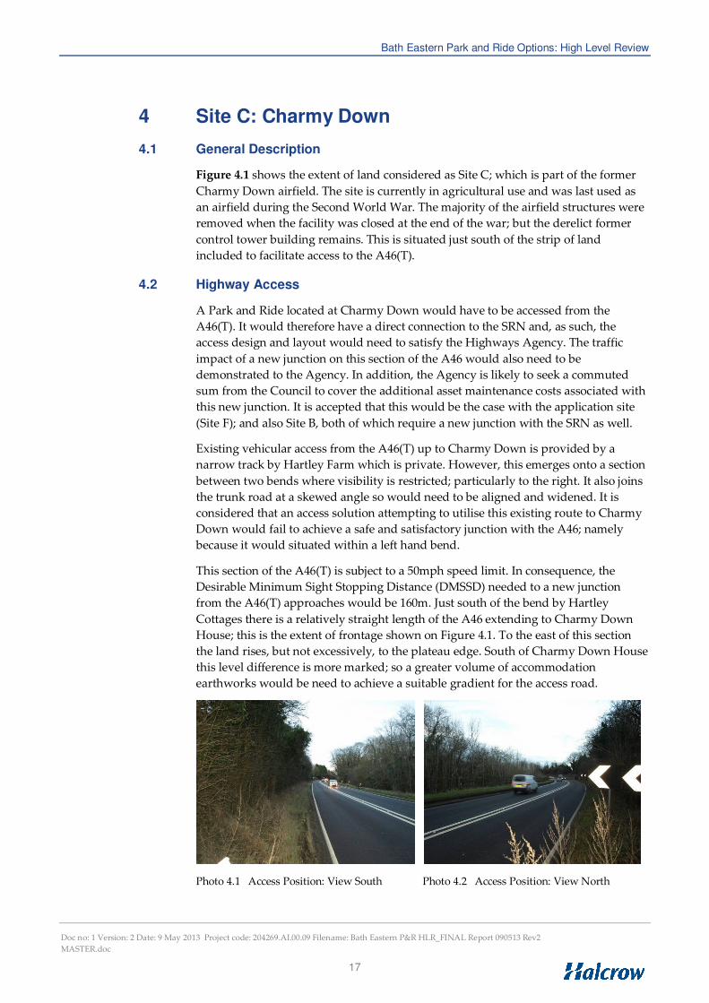
Photos 4.1 and 4.2 show the visibility achieved to the north and south of the potential
access point. By re-aligning both A46(T) approaches slightly eastwards as part of the
junction layout it is considered that it would be possible to improve the DMSSD over
that shown. This will be particularly important for southbound drivers emerging
from Hartley Bends. This would favour the use of a roundabout for the Park and Ride
access junction; with associated re-alignment of the northbound approach required
anyway to achieve satisfactory entry path curvature to slow vehicles from this
direction at entry. This form of junction would be safer than a major-minor ‘priority’
junction in accommodating right turning movements associated with the Park and
Ride site; particularly drivers attempting the right turn from the access. It would also
assist in slowing the straight-ahead traffic on the A46(T)in this location.
This high level review has not included the preliminary layout design of a
roundabout. Without doing so it is not possible to state categorically that the required
DMSSD for 50mph could be achieved on both A46(T) approaches. The approach from
the north via Hartley Bend will be the most problematic and it may be necessary to
seek a Departure of Standard to relax the visibility to, say, one or two steps below
DMSSD. A one step departure would require a sight stopping distance of 120m to the
yield line. A lower DMSSD might be allowable with the introduction of a local 40mph
speed limit on this section of the A46(T); say between the start of Hartley Bends to the
north and a point near ‘The Grange’ to the south. However, this would require the
approval of the Highways Agency but could be included within the package of
measures proposed to mitigate or overcome any Departure.
It is noted that this section of the A46(T) has steeply sloping ground on its western
side; with the road edge supported in places by retaining structures to prevent
carriageway deformation and cracking due to slope subsidence. Construction of a
roundabout to serve the Park and Ride will thus be in area of potential slope
instability; although the realignment needed to achieve a satisfactory layout would
move the existing road-line eastwards; away from the edge. One potential effect of
the re-alignment to the south of the roundabout would be the impact on Charmy
Down House; as shown on Figure 4.1. Whilst the house and out-building would be
unaffected it is probable that a large part of the garden would be needed to
accommodate the highway works associated with a new roundabout access.
4.3 Flood Risk
This site has no flooding issues given its location on an upland plateau. However, it is
noted that it is within a water source protection area and overlies a major aquifer.
This will constrain the type of surface water drainage system permissible. One based
on a soak-away drainage regime is unlikely to be acceptable because of the risk of
contaminants (fuel/oil spillages) reaching groundwater supplies and affecting water
quality. As such, a piped system of surface water drainage will probably be
necessary; possibly with controlled retention on-site and subsequent controlled
disposal off-site. The availability and capacity of any surface water drains suitable for
this purpose in this locality is unknown.

Bath Eastern Park and Ride Options: High Level Review
Doc no: 1 Version: 2 Date: 9 May 2013 Project code: 204269.AI.00.09 Filename: Bath Eastern P&R HLR_FINAL Report 090513 Rev2
MASTER.doc
19
4.4 Landscape and Visual
4.4.1 Landscape
Site C is located within the following landscape, cultural and environmental
designations:
• National designations: Cotswolds Area of Outstanding Natural Beauty
(AONB);
• Local Plan designations: Green Belt.
The site is located on the site of a former WWII airfield which is situated on the top of
an open, high Oolitic limestone plateau to the north-west of Bath, at approximately
210m AOD. The site currently comprises open, level agricultural farmland with a
large-scale, angular field pattern enclosed by scrubby hedgerows, wire fencing and
occasional dry stone walls. The area is tranquil in good weather but is exposed with
little natural protection from poor weather. Tree cover is sparse on the top of the
plateau but the scarp slopes around the former airfield supports a strong framework
of interspersed broadleaf woodland and hedges. This woodland creates an
immediate backdrop to the site on its western boundary, but the remaining vistas are
generally open. The wider setting is rural, with a few properties and farm buildings
dispersed along the route of the A46, which runs in a north-westerly direction to the
west of the site along the upper eastern slope of the Langridge valley.
A public footpath runs across the site from north-west to south-east direction.
Photo 4.3 View South towards Bath Photo 4.4 View West along Line of Access
In the wider context, the site is located within the Cotswold Plateaux and Valleys
Landscape Character Area (LCA 16) as identified in the ‘Rural Landscapes of Bath
and North East Somerset – A Landscape Character Assessment’. This character area
is defined by its geology with high, open limestone plateaux separated by dramatic
scarp slopes from adjacent low-lying valley floors. The current use of the site as
agricultural land aligns with the character of the wider Cotswold Plateaux.
As reflected in the designations which apply to it, the landscape quality of the site is
considered High. This is predominantly because the site is characteristic of the wider,
Cotswold landscape which is considered to be of national importance and which is
generally in good condition, rather than the value of its constituent landscape
elements.

Bath Eastern Park and Ride Options: High Level Review
Doc no: 1 Version: 2 Date: 9 May 2013 Project code: 204269.AI.00.09 Filename: Bath Eastern P&R HLR_FINAL Report 090513 Rev2
MASTER.doc
20
4.4.2 Visual
The site is located on a high, level and generally open plateau with woodland on
much of its surrounding scarp slopes. This restricts views of the site from low lying
areas around the site but the site remains widely visible from other elevated areas
within the Cotswold plateaux, although these tend to be some considerable distance
away. Woodland to the west of the site provides some screening of distant views
from high ground to the west.
Potential visual receptors include:
• Approximately 5-8 properties with potential views over the site located
around the western and southern boundary of the site, at a distance between
50-250m from the site boundary, including the access road.
• Users of the public footpath which passes through the site would experience
close views of the proposal over a distance of some 350m.
• Distant and filtered views from surrounding high areas such as Henley Hill,
Lansdown Hill, Little Solsbury Hill and Banner Down may be possible, over
a distance of between 1.1km and over 3km.
4.5 Planning and Land Constraints
4.5.1 Agriculture & Land Use
The site is Grade 3 agricultural land (where Grades 1, 2 and 3a represent the best and
most versatile grades of agricultural land). The site is wholly within the Green Belt.
4.5.2 Biodiversity
There are no sites of international or national importance within the site. Designated
ancient woodland is located to the west of the A46 (Ashcombe Wood) and 400m to
the north of the site (Hunterwick Wood and the nearest SSSI is 390m to the north
(Monkswood Valley SSSI).
The site is immediately adjacent to parts of the Charmy Down SNCI, covered by
BathNES Local Plan Policy NE.9. This designation covers land in St Catherine’s
Parish to the east of the site, as well some areas to the immediate north of the site.
4.5.3 Community Infrastructure & Transport
The site is not covered by any local plan designations protecting or reserving land for
community infrastructure.
Public footpath (ref BA2/12) crosses the site in a broadly north-west to south-east
alignment through the middle of the site.
4.5.4 Cultural heritage and built environment
The site does not fall within any heritage or built environment designations. There is
one Listed Building within 500m of the site (Hartley Farmhouse, a Grade II Listed
Building approximately 370m north of the proposed access).

Bath Eastern Park and Ride Options: High Level Review
Doc no: 1 Version: 2 Date: 9 May 2013 Project code: 204269.AI.00.09 Filename: Bath Eastern P&R HLR_FINAL Report 090513 Rev2
MASTER.doc
21
4.5.5 Pollution prevention
The site falls wholly within the St Catherine Water Source Protection Area. No other
designations apply.
4.6 Potential Business Case
This site is much further from the City Centre than the application site (Site F). The
data indicates that the ‘round trip’ time for buses operating from Site C in the 8:00-
9:00am period would be circa 27 or 29 minutes for the two routes through to Orange
Grove assumed; and 29 or 33 minutes in the 5:00-6:00pm period. This assumes a bus
route via the Gloucester Road between the A46 and A4, with timings dictating a need
for four buses dedicated to operating the Park and Ride service based on a 10 minute
frequency; as opposed to three for Sites A, B and the ‘application’ site. As before this
increased operating cost; together with others, would have had to be balanced against
the expected revenue in establishing the business case for Site C.
It is considered that Site C will have considerably more difficulty in attracting
potential users from the A4 and A363 corridors to the east of the city. It is possible
that some drivers currently using the A4 Box Road with more distant origins could
choose to re-route to the A420 to access a site at Charmy Down; although a proper
patronage study would be needed to establish the likelihood of this. A site here is
unlikely to be attractive to drivers currently using the A363 by virtue of the diversion
needed to reach it; this may also be the case for many potential users on the A4.

Bath Eastern Park and Ride Options: High Level Review
Doc no: 1 Version: 2 Date: 9 May 2013 Project code: 204269.AI.00.09 Filename: Bath Eastern P&R HLR_FINAL Report 090513 Rev2
MASTER.doc
22
5 Site E: Bathford
5.1 General Description
Figure 5.1 shows the extent of land considered as Site E. Following a pre-meeting
with Parish Councillors and B&NES to agree sites for inclusion in the review it was
decided that the playing field to the south of the By Brook and any land associated
with The Mill should be excluded from consideration. The resultant land parcels
considered form two strips running along the north and south sides of the railway
embankment.
The land to the south of the railway is bounded by the By Brook along its southern
edge. At its western end is an existing contractor’s yard operated by Bath Demolition.
Access to this yard is achieved via a gated entrance onto the A363 immediately south
of the railway bridge.
Most of the land identified to the north of the railway is either derelict or in use for
garaging. This is bounded to the north by the A4 Box Road; which has a 40mph speed
limit in force along this section.
5.2 Highway Access
This site is unattractive in that the site is fragmented with no means of achieving an
internal linkage for vehicles or pedestrians between the two land parcels. There is a
bridge under the railway to the east with sufficient width for one-way vehicular
passage; but accommodating this within the site is not practical. This is because it
would require the acquisition and demolition of three residential properties; nos. 31,
33 and 35 Box Road, on the north side of the railway. Furthermore, the land on the
south side of the bridge is controlled by The Mill.
The only possible access to any parking situated on the south side of the railway
would need to be sited where the depot entrance is now. This is less than ideal in that
the visibility to the right through the bridge will be restricted. Furthermore, the view
of northbound traffic to the left is also restricted by the bridge over the By Brook and
the associated deviation of the road. A further safety concern would be drivers
waiting to turn right into this site and the risk of vehicle shunts’ resulting from the
restricted forward visibility available to following traffic at the By Brook bridge.
Most of the land parcel on the north side of the railway is too narrow to achieve an
efficient layout of parking spaces. The vehicle access and bus turning loop would
need to be situated at the eastern end of this site where the garaging is now. Visibility
to the right here would be extremely restricted due to the access position on the
inside of a shallow bend. Achieving the 120m visibility splay necessary for a 40mph
road would further impact on the site area available and require additional land from
the garden to no 31 Box Road.
Notwithstanding the above a split site is not sensible in operating terms. For example,
a driver accessing the north site from the A4 and failing to find a free space would
then have to rejoin the highway to seek an available space in the parking area south
of the railway. Any users parking on the south side of the railway would also have to
walk under the railway bridge to a bus pick-up point situated at the eastern end of
the northern land. This would be an inconvenient and lengthy walk for people forced
to park at the eastern end of the southern land parcel.
Bath Eastern Park and Ride Options: High Level Review
Doc no: 1 Version: 2 Date: 9 May 2013 Project code: 204269.AI.00.09 Filename: Bath Eastern P&R HLR_FINAL Report 090513 Rev2
MASTER.doc
23
In summary there is no case for this site on highway access grounds, or indeed from
the point of view of user convenience and Park and Ride operation.
5.3 Flood Risk
Flood Zone mapping provided by the Environment Agency shows that the whole of
the southern land parcel falls within Flood Zone 3. The playing fields to the south are
also within Flood Zone 3; with flooding from the By Brook occurring most recently in
December 2012. However, the playing fields were previously excluded from
consideration.
5.4 Landscape and Visual
5.4.1 Landscape
Site E is located within the following landscape, cultural and environmental
designations:
• Local Plan designations: Green Belt, Forest of Avon.
It is also directly adjacent to, though not within, the boundary of the Cotswold
AONB.
The site comprises two parcels of land either side of the Great Western Railway
bridge which crosses the River Avon at Batheaston. The area to the south of the
railway comprises a hard-standing storage yard operated by Bath Demolition
adjacent to the A363, with an area of apparently disused and vegetated land located
behind the yard to the north-east. The southern site is bounded by the By Brook near
its confluence with the River Avon to the south, and the railway to the north, with
maturing woodland on the railway embankment and riverine trees present along By
Brook and. Bathford Bridge (Scheduled Monument) is located close to the southern
site where the A363 crosses By Brook.
The northern area comprises a triangular area of mown verge grassland adjacent to
the A363/A4 roundabout and a linear strip of developing woodland and scrub
located between the railway embankment and the A4, part of which is hard-standing
used for vehicle storage. The area also contains a substantial drainage ditch which
runs along the base of the railway embankment.
In the wider context, the site is located within the Bathford and Limpley Stoke Valley
Landscape Character Area (LCA 18), as described for Site A above. The current use
of the site as vehicle storage does not aligns with the historical character of the wider
Bathford and Limpley Stoke Valley, but the riverine and scrub woodland is of local
value which helps integrate the site into its valley floor setting. Electricity pylons,
roads and the vehicle storage areas detract from the quality of the local landscape.
The site occupies an important location at the confluence of the River Avon and By
Brook valleys and it has some influence in this respect on the setting of the adjacent
AONB. In general, the landscape quality of the paved areas of the site is considered
Low and the quality of the vegetated areas is considered Moderate.

Bath Eastern Park and Ride Options: High Level Review
Doc no: 1 Version: 2 Date: 9 May 2013 Project code: 204269.AI.00.09 Filename: Bath Eastern P&R HLR_FINAL Report 090513 Rev2
MASTER.doc
24
Photo 5.1 Southern Site - View from A363 Photo 5.2 Northern Area - View East from A363
5.4.2 Visual
The southern site is partially visible through the riverine tree line from a number of
properties on the northern edge of Bathford, and the northern site is clearly visible
from properties located along the northern edge of the A4 facing south, although
developing woodland provides some screening at present.
Potential visual receptors include:
• Approximately 25-30 properties and The Crown pub on the northern edge of
Bathford have potential views to the southern site, at a distance between 130
to 250m. Views are likely to be partially filtered by riverine vegetation and
are oblique in many cases.
• Approximately 15-25 properties and a car sales business would have views of
the northern site at a distance of between 20 to 70 metres. Views are oblique
and partially filtered in some cases.
• Users of the A363, A4 and Great Western Railway would experience close
views where adjacent to the sites.
5.5 Planning and Land Constraints
5.5.1 Agriculture & Land Use
The site straddles the boundary between Grade 3, Grade 4 and Grade 7 (urban) land
(where Grades 1, 2 and 3a represent the best and most versatile grades of agricultural
land). The site is wholly within the Green Belt.
5.5.2 Biodiversity
There are no sites of international or national importance within or close to the site.
The nearest such sites are 760m to the south (Brown’s Folly SAC and SSSI). Most of
the southern portion of the site south of the railway embankment forms part of the By
Brook SNCI, covered by BathNES Local Plan Policy NE.9.
5.5.3 Community Infrastructure & Transport
The site is not covered by any local plan designations protecting or reserving land for
community infrastructure. Land immediately to the south is however designated by
BathNES Local Plan Policy SR.1A as Protected Playing Fields / Recreational Open
Space, the loss of which will not be permitted unless four criteria can be met.

Bath Eastern Park and Ride Options: High Level Review
Doc no: 1 Version: 2 Date: 9 May 2013 Project code: 204269.AI.00.09 Filename: Bath Eastern P&R HLR_FINAL Report 090513 Rev2
MASTER.doc
25
No public rights of way traverse or adjoin the site.
5.5.4 Cultural heritage and built environment
The site does not fall within any heritage or built environment designations. It is 1km
east of the City of Bath World Heritage Site.
Bathford Bridge, which is a Scheduled Ancient Monument, lies at the western edge of
the southern part of the site. Bradford Road rail bridge, also at the western edge of
the site, is a Grade II listed structure and several other listed buildings are close by,
most of which are on Bathford Hill. The closest part of Bathford Conservation Area is
60m to the south, within which most of the nearby Listed Buildings are located.
5.5.5 Pollution prevention
The northern part of the site (north of the railway line) falls within the Bath Hot
Springs Protection Area. No other designations apply.
5.6 Potential Business Case
This site is slightly further east than the application site (Site F). However, the journey
time data from the Strat-E-GIS data-base shows this would only add around two
minutes to the overall ‘round trip’ bus time. As such, it is probable that three buses
dedicated to operating the Park and Ride service would still be sufficient.
Although conveniently sited for both the A4 and A363 the biggest issue with this site
is the limited parking which could be accommodated on both parcels of land;
particularly the northern part which is very narrow. The site is also split; which is less
than ideal. Problems with on-site parking capacity could lead to some use of
surrounding roads for this purpose by potential users; which is clearly not desirable.
As such, the revenue potential of this site is considered low as it would simply be
unable to cope with parking demand should a high ‘take-up’ result.

Bath Eastern Park and Ride Options: High Level Review
Doc no: 1 Version: 2 Date: 9 May 2013 Project code: 204269.AI.00.09 Filename: Bath Eastern P&R HLR_FINAL Report 090513 Rev2
MASTER.doc
26
6 Site F: Land East of Mill Lane: ‘Application’ Site
6.1 Background and Current Position
Figure 6.1 shows the extent of land considered as part of the ‘Application Site’; which
is referenced in this review as Site F. This lies to the east of Mill Lane in Bathampton
Meadows with a proposed signal controlled access junction onto the A4 Batheaston
Bypass. This junction would be to the SRN and, as with Sites B and C, the layout and
design would need to be agreed with the Highways Agency. As previously discussed
when considering Site B; a feasible access to the land on the west side of Mill Lane
may impinge onto the Site F land also.
This site has an extant planning permission granted in July 2009; but the decision to
implement it was shelved in 2011 when this Park and Ride proposal was removed
from the Bath Package.
Flood Zone mapping shows that the northern perimeter of the site is close to the
Flood Zone 2 extent; but is not within the higher risk Flood Zone 3 area.
Landscape/visual impacts and planning/land issues identified in previous assessment
work are included in the ‘Summary Comparison’ in Section 10 in order to provide a
reference case against which to compare the option sites considered in this review.

Bath Eastern Park and Ride Options: High Level Review
Doc no: 1 Version: 2 Date: 9 May 2013 Project code: 204269.AI.00.09 Filename: Bath Eastern P&R HLR_FINAL Report 090513 Rev2
MASTER.doc
27
7 Site G: Lansdown Park and Ride
7.1 General Description
Figure 7.1 shows the extent of land considered as Site G; which proposes a further
expansion of the existing Lansdown Park and Ride site beyond that envisaged in the
Bath Package. The area of land included in the proposed Bath Package expansion
scheme is also shown.
The existing Lansdown Park and Ride site has 490 spaces. This will increase to 880
spaces when the Bath Package scheme is implemented. This expansion will use
playing field land to the south and west of the existing site as indicated on Figure 7.1.
The Summary Environment Statement (SES) prepared for the current expansion
states that this scheme results in the loss of a playing field and, as such, a replacement
playing field would be provided to mitigate this impact using land owned by B&NES
close to the application site
The additional land needed to provide a parking capacity of circa 1400 spaces is also
situated to the south and west. This will clearly result in a further loss of playing field
space which will need to be compensated for elsewhere.
7.2 Highway Access
The existing Lansdown Park and Ride site is served by two major-minor ‘priority’
junctions, one providing access and the other egress. The Transport Assessment (TA)
prepared for the Bath Package expansion scheme; dated January 2009, concluded that
these existing junctions would be capable of accommodating the additional traffic
associated with the uplift from 490-880 spaces. As such, no improvements to these
junctions were proposed or deemed necessary.
The suitability of the existing access arrangements with a site of circa 1400 spaces
would need to be assessed in capacity analyses carried out as part of a further
Transport Assessment. This is because the ‘give way’ capacities achievable with
simple priority junctions are not as high as other junction types. Furthermore, the TA
carried out for the proposed 880 space scheme concluded that the Ratio of Flow to
Capacity (RFC) for right turners accessing the site in the morning peak hour could
reach 0.6. Similarly, the RFC for traffic exiting the site in the evening peak hour was
predicted to be circa 0.7. This does not provide a high level of reserve capacity to
accommodate traffic associated with a further expansion of the site. Clearly, a
detailed patronage assessment would need to be undertaken to ascertain what level
of usage could realistically be drawn from the eastern corridor; and hence the
volumes and arrival/departure profiles associated with the additional vehicle
demand in the weekday peak periods.
The existing bus turning area and stops are located close to the exit onto Lansdown
Road; with parking arranged around it so as the minimise walk times from the
furthest parking spaces. The present expansion proposed is predominantly to the
west, but walk distances would remain reasonable. The further expansion indicated
in Figure 7.1 would result in the existing bus turning loop/stop position being quite
off-centre. It may thus be desirable to examine relocating this if this second expansion
of the site was taken forward; particularly if capacity analyses were to indicate that a
revised and improved access junction was necessary
Bath Eastern Park and Ride Options: High Level Review
Doc no: 1 Version: 2 Date: 9 May 2013 Project code: 204269.AI.00.09 Filename: Bath Eastern P&R HLR_FINAL Report 090513 Rev2
MASTER.doc
28
7.3 Flood Risk
The potential impacts on flooding, surface water drainage and water quality resulting
from construction and operation of the expanded site proposed under the Bath
Package were assessed and fully reported in a Flood Risk Assessment and Drainage
Strategy (FRADS) Report. This concluded that the expansion of the Lansdown Park
and Ride was at low risk/probability of flooding from rivers, sewers or watercourses.
The main flood risk identified across the site related to surface water flooding. The
flat site topography and impermeable nature of the existing facility are known to
cause localised low levels of flooding on-site following heavy rain. This is currently
mitigated by a drainage strategy for the site; whilst it was concluded in the FRADS
that the use of Sustainable Drainage Systems (SuDS) would protect against any risk of
groundwater contamination. A further expansion of the site is likely to have the same
surface water management issues; but be capable of being mitigated in the same way.
As such, there is likely to be a ‘negligible’ impact on local hydrology and drainage.
7.4 Landscape and Visual
7.4.1 Landscape
Site G is located within the following landscape, cultural and environmental
designations:
• National designations: Cotswold AONB;
• Local Plan designations: Green Belt.
The site is located adjacent to the existing park and ride facility which is situated on
the elevated limestone plateau which forms Lansdown Hill, at approximately 227m
AOD. The site currently comprises an open, level area of sports pitches enclosed on
the Lansdown Road side by a linear screen of maturing tree planting and a remnant
field hedgerow and tree line to the south-west. The north-west boundary is formed
by a dry stone wall along Lansdown Lane, and the south-east boundary comprises
the existing park and ride facility and some associated screen planting. The wider
setting is rural, agricultural land with the exception of Lansdown Golf Course and
Bath Racecourse which are located to the north-west of the site. With some
exceptions, tree cover is sparse on the top of the plateau but the steep scarp slope
immediately to the south-west of the site supports a strong framework of
interspersed broadleaf woodland and hedges.
A public footpath runs along the south-west boundary of the site from north-west to
south-east direction.
In the wider context, the site is located within the Cotswold Plateaux and Valleys
Landscape Character Area (LCA 16) as described for Site C. The current use of the
site aligns with the character of the wider Cotswold Plateaux in so much as the sports
pitches are a large-scale, open area of grassland. The landscape quality of the site is
considered High to Moderate, on the basis that the site is generally characteristic of
the open, Cotswold plateau landscape which is considered to be of national
importance and which is generally in good condition, but its current use as playing
fields detracts from that quality to a degree.

Bath Eastern Park and Ride Options: High Level Review
Doc no: 1 Version: 2 Date: 9 May 2013 Project code: 204269.AI.00.09 Filename: Bath Eastern P&R HLR_FINAL Report 090513 Rev2
MASTER.doc
29
7.4.2 Visual
The site is located on a high, level and reasonably open plateau with woodland on
much of its surrounding scarp slopes. This restricts views of the site from low lying
areas to the south of the site and potential views from other elevated areas to the
north and east are at least partially screened by local screen planting. Views along
the plateau to Lansdown village to the north-west are largely open.
Potential visual receptors include:
• Approximately 10 properties and The Blathwaite public house have potential
oblique views towards the site, at a distance between 450-550m from the site
boundary.
• There is a property within 80m of the site on the opposite side of Lansdown
Road but it is likely that views from here are screened by intervening
vegetation.
• Users of the public footpath along the south-west boundary of the site would
experience open views of the site at a distance of 50m+.
• Users of Bath Racecourse and Lansdown Golf Club may experience distant
views of the site over a distance of 0.7 to 1.4km.
7.5 Planning and Land Constraints
7.5.1 Agriculture & Land Use
The site is Grade 3 agricultural land (where Grades 1, 2 and 3a represent the best and
most versatile grades of agricultural land). The site is wholly within the Green Belt.
7.5.2 Biodiversity
There are no sites of international or national importance within or close to the site. It
is approximately 100m north of the nearest part of the Chelcombe & Lansdown
Woods SNCI, covered by BathNES Local Plan Policy NE.9, a series of fields
designated to protect their calcareous grassland.
7.5.3 Community Infrastructure & Transport
The whole site is designated by BathNES Local Plan Policy SR.1A as Protected
Playing Fields / Recreational Open Space, the loss of which will not be permitted
unless four criteria can be met.
No public rights of way traverse or adjoin the site.
7.5.4 Cultural heritage and built environment
The site does not fall within any heritage or built environment designations. The
nearest part of the World Heritage Site is 290m to the south-east, which also forms the
boundary of Bath Conservation Area. There is one listed building within 500m
(Chapel Cottage, a Grade II Listed Building 460m north-west of the site). The site is
the nearest to any historic battlefield on English Heritage’s register, although the
nearest part of the designation is 1.6km north of the site.
Bath Eastern Park and Ride Options: High Level Review
Doc no: 1 Version: 2 Date: 9 May 2013 Project code: 204269.AI.00.09 Filename: Bath Eastern P&R HLR_FINAL Report 090513 Rev2
MASTER.doc
30
7.5.5 Pollution prevention
The site is adjacent to, but not within, the Lansdown Hill Water Source Protection
Area. No other designations apply.
7.6 Potential Business Case
This site is far removed from the eastern A4 and A363 corridors. Pending a proper
study to establish potential patronage; the ability of a further expanded facility here
to attract users from the east of the city is considered doubtful. Data supplied by
B&NES showing the origin and journey purpose of car trips using the current Park
and Ride sites shows that that the Lansdown site does attract users from the North-
East as well as the North, but the scatter-plots produced suggest that drivers
accessing this site from the North-East are generally using the A420. This suggests
that simply expending facilities here would not attract many drivers currently
routing into Bath along the A4 Box Road; and most likely none from the A363 where
the site at Odd Down would present a more obviously choice for users prepare to
divert this far from their route.

Bath Eastern Park and Ride Options: High Level Review
Doc no: 1 Version: 2 Date: 9 May 2013 Project code: 204269.AI.00.09 Filename: Bath Eastern P&R HLR_FINAL Report 090513 Rev2
MASTER.doc
31
8 Site H: Bathampton Junction
8.1 General Description
Figure 8.1 shows the extent of land considered as Site H; which lies adjacent to the
Great Western Main Line (GWML) at Bathampton junction and is currently bisected
by the railway line to Westbury. Comment in this review is based on the proposals
put forward by Dorian Baker; which in his report states: “The scheme is to provide a new
Bathampton Park and Ride railway station at a new bay platform track as part of the carrying
of works to rebuild the railway track at Bathampton Junction to improve its flexibility and
capacity in preparation for 25kV AC overhead line electrification. Adjacent to this station a
new park car on three levels would be build mainly on railway land of the original station yard
and in the angle between the two railways, with the lowest level at about that of the base of the
embankment, outside the flood plain.”
The delivery of the land area needed for the Park and Ride site is thus dependent on
re-aligning the railway line that currently bisects it. Again, quoting from the Dorian
Baker report it is stated that: “To make up the site area, the greater part would be achieved
by moving track switches that form the ‘railway junction’ about 200 metres to the west so that
two parcels of ‘brown land’ that are, today, divided by the railway branch to Trowbridge can
be utilised as a single area of 1.9ha. A further 1.2ha of land would be taken from the Green
Belt, mainly land of Bathampton Farm in the angle of the railway junction, to the south of the
A4 Batheaston Bypass and the GWML railway corridor.”
As stated most of the land directly affected is either the station yard or pasture land
adjacent to Bathampton Farm. However, the slewing of the railway line to the south
affects land north of Tyning Road which is designated as the ‘Hampton Rocks
Cutting Site of Special Scientific Interest’ (SSSI) as shown below. This is not
mentioned in the Dorian Baker report.

Bath Eastern Park and Ride Options: High Level Review
Doc no: 1 Version: 2 Date: 9 May 2013 Project code: 204269.AI.00.09 Filename: Bath Eastern P&R HLR_FINAL Report 090513 Rev2
MASTER.doc
32
South of Tyning Road the land required for moving the railway affects land currently
used as a timber yard; and a residential property known as ‘The Skillings’. The
existing level crossing at the eastern end of Tyning Road is also affected; potentially
cutting off access to Bathampton Farm.
8.2 Highway Access
8.2.1 General
The existing roads through Bathampton village to the south of the GWML are totally
unsuitable for providing access to a Park and Ride site. Bathampton Lane is subject to
a 20mph speed limit and has traffic calming measures in place; whilst Tyning Road is
a single track road and has a poor junction with Mill lane at its western end. This is
also an important factor when considering how access for construction traffic will be
achieved to undertake the heavy engineering works required on the south side of the
GWML to bring this site forward. This includes the bridge through the railway
embankment, the excavation needed to accommodate a three level Multi-Storey Car
Park (MSCP) and the construction of the MSCP itself. Other access constraints
include:
• Mill Lane bridge over the River Avon is subject to a 4 ton weight limit and is
a Grade 2 Listed Structure;; and
• The Avon and Kennet Canal bridge on Bathampton Lane is denoted as
having a 4 ton axle limit (on a Heritage Sign). The horizontal and vertical
alignment in the vicinity of the bridge is poor; whilst the visibility achievable
to the left at the adjacent Tyning Road junction is extremely restricted. This
bridge is almost Grade 2 Listed;
• As previously stated, Tyning Road is single track along practically the whole
of its length; and
• The level crossing at the end of Tyning Road has user worked gates with
miniature lights to indicate the approach of trains. The road approach to the
level crossing from the west is on the inside of the railway curve with
reduced sighting distances of and from trains. Despite the use of gates and
lights; its frequent use by even light construction traffic would increase the
risk of a collision between road and rail vehicles.
The Dorian Baker proposals suggest that the current level crossing would be lost;
insofar as the southern end of the MSCP cuts across the southern end of Tyning Road
and the existing facility. It is not clear how access to Bathampton Farm will be
maintained as this is effectively cut-off by the MSCP. The track re-alignment will also
affect the existing access to the timber yard, whilst it results in the loss of the
residential property known as ‘The Skillings’. The current rear garden of this
property is shown as providing an alternative means of access to the timber yard
from Tyning Road. It was noted during the site visit that the present owner of ‘The
Skillings’ is attempting to sell the property; whilst Bathampton Farm is also up for
sale.
As included in the Dorian Baker proposal, the only feasible of achieving permanent
highway access to this site is from the A4 Batheaston Bypass. The engineering issues
in achieving this; which envisage a bridge under the bypass and a further bridge
through the GWML embankment are covered in the following sub-section. Given the
Bath Eastern Park and Ride Options: High Level Review
Doc no: 1 Version: 2 Date: 9 May 2013 Project code: 204269.AI.00.09 Filename: Bath Eastern P&R HLR_FINAL Report 090513 Rev2
MASTER.doc
33
difficulty in achieving access for heavy construction traffic to the south of the GWML;
at least by road, the bridge through the embankment will need to be place first to
allow access for earthworks/construction of the MSCP. To do this the railway line
would have to be re-aligned first to undertake any preparatory work needed on the
south side to allow the bridge to be box jacked through or constructed in-situ.
8.2.2 Bridge Engineering Works/Issues
8.2.2.1 General / Dimensions
Appendix C includes a Technical Note which provides details on the potential
methodologies available and issues associated with constructing the two bridge
structures to access Site H. This considers ‘possession time’ needed and/or other
impacts on railway operation, and the likely cost of the works to install the bridges
and the diamond interchange proposed with the A4 Batheaston Bypass. The
additional rail engineering issues and anticipated costs are considered separately in
sub-section 8.3.
The two bridges under the A4 and railway line need to provide a minimum internal
width of 10.3m based upon two 3.65m lanes and 1.5m wide verges (TD 27/05). There
will be a need for wing walls in the form of retaining walls at either end splayed back
to satisfy sighting distance criteria. The minimum headroom required is 5.3m to be
provided over the full width of the carriageway and verges, to which must be added
an allowance for cross fall and longitudinal drainage gradient. The thickness of the
roof, walls and floor for a reinforced concrete box would be about 0.85m resulting in
external box dimensions in the order of 12.0m wide and 7.5m high. On top of the box
must be added 0.468m for track and 0.35m for ballast and waterproofing, thus total
construction depth would be a minimum of 1.668m from soffit to rail level.
8.2.2.2 Possible Forms of Construction
Possible forms of construction would include:
• Jacked box advanced through the embankments under live traffic;
• Jacked box constructed off line for positioning during an extended
possession;
• Portal structure constructed off line and slid into place on guides pre-placed
within small tunnels within the base of the embankment; the slide taking
place during an extended possession;
• Railway Bridge only: a conventional half through steel bridge superstructure
on transversely spanning crossbeams supported by large diameter piles or
caissons at each corner. The piles would be bored outside the railway
clearance so as to avoid interference with operations. The bridge could then
be lifted in by crane during a short possession
• Bypass Bridge only: in-situ concrete construction with traffic diverted along
the slip roads that would be constructed in advance
A major consideration governing the form of construction used for the bridge under
the GWML will be the avoidance or minimisation of disruption to railway operations.
Possession planning often requires a three year lead in time and ‘extended
possessions’ up to four days or more are typically only available at Christmas and
Bath Eastern Park and Ride Options: High Level Review
Doc no: 1 Version: 2 Date: 9 May 2013 Project code: 204269.AI.00.09 Filename: Bath Eastern P&R HLR_FINAL Report 090513 Rev2
MASTER.doc
34
Easter. As an example; the box jack under the M1 motorway at Junction 15a was
accomplished without any interruption of traffic and, in this case, the top surface of
the box was 1.5m below the highway running surface. Such an approach would be
preferred if acceptable to Network Rail albeit a temporary rail speed restriction
would be necessary for a period of about three weeks.
8.2.2.3 Earthworks
At the proposed bridge location, the A4 Batheaston Bypass is in a cutting. The raised
earth profile currently occupying the space between the A4 and the GWML
embankment; and the north side of the road, would have to be fully removed and a
cutting excavated in its place over a distance of some 400 metres in order to
accommodate the slip roads on descending gradients. The depth of these cuttings
would need to reach about 7m below existing road level to gain sufficient headroom
for turning vehicles to pass under the road and railway bridges, to which must be
added a further volume of excavation to represent the height of the ground above
existing road level at the site.
Subject to soil investigation and slope stability considerations, a 1:2 side slope may be
expected, requiring a top cutting width of around 37 metres at the level of the A4
road. This width would fully occupy the space available between the road and the
railway, suggesting the need for retaining walls to ensure slope stability at the toe of
both of the road and the railway embankments.
On the south side of the GWML substantial volumes of excavation will be needed to
create a three storey car park, and the basement retaining walls will need to be
sufficiently deeply founded to secure the railway embankment against slope
instability. It was during the site visit that; whilst the GWML embankment is quite
high by Bathampton Farm; this level difference with the land to the south reduces to
the west. Furthermore, the level difference with the line to Westbury is not excessive.
The lowest level of the car park may be affected by extreme flood events, as the
Environment Agency flood map envelopes the whole of Bathampton Farm. It is noted
from the Dorian Baker proposal layout that the aim is to remove this risk by bunding
and screening works to the east of Bathampton Farm. The implications of this are
discussed later in the section on flood risk.
8.2.2.4 Construction Access / Working Space
As discussed earlier there are considerable constraints in achieving suitable access for
construction traffic to the south side of the GWML. As such; whilst establishing a site
compound and fabrication yard in the ‘triangle’ of land between the two railway lines
to the west of Bathampton Farm would be the ‘ideal’, the existing road access is
totally unsuitable. In The Technical Note included as Appendix C the possibly of
constructing a temporary haul road across the floodplain east of the farm to a
connection point with the A363 Bradford Road is ‘postulated’. However, the issues
associated with this are considerable; not least the need for a temporary Bailey bridge
spanning the River Avon. Accommodating a suitable and safe temporary access
junction with the A363 would also be very difficult
The off line construction of a new railway bridge (e.g. jacked box or portal) would
need to be as close as possible to its final position in order to be viable. For in-situ
railway bridge construction the same proximity requirements apply for crane
positioning. The difficulty of achieving access to the south side of the GWML to do
Bath Eastern Park and Ride Options: High Level Review
Doc no: 1 Version: 2 Date: 9 May 2013 Project code: 204269.AI.00.09 Filename: Bath Eastern P&R HLR_FINAL Report 090513 Rev2
MASTER.doc
35
this has been discussed. The option of having the site compound and working area
wholly to the north of the A4 is unlikely to be feasible since any off-line railway
bridge construction would be more remote from its final position. In addition, the
temporary working area required would be likely to extend beyond the future
highway boundary into the flood plain to the north (Site F); with greater risk to the
project, environmental impact and the need for remediation measures.
To obtain sufficient working space and a site compound it is considered that the area
between the GWML and the bypass would need enlarging. This would require the
temporarily narrowing of the A4 dual carriageway to a single lane in each direction
and diversion via a bypass route to the north around the works site. It may be
possible to limit the northern extremity of the road diversion to be within the future
highway footprint; in order to minimise encroachment on to the flood plain further
north. Working space thus obtained would be sufficient for construction of both the
railway bridge and the road bridge. Depending upon the limitations of the available
space that can be obtained by this method; construction of the two bridges is likely to
be consecutive as opposed to concurrent. A construction period of up to 18 months
would be needed during which the temporary traffic diversion with speed
restrictions would be in force.
This will clearly have a major impact on the operation of the SRN; so would require
the approval of the Highways Agency. Assuming the Agency is satisfied B&NES
would be liable for all the temporary traffic management costs; including
maintenance, for this period. It is also worth noting that the Agency will most likely
seek a commuted sum to cover all additional asset maintenance costs associated with
the completed works affecting the SRN; in this case an additional bridge, four new
slip-roads including possible retaining structures and all additional lighting and
signing. From recent experience on M5 Junction 21 this is normally estimated for a 60
year period.
8.2.2.5 Estimated Costs
The estimated cost of the construction of a bridge under the Batheaston Bypass, a
bridge under the GWML, earthworks, retaining walls, slip roads and the maintenance
of the A4 road diversion is estimated to be in the order of £10-12M. This is based
upon a construction working area being established between the road and the
railway as described. The commuted sum which the Agency would seek to cover
their additional asset maintenance liabilities in respect of the SRN would need to be
added to this; as well as temporary traffic management costs. Transport Analysis
Guidance (TAG) from the DoT in respect of ‘The Estimation and Treatment of
Scheme Costs’ recommends that an appropriate level of ‘Optimism Bias’ should be
built into scheme cost estimates; the level dependent on the stage the scheme is at. It
is considered this is pre-feasibility or Stage 1; in which case the recommended
optimism bias uplift is +44% for road schemes. Applying this to the highway related
costs gives an estimate of circa £14.4-17.3M for this element.
This estimate does not include for railway costs such as possessions, removal and
reinstatement of track, protection of signalling cables and station infrastructure
works. This is covered in the following sub-section which considered the rail
engineering works needed and potential issues.
Bath Eastern Park and Ride Options: High Level Review
Doc no: 1 Version: 2 Date: 9 May 2013 Project code: 204269.AI.00.09 Filename: Bath Eastern P&R HLR_FINAL Report 090513 Rev2
MASTER.doc
36
8.3 Rail Engineering Works
Appendix D contains a report which provides a ‘rail engineering’ view on the
content of the Dorian Baker report into the Park and Ride proposal at Bathampton
Junction. This goes into some detail about the considered feasibility of the proposals.
The key points to emerge are set out below.
8.3.1 Permanent Way: Track
There are two major drawbacks to the scheme from a P Way point of view. From
analysis of the drawing provided, the radii of the proposed curve appears to be
somewhere in the region of approximately 390m radius. In addition, from
information extracted from the railway industry Five Mile Line Diagrams the new
platform would be located on land almost immediately adjacent to the track on an
existing < 1 in 330 gradient. This is in contravention of the track design handbook
NR/L2/TRK 2049, which states: “Station platforms shall not be located on horizontal curves
with radii less than 1000m” and “Wherever possible; platforms shall be located with an
average gradient not steeper than 1 in 500. It is permissible for platforms to be located on
track with average gradients steeper than 1 in 500 provided trains are not planned to
terminate or reverse at the platform”.
It is possible that detailed design may be able to improve on the existing situation
and/or a dispensation may be obtained, but it is by no means certain. This one aspect
alone may prevent the approval of the scheme.
8.3.2 Signalling
The report produced by Mr Baker contains little if any reference to either the existing
signalling arrangements in the Bathampton and Bath Spa areas; or what new
equipment would be necessary to accommodate the suggested park and ride service.
The report states that “there is a once in a generation opportunity to amend the layout at
Bathampton, as part of the work associated with the Great Western Main Line Electrification
project”. Whilst this is correct; in that the signalling equipment will be entirely
replaced by this project; Mr Bakers report appears to presume that the substantial
changes to track, signalling and electrification which he recommends at Bathampton
Junction would be completed and funded as part of this far larger project. Presuming
that Network Rail is willing to incorporate into Great Western Electrification the
suggested substantial alterations to the junction is a major assumption, the funding of
it even more so.
Comparing the new and old layouts simply by numbers of switches and crossings
does not address the additional and possibly excessive complexity of the new layout,
for signalling purposes. The addition of the central bi-directional loop appears to add
little functionality compared to the existing layout and it is unlikely it would in
practice be used for either of the “advantages” quoted by Mr Baker. Similarly the
proposal for a bay platform sited in between the Up & Down Trowbridge lines adds
unnecessary complication to the layout and the island platform arrangement would
prevent Regional services on the Up Trowbridge line from calling at Bathampton.
Lastly, the suggestion to provide a light rail line adjacent to the Great Western Down
Main should be treated with caution. Although there is no track here at present, all
the signalling equipment cabinets and associated cable routes are presently located
on this side of the line. Re-Signalling of the Great Western Main Line may or may not
Bath Eastern Park and Ride Options: High Level Review
Doc no: 1 Version: 2 Date: 9 May 2013 Project code: 204269.AI.00.09 Filename: Bath Eastern P&R HLR_FINAL Report 090513 Rev2
MASTER.doc
37
replicate this arrangement. The addition of new track here could potentially require
the re-location of and consequent re-testing of all of the main line signalling
equipment adjacent to the light rail.
8.3.3 Telecommunications
Considerable alterations to the telecommunications will be required to provide all the
modern facilities necessitated by the new station: PA, CCTV and so forth.
8.3.4 Operations
It is suggested by Mr Baker that the park and ride site is served by a rail shuttle
service to Bath Spa station. This is not regarded as being operationally feasible in
itself. Bath Spa station has very limited capacity for turning trains back; and the
nature and layout of turnouts at Bath do not allow turning back from/to the east. The
site might possibly be served by other existing and proposed services. These would
be:
• Existing regional services that link Westbury and Bath hourly; although note
the previous comment raised about the problem in stopping regional trains
travelling down the line to Westbury; and
• The proposed Bristol Metro Phase 1 service terminating at Bath; provided
that it can be extended to serve Bathampton.
Early work on Bristol Metro Phase suggested that an operationally robust turn-back
for Bath would require running to Bathampton to turn around there. However,
further work has concluded that this is not necessary to make the Metro Phase 1
service to Bath work reliably. However, it remains potentially feasible to extend this
service to Bathampton; but given that the Bathampton turn-back is no longer
required for Bristol Metro the park and ride scheme’s overall income stream would
have to cover the additional operational and infrastructure costs. In all likelihood
these running costs would be sought from B&NES
8.3.5 Possession Strategy
It is understood that comments from Mr Baker outside of his report imply that the
implementation of signalling alterations could be staged over no more than two
weekend possessions. We do not agree with this conclusion and believe the true
figure would be considerably greater. However, to provide a comprehensive staging
strategy as evidence of this is beyond the remit of this study, and would require
significant further investigation.
8.3.6 Estimated Cost
Annex C to the Technical Note provides an initial estimate of the costs associated
with the rail works. This does not include on-going operational costs which may be
sought from B&NES to extend the Bristol Metro trains to Bathampton junction. The
estimated sum is circa £9-10M. As with the highway costs ‘Optimism Bias’ needs to
be applied to this which, for Stage 1 (Grip Stage 1) rail projects is +66%. Thus a ‘first
order’ estimate of the likely rail infrastructure works costs is £15-16.6M.

Bath Eastern Park and Ride Options: High Level Review
Doc no: 1 Version: 2 Date: 9 May 2013 Project code: 204269.AI.00.09 Filename: Bath Eastern P&R HLR_FINAL Report 090513 Rev2
MASTER.doc
38
8.4 Flood Risk
As previously stated; the Environment Agency flood map envelopes the whole of
Bathampton Farm on the south side of the GWML. The western edge of the flood risk
area near the farm is within Flood Zone 2; but most of the land between the farm and
the River Avon is within Flood Zone 3. It is noted in the Dorian Baker proposals that
a raised ridge of ground running north-south is proposed east of Bathampton Farm to
remove any risk of flooding affecting the MSCP; and to facilitate the planting of trees
to screen the view of the site from the east. This land is currently flat and mostly
within Flood Zone 3. As such; raising this profile of the ground by construction of the
ridge can be expected to impact on the flood zone, potentially exacerbating risk
elsewhere. It is accepted that the construction of this bund ridge may be a good way
of utilising spoil material excavated from the site of the MSCP; but it will have clear
impact on land identified as currently lying in Flood Zones 2 and 3.
8.5 Landscape and Visual
8.5.1 Landscape
Site H is located within the following landscape and environmental designations:
• National designations: Cotswold AONB
• Local Plan designations: Green Belt; Forest of Avon, SSSI / Site of Nature
Conservation Interest. The western end of the site abuts the Bathampton
Conservation Area boundary.
The site is located predominantly on agricultural pasture land on the southern side of
the River Avon valley floor at the point around which the valley pivots from a
northerly direction to head westwards to the north of Bathampton. The site is
bounded by the A4 and Great Western Railway to the north, Bathampton Farm
buildings and the open River Avon valley floodplain to the east (beyond which is
Bathford) and south, and agricultural land to the west (beyond which is Batheaston).
The rail branch line to Limpley Stoke and beyond dissects the site and is raised on
embankment over the south-eastern section of the site. There are areas of hard-
standing at the eastern end of the site (associated with the railway) and a residential
property and an architectural salvage yard at the eastern end. The site rises in
elevation from around 26m AOD at the eastern perimeter to around 30m AOD in the
west. A remnant field hedge runs adjacent to the branch line for 200m and there is
some scrub and tree growth adjacent to the both mainline and branch rail lines, but
otherwise the site is pasture.
The area to the south of the branch line is designated as a site of nature conservation
interest in the Local Plan and is also identified as a geological SSSI
The Kennet and Avon Canal and a national cycle route run within 70m of the south-
west site boundary and the grounds of Bathampton Primary School abut the western
site boundary. There are also a number of residential and commercial properties
close to or within the indicative site boundary.

Bath Eastern Park and Ride Options: High Level Review
Doc no: 1 Version: 2 Date: 9 May 2013 Project code: 204269.AI.00.09 Filename: Bath Eastern P&R HLR_FINAL Report 090513 Rev2
MASTER.doc
39
Photo 8.1 Site H: View west across the River Avon floodplain from Bradford Road in
Bathford. Bathampton Farm is centre-right
In the wider context, the site is located within the Bathford and Limpley Stoke Valley
Landscape Character Area (LCA 18), as described for Site A above. Whilst the
pastoral use of the site identifies it as an important component of the generally rural
character of the valley, the settlements of Bathford and Batheaston and the adjacent
rail and road transportation routes and adjacent salvage yard exert a strong, and in
the case of the latter, detracting influence on the character of the site. However, the
strategic and pivotal location of the site opposite the confluence of the By Brook and
Limpley Stoke valleys is important in terms of preserving the integrity of the valley
landscape and the landscape quality of the site is therefore considered to be High to
Moderate. Any development at this location would therefore need to be carefully
assessed and designed to ensure it integrated effectively into the surrounding high
quality and sensitive landscape. It appears unlikely that this would be entirely
feasible with regard to the proposal for three level multi-storey car park, particularly
once the re-aligned railway, new diamond interchange and slip roads off the A4 and
associated box section tunnel under the mainline railway and A4 infrastructure is
taken into consideration.
8.5.2 Visual
The site is located in a generally open, slightly elevated and widely visible location
within the valley, with clear and elevated views from higher ground on the valley
sides to the north, east and south, including Bathford and Batheaston. The following
assessment relates only to the indicative site area to the south of the A4 and does not
include the slip roads, diamond interchange and associated infrastructure which is
likely to be required to the north of the A4 to enable vehicular access to the site. Such
access infrastructure is likely to significantly increase the potential for significant
adverse visual impact on views from the north, both during construction and
operation.
Bath Eastern Park and Ride Options: High Level Review
Doc no: 1 Version: 2 Date: 9 May 2013 Project code: 204269.AI.00.09 Filename: Bath Eastern P&R HLR_FINAL Report 090513 Rev2
MASTER.doc
40
Potential visual receptors include:
• Close, open views from directly adjacent residential and commercial
properties including Bathampton Farm, The Skillings and salvage yard at a
distance of 0m+.
• Partially screened and /or oblique views from Bathampton Primary School,
4-6 residential properties adjacent to the west end of the site and along
Tyning Road. The setting of Bathampton Conservation Area where it abuts
the site is also likely to be adversely affected.
• Approximately 25-35 properties in Bathford with potential elevated views
(direct and oblique, open and filtered) over a distance of approximately 440
to 600m to the eastern boundary of the site.
• Approximately 40-50 properties in Bathampton with potential elevated views
(direct and oblique, open and filtered) over a distance of approximately 530
to 800m to the eastern boundary of the site.
• Approximately 15-20 properties on the north-east side of Bathampton with
potential views over a distance of approximately 390m+ to the southern
boundary of the site
• Properties on elevated locations in Bailbrook to the north and users of
footpaths on Little Solsbury Hill would have potential views of the site at a
distance of 820m to 1.5km respectively.
• Users of the public right of way which passes through the site would
experience close views of the proposal, with open views also possible from a
short section of the National Cycleway, towpath and moorings on the Kennet
and Avon Canal where it runs alongside Tyning Road.
• Users of the A4, railways where they pass over the valley floor adjacent to the
site, as well as the A363 and a number of minor roads.
• There are likely to be views of the site from locations within Batheaston and
Bathford Conservation Areas
8.6 Planning and Land Constraints
8.6.1 Agriculture & Land Use
The site is Grade 3 agricultural land (where Grades 1, 2 and 3a represent the best and
most versatile grades of agricultural land). The site is wholly within the Green Belt.
8.6.2 Biodiversity
There are no sites of international importance within or close to the site. The nearest
such site is 810m to the east (Brown’s Folly SAC and SSSI). However, a strip of land
within the site south of the Westbury railway line is designated as a SSSI (Hampton
Rocks Cutting SSSI) for its geological interest. A wider area (between the railway
curve and Tyning Road) is designated as an SNCI.
The site is also approximately 80m from the Kennet & Avon Canal SNCI and 110m
from the River Avon SNCI.

Bath Eastern Park and Ride Options: High Level Review
Doc no: 1 Version: 2 Date: 9 May 2013 Project code: 204269.AI.00.09 Filename: Bath Eastern P&R HLR_FINAL Report 090513 Rev2
MASTER.doc
41
8.6.3 Community Infrastructure & Transport
The site is not covered by any local plan designations protecting or reserving land for
community infrastructure. Land immediately to the south is used by Bathampton
Primary School as playing fields, but this is not protected by BathNES Local Plan
Policy SR.1A.
The south-eastern corner of the site is crossed by Tyning Road, a public highway,
which leads to a level crossing of the Westbury railway line, beyond which public
footpath ref BA1/32 leads in a north-easterly direction to the Bathford rail bridge.
8.6.4 Cultural heritage and built environment
The site does not fall within any heritage or built environment designations, but the
western end of the site borders Bathampton Conservation Area. There are 17 Listed
Buildings or structures within 250m of the site, mostly clustered between the canal
and railway. One of these, St Nicholas Church, is a Grade II* Listed Building, and the
rest are Grade II. Nine of these are tombs or groups of tombs in the churchyard.
Others include Manor Farm Barn, the bridges over the canal and railway, George Inn
and Canal Terrace cottages.
The nearest part of the City of Bath World Heritage Site is 460m away to the north-
west, on the north bank of the Avon. Bathford Conservation Area is 390m to the east
of the site on the east bank of the Avon.
8.6.5 Pollution prevention
A small area at the westernmost edge of the site falls within the Bath Hot Springs
Protection Area. No other designations apply.
8.7 Potential Business Case
The highway and rail engineering works will make this site very expensive to deliver
(circa £34M). In view of this it is considered doubtful that a good business case with a
sound Benefit Cost Ratio (BCR) could be achieved. The Dorian Baker report proposes
a MSCP on three levels with a parking capacity of 3000 spaces. We would question
the need for this level of on-site parking and; more particularly, whether the rail
capacity can be provided to match the passenger demand this could generate.
The viability of a rail-based site at Bathampton Junction is highly dependent on the
Greater Bristol Metro happening. Even so, this will only provide an hourly service,
with a half hourly rail frequency serving the Park and Ride thus dependent on
existing train services running to/from Westbury, Warminster, Weymouth and
Portsmouth. This presumes that the existing services operating towards Bristol in the
weekday morning peak period will have a high level of spare capacity to accept the
additional Park and Ride demand. This is not thought to be the case by the time these
trains reach Bath. The existing local services are also very congested already in the
evening peak period.
With a rail based operation B&NES will have no control over the service provided to
this Park and Ride site. Furthermore, unlike the bus based operations at the other
sites in Bath; B&NES would get no revenue as ‘pay-back’ for the considerable capital
costs incurred in constructing the Park and Ride facility; maintenance costs for the
MSCP and possible charges levied by the Train Operating Companies (TOC).

Bath Eastern Park and Ride Options: High Level Review
Doc no: 1 Version: 2 Date: 9 May 2013 Project code: 204269.AI.00.09 Filename: Bath Eastern P&R HLR_FINAL Report 090513 Rev2
MASTER.doc
42
9 Site I: Land South of Box Bridge
9.1 General Description
Figure 9.1 shows the extent of land considered as Site I. This uses a strip of land
adjacent to the GWML near Box Bridge used as former sidings. It is currently used for
storing spoil; as evidenced by the number of skip wagons seen accessing the land
during the site visit.
This land and the access junction with the A4 Box Road are wholly within the North
Wiltshire District Council boundary.
9.2 Highway Access
Access to and from the A4 would be via the relatively poor major-minor ‘priority’
junction with the unclassified road to Ashley. Just south of this junction this
unclassified road passes under Box Bridge; which is low structure with a clearance of
15’3’’. The width under the bridge is sufficient for two way passage of vehicles;
although inter-visibility through the structure for drivers turning left from the A4 is
poor due to the approach bend on its southern side (Photo 9.1). Similarly, drivers
approaching the bridge from the south side have a restricted view of oncoming
vehicles. This could be a potential safety issue where larger vehicles; such as buses,
are required to encroach onto the opposing carriageway in negotiating the route
under the bridge.
Drivers waiting at the give-way line to the A4 have good visibility to the right; but
visibility to the left is restricted due to the alignment of the eastbound A4 approach
(Photo 9.2). There is also no sheltered provision for vehicles turning right from the A4
at this junction; whilst forward visibility for drivers approaching the junction from
the west is restricted. In consequence, an increased incidence of vehicles waiting to
turn right in this location would increase the risk of ‘shunt’ accidents.
Photo 9.1 Restricted View through Bridge Photo 9.2 Poor Visibility to the Left
Improving the junction might be achieved by taking land on the north side of the
junction to both improve visibility to/from the west and accommodate a ghost island
right turning lane. The restricted forward visibility issues with the bridge would,
however, remain.

Bath Eastern Park and Ride Options: High Level Review
Doc no: 1 Version: 2 Date: 9 May 2013 Project code: 204269.AI.00.09 Filename: Bath Eastern P&R HLR_FINAL Report 090513 Rev2
MASTER.doc
43
9.3 Flood Risk
Flood Zone mapping provided by the Environment Agency shows that the site itself
is unaffected by flooding. Flooding when it occurs is associated with the By Brook
and affects the land on the north of the GWML. Most of this flood risk area is in Flood
Zone 3; which includes a section of the A4 Box Road and the junction at Box Bridge.
In consequence, an unexpected flood event affecting the A4 where the By Brook
crosses it could prevent buses from returning users to the Park and Ride car park.
Access to and from the car park could, however, be maintained via the unclassified
road to Ashley; which lies outside of the flood risk area.
9.4 Landscape and Visual
9.4.1 Landscape
Site I is located within the following landscape, cultural and environmental
designations:
• National designations: Cotswold AONB;
• Local Plan designations: Green Belt (Western Wiltshire).
The site is located on a linear area of land formerly used as railway sidings adjacent
to the Great Western Railway on the floor of the By Brook valley, just over the county
border into Wiltshire. The site currently comprises a narrow linear strip of rough
grassland and an access track which was being used at the time of the site visit as a
building rubble disposal/processing area. The site supports mature woodland at its
north-east end and the southern boundary comprises hedgerow with mature trees. It
is located some 1.5km east of Batheaston in a narrowing section of the By Brook
valley, which at this point is a high quality, rural landscape with widespread
broadleaf and riverine tree cover on the valley floor with medium sized, hedged
pastoral fields with an irregular pattern on the valley slopes. Detractors include both
the railway and the A4 which generally run parallel along the valley floor but
separate out by 130m or so adjacent to the site. The railway and the site are elevated
on embankment above river level and cut slightly into the valley up-slope to the
south of the site where the valley side starts to rise.
In the wider context, the site is located within the By Brook Valley Landscape
Character Area (LCA 9), as identified in the North Wiltshire Landscape Character
Assessment. This assessment describes the valley as tranquil, enclosed and wooded,
with some areas of ancient woodland. It advises that only small-scale, sensitively
designed development, appropriately associated with existing built form, could be
successfully accommodated without adverse landscape impacts.
As reflected by the AONB designation which applies to the surrounding landscape,
the landscape quality of the site is considered High to Moderate. The site itself is of
limited landscape quality with the exception of the woodland and boundary
hedgerows, but it does fit fairly unobtrusively within the valley floor and is not
significantly detrimental to the quality of the surrounding landscape.

Bath Eastern Park and Ride Options: High Level Review
Doc no: 1 Version: 2 Date: 9 May 2013 Project code: 204269.AI.00.09 Filename: Bath Eastern P&R HLR_FINAL Report 090513 Rev2
MASTER.doc
44
Photo 9.3 View to west from adjacent field Photo 9.4 View along the site access track
9.4.2 Visual
Due to its location on the valley floor, the site is likely to be widely visible from
surrounding higher ground on both sides of the valley, although valley floor
vegetation and field hedgerows on the valley sides and localised topography assist to
screen the site, particularly at lower elevations within the valley.
Potential visual receptors include:
• Approximately 15-25 properties on the northern edge of Kingsdown village
with elevated views but filtered views over the site over a distance of 680m+.
• Users of certain sections of 3 to 4 public footpaths and a bridleway on the
southern side of the valley would experience filtered views over a distance of
140 to 750m.
• Users of the A4 and Great Western railway over short sections adjacent to the
site.
• Potential more distant views from minor roads on higher elevations within
the valley.
9.5 Planning and Land Constraints
9.5.1 Agriculture & Land Use
The site is Grade 3 agricultural land (where Grades 1, 2 and 3a represent the best and
most versatile grades of agricultural land). The site is wholly within the West
Wiltshire Green Belt.
9.5.2 Biodiversity
There are no sites of international or national importance within or close to the site.
Brown’s Folly is 830m south of the site and is designated as a SAC and SSSI.
The site is 40m south of the By Brook SNCI (within BathNES) and 590m west of the
Kingsdown County Wildlife Site (in Wiltshire), which are covered by BathNES Local
Plan Policy NE.9 and North Wiltshire Local Plan Policy NE7 respectively.
9.5.3 Community Infrastructure & Transport
The site is not covered by any local plan designations protecting or reserving land for
community infrastructure.

Bath Eastern Park and Ride Options: High Level Review
Doc no: 1 Version: 2 Date: 9 May 2013 Project code: 204269.AI.00.09 Filename: Bath Eastern P&R HLR_FINAL Report 090513 Rev2
MASTER.doc
45
A public footpath (ref Box 82) leaves the public highway and heads through the
eastern end of the site (essentially the access road part of the site), before climbing
through fields towards Kingdsown.
9.5.4 Cultural heritage and built environment
The site does not fall within any heritage or built environment designations.
There are two Grade II listed boundary markers on the A4 60m north of the site. More
distant are three Grade II listed properties between 180 and 360m to the east of the
site and one 440m to the north. Bathford Conservation Area is 700m to the south-
west.
9.5.5 Pollution prevention
Site I is not within any policy areas designated to protect water quality or subject to
an air quality action plan.
9.6 Potential Business Case
This site is further from the City Centre than the application site (Site F). The data
indicates that the ‘round trip’ time for buses operating from Site I in the 8:00-9:00am
period would be circa 26 or 29 minutes for the two routes through to Orange Grove
assumed; and 28 or 31 minutes in the 5:00-6:00pm period. These timings suggest a
need for four buses dedicated to operating the Park and Ride service based on a 10
minute frequency; as opposed to three for Sites A, B, E and the ‘application’ site. As
before this increased operating cost; together with others, would have had to be
balanced against the expected revenue in establishing the business case for Site I.
A big disadvantage of Site E is its relatively small area and elongated shape; both of
which would severely constrain the number of parking spaces which could be
accommodated. For example, the eastern part of the site as far as Box Bridge is only of
sufficient width to accommodate the access road and screening. Another
disadvantage would be the diversion of some 1.9km required by drivers using the
A363 to access Site I. Whilst the distance and travel time from the A4/A363
roundabout is not excessive; it is likely to be perceived as inconvenient and ‘out of the
way’ by these potential users.
In summary, the inability of Site I to accommodate a high volume of parking and the
likely difficulty in attracting drivers using the A363 make the business case for this
site highly questionable. .

Bath Eastern Park and Ride Options: High Level Review
Doc no: 1 Version: 2 Date: 9 May 2013 Project code: 204269.AI.00.09 Filename: Bath Eastern P&R HLR_FINAL Report 090513 Rev2
MASTER.doc
46
10 Option Sites: Summary Comparison
10.1 Overview
Table 10.1 provides a summary comparison of all the option sites considered in this
High Level Review. This includes the ‘application’ site (Site F) so that relative impacts
can be compared and contracted. Topics included are:
• Highway Access;
• Rail Engineering: Site H only;
• Flood Risk;
• Landscape;
• Visual Impact;
• Agriculture and land use;
• Biodiversity;
• Community infrastructure and transport;
• Cultural heritage and built environment;
• Pollution prevention; and
• Potential Business Case
Bath Eastern Park and Ride Options: High Level Review
Doc no: 1 Version: 2 Date: 9 May 2013 Project code: 204269.AI.00.09 Filename: Bath Eastern P&R HLR_FINAL Report 090513 Rev2
MASTER.doc
47
11 Overview
11.1 Conclusions and Recommendations
This High Level Review has considered seven alternative ‘option’ sites for providing
a Park and Ride facility to cater for drivers approaching Bath from the east; namely
along the A4 Box Road and A363 Bradford Road corridors. The existing ‘application’
site using land in Bathampton Meadows to the east of Mill Lane has been included in
Summary Table 10.1 to allow comparison of impacts and issues with this proposal;
which has planning consent. Conclusions and recommendations regarding each of
the option sites are set out below:
11.1.1 Site A: Land East of A4/A46 Interchange
A re-aligned access road will be needed with London Road West as the current access
is far too steep. The junction will also need up-grading; which may result in some
impact on existing on-street parking. The biggest issue with this site is its propensity
to flooding. Most lies within Flood Zone 3 (High Risk) so there would be a probable
need for flood protection and compensation measures. Part of the site adjoining the
riverbank forms part of the River Avon Site of Nature Conservation Interest (SNCI);
so would be directly affected. The playing fields on the site are also designated by
BathNES Local Plan Policy SR.1A as Protected Playing Fields / Recreational Open
Space; so would need to be replaced with similar elsewhere. Taken together it is
considered that the issues; notably flood risk, rule against further consideration of
this site.
11.1.2 Site B: Land West of Mill Lane
This site would require a new access on the A4(T) Batheaston Bypass. Unfortunately
DMRB TD22/06 weave length requirements for the eastbound slip-road merge zone
at the A4/A46 interchange indicate that a junction location east of Mill Lane Bridge
would be required. This would require bridging under Mill Lane; impacting on land
associated with the current extant permission site. It may be possible to screen the
access road ‘in cut’; whilst further screening along Mill Lane could reduce views from
the east. However, the site is likely to remain visible to some properties in
Bathampton and also Lambridge /Bailbrook.
The site is not affected by flooding; although during the site visit it was noted that the
ground was quite wet/waterlogged in the vicinity of the electricity pylon. This could
reflect a surface water drainage issue; or a locally high water-table.
This site is considered worthy of further examination. As part of this; the possibility
of locating an access junction west of Mill Lane bridge should be examined in greater
depth to ascertain what level of Departure would be needed to achieve this; given the
benefits this would give in removing the impact on land east of Mill Lane and the
need for a deep cutting/bridge to pass under this road.
11.1.3 Site C: Charmy Down
The optimal access location on the A46(T) is situated just south of Hartley Bends
where the gradient up to the plateau on the east side is least. A roundabout junction
is preferable to achieve safer egress for Park and Ride users; most of whom would be
expected to turn right. However, achieving DMSSD (50mph) for the A46(T)
Bath Eastern Park and Ride Options: High Level Review
Doc no: 1 Version: 2 Date: 9 May 2013 Project code: 204269.AI.00.09 Filename: Bath Eastern P&R HLR_FINAL Report 090513 Rev2
MASTER.doc
48
approaches will be difficult; so Departures from Standard requiring Highway Agency
approval are likely to be necessary. This site lies within the Cotswolds AONB and;
whilst there is potential to provide landscape and visual mitigation planting and
earthworks to screen the site, this is not considered to be in keeping with the open
landscape character of the Cotswold plateau. Although a former wartime airfield
most traces of this have long since been removed and the land returned to
agriculture; the land affected is Grade 3.
It is considered that Site C would have considerably more difficulty than the
‘application’ site in attracting potential users from the A4 and A363 corridors to the
east of the city, or indeed other ‘option’ sites in the valley. It is possible that some
drivers currently using the A4 Box Road with more distant origins could choose to re-
route to the A420 to access a site at Charmy Down; although a proper patronage
study would be needed to establish the likelihood of this. A site here is unlikely to be
attractive to drivers currently using the A363 by virtue of the diversion needed to
reach it; this may also be the case for many potential users on the A4. In view of its
probable poor business case and undesirable location in the AONB it is not
considered that this potential site should be pursued further.
11.1.4 Site E: Bathford
Although conveniently sited for both the A4 and A363 the biggest issue with this site
is the limited parking which could be accommodated on both parcels of land;
particularly the northern part which is very narrow. The site is also split; which is less
than ideal. Problems with on-site parking capacity could lead to some use of
surrounding roads for this purpose by potential users; which is clearly not desirable.
As such, the revenue potential of this site is considered low as it would simply be
unable to cope with parking demand should a high ‘take-up’ result.
Satisfactory vehicular access to each parcel of land from the A4 and A363 respectively
is difficult to achieve because of restricted visibility issues in each case. Furthermore,
the whole of the southern site is liable to flooding, with the Environment Agency
flood risk maps including it in Flood Zone 3 (High Risk).
In view of all of the above it is recommended that this site is dismissed from further
consideration. Any viable site here would demand the inclusion of the playing fields
to the south of the GWML However, this loss of playing field space would raise
policy issues; whilst all of this land is also liable to flooding from the By Brook (Flood
Zone 3).
11.1.5 Site G: Lansdown Park and Ride
The proposed Bath Package expansion of the Lansdown Park and Ride site from 490-
880 spaces will utilise the existing major-minor ‘priority’ access and egress junctions.
A further expansion to 1400 spaces would demand a proper patronage study and
capacity analysis to ascertain whether the additional demand could still be serviced
by what are ‘low capacity’ junctions.
Notwithstanding the above; it is considered that a site to the NW of the city is too far
removed from the eastern A4 and A363 corridors to attract users from these routes
into Bath. Data supplied by B&NES showing the origin and journey purpose of car
trips using the current Park and Ride sites shows that that the Lansdown site does
attract users from the North-East as well as the North, but the scatter-plots produced
Bath Eastern Park and Ride Options: High Level Review
Doc no: 1 Version: 2 Date: 9 May 2013 Project code: 204269.AI.00.09 Filename: Bath Eastern P&R HLR_FINAL Report 090513 Rev2
MASTER.doc
49
suggest that drivers accessing this site from the North-East are generally using the
A420. This suggests that simply expending facilities here would not attract many
drivers currently routing into Bath along the A4 Box Road; and most likely none from
the A363 where the site at Odd Down would present a more obviously choice for
users prepare to divert this far from their route. In view of this it is not considered
that this site should be assessed further.
11.1.6 Site H: Bathampton Junction
This site is undoubtedly well located to ‘capture’ potential car users from both the A4
Box Road and A363 Bradford Road routes. As such; it has similar potential to the
‘application’ site in attracting a suitable level of demand/usage; although the capital
cost of delivering this facility is potentially very high (circa £37M). Furthermore,
B&NES could incur higher revenue cost liabilities in securing a satisfactory level of
rail service to a new station at Bathampton.
Construction of the bridges needed under the GWML and the A4 Batheaston Bypass
will be severely hampered by the nature of the existing roads providing access to the
south side of the GWML. Bathampton Lane, Mill Lane and Tyning Road are all
unsuitable for accommodating heavy construction traffic; which suggests that a
compound/fabrication yard would need to be established to the north. The optimal
location between the GWML and the bypass for ‘jacking’ operations would require
temporary diversion of the A4 around the works (along the proposed slip-road line).
This would create significant disruption to the SRN; possibly for a period of 18
months.
As part of this work a review of the report produced by Dorian Baker has been
undertaken to consider the feasibility of the rail engineering changes being
advocated. There are concerns about the viability of locating the new station on the
horizontal curve radius proposed, whilst the track layout would not allow regional
services operating to Westbury to stop.
It was also clear from the site visit that the MSCP will not lie ‘unobtrusively’ in the
landscape without considerable excavation into the ground in the ‘triangle’.
Furthermore, the earth bund and screening to the east of Bathampton Farm proposed
by Mr Baker is located in a high flood risk area (Flood Zone 3); so may require flood
compensation works. The existing level crossing providing the only access to
Bathampton Farm is removed; but no alternative provision is shown. The slewing of
the Westbury line also affects land associated with the timber yard; requires the
acquisition/demolition of a residential property on Tyning Road (The Skillings) and
impacts upon both a SSSI and SNCI.
Notwithstanding the very high costs; the issues associated with the delivery of this
site are very significant. The volume of earthworks needed north of the GWML to
achieve a suitable works area in the first instance; and the finished ‘diamond’
interchange, will be considerable. Close to and possibly encroaching into land
forming the ‘application’ site; this will create its own visual impact, in addition to
views of the MSCP likely to be possible from Bathford.
It is recognised that the Council have commissioned further Grip Stage 1 and 2
assessment work in respect of this rail-based Parkway option. However, we would
question its affordability and the overall business case given the very high capital cost
involved. We would furthermore challenge the assertion that a MSCP of this size and

Bath Eastern Park and Ride Options: High Level Review
Doc no: 1 Version: 2 Date: 9 May 2013 Project code: 204269.AI.00.09 Filename: Bath Eastern P&R HLR_FINAL Report 090513 Rev2
MASTER.doc
50
the adjoining interchange could be accommodated here without significant visual
and landscape impact.
11.1.7 Site I: Box Bridge
This site is in North Wiltshire and located within the By Brook Valley Landscape
Character Area (LCA 9); as identified in the North Wiltshire Landscape Character
Assessment. This assessment describes the valley as tranquil, enclosed and wooded,
with some areas of ancient woodland. It advises that only small-scale, sensitively
designed development, appropriately associated with existing built form, could be
successfully accommodated without adverse landscape impacts. It is highly
questionable whether a Park and Ride car park would meet the NWLCA criteria.
Notwithstanding the above, the access junction with the A4 Box Road is sub-
standard; whilst improving it by using land to the north would further impact on the
By Brook Valley. This junction; and the section of the A4 to the west, is also liable to
flooding from the By Brook. This is classified as high risk (Flood Zone 3).
A further big disadvantage of Site E is its relatively small area and elongated shape;
both of which would severely constrain the number of parking spaces which could be
accommodated. For example, the eastern part of the site as far as Box Bridge is only of
sufficient width to accommodate the access road and screening. Another
disadvantage would be the diversion of some 1.9km required by drivers using the
A363 to access Site I. Whilst the distance and travel time from the A4/A363
roundabout is not excessive; it is likely to be perceived as inconvenient and ‘out of the
way’ by these potential users.
It is thus recommended that Site I is dismissed from further consideration is view of
above issues and the physical parking capacity achievable.

Bath Eastern Park and Ride Options: High Level Review
Appendix A
Landscape Designations / Relevant Policy Extracts

Bath Eastern Park and Ride Options: High Level Review
Appendix B
Constraints Plans

Bath Eastern Park and Ride Options: High Level Review
Appendix C
Site H: Bridge Engineering Issues
Bath Eastern Park and Ride Options: High Level Review
Appendix D
Site H: Rail Engineering Issues

Bath Eastern Park and Ride Options: High Level Review

For details of your nearest Halcrow office, visit our website halcrow.com