site information tir na league · tir na league water framework directive groundwater monitoring...
TRANSCRIPT
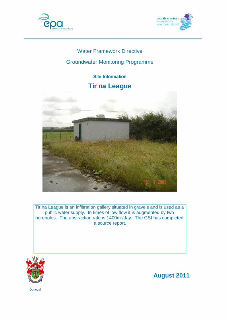
Tir na League
Water Framework Directive
Groundwater Monitoring Programme
Site Information
Tir na League is an infiltration gallery situated in gravels and is used as a public water supply. In times of low flow it is augmented by two
boreholes. The abstraction rate is 1400m³/day. The GSI has completed a source report.
ImagePath1: Tir na
League\IE_NW_G_078_05_005_
A_PumpHouse.jpg
August 2011
Donegal
Final Borehole Depth (m): -
Site Use: Drinking Water (PWS)
RBD: NWIRBD
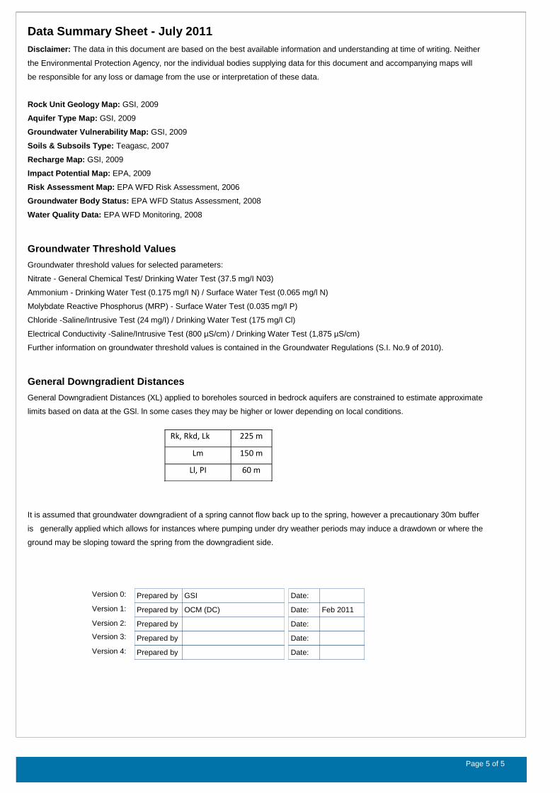
Northing: 446455
County: Donegal
EU Reporting Code: IE_NW_G_078_05_005
GWB Name: Carndonagh Gravels
GWB Code: IE_NW_G_078
Drinking Water Code: 0600PUB1007
Site Name: Tir na League
Water Quality Monitoring Network:
Hydrometric Area: 40
Ownership: Donegal County Council
Site Comments:
---
SITE INFORMATION
Screen Interval (m bgl): ---
Potential Yield (m³/day): ---
Top of Casing (m agl): ---
Abstraction Rate (m³/d): 1400 Ground Elevation (m OD): 16
Upper Casing Diameter (mm):
---
Upper Casing Bottom Depth (m bgl) :
---
Monitoring Point Type: BH
Specific Capacity (m³/d/m):
460Comments on Monitoring
Site:
---
WELL INFORMATION
Total Drilled Depth (m bgl): 7.3 Depth to Bedrock (m bgl): 15
Lower Casing Diameter (mm):
---
Lower Casing Bottom Depth (m bgl):
---
Static Water Level (m bgl): 14.5
SITE DIRECTIONS
Location and Access Information:
Located in the Churchland Quarters townland, close to the Tirnaleague Demesne, some 1.5 km north to northwest of Carndonagh Town.
Additional Comments: ---
Townland: CHURCHLAND QUARTERS
Water Level Monitoring Network:
Easting: 246251
Open Hole Interval (m bgl): ---
Level Flow
Surveillance Operational (Point) Operational (Diffuse)
Borehole Log Available:
NN
Y N N
---
Scheme Name: Carndonagh (Tir Na League)
Number of Abstraction Points in the Scheme:
4
Scheme Summary:The scheme comprises two infiltration galleries and two boreholes. During the summer the main gallery is augmented by water from the other gallery and the boreholes, as the main gallery can be pumped dry.
Source Report Available
Y
Source Report Info:Source report prepared by GSI in 2005.
Screen Type (PVC,Steel,other):
--- Screen Slot Size (mm): ---
Grout Type (cement,bentonite):
--- Grouted above (m bgl): --- Grout Volume Injected (m³):
---
Gravel Pack Interval (m bgl):
--- Gravel Pack Volume (m³): ---
Page 2 of 5
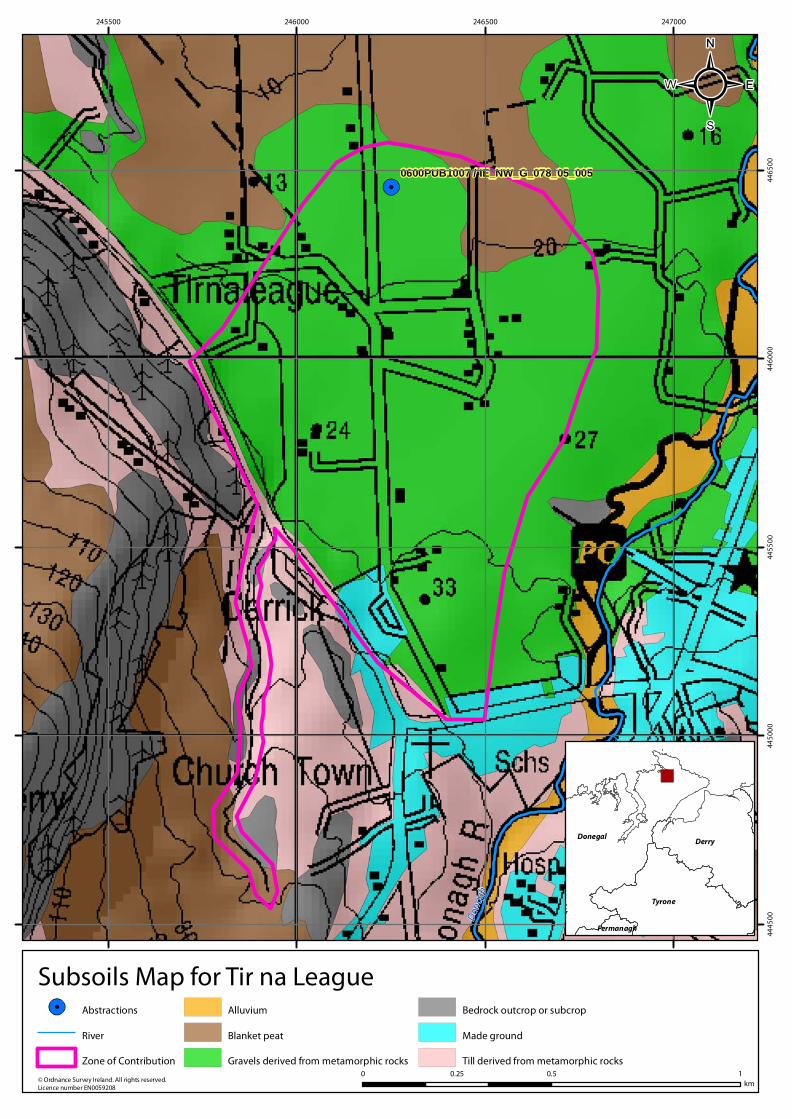
Subsoil: Glaciofluvial sands and gravels (GMp)
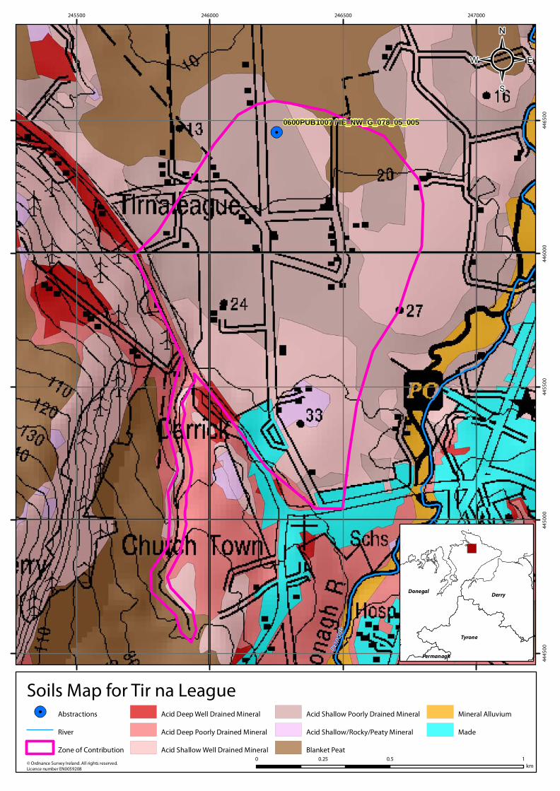
Soil: Shallow poorly drained mineral (AminSP)
ZOC Delineation Comments:
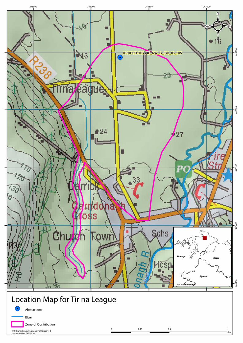
The GSI delineated a ZOC based on abstraction rate, recharge, topography and the extent of the gravels. See the source report for details.
HYDROGEOLOGY
GEOLOGY
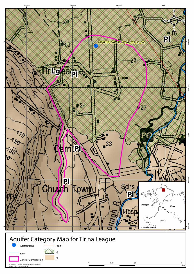
Bedrock: Precambrian Quartzites, Gneisses & Schists
Subsoil Permeability:
n/a
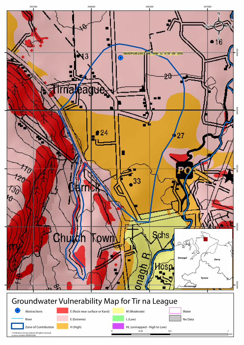
HYDROGEOLOGYVulnerability at Monitoring
site:
ExtremeAquifer
Category: Lg Flow Regime: Intergranular
ZONE OF CONTRIBUTION
Estimated ZOC Size
(km²):
1.09
Recharge Est (mm/yr):
577
HYDROCHEMISTRY
Additional Water
Chemistry Information:
During the monitoring period: The average nitrate concentration was 16 mg/l NO3 and the maximum nitrate concentration was 30 mg/l NO3. The average ammonium concentration was 0.021 mg/l N and the maximum ammonium concentration was 0.076 mg/l N. The average molybdate reductive phosphorus (MRP) concentration was 0.01 mg/l P and the maximum MRP concentration was 0.03 mg/l P. The average chloride concentration was 28.9 mg/l Cl and the maximum chloride concentration was 35 mg/l Cl.
ZOC Delineated By: GSI
Recharge Estimate(mm/yr):
Average:
286Alkalinity (mg/l HCO3):
Range:
174-560
Average:
314Hardness (mg/l
CaCO3):
Range:
218-423
Average:
615Conductivity (uS/cm):
Range:
295-702
From:
1995
Monitoring Record Period:
To:
2010
RISK ASSESSMENT
Risk Category: Not at risk, low confidence
Typical Contaminants: Nitrate
GWB Status: Good
Pressure (e.g., Nitrates, Phosphates, Abstractions): Diffuse
Extreme (X)
1.27
Groundwater Vulnerability within
ZOC (% area):
Extreme (E)
48.77
High
49.22
Moderate
0.74
Low
0
Unclassified
0
Extreme:
0.00
Impact Potential within ZOC (% area):
High:
0.00
Moderate:
4.61
Low:
86.07
Negligible:
9.33
Hydrochemical Signature: Ca-HCO3
High to Low
0
OTHER INFORMATION
---
Page 3 of 5
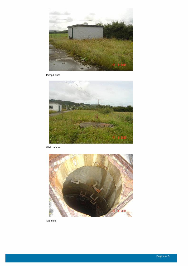
Pump House
Well Location
Manhole
Page 4 of 5
Data Summary Sheet - July 2011
Disclaimer: The data in this document are based on the best available information and understanding at time of writing. Neither
the Environmental Protection Agency, nor the individual bodies supplying data for this document and accompanying maps will
be responsible for any loss or damage from the use or interpretation of these data.
Rock Unit Geology Map: GSI, 2009
Aquifer Type Map: GSI, 2009
Groundwater Vulnerability Map: GSI, 2009
Soils & Subsoils Type: Teagasc, 2007
Recharge Map: GSI, 2009
Impact Potential Map: EPA, 2009
Risk Assessment Map: EPA WFD Risk Assessment, 2006
Groundwater Body Status: EPA WFD Status Assessment, 2008
Water Quality Data: EPA WFD Monitoring, 2008
Groundwater Threshold Values
Groundwater threshold values for selected parameters:
Nitrate - General Chemical Test/ Drinking Water Test (37.5 mg/I N03)
Ammonium - Drinking Water Test (0.175 mg/I N) / Surface Water Test (0.065 mg/l N)
Molybdate Reactive Phosphorus (MRP) - Surface Water Test (0.035 mg/I P)
Chloride -Saline/Intrusive Test (24 mg/I) / Drinking Water Test (175 mg/I Cl)
Electrical Conductivity -Saline/Intrusive Test (800 µS/cm) / Drinking Water Test (1,875 µS/cm)
Further information on groundwater threshold values is contained in the Groundwater Regulations (S.I. No.9 of 2010).
General Downgradient Distances
General Downgradient Distances (XL) applied to boreholes sourced in bedrock aquifers are constrained to estimate approximate
limits based on data at the GSl. ln some cases they may be higher or lower depending on local conditions.
It is assumed that groundwater downgradient of a spring cannot flow back up to the spring, however a precautionary 30m buffer
is generally applied which allows for instances where pumping under dry weather periods may induce a drawdown or where the
ground may be sloping toward the spring from the downgradient side.
Rk, Rkd, Lk 225 m
Lm 150 m
Ll, PI 60 m
Prepared by GSI Date:
Prepared by Date:
Prepared by Date:
Prepared by Date:
Prepared by OCM (DC) Date: Feb 2011
Version 0:
Version 1:
Version 2:
Version 3:
Version 4:
Page 5 of 5
Don
agh
0600PUB1007 / IE_NW_G_078_05_005
245500 246000 246500 247000
44
45
00
44
50
00
44
55
00
44
60
00
44
65
00
© Ordnance Survey Ireland. All rights reserved. Licence number EN0059208
Location Map for Tir na League
0 0.5 10.25km
Abstractions
River
Zone of Contribution
Donegal
Tyrone
Derry
Fermanagh
Pl
Pl
Pl
Pl
Pl
Pl
Lg
Don
agh
0600PUB1007 / IE_NW_G_078_05_005
245500 246000 246500 247000
44
45
00
44
50
00
44
55
00
44
60
00
44
65
00
© Ordnance Survey Ireland. All rights reserved. Licence number EN0059208
Aquifer Category Map for Tir na League
0 0.5 10.25
km
Abstractions
River
Zone of Contribution
Fault
Lg
Pl
Donegal
Tyrone
Derry
Fermanagh
!.
!.
Lg
Do
nag
h
0600PUB1007 / IE_NW_G_078_05_005
245500 246000 246500 247000
44
45
00
44
50
00
44
55
00
44
60
00
44
65
00
© Ordnance Survey Ireland. All rights reserved. Licence number EN0059208
Bedrock Map for Tir na League
0 0.5 10.25km
!. Abstractions
River
Zone of Contribution
Precambrian Quartzites, Gneisses & Schists
Lg
Fault
")
Donegal
Tyrone
Derry
Fermanagh
²
Don
agh
0600PUB1007 / IE_NW_G_078_05_005
245500 246000 246500 247000
44
45
00
44
50
00
44
55
00
44
60
00
44
65
00
© Ordnance Survey Ireland. All rights reserved. Licence number EN0059208
Groundwater Vulnerability Map for Tir na League
0 0.5 10.25km
Abstractions
River
Zone of Contribution
E (Rock near surface or Karst)
E (Extreme)
H (High)
M (Moderate)
L (Low)
HL (unmapped - High to Low)
Water
No Data
Donegal
Tyrone
Derry
Fermanagh
Don
agh
0600PUB1007 / IE_NW_G_078_05_005
245500 246000 246500 247000
44
45
00
44
50
00
44
55
00
44
60
00
44
65
00
© Ordnance Survey Ireland. All rights reserved. Licence number EN0059208
Subsoils Map for Tir na League
0 0.5 10.25km
Abstractions
River
Zone of Contribution
Alluvium
Blanket peat
Gravels derived from metamorphic rocks
Bedrock outcrop or subcrop
Made ground
Till derived from metamorphic rocks
Donegal
Tyrone
Derry
Fermanagh
Don
agh
0600PUB1007 / IE_NW_G_078_05_005
245500 246000 246500 247000
44
45
00
44
50
00
44
55
00
44
60
00
44
65
00
© Ordnance Survey Ireland. All rights reserved. Licence number EN0059208
Soils Map for Tir na League
0 0.5 10.25km
Abstractions
River
Zone of Contribution
Acid Deep Well Drained Mineral
Acid Deep Poorly Drained Mineral
Acid Shallow Well Drained Mineral
Acid Shallow Poorly Drained Mineral
Acid Shallow/Rocky/Peaty Mineral
Blanket Peat
Mineral Alluvium
Made
Donegal
Tyrone
Derry
Fermanagh