shuttle launch imagery from land, air, and water
TRANSCRIPT
8/7/2019 Shuttle Launch Imagery From Land, Air, And Water
http://slidepdf.com/reader/full/shuttle-launch-imagery-from-land-air-and-water 1/8
Shuttle launch imageryfrom land, air and water
The Vision for Space Exploration is
being made a reality at Kennedy Space Center in Florida through theSpace Shuttle Program. KSC is taking the word “vision” literally.
Eyes around the world watch thespectacle of Space Shuttle launches. But
the eyes of NASA are on the close-updetails, which they see thanks to theaddition of more cameras.
When the Space Shuttle returned toflight in 2005, more cameras examinedits ascent than ever in the past. Thereason was a major improvement in thetracking and imaging capabilities atKennedy Space Center, primarily through additional cameras and digitalresolution, as recommended by theColumbia Accident Investigation Boardin its report released in July 2003.
Cameras are either fixed or mountedon a tracker. A variety of trackers areused at the different camera sites, thepredominant tracker being a Kineto
Tracking Mount (KTM) tracker. All of the trackers within close proximity tothe launch pads are remotely controlled.
The remaining trackers are remotely ormanually controlled on site.
Cameras at KSC are sited for short-range tracking (T-10 through T+57
seconds), medium-range (T-7 through T+110 seconds), and long-range (T-7through T+165 seconds) during alaunch. Around the launch pad, cam-eras focus on the External Tank, SolidRocket Boosters and Orbiter. For milesup and down the coast, tracking cam-eras and long-range optical tracking systems capture ascent imagery.
Additional cameras during launch give more detail
National Aeronautics and Space Administration
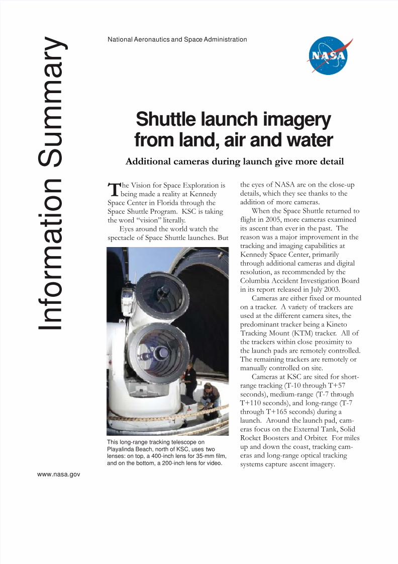
This long-range tracking telescope onPlayalinda Beach, north of KSC, uses twolenses: on top, a 400-inch lens for 35-mm film,and on the bottom, a 200-inch lens for video.
I n f o
r m a
t i o n
S u m m
a r y
www.nasa.gov

8/7/2019 Shuttle Launch Imagery From Land, Air, And Water
http://slidepdf.com/reader/full/shuttle-launch-imagery-from-land-air-and-water 2/8
Before 2003, four short-range trackingcameras on two sites were used on the launch pads,on camera sites two (east side) and six (northwest)( see p. 3 ). Remotely controlled from the LaunchControl Center, one camera focused on the top half of the Shuttle and one focused on the bottom half.
Cameras on site six view the hydrogen vent arm(above the External Tank) as it releases and also
views the underside of the orbiter’s left wing.Cameras on site two view the area between theorbiter and the External Tank to see any debris orice that might fall.
For Return To Flight, there are three camerasites: one, two and six. Two new cameras have beenadded for camera site one, which is northeast. Theaddition of this tracker ensures a view of theunderside of the right wing, as well as the areabetween the External Tank and the orbiter to track
any debris during its roll maneuver. All camera siteshave two film cameras and one High Definition Television (HDTV) video camera.
The short-range tracking cameras have 200mm(focal length) lenses, running 100 frames per second(fps). Each camera is loaded with 400 feet of film.
In addition to the film cameras around thelaunch pads, there are 42 fixed cameras with 16mmmotion picture film.
Medium-range trackers are located at six sitesalong the coast and near the Launch Complex 39
Area. Placement at these sites provides three viewsfor triangulation, to better characterize any suspectarea. (See p. 3)
These cameras have 800mm (32-inch) andgreater lenses (80-inch and 120-inch), running 100feet per second. Three of the cameras have 400feet of film, two of the cameras have 1,000 feet.
The additional tracking cameras have 150-inchlenses, with 1,000 feet of film.
The 10 sites also have HDTV video cameras.Long-range cameras are used during early
phases of ascent to identify and track debris andcontinue to be used as long as the vehicle is visible.
Long-range trackers are located at 11 sites northand south of the pads, ranging approximately 38miles north to Ponce Inlet and 23 miles south toPatrick Air Force Base (PAFB) (see p. 4).
One camera is mobile, an Advanced Transport-able Optical Tracking System (ATOTS) on northMerritt Island.
Two of the cameras are part of the Distant2
Object Attitude Measurement System (DOAMS),located at Playalinda Beach and Cocoa Beach. Arefurbished five-meter focal length telescope wasrecently installed in the Cocoa Beach location. Eachof these camera sites will also have HDTV videocameras.
A unique feature of the tracking telescopes is arobotic camera manned by a technician sitting ontop and gently manipulating a joystick to map theShuttle’s trek through the sky.
“The joystick is so sensitive, it even responds tothe heartbeat of the person using it,” explains BobPage, chairman of the NASA Intercenter Photo
Working Group. There are two lenses stacked vertically. The top
is a 400-inch lens for 35mm film. The bottom is a200-inch lens for video.
Improvement in backup imagery is a change
from the standard analog video camera (640 x 480resolution at 30 fps interlaced) to a digital high-definition camera (1280 x 720 resolution at 60 fpsprogressive).
Ten of these Contraves-Goerz Kineto Tracking Mounts(KTM) are certified for use on the Eastern Range. Theyinclude a two-camera, camera control unit offering acombination of film, shuttered and high-speeddigital video, and FLIR camerasconfigured with 20-inch to150-inch focal length lenses.

8/7/2019 Shuttle Launch Imagery From Land, Air, And Water
http://slidepdf.com/reader/full/shuttle-launch-imagery-from-land-air-and-water 3/8
3

8/7/2019 Shuttle Launch Imagery From Land, Air, And Water
http://slidepdf.com/reader/full/shuttle-launch-imagery-from-land-air-and-water 4/8
4
Other Camera Locations
Launch Pad Ascent ground cameras also provide imagery
from the Mobile Launch Platform (MLP) and onthe Fixed Service Structure (FSS). Twenty-two16mm cameras are on the MLP and eight 16mmcameras are on the FSS.
Radar Tracking A new wideband and Doppler radar tracking
system has been implemented for adequately detecting debris during launch and ascent. Threeradars will digitally record tracking data of theShuttle from launch until the signal is lost, with theprimary timeframe of interest being launch plus 60seconds to launch plus two minutes.
The three radar systems include one C-bandand two Doppler X-band.
The Wideband Coherent C-band Radar pro- vides high spatial resolution of debris events andcan detect them within the Shuttle vehicle stack.
Total No. Cameras 84
Land-Based Camera Sites 20
Long-Range Tracking Sites 11(T-165 seconds)
Long-Range Cameras 21
Medium-Range Tracking Sites 6
(T+110 seconds)Medium-Range Cameras 17
Short-Range Tracking Sites 3(T+57 seconds)
Short-Range Cameras 9
Launch/Perimeter Cameras 37
Statistics

8/7/2019 Shuttle Launch Imagery From Land, Air, And Water
http://slidepdf.com/reader/full/shuttle-launch-imagery-from-land-air-and-water 5/8
5
The radar resides in an area in the northern part of Kennedy Space Center.
The two Weibel Continuous Pulse Doppler X-band radars are located on ships, one mounted on abooster recovery ship downrange of the launch siteand the other on a ship south of the ground track.
The two radars provide velocity and differentialShuttle/debris motion information.
The radar data will be analyzed at the NCAR site. The C-band data will be available in near real-time, while the X-band data (screen captures) willbe sent from the ships via satellite link to theNCAR site.
The southern ship is expected back in port sixhours after launch, and the data will be transportedimmediately to the NCAR site.
Shuttle-Based Camera Views
New and modified cameras on the SpaceShuttle Discovery, Solid Rocket Boosters andExternal Tank will greatly increase the views avail-able to verify the health of the Shuttle’s ThermalProtection System and the redesigned portions of the Exernal Tank, and to verify there is no hazard-ous debris or damage during ascent.
Previously used cameras on the boosters werereinstated to provide views of the External Tank intertank for Return to Flight mission STS-114.
The cameras are located below the nosecone of each booster. Their imagery is recorded for play-back after the booster retrieval from the AtlanticOcean.
A television camera installed on the exterior of the External Tank was repositioned to a pointseveral feet above the right bipod area in the liquidoxygen feedline fairing housing.
The new site provides greater visibility of theShuttle’s underside and tank.
A 35mm still camera that was located in theright umbilical well on the underside of the orbiteron previous Shuttle flights was replaced with aKodak DCS760 digital still camera.
The new camera takes digital images of the tank after it has separated from the orbiter and feedsthem to a laptop computer in the crew cabin. Thecrew then downlinks those images to Mission
Control for analysis early in the flight. The left umbilical well continues to have twofilm cameras to gather movie imagery for use inanalysis after it has been returned to Earth.
Handheld cameras used by crew members havebeen modified to allow them to take digital imagesthat can be processed onboard the Shuttle as well astransmitted to the ground.
These enhancements are part of a projectknown as the Enhanced Launch Vehicle Imaging System (ELVIS).
On Return to Flight mission STS-114, a new handheld digital camera and flash were madeavailable to astronauts to take electronic images of exterior surfaces of the Shuttle during spacewalks.
The new Extravehicular Activity (EVA) camerais a Kodak DCS760, the same used for digitalimagery inside the Shuttle cabin. Some modifica-tions were made to equip it for use in the vacuumand extreme temperatures of space: a change of lubricants for the camera and a thermal protectivecovering.
In addition, the flash was modified to remain inan air-tight housing for use in the vacuum of space.
Digital images taken during a spacewalk arestored in the memory of the camera and laterbrought back inside the Shuttle cabin. They arethen fed into a laptop computer in the cabin andtransmitted to Mission Control.
The digital EVA camera may be used to provideimages of an inflight repair performed during amission, to assist an EVA inspection of potentialdamage or for other reasons.
At Hangar AF at Cape Canaveral Air Force Station, workerson the Liberty Star, one of the two SRB Retrieval Ships,oversee the safe placement of an X-band Doppler radararray onto the deck. The radar will be used for trackingsupport on NASA’s Return to Flight mission, STS-114, onSpace Shuttle Discovery.

8/7/2019 Shuttle Launch Imagery From Land, Air, And Water
http://slidepdf.com/reader/full/shuttle-launch-imagery-from-land-air-and-water 6/8
CamerasA variety of cameras and lenses are used to support ascent imaging, including
film and digital cameras:
35mm film cameras used at the pad and on short-, medium- and long-rangecamera sites provide the highest resolution. They are the primary imagery as theymeet the minimum size requirements for debris identification during ascent.
HDTV digital video cameras are co-located with many of the 35mm cam-eras and provide quick-look capability. The digital video data enables speedy post-launch imagery processing and review (quick-look) before the film is processedand distributed.
The National Television Standards committee provides backup for siteswithout HDTV.
70mm motion picture film cameras provide “big sky” views.
16mm motion picture film cameras are used on the Mobile Launch Platformand Fixed Service Structure of the launch pad.
Other cameras are located throughout the launch pad perimeter and otherlocations, providing additional quick-look views of the launch.
6
focal-length lens. The system can be operated inboth auto track and manual modes.
The two imaging cameras are an HDTV colorcamera (Panasonic AK-HC900) and a Near Infraredcamera (Sensors Unlimited SU640SDV 1.7RT/RS-170). Both share a Celestron fixed field-of-view telescopic lens. In addition, a National TelevisionStandards Committee color acquisition camera wereused to track the Shuttles during ascent on bothReturn to Flight missions.
The aircraft took off from Patrick Air ForceBase approximately two-and-a-half hours beforelaunch and entered a holding pattern: one north of the Shuttle’s flight path and one south.
The aircraft communicated with a WAVEOperations Officer in the Range Operations Con-trol Center, who in turn communicated with thechairperson of the imagery team in the LaunchControl Center.
Aircraft provide additional views of the Space Shuttle during ascent
NASA has approved the development andimplementation of an aircraft-based imaging sys-tem. The WB-57 Ascent Video Experiment(WAVE) was to be used on an experimental basisduring the first two Space Shuttle launches forReturn to Flight.
The WAVE provides both ascent and entry
imagery and enables better observation of theShuttle on days of heavier cloud cover and areasobscured from ground cameras by the launchexhaust plume.
WAVE comprises a 32-inch-ball turret systemmounted on the nose of two WB-57 aircraft. Theturret houses an optical bench, providing installationof both HDTV and infrared cameras. Opticsconsist of an 11-inch-diameter, 4.2 meter fixed-

8/7/2019 Shuttle Launch Imagery From Land, Air, And Water
http://slidepdf.com/reader/full/shuttle-launch-imagery-from-land-air-and-water 7/8
7
NASA has approved the development and implementation of an aircraft-based imaging system, using
NASA’s WB-57 aircraft (above). The WB-57 Ascent Video Experiment (WAVE) was used on anexperimental basis during the first two Space Shuttle flights following Return to Flight in 2005.
The two aircraft, flying at an altitude of 60,000feet, allow a wide range of coverage, with eachplane providing imagery over a 400-mile path.
The entry imaging program also proposed using additional aircraft to provide imagery during laterstages of entry.
If the WAVE system performance and quality of images are acceptable, relevant and valid, NASA
will consider use of this system on future flights.
NASA’s Johnson Space Center operates the only two WB-57s still flying in the world today, out of Ellington Field, Houston, Texas. Identified asNASA 926 and NASA 928, the high-altitude
weather aircraft can fly day and night with a rangeof approximately 2,500 miles.
Two crew members in pressurized suits pilot theplane to altitudes in excess of 60,000 feet and theaircraft can carry a payload of about 6,000 pounds.
8/7/2019 Shuttle Launch Imagery From Land, Air, And Water
http://slidepdf.com/reader/full/shuttle-launch-imagery-from-land-air-and-water 8/8
NASA: Explore. Discover. Understand.
8 IS-2005-04-016-KSC John F. Kennedy Space Center
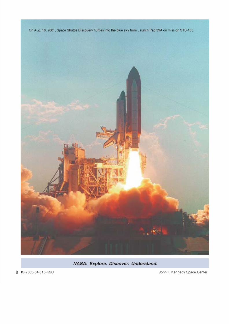
On Aug. 10, 2001, Space Shuttle Discovery hurtles into the blue sky from Launch Pad 39A on mission STS-105.