shoreline changes and high-energy wave impacts at the ... planets space, 64, 905–921, 2012...
TRANSCRIPT
Earth Planets Space, 64, 905–921, 2012
Shoreline changes and high-energy wave impacts at the leeward coast ofBonaire (Netherlands Antilles)
Max Engel1, Helmut Bruckner1, Karoline Messenzehl2, Peter Frenzel3, Simon Matthias May1, Anja Scheffers4,Sander Scheffers5, Volker Wennrich6, and Dieter Kelletat1
1Institute of Geography, Universitat zu Koln, Albertus-Magnus-Platz, 50923 Cologne, Germany2Department of Geography, Rheinische Friedrich-Wilhelms-Universitat Bonn, Meckenheimer Allee 166, 53115 Bonn, Germany
3Institute of Earth Sciences, Friedrich-Schiller-Universitat Jena, Burgweg 11, 07749 Jena, Germany4Southern Cross GeoScience, Southern Cross University, PO Box 157, Lismore NSW 2480, Australia
5Marine Ecology Research Centre, Southern Cross University, PO Box 157, Lismore NSW 2480, Australia6Institute of Geology and Mineralogy, Universitat zu Koln, Albertus-Magnus-Platz, 50923 Cologne, Germany
(Received December 7, 2010; Revised July 11, 2011; Accepted August 9, 2011; Online published October 24, 2012)
Supralittoral coarse-clast deposits along the shores of Bonaire (Netherlands Antilles) as well as increased hur-ricane frequency during the past decade testify to the major hazard of high-energy wave impacts in the southernCaribbean. Since deducing certain events from the subaerial coarse-clast record involves major uncertainties andhistorical reports are restricted to the past 500 years, we use a new set of vibracore and push core data (i) to con-tribute to a more reliable Holocene history of regional extreme-wave events and (ii) to evaluate their impact onshoreline evolution. Multi-proxy palaeoenvironmental analyses (XRF, XRD, grain size distribution, carbonate,LOI, microfossils) were carried out using nearshore sedimentary archives from the sheltered western (leeward)side of Bonaire and its small neighbour Klein Bonaire. In combination with 14C-AMS age estimates the stratig-raphy reflects a long-term coastal evolution controlled by relative sea level rise, longshore sediment transport,and short-term morphodynamic impulses by extreme wave action, all three of which may have significantly in-fluenced the development of polyhaline lagoons and the demise of mangrove populations. Extreme wave eventsmay be categorized into major episodic incidents (c. 3.6 ka [?] BP; 3.2–3.0 ka BP; 2.0–1.8 ka BP; post-1.3 ka [?]BP), which may correspond to tsunamis and periodic events recurring on the order of decades to centuries, whichwe interpret as severe tropical cyclones. Extreme wave events seem to control to a certain extent the formationof coastal ridges on Bonaire and, thus, to cause abrupt shifts in the long-term morphodynamic and ecologicalboundary conditions of the circumlittoral inland bays.Key words: Washover deposits, tropical cyclones (hurricanes), tsunamis, Holocene stratigraphy, coastal hazards,environmental change, Caribbean.
1. IntroductionA broad spectrum of potential triggering mechanisms of
tsunamis exists throughout the Caribbean region. These in-clude (i) earthquake-triggering tectonic movement (strike-slip motion, oblique convergence) along the boundary ofthe Caribbean and North American Plates (Grindlay et al.,2005) or the Venezuelan coast (Audemard et al., 2005); (ii)the Lesser Antilles subduction zone with earthquakes andvarious sources of explosive and effusive volcanism (e.g.Zahibo and Pelinovsky, 2001; Mattioli et al., 2007); (iii)morphological signatures of large-scale submarine massfailure, e.g. north of Puerto Rico (Grindlay et al., 2005;ten Brink et al., 2006) or on Curacao (Hornbach et al.,2010); (iv) submarine debris avalanches along the LesserAntilles arc (Deplus et al., 2001); (v) teletsunamis from theopen Atlantic Ocean as triggered by the 1755 Lisbon earth-quake (O’Loughlin and Lander, 2003) or by a future vol-
Copyright c© The Society of Geomagnetism and Earth, Planetary and Space Sci-ences (SGEPSS); The Seismological Society of Japan; The Volcanological Societyof Japan; The Geodetic Society of Japan; The Japanese Society for Planetary Sci-ences; TERRAPUB.
doi:10.5047/eps.2011.08.011
canic edifice collapse at the Canary Islands (Ward and Day,2001). In some places possible geologic evidence of suchevents has been found onshore such as marine sand sheetsdeposited inland, barrier breaches or supralittoral boulderdeposits in elevated positions significantly exceeding thesize of the largest boulders moved by recent severe hurri-canes (Khan et al., 2010; Scheffers and Scheffers, 2006),e.g. on Aruba, Bonaire and Curacao (ABC Islands), the An-tillean Arc, Anegada, Barbados, Jamaica, the Grand Cay-mans and the Bahamas (Jones and Hunter, 1992; Scheffers,2004, 2005; Kelletat et al., 2005; Robinson et al., 2006;Atwater et al., 2010). The high tsunami risk is also con-firmed by O’Loughlin and Lander (2003) who compile 53reliable tsunami occurrences in the Caribbean region withinthe last 500 years of written history.
On the island of Bonaire in the southern Caribbean(Fig. 1), the lack of historical accounts of tsunamis(O’Loughlin and Lander, 2003) stands in a remarkable con-trast to the massive circumlittoral boulder deposits someof which have been associated with tsunamigenic disloca-tion (Scheffers, 2004, 2005). However, the interpretation ofthese boulders as storm or tsunami deposits has been ques-
905

906 M. ENGEL et al.: HIGH-ENERGY WAVE IMPACTS ON LEEWARD BONAIRE
Fig. 1. Geological overview of Bonaire based on previous mapping by Pijpers (1933), Westermann and Zonneveld (1956) and De Buisonje (1974) aswell as SRTM elevation data (http://dds.cr.usgs.gov/srtm) showing sites from this study (white rectangles) and Engel et al. (2010).
tioned (cf. Morton et al., 2008; Spiske et al., 2008). Forthis reason, we have chosen to use coastal stratigraphicalcontexts (lagoons, alluvial flats) of Bonaire’s coastline inorder to examine the extreme wave history of the south-ern Caribbean and to evaluate the impact of those waves onshoreline dynamics.
The main goals of this paper are to reconstruct mid-to late Holocene coastal environments and to identify anddate extreme wave deposits, as well as to differentiate be-tween sedimentary signatures of tsunamis and tropical cy-clones (in the Caribbean region referred to as hurricanes)of west (leeward) Bonaire. The signatures are comparedwith those of fine-grained extreme-wave deposits from theeastern (windward) coast (cf. Engel et al., 2009, 2010) andwith implications of the supralittoral coarse-clast record(Scheffers, 2005; Morton et al., 2008; Watt et al., 2010).Research on palaeotsunami deposits in coastal areas wheretsunami occurrence has never been documented may pro-vide a scientific basis for:
• the designation of high-risk areas,• the creation of public awareness for a generally under-
estimated coastal hazard, and• local disaster mitigation planning (cf. Rhodes et al.,
2006).
2. Study SitesThe island of Bonaire (Fig. 1) comprises a volcanic core
(Late Cretaceous, Washikemba Formation) and a seriesof surrounding palaeo-reef terraces (Neogene–Quaternary)forming steep cliffs along the coast as well as minor relicsof Palaeogene deposition. Slow tectonic uplift (around5 cm/ka), tilting and Quaternary sea-level fluctuations fos-tered the development of a sequence of reefal limestone ter-races. The lowermost palaeo-reef stages, the Middle Ter-race (MT) and the Lower Terrace (LT), relate to MIS 7 orearlier and 5e, respectively (Herweijer and Focke, 1978).
Bonaire has an arid climate and experiences persistenttradewinds from the east, with easterly storms and oc-casional hurricanes during the period between June andNovember. The coasts have a microtidal regime (c. 0.3 m).While the eastern shore is exposed constantly to high waveenergy, the western, leeward shore—including the study
M. ENGEL et al.: HIGH-ENERGY WAVE IMPACTS ON LEEWARD BONAIRE 907
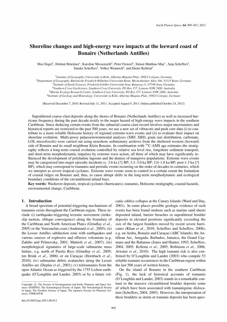
Fig. 2. Aerial view of Salina Tam (1996), western Bonaire (Fig. 1), providing information on coring sites and bathymetry of the water body. The crosssection A–A′ was measured by DGPS. The internal structure of the barrier is also shown on Fig. 3. The ESR age of a large head coral (1300±60 a) istaken from Scheffers (2005). The back-barrier stratigraphy is based on SAT 10 (Fig. 9). Dates on the seaward berm indicate morphological traces ofhurricanes Lenny (1999), Tekla (1877) and an unspecified EWE c. 600 years ago (Scheffers, 2005). A key to symbols is on Fig. 5. EWE = extremewave event.
sites of Salina Tam and Klein Bonaire—is calmer and thuscharacterised by a vertically narrow notch and a flourishingfringing reef (Focke, 1978). Nevertheless, increased waveaction triggered by tropical cyclones in the last decade, e.g.Hurricane Lenny in 1999, taking an unusual west-to-easttrack, had significant morphological effects on the coralrubble beaches (Scheffers, 2005) and destroyed large partsof the living reef (Bries et al., 2004). The southern partof the western (leeward) coastline from Lacre Punt to PuntVierkant is covered by coral debris and boulders of up to2 t, most of which were washed onshore in 1999. Severalboulders of up to 20 t lie on top of the lower marine terraceLT between Kralendijk and Goto Meer (Scheffers, 2005).
In search of subsurface extreme wave deposits along theleeward side of Bonaire, the former inland bay of SalinaTam and the shallow back-barrier lagoon of southern KleinBonaire (Fig. 1) were chosen for stratigraphic investiga-tions. The sites are characterised by background sedimenta-tion from shallow standing water (brackish to hypersaline)and occasional fluvial input (Salina Tam) behind a barrierof coral rubble. At some places thick beds of mangove peatare present. Event layers consist of shallow marine sands,shells, and coral fragments.2.1 Salina Tam
Salina Tam is a ria-like landform (Scheffers, 2004, 2005)locally referred to as boka (Fig. 2). It is the lower sectionof a valley, draining a part of the undulating topography
of northwestern Bonaire (Washikemba Formation, Fig. 1)and intersecting the LT and MT. The main morphodynamicprocesses are linear erosion during the latest Pleistocenebase-level fall. At the entrance of Bonaire’s bokas, LTincision amounts up to 16 m below present sea level (DeBuisonje, 1974).
Postglacial sea-level rise flooded Salina Tam. The bokais separated from the open sea by a bar of sand, coral rub-ble and beachrock reaching a width of up to 70 m and aheight of up to 3 m above present sea level (a.s.l) (Figs. 2and 3). When this bar formed and whether it formed due tolong-term morphodynamic processes (e.g. longshore drift)(Zonneveld et al., 1977) or due to extreme wave events(Scheffers, 2005; Morton et al., 2008) is a subject of thispaper. Today, salinity of the bokas is high (up to 120‰below the halocline of Goto Meer during summer (Koblukand Crawford, 1990)) and the water table is low due tolow permeability of the seaward barrier, low precipitationmost time of the year, as well as to high evaporation (DeBuisonje, 1974).
Approximately 250 m west of Salina Tam, the coastalbarrier of coral rubble is separated from the inactive cliff ofthe LT by a morphological depression filled with sediment(site SAT 10). At ground level the uppermost part of abioerosive notch is visible. Numerous coral boulders (a-axes up to 2 m) are clustered at the landward avalanchingface of the barrier (Fig. 2) (Scheffers, 2005; Morton et al.,

908 M. ENGEL et al.: HIGH-ENERGY WAVE IMPACTS ON LEEWARD BONAIRE
Fig. 3. Outcrop of the ridge of coral rubble near Salina Tam (Fig. 2). Its stratigraphy is divided into three parts. On top there is a unit of well sortedangular fragments of Acropora cervicornis (c. 80 cm, upper left close-up photo). It is separated from the basal unit of well-sorted and well-roundedcoral rubble (lower left close-up photo) by a palaeosol developed in a layer of poorly sorted carbonate sand and coral material (close-up photo on theright). The elevation is shown in cm above mean sea level.
Fig. 4. Aerial view of coring site KLB 1 on southern Klein Bonaire (Fig. 1)at the back of a broad, active ridge of coral rubble.
2008).2.2 Southern Klein Bonaire
Klein Bonaire is a small and flat island off the leewardcoast of Bonaire entirely consisting of MT and LT lime-stone. It is surrounded by ridges of sand and coral rubble(De Buisonje, 1974). The MT and LT deposits lie signifi-cantly lower compared to their counterparts on the main is-land, possibly due to tilting. In the southern part, the surfaceof the LT gently slopes towards the barrier forming an areaof shallow water and back-barrier sedimentation (Fig. 4).
3. MethodsIn order to reconstruct sedimentation processes and
palaeoenvironments at the two sites, we examined five sedi-ment cores for their sedimentological, geochemical and fau-nal composition. Cores allow for sampling relatively greatdepths regardless of the groundwater table, though theyonly provide one-dimensional insights into the stratigraphyand may hamper the identification of certain sedimentolog-ical features indicative of tsunami or storm deposition. Fourvibracores (d = 6.0 and 5.0 cm) were taken at Salina Tamwith an engine-driven Atlas Copco 248 coring device. The
maximum coring depth was 11 m b.s. (below surface). Twoof them were taken with open steel probes (SAT 7 and 10),and in these cases the cores were cleaned, photographed,documented and sampled in the field for multi-proxy anal-yses. Two vibracores were preserved in closed PVC tubes,which were split in the laboratory (SAT 8 and 9). The fifthcore was a 1.28-m PVC push core (d = 7.5 cm) also splitin the laboratory (KLB 1).3.1 Non-destructive core analysis
The inorganic element composition of KLB 1 and SAT 8was determined using an ITRAX X-ray fluorescence (XRF)core scanner (Cox Analytical Systems). The device wasprepared with a 3 kW Mo X-ray tube set to 30 kV and30 mA. It enabled analyses of semi-quantitative variationsof elements from Al to U by scanning 1 mm steps for20 s each. Element amounts are shown as count rates (cr)representing estimates of the relative concentrations in thesediment (Croudace et al., 2006).3.2 Analyses using core samples
For a sufficient amount of sediment material each sam-ple from the open cores (SAT 7 and 10) represents sectionsof 5–10 cm from significant stratigraphic units. The closedcores (SAT 8 and 9, KLB 1) were sampled selectively in1–2 cm sections. Samples were air-dried and broken up byhand with a mortar and pestle. The carbonate content of thefine-grained fraction (<2 mm) of all vibracores was gas-volumetrically measured following the Scheibler method.Loss on ignition (LOI) was determined by oven-drying at105◦C for 12 h and ignition in a muffle furnace at 550◦Cfor 4 h (Beck et al., 1993). The wet sieve-pipette technique(Kohn, 1928) was applied for analysing the grain size dis-tribution after pre-treatment of the aliquots with Na4P2O7
(55.7 g/l) for aggregate dispersion. Shell material was notremoved. Results were processed with GRADISTAT soft-ware (Blott and Pye, 2001). Mean grain size was calculatedafter Folk and Ward (1957) and grain sizes were classifiedafter Arbeitsgemeinschaft Boden (2005).
Selected samples were treated with H2O2 (3%) and frac-tionated by sieving (mesh sizes of 0.063 mm, 0.2 mm and1.0 mm) for quantitative microfossil investigations. Micro-faunal remains were picked from residue splits containingat least 300 specimens, if present within the sample, andwere taxonomically identified using a low-power binocularmicroscope. High magnification light microscopy and scan-

M. ENGEL et al.: HIGH-ENERGY WAVE IMPACTS ON LEEWARD BONAIRE 909
Fig. 5. Characteristic microfossils from Salina Tam and Klein Bonaire: 1)–20) Ostracoda, 21)–27) Foraminifera, 28) Octocorallia. 1)–7) Cyprideissp.: 1) left side of a male carapace, SAT 9 (2.61–2.50 m b.s.); 2) right side of a male carapace, SAT 8 (2.51–2.43 m b.s.); 3) right side of a femalecarapace, SAT 8 (1.75–1.65 m b.s.); 4) interior of a female left valve, SAT 9 (2.61–2.50 m b.s.); 5) juvenile right valve, SAT 9 (2.61–2.50 m b.s.);6) dorsal view of a female carapace, SAT 9 (2.61–2.50 m b.s.); 7) sieve pores of a female left valve, SAT 9 (2.61–2.50 m b.s.). 8)–12) Cyprideisbeaveni (Tressler and Smith, 1948): 8) dorsal view of a female carapace, SAT 8 (2.43–2.38 m b.s.); 9) male left valve, SAT 8–13; 10) interior viewof a male left valve, SAT 9 (2.61–2.50 m b.s.); 11) noded female right valve and two sieve pores, SAT 9 (2.61–2.50 m b.s.); 12) noded juvenile leftvalve, SAT 8 (2.57–2.51 m b.s.). 13)–20) Perissocythere cribrosa (Klie, 1933): 13) dorsal view of a female carapace, SAT 8 (3.00–2.90 m b.s.); 14)dorsal view of a male carapace, SAT 8 (3.05–2.95 m b.s.); 15) right side of a juvenile valve and a sieve pore, SAT 8 (2.86–2.81 m b.s.); 16) left sideof a male carapace, SAT 8 (3.25–3.20 m b.s.); 17) right side of a male carapace, SAT 8 (3.05–2.95 m b.s.); 18) right side of a female carapace, SAT8 (2.09–2.00 m b.s.); 19) female right valve, SAT 8 (3.25–3.20 m b.s.); 20) internal view of a male right valve, SAT 8 (3.00–2.90 m b.s.). 21)–22)Ammonia tepida? (Cushman, 1926): 21) spiral view, last chamber missing, KLB 1 (0.69–0.68 m b.s.); 22) umbilical view, KLB 1 (0.69–0.68 mb.s.). 23–25) Miliolinids, lateral views: 23) Quinqueloculina seminula (Linnaeus, 1758), SAT 8 (2.29–2.25 m b.s.); 24) Miliolinella sp. I, SAT 8(2.80–2.73 m b.s.); 25) Miliolinella sp. II, KLB 1 (0.58–0.57 m b.s.). 26) Globigerinoides cf. immaturus (Leroy, 1939), SAT 8 (2.59–2.40 m b.s.).27) Amphistegina sp., SAT 8 (2.59–2.40 m b.s.). 28) Sclerite of an alcyonarian coral, SAT 8 (3.25–3.20 m b.s.). Photos 2, 3, 8, 9, 12, 14, 17, 18, 23,26, and 27 are light microscope photos, all others are scanning electron microscope (SEM) pictures.
ning electron microscopy (SEM) supported photographicdocumentation and taxonomic identification (Fig. 5). Os-tracods and foraminifers were identified to the species levelif possible; all other fossils were identified to group level.The state of preservation of fossil groups was documentedfor distinguishing reworked and (par-)autochthonous speci-mens.
In order to identify sediment provenance areas (ma-rine, terrestrial-autochthonous, terrestrial-allochthonous),the mineralogical spectrum of selected powder samples wasinvestigated by means of a Siemens 5000D X-ray diffrac-
tometer. XRD investigations were carried out using Cu Kα
radiation (40 kV, 40 mA). Samples were run from 10◦ to70◦ 2�. For semiquantitative interpretation X’Pert High-Score Plus software (PANalytical) was used, which is basedon the Rietveld refinement technique fitting a calculatedXRD profile to the measured pattern and assigning abun-dances of minerals.
The chronostratigraphy of all sites is based on 14C-AMSanalyses (Table 1). Radiocarbon dates of marine shells werecorrected for a regional marine reservoir effect of �R =−49 (Radtke et al., 2003). 14C-AMS data were converted to

910 M. ENGEL et al.: HIGH-ENERGY WAVE IMPACTS ON LEEWARD BONAIRE
Table 1. 14C-AMS dates for samples from Salina Tam and Klein Bonaire were carried out at the radiocarbon laboratoriy of the University of Georgiaat Athens (USA).
Sample Depth (cm b.s.) Lab ID UGAMS# Material δ13C (‰) 14C age Age cal BP (2σ )
SAT 7/11 273∗ 3212 gastropod −3.74 2740 ± 25 2607–2462
SAT 8/7 243 5996 gastropod 0.3 2280 ± 20 2021–1869
SAT 8/28 272 7577 gastropod −2.8 3110 ± 20 3039–2857
SAT 9/1 355 5999 peat −24.4 4030 ± 25 4568–4424
SAT 9/2 360 6000 peat −26.4 4160 ± 25 4826–4584
SAT 9/a 325 7578 gastropod −3.8 3360 ± 25 3359–3206
SAT 10/4 Ko 50 7579 coral −3.0 1890 ± 25 1563–1395
SAT 10/10 210 7580 peat −26.9 2080 ± 25 2295–2004
KLB 1/a 43 43 7588 gastropod −4.1 3240 ± 25 3236–3028
KLB 1/c 70 70 7589 gastropod −5.3 3570 ± 30 3614–3426
∗Depth information is as recorded in core SAT 7. However, the sediment layer lies approx. 15 cm deeper compared to parallel core SAT 8, most likelydue to compaction differences between open and closed coring techniques.
sidereal years by means of CALIB 6.0.1 software (Reimeret al., 2009). For age interpretation the 2σ error (p =0.956) was taken into account.
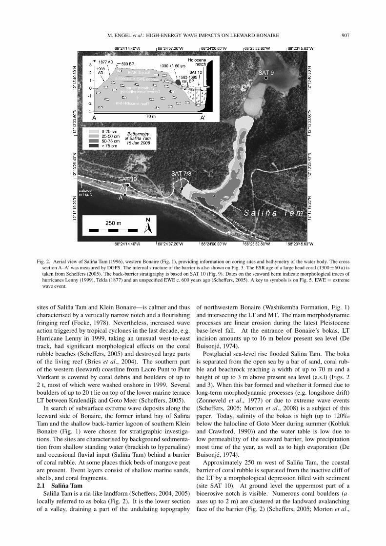
4. Sedimentary Record of Salina Tam4.1 The back-barrier record—SAT 7/8
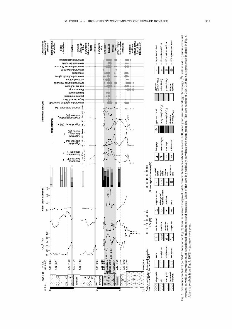
Sediment cores SAT 7 and SAT 8 represent the stratigra-phy directly behind the broad ridge of coral rubble separat-ing Salina Tam from the open sea (Fig. 2). One open (SAT7) and one closed (SAT 8) core were taken at the same site.The environmental interpretation of the cores is given onFigs. 6 and 7.
The lower 7.75 m (11.00–3.25 m b.s.) at site SAT 7/8consist of a coquina of fine shell debris (light grey bi-valves, mainly Ctena orbiculata, and gastropods, mainlyBulla striata, Caecum sp.), carbonate sand (on Bonairepredominantly fragments of Halimeda sp.) and bryozoanfragments showing a high degree of abrasion. Ca andSr concentrations are high and slightly decrease in theuppermost part. At 3.35–3.25 m b.s., the coquina con-tains lagoonal ostracods (Cyprideis beaveni [partly noded],Cyprideis sp., Perissocytheridea cribrosa; Fig. 5), smallbenthic foraminifers (miliolinids), and remains of small fishand echinoderms.
The overlying deposit of very dark brown sandy silt(3.25–2.82 m b.s.) shows an abrupt decrease in CaCO3
and increasing LOI values. From 3.00–2.82 m b.s. theunit is stratified and contains thin layers of calcite, arag-onite and gypsum. Concentrations of K, Ti and Br in-crease. Cyprideis beaveni (partly noded), Cyprideis sp.,Perissocytheridea cribrosa and miliolinid foraminifers arestill present. Mollusc shells, bryozoan and echinoderm re-mains are absent.
Between 2.82–2.60 m b.s. there are ten graded sequenceswith a thickness of 1–6 cm (Fig. 7). The lower boundaryof each bed is erosional. The bottom parts of the sequencescontain partly fragmented shells of Cerithium sp. and coarsecarbonate sand. The upper parts are silty mud containingrafted plant material. Most of the graded sequences startwith a sudden increase in Ca, which gradually decreases up-wards (Fig. 7). Peaks of Br correlate with the upper parts ofthe graded beds and identify high concentration of organicmatter (Chague-Goff et al., 2002; Perez et al., 2010). Sim-
ilar to the underlying unit, bulk samples of the entire unitcontain high amounts of brackish foraminifers and ostra-cods, but also scattered fragments of corals, mollusc shells,bryozoans and echinoderms. It is noteworthy that only thelowermost sequence contains planktonic foraminifers andhigh abundances of reworked ostracods (thick carbonate en-crustations). A shell of Cerithium sp. (2.72 m b.s., bed EWEV) was radiocarbon dated to 3039–2857 cal BP.
The overlying unit (2.60–2.38 m b.s.) is pale white andalmost entirely consists of CaCO3. Four sequences—threenormally graded beds containing shells of Cerithium sp.and coarse sand at the bottom, and one inversely gradedbed (Fig. 7)—were identified. A very thin mud drapecovers the second graded sequence. The section containsreworked valves of brackish ostracods as well as mili-olinid foraminifers, Amphistegina, Discorbis, Alcyonariaand fragments of Malacostraca, Scleractinia and severalother marine forms. Planktonic foraminifers (Globigeri-noides cf. immaturus) were also located (Fig. 5). Aragoniteis the dominating mineral. The amount of quartz is verylow. From the lower part of this unit (in SAT 7) as well asfrom 2.43 m b.s. (in SAT 8) cerith shells were radiocarbondated to 2607–2462 and 2021–1869 cal BP (Table 1, Figs. 6and 7).
Between 2.38 and 2.30 m b.s. are three fining-up se-quences, with distinct lower contacts consisting of a verythin basal layer of carbonate sand and a thicker muddy,organic-rich part. The spectrum of microfossils coversCyprideis sp. and P. cribrosa, and some tests of miliolinidforaminifers and Amphistegina. The amount of marine bio-genic particles is significantly reduced compared to the un-derlying graded beds.
The overlying units represent the background sedimenta-tion: Ca and Sr are lower than previously, and LOI, Ti, Brand K values higher. The most abundant mineral is quartz.Several plant remains (leaf fragments, wood) and angularstones were found. A thin unit of alternating silt layers ofcarbonate and gypsum occurs between 2.30 and 2.26 m b.s.From 1.00–0.76 m b.s., CaCO3 values and mean grain sizeare higher than background and the sediment is more poorlysorted.
M. ENGEL et al.: HIGH-ENERGY WAVE IMPACTS ON LEEWARD BONAIRE 911
Fig.
6.Se
dim
entc
ore
SAT
8(=
SAT
7;lo
catio
non
Fig.
2)fr
omth
ese
awar
dm
argi
nof
Salin
aTa
mw
ithda
taon
carb
onat
eco
nten
t,L
OI,
mea
ngr
ain
size
,min
eral
ogy,
chro
nolo
gy(14
Cda
tain
calB
P)an
dm
icro
faun
alre
mai
ns,a
sw
ella
sin
terp
reta
tion
ofde
posi
tiona
lenv
iron
men
tsan
dpr
oces
ses.
Wid
thof
the
core
log
posi
tivel
yco
rrel
ates
with
mea
ngr
ain
size
.T
heco
rese
ctio
nof
2.86
–2.2
8m
b.s.
ispr
esen
ted
inde
tail
inFi
g.6.
Ake
yto
sym
bols
ison
Fig.
5.E
WE
=ex
trem
ew
ave
even
t.
912 M. ENGEL et al.: HIGH-ENERGY WAVE IMPACTS ON LEEWARD BONAIRE
Fig. 7. X-ray, photograph, and high-resolution XRF data (Ca, Sr, Ti, Br; cr = XRF count rates) of core section 2.86–2.28 m b.s. from SAT 8 (Figs. 2and 5), labeled with basic interpretation of depositional environments and processes. 14C ages are displayed as cal BP. A key to symbols is on Fig. 5.EWE = extreme wave event.
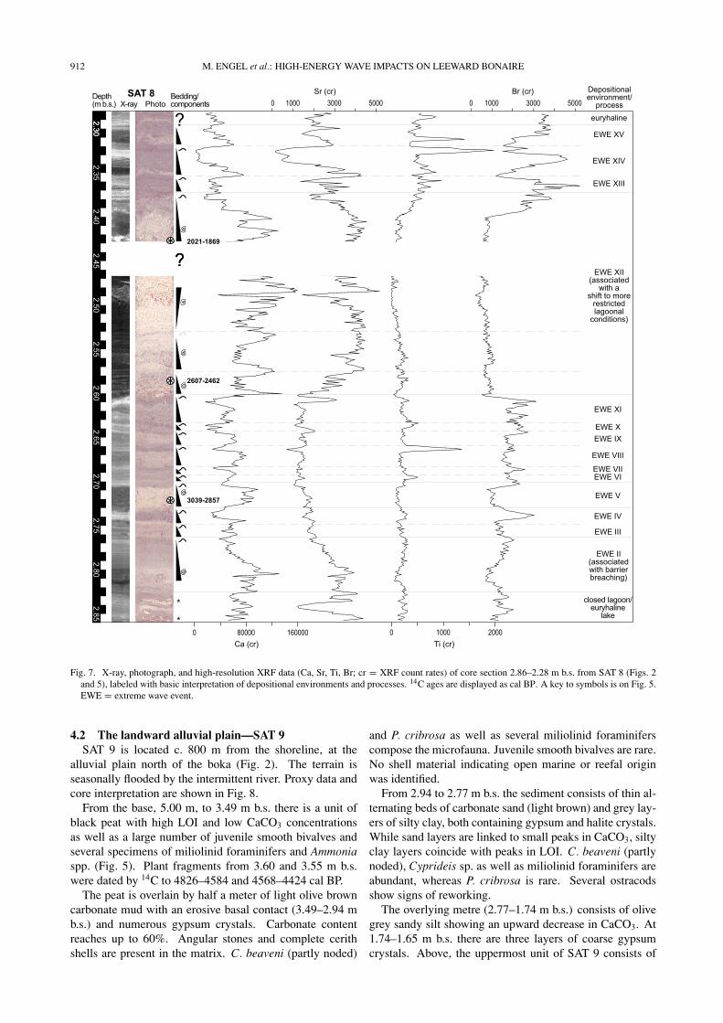
4.2 The landward alluvial plain—SAT 9SAT 9 is located c. 800 m from the shoreline, at the
alluvial plain north of the boka (Fig. 2). The terrain isseasonally flooded by the intermittent river. Proxy data andcore interpretation are shown in Fig. 8.
From the base, 5.00 m, to 3.49 m b.s. there is a unit ofblack peat with high LOI and low CaCO3 concentrationsas well as a large number of juvenile smooth bivalves andseveral specimens of miliolinid foraminifers and Ammoniaspp. (Fig. 5). Plant fragments from 3.60 and 3.55 m b.s.were dated by 14C to 4826–4584 and 4568–4424 cal BP.
The peat is overlain by half a meter of light olive browncarbonate mud with an erosive basal contact (3.49–2.94 mb.s.) and numerous gypsum crystals. Carbonate contentreaches up to 60%. Angular stones and complete cerithshells are present in the matrix. C. beaveni (partly noded)
and P. cribrosa as well as several miliolinid foraminiferscompose the microfauna. Juvenile smooth bivalves are rare.No shell material indicating open marine or reefal originwas identified.
From 2.94 to 2.77 m b.s. the sediment consists of thin al-ternating beds of carbonate sand (light brown) and grey lay-ers of silty clay, both containing gypsum and halite crystals.While sand layers are linked to small peaks in CaCO3, siltyclay layers coincide with peaks in LOI. C. beaveni (partlynoded), Cyprideis sp. as well as miliolinid foraminifers areabundant, whereas P. cribrosa is rare. Several ostracodsshow signs of reworking.
The overlying metre (2.77–1.74 m b.s.) consists of olivegrey sandy silt showing an upward decrease in CaCO3. At1.74–1.65 m b.s. there are three layers of coarse gypsumcrystals. Above, the uppermost unit of SAT 9 consists of

M. ENGEL et al.: HIGH-ENERGY WAVE IMPACTS ON LEEWARD BONAIRE 913
Fig. 8. Sediment core SAT 9 (located on Fig. 2) from the landward margin of Salina Tam with data on carbonate content, LOI, mean grain size,microfaunal remains and chronology (14C data in cal BP), as well as interpretation of depositional environments and processes. Width of the core logpositively correlates with mean grain size. A key is provided in Fig. 5. EWE = extreme wave event.
very dark grey clayey silt with several reddish dark brownsections. The ostracod fauna is brackish, noded C. beav-eni decrease. A minor peak in CaCO3 occurs at 0.90–1.00 m b.s.4.3 Between Salina Tam and Punt’i Wekua—SAT 10
SAT 10 (Fig. 9) is located on a narrow alluvial plainbetween the ridge of coral rubble and the LT cliff (Fig. 2).At ground level, this cliff is cut horizontally by a sea level-related bioerosive notch (c. 0.00–0.20 m a.s.l.). The corereached only 2.45 m due to a thick layer of coral rubble(mainly Acropora cervicornis).
The coral rubble is overlain by a unit of very dark brownmangrove peat (2.17–0.52 m b.s.) dated to 2295–2004 calBP at 2.10 m b.s. An erosional boundary separates the peatfrom a carbonate sand layer (0.52–0.40 m b.s., layer A inFig. 9) containing reworked peat remains, shell debris andtwo 4 cm-fragments of Diploria sp. (1563–1395 cal BP).In a trench at the site (photo inset in Fig. 9), even coarsercoral shingle and beachrock slabs containing branches of A.cervicornis were present in this layer. At 0.40–0.30 m b.s.(layer B in Fig. 9) the sediment consists of poorly sorted,grey silty sand with shell debris. The overlying strata con-sist of dark greyish brown (0.30–0.17 m b.s.) to dark yel-lowish brown (0.17–0.00 m b.s.) silty matrix with reducedcarbonate sand components (layers C and D in Fig. 9).
4.4 The sedimentary record of southern Klein-Bonaire—KLB 1
Core KLB 1 (Fig. 10) was recovered behind the coastalbarrier of southern Klein Bonaire (Fig. 4), less than 100 mfrom the swash zone. The site is a shallow pond charac-terized by algae mats, mud sedimentation, and carbonateprecipitation.
The basal part (1.28–1.20 m b.s.) consists of light olivegrey sandy silt containing several gastropod shells, a lensof root material, and a brackish-marine foraminifer assem-blage dominated by miliolinid foraminifers and Ammoniaspp. (both taxa highly abundant), marine mollusc shells, andonly few ostracods. Between 1.20 and 0.70 m b.s. is a layerof pure mangrove peat void of Ca and Sr and exhibiting ahigh plateau in the Br curve. The peat is unconformablyoverlain by two thin graded beds (0.70–0.67 cm b.s.; 0.67–0.66 cm b.s.), both characterized by basal carbonate sandwith well-preserved gastropod shells and shell fragments,an upward decrease in Ca, a Br peak in the upper part cor-responding to a mud cap (Chague-Goff et al., 2002; Perezet al., 2010) and a large number of reworked brackish os-tracods. The amount of aragonite is more than 60%. Radio-carbon dating of a cerith shell (0.70 m b.s.) yielded an ageof 3614–3426 cal BP. The thin sand beds are overlain by awell sorted layer of light yellowish brown sandy silt (0.66–0.64 m b.s.) rich in Ca and Sr. Aragonite is significantlyreduced in favour of calcite. A thin layer of mangrove peat

914 M. ENGEL et al.: HIGH-ENERGY WAVE IMPACTS ON LEEWARD BONAIRE
Fig. 9. Sediment core SAT 10 (2.45 m) west of Salina Tam (Fig. 2) with 14C data and grain size distribution of the upper four clastic sediment units.Grain size samples represent the centre of each layer A–D. Each line style indicates a particular grain size distribution of one of the four carbonatesand/mud units (A–D) in the core. Correlating line styles of the core units are displayed on top of the core photo. The photo inset at the top leftshows a profile within a trench at the same site, displaying the uppermost part of the peat and three of the overlying carbonate sand/mud units (A–C)as indicated on the core photo as well as a massive coral branch. Correlating line styles are plotted on the left. EWE = extreme wave event.
Fig. 10. Push core KLB 1 (Fig. 3) with mean grain size variations, high-resolution XRF data (Ca, Sr, Br; cr = XRF count rates), mineral spectra,microfaunal remains and 14C data (cal BP). A key is provided in Fig. 5. EWE = extreme wave event.

M. ENGEL et al.: HIGH-ENERGY WAVE IMPACTS ON LEEWARD BONAIRE 915
Fig. 11. Left: Synopsis of the cores used in this study including tentative correlations of extreme wave deposits (EWE). Right: Chronology of EWEincluding the sites of windward Bonaire investigated in Engel et al. (2010). Position and width (time frame) of the EWE is inferred from 14C datawhich provide either maximum (in case the date derives from an object incorporated into the EWE deposit or from beneath the EWE deposit) orminimum (in case the date derives from the layer above the EWE deposit) ages.
resembling the lower peat is present at 0.64–0.60 m b.s.A sharp upper boundary separates it from a massive layerof loamy carbonate sand (0.60–0.35 m b.s.), which is di-vided into three subunits: (i) a lowermost normally gradedsequence with shells and shell fragments (0.60–0.50 m b.s.);(ii) a coarsening-up sequence (0.50–0.43 m b.s.) associatedwith increasing values of Ca and Sr, a large peatclast, mostlikely from the underlying peat, and shells of Cerithium sp.in the upper part; (iii) a normally graded bed (0.43–0.35 mb.s.) with basal shell material and another large peat clast.
The overlying stratum (0.35–0.15 m b.s.) also has a nor-mally graded bed and contains Cerithium sp. shells. At0.14–0.02 m b.s. is a pale yellow, silty fine sand consist-ing of calcite, dolomite, gypsum and halite with no largercomponents. The surface is composed of a very dark brownaragonite-rich crust.
5. DiscussionInterpretation of the cores is based on the assumption
that sedimentary patterns are predominantly determined byrelative sea level evolution, intermittent river input, typi-cal yearly wave action as well as hurricanes and tsunamis.The frequency of strong hurricanes is considered as periodic(in the order of 10–500 years), the one of major tsunamisas episodic (in the order of 500–5000 years). Both aresummarised under the term extreme wave event (EWE).Even though long-term fluctuations in temperature and pre-cipitation were considered to be very important in other
palaeoenvironmental investigations along Caribbean shore-lines (e.g. Bertran et al., 2004), they appear rather negli-gible in this study, at least concerning the prehistoric coresections. Evaporation rates throughout the time of deposi-tion seem to have been cosistently high, often resulting instressful ecological conditions, reflected by the low diver-sity of the in-situ ostracofauna (cf. Frenzel and Boomer,2005). Increased sedimentation rates in the last millen-nium on Bonaire (Engel et al., 2010) may be the result ofa combination of anthropogenic impact on the vegetation—e.g. livestock breeding since the 16th century AD (Hartog,1978)—and a regional aridification impulse (Haug et al.,2003).
Subsection 5.1 provides a chronology of coastal evolu-tion and EWEs based on core data. It is separated intoevidence from Klein Bonaire (KLB) and Salina Tam (SAT).The nature of EWEs (tsunami or tropical cyclone) is dis-cussed in 5.2, a synopsis of the cores is shown in Fig. 11.5.1 High energy wave impacts and shoreline change
5.1.1 Klein Bonaire (KLB) In the south of KleinBonaire, the lowermost calcareous deposit (pre-3.6 ka BP)may be associated with a calm lagoon connected to the openocean according to the presence of a large number of shal-low marine to brackish foraminifers (Quinqueloculina spp.,Ammonia spp.) and ostracods (C. beaveni) (e.g. Culver,1990). Several well-rounded shell fragments point to tem-porarily intensified energetic conditions. Thus, the man-grove peat overlying this carbonate mud may be inter-

916 M. ENGEL et al.: HIGH-ENERGY WAVE IMPACTS ON LEEWARD BONAIRE
preted as a regressive process where prograding mangrovescolonised marginal marine sediments, similar to findingsmade by Woodroffe (1981) at North Sound, Grand Cayman.
At around 3.6 ka BP or later (cerith shell: 3614–3426cal BP) a high-energy wave event (which we label EWEI) possibly destroyed the mangroves, as indicated by anerosional unconformity and two thin fining-up sequences,each capped by rafted plant fibres from the underlying peat.Ostracod valves from the beds indicate reworking. Theevent significantly contributed to the formation of a barrierof coral rubble fringing the entire coast of southern KleinBonaire and which limited access to the open ocean. Thisis inferred from the subsequent layer of carbonate mud re-sembling recent deposition at KLB 1. High amounts ofdolomite (>25%) within this lithofacies result from increas-ing Mg/Ca ratios due to evaporation of the supratidal seawater and withdrawal of Ca due to gypsum precipitation andsecondary replacement of pre-existing CaCO3 (Deffeyes etal., 1965; Klosowska et al., 2004). Subsequently, man-groves began to recolonise the site.
The mangrove stands, which reestablished at KLB 1 afterEWE I, were irreversibly destroyed by a major wave impact(EWE II) overtopping the barrier. EWE II left a deposit,which unconformably overlies the mangrove peat. It is di-vided into three beds of marine sediment and contains largereworked clasts of the underlying peat material causing ex-cursions in the Br curve (Fig. 9). EWE II struck the coast-line of Klein Bonaire 3.2–3.0 ka BP or later (cerith shell:3236–3028 cal BP).
5.1.2 Salina Tam (SAT) The deepest and oldest sed-iment unit reached at Salina Tam is between 11.00 and3.25 m b.s. right behind the barrier of coral rubble (SAT7/8). High amounts of Ca and Sr, well rounded carbonateparticles and shell debris as well as its extraordinary thick-ness relate to a sublittoral environment or—regarding theupper part of the unit—to the beach ridge of a shoreline,which ran landward in a sheltered position right at the footof the MIS 5e cliff (mid-Holocene transgression in Fig. 2).Since long-term littoral sedimentation is connected to thesea level, an age of c. 8 ka for the base of core SAT 8may be inferred from the model of southern Caribbean sealevel evolution by Milne et al. (2005). The early to mid-Holocene transgression is assumed to have flooded the near-shore parts of the island’s drainage network creating bokaswith full sea access and a landward fringe of mangrovescomparable with today’s inlet of Lagun, west Bonaire (cf.Engel et al., 2010). Mangroves established when relativesea level rise decelerated c. 7–6 ka ago (McKee et al., 2007)and compensation through subsurface accumulation of re-sistant roots and rhizomes was possible (Woodroffe, 1981;McKee et al., 2007). The mangrove populations at SalinaTam were probably dominated by Rhizophora mangle ac-cording to mid-Holocene pollen spectra (Engel et al., 2009)and recent mangrove stands (De Freitas et al., 2005) alongthe west coast of Bonaire. Small but stable mangrove pop-ulations persisting at Salina Tam until at least 4.5 ka BPare represented by thick fibrous peat accumulations in thelandward core SAT 9 (5.00–3.49 m b.s.). Their microfaunalassemblage of brackish ostracods and foraminifers, both ofwhich show relatively high abundance and diversity, as well
as numerous juvenile bivalves reflect low-energy environ-mental conditions of a distal lagoon connected to the opensea.
Isolation of the boka some time before 3000 BP is re-flected by thin alternating layers of organic rich sediment,platy aragonite and gypsum, which cover the littoral litho-facies in SAT 8 (Fig. 4). The evaporites relate to au-tochthonous sedimentation and a negative water balancedue to limited water input either from the sea or inlandin combination with high evaporation as also observed onCuracao (Klosowska et al., 2004). Mg, Na, Cl and Ca ionsindicate high evaporation rates and isolation from the seasimilar to recent conditions, but also continuous sea wa-ter supply through the permeable seaward barrier. Depend-ing on fluctuating concentrations of soluble salts, differentevaporite types precipitated forming the cyclic laminateddepositional pattern. Surface runoff at that time was re-duced since the amount of detrital material from the vol-canic catchment area (quartz, plagioclase) is very low (SAT8, 3.00–2.82 m b.s.). Euryhaline to polyhaline conditionsare supported by the sole presence of Cyprideis sp. andPerissocytheridea cribrosa within the ostracofauna (Keyser,1977).
No sedimentary evidence for an abrupt closure of theboka during an episodic wave event was found at SAT8. It seems likely that the barrier was formed gradu-ally due to the low rate of sea-level rise (Milne et al.,2005), a moderate longshore current from south to north-west (Zonneveld et al., 1977) and the effects of periodictropical cyclones, which are capable of moving coral rub-ble onshore (Schubert and Valastro, 1976; Scheffers andScheffers, 2006; Spiske and Jaffe, 2009). The stratigra-phy of the lower part of the barrier (Fig. 5) also supports agradual closure of Salina Tam due to the very well roundedparticles in its entire lower part (pre-1300 BP according toScheffers et al., 2009) resembling the degree of roundnessof A. cervicornis fragments at the present beachface. Theydiffer significantly from the angular coral rubble, whichbuilds up the uppermost part of the barrier (Fig. 3) andwas removed and transported onshore by a major hurricane(EWE XVI or later?) according to Scheffers (2005) andScheffers et al. (2009). For the period when Salina Tamclosed (c. 3.5–3.4 ka BP), a gradual barrier formation wasalso reconstructed for the St. Michiel Lagoon at leewardCuracao, which shares similar morphodynamic boundaryconditions (Klosowska et al., 2004). However, the isola-tion of Salina Tam is in the same time window as EWE I(inferred from the core at Klein Bonaire) which may haveaccumulated coral material at the outlet of the boka.
Isolation of the small basin of Salina Tam resulted in ademise of the mangrove population in the landward part ofSalina Tam (SAT 9), which depends on the circulation ofsea water. The deposition of autochthonous carbonate mudat SAT 9 started before 3359–3206 cal BP and correlateswith the evaporite facies in SAT 8 (3.00–2.82 m b.s., pre-3039–2857 cal BP). The carbonate mud itself in SAT 9is not related to an EWE since it is very homogeneous andmarine sand, faunal remains or reworked material of the un-derlying peat are absent. However, the erosional unconfor-mity might be induced by purely erosional processes during

M. ENGEL et al.: HIGH-ENERGY WAVE IMPACTS ON LEEWARD BONAIRE 917
EWE I—the relevance of which has been demonstrated byMacInnes et al. (2009) on the Kurils, N Pacific. The abun-dant valves of noded C. beaveni (75%) and P. cribrosa aswell as several miliolinid foraminifers within the carbonatemud indicate euryhaline to polyhaline still water conditions(Keyser, 1977) and show no signs of reworking.
We interpret the basal part of the coarse shelly sequencein SAT 8 (2.82–2.76) to be a deposit of EWE II (cf. KLB1, chapter 5.1.1); the age control is from an overlying bed(2.72 m b.s.) of 3039–2857 cal BP. This basal unit is afining-up sequence, which has a partly marine microfauna,an upward decrease in Ca and Sr, and is capped by organic-rich mud. The mud layer, marked by a small Br peak(Fig. 6), we interpret to have been deposited after flowattenuation.
We also interpret the following nine sequences (2.76–2.60 m b.s. in Fig. 6) as deposits of overwash events (EWEIII–XI) affecting the interior of Salina Tam due to the partialdestruction of the barrier during EWE II. Within the entiresection EWE III–XI, increased marine influence is reflectedby abraded sand-sized shell particles. Each of the nine de-positional cycles comprises basal sand with increasing phy-tomass and mud content upward. Accordingly, nine signifi-cant overwash events may be inferred between c. 3.0 ka BPand the overlying age 2.0–1.8 ka BP based on radiocarbondates of cerith shells (Table 1, Fig. 5).
The depositional sequence containing a radiocarbon ageof 2021–1869 cal BP unconformably overlies the EWE III–XI unit and consists of a wide variety of marine microfossils(benthic and planktonic) indicating that it was generated bya larger EWE (which we label XII) than EWE III–XI.
After EWE XII, three minor overwash deposits separatedby relatively thick mud sections (EWE XIII–XV) indicate alower frequency compared to the phase of EWE III–XI.
Above the EWE sequences associated with a partial de-struction of the barrier and a higher susceptibility to over-wash deposition, still-water conditions very similar to theperiod before EWE II (pre-3.2–3.0 ka BP) indicate that thebarrier closing the boka recovered. We assume that reshap-ing the barrier represents development towards an equilib-rium defined as “stability of form” (Woodroffe, 2002: 32)during a relatively stable sea level after disturbances (EWEII–XII) manifested by cyclic carbonate sequences spanninga period of c. 1 ka. This is a long time given the fact thatbeaches of Sumatra and Thailand have reorganised only afew years after the Indian Ocean Tsunami of 2004 (IOT)(Choowong et al., 2009; Liew et al., 2010). Nevertheless,Kraus (2005: 171) describes barrier breachings, which did“not recover on the timescale of human lifetime” in casethe event was so strong that the sediment was transportedinto deeper water—consider the narrow reef and steep off-shore slope of Bonaire—where it was out of reach for long-term wave action. Temporary changes in external boundaryconditions, e.g. an interruption of the longshore current, in-creased hurricane frequency, and limited sediment sources,also have to be taken into consideration. In addition to thecoring results, the reestablishment of the barrier after 2.0 kaBP is corroborated by ESR ages from the Salina Tam bar-rier, all of which are younger than 1.3 ka (Scheffers, 2005).
The period of increased susceptibility to overwash impact
at Salina Tam (EWE III–XI) or EWE II both inferred fromSAT 8, might correlate with layer 2.94–2.77 m b.s. in SAT9 where reworked ostracods were identified; however, thisis a tenuous assumption since age control is not available.Apart from that, SAT 9 has no clear event deposits.
West of Salina Tam, at SAT 10, a mangrove populationestablished around 2.0 ka BP. Below the mangrove peat, thecoral rubble from the basal core unit is interpreted to de-rive from a major EWE (II or XII?). After the event, thearea was sheltered by the coastal barrier but still had accessto the sea providing a suitable habitat for mangroves. Thedemise of the mangroves is associated with the two overly-ing units of medium sand (layers A and B in Fig. 9), whichmost probably represent one or two EWE. The age of acoral boulder found at the landward foot of the broad ridgeof coral rubble adjacent to SAT 10 was dated to 1300 ± 60(Fig. 2; Scheffers, 2005). Since a Diploria sp. fragmentfrom the sand layer yielded a similar age (1563–1395 calBP), boulder transport and deposition of the sand layersmay be linked to one EWE (which we label XVI). The over-lying silt-dominated alluvial lithofacies (C and D in Fig. 9)contains several carbonate sand components testifying toperiodic small overwash processes.
The upper sediment column of SAT 8 (2.00–0.00 m b.s.)and SAT 9 (2.78–0.00 m b.s.) is dominated by detrital sed-imentation as indicated by increased amounts of quartz,anorthite and albite (feldspar varieties) in the mineralogicalspectrum. Mean grain size is small reflecting the interfacebetween the fluctuating still water body and distal alluvialfans (inferred from changing LOI percentages). At SAT8, two candidate overwash deposits occur at 1.96–1.87 mb.s., where several bryozoan fragments are preserved, andat 0.97–0.77 m b.s. (EWE XVI?). The upper one might cor-relate with a peak in CaCO3 at SAT 9 (1.00–0.90 m b.s.).However, both layers are heavily altered by capillary evap-orites from interstitial pore waters.5.2 Extreme wave events (EWE): tsunamis or tropical
cyclones?Sediment layers from Salina Tam and Klein Bonaire in-
terpreted as extreme wave deposits fulfill several criteriacommonly associated with tsunami and/or storm wave im-pacts, such as a basal unconformity, reworked underlyingmaterial, graded bedding, increased mean grain size, peaksin marine indicator ions (Ca, Sr), increased CaCO3 contentas well as marine microfossils showing signs of reworking(Switzer and Jones, 2008; Mamo et al., 2009; Peters andJaffe, 2010). However, in the sedimentary record, differ-entiating between deposits of tsunamis and waves gener-ated by extraordinary storms is challenging (Bridge, 2008)since most onshore sedimentary features attributed to ei-ther one may be generated by both hydrodynamic pro-cesses (Sugawara et al., 2008). Further problems in deduc-ing a chronology of extreme wave events from the strati-graphic record include the possibility that events may notleave sedimentary traces, that sediments may be eroded orheavily disturbed, e.g. by bioturbation (Szczucinski, 2012),and that radiometric ages obtained from the deposit maynot represent the age of the event (Sugawara et al., 2008)due to possible previous reworking or local reservoir ages.The sedimentary pattern a tsunami creates is hard to predict

918 M. ENGEL et al.: HIGH-ENERGY WAVE IMPACTS ON LEEWARD BONAIRE
and site-specific. However, interpretations may be enhancedby identifying the presence of a high number of commontsunami signature types, by careful analyses of the localsedimentary environment and “the geologic potential fortsunamis” (triggering processes) at a site (Peters and Jaffe,2010: 22), by comparing a candidate tsunami deposit withlocal modern analogues (either recent tsunami or storm de-posits), and by also considering the coarse-clast record (e.g.Yu et al., 2009; Peters and Jaffe, 2010). On Bonaire, no his-torical tsunamis are documented, but category 5 hurricanespassed the island several times within close distance dur-ing the recent past (Meteorological Service of the Nether-lands Antilles and Aruba, 2009) leaving very little to nosediment at coastal depressions such as alluvial plains andbokas (Engel et al., 2010).
5.2.1 EWE I (→ KLB 1) Tsunami. EWE I was onlyfound in KLB 1 where it is represented by two thin gradedbeds of 2 and 1 cm thickness. It may also be associatedwith an erosional unconformity above the peat in SAT 9.The graded beds are dated to c. 3.6 ka BP or later (Fig. 11).Both graded beds are characterized by plant remains andfiner material covering basal marine sand. These findingsindicate a long wave period of at least several minutes offlow attenuation. Similar observations were made follow-ing the tsunamis of Papua New Guinea 1998, Peru 2001(Morton et al., 2007) and the IOT 2004 (Choowong et al.,2008; Naruse et al., 2010). Thus, storm wave origin aftera long period of undisturbed mangrove growth seems un-likely though not impossible.
5.2.2 EWE II (→ SAT 8, KLB 1) Tsunami. Barrierdestruction or breaching by EWE II at Salina Tam c. 3.2–3.0ka BP is a phenomenon commonly associated with extraor-dinary storms or tsunamis (Andrade et al., 2004; Kortekaasand Dawson, 2007; Atwater et al., 2010). Even though itis difficult to deduce the exact origin of the EWE II depositin SAT 8, the presence of open marine planktonic forman-ifera, which are absent in the overlying deposits from pe-riodic events may point to tsunami (cf. Luque et al., 2002;Uchida et al., 2010). At Klein Bonaire, two normally andone inversely graded sequence are associated with EWEII. Large intraclasts of the underlying peat are a typicalfeature of tsunami deposits (Kortekaas and Dawson, 2007;Morton et al., 2007; Choowong et al., 2008; Switzer andJones, 2008; Bourgeois, 2009; Mamo et al., 2009; Petersand Jaffe, 2010), even though they have also been observedwithin storm deposits (Wang and Horwitz, 2007). At PlayaGrandi, northeast Bonaire, a coeval deposit was interpretedas tsunamigenic based on taphonomic characteristics andthe comparison with the marginal sediment input during re-cent hurricanes (Engel et al., 2010). Scheffers et al. (2009)deduced a major tsunami around 3.1 ka BP based on 14Cand ESR ages of onshore coral debris from eastern Bonaireeven though this chronological interpretation has recentlybeen challenged by Morton et al. (2008).
5.2.3 EWE III–XI (→ SAT 8) Cyclones. Deposi-tional cycles of sand and organic-rich mud present in SAT8 relate to periodically recurring inundation pulses duringEWE III–XI in the order of decades to centuries. The lowersequences might also be associated with a tsunami wavetrain of EWE II creating several fining-up layers (cf. Morton
et al., 2007; Switzer and Jones, 2008).However, nine (EWE III–XI) thin graded sequences im-
plying c. 1 ka of deposition correspond to the approxi-mate recurrence rate of severe tropical cyclones on Bonaire,which is about 100 years (Meteorological Service of theNetherlands Antilles and Aruba, 2009). It is assumed thatstorm waves transported reworked particles from the surfzone and shallow marine ostracods into the partly openedsouthern section of Salina Tam, each time followed byponding conditions resulting in sedimentation of organic-rich mud and plant debris and growth of algae (cf. Morton,1978). This interpretation is in accordance with that of sandlayers in a hypersaline lagoon of southern Puerto Rico byDonnelly and Woodruff (2007). A series of thin normallygraded sequences may only be attributed to one single stormevent if the graded layers are not separated by mud layersdue to the short periods of storm wave pulses (Morton etal., 2007). No planktonic or larger foraminifera were iden-tified in these beds, also indicating a different, less extendedsource area of the sand than in the sediments of EWE II andXII.
5.2.4 EWE XII (→ SAT 8, SAT 10 [?]) Tsunami.Around 2.0–1.8 ka BP, EWE XII struck Bonaire’s coast-line. For the same time, a tsunami impact was inferred froma massive shell debris layer on the eastern shore (Engel etal., 2010). The high diversity of marine particles includ-ing planktonic foraminifers and marine ostracods recordedin this bed at SAT 8 (Fig. 5) indicates a wider source areacompared to the underlying beds interpreted as storm de-posits and may support the tsunami hypothesis. Largerforaminifers such as Amphistegina sp., for instance, relat-ing to a reefal sediment source were also found in depositsof the IOT 2004 on the Andaman Islands (Hussain et al.,2006). In a sediment sequence from Martinhal (Algarve,Portugal) containing deposits from the 1755 AD Lisbontsunami and subsequent storm events, slightly increased mi-crofossil diversity within the tsunami sediments was one ofthe few features differentiating the layers (Kortekaas andDawson, 2007). The bedding structure including shell de-bris at the bottom, two fining-up sequences followed by in-verse grading and a relatively thick normally graded sub-layer may correspond to tsunamigenic deposition ratherthan to cyclone-induced waves (Morton et al., 2007).
5.2.5 EWE XIII–XV (→ SAT 8) Cyclones. Sedi-ment layers of EWE XII–XV (SAT 8) show a similar struc-ture to those of EWE III–XI, even though thicker subunitsof organic-rich mud indicate lower frequency, which couldbe related to barrier regrowth. Cyclic hurricane impacts areassumed to be responsible for their deposition since diver-sity and abundance of marine microfossils decreases com-pared to EWE XII.
5.2.6 EWE XVI (→ SAT 10, SAT 8 [?]) Tsunami?A sand deposit unconformably overlying mangrove peat atSAT 10, containing shell debris and coral rubble (1563–1395 cal BP), and an adjacent ESR-dated coral boulder(1300 ± 60 a according to Scheffers, 2005) indicate thataround 1.3 ka BP or later, a major wave event (EWE XVI)impacted the leeward shore of Bonaire. EWE XVI is theyoungest EWE that is well-preserved in the local stratig-raphy. Major historical hurricanes, e.g. in 1877 and 1999,

M. ENGEL et al.: HIGH-ENERGY WAVE IMPACTS ON LEEWARD BONAIRE 919
only modified the higher berm (Scheffers, 2005; Fig. 2), butdid not leave distinct sand sheets within the back-barrier,what may indicate that EWE XVI was a tsunami.
6. ConclusionThe stratigraphy of Salina Tam at the leeward coast of
Bonaire reflects an interplay of long-term sea-level rise,gradual sediment dynamics as well as periodic (tropical cy-clones) and episodic (tsunamis) wave impacts. Figure 11provides a synopsis of the cores of this study focussingon the distribution of extreme wave deposits. Clear sedi-mentary evidence for EWE I (tsunami) is only provided onKlein Bonaire, though it may be associated with the ero-sional unconformity in SAT 9. The scale on the right onFig. 11 shows that EWE II (around 3.2–3.0 ka BP) whichwe also interpret as tsunamigenic is well represented at sev-eral sites on the island including the windward coast. Athird candidate tsunami deposit (EWE XII) from c. 2.0–1.8 ka BP is preserved at Salina Tam (SAT 8) and Lagun(Engel et al., 2010). EWE XVI (post-1.3 ka BP) had a ma-jor impact on barrier accumulation at Salina Tam. It mayalso correspond to a tsunami since recent strong hurricanes(e.g. west-east-tracking Hurricane Lenny in 1999) causedno changes on the top and back of the barrier. However,sedimentary evidence of this event is limited at other sites.Today, i.e. in case of a stable barrier of coral rubble, ma-rine sediment deposition at Salina Tam tends to zero dur-ing tropical cyclone conditions. Thus, the graded sequencesof EWE III–XI and XIII–XV, which we interpret as stormwave deposits, are associated with a breach of the barrier.
The geographical distribution of event deposits wasfound to be very irregular and difficult to predict, even ona small spatial scale. The same applies to the impact oftsunamis and extraordinary storms on the coastal morphol-ogy. However, the outcome of this study is that high-energywave events do have long-lasting effects on the coastalmorphology and ecosystem of Bonaire. This influence in-cludes century-scale destruction of coastal ridges and mayeven trigger or drive ridge formation (cf. Scheffers, 2005;Scheffers et al., 2009). This process has recently been ob-served during Hurricane Lenny, when a spit of coral rub-ble (c. 100 m long) was accumulated in the foreshore ofnorth Bonaire (Scheffers and Scheffers, 2006; Morton et al.,2008). EWEs seem to control the formation of coastal sed-imentary landforms to a certain extent, as already been em-phasised by Scheffers (2004, 2005), Morton et al. (2008),Scheffers et al. (2009), and Watt et al. (2010), and thus,they shift ecological and morphodynamic boundary condi-tions of the circumlittoral bokas.
Acknowledgments. Funding by the Deutsche Forschungsge-meinschaft (German Research Foundation) is gratefully acknowl-edged (BR 877/26-1). Administrative and logistic support waskindly provided by DROB (Government of the Island TerritoryBonaire/Department of Environment and Natural Resources) andSTINAPA (Bonaire National Parks Foundation). We are thank-ful for fieldwork support by Frank Schabitz (Cologne), TimoWillershauser (Mainz) and Jan Brouwer (Hato, Bonaire). An-dreas Ginau (Frankfurt/M.) helped with the interpretation of XRDspectra. Andreas Bolten (Cologne) calculated the bathymetricmodel. Armine Shahnazarian (Cologne) assisted the XRF anal-yses. We are grateful to Jody Bourgeois (Seattle) and Klaus Re-
icherter (Aachen) for their thorough reviews and helpful remarksas well as Kirstin Jacobson (Marburg) for language editing.
ReferencesAndrade, C., M. C. Freitas, J. Moreno, and S. C. Craveiro, Stratigraphical
evidence of Late Holocene barrier breaching and extreme storms inlagoonal sediments of Ria Formosa, Algarve, Portugal, Mar. Geol., 210,339–362, 2004.
Arbeitsgemeinschaft Boden, Bodenkundliche Kartieranleitung, 438 pp.,Schweizerbart, Stuttgart, 2005 (in German).
Atwater, B. F., U. S. ten Brink, M. Buckley, R. S. Halley, B. E. Jaffe,A. M. Lopez-Venegas, E. G. Reinhardt, M. P. Tuttle, S. Watt, and Y.Wei, Geomorphic and stratigraphic evidence for an unusual tsunami orstorm a few centuries ago at Anegada, British Virgin Islands, Nat. Haz.,doi:10.1007/s11069-010-9622-6, 2010.
Audemard, F. A., G. Romero, H. Rendon, and V. Cano, Quaternary faultkinematics and stress tensors along the southern Caribbean from faultslip data and focal mechanism solutions, Earth Sci. Rev., 69, 181–233,2005.
Beck, R., D. Burger, and K.-H. Pfeffer, Laborskript, Kl. Arb. Geogr. Inst.Univ. Tubingen, 11, 215 pp., 1993 (in German).
Bertran, P., D. Bonnissent, D. Imbert, P. Lozouet, N. Serrand, andC. Stouvenot, Paleoclimat des Petit Antilles depuis 4000 ans BP:l’enregistrement de la lagune de Grand-Case a Saint-Martin, C. R.Geosci., 336, 1501–1510, 2004 (in French with abridged English ver-sion).
Blott, S. J. and K. Pye, GRADISTAT: A grain size distribution and statis-tics package for the analysis of unconsolidated sediments, Earth Surf.Proc. Land., 26, 1237–1248, 2001.
Bourgeois, J., Geologic effects and records of tsunamis, in The Sea, Volume15: Tsunamis, edited by A. R. Robinson and E. N. Bernard, pp. 53–91,Harvard University Press, 2009.
Bridge, J. S., Discussion of articles in “Sedimentary features of tsunamideposits”, Sediment. Geol., 211, 94, 2008.
Bries, J. M., A. O. Debrot, and D. L. Meyer, Damage to the leeward reefsof Curacao and Bonaire, Netherlands Antilles from a rare storm event:Hurricane Lenny, November 1999, Coral Reefs, 23, 297–307, 2004.
Chague-Goff, C., S. Dawson, J. R. Goff, J. Zachariasen, K. R. Berryman,D. L. Garnett, H. M. Waldron, and D. C. Mildenhall, A tsunami (ca.6300 years BP) and other Holocene environmental changes, northernHawke’s Bay, New Zealand, Sediment. Geol., 150, 89–102, 2002.
Choowong, M., N. Murakoshi, K. Hisada, T. Charoentitirat, P. Charusiri,S. Phantuwongraj, P. Wongkok, A. Choowong, R. Subsayjun, V.Chutakositkanon, K. Jankaew, and P. Kanjanapayont, Flow conditionsof the 2004 Indian Ocean tsunami in Thailand inferred from cappingbedforms and sedimentary structures, Terra Nova, 20, 141–149, 2008.
Choowong, M., S. Phantuwongraj, T. Charoentitirat, V. Chutakositkanon,S. Yumuang, and P. Charusiri, Beach recovery after 2004 Indian Oceantsunami from Phang-nga, Thailand, Geomorphology, 104, 134–142,2009.
Croudace, I. W., A. Rindby, and R. G. Rothwell, ITRAX: descriptionand evaluation of a new multi-function X-ray core scanner, in NewTechniques in Sediment Core Analysis, edited by R. G. Rothwell, Geol.Soc. Lond. Spec. Publ., 267, 51–63, 2006.
Culver, S. J., Benthic Foraminifera of Puerto Rican mangrove-lagoon sys-tems: Potential for palaeoenvironmental interpretations, Palaios, 5, 34–51, 1990.
De Buisonje, P. H., Neogene and Quaternary Geology of Aruba, Curacaoand Bonaire, PhD thesis, Universiteit van Amsterdam, The Netherlands,1974.
De Freitas, J. A., B. S. J. Nijhof, A. C. Rojer, and A. O. Debrot, Land-scape ecological vegetation map of the Island of Bonaire (SouthernCaribbean), Royal Netherlands Academy of Arts and Sciences, Ams-terdam, (www.knaw.nl/publicaties/pdf/20031055.pdf), last access: 12-01-2010, 2005.
Deffeyes, K. S., F. J. Lucia, and P. K. Weyl, Dolomitization of recentand Plio-Pleistocene sediments by marine evaporate waters on Bonaire,Netherlands Antilles, in Dolomitization and Limestone Diagenesis,edited by L. C. Pray and R. C. Murray, SEPM Spec. Publ., 13, 71–88,1965.
Deplus, C., A. Le Friant, C. Boudon, J.-C. Komorowski, B. Villemant,C. Harford, J. Segoufin, and J.-L. Cheminee, Submarine evidence forlarge-scale debris avalanches in the Lesser Antilles Arc, Earth Planet.Sci. Lett., 192, 145–157, 2001.
Donnelly, J. P. and J. D. Woodruff, Intense hurricane activity over the
920 M. ENGEL et al.: HIGH-ENERGY WAVE IMPACTS ON LEEWARD BONAIRE
past 5,000 years controlled by El Nino and the West African monsoon,Nature, 447, 465–468, 2007.
Engel, M., A. Bolten, H. Bruckner, G. Daut, D. Kelletat, F. Schabitz, A.Scheffers, S. R. Scheffers, A. Vott, M. Wille, and T. Willershauser,Reading the chapter of extreme wave events in nearshore geo-bio-archives of Bonaire (Netherlands Antilles)—initial results from Lagunand Boka Bartol, Marburg. Geogr. Schr., 145, 157–178, 2009.
Engel, M., H. Bruckner, V. Wennrich, A. Scheffers, D. Kelletat, A. Vott, F.Schabitz, G. Daut, T. Willershauser, and S. M. May, Coastal stratigra-phies of eastern Bonaire (Netherlands Antilles): new insights into thepalaeotsunami history of the southern Caribbean, Sediment. Geol., 231,14–30, 2010.
Focke, J. W., Holocene development of coral fringing reefs, leeward offCuracao and Bonaire (Netherlands Antilles), Mar. Geol., 28, M31–M41,1978.
Folk, R. L. and W. C. Ward, Brazos River Bar: a study in the significanceof grain size parameters, J. Sediment. Petrol., 27, 3–26, 1957.
Frenzel, P. and I. Boomer, The use of ostracods from marginal marine,brackish waters as bioindicators of modern and Quaternary environ-mental change, Palaeogeogr. Palaeoclimatol. Palaeoecol., 225, 68–92,2005.
Grindlay, N. R., M. Hearne, and P. Mann, High risk of tsunami in theNorthern Caribbean, Eos, 86(12), 121, 126, 2005.
Hartog, J., A Short History of Bonaire, 118 pp., De Wit, Aruba, 1978.Haug, G. H., D. Gunther, L. C. Peterson, D. M. Sigman, K. Hughen, and
B. Aeschlimann, Climate and the collapse of Maya civilization, Science,299, 1731–1735, 2003.
Herweijer, J. P. and J. W. Focke, Late Pleistocene depositional and denuda-tional history of Aruba, Bonaire and Curacao (Netherlands Antilles),Geol. Mijnbouw, 57(2), 177–187, 1978.
Hornbach, M. J., P. Mann, F. W. Taylor, and S. W. Bowen, Estimatingthe age of near-shore carbonate slides using coral reefs and erosionalmarkers: A case study from Curacao, Netherlands Antilles, Sediment.Rec., 8(1), 4–10, 2010.
Hussain, S. M., R. Krishnamurthy, M. Suresh Gandhi, K. Ilayaraja, P.Ganesan, and S. P. Mohan, Micropalaeontological investigations ontsunamigenic sediments of Andaman Islands, Curr. Sci., 91(12), 1655–1667, 2006.
Jones, B. and I. G. Hunter, Very large boulders on the coast of GrandCayman: The effects of giant waves on Rocky Coastlines, J. Coast. Res.,8(4), 763–774, 1992.
Kelletat, D., A. Scheffers, and S. Scheffers, Holocene tsunami depositson the Bahaman island of Long Island and Eleuthera, Z. Geomorphol.,48(4), 519–540, 2005.
Keyser, D., Ecology and zoogeography of recent brackish-water Ostra-coda (Crustacea) from South-West Florida, in Aspects of Ecology andZoogeography of Recent and Fossil Ostracoda, edited by H. Loffler,pp. 207–222, Kluwer Academic Publishers, The Hague, 1977.
Khan, S., E. Robinson, D.-A. Rowe, and R. Coutou, Size and mass ofshoreline boulders moved and emplaced by recent hurricanes, Jamaica,Z. Geomorphol., 54(Suppl. 3), 281–299, 2010.
Klosowska, B. B., S. R. Troelstra, J. E. van Hinte, D. Beets, K. van derBorg, and A. F. M. de Jong, Late Holocene environmental reconstruc-tion of St. Michiel saline lagoon, Curacao (Dutch Antilles), Radiocar-bon, 46(2), 765–774, 2004.
Kobluk, D. R. and D. R. Crawford, A modern hypersaline organic mud-and gypsum-dominated basin and associated microbialites, Palaios,5(2), 134–148, 1990.
Kohn, M., Bemerkungen zur mechanischen Bodenanalyse. III. Ein neuerPipettierapparat, J. Plant. Nutr. Soil Sc., 11(1), 50–54, 1928 (in Ger-man).
Kortekaas, S. and A. G. Dawson, Distinguishing tsunami and storm de-posits: An example from Martinhal, SW Portugal, Sediment. Geol., 200,208–221, 2007.
Kraus, N. C., Beach Profile, in Encyclopedia of Coastal Science, edited byM. Schwartz, pp. 169–172, Springer, Dordrecht, 2005.
Liew, S. C., A. Gupta, P. P. Wong, and L. K. Kwoh, Recovery from a largetsunami mapped over time: the Aceh coast, Sumatra, Geomorphology,114, 520–529, 2010.
Luque, L., J. Lario, J. Civis, P. G. Silva, C. Zazo, J. L. Goy, and C. J.Dabrio, Sedimentary record of a tsunami during Roman time, Bay ofCadiz, Spain, J. Quaternary Sci., 17, 623–631, 2002.
MacInnes, B. T., J. Bourgeois, T. Pinegina, and E. A. Kravchunovskaya,Tsunami geomorphology: Erosion and deposition from the 15 Novem-ber 2006 Kuril Island tsunami, Geology, 37, 995–998, 2009.
Mamo, B., L. Strotz, and D. Dominey-Howes, Tsunami sediments and
their foraminiferal assemblages, Earth-Sci. Rev., 96, 263–278, 2009.Mattioli, G. S., B. Voight, A. T. Linde, I. S. Sacks, P. Watts, C. Widiwi-
jayanti, S. R. Young, D. Hidayat, D. Elsworth, P. E. Malin, E. Shalev, E.Van Boskirk, W. Johnston, R. S. J. Sparks, J. Neuberg, V. Bass, P. Dunk-ley, R. Herd, T. Syers, P. Williams, and D. Williams, Unique and remark-able dilatometer measurements of pyroclastic flow-generated tsunamis,Geology, 35(1), 25–28, 2007.
McKee, K. L., D. R. Cahoon, and I. C. Feller, Caribbean mangroves adjustto rising sea level through biotic controls on change in soil elevation,Global Ecol. Biogeogr., 16, 545–556, 2007.
Meteorological Service of the Netherlands Antilles and Aruba, Hurricanesand Tropical Storms in the Netherlands Antilles and Aruba (URL:http://www.meteo.an/include/HurricanesandTropicalStorms.pdf), lastaccess: 09-27-2010, 2009.
Milne, G. A., A. J. Long, and S. E. Bassett, Modelling Holocene relativesea-level observations from the Caribbean and South America, Quater-nary Sci. Rev., 24, 1183–1202, 2005.
Morton, R. A., Large-scale rhomboid bed forms and sedimentary struc-tures associated with hurricane washover, Sedimentology, 25, 183–204,1978.
Morton, R. A., G. Gelfenbaum, and B. E. Jaffe, Physical criteria for dis-tinguishing sandy tsunami and storm deposits using modern examples,Sediment. Geol., 200, 184–207, 2007.
Morton, R. A., B. M. Richmond, B. E. Jaffe, and G. Gelfenbaum, Coarse-clast ridge complexes of the Caribbean: A preliminary basis for distin-guishing tsunami and storm-wave origins, J. Sediment. Res., 78, 624–637, 2008.
Naruse, H., S. Fujino, A. Suphawajruksakul, and T. Jarupongsakul, Fea-tures and formation processes of multiple deposition layers from the2004 Indian Ocean Tsunami at Ban Nam Kem, southern Thailand, Is-land Arc, 19, 399–411, 2010.
O’Loughlin, K. F. and J. F. Lander, Caribbean Tsunamis—A 500-Year His-tory from 1498–1998, 280 pp., Kluwer Academic Publishers, Dordrecht,2003.
Perez, L., R. Bugja, J. Massaferro, P. Steeb, R. van Geldern, P. Frenzel,M. Brenner, B. Scharf, and A. Schwalb, Post-Columbian environmentalhistory of Lago Peten Itza, Guatemala, Rev. Mex. Cienc. Geol., 27, 490–507, 2010.
Peters, R. and B. Jaffe, Identification of tsunami deposits in the geologicrecord: Developing criteria using recent tsunami deposits, USGS Open-File Report, 2010-1239, 43 pp., 2010.
Pijpers, P. J., Geology and paleontology of Bonaire (D.W.I.), Geographis-che en Geologische Mededeelingen. Physiographisch-GeologischeReeks, 8, 103 pp., 1933.
Radtke, U., G. Schellmann, A. Scheffers, D. Kelletat, B. Kromer, andH. U. Kasper, Electron spin resonance and radiocarbon dating of coraldeposited by Holocene tsunami events on Curacao, Bonaire and Aruba(Netherlands Antilles), Quatern. Sci. Rev., 22, 1309–1315, 2003.
Reimer, P. J., M. G. L. Baillie, E. Bard, A. Bayliss, J. W. Beck, P. G.Blackwell, C. Bronk Ramsey, C. E. Buck, G. S. Burr, R. L. Edwards,M. Friedrich, P. M. Grootes, T. P. Guilderson, I. Hajdas, T. J. Heaton, A.G. Hogg, K. A. Hughen, K. F. Kaiser, B. Kromer, F. G. McCormac, S.W. Manning, R. W. Reimer, D. A. Richards, J. R. Southon, S. Talamo,C. S. M. Turney, J. van der Plicht, and C. E. Weyhenmeyer, IntCal09 andMarine09 Radiocarbon Age Calibration Curves, 0–50,000 Years cal BP,Radiocarbon, 51(4), 1111–1150, 2009.
Rhodes, B., M. Tuttle, B. Horton, L. Doner, H. Kelsey, A. Nelson, and M.Cisternas, Paleotsunami research, Eos, 87(21), 205, 209, 2006.
Robinson, E., D.-A. C. Rowe, and S. A. Khan, Wave-emplaced boulderson Jamaica’s Rocky Shores, Z. Geomorphol., Suppl. Vol., 146, 39–57,2006.
Scheffers, A., Tsunami imprints on the Leeward Netherlands Antilles(Aruba, Curacao, Bonaire) and their relation to other coastal problems,Quatern. Int., 120, 163–172, 2004.
Scheffers, A., Coastal response to extreme wave events—hurricanes andtsunamis on Bonaire, Essen. Geogr. Arb., 37, 99 pp, 2005.
Scheffers, A. and S. Scheffers, Documentation of Hurricane Ivan on theCoastline of Bonaire, J. Coast. Res., 22(6), 1437–1450, 2006.
Scheffers, A., S. Scheffers, and D. Kelletat, Paleo-tsunami relics on thesouthern and central Antillean Island Arc, J. Coast. Res., 21(2), 263–273, 2005.
Scheffers, S., J. Haviser, T. Browne, and A. Scheffers, Tsunamis, hurri-canes, the demise of coral reefs and shifts in prehistoric human popula-tions in the Caribbean, Quatern. Int., 195, 69–87, 2009.
Schubert, C. and S. Valastro, Quaternary geology of La Orchilla Island,central Venezuelan offshore, Caribbean Sea, Geol. Soc. Am. Bull., 87,

M. ENGEL et al.: HIGH-ENERGY WAVE IMPACTS ON LEEWARD BONAIRE 921
1131–1142, 1976.Spiske, M. and B. E. Jaffe, Sedimentology and hydrodynamic implications
of a coarse-grained hurricane sequence in a carbonate reef setting, Ge-ology, 37(9), 839–942, 2009.
Spiske, M., Z. Borocz, and H. Bahlburg, The role of porosity in discrim-inating between tsunami and hurricane emplacement of boulders—Acase study from the Lesser Antilles, southern Caribbean, Earth. Planet.Sci. Lett., 268, 384–396, 2008.
Sugawara, D., K. Minoura, and F. Imamura, Tsunamis and tsunami sed-imentology, in Tsunamiites—Features and Implications, edited by T.Shiki, Y. Tsuji, T. Yamazaki, and K. Minoura, pp. 9–49, Elsevier, Ams-terdam, Oxford, 2008.
Switzer, A. D. and B. G. Jones, Large-scale washover sedimentationin a freshwater lagoon from the southeast Australian coast: Sea-levelchange, tsunami or exceptionally large storm?, Holocene, 18(5), 787–803, 2008.
Szczucinski, W., The post-depositional changes of the onshore 2004tsunami deposits on the Andaman Sea coast of Thailand, Nat. Haz., 60,115–133, 2012.
ten Brink, U. S., E. L. Geist, and B. D. Andrews, Size distribution ofsubmarine landslides and its implication to tsunami hazard in PuertoRico, Geophys. Res. Lett., 33, L11307, 2006.
Uchida, J.-I., O. Fujiwara, S. Hasegawa, and T. Kamataki, Sources and de-positional processes of tsunami deposits: Analysis using foraminiferaltests and hydrodynamic verification, Island Arc, 19, 427–442, 2010.
Wang, P. and M. H. Horwitz, Erosional and depositional characteristics ofregional overwash deposits caused by multiple hurricanes, Sedimentol-ogy, 54, 545–564, 2007.
Ward, S. N. and S. Day, Cumbre Vieja Volcano—Potential collapse andtsunami at La Palma, Canary Islands, Geophys. Res. Lett., 28(17), 3397–4000, 2001.
Watt, S. G., B. E. Jaffe, R. A. Morton, B. M. Richmond, and G. Gelfen-baum, Description of extreme-wave deposits on the northern coast ofBonaire, Netherlands Antilles, USGS Open-File Report, 2010-1180,64 pp., 2010.
Westermann, J. H. and J. I. S. Zonneveld, Photo-geological Observa-tions and Land Capability & Land Use Survey of the Island of Bonaire(Netherlands Antilles), 101 pp., Koninklijk Institut voor de Tropen, Am-sterdam, 1956.
Woodroffe, C. D., Mangrove swamp stratigraphy and Holocene transgres-sion, Grand Cayman Island, West Indies, Mar. Geol., 41, 271–294,1981.
Woodroffe, C. D., Coasts, 623 pp., Cambridge University Press, Cam-bridge, 2002.
Yu, K.-F., J.-X. Zhao, Q. Shi, and Q.-S. Meng, Reconstruction ofstorm/tsunami records over the last 4000 years using transported coralblocks and lagoon sediments in the southern South China Sea, Quatern.Int., 195, 128–137, 2009.
Zahibo, N. and E. N. Pelinovsky, Evaluation of tsunami risk in the LesserAntilles, Nat. Haz. Earth Syst., 1, 221–231, 2001.
Zonneveld, J. I. S., P. H. de Buisonje, and J. P. Herweijer, Geomorphologyand denudation processes, in Guide to the Field Excursions on Curacao,Bonaire and Aruba, Netherlands Antilles (8th Caribbean GeologicalConference, Curacao 9–24 July 1977), GUA Papers of Geology, 10, 56–68, 1977.
M. Engel (e-mail: [email protected]), H. Bruckner, K.Messenzehl, P. Frenzel, S. M. May, A. Scheffers, S. Scheffers, V.Wennrich, and D. Kelletat