reporteisdocs.dsdip.qld.gov.au/cairns shipping development/… · · 2018-02-26groundwater impact...
TRANSCRIPT

14 December 2017
UPDATE OF GROUNDWATER IMPACT ASSESSMENT - NORTHERN SANDS DMPA
Cairns Shipping Development Project
RE
PO
RT
Report Number. 1546223-024-R-Rev0
Distribution:
1 PDF
Submitted to:
Mr Pat Flanagan Flanagan Consulting Group ~Transmission Via Email - [email protected]~

UPDATE OF GROUNDWATER IMPACT ASSESSMENT - NORTHERN SANDS DMPA
14 December 2017 Report No. 1546223-024-R-Rev0 i
Table of Contents
1.0 INTRODUCTION ........................................................................................................................................................ 1
2.0 SITE SETTING – GROUNDWATER QUALITY ......................................................................................................... 1
3.0 GROUNDWATER MODELLING ................................................................................................................................ 2
4.0 POTENTIAL GROUNDWATER IMPACTS ................................................................................................................ 3
4.1 Impacts on the upper unconfined aquifer and near surface soils to the north and east of Narelle
Lake .............................................................................................................................................................. 3
4.2 Impacts on the Barron River ......................................................................................................................... 4
4.3 Other Impacts ............................................................................................................................................... 4
4.4 Summary of Potential Impacts ...................................................................................................................... 5
5.0 GROUNDWATER IMPACT ASSESSMENT .............................................................................................................. 5
5.1 Methodology ................................................................................................................................................. 5
5.2 Results of impact assessment ...................................................................................................................... 8
6.0 MITIGATING EXTENT OF SALT MIGRATION AWAY FROM DMPA .................................................................... 11
7.0 MONITORING PROGRAM ...................................................................................................................................... 11
8.0 CONCLUSIONS ....................................................................................................................................................... 12
9.0 IMPORTANT INFORMATION .................................................................................................................................. 13
TABLES
Table 1: Extent of increase in salinity in upper sand layer................................................................................................... 3
Table 2: Significance criteria ................................................................................................................................................ 5
Table 3: Classifications of the duration of identified impacts ............................................................................................... 6
Table 4: Likelihood of impact ............................................................................................................................................... 6
Table 5: Risk matrix ............................................................................................................................................................ 7
Table 6: Risk Rating Legend ............................................................................................................................................... 7
Table 7: Summary of Mitigation Measures .......................................................................................................................... 8
Table 8: Assessment of impacts ......................................................................................................................................... 9
Table 9: Summary of assessed impacts............................................................................................................................ 10
Table 10: Proposed groundwater monitoring .................................................................................................................... 12

UPDATE OF GROUNDWATER IMPACT ASSESSMENT - NORTHERN SANDS DMPA
14 December 2017 Report No. 1546223-024-R-Rev0 ii
FIGURES
Figure 1: Dredge Material Placement Area
Figure 2: Seep/W Cross-sectional Models
Figure 3: Water levels and Dredge Material Levels Used for Section A and B
Figure 4: Seep/W Model Boundary Conditions
Figure 5: Salinity Concentration Contours at Completion of Filling for Section A and B
Figure 6: Profiles of Increase in Salinity Concentration with Distance from Lake for Section A and B
Figure 7: Approximate Extent of Increase in Salinity in Upper Sand Layer
APPENDICES
Important information relating to this document

UPDATE OF GROUNDWATER IMPACT ASSESSMENT - NORTHERN SANDS DMPA
14 December 2017 Report No. 1546223-024-R-Rev0 iii
GLOSSARY, ACRONYMS, ABBREVIATIONS
Term Meaning
AHD Australian Height Datum
EC electrical conductivity
FCG Flanagan Consulting Group
Golder Golder Associates Pty Ltd
km kilometre
m metre
m/s metres per second
m3 cubic metres
m3/day cubic metres per day
g/s grams per second

UPDATE OF GROUNDWATER IMPACT ASSESSMENT - NORTHERN SANDS DMPA
14 December 2017 Report No. 1546223-024-R-Rev0 1
1.0 INTRODUCTION
Golder Associates (Golder) was commissioned by Flanagan Consulting Group (FCG) to update the
groundwater impact assessment report previously prepared for proposed placement of dredged materials at
the Northern Sands DMPA.
Modelling was previously carried out for proposed placement of dredged material in the eastern area of the
overall lake with the results being presented in Baseline Hydrogeological Assessment Northern Sands,
Golder Associates Report Ref 1546223-012-R-Rev4 dated January 2017 (Golder 2017a). Modelling was
also carried out for proposed placement of dredged material in the western area of the overall lake with the
results being presented in Groundwater Impact Assessment Northern Sands DMPA, Golder Associates
Report Ref 1546223-023-R-Rev0 dated June 2017. 7 (Golder 2017b).
It is understood that placement of dredged material into all areas of the lake is now to be assessed. Details
of the proposed placement were presented in the following documents:
Northern Sands Dredge Material Placement - Placement Zone Plan and Volumes, Flanagan Consulting
Group Dwg 3527SK-14D (FCG 2017a)
Northern Sands Dredge Material Placement - Cross Sections, Flanagan Consulting Group Dwg
3527SK-15A (FCG 2017b)
A plan based on (FCG 2017a) showing the proposed dredged material placement area is presented as
Figure 1. The plan also shows the proposed location of temporary bunds to provide flood immunity for events
up to the 1% AEP for the Barron Delta. The temporary bunds have a design level of RL 5.5m.
The cross sections (FCG 2017b) present dredged material levels and lake water levels at the end of each of
the 12 weeks of the dredging programme. The sections indicate placement of dredged material into the lake
up to a maximum material level of 4.07m AHD with the associated raise of the water level in the lake up to a
maximum of 5.07m AHD. As a consequence, the lake level will be above the surrounding groundwater level
and above the water level in the Barron River during and after placement of the dredged material.
This report presents an update of the groundwater impact assessment based on the results of additional
groundwater modelling for Sections A and B as shown on Figure 1.
2.0 SITE SETTING – GROUNDWATER QUALITY
Details regarding the regional groundwater system and groundwater conditions in the vicinity of the Northern
Sands DMPA are presented in Golder 2017b. A summary of information regarding existing groundwater
quality in aquifers in the area is provided in the following.
The Northern Sands site is located on the alluvial fan and delta of the Barron River. Erosion of the bedrock
has resulted in the formation of the Barron River floodplain that stretches from Trinity Beach to the north of
the site to south of the Cairns Airport. The floodplain is underlain by unconsolidated Quaternary age alluvial
deposits of sands, gravels, silts and clays. These sediments reach thicknesses of up to around 90 m, in the
area to the immediate north-east of the site.
There are two major aquifers within the unconsolidated sediments of the Barron River delta (QLD Water
Resources Commission, 1982):
An upper, unconfined aquifer varying in thickness from about 2 m to 11 m, which is overlain by up to
5 m of beach ridge deposits or clayey strata.
A lower, confined or semi-confined aquifer, separated from the upper aquifer by a clay layer of varying
thickness from around 3 m to around 25 m. The lower aquifer includes numerous inter-fingering clay
layers.
Bore yields of up to 1500 m3/day are reported for these aquifers; however, the potential for use of this water
for various beneficial uses is impacted by the salinity of the groundwater. Elevated salinity is observed up to
3 km from the coast (QLD Water Resources Commission, 1982).

UPDATE OF GROUNDWATER IMPACT ASSESSMENT - NORTHERN SANDS DMPA
14 December 2017 Report No. 1546223-024-R-Rev0 2
The Queensland Water Resources Commission 1982 report states the following:
“High salinity waters occur up to 3 km from the coast”.
“In general, aquifers east of a line joining Stratford, Thomatis Creek and Yorkeys Point contain poor
quality water unsuitable for both cane irrigation and domestic use”. (The reference to Yorkeys Point in
the report is interpreted to mean Yorkeys Knob). This line would pass close to the eastern boundary of
the existing lake.
It is also noted that that the groundwater Schedule 1 Environmental Values and Water Quality Objectives
and Plan for Groundwater at this site (https://www.ehp.qld.gov.au/water/policy/wet-tropics.html) indicates that
the site is within a groundwater area mapped as high salinity alluvial deposits.
Water quality results for registered bores are shown in Figure 6 of Golder 2017b. These results indicate a
relatively high degree of spatial and temporal variability in EC (representative of salinity), but support the
statements in the QWRC report. The five registered bores that are closest to the site on the northern side of
the Barron River indicate EC values in the range of 3,800 S/cm to 37,700 S/cm (brackish to saline). Four
of these bores are screened in the lower confined aquifer (with EC in the range of 3,800 S/cm to
37,700 S/cm), and one is in the upper unconfined aquifer (EC of 17,500 S/cm). As noted in Golder 2017b,
registered groundwater bores 11000049 and 11000033 to the immediate east of Narelle Lake have high
recorded EC ranging from 19 000 S/cm to 38 000 S/cm, which is higher than at all other registered
groundwater bores within a 2 km radius where water quality measurements are available.
In addition to water quality measurements from registered bores, water quality measurements in shallow
bores installed on the site as part of the current studies have indicated variable EC values, with results in the
range of less than 500 S/cm for 2 bores (BH01 and GA04), and from 8,000 to 26,540 S/cm in two bores
(BH02 and BH03). It is considered likely that areas of fresh water are likely to be limited in extent, and that
bores in such areas would became saline if they were pumped for an extended period of time (by drawing in
saline water from the broader aquifer). Such bores would therefore not be considered suitable for providing
a sustainable source of water for irrigation or drinking water.
In summary, water quality in the aquifers in the area of the Northern Sands DMPA is generally poor and is
considered to be unsuitable for both cane irrigation and domestic use. It is also noted that sugarcane is
grown in areas surrounding the DMPA with elevated groundwater salinity. It is therefore considered that the
localised increase in salinity in the vicinity of the DMPA will not impact on the existing environmental values
associated with groundwater.
3.0 GROUNDWATER MODELLING
Conceptual hydrogeological models were previously prepared for the Northern Sands DMPA (Golder 2017a
and 2017b). In order to provide an assessment of saline water flow away from the lake for the revised
placement processes, numerical models were prepared based on the conceptual hydrogeological models
and inferred subsurface conditions along south-southwest to north-northeast and northwest to southeast
oriented cross-sections as shown in Figure 1. The simplified cross-sectional models are shown in Figure 2.
The finite element software SEEP/W was used to develop a variably saturated, solute transport model.
Parameters for the modelling were the same as those adopted for the previous modelling (Golder 2017a and
2017b) which were based on the results of fieldwork and laboratory testing.
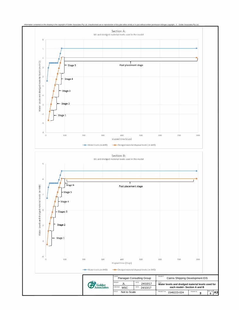
During the placement of dredged material, the water level in the lake will increase as the pit is filled with
saline water. Placement of the dredged material has been modelled in 5 sequential stages for Section A and
6 sequential stages for Section B to a maximum level of 4.07m AHD over a period of 84 days as per
Figure 3. It has been assumed that the dredged material will have a saturated hydraulic conductivity of
1 x 10⁻⁸ m/s.
The adopted boundary conditions for the models are shown in Figure 4. The water level in the lake has been
modelled as increasing to 5.07m AHD over the 12 weeks of filling and then held constant at this level for 2
years after the end of the dredged material disposal as shown in Figure 3. The level of the dredged material
has also been held constant for 2 years as shown in Figure 3.

UPDATE OF GROUNDWATER IMPACT ASSESSMENT - NORTHERN SANDS DMPA
14 December 2017 Report No. 1546223-024-R-Rev0 3
This is considered to be conservative given that it is proposed to reduce the water level as the surface of the
dredged materials drops as a result of settlement that will occur after deposition.
4.0 POTENTIAL GROUNDWATER IMPACTS
4.1 Impacts on the upper unconfined aquifer and near surface soils to the north and east of Narelle Lake
The near surface soils to the north and east of the lake comprise a surficial clay layer generally ranging in
thickness from about 1 m to 4 m, overlying the upper sand layer (refer Units 1 and 2 in Figure 2). The results
of modelling to assess potential groundwater impacts are presented in Figures 5 and 6. Figure 5 shows
contours of the salinity concentration under increased lake levels at Sections A and B and indicates that the
lateral migration of salinity through the surficial clay layer is significantly less than the extent of migration
through the underlying upper sand layer.
A summary of the approximate maximum distances to which an increase in salinity above background is
calculated to extend is provided in Table 1, for the area to the north of the lake (i.e. Section A) and to the
area to the east of the lake (i.e. Section B).
Table 1: Extent of increase in salinity in upper sand layer
Cumulative days from
commencement of dredged
material placement
Approximate maximum distance to
which increased salinity
concentration extends for Section A
Approximate maximum distance to
which increased concentration
extends for Section B
84 days (end of placement) 115 m 120 m
792 days (~2 years after end
of placement) 150 m 150 m
Note that the distances noted in Table 1 are a maximum distance to which an increase in salt concentration
is calculated to occur. The magnitude of calculated increase in salinity reduces with distance from the lake.
Figure 6 shows profiles of the increased salt concentrations1 as a function of distance from the lake at
Section A and Section B. The profiles in Figure 6 are based on salinity concentrations in the upper sand
layer below the surficial clay layer. The profiles of increase in salt concentration illustrated in Figure 6
indicate the significant slowing of the lateral spread of salt that occurs once the level of the dredged material
rises above the upper sand layer.
Beyond the distances noted in Table 1, a negligible increase in salinity is predicted to occur. These
distances are considered to be conservative as the modelling has not taken into account two factors which
will tend to reduce the lateral migration of saline water: the proposed reduction in the water level in the lake
as the dredged materials settles following the end of dredging; and the reduction in permeability of the
material placed in the lake as it consolidates.
The estimated extent of increase in salinity in the upper sand layer to the north and east of the lake is shown
on Figure 7 based on the distances in Table 1.
As outlined above, the lateral migration of salinity through the surficial clay layer is significantly less than the
extent of migration through the upper sand layer. During the period considered in the modelling (i.e. up to 2
years after the end of placement of dredged material) the hydraulic gradient remains downwards away from
the lake. The downward hydraulic gradient will limit the extent to which salt can migrate upwards into the
surficial clay layer from the upper sand layer, and it is assessed that negligible changes in the salinity of the
near surface clays will occur.
1 That is, the increase in concentration above those calculated to be present prior to placement.

UPDATE OF GROUNDWATER IMPACT ASSESSMENT - NORTHERN SANDS DMPA
14 December 2017 Report No. 1546223-024-R-Rev0 4
Although it is assessed that there will negligible changes in the salinity of the near surface clays, the
thickness of the clays within the sugar cane land to the east of the lake is variable, ranging from about 1 m at
the site boundary to about 2 m at about 80 m into the site or about 150 m from the lake (i.e. the lateral extent
of the area of increased salinity). Figure 6 indicates that the increase in salinity concentrations within the
upper sand reduces from about 7 500 g/m3 at the site boundary to nil about 80 m into the site. On this basis
there may be a potential for the root zone of the sugar cane in the area near the site boundary where the
thickness of the clays is thinner and the increase in salinity is greater to be impacted by an increase in
salinity, however this potential will reduce with the progressive increase in clay thickness and diminishing
salinity levels. With regards to the sugar cane land to the north, the potential for the root zone of the sugar
cane to be impacted by an increase in salinity is much less as the thickness of the clays is greater (i.e. 3 m to
3.5 m) and the increase in salinity concentrations within the upper sand reduces from about 2 000 g/m3 at
the site boundary to nil about 30 m into the site or about 150 m from the lake (i.e. the lateral extent of the
area of increased salinity).
4.2 Impacts on the Barron River
The potential flow rate and solute transport rate between Narelle Lake and the Barron River during the
period of increased lake water level was assessed during initial studies (Golder 2017a), noting that at that
stage, a higher lake level and different lake configuration was proposed.
Further assessment during subsequent studies (Golder 2017b) indicated that groundwater seepage from the
lake to the river during the period of increased water level would briefly reach a rate of 25 000 m3/day for a
lake level of about 7m AHD. This could result in a maximum salt flux of 3 500 g/s distributed along
approximately 1.1 kilometres of the Barron River that is located to the west of the dredge placement area.
The results of the updated modelling indicate that groundwater seepage from the lake to the river during the
period of the increased lake water level will reach a maximum rate of 7 400 m3/day with a maximum salt flux
of about 700 g/s distributed along approximately 1.1 km length of the Barron River.
Potential impacts of the groundwater seepage on water quality in the Barron River have been addressed by
BMT WBM in their Marine Water Quality Impact Assessment Technical Report, 2017.
4.3 Other Impacts
As outlined in previous studies (Golder 2017b), other impacts which could result from the proposed
extension of the lake, construction of the bunds, and increased water level in the lake during placement of
dredged material include:
Seepage beneath the bund wall in areas where the foundation material beneath the bund comprises
higher permeability sandy material leading to increased saturation levels/water logging with high salinity
at the surface close to the bund wall. Upward migration of water, potentially with elevated salinity, could
also occur at locations further from the bund wall as a result of increased groundwater pressures in the
upper aquifer, where isolated areas of higher permeability sandy materials are present at surface and
are directly connected with the upper aquifer. The potential for such impacts to occur close to the bund
wall can be mitigated through appropriate subsurface investigations along the bund, and measures
such as the removal of unsuitable material from the foundation. The potential for impacts at locations
further from the bund wall can be mitigated through management of groundwater pressures in the upper
aquifer. This mitigation will be achieved through controlling the water level in the lake until the level of
the low permeability dredged material in the placement area has increased to the level where it limits
the direct connection between the aquifer and the water in the placement area.
If areas of high permeability sandy soils are not detected and addressed in the design and/or
construction of the bund wall, the potential exists for piping through such materials, with the potential to
impact on the integrity of the bund wall. This could lead to safety risks and risks to adjacent
infrastructure, in addition to the environmental risks that would result from the potential release of large
volumes of saline water and dredged material. The potential for such impacts to occur can be mitigated
through appropriate subsurface investigations along the bund, appropriate design of the bund, and
measures such as the removal of unsuitable material from the foundation.

UPDATE OF GROUNDWATER IMPACT ASSESSMENT - NORTHERN SANDS DMPA
14 December 2017 Report No. 1546223-024-R-Rev0 5
4.4 Summary of Potential Impacts The potential groundwater impacts identified during previous studies (Golder 2017b) are summarised as follows:
Impacts on water quality in the Barron River as a result of seepage from the dredged material
placement area to the river.
Impacts on water quality in the upper unconfined aquifer.
Increased salinity in near surface soils.
Increased saturation levels/water logging of surface soils as a result of seepage beneath the bund wall.
Seepage beneath the bund wall adversely impacting on the integrity of the bund wall.
Upward migration of water, potentially with elevated salinity, at locations further from the bund wall
where isolated areas of higher permeability sandy materials are present at surface and are directly
connected with the laterally extensive upper aquifer.
Further assessment of soils related impacts is presented in Section 4.0
5.0 GROUNDWATER IMPACT ASSESSMENT
5.1 Methodology
In order to address the terms of reference, guidelines and other requirements for the currently defined
project, the following methodology was adopted:
Assess impacts (based on the risk assessment format outlined below);
Provide recommendations for mitigation by design changes; and
Provide recommendations for mitigation by management.
Flanagan Consulting Group has extracted relevant items from the Queensland Government Terms of
Reference and the Commonwealth Government Guidelines for groundwater studies. These items and
assessed relevant details were presented in previous studies (Golder 2017b).
The initial assessment of impacts utilises a significance table based on that shown in Table 2.
Table 2: Significance criteria
Impact significance / consequence
Description of significance (examples)
Very High
The impact is considered critical to the decision-making process.
Impacts tend to be permanent or irreversible or otherwise long term and can occur over large scale areas.
Very high sensitivity of environmental receptors to impact (e.g. permanent loss of groundwater dependent ecosystems).
High
The impact is considered likely to be important to decision-making.
Impacts tend to be permanent or irreversible or otherwise long to medium term. Impacts can occur over large or medium scale areas.
High to moderate sensitivity of environmental receptors to impact (e.g. permanent increase in salinity of surface aquifer creating permanent decrease in cane crop yields and reduced health of riparian vegetation).

UPDATE OF GROUNDWATER IMPACT ASSESSMENT - NORTHERN SANDS DMPA
14 December 2017 Report No. 1546223-024-R-Rev0 6
Moderate
The effects of the impact are relevant to decision making including the development of environmental mitigation measures
Impacts can range from long term to short term in duration Impacts can occur over medium scale areas or otherwise represents a significant impact at the local scale
Moderate sensitivity of environmental receptors to impact (e.g. bund failure resulting in discharge of saline waters and dredge material to riparian areas and Barron River and resulting in short term mortality of adjacent cane crops or short term suspended solids loading to the Barron River).).
Minor
Impacts are recognisable/detectable but acceptable.
These impacts are unlikely to be of importance in the decision making process. Nevertheless, they are relevant in the consideration of standard mitigation measures.
Impacts tend to be short term or temporary and/or occur at local scale. (e.g short term increase in salinity of surface aquifer creating short term decrease in cane crop yields and reduced health of riparian vegetation).
Negligible
Minimal change to the existing situation. This could include, for example, impacts which are beneath levels of detection, impacts that are within the normal bounds of variation, or impacts that are within the margin of forecasting error (e.g. minor short term salinity increases in adjacent surface aquifer salinity).
Beneficial Impacts have a positive outcome on the existing situation. This could include for example, an improvement in vegetation management or an improvement in air quality as a result of the project.
The approach to classifying the duration of identified impacts is presented in Table 3.
Table 3: Classifications of the duration of identified impacts
The likelihood of an impact occurring is assessed as per Table 4.
Table 4: Likelihood of impact
Likelihood of Impacts
Risk probability categories
Highly Unlikely Highly unlikely to occur but theoretically possible
Unlikely May occur during construction of the project but probability well below 50%; unlikely, but not negligible
Possible Less likely than not but still appreciable; probability of about 50%
Likely Likely to occur during construction or during a 12 month timeframe; probability greater than 50%
Almost Certain Very likely to occur as a result of the proposed project construction and/or operations; could occur multiple times during relevant impacting period
Relative Duration Of Impacts
Temporary Days to months
Short Term Up to one year
Medium Term From one to five years
Long Term From five to fifty years
Permanent/Irreversible In excess of fifty years

UPDATE OF GROUNDWATER IMPACT ASSESSMENT - NORTHERN SANDS DMPA
14 December 2017 Report No. 1546223-024-R-Rev0 7
A risk rating is assigned by assessing significance versus likelihood within a risk matrix. Risk is described as the product of likelihood and significance as shown in Table 5.
Table 5: Risk matrix
Likelihood Significance
Negligible Minor Moderate High Very high
Highly Unlikely/ Rare
Negligible Negligible Low Medium High
Unlikely Negligible Low Low Medium High
Possible Negligible Low Medium Medium High
Likely Negligible Medium Medium High Extreme
Almost Certain
Low Medium High Extreme Extreme
The rating of risk assessed in the risk matrix is presented in Table 6.
Table 6: Risk Rating Legend
Extreme Risk An issue requiring change in project scope; almost certain to result in a ‘significant’ impact on a Matter of National or State Environmental Significance
High Risk An issue requiring further detailed investigation and planning to manage and reduce risk; likely to result in a ‘significant’ impact on a Matter of National or State Environmental Significance
Medium Risk An issue requiring project specific controls and procedures to manage
Low Risk Manageable by standard mitigation and similar operating procedures
Negligible Risk No additional management required
After assessing the nature and severity of impacts they are summarised under the following categories:
Adverse/beneficial;
Consequential;
Cumulative;
Short-term/long term;
Reversible/irreversible; and
Predictable/unpredictable.

UPDATE OF GROUNDWATER IMPACT ASSESSMENT - NORTHERN SANDS DMPA
14 December 2017 Report No. 1546223-024-R-Rev0 8
5.2 Results of impact assessment
Potential impacts related to groundwater have been outlined in Section 4.0.
An assessment of these impacts is presented in Table 8, based on the mitigation measures proposed
in Table 7.
Table 7: Summary of Mitigation Measures
Impacting Processes Proposed Mitigation Measures
Seepage from the dredge placement area towards the Barron River
causing increases in salinity in the river.
Limit the water level in the lake until sufficient dredged material has been placed in the lake to create a low permeability barrier between the saline water in the dredge disposal area, and the surrounding aquifer.
Lateral migration of saline water away from the dredge placement area causing impacts on water quality in the upper unconfined aquifer.
Lateral migration of saline water away from the dredge placement area causing increased salinity in near surface soils.
Elevated groundwater pressures in upper unconfined aquifer causing upward migration of potentially saline water, in areas where higher permeability sandy materials are present at surface.
Seepage beneath the bund causing increased saturation levels/water logging of surface soils close to the bund.
Geotechnical investigation along the alignment of the wall to identify unsuitable foundation materials for the wall, engineering design to take into account foundation materials, and oversight of construction to ensure that the construction is adapted where necessary to ground conditions encountered on site.
Seepage beneath the bund wall adversely impacting on the integrity of the bund wall.

UPDATE OF GROUNDWATER IMPACT ASSESSMENT - NORTHERN SANDS DMPA
14 December 2017 Report No. 1546223-024-R-Rev0 9
Table 8: Assessment of impacts
Primary impacting processes
Initial assessment with standard (statutory) mitigation measures in
Place
Residual assessment with additional (proposed) mitigation measures in place
Significance of impact
Likelihood of impact
Risk rating
Significance of impact
Likelihood of impact
Risk rating
Seepage from the dredge placement area towards the Barron River causing increases in salinity in the river.
Negligible Almost certain
Low Negligible Almost certain
Low
Lateral migration of saline water away from the dredge placement area causing impacts on water quality in the upper unconfined aquifer.
Moderate Likely Medium Minor Likely Medium
Lateral migration of saline water away from the dredge placement area causing increased salinity in near surface soils.
Moderate Possible Medium Moderate Possible Medium
Seepage beneath the bund causing increased saturation levels/water logging of surface soils close to the bund.
Minor Possible Low Minor Unlikely Low
Seepage beneath the bund wall adversely impacting on the integrity of the bund wall.
Moderate Possible Medium Moderate Unlikely Low
Elevated groundwater pressures in upper unconfined aquifer causing upward migration of potentially saline water, in areas where higher permeability sandy materials are present at surface.
Moderate Possible Medium Moderate Unlikely Low
Based on the above, the risks associated with potential impacts related to groundwater are assessed to be
predominantly low, with a likely minor impact on water quality in the upper unconfined aquifer and a possible
moderate impact on the near surface soils leading to medium risks. With reference to the modelling
discussed in Section 2.0, these impacts are likely to be limited to a maximum distance of about 150 m from
the placement area. Further assessments of the impacts are presented in Table 9.

UPDATE OF GROUNDWATER IMPACT ASSESSMENT - NORTHERN SANDS DMPA
14 December 2017 Report No. 1546223-024-R-Rev0 10
Table 9: Summary of assessed impacts
Element Adverse impact Beneficial
impact Consequential impact
Cumulative impact
Sh
ort
te
rm
Lo
ng
te
rm
Re
ve
rsib
le
Irre
ve
rsib
le
Pre
dic
tab
le
Un
pre
dic
tab
le
Ground-water and surface water
Lateral migration of saline water away from placement area causing increased salinity of the Barron River
Impacts on water quality.
X X X
Ground-water
Lateral migration of saline water away from placement area causing increased salinity of upper unconfined aquifer
Limitations on the potential to locate shallow groundwater bores close to the placement area
X X X
Ground-water and soils
Lateral migration of saline water away from placement area causing increased salinity of near surface soils
Decrease in productivity of agricultural land
X X X
Ground-water
Seepage beneath the bund causing increased saturation levels/water logging of surface soils close to the bund.
Poor trafficability in areas close to the bund.
X X X
Ground-water
Seepage beneath the bund wall adversely impacting on the integrity of the bund wall.
Failure of the bund wall with release of saline water and potential acid sulfate soils.
X X X
Ground-water
Elevated groundwater pressures in upper unconfined aquifer causing upward migration of potentially saline water.
Poor trafficability, impacts on surface infrastructure, decrease in productivity of agricultural land.
X X X

UPDATE OF GROUNDWATER IMPACT ASSESSMENT - NORTHERN SANDS DMPA
14 December 2017 Report No. 1546223-024-R-Rev0 11
6.0 MITIGATING EXTENT OF SALT MIGRATION AWAY FROM DMPA
As noted in Section 4.1, the low permeability material that is placed in the void and that will separate the
water in the void from the surrounding aquifer will significantly reduce the potential for impacts on
groundwater by reducing the rate of lateral migration of salt. As a further mitigation, in the early stages of
dredging until the level of this low permeability material rises above the upper sand layer, it is proposed to
limit the height of the water in the lake.
The sealing effect of the sediments is controlled by the permeability of the dredged material, for which a
value of 1x10⁻⁸ m/s has been assumed. This value is considered to be reasonable for the fine grained
material that will be placed in the lake. As noted above, the reduction in permeability of the material as it
consolidates in the period after placement has not been represented in the modelling.
Placement of a liner of some sort on the base of the existing lake (e.g. a GCL liner comprising layer of
bentonite or other very low-permeability material sandwiched between geotextiles) is not considered
practical. Placement of such a liner underwater in a manner that ensures it would function as intended
would likely not be practical. In any case, a liner of several millimetres thickness would provide significantly
less hydraulic resistance than the several metres thickness of low permeability dredge material that will
ultimately separate the ponded water from the upper aquifer.
Other mitigation measures such as a cut-off wall around the perimeter of the lake would be prohibitively
expensive to construct.
As contingency management measure, groundwater pumping wells could be used if groundwater monitoring
indicates that the rate and extent of salt migration is unacceptable.
7.0 MONITORING PROGRAM
As identified in Section 5.0 the main potential impacts on groundwater are:
Localised increase in groundwater level adjacent to lake during dredged material placement; and
Changes in groundwater quality (salinity) associated with flow of saline water outwards from the lake.
Groundwater monitoring is to be carried out to assess changes in water level and water quality parameters,
to assess whether such changes are within the expected range. The proposed groundwater monitoring
network will make use of some of the existing monitoring bores at the site, and will also include additional
“sentinel” monitoring bores located on the edge of the expected zone of increased salinity and “secondary”
monitoring bores located (at accessible locations) beyond the sentinel bores. The secondary bores will be
used to confirm the extent of increased salinity (if detected) in sentinel bores and to evaluate the
effectiveness of contingency measures employed to mitigate increased salinity. The location of the existing
and proposed monitoring bores is illustrated in Figure 7.
The groundwater monitoring network will be used to collect both groundwater level and water quality data
prior to, during, and after placement of dredged material. Pressure/electrical conductivity transducers will be
installed in selected bores to enable near real time monitoring of groundwater level, electrical conductivity
and pH and to allow a greater understanding of the natural variability of these parameters. Trigger levels for
water level and water quality parameters will be set relative to background values established through the
pre-dredging period, and based on the predicted changes in water level and salinity.
Table 10 provides details of the proposed monitoring and sampling for different phases of the program.
A more detailed monitoring plan and approach to establishment of baseline values and trigger values will be
developed in the detailed design phase.

UPDATE OF GROUNDWATER IMPACT ASSESSMENT - NORTHERN SANDS DMPA
14 December 2017 Report No. 1546223-024-R-Rev0 12
Table 10: Proposed groundwater monitoring
Monitoring Phase
Parameter Sampling Frequency
12 months prior to placement of dredged material
Water Level Hourly (data logger) and manually during monthly sampling events (existing, sentinel and secondary bores)
Electrical Conductivity and pH Hourly (data logger) and monthly during sampling events (existing, sentinel and secondary bores)
Field physicochemical parameters (EC, pH, DO, Redox, Temp)
Monthly during sampling events (existing, sentinel and secondary bores)
Major Ions Monthly (existing, sentinel and secondary bores)
Metals (Total / Dissolved) Monthly (existing, sentinel and secondary bores)
During placement of dredged material
Water Level Hourly (data logger) and manually during monthly sampling events (existing and sentinel bores)*
Electrical Conductivity and pH Hourly (data logger) and monthly during sampling events (existing and sentinel bores)*
Field physicochemical parameters (EC, pH, DO, Redox, Temp)
Weekly during sampling events (existing and sentinel bores)*
Major Ions Weekly (existing and sentinel bores)*
**Metals (Total / Dissolved) Weekly (existing and sentinel bores)*
24 months after placement of dredged material
Water Level Hourly (data logger) and manually during monthly sampling events (existing and sentinel bores)*
Electrical Conductivity and pH Hourly (data logger) and monthly during sampling events (existing and sentinel bores)*
Field physicochemical parameters (EC, pH, DO, Redox Temp)
Monthly during sampling events (existing and sentinel bores)*
Major Ions Monthly (existing and sentinel bores)*
**Metals (Total / Dissolved) Monthly (existing and sentinel bores)*
*Monitoring in the secondary bores will be commenced should water level and/or electrical conductivity trigger levels be
exceeded in sentinel bores.
**The need for on-going metal analysis will be assessed based on background concentrations and exceedances
observed during filling. The pH will be systematically monitoring and should pH values show a decrease to below 6, then
metals testing would be recommenced.
8.0 CONCLUSIONS
The results of the updated groundwater modelling indicate that after 2 years the increase in salinity in the
upper aquifer around the lake due to currently proposed placement of dredged materials will extend to a
maximum distance of about 150 m. This will impact the Barron River to the west of the site, plus the sugar
cane land to the north and east of the site. It is noted that the assessed extent of the increase in salinity
within two years of deposition is considered to be conservative as it is proposed to reduce the water level in
the lake as the level of the dredged materials drops. We also note that the permeability of the material
placed in the lake will decrease as it consolidates, which has not been allowed for in the modelling and adds
further conservatism to the predicted extent of impact.
Within the extent of the aquifer impacted by outward salinity migration (resulting from the placement of the
dredged material), salinity concentrations are likely to remain elevated for an extended period. Higher salinity
groundwater to the north of the lake will gradually be flushed by groundwater flow to Thomatis Creek, and
higher salinity water to the east will be flushed towards the Barron River. The timeframe for this flushing has
not been assessed through modelling as the direction of long term groundwater flow that will flush the higher
salinity water is perpendicular to the cross-sectional models, however it is estimated to be in the range of 10-
20 years.

UPDATE OF GROUNDWATER IMPACT ASSESSMENT - NORTHERN SANDS DMPA
14 December 2017 Report No. 1546223-024-R-Rev0 13
Water quality in the aquifers in the area of the Northern Sands DMPA is generally poor and is considered to
be unsuitable for both cane irrigation and domestic use. It is also noted that sugarcane is grown in areas
surrounding the DMPA with elevated groundwater salinity. It is therefore considered that the localised
increase in salinity in the vicinity of the DMPA will not impact on the existing environmental values associated
with groundwater.
Potential impacts on environmental values associated with aquatic and riparian ecosystems along the Barron
River are assessed in other reports for the project.
The lateral migration of salinity through the surficial clay layer will be significantly less than the extent of
migration through the upper sand layer. A general downward hydraulic gradient from the lake will limit the
extent to which salt can migrate upwards into the surficial clay layer and it is assessed that negligible
changes in the salinity of the near surface clays will occur. Notwithstanding this there is a potential for the
root zone of the sugar cane in the adjacent property to the east of the site to be impacted by an increase in
salinity where the layer of surface clay is about 1 m to 2m thick within the extent of the impacted area.
The potential groundwater impacts associated with the currently proposed placement of dredged materials at
the Northern Sands DMPA are generally consistent with the previous groundwater impact assessment
(Golder 2017b). As outlined in Section 4.0 the risks associated with potential impacts related to groundwater
are assessed to be predominantly low, with a likely minor impact on water quality in the upper unconfined
aquifer and a possible moderate impact on the near surface soils leading to medium risks.
Groundwater monitoring is to be carried out to assess changes in water level and water quality parameters,
to assess whether such changes are within the expected range. The proposed groundwater monitoring
network will be used to collect both groundwater level and water quality data prior to, during, and after
placement of dredged material. The proposed groundwater monitoring program is outlined in Section 5.0.
9.0 IMPORTANT INFORMATION
Your attention is drawn to the document - “Important Information relating to this report”, which is included as
Appendix A. The statements presented in this document are intended to advise you of what your realistic
expectations of this report should be. The document is not intended to reduce the level of responsibility
accepted by Golder Associates, but rather to ensure that all parties who may rely on this report are aware of
the responsibilities each assumes in so doing.

UPDATE OF GROUNDWATER IMPACT ASSESSMENT - NORTHERN SANDS DMPA
14 December 2017 Report No. 1546223-024-R-Rev0
Report Signature Page
GOLDER ASSOCIATES PTY LTD
Malcolm Cook Scott Fidler
Principal Principal
JL/MSC/PKS/DB/msc/ow
A.B.N. 64 006 107 857
Golder, Golder Associates and the GA globe design are trademarks of Golder Associates Corporation.
j:\geo\2015\1546223 - fcg - eis stage 1 - port development\corr out\1546223-026-r-rev0 update of groundwater impact assessment at northern sands.docx

UPDATE OF GROUNDWATER IMPACT ASSESSMENT - NORTHERN SANDS DMPA
14 December 2017 Report No. 1546223-024-R-Rev0
FIGURES

LEGENDCross Section for SeepW Modelling
Earth BundEarth Bund (RL 5.50)Existing Earth Bund (RL 5.50 or greater)Watercourses (25k)
Dredge Material PlacementDredge Material Placement ZoneExisting Sand Reclamation AreaFuture Sand Reclamation Area
Path:
\\gold
er.gd
s\gap
\Cair
ns\Jo
bs\G
eo\20
15\15
4622
3 - F
CG - E
IS S
tage 1
- Port
Dev
elopm
ent\G
IS\M
XD\H
ydro
_Ass
essm
ent\1
5462
23-0
24-R
-Rev
0_F0
01_N
t_San
ds_D
redg
eMate
rial.m
xd
Study Area
LOCATION MAP
CLIENTFLANAGAN CONSULTING GROUP
PROJECTCAIRNS SHIPPING DEVELOPMENT EIS
TITLEDREDGE MATERIAL PLACEMENT AREA
1546223 024 0 1
2017-10-26 HGHGMSCMSC
IF TH
IS M
EASU
REME
NT D
OES
NOT M
ATCH
WHA
T IS S
HOW
N, TH
E SH
EET
SIZE
HAS
BEEN
MOD
IFIE
D FR
OM: A
3
CONSULTANT
PROJECT NO. CONTROL REV. FIGURE
YYYY-MM-DDPREPAREDDESIGNEDREVIEWEDAPPROVED
25mm
0
River
Barron
CPT30
CAPTAIN COOK HIGHWAY
WIST
ERIA
STRE
ET
MACHANS BEACH ROAD
HOL L
OWAY
B EA C
HR O
A D
ROUNDABOUT
Secti
on A
Section B
363,000
363,000
363,500
363,500
364,000
364,000
364,500
364,500
365,000
365,000
8,135
,000
8,135
,000
8,135
,500
8,135
,500
8,136
,000
8,136
,000
8,136
,500
8,136
,500
0 100 200 300 400 500
Metres1:8,000 at A3PROJECTION: GDA 1994 MGA Zone 55
0 10km
Localities, Roads and Tracks, Watercourses © State of Queensland (Department of NaturalResources and Mines) 2016.Imagery: Sourced from Nearmap 02/09/2016, dated 07/06/2016.
COPYRIGHT
Service Layer Credits: Sources: Esri, HERE, DeLorme, USGS, Intermap, increment P Corp.,NRCAN, Esri Japan, METI, Esri China (Hong Kong), Esri (Thailand), MapmyIndia, ©OpenStreetMap contributors, and the GIS User Community

Information contained on this drawing is the copyright of Golder Associates Pty Ltd. Unauthorised use or reproduction of this plan either wholly or in part without written permission infringes copyright. © Golder Associates Pty. Ltd.
CLIENT PROJECT
DRAWN JL DATE: 24/10/12017CHECKED MC DATE: 24/10/2017SCALE:
NTS
PROJECT No.
1546223-024FIGURE No.
J:\Hyd\2016\Cairns\1540311 Northern Sands\Analysis\SEEP w MODEL\Modelling for phase 9200\Figures\[Figure 2 seep_W geological crossection.xlsx]Landscape
Flanagan Consulting Group Cairns Shipping Development EISSeep/W cross-sectional models
FIGURE 2
Barron River Pit Lake
Pit Lake
NWSE
SWNE
Section B
Section A
Information contained on this drawing is the copyright of Golder Associates Pty Ltd. Unauthorised use or reproduction of this plan either wholly or in part without written permission infringes copyright . © Golder Associates Pty Ltd.
DATE
DATE
FIGURE No
CLIENT
DRAWN
CHECKED
SCALE
TITLE
PROJECT No
PROJECT
Flanagan Consulting Group
JL 24/10/17
Cairns Shipping Development EIS
A3REV NoNot to ScaleMSC 24/10/17
Water levels and dredged material levels used for each model– Section A and B
3 01546223-024

Information contained on this drawing is the copyright of Golder Associates Pty Ltd. Unauthorised use or reproduction of this plan either wholly or in part without written permission infringes copyright. © Golder Associates Pty. Ltd.
CLIENT PROJECT
DRAWN JL DATE: 24/10/2017CHECKED MSC DATE: 24/10/2017SCALE:
NTS
PROJECT No.
1546223-024FIGURE No.
J:\Hyd\2016\Cairns\1540311 Northern Sands\Analysis\SEEP w MODEL\Modelling for phase 9200\Figures\[Figure 4 seep_W Boundary Conditions.xlsx]Landscape
Flanagan Consulting Group Cairns Shipping Development EISSeep/w Model Boundary Conditions
FIGURE 4
Boundary Barron River Pit Lake(All levels in mAHD)
Pre‐filling 0.25m / 16000g/m3 0.25m / 500g/m3Filling 0.25m / 160000g/m3 0.25m increasing to up to
5.07 m/ 35000g/m3 Post ‐ filling 0.25m / 16000g/m3 Rainfall recharge
Barron River Pit Lake
Pit Lake
NW SE
SW NE
Section B
Section A
0.5 m Head180 g/m3 Cont.
0.5 m Head12000 g/m3 Cont.
0.5 m Head180 g/m3 Cont.
0.5 m Head12000 g/m3 Cont.
0.5 m Head180 g/m3 Cont.
0.5 m Head12000 g/m3 Cont.
0.5 m Head180 g/m3 Cont.
0.5 m Head12000 g/m3 Cont.

Information contained on this drawing is the copyright of Golder Associates Pty Ltd. Unauthorised use or reproduction of this plan either wholly or in part without written permission infringes copyright . © Golder Associates Pty Ltd.
DATE
DATE
FIGURE No
CLIENT
DRAWN
CHECKED
SCALE
TITLE
PROJECT No
PROJECT
Flanagan Consulting Group
JL 24/10/17
Cairns Shipping Development EIS
A3REV NoNot to ScaleMSC 24/10/17
Concentration contours at completion of disposal -Section A and Section B
5 01546223-024
Filling to WL 5.07 m RL with dredged material level at 4.07 m RL at the end of 12 weeks disposal Section A
Filling to WL 5.07 m RL with dredged material level at 4.07 m RL at the end of 12 weeks disposalSection B
Distance [m]0 500 1,000 1,500
Ele
vatio
n [m
AH
D]
-45
-35
-25
-15
-5
5
15

Information contained on this drawing is the copyright of Golder Associates Pty Ltd. Unauthorised use or reproduction of this plan either wholly or in part without written permission infringes copyright . © Golder Associates Pty Ltd.
DATE
DATE
FIGURE No
CLIENT
DRAWN
CHECKED
SCALE
TITLE
PROJECT No
PROJECT
Flanagan Consulting Group
JL 24/10/17
Cairns Shipping Development EIS
A3REV No
Not to Scale
MSC 24/10/17
Profiles of increase in concentration with distance
from lake – Section A and B (WL up to 5.07 mRL)
6 31546223-024
Profiles based on concentrations in the
upper sand layer immediately below the
upper clay layer
Bund effect

LEGEND
A Existing Monitoring Bore!A Proposed Sentinel Monitoring BoreA Proposed Secondary Monitoring Bore
Cross Section for SeepW ModellingEarth Bund (RL 5.50)Existing Earth Bund (RL 5.50 or greater)Watercourses (25k)Estimated Extent of Increase in Salinity in Upper Sand Layer
Dredge Material PlacementDredge Material Placement ZoneExisting Sand Reclamation AreaFuture Sand Reclamation Area
Path:
J:\H
yd\20
16\C
airns
\1540
311 N
orthe
rn Sa
nds\G
IS\MX
D\Hy
dro_A
sses
smen
t\154
6223
-024-R
-Rev
2_F0
07_N
t_San
ds_D
redge
Mater
ial.m
xd
Study Area
LOCATION MAP
CLIENTFLANAGAN CONSULTING GROUP
PROJECTCAIRNS SHIPPING DEVELOPMENT EIS
TITLEAPPROXIMATE EXTENT OF INCREASE IN SALINITY IN UPPERSAND LAYER
1546223 024 2 7
2017-12-13 HGHGMSCMSC
IF TH
IS M
EASU
REME
NT D
OES
NOT M
ATCH
WHA
T IS S
HOW
N, TH
E SH
EET
SIZE
HAS
BEEN
MOD
IFIE
D FR
OM: A
3
CONSULTANT
PROJECT NO. CONTROL REV. FIGURE
YYYY-MM-DDPREPAREDDESIGNEDREVIEWEDAPPROVED
25mm
0
A
!A
!A
A
A
A
A
A
!A
A
A !A A
AA
A
River
Barron
CPT30
CAPTAIN COOK HIGHWAY HOL L
OWAY
B EAC
HRO
A D
ROUNDABOUT
Secti
on A
Section B
MW2
MW1
MW3
MW4
BH01
BH4a
BH5a
GA04
BH02
BH03BH3
BH2
363,000
363,000
363,500
363,500
364,000
364,000
364,500
364,500
365,000
365,000
8,135
,000
8,135
,000
8,135
,500
8,135
,500
8,136
,000
8,136
,000
8,136
,500
8,136
,500
0 100 200 300 400 500
Metres1:8,000 at A3PROJECTION: GDA 1994 MGA Zone 55
0 10km
Localities, Roads and Tracks, Watercourses © State of Queensland (Department of NaturalResources and Mines) 2016.Imagery: Sourced from Nearmap 02/09/2016, dated 07/06/2016.
COPYRIGHT
Service Layer Credits: Sources: Esri, HERE, DeLorme, USGS, Intermap, increment P Corp.,NRCAN, Esri Japan, METI, Esri China (Hong Kong), Esri (Thailand), MapmyIndia, ©OpenStreetMap contributors, and the GIS User Community

UPDATE OF GROUNDWATER IMPACT ASSESSMENT - NORTHERN SANDS DMPA
14 December 2017 Report No. 1546223-024-R-Rev0
Important information relating to this document

IMPORTANT INFORMATION RELATING TO THIS REPORT
The document (“Report”) to which this page is attached and which this page forms a part of, has been issued by Golder Associates Pty Ltd (“Golder”) subject to the important limitations and other qualifications set out below. This Report constitutes or is part of services (“Services”) provided by Golder to its client (“Client”) under and subject to a contract between Golder and its Client (“Contract”). The contents of this page are not intended to and do not alter Golder’s obligations (including any limits on those obligations) to its Client under the Contract. This Report is provided for use solely by Golder’s Client and persons acting on the Client’s behalf, such as its professional advisers. Golder is responsible only to its Client for this Report. Golder has no responsibility to any other person who relies or makes decisions based upon this Report or who makes any other use of this Report. Golder accepts no responsibility for any loss or damage suffered by any person other than its Client as a result of any reliance upon any part of this Report, decisions made based upon this Report or any other use of it. This Report has been prepared in the context of the circumstances and purposes referred to in, or derived from, the Contract and Golder accepts no responsibility for use of the Report, in whole or in part, in any other context or circumstance or for any other purpose. The scope of Golder’s Services and the period of time they relate to are determined by the Contract and are subject to restrictions and limitations set out in the Contract. If a service or other work is not expressly referred to in this Report, do not assume that it has been provided or performed. If a matter is not addressed in this Report, do not assume that any determination has been made by Golder in regards to it. At any location relevant to the Services conditions may exist which were not detected by Golder, in particular due to the specific scope of the investigation Golder has been engaged to undertake. Conditions can only be verified at the exact location of any tests undertaken. Variations in conditions may occur between tested locations and there may be conditions which have not been revealed by the investigation and which have not therefore been taken into account in this Report. Golder accepts no responsibility for and makes no representation as to the accuracy or completeness of the information provided to it by or on behalf of the Client or sourced from any third party. Golder has assumed that such information is correct unless otherwise stated and no responsibility is accepted by Golder for incomplete or inaccurate data supplied by its Client or any other person for whom Golder is not responsible. Golder has not taken account of matters that may have existed when the Report was prepared but which were only later disclosed to Golder. Having regard to the matters referred to in the previous paragraphs on this page in particular, carrying out the Services has allowed Golder to form no more than an opinion as to the actual conditions at any relevant location. That opinion is necessarily constrained by the extent of the information collected by Golder or otherwise made available to Golder. Further, the passage of time may affect the accuracy, applicability or usefulness of the opinions, assessments or other information in this Report. This Report is based upon the information and other circumstances that existed and were known to Golder when the Services were performed and this Report was prepared. Golder has not considered the effect of any possible future developments including physical changes to any relevant location or changes to any laws or regulations relevant to such location. Where permitted by the Contract, Golder may have retained subconsultants affiliated with Golder to provide some or all of the Services. However, it is Golder which remains solely responsible for the Services and there is no legal recourse against any of Golder’s affiliated companies or the employees, officers or directors of any of them. By date, or revision, the Report supersedes any prior report or other document issued by Golder dealing with any matter that is addressed in the Report. Any uncertainty as to the extent to which this Report can be used or relied upon in any respect should be referred to Golder for clarification.
GAP Form No. LEG04 RL2 July 2015 1/1
Golder Associates Pty Ltd
147 Coronation Drive
Milton, Queensland 4064
Australia
T: +61 7 3721 5400
Caption Text