shawangunkmountains scenic byway · our appreciation also to laura zeisel, david porter, nathan...
TRANSCRIPT
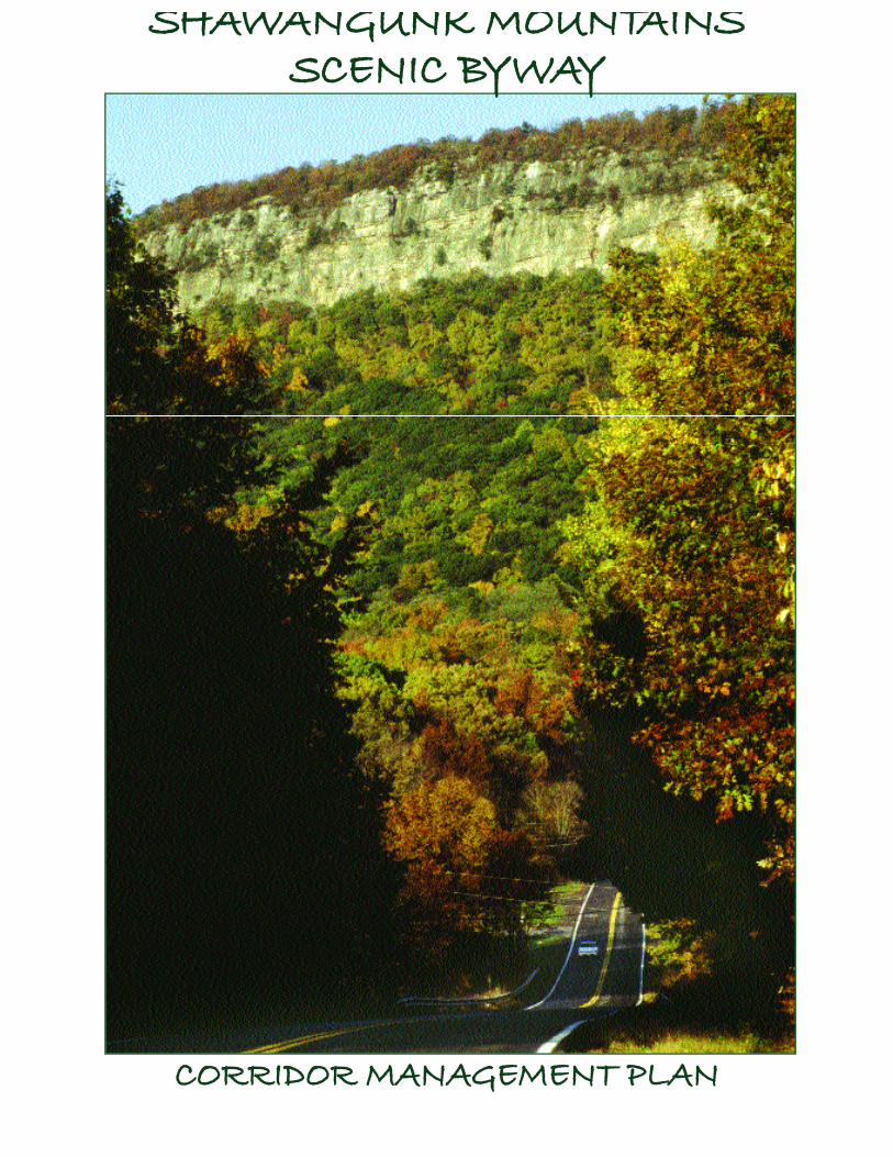
SHAWANGUNK MOUNTAINSSCENIC BYWAY
CORRIDOR MANAGEMENT PLAN
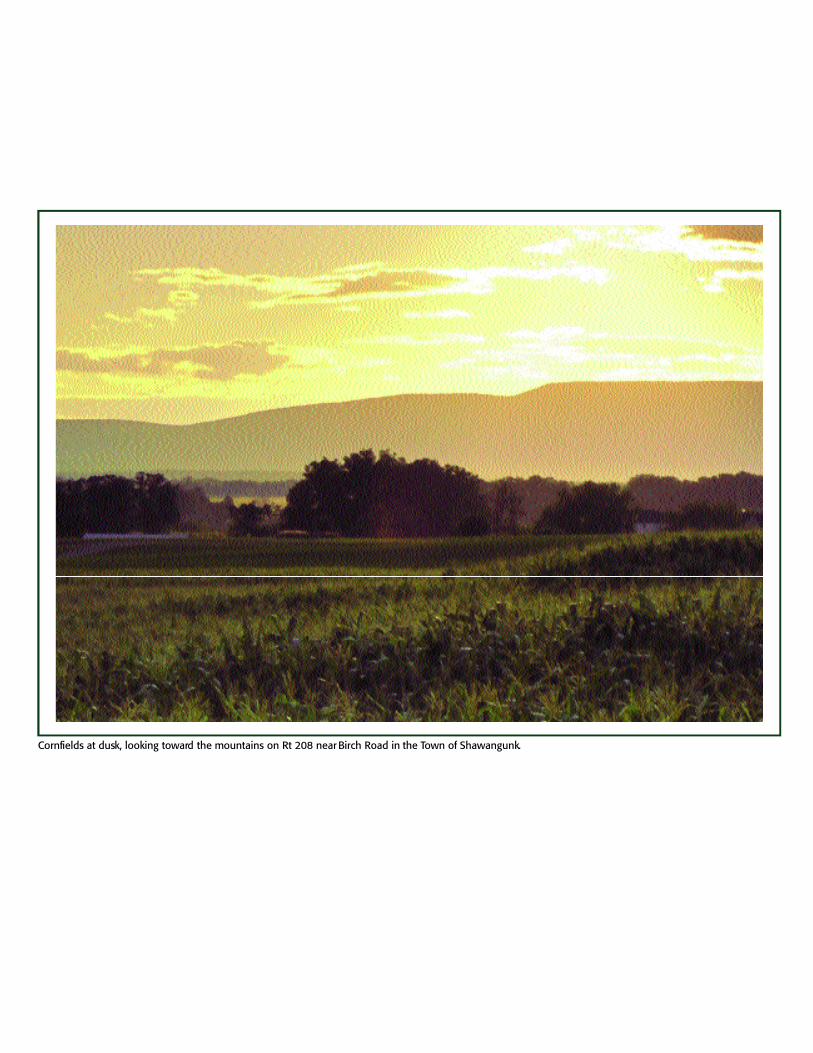
Cornfields at dusk, looking toward the mountains on Rt 208 near Birch Road in the Town of Shawangunk.
3
SHAWANGUNK MOUNTAINSSCENIC BYWAY
CORRIDOR MANAGEMENT PLAN
October, 2005
4
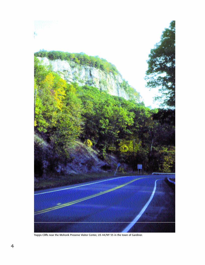
Trapps Cliffs near the Mohonk Preserve Visitor Center, US 44/NY 55 in the town of Gardiner.

5
Presented by the Shawangunk Mountains Scenic Byway
Steering CommitteeJohn Valk, Jr, ChairmanSupervisor, Town of Shawangunk
Brinton Baker, Vice ChairRepresentative, Town of Rochester
Don Wilen, Vice ChairSupervisor, Town of New Paltz
Phil JamisonRepresentative, Town of Crawford
Iris FriedmanRepresentative, Village of Ellenville
Carl ZatzSupervisor, Town of Gardiner
Vincent T. MartelloSupervisor, Town of Marbletown
Susan CockburnSupervisor, Town of Montgomery
Jason WestMayor, Village of New Paltz
Bob GallagherSupervisor, Town of Rosendale
Tom GaleRepresentative, Town of Wawarsing
PROJECT MANAGERAl Wegener, Landscape ConsultantNew Paltz, NY (845) 255-3572
ADVISORS:
David Church, CommissionerOrange County Planning
Alex Collins, ManagerMinnewaska State Park Preserve
Virginia Craft, PlannerUlster County Planning Department
Dennis Doyle, DirectorUlster County Planning Department
Glenn Hoagland, Executive DirectorMohonk Preserve, Inc.
Cara Lee, DirectorShawangunk Ridge Program ofThe Nature Conservancy
Joyce M. Minard, PresidentNew Paltz Regional Chamber of CommerceRussell Robbins, NYSDOTSenior Transportation Analyst Lisa Weiss, NYSDOTScenic Byway Coordinator
PROJECT FISCAL SPONSORThe Mohonk Preserve, Inc.
We would like to express our warm appreciation to the following people who contributed greatly to the development of thisPlan by serving earlier as active members of the Steering Committee during their terms as officials of their municipalities:Town of Gardiner Supervisors Laura Walls and Jack Hayes, Town of Marbletown Supervisor Tom Jackson and CouncilmanTim Sweeney, Town of Montgomery Supervisor Al Valk, Town of New Paltz Supervisor Carol Roper, Village of New PaltzMayor Tom Nyquist, Town of Rosendale Supervisor Phil Terpening and Town of Wawarsing Representatives Greg Black andHattie Grifo.
We would like to remember our good friend Ann Botshon, who represented the Town of Cra wford and was an enthusiastic andhard-working member of our committee, and a champion of many preservation causes in the region, including Route 30 2 .
We appreciate the support and cooperation these officials gave to the Byway planning process and to their representatives:Town of Crawford Supervisor Charlie Carnes, Village of Ellenvile Mayor Jeff Kaplan, Ellenville Village Manager ElliottAuerbach, Town of Rochester Supervisors Harold Lipton and Pam Duke, Town of Wawarsing Supervisor James Dolaway.
Our thanks also to the following people who worked with the Steering Committee in an ex officio capacity: Dr. Richard Craft,during his term as Supervisor of the Town of Wawarsing, Susan Wiand of Shawangunk and Keith LaBudde, President ofFriends of the Shawangunks.

6
Acknowledgements:The Steering Committee would like to express its appreciation for the funding that made this CorridorManagement Plan possible. This Plan was funded in part by grants awarded to the New York StateScenic Byways Program through the Federal Highway Administration’s National Scenic Byways Progr a m .
Funding was also provided by Chairman Richard A. Gerentine and the Ulster County Legislature,County Executive Edward Diana and the Orange County Legislature, New York State Assemblymember Kevin A. Cahill and the Open Space Institute.
The Steering Committee would also like to thank our advisors for their many ideas and contributions,for helping us to stay on track, and for giving freely of their time and resources. In particular, wewould like to thank our county planners, Dave Church and Dennis Doyle, for their presentation to theSteering Committee on “Managing a Byway Corridor.”
We are very grateful for the helpful guidance and encouragement we have received over a period offour years from Nancy Alexander and Mark Woods, of the Landscape Architecture Bureau of NYS DOT.Our thanks also to Mary Ivey, Chair of the Byways Advisory Board and David Fasser, retired chair. RussRobbins, at NYS DOT Region 8, has been extremely helpful and we appreciate the personal interest hehas taken in helping us move along.
Leaders of other Byways in the State were generous in sharing their experiences with us: TeresaMitchell, the Seaway Trail; Janet Kennedy, Adirondack North Country Association; Barbara Henderson,Mohowk Valley Heritage Corridor Commission.
Special thanks to Valerie Scopaz, who, as Town of Southold Planner for the North Fork Scenic Byway,on Long Island, visited us and made a very informative presentation.
We would like to recognize the key role played by the Mohonk Preserve in this endeavor: the inceptionof the initial idea for a Byway, working as the project fiscal sponsor, providing meeting space (with cof-fee) in the heart of the Shawangunks. Special thanks to Executive Director Glenn Hoagland for theenthusiasm, imagination and wisdom he added to each phase of this undertaking, to the Preserve’sEllen Bennett, who provided timely and excellent minutes of all our meetings. Also to Scott W. Brown,Director of Finance and Administration, and Beth McCaffrey, Business Manager, for dutifully keepingour financial affairs in order, Bill Sticker, Information Technology Coordinator, and to the many otherindividuals at the Preserve who helped all along the way.
Our appreciation to the Hudson River Valley Greenway for sponsorship of the Community LeadershipAlliance Training Program. Most of our municipalities have participated in this training program, andcontinue to benefit from the guidance and can-do approach of Professor John R. Nolon and Director ofTraining Sean Nolon of the Pace Land Use Law Center. Special thanks also to Beth Campochiaro.
Our thanks to Laura Walls who, as Research Director of Mid-Hudson Pattern for Progress, presented thePattern regional transportation study to our Steering Committee. We also appreciate the comprehen-sive inventory of handicapped access and recommendations provided by Norman Turner.
Thank you to the many individuals who contributed information, ideas and often photography: Bertand Nina Smiley, Kim Traudt at the Mohonk Mountain House; Jack Braunlein and Eric Roth at the
7
Credits:The presentation was written by Al Wegener, except for the history of the region, which wasresearched and written by Wendy E. Harris M.A., R.P.A. of Cragsmoor Consultants.
A rt direction, layout and production coordination by Ad Essentials, New Paltz, NY. Linda Engler,President and Kristen Gardner, Graphic Designer. The folks at Ad Essentials gave unstintingly oftheir expertise, time and patience. Their full measure of helpfulness is appreciated by all of us whohave worked on this project.
Photography by Al Wegener, except as indicated. Thank you to G. Steve Jordan, professionalphotographer, for contributing the use of his photos on pages 24 t h r o u g h27, and to the many other fine photographers whose work is shown herein.
Cartography by Herb Chong of Peekskill. Maps for the sections of theroute by Al Wegener and Ad Essentials.
Byway logo design by Dave Palmer, New York City, NY.
Georges Jacquemart, PE, AICP, and Maya Phatate, senior urban designer,of Buckhurst Fish & Jacquemart, Inc. provided transportation strategiesand design assistance.
Acknowledgements (continued)
Huguenot Historical Society; Alice Cross, Friends of Historic Rochester; Gayle Grunwald and DietrichWerner of the Century House Historical Society; Rosendale Town Historian Ann Gilchrist; AnnBienstock of the Shawangunk Valley Conservancy; Bob Taylor of the Wallkill Valley Land Trust.
Our thanks to Steve Kohl, Wallkill River National Wildlife Refuge; DEC’s Bill Rudge, Jeff Rider andKaren Strong; Nick Miller of the Wildlife Conservation Society; Martha Cheo, Wallkill River Task Force;Bobbi Esmark, Friends of the Rondout; George Danskin, Wallkill Valley Rail Trail; Andy Helygren andSheldon Quimby of the D&H Canal Heritage Corridor; Kathy Burns of GUMBA.
Thanks also to farmers Bruce Davenport, Chris Kelder, Bev Tantillo, Peter Ferrante, John Adams, PeterDavis, Jay and Polly Armour and Lydia Reidy, Chair of the Ulster County Agricultural and FarmlandProtection Board; and Julie Suarez, Manager of Government Relations, NYS Farm Bureau.
Our appreciation also to Laura Zeisel, David Porter, Nathan Roper, Vici Danskin, Liona Hoodes andViolet Stone. And PDQ Printers, Art Craft, On Location and Northport Systems.
And a round of thank yous to the over 250 people who participated in our meetings in all of the 11municipalities around the Byway, and who expressed their enthusiasm, raised key issues and generatedmany of the ideas included in this Plan.

9
Table of ContentsPage
Executive Summary 10
Introduction 13
NYS Scenic Byways Program 14
Shawangunk Mountains Scenic Byway Vision and Goals 15
Inventory of Resources
Resource Overview 16
Scenic Resources Inventory 18
Natural Resources Inventory 24
Recreational Resources Inventory 32
Historic Resources Inventory 38
Guide to the Shawangunk Mountains G-1Scenic Byway Region
Access Map G-2
Guide Map G-4
Guide Contents G-5
Farm Markets G-62
Places to Eat G-64
Places to Stay G-67
Plans
Our Vision and Our Story
Tourism Plan P-1
Transportation Plan P-10
Preservation of Resources Plan P-37
Management Plan P-47
10
Executive SummaryThe idea of the Shawangunk (SHON-gum) Mountains Scenic Byway is to link together the communities aroundthe northern Shawangunk Mountains and, in so doing, to give birth to a new region of New York State. . .theShawangunk Mountains Region. Encircled by the 82-mile Byway, this new region of over 115,000 acres isw o n d e rfully rich in scenic, natural, recreational and historic resources.
The beautiful Shawangunk Mountains cover 94,000 acres of our region and are the centerpiece of the Byway.The mountains can be seen throughout most of the route. The views, looking across a mostly rural countrysideof farm fields and forests, are among the most pleasing New York State has to offer.
Named one of “Earth’s Last Great Places” by The Nature Conservancy, the Shawangunks are cited in theNew York State Open Space Plan as “one of the highest priority areas for biodiversity conservation in then o rt heastern United States.” About 33,000 acres are protected, including lands of the Minnewaska State ParkPreserve, The Mohonk Preserve and Sam’s Point Preserve.
Several of the more than 35 natural communities are globally rare, such as the dwarf pine ridge community.And we have dozens of rare species, such as the mountain spleenwort and the timber rattlesnake. Our chest-nut oak forest of over 38,000 acres is the second largest in New York State, and we have an extensive forestof hemlock-northern hardwoods.
North of the mountains is the Rondout Valley, with the Rondout Creek and other streams and kills. To thesouth is the Wallkill Valley, with the Wallkill River and the Shawangunk Kill, a DEC-designated RecreationalRiver. Other natural resources in the region include the Shawangunk Grasslands National Wildlife Refuge andthe Vernooy Kill State Forest.
Traveling along the Byway is one way to enjoy these scenic views and natural resources. In addition, we areproud to have over 250 miles of hiking trails, about 100 miles of mountain biking, nearly 150 miles of cross-country skiing and other recreational activities, such as rock climbing. In fact, more rock climbers come to the“Gunks” than to Yosemite or any place else in the U.S.
We can trace the history of our region back thousands of years, and are fortunate to have in a well-preservedstate much evidence of life here going back to the late 1600's. In the Shawangunk Mountains Region, we areproud to have 56 listings on the National Registry of Historic Places. These include the Huguenot Street NationalHistoric Landmark District, the Lake Mohonk National Historic Landmark, and eight other historic districts.
Much of our history involves industries that employed scores of people here for many years. The NationalRegister includes sites with artifacts and remains of the D&H Canal at High Falls and Ellenville, the cementindustry at the Snyder Estate Natural Cement Historic District and the Binnewater Historic District in Rosendale,the O&W Railroad in Wawarsing and the Tuthilltown Gristmill in Gardiner.
Together, these scenic, natural, recreational and historic resources help to tell the story of our region: the storyof the towns and villages in the Rondout and Wallkill valleys and their connections for thousands of years withthe northern Shawangunk Mountains as well as with each other.
Now these towns and villages have come together in a regional partnership with a plan for the ShawangunkMountains Scenic Byway and the Shawangunk Mountains Region.
11
Our Plan is actually four mini-plans, although each is comprehensive and ambitious. Goals for these plans follow, with highlights of strategies and projects for each.
Tourism and Economic Development PlanGoals: Build a strong identity for the Shawangunk Mountains Scenic Byway and Region. Improve the ability ofeach of the participating communities to benefit from the tourism that is attracted to our Region.
Strategies and Projects: Byway signage identifying the route, cooperation with state, county and local tourismgroups, visitor centers in the Wallkill and Rondout valleys, information kiosks, general and special-interestc o mmunications, expansion of tourism-related resources.
Transportation PlanGoals: Help to build a strong identity for the Shawangunk Mountains Scenic Byway and Region. Enhance theavailability, convenience and safety of multimodal travel throughout the Byway. Upgrade the appearance alongthe Byway right-of-way.
Strategies and Projects: Improve guiderails and shoulders throughout the Region, redesign of certain intersec-tions with preference for roundabouts, encouragement of bicycle and bus travel, enhanced landscaping andother aesthetic features along the right-of-way, including upgrading the attractiveness of our Main Streets, andbetter access management.
Preservation of Resources PlanGoal: To encourage the preservation of the scenic, natural, recreational and historic resources of the Region.
Strategies and Projects: Guide development off the Ridge, encourage conservation subdivision design and openspace planning, provide helpful information to local planning boards, utilize regional strategies for farmlandand open space preservation, expand recreational opportunities on the Ridge and in the valleys, aid thep r e s e rvation and presentation of historic resources.
Plan for ManagementGoal: To provide a regional management entity than will implement the Corridor Management Plan in a manner that respects home rule authority and also engages the active participation of the public in each of the communities along the route.
Strategies and Projects: Formation of the Shawangunk Mountains Regional Partnership by an intermunicipalagreement with an Executive Committee made up of the chief elected official or appointed representative ofeach of the nine towns and two villages along the Byway route. Guided by an Advisory Committee made up ofState and County representatives as well as other key stakeholders in the Region.
Pa rticipation by the public and organizations in the communities on the working committees that will functionon a continuing basis to assure implementation of the tourism, transportation and preservation plans.Financed through an organized multi-source funding program, and aided by a support/service staff.
Designation of the Shawangunk Mountains Scenic Byway and effective implementation of the CorridorManagement Plan will add important scenic, natural, recreational and historic resources to the New York StateScenic Byways Program.
12
13
IntroductionOne of the most unique areas of the easternUnited States is located less than 90 milesn o rth of New York City.
It’s an area of over 115,000 acres withexceptional and diverse resources . . . scenic,natural, recreational and historic.
This is the area of the northern ShawangunkMountains, and the valleys around themountains, known since the days of theearly Dutch settlers as the Wallkill and theRondout.
The concept of the Shawangunk MountainsScenic Byway is to link together the commu-nities in these valleys that encircle themountains. In so doing, we will be creatinga new and distinctive region of New YorkState, a region bonded together by thec o mmon connection these communitieshave with the Shawangunks.
The idea of the byway dates back to 1997,when the Mohonk Preserve and Friends ofthe Shawangunks developed a planningstudy for the 12-mile road corridor alongRoutes 299 and 44/55. The study presentedsuggestions for accommodating growthwhile preserving the viewshed, and pointedout the possible benefits of State ScenicByway designation.
To explore these possibilities, a steeringcommittee was formed early in 2000, spear-headed by Al Wegener. Our process has fol-lowed a truly grass roots approach, with thegeneral public involved through meetingsheld in our towns and villages.
Now our route is 82 beautiful miles longand includes all of the nine towns and twovillages that encircle the northernShawangunks. These local municipalities
have led the planning for our Bywaythrough the participation of their chiefelected official or officially-appointed repre-sentative on the Byway Steering Committee.
Through this process, we have shaped thestory of our Region; namely, the connectionsover the years between the northernShawangunk Mountains and the communitiesin the two surrounding valleys.
We have also gained a greater appreciationof the vast and wonderful resources we havein the Region. And we have a better under-standing of the issues and opportunitiesinvolved in achieving our goals for tourism,t r a n s p o rtation and preservation in our Regi o n .
Our plan is organized as follows:
First, a description of the scenic, natural,recreational and historic resources of theregion which we believe to be of true signif-icance to the people of New York State.
Second, the concept, route and featuresof the Byway and the Region (corridor) asp r esented by route segments in the Guide.
Third, our vision and goals.Fourth, the individual plans with strategies
and projects to achieve our goals.The appendix follows with a report of the
public meetings and letters of support.
We respectfully submit this plan and lookforward to designation by New York State ofthe Shawangunk Mountains Scenic Bywayas a State Scenic Byway and a member ofthe New York State Scenic Byways Program.
John Valk, Jr.Chairman of the Steering CommitteeSupervisor, Town of Shawangunk
14
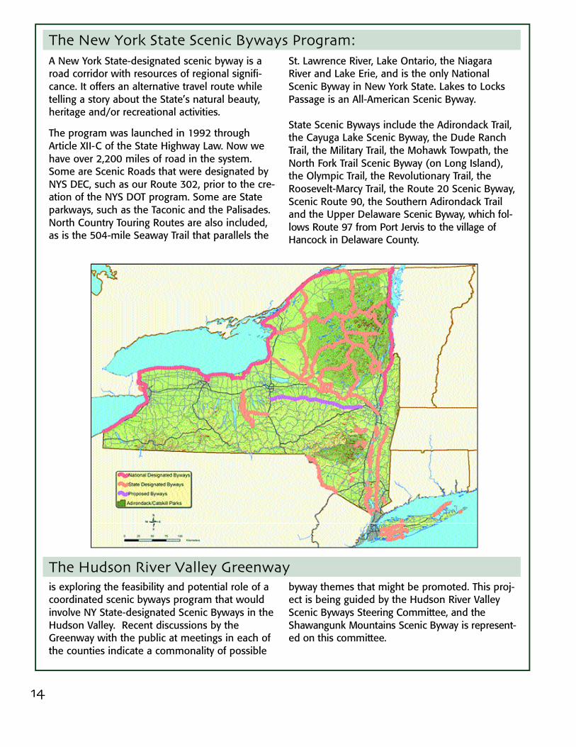
A New York State-designated scenic byway is aroad corridor with resources of regional signifi-cance. It offers an alternative travel route whiletelling a story about the State’s natural beauty,heritage and/or recreational activities.
The program was launched in 1992 throughArticle XII-C of the State Highway Law. Now wehave over 2,200 miles of road in the system.Some are Scenic Roads that were designated byNYS DEC, such as our Route 302, prior to the cre-ation of the NYS DOT program. Some are Stateparkways, such as the Taconic and the Palisades.North Country Touring Routes are also included,as is the 504-mile Seaway Trail that parallels the
St. Lawrence River, Lake Ontario, the NiagaraRiver and Lake Erie, and is the only NationalScenic Byway in New York State. Lakes to LocksPassage is an All-American Scenic Byway.
State Scenic Byways include the Adirondack Trail,the Cayuga Lake Scenic Byway, the Dude RanchTrail, the Military Trail, the Mohawk Towpath, theNorth Fork Trail Scenic Byway (on Long Island),the Olympic Trail, the Revolutionary Trail, theRoosevelt-Marcy Trail, the Route 20 Scenic Byway,Scenic Route 90, the Southern Adirondack Trailand the Upper Delaware Scenic Byway, which fol-lows Route 97 from Po rt Jervis to the village ofHancock in Delaware County.
The New York State Scenic Byways Program:
is exploring the feasibility and potential role of acoordinated scenic byways program that wouldinvolve NY State-designated Scenic Byways in theHudson Valley. Recent discussions by theGreenway with the public at meetings in each ofthe counties indicate a commonality of possible
byway themes that might be promoted. This proj-ect is being guided by the Hudson River ValleyScenic Byways Steering Committee, and theShawangunk Mountains Scenic Byway is represent-ed on this committee.
The Hudson River Valley Greenway
15
The Shawangunk Mountains Scenic Byway:The Shawangunk Mountains Scenic Byway wouldadd to the State Byways system an 82-mile route,strategically located midway between metro NewYork and Albany, and well within a day’s drive forfolks from Philadelphia, Boston and New Jersey.
The Shawangunk Mountains Region, defined bythe Byway loop, would add important resourcesof statewide significance . . . scenic, natural,recreational and historic . . . to the State’s Byways progr a m
Our Goals:1. Build a strong identity for the Shawangunk
Mountains Scenic Byway and Region.
2. Improve the ability of each of the participating communities to benefit from the tourism that is attracted to our Region.
3. Enhance the availability, convenience and safety of multimodal travel throughout the Region, and upgrade the appearance along the Byway right-of-way.
4. Encourage the preservation of the scenic, natural, recreational and historic resources of the Shawangunk Mountains Region.
5. Provide a management entity that will implement the Corridor Management Plan in a manner that respects home rule authority and engages the active participation of all the communities along the route.
Our Vision:The Shawangunk Mountains Scenic Byway will bemanaged by a regional partnership of the eleventowns and villages that encircle the NorthernShawangunk Mountains. This is a coming togetherof the communities that, for thousands of years,have had a common bond with the Shawangunks.
Through this partnership, we seek to add a regi o n a ldimension to the vision and plans created at thelocal level by our towns and villages. Together, westrive to encourage growth and developmentwhile preserving those resources that are essentialto the intrinsic character of our region.
The future we see is one in which:
The Shawangunk Mountains Region will be recog-nized as a distinct region of New York State.
Tourism will be spread throughout the region ratherthan concentrated on the Shawangunk Ridge.
Visitors to our region will be aware of our manyscenic, natural, recreational and historic resourcesand will know how to access them as well as theplaces to dine, stay and shop.
Our recreational resources will be expanded andwill include additional lands on the Ridge, fullerutilization of our waterways, more bicycling, and
public access to greenways linking open spaceareas in the valleys and adjacent to the Ridge.
We will be more aware of the rich history of ourregion and we will have an organized program forthe interpretation and presentation of the vast his-toric resources we have throughout the region.
Our transportation system will be improved, par-ticularly in regard to the New Paltz section, andtraffic will flow smoother and more safely throughcertain intersections. We will have adequateshoulders for the safety of bicycle travel through-out the region. And we will have a more aestheti-cally-pleasing corridor, with improved design andaccess management, graced by landscaping inkeeping with our rural countryside.
We will continue to preserve the unique biodiver-sity and natural landscape of the ShawangunkRidge. We will preserve farmland and other agri-cultural resources. We will be engaged in on-goingimplementation of Open Space plans.
Although more housing will be built in our coun-tryside, the impact of this on our scenic views willbe minimized. We will continue, in particular, toenjoy the scenic views of the Shawangunks andbe reassured of where we are.

16
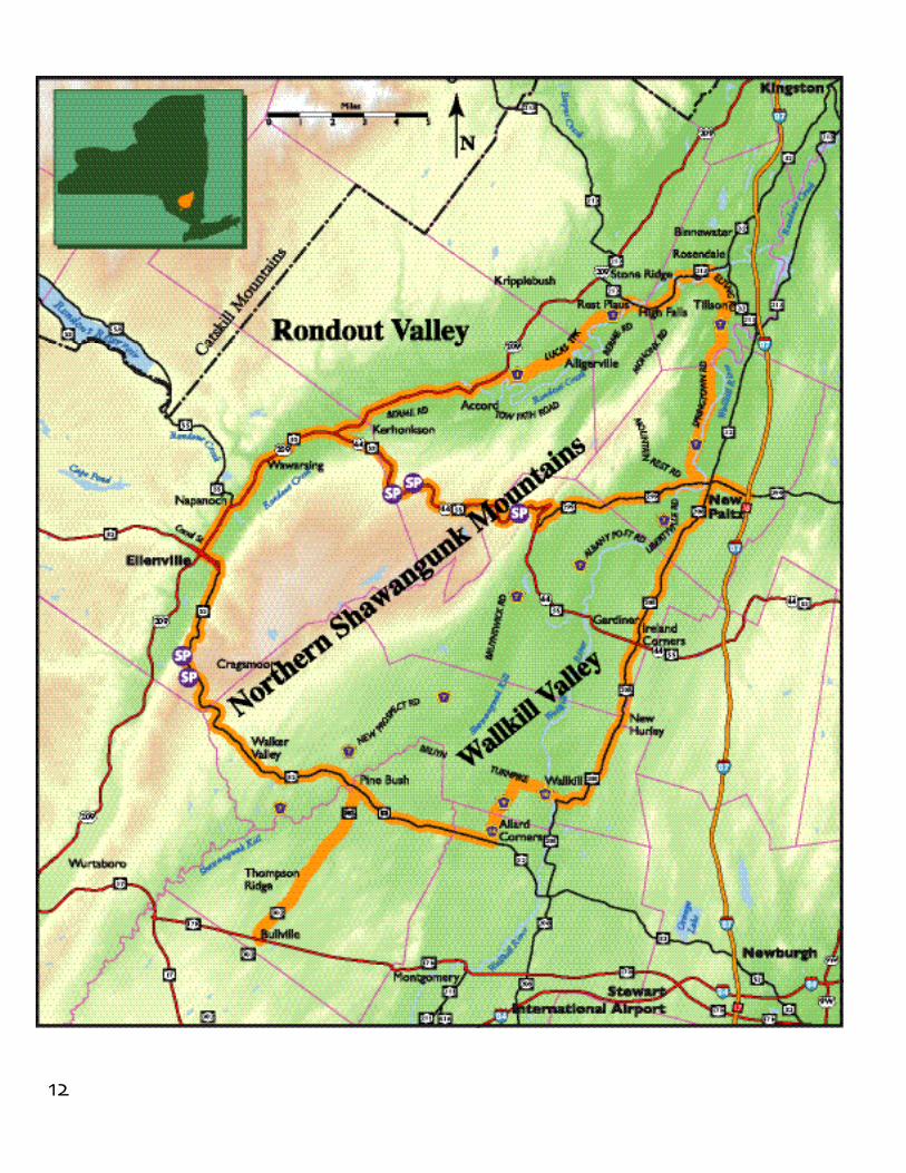
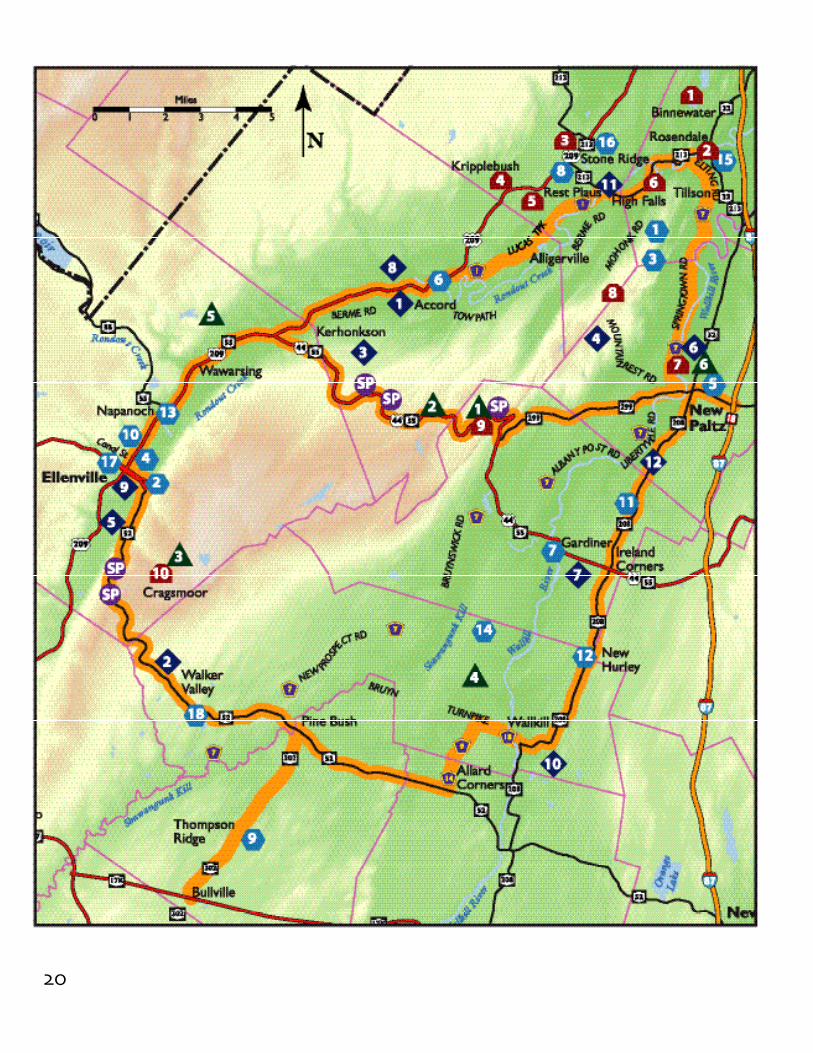
The Route of the Shawangunk Mountains Scenic Byway:82 miles in all, the Byway route follows State and County roads, past mostly rural countryside, throughthe Shawangunk Mountains and down the main streets of our villages and hamlets. The route inter-sects key roads, providing numerous points of access, as mapped and detailed on pages G-2 and G-3.
The overall route may be visualized as a loop with a tail and a bisector. Traveling the route, one seesviews of the mountains from all directions. And the bisector US 44/NY 55 and NY 52 go right overthe mountains.
The 4.1 miles of Route 302 designated by the DEC in 1988 as a State Scenic Road have been integr a t e dinto the Shawangunk Mountains Scenic Byway.
In the future, as growth and other change occurs in the region, it may be desirable to add other roadsections to the route, perhaps as “spurs” to the main route.
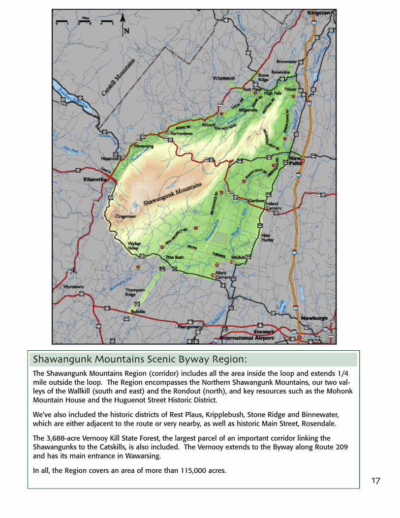
17
Shawangunk Mountains Scenic Byway Region:The Shawangunk Mountains Region (corridor) includes all the area inside the loop and extends 1/4mile outside the loop. The Region encompasses the Northern Shawangunk Mountains, our two val-leys of the Wallkill (south and east) and the Rondout (north), and key resources such as the MohonkMountain House and the Huguenot Street Historic District.
We’ve also included the historic districts of Rest Plaus, Kripplebush, Stone Ridge and Binnewater,which are either adjacent to the route or very nearby, as well as historic Main Street, Rosendale.
The 3,688-acre Vernooy Kill State Forest, the largest parcel of an important corridor linking theShawangunks to the Catskills, is also included. The Vernooy extends to the Byway along Route 209and has its main entrance in Wawarsing.
In all, the Region covers an area of more than 115,000 acres.
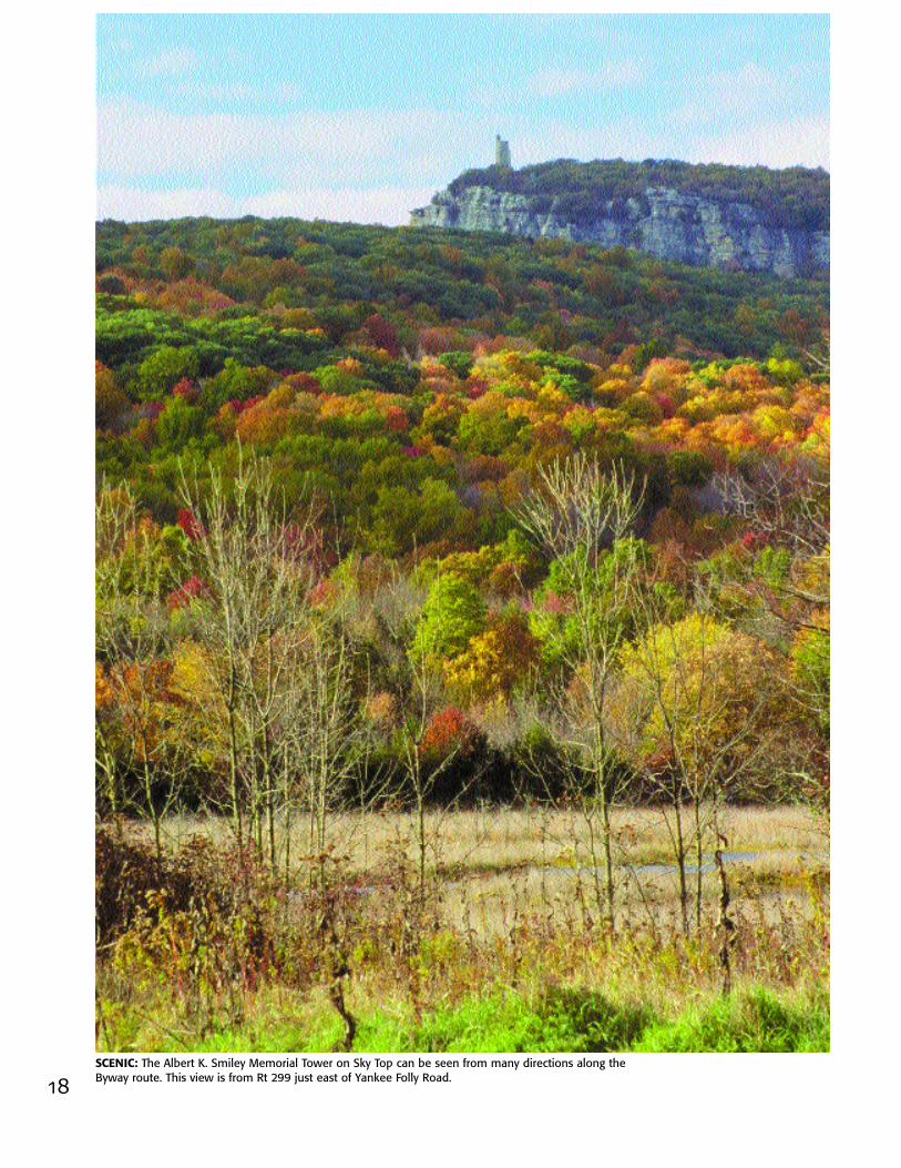
SCENIC: The Albert K. Smiley Memorial Tower on Sky Top can be seen from many directions along theByway route. This view is from Rt 299 just east of Yankee Folly Road.18

The Shawangunk Mountains Scenic BywayR e gion is wonderfully rich in scenic, natural,recreational and historic resources, andmany of these are recognized to be signifi-cant from a state, national and even globalperspective.
The New York State Open Space Plan, c i t e sthe Shawangunks as “one of the highestpriority areas for biodiversity conservation inthe northeastern United States “ and refersto the exemplary natural communities here,several of which are globally rare, such as thed w a rf pitch pine barrens.
A similar rating of our natural resources isvoiced by The Nature Conservancy, whichrefers to the Shawangunks as one of“ E a rth’s Last Great Places.” Two of ourp r eserves, at Sam’s Point and the MohonkPreserve, are registered as NationalNatural Landmarks.
The mountains are the centerpiece of theByway, and are seen from nearly every-where along the route, looking across amostly rural countryside of farm fields andforests. The result is a visual harmony: scenicviews which are among the most pleasingNew York State has to offer.
The recreational resources take us outdoorsto enjoy these views, with over 250 miles ofhiking, about 100 miles of mountain b i k i n gand nearly 150 miles of cross-country skiing.And more rock climbers come to the“ G u n k s ” than Yosemite or any place else inthe United States.
With 56 listings on the National Register ofHistoric Places, the Byway Region hash i s t o r i c resources that are very much a partof our scenic landscape. These includemany wonderful stone houses built in thelate 1600's and nine historic districts.
ResourceOverview
19
RECREATIONAL: Hiking along the D&H Canal Five Locks Walk in High Falls combinesscenic recreation with a sense of history.
HISTORIC: Bevier-Elting House (1698) in the Huguenot Street National Historic LandmarkDistrict, one of 56 listings on the National Register. Hugenot Historical Society Photo.
NATURAL: Lake Minnewaska and cliffs of erosion-resistantShawangunk conglomerate, formed about 420 million years ago.
20

21
Scenic Pulloffs (5)
Preserves1. Mohonk Preserve2. Minnewaska State Park Preserve3. Sam’s Point Preserve4. Shawangunk Grasslands
National Wildlife Refuge5. Vernooy Kill State Forest6. Harcourt Wildlife Sactuary
Recreational Areas
1. D&H Canal Heritage Corridor2. Hang gliding3. Hudson Valley Resort and Spa4. Mohonk Mountain House5. Nevele Grande Resort6. New Paltz Golf Course7. Ranch Parachute Club8. Rondout Golf Club9. Shawangunk Country Club10. Shawangunk Town Rail Trail11. Stone Dock Golf Course12. Wallkill Valley Rail Trail
Historic Districts
1. Binnewater Historic District2. Snyder Estate Historic District3. Main Street Historic District in Stone Ridge4. Kripplebush Historic District5. Rest Plaus Historic District6. High Falls Historic District7. Huguenot Street National
Historic Landmark District8. Lake Mohonk National Historic Landmark9. Trapps Mountain Hamlet Historic District10. Cragsmoor Historic District
Historic Sites with Public Access
1. D&H Canal Museum2. D&H Canal Ticket Office3. Depuy Canal House4. Ellenville Village Square & PO5. Elting Library6. Friends of Historic Rochester
Museum & Meeting Room7. Gardiner School8. Hasbrouck House9. Hopewell Presbyterian Church10. Hunt Memorial Building11. Kettleborough Schoolhouse12. New Hurley Reformed Church13. O&W Railroad Station14. Reformed Church of Shawangunk15. Rosendale Library16. Stone Ridge Library17. Terwilliger House Museum18. Walker Valley Methodist Church
Major Resources of the Shawangunk Mountains Region
22
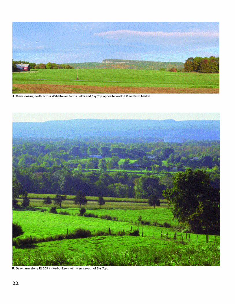
A. View looking north across Watchtower Farms fields and Sky Top opposite Wallkill View Farm Market.
B. Dairy farm along Rt 209 in Kerhonkson with views south of Sky Top.

23
Scenic ResourcesThe views shown in the photographs inthis section are representative of the areaand give the reader an idea of what isseen as one travels around the Byway.The photos are keyed to the map locationson page 27. Photos of the scenery alongeach section of the Byway route and with-in the Region are provided in the Guide,which follows page 53.
By encircling the Shawangunks, the Bywayoffers pleasing views of the mountainsfrom every direction, and from near anda f a r. The hard white Shawangunk con-glomerate rock, exposed and visiblethroughout the ridge, identifies thesemountains. As one travels the route, thedifferences in the mountains from oneplace to another become evident. An alertobserver is able to piece these togetherand mentally construct a visual montageof the entire expanse of the ridge.
The views of the mountains depend a l o ton the agriculture and rural countrysidewe are still fortunate to enjoy here. Welook out across orchards, rows of fieldand sweet corn, other vegetables, hayfields and pastures. And our eyes take inthe farm houses, barns, silos and sheds,the fences, wagons and machinery, thelivestock and horses.
Although we are experiencing muchchange and population growth, this is stillvery much a rural countryside, with smallvillages and hamlets. In commercial areas,we have managed to avoid large stretchesof out-of-character development. A n d ,even in the built-up areas, the traveler i sable to enjoy views of the Shawangunksand, off to the north and west of us, theCatskills.
The overall effect is one of harmony, avisual cohesiveness of the mountains withthe surrounding rural countryside.
We still have this beauty here.
C. Rondout Creek from Rt 7 in Rosendale with old Wallkill Valley RR bridge.
D. Escarpment from Rt 299 by Jenkins-Luekins Orchards looking west.

24
F. Wallkill River flowing north toward the hamlet of Wallkill.
E. Pulloffs on Rts 44/55 and Rt 52 offer views of the Catskills.
25
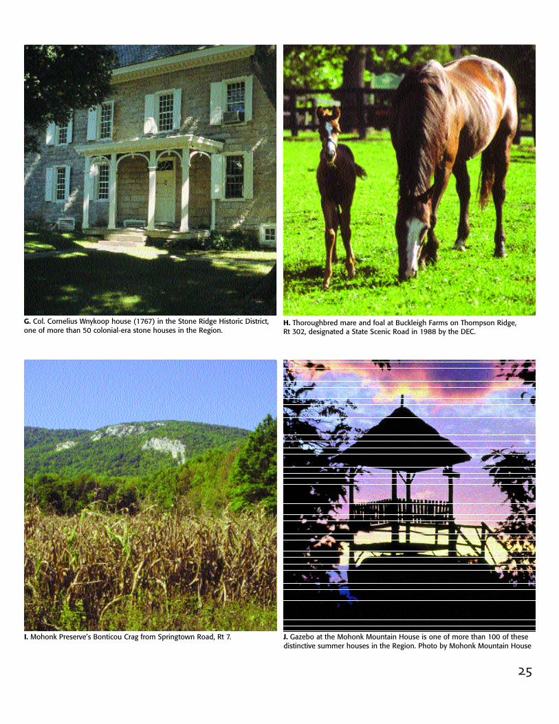
G. Col. Cornelius Wnykoop house (1767) in the Stone Ridge Historic District,one of more than 50 colonial-era stone houses in the Region.
J. Gazebo at the Mohonk Mountain House is one of more than 100 of thesedistinctive summer houses in the Region. Photo by Mohonk Mountain House
I. Mohonk Preserve’s Bonticou Crag from Springtown Road, Rt 7.
H. Thoroughbred mare and foal at Buckleigh Farms on Thompson Ridge, Rt 302, designated a State Scenic Road in 1988 by the DEC.

26
L. Escarpment, looking northwest over orchards and farm buildings along Rt 208 just south of Rts 44/55.
K. View to east from Rt 209 in Napanoch of Ridge rising above harvested cornfields of Eastern New York Correctional Facility.

27
Scenic Resources

28
Summer sun sets behind the Trapps at the Mohonk Preserve.
The Peterskill in autumn at the Minnewaska State Park Preserve.

29
Natural ResourcesT HE NORTHE RN S H AWA N G UNK MOUNTAINSstretch 18 miles across the Byway regionin a south-westerly direction from theRondout Creek at Route 213 in Rosendaleto below Sam’s Point just beyond Route52. From here south the mountains areless imposing and are known as theSouthern Shawangunks in SullivanCounty, the Kittatinny Mountains in New Jersey and the Blue Mountains in Pennsylvania.
In our Region, the most obvious featureof the mountains is the southeast-facing,stark white, sharp-edged cliffs that arevisible for miles around. Put on a goodpair of hiking boots and you’ll find oldfarm fields leading into spacious forestswith giant boulders and rock slabs, fiveglacier-formed lakes, and many clearstreams or “kills”, some plunging off theedge of cliffs as powerful waterfalls. Walkquietly and look closely and you may seeplants and wildlife you have never seenbefore. Continue on and you’ll reachb a rren windswept ridgetops with strug-gling pitch pines, and here, in this open-ness, you may discover the wonder ofbeing surrounded by nature.
Naturalists and others have studied theShawangunks for over 100 years andhave reached some conclusions aboutthese 94,000 acres that are worthy ofnotice.
John Burroughs, who visited here oftenin the late 1800’s, felt there was “nothingelse like it in the whole country.”
Active on the ridge since 1972, TheNature Conservancy has named theNorthern Shawangunks one of “Earth’sLast Great Places.”
continue . . .
Verkeerderkill Falls, the highest waterfalls in the Shawangunks, at theSam’s Point Preserve.
Photos by Steve Jordan

30
Castle Rock at Minnewaska State Park Preserve.
Mountain Laurel grows throughout much of the Shawangunks.
Photos by Steve Jordan
31
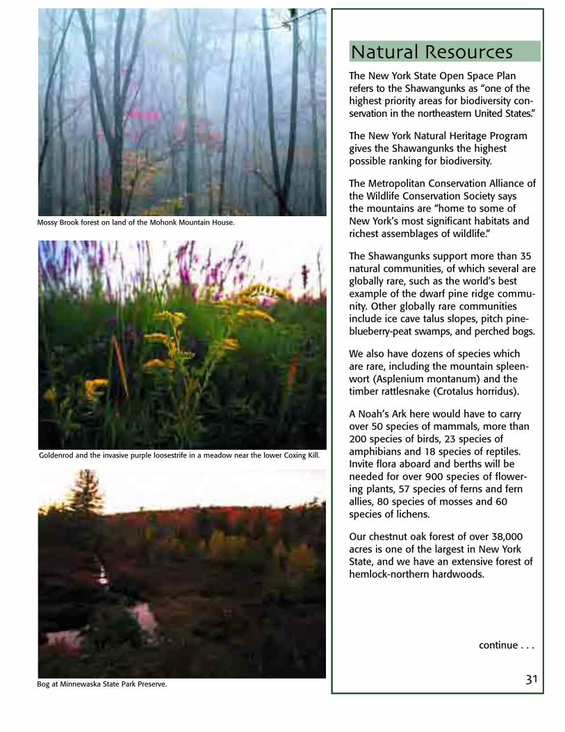
Natural ResourcesThe New York State Open Space Planrefers to the Shawangunks as “one of thehighest priority areas for biodiversity con-servation in the northeastern United States.”
The New York Natural Heritage Programgives the Shawangunks the highest possible ranking for biodiversity.
The Metropolitan Conservation Alliance ofthe Wildlife Conservation Society saysthe mountains are “home to some ofNew York’s most significant habitats andrichest assemblages of wildlife.”
The Shawangunks support more than 35natural communities, of which several areglobally rare, such as the world’s bestexample of the dwarf pine ridge commu-n i t y. Other globally rare communitiesinclude ice cave talus slopes, pitch pine-blueberry-peat swamps, and perched bogs.
We also have dozens of species whichare rare, including the mountain spleen-wort (Asplenium montanum) and thetimber rattlesnake (Crotalus horridus).
A Noah’s Ark here would have to carryover 50 species of mammals, more than200 species of birds, 23 species ofamphibians and 18 species of reptiles.Invite flora aboard and berths will beneeded for over 900 species of flower-ing plants, 57 species of ferns and fernallies, 80 species of mosses and 60species of lichens.
Our chestnut oak forest of over 38,000acres is one of the largest in New YorkState, and we have an extensive forest ofhemlock-northern hardwoods.
continue . . .
Mossy Brook forest on land of the Mohonk Mountain House.
Goldenrod and the invasive purple loosestrife in a meadow near the lower Coxing Kill.
Bog at Minnewaska State Park Preserve.
32
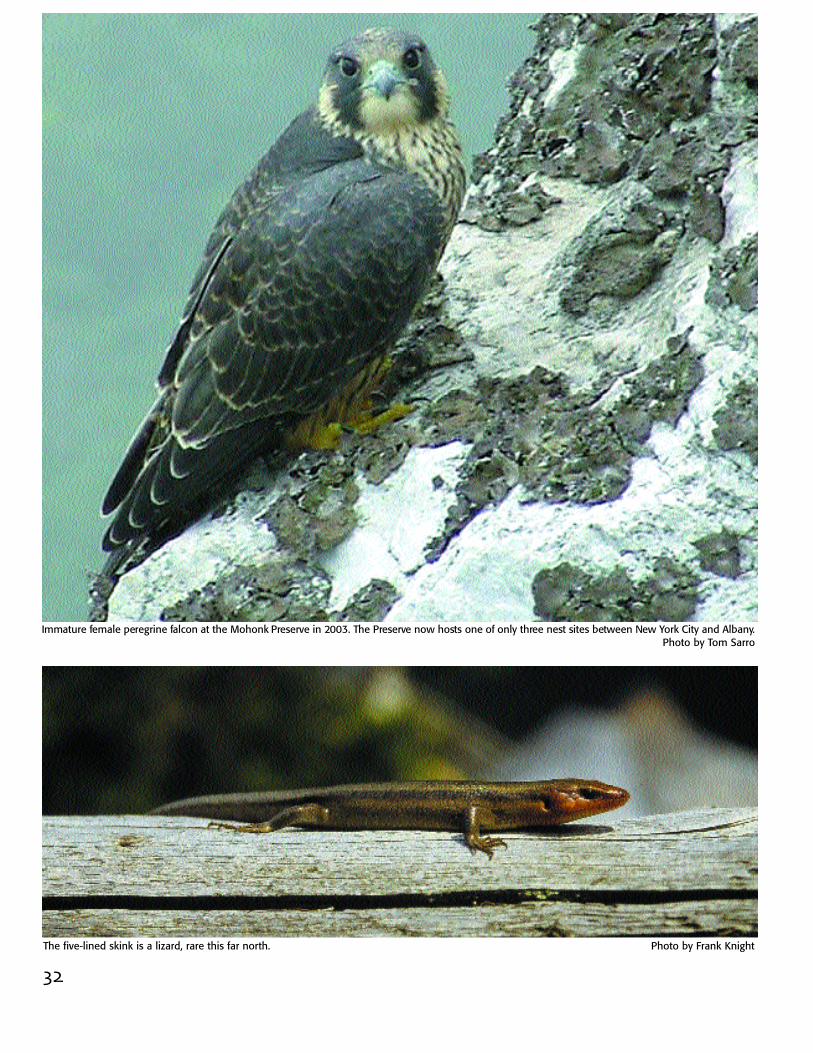
Immature female peregrine falcon at the Mohonk Preserve in 2003. The Preserve now hosts one of only three nest sites between New York City and Albany.Photo by Tom Sarro
The five-lined skink is a lizard, rare this far north. Photo by Frank Knight

33
Natural ResourcesThe ridge is part of the AppalachianFlyway for migrating birds and theMonarch Butterfly. Vultures, eagles andnine species of hawks fly here, includingred-shouldered and Cooper’s hawks,which have been in decline in theHudson Valley but are showing somesigns of comeback here. Also found hereare the bald eagle and the black vulture,the raven, coyote and the fisher. Andthree peregrine falcon chicks fledgedhere in 2003. They’re another speciesthat nearly disappeared from the nort h e a s t .
Paul Huth, Director of the Daniel SmileyResearch Center of the Mohonk Preserve,has observed this return of nativespecies, and the arrival of new specieswhich are extending their range, such asthe clay-colored sparrow, a prairie nester.In his mind, these trends demonstratethat the unique biological character andrelatively unfragmented landscape of theShawangunks offer the potential for natural processes to continue to evolve,leading to more wildness than was hereyears ago.
If so, that would bode well for the futureof one of the most scenic and biologi-cally unique natural resources in NewYork State . . . and the centerpiece of theShawangunk Mountains Scenic Byway.
Rare pitch pine-blueberry-peat swamp at Sam’s Point. Photo by The Nature Conservancy
Eastern Swallowtail at Sam’s Point. Photo by The Nature Conservancy
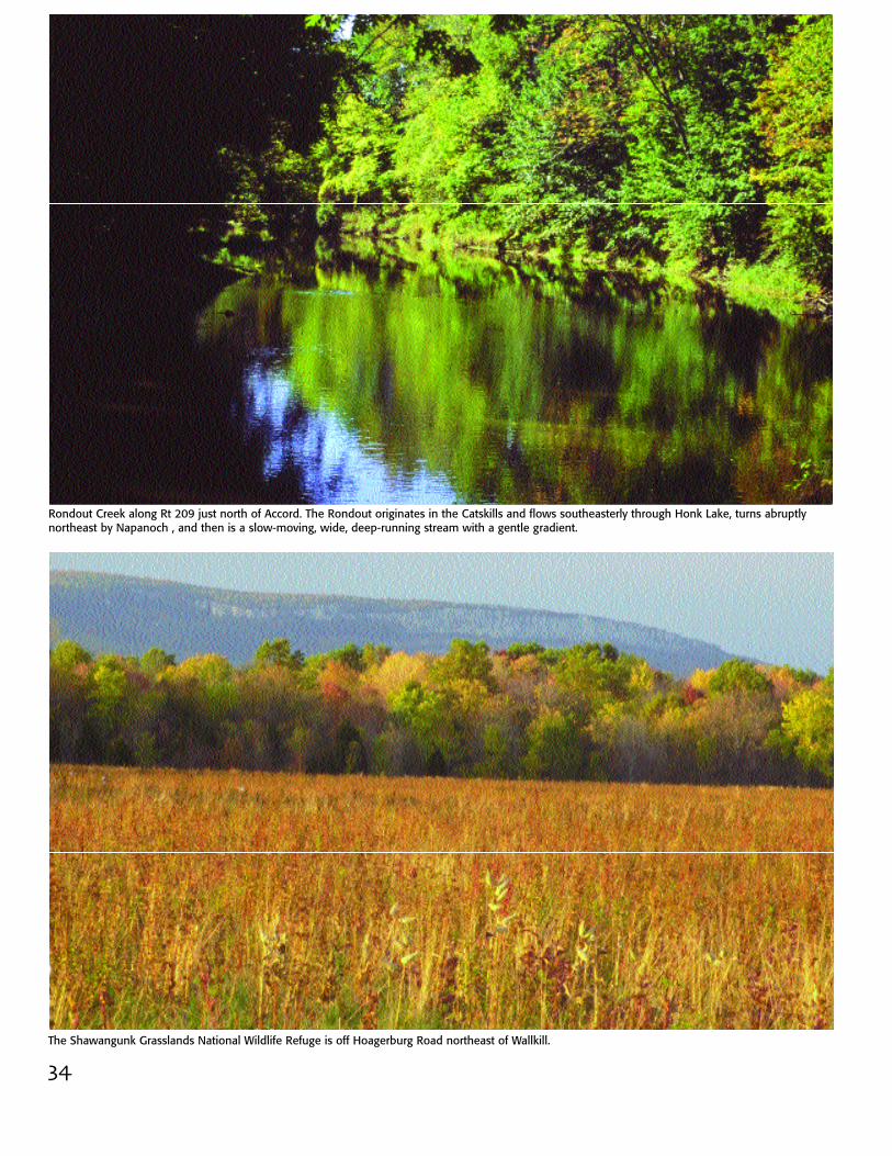
Rondout Creek along Rt 209 just north of Accord. The Rondout originates in the Catskills and flows southeasterly through Honk Lake, turns abruptlynortheast by Napanoch , and then is a slow-moving, wide, deep-running stream with a gentle gradient.
34The Shawangunk Grasslands National Wildlife Refuge is off Hoagerburg Road northeast of Wallkill.
35
Other Natural ResourcesThe Rondout Creek, the Wallkill River andthe Shawangunk Kill (a DEC-designatedRecreational River) are the main water-ways which flow through our valleys andempty into the Hudson River, just 15miles east of the mountains.
The Shawangunk Grasslands NationalWildlife Refuge is under the managementof the U.S. Fish and Wildlife Service andprovides 566 acres of habitat for gr a s s l a n d -dependent birds. Also see pages G60-61.
The Vernooy Kill State Forest, managed bythe New York State Department ofEnvironmental Conservation, provides3,688 acres which will link theShawangunks to the Catskills. Also see pages G50-51.
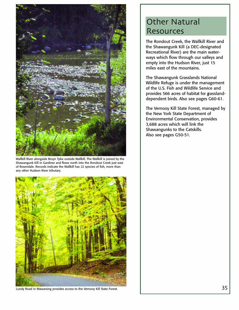
Wallkill River alongside Bruyn Tpke outside Wallkill. The Wallkill is joined by theShawangunk Kill in Gardiner and flows north into the Rondout Creek just eastof Rosendale. Records indicate the Wallkill has 22 species of fish, more thanany other Hudson River tributary.
Lundy Road in Wawarsing provides access to the Vernooy Kill State Forest.
36
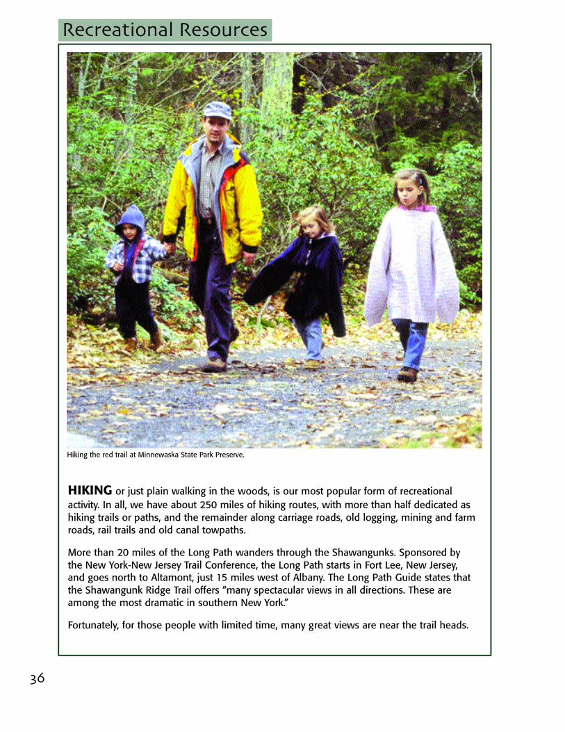
HIKING or just plain walking in the woods, is our most popular form of recreationalactivity. In all, we have about 250 miles of hiking routes, with more than half dedicated ashiking trails or paths, and the remainder along carriage roads, old logging, mining and farmroads, rail trails and old canal towpaths.
More than 20 miles of the Long Path wanders through the Shawangunks. Sponsored bythe New York-New Jersey Trail Conference, the Long Path starts in Fort Lee, New Jersey,and goes north to Altamont, just 15 miles west of Albany. The Long Path Guide states thatthe Shawangunk Ridge Trail offers “many spectacular views in all directions. These areamong the most dramatic in southern New York.”
Fortunately, for those people with limited time, many great views are near the trail heads.
Recreational Resources
Hiking the red trail at Minnewaska State Park Preserve.
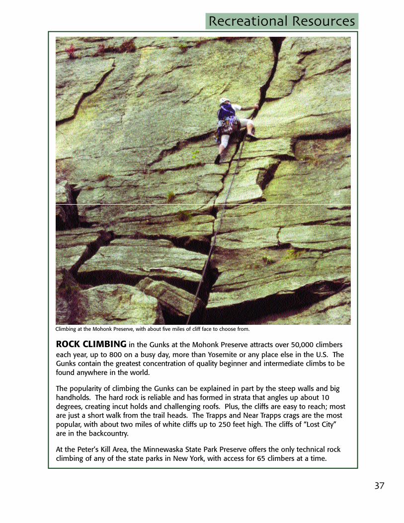
ROCK CLIMBING in the Gunks at the Mohonk Preserve attracts over 50,000 climberseach year, up to 800 on a busy day, more than Yosemite or any place else in the U.S. Th eGunks contain the greatest concentration of quality beginner and intermediate climbs to befound anywhere in the world.
The popularity of climbing the Gunks can be explained in part by the steep walls and bighandholds. The hard rock is reliable and has formed in strata that angles up about 10degrees, creating incut holds and challenging roofs. Plus, the cliffs are easy to reach; mostare just a short walk from the trail heads. The Trapps and Near Trapps crags are the mostpopular, with about two miles of white cliffs up to 250 feet high. The cliffs of “Lost City”are in the backcountry.
At the Peter’s Kill Area, the Minnewaska State Park Preserve offers the only technical rockclimbing of any of the state parks in New York, with access for 65 climbers at a time.
37
Recreational Resources
Climbing at the Mohonk Preserve, with about five miles of cliff face to choose from.
Recreational Resources
38
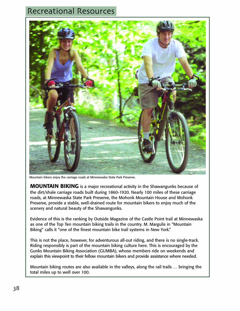
MOUNTAIN BIKING is a major recreational activity in the Shawangunks because ofthe dirt/shale carriage roads built during 1860-1920. Nearly 100 miles of these carriageroads, at Minnewaska State Park Preserve, the Mohonk Mountain House and MohonkPreserve, provide a stable, well-drained route for mountain bikers to enjoy much of thescenery and natural beauty of the Shawangunks.
Evidence of this is the ranking by Outside Magazine of the Castle Point trail at Minnewaskaas one of the Top Ten mountain biking trails in the country. M. Margulis in “MountainBiking” calls it “one of the finest mountain bike trail systems in New York.”
This is not the place, however, for adventurous all-out riding, and there is no single-track.Riding responsibly is part of the mountain biking culture here. This is encouraged by theGunks Mountain Biking Association (GUMBA), whose members ride on weekends andexplain this viewpoint to their fellow mountain bikers and provide assistance where needed.
Mountain biking routes are also available in the valleys, along the rail trails … bringing thetotal miles up to well over 100.
Mountain bikers enjoy the carriage roads at Minnewaska State Park Preserve.
Recreational Resources
39
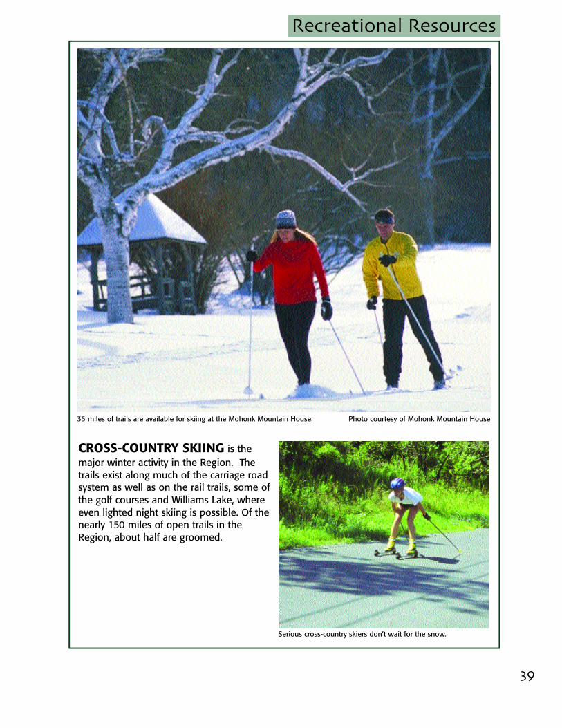
CROSS-COUNTRY SKIING is themajor winter activity in the Region. Thetrails exist along much of the carriage roadsystem as well as on the rail trails, some ofthe golf courses and Williams Lake, whereeven lighted night skiing is possible. Of thenearly 150 miles of open trails in theRegion, about half are groomed.
Photo courtesy of Mohonk Mountain House
Serious cross-country skiers don’t wait for the snow.
35 miles of trails are available for skiing at the Mohonk Mountain House.
40
Photo by Hatti Langsford
41
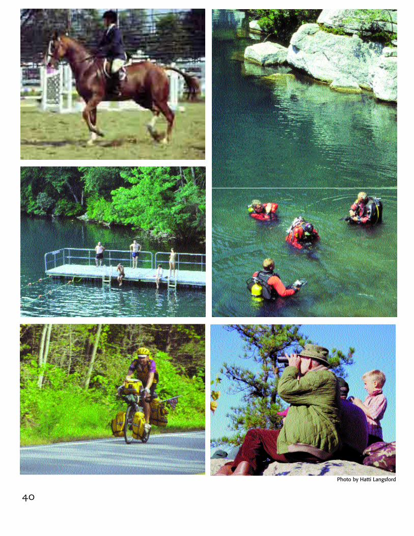
Recreational ResourcesHORSEBACK RIDING also follows along m o s tof the carriage road and rail trail systems.Horses may be trailered to Minnewaska andthe Mohonk Preserve or rented at the MohonkMountain House or Nevele Grande. Manyboarding, breeding and training farms are inthe Region.
SCUBA DIVING for certified divers with a per-mit is available at Lake Minnewaska.
SWIMMING is enjoyed at Lake Minnewaskaand Lake Awosting and at the M o h o n kPreserve’s Split Rock on the Coxing Kill.
ROAD BIKING is enjoyed throughout theRegion, although the lack of shoulders onsome roads limits bike use.
BIRD WATCHING is enjoyed throughout theRegion, with the preserves sponsoring g u i d e doutings. The Shawangunks are part of theAppalachian Flyway for migrating birds and ishome once again to Peregrine Falcons. TheShawangunk Grasslands National WildlifeRefuge has been designated as an I m p o rt a n tBird Area by Audubon, New York.
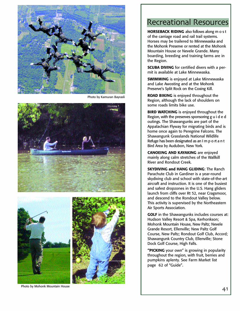
CANOEING AND KAYAKING are enjoyedmainly along calm stretches of the WallkillRiver and Rondout Creek.
SKYDIVING and HANG GLIDING: The RanchParachute Club in Gardiner is a year-roundskydiving club and school with state-of-the-artaircraft and instruction. It is one of the busiestand safest dropzones in the U.S. Hang gliderslaunch from cliffs over Rt 52, near Cragsmoor,and descend to the Rondout Valley below.This activity is supervised by the NortheasternAir Sports Association.
GOLF in the Shawangunks includes courses at:Hudson Valley Resort & Spa, Kerhonkson;Mohonk Mountain House, New Paltz; NeveleG r a n d e Resort, Ellenville; New Paltz GolfCourse, New Paltz; Rondout Golf Club, Accord;Shawangunk Country Club, Ellenville; StoneDock Golf Course, High Falls.
“PICKING your own” is growing in popularitythroughout the region, with fruit, berries andpumpkins aplenty. See Farm Market list page 62 of “Guide”.
Photo by Kamuran Bayrasli
Photo by Mohonk Mountain House
Trails in the Wallkill and Rondout ValleysWallkill Valley Rail Trail12.2 miles of linear park from theShawangunk/Gardiner town line to theNew Paltz/Rosendale line. Views ofmountains, Wallkill River and crossesold railroad bridge.
D&H Canal Heritage Corridor AllianceA cooperative effort of towns in theRondout Valley to develop a 35 milel i near park. The path will follow theDelaware & Hudson Canal route fromEllenville to Accord. North of Accord,one arm follows the old Ontario &Western Railroad route to Kingston,while another arm is planned to go inan easterly direction, in the vicinity ofthe old canal, toward High Falls andRosendale.
Shawangunk Town Rail Trail 4.5 miles of rail trail with access in thevillage of Wallkill.
Harcourt Wildlife SanctuaryLocated in New Paltz betweenHuguenot Street historic district and theWallkill River. A one-mile loop throughabout 40 acres of wetlands, open fieldsand floodplain.
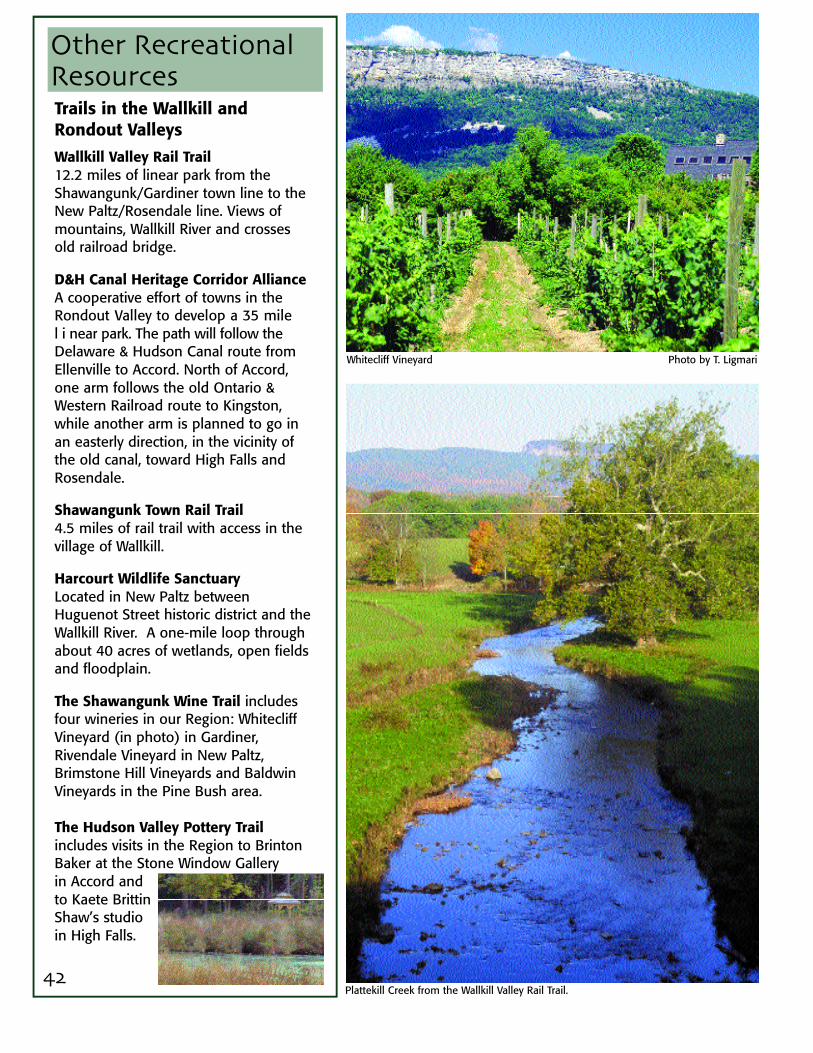
The Shawangunk Wine Trail includesfour wineries in our Region: WhitecliffVineyard (in photo) in Gardiner,Rivendale Vineyard in New Paltz,Brimstone Hill Vineyards and BaldwinVineyards in the Pine Bush area.
The Hudson Valley Pottery Trailincludes visits in the Region to BrintonBaker at the Stone Window Gallery in Accord andto Kaete BrittinShaw’s studioin High Falls.
42
Whitecliff Vineyard Photo by T. Ligmari
Plattekill Creek from the Wallkill Valley Rail Trail.
Other Recreational Resources

D&H Canal Museum in High Falls .
Carrying water as in the 1700's at the Huguenot Street National Historic LandmarkDistrict, one of the oldest streets in America with the original stone houses. Photo courtesy Huguenot Street Historical Society
On the following several pages, our histo-rian, Wendy E. Harris, has sketched thehistory of the region going back hundredsof years. Many of our historical resourcesare shown in photographs that accompa-ny the text.
We are fortunate to have much to photo-graph. Many of the early Dutch-style stonehouses built here in the colonial era sur-vive throughout the region. In fact, of the56 listings on the National Register, 13were built in the early 1700's or before.
Many listings are farmsteads, such as theVan Wagenen stone house (1751) andfarm complex in the Rondout Valley andthe Johannes Decker stone house (1726)and farmstead in the Wallkill Valley.
Much of our history involves the industriesthat were here for many years. The NationalRegister includes sites with artifacts andremains of the D&H Canal at High Fallsand Ellenville, the cement industry at theSnyder Estate Natural Cement HistoricDistrict and the Binnewater HistoricDistrict in Rosendale, the O&W Railroad inWawarsing, and the Tuthilltown Gristmill inGardiner.
In addition to these historic resources ofnational significance, we have many listedon the state and county registers. Furtherdetail and discussion of historic resourcesare included in the Guide.
Historical Resources
43
44
Historical Resources
The history of the Shawangunk MountainsRegion goes back to about 11,500 years ago,when the last glaciers were receding fromthe landscape and the Native Americanswho lived here traveled back and forth overthe ridge between the two rivers that givethe Wallkill and Rondout valleys their names.
For thousands of years, Native American s e t-tlement was shaped by waterways whichserved as travel and trade routes, f i s h i n gareas, pathways for following game and sitesfor cultivation. Our rivers were said to be“lined with corn-planting grounds”.
Evidence also indicates that the ridge itselfwas an especially attractive area for theregion’s original inhabitants, perhaps forhunting and gathering various foodstuffssuch as berries, nuts and medicinal plants.
The ridge must have been an importantlandmark in a world of footpaths and rivers,visible from the Hudson River as well asfrom the mountains lying to the n o rt h w e s t .Native American travelers followed a num-ber of trails over the ridge. One such foot-path, the “Old Wawarsing Trail,” connectedNative American settlements on either sideof the mountain and crossed the steep east-ward facing escarpment at a break nearIndian Cave, passed close by Lake Awosting,and finally reached the Rondout floodplainjust outside of the hamlet of Wawarsing. Thealignments of other trails became the b a s i sfor many modern roadways including Route209, Route 52, and Routes 44/55.
The first Europeans arrived in Kingston in theearly 1650’s. Although we are now accus-tomed to defining the region’s early s e t t l e r sas “Dutch,” only a portion actually came fromthe Netherlands. The settlers, in fact, encom-passed a heterogeneous mixture of French,Walloon, German, Flemish, Scandinavian,and English heritage.
During these first years, the settlers and theirNative American (Esopus) neighborsattempted a peaceful co-existence. Theseefforts, however, were almost immediatelydoomed by conflicting concepts of landownership.
Tensions culminated in the First and SecondEsopus Wars, spanning the years 1659 to1664. During the wars, the settlers pursuedthe Esopus down the Wallkill and theRondout rivers. It was during these expedi-tionary journeys that the s e ttlers may have first fully grasped theregion’s enormous agricultural potential.
English forces conquered New Netherland in1663 and in 1668 English soldiers atKingston were awarded portions of landwithin present day Marbletown.
Other settlements soon followed. In 1677,portions of the towns of New Paltz, Lloyd,Esopus, and Rosendale were granted to 12French Huguenots who moved from Hurleyto New Paltz and began building homes in1678. Settlers are believed to have been inthe Town of Shawangunk as early as the1680’s and by 1700 settlers were living inWawarsing.
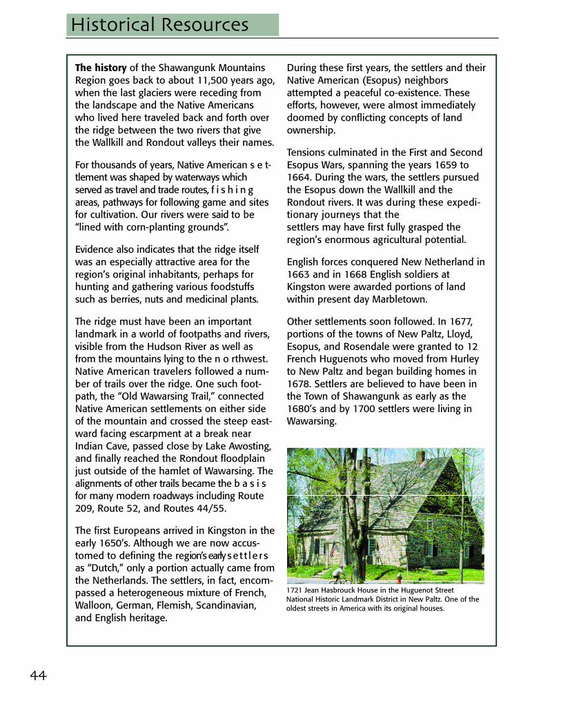
1721 Jean Hasbrouck House in the Huguenot StreetNational Historic Landmark District in New Paltz. One of theoldest streets in America with its original houses.

45
By the beginning of the 18th century, thefarms and villages had completely trans-formed the lands of the Esopus. Dutch archi-tecture, religion and language were perva-sive throughout the region well into the mid-dle third of the 18th century. Even NewPaltz’s French Huguenots came to speakDutch before switching over to English at theend of the century.
Perhaps the most lasting legacy of the Dutchand French Huguenots are the homes theybuilt of native limestone. Many of thesestructures can be found today along theregion’s roadways, on remote farmsteads, orclustered together in the older villages
Although early settlers were involved in thel u c r ative fur trade, it was apparent from thevery beginning that the region’s “real riches”lay in the lowlands adjoining the WallkillRiver and Rondout Creek. As early as 1683,wheat and other produce were grown formarket, including trade with both New Yorkand the West Indies. The fields to the northof New Paltz, especially in an area called“Bontecoe,” became famous for wheatp r oduction.
The milling of grain was a vital economicfunction. Thus, the presence of waterwaysthat could furnish hydropower influenced thelocation of Euro-American settlements in theregion. The unbroken forests and barrens of
the Shawangunks fed numerous streams thatflowed down the ridge’s slopes, joining theRondout, the Wallkill and the ShawangunkKill. In what is now the Town of Gardiner, theearliest recorded settlement was at
Tuthilltown where a mill was built upon theShawangunk Kill in 1745. Settlement in theTown of Crawford began in the mid-18thcentury, clustered around a series of mills onthe Dwaars Kill and Shawangunk Kill. In thetown of Shawangunk, hydropower alsoplayed a major role in the settlement ofBrunswyck, Dwaarskill and Wallkill.
On the western side of the ridge, in the To w nof Rochester, a cluster of mills developed on
Historical Resources
1770 stone and frame house in the Main Street NationalHistoric District serves now as the Stone Ridge Library.
1788 Tuthilltown Grist Mill.Photo by Tuthilltown/Erenzo
Van Wagenen stone house in the town of Rochester.
46
Historical Resources
the Stony Kill and Peters Kill, tributaries of theR o n d o u t that drained the Shawangunks’western slope. The first gristmill in the Townof Wawarsing dates to 1702. It was con-structed on the Vernooy Kill.
Many of the region’s early “service indus-tries” —such as taverns, inns, blacksmiths,brewers—grew up along the early road sys-tem, especially at crossroads and fordingplaces. Like mills, these facilities attractedsmall communities, often accompanied by aDutch Reformed Church. In the narrow
Rondout Valley, settlement was focusedupon a single roadway, the Old Mine Road(corresponding to present day Route 209).Like most roads of the time, the Old MineRoad followed an ancient Native Americantrail. By the 1730’s, farmers as far away asPennsylvania and western New Jersey fol-lowed the Old Mine Road to the HudsonRiver at Kingston, where they loaded theirproduce on New York City-bound sloops.
In the Wallkill Valley, several early roadwayswere oriented east/west to take advantageof Hudson River landings. The BruynTurnpike is said to date to the 1690’s. Theprincipal north/south route, opened in 1735,was the Old Kings Road—running throughKingston, New Paltz, and “the ShawangunkPrecinct” before finally reaching Goshen inOrange County (portions corresponding topresent day County Route 7). Because theKing’s Road followed the west bank of theWallkill River, New Paltz residents could con-nect with it only by crossing the Wallkill byscow. Another road was built on the eastbank of the Wallkill River leading south by1790 (corresponding to Plains Road andRoute 208).
As the two valleys became more populatedand good farmland scarce, a small number offamilies were drawn to the few locations onthe Shawangunk Ridge where the soils couldsupport agriculture. By the end of the 18thcentury, there were three communities onthe ridge: Trapps Hamlet, within what is nowthe Mohonk Preserve; and the Mance andGoldsmith Settlements, near what is nowCragsmoor. Mountain residents raised sheepand grew flax to provide wool and linen.They raised cattle to provide leather for theirclothing and equipment. Hunting and trap-ping were pursued for both sustenance andcurrency.
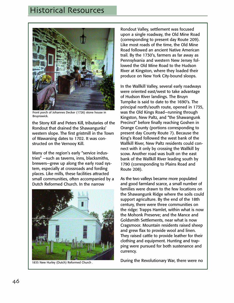
During the Revolutionary War, there were no1835 New Hurley (Dutch) Reformed Church .
Front porch of Johannes Decker (1726) stone house inBruynswick.

47
Historical Resources
engagements here between the warringarmies. But in the spring of 1779, Tories,Hessians and Iroguois attacked the settle-ment at Fantinekill, near present dayEllenville. This was followed by murders andraids in the Town of Shawangunk and on theridge in 1780, and the destruction ofWarwarsing in 1781.
General George Washington did indeed sleephere. On November 15, 1782 he stopped forthe night in Stone Ridge at the Wynkoop-Lounsbery House on his way to Kingston. Histroops spent the evening at the Tack Ta v e r n .Both structures are still standing.
The event that marked the region’s entry intothe industrializing world of the 19th centurywas the completion of the Delaware andHudson Canal in 1828. Built to carryanthracite coal from northeasternPennsylvania to New York City, the D&H pre-sented what seemed to be limitless econom-ic opportunities to many rural communities.Villages lucky enough to be located along thecanal’s route thrived. Others sprang upalmost overnight, owing their existences tothe canal. Within the region, these self-described “canal towns” included Ellenville,Napanoch, Port Hixon, Port Ben (EastWawarsing), Middleport (Kerhonkson), PortJackson (Accord), Alligerville, High Falls,Lawerenceville and Rosendale.
Cheap transportation via the canal openedm a r k e t s for a wide range of local productsand resources. From the slopes of theShawangunks came lumber, cordwood,c h a rcoal, shingles, hoop poles and mill-stones. Agricultural products included fruit,grain, and flour. New factories opened alongthe canal’s route. Ellenville and Napanochwere transformed into industrial centers.Their products included pottery, axes, glass,iron, leather, paper and cutlery. Support serv-ices for the canal included stores, hotels,boarding houses, taverns, and harness andblacksmith shops. A number of communit i e s ,
1767 Col. Cornelius Wynkoop stone house where GeorgeWashington stayed in Stone Ridge.
Typical canal barge crew quarters at D&H Canal Museum inHigh Falls.
Canal museum guide demonstrates how locks worked.

48
Historical Resources
especially Ellenville, developed boat-build-ing facilities.
Perhaps the most significant industry associ-ated with the canal was the manufacture ofhydraulic cement, also known as Rosendalecement. Hydraulic cement was critical to thecanal’s construction because it was not sol-uble in water. Due either to luck or the inter-vention of a geologist employed by the canalcompany, limestone beds discovered in thevicinity of High Falls and Rosendale in 18 25were found to produce a superior qualityhydraulic cement. In the following decades, acement manufacturing district developeda r o u n d Rosendale and High Falls. The variouscommunities supported by the industry tend-ed to cluster along the canal’s route and nearlimestone outcroppings. The region’s cementmanufacturing factories went into a declinein the 1890’s, finally eclipsed by the manu-facture of the faster setting Portland cement.
Like the cement industry, the quarrying ofmillstones from Shawangunk conglomeratealso developed as a result of the ridge’s
g e ological properties. The quarries werelocated on the northwestern slope of theShawangunk Ridge, concentrated in a stripthat extended from Kerhonkson to High Falls.Approximately 350 tons of millstones wereexported over the D&H from these townseach year and most of the nation’s mill-stones came from the region.
Owing their existence to the canal, as well asto Hudson River shipping (and later to therailroad) were a series of industries thatentailed the exploitation of the region’sforests. Perhaps the most widely dispersedacross the region was the tanning industry,based upon the harvesting and processing ofhemlock bark. Ironically it was only the barkwhich was sought, not the tree. But thou-sands of acres of hemlocks were used forthis purpose.
Exhibit of artifacts from cement industry at Snyder EstateNatural Cement Historic District in Rosendale.
Woman’s Studio Workshop is housed in a10 0 - y e a r - o l dm e rcantile building, once the company store of theRosendale Cement Company.
49
Historical Resources
Tanneries also required enormous amountsof pure water to fill the countless tanningvats that were used in the process. By the1850’s almost every creek in the RondoutValley hosted a tannery. There were tanner-ies at Wawarsing, Honk Hill, Samsonville,Lackawack, Napanoch and Ellenville as wellas on the Shawangunk Kill near Pine Bush,the Verkerderkill near present day WalkerValley, and the Wallkill River, oppositeS p r i n gtown. Tanning continued in ourr e gion through the 1880’s.
Canal records from the mid-19th centuryprovide a glimpse of several other commodi-ties harvested on the ridge. Charcoal wasused by blacksmiths and for the productionof pig iron. Early settlers at the Trapps Hamletengaged in its production. Shingle makingwas also an important local industry, as indi-cated by the place name “Shingle Gully,”given to a ravine located on the mountain’swestern slope just above Ellenville.
Hoop pole production and sawmilling devel-oped in the wake of the destruction broughtabout by the tanneries. Numerous water-powered sawmills soon appeared along themountain streams, processing not only thediscarded hemlocks but also spruce, pine,and hardwoods. An immense amount oflumber, timber, and cordwood was shippedon the canal between 1836 and 1866
Hardwood saplings often replaced the hem-locks and this became the impetus of a localhoop manufacturing industry. Wooden hoopswere fashioned from saplings and used tobind kegs, casks, and barrels. Beginning inthe 1840’s and 50’s, and reaching its peak inthe late 1880’s and early 90’s, the industry issaid to have shipped fifty to sixty millionhoops out of the region annually. At onetime, the largest dealer of hoops in the coun-try was located in Ellenville, shipping hoopsall over the world. The hamlet of Kripplebush,
in the Town of Marbletown, was anotherimportant center for hoop making.
Crossing the ridge remained a difficult under-taking until the middle of the 19th century.One road, built in 1825, corresponding inpart to present day Mountain Rest Road,crossed the ridge linking the communities ofCanaan and Butterville to Alligerville. Initialconstruction of the Newburgh-Ellenville PlankRoad began in 1849. Running along an align-ment that would later become Route 52, itpassed directly through Pine Bush and waslargely responsible for the initial growth ofthat community. The 32-mile road was builtof rough hemlock planks nailed to sleepersthat were laid on the ground. In 1869, main-tenance of the now rotting planks stoppedand the road was allowed to revert to mudand dirt.
The New Paltz-Wawarsing Turnpike was c o m-pleted in 18 56. It was a toll road, runningfrom the bridge over the Wallkill at New Pa l t z ,westwards through Trapps Hamlet, and final-ly terminating in Kerhonkson at the D&HCanal. During the 1850’s it was filled withfarmers and drovers taking their produce andcattle to Hudson River landings. Anyonewishing a night’s lodging could stay at BenFowler’s hotel and tavern, located just southof Trapps Hamlet.
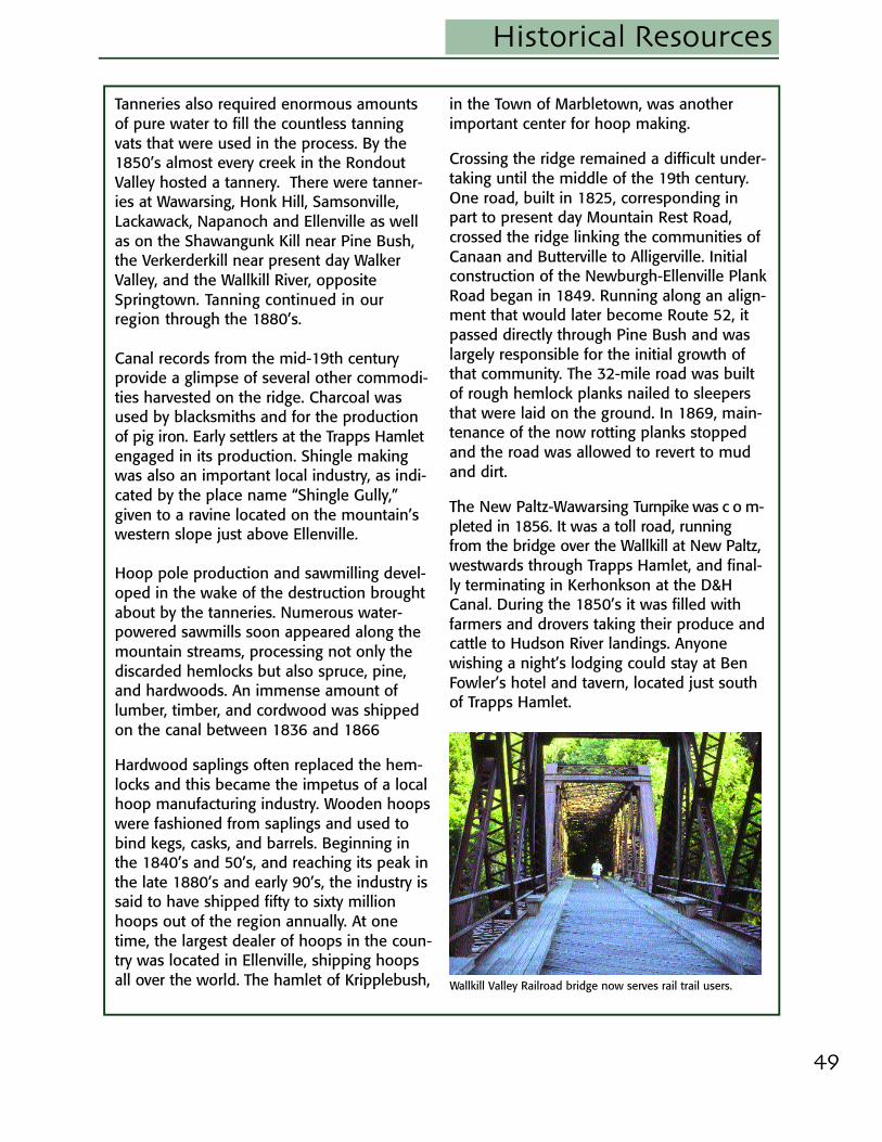
Wallkill Valley Railroad bridge now serves rail trail users.
50
Historical Resources
The era of the railroads began in the late1800’s. The Wallkill Valley Railroad was com-pleted as far as New Paltz by 1870. The NewYork and Oswego Midland Railroad (after-wards the New York, Ontario and WesternRailroad or “O&W”) also reached the regionat this time—one branch extending as far asPine Bush by 1868 and another branch arriv-ing in Ellenville in 1871. It included a tunneldrilled through the base of the Shawangunksnear Wurtsboro in 1871. The advantages ofrailroad transport were inescapable and in1898 the D&H Canal Company signed anagreement with the Erie Railroad to trans-port its entire output of coal. By 1902, theO&W had built track extending between PortJervis on the Delaware River to Kingston onthe Hudson River, thus duplicating the routeof the now nearly extinct D&H Canal.
For farmers on both sides of the mountain,accessibility to railroads was a virtual guaran-tee that their dairy products and producewould reach the New York City market with-out spoiling. The fields surrounding NewPaltz were filled with new orchards. Visitorsreported peach, pear and cherry trees, vine-yards, and acres of berries including currants,strawberries, blackberries, and raspberries.New Paltz was now “a great fruit producingtown”. The village of Gardiner, a communityborn with the railroad, was now the preferredshipping depot for about 30 local growers.
Creameries were established adjacent to thedepots at Bullville, Thompson Ridge, PineBush, Wallkill, Gardiner, New Paltz, and othersmaller communities. Milk shipped in theafternoon in the Wallkill Valley was in NewYork City households by the following morn-ing. The most famous dairying enterprise inthe region was the 2000-acre home farmand condensed milk factory of the BordenMilk Company in Wallkill. (Remember “Elsie,the Borden Cow”?)
On the ridge, the gathering and distilling ofwintergreen and huckleberry picking weretwo of the more important occupations.Wintergreen, which grows in the mountain’smany shaded and moist ravines, was usedfor flavoring and for medicinal purposes. Itsleaves were gathered and brought to local“stills” where it was converted into oil.
By 1871 huckleberries (the word “blueberry”being reserved for cultivated varieties)became one of the Shawangunk Region’smajor items of export. The “patch” extendedfrom Lake Mohonk to Sam’s Poit. An 1899map shows at least three separate huckle-berry picker camps immediately west of LakeMaratanza. Like the Native Americans beforethem, the huckleberry pickers manipulatedthe local ecology by setting fires in order toincrease yields. This particular ShawangunkRidge lifeway continued—complete withyearly fires—well into the 20th century.
The arrival of the railroads coincided with theinitial appearance of resorts for summerguests in the Shawangunks. The first hotelsto open here during this era—the MohonkMountain House in 1870, the MountainHouse at Sam’s Point in 1871, Cliffhouse(1879) and Wildemere (1887) at Lake
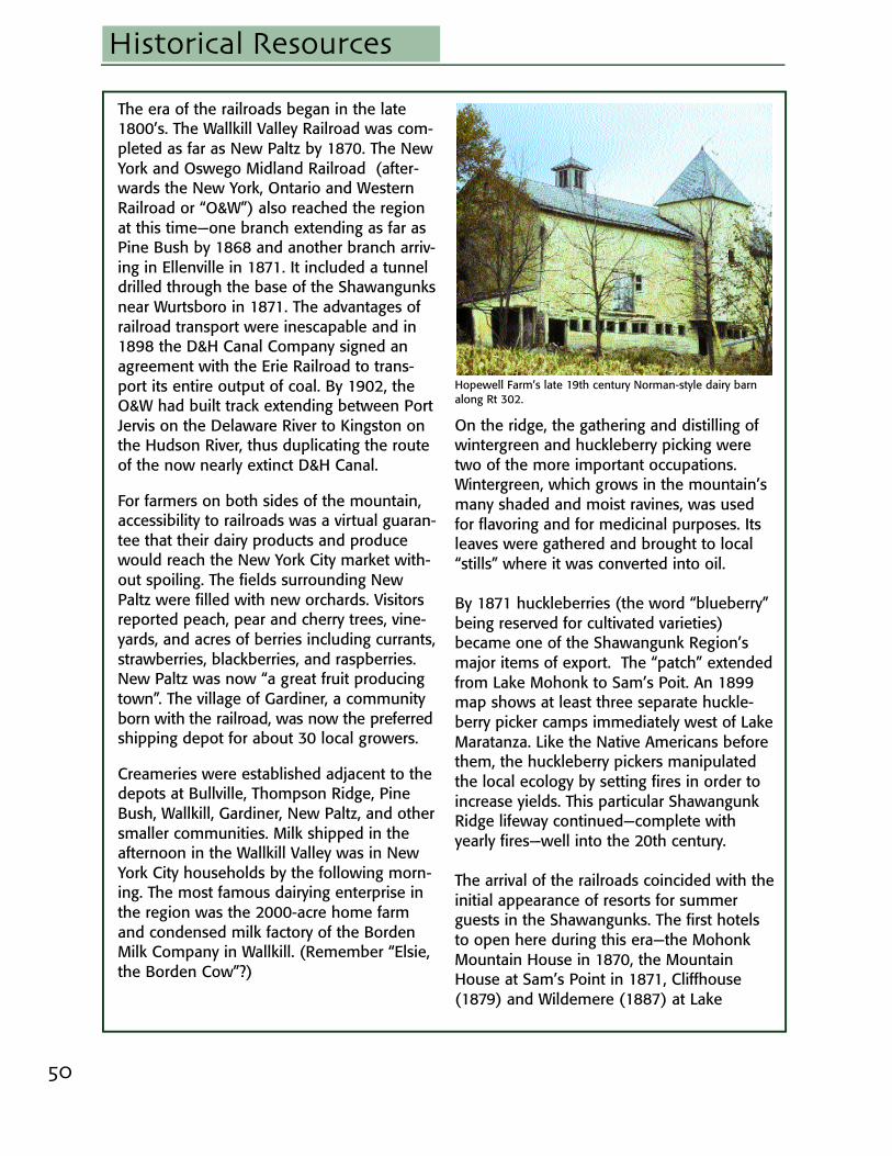
Hopewell Farm’s late 19th century Norman-style dairy barnalong Rt 302.
51
Historical Resources
Minnewaska, and the Mt. Meenahga Houseon the ridge overlooking Ellenville in 1883—catered to guests who valued theS h a w a n g u n k s ’ scenic beauty. Althoughforests directly adjoining the hotels werebeing clear cut for tannin bark and timber,landscaping at the hotels featured mean-d e ring carriage roads and vistas opened tocreate breathtaking views of the valleys andthe distant Hudson.
In an effort to preserve the wildernessl a n dscape and to become self-sufficient, theSmiley family, owners of the Lake Mohonkand Lake Minnewaska resorts, embarkedupon an ambitious program of land acquisi-tion. The more than 17,000 acres they pur-chased over time included agricultural landsand forests, as well as remote ravines andridge tops.
Smaller hotels and boarding houses werelocated in almost every village along theO&W and Wallkill Valley lines and the entireregion benefited from the development oftourism. In 1901 listings for the Ellenville-Cragsmoor area alone contained approxi-mately 40 hotels or boarding houses.
Hotels catering to Jewish families began toappear in the Rondout Valley in the first
decade of the 20th century. These wereowned and operated by immigrants fromEastern Europe and Russia who were drawnby the belief that farming was a viable alter-native to urban sweatshops. Because muchof the land that they had purchased wasunproductive, the practice soon developed oftaking in paying boarders during the summermonths. Some of these small boarding houseseventually grew into the famous “borschtbelt” hotels of the southern Catskills region,such as the Nevele and Fallsview Hotels inEllenville. Along side them were countlesssmall bungalow colonies. Several of the vil-lages along the ridge’s western slope soondeveloped sizeable Jewish populations.
Beginning at the turn of the century, NewYork State began a program of road develop-ment in the region, creating a transportationinfrastructure benefiting automobiles, busesand trucks. Improvements to the Ellenville-Kingston Road (today’s Route 209) wereunderway in 1921. In the same year, theNew Paltz-Highland Road became the firstconcrete road in Ulster County. The
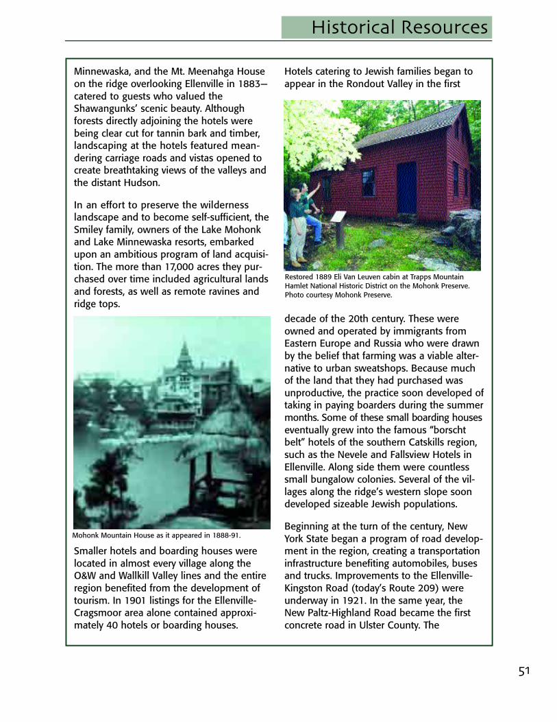
Restored 1889 Eli Van Leuven cabin at Trapps MountainHamlet National Historic District on the Mohonk Preserve.Photo courtesy Mohonk Preserve.
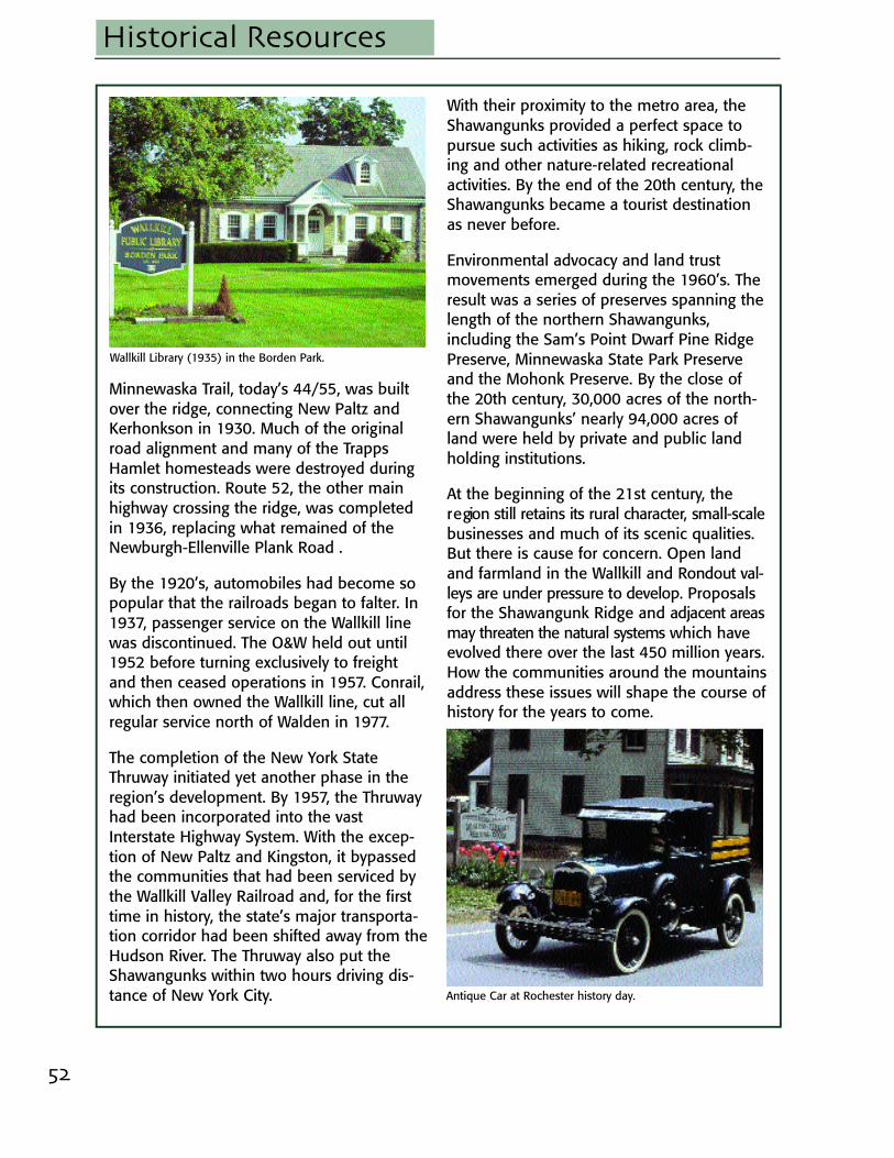
Mohonk Mountain House as it appeared in 1888-91.
52
Historical Resources
Minnewaska Trail, today’s 44/55, was builtover the ridge, connecting New Paltz andKerhonkson in 1930. Much of the originalroad alignment and many of the TrappsHamlet homesteads were destroyed duringits construction. Route 52, the other mainhighway crossing the ridge, was completedin 1936, replacing what remained of theNewburgh-Ellenville Plank Road .
By the 1920’s, automobiles had become sopopular that the railroads began to falter. In1937, passenger service on the Wallkill linewas discontinued. The O&W held out until1952 before turning exclusively to freightand then ceased operations in 1957. Conrail,which then owned the Wallkill line, cut allregular service north of Walden in 1977.
The completion of the New York StateThruway initiated yet another phase in theregion’s development. By 1957, the Thruwayhad been incorporated into the vastInterstate Highway System. With the excep-tion of New Paltz and Kingston, it bypassedthe communities that had been serviced bythe Wallkill Valley Railroad and, for the firsttime in history, the state’s major transporta-tion corridor had been shifted away from theHudson River. The Thruway also put theShawangunks within two hours driving dis-tance of New York City.
With their proximity to the metro area, theShawangunks provided a perfect space topursue such activities as hiking, rock climb-ing and other nature-related recreationalactivities. By the end of the 20th century, theShawangunks became a tourist destinationas never before.
Environmental advocacy and land trustmovements emerged during the 1960’s. Theresult was a series of preserves spanning thelength of the northern Shawangunks,including the Sam’s Point Dwarf Pine RidgePreserve, Minnewaska State Park Preserveand the Mohonk Preserve. By the close ofthe 20th century, 30,000 acres of the north-ern Shawangunks’ nearly 94,000 acres ofland were held by private and public landholding institutions.
At the beginning of the 21st century, ther e gion still retains its rural character, small-scalebusinesses and much of its scenic qualities.But there is cause for concern. Open landand farmland in the Wallkill and Rondout val-leys are under pressure to develop. Proposalsfor the Shawangunk Ridge and adjacent areasmay threaten the natural systems which haveevolved there over the last 450 million years.How the communities around the mountainsaddress these issues will shape the course ofhistory for the years to come.
Wallkill Library (1935) in the Borden Park.
Antique Car at Rochester history day.
53
CrawfordHopewell Presbyterian Church 1825-1849Shorter House 1750-1799Alexander Thompson House 1750-1799Robert A. Thompson House 1800-1824Peter Aldrich Homestead 1700-1749
GardinerBevier House 1825-1849Brykill 1700-1749Johannes Decker Farm 1700-1749Gardiner School 1875-1899Jenkins-DuBois Farm
and Mill Site 1750-1799Locust Lawn Estate 1700-1749Trapps Mountain Hamlet
Historic District 1750-1799Tuthilltown Gristmill 1750-1799Van Vleck House 1750-1799Bevier Stone House 1650-1699
MarbletownDelaware and Hudson Canal 1825-1949 High Falls Historic District 1750-1799Kripplebush Historic District 1750-1799Lock Tender’s House and
Canal Store Ruin 1825-1849Main Street Historic District 1750-1799Rest Plaus Historic District 1700-1749Cornelius Wynkoop Stone House 1750-1799Josiah DuBois Farm 1800-1824
New PaltzGuilford-Bower Farm House 1850-1874Jean Hasbrouck House 1650-1699Maj. Jacob Hasbrouck, Jr. House 1750-1799Huguenot Street National
Historic Landmark District 1650-1699John A. Lafevre House and School 1750-1799Lake Mohonk National
Historic Landmark 1850-1874The Locusts 1825-1849Sahler Stone House 1750-1799The Elting Library 1700-1750
Rochester*Van Wagenen Stone House
and Farm Complex 1700-1749Jacobus Van Wagenen
Stone House 1750-1799All Saint’s Chapel 1875-1899
RosendaleBinnewater Historic District 1875-1899DuBois-Deyo House 1750-1799Snyder Estate Natural Cement
Historic District 1800-1824Bruynswick School No. 8 1825-1849
ShawangunkWilliam Decker House 1700-1749Andries DuBois House 1750-1799J.B. Crowell & Son Brick
Mold Mill Complex 1750-1799Dill Farm 1750-1799Johannes Jansen House
and Dutch Barn 1700-1749Thomas Jansen House 1700-1749Miller’s House at Red Mills 1825-1849Pearl Street Schoolhouse 1825-1849Reformed Church of
Shawangunk Complex 1750-1799Terwilliger House 1750-1799Benjamin Van Keuren
House Ruin 1700-1749
WawarsingChetolah 1900-1924Cragsmoor Historic District 1850-1874Hornbeck Store Complex 1800-1824O&W Railroad Station
at Port Ben 1900-1924O&W Railroad Passenger
Station at Napanoch 1900-1924US Post Office, Ellenville 1925-1949
* There are 21 additional listings in the Town of Rochester just north of the Byway Region.
National Registry Listings of Byway Region Historic Places