sharing groundwater information, knowledge and experience ... › ... › protected ›...
TRANSCRIPT
16 Sharing Groundwater Information, Knowledge and Experience on a Worldwide Scale
JAC A.M. VAN DER GUN
International Groundwater Resources Assessment Centre (IGRAC), PO Box 80015, 3508 TA Utrecht, The Netherlands
Importance of Sharing Groundwater-Related Information, Knowledge and Experience on a Worldwide Scale
Rationale behind sharing information
Sharing information is at least as old as mankind, maybe even as old as primitive life on earth. Parents bring up their children by teaching them all they consider necessary or useful for their proper development into independent and happy human beings. When children grow up, the initially predominantly unidirec-tional flow of information gradually changes into a balanced bidirectional process. However, sharing information is not restricted to the parent–child rela-tionship, but can be observed between all people who have something in com-mon: partners in marriage, relatives, friends, neighbours, members of the same community or a nation, colleagues, business partners, etc.
Why do we share knowledge and experience? By instinct, we know that knowledge and experience are important for survival and for feeding into the learn-ing processes that help making us more successful in daily life. Sharing knowledge and experience has the potential to accelerate these learning processes signifi-cantly. Sharing information simply improves efficiency, stimulates development and reduces the probability of making wrong decisions. It is evident that good relations between people stimulate their preparedness for sharing information.
Importance of a knowledge base related to groundwater
It is commonly agreed that major water issues of our time include meeting basic human needs for water, securing food supply, protecting ecosystems and avoid-
©CAB International 2007. The Agricultural Groundwater Revolution:362 Opportunities and Threats to Development (M. Giordano and K.G. Villholth)
Sharing Groundwater Information, Knowledge and Experience 363
ing loss of life and other damages due to flooding and droughts. Over time, it has been recognized that appropriate action on these major issues is impossible without having access to sufficient and relevant information on the systems con-sidered. As stated by the South African Minister of Water Resources Ronny Kasrils (2003): ‘No sustainable development of a scarce natural resource is possible with-out understanding the resource and managing it wisely according to this growing understanding.’ Therefore, the knowledge base on our water resources has to be continuously developed and updated.
Where a knowledge base is needed on water resources in general, it is even more indispensable in relation to groundwater. Groundwater is an invisible resource: it is hidden underground and after appearing at the surface it is formally not ground-water any more. This makes groundwater a component of the water cycle that is comparatively difficult to understand for most people. Unlike rain and surface water, groundwater is veiled in mystery. Only few people have a conceptually correct idea of aspects such as: how groundwater in their region is stored underground; how voluminous it is; how it moves and at what speed; what is its quality and how this quality may change; how groundwater is linked with surface water, local ecosystems and the environment; how to develop the groundwater resources efficiently and pro-tect them against pollution and other problems. Even more difficult is it to imagine how the state and functions of a groundwater system may respond over time to inten-sified rates of groundwater exploitation and other changing boundary conditions.
It goes without saying that sufficient information and knowledge is needed if we want to make optimum use of such a natural resource and if we want to manage and protect it properly. However, even the nature of the information and knowledge needed varies widely. On the one hand, area-specific (i.e. geo-referenced) information is required to:
● unveil at least some of the mysteries of this hidden resource in order to make groundwater systems under standable to water resources planners and decision makers;
● contribute to the proper identification of groundwater-related potentials and problems;
● facilitate the prediction over time of the groundwater system evolution in response to changing natural and anthropogenic boundary conditions.
On the other hand, professionals engaged in groundwater cannot fulfil their jobs adequately without also having access to some more generic information on groundwater, especially on:
● relevant scientific and technological principles, such as geology, hydrau-lics, drilling, pumping, hydrology, groundwater quality, eco-hydrology, water economics, water law and behaviour sciences;
● methods and technology for assessment, development and management of groundwater.
Consequently, knowledge bases that combine both local information with broader principles related to groundwater are required for guiding towards proper development and management of groundwater resources.
364 J.A.M. van der Gun
Added value of taking a global or regional perspective
It is evident that the success of groundwater development and management depends to a large extent on local efforts in collecting relevant information and on the local expertise available. If the local dimension is so important, what are the potential benefits of taking a global or regional perspective, by sharing knowledge and experience across and far beyond national boundaries?
In this context it is useful to make a distinction between generic knowledge and area-specific information. Generic knowledge is in principle universally applicable; hence sharing this knowledge on a worldwide scale produces effi-ciency, as pointed out at the beginning of this section. Important actors involved as well as programmes and activities they have embarked upon for globally dis-seminating this generic knowledge are reviewed in the following sections.
The value of sharing area-specific information internationally may seem less obvious at first glance. However, it becomes more evident in the context of specific challenges:
● Managing transboundary groundwater resources: This is an emerging issue. Many countries share aquifers with neighbouring countries and there is a growing need to jointly manage them (or at least coordinate management efforts) because of steadily increasing pressures such as scarcity, pollution and environmental impacts. International exchange of information on shared groundwater systems is among the first and most indispensable steps to put the process towards transboundary aquifer management into motion.
● Understanding global or regional patterns and processes: This is obviously of first importance for those studying groundwater phenomena at a global, continental or other supranational scale (e.g. world water balance, world climatic processes, occurrence of different types of water-related problems). However, it is useful as well to those focusing on spatially more restricted areas, by providing an overall context and reference, and by making them more aware of patterns and how these are produced.
● Recognizing potentials, problems and trends related to groundwater: For groundwater investigators and planners alike, analogies between different areas of the globe may be of great help in the preliminary estimation of groundwater potentials and in the early diagnosis of trends and problems. Global patterns of relevant variables may reveal similarities that provide a basis for tentative diagnosis. The basic principle is that information collected for more intensely investigated, monitored or pressured areas may give hints on likely conditions or trends for analogous areas that have been studied less and/or have been exposed thus far to a lower external pressure.
● Benefiting from experiences gained under similar or analogous conditions:This is related to the previous comment. Observed similarities or analogies in groundwater conditions are a support in developing ideas on appropri-ate action for groundwater development, use and management. Knowing the actions implemented elsewhere under similar or analogous condi-tions enriches the overview of possible actions to be considered. Knowing
Sharing Groundwater Information, Knowledge and Experience 365
whether (and why) they have been a success or a failure helps in making optimal decisions and avoiding less effective measures.
● Contributing to standardization of variables, methods and observational practices: It is clear that the potential benefits outlined above, but also the validity of research outcomes based on data from different areas, depend on the consistency between all data-sets used. Lack of standardization in definitions, observational practices and methods for processing may lead to serious errors in interpretation. Sharing area-specific information internation-ally will undoubtedly contribute to international standardization, which will raise the quality of any analysis based on international data-sets.
Important International Actors and Programmes
Bilateral and multilateral cooperation projects related to groundwater
Especially since the 1960s, numerous international projects have been car-ried out in the context of development cooperation or cooperation between ‘befriended nations’. The general idea behind these projects is that the develop-ment of a country or a part of it may be accelerated by international coopera-tion, either in a bilateral (country-to-country) or in a multilateral setting (country and international organization). The projects are operating on the basis of a mix of national and foreign or international inputs, with a formal project agree-ment as a certain guarantee for having these inputs available when they are needed. Inputs from the donor countries or international organizations tend to include financial support, vehicles, equipment and other materials, as well as personnel for supplying professional capacity and/or transfer of knowledge and technology.
A substantial part of all these development cooperation projects was and still is related to water resources, and many of these focus on groundwater. Since the 1960s, several donors and recipient countries have become aware that avail-able groundwater resources were being underused in many areas, due to limited knowledge on these subsurface resources or due to insufficient access to the technology or the funds needed to exploit them. Unlocking this natural resource to its full extent was therefore seen as a promising strategy to improve economic and social development. This idea has triggered a large number of groundwater projects all over the world. Many projects focused on regional exploration and assessment of groundwater resources to provide a basis for implementing ground-water development initiatives. Even more projects have been given the explicit objectives to drill large numbers of wells and to assist the local population in making efficient use of the tapped groundwater resources. The impacts of these projects are enormous. Many areas in the world where groundwater abstraction used to be insignificant have changed into areas of intensive groundwater exploi-tation within a few tens of years, yielding immense social gains by securing water supplies and providing water for economic activities such as irrigated farming. The aquifers of these areas are tapped now by large numbers of wells, many of them much deeper than the traditional ones.
366 J.A.M. van der Gun
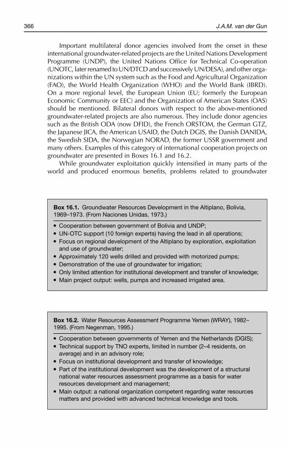
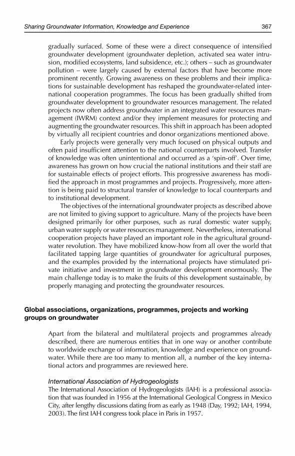
Important multilateral donor agencies involved from the onset in these international groundwater-related projects are the United Nations Development Programme (UNDP), the United Nations Office for Technical Co- operation (UNOTC, later renamed to UN/DTCD and successively UN/DESA), and other orga-nizations within the UN system such as the Food and Agricultural Organization (FAO), the World Health Organization (WHO) and the World Bank (IBRD). On a more regional level, the European Union (EU; formerly the European Economic Community or EEC) and the Organization of American States (OAS) should be mentioned. Bilateral donors with respect to the above-mentioned groundwater-related projects are also numerous. They include donor agencies such as the British ODA (now DFID), the French ORSTOM, the German GTZ, the Japanese JICA, the American USAID, the Dutch DGIS, the Danish DANIDA, the Swedish SIDA, the Norwegian NORAD, the former USSR government and many others. Examples of this category of international cooperation projects on groundwater are presented in Boxes 16.1 and 16.2.
While groundwater exploitation quickly intensified in many parts of the world and produced enormous benefits, problems related to groundwater
Box 16.1. Groundwater Resources Development in the Altiplano, Bolivia, 1969–1973. (From Naciones Unidas, 1973.)
● Cooperation between government of Bolivia and UNDP;● UN-OTC support (10 foreign experts) having the lead in all operations;● Focus on regional development of the Altiplano by exploration, exploitation
and use of groundwater;● Approximately 120 wells drilled and provided with motorized pumps;● Demonstration of the use of groundwater for irrigation;● Only limited attention for institutional development and transfer of knowledge;● Main project output: wells, pumps and increased irrigated area.
Box 16.2. Water Resources Assessment Programme Yemen (WRAY), 1982–1995. (From Negenman, 1995.)
● Cooperation between governments of Yemen and the Netherlands (DGIS);● Technical support by TNO experts, limited in number (2–4 residents, on
average) and in an advisory role;● Focus on institutional development and transfer of knowledge;● Part of the institutional development was the development of a structural
national water resources assessment programme as a basis for water resources development and management;
● Main output: a national organization competent regarding water resources matters and provided with advanced technical knowledge and tools.
Sharing Groundwater Information, Knowledge and Experience 367
gradually surfaced. Some of these were a direct consequence of intensified groundwater development (groundwater depletion, activated sea water intru-sion, modified ecosystems, land subsidence, etc.); others – such as groundwater pollution – were largely caused by external factors that have become more prominent recently. Growing awareness on these problems and their implica-tions for sustainable development has reshaped the groundwater-related inter-national cooperation programmes. The focus has been gradually shifted from groundwater development to groundwater resources management. The related projects now often address groundwater in an integrated water resources man-agement (IWRM) context and/or they implement measures for protecting and augmenting the groundwater resources. This shift in approach has been adopted by virtually all recipient countries and donor organizations mentioned above.
Early projects were generally very much focused on physical outputs and often paid insufficient attention to the national counterparts involved. Transfer of knowledge was often unintentional and occurred as a ‘spin-off’. Over time, awareness has grown on how crucial the national institutions and their staff are for sustainable effects of project efforts. This progressive awareness has modi-fied the approach in most programmes and projects. Progressively, more atten-tion is being paid to structural transfer of knowledge to local counterparts and to institutional development.
The objectives of the international groundwater projects as described above are not limited to giving support to agriculture. Many of the projects have been designed primarily for other purposes, such as rural domestic water supply, urban water supply or water resources management. Nevertheless, international cooperation projects have played an important role in the agricultural ground-water revolution. They have mobilized know-how from all over the world that facilitated tapping large quantities of groundwater for agricultural purposes, and the examples provided by the international projects have stimulated pri-vate initiative and investment in groundwater development enormously. The main challenge today is to make the fruits of this development sustainable, by properly managing and protecting the groundwater resources.
Global associations, organizations, programmes, projects and working groups on groundwater
Apart from the bilateral and multilateral projects and programmes already described, there are numerous entities that in one way or another contribute to worldwide exchange of information, knowledge and experience on ground-water. While there are too many to mention all, a number of the key interna-tional actors and programmes are reviewed here.
International Association of HydrogeologistsThe International Association of Hydrogeologists (IAH) is a professional associa-tion that was founded in 1956 at the International Geological Congress in Mexico City, after lengthy discussions dating from as early as 1948 (Day, 1992; IAH, 1994, 2003). The first IAH congress took place in Paris in 1957.
368 J.A.M. van der Gun
The initial aims of the association were getting to know each other, sharing professional expertise and furthering hydrogeological science. In IAH’s annual report of 2003 the objectives are formulated as follows:
‘to advance public education and promote research (and disseminate the useful results of such research) in the study and knowledge of hydrogeological science. The Association seeks to achieve these objectives by:
● Publishing journals, book series, newsletters and other occasional publications in both hard copy and electronic format for the benefit of members and the wider community interested in the objectives of the Association.
● Promoting international cooperation among hydrogeologists and others with an interest in groundwater through commissions, working groups and joint projects.
● Encouraging the worldwide application of hydrogeological skills through education and technology transfer programmes, and sponsoring international, regional and national meetings open to all.
● Cooperating with national and international scientific organizations, to pro-mote understanding of groundwater in the international management of water resources and the environment.’
IAH has been affiliated with the International Union of Geological Sciences since 1964.
IAH is a very active and influential worldwide professional association, governed by the IAH Council (11 members) and a General Assembly. By the end of 2003, the association counted more than 3700 members in more than 130 countries, scattered over all continents. There is a special fund (Burdon Fund) for sponsoring members in developing countries. Commissions (formerly Working Groups), National Chapters (in 40 countries) and regional groups or committees facilitate the efficient implementation of activities.
The main activities of the IAH include: (i) organizing or coorganizing inter-national meetings and sponsoring national meetings; (ii) publishing a journal, newsletter and publications; (iii) organizing and participating in international projects on hydrogeological subjects. IAH’s website address is: www.iah.org.
Foremost among the international meetings and conferences organized by IAH are the IAH congresses, which are the most important international meet-ings for hydrogeologists. The October 2004 congress in Zacatacas, Mexico, was the 33th IAH Congress since the association was established; thus the aver-age frequency is about one in 18 months.
IAH’s scientific journal started in 1992, initially under the name AppliedHydrogeology, but at the beginning of 1995 it was renamed Hydrogeology Journal. It appears bimonthly and favours papers with an applied hydrogeologi-cal and/or area-specific focus.
To date, IAH has produced two series of publications: International con-tributions to Hydrogeology and Hydrogeology: Selected Papers. An important early co-production (IASH, IAH, UNESCO/IHD, IGS) was the InternationalLegend for Hydrogeological Maps (1970, in four languages).
IAH currently has 12 commissions (permanent technical groups) on the fol-lowing subjects: Hydrogeological Maps (the oldest one, established in 1959);
Sharing Groundwater Information, Knowledge and Experience 369
Hydrogeology of Karst; Mineral and Thermal Waters; Groundwater Protection; Hydrogeology in Developing Nations (Burdon Commission); Education and Training; Hydrogeology in Urban Areas; Transboundary Aquifers; Hydrogeology of Hard Rocks; Managing Aquifer Recharge; Groundwater Dependent Eco-Systems; Aquifer Dynamics; and Coastal Zone Management. In addition, a Working Group on Groundwater and Climate Change is in formation.
The association closely cooperates with the United Nations Educational, Scientific and Cultural Organization (UNESCO), for example, in the project to develop the Hydrogeological Map of Europe ‘1:1.5 M’ (30 sheets; started in 1965 and now nearly completed), in the WHYMAP project (Groundwater Resources of the World) and in the ISARM initiative (Internationally Shared Aquifer Resources Management). More information on these projects will be provided later.
International Association of Hydrological SciencesThe International Association of Hydrological Sciences (IAHS), an association involving all components of the hydrological cycle, was founded in 1922 in Rome as the International Section of Hydrology of the International Union of Geodesy and Geophysics (IUGG). It is now one of the seven autonomous bod-ies that together constitute the IUGG.
IAHS is the oldest learning society in the field of water. It aims to serve the needs of humanity through the promotion of hydrological science and the stimulation of its applications. It has approximately 3700 members, from 129 countries. Websites of IAHS are: www.wlu.ca /~wwwiahs/index.html and www.cig.ensemp.fr/~iahs.
The activities of IAHS include organizing scientific meetings (assemblies, symposia and workshops), producing and disseminating publications and carry-ing out research projects. Among the publications are the Hydrological Sciences Journal, a Newsletter and the Red Books series started in 1924 in which almost 300 titles have appeared, several of them related to groundwater.
IAHS has nine scientific commissions, including the International Commission on Groundwater (ICGW). The latter is active in:
● organizing international symposia such as ModelCARE and Groundwater Quality (GQ);
● collaboration with the American Geophysical Union (AGU), the International Association of Hydrogeologists (IAH) and the International Groundwater Modeling Centre (IGWMC);
● organizing working groups, often under UNESCO’s IHP.
The relative importance of IAHS with regard to groundwater has undoubtedly declined somewhat after IAH came into being and achieved a strong position among hydrogeologists.
Association of Geoscientists for International DevelopmentThe Association of Geoscientists for International Development (AGID) is a global association uniting more than 1400 geologists, hydrogeologists, engin-eers and other professionals involved in international development activities
370 J.A.M. van der Gun
with an earth-scientific scope. Notwithstanding a number of very useful activities – such as the Preliminary Bibliography on Groundwater in Developing Countries (Stow et al., 1976) – regarding groundwater, it cannot compete in importance and activity level with associations such as IAH and IAHS. AGID’s website can be found at: http://agid.igc.usp.br.
United Nations Educational, Scientific and Cultural OrganizationThrough its Water Science Division, UNESCO has developed a strong profile in water since the International Water Decade (1965–1974). This decade was fol-lowed by the International Hydrological Programme, carried out in phases, with IHP-1 starting in 1975. IHP is UNESCO’s intergovernmental multi- disciplinaryscientific programme in hydrology and water resources; the programme of each phase reflects the needs and/or priorities of the member states and is formally approved by these states. IHP is currently in its sixth phase (IHP-6, 2002–2007, see Box 2.3).
UNESCO/IHP Headquarters in Paris is cooperating with IHP National Committees and with IHP regional and cluster offices (Apia, Brasilia, Montevideo, Kingston, Port au Prince, Venice, Moscow, Cairo, Nairobi, New Delhi, Tehran, Jakarta, etc.). Forging cooperation is the main mechanism for laying foundations. As of early 2003, the IHP network included 13 UNESCO centres and 11 UNESCO university chairs.
Groundwater-related objectives of UNESCO’s Water Science Division are: development of scientific knowledge in hydrogeology (especially quantity, quality, salt water, arid hydrology) and related training. Research is promoted by working groups, supported centres, publications, participation in projects, etc. Training is promoted by supporting various international training centres (e.g. Barcelona groundwater course; UNESCO-IHE).
Over the years, UNESCO has produced a considerable quantity of training materials, manuals, guides, proceedings and publications on groundwater, has participated in the Hydrogeological Map of South America and is still involved in the preparation of the Hydrogeological Map of Europe. Recent important projects and programmes on groundwater are: World Groundwater Resources Map (WHYMAP), Internationally Shared Aquifer Resources Management (ISARM) and the Working Groups on Groundwater Indicators and on Non-renewable Groundwater Resources. Well-known series of publications are UNESCO’s Technical Papers in Hydrology, Studies and Reports in Hydrology
Box 16.3. Themes of UNESCO’s IHP-6 (2002–2007) ‘Water interactions: systems at risk and social challenges’
1. Global changes and water resources;2. Integrated Watershed and Aquifer Dynamics;3. Land Habitat Hydrology;4. Water and Society;5. Water Education and Training.
Sharing Groundwater Information, Knowledge and Experience 371
and Technical Documents in Hydrology. Some of the recent publications related to groundwater are listed in Box 16.4.
United Nations Food and Agricultural OrganizationAlthough FAO (website: www.fao.org) has been involved in groundwater assessments since the 1960s, followed by groundwater modelling for regional assessment of Africa and by extensive regional groundwater programmes in the Near East and Africa during the 1970s and 1980s, FAO’s role in generating and disseminating new knowledge on groundwater is less pronounced than that of UNESCO.
FAO’s activities related to groundwater usually reflect an irrigation or drainage perspective. Nevertheless, the organization has contributed to devel-opments in groundwater quality studies and in groundwater management. Furthermore, the long-standing expertise on legal aspects of water has resulted in active involvement in legal and institutional aspects of internationally shared groundwater management.
Many FAO publications are relevant for those interested in groundwater, in particular the publications of the series of FAO Technical Papers/Water Reports (25 reports over the period 1993 through 2003).
A very interesting service to the international community is AQUASTAT,FAO’s web-based worldwide water database (www.fao.org/ag/AGL/aglw/Aquastatweb/Main/html/aquastat.htm). It presents key data on water variables at the country level, such as total internally renewable water resources and their breakdown into groundwater, surface water and ‘overlap’; national break-down of irrigated lands in groundwater-dependent irrigation and surface water–dependent irrigation; dependency on internally generated water resources; and per capita indicators.
United Nations Environmental ProgrammeThe United Nations Environmental Programme (UNEP) covers a very broad field, of which groundwater represents only a minor part. Nevertheless, several of UNEP’s activities are contributing to a better understanding and characteriza-tion of the world’s groundwater resources. Examples are its recent global assess-ment of problems and options for groundwater management (UNEP, 2003), and
Box 16.4. Recent issues in UNESCO’s ‘Series on Groundwater’
Produced in the framework of IHP (available in hard copy and on CD):
1. Internationally Shared (Transboundary) Aquifer Resources Management (2001);2. Groundwater contamination inventory (2002);3. Groundwater studies (2004);4. Intensively exploited aquifers (2002);5. Submarine groundwater discharge (2004);6. Groundwater resources of the world and their use (2004);7. Groundwater and fractured rocks (2003).
372 J.A.M. van der Gun
in particular the periodically published Global Environmental Outlook. The last version of this Global Environmental Outlook – GEO-3 – includes a global and regional synopsis of groundwater conditions (UNEP, 2002). The associated Internet-based GEO-3 database (http://geocompendium.grid.unep.ch/index.htm)includes – among other things – useful groundwater information at a country level, for all countries of the world.
International Atomic Energy AgencyThe Isotope Hydrology Section of the International Atomic Energy Agency (IAEA) (Vienna; website: www.iaea.org) develops activities on isotopes and related geochemistry in the water cycle. It does so by conducting research, training and workshops, and by supplying isotope laboratory services to those interested in the application of isotope techniques. Major ongoing projects of the section regarding groundwater are:
● mapping palaeo-waters of the world (non-renewable or fossil groundwater);● Dead Sea (including study on the origin of salt groundwater);● groundwater of eastern and southern Africa (main subjects: recharge, sur-
face water–groundwater interrelations in conjunctive management, pollu-tion transport).
The section is cooperating with relevant international organizations such as UNESCO and IAH by participating in their projects (e.g. WHYMAP, UNESCO Working Groups on Non-renewable Groundwater and on Groundwater Indicators) or in the form of joint programmes (e.g. with UNESCO in the Joint International Isotopes in Hydrology Programme). A biannual training course on isotopes in hydrology is presented in Graz, Austria. In addition, IAEA is organiz-ing many short courses in different parts of the world.
The World BankThe World Bank (IBRD) finances development programmes and projects in many countries of the world. Within its programmes, the role of groundwater is most pronounced in the water and sanitation sector and the irrigation sec-tor programmes. Apart from financing and taking care of the technical work involved in the project cycle, the World Bank is also contributing to the inter-national exchange of experience in groundwater. This is done in particular by studies on the impact of groundwater-related projects on human welfare and by dissemination of publications on ‘good practice’ or ‘lessons learned’. A rather technical example of the latter is the publication Community Water Supply: The Handpump Option (Arlosoroff et al., 1987), which presents results of testing and monitoring 2700 pumps of 70 different models in 17 countries. A recent World Bank activity focusing on the promotion of ‘good practice’ in ground water is the Groundwater Management Advisory Team (GW·MATE) programme.
GW·MATE was designed to support the thrust ‘from vision to action’ of the World Water Forum of March 2000 and has the overall objective to give worldwide support to groundwater resources management and protection. It does so by supporting and strengthening the groundwater components of Bank-financed projects and Global Water Partnership (GWP) actions, by harvesting
Sharing Groundwater Information, Knowledge and Experience 373
global experience and by disseminating ‘best-practice elements’ internationally. GW·MATE issues a Briefing Note Series with the following characteristics:
● the notes are intended to give a concise introduction to the theory and practice of groundwater resources management and protection, in a con-venient and readily accessible format.
● primary target audiences include water resources managers of limited groundwater experience and groundwater specialists with limited expo-sure to water resources management.
So far, 13 titles are available in the Briefing Note Series: 9 on Core Series Topics, 4 on Supplementary Series Topics. Contribuitions to guides and books related to groundwater management are another output of GW . MATE.
GW·MATE is a component of the Bank-Netherlands Water Partnership Programme (BNWPP), using trust funds from the Dutch and British governments. More information can be found on the website at: www.worldbank.org.gwmate.
World Meteorological OrganizationThe World Meteorological Organization (WMO) (http://www.wmo.ch/index-en.html) has a long-standing activity record in the promotion of hydrological/meteorological monitoring and the analysis of observed meteorological and hydrological variations in time. To this end, networks of national organizations collaborating by exchanging information are operational for approximately 50 years. Although the organization’s activities mainly focus on meteorology and on surface water, attention to groundwater is increasing and is being supported, inter alia, by the WMO Resolution 25 (‘Exchanging hydrological data and information’, Cg-XIII, 1999) and by the World Hydrological Cycle Observation System (WHYCOS), a decentralized global programme intended to improve regional monitoring networks.
WMO’s famous Guide to Hydrometeorological Practices (2nd edition, 1970; 1st edition, 1969), renamed Guide to Hydrological Practices in later edi-tions, pays only limited attention to groundwater (groundwater levels only), but has been, and still is, of great interest to many groundwater specialists all over the world.
World Water Assessment ProgrammeMany international conferences emphasize that water is at the heart of sustain-able development, trigger debates on a global water crisis and call for immediate action. However, in spite of the many valuable water resources assessments in the past, until recently there has been no global system in place to produce a sys-tematic, continuing and comprehensive global picture of water and its manage-ment. The World Water Assessment Programme (WWAP), a joint initiative of the water-related agencies under the UN, was established to fill this gap. The Internet address www.unesco.org/water/wwap provides information on the programme.
Certainly the most visible output of WWAP is the World Water Development Report (WWDR). According to the preface of its first report (WWDR-1), the report is;
374 J.A.M. van der Gun
‘designed to give an authoritative picture of the state of the world’s freshwater resources and our stewardship of them. The WWDR builds upon past assessments and will constitute a continuous series of assessments in the future. The WWDR is targeted to all those involved in the formulation and implementation of water-related policies and investments, and aims to influence strategies and practices at the local, national and international levels.’
(WWAP, 2003)
After the presentation of WWDR-1 in 2003 at the Third World Water Forum in Japan, a second report was prepared for presentation at the Fourth World Water Forum in Mexico in March 2006. Numerous water-related agencies and spe-cialists from all over the world contribute to this report. Groundwater is focused upon in the chapter on ‘Water Resources’, but the space allocated by WWAP for this subject is very limited.
Global Water PartnershipThe Global Water Partnership (GWP), created in 1996 and based in Sweden, is a working partnership among all those involved in water management: govern-ment agencies, public institutions, private companies, professional organ izations, multilateral development agencies and others committed to the Dublin–Rio prin-ciples. The mission of GWP is ‘to support countries in the sustainable manage-ment of their water resources’.
One of the products of GWP is its ‘ToolBox’, a comprehensive set of guide-lines for IWRM. The tools are organized in three groups:
● Enabling environment: policies, legislative framework, financing and incen-tive structures;
● Institutions: creating an organizational framework and building institu-tional capacity;
● Management tools: water resources assessment, planning for IWRM, effi-ciency in water use, social change instruments, conflict resolution and regulatory instruments.
GWP and its ToolBox do not (yet) have a pronounced focus on groundwater. GWP’s website can be accessed at: www.gwpforum.org.
International Water Management InstituteThe International Water Management Institute (IWMI), with its headquarters in Sri Lanka, is active in applied research and capacity building. It deals with issues related to water management and food security: water for agriculture; groundwater; poverty; rural development; policy and institutions; health and environment.
IWMI’s groundwater research to date has focused on groundwater use and management in irrigation, primarily in south and south-east Asia. At present – and especially with the Comprehensive Assessment in Agriculture, of which this paper is a part – a more comprehensive approach to research and synthesis of knowledge within groundwater management is being developed on a wider scale.

Sharing Groundwater Information, Knowledge and Experience 375
Some of the information to be shared can be found at the website: www.cgiar.org/iwmi/. An interesting global product prepared by IWMI is the World Water and Climate Atlas, based on weather data collected over the period 1961–1990.
International Groundwater Resources Assessment CentreThe International Groundwater Resources Assessment Centre (IGRAC) was founded in early 2003 in Utrecht (the Netherlands) with funding from the government of the Netherlands made available after UNESCO and WMO formulated an initiative for such a centre. The need for IGRAC was motivated by the following main factors:
● Generally perceived poor access to geo-referenced information on ground-water at a global scale: Even if the information does exist, it is often so diffi-cult to access that most of it in practice fails to contribute to the analysis and planning of groundwater at the global, regional and even national levels.
● Inadequacy of groundwater data acquisition in many countries: Many groundwater systems have not been explored and assessed sufficiently, while variations in time of the groundwater conditions – essential informa-tion for adequate management – are monitored only exceptionally.
There is no doubt that a global groundwater centre can make an important contribution to filling these gaps. Therefore, it has the potential to significantly reduce the currently widespread inefficiencies in groundwater-related activities and to help countries in defining their priorities regarding groundwater.
Under the general objective of contributing to adequate development and management of the world’s groundwater resources, in conjunction with surface water resources, the fundamental objectives adopted by IGRAC are:
● enhancing worldwide knowledge on groundwater, by promoting related data and experiences to be shared and by making this information widely available on the basis of centralized retrieval services and targeted dissemination;
● contributing to the acquisition of more and better groundwater data, by means of guidelines and protocols for groundwater assessment and monitoring.
IGRAC pursues these objectives by the development of a Global Groundwater Information System (GGIS), by activities related to Guidelines and Protocols for groundwater data acquisition (G&P) and by participation in strategic global and regional projects with a strong groundwater component (WHYMAP, WWAP, UNESCO working groups, ISARM, etc.). Cooperation with UNESCO, WMO, IAH, national groundwater organizations and many other partners all over the world is among the key mechanisms to achieve IGRAC’s goals.
The ambition of IGRAC is to become a central international platform for groundwater information, where parties from all parts of the world share their information, knowledge and experience on groundwater. Emphasis is on geo-referenced information. As such, it fits into the family of global centres collecting geo-referenced information on components of the water cycle, such as the Global Precipitation and Climate Centre (GPCC) at Offenbach, Germany, the Global Runoff Data Center (GRDC) at Koblenz, Germany, and the Global Environmental Monitoring System on Water (GEMS/Water) at Burlington, Canada. Most of IGRAC’s products can be found on the website at: www.igrac.nl.
376 J.A.M. van der Gun
International Groundwater Modeling CentreIGWMC was established in 1978 at the Butler University, Indianapolis, USA, and had a branch office in Delft, the Netherlands, during the 1980s. IGWMC originally had the profile of a clearing-house for groundwater modelling soft-ware, and presented groundwater-modelling courses as a secondary activity. The centre now operates from Colorado School of Mines in Golden, Colorado, USA. It sells software and it provides advisory services and training related to groundwater modelling. Its website address is: www.mines.edu/igwmc/.
Regional institutions, programmes and networks on groundwater
Regional institutions, programmes and networks on groundwater are numer-ous. It is virtually impossible to give a complete overview. Therefore, only a few of them (probably the ones most visible to the global community) are briefly mentioned here, region by region.
EuropeInteresting from the groundwater point of view are – among others – the European Union (EU), the United Nations Economic Commission for Europe (UN/ECE), ISARM-Balkans and the Association of European Geological Surveys (EGS).
The EU is important for groundwater for at least two reasons: (i) the Water Framework Programmes for financing innovative research on Europe’s water resources; and (ii) the EU Framework Directive on Water, aiming to establish a framework for the protection of Europe’s water systems (including groundwater), which forces all states of the EU to assess their water resources properly and to upgrade their water-monitoring systems according to a common standard.
In recent years, the UN/ECE Task Force on Monitoring and Assessment (now known as the UN/ECE Working Group on Monitoring and Assessment) has made very substantial efforts related to groundwater, which has resulted in Europe-wide reports on:
● inventory of transboundary groundwaters;● problem-oriented approach and the use of indicators;● application of models;● state of the art on monitoring and assessment of groundwater.
ISARM-Balkans is a network in which representatives of the Balkan countries and Turkey are trying to forge the cooperation needed for transboundary aqui-fer management in their region.
North, Central and South AmericaA powerful regional organization for the Americas is the Organization of American States or Organización de Estados Americanos (AOS/OEA). In cooper-ation with the Montevideo Office of UNESCO/IHP, it has been, and still is, actively involved in many groundwater-related projects and efforts such as the Hydrogeological Map of South America and ISARM of the Americas.
Sharing Groundwater Information, Knowledge and Experience 377
As a regional equivalent of the global IAH, the Asociación Latinoamericana de Hidrología Subterránea para el Deasarrollo (ALHSUD) has been established as the professional association of hydrogeologists of Latin America.
Middle East and Northern AfricaFor this region, several regional programmes on groundwater are carried out by the United Nations Economic and Social Commission for Western Asia (UN/ESCWA, Beirut), the Arab Center for the Study of Arid and Dry Lands (ACSAD, Damascus), l’Observatoire du Sahara et du Sahel (OSS, headquarters in Paris) and the Arab Networks on Groundwater, usually in cooperation with the Cairo office of UNESCO/IHP. More agriculturally oriented regional organizations with keen interest in water resources are the Centre for Environmental Development for the Arab Region and Europe (CEDARE, Cairo) and the International Centre for Research in the Dry Areas (ICARDA, Aleppo).
The OSS, with headquarters in Paris (UNESCO building), is working under the theme ‘Fight against Desertification’ (Earth Summit in Rio, Agenda 21) with its main objectives:
● consolidating and improving observational programmes (including equip-ment, standards and info systems);
● increasing knowledge on shared resources;● optimizing local management of natural resources (e.g. by databases and
exchange of experience and know-how);● sustaining the fight against desertification in Africa.
Its membership includes five East African countries, nine West African coun-tries, five North African countries, four European countries and several sub-regional, civil society and international organizations. Its website is: www. unesco.org/oss.
ACSAD’s scope of activities includes water resources, soil science, plant studies, animal studies and economics. Its website is: www.acsad.org. A very relevant groundwater-related coproduction in this region is the Hydrogeological Map of the Arab Region and Adjacent Areas (UNESCO/ACSAD, 1988). Furthermore, attention is being paid in the region to shared aquifers and to non-renewable groundwater resources.
Central and Southern AfricaThe most visible regional network is the Southern African Development Com-munity (SADC). Among its many activities, it is carrying out ground water-related activities in cooperation with the Gabarone office of UNESCO and with other multi- or bilateral parties. More information can be viewed on the website at: www.thewaterpage.com/sadcWSCU.htm.
Asia and the PacificAn important organization in this region is the Coordinating Committee for Coastal and Offshore Geosciences Programmes in East and South-East Asia (CCOP), with its Technical Secretariat located at Bangkok, Thailand. It organizes courses, workshops and projects with a focus on exchanging knowledge and experience
378 J.A.M. van der Gun
within the region. Its interests include integrated coastal zone management and groundwater resources. Member countries of CCOP are: Cambodia, China, Indonesia, Japan, Korea, Malaysia, Papua New Guinea, Philippines, Singapore, Thailand and Vietnam. CCOP’s website address is: www.ccop.or.th.
Other regional organizations actively regarding groundwater in this region are the United Nations Economic and Social Commission for Asia and the Pacific (UNESCAP) and the Jakarta office of UNESCO.
Selected Themes
Structured interaction between groundwater professionals
This may be the oldest way of sharing information and experience on ground water internationally. Since the time groundwater subjects were considered to have a scientific dimension, scientists have been communicating on their findings and ideas on groundwater. An example from the early days of groundwater science is the famous publication on groundwater flow by Dupuit (1863). Books, papers in journals with international circulation and international meetings related to groundwater have become important means to share knowledge and experience worldwide and to trigger international scientific debate. Recently emerged mech-anisms and tools for structured professional interaction are international working groups, newsletters and electronic discussion or conferencing platforms.
The international interaction between groundwater professionals is now very well facilitated, in particular as far as knowledge on groundwater at a the-oretical, methodological and generic level is concerned. There is ample oppor-tunity to meet at the regular global IAH Congresses and IAHS Conferences, and at the regional and thematic conferences, workshops or symposia organized by national or regional organizations, often in cooperation with IAH, IAHS and/or water-related UN organizations. Proceedings of such meetings are a valuable support to reach a wider group of professionals – beyond those that attended the meetings – and they provide access to the papers for later consultation.
International commissions, working groups and research projects organ-ized and/or funded by UNESCO/IHP, IAH, IAHS, EU and other foundations provide additional opportunities for structured interaction between groundwa-ter professionals.
Several scientific publishers bring groundwater-related books on the market. In addition, there are important journals and publications series, contributing to international dissemination of groundwater knowledge. At the international level, of particular interest for groundwater are the following journals:
Hydrogeology Journal (IAH); Groundwater; Journal of Hydrology; Water Resources Research; Hydrological Sciences Journal (IAHS)
and publications series:
International Contributions to Hydrogeology (IAH); ‘Red Books’ (IAHS); UNESCO/IHP Series on Groundwater; FAO Technical Papers – Water Reports; etc.
Sharing Groundwater Information, Knowledge and Experience 379
Electronic versions of papers, reports and publications are becoming widely accessible on the Internet, among others via the websites of IAH, UNESCO/IHP, IGRAC, etc.
In conclusion, the exchange of theoretical, methodological and generic knowledge seems to be constrained more by the absorption capacity of the groundwater community than by a lack of structured means for sharing know-ledge. Different professional backgrounds or specializations, different roles (scientists vs. practitioners) and lack of time constitute important bottlenecks in the effective exchange of knowledge.
Enhanced knowledge as a result of international interaction among ground-water professionals certainly had its impact on the agricultural groundwater revo-lution. It has disseminated scientific and technical knowledge on groundwater development and has made many water sector professionals more aware of the potentials offered by groundwater. The challenge now is to make the benefits of the revolution sustainable. No doubt structured inter national interaction between groundwater professionals may provide a valuable contribution to this endeavour by alerting them to side effects of increased groundwater exploitation and by facilitating joint development and enhancement of the knowledge and method-ologies required for effective groundwater resources management.
Raising public awareness
The World Water Vision’s slogan ‘making water everybody’s business’ launched at the Second World Water Forum in 2000 (WWF2) correctly highlights the fact that everybody on the globe has a stake in water. Consequently, water is not a subject matter to be understood and handled by water specialists only, but rather a matter of concern to everybody. Politicians and other decision makers need to understand in general lines how to exploit and use the water resources properly, ensure sustainability, protect water quality and minimize negative impacts of exploitation. Water users need to know how to benefit opti-mally from water, both for domestic and productive uses. The general public, finally, needs to understand how individual behaviour – on a voluntary basis or enforced by regulations – contributes to conservation and protection of water resources and the related environment.
In general, public awareness on water is still rather limited. Water is often not yet sufficiently prominent on the national water agenda and in the national budgets, while decision makers lack vision to make proper decisions on water and the general public fails to adopt water-friendly behaviour. Do water profes-sionals fail in raising public awareness on water? There is no doubt that signifi-cant efforts are being made already on this subject at local, national, regional and global levels. But, admittedly, these efforts do not have a very long history and the process of raising public awareness is rather time-consuming.
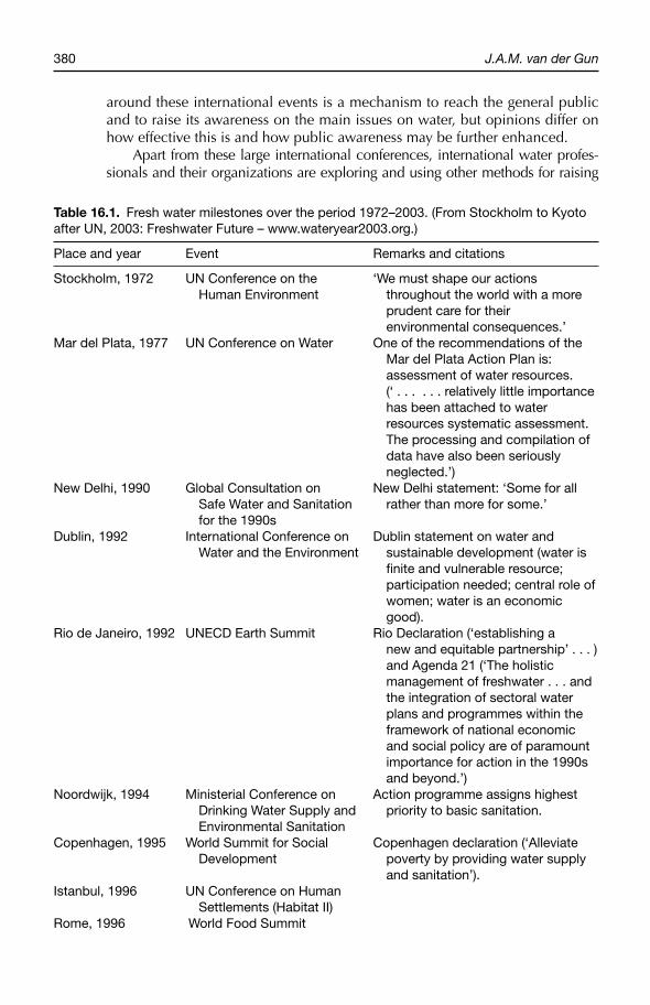
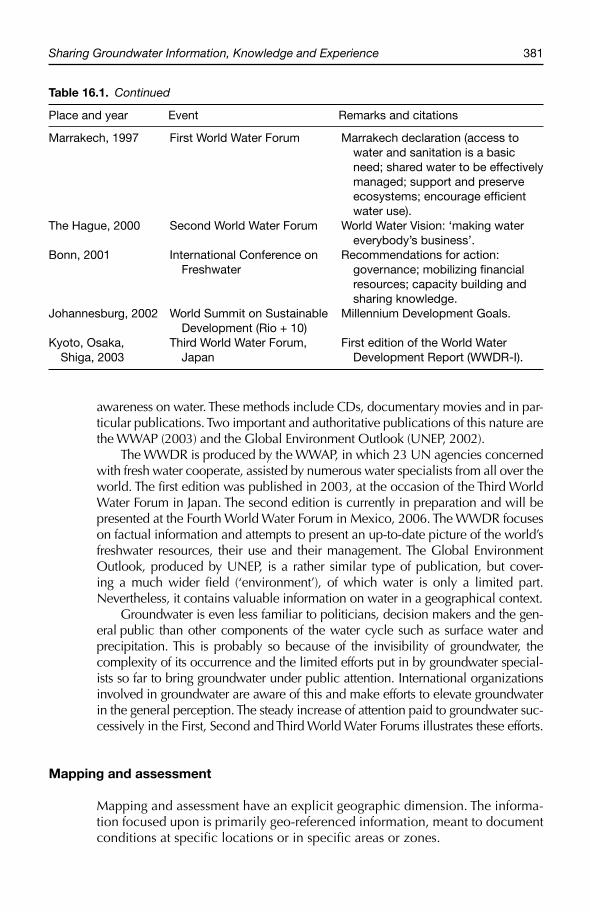
Milestones in global activities to raise awareness on fresh water are listed in Table 16.1. In spite of widespread criticism, it cannot be denied that the listed conferences have produced a great impact on the awareness of politicians, decision makers and professionals on water and related matters. Publicity
380 J.A.M. van der Gun
around these international events is a mechanism to reach the general public and to raise its awareness on the main issues on water, but opinions differ on how effective this is and how public awareness may be further enhanced.
Apart from these large international conferences, international water profes-sionals and their organizations are exploring and using other methods for raising
Table 16.1. Fresh water milestones over the period 1972–2003. (From Stockholm to Kyoto after UN, 2003: Freshwater Future – www.wateryear2003.org.)
Place and year Event Remarks and citations
Stockholm, 1972 UN Conference on the ‘We must shape our actions Human Environment throughout the world with a more prudent care for their environmental consequences.’
Mar del Plata, 1977 UN Conference on Water One of the recommendations of the Mar del Plata Action Plan is: assessment of water resources. (‘ . . . . . . relatively little importance has been attached to water resources systematic assessment. The processing and compilation of data have also been seriously neglected.’)
New Delhi, 1990 Global Consultation on New Delhi statement: ‘Some for all Safe Water and Sanitation rather than more for some.’ for the 1990s
Dublin, 1992 International Conference on Dublin statement on water and Water and the Environment sustainable development (water is fi nite and vulnerable resource; participation needed; central role of women; water is an economic good).
Rio de Janeiro, 1992 UNECD Earth Summit Rio Declaration (‘establishing a new and equitable partnership’ . . . ) and Agenda 21 (‘The holistic management of freshwater . . . and the integration of sectoral water plans and programmes within the framework of national economic and social policy are of paramount importance for action in the 1990s and beyond.’)
Noordwijk, 1994 Ministerial Conference on Action programme assigns highest Drinking Water Supply and priority to basic sanitation. Environmental Sanitation
Copenhagen, 1995 World Summit for Social Copenhagen declaration (‘Alleviate Development poverty by providing water supply and sanitation’).
Istanbul, 1996 UN Conference on Human Settlements (Habitat II)
Rome, 1996 World Food Summit
Sharing Groundwater Information, Knowledge and Experience 381
awareness on water. These methods include CDs, documentary movies and in par-ticular publications. Two important and authoritative publications of this nature are the WWAP (2003) and the Global Environment Outlook (UNEP, 2002).
The WWDR is produced by the WWAP, in which 23 UN agencies concerned with fresh water cooperate, assisted by numerous water specialists from all over the world. The first edition was published in 2003, at the occasion of the Third World Water Forum in Japan. The second edition is currently in preparation and will be presented at the Fourth World Water Forum in Mexico, 2006. The WWDR focuses on factual information and attempts to present an up-to-date picture of the world’s freshwater resources, their use and their management. The Global Environment Outlook, produced by UNEP, is a rather similar type of publication, but cover-ing a much wider field (‘environment’), of which water is only a limited part. Nevertheless, it contains valuable information on water in a geographical context.
Groundwater is even less familiar to politicians, decision makers and the gen-eral public than other components of the water cycle such as surface water and precipitation. This is probably so because of the invisibility of groundwater, the complexity of its occurrence and the limited efforts put in by groundwater special-ists so far to bring groundwater under public attention. International organizations involved in groundwater are aware of this and make efforts to elevate groundwater in the general perception. The steady increase of attention paid to groundwater suc-cessively in the First, Second and Third World Water Forums illustrates these efforts.
Mapping and assessment
Mapping and assessment have an explicit geographic dimension. The informa-tion focused upon is primarily geo-referenced information, meant to document conditions at specific locations or in specific areas or zones.
Table 16.1. Continued
Place and year Event Remarks and citations
Marrakech, 1997 First World Water Forum Marrakech declaration (access to water and sanitation is a basic need; shared water to be effectively managed; support and preserve ecosystems; encourage effi cient water use).
The Hague, 2000 Second World Water Forum World Water Vision: ‘making water everybody’s business’.
Bonn, 2001 International Conference on Recommendations for action: Freshwater governance; mobilizing fi nancial resources; capacity building and sharing knowledge.
Johannesburg, 2002 World Summit on Sustainable Millennium Development Goals. Development (Rio + 10)
Kyoto, Osaka, Third World Water Forum, First edition of the World WaterShiga, 2003 Japan Development Report (WWDR-I).
382 J.A.M. van der Gun
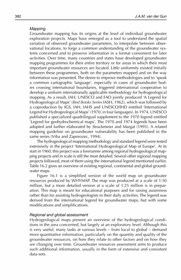
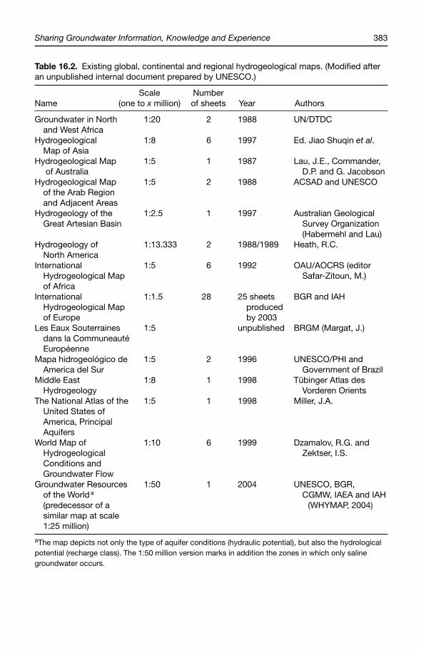
MappingGroundwater mapping has its origins at the level of individual groundwater exploration projects. Maps have emerged as a tool to understand the spatial variation of observed groundwater parameters, to interpolate between obser-vational locations, to forge a common understanding of the groundwater sys-tems concerned and to preserve information in a format convenient for later activities. Over time, many countries and states have developed groundwater mapping programmes for their entire territory or for areas in which their most important groundwater resources are located. Little uniformity existed initially between these programmes, both on the parameters mapped and on the way information was presented. The desire to improve methodologies and to ‘speak a common cartographic language’, especially in cases of groundwater bod-ies crossing international boundaries, triggered international cooperation to develop a uniform internationally applicable methodology for hydrogeological mapping. As a result, IAH, UNESCO and FAO jointly produced ‘A Legend for Hydrogeological Maps’ (Red Books Series IASH, 1962), which was followed by a coproduction by IGS, IAH, IAHS and UNESCO/IHD entitled ‘International Legend for Hydrogeological Maps’ (1970, in four languages). In 1974, UNESCO published a specialized quadrilingual supplement to the 1970 legend entitled ‘Legend for geohydrochemical maps’. The 1970 and 1974 legends have been adopted and further elaborated by Struckmeier and Margat (1995). A related mapping guideline on groundwater vulnerability has been published in the same series (Vrba and Zaporozec, 1994).
The hydrogeological mapping methodology and standard legend were tested extensively in the project ‘International Hydrogeological Map of Europe’. At its start in 1960, this project was a forerunner among regional hydrogeological map-ping projects and in scale is still the most detailed. Several other regional mapping projects followed, most of them using the international legend mentioned earlier. Table 16.2 gives an overview of existing regional, continental and global ground-water maps.
Figure 16.1 is a simplified version of the world map on groundwater resources produced by WHYMAP. The map was produced at a scale of 1:50 million, but a more detailed version at a scale of 1:25 million is in prepar-ation. This map is meant for educational purposes and for raising awareness rather than for assisting hydrogeologists in their daily activities. The legend was derived from the international legend for groundwater maps, but with some modifications and simplifications.
Regional and global assessmentHydrogeological maps present an overview of the hydrogeological condi-tions in the area concerned, but largely at an exploratory level. Although this is very useful, many tasks at various levels – from local to global – demand more quantitative information, particularly on the quantity and quality of the groundwater resources, on how they relate to other factors and on how they are changing over time. Groundwater resources assessment aims to produce such additional information, usually in the form of extensive and consistent data-sets.
Sharing Groundwater Information, Knowledge and Experience 383
Table 16.2. Existing global, continental and regional hydrogeological maps. (Modifi ed after an unpublished internal document prepared by UNESCO.)
Scale Number Name (one to x million) of sheets Year Authors
Groundwater in North 1:20 2 1988 UN/DTDCand West Africa
Hydrogeological 1:8 6 1997 Ed. Jiao Shuqin et al.Map of Asia
Hydrogeological Map 1:5 1 1987 Lau, J.E., Commander, of Australia D.P. and G. Jacobson
Hydrogeological Map 1:5 2 1988 ACSAD and UNESCOof the Arab Region and Adjacent Areas
Hydrogeology of the 1:2.5 1 1997 Australian GeologicalGreat Artesian Basin Survey Organization (Habermehl and Lau)
Hydrogeology of 1:13.333 2 1988/1989 Heath, R.C.North America
International 1:5 6 1992 OAU/AOCRS (editorHydrogeological Map Safar-Zitoun, M.)of Africa
International 1:1.5 28 25 sheets BGR and IAHHydrogeological Map producedof Europe by 2003
Les Eaux Souterraines 1:5 unpublished BRGM (Margat, J.)dans la CommuneautéEuropéenne
Mapa hidrogeológico de 1:5 2 1996 UNESCO/PHI andAmerica del Sur Government of Brazil
Middle East 1:8 1 1998 Tübinger Atlas desHydrogeology Vorderen Orients
The National Atlas of the 1:5 1 1998 Miller, J.A.United States of America, Principal Aquifers
World Map of 1:10 6 1999 Dzamalov, R.G. andHydrogeological Zektser, I.S.Conditions and Groundwater Flow
Groundwater Resources 1:50 1 2004 UNESCO, BGR, of the World a CGMW, IAEA and IAH(predecessor of a (WHYMAP, 2004)similar map at scale 1:25 million)
aThe map depicts not only the type of aquifer conditions (hydraulic potential), but also the hydrological potential (recharge class). The 1:50 million version marks in addition the zones in which only saline groundwater occurs.
384 J.A.M. van der Gun
The role and usefulness of assessment at the level of an aquifer (or part of it) is generally understood and recognized. Hence, assessment is widely prac-tised as a basic step in the development of balanced programmes for ground-water resources development and management. It underpins local actions and enables a better prediction of effectiveness and possible side effects.
Water resources assessment at the national, regional and global levels addresses other needs and often focuses more on policy than on ‘action on the ground’. National governments and international organizations want to know the opportunities and problems offered by water in the near future. It allows them to define priorities in their policies and programmes, to allocate budgets and other means accordingly and to decide on which aspects of the political agenda efforts are needed to raise public support. It will be clear that data-sets on selected cases in certain areas – although extremely useful to demonstrate typical concepts and processes – are not enough to satisfy these needs. Full cover age is needed of the territory concerned: a nation, region or even the entire globe. Global water resources assessment is strongly boosted by the WWAP.
In response to the needs for water resources assessment on a global level, FAO has developed its AQUASTAT database on water and agriculture, and UNEP has organized the environmental database of its GEO data portal. Both global data-bases aim for consistent sets of data on a large number of attributes, defined at the level of countries. FAO’s original data are based on enquiries circulated to repre-sentatives in the different countries; UNEP’s data are being collected by the World Resources Institute (WRI).
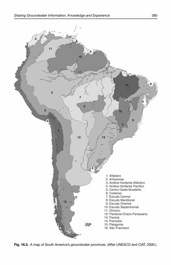
The recently established GGIS database of IGRAC (see: www.igrac.nl), intend ing to bring together all information relevant for groundwater, draws heavily on data from these and other global or regional databases. GGIS not only builds a global database on groundwater-related attributes, but it also provides possibil ities for online visualization. One of the GGIS views is ‘country-oriented’, like the AQUASTAT and GEO databases, and contains 77 standardized attributes. In add ition to these administratively defined spatial boundaries, IGRAC has developed a system of Global Groundwater Regions, in order to organize data according to more physically based units. For this second view, 43 uniform attributes have been defined. The Global Groundwater Regions are depicted in Fig. 16.2. These regions form the highest level in a hierarchical system to delineate physical groundwater units on earth: global groundwater regions – ground-water provinces – aquifers. The global groundwater regions can be subdivided into a number of groundwater provinces; each province encompasses a number of aquifers, which in turn can be subdivided into aquifer beds, and so on. A map of South America’s groundwater provinces is shown in Fig. 16.3 for illustrative purposes. A similar map for Australia has been prepared by the Australian Water Resources Council (2004). The added value of GGIS goes beyond bringing together data from different sources and visualizing them; it actively incorporates new data as well.
Programmes like WWAP with its WWDR and UNEP’s Global Environment Outlook are heavily depending on data from global databases like AQUASTAT,GEO and GGIS, together with those of the GRDC, GEMS/Water, the GPCC and other global data centres. The quantity, quality and consistency of all these data are still limited. Large efforts are needed to upgrade the databases and the underlying data acquisition programmes.
Sharing Groundwater Information, Knowledge and Experience 385
Fig. 16.3. A map of South America’s groundwater provinces. (After UNESCO and CIAT, 2000.)
6
11
10
6
14 6
6
16
9
1312
1
4
3
2
7
5
15
8
1: Altiplano 2: Amazonas 3: Andina-Vertiente Atlántico 4: Andina-Vertiente Pacífico 5: Centro Oeste Brasileño 6: Costeras 7: Escudo Central 8: Escudo Meridional 9: Escudo Oriental10: Escudo Septentrional11: Orinoco12: Pantanal-Chaco-Pampeana13: Paraná14: Parnaíba15: Patagonia16: São Francisco
386 J.A.M. van der Gun
The WWDR and UNEP’s Global Environment Outlook present ground-water information in a very broad interdisciplinary context. A recent UNESCO publication on the world’s groundwater resources more specifically addresses the needs of groundwater specialists (Zektser and Everett, 2004).
Guidelines and ‘lessons learned’
Groundwater assessment and monitoringGuidelines may be of great benefit to those practically involved in ground water exploration, groundwater resources assessment or groundwater monitoring. To carry out such activities efficiently and effectively, experience is at least as important as a professional background in groundwater. A guideline aims to absorb such experience and to disseminate it by suggesting some kind of ‘best practice’ under given circumstances. Guidelines speed up the learning process of those who have only limited experience, they may inspire more experienced colleagues to improve their daily practices and they may contribute to a larger degree of uniformity or even to standardization (WMO, 2001). Standardizing data acquisition is not only convenient; in some cases it is even essential for properly assessing the meaning and value of data-sets from different sources. Examples of generally implemented standardization tools are the laboratory protocols for the determination of water quality parameters and the field proto-cols for geophys ical surveys and aquifer testing. Without a specification of the protocols used, the numerical results have only limited value.
An early guideline covering more or less the entire field of ground water exploration, groundwater resources assessment or groundwater monitor-ing is UNESCO’s publication Groundwater Studies: An International Guide for Research and Practice (1972). This guide, completely revised in 2004, is in reality very close to a textbook and is more useful as a general back-ground than for providing step-by-step guidance on specific activities. The guidelines Water Resources Assessment: Handbook for Review of National Capabilities (WMO/UNESCO, 1997) pays ample attention to institutional capacities required for water resources assessment. Many other guidelines, however, focus on narrower, more specific subjects and usually offer more details. These guidelines have often been written to support activities inside a certain organization or country, but several of them may provide excellent support far beyond that region. A good example is the USGS series entitled Techniques of Water Resources Investigations of the United States Geological Survey, which currently consists of nine chapters with a total of more than 50 different topics, part of them on groundwater. Only a limited number of guidelines, primarily from IAH and UNESCO, have been developed explicitly for worldwide dissemination. Guides with the characteristics of protocols are produced and disseminated by organizations for standardization, both inter-national such as the International Organization for Standardization (ISO) and national such as the American Standards for Testing Materials (ASTM) and the German Industrial Norms (DIN). Quite a number of them are related to groundwater.
Sharing Groundwater Information, Knowledge and Experience 387
Many hydrogeologists are not sufficiently aware of the many guidelines and protocols available in the public domain that may help them in their data acquisition activities. Therefore, IGRAC developed a database on such guide-lines and protocols and made it publicly accessible from their website (www.igrac.nl) as a service to the international groundwater community. The database has been fed by an initial inventory of more than 420 available documents, and it is intended to be expanding continuously by additional references brought under IGRAC’s attention by groundwater specialists from all over the world. On the basis of observed gaps and on interactions with groundwater profession-als, IGRAC initiated a programme of developing new guidelines. Since 2004, two international working groups are active in this context, with the aim of developing guidelines on ‘baseline groundwater monitoring’ and ‘exploitable groundwater resources’, respectively.
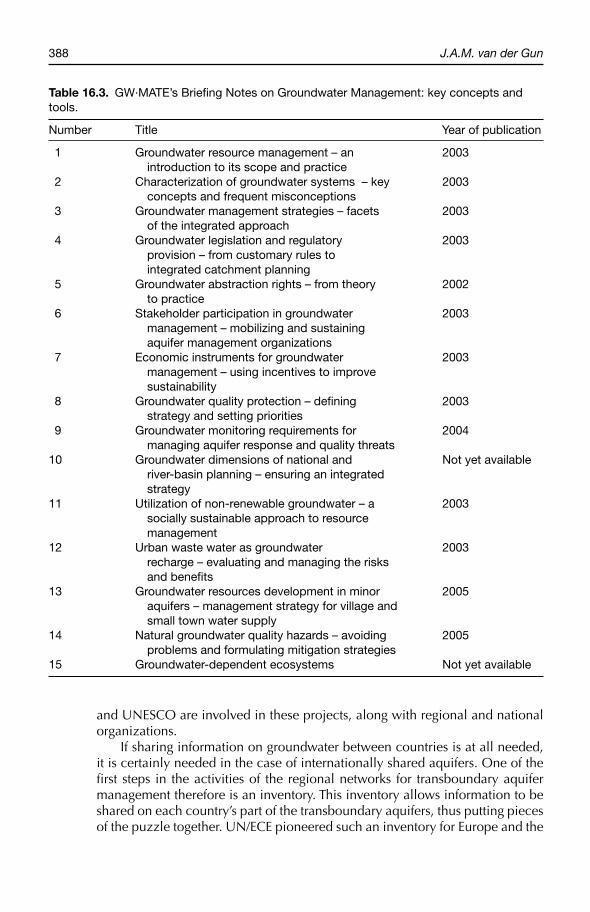
Groundwater resources managementRecent guidelines concern groundwater resources management. While during the early 1990s worldwide attention was raised for integrated water resources management, several international organizations have been producing publi-cations and guidelines in order to promote good practice in water resources management and to communicate ‘lessons learned’ (e.g. World Bank, 1994; Burke and Moench, 2000; FAO, 2003). Regarding groundwater, several relevant international sets of guidelines have appeared in recent years, among which the ToolBox of the Global Water Partnership (although addressing ground water to a limited extent only) and the Briefing Notes Series of the World Bank’s GW˙MATE. Both products are accessible from the Internet at www.gwpforum.org and www.worldbank.org.gwmate, respectively. The titles of GW˙MATE’s Briefing Notes are listed in Table 16.3.
Transboundary groundwater resources management
Groundwater systems do not respect administrative boundaries: many ground-water systems therefore are shared between two, three or more countries. Whereas debates on international river basins have been taking place for many years, the attention for transboundary or ‘internationally shared’ aquifers is only very recent. The establishment of internationally shared aquifer resource management/transboundary aquifer resource management (ISARM/TARM) as a commission under IAH and UNESCO has been instrumental to raise aware-ness of the need for transboundary aquifer management arrangements between countries. ISARM/TARM is also active in forming – in cooperation with regional and national entities – regional networks for transboundary aquifer manage-ment. Examples are the networks in the Balkans and in the Americas. The scope of activities is multi-disciplinary and includes hydrogeological, legal, institutional, socio-economic and environmental aspects. In addition, there are transboundary aquifer management projects for large shared aquifers such as the Guaraní aquifer in South America and the Iullemeden aquifer in northern Africa. Organizations like the Global Environmental Facility (GEF), World Bank
388 J.A.M. van der Gun
and UNESCO are involved in these projects, along with regional and national organizations.
If sharing information on groundwater between countries is at all needed, it is certainly needed in the case of internationally shared aquifers. One of the first steps in the activities of the regional networks for transboundary aquifer management therefore is an inventory. This inventory allows information to be shared on each country’s part of the transboundary aquifers, thus putting pieces of the puzzle together. UN/ECE pioneered such an inventory for Europe and the
Table 16.3. GW·MATE’s Briefi ng Notes on Groundwater Management: key concepts and tools.
Number Title Year of publication
1 Groundwater resource management – an 2003 introduction to its scope and practice
2 Characterization of groundwater systems – key 2003 concepts and frequent misconceptions
3 Groundwater management strategies – facets 2003 of the integrated approach
4 Groundwater legislation and regulatory 2003 provision – from customary rules to integrated catchment planning
5 Groundwater abstraction rights – from theory 2002 to practice
6 Stakeholder participation in groundwater 2003 management – mobilizing and sustaining aquifer management organizations
7 Economic instruments for groundwater 2003 management – using incentives to improve sustainability
8 Groundwater quality protection – defi ning 2003 strategy and setting priorities
9 Groundwater monitoring requirements for 2004 managing aquifer response and quality threats
10 Groundwater dimensions of national and Not yet available river-basin planning – ensuring an integrated strategy
11 Utilization of non-renewable groundwater – a 2003 socially sustainable approach to resource management
12 Urban waste water as groundwater 2003 recharge – evaluating and managing the risks and benefi ts
13 Groundwater resources development in minor 2005 aquifers – management strategy for village and small town water supply
14 Natural groundwater quality hazards – avoiding 2005 problems and formulating mitigation strategies
15 Groundwater-dependent ecosystems Not yet available
Sharing Groundwater Information, Knowledge and Experience 389
inventory model has been used later by other regional groups. Findings so far are that this inventory step is already very difficult and time-consuming, but it breaks the ice for next steps in which not only information has to be shared, but a good degree of trust as well. IGRAC is cooperating with ISARM by organizing ISARM’s website (including regional pages) and by assisting in the processing and visualization of inventory data.
It can be observed that at present the degree of sharing information is insuf-ficient to allow shared aquifer management to be planned and implemented. It will still take many more years and dramatically increased efforts to achieve satisfactory levels of sharing information.
Conclusions and a Look into the Future
Exchange of information and the agricultural groundwater revolution
Worldwide exchange of information has undoubtedly been one of the key fac-tors triggering the ‘agricultural groundwater revolution’ in quite a number of countries scattered over the world. It has been a mechanism to raise awareness on the potential benefits of the groundwater resources and to spread know-ledge on how to explore, develop and use them properly.
However, once agriculture has been expanded significantly by tapping groundwater, a number of associated problems usually start to develop. This means that the main challenge shifts from expanding groundwater exploitation to keeping the resource and its beneficial use sustainable, while at the same time avoiding significant damage by groundwater abstraction to nature and the environment. Intensive sharing of information, knowledge and experience is likely to have a positive effect on the outcomes of these efforts. Given the men-tioned shift in focus, it follows that the types of information and experience to be exchanged have to change accordingly.
Current state of sharing information on groundwater worldwide
Important contributions to the global sharing of information, knowledge and experience on groundwater are being made by many actors and programmes. Many of the endeavours are focusing on information, knowledge and exper-ience of a generic nature, but others are explicitly related to area-specific information.
It can be observed that international exchange of generic information, knowledge and experience on groundwater has a much longer tradition and is much more advanced than that of area-specific information, knowledge and experience. Where the former may produce more than any groundwater spe-cialist is able to absorb, the latter is still in its infancy and does not yet satisfy more than very elementary demands. This means – among other things – that existing global or regional pictures of groundwater conditions are still deficient and inaccurate, that many analogies regarding groundwater are not yet properly
390 J.A.M. van der Gun
identified or understood, that highly relevant patterns and trends may still fail to be recognized, and that transboundary groundwater management does not take off because information on the aquifers to be managed jointly is lacking.
With so many organizations in one way or another active in the described field, it is difficult to ensure coordinated efforts and to avoid duplication. However, there is an increasing tendency to join forces in international pro-grammes under the aegis of international organizations such as UNESCO and IAH. This creates synergy, reduces inconsistencies and increases efficiency.
A look into the future
Although the continuation of exchanging groundwater information on a generic level remains important, it follows from the earlier-described current state of affairs that priority needs to be given to the enhancement of sharing area-specific (or geo-referenced) information, knowledge and experience. Documentation of the world’s groundwater systems on freely accessible platforms, such as those initiated by FAO (AQUASTAT), UNEP (GEO) and IGRAC (GGIS) needs to be intensified, improved and diversified. Present-day deficiencies of these systems include the scarcity of data in general; the lack of uniformity/synchronization of the data and thus an inherent poor quality of the processed information; and the lack of groundwater-monitoring data, which implies that changes in groundwater conditions are very poorly known, precluding rational and effi-cient actions to exploit, manage and protect the groundwater resources prop-erly. Furthermore, the information is presented predominantly in the form of variables and indicators; analysis of the corresponding numbers and well-doc-umented accounts of experiences on groundwater are rare.
In the endeavour to establish an enhanced GGIS to better service the inter-national community, IGRAC is challenged in many ways. One of the challenges is to convert the currently ad hoc data inflow mechanisms into more structural ones; this will require strong and active international networks of motivated people, which can only be achieved in the longer term. Another challenge is diversification of the information inside the GGIS. Important categories of addi-tional information to be exchanged and made centrally available are:
● monitored change in groundwater conditions;● activities undertaken and results obtained in groundwater resources man-
agement (sharing experiences as an efficient mechanism for learning);● national or local organizations and projects active in collecting and pro-
viding area-specific information (metadata);● principal maps, reports and publications on groundwater (metadata).
Beyond the improvement of these platforms and the related databases, there are many more modalities for improving the process of sharing information and experience on groundwater. One of the evident options is building communi-ties of practice and interactive networks on groundwater; expanding the aware-ness on groundwater effectively to non-technical target groups (politicians, the general public) is another important one.
Sharing Groundwater Information, Knowledge and Experience 391
Managing groundwater resources is a very complex activity and char-acterized by trial and error. Information is only one of the many factors at play, but an important one. Sufficient area-specific information will help us in choosing which road to embark upon and in keeping track of whether it brings us where we want to be. Local information is crucial in this respect, but – as explained in this paper – the international exchange of information and experience may produce significant added value and thus contribute to better results.
References
Arlosoroff, S. et al. (1987) Community water supply. The Handpump Option: A Joint Contribution by the UNDP and the World Bank to the International Drinking Water Supply and Sanitation Decade. The World Bank, Washington, DC.
Australian Water Resources Council (2004) Groundwater provinces map of Australia, published on the website of the Australian Department of the Environment and Heritage. Available at: http://www.deh.gov.au/soe/2001/inland/water01–2d.html
Burke, J. and Moench, M. (2000) Groundwater and Society. United Nations, New York.
Day, J.B.W. (1992) A brief account of the International Association of Hydrogeologist. In: Applied Hydrogeology (International Journal) Vol. 0/1992, IAH.
Dupuit, J. (1863) Etudes théoriques et pratiques sur le mouvement des eaux dans les canaux découverts et à travers les terrains permé-ables. Dunod, Paris.
FAO (2003) Groundwater Management: The Search for Practical Approaches. FAO Water Report no. 25, Rome.
IAH (1994) Membership Directory 1994.IAH (2003) Annual Report 2003.IAH, UNESCO and FAO (1962) A legend for
hydrogeological maps. Red Books Series.IASH.
IGS, IAH, IASH and UNESCO/IHD (1970) International legend for hydrogeological maps (in four languages).
IGRAC (2004) Global Groundwater Information System. Available at: http://igrac.nitg.tno.nl/ggis_start.html
Kasrils, R. (2003) Preface. In: Xu, Yongxin and Hans E. Beekman (eds) 2003: Groundwater
Recharge Estimation in Southern Africa.UNESCO-IHP Series No. 64, UNESCO, Paris.
Naciones Unidas, PNUD (1973) Desarrollo de los Recursos de Aguas Subterráneas en el Altiplano. Resultados del Proyecto. Conclusiones y recommendaciones.
Negenman, A.H.J. (1995) Capacity building and water resources management in Yemen: the WRAY project experience. In: Romijn, E. and de Roon, J.C.S. (eds) Netherlands Experiences with Integrated Management.RIZA, Lelystad, The Netherlands, pp. 33–52.
Stow, D.A.V., Skidmore, J. and Berger, A.R. (1976) Preliminary Bibliography on Ground-water in Developing Countries. AGID Report No.4.
Struckmeier, W. and Margat, J. (1995) Hydrogeological Maps: A Guide and a Standard Legend. IAH Series InternationalContributions to Hydrogeology 17, Heise, Hannover.
UNEP (2002) Global Environment Outlook 3: Past, Present and Future Perspectives.Produced by UNEP GEO team, Division of Early Warning and Assessment (DEWA), UNEP, Nairobi, Kenya.
UNEP (2003) Groundwater and Its Susceptibility to Degradation. UNEP/DEWA, Nairobi, Kenya.
UNESCO (1972) Groundwater Studies: An International Guide for Research and Practice. UNESCO, Paris.
UNESCO (1974) Legend for geohydrochemi-cal maps (quadrilingual supplement to the 1970 legend on hydrogeological maps). UNESCO, Paris.
UNESCO and ACSAD (1988) Hydrogeological map of the Arab region and adjacent areas. Two sheets, scale 1:5 million.
392 J.A.M. van der Gun
UNESCO, BGR, CGMW, IAEA and IAH (2004) Map of Groundwater Resources of the World, 1:50 000 000. Special edition for the 32nd International Geological Congress, Florence/Italy, 20–28 August 2004.
UNESCO and CIAT (2000) Mapa Hidrogeológico de América del Sur. Digital coverages on CD, prepared for UNESCO/IHP.
UNESCO, IAH, UNECE and FAO (2001) Internationally Shared (Transboundary) Aquifer Resources Management: Their Significance and Sustainable Management.A framework document. IHP-VI, IHP Non Serial Publications in Hydrology, UNESCO, Paris.
USGSTechniques of Water-Resources Investigations of the United States Geological Survey. US Department of the Interior, Geological Survey. US Government Printing Office, Washington, DC.
Vrba, J. and Zaporozec, A. (eds) (1994) Guidebook on mapping groundwater vul-
nerability. International Contributions to Hydrogeology, Vol.16, IAH/IHP.
WHYMAP (2004) Identical to UNESCO et al. (2004).
WMO (2001) Exchanging hydrological data and information. WMO Policy and Practice. Geneva, Switzerland, WMO-No. 925, 2001.
WMO and UNESCO (1997) Water resources assessment. Handbook for Review of National Capabilities, USA, pp. 1–113.
World Bank (1994) A Guide to the Formulation of Water Resources Strategy. World Bank Technical Paper No. 263. The World bank, Washington, DC.
WWAP (2003) Water for People, Water for Life. The United Nations World Water Development Report. Published by UNESCO, Paris/Berghahn Books, Oxford, UK.
Zektser, I.S. and Everett, L.G. (2004) Ground water resources of the world and their use. UNESCO, IHP-VI Series in Groundwater No 6.