sgef 173 maps of lee county noticed general permit …nsgl.gso.uri.edu/flsgp/flsgpm08002.pdf ·...
TRANSCRIPT

i
Maps of Lee County Noticed General PermitTrafficshed Channels and
Secondary Channels
SGEF-17330 October 2008
Gustavo A. AntoniniRobert A. SwettDavid A. Fann
ii
This publication was supported by the National Sea Grant College Program of the U.S. Department of Commerce’s National Oceanic and Atmospheric Administration (NOAA), Grant No. NA16RG-2195. The views expressed are those of the authors and do not necessarily reflect the view of these organiza-tions. Additional copies are available by contacting Florida Sea Grant, University of Florida, PO Box 110409, Gainesville, FL, 32611-0409, (352) 392.2801, www.flseagrant.org.

iii
Maps of Lee County Noticed General PermitTrafficshed Channels and
Secondary Channels
SGEF-17330 October 2008
Gustavo A. AntoniniRobert A. SwettDavid A. Fann

ii
Foreword
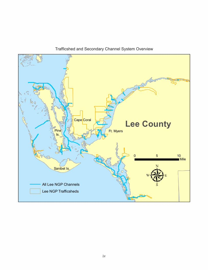
This document is a collection of maps, prepared by Florida Sea Grant, that depict channels included in the Lee County Noticed General Permit (NGP)1 . Each map shows either (a) channel segments within an NGP trafficshed (boat source area, the vessels berthed in which exit via a common channel to a secondary channel or directly to deep, open water) or (b) segments in an NGP secondary chan-nel system (contains channels that route vessels from one or more trafficsheds to deep, open water).
Channel segments are symbolized by line thickness to highlight those for which dredging is antici-pated under the NGP. The symbology is determined by subtracting the measured MLLW2 depth of each channel segment from the NGP depth (determined for the entire trafficshed or secondary chan-nel system). If the difference is greater than zero, the status “NGP Dredging Anticipated” is assigned. Otherwise, the status is “NGP Dredging not Anticipated.” Each map includes a summary table of total NGP channel length, total length of channel segments for which NGP dredging is anticipated, and NGP dredge depth.
The channel segments are waterway centerlines constructed from depths measured in the Lee County Regional Waterway Management System project, Phase 1 (2000)3 , Phase 2 (2001)4, and Phase 3 (2002)5.
1 Rule 62-341.494, F.A.C., “Noticed General Permit for Maintenance of Public Navigation Channel and Canal Infrastructure by the West Coast Inland Navigation District within Lee County”
2 Mean Lower Low Water
3 Swett, R.A., D.A. Fann, G.A. Antonini, and L. Carlin Alexander, 2000. Regional Waterway Man-agement System for Lee County, Phase 1: Estero Bay, Florida Sea Grant TD3, Gainesville, FL: Florida Sea Grant College Program, 2000.
4 Swett, R.A., D.A. Fann, G.A. Antonini, and L. Carlin Alexander, 2001. Regional Waterway Manage-ment System for Lee County, Phase 2: Pine Island Sound, Florida Sea Grant TD4, Gainesville, FL: Florida Sea Grant College Program.
5 Fann, D.A., R.A. Swett, L. Carlin Alexander, and G.A. Antonini, 2002. Regional Waterway Manage-ment System for Lee County, Phase 3: Caloosahatchee River, Florida Sea Grant TD5, Gaines-ville, FL: University of Florida Sea Grant College Program.
ii

iii
1. Back Channel-South Estero Bay (SC)2. Big Carlos Pass & Vicinity (SC)3. Bokeelia East4. Bokeelia West5. Caloosa Isle Marina6. Cape Coral Southwest7. Central Estero Bay (SC)8. Chantry Canal9. Compass Rose10. Deep Lagoon11. Demere Key12. East Fort Myers13. Estero Island-Bayside (SC)14. Everest Canal15. Fish Tale Marina16. Fish Trap Bay 217. Fort Myers Yacht Basin18. Franklin Locks East19. Getaway20. Hancock Creek21. Hogue (SC)22. Hurricane Bay East (SC)23. Hurricane Bay West (SC)24. Imperial River-Lower
25. Imperial River-Upper26. Imperial Shores27. Marsh Point28. Matanzas Harbor (SC)29. Matlacha-Northwest30. Matlacha-Southwest31. Matlacha Isles/Cape Coral-Northwest32. Mullock Creek33. Normandy Canal34. North Matlacha (SC)35. Orange River36. Pelican Landing37. Plato Canal38. Punta Rassa/Connie Mack Island39. Redfish Point40. Rookery Trace (SC)41. Roosevelt Channel-Bayside42. Roosevelt Channel-North43. Saint James City-East44. Saint James City-South45. Siesta Isles46. South Estero Bay (SC)47. South Matlacha (SC)48. Sunset Bay
Trafficshed and secondary channel (SC) maps
iv
Trafficshed and Secondary Channel System Overview
Lee County
All Lee NGP Channels
Lee NGP Trafficsheds
0 105Mile
Ft. Myers
Cape Coral
Sanibel Is.
PineIs.

1
0 0.50.25Mile
Back Channel-South Estero Bay
Secondary Channel
Total NGP channel length 18,252 ftAnticipated dredge length 178 ftNGP dredge depth 3 ft
BigCarlosPass
ChannelLocation
NGP Dredging not Anticipated
NGP Dredging Anticipated
Figure 1. Back Channel-South Estero Bay

2
0 0.50.25Mile
Big Carlos Pass& Vicinity
Secondary Channel
Total NGP channel length 9,354 ftAnticipated dredge length 0NGP dredge depth 4.5 ft
Ft Myers Beach
ChannelLocation
Big Carlos Pass
NGP Dredging not Anticipated
NGP Dredging Anticipated
Figure 2. Big Carlos Pass & Vicinity
3
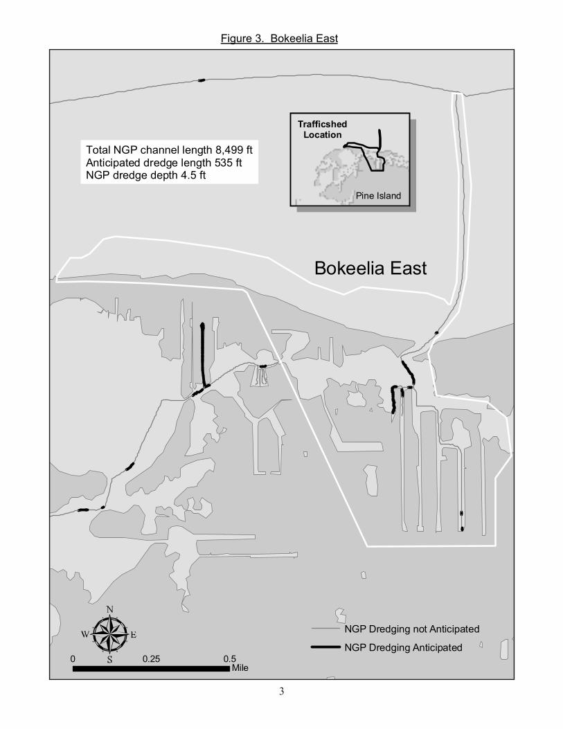
0 0.50.25Mile
Bokeelia East
Total NGP channel length 8,499 ftAnticipated dredge length 535 ftNGP dredge depth 4.5 ft
NGP Dredging not Anticipated
NGP Dredging Anticipated
TrafficshedLocation
Pine Island
Figure 3. Bokeelia East
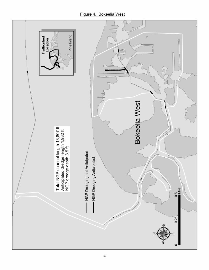
4
00.
50.
25M
ile
Boke
elia
Wes
t
NG
P D
redg
ing
not A
ntic
ipat
ed
NG
P D
redg
ing
Ant
icip
ated
Traf
ficsh
edLo
catio
n
Pine
Isla
nd
Tota
l NG
P ch
anne
l len
gth
13,8
07 ft
Antic
ipat
ed d
redg
e le
ngth
1,9
82 ft
NG
P d
redg
e de
pth
3.5
ft
Figure 4. Bokeelia West

5
00.
50.
25M
ile
Cal
oosa
Isle
Mar
ina
NG
P D
redg
ing
not A
ntic
ipat
ed
NG
P D
redg
ing
Ant
icip
ated
Traf
ficsh
edLo
catio
n
Cap
eC
oral
Ft.
Mye
rs
Tota
l NG
P ch
anne
l len
gth
8,34
3 ft
Antic
ipat
ed d
redg
e le
ngth
2,5
39 ft
NG
P d
redg
e de
pth
5 ft
Figure 5. Caloosa Isle Marina

6
0 10.5Mile
Cape Coral Southwest
NGP Dredging not Anticipated
NGP Dredging Anticipated
TrafficshedLocation
CapeCoral
PineIsland
Lock
Total NGP channel length 10,603 ftAnticipated dredge length 1,521ftNGP dredge depth 6 ft
Figure 6. Cape Coral Southwest
7
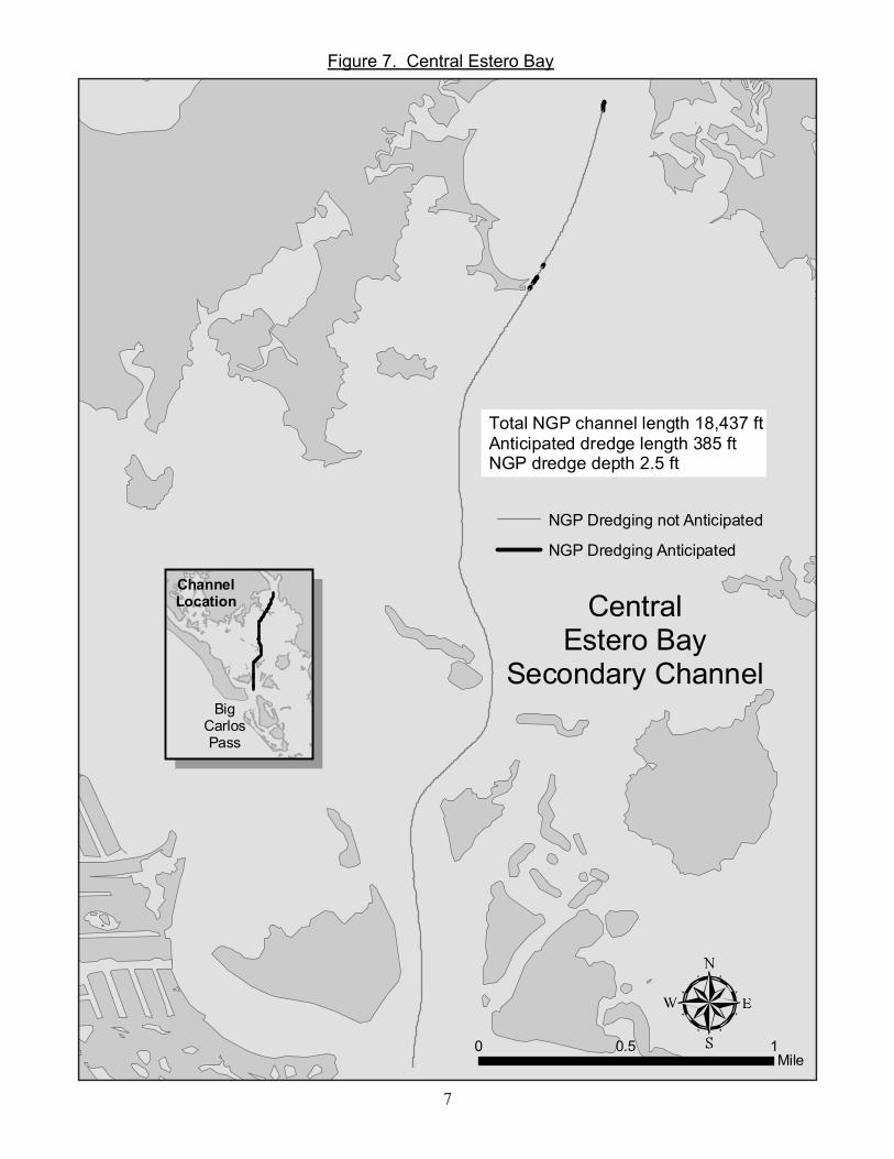
0 10.5Mile
CentralEstero Bay
Secondary Channel
Total NGP channel length 18,437 ftAnticipated dredge length 385 ftNGP dredge depth 2.5 ft
NGP Dredging not Anticipated
NGP Dredging Anticipated
BigCarlosPass
ChannelLocation
Figure 7. Central Estero Bay

8
01
0.5
Mile
Cha
ntry
Can
al
Tota
l NG
P ch
anne
l len
gth
11,3
15 ft
Antic
ipat
ed re
dge
leng
th 4
58 ft
NG
P d
redg
e de
pth
4.5
ft
NG
P D
redg
ing
not A
ntic
ipat
ed
NG
P D
redg
ing
Ant
icip
ated
Traf
ficsh
edLo
catio
nC
ape
Cor
al
Ft.
Mye
rs
Figure 8. Chantry Canal

9
0 0.10.05Mile
Compass Rose
Total NGP channel length 1,172 ftAnticipated dredge length 0NGP dredge depth 4.5 ft
NGP Dredging not Anticipated
NGP Dredging Anticipated
Ft Myers Beach
TrafficshedLocation
San CarlosIsland
Figure 9. Compass Rose

10
0 0.50.25Mile
Deep Lagoon
Total NGP channel length 9,242 ftAnticipated dredge length 491NGP dredge depth 6 ft
NGP Dredging not Anticipated
NGP Dredging Anticipated
TrafficshedLocation
RedfishPoint
Figure 10. Deep Lagoon
11
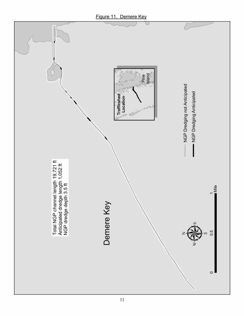
01
0.5
Mile
Dem
ere
Key
Tota
l NG
P ch
anne
l len
gth
19,7
21 ft
Antic
ipat
ed d
redg
e le
ngth
1,0
52 ft
NG
P d
redg
e de
pth
3.5
ft
NG
P D
redg
ing
not A
ntic
ipat
ed
NG
P D
redg
ing
Ant
icip
ated
Traf
ficsh
edLo
catio
n
Pine
Isla
nd
Figure 11. Demere Key

12
00.
50.
25M
ile
East
For
t Mye
rs
Tota
l NG
P ch
anne
l len
gth
2,58
8 ft
Antic
ipat
ed d
redg
e le
ngth
1,6
22 ft
NG
P d
redg
e de
pth
7 ft
NG
P D
redg
ing
not A
ntic
ipat
ed
NG
P D
redg
ing
Ant
icip
ated
Traf
ficsh
edLo
catio
n
FtM
yers
Nor
th F
tM
yers
Figure 12. East Fort Myers
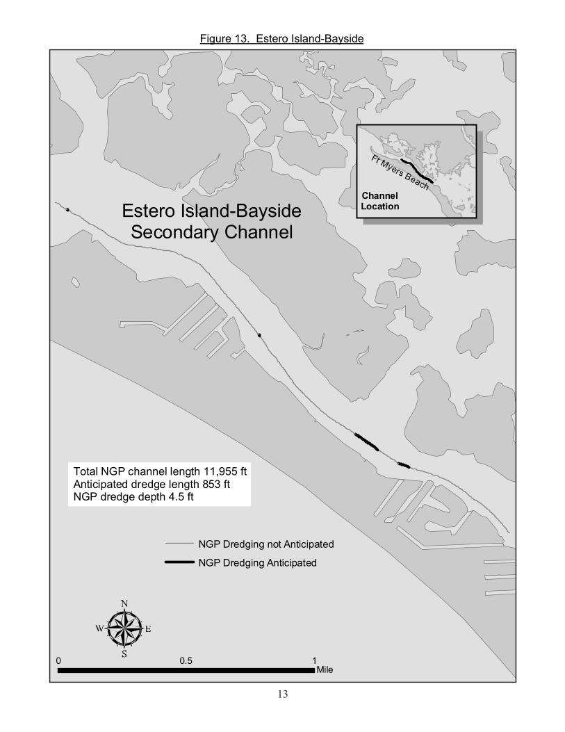
13
0 10.5Mile
Estero Island-BaysideSecondary Channel
Total NGP channel length 11,955 ftAnticipated dredge length 853 ftNGP dredge depth 4.5 ft
NGP Dredging not Anticipated
NGP Dredging Anticipated
ChannelLocation
Ft Myers Beach
Figure 13. Estero Island-Bayside
14
01
0.5
Mile
Ever
est C
anal
Tota
l NG
P ch
anne
l len
gth
4,92
8 ft
Antic
ipat
ed d
redg
e le
ngth
2,4
94 ft
NG
P d
redg
e de
pth
5 ft
NG
P D
redg
ing
not A
ntic
ipat
ed
NG
P D
redg
ing
Ant
icip
ated
Traf
ficsh
edLo
catio
n
Cap
eC
oral
FtM
yers
Red
fish
Pt.
Figure 14. Everest Canal

15
00.
10.
05M
ile
Fish
Tal
e M
arin
a
Tota
l NG
P ch
anne
l len
gth
1,84
9 ft
Antic
ipat
ed d
redg
e le
ngth
0N
GP
dre
dge
dept
h 4
ftN
GP
Dre
dgin
g no
t Ant
icip
ated
NG
P D
redg
ing
Ant
icip
ated
Big
Car
los
Pass
Traf
ficsh
edLo
catio
n
Figure 15. Fish Tale Marina

16
0 0.10.05Mile
Fish Trap Bay 2
Total NGP channel length 3,213 ftAnticipated dredge length 520 ftNGP dredge depth 2.5 ft
NGP Dredging not Anticipated
NGP Dredging Anticipated
TrafficshedLocation
BonitaSprings
Figure 16. Fish Trap Bay 2

17
00.
10.
05M
ile
Fort
Mye
rs Y
acht
Bas
in
Tota
l NG
P ch
anne
l len
gth
7,94
1 ft
Antic
ipat
ed d
redg
e le
ngth
4,9
87 ft
NG
P d
redg
e de
pth
7 ft
NG
P D
redg
ing
not A
ntic
ipat
ed
NG
P D
redg
ing
Ant
icip
ated
Traf
ficsh
edLo
catio
n
Fort
Mye
rs
Figure 17. Fort Myers Yacht Basin

18
01
0.5
Mile
Fran
klin
Loc
ks E
ast
Tota
l NG
P ch
anne
l len
gth
2,47
8 ft
Antic
ipat
ed d
redg
e le
ngth
1,4
05 ft
NG
P d
redg
e de
pth
5 ft
NG
P D
redg
ing
not A
ntic
ipat
ed
NG
P D
redg
ing
Ant
icip
ated
Traf
ficsh
edLo
catio
n
Fran
klin
Lock
s
Hendry County
Hendry County
Figure 18. Franklin Locks East

19
Figure 19. Getaway

20
0 10.5Mile
Hancock Creek
Total NGP channel length 26,613 ftAnticipated dredge length 2,778 ftNGP dredge depth 5 ft
NGP Dredging not Anticipated
NGP Dredging AnticipatedTrafficshed
LocationFt Myers
NorthFt Myers
Figure 20. Hancock Creek
21
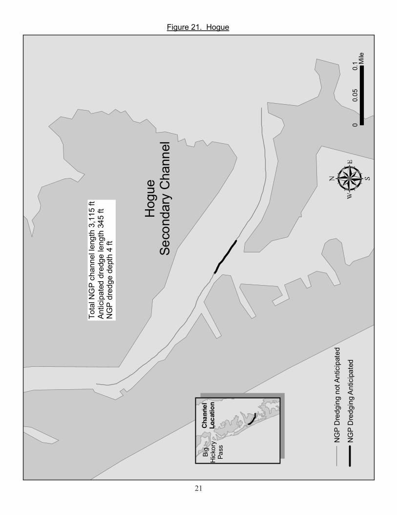
00.
10.
05M
ile
Hog
ueSe
cond
ary
Cha
nnel
Tota
l NG
P ch
anne
l len
gth
3,11
5 ft
Antic
ipat
ed d
redg
e le
ngth
345
ftN
GP
dre
dge
dept
h 4
ft
NG
P D
redg
ing
not A
ntic
ipat
ed
NG
P D
redg
ing
Ant
icip
ated
Cha
nnel
Loca
tion
Big
Hic
kory
Pass
Figure 21. Hogue
22
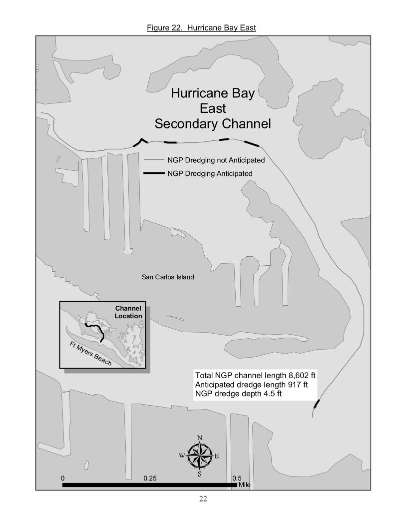
0 0.50.25Mile
Hurricane BayEast
Secondary Channel
Total NGP channel length 8,602 ftAnticipated dredge length 917 ftNGP dredge depth 4.5 ft
NGP Dredging not Anticipated
NGP Dredging Anticipated
ChannelLocation
Ft Myers Beach
San Carlos Island
Figure 22. Hurricane Bay East

23
0 0.250.125Mile
Hurricane Bay WestSecondary Channel
Total NGP channel length 8,750 ftAnticipated dredge length 1,369 ftNGP dredge depth 5 ft
NGP Dredging not Anticipated
NGP Dredging Anticipated
Ft Myers BeachChannelLocation
Figure 23. Hurricane Bay West
24
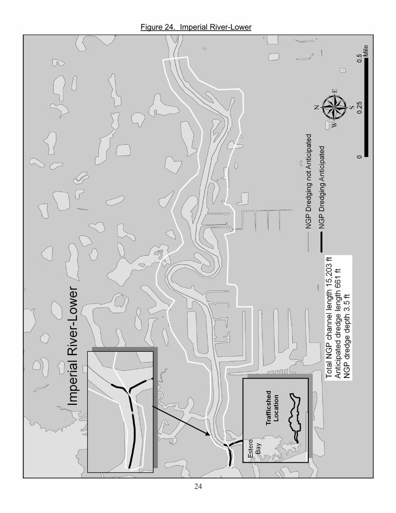
Figure 24. Imperial River-Lower
25
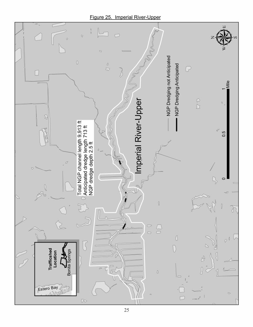
01
0.5
Mile
Impe
rial R
iver
-Upp
er
Tota
l NG
P ch
anne
l len
gth
9,91
3 ft
Antic
ipat
ed d
redg
e le
ngth
713
ftN
GP
dre
dge
dept
h 2.
5 ft
NG
P D
redg
ing
not A
ntic
ipat
ed
NG
P D
redg
ing
Ant
icip
ated
Traf
ficsh
edLo
catio
n
Boni
ta S
prin
gs
Estero Bay
Figure 25. Imperial River-Upper

26
00.
10.
05M
ile
Impe
rial S
hore
s
Tota
l NG
P ch
anne
l len
gth
4,10
6 ft
Antic
ipat
ed d
redg
e le
ngth
1,6
85 ft
NG
P d
redg
e de
pth
2.5
ft
NG
P D
redg
ing
not A
ntic
ipat
ed
NG
P D
redg
ing
Ant
icip
ated
Traf
ficsh
edLo
catio
n
Este
roBa
y
Figure 26. Imperial Shores

27
0 0.50.25Mile
Marsh Point
Total NGP channel length 5,729 ftAnticipated dredge length 1,201 ftNGP dredge depth 3 ft
NGP Dredging not Anticipated
NGP Dredging Anticipated
TrafficshedLocation
FortMyers
NorthFort
Myers
Figure 27. Marsh Point
28
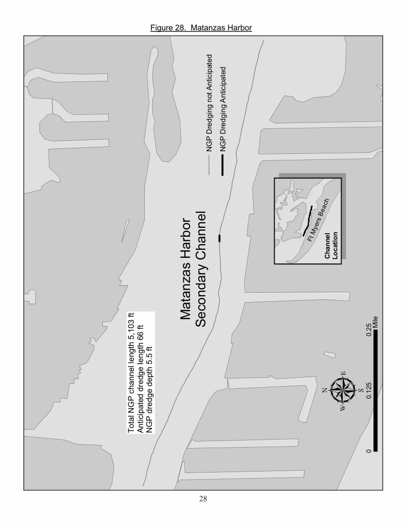
00.
250.
125
MileM
atan
zas
Har
bor
Seco
ndar
y C
hann
el
Tota
l NG
P ch
anne
l len
gth
5,10
3 ft
Antic
ipat
ed d
redg
e le
ngth
66
ftN
GP
dre
dge
dept
h 5.
5 ft
NG
P D
redg
ing
not A
ntic
ipat
ed
NG
P D
redg
ing
Ant
icip
ated
Ft M
yers
Bea
chC
hann
elLo
catio
n
Figure 28. Matanzas Harbor

29
0 0.250.125Mile
Matlacha-Northwest
Total NGP channel length 1,457 ftDredge length 654 ftNGP dredge depth 4.5 ft
NGP Dredging not Anticipated
NGP Dredging Anticipated
TrafficshedLocation
LittlePine
IslandCapeCoral
Mat
lach
a P
ass
Figure 29. Matlacha-Northwest

30
0 0.10.05Mile
Matlacha-Southwest 2
Total NGP channel length 2,719 ftAnticipated dredge length 180 ftNGP dredge depth 3.5 ft
NGP Dredging not Anticipated
NGP Dredging Anticipated
LlittlePIne
Island
CapeCoral
TrafficshedLocation
Figure 30. Matlacha-Southwest 2

31
Matlacha Isles/Cape Coral-Northwest
Total NGP channel length 14,057ftAnticipated dredge length 1,729 ftNGP dredge depth 4 ft
0 10.5Mile
TrafficshedLocation
CapeCoral
PineIsland
NGP Dredging not Anticipated
NGP Dredging Anticipated
MatlachaPass
BoatLift
Figure 31. Matlacha Isles/Cape Coral-Northwest

32
Figure 32. Mullock Creek

33
00.
50.
25M
ile
Nor
man
dy C
anal
Tota
l NG
P ch
anne
l len
gth
11,8
78 ft
Antic
ipat
ed d
redg
e le
ngth
4,0
68 ft
NG
P d
redg
e de
pth
5 ft
NG
P D
redg
ing
not A
ntic
ipat
ed
NG
P D
redg
ing
Ant
icip
ated
Traf
ficsh
edLo
catio
nC
ape
Cor
al
FtM
yers
Red
fish
Poin
t
Figure 33. Normandy Canal

34
02
1M
iles
Nor
thM
atla
cha
Seco
ndar
yC
hann
el
Tota
l NG
P ch
anne
l len
gth
62,8
64 ft
Antic
ipat
ed d
redg
e le
ngth
84
ftN
GP
dre
dge
dept
h 4.
5 ft
NG
P D
redg
ing
not A
ntic
ipat
ed
NG
P D
redg
ing
Ant
icip
ated
Boke
elia
Boke
elia
Cap
eC
oral
Cha
nnel
Loca
tion
Pine Island
Figure 34. North Matlacha
35
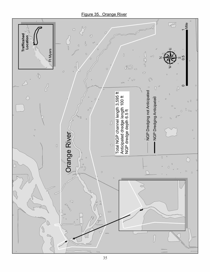
01
0.5
Mile
Ora
nge
Riv
er
Tota
l NG
P ch
anne
l len
gth
3,59
5 ft
Antic
ipat
ed d
redg
e le
ngth
100
ftN
GP
dre
dge
dept
h 6.
5 ft
Traf
ficsh
edLo
catio
n
Ft M
yers
NG
P D
redg
ing
not A
ntic
ipat
ed
NG
P D
redg
ing
Ant
icip
ated
Figure 35. Orange River

36
00.
10.
05M
ile
Pelic
an L
andi
ngTo
tal N
GP
chan
nel l
engt
h 3,
992
ftAn
ticip
ated
dre
dge
leng
th 1
,169
ftN
GP
dre
dge
dept
h 2.
5 ft
NG
P D
redg
ing
not A
ntic
ipat
ed
NG
P D
redg
ing
Ant
icip
ated
Traf
ficsh
edLo
catio
nEs
tero
Bay
Big
Car
los
Pass
Figure 36. Pelican Landing

37
01
0.5
Mile
Plat
o C
anal
Tota
l NG
P ch
anne
l len
gth
18,5
20 ft
Antic
ipat
ed d
redg
e le
ngth
5,4
87 ft
NG
P d
redg
e de
pth
5.5
ft
NG
P D
redg
ing
not A
ntic
ipat
ed
NG
P D
redg
ing
Ant
icip
ated
Traf
ficsh
edLo
catio
nC
ape
Cor
al
Red
fish
Poin
t
Figure 37. Plato Canal
38
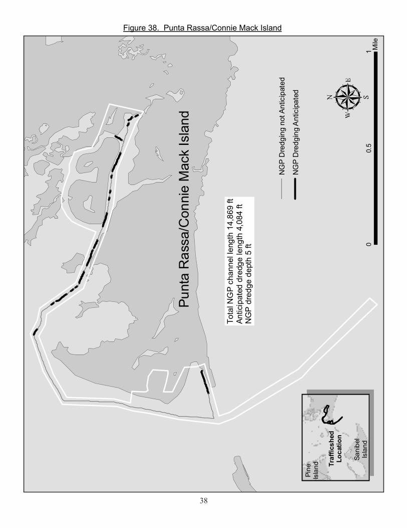
01
0.5
Mile
Punt
a R
assa
/Con
nie
Mac
k Is
land
Tota
l NG
P ch
anne
l len
gth
14,8
69 ft
Antic
ipat
ed d
redg
e le
ngth
4,0
84 ft
NG
P d
redg
e de
pth
5 ft
NG
P D
redg
ing
not A
ntic
ipat
ed
NG
P D
redg
ing
Ant
icip
ated
Pine
Isla
nd
Sani
bel
Isla
nd
Traf
ficsh
edLo
catio
n
Figure 38. Punta Rassa/Connie Mack Island

39
Figure 39. Redfish Point
0 0.250.125Mile
Redfish Point
Total NGP channel length 13,023 ftAnticipated dredge length 4,436 ftNGP dredge depth 6 ft
NGP Dredging not Anticipated
NGP Dredging AnticipatedTrafficshed
LocationCapeCoral
Ft.Myers

40
00.
250.
125
Mile
Roo
kery
Tra
ceSe
cond
ary
Cha
nnel
Tota
l NG
P ch
anne
l len
gth
8,49
6 ft
Antic
ipat
ed d
redg
e le
ngth
1,0
28 ft
NG
P d
redg
e de
pth
3.5
ft
Cha
nnel
Loca
tion
Big
Car
los
Pass
NG
P D
redg
ing
not A
ntic
ipat
ed
NG
P D
redg
ing
Ant
icip
ated
Figure 40. Rookery Trace

41
00.
10.
05M
ile
Roo
seve
lt C
hann
el-B
aysi
de
Tota
l NG
P ch
anne
l len
gth
1,50
9 ft
Antic
ipat
ed d
redg
e le
ngth
0N
GP
dre
dge
dept
h 3
ft
NG
P D
redg
ing
not A
ntic
ipat
ed
NG
P D
redg
ing
Ant
icip
ated
Blin
dPa
ss
Traf
ficsh
edLo
catio
n
Figure 41. Roosevelt Channel-Bayside
42
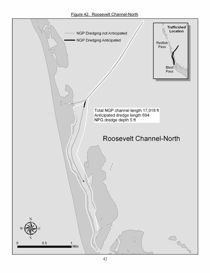
Figure 42. Roosevelt Channel-North

43
00.
50.
25M
ileSain
t Jam
esC
ity-E
ast
Tota
l NG
P ch
anne
l len
gth
16,1
37 ft
Antic
ipat
ed d
redg
e le
ngth
3,2
66 ft
NG
P d
redg
e de
pth
5 ft
NG
P D
redg
ing
not A
ntic
ipat
ed
NG
P D
redg
ing
Ant
icip
ated
Sain
t Jam
esC
ity
Pine
Isla
ndTr
affic
shed
Loca
tion
Figure 43. Saint James City-East
44
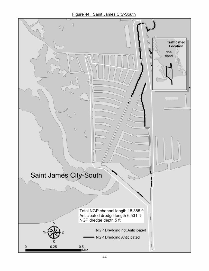
0 0.50.25Mile
Saint James City-South
Total NGP channel length 18,385 ftAnticipated dredge length 6,531 ftNGP dredge depth 5 ft
NGP Dredging not Anticipated
NGP Dredging Anticipated
TrafficshedLocation
PIneIsland
Figure 44. Saint James City-South

45
0 0.20.1Mile
Siesta Isles
Total NGP channel length 1,088 ftAnticipated dredge length 713 ftNGP dredge depth 5 ft
NGP Dredging not Anticipated
NGP Dredging Anticipated
TrafficshedLocation
San CarlosIsland
Figure 45. Siesta Isles

46
0 0.50.25Mile
South Estero BaySecondary Channel
Total NGP channel length 27,694 ftAnticipated dredge length 327 ftNGP dredge depth 4 ft
NGP Dredging not Anticipated
NGP Dredging AnticipatedChannelLocation
BigCarlosPass
Figure 46. South Estero Bay

47
SouthMatlacha
SecondaryChannels
0 10.5Mile
NGP Dredging not Anticipated
NGP Dredging Anticipated
Total NGP channel length 71,465 ftAnticipated dredge length 889 ftNGP dredge depth 3.5 ft
ChannelLocation
CapeCoral
San CarlosBay
Figure 47. South Matlacha

48
0 0.10.05Mile
Sunset Bay
Total NGP channel length 2,440 ftAnticipated dredge length 376 ftNGP dredge depth 2.5 ft
NGP Dredging not Anticipated
NGP Dredging Anticipated
TrafficshedLocation
SunsetBay
Figure 48. Sunset Bay
