sequence stratigraphy of fluvially-dominated strata of the
TRANSCRIPT

International Journal of Coal Geology 154–155 (2016) 136–154
Contents lists available at ScienceDirect
International Journal of Coal Geology
j ourna l homepage: www.e lsev ie r .com/ locate / i j coa lgeo
Sequence stratigraphy of fluvially-dominated strata of the Mid-LatePennsylvanian Conemaugh Formation, Central Appalachian Basin
Ronald L. MartinoDepartment of Geology, Marshall University, Huntington, WV 25755, United States
http://dx.doi.org/10.1016/j.coal.2015.12.0160166-5162/© 2015 Elsevier B.V. All rights reserved.
a b s t r a c t
a r t i c l e i n f oArticle history:Received 14 August 2015Received in revised form 29 December 2015Accepted 30 December 2015Available online 31 December 2015
Sequence stratigraphic analysis of nonmarine, fluvially-dominated strata is particularly challenging compared toparalic and marine sequences due to rapid facies changes and limited lateral continuity of key beds. TheConemaugh Formation of central West Virginia is a prime example of this type of stratigraphic interval. Thisstudy describes the stratigraphy and sedimentary facies from 68 outcrops in the lower 100 m of the Mid-LatePennsylvanian, nonmarine Conemaugh Formation in this area. Facies identified include 1) fluvial–upper estua-rine channel sandstones, 2) crevasse splay channel and sheet sandstones, 3) lacustrine shale, mudstone, andclaystone, 4) lacustrine/palustrine limestone, 5) paludal coal and carbonaceous shale, and 6) hackly mudstoneand claystone paleosols.Mature, polygenetic, high-chroma calcic vertisols and calcisols are the regionally developed interfluvial sequenceboundaries (IFSBs) of seven fourth-order sequences (major cyclothems) between the Upper Freeport and Har-lem coal horizons. Initial paleosol development occurred under well-drained conditions and strongly seasonal,semiarid–arid climate approaching and during glacial maxima at a time of minimal accommodation space onthe interfluves. Subsequent rising water table associated with rising base level occurred as interglacial sea levelrose and the climate became less seasonal and more humid. This initially led to deposition of thin, carbonaceousmud and peat followed by lacustrine and palustrine limestones. The presence of spirorbid microconchids indi-cates that the lakes were at least intermittently connected to the sea, which reached to within 50–80 km of alloutcrops in the study during five transgressions. The tops of these limestones represent maximum flooding sur-faces. They are overlain by coarsening–upward lake-fill sequences formedduring high accommodation on the in-terfluves during the HST. A nonmarine sequence stratigraphic model and a polygenetic paleosol model areproposed for the Conemaugh in central West Virginia. This study underscores the importance of recognizing re-gionally developed IFSB paleosols and microconchid limestones in correlation and sequence stratigraphicanalysis.
© 2015 Elsevier B.V. All rights reserved.
Keywords:PaleosolsSequence stratigraphyConemaugh Fm.Nonmarine cyclothems
1. Introduction
The study of Pennsylvanian cyclothems in North America has had along history dating back to the early 1900s (e.g. Weller, 1930;Wanless and Weller, 1932; Wanless and Shepard, 1936). Cylcothemshavemore recently been viewedwithin the context of sequence stratig-raphy (sensu Vail et al., 1977; e.g. Miall, 2010). The bulk of sequencestratigraphic studies to date have addressed stratigraphic intervalswith marine components. Marine–coastal cyclothems have been de-scribed from the lower Conemaugh Glenshaw Formation of the north-ern and central Appalachian Basin (e.g. Stout, 1947; Sturgeon andHoare, 1968; Busch and Rollins, 1984; Busch and West, 1987; Martino,2004). Henry et al. (1979) andWindolph (1987) were unable to distin-guish or correlate Conemaugh cyclothems in central West Virginia.Their efforts were hindered by 1) the absence of marine shales/lime-stones and the paucity of laterally persistent coal beds, and 2) the
perception that deposition was dominated by autocyclic processessuch as delta switching and river avulsion that precluded the develop-ment of widespread marker beds (e.g. Donaldson, 1979).
Sequence stratigraphic studies of fluvial successions are hindered byrapid lateral facies changes and inability to distinguish time-significantsurfaces. The recognition of widespread mature paleosols as interfluvialsequence boundaries between incised valley fills (IVFs) has led to signif-icant progress in this area (Wright and Marriott, 1993; Shanley andMcCabe, 1994; Gibling and Bird, 1994; McCarthy et al., 1999; McCarthy,2002). The purpose of this study is to develop a high-resolutionstratigraphic framework by correlating paleosol-bounded terres-trial cyclothems in central West Virginia with their downdip,marine-influenced equivalents. Sedimentary facies architecture willbe analyzed and compared with nonmarine sequence stratigraphicmodels. The sequence stratigraphic significance of “nonmarine” (brack-ish-freshwater) limestones will be evaluated.

Fig. 1.Map showing outcrop locations used in this study. The regional paleoslope was toward the northwest. The transgressive maximum line is based on projected maximum extent ofBrush Creek and Amesmarine units (modified from Busch andWest, 1987). Conemaugh outcrops southeast of this line (i.e. updip) are comprised of nonmarine cyclothemswhereas thosenorthwest of it (i.e. downdip) contain marine-cored cyclothems (Martino, 2004).
137R.L. Martino / International Journal of Coal Geology 154–155 (2016) 136–154
2. Methods
A total of 2251mof stratawasmeasured through the lower 80–100mofthe Conemaugh Formation and component sedimentary facies were
Table 1Outcrop location coordinates in latitude and longitude and UTM coordinates (WGS 1984 Zone
Loc. Latitude Longitude Northing Easting
BX2 38.68838 −80.68688 4282243 527231.8BX3 38.66811 −80.77741 4279971 519364BX5 38.68706 −80.68956 4282096 526999.5BX6 38.70611 −80.65954 4284219 529602.4BX7 38.69973 −80.66369 4283510 529244BX8 38.62732 −80.72181 4275458 524214.8BX9 38.62833 −80.71881 4275571 524475.4BX14 38.65836 −80.72679 4278901 523771.1BX15 38.65836 −80.72679 4278901 523771.1BX20 38.64676 −80.7194 4277616 524418.4BX22 38.61624 −80.84808 4274203 513225.5C1 38.24939 −82.28829 4234271 387273.9C2 38.26804 −82.25398 4236300 390303.4C3 38.26871 −82.20683 4236319 394429.8C4 38.27642 −82.23976 4237212 391559.9C5 38.25644 −82.28838 4235054 387276.5C6 38.26382 −82.29592 4235882 386628.4C7 38.32634 −82.21858 4242727 393486C8 38.32783 −82.20703 4242879 394497.2K36 38.39691 −81.59226 4250020 448282.5K37 38.4191 −81.55082 4252461 451915.5K38 38.44799 −81.51548 4255649 455018.8K39 38.44022 −81.51693 4254787 454887.2K40 38.30428 −81.7007 4239809 438734.7K41 38.36352 −81.72219 4246397 436907.8K42 38.33656 −81.70144 4243391 438697.4K43 38.40991 −81.65176 4251498 443096.8K44 38.41429 −81.6242 4251967 445506.1K45 38.37554 −81.79396 4247781 430649.3K47 38.38151 −81.60131 4248317 447480.9K48 38.38522 −81.61397 4248736 446378.2K49 38.40384 −81.62 4250806 445864.9K50 38.40111 −81.66085 4250527 442295.9
described at 68 outcrops (Fig. 1, Table 1). Paleosols were identified in thefield using soil structure, horizonization, and root traces (Retallack, 1988).Elevations were determined with an American Paulin SystemMicro altime-ter, or from satellite imagery using Google Earth software. Lithostratigraphic
17N datum).
Loc. Latitude Longitude Northing Easting
K51 38.3855 −81.83572 4248919 427010.8K52 38.38717 −81.7918 4249071 430848.4K53 38.39175 −81.81247 4249594 429048.2K54 38.45545 −81.49139 4256465 457125.7K55 38.45793 −81.49527 4256741 456788K56 38.45793 −81.49527 4256741 456788K57 38.52115 −81.35114 4263699 469390.3K58 38.52115 −81.35114 4263699 469390.3K59 38.52939 −81.33951 4264609 470407.8K60 38.42554 −81.52571 4253163 454112.2K61 38.37817 −81.60347 4247948 447289.7K62 38.36272 −81.84536 4246399 426146K63 38.3676 −81.82152 4246922 428233.8K64 38.41507 −81.67188 4252083 441344.3K65 38.42002 −81.64309 4252615 443861.9L1 38.29213 −82.18998 4238898 395937.2L2 38.27939 −82.12436 4237413 401658.7L3 38.26064 −81.83011 4235060 427376.6L4 38.26696 −81.82177 4235754 428112.4L5 38.23305 −81.83867 4232005 426600.2L7 38.24726 −81.8335 4233578 427066.5L11 38.2826 −82.17377 4237823 397340.9L12 38.28259 −82.17381 4237821 397337.5R1 38.57037 −81.26346 4269134 477049.4R2 38.58355 −81.20568 4270585 482085.6R3 38.551 −81.29602 4266994 474206.1R4 38.54639 −81.30682 4266485 473263.3R5 38.58218 −81.21691 4270435 481107.2R6 38.5632 −81.13186 4268314 488512.1R7 38.56283 −81.14188 4268275 487639.4R8 38.57196 −81.2605 4269311 477307.3R9 38.56941 −81.15995 4269008 486066.1R10 38.57085 −81.26767 4269189 476682.5

138 R.L. Martino / International Journal of Coal Geology 154–155 (2016) 136–154
correlations were based on similarities in well-developed paleosols takinginto account their thickness, type, and elevation, and were guided in part bytheir relations to the elevation of structural contours on the top of the
Fig. 2. Stratigraphic framework showing (from left to right) North American subsystem, Northglobal eastern European stages, and lithostratigraphic units in West Virginia. Lithostratigraphiccoal beds and marine units which are absent or limited in the study area. Twomile Limeston(Windolph, 1987). Ranges of selected palynomorphs are from Peppers (1996) and Eble et al. (
Sandy Grove Sandstone (Windolph, 1987) and the Pittsburgh coal (WestVirginia Geological and Economic Survey Coal Bed Mapping Project; Krebsand Teets, 1914).
American series, eastern European stages, central and western European series and stages,framework for Conemaugh is based on Fonner (1987), and Martino (2004) and relies one and Sandy Grove Sandstone are units that have been mapped in the Charleston area2009).

139R.L. Martino / International Journal of Coal Geology 154–155 (2016) 136–154
3. Stratigraphic framework and coal geology
The late Middle to Late Pennsylvanian Conemaugh Group/Forma-tion, known as the “Lower Barren Measures” due to the paucity of min-able coals, extends from the top of theUpper Freeport coal to the base ofthe Pittsburgh coal (Wanless, 1939; Fig. 2). Where the Ames Limestoneis present, the Conemaugh Group is divided into the Glenshaw andCasselman Formations (Fig. 2). The Ames Limestone and other marinemarkers in Fig. 2 are well-developed in Wayne County, West Virginia,but are absent throughoutmost of the study areawhere the Conemaughis treated as a formation (e.g. Henry et al., 1979, Fig. 72). In theCharleston, West Virginia area, the Conemaugh is 180 m thick (Krebsand Teets, 1914). Where the Upper Freeport coal is not present, thebase of the Conemaugh is placed at the lowest occurrence of redmudrocks (Rice, 1986). The Brush Creek, Bakerstown, and Harlemcoals, locallymined in thenorthern Appalachian Basin, tend to be higherin sulfur and ash compared to coals from the Lower andMiddle Pennsyl-vanian (Cecil et al., 1985).
4. Geologic setting
4.1. Tectonics
During the Middle–Late Pennsylvanian, thrust-loading in theAppalachian Orogen from crustal collisions associated with the closureof the Rheic Ocean induced basin subsidence and provided sedimentaccommodation space (Quinlan and Beaumont, 1984). Subsidencewas greatest in the foredeep of eastern West Virginia and decreasednorthwestward toward the cratonic platform in Ohio and Kentucky.Thrust loading alternated with relaxation producing transgressive–regressive tectophases lasting several million years. Higher frequencyglacioeustatic transgressive–regressive cycles are embedded withinthe tectophases (Busch and Rollins, 1984; Heckel, 1994; Ettensohn,2008). At the beginning of the Late Pennsylvanian, deformational load-ing forced foreland basin subsidence to shift from the central to thenorthern Appalachian Basin. The Brush Creek Limestone through theAmes Limestone intervalmay represent an overall long-term transgres-sion from the west in response to the early stages of this tectophase(Ettensohn, 2008). During the Late Pennsylvanian, accommodationspace was generally lower than during the Early–Middle Pennsylvaniandue to a decreased rate of tectonic subsidence (Greb et al., 2008).
4.2. Paleoclimate and eustasy
During the Early to Middle Pennsylvanian, the climate in the centralAppalachian Basin varied from tropical everwet to long wet season/short dry season. The climate during the late Middle and Late Pennsyl-vanian had significantly less rainfall, and fluctuated between humidsubtropical to semiarid (Donaldson et al., 1985; Cecil, 1990). An abruptclimate change occurred near the Westphalian–Stephanian boundaryand was characterized by global warming, stronger seasonality, andshorter wet phases. It coincided with the regional extinction of treelycopsids and the appearance ofwidespread, red vertisols and aridosols.Aridity was greatest during deposition of the Glenshaw Formation(Cecil, 1990; Pfefferkorn et al., 2008).
Widespread ice sheets developed in Gondwana at the beginning ofthe Stephanian and extended to within 25 degrees of the equator(Fielding et al., 2008; Isbell et al., 2003). Busch and Rollins (1984) recog-nized 11 paleosol-bounded cyclothems in the Glenshaw Formation inOhio and Pennsylvanian. These have been correlated between the Ap-palachian and Illinois Basins using conodonts and palynomorphs. Re-gional analysis indicates that only the greater highstands invaded theAppalachian Basin due to its high shelf position (e.g. Busch and West,1987; Heckel, 1995, 2008); however, even these marine units are diffi-cult to trace updip into the study area.Major cyclothemshad an averageduration of 400 kyr and have been attributed to glacioeustatic sea level
cycles and climate variations associated with the eccentricity of theearth's orbit (e.g. Busch and Rollins, 1984; Heckel, 2008).
4.3. Paleogeography
During the Pennsylvanian, the Central Appalachian Basin driftednorthward with Larussia and was positioned within a few degrees ofthe equator by the Late Pennsylvanian (Blakely, 2007; Rosenau et al.,2013a, Fig. 3). During the Middle and Late Pennsylvanian, rivers flowedwest and north across West Virginia, draining the Allegheny Orogen.Channel belts in the tropical coastal plain were flanked by flood basinlakes and swamps (Arkle, 1974; Donaldson, 1979; Martino, 2004).Eight transgressions,marked bymarine limestone and shale, are record-ed in the Glenshaw Formation of Ohio and Pennsylvania (Busch andWest, 1987). Six of these transgressions extended into northern andwesternmost West Virginia, down dip from the current study area.
5. Sedimentary facies
5.1. Facies 1 — large scale channel-fills
5.1.1. DescriptionFacies 1 consists of single and multistory bodies of micaceous sand-
stones with erosional basal contacts (Fig. 5F). The thickness of single-story fills average 7.75 m and ranges from 4.1 to 11 m, with multistoryfills reaching a maximum of 26 m. The fills fine upward within a storyand are commonly interbedded with, or capped by siltstone, shale,and occasionally coal. Conglomeratic channel lag deposits are some-times present with siderite, limestone, coal spar, and vein quartz peb-bles. The lower portions of the fills are typically trough cross-stratifiedwith sets from 20 to 50 cm thick. Compound cross-stratification is com-monwith large scale sets from 1.5 to 7 m thick, and foreset dips of 8–11degrees. The upper portions of the fills are ripple cross-laminated orparallel laminated. Cross-bed dip azimuths and trough axes areunimodal within a story and range from WSW to NNE. The vectormean is 315° and the magnitude, R, is 58% (Fig. 4). Plant fossils arerare and include fossilized, mud-filled logs, and ferns. Mudstone lensesup to 6 m thick and 70 mwide are locally present. The mudstones varyfrom dark gray to greenish gray silty shales to red hackly, calcareousmudstones.
Although most channel-fill sandstones contain unimodal, down-diporiented paleocurrent indicators, four locations in the study area havepossible tidal structures. At K57, four bundles of thicker shale-drapedsiltstone laminations alternate with thinner couplets. At BX22, a9.75m thick channel sandstone fines upward into rhythmically bedded,very fine sandstone-silty shale with horizontal laminations. Thickerbundles of sand laminae alternate with thinner bundles of silt laminaeand carbonaceous shale. Four thick-thin cycles are locally developedover a 50 cm interval. At K36, the top 10 cm of a compound cross-stratified channel-fill is burrow mottled. At K63, 7 m of coarse, troughcross-stratified sandstone are overlain by 3.1 m of inclined heterolithicstrata.
5.1.2. InterpretationFacies 1 is interpreted as the product of alluvial, upper estuarine, and
possibly upper delta plain distributary channels and is similar to thosepreviously described from downdip areas (Martino, 2004). This inter-pretation is consistent with the unimodal paleocurrents and vectormean northwest flow which is down the regional paleoslope. The Rvalue of 58% may reflect moderate channel sinuosity and radiating del-taic distributaries. The local occurrence of burrowing, shale-drapedforesets, and rhythmic laminations may indicate fluvial channels atthe fluvial–tidal transition of the upper estuary (Greb and Martino,2005). Upper delta plain distributaries differ from alluvial facies inhaving smaller depth and width, and more widespread lakes and

140 R.L. Martino / International Journal of Coal Geology 154–155 (2016) 136–154
swamps in overbank areas (Reading and Collinson, 1996; Olariu andBhattacharya, 2006).
5.2. Facies 2 — small scale channel-fills
5.2.1. DescriptionFacies 2 consists of veryfine tofine, greenish gray,micaceous, calcar-
eous sandstones 0.5–4 m thick. Scour-fill trough cross-stratificationpredominates with 10–50 cm thick sets. The channel-fills fine upwardinto siltstone and shale. Lateral dimensions are 3–15 m. Ripple cross-lamination and parallel lamination are common toward the top of thefills. Plant fossils are rare. The channel-fills typically overlie thin-bedded mudstones and shales of facies 4.
5.2.2. InterpretationFacies 2 is interpreted as the product of crevasse splay channels. Basal
scours, fining-upward, and less-than-meter-scale thicknesses are consis-tentwith a flood basin origin (Elliott, 1974; Reading and Collinson, 1996).Crevasse channel and splay lobe deposits that fine upward and haveerosional bases reflect waning flow from flooding that breached the le-vees offluvial anddeltaic channels (Collinson, 1996; Leeder, 2011). Splaysdeposits contribute to the infilling of flood basin lakes (Collinson, 1996).
5.3. Facies 3 — sheet sandstone and shale
5.3.1. DescriptionFacies 3 is typically 5–6 m thick and consists of interbedded fine
sandstone to shale. Sandstones are sharp based with scour-fill, troughcross-strata that grade up into ripple cross-lamination and parallel lam-ination. There are typically four or five fining-upward sandstone-shalebedsets ranging from 1 to 1.5 m thick. The couplets are laterally persis-tent across the outcrops for at least 100 m up to a km or more. Smallchannel-fills 1–2 m thick and 5–10 m wide locally cut into the top ofthe sandstones. Root traces and plant fossils are occasionally present.Trace fossils are rare and include sand-filled vertical burrows2–10 mm wide occur in parallel laminated, very fine sandstone (K38),and a large Diplichnites trackway (K44, Fig. 3A).
5.3.2. InterpretationCrevasse-splay lobes with erosional bases and textures and struc-
tures reflect waning flow from flooding that breaches the levees of flu-vial and deltaic channels (Collinson, 1996; Leeder, 2011). They have asheet-like to lobate geometry that can extend up to several kilometersaway from the main channel, and are typically finer grained than themain channel-fill. Successive flood events are capable of producingmeter-scale, stacked bedsets of sand-shale like those described above.The large Diplichnites trackway was made by Arthropleurid myriopodsin sand and mud flats that bordered ephemeral flood-basin lakes(Martino and Greb, 2009).
5.4. Facies 4 — thin-bedded mudstone/claystone/shale
5.4.1. DescriptionFacies 4 is widely developed and 1–8 m thick. Mudstones display
crude, thin bedding or are hackly. Slickensides are locally developed.Olive green and dark greenish gray shades predominate, but darkgray, red, and variegation (red/green/graymottling) also occur. The faciesis commonly darker at the base and coarsens upward in to silty shale andsiltstone; it typically overlies facies 6, 7, or 8 and is capped by facies 3 or 6.Thin beds and nodules of argillaceous, micritic limestone and sideriteare locally present. Plant fossils commonly include Cordaites, and rarelyNeuropteris, Alethopteris, Pecopteris, and Sphenopteris (K59). At K65,Sigillaria is preserved in situ (Fig. 3B).
5.4.2. InterpretationFacies 4 is interpreted as the deposits of flood-basin lakes (or possi-
bly bays) where low energy deposition of mud from suspension oc-curred. Red clays may have been derived by erosion of well-drainedupland soils that were deposited in the lakewaters. Rather than indicat-ing subaerial exposure during deposition, ferric iron-stained clays werepreserved in the lakebedwhere there was insufficient organic matter toreduce the iron. Fissility in shales is prevalentwhereflocculation of clayswas inhibited (Moon and Hurst, 1984). Slickensides may have formedfrom periods of subaerial exposure and shrink and swell during incipi-ent pedogenesis, or by dewatering of subaqueous, clay-rich sedimentand clay flocculation and shrinkage during syneresis (White, 1961;Potter et al., 1980).
Lake levels in coastal plains are usually less than 5 m deep (Elliott,1974; Reading and Collinson, 1996) and lake levels are vulnerable toseasonal and longer term variations in climate. Upward-coarsening ofthe lacustrine shale into siltstone reflects shallowing and infilling ofthe lake by the distal margins of encroaching levees and crevasse splays(Elliott, 1974; Horne et al., 1978; Reading and Collinson, 1996).
5.5. Facies 5 — dark gray–black, molluscan shale/claystone
5.5.1. DescriptionFacies 5 is found at only three localities in Braxton County and over-
lies the Brush Creek coal. The dark gray to black shale/claystone facies is30–50 cm thick but fossils are restricted to a thin zone of 2–3 cm. Thefossils include the gastropod Bellerophon, several bivalve genera includ-ing Phestia and a nuculid, anOrbiculoid brachiopod, and plant fragments(Cordaites). The facies contains siderite nodules and thin beds andcoarsens upward into siltstone and very fine sandstone.
5.5.2. InterpretationFacies 5 was formed in a low-energy, nearshore marine setting as
rising sea level drowned a coastal swamp. The types of invertebrates in-dicate normal to restricted marine salinity (Boardman et al., 1984). Thehigh organic content of the shale may be due to proximity to coastalpeat swamps and limited clastic influx as sediments were initiallytrapped in estuaries until they filled. Siderite nodules and beds formduring early diagenesis under reducing conditions and are common inorganic-rich mudrocks deposited in fresh- and brackish-water settings(Tucker, 2001). Siderite beds may be formed by the sudden influx offreshwater into more saline waters (Woodland and Stenstrom, 1979).
5.6. Facies 6 — coal/carbonaceous shale
5.6.1. DescriptionFacies 6 consists of seams of coal, bone coal, and carbonaceous shales
up to 1.75m thick and usually overlies root-traced, hackly mudstone orlight gray to white underclays (Facies 7). Roof rock is most often a darkgray shale with plant fragments. In some cases, it consists of hacklymudstone with crude, thin bedding and slickensides. Plant fossils in-clude locally abundant Cordaites and occasionally Neuropteris andAnnularia. Smooth-shelled ostracods are present at R2, and abundantConchostracans occur at C7. Coals rarely occur near the top ofchannel-fills interbedded with dark gray shales. Coal seams typicallycontain thin interbeds of carbonaceous shale and hacklymudstone. Lat-eral extent is often limited by channel washouts or coal pinchouts.
5.6.2. InterpretationThe coals that overlie underclays or root-traced, hackly mudstones
accumulated in coastal peat swamps. The shale roof facies with plantfossils but lacking root traces indicates that swamps became lakes asthe water table rose and became too deep for standing vegetation.Channel-fill coals accumulated in deactivated channels following avul-sion. Mudstone partings resulted from clastic influx from alluvial chan-nels, most likely due to catastrophic flooding, perhaps at 500- to 1000-

Fig. 3. A. Diplichnites trackway 23 cm wide preserved as convex hyporelief. Sample in float from very fine grained, flaggy sandstone from crevasse splay facies at K44. B. Arborescentlycopod Sigillaria preserved as mudstone cast in situ above protosol at K65. C. Flint clay facies (white) at Clendenin Exit of I-79 (K57) pedogenically overprinted by calcic vertisol. Staffis 1.5 m. D. Flint clay lens (white with red margin) of lacustrine origin from I-79 roadcut northeast of Amma (R8). The lens grades laterally into thin bedded mudstone. 1.1 m of staffshowing for scale. Bedding is chaotic between and above flint clay bodies at this location. E. Two benches of lacustrine/palustrine limestone and intervening mudstone overlyingvariegated, mottled, calcic vertisol along Rt. 119 near Priestly (L3). F. Trough cross-stratified, ostracodal grainstone from upper limestone bench in E. (For interpretation of thereferences to color in this figure legend, the reader is referred to the web version of this article.)
141R.L. Martino / International Journal of Coal Geology 154–155 (2016) 136–154
year intervals (using a tropical peat accumulation rate frommodern an-alogs of 0.25 mm/year; Cecil et al., 1993). Cordaitesweremost commonalong the margins of swamps and expanded into their interior duringecologic stress (Eble, 1998). Ostracods with thin smooth shells are usu-ally found in freshwater facies; Conchostracans are found mainly infreshwater to brackish facies which may interfinger with marine faciesor pinchout over short distances (Tasch, 1980). Carbonaceous, fissileshales lacking root traces formed in anoxic lakes or bays bordering theswamps where clays mixed with macerated organics.
5.7. Facies 7 — limestone/claystone
5.7.1. DescriptionFacies 7 encompasses a range of carbonate lithologies; subfacies in-
clude mudstones, peloidal packstones and wackestones and locally,rudstones and grainstones. The limestones are medium to dark gray
and weather light gray to white, or yellow-orange if pyritic or sideritic.The facies is up to 1.9 m thick and consist of individual beds 5–50 cmthick interbedded with olive to dark gray claystone, mudstone, and oc-casionally coal. Allochems include pelloids, limeclasts, ostracodes,spirorbid microconchids, fish bones and teeth, coprolites, and blue-green algae (Fig. 6). Algal laminations are common, and the tops ofsome beds are brecciated. Birdseye, laminar, and tubular fenestrae arecommon. The carbonates nearly always occur immediately above ahackly mudstone (paleosol) and are overlain by Facies 4 (Figs. 3E, 5A,C). At K44 and K45, intraclastic rudstone with rounded ripups andbone fragments fill shallow channels up to 50 cm deep and 10–20 mwide which are cut into the underlying paleosol (Fig. 5D).
5.7.2. InterpretationFacies 7 accumulated in lacustrine, palustrine, and, possibly, near-
shore bay environments. The deposition of the lime mudstones,
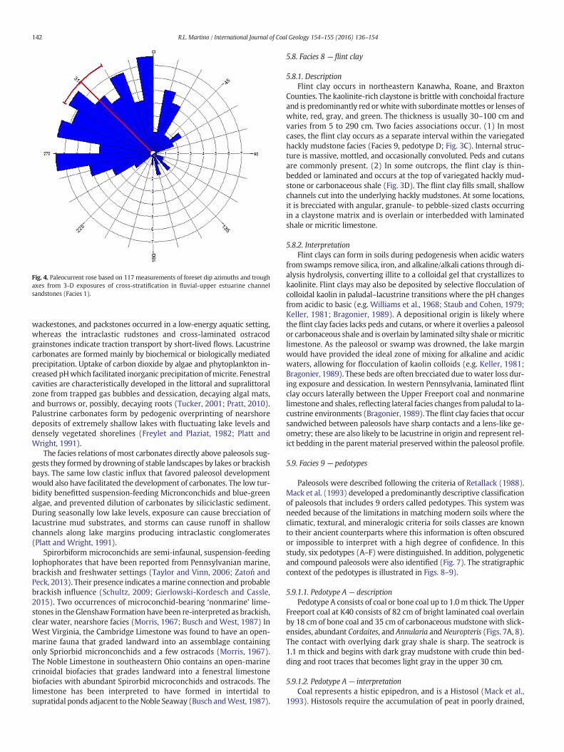
Fig. 4. Paleocurrent rose based on 117 measurements of foreset dip azimuths and troughaxes from 3-D exposures of cross-stratification in fluvial-upper estuarine channelsandstones (Facies 1).
142 R.L. Martino / International Journal of Coal Geology 154–155 (2016) 136–154
wackestones, and packstones occurred in a low-energy aquatic setting,whereas the intraclastic rudstones and cross-laminated ostracodgrainstones indicate traction transport by short-lived flows. Lacustrinecarbonates are formed mainly by biochemical or biologically mediatedprecipitation. Uptake of carbon dioxide by algae and phytoplankton in-creased pHwhich facilitated inorganic precipitation ofmicrite. Fenestralcavities are characteristically developed in the littoral and supralittoralzone from trapped gas bubbles and dessication, decaying algal mats,and burrows or, possibly, decaying roots (Tucker, 2001; Pratt, 2010).Palustrine carbonates form by pedogenic overprinting of nearshoredeposits of extremely shallow lakes with fluctuating lake levels anddensely vegetated shorelines (Freylet and Plaziat, 1982; Platt andWright, 1991).
The facies relations of most carbonates directly above paleosols sug-gests they formed by drowning of stable landscapes by lakes or brackishbays. The same low clastic influx that favored paleosol developmentwould also have facilitated the development of carbonates. The low tur-bidity benefitted suspension-feeding Micronconchids and blue-greenalgae, and prevented dilution of carbonates by siliciclastic sediment.During seasonally low lake levels, exposure can cause brecciation oflacustrine mud substrates, and storms can cause runoff in shallowchannels along lake margins producing intraclastic conglomerates(Platt and Wright, 1991).
Spirorbiform microconchids are semi-infaunal, suspension-feedinglophophorates that have been reported from Pennsylvanian marine,brackish and freshwater settings (Taylor and Vinn, 2006; Zatoń andPeck, 2013). Their presence indicates amarine connection and probablebrackish influence (Schultz, 2009; Gierlowski-Kordesch and Cassle,2015). Two occurrences of microconchid-bearing ‘nonmarine’ lime-stones in theGlenshaw Formation have been re-interpreted as brackish,clear water, nearshore facies (Morris, 1967; Busch and West, 1987) InWest Virginia, the Cambridge Limestone was found to have an open-marine fauna that graded landward into an assemblage containingonly Spriorbid micronconchids and a few ostracods (Morris, 1967).The Noble Limestone in southeastern Ohio contains an open-marinecrinoidal biofacies that grades landward into a fenestral limestonebiofacies with abundant Spirorbid microconchids and ostracods. Thelimestone has been interpreted to have formed in intertidal tosupratidal ponds adjacent to theNoble Seaway (Busch andWest, 1987).
5.8. Facies 8 — flint clay
5.8.1. DescriptionFlint clay occurs in northeastern Kanawha, Roane, and Braxton
Counties. The kaolinite-rich claystone is brittle with conchoidal fractureand is predominantly red orwhitewith subordinatemottles or lenses ofwhite, red, gray, and green. The thickness is usually 30–100 cm andvaries from 5 to 290 cm. Two facies associations occur. (1) In mostcases, the flint clay occurs as a separate interval within the variegatedhackly mudstone facies (Facies 9, pedotype D; Fig. 3C). Internal struc-ture is massive, mottled, and occasionally convoluted. Peds and cutansare commonly present. (2) In some outcrops, the flint clay is thin-bedded or laminated and occurs at the top of variegated hackly mud-stone or carbonaceous shale (Fig. 3D). The flint clay fills small, shallowchannels cut into the underlying hackly mudstones. At some locations,it is brecciated with angular, granule- to pebble-sized clasts occurringin a claystone matrix and is overlain or interbedded with laminatedshale or micritic limestone.
5.8.2. InterpretationFlint clays can form in soils during pedogenesis when acidic waters
from swamps remove silica, iron, and alkaline/alkali cations through di-alysis hydrolysis, converting illite to a colloidal gel that crystallizes tokaolinite. Flint clays may also be deposited by selective flocculation ofcolloidal kaolin in paludal–lacustrine transitions where the pH changesfrom acidic to basic (e.g. Williams et al., 1968; Staub and Cohen, 1979;Keller, 1981; Bragonier, 1989). A depositional origin is likely wherethe flint clay facies lacks peds and cutans, or where it overlies a paleosolor carbonaceous shale and is overlain by laminated silty shale ormicriticlimestone. As the paleosol or swamp was drowned, the lake marginwould have provided the ideal zone of mixing for alkaline and acidicwaters, allowing for flocculation of kaolin colloids (e.g. Keller, 1981;Bragonier, 1989). These beds are often brecciated due to water loss dur-ing exposure and dessication. In western Pennsylvania, laminated flintclay occurs laterally between the Upper Freeport coal and nonmarinelimestone and shales, reflecting lateral facies changes frompaludal to la-custrine environments (Bragonier, 1989). The flint clay facies that occursandwiched between paleosols have sharp contacts and a lens-like ge-ometry; these are also likely to be lacustrine in origin and represent rel-ict bedding in the parent material preserved within the paleosol profile.
5.9. Facies 9 — pedotypes
Paleosols were described following the criteria of Retallack (1988).Mack et al. (1993) developed a predominantly descriptive classificationof paleosols that includes 9 orders called pedotypes. This system wasneeded because of the limitations in matching modern soils where theclimatic, textural, and mineralogic criteria for soils classes are knownto their ancient counterparts where this information is often obscuredor impossible to interpret with a high degree of confidence. In thisstudy, six pedotypes (A–F) were distinguished. In addition, polygeneticand compound paleosols were also identified (Fig. 7). The stratigraphiccontext of the pedotypes is illustrated in Figs. 8–9).
5.9.1.1. Pedotype A — descriptionPedotype A consists of coal or bone coal up to 1.0m thick. The Upper
Freeport coal at K40 consists of 82 cm of bright laminated coal overlainby 18 cm of bone coal and 35 cm of carbonaceous mudstone with slick-ensides, abundant Cordaites, and Annularia and Neuropteris (Figs. 7A, 8).The contact with overlying dark gray shale is sharp. The seatrock is1.1 m thick and begins with dark gray mudstone with crude thin bed-ding and root traces that becomes light gray in the upper 30 cm.
5.9.1.2. Pedotype A — interpretationCoal represents a histic epipedron, and is a Histosol (Mack et al.,
1993). Histosols require the accumulation of peat in poorly drained,

Fig. 5.A. Thick vertisol with conjugate shears (arrows) capped by lacustrine limestone and shale from K56 near Elkview Exit of I-79. Staff= 1.5m. B.Microconchid packstone with shark’stooth from Twomile Limestone at K45 east of St. Albans. C. Twomile Limestone interbedded with olive green flint clay above thick, polygenetic, calcic vertisol in its type area near Guthrie(K43). D. Shallow channel-fill limestone incised into vertisol near St. Albans (K45). E. Rudstone channel lag, I-77 north, Edens Fork Exit (K44). F. Multistory channel sandstone fromamalgamation of Upper and Lower Mahoning Sandstone IVFs along I-79 at K47. Channel-fills (arrows) are 8–9 m thick.
143R.L. Martino / International Journal of Coal Geology 154–155 (2016) 136–154
anoxic environments where microbial decomposition is inhibited andwhere influx of clastics is limited (Retallack, 2001). The vertical succes-sion of lithologies at K40 indicates the development of a planar mirewith highly acidic, anoxic conditions which was drown by rising watertable. Portions of the mire that were increasingly more proximal tothe lake received higher rates of clastic influx forming bone coal andcarbonaceous shale.
5.9.1.3. Pedotype B — descriptionPedotype B paleosols range in thickness from 0.5 to 3.0 m. The up-
permost horizon is a thin carbonaceous mudstone which overlies darkgreenish gray mudstone grading down into red mudstone/claystone.Soil structure includes angular blocky peds, slickensides, and conjugateshears. An example of Pedotype B at K55 consists of a 2.9m thick, hacklymudstone containing angular blocky peds, slickensides, and steeply in-clined fractures (Fig. 7B). The base of the paleosol is transitional withthin-bedded greenish gray mudstone. The top is sharply overlain bydark gray shale. Colors from top down are: 0–10 cm, medium gray;
10–35 cm, green; 35–85 cm, red/green variegated; 85–2.65 cm, red;and 2.65–2.9 cm, green.
5.9.1.4. Pedotype B — interpretationPedotype B is classified as a Vertisol. Vertisols are distinguished by
thick accumulations of smectitic clays that expand and contract withwetting and drying. Large scale, downward tapering cracks may form.These form in sparsely wooded areas of low relief with subhumid tosemiarid climates with a prolonged dry season (Retallack, 2001).Thick argillic horizons (Bt) in excess of 1m are characteristic of stronglyto very strongly developed soils suggest prolonged periods of landscapestability on the order of at least 105 years (Retallack, 2001).
5.9.1.5. Pedotype C — descriptionPedotype C is similar to Pedotype B, but contains abundant micritic
limestone nodules in red, or variegated mudstone up to 6 m thick(Figs. 3E, 5A, D). At K58, an example occurs that is 4.67 m thick(Fig. 7C). The upper 2.5 m consists of red hackly mudstonewith angular

Fig. 6. Photomicrographs. All at 40×, PPL. Scale bar= 500microns. A. Spar-filledmicroconchid (above arrows) in peloidal, micrite matrix, Twomile Limestone nearWest Hamlin (L12). B.Disarticulated ostracods (arrows) in micrite matrix (L12). C. Pelodal dismicrite (P-pelloids), clotted fabric, with a few ostracods (L12). D. Ostracod shells (O), blocky phosphatic bonefragments (P), and spar-filled birdseye structure (BE) from Twomile Limestone near West Hamlin (L12). E. Blue-green algae (BG). Longitudinal section through bundles with long,narrow (2.5 micron) filaments with a thin micritic wall. Spar-filled tubular fenestrae (TF) in upper left. Twomile Limestone near West Hamlin (L1). F. Blue green-algae (arrows) withscalloped outline and micritic texture (L1).
144 R.L. Martino / International Journal of Coal Geology 154–155 (2016) 136–154
blocky peds, slickensides, and steeply inclined fractures filled withhematite/limonite. The lower 2.17 m has similar structures and isvariegated red/greenish gray with micritic limestone nodules. Its baseis transitional with olive, thin-bedded siltstone.
5.9.1.6. Pedotype C — interpretationPedotype C is classified as a calcic vertisol (Mack et al., 1993). Calcic
vertisols that have a concentration of carbonate nodules within the Bhorizon (Bk) are indicative of at least semiarid conditions lasting104 years (Retallack, 2001).
5.9.1.7. Pedotype D — descriptionPedotype D consists of dark greenish gray, hackly mudstones that
grade up into dark gray mudstones and is restricted to the Upper Free-port to Brush Creek coal interval. An example of Pedotype D from K37consists of an 80 cm thick claystone sharply overlain by greenish grayshale (Fig. 7D). A black carbonaceous claystone band 1 cm thick occurs
at the top and overlies dark gray claystone which becomes light olivegray toward the base. The profile contains abundant root traces and sev-eralmicritic and sideritic nodules, aswell as slickensides, angular blockypeds, and large-scale inclined fractures.
5.9.1.8. Pedotype D (Gleysols) — interpretationPedotype D is classified as a Gleysol. Gleysols form where the water
table is consistently high, or predominantly high throughoutmost of theyear, producing low redox conditions. Low chroma colors such as grayor green are characteristic, and carbonaceous horizons are common(Mack et al., 1993).
5.9.1.9. Pedoype E — descriptionPedotype E has a shallowBk or K horizonwithin 1mof the surface of
theprofile. A 2.9m thick example occurs at K39whichhas a sharp uppercontact with red shale and a base that is transitional with underlinggreenish gray silty shale (Fig. 7E). The upper 45 cm consists of red

Fig. 7. Pedotypes. A: histosol, Upper Freeport coal (K40); B: vertisol (K55); C: calcic vertisol (K58); D: gleysol (K37); E: calcisol (K39); F: protosol (K37); G: polygenetic paleosol, BrushCreek coal horizon (BX5); H: compound paleosol, 3 profiles each capped by carbonaceous mudstone (K55). Munsell color designations (hue, chroma) are: 1) red: 5R 4/6 to 10R 3/3;2) greenish gray: 5G 5/1 to 5GY 6/1; 3) dark greenish gray: 5GY 4/1; 4) olive: 5Y 4/3; 5) dark gray: N3; 6) medium gray: N5; 7) light gray: N7. (For interpretation of the references tocolor in this figure legend, the reader is referred to the web version of this article.)
145R.L. Martino / International Journal of Coal Geology 154–155 (2016) 136–154
hacklymudstonewith angular blocky peds and slickensides. From 45 to85 cm, light gray micritic limestone nodules coalesce to form an irregu-lar bed (K horizon). The lower 2.05 m consists of red hackly mudstoneas at the top, butwith steeply inclined fractures filledwithmicrite. Frac-ture margins are reduced to green.
5.9.1.10. Pedoype E — interpretationPedotype E is classified as a calcisol based on the prominence of its
calcic horizon (Mack et al., 1993). The proximity of the calcic horizonto the surface suggests this pedotype is an Aridosol (Retallack, 1988,2001). Aridosols are formed in semiarid to arid regions where limitedrainfall is unable to completely leach soluble minerals very far down-ward, resulting in densely packed or coalescing carbonate nodulesclose to the surface at the depth of the average wetting (Retallack,2001). This stage of carbonate accumulation requires pedogenesisover 105 years. The thickness and distinctness of the horizons inpedotypes B, C, and D, especially the thick (N1.5 m, after compaction),red, argillic horizons, and calcareous horizons with Stage 2–3
development, indicate these are in the strongly developed stage(Retallack, 1988, 2001).
5.9.1.11. Pedotype F — descriptionPedotype F consists of hackly mudstones with crude, thin bedding.
Soil profiles are usually thin and lack well-differentiated horizons.Root traces are preserved in greenish gray to dark gray varieties butare absent in red and variegated types. Two examples occur at K37(Fig. 7F). The lower one is 20 cm thick with crudely bedded greenishgray siltstone that grades up into hackly mudstone with root traces.The upper one is similar, but is 60 cm thick.
5.9.1.12. Pedotype F — interpretationPedotype F is classified as a Protosol (Mack et al., 1993). Protosols in-
clude weakly developed paleosols ranging from Entisols (incipient soil)the Inceptisols (young soils) Mack et al., 1993; Retallack, 2001). Entisolsreflect minimal soil development. Stratification is usually well-preserved. Root traces are often present and organic matter may

Fig. 8. Cross-section of composite sections through southern portion of study area (Fig. 1) from northern Wayne County eastward to Priestly along Rt. 119, then northward to theCharleston area. Location numbers at top of stratigraphic columns show central location for composite section which also incorporates nearby locations. Paleosols representinginterfluvial sequence boundaries are numbered from 1 (base of Upper Freeport Coal) to 9 (base of Harlem Coal) after Martino (2004, Fig. 12). Horizons 2 and 3 are poorly developed inthe study area due to extensive development of the Mahoning Sandstone between the Upper Freeport and Brush Creek coals. The Wayne County section is based on outcrops innorthern Wayne County (Martino, 2004) and is included to show correlation of downdip, marine-cored cyclothems with nonmarine cyclothems updip to the east. Pedotypes (A–G)are labeled in parentheses. Asterisks indicate pedotype used in Fig. 7; not all pedotype examples in Fig. 7 are included in composite sections. IFSB paleosols are split into a and bdivisions where avulsion locally introduced a lens of clastics that interrupted pedogenesis.
146 R.L. Martino / International Journal of Coal Geology 154–155 (2016) 136–154
accumulate at the surface. Inceptisols represent slightly longerpedogenesis than Entisols, which obscures or obliterates primary depo-sitional features. Such soils are typical of short periods of time for forma-tion due to frequent clastic influx as in floodplains that are proximal toactive drainage lines (Retallack, 2001).
5.9.1.13. Polygenetic paleosols — descriptionA polygenetic paleosol has attributes that point to contrasting pedo-
genic conditions (e.g. Driese and Ober, 2005; Rosenau et al., 2013a,b).An example at BX5 is 3.4 m thick; it is transitional with underlying grayshale and sharply overlain by crudely bedded olive mudstone (Fig. 7G).
The upper 30 cm consists of carbonaceous shale and carbonaceousclaystone, which overlies 3.1 m of greenish gray, hackly mudstone withshrink-swell features including angular blocky peds and inclined frac-tures. Large, steeply inclined, elongated siderite nodules are present inthe upper 1 m of the mudstone; this interval weathers yellow-orange.A lateral transition of the 3.1 m interval occurs from greenish gray topatchy areas of variegated (dull red, gray, and green), hackly mudstones.
5.9.1.14. Polygenetic paleosols — interpretationThe paleosol in Fig. 7G records changing paleohydrologic conditions
that may be linked to climatic and sea level changes. The paleosol

Fig. 9. Cross-section of composite sections through northern portion of study area from Guthrie (just north of Charleston) to Flatwoods.
147R.L. Martino / International Journal of Coal Geology 154–155 (2016) 136–154
contains angular blocky peds, pedogenic slickensides, conjugate shearsthat indicate a well-drained phase of pedogenesis and the initialdevelopment of a vertisol which likely had high chroma coloration. Asubsequent rise in water table produced poorly drained, low Eh, lowpH conditions that led to gley overprinting, producing low chromacolors in the upper portion of the profile due to Fe reduction. These con-ditions also promoted siderite precipitation which may have formedaround decaying roots (rhizoconcretions), and anaerobic conditionswhich facilitated the preservation of organicmatter. Similar polygeneticpaleosols in Pennsylvanian have been reported elsewhere in the Appa-lachian and Illinois Basins (Gardner et al., 1988; Driese and Ober, 2005;Rosenau et al., 2013a). IFSB paleosols in the Conemaugh are polygenet-ic; they formed when well-drained, high-chroma vertisols, calcicvertisols and calcisolswere subsequently gleyed in their upper part dur-ing high water table conditions (see Section 7.3).
5.9.1.15. Composite paleosols — descriptionA 4.5 m thick composite profile occurs at K55 recording three
stacked paleosols (Fig. 7). The top of each paleosol is demarcated by
dark gray to black carbonaceous shale or carbonaceous hackly mud-stone. The upper paleosol is 2.2 m thick; 1 cm thick carbonaceousshale overlies 30 cm of green hackly mudstone which occurs above a1.88 m of variegated (red/green) mudstone with micritic limestonenodules. This upper profile, as well as the other two, contain slicken-sides and angular blocky peds.
Themiddle profile is 1.45m thick and consists of 15 cm of dark grayhackly mudstone above variegated (red–green–yellow) mudstone. Thelower profile is a 75 cm thick hackly mudstone that is dark gray in theupper 20 cmandpasses downward to red and gray variegation, then be-comes green at the base.
5.9.1.16. Composite paleosols — interpretationA composite paleosol profile consists of stacked paleosols that over-
lap, whereas compound paleosol profiles are separated by thin beds ofnonpedogenically modified sediment (Wright, 1992). Both composite(Fig. 7H) and compound paleosols occur in the study area and indicatethat pedogenesis was locally interrupted by influx of sediment (Wright,1992).

Fig. 10. Sequences, systems tracts, and stratigraphic surfaces defined in relation to the base-level and the transgressive–regressive curves. SU—subaerial unconformity; c.c.—correlativeconformity; BSFR—basal surface of forced regression; MRS—maximum regressive surface; MFS—maximum flooding surface; (A)—positive accommodation (base-level rise);NR—normal regression; FR—forced regression; LST—lowstand systems tract; TST—transgressive systems tract; HST—highstand systems tract; FSST—falling-stage systems tract;RST—regressive systems tract; TR—transgressive–regressive sequence; IFSB—paleosol formed during negative accommodation on interfluves. Late Pennsylvanian major cyclothemshave average duration of 400 kyr.Modified from Catuneanu (2006).
Fig. 11. Nonmarine sequence stratigraphic model for fourth order cyclothems of the Conemaugh Formation in central West Virginia.
148 R.L. Martino / International Journal of Coal Geology 154–155 (2016) 136–154

Fig. 12. Three stage model for development of IFSB paleosols in the Conemaugh Formation.Modified from Driese and Ober (2005, Fig. 9).
149R.L. Martino / International Journal of Coal Geology 154–155 (2016) 136–154
6. Stratigraphy
6.1. Results
Eleven composite sectionswere developed from individual outcropsfor the following areas: northwestern Lincoln County (West Hamlin),northeastern Lincoln County (Priestly), westernmost Kanawha County(Ruth, St. Albans), north Charleston (Eden Fork, Mink Shoals), north-eastern Kanawha County (Big Chimney, Clendenin), and southernRoane and Braxton Counties (Amma, Wallback, Flatwoods; Figs. 1, 8,9). The tops of thick, regionally persistent paleosols were used in con-junction with the Upper Freeport and Brush Creek coals to correlatethe sections. An additional composite section was developed for north-ern Wayne County where marine-cored cyclothems are present(Martino, 2004).
6.2. Stratigraphic correlation
The Upper Freeport coal has been mined in the Hamlin, McCorkle,and Sutton areas, but is otherwise thin or absent. In the AppalachianBasin, palynologic analyses indicate the last abundant occurrence of
Lycospora is in the Upper Freeport coal; it is greatly reduced in theMahoning and is absent above it (Peppers, 1996; Eble et al., 2009).Where the Upper Freeport is absent, the lowest occurrence of wide-spread red mudstone is used to mark the base of the Conemaugh(Rice, 1986). In the Huntington area (Fig. 1), the lowest red mudstoneis typically 15mabove theUpper Freeport coal. The Brush Creek coal oc-curs 28 m above the base of the Upper Freeport coal. It is distinguishedfrom the Mahoning coal below by the absence of Lycospora, and fromthe Bakerstown above by the presence of Laevigatosporites globosusand Punctatosporites granifer (Peppers, 1996; Eble et al., 2009). TheBrush Creek coal to Bakerstown coal interval is 24.5 m; the base of theAmes Shale/Limestone marine unit occurs 48.5 m above the BrushCreek coal (Martino, 2004; Fig. 8); the interval between the Pittsburghcoal and the Ames Limestone is 90 m in Cabell and Putnam Counties(Fonner and Chappell, 1987; Fonner, 1987). The Pittsburgh coal is dis-tinguished from coals above and below it by the Thymospora theisseniiepibole (Kosanke, 1988; Eble et al., 2009).
Early workers (e.g. Krebs and Teets, 1914)mistook what is likely theBrush Creek coal for the Bakerstown coal in the study area. At K50 nearGuthrie (Fig. 1), this coal occurs 136.6 m below the Pittsburgh coal (asmapped by theWVGES; Fig. 9), 20.7 m lower than its expected position
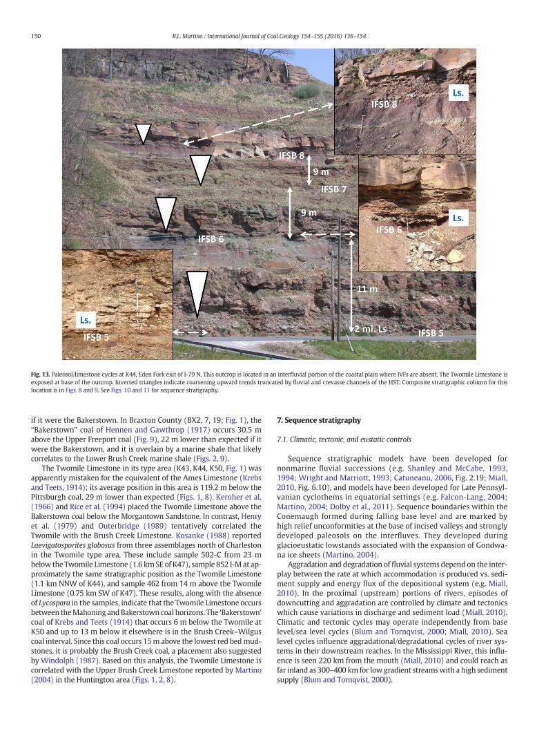
Fig. 13. Paleosol/limestone cycles at K44, Eden Fork exit of I-79 N. This outcrop is located in an interfluvial portion of the coastal plain where IVFs are absent. The Twomile Limestone isexposed at base of the outcrop. Inverted triangles indicate coarsening upward trends truncated by fluvial and crevasse channels of the HST. Composite stratigraphic column for thislocation is in Figs. 8 and 9. See Figs. 10 and 11 for sequence stratigraphy.
150 R.L. Martino / International Journal of Coal Geology 154–155 (2016) 136–154
if it were the Bakerstown. In Braxton County (BX2, 7, 19; Fig. 1), the“Bakerstown” coal of Hennen and Gawthrop (1917) occurs 30.5 mabove the Upper Freeport coal (Fig. 9), 22 m lower than expected if itwere the Bakerstown, and it is overlain by a marine shale that likelycorrelates to the Lower Brush Creek marine shale (Figs. 2, 9).
The Twomile Limestone in its type area (K43, K44, K50, Fig. 1) wasapparently mistaken for the equivalent of the Ames Limestone (Krebsand Teets, 1914); its average position in this area is 119.2 m below thePittsburgh coal, 29 m lower than expected (Figs. 1, 8). Keroher et al.(1966) and Rice et al. (1994) placed the Twomile Limestone above theBakerstown coal below the Morgantown Sandstone. In contrast, Henryet al. (1979) and Outerbridge (1989) tentatively correlated theTwomile with the Brush Creek Limestone. Kosanke (1988) reportedLaevigatosporites globosus from three assemblages north of Charlestonin the Twomile type area. These include sample 502-C from 23 mbelow the Twomile Limestone (1.6 kmSE of K47), sample 852 I-M at ap-proximately the same stratigraphic position as the Twomile Limestone(1.1 km NNW of K44), and sample 462 from 14 m above the TwomileLimestone (0.75 km SW of K47). These results, along with the absenceof Lycospora in the samples, indicate that the Twomile Limestone occursbetween theMahoning andBakerstown coal horizons. The ‘Bakerstown’coal of Krebs and Teets (1914) that occurs 6 m below the Twomile atK50 and up to 13 m below it elsewhere is in the Brush Creek–Wilguscoal interval. Since this coal occurs 15m above the lowest red bedmud-stones, it is probably the Brush Creek coal, a placement also suggestedby Windolph (1987). Based on this analysis, the Twomile Limestone iscorrelated with the Upper Brush Creek Limestone reported by Martino(2004) in the Huntington area (Figs. 1, 2, 8).
7. Sequence stratigraphy
7.1. Climatic, tectonic, and eustatic controls
Sequence stratigraphic models have been developed fornonmarine fluvial successions (e.g. Shanley and McCabe, 1993,1994; Wright and Marriott, 1993; Catuneanu, 2006, Fig. 2.19; Miall,2010, Fig. 6.10), and models have been developed for Late Pennsyl-vanian cyclothems in equatorial settings (e.g. Falcon-Lang, 2004;Martino, 2004; Dolby et al., 2011). Sequence boundaries within theConemaugh formed during falling base level and are marked byhigh relief unconformities at the base of incised valleys and stronglydeveloped paleosols on the interfluves. They developed duringglacioeustatic lowstands associated with the expansion of Gondwa-na ice sheets (Martino, 2004).
Aggradation and degradation of fluvial systems depend on the inter-play between the rate at which accommodation is produced vs. sedi-ment supply and energy flux of the depositional system (e.g. Miall,2010). In the proximal (upstream) portions of rivers, episodes ofdowncutting and aggradation are controlled by climate and tectonicswhich cause variations in discharge and sediment load (Miall, 2010).Climatic and tectonic cycles may operate independently from baselevel/sea level cycles (Blum and Tornqvist, 2000; Miall, 2010). Sealevel cycles influence aggradational/degradational cycles of river sys-tems in their downstream reaches. In the Mississippi River, this influ-ence is seen 220 km from the mouth (Miall, 2010) and could reach asfar inland as 300–400 km for low gradient streamswith a high sedimentsupply (Blum and Tornqvist, 2000).

151R.L. Martino / International Journal of Coal Geology 154–155 (2016) 136–154
The outcrops in this study are 28 km or less from the projectedpaleoshorelines during the maximum transgression of the LowerBrush Creek and Ames Seas (Fig. 1). The Upper Brush Creek, Cambridgeand Portersville transgressions reached towithin 50–80 km or less of alloutcrops (Busch and West, 1987). A total of eight Glenshaw transgres-sions are recognized in West Virginia and/or eastern Ohio and south-western Pennsylvania (Busch and Rollins, 1984; Busch and West,1987). It is therefore likely that sea level/base level changes played adominant role in the development of sequences and systems tracts ofthe Conemaugh updip from these marine locations in central WestVirginia.
7.2. Incised valley-fills (IVFs)
Valley fills are elongate bodies larger than a single channel thatrange from 8 to 100 m thick and 0.5 to 40 km in maximum width(Schumm and Ethridge, 1994; Dalrymple et al., 1994). Within an IVF,the lowest story is usually the coarsest and often conglomeratic;upper stories are finer grained with a higher frequency of heterolithicstrata and mudstone plugs. The amalgamation of channel deposits andthe abrupt increase in grain sizewithin IVFs is expected above sequenceboundaries (Emery and Myers, 1996). Coastal plain rivers incised theirvalleys during falling base level associated with falling glacioeustaticsea level. Crowley and Baum (1991) estimated the magnitude of sealevel changes due to Gondwana glaciation to be between 45–75 m(minimum ice cover) and 150–190 (maximum ice cover) and thosereaching the Appalachian Basin in its high shelf position required sealevel changes of approximately 100 m (Heckel, 2008).
IVFs occur in association with all cycles bounded by maturepaleosols (Figs. 8, 9) but three are especially prominent. The Upperand Lower Mahoning Sandstone IVFs (Fig. 8, Ruth and Eden Fork sec-tions between IFSBs 1 and 4) are 15–19 m thick and separated by theMahoning coal of Windolph (1987). In many places near Charleston,the Mahoning and Upper Freeport coals have been removed bypaleovalley incision (e.g. K42, K47, K37, Figs. 1, 8, 9). A second promi-nent IVF, ranging from 13 to 25 m in thickness, occurs above theTwomile Limestone and locally truncates it (Fig. 9, Priestly, St. Albans,Eden Fork sections between IFSBs 4 and 7). This IVF correlates withthe Saltsburg-Buffalo Sandstone compound IVF in the Huntington area(Martino, 2004). A third large IVF, correlated with the Grafton Sand-stone IVF of Martino (2004) is represented by the Sandy Grove Sand-stone of Windolph (1987; Fig. 9, Flatwoods section above IFSB 8). Thetop of the Sandy Grove IVF occurs from 70 to 85m below the Pittsburghcoal. It is typically 15–20m thick; greater thicknesses (up to 29m) likelyindicate a compound IVF due to incision into the underlying SaltsburgIVF.
Bundles of thicker and thinner laminae and limited burrowing areassociated with upper estuarine channels near the fluvial-tidal transi-tion (Greb and Martino, 2005). Inclined heterolithic strata form inmeandering channels of mixed load streams in fluvial and tidal settings(Thomas et al., 1987). Fluvial-tidal transition facies are important influvially dominated successions as they may represent the only updipexpression of marine flooding surfaces (Greb and Martino, 2005).Mud-filled channels (Fig. 9, Eden Fork section between IFSBs 5 and7) and heterolithic channel fills occur in the upper portion of the IVFsand result from decreased fluvial gradient and stream power associatedwith rising relative base level.
7.3. Interfluvial sequence boundaries
Interfluvial sequence boundaries (IFSBs) in coastal plain deposits arerepresented by well-developed paleosols formed between incised rivervalleys during prolonged subaerial exposure (VanWagoner et al., 1990;Shanley and McCabe, 1993, 1994; Emery and Myers, 1996; Plint et al.,2001; Catuneanu, 2006; Miall, 2010). Sediment bypassing and negativeaccommodation occurs during falling stage, lowstand, and early
transgressive systems tracts (McCarthy and Plint, 1998; McCarthyet al., 1999; Fig. 10). Lowstand paleosols are relatively thick with well-defined horizons. Exposure time for Milankovitch driven eccentricitycycles is usually 104 to 105 years, and the soils are usually well-drained and of regional extent due to lowered base level (Miall, 2010).Climate and base level cycles may be interdependent at the time scaleof Milankovitch periodicities (Catuneanu, 2006). Major cyclothemshave a duration of about 400 kyr (Heckel, 2008), and IFSB paleosols innonmarine cyclothems of this study may represent much of this time(Fig. 10).
In Figs. 8 and 9, well-developed paleosols interpreted as IFSBs arecapped by limestones, coals or carbonaceous shales. Good examplesare illustrated in Figs. 5A, C, and D and 8 (Eden Fork and St. Albans sec-tions, horizons 4–9). The close association of well-drained, soils(vertisols, calcisols)with overlying paludal and/or lacustrine facies indi-cates contrasting pedogenic conditions and little or no accommodationspace on the interfluves during falling stage, lowstand, and early trans-gressive systems tracts (Gibling and Bird, 1994; Tandon and Gibling,1997; Falcon-Lang, 2004; Hanneman and Wideman, 2010). Risingwater table can produce gley soil overprinting of high chroma soilsand a polygenetic soil with features that reflect contrasting hydromor-phic conditions (e.g. Driese and Ober, 2005). These polygeneticpaleosols are typically present along horizons 4–9 in Figs. 8 and 9. Awetter climate accompanied interglacial highstands (e.g. Heckel, 1994;Falcon-Lang, 2004; Catuneanu, 2006). The higher sediment flux associ-ated with increased runoff would have impeded the development oflimestones unless 1) clastics were filtered by vegetation that fringedthe lakes or coastal bays, or 2) clastics were initially trapped in incisedvalleys before base level rose above the interfluves.
IFSB paleosols developed in three stages as portrayed in Fig. 12(modified fromDriese and Ober, 2005, Fig. 9). In Stage I, highly seasonalrainfall with short wet/long dry seasons caused oxidizing conditions,shrink/swell features, and precipitation of micritic limestone nodules,producing a calcic vertisol. Base level was lowest during glaciallowstand. In Stage 2, rising sea level and wetter climate caused watertable to rise and led to impure peat accumulation, reducing conditionsin the upper part of the soil, and gleying. During Stage 3, sea levelreached highstand, and with wetter climate, water table continued torise, causing drowning of swamp by lakes and bays and continued gley-ing of soil. Calcic vertisols and aridosols formed in the Conemaugh dur-ing the Missourian and Early Virgilian lowstands due to higher rates ofevaporation associated with global warming. Coals were thin, impure,and localized to topographic lows. Lacustrine and palustrine or coastalmarine carbonates formed in place of coals or directly above carbona-ceous horizons prior to highstand.
7.4. Paleosol/limestone cycles
A cyclic development of calcic vertisols overlain by microchonchidlimestones is associated with horizons 5–8 at and above the TwomileLimestone; these cycles particularly well-developed in the Guthrie-Eden Fork area (IFSBs 5, 6, and 8 in Figs. 8, 9). At K44 (Figs. 8, 9, 13),the Twomile Limestone is 2m thick and occurs 120.4m below the Pitts-burgh coal as mapped by Windolph (1987). Two other microconchidlimestones occur at 107 m and 88 m below the Pittsburgh coal (EdenFork section, Fig. 9). Each limestone overlies a mature paleosol 1.9–4.7m thick, and is overlain by shale or mudstone that coarsens upward.These cycles are similar in scale and architecture to the paleosol-bounded cycles of the Huntington area that contain marine limestonesand shales directly above a mature IFSB paleosol (Martino, 2004).
The paleosols and limestones formed at a time when clastic influxwas minimal. In both cases, a rising water table drowned the initiallywell-drained soils. Given the proximity of the study area to thepaleoshorelines during maximum transgressions, it is quite likely thatthe limestones were deposited in brackish bays or coastal lakes thatwere intermittently connected to the sea during seasonally high lake

152 R.L. Martino / International Journal of Coal Geology 154–155 (2016) 136–154
levels or high bay water level associated with spring tides and lunarperigee tides. Periodic variations in tropical precipitation patternscould also have contributed to the cyclic development. Wanless andShepard (1936) were the first to propose more humid conditions ac-companied transgressions (now recognized as sea-level highstands),while drier conditions prevailed during repressions (i.e. lowstands) as-sociated with glaciation. The drier climatic phases would be the expect-ed effect of the shift of mid latitude high pressure systems toward theequator during glacial periods, while wetter phases result from the ex-pansion of the intertropical convergence zone (characterized by lowpressure) during sea level highstands (Perlmutter and Matthews,1989). A comparable wet/dry pattern linkage to glacioeustatic sealevel operated during the Late Pleistocene and Holocene as well(Crowley and North, 1991; Kershaw and Nanson, 1993).
Busch andWest (1987) described climate change surfaces from theGlenshaw Formation in Ohio and Pennsylvanian. These surfaces sepa-rated well-drained paleosols often associated with arid conditionsfrom superjacent coals or limestones formed under more humid condi-tions. Nine to eleven paleosol-bounded allocycles are present in thelower Conemaugh Group downdip to the north and west of the presentstudy area (Busch and Rollins, 1984;Martino, 2004). The dry glacial/wetinterglacial viewpoint is widely held among many other recentresearchers (e.g. Perlmutter and Matthews, 1989; Heckel, 1995;Tandon and Gibling, 1997; Driese and Ober, 2005; Catuneanu, 2006;Falcon-Lang et al., 2011). In contrast, a wet glacial/dry interglacial asso-ciation has been advocated by some (e.g. Cecil et al., 2003; Rosenauet al., 2013a). In this alternative scenario, peat accumulation and higher,less seasonal rainfall occurred during glacial maxima; vertisols,aridosols, and lacustrine and marine limestones formed during drierconditions associated with sea level highstands. This view is basedmainly on climate models that suggest that a stable low-pressure cellwould have been pinned to the equator by the development of high-pressure zones over the Gondwana ice sheets. However, this wet-glacial/dry interglacial model does not fit the succession of events re-corded in Conemaugh cyclothems, which would appear to require dryseasonal conditions to be followed by wetter conditions associatedwith marine transgression.
8. Conclusions
1) Paleosol-bounded cyclothems of terrestrial strata in central WestVirginia are correlated downdip to the north and west withcyclothems containing marine units;
2) Initial stages of sequence-bounding paleosol development occurredon interfluves during FSST and LST under well-drained oxidizingconditions and strongly seasonal climate. Sediment bypassingallowed for prolonged pedogenesis lasting 10s to 100s of thousandyears; gleying of soils and local histosol development occurred dur-ing TST when local water tables rose due to rising sea level andwet-ter, less seasonal climate;
3) Microconchid limestones formed under lacustrine, palustrine, andpossibly brackish intertidal conditions and represent maximumflooding surfaces within predominantly terrestrial sequences;
4) Coarsening-upward bay- and lake-fill sequences formed during theHST;
5) IVFs occur in associationwith each paleosol-bounded cycle; the larg-est ones correlate with the Mahoning, Saltsburg, and Grafton IVFs(Martino, 2004);
6) Sea-level/base level was the primary control on high-frequencyvariations in accommodation space within the coastal plain fluvialsystems during the development of the fourth-order cyclothems;
7) Striking parallels in scale and internal architecture occur betweendowndip, marine-cored cyclothems and their updip ‘nonmarine’cyclothem equivalents;
8) This study underscores the importance of regionally developedpaleosols as a valuable tool in stratigraphic correlation and in se-quence stratigraphic studies.
Acknowledgments
Early phases of this study were supported by a grant from the Petro-leum Research Fund (PRF 34516-B8). The author thanks Cortland Eble,Nick Fedorko, and Mitch Blake for helpful discussions, Patrick Fosterand John Ferguson for field assistance, and Annalisha Johnson and Pat-rick Foster for drafting support. Steve Greb and Jim Hower providedthorough and thoughtful reviews which significantly enhanced thefinal version of this paper.
References
Arkle Jr., T.A., 1974. Stratigraphy of the Pennsylvanian and Permian Systems of the centralAppalachians. In: Briggs, G. (Ed.), Carboniferous of the Southeastern United States.Geological Society of America Special Paper 148, pp. 5–29.
Blakely, R.C., 2007. Carboniferous–Permian paleogeography of the assembly of Pangaea.In: Wong, T.E. (Ed.), Proceedings on the XVth International Congress on Carbonifer-ous and Permian Stratigraphy, Utrecht, 10–16 August 2003. Royal Dutch Academyof Arts and Sciences, pp. 443–456.
Blum, M.D., Tornqvist, T.E., 2000. Fluvial responses to climate and sea level change: a re-view and a look forward. Sedimentology 47, 2–48.
Boardman II, D.R., Mapes, R.H., Yancey, T.E., Malikny, J.M., 1984. A new model for depth-related allogenic community succession within North American Pennsylvaniancyclothems and implications on the black shale problem. In: Hyne, N.J. (Ed.)-Limestones of the Mid-Continent: Tulsa Geological Society Special Publication 2,pp. 141–182.
Bragonier, W.A., 1989. Stratigraphy of flint clays of the Allegheny and Pottsville Groups,western Pennsylvania. In: Harper, J.A. (Ed.), Geology in the Laurel Highlands of South-western Pennsylvania. Guidebook, 54th Annual Field Conference of PennsylvanianGeologists. Pennsylvania Geologic Survey, pp. 69–88.
Busch, R.M., Rollins, H.B., 1984. Correlation of Carboniferous strata using a hierarchy oftransgressive regressive units. Geology 12, 471–474.
Busch, R.M., West, R.R., 1987. Hierarchal genetic stratigraphy: a framework forPaleoeceanography. Paleoceanography 2, 141–164.
Catuneanu, O., 2006. Principles of Sequence Stratigraphy. Elsevier, Amsterdam, TheNetherlands (375 pp.).
Cecil, C.B., 1990. Paleoclimate controls on stratigraphic repetition of chemical andsiliciclastic rocks. Geology 18, 533–536.
Cecil, C.B., Stanton, R.W., Neuzil, S.G., Dulong, F.T., Ruppert, L.F., Pierce, B.F., 1985.Paleoclimate controls on Late Paleozoic sedimentation and peat formation in the cen-tral Appalachian Basin, USA. Int. J. Coal Geol. 5, 195–230.
Cecil, C.B., Dulong, F.T., Cobb, J.C., Supardi, M., 1993. Allogenic and autogenic controls onsedimentation in the Central Sumatra Basin as an analogue for Pennsylvanian coal-bearing strata in the Appalachian Basin. In: Cobb, J.C., Cecil, C.B. (Eds.), Modern andAncient Coal-forming Environments. Geological Society of America Special Paper286, pp. 3–22.
Cecil, C.B., Dulong, F.T., West, R.R., Stamm, R., Wardlaw, B., Edgar, N.T., 2003. Climate con-trols on the stratigraphy of a Middle Pennsylvanian cyclothem in North America. In:Cecil, C.B., Edgar, N.T. (Eds.), Climate Controls on Stratigraphy. Society of EconomicPaleontologists and Mineralogists Special Publication 77, pp. 151–180.
Collinson, J.D., 1996. Alluvial sediments. In: Reading, H.G. (Ed.), Sedimentary Environ-ments: Processes, Facies and Stratigraphy. Blackwell Science Ltd., Oxford, UK,pp. 37–82.
Crowley, T.J., Baum, S.K., 1991. Estimating Carboniferous sea level fluctuations fromGond-wana ice extent. Geology 19, 975–977.
Crowley, T.J., North, G.R., 1991. Paleoclimatology. Oxford Monographs on Geology andGeophysics 18. Oxford University Press, New York (339 pp.).
Dalrymple, R.W., Boyd, R., Zaitlin, B.A., 1994. History of research, types and internal orga-nization of incised-valley systems: introduction to the volume. In: Dalrymple, R.,Boyd, R., Zaitlin, B. (Eds.), Incised-valley Systems: Origin and Sedimentary Sequences:Society of Economic Paleontologists and Mineralogists Special Publication 51,pp. 353–368.
Dolby, G., Falcon-Lang, H.J., Gibling, M.R., 2011. A conifer-dominated palynological assem-blage from Pennsylvanian (Late Moscovian) alluvial drylands in Atlantic Canada: im-plications for the Vegetation of tropical lowlands during glacial phases. J. Geol. Soc.168, 571–584.
Donaldson, A.C., 1979. Depositional environments of the Upper Pennsylvanian Series. In:Englund, K.J., Arndt, H.H., Henry, T.W. (Eds.), Proposed Pennsylvanian SystemStratotype Virginia and West Virginia. American Geologic Institute, Selected Guide-book Series 1, pp. 123–132.
Donaldson, A.C., Renton, J.J., Presley, M.W., 1985. Pennsylvanian deposystems andpaleoclimates of the Appalachians. Int. J. Coal Geol. 5, 167–193.
Driese, S.G., Ober, E.G., 2005. Paleopedologic and paleohydrologic records of precipitationseasonality from Early Pennsylvanian “underclay” paleosols, U. S. A. J. Sediment. Res.75, 997–1010.

153R.L. Martino / International Journal of Coal Geology 154–155 (2016) 136–154
Eble, C.F., 1998. Paleobotanical considerations. Coal Geology, Paleobotany, and RegionalStratigraphy of the Middle Part of the Kanawha Formation, Southern West Virginia.Geological Society of America Field Trip Guidebook, p. A56-F56.
Eble, C.F., Blake, B.M., Gillespie, W.H., Pfefferkorn, H.W., Chesnut, D.R.J., 2009. AppalachianBasin fossil floras. In: Greb, S.F. (Ed.), Carboniferous of the Appalachian and BlackWarrior Basins. Kentucky Geologic Survey Special Publication 10 Series XII,pp. 46–58.
Elliott, T., 1974. Interdistributary bay sequences and their genesis. Sedimentology 21,611–622.
Emery, D., Myers, K.J., 1996. Sequence Stratigraphy. Blackwell Science Ltd., London (297pp.).
Ettensohn, F., 2008. The Appalachian foreland basin in Eastern United States. In: Miall,A.D. (Ed.), The Sedimentary Basins of the United States and Canada. Elsevier, TheNetherlands, pp. 105–179.
Falcon-Lang, H.J., 2004. Pennsylvanian tropical rainforests responded to glacial–interglacial rhythms. Geology 32, 689–692.
Falcon-Lang, H.J., Heckel, P.E., Dimichele, W.A., Blake Jr., B.M., Easterday, C.R., Eble, C.F.,Elrick, S., Gastaldo, R.A., Greb, S.F., Martino, R.L., Nelson, W.J., Pfefferkorn, H.W.,Phillips, T.L., Rosscoe, S.J., 2011. No major stratigraphic gap exists near the Middle-Upper Pennsylvanian (Desmoinesian–Missourian) boundary in North America.Palaios 26, 125–139.
Fielding, C.R., Frank, T.D., Isabell, J.L., 2008. The Late Paleozoic ice age—a review of currentunderstanding and synthesis of global climate patterns. In: Fielding, C.R., Frank, T.D.,Isbell, J.L. (Eds.), Resolving the Late Paleozoic Ice Age in Time and Space. GeologicalSociety of America Special Paper 441, pp. 343–354.
Fonner, R.F., 1987. Geology along I-64 Putnam County, West Virginia. West Virginia Geo-logical and Economic Survey Publication MAPWV-33 (35 pp.).
Fonner, R.F., Chappell, G.A., 1987. Geology along I-64 Cabell County, West Virginia.West Virginia Geological and Economic Survey Publication MAPWV-32 (59pp.).
Freylet, P., Plaziat, J.-C., 1982. Continental carbonate sedimentation and pedogenesis—LateCretaceous and Early Tertiary of Southern France. Contrib. Sedimentol. 12 (213 pp.).
Gardner, T.W., Williams, E.G., Holbrook, P.W., 1988. Pedogenesis of some Pennsylvanianunderclays; groundwater, topographic, and tectonic controls. Geol. Soc. Am. Spec.Pap. 216, 81–101.
Gibling, M.R., Bird, D.J., 1994. Late Carboniferous cyclothems and alluvial paleovalleys inthe Sydney Basin, Nova Scotia. Geol. Soc. Am. Bull. 106, 105–117.
Gierlowski-Kordesch, E.H., Cassle, C.F., 2015. The ‘Spirorbis’ problem revisited: sedimen-tology and biology of microconchids in marine–nonmarine transitions. Earth Sci.Rev. 148, 209–227.
Greb, S.F., Martino, R.L., 2005. Fluvial–estuarine transitions in fluvial-dominant succes-sions; examples from the Lower Pennsylvanian of the Central Appalachian Basin.In: Blum, M., Marriott, S.B., Leclair, S. (Eds.), Fluvial Sedimentology VIIInternationalAssociation of Sedimentologists, Special Publication 35. Blackwell Publishing,pp. 425–452.
Greb, S.F., Pashin, J.C., Martino, R.L., Eble, C.F., 2008. Appalachian sedimentary cycles dur-ing the Pennsylvanian: changing influences of sea level, climate, and tectonics. In:Fielding, C.F., Frank, T.D., Isbell, J.L. (Eds.), Resolving the Late Paleozoic GondwananIce Age in Time and Space. Geological Society of America Special Publication 441,pp. 235–248.
Hanneman, D.L., Wideman, C.J., 2010. Continental sequence stratigraphy and continentalcarbonates. In: Alonso-Zara, A.M., Tanner, L.H. (Eds.), Carbonates in ContinentalSettingsDevelopments in Sedimentology 62. Elsevier, pp. 215–273.
Heckel, P.H., 1994. Evaluation of evidence for glacial-eustatic control over marinePennsylvanian cyclothems in North America and consideration of possible tectoniceffects. In: Dennsion, J.M., Ettensohn, F.R. (Eds.), Tectonic and Eustatic Controls onSedimentary Cycles. Society of Economic Paleontologists and Mineralogists Conceptsin Sedimentology and Paleontology 4, pp. 65–87.
Heckel, P.H., 1995. Glacial–eustatic base-level-climate model for Late Middle to LatePennsylvanian coal bed formation in the Appalachian Basin. J. Sediment. Res. B65,348–356.
Heckel, P.H., 2008. Pennsylvanian cyclothems in Midcontinent North America as far-fieldeffects of waxing and waning of Gondwana ice sheets. In: Fielding, C.R., Frank, T.D.,Isbell, J.L. (Eds.), Resolving the Late Paleozoic Ice Age in Time and Space. GeologicalSociety of America Special Paper 441, pp. 275–289.
Hennen, R.V., Gawthrop, R.M., 1917. Braxton and Clay Counties. West Virginia Geologicaland Economic Survey (883 pp.).
Henry, T.W., Lyons, P.C., Windolph Jr., J.F., 1979. Upper Pennsylvanian and LowerPermian(?) Series in the area of the proposed Pennsylvanian System Stratotype. In:Englund, K.J., Arndt, H.H., Henry, T.W. (Eds.), Proposed Pennsylvanian SystemStratotype, Virginia and West Virginia. American Geological Institute Selected Guide-book Series, pp. 81–85.
Horne, J.C., Ferm, J.C., Caruccio, F.T., Baganz, B.P., 1978. Depositional models in coal explo-ration and mine planning. Am. Assoc. Pet. Geol. Bull. 62, 2379–2411.
Isbell, J.L., Miller, M.F., Wolfe, K.L., Lenaker, P.A., 2003. Timing of the Late Paleozoic glaci-ation in Gondwana: was glaciation responsible for the development of northernhemisphere cyclothems? In: Chan, M.A., Archer, A.W. (Eds.), Extreme DepositionalEnvironments: Mega End Members in Geologic Time. Geological Society of AmericaSpecial Publication 370, pp. 5–24
Keller, W.D., 1981. The sedimentology of flint clay. J. Sediment. Petrol. 51, 233–244.Keroher, G.C., Bedette, B., Eggleton, J.L., Hansen, B.E., Kopf, R.W., Mann, C., Melton Jr., W.G.,
Nace, H.L., Palmer, K.D., Sando, W.J., Smedley, J.E., Stock, S.W., Swift, C.S., Toulmin,M.S., Wilson, D., 1966. Lexicon of geologic names for the United States for1936–1960. U.S. Geol. Surv. Bull. 1200 (4341 pp.).
Kershaw, A.P., Nanson, G.C., 1993. The last full glacial cycle in the Australian region. Glob.Planet. Chang. 7, 1–9.
Kosanke, R.M., 1988. Palynologic analyses of Upper Pennsylvanian coal beds and adjacentstrata from the proposed Pennsylvanian System Stratotype in West Virginia. U. S.Geol. Surv. Prof. Pap. 1486, 1–24.
Krebs, C.E., Teets Jr., D.D., 1914. Kanawha County. West Virginia Geologic Survey CountyReports (679 pp.).
Leeder, M., 2011. Sedimentology and Sedimentary Basins. second ed. Wiley-Blackwell(768 pp.).
Mack, G.H., James, W.C., Monger, H.C., 1993. Classification of paleosols. Geol. Soc. Am. Bull.105, 129–136.
Martino, R.L., 2004. Sequence stratigraphy of the Glenshaw Formation (Middle–LatePennsylvanian) in the Central Appalachian Basin. In: Pashin, J.C., Gastaldo, R.A.(Eds.), Sequence Stratigraphy, Paleoclimate, and Tectonics of Coal-bearing Strata.American Association of Petroleum Geologists Studies in Geology 51, pp. 1–28.
Martino, R.L., Greb, S., 2009. Walking trails of the giant terrestrial arthropod Arthropleurafrom the Upper Carboniferous of Kentucky. J. Paleontol. 83, 140–146.
McCarthy, P.J., 2002. Micromorphology and development of interfluve paleosols: a casestudy from the Cenomanian Dunvegan Formation, NE British Columbia, Canada.Can. Petrol. Geol. Bull. 50, 158–177.
McCarthy, P.J., Plint, A.G., 1998. Recognition of interfluve sequence boundaries: integrat-ing paleopedology and sequence stratigraphy. Geology 26, 387–390.
McCarthy, P.J., Faccini, U.F., Plint, A.G., 1999. Evolution of an ancient coastal plain:palaeosols, interfluves and alluvial architecture in a sequence stratigraphic frame-work, Cenomanian Dunvegan Formation, NE British Columbia, Canada. Sedimentolo-gy 46, 861–891.
Miall, A.D., 2010. The Geology of Stratigraphic Sequences. second ed. Springer-Verlag,Berlin Heidelberg (522 pp.).
Moon, C.F., Hurst, C.W., 1984. Fabric of muds and shales: an overview. In: Stowe, D.A.V.,Piper, D.J.W. (Eds.), Fine-grained Sediments: Deep-water Processes andFaciesGeological Society Special Publication 15. Blackwell Scientific PublicationsLimited, Oxford, pp. 579–593.
Morris, D.A., 1967. Lower Conemaugh (Pennsylvanian) Depositional Environments andPaleogeography in the Appalachian Coal Basin. Unpublished PhD Dissertation, Uni-versity of Kansas, Lawrence (521 pp.)
Olariu, C., Bhattacharya, J.P., 2006. Terminal distributary channels and delta front architec-ture of river-dominated delta systems. J. Sediment. Res. 76, 212–233.
Outerbridge, W.F. , 1989. Correlation of the Charleston Sandstone of theproposed Pennsylvanian stratotype with strata in eastern Kentucky, western WestVirginia, and southern Ohio. U.S. Geological Survey. Miscellaneous Field Studies MapMF— 2110.
Peppers, R.A., 1996. Palynological correlation of major Pennsylvanian (Middle and UpperCarboniferous) chronostratigraphic boundaries in the Illinois and other coal basins.Geol. Soc. Am. Mem. 188 (111 pp.).
Perlmutter, M.A., Matthews, M.D., 1989. Global cyclostratigraphy—a model. In: Cross, T.A.(Ed.), Quantitative Dynamic Stratigraphy. Prentice Hall, Englewood Cliffs, New Jersey,pp. 233–260.
Pfefferkorn, H.W., Gastaldo, R.A., DiMichele, W.A., Phillips, T.L., 2008. Pennsylvanian trop-ical floras from the United States as a record of changing climates. In: Fielding, C.R.,Frank, T.D., Isbell, J.L. (Eds.), Resolving the Late Paleozoic Ice Age in Time and Space.Geological Society of America Special Paper 441, pp. 305–316.
Platt, N.H., Wright, V.P., 1991. Lacustrine carbonates: facies models, facies distributionsand hydrocarbon aspects. In: Anadon, P., Cabreraq, L.I., Kelts, K. (Eds.), LacustrineFacies Analyses. International Association of Sedimentologists Special Publication13, pp. 55–73.
Plint, A.G., McCarthy, P.J., Faccini, U.F., 2001. Nonmarine sequence stratigraphy: updip ex-pression of sequence boundaries and systems tracts in a high-resolution framework,Cenomanian Dunvegan Formation, Alberta Foreland Basin, Canada. Am. Assoc. Pet.Geol. Bull. 85, 1967–2001.
Potter, P.E., Maynard, J.B., Pryor, W.A., 1980. The Sedimentology of Shale. Springer-Verlag,New York (306 pp.).
Pratt, B.R., 2010. Peritidal carbonates. In: James, N.P., Dalrymple, R.W. (Eds.), FaciesModels 4. Geological Association of Canada, pp. 401–420.
Quinlan, G.M., Beaumont, C., 1984. Appalachian thrusting, lithospheric flexure, and thePaleozoic stratigraphy of the Eastern Interior of North America. Can. J. Earth Sci. 21,973–996.
Reading, H.G., Collinson, J.D., 1996. Clastic coasts. In: Reading, H.G. (Ed.), Sedimentary En-vironments: Processes, Facies, and Stratigraphy. Blackwell Science Ltd, Oxford,pp. 154–231.
Retallack, G.J., 1988. Field recognition of paleosols. In: Reinhardt, J., Sigleo, W.R. (Eds.),Paleosols and Weathering Through Geologic Time. Geological Society of AmericaSpecial Paper 216, pp. 1–20.
Retallack, G.J., 2001. Soils of the Past. second ed. Blackwell Science, London (404 pp.).Rice, C.L., 1986. Pennsylvanian system (Kentucky). In: McDowell, R.C. (Ed.), The Geology
of Kentucky — A Text to Accompany the Geologic Map of Kentucky. U.S. GeologicalSurvey Professional Paper 1151-H, pp. H31–H44.
Rice, C.L., Hiett, J.K., Koozmin, E.D., 1994. Glossary of Pennsylvanian stratigraphic names,central Appalachian basin. In: Rice, C.L. (Ed.), Elements of Pennsylvanian Stratigraphy,Central Appalachian Basin. Geological Society of America Special Paper 294,pp. 115–155.
Rosenau, N.A., Tabor, N.J., Elrick, S.D., Nelson, W.J., 2013a. Polygenetic history of paleosolsinMiddle-Upper Pennsylvanian cyclothems of the Illinois Basin, U.S.A.: Part I. Charac-terization of paleosol types and interpretation of pedogenic processes. J. Sediment.Res. 83, 606–636.
Rosenau, N.A., Tabor, N.J., Elrick, S.D., Nelson, W.J., 2013b. Polygenetic history ofpaleosols in Middle-Upper Pennsylvanian cyclothems of the Illinois Basin,U.S.A.: Part II. Integrating geomorphology, climate, and glacioeustasy.J. Sediment. Res. 83, 637–668.

154 R.L. Martino / International Journal of Coal Geology 154–155 (2016) 136–154
Schultz, H.-P., 2009. Interpretation of marine and freshwater paleoenvironments inPermo-Carboniferous deposits. Palaeogeogr. Palaeoclimatol. Palaeoecol. 281,126–136.
Schumm, S.A., Ethridge, F.G., 1994. Origin, evolution andmorphology of fluvial valleys. In:Dalrymple, R., Boyd, R., Zaitlin, B. (Eds.), Incised-valley Systems: Origin and Sedimen-tary Sequences. Society of Economic Paleontologists and Mineralogists Special Publi-cation 51, pp. 11–27.
Shanley, K.W., McCabe, P.J., 1993. Alluvial architecture in a sequence stratigraphic frame-work: a case history from the Upper Cretaceous from southern Utah. In: Flint, S.S.,Bryant, I.D. (Eds.), The Geologic Modeling of Hydrocarbon Reservoirs and OutcropAnalogues. International Association of Sedimentologists Special Publication 15,pp. 21–56.
Shanley, K.W., McCabe, P.J., 1994. Perspectives on the sequence stratigraphy of continen-tal strata. Am. Assoc. Pet. Geol. Bull. 78, 544–568.
Staub, J.R., Cohen, A.D., 1979. The Snuggedy Swamp of South Carolina: a back-barrierestuarine coal-forming environment. J. Sediment. Res. 49, 133–143.
Stout, W., 1947. Generalized geologic section of rocks in Ohio. Ohio Geologic SurveyInformation Circular 4.
Sturgeon, M.T., Hoare, R.D., 1968. Pennsylvanian brachiopods of Ohio. Ohio Geol. Surv.Bull. 63 (95 pp.).
Tandon, S.K., Gibling, M.R., 1997. Calcretes at sequence boundaries in Upper Carbonifer-ous cyclothems of the Sydney Basin, Atlantic Canada. Sediment. Geol. 112, 43–67.
Tasch, P., 1980. Paleobiology of the Invertebrates, Data Retrieval From the Fossil Record.John Wiley and Sons, New York (975 pp.).
Taylor, P.D., Vinn, O., 2006. Convergent morphology in small spiral worm tubes(‘Spirorbis’) and its palaeoenvironmental implications. J. Geol. Soc. 163, 225–228.
Thomas, R.G., Smith, D.G., Wood, J.M., Visser, J., Calverley-Range, E.A., Koster, E.H., 1987.Inclined heterolithic stratification—terminology, description, interpretation, andsignificance. Sediment. Geol. 53, 123–179.
Tucker, M.E., 2001. Sedimentary iron deposits. Sedimentary Petrology. Blackwell Science,pp. 182–193.
Vail, P.R., Mitchum, R.M., Todd, R.G., Widmier, J.M., Thompson, S., Sangree, J.B., Bubb, J.N.,Hatfield, W.G., 1977. Seismic stratigraphy and global changes in sea level. In: Payton,
C.E. (Ed.), Seismic stratigraphy—Applications to Hydrocarbon Exploration. AmericanAssociation of Petroleum Geologists Memoir 26, pp. 49–212.
Van Wagoner, J.C., Mitchum, R.M., Campion, K.M., Rahmanian, V.D., 1990. Siliciclastic se-quence stratigraphy in well logs, cores, and outcrops: concepts for high-resolutioncorrelation of time and facies. American Association of PetroleumGeologists Methodsin Exploration Series 7 (55 pp.).
Wanless, H.R., 1939. Pennsylvanian correlations in the eastern interior and Appalachiancoal fields. Geol. Soc. Am. Spec. Pap. 17 (130 pp.).
Wanless, H.R., Shepard, F.P., 1936. Sea level and climatic changes related to late Paleozoiccycles. Geol. Soc. Am. Bull. 47, 1177–1206.
Wanless, H.R., Weller, J.M., 1932. Correlation and extent of Pennsylvanian cyclothems.Geol. Soc. Am. Bull. 43, 1003–1016.
Weller, M.J., 1930. Cyclic sedimentation of the Pennsylvanian Period and its significance.J. Geol. 38, 97–135.
West Virginia Geological and Economic Survey Coal Bed Mapping Project; PittsburghCoal. http://www.wvgs.wvnet.edu/GIS/CBMP/Pittsburgh.html).
White,W.A., 1961. Colloid phenomena in sedimentation of argillaceous rocks. J. Sediment.Petrol. 31, 560–570.
Williams, E.G., Berbenback, R.F., Falla, W.S., Udagawa, S., 1968. Origin of somePennsylvanian underclays in western Pennsylvania. J. Sediment. Petrol. 39, 1179–1193.
Windolph Jr., J.F., 1987. Geologic Map of the Big Chimney Quadrangle, Kanawha County,West Virginia. U. S. Geological Survey 1:24,000, Map GQ-1612.
Woodland, B.G., Stenstrom, R.C., 1979. The occurrence and origin of siderite concretions inthe Francis Creek Shale (Pennsylvanian) of northeastern Illinois. In: Nitechi, M.H.(Ed.), Mazon Creek Fossils. Academic Press, New York, pp. 69–103.
Wright, V.P., 1992. Paleopedology: stratigraphic relationships and empirical models. In:Martini, I.P., Chesworth, W. (Eds.), Weathering, Soils, and Paleosols. Earth SurfaceProcesses 2. Elsevier, pp. 475–499.
Wright, V.P., Marriott, S.B., 1993. The sequence stratigraphy of fluvial depositionalsystems: the role of floodplain sediment storage. Sediment. Geol. 86, 203–210.
Zatoń, M., Peck, R.L., 2013. Morphology and palaeoecology of new, non-marinemicroconchid tubeworm from Lower Carboniferous (Upper Mississippian) of WestVirginia, USA. Ann. Soc. Geol. Pol. 83, 37–50.