sensor web workshop report - nasa
TRANSCRIPT

Report from the Earth Science Technology Office (ESTO)
Advanced Information Systems Technology (AIST) Sensor Web Technology Meeting
February 13-14, 2007
Sensor Web Technology Meeting Report i February 13-14, 2007
Acknowledgement
This report represents the extensive effort and support of many individuals both within and outside of the National Aeronautics and Space Administration (NASA) and from the sensor web community. The members of the Earth Science Technology Office (ESTO) Advanced Information Systems Technology (AIST) projects who attended the meeting are listed in the breakout group reports (Sections 3.1, 4.1 and 5.1). The editors would like to acknowledge the work of the AIST team lead, Karen Moe, and the primary authors, Bradley Hartman, Samuel Gasster, and Peter Eggan, from The Aerospace Corporation. The editors would also like to acknowledge the support from Sheri Benator, The Aerospace Corporation, for discussions and suggestions regarding architecture frameworks for sensor webs and Penny Newsome, Global Sciences and Technology, for detailed review comments.
Sensor Web Technology Meeting Report ii February 13-14, 2007
TABLE OF CONTENTS
1 EXECUTIVE SUMMARY.........................................................................................................1
2 INTRODUCTION .....................................................................................................................2
2.1 MEETING CHARTER .......................................................................................................... 2 2.2 MEETING PROCESS .......................................................................................................... 3 2.3 DOCUMENT ORGANIZATION............................................................................................... 5
3 BREAKOUT GROUP A...........................................................................................................6
3.1 PARTICIPANTS .................................................................................................................. 6 3.2 TERMS & DEFINITIONS ...................................................................................................... 6 3.3 ARCHITECTURAL CONCEPT ............................................................................................... 7
3.3.1 List of Sensor Web Components ............................................................................. 11 3.3.2 Interacting External Systems ................................................................................... 12
3.4 KEY SENSOR WEB FEATURES ......................................................................................... 13 3.5 KEY SENSOR WEB BENEFITS .......................................................................................... 15 3.6 USE CASE CHALLENGE ................................................................................................... 16
3.6.1 Challenge Statement – Protecting Our Ecosystems ............................................... 16 3.6.2 Discussion................................................................................................................ 17
3.7 INVESTIGATOR PROJECT MAPPING .................................................................................. 19
4 BREAKOUT GROUP B.........................................................................................................20
4.1 PARTICIPANTS ................................................................................................................ 20 4.2 TERMS & DEFINITIONS .................................................................................................... 20 4.3 ARCHITECTURAL CONCEPT ............................................................................................. 22
4.3.1 Sensor Web Concept & Components...................................................................... 22 4.3.2 Interacting External Systems ................................................................................... 25
4.4 KEY SENSOR WEB FEATURES ......................................................................................... 26 4.4.1 Key Features............................................................................................................ 26 4.4.2 Desired Features ..................................................................................................... 27
4.5 KEY SENSOR WEB BENEFITS .......................................................................................... 27 4.6 OTHER ISSUES ............................................................................................................... 29 4.7 USE CASE CHALLENGE ................................................................................................... 30 4.8 INVESTIGATOR PROJECT MAPPING .................................................................................. 32
5 BREAKOUT GROUP C.........................................................................................................33
5.1 PARTICIPANTS ................................................................................................................ 33 5.2 TERMS & DEFINITIONS .................................................................................................... 33 5.3 ARCHITECTURAL CONCEPT ............................................................................................. 35
5.3.1 Sensor Web Concept & Components...................................................................... 35 5.3.2 Interacting External Systems ................................................................................... 38
5.4 KEY SENSOR WEB FEATURES ......................................................................................... 39 5.5 KEY SENSOR WEB BENEFITS .......................................................................................... 39 5.6 USE CASE CHALLENGE ................................................................................................... 40 5.7 INVESTIGATOR PROJECT MAPPING .................................................................................. 42
6 CONSENSUS SESSION .......................................................................................................45
6.1 TERMS & DEFINITIONS .................................................................................................... 45 6.2 ARCHITECTURAL CONCEPT ............................................................................................. 50
6.2.1 Operational Concept View ....................................................................................... 51 6.2.2 Sensor Web Architecture Context Diagram............................................................. 53 6.2.3 Sensor Web Architecture Data Flow Diagram......................................................... 55 6.2.4 Sensor Web Example Sequence Diagram .............................................................. 57 6.2.5 Application to Earth Science Use Cases ................................................................. 61
6.3 KEY SENSOR WEB FEATURES ......................................................................................... 62

Sensor Web Technology Meeting Report iii February 13-14, 2007
6.3.1 Required Features ................................................................................................... 63 6.3.2 Desirable Features................................................................................................... 65
6.4 KEY SENSOR WEB BENEFITS .......................................................................................... 66
7 REFERENCES ......................................................................................................................69
APPENDIX A - ACRONYMS .........................................................................................................71
APPENDIX B - KEYNOTE SPEAKERS’ ABSTRACTS................................................................75
NSF NETWORKING OF SENSOR SYSTEMS (NOSS) PROGRAM AND ITS POTENTIAL CONNECTION TO
NASA SENSOR WEBS ................................................................................................................. 76 LESSONS LEARNED FROM THE NSF ORION CYBER INFRASTRUCTURE ARCHITECTURE .................. 76 SEMANTIC SOA: KEY TECHNOLOGIES FOR DOD NET-CENTRIC COMPUTING .................................. 77
APPENDIX C - INVESTIGATORS & RESEARCH PROJECTS ...................................................78
A SMART SENSOR WEB FOR OCEAN OBSERVATION: SYSTEM DESIGN, MODELING, AND OPTIMIZATION
79 IMPLEMENTATION ISSUES AND VALIDATION OF SIGMA IN SPACE NETWORK ENVIRONMENT............. 79 VIRTUAL SENSOR WEB INFRASTRUCTURE FOR COLLABORATIVE SCIENCE (VSICS) ........................ 80 INCREASING THE TECHNOLOGY READINESS OF SENSORML FOR SENSOR WEBS ............................ 81 A GENERAL FRAMEWORK AND SYSTEM PROTOTYPES FOR THE SELF-ADAPTIVE EARTH PREDICTIVE
SYSTEMS (SEPS) – DYNAMICALLY COUPLING SENSOR WEB WITH EARTH SYSTEM MODELS .......... 81 TELESUPERVISED ADAPTIVE OCEAN SENSOR FLEET ..................................................................... 82 QUAKESIM: ENABLING MODEL INTERACTIONS IN SOLID EARTH SCIENCE SENSOR WEBS ................ 83 SATELLITE SENSORNET GATEWAY (SSG)..................................................................................... 83 SENSOR-ANALYSIS-MODEL INTEROPERABILITY TECHNOLOGY SUITE.............................................. 84 SENSOR MANAGEMENT FOR APPLIED RESEARCH TECHNOLOGIES (SMART) - ON-DEMAND MODELING
84 SEAMONSTER: A SMART SENSOR WEB IN SOUTHEAST ALASKA................................................. 85 DEVELOPING AN EXPANDABLE RECONFIGURABLE INSTRUMENT NODE AS A BUILDING BLOCK FOR A
WEB SENSOR STRAND................................................................................................................. 86 LAND INFORMATION SENSOR WEB ............................................................................................... 87 RECONFIGURABLE SENSOR NETWORKS FOR FAULT-TOLERANT IN-SITU SAMPLING......................... 87 SECURE, AUTONOMOUS, INTELLIGENT CONTROLLER FOR INTEGRATING DISTRIBUTED SENSOR WEBS
88 SENSOR WEB DYNAMIC REPLANNING ........................................................................................... 89 AN OBJECTIVELY OPTIMIZED SENSOR WEB .................................................................................. 89 SENSOR-WEB OPERATIONS EXPLORER (SOX) ............................................................................. 90 AUTONOMOUS DISTURBANCE DETECTION AND MONITORING SYSTEM FOR UAVSAR...................... 90 AN INTER-OPERABLE SENSOR ARCHITECTURE TO FACILITATE SENSOR WEBS IN PURSUIT OF GEOSS 91 SOIL MOISTURE SMART SENSOR WEB USING DATA ASSIMILATION AND OPTIMAL CONTROL ............ 92 HARNESSING THE SENSOR WEB THROUGH MODEL-BASED OBSERVATION ...................................... 93 EFFICIENT SENSOR WEB COMMUNICATION STRATEGIES BASED ON JOINTLY OPTIMIZED DISTRIBUTED
WAVELET TRANSFORM AND ROUTING........................................................................................... 93 END-TO-END DESIGN AND OBJECTIVE EVALUATION OF SENSOR WEB MODELING AND DATA
ASSIMILATION SYSTEM ARCHITECTURES....................................................................................... 94 OPTIMIZED AUTONOMOUS SPACE - IN-SITU SENSORWEB ............................................................... 95 THE MULTI-AGENT ARCHITECTURE FOR COORDINATED, RESPONSIVE OBSERVATIONS .................... 95 AN ADAPTIVE, NEGOTIATING MULTI-AGENT SYSTEM FOR SENSOR WEBS....................................... 96 USING INTELLIGENT AGENTS TO FORM A SENSOR WEB FOR AUTONOMOUS MISSION OPERATIONS.. 96

Sensor Web Technology Meeting Report iv February 13-14, 2007
TABLE OF FIGURES
FIGURE 1 ARCHITECTURE DRAWING SHOWING THE PHYSICAL ASPECTS OF A SENSOR WEB................. 8 FIGURE 2 ARCHITECTURE DRAWING SHOWING THE FUNCTIONAL ASPECTS OF A SENSOR WEB........... 10 FIGURE 3 THE CONCEPT OF SENSOR WEB EVOLUTION...................................................................... 11 FIGURE 4 MAPPING THE SENSOR WEB ARCHITECTURE TO THE USE CASE CHALLENGE ....................... 19 FIGURE 5 GROUP B SENSOR WEB CONCEPTUAL ARCHITECTURE ...................................................... 24 FIGURE 6 GROUP C'S ARCHITECTURAL CONCEPT............................................................................. 35 FIGURE 7 SENSOR WEB PLATFORM ................................................................................................. 36 FIGURE 8 PROJECT:SENSOR WEB COMPONENT MAPPING ................................................................ 44 FIGURE 9 SENSOR WEB ARCHITECTURE: OPERATIONAL CONCEPT VIEW ........................................... 52 FIGURE 10 SENSOR WEB CONTEXT DIAGRAM .................................................................................. 54 FIGURE 11 SENSOR WEB ARCHITECTURE: DATA FLOW DIAGRAM....................................................... 56 FIGURE 12 EXAMPLE SEQUENCE DIAGRAM FOR EARTHQUAKE RESPONSE SENSOR WEB .................... 58
TABLE OF TABLES
TABLE 1 MEETING DISCUSSION QUESTIONS ....................................................................................... 3 TABLE 2 BREAKOUT GROUP ARTIFACTS ............................................................................................. 4 TABLE 3 BREAKOUT GROUP A PARTICIPANTS..................................................................................... 6 TABLE 4 BREAKOUT GROUP B PARTICIPANTS................................................................................... 20 TABLE 5 BREAKOUT GROUP C PARTICIPANTS................................................................................... 33 TABLE 6 PROJECT:SENSOR WEB COMPONENT MAPPING .................................................................. 43 TABLE 7 REQUIRED SENSOR WEB FEATURES................................................................................... 63 TABLE 8 DESIRABLE SENSOR WEB FEATURES.................................................................................. 63

Sensor Web Technology Meeting Report 1 February 13-14, 2007
1 Executive Summary This report documents the proceedings of the first NASA Earth Science Technology Office (ESTO) sponsored sensor web meeting, which took place on February 13 and 14, 2007. The primary objectives of this meeting were to increase the understanding of sensor web technology, begin to achieve consensus on sensor web architectural principles, and to provide a forum for collaboration amongst the ESTO-sponsored sensor web investigators. Thirty-one investigators representing twenty-eight research projects participated in the meeting. During the meeting, the investigators were divided into three groups, and each group developed a consensus view consisting of key sensor web terms, features, benefits, and an architectural concept figure(s). Each group also addressed a different earth science use case challenge (protecting our ecosystems, protecting against solid-earth hazards, and improving weather forecasts). After this was done, all meeting participants reconvened to present and discuss their results in order to begin to achieve consensus among the meeting participants. In the weeks that followed the meeting, participants documented the meeting’s proceedings, the groups’ consensus views, and continued to develop a meeting consensus view. This report describes the proceedings of the meeting and also describes a consensus view of sensor webs, consisting of key sensor web terms, features, benefits, and four architecture figures (an operational concept diagram, an architecture context diagram, an architecture data flow diagram, and an example sequence diagram depicting events in a real-world earth science scenario). In brief, the resulting consensus view of a Sensor Web is a coordinated observation infrastructure composed of a distributed collection of resources that can collectively behave as a single, autonomous, task-able, dynamically adaptive and reconfigurable observing system that provides raw and processed data, along with associated meta-data, via a set of standards-based service-oriented interfaces. Some key sensor web features include the ability to obtain targeted observations through dynamic tasking requests, the ability to incorporate feedback (e.g., forecasts) to adapt via autonomous operations and dynamic reconfiguration, and improved ease of access to data and information. Some key sensor web benefits include improved resource usage where selected sensors are reconfigured to support new science questions; improved ability to respond to rapidly evolving, transient phenomena via autonomous rapid reconfiguration, contributing to improved tracking accuracy; cost effectiveness which derives from the ability to assemble separate but collaborating sensors and data forecasting systems to meet a broad range of research and application needs; and improved data accuracy, e.g., through the ability to calibrate and compare distinct sensor results when viewing the same event. The architecture figures and associated descriptions in this report illustrate the sensor web concept and provide high-level architecture principles and guidelines.

Sensor Web Technology Meeting Report 2 February 13-14, 2007
2 Introduction NASA’s February 2005 publication, NASA’s Direction 2005 & Beyond, stated, “NASA will develop new space-based technology to monitor the major interactions of the land, oceans, atmosphere, ice, and life that comprise the Earth system. In the years ahead, NASA’s fleet will evolve into human-made constellations of smart satellites that can be reconfigured based on the changing needs of science and technology. From there, researchers envision an intelligent and integrated observation network comprised of sensors deployed to vantage points from the Earth’s subsurface to deep space. This ’sensor web’ will provide timely, on-demand data and analysis to users who can enable practical benefits for scientific research, national policymaking, economic growth, natural hazard mitigation, and the exploration of other planets in this solar system and beyond.” [NASA 05] “As the lead technology office within the Earth Science division of the NASA Science Mission Directorate, the Earth Science Technology Office (ESTO) is focused on the technological challenges inherent in space-based investigations of our planet and its dynamic, interrelated systems.” [ESTO 06] The ESTO’s Advanced Information Systems Technology (AIST) program, a program to identify, develop, and (where appropriate) demonstrate advanced information system technologies, released a solicitation, AIST Research Opportunities in Space and Earth Sciences (ROSES) -05 (AIST ROSES-05), to focus attention on component technologies for sensor webs. Of the 99 proposals evaluated, the ESTO awarded funding (approximately $31 million) to 28 projects, covering a range of topics including smart sensing, sensor web communications, and enabling model interactions in sensor webs. On February 13 and 14, 2007, the ESTO sponsored its first sensor web meeting, organized by the AIST team and lead by Karen Moe. This report summarizes the results of that meeting.
2.1 Meeting Charter
The primary objectives of the meeting follow.
1. Increase awareness and understanding of sensor webs amongst the participants and the Earth science community.
2. Define a sensor web architectural concept, including: a. An architecture figure b. Understandable scope c. Useful definitions
3. Provide a forum for investigator collaboration. 4. Develop an action plan to achieve technology infusion goals.1
1 Time constraints precluded developing this action plan. As a result, the ESTO made the
decision to develop this plan after the meeting.

Sensor Web Technology Meeting Report 3 February 13-14, 2007
5. Create a report (this report) summarizing the results of the meeting.
2.2 Meeting Process
The NASA ESTO invited 31 investigators from 28 AIST research projects to participate in the meeting. Prior to the meeting, the ESTO asked all investigators to:
• become familiar with the current AIST sensor web description,2 • generate a position paper addressing a refinement of a sensor web
architecture or identifying and expounding on a key sensor web component,
• prepare a 5-minute project briefing, • prepare a project poster for a collaboration session, and • give thought to the discussion questions identified in Table 1.
Table 1 Meeting Discussion Questions
What is a sensor web? What factors distinguish a sensor web from data collection scenarios in use today? What is the scope of a sensor web? What are the components or elements of a sensor web? What other systems might interact with the sensor web? What is the benefit of a sensor web approach? Where or how would it be used? What new Earth science work can be accomplished via sensor webs not available today?
The ESTO began the meeting with a brief orientation before dividing the participants into three “breakout groups,” A, B, and C. Each breakout group consisted of investigators (approximately 10 per session) from each NASA Research Announcement (NRA) topic area (smart sensing, sensor web communications, and enabling models), ESTO facilitators and staffers, an editor from The Aerospace Corporation, and a science challenge application advisor(s). During these breakout sessions, investigators first briefly described their ESTO/AIST-funded sensor web research projects (approximately five minutes per project overview). Subsequently, the facilitators asked the investigators to address the questions identified in Table 1, above. After these foundational discussions, the facilitators requested that the participants concentrate on generating the artifacts described in Table 2 in a PowerPoint presentation to be presented in a joint session to the other two groups. The last two of the artifacts in Table 2 were identified as “stretch goals” and are shaded to indicate this fact.
2 A description of the AIST sensor web concept may be found in the AIST ROSES 2005 NASA
Research Announcement (NRA).

Sensor Web Technology Meeting Report 4 February 13-14, 2007
Table 2 Breakout Group Artifacts
An architecture drawing showing the scope of the sensor web within a NASA system-of-systems context List of sensor web components List of key terms and definitions List of key sensor web features List of key sensor web benefits List of interacting external systems Show sensor web Earth science use case application and benefits. Show where AIST-05 projects/products map to the sensor web concept/architecture developed by the group.
Each breakout group nominated a person to present their artifacts to the meeting participants during a joint session designed to drive toward a consensus view of sensor webs. During this joint, consensus session, the participants discussed the advantages and disadvantages of the artifacts developed by each breakout group. As previously mentioned, each breakout group consisted of one representative from The Aerospace Corporation, three in total. These representatives recorded the proceedings of the meeting for the purpose of generating this report. Each representative first wrote a summary of the results of their breakout session. These summaries were sent to the corresponding breakout group participants for feedback. The Aerospace representatives then described a consensus view based upon the thoughts and ideas expressed during the meeting and in subsequent correspondence with the investigators. The meeting also included the following invited speakers to address related sensor network infrastructure technology efforts funded by the National Science Foundation (NSF) and the Department of Defense (DoD):
• Dr. David Du, National Science Foundation Directorate for Computer and Information Science and Engineering provided a program overview on "NSF Networking of Sensor Systems (NOSS) and Its Connection to NASA Sensor Webs,"
• Dr. John Orcutt, University of California at San Diego, and the NSF Ocean Research Interactive Observatory Networks (ORION) project spoke on the "NSF ORION Cyberinfrastructure," and
• Dr. Tom Velez, Computer Technology Associates, discussed "Semantic SOA: Key Technologies for DoD Net-Centric Computing."
The abstracts for these presentations are included in Appendix B and the corresponding presentation charts are available at the ESTO Sensor Web Meeting Web site (http://esto.nasa.gov/sensorwebmeeting). The speakers provided a context for evolving the concepts of sensor networks, net-centric

Sensor Web Technology Meeting Report 5 February 13-14, 2007
computing and service oriented architectures to encompass the breadth and diversity of NASA earth science sensor web concepts. Finally, the meeting included a poster session at the end of the first day, during which time investigators were given the opportunity to display a poster or set of slides describing their ESTO/AIST-funded sensor web research projects. The attendance of this poster session was high (almost 100%) and facilitated collaboration amongst the investigators.
2.3 Document Organization
This document is organized in the following manner:
• Section 1 provides a high-level description of the 2007 Earth Science Technology Office / Advanced Information Systems Technology workshop on sensor webs.
• Section 2, this section, summarizes the charter and the process of the meeting and briefly describes each section of this report.
• Sections 3, 4, and 5 summarize the results of breakout sessions A, B, and C respectively.
• Section 6 presents a consensus view (consisting of terms and definitions, an architectural concept, and key sensor web features and benefits) derived from the meeting.
• Section 7 contains a list of references. • Appendix A contains a list of acronyms used in this report. • Appendix B contains the abstracts describing the keynote speakers’
presentations. • Appendix C contains the abstracts describing each principal investigator’s
sensor web project.
Sensor Web Technology Meeting Report 6 February 13-14, 2007
3 Breakout Group A
3.1 Participants
This section enumerates all of the participants in breakout group A and indicates each participant’s organization and research area (i.e., NRA subcategory).
Table 3 Breakout Group A Participants
Name Organization NRA Subcategory
Carvalho, Robert Ames Research Center ESTO Lead
Hyon, Jason Jet Propulsion Laboratory ESTO
Chu, Kai-Dee Earth Science Technology Office
ESTO
Eggan, Peter The Aerospace Corporation Aerospace
Arabshahi, Payman University of Washington, Applied Physics Laboratory
Hetero Networks & Interoperability
Bose, Prasanta Lockheed Martin Space Systems Company
Infrastructure
Botts, Mike University of Alabama SensorML
Houser, Paul Institute of Global Environment and Society
Architecture
Krishnakachari, Bhaskar University of Southern California
Reliable & Efficient Networks
Lary, David University of Maryland, Baltimore County
Model-Based Sensor Control
Lou, Yunling Jet Propulsion Laboratory Reconfigurable Hardware
Moghaddam, Mahta University of Michigan Coordination of Smart
Assets
Talabac, Steve Goddard Space Flight Center
Architecture
Witt, Kenneth West Virginia High Technology Consortium
Agents & Control
Aulov, Oleg University of Maryland, Baltimore County
Model-Based Sensor Control
3.2 Terms & Definitions
This section contains a list of terms and associated definitions that Group A identified as important to the sensor web concept.
Sensor Web A sensor web is a coherent set of heterogeneous, loosely-coupled, distributed nodes, interconnected by a communications fabric that can collectively behave as a single dynamically adaptive and reconfigurable observing system. The Nodes in a sensor web interoperate with common standards and services. Sensor webs can be layered or linked together.

Sensor Web Technology Meeting Report 7 February 13-14, 2007
Node A Node is an independent entity that performs one or more of the following functions: sensing, computing, storing, directing, and communicating. A Node can participate in one or more sensor web(s). Communications Fabric Communications Fabric is an interconnected collection of networking and communication technologies that together provide the physical means by which the different nodes of a sensor web communicate. Given the breadth of environments and missions in which the nodes of a sensor web may be deployed, from ocean depths to outer space, the term is left deliberately vague to allow for the use of novel communication schemes.
3.3 Architectural Concept
In attempting to describe a Sensor Web Architecture, Group A attacked the problem from several different angles. The discussion began with several brief statements regarding what a sensor web is not. In particular, a sensor web is not any of the following:
• just a distributed data collection system • just a portal, or other centralized point of entry to sensors • just a sensor network
The word “just” being used here to emphasize that while a sensor web may possess any or all of these characteristics, it is really a much more general concept that shouldn’t be limited to any of these other concepts. One of the approaches attempted by Group A was a bottom up approach to define a very basic and flexible set of components from which an arbitrary sensor web could be described. This began with a definition of sensor web developed a few years earlier by Steve Talabac of NASA/GSFC. This definition was modified by the group and is the definition that appears in Section 3.2. Figure 1 shows a very simple physical view of the sensor web concept under this definition, with four types of nodes – Compute, Storage, Sensor, and Composite – connected via a central communications fabric, which also connects the sensor web to the outside network(s). Composite nodes were included in the architecture for two reasons. First, composite nodes allow for the possibility that a node can have multiple capabilities, such as both sensor(s) and computing resources. Second, this provided a mechanism to allow for a hierarchy of sensor webs, in that a composite node is allowed to be another sensor web. The concept of hierarchy was considered a critical characteristic of a sensor web by all members of the group, though many different terms were used at first to describe it, including recursiveness, layering, and Web of Webs. This concept of hierarchy, or the ability to form a system of systems (SoS) using sensor webs, was the first significant functional characteristic discussed about the sensor web concept.
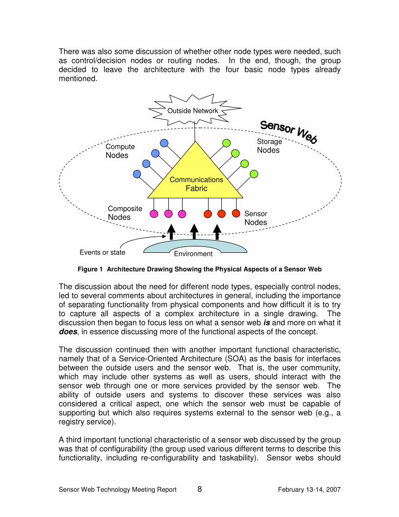
Sensor Web Technology Meeting Report 8 February 13-14, 2007
There was also some discussion of whether other node types were needed, such as control/decision nodes or routing nodes. In the end, though, the group decided to leave the architecture with the four basic node types already mentioned.
Figure 1 Architecture Drawing Showing the Physical Aspects of a Sensor Web
The discussion about the need for different node types, especially control nodes, led to several comments about architectures in general, including the importance of separating functionality from physical components and how difficult it is to try to capture all aspects of a complex architecture in a single drawing. The discussion then began to focus less on what a sensor web is and more on what it does, in essence discussing more of the functional aspects of the concept. The discussion continued then with another important functional characteristic, namely that of a Service-Oriented Architecture (SOA) as the basis for interfaces between the outside users and the sensor web. That is, the user community, which may include other systems as well as users, should interact with the sensor web through one or more services provided by the sensor web. The ability of outside users and systems to discover these services was also considered a critical aspect, one which the sensor web must be capable of supporting but which also requires systems external to the sensor web (e.g., a registry service). A third important functional characteristic of a sensor web discussed by the group was that of configurability (the group used various different terms to describe this functionality, including re-configurability and taskability). Sensor webs should
Outside Network
Compute Nodes
Storage Nodes
Composite Nodes Sensor
Nodes
Communications Fabric
Environment Events or state

Sensor Web Technology Meeting Report 9 February 13-14, 2007
have the ability to be configured for different tasks and changes in overall mission in order to optimize both the value of the data collected (science data in NASA’s case) and to obtain the greatest return possible on funding dollars. It was understood that this configurability did not necessarily apply to individual components of the sensor web, such individual sensors, or even collections of sensors, but rather applies to the sensor web as a whole. Another driver for this functionality was the earlier mentioned characteristic of hierarchy in sensor webs. In order to facilitate hierarchy (i.e., a Web of Webs (WoW) concept) it is desirable for an individual sensor web to be configurable to the needs of the different WoWs in which it might participate. One implication of the need for configurability is the need for a sensor web to make state information available to external entities, and hence should be included in the services provided. Models were the final key concept discussed by the group. This discussion began with questions of whether models were just another form of sensor and of whether there was a taxonomy of sensors. In particular, there was the question of whether simulations could be considered a type of sensor. Although there was not a clear consensus on these questions, the discussions turned toward the importance of models themselves to a sensor web. The group discussed that there were two parts to this general issue, first are the local models that are needed to make sense of the data from a sensor or sensors (e.g., sensor models), and then there are the higher level or global models that are needed to make sense of the data within the context of the environment (e.g. environment models such as climate models). The consensus was that the local/sensor type was clearly an important component of a sensor web. However, the global/environmental type might or might not be part of a sensor web, depending upon context, but the architecture should allow for its inclusion nonetheless. A particularly important aspect to NASA and others of including the sensor models in a sensor web is the ability to do instrument validation and calibration. This might also allow for cross calibration of instruments, the ability to do continual optimization of the data quality, and aid in the ability to fuse data from different temporal and spatial scales. Figure 2 is an attempt by one member of Group A to create a very simple view of the functional characteristics of a sensor web. Of the four key concepts – hierarchy, service orientation, configurability and models – the figure explicitly shows where three of the concepts fit (excluding hierarchy) within a layered architecture. Specifically, the figure shows the sensors at the lowest layer, interfacing directly with the environment and communicating both data and state information with the middle processing layer. The middle layer also includes the control structure and the models used by the sensor web to describe both the sensors and the environment. The control structure may be centralized or distributed, and encompasses capabilities such as resource management and workflow within the sensor web. This is also the layer at which data from multiple sensors or sensor types might be fused. The processing layer communicates to the outside network(s) via the service layer, in which specific services are defined

Sensor Web Technology Meeting Report 10 February 13-14, 2007
as the system interface. These services allow for dissemination of various data and data products (fused data), as well as tasking and configuration requests. The color coding of the figure is meant to correlate with that of Figure 1, where
Figure 2 Architecture Drawing Showing the Functional Aspects of a Sensor Web
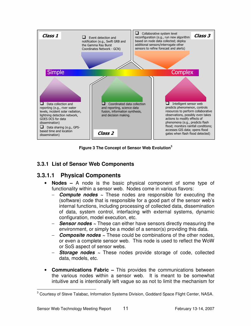
coloring of the sensor layer indicates this occurs on sensor and composite nodes, the service layer occurs on compute nodes, etc. Underlying the three layers is the yellow communications fabric. As there was insufficient time for Group A to discuss this figure, it should not be considered a consensus view of the group, and is included only for the sake of completeness, reflecting only one individual’s attempt to consolidate the thinking of the group. The group also discussed briefly the concept of sensor web evolution, which has been discussed at NASA in the past. In a way, sensor web evolution represents a temporal taxonomy of sensor webs separated along the dimensions of complexity and capability. Figure 3 shows a notional view of sensor web evolution. Early (Class 1) sensor web systems have limited capability, such as basic data and meta-data collection and reporting. As the community’s experience and knowledge of how to build sensor webs grows, more and more sensor web to sensor web coordination and data fusion capability develops (Class 2), until eventually sensor webs evolve into the highly autonomous and intelligent systems currently envisioned for the future (Class 3). This concept was universally embraced by the group.
Environment Events or State
Sensor Layer
Models:
- Sensor
- Envrn’t
-
Processing: - algorithms - agents - data fusion
Service Layer
Control:
-Workflow
-Rsrc Mgmt
-
raw data state data change of state command
Observation request
service request Data / information
Data / information
Communications Fabric
Sensor Web Technology Meeting Report 11 February 13-14, 2007
Figure 3 The Concept of Sensor Web Evolution3
3.3.1 List of Sensor Web Components
3.3.1.1 Physical Components
• Nodes – A node is the basic physical component of some type of functionality within a sensor web. Nodes come in various flavors: − Compute nodes ~ These nodes are responsible for executing the
(software) code that is responsible for a good part of the sensor web’s internal functions, including processing of collected data, dissemination of data, system control, interfacing with external systems, dynamic configuration, model execution, etc.
− Sensor nodes ~ These can either have sensors directly measuring the environment, or simply be a model of a sensor(s) providing this data.
− Composite nodes ~ These could be combinations of the other nodes, or even a complete sensor web. This node is used to reflect the WoW or SoS aspect of sensor webs.
− Storage nodes ~ These nodes provide storage of code, collected data, models, etc.
• Communications Fabric – This provides the communications between
the various nodes within a sensor web. It is meant to be somewhat intuitive and is intentionally left vague so as not to limit the mechanism for
3 Courtesy of Steve Talabac, Information Systems Division, Goddard Space Flight Center, NASA.
Simple Complex
� Data collection and reporting (e.g., river water levels, incident solar radiation, lightning detection network, GOES DCS for data dissemination)
� Data sharing (e.g., GPS-based time and location dissemination)
� Event detection and notification (e.g., Swift GRB and the Gamma Ray Burst Coordinates Network - GCN)
� Coordinated data collection and reporting, science data fusion, information synthesis, and decision making.
� Collaborative system level reconfiguration (e.g., run new algorithm based on node data collected; deploy additional sensors/interrogate other sensors to refine forecast and alerts)
� Intelligent sensor web predicts phenomenon, controls resources to perform collaborative observations, possibly even takes actions to modify effects of phenomena (e.g., predicts flash flood; monitors rainfall conditions; accesses GIS data; opens flood gates when flash flood detected)
Class 1
Class 2
Class 3

Sensor Web Technology Meeting Report 12 February 13-14, 2007
realizing communication between the various components. Some aspects of the communications fabric may be internal while others may be external. For example, in the case of wireless sensor networks, the wireless network would be considered part of the sensor web. On the other hand, in the case where different components of the sensor web are tied together through commercial network service providers, those networks would be considered external to the sensor web. The issue is one of administrative control.
• Outside Network Interface – This is the way in which most users and
other systems will interact with the sensor web. For example, this may be a connection to the Internet.
3.3.1.2 Functional/Virtual components:
• Control mechanism – The control mechanism manages the sensor web state and provides the coordination function among the different physical and virtual components, as well as any prioritization needed between tasks. As such, the control mechanism enables several other characteristics of a sensor web, including autonomy, reconfigurability, sensor tasking, sensor node resource management, etc.
• Processing capability – This is the general capability within a sensor
web, provided by the compute nodes, to execute software and process data.
• Models – Models are a key virtual component of sensor webs, and can
consist of both data and software code. As such they can reside on both storage and compute nodes. Models can be broken into two general classes: − Sensor specific models ~ These are models that characterize or
describe how the sensor works and are needed to accurately process and interpret the collected data. They are typically smaller in size and focused on a lower level of abstraction or granularity.
− Environmental system models ~ These are (typically) large models of complex environmental systems. They are usually focused on a higher level of abstraction or granularity, and use the sensor web data as input to the overall science model rather than trying to interpret the data.
• Services – This is the external interface mechanism and defines how
users (people & systems) interact with the sensor web.
3.3.2 Interacting External Systems
The following list summarizes the key systems external of the sensor web concept, as determined by the Group A:

Sensor Web Technology Meeting Report 13 February 13-14, 2007
• Communications Fabric – The communications fabric can be either an internal system, as in the case of wireless sensor networks, or an external system, as in the case where different components of the sensor web are tied together through commercial network service providers.
• Discovery/Registry System – This is the system which registers the sensor web’s external services, including certain specifics describing these services, and makes them known to other sensor webs and systems.
• Relevant ontologies and standards – Clearly, while a sensor web may adhere to a set of standards in its implementation, these are externally defined and exist outside the influence of any given sensor web. Similarly, a given ontology can be used by a sensor web as a way to reference the data and concepts used within the sensor web, especially its interfaces, but the ontology exists outside the sensor web architecture or implementation, and in fact would be nearly useless if it didn’t.
• Portal – A portal is an external system that simply provides a user interface into certain aspects of a sensor web or sensor webs, and their data. Thus, a portal may provide a mechanism through which to display data from the sensor web, or may provide an interface through which tasking of the sensor web can be performed.
• Decision Support System (could be in or out) – A decision support system could be either an internal system (optional component) to the sensor web, or an external system. In the case of an external component, the decision support system’s function was viewed as being somewhat removed from and at a higher level to the sensor web. For example, sensor web that contained a sensor network of GPS enabled sea buoys might be used by an external decision support system design to provide early detection and warning of tsunamis.
• Scientific/Societal Need/Requirement Driver – This refers to the general scientific, educational, governmental, etc. universe of users and systems which might need to interact with a sensor web.
3.4 Key Sensor Web Features
The following list summarizes the key features of a sensor web, as determined by Group A:
• Standards-based interaction/interconnection – An important feature of a sensor web is that the external interfaces are based upon widely available standards, e.g. SensorML-based services. This greatly improves the ability of other systems to interface easily and effectively with the sensor web.

Sensor Web Technology Meeting Report 14 February 13-14, 2007
• Accessible via SOA interfaces – While an allowance is made for other interfaces for special circumstances, the sensor web should be accessible via a standards-based set of Service Oriented Architecture interfaces, that allow for: − Discovery of sensor webs and sensor web data, − Receiving alerts/notifications (e.g. through a properly defined service), − Receiving data in a standard encoding and in a standard manner.
• Dynamical reconfiguration – This feature of a sensor web refers to its ability to automatically adjust its configuration and state information in order to optimize some aspect of its operation (e.g. low power consumption or collection frequency), to adjust to changes in the system (e.g. component failure), to adjust to changes in the environment (e.g. day changing to night), or to support an external tasking request. (Note: The term dynamical reconfiguration seems to be used more commonly in hardware domains such as with FPGAs, whereas dynamic reconfiguration seems to be more common in the software engineering domain.)
• Dynamic resource management – This is essentially a subset of dynamical reconfiguration, in that adjusting or managing any sensor web resources requires adjusting the configuration or state of the sensor web.
• Context management of the data – This feature refers to the fact that sensor webs need to manage both the data they collect as well as the meta-data associated with the collection of that data, e.g. date & time stamp, geo-location, sensor type, sensor characteristics.
• Workflow management – A key feature of sensor webs is the ability to coordinate the activities of different sub-components in order to accomplish a task or science objective. This is essentially an aspect of the control mechanism virtual component discussed above. For example, suppose a forest monitoring sensor web contains a forest floor temperature monitoring wireless sensor network. It’s possible to conceive of a workflow being created in the sensor web whereby the sensor network is tasked to focus (change collection frequency) on a particular region (hot spot). These data are then relayed back to a processing component where a fire model and decision support system analyze the processed data. Finally, the result is passed from the sensor web to the external tasking entity. Workflow management is the feature that automatically handles this internal work and data flow coordination.
• Taskable (with proper authorization) – Another key feature of a sensor web is the ability to task it – through its standards-based interfaces and using higher level (science-based) concepts – to accomplish new,

Sensor Web Technology Meeting Report 15 February 13-14, 2007
targeted data collection. Authorization and other security issues will clearly play a critical role in making this a viable feature.
3.5 Key Sensor Web Benefits
The following list summarizes the key benefits of the sensor web concept, as determined by Group A. Many pairs of these benefits are highly correlated. It should be noted, however, that there was no attempt made to create what could be considered an independent and comprehensive list of benefits.
• Maximize Useful Science Return – As an autonomous, dynamically reconfigurable system, a sensor web should be able to adjust its data collection scheme to optimize against a set of collection requests and performance requirements, thus objectively maximizing the value of the science data for the given situation.
• Increase societal benefits – Increased benefits to society result directly
from several of the other benefits. For example, the ability to maximize useful science return provides the potential to increase the understanding of various physical systems, especially earth systems. Similarly, the ability to obtain a rapid data response from a sensor web enables the ability to build other important systems such as environmental disaster early warning systems, e.g. forest fire or tsunami warning systems.
• Increase return on investment – Maximizing useful science return
(identified in the first bullet, above) is one dimension in which the return on investment (ROI) can be increased. Another dimension affecting ROI is the sharing of information and resources (identified below). Because sensor webs can be more easily used within numerous different systems of systems, the dollars spent can be shared across a greater number of missions. Thus, from both these dimensions, more useful science data is generated per dollar spent.
• Increase robustness – Increased robustness and dependability results
from the fact that sensor webs are defined (by the group) to consist of more than a single sensor covering a given environment. Thus, failure of a single sensor should not result in a catastrophic failure.
• Increase resource utilization – The fact that sensor webs can be used
and tasked by multiple other systems or other sensor webs means that its resources can be spread across a greater number of projects or programs, increasing the utilization of its resources.
• Minimize redundancy – The redundancy referred to here is more at the
macro or SoS level. Any given sensor web is likely to have a greater redundancy of sensors and other components that increase robustness,
Sensor Web Technology Meeting Report 16 February 13-14, 2007
as described above. However, at the SoS level, because sensor webs can be used by multiple other sensor webs, the need for every major system to have its own dedicated suite of sensors is greatly reduced or eliminated.
• Evolvable and Scalable – By virtue of their architectural definition, it
should be easier to add additional sensors or sensor subsystems, or swap out newer sensors for aging ones, thus providing a path to scaling up and/or evolving a given sensor web.
• Sharing information and resources – This makes reference to a few of
the key features of a sensor web mentioned in the previous section, namely Standards-based interaction, Accessible via SOA interfaces and Taskable. The standards-based service oriented architecture should allow for much easier information sharing among a much greater number of systems. Taskability means that a given sensor web’s resources are more easily shared by other systems, including but not limited to other sensor webs.
• Rapid or real-time data response – The sensor web architecture should
enable near real-time dissemination of collected and processed data to users through its standards-based interfaces.
• Human and Machine understandable – This benefit refers to the fact
that sensor web interfaces need to pass both data and the meta-data needed to properly interpret or process it. In particular, this allows for other systems to more easily use the sensor web’s data.
• Standards and Services based means no need for a priori knowledge
of all nodes – A sensor web should abstract away the details of how it accomplishes its measurement tasks through use of standards-based services that are described at a higher semantic level than is needed to control the detailed behavior of the sensors, i.e., they should be described at the level of the desired science.
• More accurately track dynamic behavior – The key sensor web feature
of Dynamical Reconfiguration enables a sensor web to more easily adjust the frequency of data collection in order to increase the collection during periods of high dynamic behavior and reduce it during periods of low dynamic behavior.
3.6 Use Case Challenge
3.6.1 Challenge Statement – Protecting Our Ecosystems
Nearly half of the land surface has been transformed by direct human action, with significant consequences for biodiversity, nutrient cycling, soil structure and

Sensor Web Technology Meeting Report 17 February 13-14, 2007
biology, and climate. The beneficial effects of these transformations—additions to the food supply, improved quality of human habitat and in some cases ecosystem management, large-scale transportation networks, and increases in the efficiency of movement of goods and services—have also been accompanied by deleterious effects. More than one-fifth of terrestrial ecosystems have been converted into permanent croplands; more than one-quarter of the world’s forests have been cleared; wetlands have shrunk by one- half, and most of the temperate old growth forest has been cut. More nitrogen is now fixed synthetically and applied as fertilizers in agriculture than is fixed naturally in all terrestrial ecosystems, and far too much of this nitrogen runs off the ground and ends up in the coastal zone. Coastal habitats are also being dramatically altered; for example, 50 percent of the world’s mangrove forests, important tropical coastal habitats existing at the interface between land and sea, and coastal buffers from wave action, have been removed. It is well known that the world’s marine fisheries are either overexploited or, for certain fish, already depleted. One recent study even suggests the potential for their total collapse by the middle of this century; and yet, we do not have adequate spatially-resolved estimates of the planet’s biomass and primary production, and how it is changing and interacting with climate variability and change.
3.6.2 Discussion
This session began with a brief overview, given by the Application Advisor, Paul Houser, of the problem space encompassed within the Protecting our Ecosystems Challenge. Much of the subsequent discussion and questioning was centered on the group trying to understand the science needs in this domain. This exchange identified some representative types of measurements that a sensor web would need to make for this challenge, e.g., vegetation type, vegetation structure, soil moisture, carbon dioxide levels, and weather (which is multidimensional). The point was made, however, that the exact measures, while necessary for an actual implementation, may not be that important for the purposes of the exercise. The Application Advisor commented that in addition to the types and variety of measurements needed, science models were a key component of the work in this area. Thus, if one wants to know soil moisture now, then a measurement is needed; if one wants to know the soil moisture for tomorrow, then it is necessary to know the current soil moisture, vegetation type and structure, the weather, and to have a model of how the these phenomena relate over time. As another example, there are models that predict the current state of vegetation and carbon uptake given a certain climate model. However, these models typically do not include human interaction, even though there is clearly an impact, and adding people into the models could greatly help NASA by adding an additional level of realism. The discussion around specific measurements that would be needed for the challenge problem highlighted a couple of capabilities that sensor webs were expected to support more effectively than current approaches, specifically 1) the correlation of data from many different scales, both temporal and spatial, and 2)

Sensor Web Technology Meeting Report 18 February 13-14, 2007
the validation and calibration of sensors and sensor data. Thus, in this domain, the sensor web would likely be required to deal with data all the way from a relatively high density network of in situ sensors measuring soil moisture, temperature, etc., at a very fine spatial granularity, to satellite-based remote sensing data at a very course spatial granularity. In addition, frequency of data samples collected from the different sensor could vary greatly, from minutes to days, while the science and models are dealing with timescales on the order of years to decades. Sensor webs were viewed as needing to inherently deal with this issue through various sensor coordination and data fusion techniques. This same scenario provides a way of addressing a key challenge of remote sensing, namely the on orbit verification and validation of new sensors and the continuous calibration of already operational sensors. By having in situ sensors and sensor networks at characteristic terrestrial locations, the satellite-based remote sensing data can be validated and regularly calibrated against the in situ data to increase the accuracy and value of the remote data collected across all observed locations. This capability requires both an inter-sensor coordination function (or node) and a feedback function whereby the error signal or uncertainty data can be fed back into the sensor sub-system to enable a calibration of the sensor and a minimization of the uncertainty in subsequent sensor data. Most felt that a special control node was required to handle the coordination of the data collection and sensor optimization function. Three different solution levels to attacking the challenge problem were proposed initially: 1) a simple descriptive solution that only collected the relevant data, 2) an extension of the simple solution that in addition to collection would include a decision support capability to support rapid response to natural disasters such as fires or floods, and 3) a solution that combines the first two options with models to allow for understanding and predicting the future state of certain processes, e.g. predicting future crop yields and potential famines. Two observations were made regarding these levels. First, it wasn’t clear that using a sensor web was required for doing level 1, or that it would even substantially simplify an implementation. Second, the three levels aligned well with the concept of sensor web evolution discussed in the earlier section on sensor web architectures (See Figure 3 under Section 3.3, Architectural Concept). Thus, the sensor web might begin by fulfilling level 1 requirements, but by slowly adding capability eventually grow into supporting level 3 requirements. In creating a figure to describe a sensor web solution to the challenge, the group took a distinctly process and data flow view of the problem. Figure 4 is the final result of the group’s deliberations on developing a graphical view for their solution to the challenge. It shows the collection of sensors measuring the environment – namely weather, soil and vegetation – feeding into a multi-variable biomass function. Using a model or models, the system is able to generate an uncertainty estimate that feeds two paths, a feedback loop path for optimizing the sensors and future data collected, and a reporting path that feeds the data and

Sensor Web Technology Meeting Report 19 February 13-14, 2007
uncertainty measures collected into a current biomass map, which itself can be used by other predictive ecosystem models. Thus, this figure captures and highlights three of the key concepts discussed by the group in relation to a sensor web solution to the challenge: the need for a sensor data feedback loop to calibrate sensors and optimize the data, the need to fuse data from different sources, and the critical interaction between data and models. Note that while not exactly the same, these three concepts are closely related to the sensor web key concepts of dynamic reconfigurability and context management of the data discussed by the group in Section 3.4 The final conclusion by the group was that the sensor web concept worked well for this problem space, due at least in part to the need for a wide variety of data and sensor types, and the related problem of dealing with data at widely varying spatial and temporal scales.
Figure 4 Mapping the Sensor Web Architecture to the Use Case Challenge
3.7 Investigator Project Mapping
Group A did not have time during the breakout sessions to start the Investigator Project Mapping exercise.
Sensors
Weather Soil Moisture
Vegetation
Biomass (x,y,z,t)
Estimate of Uncertainty
Map of Biomass + Uncertainty
Assimilate with Model to Predict Future Ecosystem parameters (e.g. CO2)
Utility of Data Decision Making
Re-task Sensors Model Calibration

Sensor Web Technology Meeting Report 20 February 13-14, 2007
4 Breakout Group B
4.1 Participants
This section enumerates all of the participants in breakout group B and indicates each participant’s organization and research area (i.e., NRA subcategory).
Table 4 Breakout Group B Participants
Name Organization NRA Subcategory
Sherwood, Rob Jet Propulsion Laboratory ESTO Lead
Smith, Steve Earth Science Technology Office
ESTO
Oxenham, Vicki Goddard Space Flight Center
ESTO
Gasster, Samuel The Aerospace Corporation Aerospace
Di, Liping George Mason University
Architecture
Falk, Aaron University of Southern California, Information Sciences Institute
Gateways, Gnd Stations & HW
Ivancic, William Glenn Research Center Hetero Networks &
Interoperability Ivancic, Will for Atiquzzaman
University of Oklahoma Reliable & Efficient Networks
Kolitz, Stephan Charles Stark Draper Laboratory
Reconfigurable Hardware
Mandl, Dan Goddard Space Flight Center
Coordination of Smart Assets
Morris, Robert Ames Research Center Model-Based Sensor
Control
Parker, Jay for Donnellan Jet Propulsion Laboratory Applications
Song,WenZhan Washington State University
Intelligent Processing
Andrew Gray/ representing Payman Arabshahi
University of Washington, Applied Physics Laboratory
Smart Sensor Web for Ocean Observation
Costas Tsatsoulis University of Kansas Agents & Control
Sullivan, Don for Falke Northrop Grumman Information Technology, TASC
Infrastructure
4.2 Terms & Definitions
The following terms were discussed during the breakout session and the group discussed possible definitions.

Sensor Web Technology Meeting Report 21 February 13-14, 2007
Architecture A System Architecture is the design or set of relations between the parts of a system. It describes how these components interact with each other and their environment. The team discussed issues relating to the SoS nature of a sensor web architecture, indicating that the parts of a sensor web could be distinct and separate systems that are sensor webs in their own right. Autonomy Autonomy is the ability of a system or process to perform successfully for extended periods of time without human intervention, the ability to make decisions and exert control over a how a goal is achieved. Component In programming and engineering disciplines, a component is an identifiable part of a larger program or construction. Feature A feature is a prominent aspect of something. In the sensor web context this might refer to the overall behavior of the sensor web or a service provided by the sensor web, or a capability provided by the sensor web architecture instantiation. Feedback Information returned from the output of a system or process intended for use as input in subsequent operations or for purposes of automatic control. Resource Discovery This is the process of searching, locating and retrieving meta-data about the resources available to the sensor web. The resource queries are handled by registries that maintain catalogs of the available resources (sensors, computing resources, other sensor webs, etc.) and meta-data about specific attributes of these resources that allow either human users or other processes to utilize these resources. Fault A fault is an incorrect step, process, or data definition in a computer program. Fault-Tolerance The ability of a system or component to continue normal operation despite the presence of hardware or software faults. Fractal Fractal refers to a self-similar structure whose geometrical and topographical features are recapitulated in miniature on finer and finer scales. This term was mentioned during the group discussions as a “picturesque” way to describe certain aspects of sensor web architectures. While there was no

Sensor Web Technology Meeting Report 22 February 13-14, 2007
consensus reached on the use of this term, the group was in fact trying to capture the SoS aspect of sensor webs. Graceful Degradation Degradation of a system in such a manner that it continues to operate, but provides a reduced level of service or performance rather than failing completely. The system may not completely fulfill certain requirements but rather is still able to operate. Dynamic Configurability Dynamic configurability is the characteristic of a system that supports the rearrangement of features and attributes in a dynamic manner; generally triggered by one or more events. Sensor A sensor is an entity that responds to a stimulus, and generates a signal that can be measured or interpreted. Sensors within a sensor web context provide measurements of not only geophysical quantities but may also provide measurements of internal system parameters necessary for monitoring and optimizing the sensor web performance. Sensor Web A distributed collection of resources that is coordinated in such a manner as to provide measurements and observations as well as the means to process and distribute these observations to applications and users. There was some debate within the group as to whether the data processing and distribution resources were included in the minimum description of a sensor web. Some members felt these are not necessarily included and could be provided by external resources. Sensor Network A collection of network-enabled devices, distributed in space or time, that measure one or more observables. Virtual Sensor A virtual sensor is a process that provides an estimate of an observable by combining a mathematical model or algorithm with measurements from physical instrumentation.
4.3 Architectural Concept
4.3.1 Sensor Web Concept & Components
The group discussed the components necessary for the construction of a sensor web. The components included both physical components (hardware elements) and non-physical components (processes, nodes, data, metadata, etc.). Some components of a system may have generic interfaces through which they

Sensor Web Technology Meeting Report 23 February 13-14, 2007
advertise their functionalities. This is consistent with an overall architectural paradigm of the SOA, which was discussed by several group members.
4.3.1.1 Physical Components
Sensors provide the basic measurements of the observables that are key to the sensor web concept. This notion captures a broad range of sensing capabilities from in-situ sensor networks to remote sensing instruments flying on Earth orbiting satellites. The sensors measure and observe not only geophysical phenomena but also provide measurements of the infrastructure itself, often required to optimally operate the system. Communication resources provide the ability to network the various elements and subsystems so that they may interchange data and information. These include not only wired and wireless IP-based and RF links, but other approach as well (e.g., acoustical). Computational resources provide a variety of services within the sensor web system, including data analysis, scheduling and planning, and data archive, to mention a few. In addition to the traditional data processing functions these resource enable autonomous control and feedback, which the group discussed as important features of sensor web architectures.
4.3.1.2 Non-physical Components
The non-physical components included a wide range of processes that enable the overall functionality and operation of the sensor web. These included the fundamental data and associated metadata that exist within the sensor web. The group discussed not only the data and metadata associated with the sensor web measurements and observations of geophysical phenomena, but the data and metadata that pertain to the overall operation of the sensor web itself. This data is necessary to support such key processes as the overall command, control and coordination (C3) of the sensor web and the resources that make up the sensor web. These processes manage the fulfillment of external user requests for data and information, through a variety of mechanisms, including simply retrieval of data from a storage system to the tasking of sensors and subsequent delivery of the associated observations. The group discussed the importance of science models as part of the sensor web, and how these enable the notion of virtual sensors within the sensor web concept. The architectural concept developed by the group is shown in Figure 5. This figure illustrates the key components (both internal and external) that the group believed constituted a sensor web architecture. The double headed arrows represent the two-way flow of information (data, metadata, users’ requests, etc.) between various components and nodes. The group attempted to capture what it believes is a hierarchical level of complexity in the architectures of sensor webs by labeling different layers within this diagram. The simplest set of capabilities and components consists of those components in layer 1 (below the dashed line). A minimum set of components and functionality for a sensor web consists of a set of sensing resources (sensors and platforms) and the components that provide the C3 and communication for these sensing resources, allow users to

Sensor Web Technology Meeting Report 24 February 13-14, 2007
access the measurements provided by the sensors. A sensor web can exist using only the components shown in layer 1, which is a collection of sensors and the corresponding command and control infrastructure (see [Chien] for an example of this sensor web). The next layer (layer 2 and the elements below the dash-dot line) of complexity one could add to a sensor web includes the services to handle data requests and sensor tasking requests, and also includes data storage capabilities. The third layer of complexity (layer 3 below the dash-dash-dot line) involves the addition of shared applications and science models within a sensor web architecture. The group discussed how the users and related user tools (such as visualization) were considered external to the sensor web, as shown in Figure 5. The conceptual boundaries of the sensor web architecture are somewhat elastic. In defining the Sensor Web Architecture we think it most helpful to use a broad definition that includes services, archives, models, applications, and the user interface, as each of these may be affected or redesigned as the Sensor Web concept is implemented. But it is recognized that for some topical discussions subsets may also be termed sensor webs, so long as the subset includes, as a minimum, the first layer (Sensors, Platforms, C3 and communications).
Figure 5 Group B Sensor Web Conceptual Architecture

Sensor Web Technology Meeting Report 25 February 13-14, 2007
4.3.2 Interacting External Systems
The group had considerable debate regarding which components should be considered internal or external to the sensor web. In the end, the group agreed on several elements and systems that should be external to the sensor web concept; other entities could be either external or internal. The group did discuss the minimum requirements for a system to be considered a sensor web - a collection of sensors that can be controlled and coordinated to acquire observations and make those data available to users. Users: The group agreed that users should be considered external to the sensor web. Users are, however, the primary external element interacting with the sensor web. The group defined users to include not only human users (scientists, general public, etc.) but also other sensor webs or processes that can communicate with the sensor web through a well defined interface (service oriented interfaces were frequently mentioned). Goals (input): The group discussed the fact that sensor webs are generally goal based, but that the goals for a particular sensor web configuration or architecture should be considered as external inputs to the system. Information (output): The group also discussed the issue that while sensor webs provide, distribute and manipulate measurement data (real and virtual) for a wide range of observables they ultimately result in information as an important output product. Data archive centers (could be internal as well): There was some debate within the group of the role played by what are traditionally known as data archive centers (e.g., NASA Distributed Active Archive Centers (DAACs)). The group agreed that depending on the architectural details and goals for a particular sensor web, a data archive could be considered either as an important external system or internal to the sensor web. Resource Discovery (could be internal as well): This was another topic of some debate. While resource discovery is a critical element of service oriented and grid service architectures, the group realized that it is possible to build a sensor web and handle resource knowledge using a variety of different approaches. For example, it is possible to not make use of resource discovery with all knowledge of all resources known a priori in some static manner, or that the mechanisms and services that provide resource discovery could be provided within a given sensor web only (a given sensor web only allows resources within its own administrative domain to use its registries). Another approach might be that there exist independently maintained registries that various sensor webs or services could use for registration, all being under separate administrative control from any of the individual sensor webs.

Sensor Web Technology Meeting Report 26 February 13-14, 2007
4.4 Key Sensor Web Features
The group identified a set of features that characterize or describe the sensor web and its behavior and differentiate it from other architectural constructs. While the group felt that many of these are key features, not all are considered necessary such that if any feature is missing the system is not a sensor web. In order to capture this distinction we have provided two categories, the key and desired features.
4.4.1 Key Features
The group identified the following key features:
• Sensing – The group agreed that a fundamental key feature of a sensor web is the ability to sense phenomena (geophysical or other types of measurements).
• Feedback – The group discussed that the ability to incorporate feedback
with the system was a key feature of a sensor web architecture. One or more elements within the sensor web can provide data, information or control to other elements to form a feedback loop.
• Autonomy – The group also discussed how autonomous operation, for
some subset of the sensor web capabilities, was an important feature. This feature may appear in many different aspects of the sensor web. It might appear as a set of “dumb” networked sensors designed to be deployed and left in place with no human interaction. These sensors just operate, sending out their measurements until they die (there might be some higher level process that detects sensor fatality, but the sensors themselves don’t care). It might also in the use of an autonomous decision agent that responds to a set of triggers based on sensor data or the autonomous operation of scheduling and planning for the sensor web resources. The autonomous decision agent may perform some resource reconfiguration based on its goals and current sensor observations, for example changing the location or frequency of reporting for some subset of sensors.
• Dynamic Configurability – closely tied to the autonomy and feedback
features is the concept that a sensor web may exhibit dynamic configurability. The configuration of a set of sensor web components may be allowed to change in response to a well defined set of events and conditions. For example, the detection of a major earthquake by a seismic-sensor network may trigger the sensor web to start communicating with a satellite sensor web to acquire satellite data to perform post-quake analysis, disaster assessments and response support.
• Access – The group discussed that while it is necessary for a sensor web
to perform a set of coordinated measurements of various phenomena it
Sensor Web Technology Meeting Report 27 February 13-14, 2007
also needs to provide at least one mechanism for accessing these measurements (data access). The group discussed a variety of mechanisms that included standardized service oriented interfaces (e.g., web or grid services), web portals, Graphical User Interface (GUI) based applications, etc. A sensor web could provide two services: data services and sensor services. Data services are web-accessible and provide GUI data visualizations, etc. Sensor services enable other sensor web systems or users to automatically discover it, configure it and task it.
4.4.2 Desired Features
The group identified the following desired features:
• Graceful Degradation – The group discussed issues related to how faults and failures might be handled within a sensor web. It was agreed that both fault tolerance and graceful degradation are desirable features of a sensor web. The group discussed how true fault tolerance of all sensor web elements does not exist today, and would not be simple or inexpensive to implement. Thus a near-term goal would be to achieve graceful degradation of various the various services that make up the sensor web and a longer-term goal of fault tolerance.
• Mobility – The group discussed the capability of having sensors that are
not necessarily fixed in place, but are capable of changing their location and performing either in-situ or remote sensing observations. This is of course achieved today by inherently mobile sensors, such as those on airborne or spaceborne platforms. The group considered future capabilities where ground based instrumentation might be deployed on mobile platforms that operate autonomously.
4.5 Key Sensor Web Benefits
The group discussed potential benefits of the sensor web concept. Many of these benefits are derived from the notions of a SOA and echo many of the benefits of this architectural approach and that of grid computing as well.
• Hides complexity from the user – From the perspective of a user that is external to the sensor web, the sensor web should be viewed as a service with well defined and relatively simple interfaces. The functionality and services from the user perspective should appear to be relatively atomic, in spite of the fact that in order to achieve the functionality implied by the service interface the underlying infrastructure and operations involve a complex set of operations. Allowing users to interact with the sensor web using semantics from their own application domain is an important goal in the development of sensor webs.
• Shares resources – A fundamental aspect of the sensor web concept is
the ability to combine resources that are not necessarily under a single

Sensor Web Technology Meeting Report 28 February 13-14, 2007
administrative domain in order to achieve the desired functionality or performance.
• Enables interoperability – This refers to the ability of a sensor web (or its
elements) to work with other sensor webs or elements using well defined APIs or protocols. This benefit is related to the sharing of resource benefit mentioned above. The adherence to a SOA to achieve this functionality and behavior will require a significant level of interoperability both between different sensor webs and between the elements of a signal sensor web.
• Empowers the user community by allowing science users to focus
on scientific workflow and results and not on “computer science.”
• Enables new scientific understanding – The group discussed how the sensor web concept, by virtue of the realization of many of the other benefits, will ultimately allow new scientific understanding not possible with disjoint and stove-piped measurement and observation systems or static data repositories. The group discussed how, once complex sensor webs have been built, we may start to see emergent behaviors, as a result of the SoS architectures, that were not anticipated by the sensor web designers.
• Enables ad-hoc collaboration – As a result of the SOA approach, the
sharing of resources and interoperability, scientists will be able to create new forms of collaboration based on their current research needs and not on predefined or “hard wired” relationships between resources. Scientists will be able to construct their own “virtual observatories” based on the available resources and their workflow requirements.
• Operates autonomously – The group indicated that autonomous
operations provide the potential to support rapid reconfiguration of resources in response to specific events (triggers). The specification of these events or triggers might be based on a well-defined a-priori set of conditions or the result of emergent behavior based on a goal-based approach for autonomous operation. Furthermore, the group discussed the fact that appropriate implementation of autonomous operations could result in the efficient use of resources, such as the dynamic scheduling and planning for data processing and model execution.
• Optimizes data collection strategies in both space and time – The
group indicated that this is a very important benefit of the sensor web architecture. The fact that sensor components can provide information about both their location and capabilities to users will allow the user to perform optimizations regarding when and how data will be sampled and incorporated into analyses and models.

Sensor Web Technology Meeting Report 29 February 13-14, 2007
4.6 Other Issues
The group discussed several issues not easily placed into the categories of components, features, or benefits, and so the editors decided to capture these issues in this section. These were issues that the group felt were broadly applicable to sensor webs and helped to distinguish sensor webs as a unique architecture concept. Behavior The group discussed the idea that what really distinguishes the sensor web as a unique entity or concept is not the individual elements or components that make up a sensor web but rather the emergent, dynamic behavior that is possible when the underlying sensor web resources are connected in such a manner that the system can be reactive based on the underlying observations and measurements, or other triggers. Furthermore this emergent, reactive behavior may involve a dynamic reconfiguration of the sensor web system in reaction to these triggers. Clearly an important feature of sensor webs enabling this behavior is autonomy. The group identified the importance of the autonomy and feedback features of sensor web architectures. What may be most interesting, and not well documented or understood, is what types of emergent behavior might be possible with such a system, the sensor web with autonomous capabilities and feedback loops. Emergent behavior is an important aspect of the overall complexity exhibited by systems that are really systems of systems that may include control and coordination of elements within a given administrative domain but lack a central control for all resources. Many of the different resources that might constitute a given sensor web may include a variety of different sensor systems or sensor networks, under different administrative control, with well-defined service interfaces allowing users to create virtual systems from these different entities. The control and coordination of the different elements may be on an ad-hoc basis. Data Quality and Provenance The group also discussed the importance of adequately characterizing the measurements and observations provided by a sensor web. Users of the sensor web data products need mechanisms to access the characteristics of the data and assess data validity (either directly or via a third party). The group discussed the following characteristics of the measurements and observations (metadata):
• Fidelity and capacity • The quantity being observed • Diversity, density (spatial), frequency (temporal) • Latency • Data Provenance • Data Quality: metrics and metadata

Sensor Web Technology Meeting Report 30 February 13-14, 2007
4.7 Use Case Challenge
The group was given a broad use case challenge in the domain of solid Earth science. Jay Parker was the application advisor for this use case. The group discussed several possible specific use cases within this domain and finally agreed that examining how a sensor web would support analysis and disaster response efforts after a major Earthquake would be a highly illustrative scenario. After a major earthquake occurs, various agencies need to assess damage, identify functioning resources and then prioritize data collection strategies to task various sensing systems in order to acquire the timely data they need to provide support and response to the event. The sensing resources and tasking might include static sensors requested to acquire data at a higher refresh rate, deploy new Global Positioning System (GPS) sensors, re-task radar sensors to image the quake zone, collect data of water levels in wells, and compare with previous historical data. Goal Build a sensor web to understand the post earthquake dynamic environment including earth deformation, aftershocks, damage assessment, changes in stress field, and to help forecast where future earthquakes will occur. Users
• Disaster Response Agencies: FEMA, state and local fire and law enforcement
• Relief agencies • Science Users
System Elements
• Seismic sensor networks • GPS sensor networks • Satellite or airborne imagery
o Interferometric Radar • Data Processing and Analysis resources • Models (risk, forecast, stress/strain, workflow and processing)
Benefits
• Generate customized on-demand disaster and hazard maps and other data products
• Ability to forecast future earthquakes • Aid in planning disaster recovery • Assess the extent of the damage • Coordinate limited response and relief efforts
The group also discussed how NASA expertise and capabilities could be brought to bear on this problem.

Sensor Web Technology Meeting Report 31 February 13-14, 2007
1. Characterize the earthquake mechanism (which includes slip orientation).
GPS adds important information to seismic measurements, which cannot easily distinguish between two different slip planes. This is fundamental to many of the following.
2. To first order, determine the location, depth, slip amount and direction
relies on seismology and geologic setting (e.g., faulting in a region tends to be aligned with known faults), with additional information from deformation measurements like GPS and Interferometric Synthetic Aperture Radar (InSAR). More information leads to a more detailed model of the spatio-temporal distribution of the slip; for large quakes there may be more than one fault plane involved. A similar order crust deformation model would also include a model of subsurface structure, for example rigidity. This affects points 3, 5, 6.
3. Contribute to determination of tsunami potential by using mechanism and
deformation model. 4. Enhance detailed shake maps, indicating shake-damage potential. Mainly
comes from seismometers and building sensors, but may be enhanced by high-rate GPS, dust sensors and high-performance modeling.
5. Update regional risk map: more than aftershocks, a large earthquake
causes stress shadows and stress triggering in the region, and causes more general changes in interacting fault dynamics.
6. Ingest sensor data into regional detailed deformation model that includes
map of changes in slope, high tensile and shear stress. Combined with Geographic Information System (GIS) elements, aids evaluation of problems to plumbing, sewage, and other infrastructure.
7. Perform early fire detection and localization using Infrared (IR) sensors on
UAV or space platforms. 8. Perform detection of major chemical or gas leaks using a variety of
sensors, including hyper-spectral remote sensing from UAV or space platforms and ground based in-situ sensor networks.
9. Allow exploration of unforeseen risks by making sensor data, models and
GIS elements available via a resource-rich portal system. This would also involve other agencies responsible for monitoring various elements of the infrastructure and making the necessary data required for perform risk and damage assessments available via the required sensor web interfaces.
10. Ingest data into hydrological models: will earthquake-caused changes

Sensor Web Technology Meeting Report 32 February 13-14, 2007
affect stream flow or water table dynamics? 11. Do quick reconnaissance, using visible and infrared (VIS/IR) imagers,
Synthetic Aperture Radar (SAR) and Light Detecting and Ranging (Lidar), of high landslide potential areas to determine if damaging landslides have happened or are now more likely.
4.8 Investigator Project Mapping
The group did not have time during the breakout sessions to start the Investigator Project Mapping exercise.

Sensor Web Technology Meeting Report 33 February 13-14, 2007
5 Breakout Group C
5.1 Participants
This section enumerates all of the participants in breakout group C and indicates each participant’s organization and research area (i.e., NRA subcategory).
Table 5 Breakout Group C Participants
Name Organization NRA Subcategory
Prescott, Glenn Earth Science Technology Office
ESTO Lead
Newsome, Penny Earth Science Technology Office
ESTO
John Dickman Glenn Research Center ESTO
Hartman, Bradley The Aerospace Corporation Aerospace
Chien, Steve Jet Propulsion Laboratory Coordination of Smart
Assets
Deshbande, Manahar Goddard Space Flight Center
Gateways, Gnd Stations & HW
Dolan, John Carnegie Mellon University Coordination of Smart
Assets
Goodman, Michael Marshall Space Flight Center
Applications
Heavner, Matt University of Alaska Reconfigurable Network
Architectures
Howard, Ayanna Georgia Tech Research Corporation
Reconfigurable Network Architectures
Lee, Meemong Jet Propulsion Laboratory Architecture
Ortega, Antonio University of Southern California
Reliable & Efficient Networks
Seablom, Mike Goddard Space Flight Center
Architecture
Suri, Dipa Lockheed Martin Space Systems Company
Agents & Control
5.2 Terms & Definitions
This section contains a list of terms and associated definitions that Group C identified as important to the sensor web concept.
Communications Infrastructure media, topologies, protocols, and devices that permit intra- and inter-platform communications Data raw facts from which information may be constructed via processing, manipulation, or organization

Sensor Web Technology Meeting Report 34 February 13-14, 2007
In brief, data simply quantifies facts. For example, the fact that it is 100 degrees Fahrenheit is an example of a datum. Fractal a term that was used by Group C to indicate that sensor webs may have peers, sensor webs can be elements in a larger sensor web, and sensor webs can contain subordinate sensor webs. Information data that has been processed, manipulated, or organized in a way that adds to the knowledge of the recipient In brief, information provides answers to questions while data simply quantifies facts. Information results when facts are placed within a meaningful context to obtain answers to questions. For example, the fact that it is 100 degrees Fahrenheit is an example of a datum. Once placed within a meaningful context, e.g., this measurement was taken at the North Pole, the data becomes information; in this case, answering the question “Is it currently too hot at the North Pole?” Platform the framework, consisting of hardware and software, that provides the power, navigation, physical support, computing, storage and communications infrastructure for sensors, data processing, and/or modeling Protocol “a set of syntactic and semantic rules for exchanging information that includes (a) syntax of the information; (b) semantics of the information; and (c) rules for the exchange of information” [SEI 07] Sensor a data and/or information source The definition of the term, “sensor,” is intentionally broad and abstract to include a wide range of data and/or information providers. This definition, for example, includes models and not just physical instruments capable of sensing a phenomenon. Human reports, radar satellite feeds, models, and thermometers are all examples of sensors within the context of a sensor web. Sensor Web a coordinated observation infrastructure employing multiple communicating sensors, platforms, and/or predictive models and in which system behavior may be autonomously modified based on shared information and specific user-defined goals. The number, type, and characteristics of sensors and the platform distribution in time and space are optimized to answer specific questions. Standard “a document, established by consensus and approved by an accredited standards development organization, that provides for common and repeated use, rules, guidelines, or characteristics for activities or their results, aimed at the achievement of the optimum degree of order and consistency in a given context.” [IEEE 91]

Sensor Web Technology Meeting Report 35 February 13-14, 2007
5.3 Architectural Concept
5.3.1 Sensor Web Concept & Components
Figure 6 graphically depicts the architectural concept developed by Group C. This figure defines the major components of a sensor web and illustrates the potential interactions among those components.
Figure 6 Group C's Architectural Concept
At the core of this concept is the idea that a sensor web is fractal in nature. As defined in Section 5.2, a sensor is “a data and/or information source.” As a result, while physical instruments capable of sensing phenomena (e.g., thermometers) are certainly sensors, these are not the only kinds of sensors in a sensor web. A sensor may also be a model or even another sensor web. For example, consider a sensor web created to monitor the Earth’s changing climate. This sensor web may be comprised of other sensor webs that were designed with more focused objectives (e.g., to monitor ocean currents and temperature,
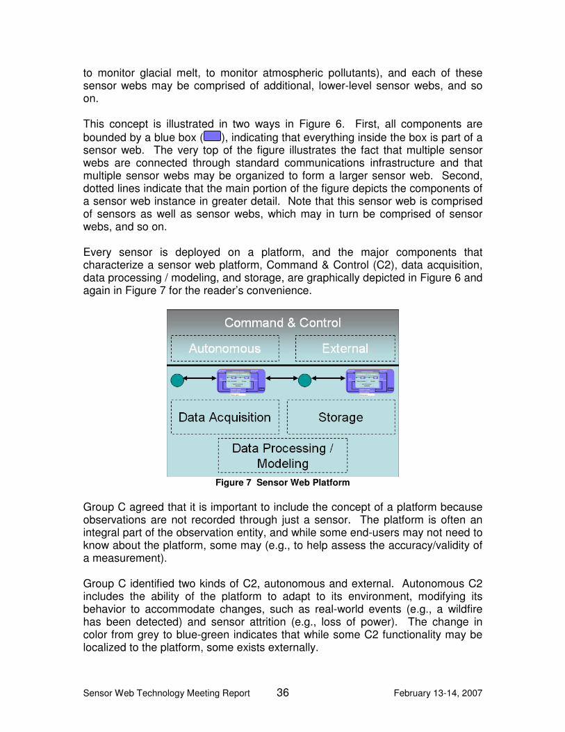
Sensor Web Technology Meeting Report 36 February 13-14, 2007
to monitor glacial melt, to monitor atmospheric pollutants), and each of these sensor webs may be comprised of additional, lower-level sensor webs, and so on. This concept is illustrated in two ways in Figure 6. First, all components are bounded by a blue box ( ), indicating that everything inside the box is part of a sensor web. The very top of the figure illustrates the fact that multiple sensor webs are connected through standard communications infrastructure and that multiple sensor webs may be organized to form a larger sensor web. Second, dotted lines indicate that the main portion of the figure depicts the components of a sensor web instance in greater detail. Note that this sensor web is comprised of sensors as well as sensor webs, which may in turn be comprised of sensor webs, and so on. Every sensor is deployed on a platform, and the major components that characterize a sensor web platform, Command & Control (C2), data acquisition, data processing / modeling, and storage, are graphically depicted in Figure 6 and again in Figure 7 for the reader’s convenience.
Figure 7 Sensor Web Platform
Group C agreed that it is important to include the concept of a platform because observations are not recorded through just a sensor. The platform is often an integral part of the observation entity, and while some end-users may not need to know about the platform, some may (e.g., to help assess the accuracy/validity of a measurement). Group C identified two kinds of C2, autonomous and external. Autonomous C2 includes the ability of the platform to adapt to its environment, modifying its behavior to accommodate changes, such as real-world events (e.g., a wildfire has been detected) and sensor attrition (e.g., loss of power). The change in color from grey to blue-green indicates that while some C2 functionality may be localized to the platform, some exists externally.
Sensor Web Technology Meeting Report 37 February 13-14, 2007
As the names indicate, data acquisition identifies the ability to obtain data, data processing / modeling identifies the ability to process (e.g., model, fuse, aggregate) that data, and storage identifies the ability to store data on the platform. On-platform storage refers to short-term storage while off-platform storage refers to long-term storage, such as archival databases. Group C agreed that feedback loops are critical components of sensor webs. Figure 6 depicts this via the two feedback loops entitled “Commands/Requests” and “Data/Information.” The loop entitled “Commands/Requests” refers to the ability of the sensor web platform to receive commands and requests, to internally act on those commands and requests, and to issue commands and requests (typically in response to collected data and information). For example, a satellite sensor web that has been commanded to search for forest fires in a given area may, upon detection of a potential fire, issue a request to another sensor web to initiate finer-grained, targeted observation of the area in question. The loop entitled “Data/Information” refers to the ability of the sensor web platform to receive data and information from external sources and to provide data and information to external sinks. Both of these feedback loops pass through a box containing four additional components, predictive modeling, decision support systems, data processing, and science users. Data processing identifies the ability to process (e.g., model, fuse, aggregate) data. Prediction models utilize data to synthesize information for the purpose of making predictions about the future. For example, some prediction models utilize environmental data to make predictions about future events. These predictions could result in issuing commands to a sensor web(s) to increase observations in high-priority areas (e.g., an area where a tornado or a fire is likely to form) or decrease observations in low-priority areas. There was significant debate regarding whether decision support systems should be internal or external to the sensor web concept. Some indicated that decision support systems should be internal to the sensor web because any kind of a support system for humans within the context of a sensor web is an inherent part of that sensor web. For example, a decision support system may lead humans to request the reconfiguration of the sensors in the network. Others indicated that the decision support systems should be external to the sensor web because these kinds of systems are typically used to make higher-level policy or management decisions, as opposed to sensor reconfiguration. For example, such a decision support system may be used to help determine whether to evacuate Florida because of an impending hurricane. Ultimately (mostly due to time constraints), the group decided to leave decision support systems as part of the sensor web but recognized that there are different kinds of decision support systems and that some of these systems should be internal and some should be external to the sensor web concept.

Sensor Web Technology Meeting Report 38 February 13-14, 2007
There was also some debate about using the term, “science users,” versus “users” and whether “science users” should be internal or external to the sensor web concept. Some preferred the term “users” as opposed to “science users” to include a broader community. Others preferred the more restrictive term, “science users,” because this ESTO research is being conducted for the scientific community. Additionally, while the majority agreed that science users should be external to the sensor web concept, a vocal minority believed that science users should be considered a part of the sensor web. The majority argued that sensor webs can function autonomously from users and that users interact with sensor webs through clearly defined external interfaces, while the minority argued that people are an inherent and necessary part of sensor webs. As a result, “science users” are depicted as external to the sensor web in the figure to reflect the majority opinion of the group. Finally, the group identified the need for off-platform or archival storage, and this is depicted in the lower right hand side of Figure 6.
5.3.2 Interacting External Systems
Group C identified the following external systems, listed alphabetically, that interact with sensor webs:
• Characteristics of the observed phenomena – Sensors are deployed in a sensor web to ingest the characteristics of external phenomena. These characteristics are not, therefore, part of the sensor web.
• Existing communication systems (backbone) – While communications is a critical component of sensor webs, and sensor web-specific communications infrastructure is a part of the sensor web concept, existing communications infrastructure (e.g., the Internet, Web Services) is not.
• Existing sensor networks – The group agreed that while sensor webs may obtain data from external, existing sensor networks, these networks are not an internal part of the sensor web concept.
• Historical sensor data databases – The group also agreed that while databases (legacy and non-legacy) containing sensor data may provide data to sensor webs, these databases are not an internal part of the sensor web concept. On this point, it is important to differentiate between databases that contain information on the characteristics of internal sensor web sensors, which are an internal part of the sensor web concept, and external databases that contain data archived by sensors, which are not an internal part of the sensor web concept.
• Modeling – Models that utilize sensor web data and information but do not contribute data and information to the sensor web (e.g., independent, user-specific models) are not an internal part of the sensor web.
• User communities – As described in the previous section, the majority of the group agreed that users belong outside the boundary of a sensor web.
Sensor Web Technology Meeting Report 39 February 13-14, 2007
The group agreed that user communities include but are not limited to user-specific policies and procedures, workflow, and decision support systems.
5.4 Key Sensor Web Features
Group C identified the following key sensor web features, which are listed alphabetically:
• Adaptive – Sensor webs are internally and externally adaptive within a time scale specific to the physical phenomenon being observed. For example, if a sensor web determines that it must deploy sensors to an area because a harmful algae bloom has occurred, the sensors must be deployed quickly enough to ensure useful observations. Failure to achieve time-sensitive adaptation results in lack of useful data and information.
• Fault-tolerant – Sensor webs are fault tolerant. For example, the loss of a sensor or a platform should not result in the loss of other sensors, platforms, or of the sensor web.
• Feedback – Sensor webs are characterized by feedback, facilitating their adaptive nature by allowing them to dynamically adjust to environmental changes.
• Fractal – Sensor webs are fractal in that sensor webs may have peers, sensor webs can be elements in a larger sensor web, and sensor webs can contain subordinate sensor webs.
• Interoperable – Sensor webs are interoperable in that sensor webs and sensor web components can work together to accomplish tasks.
• Scalable/extensible – Sensor webs are scalable and extensible in that large numbers of sensor webs and sensor web components can be added to and removed from the system (or system-of-systems) without impacting the infrastructure.
• Seamless integration – Sensor webs are characterized by an architecture that allows sensors and platforms to be added to a sensor web with minimal effort, facilitating integration.
• Self-healing – Sensor webs are characterized by automated self-healing, ensuring that if there is a problem with the web, other sensors work to minimize degradation of capability. Note that while the group used this term,) they weren’t using the term to describe systems that were truly capable of healing themselves. True self-healing systems aren’t physically feasible anytime soon; graceful degradation is the closest realizable concept.
5.5 Key Sensor Web Benefits
Group C identified the following key sensor web benefits, which are listed alphabetically:

Sensor Web Technology Meeting Report 40 February 13-14, 2007
• Goal-oriented science – Sensor webs isolate users (e.g., scientists) from the details of the underlying sensing technology, allowing users to concentrate on their goals.
• Large coverage area in a short time – Ubiquitous sensor webs result in easy access to extraordinary amounts of sensor data in short periods of time.
• More efficient use of scarce resources – Effective sensor tasking facilitates targeted observation, which results in the use of a smaller number of resources to obtain required/useful information.
• Multi-modal, coordinated observation & analysis – Sensor webs provide users with the ability to observe very complex phenomena that cannot be observed by any single sensor or sensor network.
• Reduced cost – Due to the autonomously adaptive nature of sensor webs, reduced response time will be achieved with little to no increase in operations tempo. Basically, if the system autonomously responds to events, organizations do not need to spend additional money to obtain additional data/information.
• Reduced response time – Targeted observations can be obtained in shorter periods of time through the use of sensor webs for a variety of reasons, including the existence of large (eventually ubiquitous) sensing infrastructures and the reduction of dependence on humans to manually and reactively adapt the sensing infrastructure. In other words, the deployment of large numbers of in-situ sensors and the ability for the sensor webs to autonomously adapt to their environments (versus having humans manually adapt the sensing infrastructure(s)) will reduce the response time.
5.6 Use Case Challenge
NASA requested that Group C address the topic of improving weather forecasts through the use of sensor web technology. To this end, NASA presented Group C with the following use case description:
Group C: Improving Weather Forecasts. Testing and systematically improving forecasts of weather with respect to meteorological, chemical, and radiative change places unprecedented demands on technical innovation, computational capacity, and developments in assimilation and modeling that are required for effective and timely decision and response structures. While weather forecasting has set in place the clearest and most effective example of the operational structure required, future progress depends in very important ways on a renewed emphasis on innovation and strategic investment for weather forecasting in its broader context. The U.S. has lost leadership to the Europeans in the international arena in an array of pivotal capabilities ranging from medium range weather forecasting to long-term climate forecasting. Without leadership in these and other forecasting capabilities, we lose economic competitiveness.
Michael Seablom and Michael Goodman served as application advisors for Group C. They discussed the fact that a major problem in weather forecasts is the lack of useful data. They indicated that while an extraordinary amount of data is available, only a small portion of it is useful (i.e., they don’t collect data

Sensor Web Technology Meeting Report 41 February 13-14, 2007
when and where they need it). The hope is that by developing sensor web technology, they’ll be able to more effectively direct the observing system with the goal of improving predictive skill. Currently, the United States is capable of seven-day forecasts versus eight-to-nine day forecasts in Europe. Drs. Seablom and Goodman specified a goal of fourteen-day forecasts, which they noted will require a change in the way they collect data. Subsequently, they outlined two use cases, summarized below:
• Use case 1 – As previously described, the volume of data is too large to be assimilated in a timely manner, with the result that observations are often not ingested into forecast models. Group C discussed two approaches to reducing the volume of data – data mining and targeted observation – both of which will likely be required to achieve weather forecasting goals. With data mining, tools would examine the voluminous data collected and select for analysis only the data that has a high probability of improving weather forecasts. These data would subsequently be ingested into the weather forecasting models. Targeted observation would, on the other hand, reduce the amount of data to be analyzed by concentrating sensing resources on high-priority observation phenomena. For example, one might launch a UAV or request a geostationary satellite to switch to a targeted rapid-scan mode to improve observation of a high-priority area.
• Use case 2 – The second use case was really a subset of the first in that the major problem was in dealing with extraordinary amounts of data, and the approach for dealing with this data was to adaptively perform targeted observation, in this case through the use of wind Lidar sensors. Two targeting modes were discussed by the group, autonomous and on-demand. In the autonomous mode, the atmospheric model is used to identify target regions and to autonomously (i.e., with no human intervention) task Lidar sensors. In the on-demand mode, scientists manually task Lidar sensors with observing a specific region.
In both of these use cases, the critical problem to be solved is how to effectively reduce the amount of data to be analyzed while improving the fidelity and the accuracy of the information provided by the weather forecasting models. Due to the near real-time nature of weather forecasting, adaptive autonomy, a key characteristic of sensor webs, quickly emerged as a critical aspect of the solution. In other words, to improve the speed with which data is collected and analyzed, the group agreed that the forecasting system would need to adapt to dynamic weather conditions by autonomously tasking the sensors in the sensor web. The group discussed the fact that this would mean autonomously tasking other organizations’ sensing infrastructures. Some indicated that this would be problematic because organizations would not relinquish control of their assets. The group eventually agreed, however, that any tasking (autonomous or otherwise) would be routed through the corresponding organization’s software

Sensor Web Technology Meeting Report 42 February 13-14, 2007
and that it is through this software that organizations would exercise control over their assets, probably including manual override capabilities. The group agreed that sensor webs offer unique advantages over other solutions including but not limited to the following:
• Prediction-based measurements can autonomously and adaptively drive targeted observations, targeted data acquisitions, and intelligent data collection for the purpose of reducing the amount of data to be ingested and analyzed while simultaneously increasing the fidelity of that data. This would, in turn, reduce the required amount of data processing infrastructure.
• Dynamic allocation of data collection assets facilitates intelligent spatial (3 dimensional), temporal, and spectral coverage with varying degrees of resolution.
• Collaboratively collecting data coincidentally facilitates correlation & data fusion, allowing new information to be synthesized from the individual data collections. For example, sensors in a sensor web could be tasked to collect data from multiple viewing angles simultaneously.
5.7 Investigator Project Mapping
Table 6 specifies the mapping between Group C’s investigators, project names, and the sensor web components addressed by each project. The first column of this table also associates a number with each project. These numbers are used in Figure 8 to graphically map each project to the architectural concept figure created by Group C (Figure 6). This mapping is depicted via the addition of a set of yellow numbered circles (e.g., ) to the architectural concept figure. The numbers in the circles correspond to the numbers in the first column of Table 6. Note that because a single project may address more than one sensor web component, a numbered circle may appear multiple times in Figure 8.

Sensor Web Technology Meeting Report 43 February 13-14, 2007
Table 6 Project:Sensor Web Component Mapping
# Participant Name Project Sensor Web Component(s)
1 Chien, Steve (JPL) Autonomous Disturbance Detection and Monitoring System for UAVSAR
Autonomous C&C, On-Platform Data Processing / Modeling, Predictive Modeling
2 Deshbande, Manahar (GSFC)
Developing an Expandable Reconfigurable Instrument Node as a Building Block for a Web Sensor Strand
Sensors, Data Acquisition, On-Platform Data Processing / Modeling
3 Dolan, John (CMU) Telesupervised Adaptive Ocean Sensor Fleet
Everything within a sensor web instance and particularly Autonomous C & C, Predictive Modeling
4 Goodman, Michael (MSFC)
Sensor Management for Applied Research Technologies (SMART) – On-Demand Modeling
Data Acquisition, On-Platform Data Processing / Modeling, Predictive Modeling, Off-Platform Data Processing, Communication Standards & Protocols
5 Heavner, Matt (UAS) SEAMONSTER: A Smart Sensor Web in Southeast Alaska
Everything within a sensor web instance and particularly Autonomous C & C
6 Howard, Ayanna (GTRC)
Reconfigurable Sensor Networks for Fault-Tolerant In-Situ Sampling
On-Platform C & C, Off-Platform Data Processing, Science User Interface
7 Lee, Meemong (JPL) Sensor-Web Operations Explorer (SOX)
On-Platform C & C, Predictive Modeling, Decision Support Systems
8 Ortega, Antonio (USC)
Efficient Sensor Web Communication Strategies Based on Jointly Optimized Distributed Wavelet Transform and Routing
On-Platform Data Processing / Modeling, Off-Platform Data Processing, Science User Interface
9 Seablom, Mike (GSFC)
End-to-End Design and Objective Evaluation of Sensor Web Modeling and Data Assimilation System Architectures
Autonomous C & C, Predictive Modeling
10 Suri, Dipa (LMSSC) The Multi-agent Architecture for Coordinated, Responsive Observations
On-Platform C & C, On-Platform Data Processing / Modeling, Off-Platform Data Processing, Science User Interface, Communication Standards & Protocols
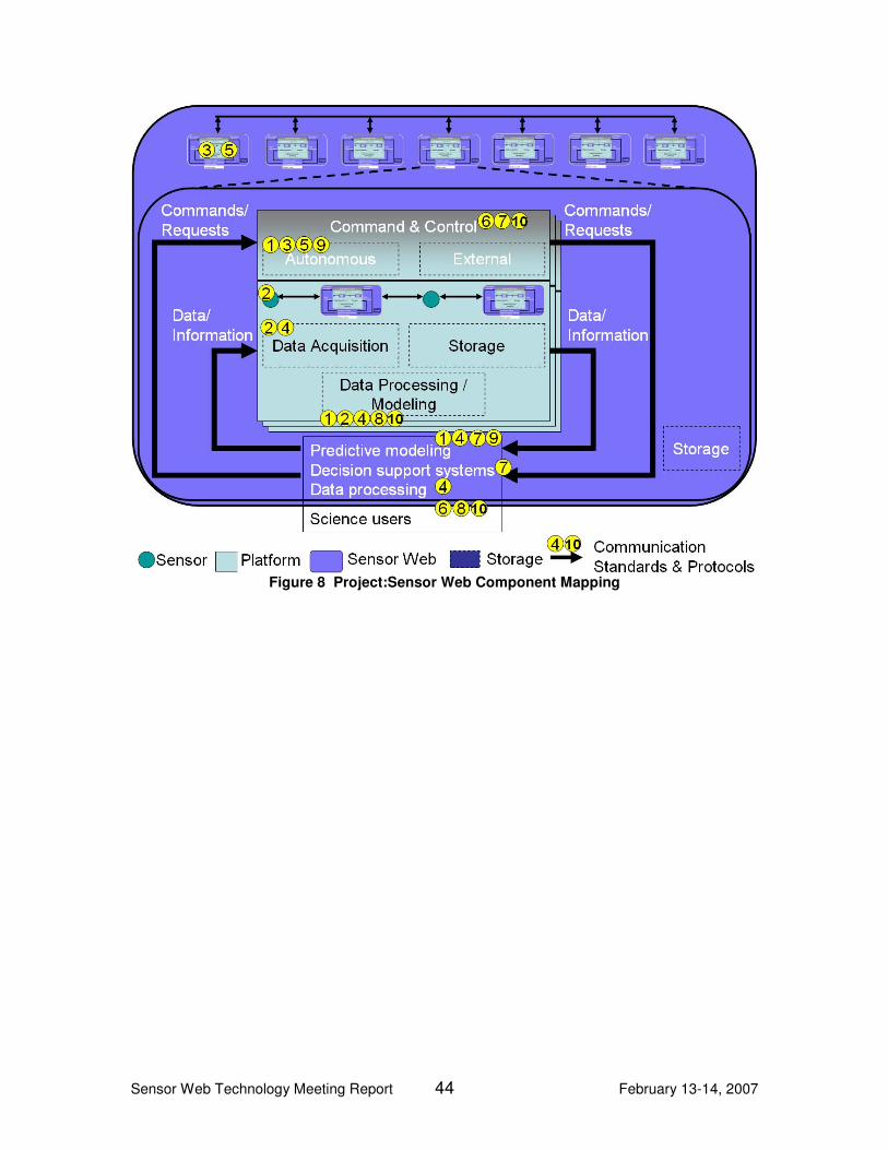
Sensor Web Technology Meeting Report 44 February 13-14, 2007
Figure 8 Project:Sensor Web Component Mapping

Sensor Web Technology Meeting Report 45 February 13-14, 2007
6 Consensus Session Time constraints prevented the formation of a meeting-wide consensus view. As a result, the Aerospace representatives, acting as editors, used their notes to develop a consensus view based upon the thoughts and ideas expressed during the meeting and in subsequent correspondence with the investigators. In general, the Aerospace representatives included items identified by more than one breakout group in the consensus view. The Aerospace representatives sent this consensus view to all participants and subsequently incorporated their feedback. The meeting-wide consensus view is described in this section.
6.1 Terms & Definitions
This section contains a list of terms and associated definitions that the meeting participants identified as important to the sensor web concept. Architecture
A systems architecture is, “the fundamental organization of a system, embodied in its components, their relationships to each other and the environment, and the principles governing its design and evolution.” [ANSI/IEEE standard 1471-2000] This is very similar to the definition given by Group B.
Autonomy Autonomy is the ability of a system or process to perform successfully for extended periods of time without human intervention. (Group B) The following two levels of autonomy were identified by the groups:
• Node-level autonomy refers to the ability for a deployed sensor web to execute with no human intervention for long periods of time.
• Goal-oriented autonomy refers to the ability of a sensor web to achieve high-level goals with no human intervention, potentially even autonomously deploying additional or re-tasking existing resources (e.g., sensors).
Communications Infrastructure
A communications infrastructure is an interconnected collection of networking and communication technologies – media, protocols, devices, etc. – that together provide the physical means by which the different nodes of a sensor web communicate. (Groups A & C) Given the breadth of environments and missions in which the nodes of a sensor web may be deployed, from ocean depths to space, this term is broadly defined to allow for the use of novel communication schemes.

Sensor Web Technology Meeting Report 46 February 13-14, 2007
Component In programming and engineering disciplines, a component is an identifiable part of a larger program or construction. (Group B)
Coordination "Coordination is the act of managing interdependencies between activities." [Malone 91] More explicitly, coordination is the regulation of diverse components into an integrated and harmonious operation. Coordination means integrating or linking together different parts of a system to accomplish a collective set of tasks.4 Although the term was used in each of the three sessions, no session attempted to define what was meant or covered under this term within the context of a sensor web. For this reason, the editors used the above definition to capture what the participants meant by the term.
Data Data is the collection of raw facts and measurements from which information may be constructed via processing, manipulation, or organization. (Group C) This definition is very close to one provided by the IEEE and referenced in the DoD Architecture Framework, namely, “A representation of individual facts, concepts, or instructions in a manner suitable for communication, interpretation or processing by humans or by automatic means” [IEEE 91, p. 610.12].
Data Fusion Data Fusion is the process, along with associated tools and techniques, of combining data from multiple and varied data sources into a new set of data or information. 5
Dynamic Configurability Dynamic configurability is the characteristic of a system that supports the rearrangement of features and attributes in a dynamic manner; generally triggered by one or more events. (Group B)
Fault Generally, in any system, a fault is an abnormal condition or defect at the component, equipment, or sub-system level (hardware or software) which may lead to a failure.6
4 Modified from Wikipedia: http://en.wikipedia.org/wiki/Coordination, 9 Mar. 07
5 This term came up in numerous sessions and conversations. It seems to have been treated as
a well-known and understood concept, as no one attempted to define it. The Aerospace editorial team felt it was sufficiently important to the discussion that it needed to be included in this section, and so generated the above definition. 6 Modified from Wikipedia: http://en.wikipedia.org/wiki/Fault, 9 Mar. 07

Sensor Web Technology Meeting Report 47 February 13-14, 2007
Fault-tolerance
Fault Tolerance is the ability of a system, sub-system or component to continue normal operation despite the presence of hardware or software faults.7 Implicit in the definition of fault-tolerance is the necessary system redundancy or backups to allow continuation of normal operations in the presence of faults, which distinguishes this feature from graceful degradation. See also Graceful Degradation.
Feature A feature is a prominent aspect of something. In the sensor web context, this might refer to the overall behavior of the sensor web or a service provided by the sensor web, or a capability provided by the sensor web architecture instantiation. (Group B)
Feedback Feedback is the characteristic of a system or process in which output information, intended for use as input in subsequent operations or systems, is used by the original system or process, usually for the purposes of automatic control. (Modified from Group B)
Fractal Fractal refers to the characteristic of a structure in which geometrical and topographical features are recapitulated in miniature on finer and finer scales, producing what is referred to as a self-similar structure The editors recommend against using the term, “fractal,” because this term has a precise mathematical definition that implies a certain self-similarity of a structure over a wide range of scales, which was not described during the meeting as a general feature of sensor webs. While use of this term is somewhat picturesque, we believe that from a systems and architectural perspective the term, system-of-systems, more accurately captures the characteristics of the sensor web concept.
Graceful Degradation Graceful Degradation of a system is degradation in such a manner that under successive faults it continues to operate, but provides a successively reduced level of performance or service rather than failing completely. (Group B) As defined here, Graceful Degradation and Fault Tolerance are closely related though not identical concepts. However, some sources treat the concepts as identical, viz.: “Fault-tolerance or graceful degradation is the property that enables a system to continue operating properly in the event of
7 Group B

Sensor Web Technology Meeting Report 48 February 13-14, 2007
the failure of some of its components. If its operating quality decreases at all, the decrease is proportional to the severity of the failure, as compared to a naively-designed system in which even a small failure can cause total breakdown. … Fault-tolerance is not just a property of individual machines; it may also characterize the rules by which they interact.” [http://en.wikipedia.org/wiki/Fault_tolerance, 9 Mar. 07]
Information Information is data that has been processed, manipulated, or organized in a way that adds to the knowledge of the recipient within the context of some area of interest. (Group C) In brief, information provides answers to questions within the context of an area of interest, while data simply quantifies facts or observations.
Interoperability Interoperability is “the ability of two or more systems or components to exchange information and to use the information that has been exchanged.” [IEEE 91a]
Node
A Node is an independent entity that performs one or more of the following functions: Sensing, Computing, Storing, Directing, and Communicating. A Node can participate in one or more sensor webs.8
Observable An observable is a parameter or characteristic of a phenomenon subject to observation.
Observation
Observation is the act of observing a property or phenomenon, with the goal of producing an estimate of the value of the property. An alternative definition is a specialized event whose result is a data value.
Platform
A platform is the framework, consisting of hardware and software, that provides the power, navigation, physical support, computing, storage, communications infrastructure for sensors, data processing, and/or modeling. (Group C)9
8 This definition is from Group A. A similar definition, though a little more general, is as follows: [a
node is a] “representation of an element of architecture that produces, consumes, or processes data.” [DoDAF 04] 9 This is similar to, though a little more specific than, the DoDAF definition: A platform is a
“physical structure that hosts systems or system hardware or software items.” [DoDAF 04]

Sensor Web Technology Meeting Report 49 February 13-14, 2007
Protocol A protocol is “a set of syntactic and semantic rules for exchanging information that includes (a) syntax of the information; (b) semantics of the information; and (c) rules for the exchange of information” [SEI 07] (Group C)
Quality of Service Quality of Service can be defined generally as, "The measure of the degree of satisfaction of the user of the system". [http://en.wikipedia.org/wiki/Quality_of_service, 9 Mar. 07] The term, “Quality of Service,” was originally developed within the Telecommunications community where it has a very specific definition, “a set of quality requirements on the collective behavior of one or more objects” [ISO/IEC 10746-2]. Within the context of software-intensive systems, such as sensor webs, the term encompasses such user perceived quality factors as availability, reliability (supported by fault tolerance and graceful degradation), responsiveness (a multi-dimensional aspect including both delay and bandwidth characteristics), data quality, etc.
Resource Discovery Resource Discovery is the property of a system and its environment that allows that system to search for, identify, and locate services or resources that it needs. This is typically done through use of a registry system. (Group B)
Self-healing Self-healing is the characteristic of a system in which any damage, malfunction or otherwise abnormal disturbance is automatically corrected without external interaction. A number of attendees applied the term self-healing to sensor webs, noting that it should at least be a desirable characteristic, if not a required one. Indeed, this is in some sense the goal of the Autonomic Computing community for computational aspects of a system. Similar terms used by other participants to get at the same general concept, or aspects of the concept, include graceful degradation, quality of service, and fault tolerance.
Sensor A sensor is an entity that either generates a raw signal or output that can be measured, or generates measurement data that could be the result of measuring such a signal or output. There was general agreement by the meeting members that a sensor is a data source. The definition of the term “sensor,” however, is left intentionally broad and abstract to allow for a wide range of data and/or information sources. It was also generally understood that a sensor could be reacting to
Sensor Web Technology Meeting Report 50 February 13-14, 2007
computational or virtual stimuli rather than strictly physical or geophysical stimuli. However, the suggestion that something which does not react to an external stimulus, such as a model or a human report (Group C), could also be a sensor was not universally accepted by the consensus group. As a result, this later meaning of the term sensor is covered explicitly under the term virtual sensor.
Sensor Network A Sensor Network is a collection of network-enabled devices (sensors), distributed in space or time that measure and report one or more observables. (Group B)
Sensor Web A Sensor Web is a coordinated observation infrastructure composed of a distributed collection of resources – e.g., sensors, platforms, models, communications infrastructure – that can collectively behave as a single, autonomous, task-able, dynamically adaptive and reconfigurable observing system that provides raw and processed data, along with associated meta-data, via a set of standards-based service-oriented interfaces. (Modified from definitions supplied by all three groups.)
Standard A standard is, “a document, established by consensus and approved by an accredited standards development organization that provides for common and repeated use, rules, guidelines, or characteristics for activities or their results, aimed at the achievement of the optimum degree of order and consistency in a given context.” [IEEE 91] (Group C)
System-of-Systems (SoS) System-of-Systems is an architectural concept from Systems Engineering whereby a large, complex, distributed system is composed of numerous other systems, which are full fledged systems in their own right, but which may be very different in function and be operated independently.
Virtual Sensor A Virtual Sensor is a process or system that provides an estimate of an observable by combining a mathematical model or algorithm with measurements from physical instrumentation. (Group B)
6.2 Architectural Concept
One of the primary goals of this meeting was the identification of the components, features, and external elements that characterize sensor web architectures. Architectures are used to describe the elements of a system and their relationships. To adequately document architectures, various frameworks have been developed [e.g., Zachman 87, DeMarco 79]. Each of these frameworks identifies various artifacts that support the overall description of the
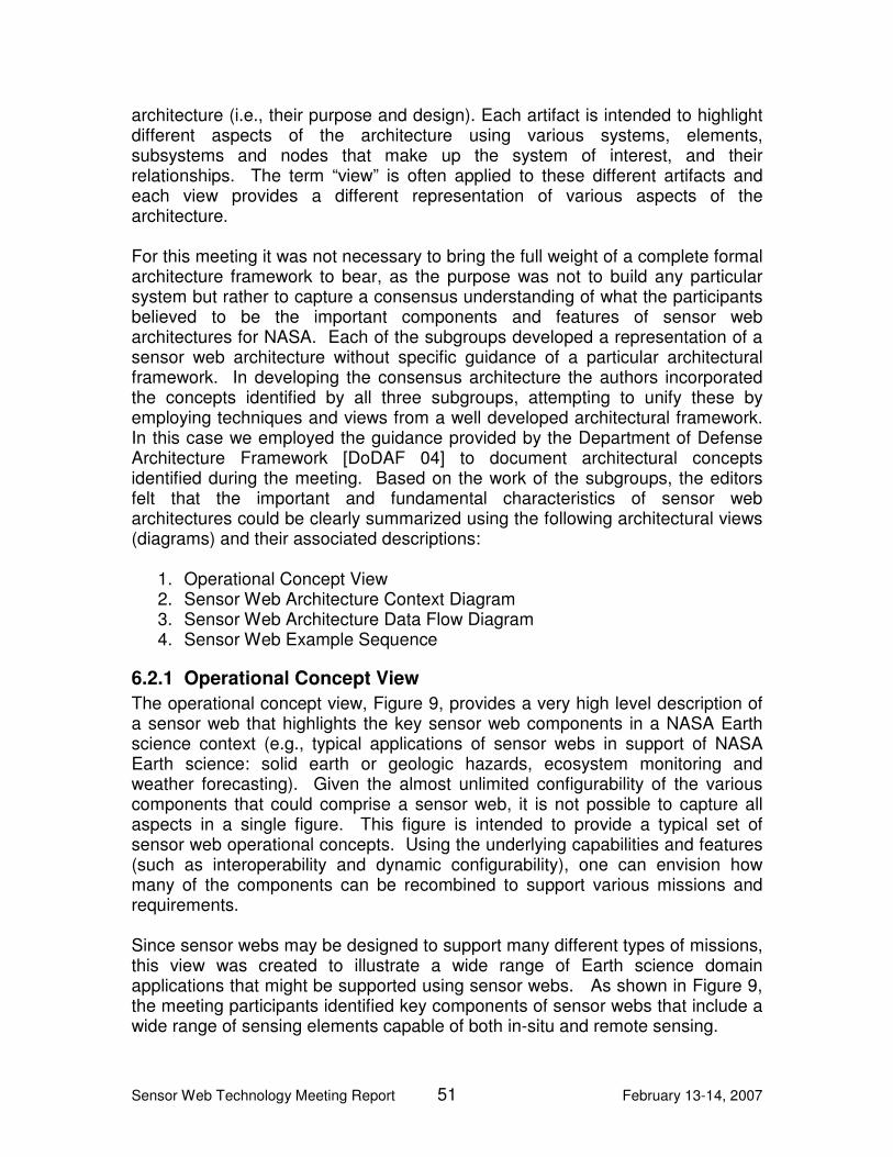
Sensor Web Technology Meeting Report 51 February 13-14, 2007
architecture (i.e., their purpose and design). Each artifact is intended to highlight different aspects of the architecture using various systems, elements, subsystems and nodes that make up the system of interest, and their relationships. The term “view” is often applied to these different artifacts and each view provides a different representation of various aspects of the architecture. For this meeting it was not necessary to bring the full weight of a complete formal architecture framework to bear, as the purpose was not to build any particular system but rather to capture a consensus understanding of what the participants believed to be the important components and features of sensor web architectures for NASA. Each of the subgroups developed a representation of a sensor web architecture without specific guidance of a particular architectural framework. In developing the consensus architecture the authors incorporated the concepts identified by all three subgroups, attempting to unify these by employing techniques and views from a well developed architectural framework. In this case we employed the guidance provided by the Department of Defense Architecture Framework [DoDAF 04] to document architectural concepts identified during the meeting. Based on the work of the subgroups, the editors felt that the important and fundamental characteristics of sensor web architectures could be clearly summarized using the following architectural views (diagrams) and their associated descriptions:
1. Operational Concept View 2. Sensor Web Architecture Context Diagram 3. Sensor Web Architecture Data Flow Diagram 4. Sensor Web Example Sequence
6.2.1 Operational Concept View
The operational concept view, Figure 9, provides a very high level description of a sensor web that highlights the key sensor web components in a NASA Earth science context (e.g., typical applications of sensor webs in support of NASA Earth science: solid earth or geologic hazards, ecosystem monitoring and weather forecasting). Given the almost unlimited configurability of the various components that could comprise a sensor web, it is not possible to capture all aspects in a single figure. This figure is intended to provide a typical set of sensor web operational concepts. Using the underlying capabilities and features (such as interoperability and dynamic configurability), one can envision how many of the components can be recombined to support various missions and requirements. Since sensor webs may be designed to support many different types of missions, this view was created to illustrate a wide range of Earth science domain applications that might be supported using sensor webs. As shown in Figure 9, the meeting participants identified key components of sensor webs that include a wide range of sensing elements capable of both in-situ and remote sensing.

Sensor Web Technology Meeting Report 52 February 13-14, 2007
The meeting participants also discussed how a given sensor web has a minimum set of components (sensing elements, C3, etc.) and features (interoperable, adaptive, etc.), as well as optional components (internal registries, data support systems, etc.) and features (goal-oriented autonomy, fault tolerance). Some of these components are illustrated in Figure 9, and others are illustrated in Figure 10 and Figure 11.
Figure 9 Sensor Web Architecture: Operational Concept View
This figure illustrates the wide range of sensors, sensor networks, and other sensor webs, which provide the observations and measurements that are fundamental to the sensor web concept. Some of these sensing elements, may be under direct control of a given sensor web, while others are under the control of different organizations and agencies but provide interfaces so that they may be incorporated into other sensor webs. In this figure, for example, the geologic sensor web incorporates measurements from a land-based seismic/GPS sensor network (that may be operated by a consortium of universities and state agencies) and utilizes the services and observations of a UAV system owned
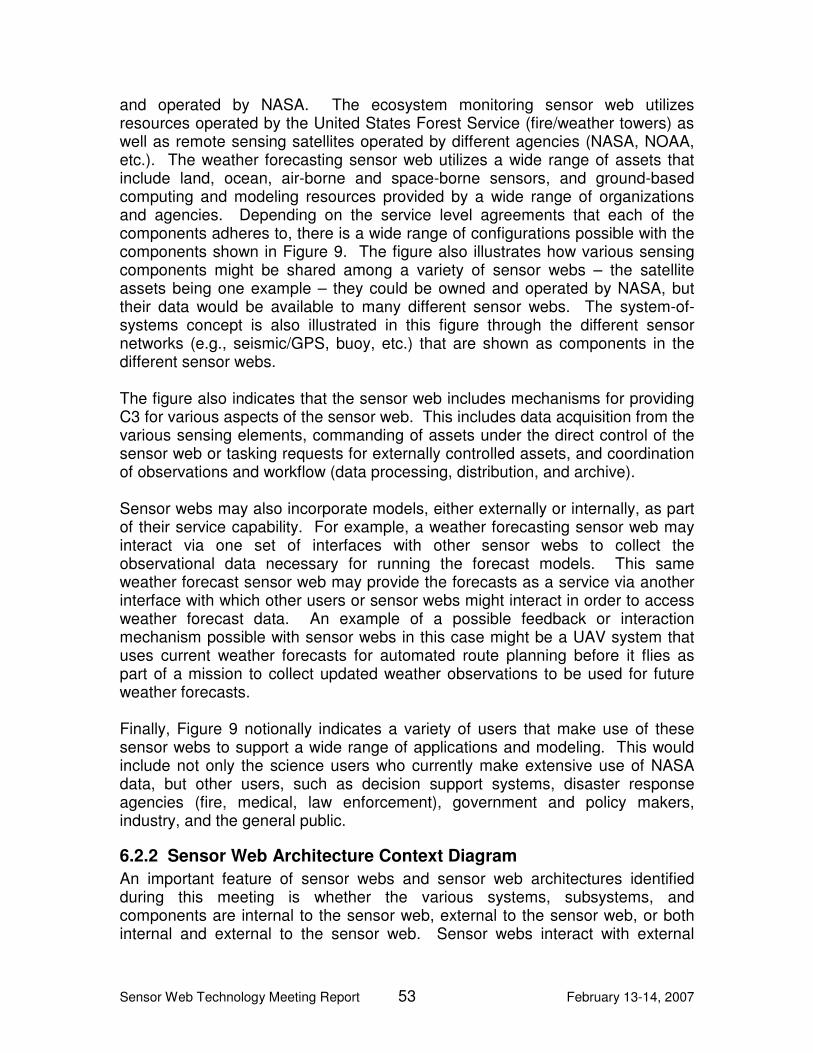
Sensor Web Technology Meeting Report 53 February 13-14, 2007
and operated by NASA. The ecosystem monitoring sensor web utilizes resources operated by the United States Forest Service (fire/weather towers) as well as remote sensing satellites operated by different agencies (NASA, NOAA, etc.). The weather forecasting sensor web utilizes a wide range of assets that include land, ocean, air-borne and space-borne sensors, and ground-based computing and modeling resources provided by a wide range of organizations and agencies. Depending on the service level agreements that each of the components adheres to, there is a wide range of configurations possible with the components shown in Figure 9. The figure also illustrates how various sensing components might be shared among a variety of sensor webs – the satellite assets being one example – they could be owned and operated by NASA, but their data would be available to many different sensor webs. The system-of-systems concept is also illustrated in this figure through the different sensor networks (e.g., seismic/GPS, buoy, etc.) that are shown as components in the different sensor webs. The figure also indicates that the sensor web includes mechanisms for providing C3 for various aspects of the sensor web. This includes data acquisition from the various sensing elements, commanding of assets under the direct control of the sensor web or tasking requests for externally controlled assets, and coordination of observations and workflow (data processing, distribution, and archive). Sensor webs may also incorporate models, either externally or internally, as part of their service capability. For example, a weather forecasting sensor web may interact via one set of interfaces with other sensor webs to collect the observational data necessary for running the forecast models. This same weather forecast sensor web may provide the forecasts as a service via another interface with which other users or sensor webs might interact in order to access weather forecast data. An example of a possible feedback or interaction mechanism possible with sensor webs in this case might be a UAV system that uses current weather forecasts for automated route planning before it flies as part of a mission to collect updated weather observations to be used for future weather forecasts. Finally, Figure 9 notionally indicates a variety of users that make use of these sensor webs to support a wide range of applications and modeling. This would include not only the science users who currently make extensive use of NASA data, but other users, such as decision support systems, disaster response agencies (fire, medical, law enforcement), government and policy makers, industry, and the general public.
6.2.2 Sensor Web Architecture Context Diagram
An important feature of sensor webs and sensor web architectures identified during this meeting is whether the various systems, subsystems, and components are internal to the sensor web, external to the sensor web, or both internal and external to the sensor web. Sensor webs interact with external

Sensor Web Technology Meeting Report 54 February 13-14, 2007
entities as part of their overall operation and functioning. Figure 10, the sensor web architecture context diagram, is designed to illustrate the overall context in which a sensor web operates as well as this internal/external aspect of sensor webs. This figure also illustrates the system-of-systems aspect, not easily represented in the Operational Concept View (Section 6.2.1). The context diagram highlights the important fact that sensor webs interact with a wide variety of external entities, including external systems and users. The majority of all groups felt that while users and their applications provide the basic reason for building sensor webs, they are outside of the sensor web from an architectural perspective.10
Figure 10 Sensor Web Context Diagram
Figure 10 includes the external entities (systems, users, computational resources, etc.) that might interface with the sensor web under consideration. Each external entity might have a unique interface with the sensor web. For example, a well defined service oriented interface (API or protocol) might exist for various external sensor webs; whereas, some users might access the sensor web using a simple web portal, while an external decision support system might have a variety of interfaces that support not only data access but tasking requests to support event-driven data collections (e.g., post-earthquake damage assessments).
10
A vocal minority of Group C indicated that they believed users should be an internal sensor web component.
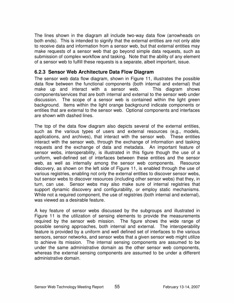
Sensor Web Technology Meeting Report 55 February 13-14, 2007
The lines shown in the diagram all include two-way data flow (arrowheads on both ends). This is intended to signify that the external entities are not only able to receive data and information from a sensor web, but that external entities may make requests of a sensor web that go beyond simple data requests, such as submission of complex workflow and tasking. Note that the ability of any element of a sensor web to fulfill these requests is a separate, albeit important, issue.
6.2.3 Sensor Web Architecture Data Flow Diagram
The sensor web data flow diagram, shown in Figure 11, illustrates the possible data flow between the functional components (both internal and external) that make up and interact with a sensor web. This diagram shows components/services that are both internal and external to the sensor web under discussion. The scope of a sensor web is contained within the light green background. Items within the light orange background indicate components or entities that are external to the sensor web. Optional components and interfaces are shown with dashed lines. The top of the data flow diagram also depicts several of the external entities, such as the various types of users and external resources (e.g., models, applications, and archives), that interact with the sensor web. These entities interact with the sensor web, through the exchange of information and tasking requests and the exchange of data and metadata. An important feature of sensor webs, interoperability, is illustrated in this figure though the use of a uniform, well-defined set of interfaces between these entities and the sensor web, as well as internally among the sensor web components. Resource discovery, as shown on the left side of Figure 11, is enabled through the use of various registries, enabling not only the external entities to discover sensor webs, but sensor webs to discover resources (including other sensor webs) that they, in turn, can use. Sensor webs may also make sure of internal registries that support dynamic discovery and configurability, or employ static mechanisms. While not a required component, the use of registries (both internal and external), was viewed as a desirable feature. A key feature of sensor webs discussed by the subgroups and illustrated in Figure 11 is the utilization of sensing elements to provide the measurements required by the sensor web mission. The figure shows the wide range of possible sensing approaches, both internal and external. The interoperability feature is provided by a uniform and well defined set of interfaces to the various sensors, sensor networks, and sensor webs that a given sensor web might utilize to achieve its mission. The internal sensing components are assumed to be under the same administrative domain as the other sensor web components, whereas the external sensing components are assumed to be under a different administrative domain.

Sensor Web Technology Meeting Report 56 February 13-14, 2007
Figure 11 Sensor Web Architecture: Data Flow Diagram
The sensor web may also include other components such as internal models, various types of data storage and even possibly decision support capabilities. It appeared from the discussions among the various groups at this meeting that while providing enhanced features and benefits, many of these capabilities are not required in order to have a basic core sensor web capability. See Sections 6.3 and 6.4 for more detail on this topic. The sensor web is able to dynamically adapt to changes in user requests, resource states or system feedback by utilizing the C3 functionality and the appropriate interfaces between the internal and external entities necessary to support this functionality.

Sensor Web Technology Meeting Report 57 February 13-14, 2007
The groups all identified autonomy as a key feature of sensor webs, not necessarily autonomy of the whole sensor web but autonomous operation of some subset of components and/or operation of the sensor web. Referring to Figure 11, the concept of autonomy may appear in any of the sensing elements (either external or internal; as illustrated below), but may also be supported by the overall internal operation of the control and coordination aspects of the sensor web. The sensor web may need to perform planning and schedule functions for various resources that make up the sensor web. This is clearly an aspect of sensor web operation that would benefit from autonomous operation (and in fact it may not function at all if it were to require routine human intervention). Recall the operational concept illustrated in Figure 9, one might imagine that the ocean buoy sensor network is autonomously operating, reporting ocean and near surface geophysical measurements and self-health and status data to some C3 center. Each buoy is able to operate for months (years) without human intervention. If a buoy fails, or goes offline, the sensor web C3 element detects this and issues a service request to repair the failing buoy. The sensor web may then attempt to respond to this failure in many ways (while waiting for repair or replacement of the failed buoy), one approach might be to use nearest neighbor buoys for interpolation to fill-in the missing observations from that location.
6.2.4 Sensor Web Example Sequence Diagram
The sequence diagram, Figure 12, graphically depicts a notional scenario designed to highlight the potential adaptability and feedback possible with sensor web architectures. This scenario includes elements that are based on currently existing real-world entities as well as entities or interfaces that may exist in the future. For the purposes of this illustration, we imagine that the California Integrated Seismic Network (CISN – http://www.cisn.org) has been extended to form a large sensor web that includes access to sensors operated by other agencies such as United States Geological Survey (USGS), NASA, NOAA, DoD, etc.

Sensor Web Technology Meeting Report 58 February 13-14, 2007
Figure 12 Example Sequence Diagram for Earthquake Response Sensor Web
Sensor Web Technology Meeting Report 59 February 13-14, 2007
6.2.4.1 Scenario
For the purpose of this scenario, assume that a large earthquake has just occurred in Southern California and that this Earthquake is immediately detected by the extensive ground seismic instrumentation network that is part of the CISN. CISN issues initial notifications to local, state, and federal disaster response agencies. These notifications include initial creation and distribution of shake maps and other hazard assessment GIS products. The CISN ground sensor web queries all seismic/GPS sensor networks to determine which systems are still online and accessible. The system reconfigures itself to only utilize those sensors still responding. This query and reconfiguration process could be repeated periodically, as systems might come back online. Using the latest data collected during the event, the CISN computes the epicenter and related seismic event parameters and publishes maps to Southern California disaster response agencies and other organizations. CISN then issues a request to the UAV sensor web for UAV flights over urban areas closest to the epicenter. This request includes a search pattern for UAV flights based on the location of the earthquake and damage model estimates (shake hazard models). The UAV collects visible and IR imagery that are streamed in real-time to various agencies to support disaster response. In addition, UAV InSAR data is sent to JPL for processing and incorporation into surface deformation and earthquake prediction models. These are used for after shock prediction. A request is also sent to the NASA InSAR satellite sensor web for high priority re-tasking for the collection of SAR and InSAR satellite data on all passes with the Southern California region in view. Real-time UAV imagery streamed to the Disaster Response Agencies (DRAs) is reviewed and a request is made by the DRA, through the CISN sensor web for high resolution real-time visible imagery of selected locations to aid first responders who will be on scene shortly. A request is sent from the CISN sensor web to the UAV sensor web to re-task the UAVs to collect targeted high resolution imagery of selected sites; the request is acknowledged and the UAVs re-tasked. First responders and disaster response agencies will receive the live, high resolution video feeds from the UAVs. Based on current seismic/GPS network data, InSAR data, and seismic risk and aftershock prediction model results, a decision is made that increased temporal sampling from the ground sensors is required to improve model predictions. A request is sent from the CISN sensor web to the functioning seismic/GPS sensor
Sensor Web Technology Meeting Report 60 February 13-14, 2007
web to have the reporting frequency increased to provide better temporal sampling for improved aftershock prediction by seismic models.
6.2.4.2 Participants (components, nodes, etc.)
The following entities participate in this example scenario and are also shown in Figure 12.
• CISN • USGS seismic networks • DRAs • UAVs carrying VIS/IR sensors, SAR • NASA satellites (InSAR) • Computational and modeling facilities at various locations throughout the
state (e.g., USGS, Universities, JPL) that run various geophysical models and prediction/risk assessment models
6.2.4.3 Sequence Diagram
The following numbered sequence describes the events illustrated in the sequence diagram shown in Figure 12. The sensor web adaptability and feedback mechanisms are illustrated in this figure by virtue of the ability of the sensor web to reconfigure itself by determining which ground instrumentation is still available, and extending the available data sets through the request for UAV data and re-tasking of NASA satellites. The feedback is illustrated using the aftershock prediction models requiring higher temporal refresh from the ground sensor network and a request for this change being sent to the appropriate ground sensor web.
1. Initial seismic data from Earthquake event is sent from the USGS sensor web to the CISN sensor web.
2. Earthquake event notification and associated data, maps, etc., is sent to
various DRAs.
3. CISN issues a request for seismic network status and reconfiguration to determine which elements and sensors are still functioning.
4. CISN issues a request for model analysis and prediction.
5. CISN issues a request for targeted UAV flights.
6. UAV sensor web acknowledges and provides URLs for UAV data access.
These URLs are provided to CISN and other organizations.
7. CISN issues a request to the NASA InSAR sensor web for high priority tasking and collection over the Earthquake area.

Sensor Web Technology Meeting Report 61 February 13-14, 2007
8. The NASA InSAR sensor web acknowledges the request and re-tasks an InSAR satellite.
9. When the UAVs are on location, they begin streaming real-time data to
CISN and disaster response agencies.
10. NASA InSAR data collections are sent to prediction models.
11. Model prediction results are sent to CISN and DRAs.
12. CISN issues a request for higher temporal refresh of USGS seismic network data.
6.2.5 Application to Earth Science Use Cases
The sensor web meeting organizers asked the participants to assess the application of sensor webs to various Earth science domain problems. Each group was given a specific Earth science challenge area (ecosystem monitoring, solid Earth hazards and weather forecasting) and asked to assess how this problem domain could be supported through the use of sensor webs. Based on the discussions provided by the working groups, we can use the sensor web architecture diagrams to summarize how sensor webs support these typical Earth science applications. Ecosystem Monitoring Group A was charged with addressing how sensor webs can support ecosystem monitoring. In Figure 9, we have conceptually illustrated how forest biomass might be monitored using various remote and in-situ sensing elements. Routine observations from air-borne and space-borne sensors, combined with in-situ monitoring, provides the spatial-temporal data required for routine monitoring and biomass estimation. When combined with various biomass, weather, and Earth system models, this enables prediction of regional biomass health. Sensor webs also allow for updating biomass inventories as they change with time or due to significant events such as forest fires. Assets deployed primarily in support of one sensor web may also be utilized to support other sensor webs. In this case the ocean buoys used for the weather forecasting sensor web can also support ocean and coastal ecosystem monitoring. Solid Earth Hazards Group B discussed the application of sensor webs to support various users and agencies during the aftermath of a major earthquake. As illustrated in Figure 9, the sensing elements utilized in this scenario include various land-based sensors, sensor networks, and other sensor webs that measure earth movement (seismometers, GPS receivers, etc.) as well as a variety of air- and space-borne remote sensing platforms (UAVs or satellites).

Sensor Web Technology Meeting Report 62 February 13-14, 2007
For this use case, DRAs and science users issue requests for data to any of the available sensors or tasking requests for additional observations (including specific observational parameters). These requests are routed through the sensor web user services interface shown at the top of Figure 11. The sensor web internal C3 services receive these requests for data or data collection (tasking) and parse these to the appropriate sensor data processing or tasking services for fulfillment. Once fulfilled, the data may be stored within the sensor webs local data storage and archive services, for possible use by models that may be internal to the sensor web. Based on the results of previous data requests, science users monitoring the earthquake event may like to increase the temporal sampling of a seismic/GPS receiver network located near the epicenter of the event in order to better predict the likelihood of large aftershocks, and issue a subscription request so that subsequent observations are automatically sent to an external application specified by these users. These users submit such a tasking request to the sensor web, which then contacts the service interface for the GPS receiver network and issues the commands for increasing the sampling rate. Subsequent observations are then automatically sent to the application for analysis and prediction of large aftershocks. Weather Forecast Support Group C addressed the application of sensor webs to support improvement of weather forecasting by providing targeted data collection capabilities in a timely manner and by providing the necessary high performance data mining tools to reduce the volume of data input to the forecast models. Typical scenarios involve the identification of specific observations needed to improve forecasts. Requests for these data are then sent to various sensor webs for fulfillment. Sensor webs may fulfill these requests differently: some may simply pull the necessary observations from local data repositories (as these are data already acquired by a given sensor web); other requests may require planning and scheduling of specific observations by the sensing elements of another sensor web (e.g., re-pointing a satellite sensor on its next over pass, or launching a UAV to collect data over a tropical storm). This is conceptually illustrated in Figure 9 within the weather forecasting sensor web. The weather forecasting sensor web coordinates all these data collection and tasking efforts with the model requirements in order to achieve the best regional forecasts in a timely manner.
6.3 Key Sensor Web Features
Based on the conversations that took place at the meeting, there are two classes of key sensor web features, required and desirable. Required features define the minimum requisite features of a sensor web (i.e., the minimum set of features that must characterize a system for it to be termed a sensor web). Desirable features, on the other hand, are desirable features that will likely characterize

Sensor Web Technology Meeting Report 63 February 13-14, 2007
many sensor webs but are not necessary for a system to be termed a sensor web. This section identifies and describes both of these kinds of features. Note that this section describes only consensus features, those features that were identified by more than one breakout group. Additionally, note that the breakout groups did not explicitly categorize the features into required and desirable features. Rather, based upon the discussions that took place in the breakout sessions, the authors categorized the features and the meeting participants reviewed this categorization. Table 7 and Table 8 summarize this section:
Table 7 Required Sensor Web Features
Depicted in: Required Sensor Web Feature Figure 9 Figure 10 Figure 11 Figure 12
Capability to sense phenomenon(a)
X X X X
Interoperable X X X X Adaptive X Node-level autonomy X
Table 8 Desirable Sensor Web Features
Depicted in: Desirable Sensor Web Feature Figure 9 Figure 10 Figure 11 Figure 12
System of Systems X X X X Goal-oriented autonomy X Fault tolerance and graceful degradation
X
Data provenance X
6.3.1 Required Features
6.3.1.1 Capability to sense phenomenon(a)
The meeting participants agreed that at some level, sensor webs must be characterized by the ability to sense some phenomenon(a). While this was a point of contention, the consensus view was that some sensor webs may consist of sensors and no models, others may consist of both sensors and models, and still others may consist of purely models but no sensors. The meeting participants termed the last example, a sensor web consisting of purely models but no sensors, a “virtual sensor web” to distinguish it from the term, “sensor web.” The participants agreed that while individual virtual sensor webs may exist, sensor webs must, from a SoS context, be characterized by devices capable of sensing some phenomenon(a).
Sensor Web Technology Meeting Report 64 February 13-14, 2007
This feature is shown in architectural concept figures: Figure 9, Figure 10, Figure 11, and Figure 12.
6.3.1.2 Interoperable
The IEEE Standard Computer Dictionary defines interoperability as “the ability of two or more systems or components to exchange information and to use the information that has been exchanged.” [IEEE 91a] This is true within sensor webs, where internal components must exchange and potentially act on information provided by other components, and external to sensor webs, where sensor webs must be capable of acting upon external requests and providing useful data and/or information in response to those requests. While not necessary for limited interoperability, the participants agreed that industry-recognized standards-based interaction and interconnection are critical to facilitating wide-scale interoperability. Additionally, there appeared to be consensus about the fact that services would play a key role in achieving interoperability within and external to a given sensor web. This feature is shown in architectural concept figures: Figure 9, Figure 10, Figure 11, and Figure 12.
6.3.1.3 Adaptive
The Oxford Essential Dictionary defines adaptive as “the ability to become adjusted to new conditions.” [OXFORD 98] All three breakout groups identified that adaptability is a key feature of sensor webs. Sensor webs can adapt as a result of manual intervention through management functions or as a result of automated feedback. As identified by breakout group C, “sensor webs are internally and externally adaptive within a time scale specific to the physical phenomenon being observed. For example, if a sensor web determines that it must deploy sensors to an area because a harmful algae bloom has occurred, the sensors must be deployed quickly enough to ensure useful observations. Failure to achieve time-sensitive adaptation results in lack of useful data and information.” Terms used by the breakout groups to identify the adaptive nature of sensor webs include Group A’s “dynamical reconfiguration,” “dynamic resource management,” “dynamic information management,” and Group B’s “dynamic configurability.” This feature is shown in Figure 12 and described in the text accompanying all architecture figures.
6.3.1.4 Node-level autonomy
Autonomy, the ability to act independently, was also identified by the groups as being a key feature of sensor webs. While two levels of autonomy, node-level and goal-oriented autonomy (both defined in Section 6.1), were discussed, only node-level autonomy is a required feature of sensor webs. There was, however,

Sensor Web Technology Meeting Report 65 February 13-14, 2007
some debate as to whether goal-oriented autonomy should be considered an essential feature, and the majority opinion was unclear. For this reason, goal-oriented autonomy is identified as a desirable feature in Section 6.3.2.2. This feature is shown in Figure 12 and described in the text accompanying all architecture figures.
6.3.2 Desirable Features
6.3.2.1 System-of-Systems
The term, system-of-systems, refers to large scale, typically inter-disciplinary, solutions characterized by heterogeneous, distributed systems connected via multi-level and multi-domain networks. While all breakout groups described this concept, each group used different terms. Other terms used include, for example, hierarchical, compose-able, and fractal.11 The groups used these terms to describe the fact that sensor webs can have peers, sensor webs can be elements in larger sensor webs, and sensor webs can contain subordinate sensor webs. The groups also used these terms to describe the fact that sensor webs are systems within a larger context of interoperable, collaborative systems. While it is highly desirable for a sensor web to be capable of acting as a system within a larger context of systems, this feature (system-of-systems) was not identified as necessary feature. This feature is shown in architectural concept figures: Figure 9, Figure 10, Figure 11, and Figure 12.
6.3.2.2 Goal-oriented autonomy
Refer to Section 6.1 for a definition of goal-oriented autonomy. Unlike node-level autonomy, goal-oriented autonomy was identified as a desirable but not a necessary feature. This feature is shown in Figure 11 through the use of clearly defined external interfaces and/or services, the fact that sensor webs receive information and tasking requests, the fact that sensor webs may be characterized by internal decision support systems and modeling, etc.
11
We recommend against using the term, “fractal,” because this term has a precise mathematical definition that implies a certain self-similarity of a structure over a wide range of scales, which was not described during the meeting as a general feature of sensor webs. While use of this term is somewhat picturesque, we believe that from a systems and architectural perspective the term, system-of-systems, more accurately captures the characteristics of the sensor web concept.
Sensor Web Technology Meeting Report 66 February 13-14, 2007
6.3.2.3 Fault tolerance and graceful degradation
Fault tolerance, the ability of a system or component to continue normal operation despite the presence of faults, and graceful degradation, the proportional reduction in system capability as a result of faults, are both desirable features that were identified by multiple groups.12 While desirable, these features were not identified as necessary features. This feature is shown in Figure 12 (e.g., the seismic/GPS sensor network still functions despite failures due to Earthquake damage) and described in the text accompanying all architecture figures.
6.3.2.4 Data provenance
The groups discussed the importance of having clear trace-ability and quality information for data within a sensor web. Meta-data that allows the sensor web to track the complete history of a data product from initial collection (raw sensor data) through all stages of processing and applications enables the communication of this trace-ability and quality information. In addition, the groups discussed that it is desirable to have mechanism in place to provide information assurance for all data and information products from a sensor web. Data provenance, one kind of meta-data that pertains to the derivation history of a data product starting from its original sources, is a highly desirable but not a necessary sensor web feature. This feature is shown in Figure 11, which identifies that meta-data may be passed into and out of sensor webs.
6.4 Key Sensor Web Benefits
Although each breakout session presented its own view of the benefits of using sensor webs, especially within the context of Earth Sciences at NASA, there was too little time in the consensus session to discuss and develop a consensus statement on this topic. Nonetheless, from the consensus session discussion and from the individual work of the three breakout sessions, five general benefit areas have emerged: 1) increased resource utilization, 2) improved system characteristics, 3) increased cost effectiveness, 4) increased quality and value of science data, and 5) increased value to the user communities. Although these benefit areas were emphasized to different degrees by the groups, each group commented upon some aspect of each one of these five benefit areas, and in this sense they contribute to a consensus position. Increased resource utilization: Increased resource utilization is probably the benefit that was most clearly identified by the participants, as all three breakout groups used very similar terminology to describe it. There are several ways in which this increased utilization can be realized. First, the architecture and features of the sensor web concept defined in the meeting describe a system in
12
Group C used the term “self-healing” to express these properties.

Sensor Web Technology Meeting Report 67 February 13-14, 2007
which the various resources, especially sensor resources, can be used and re-used by potentially many different sensor web instances. Thus any given sensor, sensor network, or even sensor web might be part of a number of different sensor webs at any given time, increasing utilization of that resource. Similarly, parts of many different sensor webs might be reconfigured to form an entirely new sensor web designed to answer a new science question or support a completely new function, such as providing early warnings of impending natural disasters. Finally, the ability to obtain targeted observations through tasking requests sent to a sensor web means that this same resource can potentially satisfy a greater variety of needs across a wider collection of organizations. Improved system characteristics: Although the phrase “improved system characteristics” was not directly used by any breakout session or individual in the consensus session, numerous specific benefits were cited that clearly fit within this more general category. In fact, there were two major areas of concern related to system characteristics: performance characteristics and lifecycle characteristics. Improved system performance includes specific benefits that can be easily enabled by the sensor web architecture, such as increased system robustness, reduced response time, and improved ability to respond to rapidly evolving, transient phenomena. Improved lifecycle characteristics include improvements to aspects such as scalability, adaptability (making the system more evolvable over time), and accessibility & interoperability (making the system easier to connect to other systems). Some of these improvements are at least partially attributable to the use of service-oriented interfaces based upon industry standards. Increased Cost Effectiveness: Increased cost effectiveness was expressed in a variety of different, though essentially equivalent ways, including reduced cost, improved ROI and minimized redundancy. Whereas the first two of these ways refer more to the funding of a given system, indicating greater value obtained per system per dollar spent, the last item (minimized redundancy) more aptly applies to funding at the organizational level or across organizations. Thus, through use of sensor webs, NASA may be able to spend less money to build a single, more capable set of sensors that can satisfy two or three missions rather than building two or three highly similar but distinct sensor systems. It’s also clear that the two earlier benefits of increased resource utilization and improved system characteristics contribute directly to cost effectiveness over the lifetime of a system and its parts. Increased Quality & Value of Science Data: A number of aspects of the sensor web concept combine to increase the quality and value of the data obtained from them. In particular, as already noted in the previous section, the optional feature of data provenance means that the data is accompanied by its history and context information, i.e., meta-data, allowing for greater assurance of its validity and applicability to a given situation. This also enhances the ability to use the data in a broader range of applications, increasing its value.

Sensor Web Technology Meeting Report 68 February 13-14, 2007
Both the coordination and services-based tasking capabilities identified in the architecture (see Figure 11) also can contribute to the quality of the data obtained. For example, the coordination aspects can help with associating and fusing data from different sensors within the sensor web, providing additional context and richness and enabling better multi-modal analysis. Coordination also enables the ability to do calibration of one sensor against another sensor when viewing the same phenomenon or event, providing for improved data accuracy. Similarly, coordination and control functions can enable the ability to more accurately track dynamic behavior in the observed environment. Finally, when factored with the services-based tasking, these capabilities together allow for the development of strategies for optimizing the data collected in order to answer different science questions or to fulfill other needs, e.g., to help answer policy-related questions. Increased Value to the User Communities: First, an increase in value to the user communities results directly from the previous benefit of increased quality and value of the science data. This also has a benefit for society as a whole, as better quality data leads to better science and deeper understanding of environmental systems, ultimately enabling better informed decision making at the public policy level. However, there are other benefits obtained from using sensor webs as envisioned by the meeting. For example, the architecture enables the hiding of complexity from the user via standardized service-oriented interfaces. The concept envisions the ability to form requests at a higher conceptual level which the sensor web would be able to analyze, plan against and execute. This reduces the burden of having to understand an arcane and highly specialized, lower level interface before the user (which may be another system) can effectively interact with the sensor and obtain useful data. In particular, this promotes direct involvement by the science community users. As a result, the end-user community can focus more on goal-oriented use – e.g., geo-physical science, policy or early warning – and much less on the computer science aspects of using the system. Finally, greater ad-hoc collaboration is fostered, as different communities can now more readily understand and use each other’s systems.

Sensor Web Technology Meeting Report 69 February 13-14, 2007
7 References [Chien 05] S. Chien, B. Cichy, A. Davies, D. Tran, G. Rabideau, R. Castano,
R. Sherwood, R. Greeley, T. Doggett, V. Baker, J. Dohm, F. Ip, D. Mandl, S. Frye, S. Shulman, S. Ungar, T. Brakke, J. Descloitres, J. Jones, S. Grosvenor, R. Wright, L. Flynn, A. Harris, R. Brakenridge, S. Cacquard, S. Nghiem, “An Autonomous Earth-Observing Sensorweb,” IEEE Conference on Systems Man and Cybernetics (IEEE-CSMC 2005), Big Island, HI, Oct. 2005.
[DeMarco 79] DeMarco, Tom, Structured Analysis and Systems Specification,
Prentice-Hall, Englewood Cliffs, New Jersey, 1979. [DoDAF 04] DoD Architecture Framework, Version 1.0, Deskbook, Volume I:
Definitions and Guidelines, Volume II: Product Descriptions, Feb 9, 2004), https://acc.dau.mil.
[ESTO 06] National Aeronautics and Space Administration, “ESTO Home
Page,” http://esto.nasa.gov/about_esto.html. [IEEE 00] Institute of Electrical and Electronic Engineers (IEEE), IEEE
Recommended Practice for Architectural Description of Software-Intensive Systems, IEEE 1471-2000, New York, NY, Sept. 21, 2000.
[IEEE 91] Institute of Electrical and Electronic Engineers (IEEE), Standard
Glossary of Software Engineering Terminology, IEEE Std. 610.12-1990. IEEE Computer Society Standards Coordinating Committee, IEEE, New York, NY 10017, with corrections dated Jan. 22, 1991.
[IEEE 91a] A. Geraci, IEEE Standard Computer Dictionary: A Compilation of
IEEE Standard Computer Glossaries, Institute of Electrical and Electronics Engineers, New York, NY, 1991.
[ISO/IEC 10746-2] ISO, ITU. ISO/IEC 10746-2 | ITU-T Recommendation
X.902, Open Distributed Processing – Reference Model – Foundations, 1995.
[Malone 91] Malone , T. W., and Crowston, K., “Toward an interdisciplinary
study of coordination”, Slone Working Papers, Center for Coordination Science, Sloan School of Management, Massachusetts Institute of Technology 1991, http://hdl.handle.net/1721.1/2356
[NASA 05] National Aeronautics and Space Administration, “The New Age of
Exploration, NASA’s Direction for 2005 and Beyond,” National Aeronautics and Space Administration, NP-2005-01-397-HQ, Washington, DC, Feb. 2005.
Sensor Web Technology Meeting Report 70 February 13-14, 2007
[OXFORD 98] The Oxford Essential Dictionary, The Berkley Publishing
Group, New York, NY, 1998. [SEI 07] Carnegie Mellon Software Engineering Institute. “SEI Open
Systems Glossary,” Carnegie Mellon University, 2007. Retrieved Feb. 13, 2007 from http://www.sei.cmu.edu/opensystems/glossary.html.
[Zachman 87] Zachman, J.A., “A Framework for Information Systems
Architecture,” IBM Systems Journal, 26(3): 276-291, 1987, http://www.zifa.com.

Sensor Web Technology Meeting Report 71 February 13-14, 2007
Appendix A - Acronyms

Sensor Web Technology Meeting Report 72 February 13-14, 2007
Acronyms
• AIST Advanced Information Systems Technology - http://esto.nasa.gov/info_technologies_aist.html
• API Application Programming Interface • ARC Ames Research Center -
http://www.nasa.gov/centers/ames/home/index.html • C2 Command & Control • C3 Command, Control, & Coordination • CISE Computer & Information Science & Engineering -
http://nsf.gov/dir/index.jsp?org=CISE • CISN California Integrated Seismic Network –
http://www.cisn.org • CMU Carnegie Mellon University – http://www.cmu.edu • CNS Computer and Network Systems -
http://nsf.gov/div/index.jsp?div=CNS • CTA Computer Technology Associates -
http://www.cta.com • CoT Cursor on Target • DAAC Distributed Active Archive Center • DCGS Distributed Common Ground Station • DoD Department of Defense • DISA Defense Information Systems Agency -
http://www.disa.mil • DRA Disaster Response Agency • ESTO Earth Science Technology Office -
http://esto.nasa.gov • FOL First Order Logic • GIS Geographic Information System • GMU George Mason University – http://www.gmu.edu • GOES Geostationary Operational Environmental Satellite • GPS Global Positioning System • GRC Glenn Research Center -
http://www.nasa.gov/centers/glenn/home/index.html • GSFC Goddard Space Flight Center -
http://www.gsfc.nasa.gov • GTRC Georgia Tech Research Corporation -
http://www.gtrc.gatech.edu • GUI Graphical User Interface • IC Intelligence Community • IGES Institute of Global Environment and Society -
http://www.iges.org • InSAR Interferometric Synthetic Aperature Radar • IR Infrared

Sensor Web Technology Meeting Report 73 February 13-14, 2007
• JPL Jet Propulsion Laboratory - http://www.jpl.nasa.gov • Lidar Light Detecting and Ranging • LMSSC Lockheed Martin Space Systems Company -
http://www.lockheedmartin.com/wms/findPage.do?dsp=fec&ci=14699&sc=400
• MSFC Marshall Space Flight Center – http://www.msfc.nasa.gov
• NASA National Aeronautics and Space Administration - http://www.nasa.gov
• NCCT Net-Centric Collaborative Targeting • NGA National Geospatial Intelligence Agency -
http://www.nga.mil • NG Northrop Grumman • NOSS Network of Sensor Systems • NRA NASA Research Announcement • NSF National Science Foundation - http://www.nsf.gov • OGC Open Geospatial Consortium -
http://www.opengeospatial.org • ORION Ocean Research Interactive Observatory Networks -
http://www.orionprogram.org • OWL Ontology Web Language -
http://www.w3.org/2004/OWL • OWL-S Ontology Web Language for Services -
http://www.w3.org/Submission/OWL-S • PI Principal Investigator • RADAR Radio Detection and Ranging • RDF Resource Description Framework -
http://www.w3.org/RDF • ROI Return on Investment • ROSES Research Opportunities in Space and Earth Sciences • SAR Synthetic Aperture Radar • SOA Service Oriented Architecture • SOAP Simple Object Access Protocol -
http://www.w3.org/TR/soap • SoS System-of-Systems • SPARQL SPARQL Protocol and RDF Query Language -
http://www.w3.org/TR/rdf-sparql-query • TTNT Tactical Targeting Network Technology • UAH University of Alabama - http://www.uah.edu • UAS University of Alaska - http://www.alaska.edu • UAV Uninhabited Aerial Vehicle • UCSD University of California, San Diego -
http://www.ucsd.edu • UDDI Universal Description, Discovery, & Integration -
http://www.uddi.org
Sensor Web Technology Meeting Report 74 February 13-14, 2007
• UMBC University of Maryland, Baltimore County - http://www.umbc.edu
• USC University of Southern California – http://www.usc.edu • USC ISI University of Southern California, Information
Sciences Institute - http://www.isi.edu • USFS Unites States Forest Service • USGS United States Geological Survey • VIS/IR Visible infrared • WCS Web Coverage Service -
http://www.opengeospatial.org/standards/wcs • WFS Web Feature Service -
http://www.opengeospatial.org/standards/wfs • WMS Web Map Service -
http://www.opengeospatial.org/standards/wms • WoW Web of Webs • WSDL Web Services Description Language -
http://www.w3.org/TR/wsdl • WVHTC West Virginia High Technology Consortium -
http://www.wvhtf.org

Sensor Web Technology Meeting Report 75 February 13-14, 2007
Appendix B - Keynote Speakers’ Abstracts

Sensor Web Technology Meeting Report 76 February 13-14, 2007
The meeting consisted of three keynote speakers, Dr. David Du from the National Science Foundation (NSF), Dr. John Orcutt from the University of California SCRIPPS Institution of Oceanography, and Dr. Tom Velez from Computer Technology Associates. Topics included NSF research opportunities for Networking of Sensor Systems, the application of sensor networks to oceanographic study, and Semantic SOA for Department of Defense systems. This appendix contains abstracts provided by each of the keynote speakers.
NSF Networking Of Sensor Systems (NOSS) Program and Its Potential Connection to NASA Sensor Webs
Dr. David H.C. Du, Program Director NSF CISE/CNS Division
With the rapid technology advancement, we now have cheap and small devices with high computing power and large storage capacity. These devices are added with various sensing capabilities and designed to improve our daily life by monitoring our environment, collecting critical data, and executing special instructions. These devices (sensors) have gradually become an essential part of our future Internet. Unprecedented amount of data are collected by these devices. How to manage, communicate and look for the desired information becomes a great challenge. To meet this challenge, NSF research funding direction for NOSS (Networking Of Sensor Systems) Program is adjusted. We will discuss the current research funding directions for both the NeTS cluster (networking research) and the NOSS Program. We will also discuss the potential collaborations between NSF NOSS and NASA Sensor Webs. A history of NOSS Program and its relationship with other NSF programs will also be covered.
Lessons Learned from the NSF ORION Cyber Infrastructure Architecture
Dr. John Orcutt UCSD Scripps
Routine, long-term measurement of episodic oceanic processes on a wide range of spatial and temporal scales is crucial to resolving scientific questions related to Earth’s climate, geodynamics and marine ecosystems. Establishing innovative ocean observatories with the capacity to provide unprecedented levels of power and communication to access and manipulate real-time sensor networks deployed within the ocean will enable scientific discovery. The core capabilities and the principal objectives of ocean observatories are the collection of real-time data, the ability to analyze data and model the ocean on multiple scales, and adaptive experimentation within the ocean. A traditional data-centric Cyber Infrastructure, in which a central data management system ingests data and serves them to users on a query basis, is no longer adequate to accomplish the

Sensor Web Technology Meeting Report 77 February 13-14, 2007
range of tasks ocean scientists will engage in when the NSF Ocean Observatory Initiative is implemented. Instead, a highly distributed set of capabilities are required that allow:
• End-to-end data preservation and access, • End-to-end, human-to-machine and machine-to-machine control of how
data are collected and analyzed, • Direct, closed loop interaction of models with the data acquisition process, • Virtual collaborations created on demand that drive data-model coupling
and share ocean observatory resources (e.g., instruments, networks, computing, storage and workflows), and
• End-to-end preservation of the ocean observatory process, its outcomes, and automation of the planning and prosecution of observational programs.
Semantic SOA: Key Technologies for DoD Net-Centric Computing
Dr. Tom Velez Computer Technology Associates
The vision of Net-Centric Computing is driving an ambitious DoD technological agenda focused on pervasive adoption of Service Oriented Architecture (SOA) and semantic data integration. For instance, the National Geospatial Intelligence Agency (NGA) has been mandated to adopt Open Geospatial Consortium (OGC) web services based specifications including WMS, WFS, and WCS. Huge efforts including DISA’s metadata repository and smaller efforts such as Cursor on Target (CoT) are attempting to define a common metadata syntax which will allow military and intelligence users to integrate their systems. However, there is a growing recognition that metadata standards, although necessary, are insufficient to deal with the huge volumes of disparate data sources that require associative analysis. As a result, there is a movement within the DoD and IC communities towards development of semantic frameworks (domain ontologies, FOL rules, agents/web services) that provide foundations for highly distributed, wireless, context-based systems: “Systems that Know”. Web Service technologies such as SOAP, WSDL, and UDDI provide the infrastructure for extensive interoperability while emerging Semantic Web technologies such as RDF, OWL, SPARQL, OWL-S and DL “reasoners” such as Pellet, provide the “standard” building blocks for required machine understanding, knowledge representation, and dynamic service composition. This talk will review key, recent examples of such efforts: Space-Based Radar Constellation, Distributed Common Ground Station (DCGS), Net-Centric Collaborative Targeting (NCCT) and a recently developed agent framework that exploits Tactical Targeting Network Technology (TTNT/AIMPOINT).

Sensor Web Technology Meeting Report 78 February 13-14, 2007
Appendix C - Investigators & Research Projects

Sensor Web Technology Meeting Report 79 February 13-14, 2007
This appendix contains the list of participants and associated project abstracts.
A Smart Sensor Web for Ocean Observation: System Design, Modeling, and Optimization
Payman Arabshahi University of Washington Applied Physics Laboratory, Seattle, WA
We propose a smart sensor web system composed of mobile and fixed underwater assets, combined with NASA satellite data, for ocean observation. The objectives of this task are to - Design, develop, and test an integrated satellite and underwater acoustic communications and navigation sensor network infrastructure and a semi-closed loop dynamic sensor network for ocean observation and modeling. - Perform science experiments in Monterey Bay, enabled by such a network, and evolve them to growing levels of sophistication over the period of performance (three years). Our approach is unique, in that it offers, for the first time: - A first-of-its-kind ad-hoc multi-hop satellite/acoustic sensor network, incorporating features such as reconfiguration of sensor assets, adaptive sampling and autonomous event detection, targeted observation, location-aware sensing, built-in navigation on mobile nodes (Seagliders), and high-bandwidth, high-power observation on cabled seafloor and moored nodes (mooring systems with vertical profilers). - Strong tie-in with the NASA satellite oceanography and ocean science community, in charge of carrying out new experiments which will overcome limitations in current approaches (undersampling of the ocean and aliasing of high frequency processes such as tides and internal waves). These experiments can also be used for in-situ calibration of data gathered via remote sensing by NASA satellites. This proposal addresses Topic Area 1, Smart Sensing, of the AIST call. .Proposed work will leverage extensive in-house expertise in acoustic networking and ocean science at the University of Washington, and the Jet Propulsion Laboratory. We project an entry of TRL-3 and an exit of TRL-7.
Implementation Issues and Validation of SIGMA in Space Network Environment
Mohammed Atiquzzaman University of Oklahoma, Norman, OK
There is significant interest in deploying the Internet protocol in space. A number of NASA-funded projects are studying the possible use of Internet technologies and protocols to support all aspects of data communication, including handover, with spacecraft. A spacecraft or a constellation of spacecrafts containing Earth observing sensing equipment forms a sensor web which has to be handed off between ground stations. Consequently, researchers at NASA and University of Oklahoma are developing a new handover scheme, called Seamless IP-diversity based Generalized Mobility Architecture (SIGMA). Although the results from

Sensor Web Technology Meeting Report 80 February 13-14, 2007
simulation and laboratory prototyping have shown very promising performance of SIGMA, its performance in the real space environment has yet to be studied. The objective of this project is to investigate a number of implementation issues of SIGMA for space missions, and evaluate SIGMA on an experimental satellite network to make it ready for space flight missions. Implementation issues to be investigated include survivability, scalability, power awareness, security, and networks in motion using simulation and laboratory prototype testbeds. Evaluation in an experimental satellite involves testing SIGMA (in conjunction with NASA, Cisco and Surrey Satellite Technologies) on the experimental UK-DMC (Disaster Monitoring Satellite). The results of this project will be directly applicable to a number of NASA projects involved in sensing the Earth's environment using Internet protocol in space. This is a three-year project with entry and exit TRLs of 3/5 and 5/6, respectively.
Virtual Sensor Web Infrastructure for Collaborative Science (VSICS)
Prasanta Bose Lockheed Martin Advanced Technology Center, Sunnyvale, CA
NASA envisions the development of smart sensor webs, intelligent and integrated observation network that harness distributed sensing assets, their associated continuous and complex data sets, and predictive observation processing mechanisms for timely, collaborative hazard mitigation and enhanced science productivity and reliability. The LMSSC-led Virtual Sensor Web Infrastructure for Collaborative Science (VSICS) effort will design, implement, demonstrate and mature (from TRL 3 to TRL 4 and higher) infrastructure creating a virtual sensor web for sustained coordination of (numerical and distributed) model-based processing, closed-loop resource allocation, and observation planning. VSICS's key ideas include i) rich descriptions of sensors as services based on semantic markup languages like OWL and SensorML; ii) service-oriented workflow composition and repair for simple and ensemble models; iii) event-driven workflow execution based on event-based iv) distributed workflow management mechanisms; and v) development of autonomous model interaction management capabilities providing closed-loop control of collection resources driven by competing targeted observation needs. The VSICS team combines the models and applications knowledge of Dr. Peter Fox (NCAR) in earth science and Dr. Neal Hurlburt (LMSSC) in space science; constraints driven resource allocation and scheduling expertise of Nicola Muscettella (LMSSC) and software architecture development strengths of Dr. Prasanta Bose (LMSSC). The project leverages model-interactions management and planning technologies being developed at LMSSC ATC.
Sensor Web Technology Meeting Report 81 February 13-14, 2007
Increasing the Technology Readiness of SensorML for Sensor Webs
Mike Botts University of Alabama at Huntsville, Huntsville, AL
The Sensor Model Language (SensorML) defines an XML schema for describing any process, but is particularly adapted to the processes of measurement and the post-measurement processing of observations. In addition to defining the lineage of an observation, SensorML provides a web-friendly means for defining executable process chains for on-demand processing of sensor data to higher level observations. SensorML was developed by the PI and initially funded by the AIST program in 2000. SensorML is in the final stages of approval as an OpenGeospatial Consortium (OGC) Technical Specification. We propose to reduce the current challenges involved in implementing and utilizing SensorML by providing a collection of Open Source tools for creating, viewing, validating, mining, and executing SensorML processes. We will also demonstrate the application of these tools, and indeed the application of SensorML, in an end-to-end scenario of relevance to NASA's Earth Science community, including the derivation of SensorML documents by the initial sensor team, the configuration of OGC sensor web services, the development of product algorithms by research scientists, and the ultimate discovery and application of SensorML within the end user's Decision Support Tools. Most applications of SensorML technology, including discovery, implementation, and process execution, currently range in TRL levels from 4-6. During this 3 year effort, we intend to increase the TRL level of all facets of SensorML technology to at least 6, and in some cases 7. The entry TRL levels for the Open Source tools that we have proposed range from 2-4. These will be increased to TRL levels of 4-7.
A General Framework and System Prototypes for the Self-Adaptive Earth Predictive Systems (SEPS) – Dynamically
Coupling Sensor Web with Earth System Models
Liping Di George Mason University, Fairfax, VA
The Self-adaptive Earth Predictive System (SEPS) concept combines Earth System Models (ESM) and Earth Observations (EO) into one system. EO measures the Earth system state while ESM predicts the evolution of the state. A feedback mechanism processes EO measurements and feeds them into ESM during model runs or as initial conditions. A feed-forward mechanism analyzes the ESM predictions against science goals for scheduling optimized/targeted observations. The SEPS framework automates the Feedback and Feed-forward mechanisms (the FF-loop). Scientists from GMU, GSFC, and UBMC will collaborate to 1) develop a general SEPS framework for dynamic, interoperable coupling between ESMs and EO, based on open, consensus-based standards;

Sensor Web Technology Meeting Report 82 February 13-14, 2007
2) implement and deploy the framework and plug in diverse sensors and data systems to demonstrate the plug-in-EO-and-play capability; and 3) prototype a Bird- Migration-Model-to-aid-avian-influenza-prediction SEPS and an atmospheric chemistry composition SEPS using this framework, to demonstrate the framework's plug-in-ESM-and-play capability and its applicability as a common infrastructure for supporting the focus areas of NASA research. This project will significantly advance 1) dynamic, interoperable and live coupling of ESM with the sensor web; 2) the sensor web from concept to operation with existing sensors and data sources; and 3) the use of service-oriented architecture in modeling and integration. The project will improve the accuracy and timeliness of monitoring and predicting rapidly changing Earth phenomena, such as severe weather and air pollution. The 3-year project will start in October 2006. The entry TRL is 4 and the exit TRL is 7.
Telesupervised Adaptive Ocean Sensor Fleet
John M. Dolan Carnegie Mellon University, Pittsburg, PA
Earth science research must bridge the gap between the atmosphere and the ocean to foster understanding of Earth's climate and ecology. Typical ocean sensing is done with satellites or in-situ buoys and research ships which are slow to reposition. Cloud cover inhibits study of localized transient phenomena such as a Harmful Algal Bloom (HAB). A fleet of extended-deployment surface autonomous vehicles will enable in-situ study of surface and sub-surface characteristics of HABs, coastal pollutants, oil spills, and hurricane factors. To enhance the value of these assets, we propose a telesupervision architecture that supports adaptive reconfiguration based on environmental sensor inputs ("smart" sensing), increasing data-gathering effectiveness and science return while reducing demands on scientists for tasking, control, and monitoring. We will autonomously reposition smart sensors for HAB study (initially simulated with rhodamine dye) by networking a fleet of NOAA surface autonomous vehicles. In-situ measurements will intelligently modify the search for areas of high concentration. Inference Grid techniques will support sensor fusion and analysis. Telesupervision will support sliding autonomy from high-level mission tasking, through vehicle and data monitoring, to teleoperation when direct human interaction is appropriate. Telesupervised surface autonomous vehicles are crucial to the sensor web for Earth science. We will integrate technologies ranging from TRL 4 into a complete system and reach TRL 6 within two years. In the third year, we will advance the system to TRL 7. This system is broadly applicable to ecological forecasting, water management, carbon management, disaster management, coastal management, homeland security, and planetary exploration.

Sensor Web Technology Meeting Report 83 February 13-14, 2007
QuakeSim: Enabling Model Interactions in Solid Earth Science Sensor Webs
Andrea Donnellan NASA Jet Propulsion Laboratory, Pasadena, CA
We propose to expand the development of our QuakeSim Web Services environment to integrate both real-time and archival sensor data with high-performance computing applications for data mining and assimilation. This work will substantially improve earthquake forecasts, which will ultimately lead to mitigation of damage from this natural hazard. We will federate sensor data sources, with a focus on InSAR and GPS data, for an improved modeling environment for forecasting earthquakes. Improved earthquake forecasting is dependent on measurement of surface deformation as well as analysis of geological and seismological data. Space-borne technologies, in the form of continuous GPS networks and InSAR satellites, are the key contributors to measuring surface deformation. These disparate measurements form a complex sensor web in which data must be integrated into comprehensive multi-scale models. In order to account for the complexity of modeled fault systems, investigations must be carried out on high-performance computers. We will build upon our "Grid of Grids" approach, which included the development of extensive Geographical Information System-based "Data Grid" services. In this project we will extend our earlier approach to integrate the Data Grid components with more improved "Execution Grid" services that are suitable for interacting with high-end computing resources. These services will be deployed on the Columbia computer at NASA Ames and the Cosmos computer cluster at JPL. Our period of performance is October 2, 2006 - Septemember 25, 2009. Entry level TRL of this project is 3 with an exit TRL at the end of the project of 5.
Satellite Sensornet Gateway (SSG)
Aaron Falk USC Information Sciences Institute, Los Angeles, CA
ISI proposes a technology development program to make sensornets more usable, economical, and manageable for NASA and other Earth scientists by designing and prototyping an open, flexible, remotely-managed Satellite Sensornet Gateway. This gateway provides storage and aggregation of data from wireless sensors, reliable transmission to a central datastore, and sensor instrument management and control. This greatly simplifies sensornet design by isolating common communication and management functions into a flexible, extensible component that can support any in-situ sensornet. The result is that in-situ sensors will become easier to deploy and manage, expanding their use by Earth scientists and enabling new observation systems and datasets. This three year project, scheduled to start in CY08, will design and build a prototype sensornet gateway along with initial NOC and datalogger interface functions. This prototype will be capable of interfacing to NASA GOES and IEEE 802.11

Sensor Web Technology Meeting Report 84 February 13-14, 2007
networks. Our assessment is that such a system is currently at TRL 3; our work will advance this concept beyond TRL 6. Our three science collaborators will assist in devising at least two field deployments of our gateway. Additionally, we will create an advisory group to leverage existing technology from the sensornet research community and ensure the prototype SSG is useful to Earth scientists and flexible in ways in which the field is expected to evolve.
Sensor-Analysis-Model Interoperability Technology Suite
Stefan R Falke Northrop Grumman IT, TASC, St. Louis, MO
This proposal addresses NASA's requirements for enabling model interactions in sensor webs using service oriented architecture principles and geospatial interoperability standards. Sensor webs provide a new type of dynamic and real-time resource for earth science data analysis and modeling. The future interaction between sensors and models is expected to be bi-directional: sensors provide input data to models; model output provides information for planning where, when and what sensors will measure next. Today's earth science models are not capable of routinely assimilating sensor web observations and less capable of driving sensor measurements. The proposed project will use and extend geospatial interoperability and emerging sensor web standards, such as the Open Geospatial Consortium Sensor Web Enablement specifications, to bridge the gap between sensors and models. The proposed project will develop a Sensor-Analysis-Model Interoperability Technology Suite (SAMITS) that provides a package of standards, technologies, methods, use cases, and guidance for implementing networked interaction between sensor webs and models. SAMITS will foster seamless two-way data and control flow between active sensors and data analysis/modeling tools. SAMITS will be tested through use case applications that tie together atmospheric, air quality, and fire sensors with weather and smoke forecasting models. A tenant of the proposed approach is to reuse and extend existing technologies and development efforts. NASA's return on investment will be maximized and the time to implement two-way interaction between sensors and models minimized if the new technology development reuses existing distributed and interoperable information system components that are already available to assist in information flow between observation databases and models. Technology Readiness Level (TRL): Entry=2/3; Exit=6 Period of performance: 36 months.
Sensor Management for Applied Research Technologies (SMART) - On-Demand Modeling
Michael Goodman NASA Marshall Space Flight Center, Huntsville, AL

Sensor Web Technology Meeting Report 85 February 13-14, 2007
The goal of the Sensor Management for Applied Research Technologies (SMART) On-Demand Modeling proposal is to develop and demonstrate the readiness of Open Geospatial Consortium (OGC) Sensor Web Enablement (SWE) capabilities that integrate both Earth observations and forecast model output into new data acquisition and assimilation strategies. The integrated SWE data assimilation and weather forecast package is relevant to NASA's Weather focus area and other Applications of National Priority (e.g., ecological forecasting through the SERVIR project) and will be responsive to environmental events for scientific research, applications and decision making processes. The proposal will plan, develop, and assimilate NASA satellite data sets into a regional weather forecast model over the southeastern U.S. The NASA Earth Observation System (EOS) satellites make real-time global observations of the Earth with revolutionary spectral and spatial fidelity on a continuous basis in support of NASA's research and applications programs. The challenge of accessing and integrating data from multiple sensors or platforms to address Earth system problems remains an obstacle because of the large data volumes, varying sensor scan characteristics, unique orbital coverage, and the steep learning curve associated with each sensor and data type. The development of sensor web capabilities to autonomously process these data streams (whether real-time or archived) presents an opportunity to overcome these obstacles and facilitate the integration and synthesis of Earth science data and weather model output. This three year proposal will advance information technology capabilities for adaptive data ingest and data fusion from TRL-3 to TRL-7. The first year will focus on the development and validation of the OGC compatible services and linkages (TRL-4/5). The second year will lead to the demonstration of the sensor web through the use of archived satellite data and model runs (TRL-6). The third year will culminate with the system prototype demonstration of real-time satellite assimilation into the WRF forecast model (TRL-7).
SEAMONSTER: A Smart Sensor Web in Southeast Alaska
Matt Heavner University of Alaska Southeast, Juneau, AK
We will construct a smart sensor web in Southeast Alaska to serve four broad research applications--Science, telecommunications, education and monitoring--with three technological emphases: (1) Network adaptation in response to acquired data and detected events, (2) Network nodes that self-modify their power management strategy, and (3) Flexibility and adaptability to accommodate new sensors, applications, and investigators. The primary product of this project will be a wireless backbone that will drastically reduce operational cost of data return for a broad spectrum of field investigators in the environmental bellwether of Southeast Alaska. This network, anchored in Juneau and extending from the Juneau Icefield to Glacier Bay, will be constructed as an aggregate of subnets tied together by long-range communication technology, particularly radio modems or satellite links. The network will return data on glacier dynamics and
Sensor Web Technology Meeting Report 86 February 13-14, 2007
mass balance, watershed hydrology, coastal marine ecology, and human impact/hazards monitoring. Additional features include a semi-closed network model that employs common communication standards to import data and export configuration directives, power-miserly nodes, redundant connectivity and a robust network transport protocol. New users will be added by "dry-connecting" at the University of Alaska before proceeding to field deployment. Acquired data will be integrated into environmental science programs in classrooms in Juneau. Project success metrics include area served, return data volume and breadth, installation survival rate and impact on our understanding of the study sites. The three-year project will commence at TRL 4 and conclude at TRL 7 with further latent capacity to support sensor web communications research.
Developing an Expandable Reconfigurable Instrument Node as a Building Block for a Web Sensor Strand
Phyllis Hestnes NASA Goddard Space Flight Center, Greenbelt, MD
Developing an Expandable Reconfigurable Instrument Node as a Building Block for a Web Sensor Strand Abstract This document proposes the development of a Web Sensor Strand (WSS) that utilizes an Expandable Reconfigurable Instrument Nodes (ERIN) as a building block. The WSS would utilize multiple ERINs to tie distributed sensors together. Each ERIN would have the ability to know the relative position of at least two other ERINs and would have short-range communications ability with them. With a web of sensors (such as a web of Earth imaging and motion measurements, satellites) distributed either in a specified manner or in a random fashion it is important to make each member of the web radiate in coherence with other members. This enabling technology will be developed using wireless connectivity (a strand) between each node of a web. The Expandable Reconfigurable Instrument Node (ERIN) will provide a semi-closed loop system solution for a variety of sensors. The ERIN baselines a reconfigurable processing technology with required memory to allow on-board processing of science data. Standardized interfaces are provided to allow for interfacing to attitude control instrumentation such as Global Positioning Systems (GPS) and Inertial Measurement Units (IMU). A communications device will be added to the node that would allow for node-to-node communications. For low cost demonstration of the above concept, two Ground Penetrating Radars* separated by some distance on the ground will be used. Proper hardware (ERIN) and software (Web Sensor Strand) will be designed to operate these two physically separate transmitters in coherence with each other. *L-Band radar doesn't penetrate far (~20 cm) but is available through the DB-SAR IRAD (front end control). We want this to be compatible to many different wavelength front ends.
Sensor Web Technology Meeting Report 87 February 13-14, 2007
Land Information Sensor Web
Paul R Houser Institute of Global Environment and Society, Inc., Beltsville, MD
This project will develop a prototype Land Information Sensor Web by integrating the Land Information System (LIS) in a sensor web framework will allow for optimal 2-way information flow that enhances land surface modeling using sensor web observations, and in turn allows sensor web reconfiguration to minimize overall system uncertainty. Through continuous automatic calibration techniques and data assimilation methods, LIS will enable on-the-fly sensor web reconfiguration to optimize the changing needs of science and solutions. This prototype will be based on a simulated interactive sensor web, which is then used to exercise and optimize the sensor web modeling interfaces. These synthetic experiments provide a controlled environment in which to examine the end-to-end performance of the prototype, and examine the impact of various design sensor web design trade-offs and the eventual value of sensor webs for particular prediction or decision support. In addition to providing critical Information for sensor web design considerations, this prototype would establish legacy for operational sensor web integration with modeling systems. Though the stand-alone LIS has achieved a TRL of 8, we determine our entry TRL to be 4 as other components are to be implemented and tested. This project will deliver an interoperable TRL 6 plug-and-play components based on LIS that enable data ingest and scientific analysis, the generation of new sensor web data products, connections to major spacecraft schedulers and task managers, metadata transformation and exchange, and data fusion techniques. This project directly addresses topic area 3: Enabling model interactions with sensor webs, and is expected to have a 3-year performance period starting from October 2006.
Reconfigurable Sensor Networks for Fault-Tolerant In-Situ Sampling
Ayanna M Howard Georgia Tech Research Corp, Atlanta, GA
The goal of this proposal is to develop and validate the core technologies needed to enable reconfigurable sensor networks for fault-tolerant in-situ sampling for Earth science applications. The key technologies, which build on prior work done by the proposers, focus on science-driven sensor network diagnosis and topological reconfiguration of sensor networks. Control of reconfigurable sensor networks is fundamentally a difficult problem in which the system must balance issues of power usage, communication versus control, the effectiveness of adapting to the environment as well as to changing science requirements. These issues generally arise due to the limited perception, precision, and range constraints on communication channels that comprise the network. Diagnosis involves identifying and communicating necessary changes in network topology required to achieve science goals and compensate for sensor failure or

Sensor Web Technology Meeting Report 88 February 13-14, 2007
communication dropouts. Reconfiguration involves physically reconfiguring the network topology based on input from the diagnostic process, in effect establishing a self-adapting sensor network. The novelty of our approach is on the focus of a decentralized versus centralized method of control in which interactions between sensor nodes are modeled topographically and manipulated locally to produce desired global behavior. These technologies will be integrated and demonstrated using a network of mobile sensors applied to a representative Earth science investigation. This proposal is directly responsive to Topic Area 1: Smart Sensing of the NRA Call by enabling "autonomous event detection and reconfiguration of sensor assets." The period of performance is planned as a 36-month effort and has an entry TRL of 3, with a planned exit TRL of 5.
Secure, Autonomous, Intelligent Controller for Integrating Distributed Sensor Webs
William D Ivancic NASA Glenn Research Center, Cleveland, OH
Glenn Research Center (GRC) proposes 3 year effort to develop key mobile networking technologies, information delivery protocols, and secure, autonomous, machine-to-machine communication and control technologies to enable an evolution of distributed Earth system sensors and processing components into sensor webs. This proposal concentrates on the architecture and development of system building blocks leading to autonomous sensor webs. In particular, GRC will leverage its existing relationships with Cisco Systems, General Dynamics, Universal Space Networks, the Army Battle Labs, the Air Force Battle Labs, Surrey Satellite Technology Limited, and the University of Oklahoma to develop a ground and space-based network and relevant protocols to enable and demonstrate time-critical interoperability between integrated, intelligent sensor webs consisting of space-based and fixed and mobile terrestrial-based assets. Furthermore, GRC plans on developing new relationships with existing sensor web operators and integrate their technologies and sensor webs into the overall system. GRC will first develop the necessary infrastructure and protocols to enable near real-time commanding and access to space-based assets. We shall then integrate General Dynamics' Virtual Mission Operation Center technology and open architecture interfaces with select terrestrial and/or aeronautics-base sensor web to demonstrate time-critical interoperability between integrated, intelligent sensor webs and knowledge generation. In parallel, GRC will work with Cisco Systems to research and deploy advanced mobile networking technology applicable to mobile sensor platforms. The Technology Readiness Level is 2 for all systems with an exit level for mobile network technology at 6 the file delivery and integrated intelligent sensor control at 8!

Sensor Web Technology Meeting Report 89 February 13-14, 2007
Sensor Web Dynamic Replanning
Stephan Kolitz Charles Stark Draper Laboratory, Cambridge, MA
We will propose to extend the dynamic replanning capability of Draper's Earth Phenomena Observing System (EPOS), which has successfully demonstrated the capability to dynamically replan the activities of NASA space-based sensor assets to maximize the return of useful science measurements (e.g., ensure cloud free targeting). We will propose to enhance and extend EPOS to include the replanning of sensors on UAVs (Unmanned Aerial Vehicles) and USVs (Unmanned Surface Vessels) being fielded by NASA over the next few years. The new dynamic replanning capability will utilize complementary and cooperative suites of heterogeneous sensor assets that can be triggered by observation data and/or predictive models to adaptively respond to significant events and provide enhanced understanding of temporal Earth phenomena. An event-driven use of a sensor web would be to task sensor resources in response to observation-triggered cues for phenomenon, such as harmful algal bloom outbreaks. A model-driven use of a sensor web would be to task sensor resources in response to significant increases in meteorological forecast model error growth due to model sensitivities within specific atmospheric regions. The events and phenomena that present the largest potential payoff to the proposed replanning capability are characterized by being localized and transient and also capable of causing damage to both human life and property, e.g., weather (tornadoes, hurricanes, etc.), harmful algal blooms, volcanic eruptions, ice shelf break-up, seismic activities, oil spills, and search and rescue. In addition, the replanning capability will be enhanced to handle outages and failures of individual sensors.
An Objectively Optimized Sensor Web
David John Lary University of Maryland, Baltimore County, Baltimore, MD
An autonomous Objectively Optimized Observation Direction System (OOODS) is of great utility for NASA's observation and exploration objectives. In particular, to have a fleet of smart assets that can be reconfigured based on the changing needs of science and technology. This proposal describes an OOODS designed as a sensor web element (plug-in) that is of use both now and for future NASA observing systems. The OOODS would integrate a modeling and assimilation system within the sensor web allowing the autonomous scheduling of the chosen assets and the autonomous provision of analyses to users. The OOODS operates on generic principles that could easily be used in configurations other than the specific examples described here. Metrics of what we do not know (state vector uncertainty) are used to define what we need to measure and the required mode, time and location of the observations, i.e., to define in real time the observing system targets. Metrics of how important it is to know this information

Sensor Web Technology Meeting Report 90 February 13-14, 2007
(information content) are used to assign a priority to each observation. The metrics are passed in real time to the sensor web observation scheduler to implement the observation plan for the next observing cycle. The same system could also be used to reduce the cost and development time in an Observation Sensitivity Simulation Experiment (OSSE) mode for the optimum development of the next generation of space and ground-based observing systems. The entry TRL is 4 the exit TRL is 7.
Sensor-Web Operations Explorer (SOX)
Meemong Lee NASA Jet Propulsion Laboratory, Pasadena, CA
We will develop a Sensor-web Operations Explorer (SOX) that can perform rapid exploration of dynamically configured air quality measurement scenarios and that can assess the optimality of a measurement scenario employing objective performance metrics (increased science information content, reduced uncertainty, and improved forecasting skill). The measurement scenarios will be executed on a high-fidelity sensor-web simulation system that integrates phenomena models, platform models, and instrument models. During field campaigns, adaptive measurement strategies are essential that account for changing atmospheric and meteorological conditions as well as the number and type of sensors, instruments, and platforms available at any given time. The goal of SOX is to enable users to plan measurement strategies that maximize science data return by identifying where and when specific measurements have the greatest impact. SOX will demonstrate both regional and global scale operations, helping to optimize satellite and sub-orbital resource usage. The SOX system architecture is organized around three sequential process groups: an Observation Design Process, an Observation Execution Process, and an Evaluation Process. The approach for developing SOX is to integrate existing, independently developed and validated high-TRL component modules using four interface subsystems that can be concurrently implemented and verified: - Sensor-Web Architecture Model (SWAM) - Sensor-Web Integrated-campaign Planner (SWIP) - Measurement Simulation and Distribution Service (MSDS) - Science Performance Metric Evaluator (SPME) We will develop the interface subsystems and provide overall system engineering. The work will be performed over a 3-year period. SOX maturity enters this project at TRL <3 and exits at TRL5.
Autonomous Disturbance Detection and Monitoring System for UAVSAR
Yunling Lou NASA Jet Propulsion Laboratory, Pasadena, CA

Sensor Web Technology Meeting Report 91 February 13-14, 2007
We will develop an autonomous disturbance detection and monitoring system with imaging radar that directly addresses one of NASA's major objectives to develop new space-based and related capabilities to advance Earth observation from space and demonstrate new technologies with the potential to improve future operational systems. This new capability will provide key information for the rapid response of natural disasters, such as hurricane landfall and forest fire, and can be readily extended to other hazards such as earthquake, volcanic eruption, landslide, and flood. The autonomous system will enable targeted observation of short-lived science phenomena or specific geologic features on planetary missions without overwhelming onboard data storage or downlink capacity and will reduce mission operations cost. This system has the potential to benefit the commercial sector by effectively monitoring forest disturbance due to fire, hurricane, or disease infestation. The autonomous system combines the advantage of radar's all weather capability to penetrate through clouds and collect data at night with high fidelity, high throughput onboard processing technology and onboard automated response capability based on specific science algorithms. This smart sensing technology development (Topic Area 1 of the proposal call) leverages the interferometric synthetic aperture radar onboard processor development for the NASA AIST-02 program and onboard automated response experience from Autonomous Sciencecraft Experiment onboard the New Millennium Earth Observation One spacecraft. We will improve the fidelity of the interferometric SAR onboard processor by implementing polarimetric and interferometric calibration capabilities, science algorithms for forestry application, and artificial intelligence for onboard automated response capability. We will develop a prototype smart sensor for demonstration on NASA's UAVSAR, an L-band polarimetric repeat-pass interferometric SAR sys tem. We will use UAVSAR to demonstrate automated response based on its own prior observation and based on external triggers from other sensors in a sensor web. This technology will take three years to develop. We will enter the development at TRL 3. The technology will advance to TRL 4 after 18 months by completing the high fidelity onboard processor development and verifying the automated response capability in a laboratory environment. We will exit the program at TRL 5 by demonstrating the closed-loop smart sensor concept with the UAVSAR instrument. This will reduce the risk, cost, and development time for infusing the smart sensor technology into future spaceborne Earth observing mission.
An Inter-operable Sensor Architecture to Facilitate Sensor Webs in Pursuit of GEOSS
Daniel Mandl NASA Goddard Space Flight Center, Greenbelt, MD
This project will develop the capability to generically discover and task sensors configured in a modular Sensor Web architecture, in space and in-situ, via the Internet. The proposed technology is thus well suited to assist future Earth science needs for integrating multiple observations without requiring the end-user

Sensor Web Technology Meeting Report 92 February 13-14, 2007
to have intimate knowledge of the sensors being used. The project will also provide lessons for future mission design. The systems developed will be applicable to all six NASA science focus areas. For development, we will focus our efforts on two phenomena where the investigators have extensive experience within the context of land cover disturbance due to wildfires and severe storm events. Furthermore, the proposed technology will also be applicable to the support of calibration and validation activities of Committee of Earth Observing Satellites (CEOS). The proposed research will demonstrate and validate a path for rapid, low cost sensor integration, which is not tied to a particular system, and thus able to absorb new assets in an easily evolvable coordinated manner. The systems developed will be used to evaluate the efficiency of various sensor combinations and configurations in meeting real world science and applications goals. Finally, the proposed technology will facilitate the United States contribution to the Global Earth Observation System-of-Systems by defining a common sensor interface protocol based upon emerging community standards. We propose to enter at a TRL 3 and exit at TRL 6 during the three-year period of performance. This proposal is being submitted under topic area 1; smart sensing.
Soil Moisture Smart Sensor Web Using Data Assimilation and Optimal Control
Mahta Moghaddam University of Michigan, Ann Arbor, MI
The proposed project addresses the topic of "Smart Sensing." It is motivated by a sensor-web measurement scenario including spaceborne and in-situ assets. The objective of the technology proposed is to enable a guided/adaptive sampling strategy for the in-situ sensor network to meet the measurement validation objectives of the spaceborne sensors with respect to resolution and accuracy. The sensor nodes are guided to perform as a macro-instrument measuring processes at the scale of the satellite footprint, hence meeting the requirements for the difficult problem of validation of satellite measurements. The science measurement considered is the surface-to-depth profiles of soil moisture estimated from satellite radars and radiometers, with calibration/validation using in-situ sensors. Satellites allow global mapping but with coarse footprints. The total variability in soil-moisture fields comes from variability in processes on various scales. Installing an in-situ network to sample the field for all ranges of variability is impractical. Our hypothesis is that a sparser but smarter network can provide the validation estimates by operating in a guided fashion with guidance from its own sparse measurements. The feedback and control take place in the context of a data assimilation system. The design and demonstration of the smart sensor web including the control architecture, assimilation framework, and logic actuation are the goals of this project. The proposed technology enables, for the first time, a guided/adaptive sampling strategy for generating optimal, statistically unbiased, calibration/validation data for space-based measurements. The project duration is three years with entry and exit TRLs of 2 and 5, respectively.

Sensor Web Technology Meeting Report 93 February 13-14, 2007
Harnessing the Sensor Web through Model-based Observation
Robert Allan Morris NASA Ames Research Center, Mountain View, CA
The objective of this project is to build, integrate and demonstrate automated capabilities for model-based observing. By model-based observing we mean the process of coordinating resources in a sensor web based on goals generated from Earth science investigations. Model-based observing will transform the sensor web into a cognitive web, a distributed, goal-directed sensing environment. The benefits of this work will be in improving the efficiency of the sensing resources as well as the science value of the data obtained. The work will significantly leverage the results of previous NASA-funded efforts, including successful efforts funded by the AIST program, as well as emerging web-based information retrieval technologies (SensorML). The work will address three technical challenges: 1) transforming Earth science goals into plans for accomplishing those goals, 2) reconfiguring the web through the execution of the plans, and 3) generating new or revised goals from the results of previous observations. This project realizes the NRA goal of "build[ing]" a direct two way interaction between forecast models and the observing system (topic area 3). This three-year project will solve the three technical challenges listed above in the first two years, resulting in a set of component capabilities that will be integrated and tested in realistic simulated scenarios in the third year. The entry TRL of the component technologies used in this project is 4; the expected exit level of the project is TRL 6. The interdisciplinary team includes expertise in planning/scheduling and Earth science to meet the technical challenges of this project.
Efficient Sensor Web Communication Strategies Based on Jointly Optimized Distributed Wavelet Transform and Routing
Antonio Ortega University of Southern California, Los Angeles, CA
Sensor webs performing fine-grained spatiotemporal monitoring of environments have the potential to completely change many existing Earth Science tasks as well as enable new ones. Because power consumption is often a fundamental limitation faced by sensor web nodes, a key challenge in realizing the potential of a sensor web is to enable energy-efficient, high-fidelity transfer of information captured by the sensors. Researchers have noted that energy efficiency can be achieved by a tight coupling of routing and data compression strategies, but much of this work has been theoretical. We propose to develop practical algorithms for joint compression and routing based on distributed wavelet transform techniques. Wavelets are known to be an excellent tool for representation and compression of correlated data. Here we develop

Sensor Web Technology Meeting Report 94 February 13-14, 2007
compression tools and routing techniques that are optimized for a distributed implementation in a wireless sensor web. Substantial reductions in energy consumption can be achieved with respect to systems that do not use an intra-network wavelet transform. This also leads to improved data fidelity or increased system lifetime for a given energy constraint. Our team brings together expertise in data compression, digital communications and wireless sensor networks. Our work leverages substantial ongoing work (TRL 2) at USC, which has already demonstrated the benefits of the proposed methods. By taking advantage of existing state-of-the-art wireless sensor network facilities at USC we will advance the technology to TRL 5 after the third year. Our deliverables include a demonstration of our proposed techniques in realistic testbed settings.
End-to-End Design and Objective Evaluation of Sensor Web Modeling and Data Assimilation System Architectures
Michael Seablom NASA Goddard Space Flight Center, Greenbelt, MD
We propose to: (i) design a sensor web architecture that couples future Earth observing systems with atmospheric, chemical, and oceanographic models and data assimilation systems; and (ii) build a sensor web simulator (SWS) based upon the proposed architecture that would objectively quantify the scientific return of a fully functional model-driven meteorological sensor web. Our proposed work is based upon two ESTO-funded studies that have yielded a sensor web-based 2025 weather observing system architecture, and a preliminary SWS software architecture funded by RASC and other technology awards. Sensor Web observing systems have the potential to significantly improve our ability to monitor, understand, and predict the evolution of rapidly evolving, transient, or variable meteorological features and events. A revolutionary architectural characteristic that could substantially reduce meteorological forecast uncertainty is the use of targeted observations guided by advanced analytical techniques (e.g., prediction of ensemble variance). Simulation is essential: investing in the design and implementation of such a complex observing system would be very costly and almost certainly involve significant risk. A SWS would provide information systems engineers and Earth scientists with the ability to define and model candidate designs, and to quantitatively measure predictive forecast skill improvements. The SWS will serve as a necessary trade studies tool to: evaluate the impact of selecting different types and quantities of remote sensing and in situ sensors; characterize alternative platform vantage points and measurement modes; and to explore rules of interaction between sensors and with weather forecast/data assimilation components to reduce model error growth and forecast uncertainty. We will demonstrate key SWS elements using documented 2005 hurricane season events.

Sensor Web Technology Meeting Report 95 February 13-14, 2007
Optimized Autonomous Space - In-situ Sensorweb
WenZhan Song Washington State University, Pullman, WA
In response to NASA's needs for Earth-hazard-monitoring sensor-web as formulated in NASA's New Age of Exploration study [1] ESTO's Hazard Monitoring [2] study, and NASA's Solid Earth Science Working Group Report [3], we propose to develop a prototype real-time Optimized Autonomous Space - In-situ Sensor-web, with a focus on volcano hazard mitigation and with the goals of: 1. Integrating complementary space and in-situ elements into an interactive, autonomous sensor-web. 2. Advancing sensor-web power and communication resource management technology. 3. Enabling scalability and seamless infusion of future space and in-situ assets into the sensor-web. To meet these goals, we will: 1. Develop a test-bed in-situ array with smart sensor nodes capable of making autonomous data acquisition decisions. 2. Develop new self-organizing topology management algorithms combining hierarchical control architecture with flat routing structure. 3. Develop new bandwidth allocation algorithms in which sensor nodes autonomously determine packet priorities based on mission needs and local bandwidth information in real-time. 4. Develop remote network management and reprogramming tools. 5. Integrate the space and in-situ control such that each element is capable of triggering by the other. 6. Synthesize the sensor-web data ingestion and dissemination through the use of SensorML. 7. Demonstrate end-to-end system performance with the in-situ test-bed at Mount St. Helens, and NASA's Earth Observing One (EO-1) platform. The period of performance will be three years. The development will begin at TRL 2 and is planned to exit at TRL 5. The research will stipulate the "Smart Sensing" topic area.
The Multi-agent Architecture for Coordinated, Responsive Observations
Dipa Suri Lockheed Martin Space Systems Company, Palo Alto, CA
Remote sensing missions for earth science provide a wealth of information to help us understand the dynamics of our planet. However, the current stovepipe operational model of remote sensing missions, i.e., a single spacecraft transmitting data to dedicated ground operations centers (Fig. 1), introduces untenable latencies in developing data products that hinder model building and refinement as well as timely responses for hazard mitigation. Future missions will operate as part of a sensor web (Fig. 2) comprised of "interlinked platforms with onboard information processing systems capable of orchestrating real-time collaborative operations" [1]. The Multi-agent Architecture for Coordinated, Responsive Observations (MACRO), an extension of our current work on the Adaptive Network Architecture (ANA) is a natural technology for enabling the deployment and operation of a sensor web. The ANA software framework of

Sensor Web Technology Meeting Report 96 February 13-14, 2007
multiple distributed agents provides localized autonomy on distributed science missions. The MACRO extensions will help overcome current mission limitations by facilitating real-time, reactive data acquisition, analysis, fusion and distribution which will greatly benefit society and scientific discovery/understanding. Our objective over a 3 year period is to mature MACRO from TRL 2/4 to TRL 5 (Sec 2.4), by focusing on two main topics that provide significant value to NASA's earth science missions: - Incorporation of self-describing sensor, processing and measurement models (Sec. 2.2.1.1) - Collaborative observations between agents via onboard planning, scheduling, and resource management (Sec. 2.2.1.2) - Validation on a representative hardware testbed with multiple demonstrations of a realistic earth science mission (Sec. 2.2.1.3).
An Adaptive, Negotiating Multi-Agent System for Sensor Webs
Costas Tsatsoulis University of Kansas, Lawrence, KS
The Department of Electrical Engineering and Computer Science of the University of Kansas proposes to perform research under NRA NNH05ZDA001N-AIST. The proposed research develops and tests the technology that allows nodes (pods) in a Sensor Web to collaborate in a rational manner, thus achieving improved sensing through intelligent, informed changes to the behavior of parts of the Sensor Web. Our work treats pods as agents in a multi-agent environment, and uses the observations of a pod or of a group of pods to guide future data collection activities of the Sensor Web or of large pieces of it. We develop techniques to identify significant events in the sensed data, that trigger the need to adaptively form pod coalitions and to collaborate for more effective sensing and processing. We also develop task planning behavior, such that pods not only react to the world they sense, but use this information to plan the execution of their behavior now and in the future, and prepare the appropriate pod coalitions. Rational behavior is achieved through negotiation for sensing and processing resources, assuring that pods agree to collaborate only when it improves the utility of the whole Web. The proposed research involves the areas of multi-agent systems, event monitoring, coalition formation, and negotiation between autonomous agents that leads to maximizing the group utility. The proposed work is of three year duration (August 16, 2006-August 15, 2009). The entry TRL is 2, and the exit TRL is expected to be 5.
Using Intelligent Agents to Form a Sensor Web for Autonomous Mission Operations
Kenneth J. Witt Institute for Scientific Research, Inc., Fairmont, WV
Our team proposes to develop an architecture which shifts sensor web control to a distributed set of intelligent agents versus a centrally controlled architecture.
Sensor Web Technology Meeting Report 97 February 13-14, 2007
Constellation missions introduce levels of complexity that are not easily maintained by a central management activity. A network of intelligent agents reduces management requirements by making use of model based system prediction, and autonomic model/agent collaboration. The proposed architecture incorporates agents distributed throughout the operational environment that monitor and manage spacecraft systems and self-manage the sensor web system via peer-to-peer collaboration. The intelligent agents are mobile and thus will be able to traverse between on-orbit and ground based systems. This network of intelligent mobile agents will be capable of modeling the future behavior of the subsystems and components that they are assigned to. Using situational awareness, the agents will be able to negotiate activities to self-optimize their subsystem or component. Furthermore, presented with a set of system goals, the network of agents will collaborate within the system to arbitrate the best set of activities to achieve a more global set of goals. With an initial proof of concept already working (TRL 3), the project will build over its proposed three (3) year effort to an end result proof of concept demonstration, at TRL 7. The demonstration will exercise the architectural features and prove applicability across a broad spectrum of Earth Science missions. Building on the team's experience with EO-1 and ST-5, the new demonstration will take steps towards increased levels of autonomy in mission operations.