sensational selwyn · walking tracks 1 contents track grades 5 selwyn map 6 safety information 8...
TRANSCRIPT
walking tracks 1
ARTHUR’S PASS
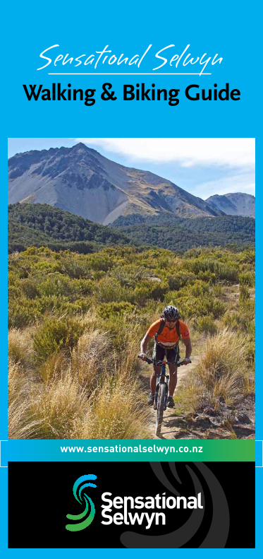
Walking & Biking Guide
www.sensationalselwyn.co.nz
Sensational Selwyn

Selwyn District Council2 Norman Kirk Drive, RollestonPh: +64 3 347 2800
Arthur’s Pass National Park Visitors Information CentreState Highway 73, Arthur’s PassPh: +64 3 318 9211
ESCAPE TO SELWYNJUST 20 MINUTESFROM CHRISTCHURCHBeautiful Scenery | Historic Homesteads & Gardens| Artisan Wineries & Food Producers | Restaurants& Cafes | Country Golf Courses | Walking & Biking |Ski Selwyn Six | Boutique Accommodation | Conference & Event Venues | Country Markets & Shops
Sensational Selwyn stretches across the great Canterbury plains and is bounded by the mighty Rakaia and Waimakariri Rivers, with Arthur’s Pass National Park in the Southern Alps to the west and the Pacific Ocean to the east.
For more information on what there is to see and do in Selwyn visit www.sensationalselwyn.co.nz

walking tracks 1
CONTENTSTrack Grades 5SELWYN MAP 6Safety Information 8
ArThur’S PASS
ShOrT WALKSCockayne Nature Walk 9Dobson Nature Walk 10Lake Misery Walking Track 10Millennium Walk 11Old Coach Road 11
WALKING TrACKS Arthur’s Pass Historical Walk 12Arthur’s Pass Walking Track 12Bealey Valley 13Devils Punchbowl Waterfall 13
TrAMPING TrACKS Avalanche Peak 14Bealey Spur 14Carroll Hut 15Cass Saddle - Lagoon Saddle 16Hawdon Hut 16Mt Aicken 17Mt Bealey 17Mt Cassidy (Cons Track) 18O’Malleys Track 18Otira Valley 19Temple Basin 19
rOuTESAvalanche Peak - Crow River 20Carrington Hut 21Casey Saddle - Binser Saddle 21Edwards - Hawdon Via Tarn Col 22Edwards Hut 22Harman Pass - Taipo River 23Harper Pass 24Mingha - Deception (Goat Pass) 24Three Passes 25
ArEA MAP 26

2
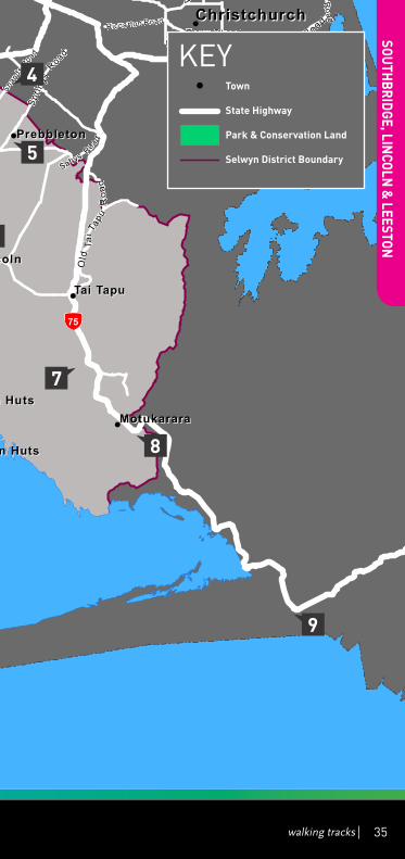
SOuThBrIDGE, LINCOLN & LEESTON
ShOrT WALKS Harts Creek 28Lincoln Historical Walk 29
WALKING TrACKS Coopers Lagoon 30 Little River Rail Trail 31
1: Christchurch (Hornby) to Prebbleton 312: Prebbleton to Lincoln 323: Lincoln to Ahuriri Reserve 324: Ahuriri Reserve to Motukarara 335: Motukarara to Birdlings Flat 336: Birdlings Flat to Little River 33
ArEA MAP 34
CrAIGIEBurN FOrEST, CASTLE hILL, KOrOWAI TOrLESSE TuSSOCKLANDS PArK & CAVE STrEAM
ShOrT WALKSCave Stream Scenic Reserve 36
WALKING TrACKS Bridge Hill Walk 37Castle Hill Limestone Reserve 37Craigieburn Valley Track 38Dracophyllum Flat Track 39Helicopter Hill 39Hogs Back Track 40Hut Creek Walk 40Lyndon Saddle 41Mistletoe Track 41Nature Trail 42Sidle 73 Track 42
TrAMPING TrACKSCamp Saddle Track 43
ArEA MAP 44

walking tracks 3
ARTHUR’S PASS
LAKE COLErIDGE
ShOrT WALKS
Lake Coleridge Arboretum 46
Lake Coleridge Village Historical Walk 47
WALKING TrACKS
Lake Coleridge Tailrace Walk 48
Rakaia Gorge Walking Track 49
Rockwood Bush Walk 50
Washpen Falls 51
TrAMPING TrACKS
Peak Hill 52
Te Araroa (The Long Pathway):
New Zealand’s National Walkway 53
Arboretum Track 55
Road Connection To Lake Hill Track 55
Lake Hill To Homestead Road 55
ArEA MAP 56
SPrINGFIELD, DArFIELD, KIrWEE & GLENTuNNEL
ShOrT WALKS
Darfield Town Walk - Walkway A 58
Darfield Town Walk - Walkway B 59
WALKING TrACKS
Glentunnel Millennium Walk 60
Kirwee Walk 60
Kowai Bush Walk 61
ArEA MAP 62
SOuThBrIDGE, LINCOLN & LEESTON
ShOrT WALKS Harts Creek 28Lincoln Historical Walk 29
WALKING TrACKS Coopers Lagoon 30 Little River Rail Trail 31
1: Christchurch (Hornby) to Prebbleton 312: Prebbleton to Lincoln 323: Lincoln to Ahuriri Reserve 324: Ahuriri Reserve to Motukarara 335: Motukarara to Birdlings Flat 336: Birdlings Flat to Little River 33
ArEA MAP 34
CrAIGIEBurN FOrEST, CASTLE hILL, KOrOWAI TOrLESSE TuSSOCKLANDS PArK & CAVE STrEAM
ShOrT WALKSCave Stream Scenic Reserve 36
WALKING TrACKS Bridge Hill Walk 37Castle Hill Limestone Reserve 37Craigieburn Valley Track 38Dracophyllum Flat Track 39Helicopter Hill 39Hogs Back Track 40Hut Creek Walk 40Lyndon Saddle 41Mistletoe Track 41Nature Trail 42Sidle 73 Track 42
TrAMPING TrACKSCamp Saddle Track 43
ArEA MAP 44

4
SELWYN CYCLING & BIKING
Aquados Tour Of Selwyn Route 64
Avoca Homestead (Hut) 64
Broken River Ski Field Road 65
Broken River Ski Field Road To Camp Saddle 65
Craigieburn Valley & Lyndon Saddle Loop 66
Dracophyllum Flat Track 67
Hogs Back Mountain Bike Track 67
Little River Rail Trail 68
1: Christchurch (Hornby) to Prebbleton 68
2: Prebbleton to Lincoln 69
3: Lincoln to Ahuriri Reserve 69
4: Ahuriri Reserve to Motukarara 70
5: Motukarara to Birdlings Flat 70
6: Birdlings Flat to Little River 71
Mt White Road 71
Poulter Valley 72
Starvation Gully To Trig M 72
Trig M To Coach Stream 73
ArEA MAP 74
ICONS KEY:
rOuTE 30
MINuTES
Short Walking Tramping Route Biking Time to Walk Track Track Track finish
1.1
KILOMETrES
GrADE3INTErMEDIATEDOWNhILL DOC
Length Level of Level of Department of Wheelchair of walk Intensity Difficulty Conservation Track Accessible

walking tracks 5
TrACK GrADES ShOrT WALK • Easywalkingforuptoanhour• Trackiswellformed,withanevensurface• Theremaybestepsorslopes• Suitable for people of most abilities and fitness levels• Streamandrivercrossingsarebridged• Walkingshoesrequired
WALKING TrACK • Easytomoderatewalkingfromafewminutesto
a day• Trackismostlywellformed,somesectionsmay
be steep, rough or muddy• Suitableforpeoplewithlowtomoderatefitness
and abilities• Clearlysignposted• Streamandrivercrossingsarebridged• Walkingshoesorlighttramping/hikingboots
required
TrAMPING TrACK • Challengingdayormulti-daytramping/hiking• Trackismostlyunformedwithsteep,roughor
muddy sections• Suitableforpeoplewithgoodfitness.Moderate
tohigh-levelbackcountryskillsandexperience.Navigation and survival skills required
• Trackhasmarkers,polesorrockcairns• Expectunbridgedstreamandrivercrossings• Tramping/hikingbootsrequired
rOuTE rOuTE• Challengingovernighttramping/hiking• Trackunformedandnatural,mayberough,
muddy or very steep• Suitableforpeoplewithhighlevelbackcountry
(remote areas) skills and experience. Navigation and survival skills required
• Completeselfsufficiencyrequired• Trackhasmarkers,polesorrockcairns• Expectunbridgedstreamandrivercrossings• Sturdytramping/hikingbootsrequired

!
!!
!
!
!!
!!
!
!
!
!
!!
!
!
!
!
!
!
!
!
!
L a k e E l l e s m e r e( T e W a i h o r a )
LakeColeridge
R a k a i a R i v e r
Oxford
Rangiora
W a i m a k a r i r i R i v e r
Lees ton
LincolnRol leston
West M elton
Dar fie ld
Shef fie ld
Spr ingfie ld
Kirw eeTai Tapu
Cast le H il l
Waddington
Southbr idge
Dunsandel
CoalgateGlentunnel
Lake C oler idge
Pr ebbleton
Rakaia H uts
Doyleston
Spr ingston
Whitecli ff s
Horor ata
Templeton
Ar thurs Pass
AshburtonDistrict
HurunuiDistrict
WaimakaririDistrict
WestlandDistrict
GreyDistrict
ChristchurchCity
|
73
|
73
|
77|
1
|
75
¯Legend
Town
Railway
State Highway
Park and Conservation Land
Selwyn District Boundary
0 10 20km
ChristchurchInternational
Airport
ChristchurchInternational
Airport
!
90mins
60mins
40mins 20mins
Driving times to Christchurch International Airport
6
IMPOrTANT PhONE NuMBErS:EmergenciesFire, Police & Ambulance 111
Arthur’s PassPolice Station: +64 3 318 9212
DarfieldPolice Station: +64 3 318 8002 Medical Centre: +64 3 318 8511
LeestonPolice Station: +64 3 378 0150 Medical Centre: +64 3 324 3850

!
!!
!
!
!!
!!
!
!
!
!
!!
!
!
!
!
!
!
!
!
!
L a k e E l l e s m e r e( T e W a i h o r a )
LakeColeridge
R a k a i a R i v e r
Oxford
Rangiora
W a i m a k a r i r i R i v e r
Lees ton
LincolnRol leston
West M elton
Dar fie ld
Shef fie ld
Spr ingfie ld
Kirw eeTai Tapu
Cast le H il l
Waddington
Southbr idge
Dunsandel
CoalgateGlentunnel
Lake C oler idge
Pr ebbleton
Rakaia H uts
Doyleston
Spr ingston
Whitecli ff s
Horor ata
Templeton
Ar thurs Pass
AshburtonDistrict
HurunuiDistrict
WaimakaririDistrict
WestlandDistrict
GreyDistrict
ChristchurchCity
|
73
|
73
|
77|
1
|
75
¯Legend
Town
Railway
State Highway
Park and Conservation Land
Selwyn District Boundary
0 10 20km
ChristchurchInternational
Airport
ChristchurchInternational
Airport
!
90mins
60mins
40mins 20mins
! Town
State highway
Park & Conservation Land
Selwyn District Boundary
KEY
walking tracks 7
Arthur’s Pass
Southbridge, Lincoln & Leeston
Craigieburn Forest, Castle hill, Korowai Torlesse Tussocklands Park & Cave Stream
Lake Coleridge
Springfield, Darfield, Kirwee & Glentunnel
LincolnPolice Station: +64 325 2800 Medical Centre: +64 3 325 2411
rollestonPolice Station: +64 3 347 9248 Medical Centre: +64 3 347 8848
Selwyn District Council+64 3 347 2800 or +64 3 318 8338

8
SAFETY INFOrMATIONWeather• TheweatherinSelwyncanbeunpredictableand
change suddenly. Please check local weather forecasts before setting out.
Skills and Experience• Refertothetrackgradestochooseatrackthatbest
suits your level of ability and fitness.
Take sufficient supplies• Makesureyouhaveenoughfood,clothing,equipment
andemergencyrationsfortheworst-casescenario.
• Takeanappropriatemeansofcommunication.Cellcoverage is limited in remote areas.
Plan Ahead• Packallappropriateequipmentandmakesureyoutell
someone your plans before you head off. This includes where you are going, whom you are going with, when you are departing and when you expect to return.
Track Status• ForDepartmentofConservationTracks,pleasecheck
the track status with them directly www.doc.govt.nz.• Forothertracks,pleasecontactlandownersfortrack
status.
Dogs• DogsarenotpermittedinNationalPark,KuraTawhiti
(Castle Hill) or anywhere where there are ground dwelling birds. All other Department of Conservation Tracks allow dogs on a leash (under control). For tracks on private land, please contact the land owner directly as many of these tracks go through working farms and stations.
Times to complete each walk and bike track are gto be used as a guide only.
The information in this guide is intended to provide general information to the public. All reasonable measures have been taken to ensure the information is true and accurate to the best of Selwyn District Council’s knowledge but we cannot accept any liability for its accuracy or content.

walking tracks
ARTHUR’S PASS
walking tracks 9
Arthur’s Pass, the South Island’s first National Park is known for its immense natural beauty and rare flora and fauna. In the Village you will find accommodation, cafés, basic groceries and the Department of Conservation Visitors Information Centre, where there are public toilets.
ShOrT WALKS1. COCKAYNE NATurE WALK
30
MINuTESrETurN
800METrES
DOC
This rough loop track winds through the diverse podcarp broadleaf forest of the West Coast. It climbs up over a small hill and comes out near SH73 with a short track leading back to the car park. The track is named after Dr Leonard Cockayne, a renowned botanist who provided the original inspiration to create Arthur’s Pass National Park.
The track starts from the car park at the end of the side road, just on the west side of the Kellys Creek SH73 bridge, 17km west of Arthur’s Pass.
Closest town: Arthur’s Pass.

10
ARTHUR’S PASS
2. DOBSON NATurE WALK
15
MINuTES 750
METrES DOC
This track is located on the summit of Arthur’s Pass and offersagoodintroductiontothesub-alpineandalpineplants of this area, and stunning views of the surrounding mountains. The alpine flowers are in bloom from NovembertoFebruary.Anexcellentself-guidedbookletabout the different native plants and their habitats is available from the Arthur’s Pass Visitor Centre.
The track starts at the Temple Basin car park, crossing the main road about 200m from the car park.
Closest town: Arthur’s Pass.
3. LAKE MISErY WALKING TrACK
20
MINuTES 1
KILOMETrE DOC
This link track turns off the Dobson Nature Walk and goes through to the Otira Valley Track when Lake Misery is low (when the lake is high the boardwalk is under water!). Walk through tall red tussock to the Otira Valley Track and then either walk up the Otira Valley Track to the footbridge or down to the car park on SH73.
The track starts off the Dobson Nature Walk.
Closest town: Arthur’s Pass.

walking tracks 11
ARTHUR’S PASS4. MILLENNIuM WALK
10
MINuTESrETurN
DOC
This short walk, part of which is suitable for prams, goes through a little stone bridge where you can see Avalanche Creek Waterfall. Small trout are often seen from the historic bridge. From here, a steeper section leads to a viewing platform closer to the waterfall.
Start beside the Visitor Centre.
Closest town: Arthur’s Pass.
5. OLD COACh rOAD
30
MINuTES 1.1
KILOMETrES DOC
Thispleasantforestwalkfollowsagently-gradedsectionofthecentury-oldcoachroadandleadsbacktotheshelteron a more recent track. The coach road was cut into the hillside to avoid the Bealey riverbed, which is prone to floods.Sectionsofoldrock-wallingarestillvisiblealongonepartofthetrack.Itissuitableforall-terrainbabybuggies. At the northern end of the track there is a rope handrail. This can be used for guidance, so visitors may shut their eyes and use their other senses to move through the forest.
Starts and finishes near Greyneys Shelter, 6km south of Arthur’s Pass village.
Closest town: Arthur’s Pass.

12
ARTHUR’S PASS
WALKING TrACKS 6. ArThur’S PASS hISTOrICAL WALK
1.5hOurS
rETurN DOC
This leisurely, easy walk takes you around Arthur’s Pass village to historic sites. At each site, photographs show how the village used to look in the early 1900s. A pamphlet for this walk is available from the Arthur’s Pass Visitor Centre.
Start at Visitor Centre.
Toilets at Visitor Centre.
Closest town: Arthur’s Pass.
7. ArThur’S PASS WALKING TrACK
80
MINuTESONE WAY
3.4KILOMETrES
DOC
This new walk, linking a series of tracks, now provides the chance to travel from Arthur’s Pass village to view the Dobson Memorial at Arthur’s Pass summit. The walk presents the best of Arthur’s Pass, and features diverse alpine vegetation, waterfalls, wetlands and rich history, interspersed with stunning views of the mountains. The track gradient is generally gentle, with some steep steps either side of Bridal Veil Creek.
Start at the Punchbowl, Bealey Chasm (Jacks Hut) or Temple Basin car parks to walk all or part of the track and return the same way.
Closest town: Arthur’s Pass.

walking tracks 13
ARTHUR’S PASS8. BEALEY VALLEY
4
hOurSrETurN
DOC
Thisisanattractive,well-gradedwalkthroughmountainbeech forest to the base of Mt Rolleston. The track is bridged across the Bealey River at ‘The Chasm’. It then goes through a tussock clearing and into the forest again before reaching the river.
Start at the carpark 3km North of Arthur’s Pass Village on SH73.
Closest town: Arthur’s Pass.
The Upper Bealey Valley is subject to avalanche hazard in winter. Please heed the warning signs.
9. DEVILS PuNChBOWL WATErFALL
1
hOurrETurN
2KILOMETrES
DOC
The most popular walk in Arthur’s Pass. The track goes up the side of the Bealey River and over two footbridges beforezig-zaggingupthestepsthroughmountainbeechforest to the waterfall’s base. The top of this spectacular fall (131 metres) can be seen from the main road, but a walk to the base of the waterfall is well worth doing.
A signpost just north of Arthur’s Chalet points to the car park where the walk starts. Return the same way.
Closest town: Arthur’s Pass.

14
ARTHUR’S PASS
TrAMPING TrACKS10. AVALANChE PEAK
6-8
hOurSrETurN
ChALLENGING
STEEP DOC
This is the most popular day walking peak at Arthur’s Pass. It is the only peak in Arthur’s Pass that is marked by a poled route to the summit. The climb is 1100m from the village and on a fine day, visitors will be rewarded with fine views of the surrounding peaks, particularly of Mt Rolleston and the Crow Glacier on its southern face. This is an extremely steep and rocky journey to the top of an 1833m peak. It is steep and exposed to the weather, with sheer drops in some places. It should not be attempted in poor visibility or high winds. Plan and prepare well for a safe and enjoyable trip.
There are two tracks to the summit– Scotts Track and Avalanche Peak Track. Both start from Arthur’s Pass Village.
In winter this track is subject to avalanche hazard. In winter conditions you must carry snow and ice climbing equipment and know how to use it.
Closest town: Arthur’s Pass.
11. BEALEY SPur
4-6
hOurSrETurN
12KILOMETrES
DOC
This walk has stunning views in fine weather. It is often a goodchoicewhennorth-westerlywindsarebringingrainto Arthur’s Pass. Being further east, it is drier in these conditions. The track climbs gently up the spur through

walking tracks 15
ARTHUR’S PASSmountain-beechforest.Insummerlookoutforred-floweringmistletoe/piriranginearthestartofthetrack.Higher up, the track passes through tussock grasslands and subalpine scrub and passes near several tarns. There are expansive views of the Waimakariri River valley and surrounding mountains. The track ends at an historic hut, used by musterers in the days when this area was used for summer grazing for sheep.
Track starts from the end of Cloudesley Road, off the main highway near the Bealey Hotel, 14km south of Arthur’s Pass Village. Parking is available near the base of Cloudesley Road. Walk up the private road to access track.
Toilet at hut.
Closest town: Arthur’s Pass.
12. CArrOLL huT
6
hOurSrETurN
12KILOMETrES
ChALLENGING
STEEP DOC
Thistrackisasteepclimbthroughrata/kamahiforestandsubalpine scrub. This leads onto the tussock grasslands which surround the hut on the Kelly Range. On fine days there are good views from the saddle behind the hut looking down the Taramakau River to the West Coast.
Starts at the Kellys Creek car park beside SH73, 3km north of Otira Village.
Toilet at hut.
Closest town: Arthur’s Pass.

16
ARTHUR’S PASS
13. CASS SADDLE - LAGOON SADDLE
2-3
DAY LOOP
ShuTTLE
required 6-7
hOurSPEr DAY
DOC
This track is in the dry mountains east of the Main Divide and contains stunning views from around Lagoon Saddle. A20-bunkhutmidwaymakesitagoodweekendtramp.
Start from either the car park at the end of Cora Lynn road (Lagoon Saddle end) or the car park beside the Cass River. This car park at the Cass end is prone to vandalism so it is safer to park in the Cass settlement itself or at the Lagoon Saddle end.
Facilities: Cass Saddle Hut, Hamilton Hut, West Harper Hut, Lagoon Saddle Shelter, Lagoon Saddle Hut, Bealey Hut.
Closest town: Arthur’s Pass.
River crossing and basic route finding skills needed. In winter, this route also requires experience assessing avalanche terrain.
14. hAWDON huT
1-2
DAYS rETurN 2-3
hOurSPEr DAY
DOC
This is an easy tramp up river flats to a new hut. A fantastic family tramp.
Starting point: Hawdon Shelter on Mt White Road; turn off SH73, 24km east of Arthur’s Pass village.
Toilet at Hut.
Closest town: Arthur’s Pass.
River crossing and basic route finding skills needed.

walking tracks 17
ARTHUR’S PASS15. MT AICKEN
3-4
hOurSrETurN
ChALLENGING
STEEP DOC
The track passes an old pipeline that fed an electricity generator used during the rail tunnel construction. The track then climbs steeply to the forest edge. The track ends at the bushline. Routes beyond the bushline are not marked. For experienced alpine trampers only.
The track begins from the Devils Punchbowl Waterfall car park. The turnoff is signposted 15 minutes up the Devils Punchbowl Waterfall track.
Closest town: Arthur’s Pass.
In winter this track is subject to avalanche hazard. In winter conditions you must carry snow and ice climbing equipment and know how to use it.
16. MT BEALEY
3-4
hOurSrETurN
ChALLENGING
STEEP DOC
Atrampingtrackzig-zagsthroughthebeechforestontothe main ridge leading to Mt Bealey. The track ends at the bushline. Routes beyond the bushline are not marked. For experienced alpine trampers only.
Starts at a small car park on the south side of Rough Creek.
Closest town: Arthur’s Pass.
In winter this track is subject to avalanche hazard. In winter conditions you must carry snow and ice climbing equipment and know how to use it.

18
ARTHUR’S PASS
17. MT CASSIDY (CONS TrACK)
3-4
hOurSrETurN
ChALLENGING
STEEP DOC
This track follows a very steep crested ridge from the north side of Punchbowl Creek. The track ends at the bushline where there are good views of Arthur’s Pass village. Routes beyond the bushline are not marked.
Start at Devils Punchbowl car park.
Closest town: Arthur’s Pass.
In winter this track is subject to avalanche hazard. In winter conditions you must carry snow and ice climbing equipment and know how to use it.
18. O’MALLEYS TrACK
45
MINuTES 2
KILOMETrES
ChALLENGING
GENTLESLOPE
DOC
This is the first section of an overnight route up the Waimakariri River. The track sidles through Mountain beech forest along slopes above the river. After 45 minutes, drop down to the destination, a large open area dotted with scrubby Matagouri. This is known as Turkey Flat, a huge fan of alluvium disgorged from Jordan Stream,aside-streamoftheWaimakaririRiver.Thetrackcontinues further up the Waimakariri valley for overnight tramps and routes.
Starting point: The car park entrance is on a sharp bend attheChristchurchendofthelongone-wayBealeyBridge across the Waimakariri River, 10km east from Arthur’s Pass.
Toilet at the start of track.
Closest town: Arthur’s Pass.

walking tracks 19
ARTHUR’S PASS19. OTIrA VALLEY
2
hOurSrETurN
ChALLENGING
GENTLESLOPE
DOC
This relatively easy graded track follows up a deep alpine valley on the northern side of Mt Rolleston. It climbs over an old glacial moraine, then follows the contour through subalpinescrubandtussocktotheOtiraRiverfoot-bridge. On a good day this is an awesome walk to view the summer alpine flowers.
Start at car park beside SH73, just north of Arthur’s Pass summit.
Closest town: Arthur’s Pass.
The track finishes at the footbridge. Travel past this point requires map reading and route finding skills. For experienced alpine trampers and mountaineers only. This track is subject to an avalanche hazard in winter.
20. TEMPLE BASIN
3
hOurSrETurN
2.4KILOMETrES
ChALLENGING
500mVErICAL
DOC
Anaturephotographer’sdream,thetrackzig-zagsupthe hill to an open tussock basin and the Temple Basin SkiClubbuildings.MagnificentviewsofMtRolleston/Kaimatau across the valley are visible on a clear day.
Startsabovethebush-lineattheSH73roadsidecarpark, 5km north of Arthur’s Pass township.
Closest town: Arthur’s Pass.
Toilet at Lockwood Shelter (day shelter with toilets at ski field).

20
ARTHUR’S PASS
rOuTES21. AVALANChE PEAK - CrOW rIVEr
rOuTE 2 DAY
LOOP
ShuTTLE
required STEEPCLIMB
DOC
This route makes a good weekend trip, all against a backdrop of some of the best features of Arthur’s Pass NationalPark—glaciers,mountainpeaksandice-fedrivers. Crow Hut is situated at the bush edge in an alpine meadow.
This route is steep, exposed to the weather, and precipitous in some places. It is not continuously marked, and at times you need to be able to find your own way. It should not be attempted in poor visibility or high winds.
Start at Arthur’s Pass Village.
Toilet at Crow Hut.
Closest town: Arthur’s Pass.
River crossing, map reading and route finding skills essential. In winter this route also requires experience assessing avalanche terrain and the use of ice axes and crampons.

walking tracks 21
ARTHUR’S PASS
22. CArrINGTON huT
rOuTE 2 DAYS
rETurN 4-6
hOurSPEr DAY
DOC
This walk leads up to the braided riverbed of the Waimakariri River and through to a large hut in the headwaters, nestled at the base of the Southern Alps.
If the Waimakariri is low, start from Klondyke Corner. Otherwise, proceed from the car park just before the one lane bridge over the Waimakariri River (on the Christchurch side).
Toilet at Anti Crow Hut, Carrington Hut.
Closest town: Arthur’s Pass.
River crossing and basic route finding skills needed.
23. CASEY SADDLE - BINSEr SADDLE
rOuTE 2 DAYS
rETurN 8
hOurSPEr DAY
DOC
Thisisapleasanttwo-daytramp.Crosseasysaddlesonwell-definedtracksthroughanopenMountainbeech/Tawhai rauriki forest. Plan for fairly long days. Walkers must take camping gear to camp at the Casey Hut site.
Start at Andrew’s Shelter on Mt White Road; turn off SH73, 24km east of Arthur’s Pass village.
Toilet at the old Casey Hut site.
Closest town: Arthur’s Pass.
No significant river crossings but you may need to ford some side streams after heavy rain.

22
ARTHUR’S PASS
24. EDWArDS - hAWDON VIA TArN COL
rOuTE 2-3DAYS
ShuTTLE
required DOC
A challenging but stunning trip over two alpine passes with tarns and steep creekbed travel.
Start at Greyneys shelter (5km south of Arthur’s Pass on SH73).
Toilet at Edwards Hut, Hawdon Hut.
Closest town: Arthur’s Pass.
River crossing, map reading and route finding skills essential. In winter this route also requires experience assessing avalanche terrain and the use of ice axes and crampons.
25. EDWArDS huT
rOuTE 2 DAYS
rETurN 5
hOurSPEr DAY
DOC
Route features riverbed travel and bush tracks that leadtoEdwardsHut,situatedatthebaseofaU-shapedglacial valley.
Start at Greyneys Shelter (5km south of Arthur’s Pass on SH73).
Toilet at Edwards Hut.
Closest town: Arthur’s Pass.
River crossing and basic route finding skills needed.

walking tracks 23
ARTHUR’S PASS26. hArMAN PASS - TAIPO rIVEr
rOuTE 3-4DAYS
ShuTTLE
required STEEPCLIMB
DOC
Southern Alps crossing with long river valleys to east and west. There are many river crossings, and alpine skills are necessary.
If the Waimakariri is low start from Klondyke Corner. Otherwise, proceed from the car park just before the one lane bridge over the Waimakariri River (on the Christchurch side).
Toilet at Carrington Hut, Julia Hut, Dillions Hut, Carroll Hut.
Closest town: Arthur’s Pass.
River crossing, map reading and route finding skills essential. In winter this route also requires experience assessing avalanche terrain and the use of ice axes and crampons.

24
ARTHUR’S PASS
27. hArPEr PASS
rOuTE 4-5DAYS
ShuTTLE
required STEEPCLIMB
DOC
Historiceast-westrouteoveraSouthernAlpspass.HarperPass was the main pathway to and from the West Coast for Ma-ori when trading pounamu (greenstone). It continued to be an important route during the gold rush in 1864–65.
This trip starts at Aickens car park beside SH73, 5km west of Otira township. The trip finishes at the shelter and car park at Windy Point, just off Lewis Pass Highway (SH7).
Toilet at Locke Stream Hut , Number 3 Hut, Hurunui Hut, Hope Kiwi Lodge.
Closest town: Arthur’s Pass.
River crossing, map reading and route finding skills essential.
28. MINGhA - DECEPTION (GOAT PASS)
rOuTE 2-3DAYS
ShuTTLE
required DOC
Cross the Southern Alps main divide at Goat Pass. Multiple river crossings are required—do not attempt if flows are high or rain is forecast.
Start at the Morrison footbridge (4km west of Otira township) or Greyneys Shelter (5km south of Arthur’s Pass village)
Toilet at Goat Pass Hut.
Closest town: Arthur’s Pass.
River crossing, map reading and route finding skills essential.

walking tracks 25
ARTHUR’S PASS29. ThrEE PASSES
rOuTE 4-5DAYS
ShuTTLE
required DOC
Oneoftheclassics.Aneast-westtraverseovertheSouthern Alps over Harman, Whitehorn and Browning passes. Ice axe and crampons required.
If the Waimakariri is low start from Klondyke Corner. Otherwise, proceed from the car park just before the one lane bridge over the Waimakariri River (on the Christchurch side).
Toilet at Carrington Hut, Park Morpeth Hut, Harman Hut, Grassy Flats Hut.
Closest town: Arthur’s Pass.
River crossing, map reading and route finding skills essential. Ice axes and crampons should be carried and in winter this route also requires experience assessing avalanche terrain.

L a k e E l l e s m e r e( T e W a i h o r a )
Lake Coleridge
W a i m a k a r i r i R i v e r
Ra k a i a
R i v e r
OxfordOxford RangioraRangiora
!
!
!
!
!
!
!
!
!
!
!
!
!
!!
!
!
!
!
!
!
!
!
!
!
!
!
!
!
!
A r t h u r ' s P a s sN a t i o n a l P a r k
C r a i g i e b u r nF o r e s t P a r k
K o r o w a i T o r l e s s eT u s s o c k l a n d s P a r k
P o r t e r H e i g h t sC o n s e r v a t i o n
A r e a
Shand
s Road
Harewood Road
Two Chain Road
High Stree t
Moorhouse AvenueTuam S tree t
Tunn elRoad
Spri n
gsRoad
Ricca rton Road
Willis
Road
Whitecli ffsRoad
Papanui Road
Hororata Dunsandel Road
Sabys Road
Sawyers
Arms Road
Dyers
Road
Coaltrack Road
Memorial Avenue
Old S
outh
Roa
d
Selwyn Lake Road
North Raka iaR
oad
Coleridge Rd
Slee
man
s R
oad
Lynd
on
Rd
HighPeak Rd
Bealey Rd
Mai
nN
o rth
Roa
d
Cha
tter
tons
Roa
d
Bexl eyR
oad
Ma rsh lan d
Ro ad
Joll i
esR
oad
Dav
ies
Rd
Harper Rd
Day
sR
oad
RakaiaTerrace
Road
SnowdonR
d
Ho m
e ste
adR
d
Alg idusRd
Old
Tai T
apu
Roa
d
Inland Scenic Route 72
|
73
|
75
|
1
|
77
|
73
0 5 10km
LeestonLeeston
LincolnLincoln
RollestonRolleston
West MeltonWest Melton
DarfieldDarfield
SheffieldSheffield
SpringfieldSpringfield
KirweeKirwee
Tai TapuTai Tapu
Castle HillCastle Hill
WaddingtonWaddington
SouthbridgeSouthbridge
DunsandelDunsandel
CoalgateCoalgateGlentunnelGlentunnel
Lake ColeridgeLake Coleridge
PrebbletonPrebbleton
Rakaia HutsRakaia Huts
DoylestonDoyleston
SpringstonSpringston
WhitecliffsWhitecliffs
HororataHororata
BurnhamBurnham
TempletonTempleton
Upper Selwyn HutsUpper Selwyn Huts
Lower Selwyn HutsLower Selwyn Huts
MotukararaMotukarara
WindwhistleWindwhistle
Arthurs PassArthurs Pass
ChristchurchChristchurch
!
15
28112
1923
207
410
8
21 616
917
24
25
5
2922
26 18 11 13
13
0 2.5 5km
26
ARTHUR’S PASS

L a k e E l l e s m e r e( T e W a i h o r a )
Lake Coleridge
W a i m a k a r i r i R i v e r
Ra k a i a
R i v e r
OxfordOxford RangioraRangiora
!
!
!
!
!
!
!
!
!
!
!
!
!
!!
!
!
!
!
!
!
!
!
!
!
!
!
!
!
!
A r t h u r ' s P a s sN a t i o n a l P a r k
C r a i g i e b u r nF o r e s t P a r k
K o r o w a i T o r l e s s eT u s s o c k l a n d s P a r k
P o r t e r H e i g h t sC o n s e r v a t i o n
A r e aSha
nds Road
Harewood Road
Two Chain Road
High Stree t
Moorhouse AvenueTuam S tree t
Tunn elRoad
Spri n
gsRoad
Ricca rton Road
Willis
Road
Whitecli ffsRoad
Papanui Road
Hororata Dunsandel Road
Sabys Road
Sawyers
Arms Road
Dyers
Road
Coaltrack Road
Memorial Avenue
Old S
outh
Roa
d
Selwyn Lake Road
North Raka iaR
oad
Coleridge Rd
Slee
man
s R
oad
Lynd
on
Rd
HighPeak Rd
Bealey Rd
Mai
nN
o rth
Roa
d
Cha
tter
tons
Roa
d
Bexl eyR
oad
Ma rsh lan d
Ro ad
Joll i
esR
oad
Dav
ies
Rd
Harper RdD
ays
Roa
d
RakaiaTerrace
Road
SnowdonR
d
Ho m
e ste
adR
d
Alg idusRd
Old
Tai T
apu
Roa
d
Inland Scenic Route 72
|
73
|
75
|
1
|
77
|
73
0 5 10km
LeestonLeeston
LincolnLincoln
RollestonRolleston
West MeltonWest Melton
DarfieldDarfield
SheffieldSheffield
SpringfieldSpringfield
KirweeKirwee
Tai TapuTai Tapu
Castle HillCastle Hill
WaddingtonWaddington
SouthbridgeSouthbridge
DunsandelDunsandel
CoalgateCoalgateGlentunnelGlentunnel
Lake ColeridgeLake Coleridge
PrebbletonPrebbleton
Rakaia HutsRakaia Huts
DoylestonDoyleston
SpringstonSpringston
WhitecliffsWhitecliffs
HororataHororata
BurnhamBurnham
TempletonTempleton
Upper Selwyn HutsUpper Selwyn Huts
Lower Selwyn HutsLower Selwyn Huts
MotukararaMotukarara
WindwhistleWindwhistle
Arthurs PassArthurs Pass
ChristchurchChristchurch
!
1423
! Town
State highway
Park & Conservation Land
Selwyn District Boundary
KEY27
Selwyn District
Westland District
walking tracks 27
ARTHUR’S PASS

SOUTHBRIDGE, LINCOLN
& LEESTON
28
ShOrT WALKS1. hArTS CrEEK
40
MINuTESrETurN
1.46KILOMETrES
Starting at the reserve car park, there is a copse of native bush to walk through before the track takes you parallel to the creek. Here you walk along a stop bank track in the openforabout10-15minutes.Thetrackisclearlymarkedby yellow markers.
Species of native flaxes line the creek and are spectacular during the summer while these are in flower. The track is easy. After crossing a stile, the track leads into a densely wooded swamp area. Take care to keep to the boarded walkway.GlimpsesofTeWaihora/LakeEllesmerecanbeseen through the trees. The walkway ends at the Bird Hide, a camouflaged hut set out on the Lake for easy viewing of bird and wildlife. A great walk for children and families, it is a pin return track and takes approximately 20 minutes eachway.Sturdyall-terrain-stylepushchairsaresuitable,but be prepared to lift over fences. The reserve entrance has a pleasant and sheltered spot for picnics. Birdlife known to reside in the area include: white swans, black swans, pukekos, Canada geese, several species of duck, white heron, pied stilts and more.
Starting via Springston – take Days Road to Coes Ford. At the ford turn left into The Lake Road. Travel for approximately 14.5 km to the intersection of Lower Lake Road and Harts Road. Turn left into Lower Lake Road and turn left again onto a small bridge not far from the corner at the AA signpost Lakeside Domain, where a shingle road will take you to the car park.

SOUTHBRIDGE, LINCOLN
& LEESTON
walking tracks 29
Starting via Southbridge – turn left into Taumutu Road at the pub. Follow this road until it becomes Southbridge Sedgemere Road. Continue on this road (turning right at the intersection of Cowans and Bealey Roads), until you get to Harts Road. Turn left onto Harts Road. Continue on past the Lakeside Hall, until Harts Road becomes Lower Lake Road. Just after the intersection of The Lake Road, turn left off Lower Lake Road onto a small bridge at the AA signpost Lakeside Domain, where a shingle road will take you to the car park.
Closest town: Springston.
This track is open to public access all year. Some areas are exposed so hats and sunscreen are essential.
2. LINCOLN hISTOrICAL WALK
45-90
MINuTES
The Lincoln Historical Precinct walk takes 45 minutes and the extended walk will take 1.5 hours. Both offer a trail around the township of Lincoln, with historical landmarks and buildings along the way. A brochure for this walk is available from the Lincoln Library or Lincoln Event Centre or download a copy from the Sensational Selwyn website.
The walk starts from the Liffey Cottage, James Street, Lincoln
Closest town: Lincoln

SOUTHBRIDGE, LINCOLN
& LEESTON
30
WALKING TrACKS3. COOPErS LAGOON
Coopers Lagoon, a wetland reserve, is just inland from the coast, and south of Taumutu. A great outing, it combines lagoon wetlands with a wild coastal walk. Expect to see abundant birdlife and classic wetland flora. Take time to stop and observe the birdlife. Birds that live in the area are; white swans, black swans, pukekos, spoonbill, several species of duck and bittern. Overall this is a pleasant walking track suitable for families and people of all ages. The track is sandy but firm, flat and wide. The beach is wild and exciting. Being able to hear the sea just beyond the dunes makes for a rejuvenating walk.
After 30 minutes, the track bordering the Lagoon ends and takes a turn to the right into the sand dunes. Here you can walk back along the Lagoon track to the car park, or choose to walk back along the beach. The beach is the more challenging option as it is stony and steep in some places.
Starting point for Coopers Lagoon is near Southbridge and approximately 80 minutes drive from Christchurch. Via Southbridge – travel through Southbridge on High Street towards the sea and turn left into Milltown Road (approximately 2km). Milltown Road winds around a few corners then ends at a crossroad intersection.
Turn right into Inwoods Road. Follow Inwoods Road for approximately 4km until it becomes McEvedys Road. Travel 2.4km down McEvedys Road until you reach a small bridge and carpark. Note: McEvedys Road becomes a gravel road after approximately 1km.
Closest town: Southbridge.

SOUTHBRIDGE, LINCOLN
& LEESTON
walking tracks 31
This track is open to public access all year. Be prepared for windy and exposed conditions. The beach is known for strong currents that makes swimming dangerous.
4-9 LITTLE rIVEr rAIL TrAIL In2003theChristchurch-LittleRiverRailTrailTrustwasestablished to transform the former railway route into a trail catering for walkers and cyclists wishing to view the region at close quarters, while avoiding the traffic on the busy road between Little River and Christchurch.
Therearesixsectionsintotal-seeeachsectionforcompletion times. Altogether the trail is 45km.
City Cycle hire. Public toilets, cafés, dining, parking, and accomodation available at each township.
4. LITTLE rIVEr rAIL TrAIL - SECTION 1: Christchurch (hornby) to Prebbleton
50
MINuTES 4
KILOMETrES
This section is sealed and follows Shands Rd to the intersection with Marshs Rd, crosses the road and follows the south side of Marshs Rd to the old railway corridor taking users through to the village of Prebbleton in the Selwyn District.
To connect to the next section of the Rail Trail (that goes to Lincoln), use the cycle lanes along Springs Rd through Prebbleton,turnleftintoBirchesRdandpickuptheoff-road trail just after the Trices Rd intersection.
This section starts about 400m south of the ShandsRd-HalswellJunctionRdintersectiononShands Rd where a small car park is available.
Closest town: Christchurch.

SOUTHBRIDGE, LINCOLN
& LEESTON
32
5. LITTLE rIVEr rAIL TrAIL - SECTION 2: Prebbleton to Lincoln
80
MINuTES 7
KILOMETrES
ThissectionstartsattheBirchsRd-TricesRdintersectionandisa7kmoff-roadashphaltpathwayalongsideBirchsRd, and then James St, to the township of Lincoln. It runs alongside the original railway line through pleasant rural surroundings and is wide enough to enable cycling in both directions.
Starting in Prebbleton, join the Rail Trail either in the township on Springs Road, where there is a cycleway markedontheroadseal,orfromthestartoftheoff-roadsectionattheBirchesRd-TricesRdintersection.
Public toilets by Prebbleton Reserve (by Children’s Playground) and Lincoln.
Closest town: Prebbleton.
6. LITTLE rIVEr rAIL TrAIL - SECTION 3: Lincoln to Ahuriri reserve
2
hOurS 10
KILOMETrES
This section of the Rail Trail connects the township of Lincoln to the Ahuriri Reserve using a number of subsections.
StartattheJamesSt-EastBeltintersectionturnleftinto East Belt which connects to Edward St.
Closest town: Lincoln.

SOUTHBRIDGE, LINCOLN
& LEESTON
walking tracks 33
7. LITTLE rIVEr rAIL TrAIL - SECTION 4: Ahuriri reserve to Motukarara
50
MINuTES 4
KILOMETrES Thissectionisoff-roadandthesurfaceishardpackedgravel.The route is adjacent to the Halswell Canal but deviates away onto farmland for approximately 1.7km to reduce the impact of disturbance on the visiting bird life. The bird life is a key attraction of this unique wetland area. The Waihora Ellesmere Trust (WET), Rail Trail Trust and Environment Canterbury are working together to enhance the wetland for wildlife, and provide interpretation signage to promote the importance of this wetland ecosystem and inform Rail Trail users of its sensitivity and value to the environment.
The Ahuriri Section starts at the eastern end of Neills Rd. Park on the grass verge.
Closest town: Motukarara.
8. LITTLE rIVEr rAIL TrAIL - SECTION 5: Motukarara to Birdlings Flat
2
hOurS 13
KILOMETrES Most of this section of the Rail Trail runs alongside Te Waihora/LakeEllesmere,wheretherailwayembankmentis raised above the lake and adjoining wetlands, affording magnificent views of the surroundings and the prolific birdlife.
This section starts at Motukarara, off Park Rd.
Toilet block and car parking area provided on Park Rd.
Closest town: Motukarara.
9. LITTLE rIVEr rAIL TrAIL - SECTION 6: Birdlings Flat to Little river
1
hOurS 7
KILOMETrES Most of this section traverses along the old railway embankment beside Te Roto o Waiewa (Lake Forsyth). The Rail Trail currently ends at Kinloch Road, a few hundred metres from the Little River township.
This section starts on Poranui Beach Rd.
Toilets at Catons Bay and in the Little River township.
Closest town: Little River

L a k e E l l e s m e r e( T e W a i h o r a )
Lake Coleridge
W a i m a k a r i r i R i v e r
Ra k a i a
R i v e r
OxfordOxford RangioraRangiora
!
!
!
!
!
!
!
!
!
!
!
!
!
!!
!
!
!
!
!
!
!
!
!
!
!
!
!
!
!
A r t h u r ' s P a s sN a t i o n a l P a r k
C r a i g i e b u r nF o r e s t P a r k
K o r o w a i T o r l e s s eT u s s o c k l a n d s P a r k
P o r t e r H e i g h t sC o n s e r v a t i o n
A r e a
Shand
s Road
Harewood Road
Two Chain Road
High Stree t
Moorhouse AvenueTuam S tree t
Tunn elRoad
Spri n
gsRoad
Ricca rton Road
Willis
Road
Whitecli ffsRoad
Papanui Road
Hororata Dunsandel Road
Sabys Road
Sawyers
Arms Road
Dyers
Road
Coaltrack Road
Memorial Avenue
Old S
outh
Roa
d
Selwyn Lake Road
North Raka iaR
oad
Coleridge Rd
Slee
man
s R
oad
Lynd
on
Rd
HighPeak Rd
Bealey Rd
Mai
nN
o rth
Roa
d
Cha
tter
tons
Roa
d
Bexl eyR
oad
Ma rsh lan d
Ro ad
Joll i
esR
oad
Dav
ies
Rd
Harper Rd
Day
sR
oad
RakaiaTerrace
Road
SnowdonR
d
Ho m
e ste
adR
d
Alg idusRd
Old
Tai T
apu
Roa
d
Inland Scenic Route 72
|
73
|
75
|
1
|
77
|
73
0 5 10km
LeestonLeeston
LincolnLincoln
RollestonRolleston
West MeltonWest Melton
DarfieldDarfield
SheffieldSheffield
SpringfieldSpringfield
KirweeKirwee
Tai TapuTai Tapu
Castle HillCastle Hill
WaddingtonWaddington
SouthbridgeSouthbridge
DunsandelDunsandel
CoalgateCoalgateGlentunnelGlentunnel
Lake ColeridgeLake Coleridge
PrebbletonPrebbleton
Rakaia HutsRakaia Huts
DoylestonDoyleston
SpringstonSpringston
WhitecliffsWhitecliffs
HororataHororata
BurnhamBurnham
TempletonTempleton
Upper Selwyn HutsUpper Selwyn Huts
Lower Selwyn HutsLower Selwyn Huts
MotukararaMotukarara
WindwhistleWindwhistle
Arthurs PassArthurs Pass
ChristchurchChristchurch
!
1
0 2.5 5km
3
2 6
SOUTHBRIDGE, LINCOLN
& LEESTON
34
L a k e E l l e s m e r e( T e W a i h o r a )
Lake Coleridge
W a i m a k a r i r i R i v e r
Ra k a i a
R i v e r
OxfordOxford RangioraRangiora
!
!
!
!
!
!
!
!
!
!
!
!
!
!!
!
!
!
!
!
!
!
!
!
!
!
!
!
!
!
A r t h u r ' s P a s sN a t i o n a l P a r k
C r a i g i e b u r nF o r e s t P a r k
K o r o w a i T o r l e s s eT u s s o c k l a n d s P a r k
P o r t e r H e i g h t sC o n s e r v a t i o n
A r e a
Shand
s Road
Harewood Road
Two Chain Road
High Stree t
Moorhouse AvenueTuam S tree t
Tunn elRoad
Spri n
gsRoad
Ricca rton Road
Willis
Road
Whitecli ffsRoad
Papanui Road
Hororata Dunsandel Road
Sabys Road
Sawyers
Arms Road
Dyers
Road
Coaltrack Road
Memorial Avenue
Old S
outh
Roa
d
Selwyn Lake Road
North Raka iaR
oad
Coleridge Rd
Slee
man
s R
oad
Lynd
on
Rd
HighPeak Rd
Bealey Rd
Mai
nN
o rth
Roa
d
Cha
tter
tons
Roa
d
Bexl eyR
oad
Ma rsh lan d
Ro ad
Joll i
esR
oad
Dav
ies
Rd
Harper Rd
Day
sR
oad
RakaiaTerrace
Road
SnowdonR
d
Ho m
e ste
adR
d
Alg idusRd
Old
Tai T
apu
Roa
d
Inland Scenic Route 72
|
73
|
75
|
1
|
77
|
73
0 5 10km
LeestonLeeston
LincolnLincoln
RollestonRolleston
West MeltonWest Melton
DarfieldDarfield
SheffieldSheffield
SpringfieldSpringfield
KirweeKirwee
Tai TapuTai Tapu
Castle HillCastle Hill
WaddingtonWaddington
SouthbridgeSouthbridge
DunsandelDunsandel
CoalgateCoalgateGlentunnelGlentunnel
Lake ColeridgeLake Coleridge
PrebbletonPrebbleton
Rakaia HutsRakaia Huts
DoylestonDoyleston
SpringstonSpringston
WhitecliffsWhitecliffs
HororataHororata
BurnhamBurnham
TempletonTempleton
Upper Selwyn HutsUpper Selwyn Huts
Lower Selwyn HutsLower Selwyn Huts
MotukararaMotukarara
WindwhistleWindwhistle
Arthurs PassArthurs Pass
ChristchurchChristchurch
!
! Town
State highway
Park & Conservation Land
Selwyn District Boundary
KEY
9
8
7
6
5
4
SOUTHBRIDGE, LINCOLN
& LEESTON
walking tracks 35

36
ShOrT WALKS 1. CAVE STrEAM SCENIC rESErVE
30
MINuTESrETurN
1.46KILOMETrES
DOC
Two short tracks lead from the reserve carpark to the cave entrances. The track to the upstream entrance goes north, through a diverse karst (limestone) landscape of solution holes,rillenkarren(water-groovedrocks)andsculpturedrock formations. The track to the downstream entrance drops south of the terraces to Broken River and then down the river to the cave entrance. Walkers going through the cave can use the downstream entrance to the south of the car park
A circular track leads to the edge of a terrace overlooking the outflow entrance of the cave.
The limestone formations nearby were the setting for the filming of ‘The Chronicles of Narnia: The Lion, the Witch and the Wardrobe’.
Start at the reserve on SH73 between the Broken River road bridge and Craigieburn Forest Park entrance.
Pit toilet.
Closest town: Springfield.
Please observe the warning signs about entering the cave – it has claimed lives. You must be properly equipped if you plan to walk through the cave.
Craigieburn Forest, Castle H
ill, Korowai
torlesse tussoCKlands ParK &
Cave stream

walking tracks 37
WALKING TrACKS 2. BrIDGE hILL WALK
20
MINuTESrETurN
DOC
There are panoramic views of Castle Hill Basin and the Torlesse Range in the east from Bridge Hill. Look for the distinctive Torlesse Gap ‘notch’ in the ridge. The Craigieburn Range in the west rises to a high point of 2194 metres at Mount Enys.
Park at the locked gate on the road to the Environment Centre and walk down the road. Turn right at the junction near the Environment Centre and right again when you reach the junction at the Forest Park boundary.
Pit toilet and shelter at the Craigieburn picnic area.
Closest town: Springfield.
Watch out for wasps in the summer months. This is also a mountain bike track.
3. CASTLE hILL LIMESTONE rESErVE
DOC
Breathtaking scenery and mountain range. The rocks take on many shapes from tabletops to pillars and with imagination some appear as familiar animal shapes. You can wander around the rocks, and crawl through mini tunnels and arches probably chiseled by glaciers millions of years ago. The history of the area is interesting. The first known settlers of the South Island, the Waitaha, were thought to have used the area for shelter on their food gathering expeditions. Originally covered in beech forest, the area was a great hunting ground forMaori.Breath-takingsceneryisateveryturn,andyou
Craigieburn Forest, Castle H
ill, Korowai
torlesse tussoCKlands ParK &
Cave stream

38
can spend as much or as little time as you like exploring the reserve. Highlights include rock formations created over 300 million years ago. This is also an excellent destination for a family with children.
Starting point is just over one hour from Christchurch on State Highway SH73 towards Arthur’s Pass. Castle HillLimestoneReserve/KuraTawhitiisclearlymarkedon the left in the Cave Stream Scenic Reserve area. Leaving the car park clearly signposted on SH73, walk along a gravel path for about 10 minutes to reach the foothills and the limestone rocks. This path is suitable for wheelchairs and pushchairs. At the end of the gravel path a series of grass trails lead up to the rocks in different directions.
Toilets at the car park Arthur’s Pass Village is 45 minutes further west on the highway. There are cafes, a store, petrol and a DOC Visitor Centre with information on the area and Arthur’s Pass National Park.
Closest town: Springfield.
4. CrAIGIEBurN VALLEY TrACK
4
hOurSrETurN
9KILOMETrES
DOC
This track begins beside the Craigieburn Valley ski field road, 1.5km from the highway and follows through Mountain beech forest until it emerges in alpine tussocks near the ski field huts and car park. The return trip can be via the ski field road.
Starts on the Craigieburn Ski Field Road, 1.5km from the main highway. Park at locked gate on Craigieburn ski field road and walk up road to start. The track can also be accessed by walking over Lyndon Saddle via the Mistletoe or Lyndon Saddle Tracks.
Craigieburn Forest, Castle H
ill, Korowai
torlesse tussoCKlands ParK &
Cave stream

walking tracks 39
Pit toilet and shelter at the Craigieburn picnic area.
Closest town: Springfield.
Watch out for wasps in the summer months. This is also a mountain bike track.
5. DrACOPhYLLuM FLAT TrACK
1.5hOurS
rETurN DOC
A popular picnic site. This sheltered clearing is covered byred-brownDracophyllum,nativetussock,andahostofsmall herbs and ground covering plants.
The track leaves Jacks Pass and gradually descends to Broken River, which is crossed on a bridge. The clearing is 5 minutes up through Mountain beech.
The track starts from the Broken River Ski Field Road (signposted from SH73) just before Jacks Pass.
Pit toilet and shelter at the Craigieburn picnic area.
Closest town: Springfield.
Watch out for wasps in the summer months. This is also a mountain bike track. The track continues beyond Dracophyllum Flat and can be followed to the Cheeseman Ski Field Road (1.5 hours one way).
6. hELICOPTEr hILL
4
hOurSrETurN
DOC
This track climbs from Lyndon Saddle along a steep ridge with open screes between the beech forests. Either Lyndon Saddle Track or Mistletoe Track can be used to get to Lyndon Saddle. The top of Helicopter Hill (1256m) is covered with tussock and low herbs and grasses. From here there are spectacular views of the Craigieburn and Torlesse ranges and the limestone landscape of Castle Hill Basin.
The track starts at the Craigieburn picnic shelter (signposted from SH73), about 1.5 hours drive from Christchurch.
Pit toilet and shelter at the Craigieburn picnic area.
Closest town: Springfield.
Watch out for wasps in the summer months.
Craigieburn Forest, Castle H
ill, Korowai
torlesse tussoCKlands ParK &
Cave stream

40
7. hOGS BACK TrACK
2.5hOurS
ONE WAY 7.4
KILOMETrES DOC
The track connects Castle Hill Village to the Cheeseman Ski Field Road. It can be walked from either end. From Castle Hill Village the track climbs over Long Spur and traverses across the Hogs Back Creek, through beech forest and up on to the Hogs Back Ridge before dropping down to Texas Flat on the Cheeseman Skifield Road.
Starts behind Castle Hill Village on the road to the Thomas Bush and St Andrews Lodge or from Texas Flat on the Cheeseman Ski Field Road.
Toilets at Castle Hill Village.
Closest town: Springfield.
Watch out for wasps in the summer months. This is also a mountain bike track.
8. huT CrEEK WALK
1
hOurrETurN
1.2KILOMETrES
DOC
This walk passes through an area that was used for trial plantingbytheForestResearchInstitutefrom1956tothemid- 1970s. Return to the car park by walking back along the road.
Start at the Environmental Education Centre off SH73, about 1.5 hours drive from Christchurch. Park at the locked gate on the road to the Environment Centre and walk down the road to the centre car park.
Pit toilet and shelter at the Craigieburn picnic area.
Closest town: Springfield.
Watch out for wasps in the summer months. This is also a mountain bike track.
Craigieburn Forest, Castle H
ill, Korowai
torlesse tussoCKlands ParK &
Cave stream
walking tracks 41
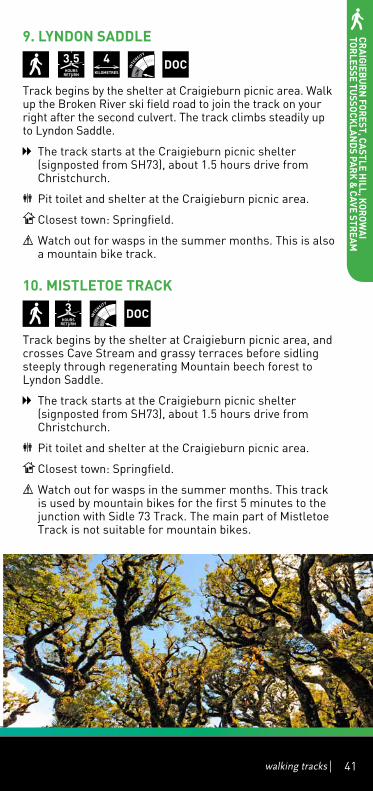
9. LYNDON SADDLE
3.5hOurS
rETurN 4
KILOMETrES DOC
Track begins by the shelter at Craigieburn picnic area. Walk up the Broken River ski field road to join the track on your right after the second culvert. The track climbs steadily up to Lyndon Saddle.
The track starts at the Craigieburn picnic shelter (signposted from SH73), about 1.5 hours drive from Christchurch.
Pit toilet and shelter at the Craigieburn picnic area.
Closest town: Springfield.
Watch out for wasps in the summer months. This is also a mountain bike track.
10. MISTLETOE TrACK
3
hOurSrETurN
DOC
Track begins by the shelter at Craigieburn picnic area, and crosses Cave Stream and grassy terraces before sidling steeply through regenerating Mountain beech forest to Lyndon Saddle.
The track starts at the Craigieburn picnic shelter (signposted from SH73), about 1.5 hours drive from Christchurch.
Pit toilet and shelter at the Craigieburn picnic area.
Closest town: Springfield.
Watch out for wasps in the summer months. This track is used by mountain bikes for the first 5 minutes to the junction with Sidle 73 Track. The main part of Mistletoe Track is not suitable for mountain bikes.
Craigieburn Forest, Castle H
ill, Korowai
torlesse tussoCKlands ParK &
Cave stream

42
11. NATurE TrAIL
20
MINuTESrETurN
DOC
Enjoy a close look at different stages of beech tree life andwhatgrowsonthetrees-lichens,mossesandasmall insect which secretes honey dew (a small droplet of sweet liquid that birds feed on), on this pleasant walk through mountain beech forest. Between late December toFebruarytheredflowersofnativemistletoe/pikirangican produce patches of blazing colour in the tree canopy. Common native forest birds living in this area include rifleman/titipounamu,bellbird/korimako,tomtit/miromiroandgreywarbler/riroriro.
Start at the Environmental Education Centre off SH73, about 1.5 hours drive from Christchurch. Park at the locked gate on the road to the Environment Centre and walk down the road to the Centre, or access from the Link Track.
Pit toilet and shelter at the Craigieburn picnic area.
Closest town: Springfield.
Watch out for wasps in the summer months.
12. SIDLE 73 TrACK
1
hOurrETurN
2KILOMETrES
DOC
Beginning by the shelter at Craigieburn picnic area, the track crosses Cave Stream and grassy terraces to a junction with the Mistletoe Track. From the junction, the track traverses above Cave Stream and runs parallel to SH73 to meet up with the Craigieburn Ski Field Road.
The track starts at the Craigieburn picnic shelter (signposted from SH73), about 1.5 hours drive from Christchurch.
Pit toilet and shelter at the Craigieburn picnic area.
Closest town: Springfield.
Watch out for wasps in the summer months. This is also a mountain bike track.
Craigieburn Forest, Castle H
ill, Korowai
torlesse tussoCKlands ParK &
Cave stream

walking tracks 43
TrAMPING TrACKS 13. CAMP SADDLE TrACK
2
hOurSONE WAY
2.5KILOMETrES
DOC
From the locked gate and car park on the Broken River ski field road, walk 1km to the signposted track opposite thetractorshed.Anoldfour-wheel-drivetracknarrowsasit steadily climbs through beech forest. The track comes out into open tussocks and poles mark the route to Camp Saddle.
Start on the Broken River ski field road at the locked gate.
Pit toilet and shelter at the Craigieburn picnic area.
Closest town: Springfield.
Watch out for wasps in the summer months.
Craigieburn Forest, Castle H
ill, Korowai
torlesse tussoCKlands ParK &
Cave stream

L a k e E l l e s m e r e( T e W a i h o r a )
Lake Coleridge
W a i m a k a r i r i R i v e r
Ra k a i a
R i v e r
OxfordOxford RangioraRangiora
!
!
!
!
!
!
!
!
!
!
!
!
!
!!
!
!
!
!
!
!
!
!
!
!
!
!
!
!
!
A r t h u r ' s P a s sN a t i o n a l P a r k
C r a i g i e b u r nF o r e s t P a r k
K o r o w a i T o r l e s s eT u s s o c k l a n d s P a r k
P o r t e r H e i g h t sC o n s e r v a t i o n
A r e a
Shand
s Road
Harewood Road
Two Chain Road
High Stree t
Moorhouse AvenueTuam S tree t
Tunn elRoad
Spri n
gsRoad
Ricca rton Road
Willis
Road
Whitecli ffsRoad
Papanui Road
Hororata Dunsandel Road
Sabys Road
Sawyers
Arms Road
Dyers
Road
Coaltrack Road
Memorial Avenue
Old S
outh
Roa
d
Selwyn Lake Road
North Raka iaR
oad
Coleridge Rd
Slee
man
s R
oad
Lynd
on
Rd
HighPeak Rd
Bealey Rd
Mai
nN
o rth
Roa
d
Cha
tter
tons
Roa
d
Bexl eyR
oad
Ma rsh lan d
Ro ad
Joll i
esR
oad
Dav
ies
Rd
Harper Rd
Day
sR
oad
RakaiaTerrace
Road
SnowdonR
d
Ho m
e ste
adR
d
Alg idusRd
Old
Tai T
apu
Roa
d
Inland Scenic Route 72
|
73
|
75
|
1
|
77
|
73
0 5 10km
LeestonLeeston
LincolnLincoln
RollestonRolleston
West MeltonWest Melton
DarfieldDarfield
SheffieldSheffield
SpringfieldSpringfield
KirweeKirwee
Tai TapuTai Tapu
Castle HillCastle Hill
WaddingtonWaddington
SouthbridgeSouthbridge
DunsandelDunsandel
CoalgateCoalgateGlentunnelGlentunnel
Lake ColeridgeLake Coleridge
PrebbletonPrebbleton
Rakaia HutsRakaia Huts
DoylestonDoyleston
SpringstonSpringston
WhitecliffsWhitecliffs
HororataHororata
BurnhamBurnham
TempletonTempleton
Upper Selwyn HutsUpper Selwyn Huts
Lower Selwyn HutsLower Selwyn Huts
MotukararaMotukarara
WindwhistleWindwhistle
Arthurs PassArthurs Pass
ChristchurchChristchurch
!
0 2.5 5km
44
7
3
1
5
813
4
92
11 612
10
Craigieburn Forest, Castle H
ill, Korowai
torlesse tussoCKlands ParK &
Cave stream

L a k e E l l e s m e r e( T e W a i h o r a )
Lake Coleridge
W a i m a k a r i r i R i v e r
Ra k a i a
R i v e r
OxfordOxford RangioraRangiora
!
!
!
!
!
!
!
!
!
!
!
!
!
!!
!
!
!
!
!
!
!
!
!
!
!
!
!
!
!
A r t h u r ' s P a s sN a t i o n a l P a r k
C r a i g i e b u r nF o r e s t P a r k
K o r o w a i T o r l e s s eT u s s o c k l a n d s P a r k
P o r t e r H e i g h t sC o n s e r v a t i o n
A r e a
Shand
s Road
Harewood Road
Two Chain Road
High Stree t
Moorhouse AvenueTuam S tree t
Tunn elRoad
Spri n
gsRoad
Ricca rton Road
Willis
Road
Whitecli ffsRoad
Papanui Road
Hororata Dunsandel Road
Sabys Road
Sawyers
Arms Road
Dyers
Road
Coaltrack Road
Memorial Avenue
Old S
outh
Roa
d
Selwyn Lake Road
North Raka iaR
oad
Coleridge Rd
Slee
man
s R
oad
Lynd
on
Rd
HighPeak Rd
Bealey Rd
Mai
nN
o rth
Roa
d
Cha
tter
tons
Roa
d
Bexl eyR
oad
Ma rsh lan d
Ro ad
Joll i
esR
oad
Dav
ies
Rd
Harper Rd
Day
sR
oad
RakaiaTerrace
Road
SnowdonR
d
Ho m
e ste
adR
d
Alg idusRd
Old
Tai T
apu
Roa
d
Inland Scenic Route 72
|
73
|
75
|
1
|
77
|
73
0 5 10km
LeestonLeeston
LincolnLincoln
RollestonRolleston
West MeltonWest Melton
DarfieldDarfield
SheffieldSheffield
SpringfieldSpringfield
KirweeKirwee
Tai TapuTai Tapu
Castle HillCastle Hill
WaddingtonWaddington
SouthbridgeSouthbridge
DunsandelDunsandel
CoalgateCoalgateGlentunnelGlentunnel
Lake ColeridgeLake Coleridge
PrebbletonPrebbleton
Rakaia HutsRakaia Huts
DoylestonDoyleston
SpringstonSpringston
WhitecliffsWhitecliffs
HororataHororata
BurnhamBurnham
TempletonTempleton
Upper Selwyn HutsUpper Selwyn Huts
Lower Selwyn HutsLower Selwyn Huts
MotukararaMotukarara
WindwhistleWindwhistle
Arthurs PassArthurs Pass
ChristchurchChristchurch
!
! Town
State highway
Park & Conservation Land
Selwyn District Boundary
KEY
walking tracks 45
Craigieburn Forest, Castle H
ill, Korowai
torlesse tussoCKlands ParK &
Cave stream

LAKE COLERIDGE
46
ShOrT WALKS 1. LAKE COLErIDGE ArBOrETuM
5-30
MINuTES 1
KILOMETrE DOC
To access the Arboretum, start at the Lake Coleridge Domain where the old Post Office has an information board. Walk up Hummocks Hill road to the intake road. Cross over a cattle stop and the Arboretum is on the left. The reserve is made up of a series of loop trails, some a short 5 minute walk, others can take up to 30 minutes. As you wander around the trails in the Arboretum, there are markers on most of the trees, identifying them and the year they were planted. The trees have been left to form their own natural habitat and now there is obvious regeneration of seedlings in the undergrowth. There is a stunning colour display in Autumn. For fir tree aficionados, the Lake Coleridge Arboretum is considered by foresters as a world class collection of conifers. Created by Harry Hart, the first tree was planted in 1933 and in total Hart is believed to have planted more than 200 plant and tree specimens in the area. Covering 1.9ha, the reserve has many trails suitable for all fitness levels and is an excellent destination for a family outing. Some lower and wider trails can be managed by a sturdy all terrain pushchair.
Start from Christchurch, take SH73 to Darfield. Turn left into Bangor Road SH77. Follow the signs to Windwhistle and Lake Coleridge. Approaching the turn offtoLakeIda/LakeColeridgecontinuestraighttotheLake Coleridge Domain and Power Station. The distance is approximately 125km and takes approximately 1.5 hours.

LAKE COLERIDGE
walking tracks 47
The Lake Coleridge Domain Information board is situated at the old Post Office and contains historical information on the area and directions for the walks.
Picnic spots and toilet facilities are available at the Lake Coleridge Domain.
Closest town: Glentunnel.
This track is accessible all year round except in extreme weather.
2. LAKE COLErIDGE VILLAGE hISTOrICAL WALK
-2
hOurS 4
KILOMETrES
up to
DOC
This is a picturesque walk that features many village paths and provides an opportunity to learn about the area’s history. Lake Coleridge Village was built around New Zealand’sfirststate-ownedhydroelectricpowerstation,which was constructed between 1911 and 1914.
Starts and finishes at Lake Coleridge Lodge.
Closest town: Glentunnel.

LAKE COLERIDGE
48
WALKING TrACKS3. LAKE COLErIDGE TAILrACE WALK
5-30
MINuTES 1
KILOMETrE
Take a right turn into Kowhai Drive and walk to the end of the road to the gate marked Cemetery. A grass track leads from the gate down a path lined by huge pine and macrocarpa trees. After a few minutes you arrive at the cemetery. Here there is a tree that was struck by lightning in 2000 and a spot reputed to be a moa cooking site discovered in 1960. At the edge of the cemetery, there are spectacular vistas stretching up the valley to the head of the Rakaia River and the Alps. The track then turns back inland through stands of native trees, willows and other deciduous trees and follows the tailrace. The track is easy, wide and mostly flat. Finishing back at the Domain, there is also the option of going down to the river’s edge. This is an excellent destination for a family with children, and asturdyall-terrain-stylepushchaircaneasilygettothecemetery section. There are stunning colour displays in Autumn.
Starting from Christchurch take SH73 to Darfield. Turn left into Bangor Road SH77. Follow the signs to Windwhistle and Lake Coleridge. Approaching the turn offtoLakeIda/LakeColeridgecontinuestraighttotheLake Coleridge Domain and Power Station. The distance is approximately 125km and takes approximately 1.5 hours.
The Lake Coleridge Domain Information board is situated at the old Post Office and contains historical information on the area and directions for the walks. Picnic spots and toilet facilities are available at the Lake Coleridge Domain.

LAKE COLERIDGE
walking tracks 49
Picnic spots and toilet facilities are available at the Lake Coleridge Domain.
Closest town: Glentunnel.
This track is accessible all year round except in extreme weather.
4. rAKAIA GOrGE WALKING TrACK
3-4
hOurSrETurN
10.4KILOMETrES
DOC
The walkway follows the rim of the gorge through spectacular geological areas, showing lava flows of rhyolite, pitchstone and andesite. It then descends into a gully under a canopy of montane forest and shrub, to the site of the Snowdon coal mines. The entrances to several coal mine tunnels can be seen here, and the remains of equipment used for extraction.
Thetrackthenclimbsoutofthecreektoasign-postedjunction. The walkway forms a loop from this point, with theright-handtrackclimbingacrosstussock-coveredterraces directly to the lookout point. The track then passes through the bush to loop back to the junction. A side track off the loop descends to the river (boat landing track 121m).
The track starts off SH72 Inland Scenic Route on the northern edge of the Rakaia River, upstream of the RakaiaGorgeBridge,mid-Canterbury.Itis75kmfromChristchurch and 11km from Methven.
Closest town: Glentunnel.
This walkway goes over private farmland; show your respect to landowners by keeping to the track, and not disturbing stock. Dogs and horses are not permitted.

LAKE COLERIDGE
50
5. rOCKWOOD BuSh WALK
1
hOurS 2
KILOMETrES
Rockwood Bush Walk is situated in Windwhistle in the Canterbury foothills. Ten minutes drive from Windwhistle, on the working farm Rockwood, this walk is on private land. It takes you through old lowland forest. There are native ferns, tree ferns, black beech, matai and white pine with wonderful birdlife and Rockwood Stream alongside. Admission charges apply to assist with track maintenance and access is by advance arrangement with the landowner.
Start by the Homestead just before the front gates. When turning into Rockwood onto Darts Road (off Washpen Road), drive for 2.5km to the Homestead.
There is a toilet inside the Homestead, through the back door. Accommodation is also available at The Shearers Hut.
Closest town: Glentunnel.
There is a fee to access this private walk to be arranged by telephone appointment. Contact Ben and Cheryl Richards at 0064 3 3186 809 or www.lakecoleridgenz.info/listing.php?id=105&l=rockwood_bush_walk.

LAKE COLERIDGE
walking tracks 51
6. WAShPEN FALLS
3
hOurSrETurN
3-4KILOMETrES
Signposted from Washpen Road near Windwhistle, this walk is on private land. A comprehensive track guide is available at the entrance to take with you. The track takes you through a canyon formed by an ancient volcano, thick in native bush and full of bird song. You’ll see waterfalls, caves and panoramic views of the Canterbury Plains. The round trip takes about 3 hours, but you can spend longer admiring the views or take a picnic. Admission charges apply via an honesty box to assist with track maintenance.
Start at 380 Washpen Road.
A dining shelter is situated at the end of the walking track. It is suitable for picnics, or hired for parties or work functions. Accommodation can be booked at Washpen Chalet, which has three bedrooms, a full dry kitchen, bathroom, and a living room with an open fireplace.
Closest town: Glentunnel.
This is a private track that is available all year round. Visitors can contact the owners for more information at www.washpenfalls.co.nz/contact-details.
LAKE COLERIDGE
52
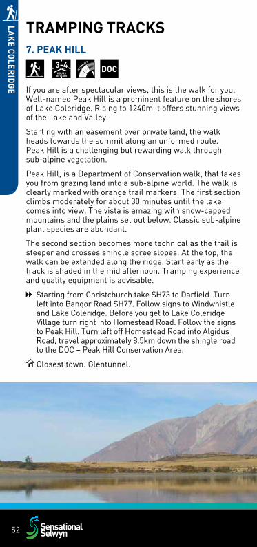
TrAMPING TrACKS7. PEAK hILL
3-4
hOurSrETurN
DOC
If you are after spectacular views, this is the walk for you. Well-namedPeakHillisaprominentfeatureontheshoresof Lake Coleridge. Rising to 1240m it offers stunning views of the Lake and Valley.
Starting with an easement over private land, the walk heads towards the summit along an unformed route. Peak Hill is a challenging but rewarding walk through sub-alpinevegetation.
Peak Hill, is a Department of Conservation walk, that takes youfromgrazinglandintoasub-alpineworld.Thewalkisclearly marked with orange trail markers. The first section climbs moderately for about 30 minutes until the lake comesintoview.Thevistaisamazingwithsnow-cappedmountainsandtheplainssetoutbelow.Classicsub-alpineplant species are abundant.
The second section becomes more technical as the trail is steeper and crosses shingle scree slopes. At the top, the walk can be extended along the ridge. Start early as the track is shaded in the mid afternoon. Tramping experience and quality equipment is advisable.
Starting from Christchurch take SH73 to Darfield. Turn left into Bangor Road SH77. Follow signs to Windwhistle and Lake Coleridge. Before you get to Lake Coleridge Village turn right into Homestead Road. Follow the signs to Peak Hill. Turn left off Homestead Road into Algidus Road, travel approximately 8.5km down the shingle road to the DOC – Peak Hill Conservation Area.
Closest town: Glentunnel.

LAKE COLERIDGE
walking tracks 53
TE ArArOA (ThE LONG PAThWAY): NEW ZEALAND’S NATIONAL WALKWAY (8-10)
4-5
hOurSrETurN
14.6KILOMETrES
The Te Araroa trail is a national walkway covering the length of NZ and it comes around Lake Coleridge and through Lake Coleridge Village. There are track notes for this part of the walkway on www.teararoa.org.nz and orange markers for most of the track (there are however no markers for some middle sections, so most trackers use a combination of markers and and trail notes). NOTE: The trail information on the Te Araroa website has been arranged for people heading south.Thefollowingdescriptionshavebeenre-orderedasmost day trippers start in the Village and travel north to the Lake and then return the same way.
The terrain is a combination of tramping track and gravel road so strong footwear is recommended. The track is suitable for children aged 10 and over, however the first third of the walk (the Arboretum section) involves a steady hill climb before it connects higher up on Intake Road. For a gentler climb, walkers can simply walk up Intake Road. Walkers can also drive from Lake Coleridge Village up Intake Road towards the lake and just walk the Lake Hill Track section of the track. The start of the Lake Hill Track is marked with Te Araroa signage and a stile next to a gate, found at the Lake Coleridge end of Intake Road.
Intake Road is signposted as a ‘Private Road’ because TrustPower, which manages the Lake Coleridge Power Station, owns it. The road is generally kept in good condition, however drivers use it at their own risk. Alternatively, drivers can reach the start of the Lake Hill Track using Homestead Road and Algidus Road (Intake Road is a shortcut from the Village).
Starts at Hart Arboretum Gate on Intake Road in Lake Coleridge Village.

LAKE COLERIDGE
54
Public toilets are available in Lake Coleridge Village. Accommodation available at Lake Coleridge Lodge and elsewhere in the wider area (see: www.lakecoleridgenz.info for more on the area’s accommodation, activities and services). There are no cafes, fuel or other services in Lake Coleridge Village. The nearest cafe is at Terrace Downs Golf Resort (approx. 15mins drive from Lake Coleridge Village heading back towards Christchurch).
Closest town: Glentunnel.
It is advisable that walkers print the track notes on www.teararoa.org.nz/canterburybecausethereareno track markers on the road which connects the Arboretum and Lake Hill Tracks. Ensure you have adequate supplies before heading into the Lake Coleridge high country as there are no shops, fuel or other services in Lake Coleridge Village or the surrounding area.

LAKE COLERIDGE
walking tracks 55
8. TE ArArOA (ThE LONG PAThWAY): Arboretum Track
20
MINuTES 0.9
KILOMETrES Closest town: Glentunnel.
9. TE ArArOA (ThE LONG PAThWAY): road Connection to Lake hill Track
40
MINuTES 2.9
KILOMETrES Closest town: Glentunnel.
10. TE ArArOA (ThE LONG PAThWAY): Lake hill to homestead road
75
MINuTES 3.5
KILOMETrES Closest town: Glentunnel.

L a k e E l l e s m e r e( T e W a i h o r a )
Lake Coleridge
W a i m a k a r i r i R i v e r
Ra k a i a
R i v e r
OxfordOxford RangioraRangiora
!
!
!
!
!
!
!
!
!
!
!
!
!
!!
!
!
!
!
!
!
!
!
!
!
!
!
!
!
!
A r t h u r ' s P a s sN a t i o n a l P a r k
C r a i g i e b u r nF o r e s t P a r k
K o r o w a i T o r l e s s eT u s s o c k l a n d s P a r k
P o r t e r H e i g h t sC o n s e r v a t i o n
A r e a
Shand
s Road
Harewood Road
Two Chain Road
High Stree t
Moorhouse AvenueTuam S tree t
Tunn elRoad
Spri n
gsRoad
Ricca rton Road
Willis
Road
Whitecli ffsRoad
Papanui Road
Hororata Dunsandel Road
Sabys Road
Sawyers
Arms Road
Dyers
Road
Coaltrack Road
Memorial Avenue
Old S
outh
Roa
d
Selwyn Lake Road
North Raka iaR
oad
Coleridge Rd
Slee
man
s R
oad
Lynd
on
Rd
HighPeak Rd
Bealey Rd
Mai
nN
o rth
Roa
d
Cha
tter
tons
Roa
d
Bexl eyR
oad
Ma rsh lan d
Ro ad
Joll i
esR
oad
Dav
ies
Rd
Harper Rd
Day
sR
oad
RakaiaTerrace
Road
SnowdonR
d
Ho m
e ste
adR
d
Alg idusRd
Old
Tai T
apu
Roa
d
Inland Scenic Route 72
|
73
|
75
|
1
|
77
|
73
0 5 10km
LeestonLeeston
LincolnLincoln
RollestonRolleston
West MeltonWest Melton
DarfieldDarfield
SheffieldSheffield
SpringfieldSpringfield
KirweeKirwee
Tai TapuTai Tapu
Castle HillCastle Hill
WaddingtonWaddington
SouthbridgeSouthbridge
DunsandelDunsandel
CoalgateCoalgateGlentunnelGlentunnel
Lake ColeridgeLake Coleridge
PrebbletonPrebbleton
Rakaia HutsRakaia Huts
DoylestonDoyleston
SpringstonSpringston
WhitecliffsWhitecliffs
HororataHororata
BurnhamBurnham
TempletonTempleton
Upper Selwyn HutsUpper Selwyn Huts
Lower Selwyn HutsLower Selwyn Huts
MotukararaMotukarara
WindwhistleWindwhistle
Arthurs PassArthurs Pass
ChristchurchChristchurch
!
! Town
State highway
Park & Conservation Land
Selwyn District Boundary
KEY
7
0 2.5 5km
31
2
8
4
Selwyn District
Ashburton District
LAKE COLERIDGE
56

L a k e E l l e s m e r e( T e W a i h o r a )
Lake Coleridge
W a i m a k a r i r i R i v e r
Ra k a i a
R i v e r
OxfordOxford RangioraRangiora
!
!
!
!
!
!
!
!
!
!
!
!
!
!!
!
!
!
!
!
!
!
!
!
!
!
!
!
!
!
A r t h u r ' s P a s sN a t i o n a l P a r k
C r a i g i e b u r nF o r e s t P a r k
K o r o w a i T o r l e s s eT u s s o c k l a n d s P a r k
P o r t e r H e i g h t sC o n s e r v a t i o n
A r e a
Shand
s Road
Harewood Road
Two Chain Road
High Stree t
Moorhouse AvenueTuam S tree t
Tunn elRoad
Spri n
gsRoad
Ricca rton Road
Willis
Road
Whitecli ffsRoad
Papanui Road
Hororata Dunsandel Road
Sabys Road
Sawyers
Arms Road
Dyers
Road
Coaltrack Road
Memorial Avenue
Old S
outh
Roa
d
Selwyn Lake Road
North Raka iaR
oad
Coleridge Rd
Slee
man
s R
oad
Lynd
on
Rd
HighPeak Rd
Bealey Rd
Mai
nN
o rth
Roa
d
Cha
tter
tons
Roa
d
Bexl eyR
oad
Ma rsh lan d
Ro ad
Joll i
esR
oad
Dav
ies
Rd
Harper Rd
Day
sR
oad
RakaiaTerrace
Road
SnowdonR
d
Ho m
e ste
adR
d
Alg idusRd
Old
Tai T
apu
Roa
d
Inland Scenic Route 72
|
73
|
75
|
1
|
77
|
73
0 5 10km
LeestonLeeston
LincolnLincoln
RollestonRolleston
West MeltonWest Melton
DarfieldDarfield
SheffieldSheffield
SpringfieldSpringfield
KirweeKirwee
Tai TapuTai Tapu
Castle HillCastle Hill
WaddingtonWaddington
SouthbridgeSouthbridge
DunsandelDunsandel
CoalgateCoalgateGlentunnelGlentunnel
Lake ColeridgeLake Coleridge
PrebbletonPrebbleton
Rakaia HutsRakaia Huts
DoylestonDoyleston
SpringstonSpringston
WhitecliffsWhitecliffs
HororataHororata
BurnhamBurnham
TempletonTempleton
Upper Selwyn HutsUpper Selwyn Huts
Lower Selwyn HutsLower Selwyn Huts
MotukararaMotukarara
WindwhistleWindwhistle
Arthurs PassArthurs Pass
ChristchurchChristchurch
!
6 5
LAKE COLERIDGE
walking tracks 57

SPRINGFIELD, DARFIELD, KIRWEE & GLENTUNNEL
58
ShOrT WALKS 1. DArFIELD TOWN WALK - WALKWAY A
60
MINuTES
1. From the Clock Tower, walk past the shops and through to the War Memorial.
2. The walkway travels along the edge of the Primary School grounds and past the stone gates – the original entrance to St Andrew’s Church.
3. Follow the road to the Baptist Church grounds, then go through Avoca Place Reserve, past Darfield High School and into Devon Crescent.
4. Walk diagonally across Daniel Mulholland Reserve, through the walkway and turn right into Stotts Drive. If you prefer a shorter route, turn right into Next Lane that leads to Churchlea Place.
5. Walk over culvert, and turn right at the marker into the walkway through to Piaka Place. At the end of this street turn onto Bangor Road. Pass by Pearson Reserve and go through the Trinity Church grounds to return to the Clock Tower.
Start from The Clock Tower in Darfield’s main street (corner of Ross St and South Tce).
Closest town: Darfield.
The green posts with red markers should be followed.

SPRINGFIELD, DARFIELD, KIRWEE & GLENTUNNEL
walking tracks 59
2. DArFIELD TOWN WALK - WALKWAY B
60
MINuTES
1. From the Clock Tower, cross the main street and follow the marker posts through the Railway Reserve Subdivision to the Recreation Reserve sports grounds.
2. Turn right into Maxwell Street and continue along the sports fields, across Horndon Street and through the walkway to Craigieburn Street.
3.Theright-of-waythroughtoKowhaiDriveisplantedinrhododendrons and crabapples.
4. Follow along Kowhai Drive into Horndon Street, pass the tennis courts, go along the sportsfields, and around the lake. Follow the marker posts through the hedge and onto North Terrace.
5. The final section takes you through the Westview Park development, past the Youth Park, and back to the Clock Tower.
Start from The Clock Tower in Darfield’s main street (corner of Ross St and South Tce).
Closest town: Darfield.
CLOCK TOWER
!( Walkway Landmarks1

SPRINGFIELD, DARFIELD, KIRWEE & GLENTUNNEL
60
WALKING TrACKS 3. GLENTuNNEL MILLENNIuM WALK
80
MINuTESrETurN
The track follows the route of an abandoned mine tramway across farmland to the mouth of a former coal mine. The track starts at the old stables that housed the pit ponies and draft horses which were used to work the mine and carry coal back to the railway in the 1870s. The track is marked with white road markers along the route. Crossing farmland and gentle hills, the track comes to a junction with an optional trek up to the top of the hill, or a continuation to the mine site into the forested gully below. A picnic table is at the track end, and a sheltered spot for a break. You can wander to the mouth of the abandoned mine, and see the remains of equipment used for extraction. Useful signs along the route tell the history of the mine.
Excellent destination for a family with children.
Start from Christchurch take SH73. Turn left into Bealey Road following signs to Hororata. At the roundabout take the 2nd exit to Hororata Road. Continue onto Bridge Street. Turn left onto Coaltrack Road. Turn left onto Homebush Road.
The township of Glentunnel lies west of Christchurch on SH72. The Glentunnel Millennium walkway was established by a group of townsfolk to mark the turn of the millennium. The walkway is clearly signposted from the main road, with ample parking along Philip Street.
Closest town: Glentunnel.
Expect snow in winter.
4. KIrWEE WALK
40
MINuTES 3
KILOMETrES
The walk goes along Courtenay Road to Hoskyns Road, up to the walkway, through the Reserve, and back on to Tramway Road then down to the kiosk. You can also opt for a shorter trip by cutting through the A&P grounds and down High Street.
Toilets are available at the corner of the Reserve beside the children’s playground.
Closest town: Kirwee.

SPRINGFIELD, DARFIELD, KIRWEE & GLENTUNNEL
walking tracks 61
5. KOWAI BuSh WALK
-1
hOur
The reserve is essentially a set of meandering loop tracks set in dense beech forest. Once a thriving community built around farming and the Midland railway, Kowai Bush Reserve is steeped in history as one of the earliest European settlements in the country. Kowai means “between the waters” and in the 1800s it was dense native bush of the hardiest kind, noted for its abundant birdlife. Today only a small remnant of the typical Lowland Beech forest remains, preserved by the efforts of Bevan Brown and the Harris Family.
This can be an excellent track for visitors, it is an example of how the native forests used to be, and is accessible and easy walking. The tracks are not too steep, which also makes it appropriate for children.
Starting point is Kowai Bush Reserve which lies about 8km off the Great Alpine Highway (SH73) just before Springfield.
From Darfield take the Great Alpine Highway (SH73) clearly marked to Springfield. Less than 1km before Springfield turn right onto Domain Rd. Kowai Pass Reserve is clearly signposted at the railway crossing. Travel 2km until Domain Road takes a left into Pococks Road. Less than 1km along, turn right into Kowai Road with the signpost ‘Kowai Bush’. Travel 5km until crossing the railway and the road becomes gravel. The entrance to the reserve is 300m on the right.
There is a map and toilet at the entrance. There are places to stop in Springfield for refreshments.
Closest town: Springfield.
This is a private scenic reserve that is open to the public. Due to its sheltered beech forest, this walk is achievable in most weather conditions. Visitors should however take care with slippery tree roots when it’s wet. Sneakers, sturdy shoes, or sport sandals are all suitable footwear.

L a k e E l l e s m e r e( T e W a i h o r a )
Lake Coleridge
W a i m a k a r i r i R i v e r
Ra k a i a
R i v e r
OxfordOxford RangioraRangiora
!
!
!
!
!
!
!
!
!
!
!
!
!
!!
!
!
!
!
!
!
!
!
!
!
!
!
!
!
!
A r t h u r ' s P a s sN a t i o n a l P a r k
C r a i g i e b u r nF o r e s t P a r k
K o r o w a i T o r l e s s eT u s s o c k l a n d s P a r k
P o r t e r H e i g h t sC o n s e r v a t i o n
A r e a
Shand
s Road
Harewood Road
Two Chain Road
High Stree t
Moorhouse AvenueTuam S tree t
Tunn elRoad
Spri n
gsRoad
Ricca rton Road
Willis
Road
Whitecli ffsRoad
Papanui Road
Hororata Dunsandel Road
Sabys Road
Sawyers
Arms Road
Dyers
Road
Coaltrack Road
Memorial Avenue
Old S
outh
Roa
d
Selwyn Lake Road
North Raka iaR
oad
Coleridge Rd
Slee
man
s R
oad
Lynd
on
Rd
HighPeak Rd
Bealey Rd
Mai
nN
o rth
Roa
d
Cha
tter
tons
Roa
d
Bexl eyR
oad
Ma rsh lan d
Ro ad
Joll i
esR
oad
Dav
ies
Rd
Harper Rd
Day
sR
oad
RakaiaTerrace
Road
SnowdonR
d
Ho m
e ste
adR
d
Alg idusRd
Old
Tai T
apu
Roa
d
Inland Scenic Route 72
|
73
|
75
|
1
|
77
|
73
0 5 10km
LeestonLeeston
LincolnLincoln
RollestonRolleston
West MeltonWest Melton
DarfieldDarfield
SheffieldSheffield
SpringfieldSpringfield
KirweeKirwee
Tai TapuTai Tapu
Castle HillCastle Hill
WaddingtonWaddington
SouthbridgeSouthbridge
DunsandelDunsandel
CoalgateCoalgateGlentunnelGlentunnel
Lake ColeridgeLake Coleridge
PrebbletonPrebbleton
Rakaia HutsRakaia Huts
DoylestonDoyleston
SpringstonSpringston
WhitecliffsWhitecliffs
HororataHororata
BurnhamBurnham
TempletonTempleton
Upper Selwyn HutsUpper Selwyn Huts
Lower Selwyn HutsLower Selwyn Huts
MotukararaMotukarara
WindwhistleWindwhistle
Arthurs PassArthurs Pass
ChristchurchChristchurch
!
0 2.5 5km
3
5
SPRINGFIELD, DARFIELD, KIRWEE & GLENTUNNEL
62

L a k e E l l e s m e r e( T e W a i h o r a )
Lake Coleridge
W a i m a k a r i r i R i v e r
Ra k a i a
R i v e r
OxfordOxford RangioraRangiora
!
!
!
!
!
!
!
!
!
!
!
!
!
!!
!
!
!
!
!
!
!
!
!
!
!
!
!
!
!
A r t h u r ' s P a s sN a t i o n a l P a r k
C r a i g i e b u r nF o r e s t P a r k
K o r o w a i T o r l e s s eT u s s o c k l a n d s P a r k
P o r t e r H e i g h t sC o n s e r v a t i o n
A r e a
Shand
s Road
Harewood Road
Two Chain Road
High Stree t
Moorhouse AvenueTuam S tree t
Tunn elRoad
Spri n
gsRoad
Ricca rton Road
Willis
Road
Whitecli ffsRoad
Papanui Road
Hororata Dunsandel Road
Sabys Road
Sawyers
Arms Road
Dyers
Road
Coaltrack Road
Memorial Avenue
Old S
outh
Roa
d
Selwyn Lake Road
North Raka iaR
oad
Coleridge Rd
Slee
man
s R
oad
Lynd
on
Rd
HighPeak Rd
Bealey Rd
Mai
nN
o rth
Roa
d
Cha
tter
tons
Roa
d
Bexl eyR
oad
Ma rsh lan d
Ro ad
Joll i
esR
oad
Dav
ies
Rd
Harper Rd
Day
sR
oad
RakaiaTerrace
Road
SnowdonR
d
Ho m
e ste
adR
d
Alg idusRd
Old
Tai T
apu
Roa
d
Inland Scenic Route 72
|
73
|
75
|
1
|
77
|
73
0 5 10km
LeestonLeeston
LincolnLincoln
RollestonRolleston
West MeltonWest Melton
DarfieldDarfield
SheffieldSheffield
SpringfieldSpringfield
KirweeKirwee
Tai TapuTai Tapu
Castle HillCastle Hill
WaddingtonWaddington
SouthbridgeSouthbridge
DunsandelDunsandel
CoalgateCoalgateGlentunnelGlentunnel
Lake ColeridgeLake Coleridge
PrebbletonPrebbleton
Rakaia HutsRakaia Huts
DoylestonDoyleston
SpringstonSpringston
WhitecliffsWhitecliffs
HororataHororata
BurnhamBurnham
TempletonTempleton
Upper Selwyn HutsUpper Selwyn Huts
Lower Selwyn HutsLower Selwyn Huts
MotukararaMotukarara
WindwhistleWindwhistle
Arthurs PassArthurs Pass
ChristchurchChristchurch
!
! Town
State highway
Park & Conservation Land
Selwyn District Boundary
KEY
412
Selwyn District
Waimakariri District
SPRINGFIELD, DARFIELD, KIRWEE & GLENTUNNEL
walking tracks 63

64
SELWYN CYCLING & BIKINGAquADOS TOur OF SELWYN rOuTEThis is a 161.77km bike ride just south of Christchurch. The bike ride has a total ascent of 184.0m and has a maximum elevation of 37.0m.
The Selwyn District is renowned by road cyclists for its long straight and picturesque rural roads. Whether you’re looking to stretch your legs after work or pound out the kms intheweekend,theroadsaroundLincolnandTeWaihora/Lake Ellesmere are perfect for all levels of road cyclists.
AVOCA hOMESTEAD (huT)
2-4
hOurS 25
KILOMETrES GrADE2
EASY
The homestead was built in 1906 and has recently undergone extensive restoration to preserve its heritage value. It features six bunks, three bedrooms, a lounge and kitchen.Category:standard(1hutticket/night).
From the Avoca homestead there are a few tracks behind the homestead suitable for mountain biking day trips. From the 2WD car park, it is possible to continue along a track to Broken River which must be forded to reach the Avoca homestead. Access may not be possible when the river is high.
Starting Point: Access to Avoca Homestead is via Craigieburn Road which turns off SH73 near Cass. This is a gravel road which provides 2WD access to within 30 minutes walk of the homestead. There are at least six railway crossings along this road with no warnings of oncoming trains. There are also numerous gates across the road. Leave all gates as you find them.
Closest town: Springfield.
SELWYN
CYCLING &
BIKING

biking tracks 65biking tracks 65
BrOKEN rIVEr SKI FIELD rOAD
1 -2
hOurS 6
KILOMETrES GrADE3
INTErMEDIATE
The road leaves Craigieburn Picnic Area following Cave Stream and climbs to Jacks Pass. The road follows the valley beyond the locked gate, winding its way to Windy Corner and on to the club huts. Beyond the day lodge on the Ski Field, sections of the road are steep and loose but the ski basin can be accessed by bike.
Starting point: Craigieburn Forest Park is approximately 100km from Christchurch on the Great Alpine Highway (SH73) towards Arthur’s Pass and is accessed via the signposted side road to Craigieburn Picnic Area.
Closest town: Springfield.
BrOKEN rIVEr SKI FIELD rOAD TO CAMP SADDLE
2
hOurS 2.5
KILOMETrES GrADE3
INTErMEDIATEuPhILL
Camp Saddle Track starts opposite the ski club tractor shed beyond the locked gate on Broken River ski field road. An old 4WD drive track narrows as it steadily climbs through beech forest. The track then comes out into open tussocks; poles mark the route to Camp Saddle.
Enjoy the magnificent views from the tussock and scree saddle before returning the same way
Starting point: Craigieburn Forest Park is approximately 100km from Christchurch on the Great Alpine Highway (SH73) towards Arthur’s Pass and is accessed via the signposted side road to Craigieburn Picnic Area.
Closest town: Springfield
SELWYN
CYCLING &
BIKING

66
CrAIGIEBurN VALLEY & LYNDON SADDLE LOOP
2-3
hOurS 17
KILOMETrES GrADE3
INTErMEDIATEDOWNhILL
GrADE4ADVANCED
DOWNhILL
The first part of the track is the most difficult as you traverse from the bottom of the first rope tow (only operating in winter) back towards Broken River Ski Area. The track keeps changing between beech clad single track to exposed scree (jagged and loose rock). The track is very well formed but the exposure will keep even the most seasoned riders on their toes.
Once you’ve navigated the traverse (mainly flat or downhill) there’s a short and easy climb, then it’s all downhill through a single track. Fast and flowing there’s also plenty of technical sections thrown into the mix. Once you cross the bridge at the end of the track just follow the gravel road back to your car.
There is one intersection on the way down, make sure to go left! If you go right, you will end up at the Mt Cheeseman Road and so will need to ride back up the highway or make your way onto the Hogs Back MTB track.
Craigieburn Forest Park is approximately 100km from Christchurch on the Great Alpine Highway (SH73) towards Arthur’s Pass and is accessed via the signposted side road to Craigieburn Picnic Area. Park your car up at the Broken River car park just off SH73. Ride west along the highway for 1km then take the turn off to Craigieburn Valley Ski Area. It’s a 6km climb up a 4WD road to the start of the track.
Closest town: Springfield.
SELWYN
CYCLING &
BIKING

67biking tracks 67
DrACOPhYLLuM FLAT TrACK
1
hOurrETurN
1.8KILOMETrES
GrADE3INTErMEDIATE
The Dracophyllum Flat Track begins opposite the road intersection and gradually descends to Broken River. The pole bridge is not suitable for bikes, and riders will need to ford the river instead. The track then briefly ascends through Mountain beech to a sheltered clearing which is coveredbyred-brownDracophyllum,nativetussockandahostofsmallherbsandground-coverplants.
This is a popular picnic site so ensure you watch out for other users.
Starting point: Craigieburn Forest Park is approximately 100km from Christchurch on the Great Alpine Highway (SH73) towards Arthur’s Pass and is accessed via the signposted side road to Craigieburn Picnic Area. Take the road from the Craigieburn Picnic Area following Cave Stream to Broken River Ski Field road.
Closest town: Springfield.
hOGS BACK MOuNTAIN BIKE TrACK
VArYING
DISTANCES
From the access road to Thomas Bush just west of Castle Hill Village the track climbs through beech forest onto the Long Spur ridgeline. After following the ridgeline the track then descends across the open flats below Long Spur to the beech forest at Long Creek. A ride through the beech forest is followed by a short climb up the true right of Waterfall Creek. After crossing Waterfall Creek the track then traverses across to the western side of the Hogs Back ridge before dropping down to Texas Flat (via Ernie’s Mistake).
The return ride back to Castle Hill Village can be made by either taking the reverse track route or by riding 4.7km down the Cheeseman Skifield access road to SH73 and then 2.3km along SH73 back to Castle Hill (note this section of SH73 includes a 90m climb).
Track length Castle Hill Village to Texas Flat: 7.4km. Total ascent Castle Hill Village to Texas Flat: 425m. Total ascent Texas Flat to Castle Hill Village: 369m. Round trip distance via the Cheeseman Skifield Road:
15.6km, 525m ascent.
Start behind Castle Hill Village on the road to the Thomas Bush and St Andrew’s Lodge or from Texas Flat on the Cheeseman Ski Field Road.
SELWYN
CYCLING &
BIKING

68
LITTLE rIVEr rAIL TrAILIn2003theChristchurch-LittleRiverRailTrailTrustwasestablished to transform the former railway route into a trail catering for walkers and cyclists wishing to view the region at close quarters, while avoiding the traffic on the busy road between Little River and Christchurch.
Sixsections-seeeachsectionforcompletiontimes.
Low intensity –Trail is flat. City Cycle hire. Public toilets, cafés, dining, parking, and accomodation available at each township.
LITTLE rIVEr rAIL TrAIL - SECTION 1:Christchurch (hornby) To Prebbleton
20
MINuTES 4
KILOMETrES GrADE1BEGINNEr
FLAT
The section is sealed and follows Shands Rd to the intersection with Marshs Rd, crosses the road and follows the south side of Marshs Rd to the old railway corridor which takes users through to the village of Prebbleton in Selwyn District.
To connect to the next section of the Rail Trail that goes to Lincoln, use the cycle lanes along Springs Rd through Prebbleton,turnleftintoBirchesRdandpickuptheoff-road trail just after the Trices Rd intersection.
StartfromtheShandsRdcarpark-locatedabout400msouthoftheShandsRd-HalswellJunctionRdintersection.
Closest town: Christchurch.
SELWYN
CYCLING &
BIKING

biking tracks 69biking tracks 69
LITTLE rIVEr rAIL TrAIL - SECTION 2: Prebbleton to Lincoln
35
MINuTES 7
KILOMETrES GrADE1BEGINNEr
FLAT ThissectionstartsattheBirchsRd-TricesRdintersectionandisa7kmoff-roadashphaltpathwayalongsideBirchsRd,andthen James St, to the township of Lincoln. It runs alongside the original railway line through pleasant rural surroundings and is wide enough to enable cycling in both directions.
Starting point: In Prebbleton join the Rail Trail either in the township on Springs Road, where there is a cycleway markedontheroadseal,orfromthestartoftheoff-roadsectionattheBirchesRd-TricesRdintersection.
Public toilets by Prebbleton Reserve (by Children’s Playground) and Lincoln.
Closest town: Prebbleton.
LITTLE rIVEr rAIL TrAIL - SECTION 3: Lincoln To Ahuriri reserve
50
MINuTES 10
KILOMETrES GrADE1BEGINNEr
FLAT
From Lincoln township, the Rail Trail goes alongside Edward Street. There will be an offroad Rail Trail connection built through to Moirs Lane. In the meantime, continue along Edward Street and turn right into Ellesmere Road. After 1.1km on the left there is an offroad Rail Trail link that goes through to Collins East Road and River Road. Go right into River Road, which follows alongside the Halswell River, a very attractive spring-fedriverthatfeedsintoTeWaihora/LakeEllesmere.
Startingpoint:attheJamesSt-EastBeltintersectionturn left into East Belt which connects to Edward St.
Closest town: Lincoln.
SELWYN
CYCLING &
BIKING

70
LITTLE rIVEr rAIL TrAIL - SECTION 4: Ahuriri reserve to Motukarara
25
MINuTES 4
KILOMETrES GrADE1BEGINNEr
FLAT
Thissectionisoff-roadandthesurfaceishardpackedgravel. The route is adjacent to the Halswell Canal but deviates away onto farmland for a approximately 1.7km to reduce the impact of disturbance on the visiting bird life. The bird life will be a key attraction of this unique wetland area. The Waihora Ellesmere Trust (WET), Rail Trail Trust and Environment Canterbury are working together to enhance the wetland for wildlife, and provide interpretation signage to promote the importance of this wetland ecosystem and inform Rail Trail users of its sensitivity and value to the environment.
Starting point: the Ahuriri Section starts at the eastern end of Neills Rd, park on the grass verge.
Closest town: Motukarara.
LITTLE rIVEr rAIL TrAIL SECTION 5: Motukarara to Birdlings Flat
70
MINuTES 13
KILOMETrES GrADE1BEGINNEr
FLAT Most of this section of the Rail Trail runs alongside TeWaihora/LakeEllesmere,wheretherailwayembankment is raised above the lake and adjoining wetlands, affording magnificent views of the surroundings and the prolific birdlife.
This section starts at Motukarara, off Park Rd.
Toilet block and car parking area provided on Park Rd.
Closest town: Motukarara.
SELWYN
CYCLING &
BIKING

biking tracks 71biking tracks 71
LITTLE rIVEr rAIL TrAIL - SECTION 6: Birdlings Flat to Little river
40
MINuTES 7
KILOMETrES GrADE1BEGINNEr
FLAT Most of this section traverses along the old railway embankment beside Te Roto o Wairewa (Lake Forsyth). The Rail Trail currently ends at Kinloch Road, a few hundred metres from the Little River township.
This section starts on Poranui Beach Rd.
Toilets at Catons Bay and in the Little River township.
Closest town: Little River.
MT WhITE rOAD
2
hOurS 25
KILOMETrES GrADE1BEGINNEr
The Mt White Road traverses along tussock flats bordering the grand Waimakariri River, with wide sweeping views up the valley. Approximately 25km of unsealed road, allow approximately 2 hours from Mt White Bridge to Poulter River one way.
Starting point: Mt White Road turns off from SH73 just before the highway drops down to follow the Waimakariri, about 25km east of Arthur’s Pass village.
Closest town: Arthur’s Pass.
SELWYN
CYCLING &
BIKING

72
POuLTEr VALLEY
3
hOurS 27
KILOMETrES GrADE2
EASY GrADE3
INTErMEDIATE From Mt White Road, follow the 4WD track for 13km, across river terraces and fans to reach the park boundary fence (Grade 3 section).
From the park boundary fence, it is easy riding along an old 4WD track over river flats and through the bush to the Casey Stream and Hut (Grade 2 section).
Beyond the hut, cross Casey Stream but DO NOT take the track through the beech forest. Instead, the route for bikers ventures out into the Poulter riverbed for 2km, crossingtherivertwice-pleasetakecare.Followanother4WD track across river flats for another 4km to reach theTrust/PoulterHut-theendpointformountainbikeaccess.
Starting point: take SH73 from Christchurch towards the West Coast. About 25km east of Arthur’s Pass village, turn onto Mt White Road. Travel for 20km along this gravel road until just before it crosses the Poulter River. The track starts here.
Closest town: Arthur’s Pass.
STArVATION GuLLY TO TrIG M
1hOurS
3.2KILOMETrES
GrADE3INTErMEDIATE
uPhILL
From the signpost on SH73, climb the marked track amongst diverse shrublands, traversing open ridges to reach Trig M. About half way up, the track from Coach Stream joins this track from the southeast.
SELWYN
CYCLING &
BIKING
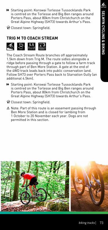
biking tracks 73biking tracks 73
Starting point: Korowai Torlesse Tussocklands Park is centred on the Torlesse and Big Ben ranges around Porters Pass, about 80km from Christchurch on the Great Alpine Highway (SH73) towards Arthur’s Pass.
Closest town: Springfield.
TrIG M TO COACh STrEAM
1hOurS
5.5KILOMETrES
GrADE3INTErMEDIATEDOWNhILL
The Coach Stream Route branches off approximately 1.5km down from Trig M. The route sidles alongside a ridge before passing through a gate to follow a farm track through part of Ben More Station. A gate at the end of the 4WD track leads back into public conservation land. Follow SH73 over Porters Pass back to Starvation Gully (an additional 4.5km).
Starting point: Korowai Torlesse Tussocklands Park is centred on the Torlesse and Big Ben ranges around Porters Pass, about 80km from Christchurch on the Great Alpine Highway (SH73) towards Arthur’s Pass.
Closest town: Springfield.
Note: Part of this route is an easement passing through Ben More Station and is closed for lambing from 1 October to 20 November each year. Dogs are not permitted in this section.
SELWYN
CYCLING &
BIKING

L a k e E l l e s m e r e( T e W a i h o r a )
Lake Coleridge
W a i m a k a r i r i R i v e r
Ra k a i a
R i v e r
OxfordOxford RangioraRangiora
!
!
!
!
!
!
!
!
!
!
!
!
!
!!
!
!
!
!
!
!
!
!
!
!
!
!
!
!
!
A r t h u r ' s P a s sN a t i o n a l P a r k
C r a i g i e b u r nF o r e s t P a r k
K o r o w a i T o r l e s s eT u s s o c k l a n d s P a r k
P o r t e r H e i g h t sC o n s e r v a t i o n
A r e a
Shand
s Road
Harewood Road
Two Chain Road
High Stree t
Moorhouse AvenueTuam S tree t
Tunn elRoad
Spri n
gsRoad
Ricca rton Road
Willis
Road
Whitecli ffsRoad
Papanui Road
Hororata Dunsandel Road
Sabys Road
Sawyers
Arms Road
Dyers
Road
Coaltrack Road
Memorial Avenue
Old S
outh
Roa
d
Selwyn Lake Road
North Raka iaR
oad
Coleridge Rd
Slee
man
s R
oad
Lynd
on
Rd
HighPeak Rd
Bealey Rd
Mai
nN
o rth
Roa
d
Cha
tter
tons
Roa
d
Bexl eyR
oad
Ma rsh lan d
Ro ad
Joll i
esR
oad
Dav
ies
Rd
Harper Rd
Day
sR
oad
RakaiaTerrace
Road
SnowdonR
d
Ho m
e ste
adR
d
Alg idusRd
Old
Tai T
apu
Roa
d
Inland Scenic Route 72
|
73
|
75
|
1
|
77
|
73
0 5 10km
LeestonLeeston
LincolnLincoln
RollestonRolleston
West MeltonWest Melton
DarfieldDarfield
SheffieldSheffield
SpringfieldSpringfield
KirweeKirwee
Tai TapuTai Tapu
Castle HillCastle Hill
WaddingtonWaddington
SouthbridgeSouthbridge
DunsandelDunsandel
CoalgateCoalgateGlentunnelGlentunnel
Lake ColeridgeLake Coleridge
PrebbletonPrebbleton
Rakaia HutsRakaia Huts
DoylestonDoyleston
SpringstonSpringston
WhitecliffsWhitecliffs
HororataHororata
BurnhamBurnham
TempletonTempleton
Upper Selwyn HutsUpper Selwyn Huts
Lower Selwyn HutsLower Selwyn Huts
MotukararaMotukarara
WindwhistleWindwhistle
Arthurs PassArthurs Pass
ChristchurchChristchurch
!
14
35
4
6
7
1617
! Town
State highway
Park & Conservation Land
Selwyn District Boundary
KEY
0 2.5 5km
74
SELWYN
CYCLING &
BIKING

L a k e E l l e s m e r e( T e W a i h o r a )
Lake Coleridge
W a i m a k a r i r i R i v e r
Ra k a i a
R i v e r
OxfordOxford RangioraRangiora
!
!
!
!
!
!
!
!
!
!
!
!
!
!!
!
!
!
!
!
!
!
!
!
!
!
!
!
!
!
A r t h u r ' s P a s sN a t i o n a l P a r k
C r a i g i e b u r nF o r e s t P a r k
K o r o w a i T o r l e s s eT u s s o c k l a n d s P a r k
P o r t e r H e i g h t sC o n s e r v a t i o n
A r e a
Shand
s Road
Harewood Road
Two Chain Road
High Stree t
Moorhouse AvenueTuam S tree t
Tunn elRoad
Spri n
gsRoad
Ricca rton Road
Willis
Road
Whitecli ffsRoad
Papanui Road
Hororata Dunsandel Road
Sabys Road
Sawyers
Arms Road
Dyers
Road
Coaltrack Road
Memorial Avenue
Old S
outh
Roa
d
Selwyn Lake Road
North Raka iaR
oad
Coleridge Rd
Slee
man
s R
oad
Lynd
on
Rd
HighPeak Rd
Bealey Rd
Mai
nN
o rth
Roa
d
Cha
tter
tons
Roa
d
Bexl eyR
oad
Ma rsh lan d
Ro ad
Joll i
esR
oad
Dav
ies
Rd
Harper Rd
Day
sR
oad
RakaiaTerrace
Road
SnowdonR
d
Ho m
e ste
adR
d
Alg idusRd
Old
Tai T
apu
Roa
d
Inland Scenic Route 72
|
73
|
75
|
1
|
77
|
73
0 5 10km
LeestonLeeston
LincolnLincoln
RollestonRolleston
West MeltonWest Melton
DarfieldDarfield
SheffieldSheffield
SpringfieldSpringfield
KirweeKirwee
Tai TapuTai Tapu
Castle HillCastle Hill
WaddingtonWaddington
SouthbridgeSouthbridge
DunsandelDunsandel
CoalgateCoalgateGlentunnelGlentunnel
Lake ColeridgeLake Coleridge
PrebbletonPrebbleton
Rakaia HutsRakaia Huts
DoylestonDoyleston
SpringstonSpringston
WhitecliffsWhitecliffs
HororataHororata
BurnhamBurnham
TempletonTempleton
Upper Selwyn HutsUpper Selwyn Huts
Lower Selwyn HutsLower Selwyn Huts
MotukararaMotukarara
WindwhistleWindwhistle
Arthurs PassArthurs Pass
ChristchurchChristchurch
!
215
Selwyn District
Waim
akariri District
biking tracks 75biking tracks 75
SELWYN
CYCLING &
BIKING

L a k e E l l e s m e r e( T e W a i h o r a )
Lake Coleridge
W a i m a k a r i r i R i v e r
Ra k a i a
R i v e r
OxfordOxford RangioraRangiora
!
!
!
!
!
!
!
!
!
!
!
!
!
!!
!
!
!
!
!
!
!
!
!
!
!
!
!
!
!
A r t h u r ' s P a s sN a t i o n a l P a r k
C r a i g i e b u r nF o r e s t P a r k
K o r o w a i T o r l e s s eT u s s o c k l a n d s P a r k
P o r t e r H e i g h t sC o n s e r v a t i o n
A r e a
Shand
s Road
Harewood Road
Two Chain Road
High Stree t
Moorhouse AvenueTuam S tree t
Tunn elRoad
Spri n
gsRoad
Ricca rton Road
Willis
Road
Whitecli ffsRoad
Papanui Road
Hororata Dunsandel Road
Sabys Road
Sawyers
Arms Road
Dyers
Road
Coaltrack Road
Memorial Avenue
Old S
outh
Roa
d
Selwyn Lake Road
North Raka iaR
oad
Coleridge Rd
Slee
man
s R
oad
Lynd
on
Rd
HighPeak Rd
Bealey Rd
Mai
nN
o rth
Roa
d
Cha
tter
tons
Roa
d
Bexl eyR
oad
Ma rsh lan d
Ro ad
Joll i
esR
oad
Dav
ies
Rd
Harper Rd
Day
sR
oad
RakaiaTerrace
Road
SnowdonR
d
Ho m
e ste
adR
d
Alg idusRd
Old
Tai T
apu
Roa
d
Inland Scenic Route 72
|
73
|
75
|
1
|
77
|
73
0 5 10km
LeestonLeeston
LincolnLincoln
RollestonRolleston
West MeltonWest Melton
DarfieldDarfield
SheffieldSheffield
SpringfieldSpringfield
KirweeKirwee
Tai TapuTai Tapu
Castle HillCastle Hill
WaddingtonWaddington
SouthbridgeSouthbridge
DunsandelDunsandel
CoalgateCoalgateGlentunnelGlentunnel
Lake ColeridgeLake Coleridge
PrebbletonPrebbleton
Rakaia HutsRakaia Huts
DoylestonDoyleston
SpringstonSpringston
WhitecliffsWhitecliffs
HororataHororata
BurnhamBurnham
TempletonTempleton
Upper Selwyn HutsUpper Selwyn Huts
Lower Selwyn HutsLower Selwyn Huts
MotukararaMotukarara
WindwhistleWindwhistle
Arthurs PassArthurs Pass
ChristchurchChristchurch
!
0 2.5 5km
8
10
9
76
SELWYN
CYCLING &
BIKING

L a k e E l l e s m e r e( T e W a i h o r a )
Lake Coleridge
W a i m a k a r i r i R i v e r
Ra k a i a
R i v e r
OxfordOxford RangioraRangiora
!
!
!
!
!
!
!
!
!
!
!
!
!
!!
!
!
!
!
!
!
!
!
!
!
!
!
!
!
!
A r t h u r ' s P a s sN a t i o n a l P a r k
C r a i g i e b u r nF o r e s t P a r k
K o r o w a i T o r l e s s eT u s s o c k l a n d s P a r k
P o r t e r H e i g h t sC o n s e r v a t i o n
A r e a
Shand
s RoadHarewood Road
Two Chain Road
High Stree t
Moorhouse AvenueTuam S tree t
Tunn elRoad
Spri n
gsRoad
Ricca rton Road
Willis
Road
Whitecli ffsRoad
Papanui Road
Hororata Dunsandel Road
Sabys Road
Sawyers
Arms Road
Dyers
Road
Coaltrack Road
Memorial Avenue
Old S
outh
Roa
d
Selwyn Lake Road
North Raka iaR
oad
Coleridge Rd
Slee
man
s R
oad
Lynd
on
Rd
HighPeak Rd
Bealey Rd
Mai
nN
o rth
Roa
d
Cha
tter
tons
Roa
d
Bexl eyR
oad
Ma rsh lan d
Ro ad
Joll i
esR
oad
Dav
ies
Rd
Harper Rd
Day
sR
oad
RakaiaTerrace
Road
SnowdonR
d
Ho m
e ste
adR
d
Alg idusRd
Old
Tai T
apu
Roa
d
Inland Scenic Route 72
|
73
|
75
|
1
|
77
|
73
0 5 10km
LeestonLeeston
LincolnLincoln
RollestonRolleston
West MeltonWest Melton
DarfieldDarfield
SheffieldSheffield
SpringfieldSpringfield
KirweeKirwee
Tai TapuTai Tapu
Castle HillCastle Hill
WaddingtonWaddington
SouthbridgeSouthbridge
DunsandelDunsandel
CoalgateCoalgateGlentunnelGlentunnel
Lake ColeridgeLake Coleridge
PrebbletonPrebbleton
Rakaia HutsRakaia Huts
DoylestonDoyleston
SpringstonSpringston
WhitecliffsWhitecliffs
HororataHororata
BurnhamBurnham
TempletonTempleton
Upper Selwyn HutsUpper Selwyn Huts
Lower Selwyn HutsLower Selwyn Huts
MotukararaMotukarara
WindwhistleWindwhistle
Arthurs PassArthurs Pass
ChristchurchChristchurch
!
! Town
State highway
Park & Conservation Land
Selwyn District Boundary
KEY
12
11
13
1
77biking tracks
SELWYN
CYCLING &
BIKING

78
Selwyn District Council2 Norman Kirk Drive, RollestonPO Box 90, Rolleston 7643P. +64 3 347 2800
www.sensationalselwyn.co.nz
Escape to Selwyn – only 20 minutes from Christchurch
Stretching from the Pacific Ocean to the Southern Alps, theSelwyn District offers a diverse range of fun activities for couples, families
and thrill seekers to experience whilst in our beautiful District.
Discover places to go and things to do ... take a tour of our beautifulgardens, sample our amazing wines & artisan food, relax in ourboutique accommodation, enjoy our walking and biking tracks,challenge yourself on our country golf courses, have fun on our
lakes and rivers, and ski on any of Selwyn’s six ski-fields!
A sensational place to visit.
For more information visit our website
www.sensationalselwyn.co.nz
www.sensationalselwyn.co.nz
Escape to Selwyn – only 20 minutes from Christchurch
Stretching from the Pacific Ocean to the Southern Alps, the Selwyn District offers a diverse range of fun activities for couples, families andthrill-seekerstoexperiencewhilstinourbeautifulDistrict.
Discover places to go and things to do ... take a tour of our beautiful gardens, sample our amazing wines & artisan food, relax
in our boutique accommodation, enjoy our walking and biking tracks, challenge yourself on our country golf courses, have fun on
ourlakesandrivers,andskionanyofSelwyn’ssixski-fields!
A sensational place to visit.For more information visit our website:
www.sensationalselwyn.co.nz
Selwyn District Council2 Norman Kirk Drive, RollestonPO Box 90, Rolleston 7643P: +64 3 347 2800