senmald report august 2003 - coventry.gov.uk
TRANSCRIPT
1234567
Spon End and Nauls Mill Area of Local Distinctiveness
Area Character Statement and Design Guidelines and
Designation of Two Conservation Areas
August 2003

2
SUPPLEMENTARY PLANNING GUIDANCE Approved by Planning Committee 4 September 2003 and by Cabinet Member
(Regeneration and Neighbourhood Renewal) 10 September 2003
3
Contents 1. Introduction and Background 5 2. Definition of the Spon End and Nauls Mill Area of Local
Distinctiveness 7 3. An Area History 9 4. Area Character Study 10 Zone 1 - Old Spon End and Broomfield Place 12 Zone 2 - Upper Spon Street and Riverside 16 Zone 3 - Compass Court 19 Zone 4 - Mid-Victorian Watchmaking Quarter (GGs 1-6) 21 Zone 5 - Red Brick Streets 26 Zone 6 - Holyhead Road (GG 7) 28 Zone 7 - Coundon Streets 30 Zone 8 - St Osburg’s and Abbotts Lane (GG 8) 34 Zone 9 - Nauls Mill 36 5. Summary and Conclusions 39 Appendix 1 - Membership of the Working Group 42 Appendix 2 - Statutory and Locally Listed Buildings in the area 42 Appendix 3 - Summary of Buildings to be considered for listing 43 Appendix 4 - Additional planning controls in Conservation Areas 44 Appendix 5 - A short bibliography 45
Wisteria arch, Wellington Gardens

4

5
1. Introduction and Background The concept of Areas of Local Distinctiveness was introduced in the Coventry Development Plan 2001 as a means of creating local design guidance for areas outside existing Conservation Areas in partnership with local communities. In October 2000 the Spon End and Nauls Mill area was selected for a pilot study to develop the concept. An initial consultation for all residents in the area on the concept and themes to be considered took place in March 2001. A draft document was produced in January 2003 by a working group of City Council officers and representatives from the Spon End and Chapelfields Community Forum (formerly the Spon End Forum). Following authorisation by Cabinet member and Planning Committee in February 2003, public consultation on this document took place in April-June 2003. In the October 2000 report it was stated that the Areas of Local Distinctiveness study 'would not include any specific commitments on the Nauls Mill Conservation Area designation timetable' although ALD work should 'support the designation process'. However during the production of the draft report it became clear that Conservation Area designation should form part of this project. The proposed Nauls Mill Conservation Area boundary was therefore reviewed and revised, and an additional Spon End Conservation Area identified. The boundaries in this report have therefore been subject to consultation and are confirmed. The method of the study has been to carry out a survey of the area’s local character that would then form a framework for local design and development proposals. Collaboration between planning authorities and the local community has been essential, as there are socio-economic factors and Government legislation and policy which may underlie design and development issues. Spon End and Nauls Mill is an area suffering deprivation. All the enumeration districts which cover the Area of Local Distinctiveness are among the 20% most deprived in the country. It has thus received a number of special designations including inclusion in the Coventry & Nuneaton Regeneration Zone and a high priority neighbourhood. Community organisations see this study as part of a package of measures needed to tackle deprivation and create an attractive, prosperous and sustainable neighbourhood. This is wholly in line with the latest Government guidance on such matters. Increasingly family houses are being purchased and converted by landlords into Houses in Multiple Occupation. These conversions (often) occur without planning consent or meeting other statutory requirements. This increases density and car parking problems, and decreases the demand for services such as schools. It restricts houses available to families, especially those in mortgage chains who cannot compete with cash buyers. The concentration of HIMO's is harmful to the community and in places has led to social and

6
architectural dereliction. The demography of HIMO letting leads to bad behaviour and conflicts within the sector and with the existing population. It is essential to the protection of the area's physical quality and community that existing policies on such properties are rigorously applied and enforced and that good practice elsewhere is followed. It is noted that a recent law case clarified that householders’ permitted development rights do not apply to Houses in Multiple Occupation. Related to the above problem is the large student population which is transient and largely without children to support local schools. While the community welcomes students, a high proportion in the population threatens the viability of local services. The letting policies of social landlords may also burden the neighbourhood with a disproportionate number of households with social problems, straining local services such as schools, and increasing anti-social behaviour. Again the community is willing to take its share of families with difficulties, but high proportions in the population can threaten sustainability. Traffic, both within and travelling through the area, creates problems of congestion, danger, pollution and parking and discourages families who want to move into the area. Unattractive and sometimes dangerous walking routes to the city centre diminish the attractiveness of the area and encourage further car use. The conservation and enhancement of the area as recommended in this study will have a positive effect on the population mix and prosperity of the area. The Spon End and Nauls Mill community recognises that one of the main advantages that the area has is good quality Victorian housing. There is evidence from estate agents that period houses in good condition with original details sell at a premium. These houses attract younger, higher income couples on whom the future of the area may depend. For the city as a whole this is an advantage, since a ring of higher income residents near to, and within walking distance from, the City Centre would benefit the variety of activities available in the City Centre. It will also give a greater purchasing power, particularly for evening activities. The Residents therefore see the Area of Local Distinctiveness study and its recommendations as an essential tool for the wider strategy of regeneration of this Inner City Area. The main threats to local distinctiveness are standardisation and the suburbanisation of design. Planning Guidance would attempt to combat these problems by tailoring development and design to the specific local setting. Following full public consultation the final approved document will constitute Supplementary Planning Guidance. There are limits however as to what can be achieved through Planning Guidance. Protection of the detailed design aspects of older houses cannot be guaranteed through current legislation, unless they are Statutorily Listed. Many of the features that make up local distinctiveness – such as door and window details, path, garden-wall and

7
interior details are not normally subject to any planning control. Conservation Area designation gives limited additional control. This means that other tactics will have to be used to protect the small-scale details on which the character of the area often depends. It is essential, however that where it can be justified, full use is made of existing planning powers and Building Regulations exemptions if local distinctiveness is to be protected. 2. Definition of the Area of Local Distinctiveness The area defined in this document was determined by the working group following detailed discussions based on the following criteria:
• That the area was easily identifiable and was determined by clear boundaries.
• That the streets included contained buildings and other features worthy of recognition.
• That the streets included did not already hold other designations, i.e. Conservation Area status.
On this basis it was agreed to include the area soon to be designated as the Nauls Mill Conservation Area and extend this south to old Spon End and The Butts, within the area bounded by the railway to the west and the ring-road to the east. The whole of the old Spon End streetscape was included (to the junction with Hearsall Lane), as was Broomfield Place and Park. Compass Court was also included because of its frontage onto the pedestrianized Upper Spon Street and its relationship to the Watchmakers’ quarter. The new housing developments at Stanier Road and Cumbria Close were excluded as they are undistinguished suburban developments. Waterworks Green was included, however, because of the features that remain from when the site was occupied by the waterworks. Finally, it was felt that the majority of the Spon End Estate did not merit inclusion. The exception was the development around Wellington Gardens/Sherbourne Street, which became a model for public housing development in the city after the war. Recommendations for additions to the Local List of Buildings of Special Architectural or Historic Interest This report, having studied the area in detail with the benefit of extensive local knowledge, puts forward a number of significant buildings which should be placed on this Local List. The Local List is a means of recognising buildings of local significance and is also considered appropriate here for identifying the best surviving examples in the area of some typical Coventry building types.
8
What Conservation Area designation means A duty is imposed on each local authority in this country to identify those areas which are of special architectural or historic interest and take positive measures to protect (preserve and enhance) them. Conservation Areas need not just be a grouping of listed buildings, although they may well include such. It is the overall character of the area that must be considered, which may include elements of townscape and landscape as well as individual buildings of importance. The process of designation of Conservation Areas is essentially a local responsibility. Public consultation is important to establish a broad base of support for the designation. A strict boundary has to be defined, which takes into account any expressed views from the local community. This is advertised locally (and in The London Gazette). The relevant Government Minister is also notified, although no formal confirmation is required. Designation as a Conservation Area does not mean that all development is prohibited and that change can no longer take place. The intention is not to preserve an area as a ‘museum piece’. In many cases, new development may not only be inevitable but also desirable to maintain the viability of an area or to enhance its character. Local authorities are encouraged to use their existing powers to further conservation objectives. This involves the City Council generally requiring fully detailed applications for planning permission, including specified materials and landscaping schemes, for developments within Conservation Areas and judging them against the 'preserve and enhance' criteria; adopting design guides and control plans specific to Conservation Areas; and exercising stricter controls over uses and advertisements that are likely to be detrimental to the character of the area. Permitted development rights are more restricted in Conservation Areas and there are additional controls over trees and demolitions (see Appendix 4). Local authorities are also expected to prepare enhancement schemes from time to time within conservation areas, but resources for this have always been extremely limited. Conservation Area status can give access to certain national grant regimes (English Heritage, Lottery). 3. An Area History- One of Coventry's oldest surviving residential areas Spon End is one of the oldest surviving residential areas in Coventry. The first documented mention of it was in the 12th century when it was known as ‘Sponn’ or ‘Spanne’, a wooded approach to the west of the city. It had all the elements of an independent community at this early date, being referred to as a ‘vill’ with its own common, fields, wood, mill and waste. Spon End thus developed outside of the area later encircled by the City Wall. It was the main approach to the city from Shrewsbury and Chester - important centres at that time. People entered the city through Spon Gate, which stood from circa 1391 to 1771. This used to be approached by a causeway which led to a packhorse

9
bridge, in existence in the late 13th century. There was a ford for wheeled vehicles, but travellers often had to wait for hours until the Sherbourne had subsided. The present Spon Bridge was constructed in 1771 after a disastrous flood. The area remained prone to flooding until a major flood relief scheme in 1972. By 1410, Spon End stretched from St John's Church to the junction of what is now Allesley Old Road and Hearsall Lane, the site of the leper hospital which survived until about 1800. It was by now an established medieval suburb with a very distinctive linear pattern of development. In 1812, Spon Street was one of six Coventry streets that were turnpiked (improved and converted to toll roads), but pressure on Spon Street was later relieved by the construction of Holyhead Road by Telford between 1827-30. At around the same time, the area was also dissected by the Coventry - Nuneaton railway that ran through Spon End over a quarter-mile-long arched railway viaduct (begun in 1848). In 1857, 23 of the 28 sandstone arches collapsed overnight and the line was not reopened until 1860. Records of the 14th and 15th centuries mention only dyers, tanners, whittawers and carriers in Spon Street. The area was later associated with weaving and several weavers’ topshops survive in old Spon End and Broomfield Place. By the 19th century the balance had shifted from cloth and leather trades to watchmaking. The 1851 census shows the area was given over almost entirely to watchmaking and associated trades. Until the development of Chapelfields, Spon End was the centre of the Coventry watchmaking industry. During the 18th and 19th centuries the land to the north and south of Spon Street was rapidly developed. Spon End was the only area outside the city wall where development had been permitted in the 18th and early 19th centuries. The area to the south of Spon Street became a working class area of terraced streets, 'back to backs' and 'courts'. To the north of Spon Street was an area of houses developed for the professional classes, built on the Lammas and Michaelmas lands enclosed in the 1860s. Development subsequently stretched along Holyhead Road and Coundon Road. As well as the problems of housing, there was also the problem of water supply in a rapidly growing industrial city. This was overcome in 1844 by the Coventry Water Act, which authorised the construction of a waterworks and the sinking of a deep artesian well in Doe Bank Lane, Spon End. The works were completed in 1847 at a cost of £29,000 and later expanded to two large pumping houses with tall chimneys visible from all over the area. Many famous industrial names are associated with Spon End. Among them were Renold Chain and Rotherham's. J. K. Starley, inventor of the modern safety cycle and founder of Rover, lived in Gloucester Street. The Rudge-Whitworth works (now the site of the SkyDome complex) employed 1,800 people and in its time was the largest cycle works in the world (later taken over by GEC and demolished in 1992). As well as the cycle, Coventry is of

10
course the birthplace of the British production motor car. Alvis cars were first produced at their works behind Northumberland Road, which took a direct hit by a bomb in 1941 and never reopened. There is also evidence of motor manufacture in Barras Lane and Spon Street. On the whole, the area escaped major destruction during the Second World War, particularly the heavy bombing raids of 1940 and 1941. There was some bomb damage to the Alvis works, Spon Street School, St Osburg’s Church and private houses, but not on the scale witnessed in other parts of the city. Ironically, after the war in the 1950s and ’60s the area saw extensive destruction and redevelopment. Virtually all of the medieval and Victorian buildings to the south of Upper Spon Street/Spon End, and some to the north, were demolished and replaced by modern flats. A small portion of Spon Street within the ringroad was preserved and restored. The larger part of Spon Street/End outside the ringroad was left cut off from the city centre. The area is therefore predominantly Victorian/Edwardian in appearance, but with earlier roots that are still very visible. Development is along two arterial routes that have been major thoroughfares into the city. The area has been subject to clearance and redevelopment in places, including a proportion of in-fill development. Because of its history, its character is a unique mix of style and usage and a great deal has survived which is worth protecting. 4. Area Character Study This section provides a survey of the area’s distinctive character, and derives from this design guidance recommendations. There are several elements that contribute individually and in conjunction to the creation of local character and distinctiveness; these include:
• building form, • materials and detail, • settlement pattern, • development history, • streetscape and street furniture, • green spaces and landscape features.
The area is actually comprised of many different sub-areas dating from different periods and reflecting many different architectural styles. This in itself gives the area its unique character. Within each of these areas there is a mixture, but in broad terms this analysis divides Spon End and Naul’s Mill into the following nine study areas, or 'zones'. Each zone is analysed in turn and distinctive features are highlighted. Design guidelines for each zone are then proposed. Areas within designated Conservation Areas and proposals for Local Listing are indicated within the text. Areas within each zone that fall

11
within the designated Conservation Areas are highlighted on the zone maps. Some guidelines are common to several zones. These are highlighted in boxes when they first appear and then cross referenced as General Guidelines
AREA CHARACTER STUDY - THE NINE ZONES

12
Zone 1 - Old Spon End and Broomfield Place
Crown Copyright Reserved CCC LA 076 155, 2001 General description Old Spon End provides a fine piece of 'townscape'. It has enclosure, vista, surprise and interest. This short section of ancient road shows the character of much of Coventry before redevelopment and is a remnant of an older form of commercial development along main radial roads of mixed use, with local commercial services and work places integrated into the community. It has a small industrial area in the old Renold Chain works, a substantial area of builders’ sales, several fast food outlets, printers, shops, garages and three pubs. Broomfield Place and the adjoining park are a quiet back-water which provide a remarkable contrast to the bustle of Spon End. A detailed study of this area has been made - see 'The Arches - a community design brief'.

13
Distinctive features • At the entrance to Spon End, on the north side by the Hearsall Lane traffic
light junction, stood the mid-19th century group known locally as Stanley Terrace, with attractive terra-cotta brickwork. Some of these were built with top shops in their rear wings. No 2 was once home of the Coventry Co-operative Watchmaking Society. In February 2002, against protests from the Spon End and Chapelfields Community Forum, amongst others, the City Council decided to proceed with the junction modification scheme, which required the demolition of these properties. The majority were demolished in mid-2002. It has been promised that the 1983 Road Improvement Line will be removed after the modification of the junction.
• After a gap comes the Black Horse - an imposing three storey mid-19th
century public house which restates the traditional building line. • After another gap the Arches Industrial Estate itself has interest. It was the
Renold, formerly Coventry, Chain Factory. The two storey redbrick office block, set back from the street, with its ironwork, is particularly fine. The estate road at the side once led to the mill and formed an old route to Birmingham.
The Arches and Spon End
• The railway viaduct, known as The Arches, is of stonework and blue brickwork. Originally built from 1848, many of its red sandstone arches, including those crossing the street, collapsed in 1857 and were rebuilt in blue brick rather than the original sandstone. It has large, bold spans. The scale is dramatic and forms a major landmark.
• After the viaduct on the left comes a major group of cottages, many
medieval in origin. There are two long terraces, the first including the locally listed Malt Shovel pub and then a longer terrace including many listed buildings, with some 1980s in-fill built in a sympathetic style. Some have kept their character while on others modern signage detracts. There is also a good example of a three-storey weaver’s house here. At the bridge end is a particularly interesting group with a fascinating rear aspect, directly on to the river. A number of these properties have recently been converted back

14
from retail to residential use and there has been a marked effort on the part of the new owners to restore them. 97-99 Spon End and 107-116 Spon End are Grade II listed, 101-103 Spon End are locally listed.
• On the south side after the viaduct is a new housing development on a plot
that was previously a factory and before that old cottages. The scheme has provided an opportunity to reinstate the historic townscape and sets a model for how locally distinctive development can take place.
• Behind a car park is the Bethel Evangelical Church The wooden building in
a mock timbered style was built 1940, blown off its foundations soon afterwards and then repaired. It was extended in the 1970's.
• Finally the mid-19th century Old Dyers’ Arms public house stands forward
again before the entrance to Broomfield Place. At this point the old, but completely redeveloped, Butts Road forks to the right, while the old street forks left towards the ancient bridge.
• Spongate House (see Zone 2) closes the view. • Broomfield Place is a row of largely Victorian two- and three-storey houses
facing the park, some of which are good examples of weavers’ cottages. There has been some modern in-fill which is not too out of place. This street has a ‘village’ feel about it.
• The small park was laid out in the 1920s, donated by Alfred Herbert, whose
first engineering works were nearby. It has lost most of its original features, but retains its boundary hedge and some fine trees. It completes the tranquil atmosphere of Broomfield Place.
Design guidelines and recommendations • Part of this Zone, comprising the Arches viaduct and the north side of
Spon End from there eastwards is included in a new Spon End Conservation Area, which will also include parts of Zone 2.
• Fill gaps in street frontages and avoid making new ones. Re-establish
continuity of the streetscape. • Retain the lively, vibrant feel of Spon End with development which retains
the historic variety of use and form but respects surviving medieval buildings in scale and form.
• Make the busy street more pedestrian friendly by improved pavements,
traffic calming, street tree planting. • Add the Arches, the Renold office block, the Black Horse and Dyers Arms
public houses to the Local List

15
• Conserve and enhance the tranquil greenspace of Broomfield Place and
the park. • Encourage the owners of Arches Industrial Estate, and especially the
frontage office block, to conserve the original details of the estate. • Maintain adequate parking to ensure the viability of small businesses along
Spon End. • Interpret shopping policies flexibly to allow shops converted to residential to
convert back, if necessary, and conserve original shop frontages. • Detail road modifications to be sympathetic to the surviving streetscape. • Confirm deletion of the 1983 road improvement line through Spon End.
Spon End

16
Zone 2 - Upper Spon Street and Riverside
Crown Copyright Reserved CCC LA 076 155, 2001 General description This zone encapsulates the extraordinary variety of the whole area. Upper Spon Street, although much of its historic street character has gone, now constitutes a distinctive collection of architectural styles including some of Spon End’s most recent, as well as its oldest, buildings. Wellington Gardens was a pioneering early 1950s development designed by the then city architect Donald Gibson as a mixed scheme of residential, community buildings and shops. The zone is now mainly made distinctive by its open, landscaped and quiet character in contrast to the nearby built-up streets. Doe Bank Lane links Upper Spon Street to these streets. It is a very old, winding lane, originally providing access to the fields north of Spon End and was later used as an access to the waterworks, which lay adjacent to it from 1847-1989. It retains an almost rural feel, with trees and high walls. The River Sherbourne winds through the area in a semi-natural course, which provides a valuable green lung.
17
Distinctive features • The north side of Upper Spon Street includes Black Swan Terrace, nos.
119-123, which is Grade II* listed, a terrace of timber-framed buildings dating from 1450, the only survivor from the original streetscape and presently the subject of a full restoration scheme. The first phase of the restoration, which is a community-led initiative supported by the City Council, was completed in March 2002. Funding has been secured for the rest of the scheme. The survival and restoration of this terrace will create a greater sense of one street, to link Spon Street within the Ringroad with Spon End.
• Spon Gate School, including the two-storey 1970s school building,
although of modern design, fits the location well with its dark coloured brick construction and its black railing frontage. Traditional railings continue along the full length of the frontage, around the grassed playing field and into Doe Bank Lane. Set back from the road is the Moat Building, formerly the Infants’ Department of Spon Street Board School (locally listed). Coventry’s first Board School was established in the former Ragged School premises in Spon Street in 1870. A new, purpose-built school, known locally as ‘Spon College’, was opened in November 1873. The Moat Building was added in 1890-91, originally as the Junior department, but it changed to Infants by 1904. It is now all that remains of Spon Street School, which was renamed Spon Gate School in 1947. The ornate design and warm red brick and tile of this building is particularly attractive.
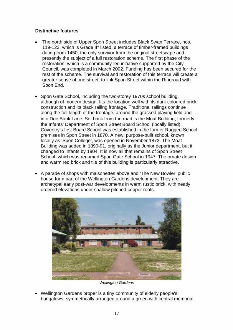
• A parade of shops with maisonettes above and ‘The New Bowler’ public
house form part of the Wellington Gardens development. They are archetypal early post-war developments in warm rustic brick, with neatly ordered elevations under shallow pitched copper roofs.
Wellington Gardens
• Wellington Gardens proper is a tiny community of elderly people's
bungalows, symmetrically arranged around a green with central memorial.
18
The group also includes a community building featuring a huge stone chimney and contemporary memorial plaque and a two storey home, sadly marred by a modern wooden panel fence. The bungalows were reputedly built as replacements for the destroyed almshouses of Ford’s Hospital. The design maintains the style of brown brick and shallow copper roofs. A delightful feature is a wisteria arch.
• Completing the group is the three/four storey, flat roofed block of flats on
Sherbourne Street. Although hardly beautiful, they are typical of the advanced thinking of the era in their stripped modernism, with decorative flourishes at the porches. They are actually built on a concrete base used as a water tank during the Second World War.
• The 1771 Spon Bridge (Grade II listed) and the ruined late 14th Century
Chapel of SS James and Christopher (Grade II listed) form a picturesque grouping in timeworn red sandstone. The bridge over the River Sherbourne was built, it is said, with material from the demolished Spon Gate. The Chapel was a wayfaring chapel, used by travellers, which had been converted to a house by the late 18th century. This was occupied continually until 1936, when the Clothiers’ Company sold it to the City Council, which proposed its restoration. Despite minor bomb damage in 1941, plans for the restoration were still in force in the late 1940s, but by the late 1950s the building had fallen into a ruinous condition. The timber-framed tenement and other accretions to the stone chapel were subsequently dismantled by the Council and the remainder left as a ruin in the early 1960s. The site was later incorporated into St. Christopher’s Club, now the Grapevine Drop-in Centre - more classic 1950s 'Festival of Britain' architecture. The group is however completely overshadowed in all senses by the 1960s twelve storey slab of Spongate House.
• Of particular note in Doe Bank Lane are the brick and stone boundary wall
and gate of the former Waterworks site and the old Waterworks Manager’s house, which is locally listed. The red sandstone waterworks house is a fine example of mid 19th century domestic Gothic but has been unsympathetically re-roofed with concrete pantiles.
• Recent enhancements of period street lighting and traditional railings to the
school have reinforced the character of the lane. • At the end of the lane is Waterworks Green, a large open green space
surrounded by a modern housing development of little note. The Green was, however, the site of Coventry's earliest municipal waterworks and traces of that remain in the form of a number of ornamental trees and the green itself, which covers a large disused water tank.
Design guidelines and recommendations • Parts of this Zone comprising Spon Bridge, Chapel and Grapevine Centre,
Doe Bank Lane, Spon Gate School, Black Swan Terrace and the

19
Wellington Gardens area east of Sherbourne Street, including shops and pub is included in the new Spon End Conservation Area.
• Maintain and enhance the distinctive open, landscaped character of the
zone. There are a large number of trees not covered by Tree Preservation Orders, which would benefit from Conservation Area protection.
• The distinctive 1950s character of the Wellington Gardens area needs to
be recognised and protected as a unique survival in the city, commemorating its most heroic period. As well as inclusion within the Conservation area, it is considered at least worthy of Local Listing and possibly, in view of its historic interest, for Statutory Listing
• New developments should recognise the zone’s uniquely varied character
by contributing their own high quality distinctiveness. • Schemes for the opening up and enhancement of the riverside area as a
pedestrian walkway should be brought forward and implemented. . Zone 3 - Compass Court
Crown Copyright Reserved CCC LA 076 155, 2001
General description Compass Court is a complex of 100 Housing Society apartments in five blocks from two to four storeys in height, built in 1974. There is a mixture of tenure and a very diverse mix of people. The complex is managed by a Management Committee elected from residents. The site is well maintained and attractive, but there is a lack of positive relationships to the surrounding streets, and the open communal landscape setting has led to security problems, which have had to be addressed by security fencing and gating.

20
Compass Court
Distinctive features • The maisonette blocks are in a warm red brick with slated roofs. Both in
siting, design and materials the buildings attempt to find a middle ground between the traditional and the modern and the development is in many respects a success.
• The long stretch of Upper Spon Street, which passes the southern
Compass Court blocks, was pedestrianised and landscaped in a contemporary style in the 1970s. The rather fussy scheme has not been entirely successful for a busy pedestrian route next to residential properties and is undergoing redesign.
Design guidelines and recommendations • The unified and coherent design of Compass Court must be recognised
and respected in small-scale adaptation works, which should also be directed at improving the functional relationships to the surrounding streets and public spaces.
• Modify the design of Upper Spon Street at this point to re-establish a
'street' character.

21
Zone 4 - Mid-Victorian Watchmaking Quarter
Crown Copyright Reserved CCC LA 076 155, 2001
General description This small, but distinctive, zone mainly comprises the only substantial surviving remnant of the Spon Street watchmaking area of the mid 19th century. The terraced houses are of a variety of designs, but many feature a rear third storey allowing for a well-lit first floor workshop in a 2 storey rear wing. There are many good examples of these watchmakers’ houses, although many have suffered later 'improvements'. Although the watchmakers’ workshops are now converted to other uses, they are still distinguishable from the outside, for example, by the brick infilling of large windows. There are signs that some people are attempting to reverse modern unsympathetic changes and return their houses to their original state, however this is being undermined by an increasing amount of conversion to multiple occupation, particularly because of a consequent reduction in the general maintenance of such properties. All of this zone, apart from 17-25 Barras Lane (Florence Terrace), is included within the Nauls Mill Conservation Area. Distinctive features • The rare Victorian synagogue in Barras Lane, and the attached house no
32 Gloucester Street, were built in about 1870 in red brick in a distinctive Romanesque style with stained-glass windows, and are locally listed,

22
Synagogue and house
• 27-57 Barras Lane are known as Rothesay Terrace and locally listed. This
terrace was not connected with the watchmaking industry but was a later 'upmarket' addition to the area. It is a three-storey, redbrick, post-1889 terrace of 16 houses of very distinctive design, stepping up the hill, with dormer windows and steeply pitched gabled roofs in plain clay tiles. Some still have the original sash windows and the integral railing features outside the first floor windows above the doors. The feature that makes these houses particularly special is the quantity of classically inspired terracotta motifs on the otherwise typically Victorian 'Gothic' vernacular frontages. Although this terrace has suffered a degree of unsympathetic alteration, recent negotiations with some owners should ensure the safeguarding of its distinctive features.
Rothesay Terrace
• The former St John’s School building, now Steeple House, in Gloucester
Street, is essentially red brick and slate roofed Victorian gothic with a distinctive round spirelet, but with some modern additions and adaptations to create an office complex. Sympathetic railings would enhance the setting.
23
• The community garden in Dover Street is shielded from the ringroad by a
tastefully designed high redbrick wall. • 10 Gloucester Street was the home of famous pioneer cycle maker John
Kemp Starley. The property has unfortunately lost much of its original character.
• 2 Percy Street and 13, 17, 27 and 29 Gloucester Street are examples of
houses largely in original condition and which have either been conserved or restored, or are in the process of restoration.
• 4 Norfolk Street, although altered at the front, still has most of its original
details, including back stairs, its watch maker’s bench, and the downstairs sub-divisions - scullery and wash room.
• 10 and 12 Norfolk Street are examples of houses which retain many
original details, such as back stairs, unplastered back room, and rolling shutters to front window. There is a photographic record of the top shop to number 10 before it was altered.
• 16 Norfolk St was the home and workshop of Danish watchmaker and
horologist Bahne Bonniksen, who invented the 'karussel' escapement for improving the accuracy of watches and other timepieces subject to continual movement. Unfortunately, many original details of the house have recently been lost.
• 18 Norfolk Street, a fine example of a watchmaker’s house, is locally listed.
It still has a well preserved frontage and rear elevation, including the original workshop windows.
Design guidelines and recommendations • Opportunities should be sought to develop a scheme for Norfolk Street for
the restoration of watchmakers’ houses • Pursue Statutory Listing to preserve and restore the distinctive character of
27-57 Barras Lane -Rothesay Terrace. • The following properties are proposed to be added to the local list:
Steeple House, Gloucester St 2 Percy Street 13,17 and 27 Gloucester Street 4 Norfolk Street

24
Melville Road Holyhead Road
General guidance 1: The Victorian Terraced House and Street The tightly built, regular terraced house forms the typical Victorian street. Although often designs were not completely consistent, use of a local red brick, Welsh slate roof or small plain clay tiles and basic repetition of door and window patterns and designs gave these streets their distinctive character. Small front elevations were carefully designed as appearance to the street was an indication of status. Decoration was applied at least to window and door surrounds and cornices and often even more lavishly. Unfortunately these distinctive features have suffered as a result of the widespread availability of 'Home Improvement Grants' in the 1970s and 1980s and from bad advice from builders. Slates or small clay tiles have been replaced by concrete roof tiles and some properties have been rendered or painted, destroying or devaluing decorative details. Modern windows and doors are installed which further erode the original design. It would be desirable to provide information to individual owners and landlords on how these distinctive features and the original design integrity can be conserved. It is possible to 'retro fit' such features as sash windows and doors of the original design and, even in certain cases (after trial testing) to remove unsightly render and reclaim original design detail.
General Guidance 2: Individual infill plots There are examples throughout the area of small gap-infill developments, of varying quality, in otherwise built-up streets. In these mostly fully built-up streets it is essential to maintaining area character that existing building form, design, materials and richness of detailing are closely followed. Attempts at simplification or dramatic contrast will usually simply result in dilution of character. Where a street already displays a considerable degree of variety of design a more flexible approach can be considered.
25
General guidance 3: Doors and Windows The inappropriate replacement of windows in one property can impact on the integrity of a whole terraced row. Replacement sash windows should be replicated to give the same detailing, construction and mechanism as was commonly used in the area. Modern draught proofing can be fitted, as can thin double glazing, although alternatives - such as thick curtains, or internal rolling shutters - can be used. The use of UPVC is not recommended, both for reasons of detailing authenticity and for the health and safety of lime-built buildings. The design of sash windows was largely determined by the availability and cost of glass. In the mid 19th century, larger panes of drawn glass were more expensive and so were reserved for the fronts of houses. In Gloucester Street, at its upper end, the rear windows are eight panes over eight, while the watch makers’ houses of Norfolk, Gloucester and Dover Streets are six over six. Front windows are two over two. Later houses in Northumberland Road have single panes to the front. Bricks used for the front elevation in earlier houses were Webster’s 9 ¼ by 3 ¼; these give a slightly larger dimension to the sash windows. Drawn glass still remains in some sashes. The replacement of front doors, particularly those glazed with stained glass, and the enclosing of porches can also have a wider impact on a street. The door and its surround was usually the focal point of the front elevation and the loss of original decorative detail and modelling upsets the balance of the design.
General guidance 4: Street details Flagged footpaths, granite setts, blue pavers, kerbs and gutters complement the street architecture and should ideally be retained or renewed to match in renewal works The area has retained many of its original cast-iron street signs, although many are damaged and in need of restoration or reinstatement using original patterns. These small features add enormous character to the area.
General guidance 5: Front gardens and boundaries Where houses have front gardens, they tend to be small. Mature planting has survived in many front gardens, but there has also been a marked increase in 'slabbing' and concreting, particularly by landlords and Housing Associations. Most of the properties, as in other parts of Coventry, would have had front boundary railings on top of low brick walls. The railings were 'salvaged' during the last war, leaving just the walls. Most of these have survived, and the railings have been replaced with a variety of treatments. Some, however, have been completely replaced with hedges, wooden fences, railings, and walls of varying heights in brick,concrete and even Cotswold stone. This has had a very detrimental effect on the appearance of the street. A co-ordinated re-railing scheme would be a high impact enhancement that would greatly add to the character of the properties.
26
• Also see General guidance 7 and 8
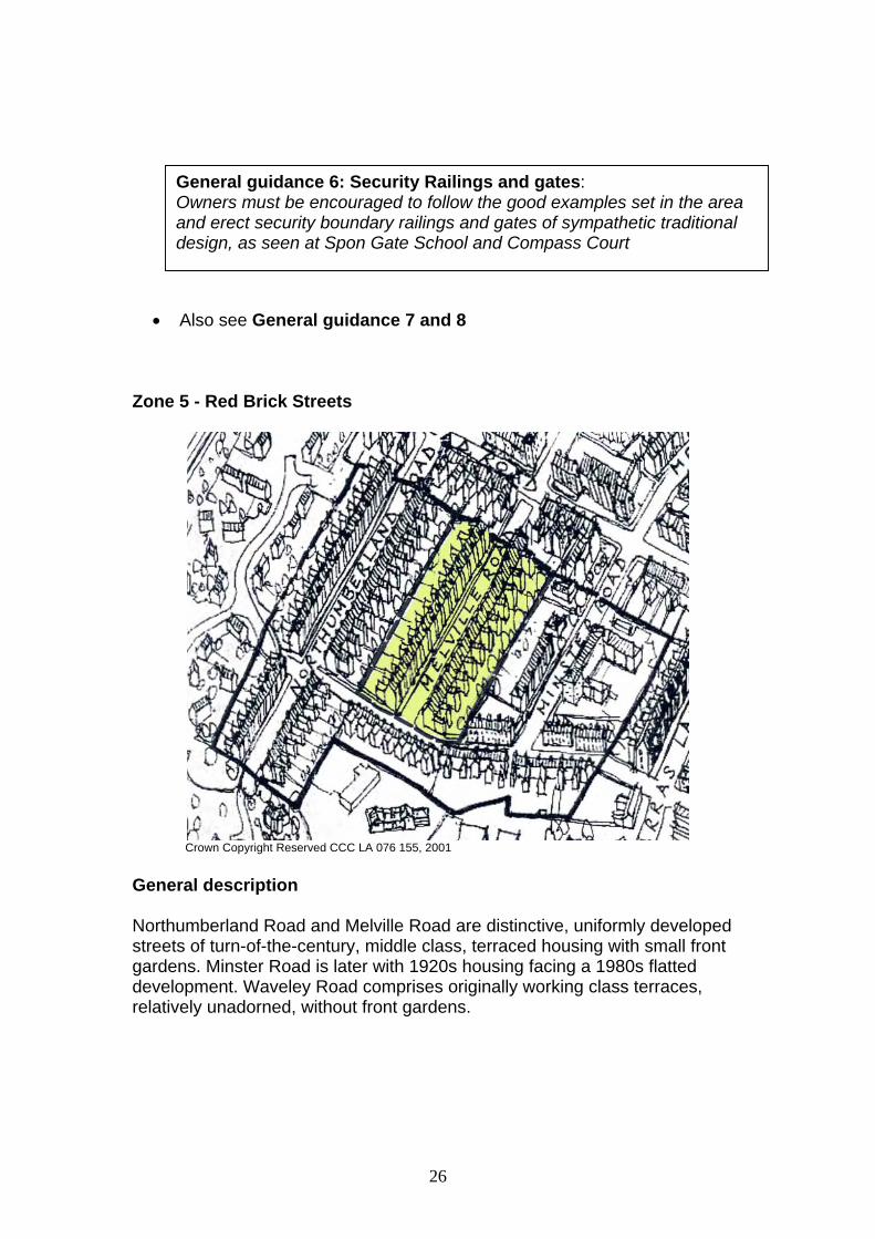
Zone 5 - Red Brick Streets
Crown Copyright Reserved CCC LA 076 155, 2001
General description Northumberland Road and Melville Road are distinctive, uniformly developed streets of turn-of-the-century, middle class, terraced housing with small front gardens. Minster Road is later with 1920s housing facing a 1980s flatted development. Waveley Road comprises originally working class terraces, relatively unadorned, without front gardens.
General guidance 6: Security Railings and gates: Owners must be encouraged to follow the good examples set in the area and erect security boundary railings and gates of sympathetic traditional design, as seen at Spon Gate School and Compass Court

27
Distinctive features • Northumberland Road has a long view down the hill to the open
Waterworks Green. The vista looking uphill is closed by the squat tower of the Holyhead Road Unitarian Church. The houses themselves are two storey redbrick Victorian terraces with single and double height bays. Many still have the original sash and bay windows. Roofs are slated, with small hips over projecting bays. The very large multiple chimney stacks are a strong feature. Other original features add to the character of the street, such as classical floral and foliage decorative panels above the windows. Generally, street character is well preserved, complimented by the traditional style lampposts.
• In Melville Road, the long, comfortable red brick terraces are particularly
ornate and generally well preserved, with double height front bay windows under small hipped roofs, distinctive window designs, leaded lights in the front doors and charming terracotta panels above the windows and doors. Some owners on Melville Road have gone to great lengths to preserve these features, as well as the original black and white tiled footpaths, and stone edgings to the front garden path.
.
. Melville Road
Design guidelines and recommendations • Melville Road is included within the Nauls Mill Conservation Area. • In these streets the regularity and consistency of detail of the front
elevations and front gardens is the key to distinctive character. Changes to

28
windows, doors, roofing, front garden boundaries, etc. that depart radically from the original, carefully considered, design will reduce distinctiveness.
• See General guidelines 1, 2, 3, 4, 5, 6, 7 and 8 Zone 6 - Holyhead Road
Crown Copyright Reserved CCC LA 076 155, 2001 General description A very busy road, laid out in 1830 by Thomas Telford as part of his great London to Holyhead road improvement, as evidenced by the shallow cutting made to reduce the gradient up the hill from the city of Coventry. The road was, however, only built up in the late Victorian period, with a mixture of small, medium and large terraced and detached houses for the middle classes. Much is now in commercial use with some redevelopment, notably the grossly out of scale and character 1960s hotel. The road is narrow for the level of activity it carries. This gives it a lively, bustling character, in striking contrast to the neighbouring quiet residential streets. Much of this area is in multiple occupation and houses have been converted for hotel and boarding house use. It is essential that these are properly regulated and that proposals for external works to the properties are encouraged to meet high conservation standards to increase the attractiveness of this important route into the city.

29
Distinctive features • Local red sandstone walls line the central section of the road, as Telford's
cutting took the new high speed coaching road across the hill crest. • The Victorian pillar post-box at the corner of Minster Road, which is the
only one of its kind surviving in the city.
Holyhead Road
• There are some elaborate, mid-Victorian villas elevated above the road, at
street corners, notably numbers 90 (part of Aston Court, but retaining a separate visual identity), 92 (Hawarden House), 85 and 103. Number 1 Chester Street is a prominent three-storey corner design, unfortunately re-windowed and unsympathetically extended.
• The 1930s Unitarian church was designed by G. A. Steane of Coventry to
seat 200 people and built in 1936-37. It is a fairly plain building of rustic red brick, with a short tower, but incorporates two columns and some oak panelling from the ‘Great Meeting’ Church in Smithford Street (1701-1935). It terminates the view at the head of Northumberland Road. The elegant 1850s stone and cast iron railway overbridge, has recently been relieved of screening advertisements, but was associated for many years with the world famous Alvis Company, based in the area from the 1920s until the 1990s.
• Recent refurbishment and redecoration of the renamed Aston Court (ex-
Godiva) Hotel has created a crisper effect, although it has barely reduced its incongruity.

30
Design Guidelines and Recommendations • Also see General guidelines 1, 2, 3, 4, 5, 6 and 8 • Both sides of the Holyhead Road east of the Melville Road/Chester St
junction and 1 Chester St are included within the Nauls Mill Conservation Area.
• Numbers 90, 92 and 103 Holyhead Road, 1 Chester Street and 2 Dover
Street should be included on the Local List. The Alvis Bridge should also be included and the Alvis connection commemorated.
Zone 7 - Coundon Streets
Crown Copyright Reserved CCC LA 076 155, 2001
GG 7- Sandstone walls Retain and maintain the historic and highly locally distinctive Coventry sandstone walls. The conservation of these 19th century walls is a key issue and requires specialist advice. Lack of or incorrect maintenance techniques, such as over-pointing in the wrong mortar, can exacerbate deterioration and create the need for major remedial works. It may also be desirable to limit the number of new openings allowed in these walls, which usually have a ‘retaining’ function.

31
General description A varied group of residential streets built up in the late Victorian period, each with its own subtly different character. Coundon Road and Barras Lane are ancient lanes, now forming a busy through route, but without the congestion of the Holyhead Road. Nauls Mill Park, Bablake School and St Osburg’s provide strong green edges, which help to define the zone. A major part of this zone is within the Nauls Mill Conservation Area. This is the area where HIMO's are most entrenched and are having the most destructive influence. A concentrated effort is needed, to promote family housing that would in turn promote residential investment and regeneration of the community, and to resist any further loss of family housing. Distinctive features • High retaining walls in local red sandstone give the ancient Barras Lane a
canyon-like character as it turns into Coundon Road. The Edwardian villas on top of the bank are hardly visible from the street. The 1920s house, number 61, was the second, childhood home of poet Philip Larkin.
Moseley Terrace
• Coundon Road, as it passes through this zone on its ancient line, has 3
distinctive terrace groups of contrasting character. Numbers 26-42 Coundon Road, Moseley Terrace, which are locally listed, form a particularly fine three-storey terrace in redbrick with extensive stucco detailing, hipped slated roofs and tall redbrick chimney stacks. The adjoining group on the city side consists of two-storey red brick villas with dominant gabled bays, all well preserved. The long group on the opposite side of the road is a bit of a mystery, as the elevations show early 1950s features such as porthole windows and cantilevered porches, but the group appears on 1920s maps. It is thought that this group might well have been substantially rebuilt following war damage. The houses are elevated from the road behind a sandstone wall and greenery, with a second front access path, all creating a very pleasant environment.
32
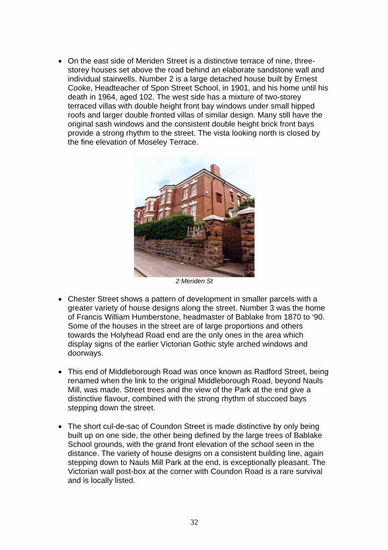
• On the east side of Meriden Street is a distinctive terrace of nine, three-
storey houses set above the road behind an elaborate sandstone wall and individual stairwells. Number 2 is a large detached house built by Ernest Cooke, Headteacher of Spon Street School, in 1901, and his home until his death in 1964, aged 102. The west side has a mixture of two-storey terraced villas with double height front bay windows under small hipped roofs and larger double fronted villas of similar design. Many still have the original sash windows and the consistent double height brick front bays provide a strong rhythm to the street. The vista looking north is closed by the fine elevation of Moseley Terrace.
2 Meriden St
• Chester Street shows a pattern of development in smaller parcels with a
greater variety of house designs along the street. Number 3 was the home of Francis William Humberstone, headmaster of Bablake from 1870 to ‘90. Some of the houses in the street are of large proportions and others towards the Holyhead Road end are the only ones in the area which display signs of the earlier Victorian Gothic style arched windows and doorways.
• This end of Middleborough Road was once known as Radford Street, being
renamed when the link to the original Middleborough Road, beyond Nauls Mill, was made. Street trees and the view of the Park at the end give a distinctive flavour, combined with the strong rhythm of stuccoed bays stepping down the street.
• The short cul-de-sac of Coundon Street is made distinctive by only being
built up on one side, the other being defined by the large trees of Bablake School grounds, with the grand front elevation of the school seen in the distance. The variety of house designs on a consistent building line, again stepping down to Nauls Mill Park at the end, is exceptionally pleasant. The Victorian wall post-box at the corner with Coundon Road is a rare survival and is locally listed.

33
Design guidelines and recommendations • 1-25 and 8-42 Coundon Road, 2 –28 f Meriden Street, Coundon St and
Middleborough Road are included in the Nauls Mill Conservation Area • See General guidance 1, 2, 3, 4, 5, 6, 7 and 8 . • Add 2 Meriden Street and 61 Barras Lane to the Local List • Redevelopment of the prominent site on the north corner of Abbotts Lane
and Coundon Road, currently in use as a builder’s yard, in a more appropriate form would be a significant enhancement for the area. A 'completion' of the adjoining terrace, with some recognition of the corner location, would be appropriate.
General guidance 8: The Conservation of Pre-WW1 Victorian and Edwardian Buildings. Pre-WW1 buildings were built largely with lime mortars, both for brickwork/pointing and plaster work. As well as having some environmental advantages, this construction method results in a soft building that can adjust to movement. For this reason, not so much attention needs to be paid to rigid foundations. Much of the building style - the use of architraves, cornices and skirtings - was an acceptance of the fact that parts of these buildings would moveand crack over their lifetime. Also, these buildings do need to breathe. There is a natural transpiration that takes place in lime walls, by which they soak in moisture and then dry out again. Similarly, interior walls take up moisture from the inside of the house and transpire it through the wall to be dried off on the outside. Nothing should interfere with this process, so that any repairs, finishes or daubs should be lime based. Conversely, cement products should not be used, particularly for pointing, pebble dashing, or masonry painting. It is doubtful if damp proof courses are appropriate, other than those already fitted, for example - blue bricks. Drains and roof drainage should be efficient, to get water away from the house. On the question of ventilation, it is important that windows should allow ventilation as well as there being open fireplaces. Sealing houses up through highly draught-proofed windows, and walls through dry lining, is likely to cause long term problems.

34
Zone 8 - St Osburg’s and Abbotts Lane
Crown Copyright Reserved CCC LA 076 155, 2001 General description The zone is dominated by the high Victorian St Osburg’s Church, with its tall spire and attendant complex of community buildings in a green hilltop setting. The most notable features of Abbotts Lane and Upper Hill Street, which as the names suggest are ancient roads, are the high sandstone side walls, which in places attain dizzying heights and provide a unifying feature for an otherwise formless street-scene. Apart from the gas site, which is excluded apart from its stone boundary walls to Upper Hill St and Abbotts Lane, all of this zone is included within the Nauls Mill Conservation Area. Distinctive features • St Osburg’s church (Grade II listed) is the historic centre of the revival of
Roman Catholicism in Coventry. A chapel was first established here in 1807, and replaced by the present fine gothic revival church in 1843-5 under the inspiration of Bishop William Ullathorne. The spire was not added until several years after the church had opened. The attendant presbytery and school were destroyed during the Blitz and the church badly damaged. The former were rebuilt in brown brick in contemporary 1950s style and form, with the church, a strong and distinctive group.

35
58-64 Upper Hill St
• Upper Hill Street is now, apart from St Osburg’s, largely devoid of frontage
buildings, but does contain numbers 58-64, a terrace of four three-storey Victorian houses built in blue brick with painted stone dressings, which are locally listed. These were associated with the adjoining gasworks. Again, a strong feature of Upper Hill Street is its high sandstone wall, which runs for much of its length. An agreement to reinstate a sandstone boundary wall to the school grounds, which was recently rebuilt in brick, has yet to be implemented.
• The south side of Abbotts Lane was developed from 1821 as the site of
Coventry's first gasworks. The site remains in gas company ownership. There is a distinctive curved wall that follows Abbotts Lane, which is the end wall of a set of north-lit Victorian workshops. These, and the high sandstone retaining walls, are of significance. The 1970s office block, which is now the main feature of the site, is an uncompromisingly modern, low rise, white plastic-clad box, only visible from the adjoining Ringway.
Design guidelines and recommendations • See General guidelines 1, 2, 3, 4, 5, 6, 7 and 8 • The 1950s buildings of Saint Osburg’s RC School and the
Presbytery/Priory building fronting Barras Lane should be considered for inclusion on the Local List.
• The former Corporation Gas Department stables, behind Britannia Tyres in
Abbotts Lane, should be considered for inclusion on the Local List. • Any future proposal for a redevelopment of the large ex-gasworks site
should take account of the site’s history and industrial archeaology and any surviving evidence of that. Scale of development on the Abbotts Lane frontage will need to take account of the residential use across the road. The distinctive stone retaining walls on that road frontage should be retained in any redevelopment. A development brief for this sensitive site

36
would be appropriate. There is an opportunity here to extend the regeneration of the Canal Basin and to improve the ringroad crossing.
Zone 9 - Nauls Mill
Crown Copyright Reserved CCC LA 076 155, 2001 General description This final, landscape-dominated zone centres on Nauls Mill Park, an Edwardian creation on the site of the ancient Nauls or Abbotts Mill. Together with the contiguous grounds of Bablake and Barr’s Hill Schools, it forms one of the largest 'green lungs' in this part of the city. The leafy Middleborough Road, with its street trees and deep front gardens, continues the theme. This is a good example of an area where a balance between family, social housing and letting exists. The zone is all included within the Nauls Mill Conservation Area, with the exception of Nauls Mill House. Distinctive features • Nauls Mill Park was opened in 1908. The boating lake has survived, as
have many original trees. The bandstand and many of the planting beds have now disappeared. A sympathetic restoration would still be possible and is being considered. The park still displays many of the design characteristics of an Edwardian Park.

37
Nauls Mill Park
• The ancient, independent Bablake School moved from the city centre to
this large site in 1890. Extensive development over recent years has created a rather motley complex, but the locally listed main school building overlooking the old playing field remains an impressive sight and forms an important local feature.
• Adjoining the rear of Bablake School is the locally listed Station House, a
stone built house which is a remnant of the old Coundon Road (railway) Station. It is now owned by the school. There is also an old timbered signal box, which is still in active use.
• The original Victorian house of Barr’s Hill School has gone, but the modern
complex of red brick buildings, which was designed to blend with the house, fits well into the mature, landscaped hillside setting.
• Middleborough Road is a quiet, tree-lined street with a variety of late
Victorian terraces and villas behind well-vegetated front gardens. Its winding route, formed by joining together two earlier streets (see Zone 7) when Nauls Mill and its mill pool, dating from the medieval period, were cleared away to create the park, and its hilly nature, create a highly distinctive character. Closest to the park there are short terraces of red brick cottages. Further up, the houses become larger and are mostly detached, with sandstone boundary walls. The trees and generally well-kept gardens give the street a very pleasant, village-like feel. The effect is somewhat diminished by the presence of the Naul’s Mill House flats tower.
Design guidelines and recommendations • See General guidelines 1, 2, 3, 4, 5, 6, 7 and 8. • New development should respect the open, landscaped character of this
zone.

38
• The existing landscaped settings of Bablake and Barr’s Hill Schools are very important to local character and must be respected. The site of Barr’s Hill House, now a sterile car parking area adjacent to Radford Road, could be enhanced by soft landscaping and better boundary treatment. Further development on the Bablake School field should be strongly resisted.
• An enhancement scheme to restore and enhance Nauls Mill Park is a high
priority. A Development Trust is currently working with the City Council and Heritage Lottery Fund with a view to submitting a bid to fund a development plan for refurbishment.
• The following should be included on the Local List: 14 and 27
Middleborough Road, signal box at the former Coundon Road Station. • The historic character of the Coundon Road rail crossing, the stone built
underpass, station remnants and signal box should be respected.
Middleborough Road
• A scheme to reconcile the conservation of the plane trees along
Middleborough Road with the improvement of the footpath alongside them should be devised.
• The site of Nauls Mill and its associated buildings, mill race and grounds
should be researched and the fruits of such research interpreted on the site in some form.
• Any development of the heavily overgrown vacant site behind 10-32
Middleborough Road and adjoining land must retain a landscaped buffer to safeguard the historic border of the park and screen the development from it. Development should respect the local character in terms of layout, form, design and materials and any ecological value of the site. A design brief

39
for this area would be advantageous considering the potential effect its development will have on the community.
5. Summary and Conclusions This report has been prepared by a working group of the Spon End and Chapelfields Community Forum and Coventry City Council. Its recommendations are based on extensive local knowledge, discussions within the community and consultation with local residents. Following formal public consultation during April-June 2003 it is now finalised as Supplementary Planning Guidance. The report proposes the designation of two Conservation Areas (see Plan), design guidance and other mechanisms needed to conserve and preserve the distinctiveness of the Spon End and Nauls Mill area, within the context of ongoing social and economic regeneration policies and programmes in the area. The area has a long history and a high quality, architecturally significant stock of buildings. These date from Medieval times to the present day. The majority of the housing stock is Victorian and there is a significant grouping of Watchmakers’ houses. This collection of ‘architecture through the ages’ in such a small area is unique. The area lies next to another historic watchmaking area - the Conservation Area of Chapelfields. The report covers by zone: building styles, remaining detailing, street furniture and character. Each of the zones has a defined character and design guidelines are proposed to reflect these. Throughout the zones, suggestions are also made for buildings to be considered for local or statutory listing. These cover particularly significant buildings or ones that are unspoiled examples of their particular architectural style or historic function. The report also proposes that certain parts of the area are considered for Conservation Area status. It is recognised however that the extent to which Supplementary Planning Guidance on its own is able to help protect the area is limited. Conservation of the distinctiveness of the area can only be assisted by the full use of existing planning powers. The area lies in an inner city district of a type that is giving problems nation-wide as they spiral down owing to neglect and lack of funding. Over the past 50 years the area has deteriorated, in part due to uncontrolled growth of through traffic and a high percentage of houses being converted, often without planning permission, for the commercial and rented sectors. At present it is contended that there are some significant areas where breaches of planning control are not being enforced. Multiple occupancy is a major issue in this area which is undermining the fabric of the built environment, resulting in additional pressure for limited parking spaces and threatening the continuing viability of local community facilities as the number of properties in use by families is reduced. It is therefore recommended that priority be given to and resources be made available for the enforcement of planning controls in relation

40
to houses in multiple occupation and commercial premises where harm can be demonstrated. It is also argued that the building industry as well as its advisors and regulators through Building Control should recognise the special requirements of pre 1920s building construction and this would have a significant impact on the conservation of the area. It is emphasised that the construction and therefore the type of work that is undertaken in lime-built buildings is quite different from the largely post-WW1 cement-built buildings. (see General guideline 7).
Crown Copyright Reserved CCC LA 076 155, 2001
41
Where this is not taken into account great damage can be done, not only to the structures of what is a considerable proportion of the housing stock, but also to people’s health. We have argued above that conservation is essential for the social structure of Inner City Areas and therefore their economic survival. We are also stating here that proper conservation practice is essential for the correct maintenance of all pre-WW1 lime-built buildings. We would therefore propose that policies should be formulated to include recognition of the requirements of pre-1920s building construction. It is also contended that by educating owners and builders as to the architectural value of their properties they could be encouraged to take their own initiatives to protect their houses, properties and the environment. It is therefore recommended that the City Council, in partnership with the local community, educational providers, and the construction industry:
- provide educational opportunities to promote the advantages of careful conservation when building repairs and improvements are undertaken; - promote conservation to homeowners and public bodies concerned with and owning property and to the building industry, - support the establishment of a community led Development Trust to purchase and conserve key buildings, to continue to set an example as to what might be achieved.
The local community has an ongoing commitment to the protection and enhancement of the area’s distinctive character. The report highlights that adoption of Supplementary Planning Guidance would not be effective by itself. It is therefore recommended that the following policy objectives be considered for adoption, to guide and support the development and delivery of service and neighbourhood plans and all work relating to the ongoing regeneration of the area: To ensure the conservation of the area, in terms of the overall design of the
buildings within it and the protection of architectural detail; and to ensure that new development within the area is in keeping with its character.
To improve the quality and appearance of the area, to attract a more
balanced population, particularly families and younger professional people on higher incomes, which will be able to support local services.
To control traffic flow and design highway improvements in such a way that
they do not destroy the character of the area To attract investment to the area, particularly investment that will protect and
enhance the distinctive character of the area. August 2003

42
Appendix 1 Membership of the ALD Working Group The Working Group was established as a partnership of residents and Council Officers, to steer the project through its various stages. The following have been members: Malcolm Adkins - Resident (Chair) Julie Fairbrother – CCC( Media and Communications) Satwant Gill – CCC(Regeneration) Kate Hunter - Radford Ward Councillor Kevin Noble - Resident Manny Kawooya – CCC(Regeneration) Mark Singlehurst – CCC(Conservation) Judith Stephenson - Resident Dave Tittle - Resident Keith Ward - Resident Steve Warner - Resident Kevin Wilkins – CCC(Urban Design) . The group reports to the community through the Chair (Malcolm Adkins) via the Spon End and Chapelfields Community Forum and to the City Council via the NW Area Forum (Councillor Hunter). Appendix 2 Summary of Statutory and Locally Listed Buildings in the area The historical significance of the Spon End and Nauls Mill area is demonstrated by the number of listed buildings recorded in the area: i) Statutory Listings 97 Spon End - Grade II 98 Spon End - Grade II 99 Spon End - Grade II 100 Spon End – Grade II 107-116 Spon End - Grade II St Osburg’s Church , Upper Hill Street - Grade II Spon Bridge, Upper Spon Street - Grade II Chapel of SS James and Christopher, Upper Spon Street - Grade II 119-123 Upper Spon St - Grade II ii) Local Listings Rothesay Terrace, 27-57 (odds) Barras Lane, c1890 Synagogue, Barras Lane, 1870 Moseley Terrace, 26-42 (evens) Coundon Road
43
Bablake School, Coundon Road, c 1890 Station House, Coundon Road, c1850 Wall post-box, Coundon Street (near the Coundon Road junction) Waterworks House, Doe Bank Lane, 1847 Moat Building, Doe Bank Lane, 1891 32, Gloucester St, c1870 18, Norfolk St, c 1860 58-64, Upper Hill Street 93, Spon End (The Malt Shovel) 101-103, Spon End Appendix 3 Summary of Buildings to be considered for Listing Statutory List – for recommendation to English Heritage Rothesay Terrace, Barras Lane - currently on the 'Local List' but considered suitable for Statutory Listing. Wellington Gardens, Sherbourne Street - considered suitable for a Statutory Listing, but it is a question of how much should be listed – i.e., whether to include Sherbourne Street, Upper Spon Street shops and the Bowling Green public house - designed as a group. Otherwise Local List. Local Listing Old Dyers’ Arms, Spon End The Arches, Spon End. The Black Horse, Spon End Koco Building – former Renold office block, Spon End [Ditto!] 13,17, and 27 Gloucester Street 4 Norfolk Street 2 Percy Street Steeple House, Gloucester St -. Formerly St John’s School and the Coventry School of Music. 2 Dover Street 90, 92 and 103 Holyhead Road The 'Alvis' Bridge, Holyhead Road 1 Chester Street 61 Barras Lane 2 Meriden Street St Osburg’s Priory (Presbytery) and School (part) Former Corporation Gas stables, Abbotts Lane 14 and 27 Middleborough Road Signal box, Coundon Road

44
Appendix 4 Additional Planning Controls In Conservation Areas No building in a Conservation Area, whether statutorily listed or not, may be totally or substantially demolished without the permission of the City Council. An application in writing (form) must be submitted for ‘Conservation Area Consent’. If the owner of an unlisted building in a Conservation Area leaves the property unoccupied and seriously neglected over a prolonged period of time, and the Secretary of State confirms that action is necessary, the City Council may carry out essential repairs and then recover costs from the owner. All trees in Conservation Areas with a diameter of 75 mm (3") or more, and a height at ‘chest level’ (i.e., around 5'), are protected, irrespective of whether or not they have also had a Tree Preservation Order placed on them. It is an offence to wilfully damage, cut, top, lop or uproot such a tree without consent from the Local Planning Authority. In Conservation Areas, there are also additional restrictions on what is permitted development:
• Extensions to a dwellinghouse must have planning permission where they exceed 50m3 or 10% of the original cubic content of the building (elsewhere, detached or semi-detached properties are allowed 70m3 or 15%).
• Cladding exterior walls with stone, artificial stone, timber, plastic or tiles is not permitted without planning permission.
• Ancillary buildings within the house’s curtilage which have a cubic content of over 10m3 come within the 50m3 limit and are classed as extensions to the house.
• Any additions or alterations to the roof on a dwellinghouse, which would enlarge the cubic content of the building, require planning permission.
• Buildings over 10m3 within the curtilage of a house cannot be built, altered or improved without planning permission.
• Satellite dishes are not permitted on chimneys, buildings over 15m high, or on walls or roof slopes fronting a highway (public roads, footpaths, etc.).
• The extension or alteration of an industrial building or warehouse is not permitted development where the cubic content of the original building would be exceeded by more than 10% (25% elsewhere) or where the floorspace of the original building would be exceeded by more than 500m2 (1,000m2 elsewhere).
Owners are strongly advised to contact the City Council before undertaking any significant building work within a Conservation Area.
45
Appendix 5 A SHORT BIBLIOGRAPHY SPAB Publications The Need for Old Buildings to Breathe - SPAB Information Sheet 4 Philip Hughes, 1986 Removing Paint from Old Buildings – SPAB Information Sheet 5 Adela Wright, 1989 An Introduction to Building Limes – SPAB Information Sheet 9 Michael Wingate, 1993? Patching Old Floorboards – SPAB Information Sheet 10 Philip Hughes, 1988 Strengthening Timber Floors – SPAB Technical Pamphlet 2 John E. M. McGregor, 1991 Cleaning Stone and Brick – SPAB Technical Pamphlet 4 John Ashurst, 1991 Pointing Stone and Brick Walling - SPAB Technical Pamphlet 5 G B A Williams, 1991 The Control of Damp in Old Buildings - SPAB Technical Pamphlet 8 Andrew R. Thomas, 1992 Electrical Installations in Old Buildings – SPAB Technical Pamphlet 9 Alistair Hunt, 1989 The Repair of Wood Windows – SPAB Technical Pamphlet 13 Andrew Townsend & Martyn Clarke, 1991
Other general conservation, repair & style advice Collins’ Care & Repair of Period Houses Albert Jackson & David Day, Harper Collins, 1998 Some reasons why UPVC windows are not appropriate replacements for timber windows in historic buildings [leaflet] Mark Singlehurst, Coventry City Council, 2001 A Brief Introduction to Conservation Areas and the Legislation Relating to Them [leaflet] Mark Singlehurst, Coventry City Council, 2003 The Elements of Style: An Encyclopædia of Domestic Architectural Details Ed. Stephen Calloway, Mitchell Beazley, 1991 Practical Building Conservation: English Heritage Technical Handbooks John & Nicola Ashurst, Gower Technical Press, 1989 Volume 2: Brick, Terracotta & Earth Volume 3: Mortars, Plasters & Renders

46
Volume 4: Metals Volume 5: Wood, Glass & Resins The Repair of Historic Buildings: Advice on principles and methods Christopher Brereton, English Heritage, 1991 Emergency Repairs for Historic Buildings Eleanor Michell, English Heritage, 1988
A Stitch in Time (Maintaining your property makes good sense and saves money), IHBC and SPAB
Victorian Period Dulux Heritage Colours Usage Guide: The Victorian Period (c.1837-1901) Care for Victorian Houses Number One: Doors Kit Wedd, The Victorian Society, 1992 Care for Victorian Houses Number Two: Decorative Tiles Kit Wedd, The Victorian Society, 1992 Care for Victorian Houses Number Three: Fireplaces Kit Wedd, The Victorian Society, 1993 Care for Victorian Houses Number Four: Interior Mouldings Kit Wedd, The Victorian Society, 1993 Care for Victorian Houses, Number Five: Wallcoverings Kit Wedd, The Victorian Society, 1993 Care for Victorian Houses, Number Seven: Brickwork Kit Wedd, The Victorian Society, 1994 Victorian House Style: An Architectural & Interior Design Source Book Linda Osband, David & Charles, 1991 (reprinted 1992) Victorian Architecture Roger Dixon & Stefan Muthesius, Thames & Hudson, 1978
Historical Research Exploring Urban History: Sources for Local Historians Stephen Porter, Batsford, 1990 History on Your Doorstep J. R. Ravensdale, BBC, 1982 Tracing the History of Your House Brenda Greysmith, Hodder & Stoughton, 1994 Spon Street and Spon End: A history of the people and buildings John Ashby, Coventry City Council, 2003 Spon End: A Family History Viewpoint John Ashby, Coventry Family History Society, 2002