section 2 spatial vision and strategy - our services · section 2 spatial vision and strategy...
TRANSCRIPT

35
This section establishes Gateshead’s and Newcastle’s spatial vision, strategic objectives and the Spatial Strategy for implementing the vision. The Spatial Strategy for sustainable development and growth includes spatial strategies for each character area: Urban Core, Neighbourhood Area and Rural and Village Area.
Chapter 4 Spatial Vision
Chapter 5 Spatial Strategy
Chapter 6 Urban Core Spatial Strategy
Chapter 7 Neighbourhood Area Spatial Strategy
Chapter 8 Rural and Village Area Spatial Strategy
Section 2
Section 2 Spatial Vision and Strategy
Spatial Vision and Strategy

4.1 This Plan responds to the needs and ambitions of our local residents and businesses. Gateshead’s and Newcastle’s Local Strategic Partnerships worked closely together to agree an overall shared vision and set of ambitions. This is expressed in our Bridging Document Developing Sustainable Cities NewcastleGateshead 2030. The shared vision states:
Vision 2030By 2030 Gateshead and Newcastle will be prosperous and sustainable cities that are unique and distinctive places - where people choose to live, work and visit because everyone can realise their full potential and enjoy a high quality lifestyle.
4.2 To deliver this vision and address challenges we face, the following vision statement and strategic objectives set out our ambitions for the three character areas and how collectively they will create a prosperous and sustainable Gateshead and Newcastle.
Vision Statement Our vision is that by 2030 Gateshead and Newcastle will be a more prosperous, attractive and sustainable place to live and work, with improved quality of life and thriving communities. Our population will increase to more than 500,000 and we will create approximately 30,000 new homes in sustainable locations.
The foundations for Gateshead and Newcastle’s transformation are its communities. All of our communities will be thriving and attractive places to live. More sustainable patterns of living will be achieved through the creation of balanced communities where there is a range of housing, good access to jobs and services to meet local needs.
Development will adhere to sustainability principles and deliver high standards of design, enhancing the quality and distinctiveness of Gateshead and Newcastle. Development will also be ecologically sustainable and designed to protect and where possible enhance biodiversity and the natural environment. This will ensure the delivery of a healthy natural environment benefiting both communities and wildlife and securing natural resources in the long term. There will be an emphasis on a low carbon economy and sustainable development. This will have been supported by a major increase in renewable and low-carbon energy capacity and new development will have been designed to mitigate and adapt to the impacts of climate change.
The Urban Core will continue to be the economic hub of the North East, fulfilling its role as the leading retail, entertainment, employment and learning centre for Tyne and Wear. It will be a place where businesses choose to locate, with a wide array of investment opportunities and an emphasis on ensuring that everyone shares in the benefits of economic growth. To sustain growth, and fundamental to achieving economic prosperity, there will be an appropriate range, mix and quality of employment sites and housing opportunities. The Urban Core will be a place of choice for doing business, learning, entertainment and living.
36
4. Spatial Vision
Spat
ial V
isio
n

Our Neighbourhood Area will comprise of places of choice with attractive communities and centres providing good access to jobs, shopping, health, recreation, open space and other facilities to meet day-to-day community needs. Areas including Benwell-Scotswood, Bensham, Birtley and Walker will have been transformed into distinctive areas where people aspire to live, offering a diverse range of high quality housing in an attractive and safe environment. Complemented by the establishment of new sustainable housing areas and communities, these areas will have helped to attract population back into the area, supported by local services and centres, and with access to local employment opportunities at Team Valley and Walker Riverside. The area also benefits from excellent access to opportunities in the Urban Core, Follingsby and Newcastle Airport.
Our Rural and Villages area will enjoy a renaissance. It will be a popular and sustainable place to live, work and visit, supported by new housing, improved facilities and services, and improved transport connections. The population of our villages will have stabilised, and in appropriate locations grown, underpinned by a larger and more diverse rural economy, all contributing to the place that is Gateshead and Newcastle. Our village and rural areas will be more than just dormitory settlements. Over the plan period this area will perform an increasingly important role, offering a range of leisure and visitor facilities set within an attractive countryside, in providing employment opportunities and in accommodating a range of homes that supplement and complement our Urban Core and Neighbourhoods.
37
Spatial Vision
Section 2

38
Spat
ial V
isio
n
SO1
SO2
S03
SO4
SO5
Encourage population growth in order to underpin sustainable economic growth.
To increase our economic performance, resilience, levels of entrepreneurship, skills and business formation by promoting Gateshead and Newcastle as the strong regional economic focus and by ensuring the supply of suitable, flexible and diverse business accommodation.
To increase our competitiveness by improving and expanding the role of the Urban Core as the regional destination for business, shopping, education, leisure, tourism and as a place to live.
To strengthen Newcastle’s position as the regional retail centre. To ensure the provision of quality District and Local centres with a diverse range of shops and services that are accessible to meet the needs of all local communities.
Expand leisure, culture and tourism providing for all age groups and diversifying the evening economy.
CS1, 2, 3, 4, 5, 9, 10, 11UC1
DEL1
CS1, 2, 3, 4, 5, 6, 13, 21UC1, 2, 3
NC2C1, 2
D1, 2, 3QO1
QB1, 2, 3GC2
KEA1KEA2AOC2DEL1
CS1, 2, 5, 6, 7, 8UC1, 2, 3
NC1, 2C1, 2
D1, 2, 3QO1
QB1, 2, 3GC1, 2
SG1, 2, 3
CS1, 2, 5, 7UC2
NC1, 2QB2
GC1, 2NN3, 4NV2, 3
CS1, 2, 5, 7, 8UC3
NC 1, 2D3
QO1AOC2
QB1, 2, 3GC 1, 2
SG3
Strategic Objective Delivered by policy
4.3 The strategic objectives will be delivered by the policies in this Plan and are identified below:

39
Spatial Vision
Section 2
SO6
SO7
SO8
Ensure that our residential offer provides a choice of quality accommodation in sustainable locations to meet people’s current and future needs and aspirations; improving opportunities to live in the Urban Core; and providing a broader range of accommodation including in new neighbourhoods.
Manage and develop our transport system to support growth and provide sustainable access for all to housing, jobs, services and shops.
Improve sustainable access to, within and around the Urban Core by promoting fast and direct public transport links to the heart of the Urban Core, increasing walking and cycling and minimising through traffic.
CS1, 2, 3, 4, 9, 10, 11, 12UC4NC2
C2D3
SG1, 2, 3QB2, 3
GC2QO1
AOC2AOC1
NN1, 2, 3, 4GN 1
GV 1, 2, 3, 4, 5, 6, 7NV1, 2, 3
DEL1
CS1, 2, 5, 13, 14, UC5, 6, 7, 8, 9, 10
NC1, 2C1, 2
D1, 2, 3SG1, 2, 3
GC1QB1, 2, 3
QO1NN1, 2, 3, 4
NV1, 2, 3GV1, 2, 3, 4, 5, 6, 7
GN1KEA2KEA1AOC1AOC2DEL1
CS1, 2, 13UC5, 6, 7, 8, 9, 10, 11
NC1, 2C1, 2
D1, 2, 3QO1
SG1, 2, 3QB1, 2, 3
GC1, 2DEL1
Strategic Objective Delivered by policy

40
Spat
ial V
isio
n
SO9
S010
SO11
SO12
Ensure the development and use of land protects, sustains and enhances the quality of the natural, built and historic environment, making the Urban Core a high quality exemplar for Gateshead and Newcastle, and ensuring our communities are attractive, safe and sustainable.
Provide the opportunity for a high quality of life for everyone and enhance the wellbeing of people to reduce all inequalities.
To reduce CO2 emission from development and future growth while adapting to the issues, mitigating adverse impacts and taking advantage of the opportunities presented by climate change.
Improve the function, usability and provision of our green infrastructure and public spaces by providing a network of green spaces and features which are connected and accessible for all.
CS1, 2, 14, 15, 16, 17, 18, 19, 20, 21UC11, 12, 13, 14, 15, 16, 17
SG1, 2, 3D2, 3,
NC1, 2GC1, 2
QB1, 2, 3QO1
AOC1, AOC2NN1, 2, 3, 4
NV1, 2, 3GV1, 2, 3, 4, 5, 6, 7
GN1KEA1KEA2
CS1, 5, 7, 11, 12 14, 18D1
QB3SG2
AOC1, AOC2GV1, 2, 3, 4, 5, 6, 7
NN1, 2, 3, 4NV1, 2, 3
GN1
CS1, 5, 16, 17, 18, 21C2
QB1, 2, 3SG1, 2
GN1NN1, 3
NV1GV1, 2, 3, 4, 5, 6, 7
KEA2AOC1, AOC2
CS1, 14, 18, 19UC15, 16
NC2C1, 2
D1, 2, 3QO1
QB1, 2, 3GC2
SG1, 2, 3NN1, 2, 3, 4
GV1, 2, 3, 4, 5, 6, 7AOC1, AOC2
KEA1 KEA2GN1
DEL1NV1, 2, 3
Strategic Objective Delivered by policy

5.1 The Plan can help achieve sustainable development by ensuring that we get the right development in the right place at the right time. This development will meet the needs of people living and working in Gateshead and Newcastle, while protecting and enhancing the environment.
5.2 Our economy and population are growing. We need to plan for 22,000 jobs and 30,000 homes (excluding purpose-built student dwellings) within the plan period. To plan for this future growth we are prioritising locations that are both sustainable and deliverable. We need to plan positively for new homes, lifetime neighbourhoods and a bigger and rebalanced economy which is linked to knowledge based sectors such as science, research and sustainable technologies. Policy CS1 sets out our spatial strategy for sustainable growth.
Policy CS1 Spatial Strategy for Sustainable GrowthTo create and sustain thriving communities and a more prosperous economy, development, including the provision for approximately 30,000 new homes, 22,000 jobs and a minimum of 150 hectares of employment land, will be directed to sustainable locations. This will be achieved by:
1. A presumption in favour of sustainable development.
2. Focusing the majority of development in the existing built up areas.
3. Prioritising the Urban Core as the location for major office, retail, higher and further education, leisure, culture and tourism development.
4. Supporting economic development outside the Urban Core in Key Employment Areas; Team Valley, Walker Riverside, Follingsby, Newcastle International Airport.
5. Enhancing neighbourhoods and re-balancing housing stock by delivering homes supported by jobs and local services.
6. Sustaining villages and the rural economy through a balance of housing provision, employment and local services.
7. Specific revisions to the boundary of the Green Belt to allocate land for new development. The new Green Belt boundary is defined on the Policies Maps.
8. All development being:
i. Fully inclusive, irrespective of cultural background ethnicity and age, to meet the diverse needs of all residents and communities.
ii. Well-connected and accessible by sustainable modes of transport.
iii. Well designed to promote community cohesion, wellbeing, and to reflect and enhance the area’s character and natural environment.
iv. Designed to reduce carbon emissions and adapted to the effects of climate change.
41
5. Spatial Strategy
Spatial Strategy
Section 2
5.3 The Spatial Strategy Key Diagram (Figure 5) illustrates a summary of the Plan’s proposals for growth and infrastructure improvements.

42
Spat
ial S
trat
egy
N
Northumberland
North Tyneside
South Tyneside
Sunderland
Durham
Dinnington
Throckley
Kibblesworth
Great Park
NewburnWalker Riverside
Highfield
Dunston and Teams
Felling
Birtley
Chopwell
Benwell Scotswood
Elswick
BenshamSaltwell
Sunniside
Ryton
Kingston Park / Kenton Bank Foot
Newbiggin Hall
Hazlerigg / Wideopen
Upper CallertonMiddle Callerton
Lower Callerton
Crawcrook
High SpenDunston Hill
Byker
Follingsby
Airport
A1 North
A1 South
Blaydon
12
34
5
Figure 5 Spatial Strategy Key Diagram © Crown Copyright and database right [2015]. Ordnance Survey [100019569].
© Crown copyright and database rights 2015 Ordnance Survey Gateshead Council [100019132].
Green Belt
Neighbourhood Area of Change
Neighbourhood Growth Area
Neighbourhood Opportunity Area
Village Growth Area
Key Employment Area
Indicative Access Road
Indicative Airport Access Road
A Road
Bus Corridor Improvements
Park and Ride
Rail Station
Rail Network
Metro Network
Airport
River Tyne
Urban Core
Neighbourhood Area
Rural and Village Area
Urban Core Key Site
1. Science Central2. East Pilgrim Street3. Stephenson Quarter4. Gateshead Quays5. The Exemplar Neighbourhood
Green Belt
Neighbourhood Area of Change
Neighbourhood Growth Area
Neighbourhood Opportunity Area
Village Growth Area
Key Employment Area
Indicative Access Road
A Road
Bus Corridor Improvments
Park and Ride
Rail Station
Rail Network
Metro Network
Airport
River Tyne
Urban Core
Neighbourhoods Area
Rural and Villages Area
Urban Core Key Site
1. Science Central2. East Pilgrim Street3. Stephenson Quarter4. Gateshead Quays5. The Exemplar Neighbourhood
5.4 Sustainable development is about meeting the needs of the present without compromising the ability for future generations to meet their own needs. The Plan promotes sustainable development as defined by the NPPF as “living within the planet’s environmental limits, ensuring a strong, healthy and just society; achieving a sustainable economy; promoting good governance; and using sound science responsibly”. The Councils have adopted a positive approach in seeking to meet their objectively assessed development needs.
5.5 When considering development proposals, the Councils will take a positive approach that reflects the presumption in favour of sustainable development contained in the NPPF. We will work proactively with applicants to find solutions, approve compliant applications without delay, and where necessary use the guidance in the NPPF to determine applications.
5.6 The Spatial Strategy positively seeks opportunities to meet the development needs of Gateshead and Newcastle. The Urban Core (Policy CS2 and Section 4) will remain the strategic priority for development in Gateshead and Newcastle, to ensure it fulfils its potential in contributing to economic prosperity. The Neighbourhood Area (Policy CS3) and Rural and Village Area (Policy CS4) will continue to support vibrant and diverse communities. The Spatial Strategy identifies four Key Employment Areas outside the Urban Core, which provide a clustering for economic activity. Employment Areas across Gateshead and Newcastle will play an important role in accommodating the requirements of a range of sectors.
5.7 We are aiming to utilise land efficiently through the use of previously developed land, vacant properties and surplus industrial land, however, there is a shortage of deliverable sites. Gateshead and Newcastle attach great importance to the Green Belt, however, the boundary is drawn tightly around the urban and village edges. It is considered that in order to meet our objectively assessed needs for housing and employment, there is an exceptional circumstance to alter the boundaries.
5.8 Most housing growth will be located in the existing built up area, this will include approximately 21,600 new homes. An additional 8,400 homes will be allocated in Neighbourhood and Village Growth Areas. This will help us to meet our five year housing land supply as required by the NPPF, and ensure land is available to meet our needs over the whole plan period. The need for an annual housing development rate of approximately 1,500 per annum (Policy CS10) means that development will be promoted simultaneously across the whole of the plan area in order to deliver the homes we need.
5.9 There is also a shortage of land for employment to ensure sufficient space of the right type is provided in the right location to allow for growth. The Councils’ Employment Land Reviews (ELRs)29 have identified a locational need for employment land to cater for storage and distribution at Follingsby, and greenfield employment sites next to the Newcastle International Airport.
43
Spatial Strategy
Section 2

5.10 A full Green Belt review has not been undertaken but a Strategic Land Review and Green Belt Assessment has. The Stage 1 report30 appraised all sites in the Green Belt, considering impact on Green Belt and broad level of suitability. The report, including all sites above a threshold, was published in September 2011. Gateshead and Newcastle each prepared Stage 231 reports which were published in July 2012. These reports looked at the consultation responses from the Draft Plan and also assessed the suitability, deliverability, and sustainable accessibility of the sites identified in Stage 1. Stage 3 reports32 were published in July 2013 and these set out the proposed revised Green Belt boundaries. The Plan identifies sites that have been removed for the specific purpose of development from the Green Belt. The Green Belt boundary has been amended as illustrated on the Policies Maps in order to meet our objectively assessed needs for employment and housing. In addition there have been minor changes to the boundaries either arising from the identification of sites, or to ensure land is included or excluded from the Green Belt in accordance with national guidance on the purposes of including land in the Green Belt and the use of suitable features to form boundaries.
5.11 Both Councils are committed to the promotion of diversity, equality and fairness, and expect all development to contribute to this in accordance with the latest equalities legislation.
5.12 It is important that development is located in the most sustainable locations, accessible by a choice of travel modes including public transport, walking and cycling (Policy CS13). This is to reduce the need for people to travel, minimise levels of congestion, improve road safety and meet climate change reduction targets.
5.13 The Plan also seeks to improve the quality of life in Gateshead and Newcastle for current and future generations. This will be achieved through well-designed development which protects and enhances the built and natural environment, which is supported by infrastructure and local facilities and which helps create healthy lifestyles and a sense of place for everyone. Developments must also address the key challenges of climate change (Policy CS16) and flood risk (Policy CS17), through their location, design and construction (Policy CS15). The need to reduce both energy consumption and the risk of flooding are key factors which underpin the Plans locational strategy, and which also need to be addressed in individual proposals.
44
Spat
ial S
trat
egy
6.1 As the cultural and economic heart of the area the Urban Core plays a critical role in Gateshead and Newcastle’s prosperity and identity. This chapter sets out the strategic approach to ensure that this role continues to drive and focus growth in the most sustainable locations. Our vision and strategy are dependent on the success of the Urban Core as it provides the greatest opportunity to deliver major growth which is regionally significant and promotes wider benefits. Major office, retail, leisure, culture and tourism development will be located here. Chapter 14 sets out a range of specific policies for the Urban Core area and Chapters 16 and 17 set out policies for the seven Sub-Areas and their allocated Key Sites.
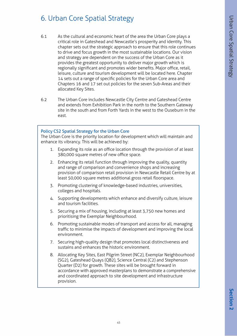
6.2 The Urban Core includes Newcastle City Centre and Gateshead Centre and extends from Exhibition Park in the north to the Southern Gateway site in the south and from Forth Yards in the west to the Ouseburn in the east.
Policy CS2 Spatial Strategy for the Urban CoreThe Urban Core is the priority location for development which will maintain and enhance its vibrancy. This will be achieved by:
1. Expanding its role as an office location through the provision of at least 380,000 square metres of new office space.
2. Enhancing its retail function through improving the quality, quantity and range of comparison and convenience shops and increasing provision of comparison retail provision in Newcastle Retail Centre by at least 50,000 square metres additional gross retail floorspace.
3. Promoting clustering of knowledge-based industries, universities, colleges and hospitals.
4. Supporting developments which enhance and diversify culture, leisure and tourism facilities.
5. Securing a mix of housing, including at least 3,750 new homes and prioritising the Exemplar Neighbourhood.
6. Promoting sustainable modes of transport and access for all, managing traffic to minimise the impacts of development and improving the local environment.
7. Securing high-quality design that promotes local distinctiveness and sustains and enhances the historic environment.
8. Allocating Key Sites, East Pilgrim Street (NC2), Exemplar Neighbourhood (SG2), Gateshead Quays (QB2), Science Central (C2) and Stephenson Quarter (D2) for growth. These sites will be brought forward in accordance with approved masterplans to demonstrate a comprehensive and coordinated approach to site development and infrastructure provision.
45
6. Urban Core Spatial Strategy
Urban Core Spatial Strategy
Section 2

1
4
2
3
7
6
5
ab
c
d
e
6.3 Figure 6 illustrates the Spatial Strategy for the Urban Core
46
Urb
an C
ore
Spat
ial S
trat
egy
Sub Area
Civic
Discovery
Newcastle Central
Quayside and Ouseburn
Southern Gateway
Gateshead Central
Quays and Baltic
Primary Shopping Area
Urban Core Distributor Route
Major Transport Routes
Bus Loop
Primary Pedestrian Routes
Future Primary Pedestrian Routes
Universities and Colleges
Metro Station
Key Site
Science Central
East Pilgrim Street
Stephenson Quarter
Gateshead Quays
The Exemplar Neighbourhood
1
2
3
4
5
6
7
a
b
c
d
e
Figure 6 Urban Core Spatial Strategy © Crown Copyright and database right [2015]. Ordnance Survey [100019569].
© Crown copyright and database rights 2015 Ordnance Survey Gateshead Council [100019132].

6.4 There has been a steady growth in offices in the Urban Core providing a range of high quality accommodation for professional, business and financial services, the knowledge economy and creative industries. Policies will promote further growth and the location of approximately 75% of office requirements within the Urban Core. It is a highly attractive location close to services, being easily accessible at the heart of the regional transport network. A range of sites have been identified to cater for the needs of different sectors and approximately 80% will be located within Newcastle and 20% within Gateshead. Major sites include Stephenson Quarter and Baltic Business Quarter and Policy UC1 sets out full details of all our priority office sites.
6.5 Newcastle is the regional retail and leisure centre and opportunities to improve and expand the range of retail must be continuously explored to meet identified needs and ensure Newcastle retains its position in the retail hierarchy, competing effectively with other centres. New retail development will be a catalyst for growth in other sectors such as leisure. Newcastle has consistently been identified for growth and the latest retail study has identified capacity for at least 50,000 square metres additional gross retail floorspace which will be located at East Pilgrim Street and within the Primary Shopping Area as outlined in Policies UC2 and NC2.
6.6 The universities, colleges, hospital and Centre for Life drive the knowledge economy and have raised our skills base leading to higher levels of productivity. These centres of excellence have seen significant growth over the last decade. The benefits of the transfer of knowledge and skills between education, research and industry are particularly important and will continue to be promoted. Attracting investment from the private sector to complement these sectors will be key to growing the knowledge economy. The Science Central Key Site provides a large site for expansion of the knowledge economy in an ideal location, as outlined in Policy C2.
6.7 Cultural-led regeneration projects have transformed areas such as the Quayside, Quays and Grainger Town. This has led to rapid growth in tourism and Gateshead and Newcastle becoming very popular destinations. Leisure, culture and tourism have been one of the fastest growing industries and have helped raise the area’s profile and image internationally. We wish to diversify the range of attractions and expand facilities to support business tourism, to continue the development of hotels and promote activity during the day into the evening.
6.8 There is potential to significantly increase the residential population by providing a broader range of housing including conversion of upper floors in the Urban Core to meet market demands. In Gateshead the Exemplar Neighbourhood will be a major new residential area providing family homes. In Newcastle we will support housing as part of mixed- use schemes. Science Central should provide a mix of housing and apartments.
47
Urban Core Spatial Strategy
Section 2

6.9 Movement into, through and around the Urban Core will be improved by promoting travel by sustainable modes and minimising through traffic. Policies will direct traffic which does not need to travel into the Urban Core onto major routes around the edge of the Urban Core. This will provide opportunities to improve the environment particularly for pedestrians and cyclists. In Newcastle this will allow further pedestrian priority areas, new cycling routes and to re-focus bus movements within the Central Sub Area.
6.10 The Key Sites will be major areas of change delivering our vision and together they will stimulate development of the surrounding area. Each Key Site will make a major contribution to regeneration, providing jobs, homes and improving the environment.
6.11 Gateshead and Newcastle are distinctive places with a strong identity. The bridges and iconic buildings of the Quayside and Quays are instantly recognisable and the defining topographical feature is the Tyne Gorge and the River Tyne that runs through it. Steep streets connect the waterfront to the Centres with street patterns which reflect the long history of the two places. Over the past 20 years, schemes have regenerated large areas and we will promote distinctive high quality development befitting of a regional capital which sustains and enhances our assets.
6.12 The Urban Core is divided into seven Sub-Areas Their boundaries are defined by a combination of factors including the built form, heritage, roads, railway uses and by the way in which they are expected to develop. Section 5 of this Plan sets out specific policies for these areas.
48
Urb
an C
ore
Spat
ial S
trat
egy

7.1 The Neighbourhood Area forms the majority of the built up area of Gateshead and Newcastle and this is where most of our residents live. This area extends as far as Gosforth and Fawdon to the north, Westerhope, Lemington and Blaydon to the west and Whickham and Harlow Green to the south. Birtley further to the south is detached, but is included in this area. The Neighbourhood Area boundary (as defined in Figure 1.2) includes the Neighbourhood Growth Areas, which were previously in the Green Belt. The Neighbourhood Area benefits from two Key Employment Areas, Team Valley and Walker Riverside, as well as other Employment Areas, and is supported by a range of District and Local Centres, as defined in Policy CS7.
7.2 A key spatial priority of the Plan is concentrating new housing development in our Neighbourhood Area. The majority of new housing development will be accommodated here, both within the existing built up area and in the new Neighbourhood Growth Areas. We will ensure that our Neighbourhoods Areas are places of choice for living, supported by sustainable access to job opportunities and a range of other services and facilities to meet the day to day needs of residents. Our Neighbourhood Area will provide housing choice for people, regardless of age and income to underpin the areas’ economic competitiveness and support our working population.
7.3 Policy CS3 identifies locations where growth and development will be supported.
Policy CS3 Spatial Strategy for Neighbourhood Area In the Neighbourhood Area sustainable communities will be promoted and maintained, meeting housing needs and supporting jobs by:
1. Development of approximately 21,900 new homes.
2. Investing in housing development and neighbourhoods specifically in Opportunity Areas at: Bensham and Saltwell, Benwell and Scotswood, Birtley, Byker, Dunston and Teams, Elswick, Felling and Walker Riverside (Figure 7.2).
3. Development of major brownfield sites for new sustainable communities in Areas of Change at Newburn (AOC1) and Metrogreen (AOC2).
4. Allocating Neighbourhood Growth Areas for housing development at: Callerton (NN1), Dunston Hill (GN1), Kingston Park/Kenton Bank Foot (NN2), Newbiggin Hall (NN3) and Newcastle Great Park (NN4). Development will be carried out in accordance with:
i. approved masterplans for each of the identified Neighbourhood Growth Areas which demonstrate a comprehensive, phased and coordinated approach to site development setting out how necessary infrastructure, and the strategic infrastructure identified for the site in the Infrastructure Delivery Plan, will be delivered on a phased basis.
ii. approved development phasing plans setting out build rates and triggers for infrastructure and demonstrating how each phase of the development is sustainable and deliverable.
5. Focusing and protecting manufacturing and industrial uses in the two Key Employment Areas of Walker Riverside (marine/offshore engineering and renewables) and Team Valley (advanced manufacturing and engineering).
49
7. Neighbourhood Area Spatial Strategy
Neighbourhood Area Spatial Strategy
Section 2

7.4 Figure 7.1 illustrates the Spatial Strategy for the Neighbourhoods Area.
50
Nei
ghbo
urho
od A
rea
Spat
ial S
trat
egy
N
Northumberland
North Tyneside
South Tyneside
Sunderland
Durham
A1 North
A1 South
Great Park
NewburnWalker Riverside
Dunston and Teams
Felling
Birtley
Benwell and Scotswood
Elswick
BenshamSaltwell
Kingston Park / Kenton Bank Foot
Newbiggin Hall
Upper Callerton
Middle Callerton
Lower Callerton
Dunston Hill
Byker
Blaydon
N
Northumberland
North Tyneside
South Tyneside
Sunderland
Durham
A1 North
A1 South
Great Park
NewburnWalker Riverside
Dunston and Teams
Felling
Birtley
Benwell Scotswood
Elswick
BenshamSaltwell
Kingston Park / Kenton Bank Foot
Newbiggin Hall
Upper Callerton
Middle Callerton
Lower Callerton
Dunston Hill
Byker
Blaydon
Neighbourhood Area
Neighbourhood Area of Change
Neighbourhood Growth Area
Neighbourhood Opportunity Area
Key Employment Area
A Road
Rail Station
Rail Network
Metro Network
River Tyne
Figure 7.1 Spatial Strategy for Neighbourhood Area © Crown Copyright and database right [2015]. Ordnance Survey [100019569].
© Crown copyright and database rights 2015 Ordnance Survey Gateshead Council [100019132].

7.5 Strategically we are seeking to provide the homes we need in a range of locations to offer choice across Gateshead and Newcastle. We have identified our priorities for investing in neighbourhoods including new major brownfield sites and any new greenfield land for future housing development.
Neighbourhood Opportunity Areas
7.6 An essential requirement of any strong and stable community is that residents have access to decent and secure homes. Major interventions through housing market renewal and regeneration programmes have aimed to address housing problems through a comprehensive programme of selective demolition, redevelopment and refurbishment and the provision of new housing. Poor housing has an adverse effect on an individual’s physical and mental health. A balanced supply of good quality housing is therefore a key component of any sustainable community and is essential for economic prosperity.
7.7 The focus for housing market activity will be in eight Neighbourhood Opportunity Areas (Figure 7.2). Comprehensive interventions including improving the quality and range of housing in these areas is required to ensure that in the future they are attractive and safe locations of choice.
51
Neighbourhood Area Spatial Strategy
Section 2
Neighbourhood Opportunity Areas
Bensham and Saltwell
Benwell and Scotswood
Birtley
Byker
Dunston and Teams
Elswick
Felling
Walker Riverside
Replacement and remodelling of existing stock providing a mixture of homes in terms of price, type and tenure.
Creating and supporting sustainable communities by delivering approximately 1300 new homes.
Potential for approximately 980 mixed price, type and tenure homes.
Potential for approximately 200 mixed price, type and tenure homes.
Potential for delivering approximately 250 mixed price, type and tenure homes in addition to the remodelling of the existing properties.
Delivering approximately 350 new homes and remodelling existing properties.
Approximately 400 mixed price, type and tenure homes in addition to remodelling of existing stock
Delivering approximately 750 new homes and remodelling existing properties.
Figure 7.2: Neighbourhood Opportunity Areas

Areas of Change
7.8 We have prioritised housing development on brownfield sites and have identified Metrogreen and Newburn as Areas of Change. These sites are embedded in the existing Neighbourhood Area and offer the opportunity for major new housing development close to established Employment Areas. Policies AOC1 and AOC2 set out our requirements in respect of their future development.
Neighbourhood Growth Areas
7.9 We have considered the allocation of Neighbourhood Growth Areas carefully and have sought to allocate only the land we need to meet our objectively assessed needs, which cannot be met in the existing built up area. The Neighbourhood Growth Areas identified are those that have been assessed to be the most sustainable. They can be linked to existing or extended public transport routes can be serviced by existing facilities and services or are of a scale that means they can support new facilities and services, can be delivered without adverse impacts on significant high quality habitat areas and are not at significant risk from fluvial flooding. Neighbourhood Growth Areas have been allocated in a range of locations to provide a reasonable level of choice and to enable a number of sites to be developed simultaneously. This will sustain the rate of development needed.
7.10 Given that the new development will generate the need for new infrastructure it is important that the individual sites (as defined in Policy CS3) in each of the Neighbourhood Growth Areas are masterplanned together, regardless of ownership. Phasing plans will be required which set out the triggers for the provision of required infrastructure and legal agreements will need to be put in place to deliver that infrastructure. Masterplans will be prepared by the landowner/developer(s) in consultation with the Councils and must be approved as part of the planning application process. The masterplanning and the development requirements of these sites are set out in policies in the Sub Areas and Site Specific policies in Section 5 of the Plan.
52
Nei
ghbo
urho
od A
rea
Spat
ial S
trat
egy

Key Employment Areas
7.11 It is important to protect and enhance our established Key Employment Areas (Team Valley and Walker Riverside). In the Neighbourhood Area these are major locations that provide an essential alternative business location to the Urban Core specifically for large floor plate employment uses. While the Urban Core is our priority, these sites are major contributors to our economic prosperity and we will support employment uses in these locations. Further detailed policies for these sites will be set out in subsequent LDD’s.
7.12 Strategically it is important to protect and enhance Team Valley Trading Estate given its importance in the region as the premier industrial estate. It continues to be a major economic driver in the region providing a wide range of marketable office and industrial premises, in a well laid out and attractive environment that benefits from direct access to the A1.
7.13 Walker Riverside is an area of economic growth benefiting from Enterprise Zone status. Walker Riverside is well placed to take advantage of significant inward investment opportunities around advanced engineering, manufacturing associated with the marine offshore related industries and renewable energy low carbon manufacturing industries. There is a thriving marine and offshore technology cluster of companies on the River Tyne employing thousands of people and the area has good prospects for growth. Newcastle City Council is investing in infrastructure here including riverside cranes. The Neptune Energy Park Enterprise Zone has the potential to provide onshore infrastructure, manufacture and support services to the marine and renewable energy sector following the Crown Estates decision to identify Dogger Bank as a preferred location for the development of one of the world’s largest offshore wind farms.
53
Neighbourhood Area Spatial Strategy
Section 2

8.1 Our Rural and Villages Area is extensive, covering a large part of our combined area, including two thirds of the whole of Gateshead. It stretches from the urban edge of our neighbourhoods to the boundary with Northumberland in the north and west, with County Durham to the south and to the outlying parts of North Tyneside, South Tyneside and Sunderland in the east. It has a multi-dimensional role which brings challenges and opportunities; as a cluster of existing settlements and communities in their own right.
8.2 A successful and popular Rural and Village Area, with a high-quality environment, is important to the wider attractiveness and success of Gateshead and Newcastle. However, in considering some villages as settlements, there is an issue in terms of sustainability in that they are unable to support key local services and facilities. There is also significant variation in the quality, affordability and type of homes available within some parts of this area.
8.3 The approach is to support an appropriate level of growth which reflects the function and character of our villages, sustaining them into the future, and maintaining and enhancing their attractiveness as predominantly residential areas. Policy CS4 identifies those settlements which have been identified as having the potential to accommodate development and sustainable growth.
Policy CS4 Spatial Strategy for Rural and Village Area In the Rural and Village Area the long term sustainability of jobs and villages will be secured by:
1. Development of approximately 4,350 new homes.
2. Allocating Village Growth Areas for housing development at: Chopwell (GV1), Crawcrook (GV2), Dinnington (NV1), Hazlerigg and Wideopen (NV2), Highfield (GV3), High Spen (GV4), Kibblesworth (GV5), Ryton (GV6), Sunniside (GV7) and Throckley (NV3). Development will be carried out in accordance with:
i. approved masterplans to demonstrate a comprehensive, phased and coordinated approach to site development, setting out how necessary infrastructure, and the strategic infrastructure identified for the site in the Infrastructure Delivery Plan, will be delivered on a phased basis.
ii. approved development phasing plans setting out build rates and triggers for infrastructure, and demonstrating how each phase of the development is sustainable and deliverable.
3. Focusing and protecting employment uses, and allocating additional land, in the two Key Employment Areas of Follingsby (KEA2) (distribution and logistics) and Newcastle Airport (KEA1) (airport related and general employment (B1, B2, B8).
54
8. Rural and Village Area Spatial Strategy
Rura
l And
Vill
age
Area
Spa
tial S
trat
egy

8.4 Figure 8 illustrates the Spatial Strategy for the Rural and Village Area.
55
Rural and Village Area Spatial Strategy
Section 2
N
Northumberland
North Tyneside
South Tyneside
SunderlandDurham
A1 North
A1 South
Dinnington
Throckley
Kibblesworth
HighfieldChopwell Sunniside
Ryton
Hazlerigg / Wideopen
Crawcrook
High Spen
Follingsby
Airport
Rural and Village Area
Village Growth Area
Key Employment Area
Newcastle Airport related uses
Newcastle Airport Employment Area
Follingsby Employment Area (existing)
Follingsby Employment Area (expansion)
A Road
Rail Network
Metro Network
Airport
River Tyne
Figure 8 Spatial Strategy for Rural and Village Area © Crown Copyright and database right [2015]. Ordnance Survey [100019569].
© Crown copyright and database rights 2015 Ordnance Survey Gateshead Council [100019132].
8.5 Strategically we are seeking to provide the homes we need in a range of locations to offer choice across Gateshead and Newcastle. Whilst the majority of housing will be located in the Neighbourhood Area it will not be possible to accommodate all of the growth there, or in the Urban Core, and therefore other locations have been allocated.
8.6 Allowing limited new housing development in the Rural and Village Area will help to address imbalances in the mix and affordability of housing available, provide more choice for families and older residents, increase population levels to support local services and businesses and complement the wider housing offer.
8.7 The villages in Gateshead and Newcastle vary in terms of their character, size and the range of local facilities. A population of fewer than 3,000 can sustain some local services, whereas higher populations will increase the viability of service provision in terms of transport, community facilities and shops. As average household sizes continue to fall, additional housing will be required, just to keep rural settlements at their current population levels.
8.8 The character of the Rural and Village Area is a key part of its attractiveness and the scale and density of housing development will need to respect this. Within the Rural and Village Area the majority of housing will be delivered in Village Growth Area sites and on sites within existing villages. Elsewhere, and in accordance with national policy, housing may also come forward within the Green Belt through the conversion of existing buildings, the reuse of previously developed sites or through limited infilling within villages, where the openness of the Green Belt is maintained.
Village Growth Areas 8.9 We have considered the allocation of Village Growth Areas carefully and have sought to allocate only the land we need to meet our objectively assessed needs and to support the sustainability of the villages themselves in terms of facilities and services.
8.10 This will help to sustain the rate of development needed across the wider Gateshead and Newcastle area. Given the potential impact that the new development will have on the existing villages in terms of their infrastructure, facilities and services it is important that it is masterplanned. Village Growth Area sites, as defined in Section 5 of the Plan are required to be masterplanned together where they adjoin each other regardless of ownership. Phasing plans will be required which set out the triggers for the provision of necessary infrastructure and legal agreements will need to be put in place to secure delivery. Masterplans will be prepared by the landowner/developer(s) in consultation with each Council and must be approved as part of the planning application process. The masterplanning and the development requirements of these sites are set out in policies in the Sub Areas and Site Specific policies in Section 5 of the Plan.
56
Rura
l And
Vill
age
Area
Spa
tial S
trat
egy

Key Employment Areas
8.11 It is important to protect and enhance our established Key Employment Areas and in order to address gaps in our employment land portfolio allocate new sites for future development. In the Rural and Village Area there are major locations that provide an essential alternative business location to the Urban Core specifically for large floor plate employment uses. These sites are major contributors to our economic prosperity and we will support employment uses in these locations. Further detailed policies for these sites are set out in Section 5.
8.12 Follingsby (Policy KEA2) is a distribution park of regional importance that is well located to serve the Tyne and Wear urban area with excellent access to the Strategic Road Network. Follingsby has a number of high- profile distribution/logistics occupiers and is considered to be an important employment location, which, although it has potential for growth, is likely to reach capacity in the medium term. The Key Employment Area consists of the already allocated industrial park and an additional 22 hectares of net employment land south of Follingsby, which is allocated in the Plan to provide capacity for the growth of distribution and logistics sectors to 2030 within Gateshead.
8.13 Newcastle International Airport (Policy KEA1) is a regionally important gateway to business markets by air. It is an economic growth driver as well as having the potential to be an important employment location in its own right. It is well connected by public transport (Metro) and to the road network. The evidence identifies the importance of allocating such a site to attract new inward investment that would not be attracted to the Urban Core. The Key Employment Area consists of Newcastle International Airport for airport related uses and 3 sites for general employment (B1, B2, B8).
57
Rural and Village Area Spatial Strategy
Section 2