secondary geography for classes ix-x
TRANSCRIPT

Prescribed by the National Curriculum and Textbook Board as a Textbook for Classes IX-X from the Academic year 1997.
SECONDARY GEOGRAPHY
For Classes IX-X
Written byDr. Shamsul Alam Kazi Abdur Rouf Selina Shahjahan
Translated byAbjad Hossain ChowdhurySyed Shakhawat Hossain
Shamim Ahmed
Edited byNazrul Islam
National Curriculum and Textbook Board, Dhaka

Published by National Curriculum and Textbook Board 69-70, Motijheel Commercial Area, Dhaka-1000
(All rights reserved by the Publisher)
First Edition : 1997 Reprint : September, 2011
Computer ComposePerform Color Graphics (pvt.) Ltd.
CoverBiren Shome
Maps and GrapsGraphosman
DesignNCTB, Dhaka
For free distribution from academic year 2010 by the Government of Bangladesh
Printed by :

Preface
Education is the key to development. A progressively improved education system largely determines the pace and the quality of national development. To reflect the hopes and aspirations of the people and the socio-economic and cultural reality in the context of the post independent Bangladesh, new textbooks were introduced in the beginning of the 1980s following the recommendations of the National Curriculum and Textbook Committee.
In 1994, in accordance with the need for change and development, the textbooks of lower secondary, secondary and higher secondary were revised and modified. The textbooks from classes VI to IX were written in 1995. In 2000, almost all the textbooks were rationally evaluated and necessary revision were made. In 2008, the Ministry of Education formed a Task Force for Education. According to the advice and guidance of the Task Force, the cover, spelling and information in the textbooks were updated and corrected.
To make assessment more meaningful and in accordance with the need of the curriculum, Creative Questions and Multiple Choice Questions are given at the end of each chapter. It is hoped that this will reduce the dependency of students on rote memorisation. The students will be able to apply the knowledge they have gained to judge, analyses and evaluate real life situation.
The textbook of Secondary Geography has been revised. Unnecessary repetition has been avoided. New chapters have been included. Maps have been given so that learners can read and learn to use them. In order to make learning of Geography simple and casy, figures and pictures are also given.
This book of Geography for class IX and X is the English Version of the original textbook entitled ÔMaydhamic BhagyalÕ written in Bangla.
We know that curriculum development is a continuous process on which textbooks are written. Any logical and formative suggestions for improvement will be considered with care. On the event of the golden jubilee of the Independence of Bangladesh in 2021, we want to be a part of the ceaseless effort to build a prosperous Bangladesh.
In spite of sincere efforts in translation, editing 'and printing some inadvertent errors and omissions may be found in the book. However, our efforts to make it more refined and impeccable will continue. Any constructive suggestion towards its further improvement will be gratefully considered.
I thank those who have assisted us with their intellect and effort in the writing, editing and rational evaluation of this book. We hope that the book will be useful for the students for whom it is written.
Prof. Md. Mostafa KamaluddinChairman
National Curriculum and Textbook Board Dhaka

Contents
Chapter Subject matter Page
Part One Mathematical Geography 2 Chapter one Luminaries and Solar System 2 Chapter two Latitude and Longitude 9 Chapter three The Motion of the Earth 21
Part Two
Physical Geography Introduction
3232
Chapter one Lithosphere 33
Rocks and Minerals Changes of the Earth ’s Crust
3743
Diastrophism 43
Landforms 52Chapter two Atmosphere 59
Chapter three The Hydrosphere 77
Part Three Regional Geography 87 Chapter one The Continent of Europe 89 Chapter two The Continent of Asia 98 Chapter three Malaysia 109Chapter four South Korea 120Chapter five The Middle East 129Chapter six Bangladesh 143
Part Four Chapter one
Practical Geography Drawing of Scales
196196
Chapter two Drawing of Plans 204Chapter three International Conventional Signs 207Chapter four Map Reading 209Chapter five Chapter six
Drawing of Bangladesh Map Representation of Data
213220

Secondary Geography 1
IntroductionGeography and the Study of Geography
Man and the earth are the principal constituents of geography. Geography is the description of the earth as the dwelling place of human beings. The ancient Greek geographer Eratosthenes first used the term ÔGeographyÕ. In Greek, ÔGeo’ means Ôthe earthÕ and ÔgraphyÕ means ÔdescriptionÕ. So geography is the description of the earth. Richard Hartshone said in 1959 Perspective on the Nature of Geography that geography is related to giving a rational and well-arranged account of the changing characteristics of the earth’s surface. Professor Mackney said in 1962 that geography studies human activities and livelihood in human related physical and social environment. Professor Dudley Stamp defined geography to be a study of the earth and its inhabitants. Many others have defined geography in different perspectives. You will come to learn these in higher classes.
The Rationale of Studying Geography
One of the reasons of studying geography as a separate subject in secondary classes is that man cannot live in this world without nature and geography is the mother of all natural sciences. The study of geography gives us the knowledge of the location of hills, mountains, rivers, deserts, plains and plateaus in different places of the earth, the cause of their formation and the distinctive features of their formation.
The scope of geography is so wide, that it is not limited to the study of physical elements only. It also examines the process of development of man’s economic life by using natural resources. The study of geography is essential to know about different agricultural methods and different kinds of crops, the status of industry, commerce and communication facilities. The knowledge of geography is also essential to prepare economic plans. Geography is divided into different branches.
The different branches of geography are : 1. Physical geography2. Economic geography3. Political geography4. Mathematical geography5. Human geography6. Regional geography7. Historical geography8. Plant geography9. Zoo geography
The three branches of geography studied at the secondary level are (1) Mathematical geography, (2) Physical geography and (3) Regional geography. These three branches have been described in the following chapters.

Part OneMathematical Geography
Chapter One
Luminaries and Solar System
LuminariesThe boundless sky is all around our abode, the earth. This vast infinite sky is called the firmament or the space. However, the scientists term it as a place where all the particles and energy of the universe are concentrated or floating. The space has no beginning or end. There are infinite number of luminaries in the firmament. If we look at this infinite space, we see the sun at day time and at night we see innumerable dots of light including the moon. These luminaries are revolving on their own axis with a particular speed in a very disciplined manner. The sun is a star and the moon is a satellite. These stars and their planets and satellites are called the luminaries. Previously only the bright objects found in the space were called the luminaries but now the existence of many objects that do not give light have been discovered. Nowadays luminaries include the moon, the sun, planets, stars, meteors, comets and besides, faded nebulae, pulser, Black Dwarf, Black Holes are also included. All these have formed the universe.
Stars : If we look at the blue and bright night sky, we see many dots of light twinkling. There are many such luminaries in the firmament which are called the stars (Fig. l). We can see only a few thousands of stars with our naked eyes. Some of this can be seen from earth with the help of powerful telescope. The scientists, with the help of powerful telescope have discovered more than 100 crores of such stars. The stars are actually burning gaseous mass. Every star has its own light and heat.
Fig. 1 : Location of stars in the sky
CANOPUS
SOUTH

Luminaries and Solar System 3
On looking from the earth, the stars seem to exist in same plane. The distance of the stars from the earth is measured by the velocity of the light. The unit of measurement from the earth to the stars or from stars to stars is called light years. Since the sun is the near most star, its distance from the earth is about 15 crore kilometres. A ray of light from the sun takes 8 minutes 19 seconds to reach the earth.
The star next to the sun is Proxima Centauri. It is about 38,00,000 crore kilometres from the earth. Scientific discoveries have enhanced our knowledge about the stars. Some of the stars are round, some are spiral or lineal while some others are shapeless. The density of Black Dwarf and Black Hole is very high and their gravitational force is also very strong.
Constellation : Looking at the cloudless sky in a dark night, one can see a number of stars clustered together. These are called constellations. The astronomers in the past, connecting every individual constellation with imaginary lines and imagining different figures, gave them strange names. Of them, the names of Great Bear, Orion, Cassiopeia, Little Bear, Canis Major, Eridanus etc. are worth mentioning.
Galaxies : Billion of stars, dusts and huge pool of vapour have formed clusters of luminaries which are called galaxy or the universe of stars. There are innumerable galaxies in the space. Galaxies are far apart from each other. The milky way is a small part of a galaxy.
The Milky Way : The cluster of stars that look like a brightly illuminated long pathway extending from north to south in the dark sky is called the milky way. A milky way is formed of millions of stars, some scientists take it to be a huge circular region. Some other scientists consider it to be a coiled up hard nebulae. Looking at the clear and cloudless night sky in winter, one would see a long line of translucent and radiant lustre of light with a wide vicinity extended north to south. That is known as the milky way. Our solar system including the sun is included in one of such a milky way. The sun is positioned among billions of stars in this milky way.
Nebulae : The covering of the dimly lit stars in the space is called the nebulae. They are visible with naked eyes or with powerful telescopes. Some of the nebulae are full of gaseous bodies. They have strong forms. These are called gaseous nebulae. The scientists think that many nebulae are far away from our milky way. One nebulae may contain billions of stars. Since the nebulae are billions and billions of light years away from the earth, the stars between them cannot be identified separately. The milky way is in the same plane with the nebulae.
Meteors : Sometimes in the cloudless night sky it looks as if a star is running about or a star has just dropped off. This event is known as drop off of a star. These are not actually stars. They are called meteors. Innumerable physical masses float in the space. The gravitional force causes these physical masses rush towards the earth with a violent speed. When they come in touch with air, the friction with air makes them flare up. Majority of the meteors are small in size.

4 Secondary Geography
Comets : Sometimes a kind of luminaries appear in the space. They exist for a short period and then disappear. They are called comets. Comets are amazing celestial body. They revolve a long way around a star. When they come near the sun, they become visible in the form of cloud. Gradually, the bright centre point looms like hair veiled in mist. Then comes out as a long steamed tail just like a bright broom. The English word comet has been derived from the Greek word ÔKomet’ that means dishevelled hair. Comets exist in the solar system. The astronomer, Edmund Halley observed that the comets follow the law of gravitation in the space. The comet he discovered is known as Halley’s Comet which appears every 75 years. Halley’s comet appeared in 1759, 1835, 1910 and 1986.
Planets : Some celestial bodies revolve round the sun as a result of the gravitional force. They have no light of their own. All of them rotate round the sun and get light and heat from it. They do not twinkle in the sky. These luminaries are called planets. The Earth, Mars, Venus, Saturn, Mercury, Jupiter, Uranus and Neptune are the eight planets of our solar system.
Satellites : Some luminaries are caused by the gravitational force to rotate around a planet. They are called satellites. They have no light or heat of their own but they get light and heat from the sun or stars. The moon is the only satellite of the planet earth. Every planet may not have satellite. Mercury and Venus have no satellite. The satellites of the Saturn are the highest in number.
The Solar SystemThe huge universe beyond our vision is called the space. The space is so huge that it is very difficult for us to conveive it. There are stars, comets, planets, satellites, meteors and other heavenly bodies in the space. The universe is formed of these innumerable celestial bodies. The sun is considered as a star of the universe. The solar system includes the sun, its planets and satellites, billions of meteoroids and thousands of comets (Fig. 2). The sun is the centre around which all other members of the solar system revolve. All the activities of the solar system centre around the sun. The solar system is quite small compared to the vastness of the amazing universe. The earth is quite insignificant. The solar system is many billion times larger than the earth in size. The solar system also includes various gaseous substances and dust particles. The gravitional force of the sun make all the planets, satellites, comets and meteors to rotate around the sun. The solar system is many times larger in area than the earth.
Sun : The sun is actually, a star. It is a yellow coloured star of moderate size among the billions of stars in the milky way. Its diameter is 13 lakh and 84 thousand kms. and mass is nearly 1.99 × 10¹³ kilograms. Of all the luminaries in the solar system, the sun has a very important place. Our relationship with the sun is very close. The sun is a heated star. The temperature at the centre of the sun is about 150,000,000° Celsius and at the surface it is about 6,000° Celsius. It is the source of light and heat of the earth but also of other planets and satellites. The earth would have been eternally dark without sun light. There would be no pulsation of life and no animal or plant would live in this world.

Luminaries and Solar System 5
The planets of the solar system are arranged according to their distance from the sun such as Mercury, Venus, Earth, Mars, Jupiter, Saturn, Uranus and Neptune. Of all the planets, Jupiter is the largest and the Mercury, the smallest. The description of these planets as arranged in the above order is given bellow :
Mercury : Mercury is the smallest planet of the solar system. It is nearest to the sun from where the average distance is 58 crore kilometres and the diameter of this planet is 4,850 kilometres. The planet takes 88 days to rotate once round the sun. So, for Mercury 88 days make a year. It takes 58 days and 17 hours to revolve round its own axis. So, one day of Mercury is equivalent to our 58 days and 17 hours. The temperature of the planet is very high because of its closeness to the sun. The metals like zinc or lead dissolves into vapour in such temperature. There is no atmosphere in Mercury. There is no cloud, rain, wind or water and hence life is non-existent in this planet. The picture that was sent by the space craft Mariner-10 in 1974 shows that the surface of the Mercury is quite similar to that of the moon. It is rugged and full of holes. There are innumerable hills and plain lands. Mercury has no satellite.
Venus : You must have heard about the morning star or the evening star and might have seen it too. Venus is, in fact, not a star. It glows in the sky like a star which prompts us to call it a star. Venus is covered under dense cloud. Naturally, the sun is never visible from its surface. The sun is 108 crore kilometres from Venus. The Venus is the nearest planet to the earth. There is little difference of light between day and night. The dense cloud in Mercury is formed of carbon dioxide cloud. The rain that falls here is actually acid rain. The diameter of the Mercury is 12,104 kilometres. It takes 225 days for the Venus to revolve round the sun. Venus rotates on its axis very slowly. The sun rises twice and sets twice in the sky of Venus. Venus has no satellite.
Earth : Earth is the third closest planet to the sun. The average distance of the earth from the sun is 15 crore kilometres. Its diameter is nearly 12,667 kilometres. The
Fig. 2 : Solar system
MoonSUN
Venus
AsteroidsSaturrn
Neptune
Uranus
Comet
Jupiter
MarsMercury
Earth

6 Secondary Geography
earth takes 23 hours 56 minutes and 4 seconds to rotate on its own axis. The earth takes 365 days 5 hours 48 minutes 47 seconds to revolve round the sun once. So, one year is equivalent to 365 days. The moon is the single satellite of the earth. The earth is the only planet in whose atmosphere there is existence of required oxygen, nitrogen and temperature that is necessary for the survival of plants and animals in the world. Hence, the earth is considered as the most important planet of the solar system.
Mars : The orbit of the earth is next to earth in the solar system. Its diameter is about 6,787 kilometres which is half of the earth. The average distance of this planet is 22.8 crore kilometres from the sun and 7.7 crore kilometres from the earth. Mars has two satellites. One of them is Phobos and the other is Deimos. The day and night in Mars are nearly the same as that of the earth is respect of period of time. The earth takes 365 days to revolve round the sun. Whereas the Mars takes 687 days. The planet takes 24 hours and 37 minutes to rotate on its own axis. There are gorges and volcanoes in the surface of the Mars. The planet has little oxygen and water but the quantity of carbon dioxide is so high that the existence of life is not possible. The planet looks reddish since the rocks became rusty getting in contact with oxygen as the available reports show.
Asteroids : There is no planet within a distance of 56.31 crore kilometres from Mars. There are many little luminaries in this vast space. All these luminaries having a diameter ranging from 1.6 kilometres to 805 kilometres are called Asteroids. The scientists have identified the orbits of thousands of Asteroids. As all these remain in a group, hence called Asteroids.
Jupiter : Jupiter is called the king of the planets because it is the largest planet. Its diameter is 1,42,800 kilometres. It is 1,300 times larger than the earth in area. Its mass is twice as much as any other planet in the solar system. This Planet is 77.8 crore kilometres from the sun. The temperature of the surface of atmosphere is very low but in the interior, it is quite high. The average temperature is 125° Celsius. Jupiter takes nearly 12 years to revolve round the sun but it takes 9 hours 53 minutes to rotate on its own axis. So in one day as of our earth, the sun rises twice and sets twice in this planet. The scientists have discovered, so far, 16 satellites. Of these, Lo, Uropa, Ganimed and Callistro are the major satellites. The scientists think that heavy atmosphere exists here.
Saturn : Saturn is the second largest planet of the solar system. The sun is 143 crore kilometres away from Saturn. It is actually a huge gaseous globe and its diameter is 1,20,000 kilometres. Saturn is 760 times greater than that of the earth. Saturn takes 29 years and 5 months to revolve round the sun once but rotates on its own axis in 10 hours 40 minutes. There are thousands of rings surrounding the Saturn having different colours. Saturn has 22 satellites outside its ring. Of these Titan, Hua, Dion, Capitus and Tethris are remarkable. The surface of the Saturn remains covered by ice. The atmosphere contains hydrogen, a mixture of helium, methane and ammonia gas.

Luminaries and Solar System 7
Uranus : Uranus is the third largest planet. In order of distance from the sun its place is seventh. It is located at a distance of 287 crore kilometres from the sun. The planet takes 84 years to complete a single rotation round the sun but it takes only 10 hours 49 minutes to rotate on its own axis. Its diameter is nearly 49,000 kilometres. It is very light because it is formed of light substances. The atmosphere contains high percentage of methane. Average temperature 170° Celsius. Recently, scientists have discovered some rings round this planet, but these rings are not bright. Uranus has 5 (five) satellites such as Mirinda, Ariel, Ambriel, Titania and Oberon.
Neptune : In order of distance from the sun, Neptune is placed in 8th position. It is about 450 crore kilometres from the sun. This planet has got feeble light and heat. Neptune in area is equivalent to 72 earths and 17 earths in mass. Its Diameter is 48,400 kilometres. The atmosphere which is formed of the mixture of gas mainly methane, ammonia and other gases. This planet was first sighted by the scientists in 1846. It has two satellites such as Triton and Neroid. Moreover, two rings have been recently discovered to exist round this planet.
Luminaries and Solar System
What we learnt from this chapter :
Luminaries : The planets, stars, satellites, comets, meteors, pulsar, Black Dwarf, Black Holes that exist in boundless space are called the Luminaries.
Stars : At night and clear sky, the luminaries that twinkle in the space are called stars.
Nebulae : The covering of the dimly lit stars in the space are called nebulae.
The Milky Way : The brightly, illuminated long pathway running from north to south formed by cluster of stars is called the milky way.
Comets : Sometimes a kind of luminaries appear in the space. They exist for a short period and then disappear. They are known as comets. Halley’s comet appear in the sky every 75 years.
Planets : The celestial bodies having no light or heat of their own revolve round the sun. They are called planets. The earth, mercury, saturn etc. are the planets.
Satellite : The celestial bodies that revolve round a planet are satellites. The moon is a satellite.
The Solar System : The family of celestial bodies that include the sun and its planets, satellites, asteroids, comets, and meteors is called the solar system. There are eight planets in the solar system. They are Mercury, Venus, Earth, Mars, Saturn, Jupiter, Uranus and Neptune.

8 Secondary Geography
Diameter of the �planets (kms.)
Planets The rotation �of the sun
The differences of rotation between the nearest two planets
Exercise
Multiple Choice Questions
1.The sun and its planets, satellites, asteroids, comets and meteors are together form -
a. Uni verse b . Solar system c. Luminaries d. Constellation
2. Why the earth is only worthy place for living for plants and animals?i. The necessary oxygen and nitrogen are in the atmosphere ii. The nitrogen is much in the atmosphere than oxygen iii. The green plants of the earth receive carbon dioxide and leave out oxygen Which one is correct below?a. i b . ii c. iii d. i, ii and iii
Notice the table given below and answer question number 3 and 4.
3.Which planet is medium in size?a. Mercury b . Earth c. Mars d. Venus
4.What is the rotation difference in days between Mars and Jupiter?a. 2,693 b . 3,693 c. 4,693 d. 5,693
Creative Questions1.Seeing her interest about the space, the maternal grand father told Dipti that it is a
vast world. There are many stars, planets, satellites, meteors, nebulae in this universe. Many planets and satellites are moving around the sun. Of these planets the earth has worthy environment for plants and animals to live.
a.What is the name of the planet rings surrounding in it?b. Why it is not possible for living organism to exist to the 4th planet revolve
round the sun? c.Show the earth and its two nearest planets by drawing the Solar System.d.ÔThe Earth is the only planet for animals and plants to live on it’- explain.

Chapter TwoLatitude and Longitude
Some imazinary lines extending from east to west and from north to south are drawn on a map of the world to determine the location of any place. These lines are known as the parallels of latitude and the meridians of longitude respectively. In geography, latitude and longitude are two important topics. One can determine the location of a place with the help of latitude and longitude. With the location of the longitude, one can determine the time of that place. Moreover, the northern and the southern position of any place can be determined through latitudes. Similarly, the western and the eastern position of any location from the Prime Meridian can be ascertained by longitude. Degree of latitude or a part of it is known as the latitude, while the degree of longitude of a part of it is termed as longtitude.
Latitude : Before we learn what is actually meant by the degree of latitude, we will have to have an idea about the axis, the equator and parallels of latitudes. The imazinary line which runs north to south through the centre of the earth is known as axis. The northernmost point of this axis is known as the north pole and the southernmost point is the south pole. Keeping both the poles in equal distance, an imazinary line has been drawn which encircles the globe from west to east is known as the equator or the terrestrial equator. Due to the spherical shape of the earth, this line is also circular. So, this line is also known as the equatorial circle.
The equator has divided the earth into two equal halves. The part lying north to the equator is known as the Northern Hemisphere and that to the south as the Southern Hemisphere. With the help of the equator, one can determine the angular distance of a place situated either in the northern or in the southern hemisphere. So, to find out the angular distance of a place upon the surface, the only thing is to be done is to connect with an imazinary line, any point of that place with the centre of the earth. Again, the meridian which passes over that point ultimately meets the equator on a certain point, and that the meeting point is connected by an imazinary line with the centre of the earth (Fig. 3).
Fig. 3 : Angular distance from equator

10 Secondary Geography
Fig. 4 : Equatorial plane, north pole and south pole
The imazinary line is actually the radius of the earth sphere. The value of the angle thus formed through those two lines is equivalent to the latitude of that particular place. Therefore, the latitude is the angular distance of a place north or south of the equator. If a line is drawn from any place on the earth to its centre then that line will create an angle with the equatorial plane. The value of that angle is the latitude of that place (Fig. 4). The latitude of a place situated to the north of the equator is desigrated as the north latitude and that of the south as the south latitude. The total value of the angle created by the circle at the centre of the earth is 360°. These angles are being divided into degrees (°), minutes (' ) and seconds ('' ). Thus the value of the equator is 0°. The latitude of the north pole is 90° North and that of the south pole is 90° South.
This is because that the angular distance of each of the poles is 90° from the equator. These angles are being divided into degrees and minutes and on the basis of these angles, the imazinary lines are drawn parallel to the equator. These are known as the parallels of latitudes. The latitudes are parallel to one another and every one of them is a full circle. The circumference of the latitudes decrease with the increase of their values. Some of the parallels arc quite important. The 23.5° latitude in the northern and southern hemispheres are known as theTropic of Cancer and the Tropic of Capricorn respectively. Besides, the 66.5° north and south latitudes are known as the Arctic and Antarctic circles respectively (Fig. 5). The equator is known as the great circle. The degree of latitude of all the places located in the same parallel is the same.
Fig. 5 : Latitude and longitude
A
B
PR
IM
E M
ER
IDIA
N
0°
15°
15° 30°
NORTH POLE
90° N
ARCTIC CIRCLE
TROPIC OF�CANCER
EQUATOR
0°E
W
TROPIC OF�CAPRICORN
ANTARCTIC CIRCLE
30° S
30° N
30°
45°60°
75°
66 1°2 S
66 1°2 N
23 1°2 N
23 1°2 S
90° NORTH POLE
EQUATORIALPLANE
0° EQUATOR
SOUTH POLE
30°

Latitude and Longitude 11
The latitude of the region near the equator, in other words, the latitudes having the
value of 0° to 30° are called the low latitudes. Similarly, latitudes having the value of
30° to 60° are known as the mid latitude and those of 60° to 90° are the high latitudes.
There are different methods of determining the latitude of a place. Out of them we are
discussing about two methods.
(a) With the help of a pole star, and
(b) With the help of a sextant and the position of the sun in the horizon.
(a) Determining latitude with the help of a pole star : We know that the earth is
divided into two hemispheres, the northern hemisphere and the southern hemisphere.
Every night from any place of the northern hemisphere one can see the pole star in a fixed
position in the northern sky. But the altitude of the pole star from the horizon does not
remain the same. It differs with the difference of the place, that means, the altitude of the
pole star in the horizon is different for different places. In the equator, the location of the
pole star is in the horizon and its altitude is 0°. From the equator towards north pole for
every 1° of approach the altitude also increases by 1°. Ultimately in the pole, the altitude
of the pole star rises to 90°. So, the degree of latitude for the equator is 0° and that of the
north pole is 90°. In other words, the degree of latitude increases with any approach
towards the north pole. Thus the latitude of any place in the northern hemisphere is
equivalent to the degree of altitude of pole star. So, the latitude of any place can be
derived from the altitude of the pole star. But it is not possible to determine the latitude of
any place in the southern hemisphere by the pole star, nor possible to determine the
latitude through this method in day time.
(b) Determination of latitude by sextant : Sextant is an instrument by which the
altitude of the sun can be measured. The latitude of any place can be determined after
finding out the altitude of the noon sun with the help of a sextant. The following formula
can be applied to find out the latitude of a place.
The formula is : 90° minus the altitude of the sun at noon ± the sun’s declination.
So, the latitude = 90°- altitude of the sun - declination
= 90 °- 50°- 15° = 90°- 65° = 25° south.
If the place under consideration is in the northern hemisphere then it will require to
add the declination value of north and to subtract the declination value of south.
Similarly, if the place is in the southern hemisphere then the declination value of south
is to added and that of the north to be subtracted.

12 Secondary Geography
Meridians of LongitudeThe terrestrial equator can be graduated to degrees, minutes and seconds and through these points imazinary lines can be drawn from north to south pole which are known as the meridians of longitude. The longitudes are also known as meridians. The meridian which passes through the Greenwich can be taken as the Prime Meridian and the angular distance of the meridians can be measured from the prime meridian (Fig. 6).
Prime Meridian The meridian which passes from north to south pole through Greenwich in the neighbourhood of London is termed as the Prime Meridian. The value of this line has been determined as 0°.
Other meridians of longitudes can be drawn through the angular distance from the Prime Meridian. For example, the meridians that lie 45° East of the prime meridian is known as 45° East Longitude or east meridian and all the places lying on this longitude has the same longitudinal value of 45° East Longitude. So, we can say that the longitude of any given point on the globe is measured as an angular distance eastward or westward from the prime meridian. We further know that the longitude of the prime meridian is 0°. The value of the angles created by the circumference at centre of the earth is 360°. So, if 360° meridians are drawn from pole to pole at equal interval of 1°, then they will lie at 1° of longitude apart. Hence, the total number of 360° meridians are equally divided into two parts of 180° each in the western and the eastern side of the prime meridian. As the earth is a sphere, so the 180° east and west longitude is virtually the same line. Like that of the latitudes, the longitudes can also be divided into minutes and seconds. One minute of longitude is 1/60th part of a degree of longitude. The value of both the latitude and longitude will be 0° when the prime meridian crosses the equator vertically. And this point has been recognised as a place located somewhere in the Gulf of Guinea.
Determination of longitude : The longitude of a place can be determined by two methods. These are : (I) by the difference of local time, (2) by Greenwich mean time.
(1) By the difference of local time : We know that the earth is a sphere. It has been moving continuously around its own axis from west to east. Consequently different places of the earth have been facing the sun at different times. Whenever, the meridian of
Fig. 6 : Longitude and angular distance
NORTH
SOUTH
WEST LONGITUDE
PR
IME
ME
RID
IAN
EAST LONGITUDE
W 90° 90° E
100° 100°120° 120°
140° 140°160° 160°180°
80° 80°60° 60°40° 40°20° 20°0°

Latitude and Longitude 13
any place comes in front of the sun i.e. when the sun appears just overhead, then it is considered as noon and the local time is taken as 12 noon. Ultimately other times of the place are determined on the basis of local time. We know that there is a difference of 4 minutes of time for 1° of difference of longitude. In other way, we can say that for every 4 minutes, the longitude differs by 1°. For example, if in any place, the local time is 12 noon, then the local time for any place located 5° east of the previous place will be 12.00 noon + (5° × 4 minutes) = 12 hours 20 minutes. For the place lying 5° west of the former place, the local time would be 12.00 noon - (5° × 4 minutes) = 12.00 - 20.00 minutes = 11 hours 40 minutes.
(2) By Greenwich mean time : We all know that the longitude of Greenwich is 0°. The actual time of Greenwich can be read from the Chronometer. To determine the longitude of a place by sextant, one will have to record the highest altitude that the sun attains there at noon and that position will have to be treated as 12.00 noon. The longitude of the place mentioned above can now be determined from the difference of time that occurs between the indicated place and Greenwich. If the place is located east of Greenwich then the local time would be more than that of Greenwich and if it is located west of the Greenwich, its local time would be less than that of Greenwich.
Differences between parallels and meridians :1. All the parallels of latitude are parallel to each other but the meridians are not;2. All the parallels are full circles and the meridians are half circles;3. The lengths of each of the meridians are equal but that of parallels are not equal;4. Parallels always run in a east-west direction, whereas the meridians in a north-
south direction;5. The highest value of parallel is 90°, whereas that of meridian is 180°.
Local and Standard Time
Local Time : Everyday the earth moves round her axis from west to east. As a result, the sun appears earlier in the places located in the east. Due to rotation of the earth, the sun reaches the zenith of the sky, or in other words, the sun reaches its highest altitude on a certain place and that hour is treated as 12.00 noon. On the basis of this noon time, the other time for the day is determined. The time thus determined is the local time for that place. So, the local time of a place is determined on the basis of the highest altitude of the sun which can be observed with the help of a sextant.
The earth at the centre creates 360°. The earth requires 1,440 minutes (24 hours × 60 minutes) to cover this distance of 360° for one time. So, the earth needs 4 minutes (1,440 ÷ 360) to rotate 1° of longitude. Therefore, for 1° difference of longitude, the difference of time will be 4 minutes.
Standard Time : If the sun’s noon position on the meridian is taken as 12 O’ clock and if that is accepeted as the basis of determining the local time then this would create confusion in maintaining, time among the different parts of the same country.
14 Secondary Geography
To avoid this confusion each country of the world has introduced a new concept of maintaining time known as standard time. The standard time of the country is that time which passes through the central part of the country.
There may be several standard times for a large country like the United States of America and Canada. The United States of America has four different standard times, whereas Canada has five. In those countries, more than one standard time has been introduced to run administration and other works more efficiently relating to postal, railway, wireless, telephone etc. The local time of Greenwich (0° meridian) has been accepted as the standard time for the world. Accordingly, the standard time in Bangladesh is six hours ahead of Greenwich time. 90° East meridian has passed through the middle part of the country and the standard time of Bangladesh is calculated from the local time of that meridian.
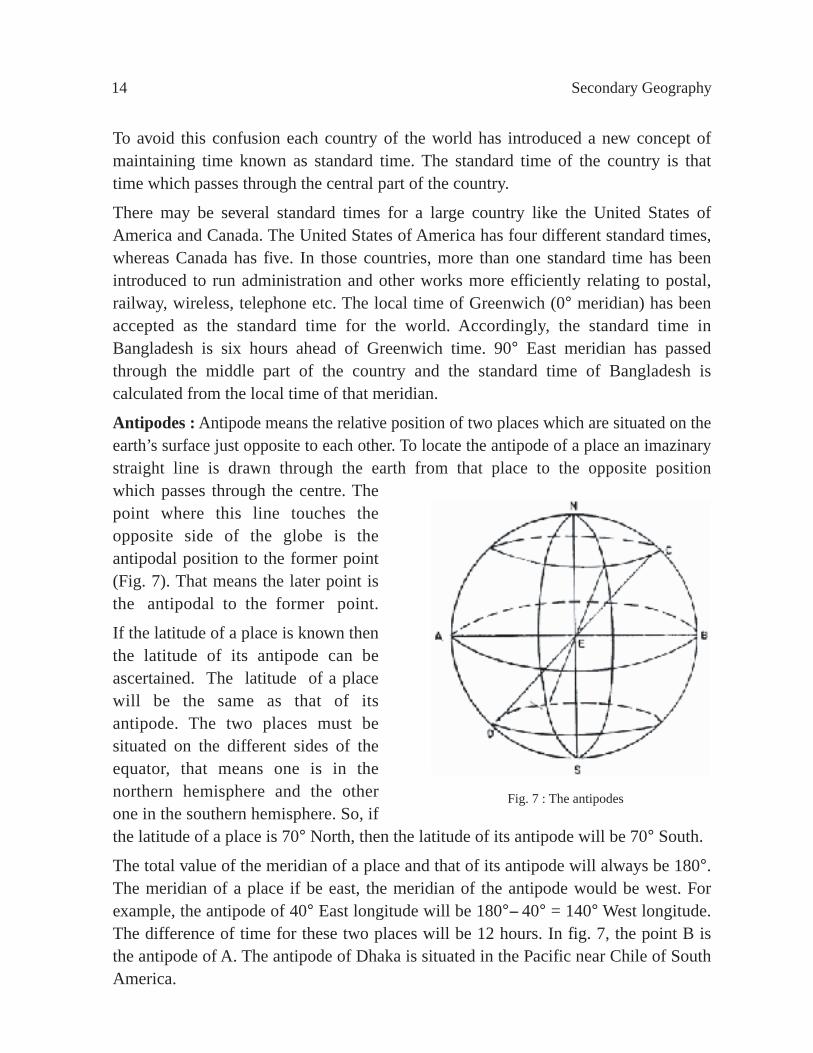
Antipodes : Antipode means the relative position of two places which are situated on the earth’s surface just opposite to each other. To locate the antipode of a place an imazinary straight line is drawn through the earth from that place to the opposite positionwhich passes through the centre. The point where this line touches the opposite side of the globe is the antipodal position to the former point (Fig. 7). That means the later point is the antipodal to the former point.
If the latitude of a place is known then the latitude of its antipode can be ascertained. The latitude of a place will be the same as that of its antipode. The two places must be situated on the different sides of the equator, that means one is in the northern hemisphere and the other one in the southern hemisphere. So, if the latitude of a place is 70° North, then the latitude of its antipode will be 70° South.
The total value of the meridian of a place and that of its antipode will always be 180°. The meridian of a place if be east, the meridian of the antipode would be west. For example, the antipode of 40° East longitude will be 180°-- 40° = 140° West longitude. The difference of time for these two places will be 12 hours. In fig. 7, the point B is the antipode of A. The antipode of Dhaka is situated in the Pacific near Chile of South America.
Fig. 7 : The antipodes

Latitude and Longitude 15
International Date Line
Travelling towards east or west from any place will require adjustment of local time which ultimately creates problems even for adjustment of days of the week. This problems stands acute if anybody crosses 180° longitude towards east or west from a particular place. To avoid this problem or an imazinary line has been drawn absolutely over the waterbodies from north to south. This imazinary line is known as International Date Line.
Necessity of the International Date Line : We know that for the difference of 1° of longitude, there is a difference of time of 4 minutes. So, for every 15° of longitude, there will be a difference of an hour. Thus travelling eastward from prime meridian (Greenwich) up to 180°, one would be 12 hours ahead of the schedule and travelling westward 12 hours behind the schedule. If it is 10 A.M. on Monday in Greenwich, then the corresponding time would be 10 P.M. on the same day at 180° East longitude, whereas, the time at 180° West longitude would be 10 P.M. on the previous day i.e. Sunday. But 180° East or 180° West longitude is virtually the same longitude. So, it is observed that the local time differs by 24 hours or one day in the same longitude. There is a change of day and date if one crosses this line which is known as the International Date Line (Fig. 8).
Any ship or aeroplane sailing towards east from Greenwich will have to subtract one day and sailing towards west will have to add one day to adjust with the local time.
The International Date Line is virtually 180° east and west longitude. It crosses through the Aleutian on the north-eastern part of Siberia, Fiji and Chatham islands. To avoid the problems of adjusting local time, the International Date Line has been so set that it passes only over the waterbodies turning 12° towards east just near the Bering Strait, 7° towards west near the Aleutian islands and 11° towards east near Fiji and Chatham islands. Had it not been drawn this way, the people would have to count two different local times in two different parts of the same island.
Fig. 8 : International Date Line
16 Secondary Geography
Determination of Longitude and TimeQuestion 1. Two places, one located at 40°30¢ east and the other 50°30¢ west of Dhaka. What will be the local time of these two places when it is 8 A.M. at Dhaka?
Solution
The longitudinal difference of the first place from Dhaka is 40°30¢ . For the difference of longitude, difference of time would be= (40 ° × 4) minutes + (30¢ × 4) seconds= 160 minutes + 120 seconds= 160 minutes + 2 minutes =162 minutes= 2 hours 42 minutes.First place is located towards east of Dhaka, so the local time will be more than that of Dhaka. Now to determine the local time of the first place it requires to add 2 hours 42 minutes with the local time of Dhaka. Therefore, the time will be= (8 hours 0 minute 0 second) + (2 hours 42 minutes 0 second)= 10 hours 42 minutes A.M. Again, the difference of longitude between Dhaka and the second place is 50°30¢ .
So, the difference of time,= (50 ° × 4) minutes + (30¢ × 4) seconds = 200 minutes + 120 seconds = 202 minutes= 3 hours 22 minutes.The second place is located towards west from Dhaka. Therefore, the local time of
that place will be less, that means 3 hours 22 minutes will have to be deducted from the
time of Dhaka.
So, the local time of the place,
= (8 hours 0 minute 0 second) - (3 hours 22 minutes)
= 4.38 A.M. = 4 hours 38 minutes A.M.
Answer : 10 hours 42 minutes A.M. and 4 hours 38 minutes A.M.
Question 2. The difference of time between Dhaka and Seoul is 2 hours 32 minutes. The
longitude of Dhaka is 90° East and the local time is 6 hours 32 minutes in the morning.
What will be local time and longitude of Seoul?
Solution
Seoul is the capital of South Korea, and is situated towards east from Dhaka. So, the local
time of Seoul will be more than Dhaka.
The local time of Dhaka is 6.32 A.M.

Latitude and Longitude 17
The local time of Seoul =(6 hours 32 minutes) + (2 hours 32 minutes) = 8 hours 64 minutes = 9 hours 4 minutes = 9.04 A.M. = 9 hours 4 minutes A.M.Again the time difference between Dhaka and Seoul is 2 hours 32 minutes or 152 minutes.
Difference of 4 minutes will make a longitudinal difference of 1°
Difference of 1 minute will make a longitudinal difference =
So, difference of 152 minutes will make a longitudinal difference = = 38°
The longitude of Dhaka is 90° East. The longitude of Seoul will be more than Dhaka as it is situated towards east of Dhaka.
So, the longitude of Seoul will be = 90° + 38° = 128° East.
Answer : The local time of Seoul is 9 hours 4 minutes A.M. and the longitude of Seoul is 128°.
Question 3. The Greenwich time is 20 minutes passed 7 A.M. If the time is the noon for any place, then determine the longitude of that place.
Solution
When the Greenwich time is 20 minutes passed 7 A.M. the local time of the particular place is 12 noon. The local time of the place is more than that of Greenwich. So, the place is located towards east of Greenwich, in effect it is located in the east longitude. The difference of time between these two places is= (12 hours - 7 hours 20 minutes) = 4 hours 40 minutes = 280 minutesFor every 4 minutes difference of time, the difference of longitude stands at 1°.
Therefore, for every 1 minute difference of time, the difference of longitude will be
So, for the difference of 280 minutes the longitudinal difference will be = 70°
Therefore, the difference of longitude between Greenwich and that particular place will be 70° East.
So, that result will be 70° East.
Question 4. Dhaka is located at 90°26¢ East longitude and Karachi is situated at 67° East longitude. If the local time of Karachi is 10 A.M. what will be the local time of Dhaka.SolutionThe difference of longitude between Dhaka and Karachi is (90°26¢ East - 67° East) = 23°26 ¢
14( (°
°
14( (
1´ 152( (4
°
°
1´ 280( (4

18 Secondary Geography
For one degree difference of longitude, the difference of time will be 4 minutes. And for 1 minute difference of longitude the difference of time will be 4 seconds.
Therefore, the difference of time between Dhaka and Karachi is := (23 ° × 4) minutes + (26¢ × 4) seconds= 92 minutes + 104 seconds= 93 minutes + (1 minute + 44 seconds) = 93 minutes 44 seconds = 1 hour , 33 minutes and 44 seconds.
Dhaka is situated towards east from Karachi. So, the local time of Dhaka will be more than that of Karachi.
Local time of Karachi is 10 A.M. So, to determine the local time of Dhaka it requires to add 1 hour 33 minutes and 44 seconds with the local time of Karachi, that means, with 10 A.M.
Therefore, local time of Dhaka will be := 10 hours + 1 hour 33 minutes and 44 seconds= 11 hours 33 minutes and 44 seconds in the morning.
Answer : The local time of Dhaka will be 11 hours 33 minutes and 44 seconds A.M.
Question 5. The latitude and longitude of a place is 40° North and 55° East respectively. Ascertain the latitude and longitude of its antipode.
SolutionThe latitude of a place and its antipode are the same but each of them is located in the opposite hemisphere. The latitude of the place in question is 40° North. So, the latitude of its antipode will be 40° South. The longitude of the antipode will be (180°- the longitude of the place).
The longitude of the place in question is 55° East.
Therefore, the longitude of the antipode will be (180°--55°) - 125°. So, the longitude of the antipode is 125° West.
Answer : The latitude and the longitude of the antipode is 40° South and 120° West respectively.
Latitude and LongitudeWhat we learnt from this chapter :Equator : The imaginary line lying midway between the poles, which encircles the earth from west to east.
The latitude : The angular distance of a point on the earthÕs surface north or south of the equator, as measured from the centre of the earth, is the latitude, of that place.
The lines of longitude : The imaginary lines which are drawn from north pole to south pole through equator connecting each of the different points created by graduating the equator into degrees, minutes and seconds.

Latitude and Longitude 19
66 1°
23 12
0
Declination : The day when the sun gives its rays vertically over a latitude is the declination of the sun for that day.
The Prime Meridian : The Prime Meridian is the line that passes from north to south over Greenwich near London.
The Local Time : Due to rotation of the earth on its axis when the sun reaches its highest position in the sky in some particular place, it is taken as noon-day and the time records as 12 O’ clock. This is accepted as the Local Time of the place and other time of the day is calculated from this local time.
Standard Time : The time which is referred to the mean time of a certain meridian. Every country determines its time from the meantime of the meridian which passes through the middle of that country and this is known as Standard Time of that country.
Antipode : A point on the earth surface is known as antipode of another point when it is situated just on the opposite side of the globe corresponding to that point.
International Date Line : From any fixed place if any body crosses the 180° longitude he will observe that it creates problems to determine the day of the week along with the differences of local time. To avoid this anomaly depending on 180° longitude, an imaginary line is drawn from north to south exclusively over the waters. The imaginary line is known as the International Date Line.
Exercise
Multiple Choice Questions1. Dhaka is located at 90° east longitude and Bangalore is situated at 80° East
longitude. If the local time of Dhaka is 12 noon what is the local time in Bangalore then?
a. 11:20 am b . 11:50 am c. 12:00 noon d. 12:40 pm
Use the figure below and answer question number 2 and 3.
°
°
2
2312°
66 12°

20 Secondary Geography
2. The line stands on 0° is called - a. Tropic of Cancer b . Tropic of Capricornc. Equator d. Axis
3. By observing the figure we can get -- i. The axis encircles the north and south pole ii. The axis passes through the equator iii. The axis and the equator are parallel to each other
Which one is correct below? a. i and ii b . ii and iii c. i and iii d. i, ii and iii
4. What is the correct place among the following over which the international imaginary date line has been drawn?
a.Through the landmass b . Over the water bodies c. Belo w the earth’s surface d. Through the space
Creative Questions1. Sadid reached in Dhaka Airport on 14th March Friday for flying to London. Their
plane flew for London at 11 pm. When the plane landed in Heathrow Airport, Sadid found it was 1 am Saturday at the airport clock. But the watch he wore in his wrist showed him 7 am Saturday.
a. What is the cause of the difference of time?b. Expla in what is the importance of Prime Meridian?c. What is the time in Greenwich when it is 11 hours 1 minute 44 seconds at night
in Dhaka? If the longitude of London is 0° what is the longitude of Dhaka then?
d. ÔThe longitude of a place can be determined by the method of Greenwich mean time’ - give your opinion.

The Motion of the Earth 21
ROTATE EASTEARD
CENTER OF THE EARTH
Chapter ThreeThe Motion of the Earth
Everyday the sun rises in the east and sets in the west. This process led many people in the past to think that the sun is moving and the earth is fixed. The sun moves around the earth. But with the advancement of science, this has been proved that the sun itself is moving and the earth has also motion. Later it has been revealed that the sun does not move around the earth, rather the earth moves around the sun. The earth not only moves around the sun, it also rotates on its own axis. The motion of the earth is of two types : (1) to rotate on its own axis, and (2) to revolve around the sun in its own orbit. The rotational motion of the earth is known as Diurnal motion and the revolutionary motion is called the annual motion.
Diurnal MotionThe earth has motion. Centering the sun, the earth moves from west to east on its axis. This motion of the earth is known as rotation. The earth takes 23 hours 56 minutes and 4 seconds or nearly 24 hours to rotate once on its axis. This period of 24 hours is regarded as one day. This diurnal movement of the earth is the rotation. One such full rotation of the earth is known as solar day. The earth takes a full day to complete rotation once on her axis.
The speed of rotation is different in different places. The speed of rotation at the equator is highest. Here the speed of rotation is more than 1,610 kilometres per hour. This speed decreases towards north and south of the equator. The speed of the rotation is nearly zero at the poles. Though the diurnal motion exists, but still we don’t feel due to the following reasons :
Fig. 9 : Material thrown from the top
CENTRE OF THE EARTH
ROTATE EASTWARD
PLUMS LINE
HORIZON
EAST
WEST

22 Secondary Geography
1. Compared to the size of the earth, we are very much insignificant, so we do not feel the speed.
2. No fixed or movable object is available in front of the earth in the space which can be taken as the basis to understand the rotational speed of the earth.
3. Keeping pace with the speed of the earth, the atmosphere also moves from west to east. So, we, do not feel the rotational speed of the earth.
4. The rotational speed of each of the places of the earth is fixed.
Evidences of Diurnal RotationIn the old days Ptolemy and his follower astronomers used to think that the earth was motionless. But subsequently astronomers like Copernicus, Kepler, Galileo and Newton gave their opinions in favour of the rotation of the earth.
1. Everyday the sun rises in the east and sets in the west. From this phenomenon we can infer that either the sun of the earth is moving. This motion is accomplished within one day or 24 hours. The sun is stationed about 15 crore kilometres away from the earth in the space. Being located at such a long distance, it is not possible for the sun to revolve round the earth within 24 hours. Moreover the tremendous speed the sun requires to move round the earth will be even more than the speed of the light, which is simply impossible. Because no object can move faster than light. So, it is not the sun but the earth which rotates on its own axis in 24 hours.
2. The shape of the earth : The earth is inflated in the middle and is compressed towards the poles. If any pliable object or matter rotates around its axis, it acquires such a condition. The present shape of the earth is the result of such rotational speed. Scientist Newton had the opinion that due to the rotational motion, the earth acquired the present shape.
3. Due to rotation of the earth, changes also occur in ocean currents and wind system. According to Ferrel’s Law, it is due to the rotation of the earth that the air and the ocean currents are deflected to the right in the northern hemisphere and to the left in the southern hemisphere.
4. It is observed that if a stone is thrown from a high place, it does not reach the gound vertically, rather it moves slightly towards the east. This proves that the earth rotates from west to east or the earth has rotational motion (Fig. 9).
5. Primarily, tide occurs due to the attraction of the moon. The moon takes twenty seven days to complete one revolution around the earth. So, it is expected that the high tide would occur once every 27 days. But practically we observe that the high tide occurs every day which proves the rotational movement of the earth.

The Motion of the Earth 23
Fig. 10 : FoucaultÕs experiment
6. French scientist Foucault, with the help of a pendulum proved the diurnal motion of the earth. He attached a pin at the bottom of the pendulum and hang it on the top of St. Pantheon church of Paris with a fixed motion, so that it would oscillate from north to south. Due to oscillation, the pin at the bottom of the pendulum started marking on the ground. Mr. Foucault observed that every time the marks have been deflected towards east. So, it can be proved that due to diurnal motion the earth rotates from west to east (Fig. 10).
Effects of Earth’s Rotation
1. Occurance of day and night : One of the effects of the earth’s rotation is the occurance of day and night. We know that the earth is round and it does not have any light of its own. The earth becomes illuminated by the light of the sun. Due to diurnal motion, that part of the earth which faces the sun becomes illuminated. It is day in the illuminated portion of the earth. Sunlight does not reach the opposite part of the illuminated portion. So, it remains dark and it is night in the dark portion of the earth (Fig. 11).
Due to rotation of the earth, alternately the illuminated portion becomes dark and the dark portion becomes illuminated and that is why the day and night are changed. When the dark portion is illuminated, it becomes day there. Similarly the illuminated portion turns dark, it becomes night there. Thus day and night have been occuring alternately. So, in some places it is 12 hours of day and 12 hours of night.
If the shape of the earth would have been flat instead of being round, the rotation of the earth would create only day or only night. In other words, either only day or only night would exist simultaneously over the globe. On a specific date, in some parts of the earth it is day whereas in other parts it is night. That means when a portion of the earth
Fig. 11 : Occurrance of day and night
SUN RAYSSHADOWCIRCLE NOON
EVENING
MID NIGHT
20
0 F
EE
T L
ON
G W
IRE
PENDULUM
OSCILLATION
a
a
b
b
c
c
d
d
e
e
MORNING

24 Secondary Geography
remains dark the other part becomes illuminated. The border of the lighted and the dark portion is called the shadow circle. Due to rotation, when the dark portion, after crossing the shadow circle faces the light, it is known as morning. The feeble light which precedes the morning is known as dawn and similarly the feeble light that precedes the evening is called twilight. In any place, when the sun reaches the highest elevation of the sky it is known as midday or noon and the time recorded is 12 O’ clock. But in the opposite point of that place it is midnight (Fig. 12).
2. Temperature differences : It is due to the spherical shape and also for rotation that a comparatively smallportion of the earth, located in the tropical areas between 23.5° North latitude to 23.5° South latitude gets direct sunlight only for sometime of the year. The region where the sun gives its rays perpendicularly gets more heat. On the other hand, the areas located north and south of the region mentioned above get slanting rays and so these areas get less heat.
3. Ocean currents, Tide and ebb and wind circulation : Diurnal motion of the earth creates rotational force which is responsible to change the direction of wind and ocean currents. So, as an effect of earth rotation, ocean current and the winds are deflected towards right in the northern hemisphere and towards left in the southern hemisphere.
4. Determining the time : Due to rotation of the earth, it has become easier to calculate the time, since the period of one complete rotation of the earth can be divided into 24 parts and each of the parts can be calculated as an hour. Again the hour can be sub-divided to sixty divisions and the period of each of the divisions can be taken as a minute. Similarly, the minute can again be divided into sixty divisions taking each division as one second.
5. Influence on nature and living creatures : If due to rotation of the earth, any change occurs in the field of temperature and light then such change influences the production, growth and character of living organisms. Had there been no diurnal motion some of the regions would remain ever dark and no plant could grow, while some other regions due to continuous sunshine would have been converted into desert.
Fig. 12 : Different position of day-night
4 P M2 P M
12 NOON
4 O' Clock 2 O' Clock12 O' Clock at night
10 A.M
10 A.M
6 A.M
6 A.M
8 P.M
8 P.M
30°0°
30°
60°
90°
120°150° 180°
60°
90°
120°
150°
Rotation of the Earth
Wes t E as t

The Motion of the Earth 25
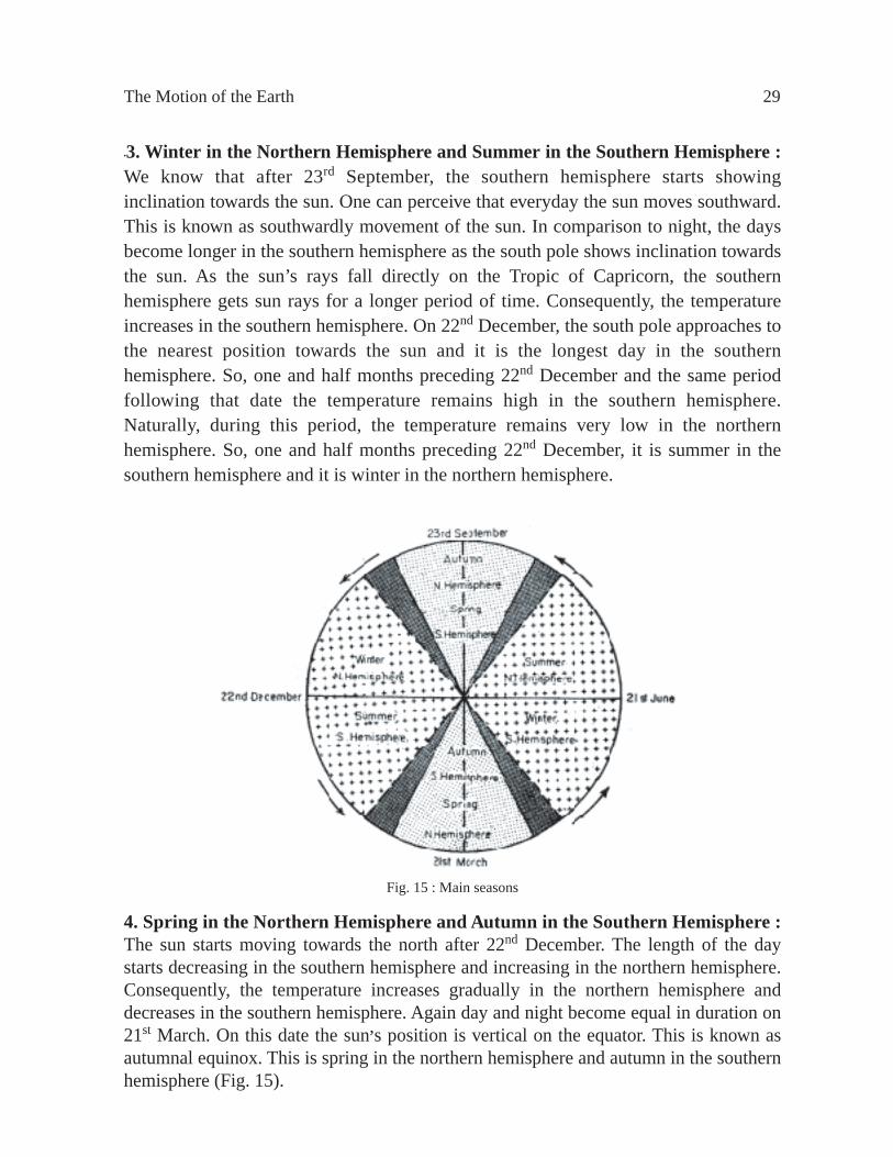
Annual MotionAccording to Newton’s Law of Gravitation, the planets move around the stars due to their attraction. A law is also applicable to the solar system. In solar system each of the planets moves round the sun. The earth being a planet of the solar system, also moves on an elliptical orbit round the sun. The earth having a full rotation on her axis for 24 hours, simultaneously moves around the sun on a set route i.e. orbit once in a year. This movement of the earth is known as the annual motion. The earth takes 365 days 6 hours to revolve around the sun in her orbit. The period, the earth takes to complete the revolution is known as the solar year.The circumference of the earth’s orbit is slightly more than 93 crore 80 lakhs and 827 kilometres. The average speed of revolution is 1,06,260 kilometres per hour. In other words, the earth moves around the sun at a speed of 30 kilometres per second. Considering this speed, it requires 365 days 6 hours 48 minutes and 47 seconds to move round the sun for one time. But the solar year is calculated to be of 365 days. So, there remains a shortfall of about 24 hours or one day. To make up this deficit one extra day is added to the calendar in every fourth year. And that year is calculated as of 366 days. The month of February is calculated to be of 29 days instead of 28 days. This year is regarded as Leap Year and the leap year is taken to be of 366 days.
Revolution of the earth is responsible to create fluctuation in the duration of day and night. It is also responsible to bring changes in the march of seasons.
Effects of Annual MotionI. Fluctuation of day and night : The duration of the days and nights fluctuate in the same time in the different parts of the year due to the revolution of the earth. As a result, it is observed that in the same latitude, the length of day and night fluctuate in different periods of the year.In the process of revolutionary motion the earth, on 2lst June reaches in such a position that the sun’s rays fall vertically on the northern most position of the earth, that means, on 23.5° North latitude or on the Tropic of Cancer. At this time, the northern hemisphere remains inclined more towards the sun and the southern hemisphere remains at the furthest distance from the sun. That is why the length of the day is greater and the temperature is higher in the northern hemisphere. So, 21st June is the longest day and shortest night in the northern hemisphere. The sun reaches its northern most limit on 21st June and the date is known as Summer Solstice.The sunshines vertically over the equator on 21st March and 23rd September. On these two dates, the sun remains in equal distance from the north and south poles. So, on these two dates, the duration of the day and night is equal (12 hours day and 12 hours night) over the entire world. The day when the day and night are equal over the globe, is known as the Equinoxes. 21st March is spring in northern hemisphere. So, 21st

26 Secondary Geography
March is called the Vernal Equinox, and 23rd September is Autumn northern hemisphere, so 23rd September is known as Autumnal Equinox.The southern hemisphere shows maximum inclination towards the sun on 22nd December. So, on that date it is the longest day and the shortest night in the southern hemisphere. The sun reaches its southernmost position on this day and the date is known as the Winter Solstice. The sun gives its rays vertically over 23.5° South latitude or Tropic of Capricorn.
Proofs of Annual Motion1. The apparent motion of the stars : As we cannot feel the occurence of earth’s rotation, similarly we cannot perceive the existence of earth’s revolution. But with the changing locations of the stars from east to west at night sky, we can comprehend that the earth has an annual motion or the revolution. By looking at the stars in a clear sky one can understand the gradual movement of the stars from east to west.2. The changing locations of the sun in the sky : The sun is seen to be located in different positions in different periods of the year. We can observe that on 21st March and 23rd September, the sun rises at a point due east on the horizon and sets at a point due west on the horizon. Again, we can see that on 21st June and 22nd December, the sun rises at north-eastern horizon and south-eastern horizon in the sky respectively. From 21st June to 23rd December, the sun seems to have an apparent motion towards south. This is known as southerly movement of the sun. Again from 22nd December to 21st June, it seems that the sun is apparently moving towards north and this movement of the sun is known as northerly movement.3. The revolutionary motion of different planets : It has been observed through telescope that all the planets are revolving around the sun. The earth as a planet also has revolutionary speed or annual motion.4. Direct observation : Recently the spaceman from spaceship has observed the revolution of the earth.5. The Law of Gravitation : In comparison to the sun, the earth is very small. The sun is 13 lakh times greater than the earth. So, it is naturally thought that due to gravitation the earth moves round the sun.
Change of SeasonsThe whole year is being divided into 4 divisions on the basis of the variation of temperature. Each of the divisions is known as a season. These are the Summer, the Autumn, the Winter and the Spring. It is to be noted here that when summer prevails in the northern hemisphere, winter sets in the southern hemisphere. Again, when there is winter in the northern hemisphere, it is summer in the southern hemisphere. Similarly, when it is spring in the northern hemisphere, it is autumn in the southern hemisphere and it is spring in the southern hemisphere when it is autumn in the northern hemisphere.

The Motion of the Earth 27
Reasons for change of seasons : Due to the difference of temperature, the clange of seasons does occur. The reasons for difference of temperature and as well as that of seasons are the following :1. Difference in solar heat;2. The earth is round. So, some places get direct sunshine, whereas in other places it falls at a slanting position. As a result, it creates difference in temperature which in turn causes to change the season.3. The orbit of the earth is elliptical. So the distance of the earth from the sun fluctuates. As a result, it creates difference in temperature which ultimately brings changes in season.4. The axis of the earth makes a fixed inclination of about 66.5° with the plane of the ecliptic. As a result, once in a year the north pole or the south pole shows inclination towards the sun. Temperature increases in the hemisphere when it remains inclined towards the sun and in opposite case the temperature decreases. As a result, the season changes.Perihelion and Aphelion : The orbit of the earth is an ellipse. Its length is 93,80,51,827 kilometres. The sun is located in the centre or in the focus of the ellipse.Perihelion : In the process of revolution around the sun, the earth on 1st to 3rd January reaches in such a position that the distance between the sun and the earth becomes the lowest. It is about 14 crore 65 lakh 83 thousand 5 hundred kilometres. This position of the earth on that date is known as Perihelion. In Perihelion position the axis of the earth lie aslant outside the orbit (Fig. 13).
Aphelion : As the orbit of the earth is ellipse, the distance between the sun and the earth does not remain fixed for all the time of the year. Sometimes the distance increases and other times it decreases. In the first half of July, particularly on 4th July, the distance between the sun and the earth becomes the highest being 15 crore 14 lakh 20 thousand and 500 kilometres. This position of the earth is known as Aphelion.
3rd JANUARYPERIHELION
14,65,83,500 Km 15,14,20,500 Km4th JULY
PLANE OF ORBIT
ORBITTHE
APHELIONSUN
Fig. 13 : Perihelion and Aphelion position

28 Secondary Geography
The process of changing of season : Normally, we know that there are four seasons in the earth viz., the summer, the autumn, the winter and the spring. Now we will try to understand how the changes of season do occur. The explanations for the change of seasons may be obtained from four situations of the earth during revolution around the sun.1. Summer in the Northern Hemisphere and Winter in the Southern Hemisphere : We know that the north pole comes nearer to the sun once in a year. During revolution on her orbit, the north pole of the earth after 21st March, starts showing inclination towards the sun. Consequently, a large portion of the northern hemisphere is being illuminated by the rays of the sun. The area of illumination gradually increases. As a result, the days become longer and the nights shorter in the northern hemisphere. As the days become longer the sun gives its rays for a longer time in the northern hemisphere. The earth gets more time to receive heat and the heated earth in turn makes the surrounding air to be hot. Nights are short and the amount of radiation from the soil is less in comparison to the amount of heat that is stored during day time. Thus hot weather prevails in the northern hemisphere and so it is summer there.At this time opposite condition prevails in the southern hemisphere. Since the southern hemisphere remains far from the sun and it gets sunshine for a shorter time. So the nights are long and the days are short. The earth radiates the heat which she has stored at day time. As a result, the earth becomes cold. Cold weather prevails in the southern hemisphere and it is winter there.2. Autumn in the Northern Hemisphere and Spring in the Southern Hemisphere : After 21st June, the length of the day starts decreasing and the length of night gets increasing in the northern hemisphere. But until 23rd September in comparison to night, the length of the day still remains shorter. The north pole which is inclined towards the sun starts moving away from the sun and from a distant position the southern hemisphere gradually inclined towards the sun i.e. the south polar region comes nearer to the sun. Consequently temperature gradually decreases in the northern hemisphere and it increases in the southern hemisphere. This condition is known as Autumn in the northern hemisphere and Spring in the southern hemisphere. On 23rd September the day and night are equal throughout the world (Fig. 14).
Fig. 14 : Revolution of earth-fluctuation of day and night-change of season
W
The Motion of the Earth 29
•3. Winter in the Northern Hemisphere and Summer in the Southern Hemisphere : We know that after 23rd September, the southern hemisphere starts showing inclination towards the sun. One can perceive that everyday the sun moves southward. This is known as southwardly movement of the sun. In comparison to night, the days become longer in the southern hemisphere as the south pole shows inclination towards the sun. As the sun’s rays fall directly on the Tropic of Capricorn, the southern hemisphere gets sun rays for a longer period of time. Consequently, the temperature increases in the southern hemisphere. On 22nd December, the south pole approaches to the nearest position towards the sun and it is the longest day in the southern hemisphere. So, one and half months preceding 22nd December and the same period following that date the temperature remains high in the southern hemisphere. Naturally, during this period, the temperature remains very low in the northern hemisphere. So, one and half months preceding 22nd December, it is summer in the southern hemisphere and it is winter in the northern hemisphere.
Fig. 15 : Main seasons
4. Spring in the Northern Hemisphere and Autumn in the Southern Hemisphere :The sun starts moving towards the north after 22nd December. The length of the day starts decreasing in the southern hemisphere and increasing in the northern hemisphere. Consequently, the temperature increases gradually in the northern hemisphere and decreases in the southern hemisphere. Again day and night become equal in duration on 21st March. On this date the sun,s position is vertical on the equator. This is known as autumnal equinox. This is spring in the northern hemisphere and autumn in the southern hemisphere (Fig. 15).

30 Secondary Geography
The Motion of the Eearth What we learnt from this chapter :Diurnal motion : The earth rotates on its own axis once in 24 hours or in a day. This motion of the earth is called the diurnal motion. The diurnal motion causes the occurance of days and nights and the variation of temperature, whereas, this motion controls the ocean currents, tide and ebb and the wind movements.Annual motion : The earth revolves round the sun on a fixed orbit once in a year. This motion of the earth is called the annual motion. The fluctuation in the duration of the days and nights and the changes of seasons do occur due to this annual motion.Seasons : The whole year has been divided into four divisions. Each of such division is known as a season. There are four seasons viz., summer, Autumn, winter and spring.Change of seasons : The change of seasons occurs mainly due to the variation of temperature. Difference in temperature of the sun, the round shape of the earth, the rotation of the earth etc. are the causes of the change of season.Perihelion and Aphelion : The earth, on 1st to 3rd January, is positioned at a shortest distance from the sun and this of the earth is known as Perihelion. Again, the earth on 1st to 4th July, remains at the furthest distance from the sun and such position of the earth is known as Aphelion.
ExerciseMultiple Choice Questions1. Where is the diurnal motion of the earth is nearly zero?i. In the north pole ii. In the south pole iii. In the equator Which one is correct below? a. i and ii b . ii and iii c. i and iii d. i, ii and iii Answer question number 2-4 as per the figure.

The Motion of the Earth 31
2. What does the given figure represent? a. The change of season b. The occurrence of the day and night c. The fluctuation of the day and night d. The rotation of the earth3. In the North and South Pole of the earth -- a. The day and night is equalb . The fluctuation of the day and night is very littlec. Six months night at a stressd. The differences of temperature of day and night4. Which is the date known as autumnal equinox? a. 21st March b . 21st June c. 23 rd September d. 21 st December
Creative Questions1. Answer the questions using the figure below.
a. What is the figure about above?b . Why it is the longest day in the Southern Hemisphere on 22nd December? c. Prove the annual motion of the earth from 4 different points of the given figure. d. Explain what role does the change of season play in Bangladesh agricultural sector?
22nd December 21st June

32 Secondary Geography
Part TwoPhysical Geography
Introduction
The landforms created by the different geographic processes under different environments on the earth’s surface are included in the physical geography. The subject matter of physical geography can be divided into three major divisions viz., lithosphere, atmosphere, and hydrosphere. Though each of these divisions possesses individual qualities, yet they are interrelated. Besides, they collectively maintain the biosphere. The lithosphere, atmosphere and hydrosphere are interlinked with each other and the biosphere has been developed based on the elements taken from them (Fig. 16). Let us cite an example. The people is using lithosphere for agriculture depending on the river water or reserviors (part of the hydrosphere). Again, solar heat is needed (part of the atmosphere) to increase the agricultural production. The lithosphere, atmosphere, and hydrosphere are discussed respectively.
Fig. 16 : Relation of organic and inorganic spheres
ATMOSPHERE
LITHOSPHEREHYDROSPHERE
BIOSPHERE
EARTH

Chapter OneLithosphere
Earth’s crust and the interior of the earth : The earth is almost like a sphere. Its radius is about 6,400 kilometres. There is no scope to observe the interior of the earth by piercing the hard external covering. The geologists by observing the characteristics of the seismic waves, gravitation and the characteristics of the magnetic field have developed some idea about the elements and structure of the earth’s interior. Depending on the worldwide collected information, the earth from the surface to the centre has been divided into three strata. These are (a) the earth’s crust, (b) barysphere and (c) centrosphere.
(a) The earth’s crust : The hard stratum of the rock covering the outer shell of the whole earth is known as the earth’s crust (Fig. 17). The thickness of the earth’s crust is the lowest in comparison to the other interior layers of the earth. On an average, it is about 20 kilometres.The thickness of the earth’s crust on an average is about 35 kilometres beneath the continents and only 5 kilometres beneath the ocean. Generally, the continental earth’s crust is known as SIAL which is composed of Silicon (Si) and of Aluminium (Al). On the other hand, the earth’s crust beneath the ocean is composed of basalt which is heavier than that of Sial layer and its major elements are Silicon (Si) and Magnesium (Mg) and is generally known as SIMA. It is inferred that probably this basalt stratum has beenexisting throughout the world as a coating beneath the Sial and in the bottom of the seas and oceans. The temperature beneath the earth’s crust increased by 30° Celsius for every kilometre of depth.
(b) Barysphere : The stratum beneath the earth’s crust is the barysphere. But, there is a thin layer between the earth’s crust and the barysphere. The Yogoslavian Seismographer Mohorovicic in 1909 first discovered this layer of seperation. So, the layer has been known as Mohorovicic Discontinuity. The layer of barysphere is 2,885 kilometres thick which is extended from Mohorovicic upto the outskirts of the
Fig. 17 : The cross section of the formation of earth’s interiorSource : Trabuck and Lutgens (1994)

34 Secondary Geography
centrosphere (Fig. 18). The rocks of the upper part of the centrosphere are hard and brittle and this layer is about 100 kilometres deep. The earth’s crust and the upper part of the barysphere is 100 kilometres thick and this collectively known as rocksphere or lithosphere.
Fig. 18 : Asthenosphere, lithosphere and mohorovicic discontinuity
The rocks beneath the hard layer of barysphere being close to the melting point are partially soft and this layer extends downwards for about 300 kilometres. This layer is known as Asthenosphere. This hard layer of rock can move slowly over the Asthenosphere. The upper part of the barysphere is made of silicate which is primarily composed of iron and magnesium. It is assumed that the lower part of the barysphere (700 to 2,885 kilometres) is constituted of the minerals composed of complete mixture of iron oxide (FeO), Magnesium Oxide (MgO) and the Silicon dioxide (SiO2). The temperature of the barysphere at 100 kilometres depth ranges from about 1,100° Celsius to 1,200° Celsius which increases to 1,900° Celsius at a depth of 700 kilometres and to 3,000° Celsius at the outskirts of the centrosphere.
(c) Centrosphere : The centrosphere is a layer which is extended from the lower part of the barysphere upto the centre of the earth. The thickness of this layer is about 3,486 kilometres (Fig.17). The centrosphere occupies about 16 per cent of the total area of the earth and its weight is about one-third of the total weight of the earth. The pressure of this layer is several lakh times more than the air pressure and the temperature ranges from 3,000° Celsius to 5,000° Celsius. It is learnt from the siesmic waves that the centrosphere has a liquid cover which is about 2,770 kilometres thick and has also a
Earth crust beneaththe oceans
DEPTHIN KM.
Upper Barysphere
Lithosphere
Asthenos phere
Partially in Melting ConditionPliable Barysphere
Mohorovicic, Discontinuity
Continental Earth Crust

Lithosphere 35
hard inner cover which is about 1,216 kilometres thick. The major two elements of the centrosphere is Ferror (Fe) and Nickel (Ni) which is combinedly known as NiFe.
LithosphereWhat we learnt from this chapter :Earth’s crust and the interior of the earth : The earth’s crust and the interior of the earth can be divided into three divisions according to their mode of formation. These are (a) Earth’s crust on Lithosphere, (b) Barysphere and (c) Centrosphere.Earth’s crust : The thickness of the earth’s crust beneath the continent, on an average is 35 kilometres and beneath the ocean it is 5 kilometres. The upper layer of the earth’s crust is S1AL. The continents are primarily made of Sial rock.Barysphere and Lithosphere : The bottom layer of the earth’s crust is barysphere. This layer is about 2,885 kilometres thick. The earth’s crust and the upper part of the barysphere upto 100 kilometres is collectively known as rocksphere or lithosphere.Centrosphere : The layer extending from the lower part of the barysphere upto the centre of the earth is known as Centrosphere. This layer is about 3,480 kilometres thick.
Exercise
Multiple Choice Questions
Observe the figure below and answer the questions from 1 to 4.
1. Which one is accepted on the basis of the living of plants and animals according to the figure?
a. The difference among lithosphere, atmosphere and hydrosphereb . The lithosphere is combined with hydrospherec. Atmosphere is combined with hydrosphered. Lithosphere, atmosphere and h ydrosphere are together connected
Hydrosphere
AtmosphereLithosphere

36 Secondary Geography
2. In the figure it is shown that lithosphere, atmosphere and hydrosphere has a common factor ( ingredient) and that is --
a. Oxygen b . Nitrogen c. Iron d. Nick el
3. What is the temperature beneath the Earth’s Crust increased for every kilometre of depth?
a. 30 ° b . 40° c. 50 ° d. 60 °4. In the Centre of the Earth, there is --i. Centrosphere ii. Iron and nick el iii. Hea vy temperature
Which one is correct below?a. i and ii b . ii and iii c. i and iii d. i, ii and iii
Creative Questions
1. The earth has been created from the Sun. A separate part of the sun has radiated to take the present shape of the earth with the change of time. The temperature of the interior part of the earth is near to the temperature of the sun. But its external cover becomes cold and hard with the change of time. There is a difference scene in the structures as well as ingredients from the earth to the centre of the earth.
a. What is Earth’s Crust? b . Why does the Earth’s Crust take hard shape?
c. Draw and show the structural differences from the Earth to the Centre of the Earth.
d. Why does the ingredients of various layers of the earth to the centre of the earth are different-- explain.

Lithosphere 37
Rocks and MineralsThe outer cover of the earth’s surface is known as the earth’s crust. The earth’s crust is basically formed of the rocks composed of different minerals. These earth forming minerals serve out different purposes. As for example, mineral oil and coal are used as fuel. Moreover, the economic use of gold, copper, zinc, aluminium, nickel, iron etc. is also very much important.
Different land forming processes like volcanism, depositional and erosional activities are highly influenced by the structure of the rocks and minerals. It is necessary to acquire some knowledge about minerals and rocks being the elements responsible for formimg the earth’s crust.
First let us see what is meant by minerals? What is the difference between rocks and minerals?
Minerals are formed by the composition of two or more basic elements. However, some minerals may be formed of one basic element. Diamond, gold, copper, silver, mercury and sulphur may be cited as examples. Of all these, the hardness of diamond is highest and of talc is lowest.
On the other hand, the rocks are formed by the mixture of one or more minerals. Here, we mention the term mixture because in nature the minerals are found in mixed condition. Each of the rock forming minerals maintains its characteristic. Though much of the rocks are formed of more than one mineral, but in such case, the minerals and rocks are the same. As for example, calcite is a mineral while it is known as limestone as a rock. The characteristics of minerals are controlled by nature of the basic elements forming them. On the other hand, the property of rocks are regulated by the nature of the minerals constituting them.
The rock family : The rocks are of three types according to their mode of origin. These are igneous, sedimentary and metamorphic rocks. Igneous and metamorphic rocks are formed by the processes accomplished in the interior of the earth. On the other hand, the sedimentary rocks are formed by the processes acting on the surface of the earth. Though the mode of formation of these rocks are different, yet they are interrelated.
Igneous rocks : Igneous rocks can be formed under two environmental conditions viz., intrusive and extrusive. In the deep interior of the earth due to cooling, magma may be crystallized to form intrusive rock. If the magma finds its way to the surface of the earth through the vents, then it is termed as lava. This lava after cooling becomes extrusive rock (chart 1).

38 Secondary Geography
Intrusive rocks are sub-divided into plutonic and hypabyssal. Extrusive rocks are again sub-divided into explosive and quiet type. In intrusive type of rock, the magma solidifies in the deep interior of the earth. Granite, gabro, syenite, diorite etc. are the examples of intrusive rocks. In hypabyssal type, the magma solidifies in the shallow interior as Porphyry.
Magma when thrown by violent explosions into the air after being solidified gives birth to the explosive Igneous rocks. Tuff and breccia may be cited as examples. In the quite type of igneous rock, the molten magma flows out quitely in all directions and solidifies. Rhyolite, basalt, andesite etc. are best examples of this type of rock.
Fig. 19 : Landforms created by igneous rock
Batholiths, Laccoliths, Dikes, and sills are the examples of the igneous rock formed into the interior of the earth (Fig. 19).
Sedimentary rocks : The rocks which are formed by the deposition of sediments are known as sedimentary rocks. In this type of rock, the sediments are deposited in layers or strata. Sedimentary rocks cover an area of 5 per cent of the total area of the earth’s crust. However, about 75 per cent of the total exposed part of the continental landmass is formed of sedimentary rocks.
Sources of sediments and their characteristics : Different types of mechanical and chemical weathering processes are acting on the earth’s crust. Due to the effect of these processes, the outer crust of the earth gradually erodes out. These eroded
Igneous Rock
Intrusive Extrusive
Plutonic Hypabyssal Explosive Quiet

Lithosphere 39
Mechanically formed (Accumulationsof detritus by mechanical processes)
Grains of normalsize or larger SandSilt Clay
Pebbles
SandstoneClay rocksShale
Sources Elements of sediments Names of the rock
Chemically formed (accumulation ofsediments by chemical processes)
CalciteDolomiteHeliteGypsum
LimestoneDolomiteSaltGypsum
Organically formed Lime
Silicon dioxidetype diatomPlant materials
Limestone,Chalk,CocinaDiatom
Coal
materials are known as sediments. The sediments which are formed by detrital created by the mechanical weathering is known as clastic sedimentary rocks. Clay, sandstone and pebbles are the examples of clastic sedimentary rocks. Sedimentary rocks which originate from the sediment accumulated by the chemical weathering is known as organic sedimentary rock. In this process, the materials which remain in soluble condition in the water gradually settle down at the bottom by different inorganic processes and ultimately become consolidated. For example, if evaporation occurs in any confined sea water, then the salts remain as residue. In this case, evaporation is an inorganic process and the salt that remains as residue is considered to be sediments. In some cases, the dead bodies of different acquatic animals are accumulated as organic sediments and ultimately these are consolidated and transformed into organic sedimentary rocks. Coal, limestone are the proper examples of such rock. Besides, dolomite, chert and gypsum are the examples of chemical sedimentary rocks.
Classification of sedimentary rock : Primarily, the sedimentary rock is of three types viz., mechanical, chemical and organic. The names of sedimentary rocks with their elements is shown in Table 1.
Table I : Sources, elements and the associated names of the sedimentary rocks
�

40 Secondary Geography
Characteristics of sedimentary rocks : Bedding, ripple marks, clay, cracks etc. are found in the sedimentary rocks (Fig. 20). The presence of fossils is one of the major characteristics of the sedimentary rock.
Metamorphic rocks : The rocks which through temperature, compression and chemical actions have been changed either in form or in composition is known as metamorphic rocks.
Fig. 20 : Bedding of sedimentary rocks
The agents of metamorphism : Heat, compression and chemically active fluids are the main agents who work singly or collectively to transform rocks. These metamorphic media increase the internal density of the rocks and the dimension of the crystals and create clear foliation. Due to the application of temperature and pressure, the minerals of the rock become compressed like the leaves of trees and are arranged in parallel layers. This characteristics of layered structure of rocks is called foliation (Fig. 21).
Fig. 21 : Formation of foliation
Examples of the important metamorphic rocks : Rocks with foliationSlate : Slate is produced from shale. This type of rock contains very fine crystals which are mainly formed by small plates created from mica. Slate is used to produce writing slates, blackboards etc.
LIMESTONE
PLANE OF BEDDING
RIPPLE MARK
CLAY STRATA
SEDIMENT
SAND
ORGANIC SEDIMENTS (COAL)
Pre-Foliation Stage Shape after Foliation
Pressure

Lithosphere 41
Non-foliated rocksMarble : It is a coarse grained crystalized rock which has been formed from limestone or dolomite.
Quartzite : It is a very hard metamorphic rock which is mainly created from sandstone.
RocksWhat we learnt from this chapter :
Rocks are divided into three types according to their mode of origin, viz. (1) Igneous rocks, (2) Sedimentary rocks, and (3) Metamorphic rocks.
The hot viscous type of matters in the interior of the earth is known as magma and if it finds its way to the surface of the earth, it is called lava.
Igneous rocks : Igneous rocks are formed by cooling of magma. Landforms created by igneous rocks have diversified characteristics. Dikes, sills, laccoliths and batholiths may be cited as examples.
Sedimentary rocks : Rocks which are formed by the accumulation of sediments is known as sedimentary rocks. In this type of rock, the sediments are accumulated in layers. Limestone, coral and gypsum are the examples of sedimentary rocks.
Metamorphic rocks : Due to temperature, compression and chemical actions, the elements and structure of the minerals of a rock are changed and transformed to a new type of rock which is known as metamorphic rock. Igneous and sedimentary through changes are transformed to metamorphic rocks.
Slate : Slate is formed from shale. It is used to produce writing slates and blackboards.
Marble : It is a coarser grained crystalline rock which is created from limestone and dolomite.
Quartzite : It is a very hard metamorphic rock. Primarily, it is formed of sandstone.
ExerciseMultiple Choice Questions
1. Which one is the Sedimentary Rock formed organically?a. Clay and sandstone b . Coal and limestone c. Dolomite and gypsum d. Calcite and nick el
2. What kind of rock the Slate is?a. Igneous b . Sedimentary c. Metamorphic d. Non-crystalline

42 Secondary Geography
Notice about the figure below and answer question number 3 and 4.
3. What is the name of the rock shown in point ÔA’ in the figure?a. Extrusi ve b . Sedimentary c. Metamorphic d. Hypabyssal
4.ÔMagma’ is --i. Plutonic rock ii. Hypabyssal rock iii. Extrusi ve rock
Which one is corr ect below?a. i b . iic. iii d. i, ii and iii
Creative Questions1. While Tamanna was on a visit to Rupsha Bridge she asked her friend Happy to tell
her what the ingredients of Rupsha Bridge are? In reply, Happy said, it is build of cement. In her evasive question Tamanna enquire of the ingredients of cement. In response to this question, Happy told that cement is made of limestone and it is a kind of rock.
a. What kind of rock is limestone?b . How is this kind of rock formed?c. Find out the difference between the limestone, which is used to prepare cement and the metamorphic rock? d. ÔThe structural formation of the sedimentary rock is always aliveÕ give reasons for your answer .
Extrusive Igneous Rocks Intrusive Igneous Rocks
A Plutonic
EarthÕs Surface
Explusive Type
Quiet Type

Lithosphere 43
Changes of the Earth’s Crust�Diastrophism
The earth’s crust is ever changing. Different landforming processes are responsible to bring changes. Landforming processes are the activities by which the changes are accomplished naturally in the formation of the land. For example, a river is building a flood plain through deposition. So, the depositional activities of a river is a landforming process. The landforming processes are accomplished with the help of different physical agencies or forces such as the gravitational forces, interior temperature and the solar energy. The different landforming processes with the help of the aforesaid agents bring changes on the earth’s crust either slowly or rapidly. Generally, the landforming processes are associated with external forces. The changes brought about on the earth’s surface takes a longer period of time, so this type, of changes is known as slow changes. The slow changes are accomplished in two processes.
Denudation : It means to make the things exposed. The processes by which the rocks on the earth’s surface are broken into pieces through the application of external physical forces and the debris are transported elsewhere is known as denudation. This denudation work is performed through three processes such as weathering, erosion and transportation.
Weathering : The weathering is a process by which the rocks on the surface of the earth is broken mechanically into pieces due to snow or frost, the variation of temperature and pressure or due to chemical (dissolution) action on the materials. Even the rocks are dislodged by the animals. But the rocks weathered this way, are not transported elsewhere.
Erosion : Erosion and transportation are accomplished together. The process by which the rocks of the earth’s crust are eroded by the river, wind, glacier, ocean currents etc. and the eroded materials are transported elsewhere is known as erosion.
On the other hand, the rapid changes are brought about on the earth’s surface by the landforming processes associated with the internal forces. The changes brought about on the earth’s crust by the landforming processes are shown in a figure below :
According to this figure, the earthquake and the volcanism are mentionable of the rapid and sudden forces responsible for the changes on the earth’s surface.

44 Secondary Geography
Landforming Processes
Slow changes Sudden changes Slow and sudden changes
Denudation Deposition Earthquake Volcanism Diastrophism
Weathering Erosion Transportation
1. Earthquake : An earthquake is a vibration or oscillation of the surface of the earth caused by sudden release of enormous pressure. If a stone is thrown in the quite water of a pond, it will create ripples in the water which will scatter all aroundthe pond. Sudden release of enormous pressure from the interior of the earth, creates waves in the surrounding rock like the waves in water which also scatter all around. The point where the energy is released is known as the centre. The point just vertically above the point of origin is known as Epicentre (Fig.22). Seismography is used to measure the intensity of the earthquake waves.
Types of earthquakes : Normally, an earthquake originates between 5 to 1,126 kilometres deep into the interior of the earth. The earthquake centre has been classified into three classes according to their depth. These are :Shallow : The earthquake originating at a depth of 60 kilometres is termed as shallow earthquake.Intermediate : The earthquake originating at a depth of 60 to 300 kilometres is known as Intermediate.Deep : The earthquake originating at a depth of 300 kilometres and above is known as deep earthquake.About 90 per cent of the earthquakes that occur throughout the year over the world originate within less than 100 kilometres of depth. The terrible earthquakes which occured so far over the world are mostly of shallow type.Causes of earthquake : The geologists opine that sudden tectonic actions in the faultline or along the cracks are responsible to create earthquake. Besides, sudden ejection of lava with great force can also produce earthquakes. Radiation of heat from the earth’s surface causes shrinkage which in turn to maintain equilibrium, develops cracks along the faultline or folds and the earthquake is caused. The rocks if dislodged due to earth movement or development of faults will also cause the earthquake.
Fig. 22 : Focus and epicentre of earthquake

Lithosphere 45
Strength of earthquake : The energy of earthquake means the amount of strength which is scattered from the earthquake centre in all directions. Charles F. R. Richter, a seismologist first introduced an arithmetic scale to measure the intensity of seismic waves. The scale is known as the ÔRichter scale’.Earthquake Prone Areas or BeltsFrom fig. 23, it can be realised that the severity of earthquake is not equal throughout the world. Earthquakes mostly occur in the comparatively smaller areas which are long and narrow in size. Among them, the most noteworthy areas are the circular islands (Philippines and Japan), young fold mountains and ocean ridges. According to fig. 23, the earthquake prone areas can be divided into three principal zones :(a) The Pacific Zone : Maximum number of earthquakes occur along the outer border of the Pacific Ocean. Japan, the Philippines, Chile, Aleutian islands and Alaska have been identified as the most earthquake prone areas.(b) The Mediterranean and the Himalayan Zone : This region extends from the Alps to New Zealand covering Caucasus, Iran, the Himalaya, Indo-China and East Indies following the northern coast of the Mediterranean Sea.(c) Ridges of the Mid-Atlantic and the Indian Ocean : The north-south ridges of the Mid-Atlantic Ocean meeting with the ridges of the Indian Ocean extends upto the Mediterranean zone through the Red Sea.Besides these three specified belts, there are some areas located seperately within the continents and in the deeps of the oceans where the occurrence of the earthquake is felt.
Fig. 23 : Distribution of earthquake prone areas
0 1000 2000 km

46 Secondary Geography
Fig. 24 : Volcano
Effects of earthquakes : Earthquake is accepted as a natural calamity. Most of the times, it causes great loss of lives and wealth in some parts of the earth.Generally, it may be mentioned that the devastative nature of earthquakes brings the following damages and changes in the earth’s crust.(a) Faults, cracks or landslides occur in the earth’s crust due to the earthquake. The course of the rivers is also changed. For example, the bed of the Brahmaputra river was raised and the river changed its original course and started flowing through the channel of the Jamuna due to the earthquake of Assam in 1787.(b) Earthquake, if it occurs in a thickly populated area, then causes great devastation to houses, roads and railways, water and gas supply line and other properties of the area. Moreover, if the area is a hilly one, then the landslides and mud flow create devastation to the settlements located at the foot of the mountains.(c) Earthquake that originates in the ocean floor create tremendous waves on the surface of water. Waves thus created by earthquakes are known as Tsunamis. Tsunamis bring sudden flood in towns and other localities in coastal areas.2. Eruption : Eruption is one of the major forces or processes bringing changes on the surface of the earth. Eruption of the volcanoes or the magma is the main sources of igneous rocks on the surface of the earth. Volcanoes, by dint of their internal energy produce different landforms which are known as initial configuration of the land. Different weathering agents start erosion on these initial landforms with various external forces and such areas are gradually transformed into plain lands. Thus it can be noted that there are continuous attempts to maintain equilibrium between the internal and the external forces.VolcanoesExtreme temperature released from the radioactive minerals in the interior of the earth cause the rocks of the lower part of lithosphere to melt. This melted rock finds its way to the earth’s crust through the cracks or weak points. This erupted materials is known as Lava, gradually accumulated surrounding the vent and creates a high landform which is called Volcano (Fig. 24).On the crest of the volcano, there is a forepart with vertical slopes which is known as crater. This crater through a

Lithosphere 47
tunnel is linked with the magma in the interior of the earth. Sometimes the molten materials instead of ejecting out may be solidified inside. After ejection, the crater collapses creating a hole which is known as caldera. Crater lake of Oregon State of the United States of America is a Caldera. The volcanoes which eject lava from time to time are active volcanoes. At present, there are about 850 active volcanoes in the world. The volcanoes where volcanism remains suspended for a certain period of time are known as dormant and where the volcanic eruption has stopped permanently are known as extinct volcanoes.
Erupted materials : Large number of rock fragments, volcanic dust and fine volcanic ashes are ejected with the lava. Besides, large amount of gaseous materials is also ejected. In the ejection process, firstly comes the basaltic lava followed by the andesite lava and lastly the rock fragments.
Types of volcanoes : Though the nature of each volcanic eruption is quiet different, but the specialists on the basis of shape, size and eruptive nature have divided the volcanoes in three different types as Shield Volcano, Cinder Cone and the Mixed Cone.
Shield volcanoes : This type of volcanoes is mainly constituted of basaltic lava. Mauna Loa and Kilauea of the Hawaii Islands are the best examples of this type of volcano. Mauna Loa is 5,000 metres wide beneath the ocean and it rises to 4,170 metres above the ocean (Fig. 25).
Fig. 25 : Shield volcano
Cinder Cone : This type of volcano is created by rock fragments and lava. Parcutin and Mount Helena of Mexico are the proper examples of this type of Volcano.
Mixed Cone : This type of volcano is created mainly by andesite lava which is fluid type with more viscous components. Hard rock fragments, volcanic dust, volcanic ashes and the heated gas are thrown with violent explosions and are accumulated near

48 Secondary Geography
the crater and the viscous lava accumulates above them. Mount Maon of the Philippines and the Fujiama of Japan are the examples of this type of volcanoes (Fig. 26).
Fig. 26 : Cinder and mixed cone volcanoes
Volcano Prone Areas : The location of the active volcanoes have been shown in fig. 27. Almost all the volcanoes are located along the border of the continents and the oceans. The main belt stretches from New Zealand in the Pacific to the southern tip of South America covering the Philippines, Japan, Alaska and the western coast of North America and this belt is known as Fiery Ring. Out of 850 active volcanoes of the world, this belt simply accounts for 75 per cent of the total. Moreover, traces of volcanic activities are also manifested in the submarine ridges of the oceans. For example, the landforming activities in the submarine ridges of Mid-Atlantic are still active.
Fig. 27 : Distribution of active volcanoes
Intrusive Rock(Strata)
Cinder ConeA
Mixed Cone
Intrusive Rock(Strata)
Crater
TunnelDike
Crater
Lava Flow
B
VOLGANOES
120°

Effects of volcanism : Volcanic eruptions and heavy lava flow are a kind of natural calamity which causes heavy damages to the living creatures and different human activities. In the past, many towns and settlements were destroyed by lava flows and thousands of people died instantaneously due to the release of poisonous gas from the volcanoes. Many of the volcanoes are situated in high mountainous regions and their crests always remain under heavy ice cover. But when eruption starts, the ice coverings melted and creates mud flow and creates heavy damages to the localities situated at the foot of the mountains. Moreover, occasionally the rock fragments and ashes ejected with explosive forces are being thrown into the air.
The landforms that are created from the volcanic eruptions and lava remain unutilised for a longer period and brings noteworthy changes in the landscape. However, the landforms thus formed by volcanoes are very fertile and are also very rich in mineral resources. Moreover, the volcanic landforms are very important for tourists.
Earthquakes
What we learnt from this chapter :
Earthquake : An earthquake is a vibration of the surface of the earth caused by sudden release of enormous pressure from the interior of the earth.
Effects of Earthquake
(a) Folds, cracks and landslides may occur and even the courses of the rivers is may be changed.
(b)Earthquake, if it occurs in any densely populated areas, will cause enormous damage to houses, roads and streets, water and gas supply system and other resources.
(c) Earthquake, if occurs beneath the sea creates tremendous waves on the surface of the water.
Volcanoes : The molten rocks of the interior of the earth finds its way to the surface through the cracks or weak points of the lithosphere. These ejected materials are known as lava which gradually accumulates in the surroundings areas of the cracks or openings and forms a high landform which is known as volcano. The volcanoes may be classified into three types viz, Shield volcano, Cinder cone and Mixed cone.
Lithosphere 49

Exercise
Multiple Choice Questions
1. The epicentre of the earthquake is --a. The place from where the intensity of strength of earthquake is being measuredb . The place where the earthquake is occurred c. The points just vertically above the point of origin d. The place where the earthquake is caused
2. Which calamity will take place if there is an intermediate earthquake caused in Dhaka? i. Loss of livesii. The multi-purpose building will be flop down iii. The course of the river will be changed
Which one is correct below? a. i and ii b . ii and iii c. i and iii d. i, ii and iii
3. Which one below is considered to be less Earthquake prone belt? a. The outer border of the Pacific Ocean b . The north part of the Mediterranean Sea c. The mountain of the Mid-Africa d. The ridge of the Mid-Atlantic Ocean
Read the paragraph below and answer question number 4 and 5.
The Earthquake that occurred in the year 2005 caused a great damage of the countries in tropical and equatorial zones. Meanwhile, a large number of earthquakes occurred around the world in the same year. Earthquake results huge natural calamities.
4. The country, which is badly damaged in the earthquake in 2005 is --i. Sri Lankaii. Japaniii. Indonesia
Which one is corr ect below?a. i b . iic. iii d. i, ii and iii
50 Secondary Geography

5. Tsunami brings in landmass --a. Sudden flood b . Sudden rain c. Sudden quak e d. Sudden thunder
Creative Questions
1.One fine morning Shuharto stood on the bank of the pond. Suddenly he felt a terrible jerking on lands and saw that the water of the pond overflowing on the otherside. At once, he saw that the wave of the water coming rush/fast towards him. He also saw that the fearful people are running here and there raising hue and cry. Shuharto was thinking about the incident. Is this a natural calamity?
a. The jerking that Shuharto felt on land, what was that? b .Why this type of incident occurs?c. Draw a map to identify the earthquake prone belt of the Pacific. d. ÔEarthquake is recognized as a natural calamityÕ give your opinion in favour of it.
�
Lithosphere 51

LandformsThe earth is formed of diversified physical structures which is known as landform. These physical structures include the high mountains, vast traces of plain lands and also features of intermediate heights. The mountainous regions cover about 18 per cent, plateaus and hills about 24 per cent and the plain lands about 58 per cent of the total area of the earth.
MountainsA mass of rock considerably very high occupying a vast area is known as a mountain. Higher altitude and steep slopes are its main characteristics. This altitude may reach to several thousand metres from the sea level. Some of the mountains may be located in isolation viz, the Kilimanjaro of East Africa. Again some mountains with several peaks may cover a large area (several thousand kilometres). This type of mountains are folded like the waves (Fig. 28) viz., the Himalayan Mountain which extends from Pamir Knot in the east. The Rocky and the Appalachian Mountains of North America, the Andes of South America, the Alps, the Ural, the Caucasus of Europe and the Fujiyama of Asia are noteworthy among other mountains.
Several mountain building processes known as Orogenesis work together in the formation of the mountain. Greek word ÔOros’ means mountain and ÔGenesis’ means formation or creation. Tremendous weathering particularly the wind, water and glacier bring substantial changes in the landforms.
Types of mountains : The mountains can be classified into four groups according to their major characteristics viz., (a) Fold Mountain, (b) Volcanic Mountain, (c) Block Mountain, and (d) Laccolith Mountain.
(a) Fold Mountain : This type of mountains are generally constituted with the union of several vast and high mountain ranges. It can be said easily that when a tectonic plate enters into another adjacent plate then huge quantity of sediments are accumulated
52 Secondary Geography
Fig. 28 : Fold Mountain
Mountain Peak
Mountain Foot
RockStrata
Mountain Peak

along the joint line of the two plates and due to lateral pressure, these sediments are folded giving rise to anticlines and synclines. The fold mountains are formed consisting of the synclines and anticlines covering a vast area. The Himalayan Mountains, the Alps, the Ural and the Rocky Mountains are the appropriate examples of the fold mountains (Fig. 29).
(b) Volcanic Mountain : Generally, the volcanic mountains are formed by the accumulation and solidification of the molten materials ejected through the volcanoes.This type of mountains are generally conical is shape. Depending on the nature of lava flow ejected through volcanoes, this type of mountain in some cases, may cover small area with steep slope (Fig. 30) as Mount St. Helena of the United States of America, and in other cases, may cover a large area with gentleslope like the Fujiyama (Japan) and the Mouna Loa (Hawaii island).
(c) Block Mountain : The block mountain has got at least one side to be very steep with natural fault. Movement of the earth creates fractures in the earth’s crust. So, therock strata on both the sides cannot match together and displacement starts among the strata. So, the earth’s crust is displaced along the crack which is known as fauly. So in some part, this displacement may be upward and in another part it may be downward. The uplifted part along the fault is
Lithosphere 53
Fig. 29 : Fold Mountain
Fig. 30 : Volcanic Mountain
Fig. 31 : Block Mountain
Mountain
Plains
Fault FaultMagma
VolcanoHill
VOLCANICMOUNTAIN
ACTIVE VOLCANO
LAVA
EXTINCT VOLCANO
VOLCANICPLAIN
Block Mountain
Valley
Lake
Lake
Fault
Plains
MAGMA

Fig. 32 : Laccolith Mountain
known as Block Mountain (Fig. 31). The Black Forest of Germany and the Salt Mountain of Pakistan may be cited as examples. The valley which is formed due to the downward movement of the land between two faults is known as the Rift Valley.
(d) Laccolith Mountain : The molten magma tries to come out of the interior of the earth being dispalced by the pressure of the gas, but these molten materials, instead ofcoming out to the surface of the earth solidifies beneath the surface of the earth’s crust. Due to upward thrust, the rock layer takes the shape of a tomb. The mountain thus formed is known as Laccolith or relict mountain (Fig. 32). The Henry Mountain of the United States of America is an example of this type of mountain.
Plateau : The vast plain area lower than the mountain but higher in elevation than the plain land is known as Plateau. The formation of plateau is mainly linked with themountain building processes (Fig. 33). The volcanic lava, in some cases, has formed a vast plain land as in the case of the Deccan Plateau of South India. Besides, the old mountainous regions, by the process of weathering and denudation has been converted into a plateau. According to the mode of location, the plateau may be classified into three types viz., (a) Intermontane Plateau, (b) The Piedmont Plateau, and (c) The Continental Plateau.
(a) The Intermontane Plateau : The elevation of the Intermontane Plateaus range from 3000 to 5000 metres. These plateaus are generally remain enclosed by mountains and are formed by the different mountain building processes. The Tibetan Plateau is of this type. This plateau is surrounded on the north by Kunlun, on the south by Himalaya and on the east and west by other mountain. The average elevation of this plateau is more than 4000 metres and the area is also more than 52 lakh square kilometres. Besides, the Bolivian Plateau of
54 Secondary Geography
Fig. 34 : Intermontane Plateau
Fig. 33 : Plateau
Rift ValleyPlateau
Fold Mountain Peak Fold Mountain Peak
Bolivian High Plateau
PacificOcean

South America, the Mexican Plateau of Central America, the Mongolian and the Tarim Plateau of Asia are examples of this type of plateau (Fig. 34).
(b) The Piedmont Plateau : This type of plateau is formed at the piedmont of high mountains. Due to extensive weathering in the mountainous slope, the eroded materials are deposited in the lower slopes of the mountains creating an extensive plain land which is known as Piedmont Plateau. However, the lower part of this type of plateau joins with the adjacent plain lands. Colorado located in the south western tip of the Rocky Mountain of the United States of America and Patagonia of South America are the Piedmont plateaus.
(c) The Continental Plateau : The vast high plain land enclosed by seas or lowlands are known as Continental Plateau. This kind of plateaus do not have any relation with the mountains. Arabian Peninsula, Spain, Australia, Greenland are the best examples of this type of plateau.
The population is very thin due to rugged relief and dry clilnate. However, these plateaus are rich in different minerals like tin, copper etc. Moreover, hydroelectric plants have also been established in the rapid flowing rivers of the plateaus.
PlainsAn extensive high land above the sea level with gentle slope is known as Plains. Here, the plain means the land which is less rugged. This type of plains have been formed by the erosional and depositional work of different landforming activities like river, glacier, and wind. Gently undulating land with less rugged relief is most suitable for agriculture, settlement and road construction. So, dense settlements have been developed on the plain lands.
On the basis of the origin of the plain land, the plains have been classified into two as erosional and depositional.
Plains formed by erosion : This type of plains are formed due to continuous erosion accomplished by river, wind and glacier. The upper rocks are eroded gradually and the lands with steep slope are transformed to plains (Fig. 35). The plains at the foot of the Appalachian and the Siberian plains are the glaring examples of this type of plains. Madhupur and Barind region are the two examples of such plains formed by erosion in
Lithosphere 55
Fig. 35 : Plains formed by erosion
Plain Formed By Erosion
Plain Formed By Erosion
Old Stage
Last Stage

Bangladesh. During the Pleistocene era that means about 8 to 10 lakh years ago, these areas were uplifted from the ocean by diastrophic action. In the later eras, these uplifted areas had been transformed to plains due to erosional activities by river.
Plains formed by deposition : The plains are also formed by deposition. Formation of this kind of plains can be found anywhere starting from the mountainous regions to the sea coast. Rivers during their course can form valley such as the valley of Nepal. Alluvial fan can be formed at foot of the mountain or hill by deposition. In the lower course of a river, when its transportation power becomes sluggish, it overflows the banks creating flood and the sediments are deposited gradually on both sides of the river forming a plain land which is known as Flood Plain (Fig. 36). Flood plains of the Dhaleswari and the Jamuna can be mentioned as examples. A type of plain land is formed at the mouth of the river through deposition which is known as Delta (Fig. 36). The south western part of Bangladesh includes such a delta which is known as the Ganges Delta. Besides, the plains are also formed in the coastal areas due to the influence of ebb and tide are known as coastal plain (Fig. 36). The coastal plains of Chittagong stretching from the mouth of the Feni river upto Teknaf is an example of this type of plains. The plains are also formed by the deposition of glacial moraines in the cold areas. The Prairie of Canada is an example of such plains.
�
Fig. 36 : Plains formed by deposition
Sometimes, the plains can also be formed by the depositional work of the wind. The Loess soil of North China and the Pampa of Argentina are the examples of such plains. The Loess soil is very fertile but very much erosion prone.
56 Secondary Geography
Depositional : Alluvial fan
Coastal Plain
Sea
Bay of Bengal
Chittagong Noakhali
Dhaka
G
Bha
gira
thi r
iver
H
oogh
ly ri
ver
Khulna Barisal
Jessore
Kolkata
Delta Plains
Coastal Plain
Gonga Nadir Mohana
Padma river
Jam
una
river
Meg
hna r
iver
ange
ss ri
ver
Modimoti river
Bhadra river

LandformsWhat we learnt from this chapter :
A mass of rock considerably higher than its surroundings occupying a vast area is known as mountain. The Mount Kilimanjaro of East Africa, the Himalayan Mountain and the Fujiama of Asia, the Rocky Mountain of North America are the examples of different types of mountains.
Types : (a) Fold Mountain, (b) Volcanic Mountain, (c) Block Mountain, and (d) Laccolith Mountain.
Plateau : An extensive flat elevated land lower than the mountains but higher than the plain land is known as plateau. According to their location, plateaus can be of three types viz., (a) Intermontane Plateau, (b) Piedmont Plateau, and (c) The Continental Plateau.
Plains : An extensive area of level land of gentle slope usually of low altitude from sea level is known as plains. The plains are of two types such as (a) Erosional, and (b) Depositional.
Exercise
Multiple Choice Questions1. What kind of mountain is the Black Forest of Germany?a. F old b . Volcanic c. Block d. Laccolith
2. The Delta deposition plains are formed --a. At the foot of mountain b . At near to the mouth of the river c. The depositional work of the wind d. The deposition of glacial moraines
3. The characteristics of the Mountains are --i. Higher altitude and steep slopes areaii. An extensive high land above the sea level with gentle slopeiii. Generally the high and plain lands
Which one is corr ect below?a. i b . iic. iii d. i, ii and iii
Lithosphere 57

4. The cause of the formation of the Delta --i. Through the deposit sediments of both sides of the riverii. The layer of the river through deposition at the bank of the riveriii. Ri vers through their mountainous course can form valley
Which one is corr ect below?a. i b . iic. iii d. i, ii and iii
5. Which statement is correct against plateau?
a. The volcanic lava at the mouth of the river through deposition creates
b. The sediments are deposited by sluggishing the transportation power of river creates high landforms on the bank of the river
c. The volcanic lava by the process of weathering and denudation in the old mountainous regions form the plain landforms
d. This type of plains are formed due to continuous erosion accompanied by river, wind and glacier
Creative Questions1.The earth is not equal everywhere. There are high mountains and plateaus. In some
places there are hills and vast traces of plain lands. The high mountains through denudation formed plateau and plains. Again, a type of plain land is formed at the mouth of the river through deposition. Sometimes, different types of landforms are created by the ascending of the earth crust or by decaying. The delta in plains at the mouth of the river is very fertile. The Delta formed by the deposition of the river Padma, Brahmaputra and Jamuna is world famous.a. What is formed at near to the mouth of the river through deposition? b. State an important difference between fold mountain and laccolith mountain.c. By drawing the map of Bangladesh identify the plain lands formed through river
deposition in the south-western part of Bangladesh.d. Analyze the economic importance of this plain lands formed at near to the
mouth of the river.
58 Secondary Geography

Chapter TwoAtmosphere
The deep blanket of gas surrounding the earth is known as Atmosphere. The scientists opine that the atmosphere is about 35 years old. Its thickness is about 10,000 kilometres. However, about 97 per cent of the total atmosphere remains confined within 30 kilometres upward from the earth’s crust. The atmosphere remains in contact with the earthÕs crust due to the gravitational attraction. Again due to the pressure of the layers of the atmosphere, density of air is highest at the sea level and decreases with height.
Importance of the atmosphere : The atmosphere is of immense importance for the existence of the living organisms of the earth. The atmosphere safeguards the lives of living beings against the effect of harmful rays of the sun. Its gaseous elements like carbon dioxide rears the vegetation and oxygen safeguards the living creatures. The human activities on the surface of the earth helps to bring changes in the structure of the atmosphere, particularly large scale deforestation, industrial smoke, and burning of coal, mineral oil and the natural gas polluting the atmosphere. For the interest of the living beings of the earth, we should refrain ourselves from contaminating the atmosphere. So, we should have an idea about the structure of the atmosphere and how it works.
Structure of the atmosphere : Atmosphere is constituted by the mixture of several gases. The composition of the atmosphere remains fairly constant roughly upto an altitude of 80 kilometres. Nitrogen and oxygen are the two important constituents of pure dry air. So far the volume is concerned, these two gases jointly constitute 98.73 per cent and the rest of 1.27 per cent being occupied by other gases. A list of different constituent elements are presented below :
Nitrogen (N2) 78.02 % Oxygen (O2) 20.71 % Argon (Ar) 0.80 % Carbon dioxide (CO2) 0.03 % Ozone (O3) 0.0001 % Other 0.4399 %
T otal 100.00%
Other gases include helium, krypton, zenon, hydrogen, methane, and nitrous oxide. But the water vapour and dust particles are also found in different scale in the atmosphere. The amount of carbon dioxide in the atmosphere is only 0.03 per cent.
Atmosphere 59

This meagre amount of carbon dioxide in the atmosphere is much important for the atmospheric processes. Because, this gas helps the short waves of the sun’s rays to reach the earth. The short waves rays after coming in contact with the earth’s surface transform themselves to long waves. Carbon dioxide absorbs these long waves in the lower atmosphere. As a result, the atmosphere becomes hot.
Atmospheric layers : The atmosphere can be divided vertically into four divisions according to the characteristics (temperature, pressure, density) of its different elements. These are Troposphere, Stratosphere, Mesosphere, and Thermosphere (Fig. 37).
Troposphere : This is the lowest layer of the atmosphere and it remains in contact with the earthÕs crust. This layer is very much important for weather and climate. The upper limit of the troposphere instead of terminating suddenly, its characteristics gradually fade away and mix up with the next stratosphere layer. The last part of the atmosphere is known as Tropopause. The thickness of the troposphere is 8 kilometres in the polar region and 16 to 19 kilometres in the equatorial region. The characteristics of the troposphere are the following :(a) The density and the temperature decrease with the increase of altitude. The
decrease of temperature with increase of altitude is known as the normal lapse rate.(b)The velocity of the wind increases with the increases of altitude.(c)The lo wer atmosphere contains water vapour.(d)The wind moves upward and downward.(e)All sorts of weather and climatic processes are accomplished in this layer .
Stratosphere : The next layer of the atmosphere is stratosphere which extends upto 50 kilometres (Fig. 37). Maximum amount of ozone gas is available in this layer. This ozone layer absorbs maximum ultra violet rays of the sun. So, this earth has become suitable abode of the living creatures. Both density and pressure are comparatively less in this layer and the temperature also does not show a change in the lower atmosphere. However, from the 20th kilometre upwards, the temperature records a gradual rise and continues upto 50 kilometres in the high stratosphere. There is no water vapour in stratosphere. Stratopause exists above this layer.
60 Secondary Geography
Fig. 37 : Atmospheric layers

Mesosphere : The temperature decreases rapidly from the stratosphere upwards upto 80 kilometres. This vast area is known as mesosphere. But the temperature again increases after the 80th kilometre. This layer is known as mesopause. Air pressure is very feeble in mesosphere.Thermosphere : Thermosphere extends upward from the mesopause. The lower part of the thermosphere is known as ionosphere. Above the ionosphere, there are other two layers such as exosphere and magnetosphere.Weather and climate : The daily average condition of temperature, pressure, wind, humidity and precipitation for any place is the weather. Generally, climate is the average condition of the weather for 30 to 40 years.Elements of weather and climate : The elements of weather and climate are : (1) Wind temperature, (2) Wind pressure, (3) Wind movement, (4) Humidity, and (5) Precipitation.Controls of weather and climate : The elements of weather and climate are controlled by the following factors. These are latitude, altitude, distance from the sea, location of the mountains, relief of the land, wind movement, ocean currents, slope of the land, soil and the forests.1. Latitude : This is one of the most important controls of climate as the incidence of sun’s rays varies with the latitude. The sun gives its rays vertically over the equator and as a result, the temperature is high in this region. On the other hand, the higher latitudes receive inclined or slanting rays and hence the temperature is low. Generally, the atmospheric temperature decreases from the equator towards the poles.2. Altitude : The atmospheric temperature decreases with the increases of altitude. There is a decrease of temperature of 6° Celsius for every 1000 metres of increase of altitude. Though two places being situated on the same latitude, but their climate will differ due to the difference in altitude. As for example, Dinajpur and Shillong though located on the same latitude but the climate differs due to the variation in altitude. The temperature in Shillong is much lesser than that of Dinajpur.3. Distance from the ocean : The climate of a place becomes mild if it is located nearer to the sea or ocean. As the climate of Cox’s Bazar, Chittagong and Patuakhali is milder than that of Bogra being situated nearer to the sea. No remarkable variation of temperature between winter and summer and between days and nights is found in the coastal regions. This type of climate is known as equable climate. But the regions away from the coastal area experiences extreme climate during winter and summer, because the landmass gets warmer as well as colder more quickly than that of the waterbodies. For this reason, the interior parts of the continent during summer become very hot and equally these become very cold during winter. This type of climate is known as the continental climate or extreme climate.
Atmosphere 61

4. Wind movement : The wind movement plays an important role on the climate of a place. If any wind blows saturated with water vapour, then this may cause abundant rainfall there. During the rainy season, the monsoon full of water vapour brings heavy shower in Bangladesh. Again during the winter season, the continental air brings no rainfall in Bangladesh and the temperature decreases.5. Ocean currents : The air of the coastal area becomes either cold or warm due to the influence of cold or warm ocean currents. As for example, it can be mentioned that the eastern coast of the United States of America records an increase of temperature due to the influence of the Warm Gulf Stream. Again, the cold Labrador Current keeps the eastern coast of North America cold.6. Location of the mountains : Wind movement, when obstructed by the high mountains, can create influence on the climate. The monsoon air being obstructed by the athwart situation of the Himalayan mountain in the north, brings heavy shower in Bangladesh, India and Nepal. On the other hand, during winter the cold airmass of Central Asia cannot cross the Himalayas and so the climate of the sub-continent never gets cold like Europe.7. Slope of the land : The air and the land become heated where the sun’s rays fall directly on the slopes of the high lands. But to the opposite side of the slope, the air remains cold due to the inclined or feeble sun’s rays.8. Soil : The structure of soil or its texture play a vital role in the preservation of temperature. The sandy soil of the uncovered areas becomes hot as well as cold quickly. But in comparison to sandy soil, the alluvial and the clayey soil take much time to become either warm or cold due to heat preservation capacity.9. Location of the forest : The vegetation by its evapo-transpiration activity helps the air to be saturated with water vapour, and this saturated air being condensed brings rainfall. Besides, the intensity of storms, and cyclones are reduced being obstructed by the forest. The air of the dense forest remains comparatively cold as the sun rays cannot penetrate the dense to heat the soil.Insolation and Air TemperatureVariation in insolation : The atmosphere receives 99.97 per cent of its total energy from the sun. The energy thus received from the sun is transformed as heat energy or energy of motion in the atmosphere. The amount of energy received from the sun by the earth through radiation in the form of small waves is the insolation. During transmission, a considerable amount of this energy is absorbed, scattered and reflected by the atmosphere. In the clear sky, about 80 per cent of this energy can reach the earth through the atmosphere and the rest of 20 per cent is lost in the space. Even the total energy that the earth receives from the sun is not distributed equally throughout the world. The amount of energy received by the equatorial region, in comparison to
62 Secondary Geography

this, loses less amount of energy. On the other hand, the condition is just the opposite in the polar regions, in other words, the polar regions lose more energy than what they receive. The solar energy tries to bring equilibrium of this unequal distribution of insolation through the wind movement and the ocean currents.
The controlling factors of insolation : The amount of insolation that any portion of the earth’s surface gets in a day will depend on two factors viz., (a) The intensity of insolation depends on the verticality or the inclination of the sum’s rays, (b) Duration of the day in comparison to night and the solar radiation. With the changing positions of the sun, the above two factors act seperately from the equatorial region to the poles in different latitudes and in different seasons.
In figure 38, it is observed that the intensity of the vertical rays is greater as it passes through a comparatively thinner layer of atmosphere and it concentrates in a smaller area. The different latitudes lying between the Tropic of Cancer and the Tropic of Capricorn get vertical rays at noon. On the other hand, the oblique solar rays pass through a thicker layer andit covers a larger area. Due to these two reasons, the intensity of solar rays during summer is more than that of the winter. Again the intensity of morning and afternoon rays is less than that of the noon’s rays.
The earth’s crust gets sufficient time, if the day is long, to receive more solar energy and consequently both the earth’s crust and the atmosphere become warm. On the other hand, if any place, the nights are longer, then that place remains cold as it receives less amount of insolation due to short duration of day time.
Air temperature : The warmth and the coldness situation of the atmosphere is the air temperature. The sun’s rays or the solar energy is the major reason for such warmth or coldness of the atmosphere.
Atmosphere 63
Fig. 38 : Incidence of sun rays
VERTICAL SUN RAYS
0.0929SquareMetre
0.0929SquareMetre
SLANTING RAYS

Transformation of temperature between the earth’s crust and the atmosphere : Temperature is transferred between the earth’s crust and the atmosphere by three processes. These are radiation, conduction and convection.
Radiation : Electromagnetic waves can transfer energy (both temperature and light) into two objects without any medium. The same process also occurs in case of solar energy. Sun rays of a fixed wave length reaches the earth penetrating the atmosphere through this process. Again by radiating heat through this process, the earth becomes cold.
Conduction : This is a process by which heat can be transferred through a close contact. In this way heat is transferred from one part of an object to another. The crust of the earth becomes heated by the process of transference of heat.
Convection : The heated particles transfer heat from hot areas to the cold areas through the process of convection. This process is also found to occur in case of liquid and gas. In this case, the liquid or gas becomes lighter being heated and rises up and the surrounding cold liquid or gas occupies the vaccum space. The temperature of the atmosphere is transferred this way.
So, the sun’s rays through radiation, after penetrating the atmosphere, reaches the earth’s surface. Through conduction, the earth’s surface is heated and by convection, there is a exchange of temperature between water and the atmosphere.
Distribution of temperature : Due to the influence of latitude and altitude, the temperature of different places differ in different seasons. There is a change of temperature of any locality due to diurnal and annual motion of the earth. Besides, variation of temperature occurs due to wind movement.
So, though the temperature differs in different places, yet we get an average distribution pattern of seasonal temperature throughout the world. Isotherms are used to show the distribution of average temperature. The imazinary lines joining the points of equal temperature on a map is known as Isotherm. The isotherms show the temperature of all points or the average for many days or several months of a year for any particular time. The horizontal distribution of temperature of the earth for the months of January and July is shown by isotherms (Fig. 39). With the change of season, the highest temperature is also changed in the northern and southern hemispheres. For example, the lowest and the highest temperature is recorded in the month of January and July respectively in the northern hemisphere. But during that time, completely, opposite condition prevails in the southern hemisphere.
Air PressureLike any other matter, the air has its own weight. The pressure of the air thus created due to the weight of the air is known as air pressure.
64 Secondary Geography

Fig. 39 : Distribution of isotherm
Atmosphere 65
0 1000 2000 Km
N
J U L YTEMPERATURE SHOWN IN° CENTIGRASE
TEMPERATURE SHOWN IN° CENTIGRADE
N
60°
60° 60°90°60°
120° 150° 180° 150° 120° 90° 60° 30° 30°0°
120° 150° 180° 150° 120° 90° 60° 30° 30°0°
120° 150° 180° 150° 120° 90° 60° 30° 30°0°
120° 150° 180° 150° 120° 90° 60° 30° 30°0°
90°60°
60°
60°
30°
30°
0°
60°
60°
30°
30°
0°
30°
0°
30°
10°
10°
5°
15°
15°
15°
20°
20°
25°
20°
10°
5°5°
25°
25°
20°
15°10°
5°
15°
20°
10°
5°
0°-5°
-10°
-20° -20°-25°
-25°
-25°
-30°
30°
30°35°40°
50°25°
20°15°
0°5°5°
10°
15°20°
15°
25°
10°
10°
25°
25°
20°
15°
10°
N
N
60°
30°
30°
30°0°
30°
N
N
0 1000 2000 Km
JANUARY

Pressure BeltsDue to the variation of temperature in different latitudes and the rotaion of the earth, several pressure zones have been formed at the lower layer of the atmosphere which are known as pressure belts (Fig. 40).
1. Equatorial Low Pressure Belt : This Equatorial Low Pressure Belt occupies an area lying on both sides of the equator extending from 0° to 5°. This region receives vertical sun’s rays throughout the whole year. The air pressure is low over this region as the air in comparison to its surrounding areas is hot and light. Moreover, this region has more waterbodies. As a result, low pressure which is known as Equatorial Low Pressure Belt has been formed.
1. Tropical High Pressure Belt :More the equatorial hot, humid and light air goes up, more it becomes cold. Thus warm air continuously rises up but it cannot come down in the equatorial zone. As a result, the upper air starts moving towards north and south. In this way, the upper cold and heavy air starts coming down in the tropical region between 25° to 30°. Thus two heavy pressure belts are formed in the mid region between 25° to 35° North and South latitudes. These two pressure belts are known as the Tropical HighPressure Belts (One over the Tropical of Cancer and the other one over the Tropic of Capricorn).
3. Subpolar Low Pressure Belt : The rotational force of the earth at two polar regions is very high. As a result, the wind of these two regions moves towards the tropics. During that time, the pressure of the wind decreases at two arctic regions (between 60° to 70° latitudes) creating two low pressure belts. These two are known as Subpolar Low Pressure Belts.
4. Polar High Pressure Belt : The wind nearer to the two poles is very cold and heavy due to the location in the cold regions. So, two high pressure belts have been formed at two polar regions. These two are known as Polar High Pressure Belts. The wind from these two high pressure belts moves towards the subpolar low pressure belts.
66 Secondary Geography
Fig. 40 : Pressure belts
High Pressure Belt
High Pressure Belt
Polar Low Pressure Belt
Polar Low Pressure Belt
Cancer High Pressure and Doldrums
Capricorn High Pressure and Doldrums
Equatorial Low Pressure and Doldrums

The value of pressure is shown as milibar (mb). At the sea level, this pressure of the air is about 6.7 kg. per 6.45 square centimetres. The pressure of the wind decreases with the increase of altitude. Sea level height is internationally accepted as zero (0) height to measure the air pressure. The pressure of the wind is measured by an instrument known as Barometer. The lines joining the places on a map having equal average pressure is known as Isobar. The air moves from high pressure area towards low pressure area.
Due to difference in temperature and pressure the air moves from one part of the earth to another. This movement of the air is known as wind. The wind has certain specific characteristics as follows :
1. The cold and heavy air moves from the areas of high pressure to low pressure area.
2. According to Ferrel’s Law, the air moves towards right in the northern hemisphere and to wards left in the southern hemisphere.
The wind system of the earth can be divided into four types. These are Planetary wind, Seasonal wind, Local wind, and Irregular wind.
Planetary wind : These winds being controlled by the pressure belts, blow towards the same direction throughout the whole year. The planetary wind is of three types such as : the trade wind, the westerlies and the polar wind. The planetary wind system has been shown in fig. 41.
The trade wind : The sun’s rays fall vertically over the equatorial region, so the air becomes hot and goes upwards. Since the pressure is less upward, the rising air gets room for expansion and consequently the air becomes cool and dense. The cool air could not come down directly due to warm air at the bottom. As a result, the air moves towards north and south directions through the upper atmosphere. Moving upto 30° latitudes some part of this air finds its way to come downward and blows towards the equatorial low pressure belt. This part of the air is known as the Trade Wind. According to Ferrel’s Law, the trade wind blows from north-east in the northern hemisphere and south-east in the southern hemisphere. The trade wind of northern hemisphere is known as North-East Trade Wind and that of southern hemisphere as South-East Trade Wind. The sky remains clear and the weather is hot and dry as this trade wind originates in the high pressure zones. The big deserts of the world are situated nearer to this area. For example, the Sahara desert, the Lybian desert, the Arabian desert in the northern hemisphere and the Kalahari desert in the southern hemisphere can be mentioned.
Atmosphere 67

Fig. 41 : Planetary wind
The Westerlies : Some part of the air from 30° latitude blows towards the poles over the surface of the earth and after reaching 60° latitude faces the cold and dense air coming from the poles. So, comparatively the warm and light air from the tropical areas rises above the dense cold polar air and a part of it blows towards the polar low pressure belt. This is known as West Wind. In the northern hemisphere, it blows from south-west and in the southern hemisphere from north-west. As the area of the landmass is greater in the northern hemisphere, so locally, some changes occur in the air motion. However, in the southern hemisphere, the maximum area is covered by the waterbodies and hence the west wind can move uninterrupted. The velocity of the westerlies reaches at the highest between 40° to 47° South latitude. This region is called Roaring Forties. This air movement is known as Brave West Winds. Two more airmasses regularly move from north and south polar high belts towards the subpolar lows. These are known as north-east and south-east polar winds. In this, the circulation of planetary wind system (the trade, the westerlies and the polar) exists between the equator and the poles.Temporary wind : The wind which is caused due to the difference of temperature of land and water occurring during at specific time of the day or during a particular season of the year is known as temporary wind such as : the monsoon, the land and the sea breezes.The Monsoon : In Arabic ÔMonsoon’ means season. The most important characteristics of this wind is the changes in the wind direction with the seasons. The monsoon is also
68 Secondary Geography
High Pressure
North Polar Wind
Low Pressure
The Westerlies
High Pressure
North-East Trade Wind
Low Pressure
South-East Trade Wind
The Westerlies
Low Pressure
High Pressure
High Pressure
90°
60° N
30° N
0° 0°
30° S
60° S
90°
60°
30°
30°
60°
South Polar Wind

a regional air. This mainly prevails in south and south-east Asia. Besides, that the monsoon is also observable in North Australia, part of Africa and in the United States of America. During summer a low pressure is formed due to excessive heat along the mid-latitudes or in the north-west of the Indian sub-continent. Hot and moist air from the adjacent oceans blows towards the continent. According to Ferrel’s Law, after crossing the equator this wind is transformed into the south-west monsoon. This wind being obstructed by the high mountains, causes heavy shower on the land.
During winter the interior part of Asia remains very cold and so there creates a high pressure cells. The cold air blows from the north-east high pressure area of the landmass towards the low pressure zone of the ocean. As this air originates in landmass, it is dry and it doesn’t contain any water vapour. This is why the Central and South Asian regions remain dry in winter. However, when this blows over the Bay of Bengal it acquires great amount of water moisture and ultimately causes shower to the coast of Sri Lanka and Tamil Nadu. This air, however, when crosses the equator according to Ferrel’s Law blows over North Australia as the north-east monsoon and acquires large amount of water moisture from the Indian Ocean causing heavy shower to northern Australia.Land and Sea Breezes : In the coastal regions, the temperature of local landmass increases with the advancement of the day and a low pressure is established locally and comparatively the cool air from the adjacent sea blows towards the land (Fig. 42).
Atmosphere 69
Fig. 42 : Land and sea breezes
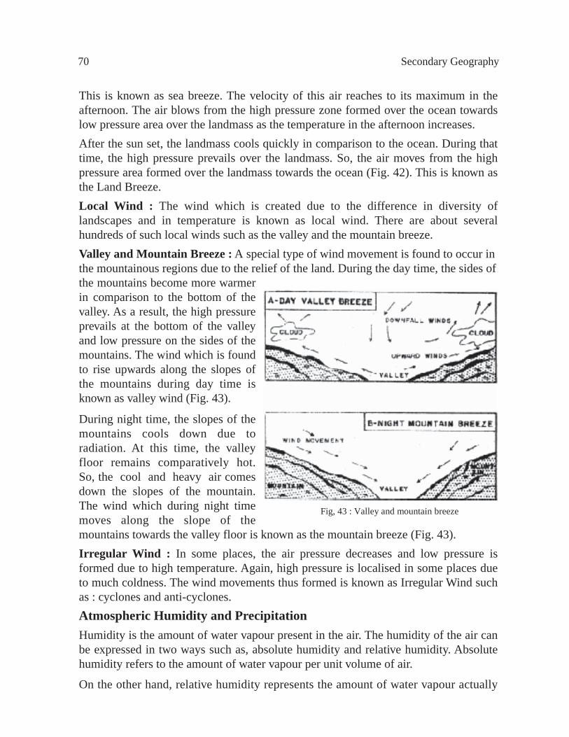
This is known as sea breeze. The velocity of this air reaches to its maximum in the afternoon. The air blows from the high pressure zone formed over the ocean towards low pressure area over the landmass as the temperature in the afternoon increases.After the sun set, the landmass cools quickly in comparison to the ocean. During that time, the high pressure prevails over the landmass. So, the air moves from the high pressure area formed over the landmass towards the ocean (Fig. 42). This is known as the Land Breeze.Local Wind : The wind which is created due to the difference in diversity of landscapes and in temperature is known as local wind. There are about several hundreds of such local winds such as the valley and the mountain breeze.Valley and Mountain Breeze : A special type of wind movement is found to occur in the mountainous regions due to the relief of the land. During the day time, the sides ofthe mountains become more warmer in comparison to the bottom of the valley. As a result, the high pressure prevails at the bottom of the valley and low pressure on the sides of the mountains. The wind which is found to rise upwards along the slopes of the mountains during day time is known as valley wind (Fig. 43).
During night time, the slopes of the mountains cools down due to radiation. At this time, the valley floor remains comparatively hot. So, the cool and heavy air comes down the slopes of the mountain. The wind which during night time moves along the slope of the mountains towards the valley floor is known as the mountain breeze (Fig. 43).Irregular Wind : In some places, the air pressure decreases and low pressure is formed due to high temperature. Again, high pressure is localised in some places due to much coldness. The wind movements thus formed is known as Irregular Wind such as : cyclones and anti-cyclones.Atmospheric Humidity and PrecipitationHumidity is the amount of water vapour present in the air. The humidity of the air can be expressed in two ways such as, absolute humidity and relative humidity. Absolute humidity refers to the amount of water vapour per unit volume of air.
On the other hand, relative humidity represents the amount of water vapour actually
70 Secondary Geography
Fig, 43 : Valley and mountain breeze

present in the air (absolute humidity) compared with on the other hand, relative humidity is the ratio of the amount of water vapour actually present (absolute humidity) in the air to the amount of water vapour required to saturate the same amount of air at a given temperature and pressure.
The humidity of the air mainly depends on the water vapour. The air receives the water vapour through evaporation of water from the open waterbodies (sea, rivers and small waterbodies) as well as from vegetation.
The air is said to be saturated when at a particular temperature, the air cannot absorb more water vapour.
If the air starts cooling it cannot hold the water vapour it had, then some of the water vapour is transformed into water particles. This is known as condensation temperature at which the water vapour is condensed is known as Dew Point.
If the temperature is 0° Celsius or remains below freezing point, then the water vapour becomes hard and falls on the earth’s surface as ice crystals or snow. But if the condensation temperature or dew point remains above the freezing temperature then the water vapour after condensation becomes dew, fog or rains.
Snow : In the cold regions, if the temperature falls below the freezing point then the water vapour of the air condenses like the carded cotton and falls on the earth. This is known as snow.
Dew : After radiating the temperature, the earth’s crust gets cold at night. The atmospheric stratum adjacent to the earth’s crust also becomes cold coming in contact with the cold earth. So, the water vapour containing capacity of the air is also decreased and hence the extra amount of water vapour which the air cannot carry is transformed to water and rest on the earth as water drops. This is known as dew. In the cold regions when the temperature of the earth’s crust goes below the freezing point then the dew is condensed to frost.
Fog : In the winter season due to close contact with earth crust, the temperature in the lower atmospheric strata is decreased. Consequently, centering the dust particles of the air, condensation starts in the lower strata of the atmosphere which is ultimately transformed to tiny water particles. These water particles remain in the air in a floating state. This is known as fog.
Rainfall : Saturated air going up becomes cool and condensed and transformed into cloud. A cloud contains innumerable water and ice particles. These water and ice particles coalesce together to form a bigger size of water particles which due to gravitational force fall on the earth’s surface as rain. The rainfall is of four types such as : convectional, orographic, cyclonic and frontal.
Atmosphere 71

Convectional rain : In the low pressure region, the air being heated goes high into the atmosphere and expands. So, it easily cools down. The rainfall which is caused due to condensation of the water vapour is known as Convectional rain (Fig. 44).The rising air, in the equatorial low pressure zone, contains plenty of water vapour and on condensation causes regular Convectional rain there.Orographic rain : The moistureladen wind is forced to rise up the slope of theobstructed mountain, is cooled down and on condensation causes rain on the windward side of the mountain. This type of rainfall is known as Orographic rain (Fig. 45). No rainfall is found to occur on the other side of the mountain as the air remains dry. This side is known as Leeward Slope. The south-west monsoon being obstructed by the hills of Meghalay gives abundant orographic rain in Sylhet.
Cyclonic rain : The air from the centre of the cyclone rising upward becomes cool. At this moment, the excess water vapour of the air condenses and causes rainfall. This type of rainfall is called as Cyclonic rain.
Frontal rain : When the cold and warm airmasses meet together, then it coming in contact with cold air, the temperature of the warm air decreases and reaches the condensation level. This condensation is deepened and gives rain in the conflict area. This is known as Frontal rain (Fig. 46). This type of rain is found in the temperate regions.
Fig. 46 : Frontal rain
72 Secondary Geography
Fig. 45 : Orographic rain
Fig. 44 : Convectional rain
WARM AND HUMID AIR
FRONT
RAINFALL
DRYCOLD AIR
HOT MOISTAIR
SEA
HOTLANDMASS
CLOUD
EARTH SURFACE

Atmosphere 73
Monsoon ClimateCharacteristics of the Monsoon : It has been discussed earlier that the monsoon is a seasonal wind in which there is a complete or almost complete reversal of wind direction. Along with the change of direction of wind, there is also a change in the characteristics of the monsoon wind. Due to the reversal nature of the wind direction, the winter remains dry and abundant rain comes in summer. The air is dry in winter as it originates in the landmass. During winter season, the monsoon wind starts blowing from the landmass and while crossing ocean it absorbs moisture and brings abundant rainfall on the landmass it comes across. The winter monsoon causes rainfall in the north-east coast of Sri Lanka, in the coast of Tamil Nadu, in West Japan and in the east coast of the Philippines. The summer monsoon, as it blows from the ocean towards the landmass, carries sufficient moisture with it. As a result, heavy shower occurs. It is due to the effect of the monsoon, that the variation of temperature is less between the winter and the summer in the low latitudes. However, the intensity of winter is well felt in the mid-latitudes. During this time, the cold continental airmass can reach the mid-latitudes. The mid-latitudinal regions come under the influence of tropical airmass in summer. So, hot weather prevails there (Fig. 47).
H = High Pressure L = Lo w Pressure
Fig. 47 : Monsoon winds movement and pressure of South and South-East Asia
Geographical locations of the Monsoon : Most of the monsoon regions are located in Asia, particularly in South and South-East Asia. The vastness of Asia, the situation of the Himalayas and the location of the warm water in south-eastern part create great difference in temperature between the landmass and the waterbodies. This difference of temperature is the cause for the formation of the monsoon.
The monsoon climate of South and South-East Asia covers India, Bangladesh, Pakistan, Nepal, Myanmar, Thailand, Laos, Cambodia, Vietnam, Malaysia and the Philippines. Besides, the monsoon climate is also found to prevail in China, Taiwan, Japan, Korea and the northern coast of Australia.
Monsoon climate of South Asia : Three seasons are found in Bangladesh, Sri Lanka, Pakistan and India due to the influence of monsoon climate. These are :
74 Secondary Geography
1. Winter season : From October to the end of February.2. Summer season : From March to the end of May.3. Rainy season : From June to the end of September.Among the three seasons, the rainy season is most important. The pattern of monsoon wind system of winter and summer has been shown in fig. 47. The air blows from the land to the ocean in winter and from the ocean to the land in summer. South Asian countries experience more or less rainfall in all the seasons in different localities. But about 80 per cent of the total rainfall occurs in the rainy seasons. The winter season in this region starts to prevail just after the rainy season. The durability and intensity of winter differs with the variation of the regions. As for example, the intensity of winter is moderate in central Bangladesh and is simply unbearable in northern India during the same period. Temperature shows an increase from March and reaches to the maximum in May. A low pressure develops during this period over the area causing the maritime air to blow towards this region. By June this maritime air reaches the landmass with its fullest intensity and in this way the Ôburst of the monsoon’ starts which brings the rainy season.The Monsoon Climate of South-East and East Asia : The winter monsoon of South-East Asia is influenced by the Siberian airmass and so it is cold and dry. The wind first blows towards the east and then takes a turn towards the equatorial region. As this wind blows over the ocean, it causes abundant rain in the western coast of Japan, in the Philippines, and in South China. Due to the formation of the low pressure in Central Asia during summer (May to September), the air from the adjacent oceans starts to blow towards East and South-East Asia. Consequently, it gives rain first in South-East Asia and later in East Asian countries.Importance of the Monsoon : The impact of monsoon is very much important in the agricultural sector, particularly in South and East Asia. The crop calendar of these regions is mostly controlled by the monsoon climate. For example, the agriculture of Bangladesh is hard hit by drought if monsoon rain does not start in time and if the rainfall is not in required quantity.AtmosphereWhat we learnt from this chapter :The coverage of the air which surrounds the earth is known as atmosphere. Atmosphere is formed by the mixture of different gases. The main two constituent elements of fresh and dry air is nitrogen and oxygen.The atmospheric layers are divided into four divisions such as : Troposphere, Stratosphere, Mesosphere and Thermosphere.Weather and climate : The weather is a daily average condition of atmospheric, temperature, pressure, rainfall, humidity, and the air movement for a certain place. Again the climate is the average condition of weather for 30 to 40 years.

Atmosphere 75
Solar energy : The amount of energy received by the earth through radiation in the form of small waves is the solar energy. The solar energy is transformed through the process of radiation, conduction and convection.Air movement : Due to difference in pressure and temperature, the air moves from one part of the earth to another. The movement of air is known as the wind. The wind moves from high pressure to low pressure zone. The wind system of the earth is divided into four types. These are Planetary wind, Seasonal wind, Local wind and Irregular wind.Land and sea breeze : In the coastal areas with the advent of the day, the temperature of the air over the landmasses is increased. So, to neutralize the pressure, cold and dense air from the sea starts blowing over the land. This is known as sea breeze.Just after the sun sets, the temperature over the landmass cools down quickly. But at that time, the ocean remains comparatively warm. So, the air blows from the land towards the sea. This is known as land breeze.Rainfall : The moistureladen air goes high into the sky and cools down and is transformed into cloud. The cloud contains innumerable water and ice particles. These water and ice particles coalesce together to form a bigger size of water particles. So, by the gravitational attraction of the earth, these water particles fall on the earth as rain. Rainfall can be divided into four types such as : Convectional, Orographic, Cyclonic and Frontal.
Exercise
Multiple Choice Questions1. On the influence of the increasing temperature of the earth --a. Carbon dioxide is reduced in the atmosphere b . Frequent cause of sudden flood c. The damage of the bio-diversity d. The destruction of the green forest
2. The characteristics of the monsoon is --i. The monsoon is a regional airii. The change in the wind direction with the season iii. Mainly pre vail in the South Asia
Which one is corr ect below?a. i and ii b . i and iiic. ii and iii d. i, ii and iii

76 Secondary Geography
Magnetosphere
Exosphere
Thermosphere
Mesosphere
Stratosphere
Troposphere
Notice about the figure below and answer to the question number 3 and 4.
3.What type of rainfall does the figure represents?a. Con vectional b . Frontal c. Cyclonic d. Orographic
4.Why there is no rainfall in the Middle East though there are huge mountains as sho wn the categories of rainfall in the figure?i. Distance from the Oceanii. Because of the influence of the desertiii. Because the air doesn ’t contain any air vapour
Which one is corr ect below?a. i and ii b . ii and iiic. i and iii d. i, ii and iii
Creative Questions1. Answer the questions from the given figure below.
a. What does the figure above represent? b . Why does the Troposphere important?
c. Explain which layer is immensely important for living organism as shown in the figure?
d. ÔThe destruction of the Ozone layer is one of the reasons to increase the air temperature on earth’-- explain.

Atmosphere 77
Chapter ThreeThe Hydrosphere
Definition : The hydrosphere is the mantle of water which covers the lower parts of the surface of the globe. The hydrosphere covers 71 per cent of the surface of the globe. Its area is about 36.25 lakh square kilometres.
The hydrosphere is formed of oceans, seas, gulfs, lakes etc. The great stretch of open water is known as Ocean, the smaller areas less than ocean are the seas. The open stretch of water surrounded on three sides by land is the bay while the gulf is surrounded by land almost on all sides. The lakes are the stretches of water surrounded by land.
The OceansThere are five oceans in the world. These are : the Pacific Ocean, the Atlantic Ocean, the Indian Ocean, the Arctic Ocean and the South Ocean. Of these, the Pacific is the largest ocean having an area of 60 crore and 60 lakh square kilometres. The average depth of the Pacific is the highest being about 4,270 metres. The Atlantic Ocean is the second largest ocean having an area of 8 crore and 24 lakh square kilometres although its place is third in respect of average depth. There are many semi-circles seas in the Atlantic having indented coastline. The Indian Ocean is about 7 crore and 36 lakh square kilometres in area and its average depth is 3,962 metres. The Arctic Ocean or the North Ocean surrounds the north pole. The southern part of this ocean is surrounded nearly all over by North America and Eurasia. The North Ocean is 1 crore and 50 lakh square kilometres in area and the average depth is 824 metres. The South Ocean is 1 crore 47 lakh square kilometres with average depth of 149 metres (Fig. 48).
Table 2 : Area and average depth of the oceans.
Oceans Area (square kilometres) Depth (metres)Pacific Ocean 16 crore 60 lakh 4,270Atlantic Ocean 8 crore 24 lakh 3,932Indian Ocean 7 crore 36 lakh 3,962North Ocean 1 crore 50 lakh 824South Ocean 1 crore 47 lakh 149
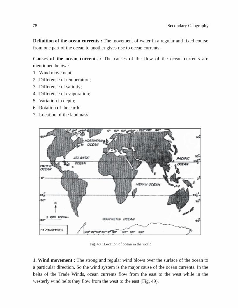
78 Secondary Geography
Definition of the ocean currents : The movement of water in a regular and fixed course from one part of the ocean to another gives rise to ocean currents.
Causes of the ocean currents : The causes of the flow of the ocean currents are mentioned below :1. Wind movement; 2. Difference of temperature;3. Difference of salinity;4. Difference of evaporation;5. Variation in depth;6. Rotation of the earth;7. Location of the landmass.
Fig. 48 : Location of ocean in the world
1. Wind movement : The strong and regular wind blows over the surface of the ocean to a particular direction. So the wind system is the major cause of the ocean currents. In the belts of the Trade Winds, ocean currents flow from the east to the west while in the westerly wind belts they flow from the west to the east (Fig. 49).
HYDROSPHERE
°

The Hydrosphere 79
Fig. 49 : Impact of wind on ocean current
Fig. 50 : Impact of evaporation and salinityin sea water
2. Difference of temperature : The temperature of the surface water of the ocean is different in different latitudes. Strong heat in the equatorial and tropical regions causes the water to become warmer which in turn results in the expansion of the water in volume and thereby the water becomes lighter and the density also decreases. But in upper and mid-latitude regions, the water is heavy due to less heat. The hot and light water in the equatorial regions flows poleward as warm surface currents while the colder water from the poles creeps as under currents to fill the vaccum.
3. Difference of salinity : Density of water depends on the salinity. Water becomes lighter with the decrease of salinity while the water becomes heavier with the increase of salinity. Light water flows as surface currents while the heavy water flows as under current (Fig. 50).
4. Differences of evaporation : Much evaporation occurs in the hot regions of the ocean resulting in the decrease of water level. Comparatively cold water from the neighbouring less hot areas of the ocean move towards more hot areas to maintain equilibrium in the ocean water.
5. Variation in depth : The shallow ocean water becomes hot and light very quickly that causes up-rise of the warm water resulting in a downward flow of the cold water current to occupy the place of the warm water. As a result, of the upward and downward movement of the ocean water as currents are created.

80 Secondary Geography
6. Rotation of the earth : The earth rotates from west to east. As a result, the ocean currents are deflected to the right in the northern hemisphere and to the left in the southern hemisphere.
7. Location of the landmass : Landmasses deflect the flow of ocean currents resulting in the formation of a new course. It is, for example, due to the Cape of Saint Rock in the east of Brazil that the South Equatorial current in the Atlantic Ocean is divided into two branches. One is flowing through the north coast of South America and the other through south-east coast.
Various ocean currents : The ocean water does not remain stationary in one place. The water of all the oceans and seas are flowing either as surface or under current. Hence, the ocean currents are divided into three on the basis of the location of the oceans. These are :
(a) The Atlantic Ocean Currents;(b) The Pacific Ocean Currents;(c) The Indian Ocean Currents.
The Atlantic Ocean Currents : The continents of Europe and Africa are in the east of Atlantic while North America and South America are in the west. The equator has divided the Atlantic Ocean into north and south part. So, the currents can be divided into two parts.
A. South Atlantic Ocean Currents; and B. North Atlantic Ocean Currents.
A. South Atlantic Ocean Currents
1. The Antarctic Current : The cold waters from the Antarctic move under the influence of the strong westerly wind from west to east. This is known as the Antarctic current and it enters into the Atlantic by the south of South America.
2. Benguela Current : The branch of the Antarctic current being deflected near the Cape of Good Hope turns to the north and flows by the west side of South Africa. This current is known as the Benguela current. The current is cold since it comes from the cold current. It turns westward under the influence of the south-east trade winds and joins the South Equatorial current.
3. South Equatorial Current : The South Equatorial Current originates from the extended part of the Benguela current. This current marches towards north-west upto

The Hydrosphere 81
the equator being influenced by the rotation of the earth and the south-east trade winds. This current is known as the South Equatorial Current as it flows to the south of the equator. This is warm current.
4. Brazil Current : The branch of South Equatorial current known as Brazil current which flows through the east coast of Brazil to the south-west. The current is warm since it originates from the warm current and flows through the tropical region, crossing the Tropic of Capricorn, the current turns eastward gradually under the influence of westerly wind and meets the Antarctic current.
5. Falkland Current : A branch of the Antarctic current on entering the Atlantic Ocean turns north and flows northward along the coast of Falkland Island and Argentina. This is known as Falkland Current and it is a cold current.
B. North Atlantic Ocean Currents1. North Equatorial Current : The warm currents flowing from east to west along the north of the equator under the influence of the rotation of the earth and the north-east trade winds is known as the North Equatorial Current (Fig. 51). This is warm current. After crossing the Mid-Atlantic, the northern branch of the South Equatorial current meets the North Equatorial current. The North Equatorial current is divided into two branches. The first branch flows into the Gulf Stream taking a turn to the north. The second branch flows first into the Carribean Sea and then into the Gulf of Mexico.
2. The Equatorial Counter Current : Between the North and South Equatorial currents, there is a weak current flowing from west to east is known as the Equatorial Counter Current. This is a warm current.
3. The Gulf Stream : The Gulf Stream, practically, has originated from the extended part of South and North Equatorial currents. This mixed current enters into the Carribean Sea and is divided into two branches being obstructed by the islands. One of the branches enters into the Gulf of Mexico. The rush of water from the Mississippi river of the United States of America enhances the speed of this current and flows through the narrow strait of Florida to North Atlantic. It is known as the Gulf Stream since it has originated in the Gulf of Mexico. The extent of the Gulf Stream varies from 64 to 80 kilometres at the entrance of Florida strait, the depth is 914 metres, the average speed is 8 kilometres per hour and the temperature is 30° Celsius. The colour of the current is deep blue.

82 Secondary Geography
Fig. 51 : Current of Atlantic Ocean
At the Mid-Atlantic, the depth and the temperature of the current comes down while the width gets increased and this current flows here at a speed of 2.5 kilometres per hour. While flowing north-east along the east coast of the United States of America, the Gulf Stream is divided into three branches at the mid of the North Atlantic due to the influence of the westerlies.(a) North Atlantic Stream;(b) West Greenland Current; and(c) Canaries Current.

The Hydrosphere 83
(a) North Atlantic Stream : The first branch of the Gulf Stream being called North Atlantic Stream flows along the coast of West Europe, the British Islands and Norway into the North Sea as a warm current.
(b) West Greenland Current : The warm West Greenland current, the second branch of Gulf Stream curving northward proceeds along the south of Iceland and Greenland and then flows through Davis Strait between Greenland and Baffin Island to the north.
(c) Canaries Current : The third branch of Gulf Stream known as the Canaries current turning southward flows along Portugal and the west coast of West Africa. The current is divided into two branches. The first branch curving south-west under the influence of Trade Wind flows into North Equatorial Current. This is a cold current.
4. Guinea Current : The Guinea current, the second branch of Canaries Current, flows along the coast of Guinea of West Africa to the south upto the Equator. Then joining the Equatorial Counter Current, it flows into the Bay of Guinea. This is a cold current.
The flow of different currents and cross currents along the sides of North Atlantic Ocean has caused in the centre of the ocean an area of stagnant sea often full of drifted branches of plants, grass, sea-weeds etc. and is called the Sargasso Sea (Fig. 51).
5. Labrador Current : Two cold currents from the North Ocean flows along the east and west of Greenland into the Atlantic Ocean. These two currents join in the north of Labrador Peninsula and taking the name of the Labrador Currents. It flows along the east coast of Newfoundland and the United States of America to the south. The Labrador current flowing south to New York gets deflected by the warm Gulf Stream. The deep blue water of the Gulf Stream and the green water of the Labrador flow side by side in the opposite direction and the border of these two cross currents is called the Cold Wall.
The impact of ocean currents on trade 1. The ocean water in the mid-tropic and high tropic region freezes in winter. Naturally the mercantile ships cannot ply in those seas. But the warm current keeps the sea ports ice free where it enters the sea. This makes possible the free trafic of the commercial ships in the seas.

84 Secondary Geography
2. A ship can sail to a port of destination in a short time in favour of the current but it takes a lot of money, energy and time if the ship goes against the current.
3. It is safe to sail ships in the passage of the warm currents. Cold currents bring icebergs. The ships are damaged if hit by an iceberg and sinks into the ocean. This way the Titanic ship sinks into the Atlantic Ocean.
4. The icebergs that come floating with the cold current are quickly melted and the loads such as pebbles, sand, mud etc. are deposited on the sea bed creating shoals. Plenty of fish food is available in these shoal areas, and as such are good for fishing ground.
HydrosphereWhat we learnt from this chapter :Hydrosphere : The hydrosphere is the envelope of water which covers about 71 per cent of the surface of the earth. It covers an area of 36 crore and 25 lakh square kilometres.
The land and waterbodies : The water area covers 71 per cent and land area covers 29 per cent of the total area of the surface of the earth.
The Oceans : The wide open mantle of water is called the Ocean. There are five oceans in the world namely, the Pacific Ocean, the Atlantic Ocean, the Indian Ocean, the North Ocean and the South Ocean.
The area of the Oceans : The Pacific Ocean is 16 crore and 60 lakh square kilometres, the Atlantic Ocean is 8 crore and 24 lakh square kilometres, the Indian Ocean is 7 crore and 36 lakh square kilometres, the North Ocean is 1 crore and 50 lakh square kilometres, and the South Ocean is 1 crore and 47 lakh square kilometres.
The Ocean Currents : The movement of water from one part of the ocean to another in a regular and fixed course is known as ocean current.
Ocean currents are of three types (1) The Atlantic Ocean Current, (2) The Pacific Ocean Current, and (3) The Indian Ocean Current.
Warm current generally flows as surface current, while the cold current moves as under current.
The causes of Ocean Currents : The wind system, the difference of temperature depth, salinity, evaporation, rotation of the earth and location of land area cause ocean currents. Of these factors, the wind system plays a vital role to create ocean currents.
South Atlantic Ocean Currents : The South Atlantic Ocean currents flow towards left (leftward or anti-clockwise). The Antarctic current, Falkland current, Benguela current, South Equatorial current, and Brazil current flow into the Atlantic Ocean.

The Hydrosphere 85
Among all these currents, the Antarctic current, Falkland and Benguela currents are cold currents and others are warm currents.
North Atlantic Ocean Current : The currents of the North Atlantic Ocean are flowing towards right (southward or clockwise). The North Equatorial Current, the Gulf Stream, North Atlantic Stream, West Greenland Current, Canaries current, Guinea Current, Labrador Current, and Equatorial Counter Current are the principal currents of the North Atlantic Ocean. The Labrador, Canaries, and Guinea currents are cold currents.
There are different currents and cross currents on the sides of North Atlantic Ocean and in the whirlpool of water in the centre, there is no current resulting in the deposit of moss and drifting weeds in the stagnant water. This is called the Sargasso Sea.
The impact of the Ocean Currents : The seas in the high latitudes are frozen during winter and the mercantile ships cannot ply. Naturally, the commercial transactions are disturbed in the ports during winter on the high latitudes. But the seas where warm currents flow do not freeze in winter and mercantile ships can move freely. There are possibilities for the ships to get damaged by the icebergs that the cold currents bring.
ExerciseMultiple Choice Questions1.What percentage of the surface of the earth is covered by the hydrosphere?a. 30 b . 45 c. 60 d. 70
2. How does salinity creates ocean current?a. Density of w ater depends on the salinityb . Saline water becomes very fastc. There is a relation between salinity and wind movementd. Saline w ater becomes lighter
Answer question number 3 and 4 according to the table.
Ocean Area (sq. kms.) Average Depth(metres)
Pacific Ocean 16 crore 60 lakh 4270
Indian Ocean 7 crore 36 lakh 3962
Atlantic Ocean 8 crore 24 lakh 3932
South Ocean l crore 47 lakh 149

86 Secondary Geography
3. Which ocean has many semi-circles seas?a. P acific b . Indian c. Atlantic d. South
4. Which one is correct below?a. The Pacific Ocean is two and a half time bigger than the Indian Ocean.b . The Pacific Ocean is twice bigger than the Indian Ocean.c. The Atlantic Ocean is one and a half time bigger than the Indian Ocean. d. The Atlantic Ocean is twice bigger than the Indian Ocean.
Creative Questions1.Anis and Shaheena has come on a trip to Cox’s Bazar sea beach. While they were
walking on the beach both of them noticed that the gigantic waves of the sea hitting at their feet. Shaheena states about the sea wave in responses to Anis, questions. Anis again asks, ÔDoes the wind movement control this current’? Shaheena replied that wind movement is the principal ingredient of almost all the current of the Seas and Oceans of the world.
a. What does Ocean current means?b. Describe any other cause of the Ocean current occurrence other than the wind
movement.c. Draw a map and indicate three currents of the Atlantic Ocean on it. d. ÔThe wind movement is the principal cause of Ocean Current occurrence’-- give
argument in favour of this statement.

The Hydrosphere 87
Part ThreeRegional Geography
A region is a wide area having some universally accepted homogeneous character. The purpose of the regiorn concept is to distinguish similar regions making them clear and well arranged from adjacent regions on some particular basis. The term ÔregionÕ is of course, used in a wide sense. Regions are classified into different types such as, physical region, political region, cultural region etc. Hill, mountains, plateaus, plains, rivers, lakes, seas are studied in the physical regions. All these are gifts of nature having no roles for human beings to play. On the other hand, the political regions (Fig. 52) are the borders of different countries and soverign area of government. The cultural region is based on culture of human beings. In the same manner, industrial region is the accumulation of a number of man-made factories that produce a number of products. So political regions, cultural regions and industrial regions are based on particular ideas.

88 Secondary Geography
Fig.
52
: The
pol
itica
l reg
ion
of th
e w
orld
The Hydrosphere 89
Chapter OneThe Continent of Europe
Location : The continent of Europe is located between 35° to 71° North latitude and 25° West longitude to 66° East longitude. 20° East longitude and 55° North latitude has passed the middle of the continent. The continent has the North Sea to its north, the Mediterranean Sea and Black Sea to its south, the Caspian Sea and Asia to its east and the North Atlantic Ocean to its west. The Ural mountain has seperated Europe from Asia.
Area : Europe ranks third among all the continents in respect of its area. The area of Europe is only 2,32,27,496 square kilometres. It is about 0.24 part smaller than Asia in area, 0.35 part of Africa, 0.43 part of North America and 0.59 part of South America while it is 1.37 times larger than Australia and 7.45 times larger than Antarctica.
Coastline : In comparison to its size, Europe has a very long and broken coastline. The coastline is 41,204 kilometres i.e.1kilometre of coastline for every 242 kilometres of its area. In many places, there are inland, seas and bays and gulfs so that no part of Europe is more than 1,690 kilometres from the sea. This has resulted in the formation of many natural harbours and ports along the coast. There are many peninsulas, islands archipelagoes along the coast of this continent. In the north coast, the majors ones among others are White Sea, Bothnia Peninsula, Baltic Sea, North Sea, Iceland Island, Scandinavian Peninsula (Norway and Sweden) and Denmark Peninsula. Besides, there are Novaya Zemlya and Pittsburgen Island, North Cape and Northkin Cape. In the west coast, there are Bay of Biscay and the Iberian Peninsula (Spain and Portugal). In the south coast, there are Mediterranean Sea, Gulf of Genoa, Tyrrhenean Sea, Adriatic Sea, Ionian Sea, Aegean Sea, Sea of Marmara, Black Sea, Azov Sea, Balearic group of Islands, Corsica Islands, Sardina Island, Sicily Island, Italian Peninsula, Ionian Archipelago, Balkan Peninsula and Crimean Peninsula. As the continent of Asia is located in the east, there is only Caspian Sea surrounded by land on all sides.
Physiography : Europe is divided into four divisions on the basis of its physical structures (Fig. 53).1. The Rocky Plateau of North-West Europe;2. The great plain of Central Europe;3. The plateau of Central and West Europe; and4. The mountainous lands of South Europe.

90 Secondary Geography
1. The Rocky Plateau of North-West Europe : The Scandinavian Peninsula (Norway and Sweden), the northern part of Scotland and Ireland are included in this region. In the past, this region was consisted of old metamorphic rocks. Owing to their long exposure to the external agents of denudation, these ancient rocks have been worn down to form plateau. The Kiolen mountain is in the north Scandinavian plateau and the Dover Field mountain is in the south. The landmass of this region slopes to the south-east. The rift valley of Glenmore has divided the Scotland plateau into two parts. The north part of the United Kingdom is known as the Scottish Highland, while the southern part is Graspian range of mountains. Nevis (1,344 metres) of Graspian mountain is the highest peak in the United Kingdom.
2. The Great Plain of Central Europe : This great plain stretches from the coast of the Bay of Biscay in the west to the eastern border of Europe in the east. In fact, this plain has joined the plains of Asia and formed the greatest plain in the world. The plain includes North France, Belgium, Netherlands (Holand), Germany, Poland, Finland, Estonia, Latvia, Lithuania, Belarus, Ukrain and most of the places of Russia. The surface in this plain is mostly flat and in most cases is not more than 152 metres above sea level. Much of the surface of the lowlands is covered by glacial deposits and moraines because the glaciers moved over this area.
Fig. 53 : Physiography of Europe

The Continent of Europe 91
3. The plateau of Central and West Europe : The region is formed of five small and big diffused plateaus. This region includes Meseta plateau of Iberia, Central Meseta Plateau of France, Bavaria, Plateau of Germany and Bohemia Plateau of Czech and Slovakia.
4. The Mountainous Lands of South Europe : The Alps Mountain is situated at the central place of this mountainous lands. The Alps Mountain is about 1,116 kilometres long and in width it varies from 56 to 64 kilometres. A number of branches from this mountain have spreaded to the different directions of South Europe. The Dinaric and Pindus mountain in the south-east of Balkan Peninsula, Balkan mountain in the east of the Dinaric, the Republican of Czech and Slovakia to the east of the Alps, the Carpethian mountain covering West Ukraine and the central east of Romania, the Transylvania mountain in South Romania, the Caucasus mountain, Jura mountain and Vosges mountain to the east of Black Sea are all determining the border of France, Switzerland and Germany. The Evergen and the Siveneze mountains are located in South France. The Mount Blank (4,807 metres) situated in the border of South-East France and Italy, is the highest peak. This peak remains under ice throughout the year. The Meseta plateau of Spain is situated in the highlands of Pyrenees in the border of France and Spain, in the highlands of the Cantabrian Mountain in North Spain and the Sierra Nevada in South Spain. The Apennines, a branch of the Alps has passed through Italy towards south.
The Hungary Plain is located in the river valley of Daniube within the Carpethian and the Dinaric Mountains, the Lombarde Plain in between the Alps and the Apennines, and the Romania plain between the Balkan and the Transylvania mountains. Visuvius of Italy, Etna of Sicily, Strombly of Lepery Island and Hekla of Iceland are the notable volcanoes of Europe.
Climate : Europe is situated at the Temperate Zone. Difference in climate is found to occur in different places of Europe due to the distance from the sea, influence of warm currents, location of the Arctic circle, and the mountains etc. On the basis of the mentioned situations, the climate of Europe is divided into four climatic regions (Fig. 54).
1. The Tundra Climatic Regions : This climatic region is included in the Frizid zone as the northern parts of Norway, Finland and Russia being situated in the north of the Arctic circle, and this type of climate is known as the Tundra Climate. The winter season is long and the intensity of winter is very high. There is a heavy snowfall in this season and the surface remains covered with snow for about nine months of the year.
2. The Temperate Climate of North-West Europe : The countries in this region are those located along the coast of the Atlantic Ocean in the north-western Europe that include Norway, southern part of Sweden, Germany, France, northern part of Spain,

92 Secondary Geography
Belgium, Netherlands, Luxembourg, Denmark, the United Kingdom and Iceland. The climate of this region is equable as the warm North Atlantic Stream flow along this region and no place is far off from the ocean. The amount of rainfall is higher more during winter but the intensity of winter cold is not much.
Fig. 54 : Climatic region of Europe
3. The Continental Climate of East Europe : This climatic region include Poland, Southern Finland, Estonia, Latvia, Lithuania, Romania, Belarus, Ukraine, Georgia, Armenia, and Azerbaijan of East Europe. The region is far from the sea. The cold wind of the north blows over these countries. The intensity of cold during winter is very high. It rains a little under the influence of westerly wind during summer, but in the east the rainfall gradually decreases. So the climate of this region is called Extreme Continental Climate.4. The Mediterranean Climatic Region : This region includes Portugal, South Spain, South France, Italy, Albania, Greece, the European Turkey, the Mediterranean Islands, Corsica, Sardinia, Sicily and Crete of South Europe not far from the Mediterranean Sea. Though there is scorching sun during summer but the temperature remains less due to the influence of the sea. The intensity of cold during winter is not felt high. There is rainfall in winter but the summer goes dry.
Tundra Climatic Region
Temperate Climatic RegionContinental Climatic Region
Mediterranean ClimaticRegion
CLIMATIC REGION OF EUROPE

The Continent of Europe 93
Political divisions and population : There are 46 large and small states in Europe (Fig. 55). The former Soviet Union broke up in 1991 giving rise to 15 independent Republican States. Similarly former Czechoslovakia formed two states such as, Czech
Fig.
55
: Pol
itica
l div
isio
n of
Eur
ope

94 Secondary Geography
and Slovakia after break up and Yugoslavia formed 5 states. A table showing areas and population of different countries is given below :Table 3 : Area, population, density and capitals of different countries of Europe, 2010
�
Name of the country Area (sq. kms.)
Population (in crore)
Density of population
Capital
(a) North-West Region Norway Sweden United Kingdom Ireland Iceland
3,23,802 4,49,964 2,44,820
70,280 1,03,000
0.49 0.94 6.22 0.45 0.03
15 21 2541 64 3
Oslo Stockholm London Dublin Reykjavik
(b) Baltic Region Finland Estonia Latvia Lithuania
3,38,145
45,226 64,589 65,200
0.54 0.13 0.22 0.33
16 29 34 51
Helsinki Tallinn Riga Vilnius
(c) The Plains Netherlands Belgium Luxembourg France Denmark Germany Poland
41,526 30,528 2,586
6,43,427 43,094
3,57,021 3,12,685
1.66 1.08 0.05 6.30 0.55 8.16 3.82
400 354 193 98 128 229 122
Amsterdam Brussels Luxembourg Paris Copenhagen Barlin Warsaw
(d) Eastern Region Russia Belarus Ukraine Moldova
1,70,75,200
2,07,000 6,03,700
33,843
14.19 0.95 4.59 0.41
8 46 76 121
Moscow Minsk Kiev Chisinau
(e) Trans-Caucasia Region Georgia Armenia Azerbaijan
69,700 29,800 86,600
0.46 0.31 0.90
66 104 104
Tbilisi Yerevan Baku
(per. sq. kms.)

The Continent of Europe 95
Name of the country Area (sq. kms.)
Population (in crore)
Density ofpopulation
Capital
(f) Central and southern RegionCzech RepublicSlovakiaRomaniaHungaryAustriaLiechtensteinSwitzerlandPortugalSpain Andorra
ItalyVatican City*MonacoSan MarinoSloveniaCroatiaBosnia and HerzegovinaSerbiaMacedoniaAlbaniaBulgariaGreeceMalta
78,86648,845
2,37,50093.03083,870
16041,29092,391
5,04,782468
3,01,2300.18
261
20,27356,54291,12977,47425,33328,748
1,10,9101,31,940
316
1.050.542.151.000.84
0.0040.781.074.710.01
6.050.0000648
0.004 0.0030.210.440.380.730.210.320.751.13 0.04
13311191
107 10022518911693
216
2013600
35835492104
78429483
1116886
1266
PragueBratislavaBucharestBudapestViennaVaduzBernLisbonMadridAndorraLa VellaRomeVatican CityMonacoSan MarinoLjubljanaZagrebSarajevoBelgradeSkopljeTiranaSofiaAthensValletta
Total 2,32,27,496 75.24 32 -----
Source : World Population Data Sheet, 2010 * Statistical Yearbook, 1994-95
(per. sq. kms.)
96 Secondary Geography
EuropeWhat we learnt from this chapter :Location, Area and Coastline : Europe is located in the temperate zone. The area of Europe is about 2,32,27,496 square kilometres. The coastline of Europe is very much broken and long.Physiography : Europe can be divided into four regions according to its physical structures such as (1) The Mountainous Plateau of North-West Europe, (2) The Great Plain of Central Europe, (3) The Plateau of Central and West Europe, and (4) The Mountainous Plain of South Europe.Climate : The climate of Europe is divided into four types such as (1) The Tundra Climatic Region, (2) The Temperate Climatic Region of North-West Europe, (3) The Continental Climatic Region of East Europe, and (4) The Mediterranean Climatic Region.The Political Divisions : The continent of Europe is consisted of 46 small and large states. In the north-west region, there are Norway, Sweden, United Kingdom, Iceland and Ireland, Finland, Estonia, Latvia and Lithuania in the Baltic Region. Belgium, Netherlands, Luxembourg, France, Denmark, Germany and Poland in the plains. In the eastern region, there are European Russia, Belarus, Ukraine and Moldova; in the Trans Caucasian region there are Georgia, Armenia and Azerbaijan; in central European region there are Czech, Slovakia, Romania; Hungary, Austria, and Switzerland; and in the Mediterranean region there are Portugal, Spain, Italy, Vatican City, San Marino, Albania, Greece and Malta.
Exercise
Multiple Choice Questions1. Which one of these below is the Scandinavian Capital? a. London, Dublin and Edinb urgh b . Stockholm, Oslo and Helsinki c. P aris, Brussels and Bonn d. Prague, Bucharest and Vienna2. Which of the European Country below is enjoying the Continental Climate? a. Denmark b . Portugal c. Turkey d. Geor gia3.The v arieties of climates of different parts of Europe mainly contributes i. The latitude of Europe is between 35° North to 71° North ii. The longitude is 25° West to 66° Eastiii. The differences of the physical structures in different parts of Europe Which one is correct below? a. i and ii b . ii and iii c. i and iii d. i, ii and iii
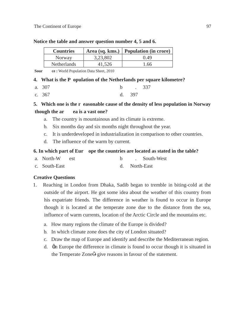
The Continent of Europe 97
Countries Area (sq. kms.) Population (in crore) Norway 3,23,802 0.49
Netherlands 41,526 1.66
Notice the table and answer question number 4, 5 and 6.
Sour ce : World Population Data Sheet, 2010
4. What is the Population of the Netherlands per square kilometre?a. 307 b . 337 c. 367 d. 397
5. Which one is the reasonable cause of the density of less population in Norway though the ar ea is a vast one?
a. The country is mountainous and its climate is extreme. b. Six months day and six months night throughout the year. c. It is underdeveloped in industrialization in comparison to other countries. d. The influence of the warm by current.
6.In which part of Eur ope the countries are located as stated in the table?a. North-W est b . South-West c. South-East d. North-East
Creative Questions1. Reaching in London from Dhaka, Sadib began to tremble in biting-cold at the
outside of the airport. He got some idea about the weather of this country from his expatriate friends. The difference in weather is found to occur in Europe though it is located at the temperate zone due to the distance from the sea, influence of warm currents, location of the Arctic Circle and the mountains etc.
a. How many regions the climate of the Europe is divided? b. In which climate zone does the city of London situated? c. Draw the map of Europe and identify and describe the Mediterranean region. d. ÔIn Europe the difference in climate is found to occur though it is situated in the Temperate ZoneÕ-- give reasons in favour of the statement.

98 Secondary Gerography
Chapter TwoThe Continent of Asia
Location : We live in the continent of Asia. Bangladesh is located in this continent. Asia lies between 10° South latitude to 80° North latitude and 25° East longitude to 170° West longtitude. The Pacific Ocean is in the east of this continent, Europe and the Mediterranean Sea in the west, Africa and the Red Sea in the south-west, the North Ocean in the north while the Indian Ocean in the south. Europe and Asia are jointly called Eurasia since they are connected by land. Only the Ural Mountain, the Ural river and the Caspian Sea have seperated Europe from Asia.
Area : Asia is the largest continent of the world. Its area is 4,64,91,180 square kilometres. This continent is 8,528 kilometres from north to south while in east to west it is 9,654 kilometres. The continent of Asia is 1.5 times larger than Africa, 1.82 times than North America, 2.4 times than South America, 4.19 times than Europe, 5.73 times than Auatralia and 3.12 times than Antarctica.
Fig. 56 : Continent of Asia in the world map
Coastline : The coastline of Asia is not very much indented. Naturally, the coastline is much shorter in comparison to its area. The total coastline is 57,924 kilometres that means it has 1 kilometre coastline per 773 square kilometres. The number of the developed sea ports is much less since the coastline is very short.
Physiography : Asia can be divided into five divisions according to its physical structures.

The Continent of Asia 99
1. The low plains of North Asia : If we draw a straight line from the Bering strait to the south of the Caspian Sea, we shall see a great low land to its north. This plain has gradually sloped to the north.2. The highlands of Central Asia and the mountains : The height of Pamir, a plateau in Central Asia is 4,813 metres and it is called the Ôroof of the worldÕ since it is the highest plateau. The plateau is called the Pamir Knot, because different mountain ranges radiate from Pamir Knot to different directions. The Tien Shan Mountains have stretched towards north-east direction from here. Of the ranges of this mountain, Altai, Yablonovy and Stanovoi are the major ranges. The Karakoram lies in the south-west of the Kunlun running towards east from the Pamir and the Himalayan Mountains in the south (Fig. 57). The Tarim plateau is situated between the Altyntag Mountains and the Tien Shan and the plateau of Tibet lies between the Himalayan Mountain and Kunlun. The Himalayas is the highest mountain in the world. It is about 2,414 kilometres long and 241 to 402 kilometres wide. The Mount Everest (8,884 metres) is the highest peak.
Fig. 57 : Physiography of AsiaBesides, there are about 22 such peaks whose height will not exceed 6,016 metres. K2 or Godwin Austin (8,619 metres) of Karakoram Mountain is the second highest peak in the world. Few branches from the east end of the Himalayas turning towards south passed through Myanmar as the Arakan Yomas and Pegu Yomas.
Low Land of Siberia Plant
Ledochina Plateau

100 Secondary Geography
Two mountain ranges viz., Hindu Kush extending towards south from Pamir Knot and the other one towards south-west as Sulaiman and Khirthar. The Elburz mountain of north Iran and the Zagros mountain of south Iran have joined the Armenian Knot to the west. The Iranian Plateau is located in between these two mountains. The mountains of Pontic and Taurus originating from the Armenian Knot extend towards west. The plateau of Anatolia is between these two mountains.3. The low plains of South Asia : The deposits of alluvial soil by the rivers of Tigris (Dazla) and Euphrates (Forat) basin of Iraq, Indus-Ganges-Brahmaputra basin of Pakistan, India and Bangladesh and Hwang Ho-Yangtze-Sikiang basin of China have developed this plain. Tigris and Euphrates plain slope towards south-east, the Indus basin towards south-west, the Ganges basin towards east, the Brahmaputra basin initially towards south-west then towards the south. The alluvial soil has made this plain very fertile.4. The Plateau of South Asia : The Arab, Deccan and Indo-China plateau of the southern part of Asia is formed of old rocks. Most of the area of the wide Arab Plateau is barren and sandy and this plateau slopes to the east. The West Ghat Mountain is situated to the west of the Deccan plateau, East Ghat Mountain in the east and Vindhya range in the north. This plateau slopes to the east while the Indo-China Plateau slopes to the south. 5. The Volcanic Islands : Forming ÔfestoonsÕ down the east coast of Asia, there are rocky islands of Aleutian, Kurile, Japan, Riukieu, the Philippines and Borneo. Most of these islands are adorned with volcanoes.Rivers : According to the flow, the four great river systems of Asia are as follows :(a) Rivers flowing to the North Sea : The Obb (with tributary Irtish 5,569 kilometres) and the Yenisey (with tributary Angara 4,989 kilometres) rising from the Altai Mountains and Lena originating from the lake Baikal (4,264 kilometres) flow to the North Sea. The mouth of the rivers remain frozen most of the time of the year.(b) Rivers flowing to the Pacific Ocean : The Amur river (4,344 kilometres) originating from Yablonovy Mountain has flowed to the Orkhotosk Sea in the east. This river remains frozen for six months of the year. The Hwang Ho (4,668 kilometres) rises from the Kunlun Mountains and has fallen into the Yellow Sea. The Yangtzekiang (5,525 kilometres) originating in the Tibet Plateau has fallen into the East China Sea. Yangtze is the longest river in Asia. The Sikiang rises from Yuanan Plateau of China and flows to the South China Sea. The Mekong river and the Menam both rise from the Tibet Plateau, have fallen into the South China Sea and to the Bay of Thailand respectively.(c) Rivers flowing to the Indian Ocean : The Salwin (2,816 kilometres) river of Myanmar originating from the Tibet Plateau has fallen into the Bay of Martaban. The Irrawaddy (2,092 kilometres) rises from the Naga Mountains and flows through Myanmar falls into the Bay of Martaban. The Brahmaputra (2,896 kilometres) rises from lake Manash of Tibet and mingles with the Ganges flows through Tibet, Assam

The Continent of Asia 101
and Bangladesh. The Ganges (2,505 kilometres) rising from the glacier ÔGangotreeÕ flows to the Bay of Bengal through India and Bangladesh. The lower part of the river is known as the Padma. The Indus (2,896 kilometres) rises from the Himalayas and flows to the Arabian Sea through Kashmir and Pakistan. The Tigris (Dazla, 1,900 kilometres) and the Euphrates (Forat) rise in the highlands of Armenia in East Turkey. The combined course of these two rivers is known as Shat-el-Arab and flows into the Bay of Persia.(d) Rivers flowing into the lakes : The Amudarya and Sirdarya rising from the Pamir plateau and Tien Shan mountain respectively fall into the Aral Lake, while the Ural river, coming up from the Ural mountains flows to the Caspian Sea, the Tarim river (2,735 kilometres) to the Lapnor Lake from the Karakoram Mountains, the Helmond river from the Hindu Kush mountains to the Hamun and the Jordan river from the highlands of Lebanon to the Dead Sea. Besides, many small rivers from the different parts of the continent of Asia have flowed to different directions.Climate : Asia, being a large continent, has diverse physical features. The barriers to the free flow of air current have created different climates in different areas. According to the prevailing climate, the continent can be divided into seven climatic zones (Fig. 58).1. Equatorial Climatic Zone : The equatorial type of climate is found in Singapore, Malaysia Peninsula and Indonesia within 5° North and 5° South latitudes. The termperature here is high and heavy shower occurs throughout the year. The variation of temperature between winter and summer is less.
Fig. 58 : Climatic region of Asia

102 Secondary Geography
2. The Monsoon Climatic Zone : The countries in the Tropical zone and the eastern part of Asia are included in this climatic zone. The countries included are South and East China, the Philippines, Vietnam, Laos, Cambodia, Thailand, Myanmar, Bangladesh, India, Sri Lanka and Pakistan. Heavy rains occur during summer and the rains make the summer cooler. Neither summer nor winter is extreme here. The climate is warm and wet.
3. The Desert Climatic Zone : The prominence of dryness in this type of climate is the major characteristics. Less growth of vegetation is found here due to no rainfall or less rainfall and the prevalence of drought. This type of climate is divided into two.
(a) Hot Desert Climatic Region : This climate includes the Thar Desert of Pakistan and India, the United Arab Emirates, Qatar, Oman, Yemen, Saudi Arabia, Jordan and South-West Iran. Here the climate is extreme. Extreme hot during day and very cold during night is found to prevail here.
(b) Cold Desert Climatic Region : This type of climate includes Mongolia of Central Asia, Sinkiang of China, Kazakhstan, Kyrgyzstan, Tajikistan, Uzbekistan, Turkmenistan, Afghanistan, and Iran. These regions experience less rainfall being far away from the ocean. The air of this region is dry due to less amount of rainfall. The climate of this region is cold due to height. The Gobi desert is located in Mongolia and Sinkiang of the cold and dry climatic region.
4. The Mediterranean Climatic Zone : This climatic zone includes Turkey, Syria, Lebanon, Palestine, Israel, and North Iraq of West Asia. Here rain falls in winter and the summer goes dry.
5. The Continental Climatic Zone : The climate of West Siberia is extreme. Winter is very cold here and there is heavy snowfall. Summer is hot but short. There is scarcely any rainfall.
6. The Cold Temperate Climatic Zone : This climate is found in East Siberia. Winter is extreme here. Extreme cold wind flows from the Arctic in winter. There is snowfall instead of rainfall. The eastern part is colder and drier than the western part.
7. The Tundra Climatic Zone : This climate is found in the north of Siberia. Winter is very long here and cold is very extreme. Verkhoyansk in Siberia is the coldest place in the world. The snow in the north of Tundra does not melt even in summer. This area is unfit for human habitation.

The Continent of Asia 103
Political division and population : The states of Asia have been divided into five regions for the sake of discussion such as (1) The SAARC countries, (2) South-East Asia, (3) Far East and Siberia, (4) Central Asia and (5) South-West Asia. The area under SAARC, a forum for the development of South Asia regional countries is 52,21,391 square kilometres and more than 159.90 crore people live hi this region. All the seven states are independent and sovereign and help each other for mutual development.
There are 11 states in South-East Asia with a total area of 45,10,560 square kilometres and population of 59.70 crore. Each of the states is independent and sovereign.
There are 8 states in the Far East and Siberia. The total area of these countries is 2,65,71,415 square kilometres with a total population of 158.01 crore.
The total area of five countries in Central Asia is 39,94,400 square kilometres and the population is 6.25 crore.
The total area of the 16 states of South-West Asis is 61,93,414 square kilometres and the population is 29.36 crore.
The Soviet Union broke up in 1991 creating 15 sovereign states. Of these, the countries included in Asia are (1) Siberia (the part of the Republic of Russia in Asia), (2) Kazakhstan, (3) Uzbekistan, (4) Turkmenistan, (5) Tajikistan, and (6) Kyrgyzstan. In 1993 some parts of Israel in the Middle East have been given self-rule status in the name of Palestine.
Table 4 : Area, population, density of population and capitals of different countries of Asia, 2010
Name of the country Area (sq. kms.)
Population (in crore)
Density of population
(per sq. kms.)
Capital
1. SAARC Countries Bangladesh*
India
Pakistan
Nepal
Bhutan
Sri Lanka
Maldives. Afghanistan
1,47,570
32,87,590
8,03,940
1,47,181
47,000
65,610
75,000
6,47,500
14.66
118.88
18.48
2.80
0.07
2.07
0.03
2.91
993
362
230
190
15
315
1070
45
Dhaka
New Delhi
Islamabad
Kathmandu
Thimphu
Colombo
Male
Kabul
Total 52,21,391 159.90 349 ¾

104 Secondary Geography
Source : * Bangladesh Statistical Pocketbook, 2009/February 2010 **Statistical Yearbook, 1994-95
Name of the country Area Population Density of Capital (sq. kms.) (in crore) population
(per sq. kms.) 1. South-East Asia Myanmar Thailand Cambodia Laos Vietnam Indonesia Malaysia Singapore Philippines Brunei Timor Leste (East-Timor)
6,78.500 5,14,000 1,81,040 2,36,800 3,29,560 19,19,440 3,29,750 693 3,00,000 5,770 15,007
5.34 6.81 1.51 0.64 8.89 23.55 2.89 0.51 9.40 0.04 0.12
79 132 83 27 270 123 88 7359 313 69 80
Pyinmana Bangkok Phnom Penh Vientiane Hanoi Jakarta Kuala Lumpur Singapore Manila Bandar SeriBegawan Dili
Total 45,10,560 59.70 132 -----
3. Far East and Siberia
Siberia (Asian part of Russia**)
Japan North Korea South Korea Mongolia China Hong Kong Taiwan
1,47,74,460 3,77,835 1,20,540 1,00,03 2 15,64,116 95,96,960 1,092 35,980
0.99 12.74 2.28 4.89 0.28 133.81 0.70 2.32
67 337 189 489 2 139 6410 645
----- Tokyo Pyongyang Seoul Ulanbatar Beijing Victoria Taipei
Total 2,65,71,415 158.01 59 ----
4. Central Asia Kazakhstan Uzbekistan Turkmenistan Tajikistan Kyrgyzstan
27,17,300 4,47,400 4,88,100 1,43,100 1,98,500
1.63 2.81 0.52 0.76 0.53
6 63 11 53 27
Astana Tashkent Ashgabat Dushanbe Bishkek
Total 39,94,400 6.25 16 ----

The Continent of Asia 105
Source : World Population Data Sheet, 2010 .MPND, 2004
AsiaWhat we learnt from this chapter :Location and area : Asia is the largest continent of the world. North Sea is in the north of Asia, while the Indian Ocean is in the south and the Pacific in the east, the continent of Europe and the Mediterranean Sea in the west and Africa and the Red Sea in the south-west. The total area of Asia is 4,64,91,180 square kilometres.Physiography : The continent of Asia is divided into five regions according to its physical structures as follows : (1) The low plains of North Asia, (2) The high plateau of Central Asia and the mountains, (3) The low plains of South Asia, (4) The plateaus of South Asia, (5) The Volcanic Islands. Pamir and Armenia are the two mountain Knots from where the
Name of the country Area (sq, kms.)
Population (in crore)
Density of population
(per sq. kms.)
Capital
5. South-West Asia Iran
Iraq
Turkey
Syria
Lebanon
Jordan
Israel
Palestine
Yemen
Saudi Arabia
United Arab Emirates
Bahrain
Qatar
Oman
Kuwait
Cyprus
16,48,000
4,37,072
7,80,580
1,85,180
10,400
92,300
20,770
6,220
5,27,970
21,49,690
83,600
665
11,437
2,12,460
17,820
9,250
7.51
3.15
7.36
2.25
0.43
0.65
0.76
0.40
2.36
2.92
0.54
0.13
0.17
0.31
0.31
0.11
46
72
94
122
413
70
366
643
45
14
65
1955
149
15
174
119
Tehran
Baghdad
Ankara
Damascus
Beirut
Amman
Jerusalem
Ramallah
Sanaa
Riyadh
Abu Dhabi
Manama
Doha
Muscat
Kuwait
Nicosia
Total 61,93,414 29.36 47 ----
Grand Total 4,64,91,180 413.22 89 ----

106 Secondary Geography
mountains run to different directions. Pamir is called ÔRoof of the WorldÕ, because of its height. The Tien Shan, Altai, Yablonovy, Stanovoi, Kunlun, Karakoram, the Himalayas, Hindu Kush, Sulaiman, Khirthar, Elburz, Zagros, Pontic and Taurus are the important mountains. Tibet, Tarim, Iran, Anatolia, Arabia, Deccan, Indo-China are the principal plateaus and Siberia, Tigris-Euphrates, Indus-Ganges-Brahmaputra, Hwang Ho-Yangtze-Sikiang are the principal plains in Asia.
Rivers : The Obb, Yenisey, Lena of North Asia; Amur, Hwang Ho, Yangtze-Sikiang of East Asia; Mekong, Manum, Salwin, Irrawaddy, Brahmaputra, Ganges, Indus of South Asia are the main rivers of Asia.
Climate : Asia being very large and wide, has diverse climates in different regions and it can be divided into seven climatic zones as follows :
(1) The Equatorial Climate, (2) The Monsoon Climate, (3) The Desert Climate, (4) The Mediterranean Climate, (5) The Cold Temperate Climate, and (6) The Tundra Climate.
Political divisions : There are 48 states in Asia. Out of these (a) Eight countries of South Asia included in Regional Development of South Asia (SAARC), and (b) eleven countries of South East-Asia, (c) eight countries of Far East and Siberia, (d) five countries of Central Asia, and (e) sixteen countries of South-West Asia are also included.
Exercise
Multiple Choice Questions
Answer question number 1 to 4 as per the table above.
1.Which country below is 2nd in area?a. Bangladesh b . Myanmar c. India d. Afghanistan
Countries Area (sq. km.)
Population (in crore)
Bangladesh 1,47,570 14.66
Myanmar 6,78,500 5.34
India 32,87,590 118.88
Afghanistan 6,47,500 2.91

The Continent of Asia 107
2.Which country is less populated in density? a. Bangladesh b . Myanmar c. India d. Afghanistan
3.The density of the population is seen differ ent though the countries in the table ar e located in the same continent-- a. Because of equable climate b . Because of extreme climate and diversified earth c. Because of cultural dif ference d. Because of geographical location
4. In which part of Asia the countries are located as stated in the table?a. East b . West c. North d. South
In the table the information of two countries are shown. Use the data from the table and answer question number 5 and 6.
Population and export information, South Korea and Bangladesh, 2001
5.Which one is corr ect as per the date noted in the year 2001? i. The total population of Bangladesh was half more than South Korea ii. The export price of South Korea per capita was one-fifth of Bangladesh iii. The density of population of South Korea is half less than Bangladesh
Which one is correct below? a. i and ii b . i and iii c. ii and iii d. i, ii and iii
6. Which inf ormation can be gathered out from the table mentioned? i. Export priceii. Area of both countriesiii. The change of export income in comparison with the previous year
Which one is correct below?a. i and ii b . i and iiic. ii and iii d. i, ii and iii
Data South Korea BangladeshPopulation (in million) 48 134Density of Population (per sq. km.) 493 1000Export (billion dollar) 159 6.6Export Per Capita (dollar) 3,300 50

108 Secondary Geography
Creative Questions
1. Answer the questions from the given map below.
a. Write the name of the continent as indicated under star mark. b. Describe the plains formed by the river deposition in Asia. c. Identify the similar climate zone of both Asia and Europe by drawing a map of Asia. d. Why it is neither summer nor winter extreme in the monsoon climate zone in Asia -- analyze.
Equator
Tropic of Cancer
Tropic of Capricorn
661°
2312
2312
0
2
°
°°

The Continent of Asia 109
Chapter ThreeMalaysia
Introduction : Malaysia has been formed of the southern part of South-East Asian Peninsula and Sabah of Borneo Island and Sarawak. The Malay Peninsula is WestMalaysia and Sabah and Sarawak is East Malaysia.Malaysia is one of the friendly countries of Bangladesh. The people of this country freed themselves from the foreign rule and supremacy and then they have accelerated the pace of economic development by their untiring toil. Bangladesh is rapidly expanding her economic co-operation with this country.Location : The South China Sea is in the north of Malaysia, Celebis Sea in the east. Java Sea in the south and the Isthmas of Malacca in the west. The country is located between 2° South latitude to 8° North latitude, and 100° East longitude to 120° East longitude.Area and inhabitants : Malaysia is a country having an area of 3,29,750 square kilometres. The total population of Malaysia is 2.89 crore and density of population is 79 per square kilometres. The state language is Malay. People of different religious beliefs such as, Islam, Buddhism, Christianity, Confucianism, Taoism, Sikh, Bahai, Hinduism live in this country. However, the majority is Muslims.
Fig. 59 : Political division of Malaysia

110 Secondary Geography
Physiography : Malaysia is formed of coastal plains while the central region has high plateau. There is a narrow plain in the east and west coast of Malaya Peninsula, while the plains in the south coast is relatively broader. The southern part of the western coast of Sarawak is quite broad and the northern part becomes narrower gradually. The northern part of Sabah is a wide plain. There are only a number of plain lands of considerably large size in mountainous or hilly Malaya Peninsula. The principal mountainous water-shed is located near the west coast. Some of its parts are more than 2,100 metres high. There are many mountain ranges parallel to the coastline.The land in the western part of the principal water-shed is undulatory and fertile and has been developed considerably. But the eastern part of the same water-shed is forest covered mountainous land and less developed. The principal mountain ranges of the Malaya Peninsula are extended from north to south and is mainly formed of granite rock. But some of the mountains in the east are formed of quartzite and shale. However, there are some regions formed of limestone with steep flank in the west of the peninsula. The small basins formed of new rocks are found here and there. One of such basins can be found near Kuala Lampur.
Fig. 60 : Physiography of Malaysia
The regions of Sabah and Sarawak of North Borneo may be divided into three parts such as (1) the coastal plains, (2) the piedmont regions, and (3) the hilly regions. Alluvial soil has formed the coastal plains and small hills have made up the piedmont regions. The coastal plain is formed of alluvium and the piedmont region is formed of parallel mountain ranges extending from north to south have gradually elevated to a height more than 1,805 metres. The Kinabalu mountain is 4,050 metres high.

Malaysia 111
Climate : Malaysia is located in the north of the equator. Naturally, the climate is equatorial and rain falls the whole year round and most of the rainfall occurs in the form of convection rain. Although located in the equatorial region, Monsoon blows over this country.The North-East and the South-West Monsoon bring rain in both the seasons of winter and summer. The eastern coast of Malaysia is under the direct influence of North-East Monsoon and hence wet season prevails from November to March and flows strongly over the neighbouring seas. Average rainfall in most of the areas of Malaysian Islands is 2,540 millimetres. The amount of rainfall increases in some open areas upto 6,860 millimetres but in the covered valleys, the rainfall comes down to 1,524 millimetres. The average temperature varies from 25° to 27° Celsius. In the low lying areas, the average temperature is around 27° Celsius throughout the year.
Fig. 61 : Windflow of Malaysia
The west coast of Malaysia is under the influence of Indian Oceanic South-West Monsoon. The wet season lasts from May to September. The western part of Malaysia remains partly outside the direct influence of the wind as Sumatra Island stands as a barrier to the flow of South-West Monsoon. As a result, the strait of Malacca located between the Island of Sumatra and Malaya Peninsula remains relatively calm. For this, it has actually accelerated the economic growth of this region. The change of the direction of the windflow occurs during the months of April and October.Average temperature in the north coastal area of Sabah remains at 27° Celsius. Two seasons prevail there one during October to April when there occurs heavy rainfall under the influence of North-East Monsoon, the other one during May to September when relatively dry weather prevails. January and February are the time for heavy rainfall.

112 Secondary Geography
Natural vegetation : Natural vegetation of Malaysia is dense and evergreen. This forest extends from sea plain to the high mountains. There is huge aquatic mangrove forest in the west coast plain of Malaya Peninsula and a narrow ring ÔCassiua BinaÕ tree of tamarisk group in sandy shore of east coast.In the equatorial forest of this country, the tall, straight and branchless trees of different species have a dense growth. About 50 per cent of the trees have a height of more than 30 feet. The big trees grow up with a canopy of thick leaves which the rain can penetrate but no sunlight ever reaches the ground. As a result, the land under these trees gets less light like twilight. Under the canopy of thick leaves, there is the under growth of creeper-like plants as well as bamboo and cane.Since in the equatorial forest, trees of different species have dense growth, one cannot find many trees of a certain species at a particular place. So, it is very difficult to collect a great number of tree trunks of a particular species and many trees are destroyed while bringing the trunks out of the forests. It is an economic loss. The valuable hard wood trees like Iron wood, Rose wood, Ebony, Mahogany and Rubber are procured from the forest of Malaysia and besides Palm, Bamboo, Malayan cane, Malaccan cane are also collected. But the plants of commercial use are not available in abundance in such a natural environment of the forest.Agriculture : The agricultural system in Malaysia is divided into (1) Indigeneous system of agriculture and (2) Arable agriculture system.
Rice grows in the west coast valleys and east coast of the peninsula. The farmers grow rice just to meet their own need. Malaysia imports three eigths (3/8) of its total need of rice from abroad. Besides, the farmers grow tobacco, camphor, sago, spices, coffee, cocoa, tea and tapioca. There is little farming in the areas far from the coast and valleys. Some of the areas of the forest are inhabited by backward ÔSemangÕ, an
Fig. 62 : Landuse of Malaysia peninsula
LANDUSE OF MALAYAPENINSULA

Malaysia 113
aboriginal tribe who are not used to farming. The Malaysians live mainly in the village. The extensive progress in the cities is carried out by the Chinese. Rubber plantation started in Malaysia in 1895 as an arable system of Agriculture. Rubber is produced commercially in the big farms. Rubber plantation is practised in 30 lakh acres of land mainly in the low hilly regions and low plains of the west coast.
Fig. 63 : Landuse in Sabah and Sarawak
The trees having big trunks are cut down and other plants are burnt to prepare lands for rubber plantation. Steps have been taken carefully so that soils are not washed out.In fact, some other temporary plants are used as cover to check soil erosion. Rubber cannot be collected from the trees less than 7 years old. One is to wait several more years to get good quality of rubber. Rubber production in Malaysia has got much importance due to the location of the gardens just in the vicinity of the coast, improved transport system, no impact of tidal water, easy availability of labour force, fast transportation of rubber products to the ports, abundant demand of rubber outside the country etc. Fig. 64 : Rubber collection from tree

114 Secondary Geography
Of the other arable plants, coconut, palm tree, pineapples and tobacco are worth mentioning. The farming of coconut has steadily increased in the sandy areas of the coast. The farming of African palm trees producing edible oil has a strong economic possibility. Comparatively the pineapples are cultivated in the low quality land. Rubber and tobacco are produced as arable crop in Sabah and Sarawak. Besides, sago and black pepper are also produced in this part of the country.Mineral resources : Mineral tin is the principal mineral product of Malaysia. Vast quantities of tin ore to produce tin are available. Most of the tin ore available in Malaya are procured from alluvial stratum. The high quality ore is deposited in the valleys of west coast. The procured mineral tin ore sent to Penang for refinement. The ore is very important for producing tin sheets.
Fig. 65 : Mineral resources of Malaysia
Coal is procured from the ancient lake basins of Malaya Peninsula. This coal is used in the railway engine and other self propelled vehicles. The petroleum fields in the hilly slopes of Sabah have earned considerable importance. The important oil fields are located in the anticlines of the folds in the hilly slopes of Sarawak. Moreover, mineral iron and gold are mined in Malaysia.Industry : Tin refineries and petroleum production are the chief industries in Malaysia. This country has occupied first place in tin production in the world. Malaysia is famous for small and cottage industries. It is one of the countries in Asia that produces computer parts and electronic goods.

Malaysia 115
Transport and communication : Land communications are well developed in the country. Railway and roads have reached all the places. Metalled road is about 25,446 kilometres and railway is about 1,488 kilometres. Railway lines and roads have connected the rubber plantations, tin, petroleum, coal, gold, mineral iron producing fields, refineries, towns, cities, ports and commercial centres. The railway lines of this country are connected with that of Thailand. The sea routes connect the two seperated parts of the country.
Fig. 66 : Transport system of Malaysia
Foreign Trade : The most important exportable items of Malaysia are rubber, tin and palm oil. She also exports tobacco, sago, different spices, coconut kernel and oil, coffee and products of cottage industries. Recently Malaysia has earned the fame for becoming one of the most industrially advanced countries of Asia by exporting equipments, computer parts, electronic goods and other industrial products. Rice is the main imported commodity. Cloth and ready-made garments, paper and medicine are also imported. Most of the rubber is exported to the United States of America.Cities, ports and commercial centres : Kuala Lampur is the capital of Malaysia. Georgetown is the main city of Penang and Penang is one of the main sea ports. Malacca founded in 1511 is now an old city and has less importance, Sutenham, near Kuala Lampur is an important port. Clang is the biggest sea port. Epoh is a tin producing centre and a main city. Jacelton is the principal city of the west coast of Sabah. Miri, city of Sarawak is the main centre of oil fields. Kuching and Sibu are the important river ports.

116 Secondary Geography
Population and Development TrendsPopulation : High fertility, less mortality and migration are the factors of population growth. This country records 2.24% for the rate of population growth, 27.95% for birth rate, 5.56% for death rate, and 24.70% for child mortality. Family planning is practised to stabilize population growth. Various steps are taken for population control so that birth rate is reduced and family size is kept small. These are necessary to achieve planned human resource development. 59% are Malaya and other native people, 32% are Chinese and 9% are of Indian origin. 78% of the population are literate of which 86% are males and 70% are females. All above the age of 10 years can read and write.
Development trend : The country has been gradually moving ahead since its independence on 31st August, 1957 from British rule. The development in agriculture is remarkable. The government is particularly active in maintaining the trend of growth in industries, especially small and cottage industries. People actively participate in development programmes. According to world population data sheet 2010, the Annual Gross National Income (GNI) of this country was 13,740 US Dollar. Due to the limited availability of labour force, manpower is imported from friendly countries for employment in agriculture, industries and trade and business. Many people from Bnagladesh are in employment in Malaysia.
MalaysiaWhat we learnt from this chapter :
Location and area : Malaysia is an important country of South-East Asia. The South China, is in its north, the Celebis Sea in the east, Java Sea in the south and the Malacca Strait in the west. The area of the country is 3,29,750 square kilometres and population records only 2.89 crore. The density of population is 79 persons per square kilometres.
Physiography : The coastal area of Malaysia is plain land and the central region is formed of plateaus. The main water-shed is located near the west coast. The mountain ranges extend from north to south. There are coastal plains, hilly slopes and hilly regions in Sabah and Sarawak. The rivers are not long.
Climate : Malaysia experiences rain throughout the year. The strong wind blows over the sea from November to March. Since the Sumatra Island remains as a barrier to the flow of South-West Monsoon, rainfall is scarce from May to September in the west of Malay Peninsula. The North-East Monsoon that blows from October to April, causes heavy rainfall in Sabah and Sarawak. Average temperature varies from 25° to 27° Celsius throughout the country.

Malaysia 117
Natural vegetation : Malaysia is a country of dense and evergreen forest. There is a huge aquatic mangrove forest in the plains of west coast and a narrow ring of ÔCassiua BinaÕ, a tree of Tarmarisk group in the sandy shore of east coast of Malay Peninsula. Valuable hard wood trees like Iron wood, Rose wood, Ebony, Mahogany and Rubber as well as palm tree, bamboo and cane are grown in abundance in the equatorial forest of central region.
Agriculture : The agriculture system can be divided into (1) Indigeneous system and (2) Arable agriculture system. Rice is produced in the valleys of west coast and the east coast of Peninsula. Besides, the farmes grow tobacco, camphor, sago, spices, coffee, cocoa, tea and tapioca. The farming of rubber has been practised here as an arable system of agriculture. Coconut, palm, pineapple and tobacco are also grown. Rubber and tobacco are produced as arable crop in Sabah and Sarawak. Sago and black pepper are grown in this part.
Mineral resources : Mineral tin is the principal mineral product. Petroleum is also extracted in the hilly slopes of Sabah. The oil fields are located in the ring of the hilly slope of Sarawak. Gold and mineral iron ore are also mined in Malaysia.
Industry : Tin refineries and petroleum productions are the two principal industries. Malaysia is also famous for small and cottage industries. It is one of the countries of Asia that produces computer parts and electronic goods.
Foreign Trade : Rubber, tin and palm oil are the important exportable items. Besides, tobacco, sago, spices, coconut kernel and oil, coffee, machineries, computer parts and electronic goods are also exported. Moreover, different types of cottage industry products are other exported goods. Of the imported commodities rice, cloth, ready-made garments, paper and medicine are the important ones.
Population and development trends : The factors of population growth are high fertility, less mortality and migration. Population growth in Malaysia is stabilized through the adaptation of family planning methods. Moreover, in order to achieve planned human resource development, family size is kept small and the birth rate is also kept low by practising various methods of birth control. The country has been gradually moving ahead since its independence on 31st August, 1957 from British rule. The record of development in Malaysia is particularly remarkable in agriculture. But the government is also keen to keep up the development trend in small and cottage industries.
118 Secondary Geography
Exercise
Multiple Choice QuestionsRead the passage below and answer question number 1 to 4.Malaysia is located in the north of the equator. There is rainfall in this country in both the seasons in winter and summer. The wind blows strongly in the country over the neighbouring seas. The average temperature various from 25° to 27° Celsius. By the influence of weather and climate the increase of the birth rate in Malaysia is higher than that of Bangladesh. The govt. of the country has taken various steps to make the population human resources development.
1. Which climate influence on Malaysia although it is located in equatorial r egion?a. Monsoon b . Tropical coastal marine c. Tropical continental d. Mild-w arm temperate
2. Which factor influences on the rains of Malaysia in both the seasons of winter and summer?a. Neighbouring seas b . Strong wind movement c. Location of equatorial line d. The Monsoon blows
3. The step of effective development of Malaysia is-- i. The adaptation of family planning ii. Family size is kept small iii. Birth control
Which one is correct below?a. i b . ii c. iii d. i, ii and iii
4. What is the rate of population growth in Malaysia?a. 2.04% b . 2.14% c. 2.24% d. 2.34%
Creative Questions
1. Malaysia achieves its independence in the year 1957. It has now become a principal economic factor in the South-East Asian countries through political stability and unexpected industrial development. In the decade of 80Õs of the last century Malaysia was in the same condition in terms of economic power as Bangladesh today. But the scenario of 2005 was of different which is shown below in the table.

Malaysia 119
Source : BBC World News Website
a. What is the name of the country situated in East Malaysia?b. Why is Malaysia under the influence of the monsoon although it is in the
equatorial region? c. Explain in 3 different economic sector of the labour employment in Malaysia
in the year 2005 and show it in the Pie Chart.d. Compare Malaysia with Bangladesh according to the information from the
table and explain the gulf of difference in terms of per capita income.
Features Malaysia Bangladesh
I. The rate of population growth 1.75% 2.05%
2. Income per capita (US dollar) 12,800 2,300
3. Labour power employment
(a) Agriculture 13% 63%
(b) Industry 36% 11%
(c) Service (Sheba) 51% 26%

120 Secondary Gerography
Chapter FourSouth Korea
Introduction : Korean Peninsula is a country of East Asia. At the beginning of the 20th century, Japan had captured this country. As a result, this country became a colony of Japan. After the world war is over, Korea became independent in 1945 and this country was divided into two parts in 1948 along 30° North latitude and the zigzag cease-fire line between South Korea and North Korea was demarcated as border line (Fig. 67). At present, South Korea calls Japan Sea as East Sea.
Location : South Korea is located between 32°20 ¢ to 38°00 ¢ North latitude and 124°00 ¢ to 132°00 ¢ East longitude. The island named Tetha-Dongo and Tek Shima which are situated far from the main land are also included in this state. North Korea is situated in the north of this country, Japan Sea in the east, Korea Strait in the south and the Yellow Sea in the west. 193 kilometres wide Korea Strait connecting Japan Sea and Yellow Sea is situated between Japan and South Korea.Area and Population : Total area of South Korea is about 1,00,032 square kilometres occupying about 45 per cent of the total land of Korean Peninsula. About 4 crore and 89 lakh people live in this country and the density of population is about 489 persons per square kilometre. The people are of Mongoloid group.Physiography : The country is divided into three regions viz. : (1) The Mountainous Region, (2) The Plains Region, and (3) The East Coastal Region. The country covers about two-thirds of the mountainous region. Taebaek Hill Tracks of east coast extends from north to south. Gaema plateau is joined with Taebaek mountain in the south. Many places of hilly region are eroded by the waves of Japan Sea. Though the eastern slope of the mountain nearer to Japan Sea is steep but the western and the southern slopes are to some extent moderate which gives birth to the plain land and also created innumerable islands and canyons. The land slopes mainly towards west and south which is evident from the normal flow of the rivers. The plain lands of coastal areas between Japan Sea and Taebaek mountain are very narrow and gradully widens towards south (Fig. 68).
Fig. 67 : Location of Cease-fire line in Korian Peninsula
Tuman
Korian Peninsula Russia
Sea ofJapan
(East Sea)
Imjin
Bukhan
Namhan
Han
Geum
Nakdong
Yellow Sea(West Sea)
Busan
Seaul
Pyongyang
Taedong
Amnok (Yalu)
China
Mt. Baekdusan
Sinuiju
0 62 KilomitresCease-fire line

South Korea 121
1. The Mountainous Region : The mauntainous region is consisted of some scattered peaks, plateaus and the valleys. The soil of this region is formed of hard granite rock. The height of the main peaks of the mountainous region is more than 2,400 metres. The Gaema plateau joins the Taebaek mountain in the south. The broad, low and long plain seperating the plateau in the south-west has connected the south plains with west plains as a link road.
2. The Plains Region : This area is formed of sand and rock. The coastal beach formed of sand is used specially for bathing. Most of the places of this region have been eroded by heavy rainfall.
3. The East Coastal Region : The east coastal region is situated between east coastal line and Taebaek mountain. The east coastal plain land is very narrow. This region is not very wide and gradully widens towards the south.
Rivers : There are many rivers in South Korea in comparison to the plain land. These rivers had great impact on the life style of the inhabitants and on the national industrial development of South Korea. The main rivers of South Korea are Nakdong (521.5 kilometres) and Han (481.7 kilometres). The Han river flowing through the modern Seoul city helps to centralise the population and to increase the density of population in the central region. The rivers flowing into the Yellow Sea are comparatively longer and have widened gradually nearer to the outlet. The rivers remain navigable for a long distance, particularly during the high tide reaching to the height of about 10 metres.
(1) Hantan, (2) Imjin, (3) Soyang, (4) Hongcheon, (5) Bukhan, (6) Han, (7) Namhan, (8) Geum, (9) Mangyeong, (10) Dongjin,(11) Yeongsan rivers have fallen into theYellow Sea in the west,
Fig. 68 : Physiography of South Korea
Fig. 69 : Main Rivers of South Korea
KoreaBay
NorthKorea
Sea of Japan(East Sea)
N
HwachonChosuji
Incheon
Seoul
Daejeon
Nak
dong
Chucheongnom1915
Gwangju
Busan
Daegu
Huksanchedo
Jejudo
Hallsan1950
Korea
Str
ait
Yellow Sea
Anmyondo
Baengnyongdo
1578
Namhan
0 62 Kilomitres
0 62 Kilometres
1 3
45
6
7
13
14
15
16
1 2
13
10
11
9
8
2
South KoreaMain Rivers
Metres
4000+
3000
2000
1500
South KoreaPhysiography

Fig. 70 : Location of Airmasses in July in East Asia Fig. 71 : Location of Airmasses in January in East Asia
SiberianPolar Continental
Siberian PolarContinental
1012 mb
1012 mb
1020 mb
Low pressure�
Central Asia
Lowpressure
Lowpressure
Highpressure High
pressure
Tropical MeritmeJuly January
1000 mb
1020 mb
1020 mb
HawaiianTropical Meritime
HawaiianTropical Meritime
Polar Meritime
Tropical Polar front
Polar front
1000 mb
1000
mb
Inter tropical front
Inter tropical front
122 Secondary Geography
(12) Seomjin, (13) Nakdong, (14) Geumho, (15) Hwang and (16) Han river have fallen into the Korean Strait in the South (Fig. 69).
The rivers falling into the Japan Sea are narrow and short, and the strong current helps to generate hydro-electricity.
As the three sides of this country are surrounded by sea, the huge quantity of water has brought diversity in the life of Korean people and it has impact on the development on the navigation and shipbuilding industries of the country.
Climate : South Korea being located in the temperate zone enjoys fully four seasons viz. Summer, Autumn, Winter and Spring. The warm and moist climate is felt during the Monsoon summer season from June to September (Fig. 70). This season is very comfortable as most of the times, the sky remains clear and the temperature remains moderate. The climate remains stagnant in Autumn (October). The winter (November to March) becomes cold and dry under the influence of Siberian high pressure. The ice flows from north-east to south-west with cold wave blowing along the side of the East coast (Fig. 71). As a result, snowfall occours in Northern part and severe cold is felt all over the country. Certainly, the South-east coast of the country remains warm due to the influence of the warm west current. Spring (April-May) remains dry and warm due to the influence of the high pressure. The seasons of low temperature and small rainfall is found to occur due to high temperature and heavy rainfall experienced after the warm and cold weather felt sequentially in four seasons.
�
Due to the evaporation of moisture from the soil, a slight changed continental polar airmass while crossing the Gobe desert of China-Mongolia border, carry fine yellow coloured loess soil from the loess plateau of China and after crossing the Yellow Sea reaches South Korea. Due to the violent flow of this yellow desert storm, dust particles create abnormal situation. During the winter months, there is predominance of dust cloud in Korea for which visibility becomes poor. The tropical cyclone named as Typhoons occuring during summer season from July-August causes heavy loss of crops, households, lives and property. These storms are seen frequently at the fag end of this summer. Heavy rainfall occurs during this time and the wind blows 242.35 kilometres per hour. Typhoons gradually moves away from the continent due to the influence of Siberian high pressure in the month of October (Fig. 72).
Con
tinen
tal M
aritime front

South Korea 123
The variation of seasonal temperature is felt though the temperature of South Korea remains between 10° to 16° Celsius. The average temperature of the country lies between 23° and 26° Celsius in August and the temperature comes down to minus 6° and 7° Celsius in the coldest month of Januray.
Snowfall and rainfall is recorded between 1,000 to 1,800 millimetres in South Korea (100 to 180 centimetres). The central region of the country experiences rainfall between 1,100 to 1,400 millimetres (100 to 140 centimetres) which accounts for about 50 to 60 per cent of the annual rainfall of summer months.
Natural Vegetation : The predominane of natural vegetation is found in the forest of the mountainous regions of South Korea. The forest has a mixture of both coniferous and deciduous trees. The southern plain regionsare mostly covered by rainfed forests. In summer the trees are decoratedwith deep green, thick and large leaves but the leaves are dropped off during winter. Red pines of straight and hard trunk are also besides, Elm, Maple, Linven, Birch, and Ash trees, found in these forests. Agriculture : The slope of the most parts of the mountainous region is steep, covered with thin-soil layer with infertile soil and forest cover. It is difficult to grow rice or even vegetables under this condition. 19.8 per cent of total land is under agriculture. Extensive farming is practised in 8 per cent of the coastal plains and in the valleys. 7.2 per cent people are farmers. The farmers remain busy during summer because of heavy Moonsoon rainfall. Cultivation is practised by means of irrigation during the dry season, particularly in winter. The rice growing land is much more wider in the southern and western parts of the country and Vegetables are cultivated by the side of the hilly areas. Vegetables are grown than rice more in east coastal plain land. Rice is used to cultivate in half of the total agricultural land. Fishing is the second important occupation.
Rainfall is least in the month of April but this little rainfall is vital for rice cultivation. With the first shower, the lands are ploughed and seeds are sown. The rice plants grow fast with the rains. The rice growing lands are much more in the southern and western parts of the country. Rice is the main staple food. Rice is grown in more than half of the cultivable lands. The production of rice remains stable due to the invent of new varities of rice and its expansion of new innovative means every year of cultivating rice. Millet, barley, wheat, soyabean, peas or red beans are also grown. Rice is reaped in October and then the land is prepared for growing barley and wheat. These crops are harvested in June and July and rice plants are planted in the rainy days. The total yield of millet, barley, and wheat together is higher than that of rice.
Fig. 72 : Route of Typhoons
July
September
October
November
April
February
December
May
June
30°
20°
20° 40°
40°
Augus
t
50°20° 40°

124 Secondary Geography
Mulberry, cotton, tobacco, flax and jinseng are produced specially as cash crops. Soyabean farming is abundant in South Korea. Recently, soyabean cultivation is decreasing as import of syabean is increasing day by day. The silk industry exits as an ancient glorious industry of South Korea but now it is flourishing. The demand of silk has increased in the internal market due to the increase of national income since 1970. As a result, silk processing industry is developing in the south-east area of the country. Cotton is gown abundantly in this country. Jinseng is an important agricultural product. The juice obtained from its roots prevents many diseases creating a high demand for it in the country and abroad. Jinseng and tobacco cultivation is encouraged by the government.Stock rearing has developed in South Korea. The cattle of South Korea is of high quality. A large number of cattle are exported every year to Japan.
Natural Regions : South Korea is divided into five natural regions on the basis of physical features and characteristics of products. These regions are discussed below :1. Mountainous Region : The density of population is very low in this area though 70 per cent of the total land is mountainous. The region having rugged surface and difficult access, is inhabited sparsely by the native aboriginals. The households in many cases have developed keeping some distance in between due to the scarcity of plain land for the growth of settlement. Though the inhabitants of this region have many problems, they do not only supply the forest and underground resources but still they do supply the oxygen and also play an important role in keeping the environments in balance in controlling the flood and drought. Besides, the charming natural scenery of mountainous region is notable as tourism wealth.2. East Coastal Strip Region : This narrow coastal region is cut off from the other areas of the country. The inhabitants of the villages are primarily inclined to fishing pursuit. They catch fish off the coast in small boats using traditional methods. They grow rice and millets in the narrow strip of agricultural rings located into hinterland of the coastal area. Tides have little influnce in this coast.3. South-East Region : This region is formed in the piedmont regions of the mountainous slopes surrounded with Naknong basin. Silk culture has expanded considerably in this part of the country. This area has an excellent transport and communication system. The port of Busan is located in this area.4. South-West Region : This part of the country formed by the agricultural basins is very important. Two crops are grown annually. Rice is harvested in October and wheat or barley before the start of rain in June. Silk culture is also gaining importance.5. North-West Region : The Gyeonggi province of Metropolitan area is closely connected with the capital of Seoul. This is a very small area of South Korea. A single crop is grown in this region because of extreme cold weather. Wheat, millet, and soyabean are produced here. This is the mining area of South Korea.Minerals : South Korea has comparatively little deposit of mineral resources. The coal mines are mainly located in the province of Gangwon. The production of coal is highest in this province. A small quantity of limestone, tungsten, silver, zinc, iron ore, copper, lead, graphite and coal are available here. Production of coal is higher than other minerals. The coal is of anthracite quality.

South Korea 125
Industry : South Korea is trying to progress its development through Labor-oriented light industry, heavy chemical industry and Technology-based Hybrid industry. The availability of coal and iron ore have accelerated the fast growth of industry in South Korea. South Korea is developed in the cotton and woollen industries. Local cotton is mixed with imported cotton and high quality cotton cloth is manufactured to meet the local demand. Extreme cold in winter has created the demand for woollen cloth that has helped the expansion of woollen cloth industry. Production of silk manufacturing of cloth has grown here as cottage industry. South Korea imports silk as a raw materials at a lower price from China, and exports the silk products after meeting the local demand through colouring, desiging and weaving of silk. Besides, Petro-chemical industry, chemical yarn, machine tools, shipbuilding indurtry, telecommunication, motor car, iron and steel industry, cement and electronics industry have flourished here.Transportation and Communication : The complex geo-physical structure of mountainous area creates great obstacles in communication system. Inspite of constructing many roads, the villages become disconnected from the outer world during snowfall in winter. Railways and roadways are the principal means of communication. The railways in the south and south-east region is connected with the railway system in the west through a wide corridor. According to 2010 census, the country has 1,04,983 kilometres of roads and 3,399 kilometres of railways. After 1960Õs, the Communication system is very much developed while the number of roads, national express highways, motor vehicles are increased along with economic development of this country. In 1960Õs, the industrial railway has been flourished to procure underground resources. In 1970Õs, Bingal Track main railway line was made double and triple track. In 1974, underground railway and recently Express railway have been commissioned. As a result, distance becomes less between place to place.
In 2000 A. D., North and South Korea is connected with railway communication system. So, the transportation of goods gradully is increasing. The neighbouring countries are connected through waterways while the distant countries by sea and air. The communication system by air is comparatively more with the neighbouring countries.
Foreign Trade : Inspite of having a large population, South Korea exports the surplus of food grains and industrial goods to foreign countries. The trade relation with China and Japan is much healthier. It has also trade relationship with Taiwan, Philippines, Bangladesh, India, the oil rich countries of the Middle East and the United States of America. High quality garments, electronics, computer parts and shipbuilding industries have turned South Korea into one of the most prosperous countries of Asia. Foreign markets have been opened for export. Rice, soyabean, silk and fish are imported. Iron, machineries, paper, medicines and cotton of high quality are the main imported items.
Cities and Ports : Seoul is the capital of South Korea. Busan is the oldest and biggest port. These two cities are quite different in prosperity and progress in comparision to other cities. Inchon is the second largest port. Daegu, Daejeon, Gwangju and Mokpo are other important cities.

126 Secondary Geography
Population and Development TrendPopulation : National industrialisation and urbanization has improved a lot in South Korea during the decades of 1960 and 1970. Besides, huge population migrated from the village to the towns specially in Seoul. As a result, population has increased rapidly in metropolitan area. In recent years, many of the inhabitants of Seoul has immigrated in the Suburb areas of the city. According to the census of 2009, it is found that the countryÕs population accounts for 16.8 per cent in the age group of 0-14, 72.6 per cent in 15-64 age group and 10.7 per cent in 65+ age group. The rate of population growth in South Korea is 0.29 per cent, birth rate 15.63 per cent, death rate 4.98 per cent, net migration rate 0.9 per cent, infant mortality rate 20.9 per cent and the life expectancy is 80.08 years. A number of different tribal people live in this country. The Chinese population is about 20,000. All above the age of 10 years, can read and write. 95 per cent of the total population is literate.Development Trends : South Korea achieved its independence from foreign rule in 1945. Since then, the country has recorded consistent economic growth. Behind this growth, there has been the export oriented planned economic development. According to world population data sheet of 2010, the Annual Gross National Income (GNI) of this country was 28,120 US Dollars. The economy of the country has been kept enliven through stable labour market, strong pressure of inflation and rapid growth of savings in banks. According to the census of 2008, about 2 crore 43 lakh and 47 thousand people used to participate in economic activities which accounts for 61.8 per cent of the total population of which 75.9 per cent are indirectly engaged in social, capital and other services, 10.9 per cent in mining and industries, 7.2 per cent people in agriculture, forestry, and fisheries.
South KoreaWhat we learnt from this chapter :Location and area : South Korea is a country of East Asia. North Korea is in its north, Japan Sea to the east, Korea Strait to the south and Yellow Sea to the west. The strait of Korea has seperated South Korea from Japan. Total area of this country is 1,00,032 square kilometres and about 4 crore and 89 lakh people live in this country with a density of 491 persons per square kilometre.Physiography : This country is divided into three parts according to its physical structure. (1) The Mountainous Region, (2) The Plains Region, and (3) The East Coastal Region.Climate : South Korea enjoys the maritime temparate Climate. In summer, wind blows from south-east and in winter from north-west. The summer monsoon causes rainfall during April to September. But the winter monsoon coming from the mainland of Asia being dry does not give any rainfall. The month of March is the time for cyclonic storms and the months from July to August for Typhoon. Natural vegetation : The forests in South Korea have a mixture of conifereous and deciduous trees. The deciduous forests are in the mountainous region and the plains have rainfed forests.

South Korea 127
Agriculture : 20.6 per cent of the total land of the country is used for agriculture. Rice is the principal crop. Rice is grown in the southern and western parts of the country with wet farming system. Mulberry, soyabean, cotton, tobacco, flax and jinseng are produced as cash crops.Mineral resources : Small amount of limestone, silver, zinc, tungsten, iron ore, copper, lead, graphite and coal are mined in the country. Anthracite coal is available here.Industry : Though the coal and the iron ore exist in South Korea but still a mentionable quantity of raw meterials are imported. The industries are flourishing rapidly in this country. Cotton and woollen cloth manufacturing are the principal industries. Silk cloth production is treated as cottage industry. Chemical yarn, petro-chemical, machinery, cement, shipbuilding industries, electronic industries have developed fast.Transport and communication : Railways and roadways are extensively used for transportation and communication. The communication system in the south is comparatively more developed. Trade and communication with foreign countries are also maintained by sea and air. Foreign trade : Rice, Soyabean oil, silk, fish, high quality garments, electronics, computer mechineries are exported and the iron and steel machineries, paper, medicine, high quality cotton, motor car, ships, semi-conductor and mobile phones are imported.
Population and development trend : According to 2009 census, the rate of population growth in South Korea is 0.29 per cent, the birth rate 15.63 per cent, death rate 4.98 per cent, net migration rate 0.9 per cent, infant mortality rate 20.9 per cent and life expectancy is 80.08 years. The country achieved independence from foreign rule in 1945 and attained continuous economic development. According to world population data sheet of 2010, the Annual Gross National Income (GNI) of this country is 28,120 US Dollars. The economy of South Korea has been kept enliven through stable labour market, strong pressure of inflation and rapid growth of savings in the banks. Nearly 2 crore people belong to the labour force of the country.
ExerciseMultiple Choice Questions
1. Which two Seas below are the connectors of Korean Strait?a. Yellow Sea and South China Sea b . Japan Sea and Yellow Sea c. Japan Sea and Sulu Sea d. Caspian Sea and Red Sea
Notice the population age structure of South Korea in the graph and answer the question number 2-4.

128 Secondary Geography
2. The age structure of South Korea is shown in the figure.
a. In the bar graph b . In the pie chartc. In the line graph d. Population p yramid3. Which age group of the population is the maximum in South Korea?a. Baby b . Juvenile c. Middle-aged d. Old4. Which is correct for South Korea? i. Number of acti ve people's excessiveness is about 0-14 yearsii. Number of acti ve people's excessiveness is about 15-64 yearsiii. Less people o ver 65 years of age Which is correct below?a. i b . iic. iii d. i, ii and iii
Creative Questions1. The climate of South Korea is influenced by the sea. In this country it rains during
April to September under the influence of the Monsoon wind. The dry monsoon wind blowing over the main land of Asia doesnÕt cause any rainfall in winter season. In this season, cultivation is practised by means of irrigation. A single crop is grown in the extreme cold zone annually. In other regions, two crops are grown annually. Inspite of this, South Korea exports the surplus of food grains by meeting the domestic demands. The availability of some important mineral resources have flourished the industries of South Korea.a.What is about the climate of South Korea?b. Explain the causes of surplus production of food grains in South Korea. c. Identify the important similarities of the climates of Bangladesh and South
Korea and list them. d. Which important natural advantages make a rapid progress in the industrial
sector of South Korea? Explain.
100
90
80
70
60
50
40
30
20
10
0
Popu
latio
n Pe
rcen
tage
0-14 15-64 65+

The Middle East 129
Chapter FiveThe Middle East
Introduction : Afghanistan, Iran, Kuwait, Bahrain, Qatar, the United Arab Emirates, Oman, Yemen, Saudi Arabia, Jordan, Syria, Palestine, Israel, Lebanon, Turkey, Cyprus and Egypt are combinedly known as the Middle East.
Location : The Caspian Sea and the Black Sea are situated on the north of the Middle East, Aegean Sea, the Mediterranean Sea, Libya, and the Red Sea on the west, Sudan, Arab Sea, and the Gulf of Persia on the south, and Pakistan on the east. The whole of the Middle East is located between 13° North latitude to 42° North latitude and 25° East longitude to 74° East longitude and 50° East longitude has crossed through the middle of the Middle East.
Area and Population : Total area of the Middle East is 78,42,364 square kilometres. The region is 4,505 kilometres long from east to west while from north to south it is 3,379 kilometres. There are 18 states of which all except Israel are Muslim states. Israel is Jewish state. In respect of area, Saudi Arabia ranks first, Iran second, Egypt third, Turkey fourth and Afghanistan fifth. At resent, the total population of this region is 40.31 crore and the density of population is 51 persons per square kilometres, but the density of population is much higher in the Nile, Euphrates and Tigris. In respect of population, Egypt ranks first, Iran second, Turkey third, Iraq fourth, and Saudi Arabia fifth. Again in respect of density of population Bahrain is placed first, Palestine second, Lebanon third, Israel fourth and Kuwait fifth.
Area, population, density of population of the different countries with their capitals have been presented in Table 5.
People, Religion and Language : Majority of the people are Caucasian, people of diverse faith that includes Islam, Christianity, Judaism and Druz live here, but 96 per cent of them are Muslims having two sects namely Sunni and Shia. The people speak Persian and Postu according to their places of origin. However English speaking people are few in number.
Physiography : The Middle East is divided into three divisions according to its physical features. (1) Mountainous region, (2) Plateau and highlands, and (3) Plains.
1. Mountainous Region : The Hindu Kush mountain extending to the west from the Pamir Plateau is located in the north of Afghanistan. The mountains Elburz and Zagros proceeding towards west have met the Armenian Knot. The two mountains Pontic and Taurus coming out from the Armenian Knot to the west, are situated in the north and south of Turkey respectively.

130 Secondary Geography
Fig.
72
: Pol
itica
l map
of t
he M
iddl
e Ea
st

The Middle East 131
Table 5 : Area, population, density and the capitals of the Middle East countries, 2010
Name of the Country Area (sq. kms.)
Population (in crore)
Density of population
(per sq. kms.)
Capital
I. Eastern Region Afghanistan Iran
6,47,500
16,48,000
2.91 7.51
45 46
Kabul Tehran
Total 22,95,500 10.42 45 -----
2. Central Region Iraq
Kuwait
Bahrain Qatar
United Arab Emirates
4,37,072
17,820
665 11,437
83,600
3.15
0.31
0.13 0.17
0.54
72
174
1955 149
65
Baghdad Kuwait Manama Doha Abu Dhabi
Total 5,50,594 4.30 78 ----
3. South Region Saudi Arabia Yemen Oman
21,49,690 5,27,970 2,12,460
2.92 2.36 0.31
14 45 15
Riyadh Sanaa Muscat
Total 28,90,120 5.59 19 ----
4. West Region Turkey Syria Jordan Lebanon Israel Palestine Egypt Cyprus
7,80,580 1,85,180
92,300 10,000 20,770 6,220
10,01,450 9,250
7.36 2.25 0.65 0.43 0.76 0.40 8.04 0.11
94 122
70 409 366 643
80 119
Ankara DamascusAmman Beirut Jerusalem Ramallah Cairo Nicosia
Total 21,06,150 20.00 95 ----
Grand Total 78,42,364 40.31 51 ----
Source : World Population Data Sheet, 2010

132 Secondary Geography
2. Plateau and Highlands : The Iran Plateau located between Hindu Kush and Elburz in the north and Zagros in the south have actually occupied most of the areas of Baluchistan, Afghanistan and Iran. The height of the plateau ranges from 902 metres to 1,504 metres with average height of 1,200 metres and its central part is relatively low.
The Anatolian plateau stands between Pontic and Taurus mountain. Its average height is 750 metres. The plateau slopes down to the west.
Arabian plateau is formed nearly of the entire Arab and Senai Peninsula. The western part is quite high and slopes gradually to the direction of the Persian Gulf in the east to meet the plain. In the east there are some highlands to the east of the river Nile of Egypt.
3. Plains : The river basin of the Nile of Egypt and Mesopotamia between the river Euphrates and the Tigris is the principal plain region of the Middle East. These two plains washed by rivers are very fertile because of alluvial soil. There are plains of North Iran near the Caspian Sea, plains of South Iran in the east of Persian Gulf, and the Saudi Arabia, the United Arab Emirates and Kuwait plains in the west of Persian Gulf, the narrow plains of the Arabian Peninsula by the Red Sea and the small plains in the north of Afghanistan by the south of Amudariya. The Nile basin is the principal plain of Egypt.
Climate : It rains in winter in the narrow west coast of the Middle East. In other places, the rainfall is very little. The wide difference between the winter and summer temperature and extreme weather is the main characteristic of this region. The small amount of rain mostly fall as frost in Afghanistan. The cold is extreme in the plateau of Iran and there is frost at night. In summer, the sky-remains cloudless and the wind is dry and as such extreme heat is felt. The cyclonic wind from the Mediterranean Sea causes rainfall in winter in Iraq but scorching heat is the general characteristic of summer. The Mediterranean coast of Turkey is the warmest. The valleys in the coast of the Aegean Sea has cool summer and cooler winter season. In the Syrian coast it rains in winter but the interior is without rain and remains dry. Southern part of Syria is becoming desert. Jordan experiences no rain in summer and gets rain in winter. The Mediterranean climate is felt in Lebanon, Palestine and Israel. Saudi Arabia is also without rain, dry and arid.

The Middle East 133
Fig.
73
: Phy
sica
l stru
ctur
e of
the
Mid
dle
East

134 Secondary Geography
Climatic Regions : Distance from the sea, the continental location and the influence of local land formation have created three climatic regions in the Middle East.1. Hot Desert Climatic Region : The Arabian Peninsula and Egypt are included in this climate. The difference between winter and summer is extremely felt in South Syria, South Iraq, Jordan, Saudi Arabia, Yemen, Oman, the United Arab Emirates and Qatar. The air remains always dry and without aqueous vapour. Cyclonic winds rarely produce rain.
Fig. 74 : Climatic region of the Middle East
2. Cold Desert Climatic Region : This region includes Iran and Afghanistan. Aqueous vapour has no access because the place is surrounded by the mountain walls. So there is no rain but the place is very cool because of height. The difference of temperature between summer and winter is very wide and so the climate here is extreme.3. Mediterranean Climatic Region : Turkey, Syria, Lebanon, Palestine, Israel, Sinai Peninsula, Cyprus and part of Egypt are included in this climatic region. The westerly wind causes rain in winter but the dry trade wind coming from land cannot bring rain in summer. Since not a single part of the region is far from the sea, the climate is not extreme.Agricultural System : Since plain land is scarce, agriculture has not flourished much in all the countries of the Middle East. Agriculture has actually developed in the river valleys and deltas. Most of the places of the Middle East have dry agriculture system. Irrigation farming is practised in the river valleys. Crop rotation system of agriculture is followed in Iran.
Cold Desert Climatic Region
Mediterranean Climatic Region
Hot Desert Climatic Region
CASPIAN
SEA
Middle EastClimatic Region

The Middle East 135
Wheat is the main staple food of the people of this region. Wheat is grown in every country. Barley, maize, rice, millet, beet, cotton, tobacco, dates, silk, and different kinds of citric fruits are other agricultural products depending on places. Stock farming is also found in suitable areas.Agricultural land in Afghanistan records one-fifth of its total land holding. The northern plains and river valleys in that country are widely used for farming. Sometimes irrigation is needed. Wheat, barley, rice, maize, beet, cotton and tobacco are the leading agricultural products and fruits as grapes, pomegranate, pear and walnut are also grown. Stock farming is also practised for wool and meat.IranÕs agricultural land accounts for only 10 per cent of the total land. Excepting the coast of the Caspian Sea and the Persian Gulf, crops are grown elsewhere by irrigation. Wheat, rice, maize, fruits, cotton, tobacco, opium, grapes and tea are the principal agricultural products. In the dry grassland, sheep and goats are tended. Fishing has developed considerably. Iraq is chiefly an agricultural country but only one, sixth of the land is used for agriculture. Inspite of its soil being alluvial, the production is not very high. In the southern part barley, rice and date while in the northen part barley, wheat and juicy fruits are produced. Among the cash crops, cotton is placed next to date. Fine quality Egyptian cotton is grown in the area between the Euphrates and Tigris river. Kurdistan produces lot of tobacco. Mulberry plants are grown for silk worm in the district of Baghdad.
Fig. 75 : Landuse in the Middle East
Subsistence FarmingNomadic Stock FarmFew Economic ActivShifting CultivaOasisOther UsesFishing Area
LEGEND
LANDUSE INMIDDLE EAST

136 Secondary Geography
In Turkey farming is done only in 30 per cent of its total land area though agriculture is the chief means of livelihood of its inhabitants. In the plateau region the principal product is the wool and skins of the goats known as Mohair. Wheat and crops are also grown in favourable environment. Tobacco, olive, silk, fig, grape, nut and other dry fruits and cotton are produced in the coastal areas.Syria is also mainly an agricultural country. Crops are grown in the Euphrates valley with the help of irrigation. Tobacco is grown in the coast but cotton is produced in North Syria. Camel, horse, sheep, goat and thick tailed sheep are raised in the grassland areas. Dates are grown in abundance in the oasis.The valleys are developed into intensive farming areas of Lebanon. Wheat, barley, tobacco, grape, olive and orange are grown. Farming is also practised extensively in the plains near west coast and Beka valley. Tobacco is grown extensively in abundance in the coast.Agriculture has not developed much in Jordan. Wheat, barley, maize, turnip, oat, grape and olive are the principal agricultural products. Farming has developed in the plains of Israeli coast. Wheat, barley, millet, potato, olive, orange, fig and grapes are grown in the fertile lands of Palestine. Scarcity of water has, however created some obstacles in the agricultural practices. Wheat and barley are grown in winter and maize and turnip in summer in the plain lands. Intensive farming of fruit has developed in the northern part. Fruits are grown in plenty in this country.In Saudi Arabia, crops are grown in highlands and oasis. Dates, wheat, barley, maize and millet are the main products. Coffee is grown in favourable condition.Natural Vegetation : No vegetation excepting grass and thorny shrubs are grown in the hot and cold desert areas extending from the Arab desert to the border of Afghanistan. In the Mediterranean climatic region comparatively smaller trees grow. But there is no grassland because the summer is totally without rain. Temperate mixed tall plants grow in the north of Turkey and Iran. In the dry plateaus of Iran, thorny bushes are the only vegetation. Gum Arabia is collected from these thorny bushes. Valuable trunk wood are collected from the forest in the slopes of Elburz mountain. Deciduous trees grow in the coastal plains and Elburz mountain. Turkey has a number of forests in the north, north-west and south. Fine quality oak, beech, far, elm, lime and pine are available in the deep forest of the east of Pontic mountain. Soft and hard wood are collected from the plains in the south.Mineral Resources : The Middle East has a very rich deposit of mineral substances in different countries. But due to underdeveloped communication system and lack of proper technological knowledge, these valuable minerals could not be tapped. Although in Afghanistan there are deposits of copper and iron ore, lead, silver, sulphur and salt in plenty but they are not mined. Iron ore is deposited in Kurdistan, copper ore in Hindu Kush, and lead ore in Hazara. Iran is rich in mineral deposits but there is not much progress in mining excepting petroleum oil. Majority of the oil fields of this country are located in the south-western part. Masjid-e-Sulaiman,

The Middle East 137
Haftkhel, Pachshara, Agazari, Naft-e-Safid and Lali are the famous oil fields. The largest oil refinery of the world is in Abadan of Iran.Oil is pumped through pipes to Abadan from different oil fields. Coal and iron ore are mined in north-west Iran. Lead, manganese, copper, nickel, borax, chromite, zinc, sulphur, salt, rock and marble stones are available in Iran. Petroleum is the principal mineral product of Iraq. Kirkuk, Khanakil, Hadita, Habburnia, Bosra, Khurram Shah and Mosul are the reputed oil fields. Petroleum is taken to Haifa of Israel and Tripoli of Lebanon through 1,850 kilometres long pipe from Kirkuk and exported abroad. Naft Kharech is an important oil field in South Iraq. Kifri produces lignite. This country also produces a little quantity of mineral salt and gypsum. Turkey is also rich in mineral substances. Coal, iron ore, copper, petroleum, chrome ore, manganese, lead, zinc, antimoni, mercury and sulphur are the major mineral products. Lebanon produces a little quantity of lignite, asphalt and bitumen. Potash, mineral salt and phosphate rock are mined in Jordan. Israel has limited production of the mineral substances such as manganese, gold, copper, chromium, lead and magnesium, sulphur, limestone and gypsum are also available. This country also produces potash,
Fig. 76 : Minerals and industrial area of the Middle East
bromite and petroleum. Petroleum is the major mineral product of Saudi Arabia. Shower, Ab Quaik, Damman, Hufuf, Saphania, Bahrain, Katik and Khurmania are the principal oil fields.
MAIN MINERALS ANDINDUSTRIAL AREA OF
MIDDLE EAST
LEGENDCOPPER
GOLD
TEXTILE
INDUSTRY
WOOLEN
SUGAR
INDUSTRY
OIL FIELD
OIL REFINERIES
OIL PIPE LINE
COAL
IRON ORE
LEAD
CEMENT IND.

138 Secondary Geography
Industry : Recently there has been considerable development of industry in the Middle East. Iran has developed production of modern machineries. Among many industries cement, sugar, cotton, silk, wool weaving and turpentine production are famous. Cigarette, soap, glass, fruit, and leather preservation industries have also flourished in this country. Tabriz, Ispahan, Tehran, Shahbad, Kerman and Samused are the principal industrial towns.
Iraq has not developed much in machinery producing industry. The weaving industry, cement, soap, cigarette, vegetable, oil industries are worth mentioning. Of the weaving industries blanket, carpet, wool, cotton, and silk cloth are famous. At present, Iraq has set up chemical industries, sugar industries and oil refineries. 90 per cent of the industries are located in Baghdad while Mosul, Kirkuk and Bosra are other industrial cities.
Turkey has developed sugar, cotton weaving, wool weaving, glass, fig preservation, milk products and rose elixir processing industries. Lebanon has also developed cotton, silk and rayon industries. The metal work has become a cottage industry in Beirut and Tripoli. Food processing industry is another important addition. Salt refineries, oil refineries, tannery industries have grown up in Jordan besides food and fruit processing plants and cotton weaving industry.
Israel has cotton and woollen weaving industries in Haifa and Tel Aviv. There are many small industrial plants and cottage industries in the Jewish settlement area. Small weaving plants have been set up in Majdal in Arab settlement. The small lace industry in Nazareth has earned good reputation. The diamond industry has grown up in Nathania and Tel Aviv. Motor cars factory and household utensils assembly plants have developed with the help of imported parts. The industries in Israel are glass, paper, fertilizer, chemicals, rubber and plastic industries. Palestine is famous for small and cottage industries. There are many cottage industries in the highlands of Judaea. The small weaving industries of Gaza are well known.
Transport and Communication : Since ancient times, the camels, horses and mules were used as beasts of burden to transport goods in the Middle East. Band of merchants ran between the capital and the ports in Saudi Arabia, Iraq and Iran.
Now the communication system has developed as bus and trucks ply in wide metalled roads and highways. Roads are the only means of communication in Afghanistan. There are about 6,700 kilometres of road. Airways are used to travel to the neighbouring countries.
Iran has 2,600 kilometres long railway but roads have greater importance for transportation and the motorways are as long as 24,200 kilometres. Motorways and roads play comparatively more effective roles in internal trade. Teheran, Tabriz, Meshed and Ispahan are the main airports and one can go abroad by air.

The Middle East 139
The two rivers Tigris and Euphrates are lifeline of communication system of Iraq. Tigris is navigable round the year. The riverways have contributed considerably towards the development of trade and commerce in this country. The railways are extended northward from Bosra. Some of the railways are partly metre gauge. The railway stretching from Baghdad to Bosra is of standard gauge.
Turkey depends mainly on railway communication though it has 74,000 kilometres of roads. The trade and industry centres are connected by roads and railways. Airlines maintain communication between Ankara and Istambul. Roads, railways and airways have developed in Syria considerably. Goods are transported by caravans of camels in the desert areas.Lebanon has got roads, railways and airways. Roads and railways are developed in both the plains and mountainous regions. Standard gauge of railway lines are used in the plains while the mountainous regions have metre gauge lines. Beirut is the main airport.Jordan has got roads, railways and airways. Camels are extremely used in the plateaus. Roads have passed through the settlement areas. The western part of the country has a long railway line having a number of branches. Amman is a principal airport.
The roads in the plains of Israel are straight and wide having been 3,500 kilometres long. The railway lines in Israel are of standard gauge.
Palestine : An agreement was signed in 1994 in the United States of America between Izac Rabin, Prime Minister, Israel and Yasir Arafat, President, PLO on the understanding that self administered Palestine is formed of Samara and Jerico of Israel, the two occupied small cities located on the west coast of Jordan rivers and Gaza strip. The area of Palestine during that time was 2,410 square kilometres and the total population was only 17.31 lakh. At present, the total area is 6,220 square kilometres and the total population is 0.40 crore. Palestine has to depend either on roads or caravan of camels.
The principal cities of Saudi Arabia are linked by improved road communication. One can go from Jeddah to Mecca and Medina by motor car. Motorways have connected Nazaf near Baghdad with Medina while railway hasconnected Dahrain, a port in Persian Gulf, with Riyadh capital of Saudi Arabia.
Fig. 77 : Palestine
JORDAN
EGYPT(Sinai)

140 Secondary Geography
Majority of the habitations in Egypt have been developed in the Nile valley and so, the river Nile has become the leading means of communication. The Suez Canal of Egypt is very significant in respect of international trade. The main railway line runs from Alexandria to Aswan via Cairo. Another railway line runs parallel to Suez Canal connecting Suez port in the south with port Said in the north. Cairo-Suez railway is also important. Egypt has both unmetalled and metalled roads and in the desert has camel path.Foreign Trade : The hides and skins, cotton, carpet, dates, fruits, gums, wool, marble stone, including petroleum are exported from different countries of the Middle East. Cotton cloth, tea, sugar, machineries, railway carriage, motor cars, consumer goods, spices, medicine, paper etc. are imported. Middle East countries have trade relationship with the United Kingdom, Germany, Belgium, Netherlands, Italy, Spain, Sri Lanka, Bangladesh, India, Pakistan and other countries.Manpower : The countries in the Middle East have considerable limitations in technological know ledge and moreover manpower is also limited. This has resulted in large number of manpower import. Many engineers, doctors, nurses, technicians, skilled and unskilled labour and drivers from Bangladesh are working in different countries of the Middle East. The country is being benefitted by the foreign currency they sent, particularly in the field of economic development and standard of living.
The Middle EastWhat we learnt from this chapter :Location, area and population : The Caspian Sea and the Black Sea are located in the north of the Middle East the Aegean Sea, the Mediterranean Sea, the Libya and Red Sea in the west, Sudan and Arab Sea in the south and Pakistan in the east.Total area of the Middle East is 78,42,364 square kilometres and the density of population is 51 per square kilometre. People of Islam, Judaism, Christianity and Druz faith live here. 96 per cent of them are Muslims.Physiography : According to its physical structures, the Middle East can be divided into three divisions viz. (1) Mountainous region, (2) Plateau and highlands and (3) Plains. Elburz and Zagros have extended towards north, Pontic and Taurus towards west from Armenian Knot. Anatolia and Arabia are the principal plateaus. Mesopotamia and the Nile basins are the two remarkable plains.Climate : Extreme weather is the salient feature of the Middle East climate. Difference between summer and winter season is insignificantly wide and the rainfall is quite insignificant excepting the narrow strip of west coast. The climate of the Middle East is divided into (a) Hot Desert, (b) Cold Desert, and (c) Mediterranean Climatic Regions.Agriculture : Since the quantity of plain land is scarce, the agriculture has flourished only in the river valleys and deltas. Wheat is the main agricultural crop. Barley,

The Middle East 141
maize, millet, rice, beet, cotton, tobacco, date, silk and different kinds of fruits are grown in this region.Natural Vegetation : In the hot and cold desert regions, no plant excepting the thorny shrubs and grass can grow in the north of Iran and Turkey, temperate mixed tall vegetations are found.Mineral Resources : Petroleum is the principal mineral product of the Middle East. Besides, Copper ore, iron ore, lead, silver, gold, sulphur, mineral salt, manganese, nickel, borax, chromite, zinc, marble stone, coal, antimony, mercury, asphalt, potash, phosphate, limestone, gypsum are mined in little quantity depending on the nature of the places.Industry : In the Middle East, cotton and woollen weaving, match, soap, sugar, silk, carpet, cigarette, glass and skin preservation industries have been developed in varying degree in various countries. The industrial products are consumed to meet the local demand.Transport and Communication : Roads are the leading means of communication of the Middle East. Roads in every country are very developed and fit for motor traffic round the year. Railway has not been developed in all the countries. Only in Egypt and Iraq, passengers and commodities are transported by rivers in limited area. Capitals of every country are connected with foreign countries by air.Foreign Trade : Petroleum is the main exportable item of the Middle East. Other exportable items are hides and skins, different mineral products, cotton, carpets, dates, fruits, gums, wool, marble stone, cotton cloth, tea, sugar, cloth, machineries, railway, railway carriages and motor cars, consumer goods, wool, medicine, paper etc. are imported.
Exercise
Multiple Choice Questions1. Which one is the non-Muslim country in the Middle East?a. Lebanon b . Turkey c. P alestine d. Israel2. Which statement is correct against the mineral resources of the Middle East?i. The Middle East is very rich in mineral substancesii. The most of the mineral substances of the Middle East is exported as the raw materialsiii. Petroleum is e xported from Baghdad to Israel through Haifa Which one is correct below?a. i b . iic. iii d. i, ii and iii

142 Secondary Geography
3. Which country in the table above is densely populated?a. Saudi Arabia b . Yemen c. Oman d. K uwait
4. Which one below is more reasonable in terms of plenty of export labour demand in Saudi Arabia?a. High labour-wage, scarcity of labour power and primitive agricultural systemb . Scarcity of labour power, technical and technological knowledge c. Scarcity of population, primitive agriculture and lack of technological knowledge d. Limitations of primitive agricultural system, technical and technological kno wledge
Creative Questions1. A vast area of the Middle East has plains and mountains. Its desert and
mountainous climate region is extreme. Yet, in many countries in the Middle East there are some plain land and plateaus where agricultural work is being done. Abdullah is a farmer in the plateau of Turkey. Turkey along with other countries of the Middle East has shortage of workers of different professions as well as in agriculture. In order to fill up this shortage of human resources the countries of the Middle East import manpower from the other countries of the world.a. What kind of agricultural method is employed in most of the places in the Middle East?b.Wh y is the climate of the Middle East extreme? c.Explain what type of f armer is Abdullah on the basis of the climate and plateau? d. How far is it correct to you about the way of importing human resources of the Middle East from the outside world in order to fill up the shortage? Give reasons for your answer .
Use the table below and answer question number 3 and 4.
Countries Area (sq. kms.)
Population (in crore)
Saudi Arabia 21,49,690 2.92 Yemen 5,27,970 2.36 Oman 2,12,460 0.31 Kuwait 17,820 0.31

Bangladesh 143
Chapter Six
Bangladesh�Location : Bangladesh is located in South Asia in the southern part of the continent of Asia. Bangladesh is an independent sovereign country. This country is situated between 20°34¢ North latitude and 26°38¢ North latitude and between 88°01¢ East longitude and 92°41¢ East longitude. The Tropic of Cancer passes through the central part of Bangladesh.
Area : The total area of Bangladesh is 1,47,570 square kilomitres. According to Bangladesh Statistical Bureau, 1996-97, the area under rivers is 9,405 square kilometres and that of the forest is 21,657 square kilometres. The total area of Bangladesh excluding rivers and forest is only 1,16,508 square kilometres. A huge area is rising slowly due to accretion in the coastal region to the south of Bangladesh. It is expected that with such accretion in the south, the total area of Bangladesh would increase.
Boundary : Bangladesh is surrounded by sea on one side and by different states of India on other three sides. To the north of Bangladesh, there is West Bengal, Meghalaya and Assam, to the east there is Assam and Tripura, Mizoram and also Myanmar, and to the south the Bay of Bengal and to the west the state of West Bengal. The total length of the boundary of Bangladesh is about 4,711.18 kilometres of which about 3,715.18 kilometres is found to exist between Bangladesh and India, whereas, the coastal boundary extends for only 716 kilometres (Fig.78).
PhysiographyThe physiography influences agriculture, industry, trade and commerce, transportation and communication system. The influence of physiography in the economic development is immense.
Bangladesh is one of the largest deltas of the world. The Padma, the Brahmaputra, the Surma and the Kushiyara flowing from the west, north and south-east respectively have together formed this huge delta.

144 Secondary Geography
Fig. 78 : Administrative units of Bangladesh
The plains are ideal for permanent settlement. The whole area of Bangladesh is a great plain, but there is little highland in Bangladesh. Bangladesh can be divided into three major physiographic divisions :
RANGPUR DIVISION
LEGEND

Bangladesh 145
1. The Hills of the Tertiary Age,2. The Terraces of Pleistocene Period, and3. The Recent Flood Plains.Detailed descriptions of these divisions are given below (Fig. 79).
Fig. 79 : Physiography of Bangladesh
1. The Hills of the Tertiary Age : This region covers the hills of the south-east and north-eastern parts of Bangladesh. These hills were formed along with the formation of the Himalayan Mountains, and so, these are called the hills of Tertiary age. It is assumed that Lusai hills of Assam and the Arakan of Myanmar are considered to be of the same age. These hills are formed of the sandstone, shales and mud. The hills of this region are divided into two, such as (a) Hills of the South-East, (b) Hills of the North and North-East.
LEGENDHILLS OF TERTIARY AGE
TERRACES OF PLEISTOCENE AGE
THE FLOOD PLAINS OF RECENT TIMES
BANGLADESHPHYSIOGRAPHY
146 Secondary Geography
(a) Hills of the South-East : Rangamati, Bandarban, Khagrachhari, CoxÕs Bazar and the eastern part of Chittagong cover this region. The average height of these hills is 610 metres. The peak of Keokradong (1,230 metres) of Bangladesh is located in the south-eastern part of this region. Recently, another peak named as Tajiodong (Bijoy) of 1,231 metres in height has been discovered in Bandarban. This is now the highest peak of Bangladesh.
(b) Hills of the North and North-East : The heights of the hills in the north of Mymensingh and Netrokona districts, in the north-east of Sylhet district and the hills of the south of Moulavi Bazar and Habiganj are not more than 244 metres. The hills of the north are locally known as Tila. The height of these Tilas varies from 30 to 90 metres.
2. The Terraces of Pleistocene Period : The Pleistocene period is over 25,000 years old. The Barind of the north-west, the Madhupur and Bhawal Garh of the central part and the Lalmai hills or highland of Comilla district cover this region. It is thought that these terraces were formed during the Pleistocene period. The description of these highlands are given below :
(a) The Barind : The Barind covers an area of 9,320 square kilometres in the north-western region of the country. The height of this region above the flood plain is about 6 to 12 metres. The colour of the soil is grey and red.
(b) The Madhupur and Bhawal Garh : The Madhupur Garh is situated in Tangail and Mymensingh districts and the Bhawal Garh is in Gazipur district. The area is about 4,103 square kilometres. The height of this region above the plain land is about 30 metres. The colour of the soil is grey and red.
(c) Lalmai Hills : The Lalmai Hills stretch from Lalmai, 8 kilometres to the west of Comilla town to Maynamati. This region covers an area of 34 square kilometres and the average height is 21 metres.
3. The Recent Flood Plains : Excepting the hills of Tertiary Age and the Pleistocene Terraces, the whole of Bangladesh is a plain land drained by rivers. Innumerable small and big rivers are found everywhere in Bangladesh. These rivers flow through the plain land causing floods during rainy seasons. This flood plain has been formed due to the deposition of the sediments brought down by the rivers for years together. The total area of this flood plain is 1,24,266 square kilometres.

Bangladesh 147
This plain land slopes towards the coast from the north of Bangladesh. The Sunderban region stands almost at sea level. The other regions such as Dinajpur stands at a height of 37.50 metres, Bogra at 20 metres, Mymensingh at 18 metres, Narayanganj and Jessore at 8 metres. Innumerable marshy and lowlands are scattered throughout this region. Some of these are abandoned Ox-bow lakes. Locally, these are known as beel, jheel or haor. Of these, the Chalan Beel and the haors of Madaripur and Sylhet are remarkable. These are submerged during the rainy season and turn into lakes. The layer of the soil of the whole flood plain is very deep and very fertile. The recent flood plain can be divided into several divisions, viz.
(a) Piedmont Plain of Rangpur and Dinajpur.(b) The Flood Plain of Dhaka, Tangail, Mymensingh, Pabna, Jamalpur, Comilla,
Noakhali and Sylhet.(c) The Deltaic Plain comprising of some parts of Faridpur, Kushtia, Jessore, Khulna
and Dhaka.(d) The Flat Coastal Plain of Chittagong extending from the lower part of Noakhali
and the Feni rivers to CoxÕs Bazar.(e) The Tidal Plain or the Mangrove Forest comprising of some parts of Khulna and
Patuakhali region and Barguna district.
RiversBangladesh has got about 700 rivers. Due to the presence of a large number of rivers, Bangladesh is called a riverine country. The rivers influence the life style of the people of Bangladesh. The Padma, the Brahmaputra, the Jamuna, the Meghna and the Karnaphuli are the major rivers of Bangladesh. These rivers have also got their tributaries and distributaries. The total length of all the rivers including tributaries and distributaries. The total length of all the rivers including tributaries and distributaries is about 22,155 kilometres. The description of the rivers of Bangladesh is given below (Fig. 80).
The Padma : The Padma is one of the largest rivers of Bangladesh. This has originated from the Gangatri glacier. Then it flows to the south-west and then to the south-east taking the name of the Ganges at Haridwar and enters into the plain lands. From this point, the Ganges flow through Uttar Pradesh and Bihar State leaving distributary named the Bhagirathi (Hooghly) river at Dhulian of Murshidabad district in West Bengal. The Bhagirathi falls into the Bay of Bengal. The main flow of the

148 Secondary Geography
Ganges takes the name of Padma at the south-western point at Rajshahi region and flowing for about 145 kilometres through West Bengal and along the border of Bangladesh enters into Bangladesh through the north-western point of Kushtia district. Then it meets the Jamuna river at Daulatdia ghat. This combined stream flows towards the south-east as the Padma and meets the Meghna at Chandpur. Afterwards, the combined flow of these three rivers fall into the Bay of Bengal as the Meghna. The Padma drains an area of 34,188 square kilometres.
The Kumar, the Mathabhanga, the Bhairab, the Gari, the Madhumati, the Arial khan etc. are the distributaries of the Padma river and the Mahananda is the main tributary. The Punarbhava, the Nagor, the Pagla, the Kulik and Tangan are the tributaries of the Mahananda.
The Brahmaputra : The Brahmaputra river originates from a glacial part of Kailash Peak of the Himalayas, then flows to the east over Tibet and finally passes through Assam to the west. Thereafter, the Brahmaputra rivers enters into Bangladesh near Kurigram district. Thereafter, this river takes a turn towards south-east near Dewanganj and then flowing through the district of Mymensingh falls at the Meghna to the south of Bhairab Bazar. The Dharla and the Tista are the main tributaries and the Bangshi and the Shitalakhya are the major distributaries of the Brahmaputra river.
The Jamuna : The main branch of the Brahmaputra near Dewanganj of Mymensingh district flows towards south as the Jamuna to meet the Padma river near Daulatdia. The Karotoa and the Atrai are the major tributaries of the Jamuna and the Dhaleshwari is its distributary. Whereas the Buriganga is the distributary of the Dhaleshwari.
The Meghna : The Barak river of Assam originates from Naga-Manipur region and being divided into two branches as the Surma and the Kushiyara, enter into Sylhet district of Bangladesh. The Surma, the northern branch, flows towards west by the side of Sylhet, Chhatak and Sunamganj. The Surma of north Sylhet, the Kushiyara of South Sylhet, the Kalni of Habiganj meet together near Ajmiriganj. Then the combined stream of the Kalni, the Surma and the Kushiyara after flowing some distance to the south as the Meghna, joins the old Brahmaputra in the south of Bhairab Bazar and flowing to the south-west it meets the Padma near Chandpur and ultimately falls into the Bay of Bengal as the Meghna. The Meghna drains an area of about 29,785 square kilometres. The Monu, the Baulai, the Titas, the Gumti, are the tributaries of the Meghna.

Bangladesh 149
Fig. 80 : Rivers of Bangladesh
LEGEND

150 Secondary Geography
The Karnaphuli : Two hundred and seventy four kilometres long the Karnaphuli river having originated from the Lusai Hills in Assam and flowing through Rangamati and Chittagong region falls into the Bay of Bengal. This is the main river of Chittagong and Rangamati. The major tributaries of the Karnaphuli river are the Kassalong, Halda, and Boalkhali. A Hydro-electric Project has been constructed at Kaptai on the Karnaphuli river. The main sea port of Bangladesh is situated at the south of the Karnaphuli river.
The Sangu : The origin of the Sangu river is in the Arakan Mountain. Originating from the boundary of Myanmar and Bangladesh and flowing through Bandarban and Chittagong, the river falls at the south of the mouth of Karnaphuli into the Bay of Bengal.
The Feni : The Feni river is situated in the district of Feni. The origin of this river is in Tippera Hills. Flowing through the eastern side of Feni, this river falls into the Bay of Bengal at the north of Sandwip.
Climate
The climate of Bangladesh is more or less moderate. As the Tropic of Cancer passes through the centre of the country, the climate prevailing is tropical. The influence of the Monsoon wind on the climate of this country is so strong that as a whole, the climate of Bangladesh is known as tropical monsoon climate. The characteristics of the monsoon climate is the appearance of different seasons in a year. A little variation in the climate in different seasons is well marked. But Bangladesh never experiences extreme climate like the cold and warm countries. In fact, hot and humid summer and dry and comfortable winter are the remarkable characteristics of the climate of Bangladesh.
The average annual temperature is 26.01° Celsius and the average rainfall is about 203
centimetres. The rain occurs from June to October due to the influence of the
monsoon in this country (Fig. 81). Maximum rain occurs in Sylhet region in
Bangladesh.

Bangladesh 151
Fig. 81 : Annual average rainfall of Bangladesh
The climate of Bangladesh, on the basis of Monsoon wind, rainfall, annual temperature is divided into three seasons, viz. (a) Summer Season, (b) Rainy Season and (c) Winter season.
(a) Summer Season : The summer season in Bangladesh extends from the month of March to May (Falgun to Jaishtha). The temperature gets increasing in this season, as the sun gives vertical rays over the tropic of cancer during this period. The temperature, wind direction and the rainfall of this season is discussed below :
Temperature : The summer is the hottest season in Bangladesh. During this season, the maximum temperature of 34° Celsius and the lowest of 21° Celsius is recorded.

152 Secondary Geography
The average temperature of 28° Celsius is found to prevail in the month of April. During this time, the temperature increases gradually to inland from the coastal region of this country (Fig. 82).
Fig. 82 : Temperature of Bangladesh (July)
Rainfall : The Kalbaishakhi thunderstorm or the Norwester is one of the important characteristics of summer weather. This Kalbaishakhi thunderstorm occurs with high intensity during the months of March to April. About 20 per cent of the total annual rainfall occurs due to Kalbaishakhi storms. About 20 per cent of the annual rainfall of Bangladesh comes in summer. During this time, the average rainfall recorded is about 51 centimetres.
BAY OF BENGAL

Bangladesh 153
Wind : A change in air pressure is found to occur due to the northward movement of
the sun in the northern hemisphere. The hot and humid air coming from the south
rises upward due to high temperature and comes in collision with the cold and dry air
coming from the north-west causing rainfall with thunderstorms.
(b) Rainy Season : The rainy season extends from June to October (Jaishtha to
Kartik) in Bangladesh i.e. the interim period between summer and winter with rain is
known as the rainy season. During the first half of June, the rainy season starts with
the advent of Monsoon wind. The characteristics of rainy season is discussed below :
Temperature : The sun gives vertical rays during rainy season in Bangladesh. As a
result, the temperature increases. But due to cloud cover and heavy downpour, the
high temperature is not felt. The average temperature is 27° Celsius. The month of
April is the hottest month.
Rainfall : During the rainy season, south-west monsoon wind blowing over
Bangladesh brings heavy moisture from the Indian Ocean and the Bay of Bengal. This
moisture causes heavy convectional rainfall. 80 per cent of the total annual rainfall
occurs during this time.
Wind : There is a change in air pressure due to the location of the sun over
Bangladesh in the month of June. The rainy season begins when the south-west trade
wind starts blowing from the Bay of Bengal. During this time, the north-east trade
wind subsides and the south-east trade wind after crossing the equator, according to
FerrelÕs Law, is deflected towards right and it becomes south-west monsoon wind.
After the rainy season is over, the cyclone hits Bangladesh occasionally.
(c) Winter Season : The period from the end of November to February (Kartik to
Falgun) is known as winter. The temperature starts declining after September and
October. The lowest temperature is found to prevail in January (Fig. 83).

154 Secondary Geography
Fig. 83 : Temperature of Bangladesh (January)
Temperature : The minimum temperature is found in winter is our country. During this season, the maximum temperature of 29° Celsius and minimum of 11° Celsius is recorded. The coldest month is January and the average temperature recorded is 17.7° Celsius. During winter, the temperature decreases towards north from the coast to inland. In the history of Bangladesh, the lowest temperature ever recorded was 1° Celsius in 1905 in the district of Dinajpur northern region.
Rainfall : During winter, Bangladesh does not normally experience any rainfall. At this time, the north-east cold monsoon wind blows over Bangladesh. A little amount of rainfall occurs in the coastal and in the mountainous regions during winter. The rainfall accounts for not more than 10 centimetres.
BAY OF BENGAL
INDIA INDIA
BANGLADESH
MEAN TEMPERATURE (JANUARY)(CELSIUS)
0 30 60 Km
INDIA
INDIA

Bangladesh 155
Country Forest land (%) Country Forest land (%)
Finland 74 Canada 45
Myanmar 67 U.S.A. 34
Japan 63 India 22
Sweden 55 Bangladesh1 17
Russia 51 -
Wind : During winter season, the humidity in the air is less as the cold Monsoon wind blows from the north-east over Bangladesh. The lowest humidity recorded during this time is 36 per cent. Sometimes, very cold wind blows over the northern region and as a result, it experiences very cold weather.
Forest ResourcesThe accumulation of trees is known as forest. The resources which are produced or collected from the forest is known as forest resources. Forest resources have a great part to play in the economic development of the country. 25 per cent of the total land should remain under forest cover for the economic development of a country. During 1995-96, the area of the forest was 21,914 square kilometres. At present, the area of the forest of Bangladesh is 25,000 square kilometres i.e. about 62 lakh acres of land remians under forest which accounts for only 17 per cent of the total land. The forest cover in Bangladesh is remarkably less compared to the demand. The forest cover is diminishing day by day to meet greater demand for timber for housing and furniture and wood for fuel caused by the increase of population. The following table shows the area of the forest in Bangladesh in comparison to other countries of the world.
Table 6 : Percentage of the total area of the forest cover in comparison to other countries (Bangladesh Forest).
Source : 1 Bangladesh Economic Survey, 2003, Page 63
Account of forest resources of Bangladesh : Due to the variation of the soil and climate, different types of natural vegetation is found to grow in different regions of Bangladesh. According to the characteristics of the vegetation, the forests of Bangladesh has been classified as follows.
1. Tropical Evergreen and Deciduous Forest : The trees which do not shade their leaves at a time and the leaves remian more or less evergreen are known as Evergreen Deciduous Forest, but trees which shade their leaves at a time are known as Deciduous Trees. In Bangladesh too, there are two types of forest. These forests cover

156 Secondary Geography
the major parts of Khagrachhari, Rangamati and Bandarban and a considerable part of Chittagong and Sylhet districts of Bangladesh. The area of this forest is 14,102 square kilometres. Due to heavy rainfall, evergreen trees have developed in this forest (Fig. 84).
Fig. 84 : Forest resources of Bangladesh
Evergreen trees like Chapalish, Moyna, Telsur etc. are found in this forest. Gamari, Shimul, Koroi, Teak. Jarul etc. are among the deciduous trees. Besides, bamboo, cane, wax, honey and medicinal herbs are collected from this type of forest.2. Tropical Deciduous Forest : The trees of the tropical regions which shade their trees once a year are known as Tropical Deciduous Forest. The Pleistocene Terraces of Bangladesh are covered with this forest. This type of forest is found in Mymensingh, Tangail, Gazipur, Rangpur and Dinajpur. This forest has been divided into two parts viz.
BANGLADESHFOREST RESOURCES
LEGENDTropical Evergreen and Deciduous ForestTropical Decidous Forest or Sal-ForestMangrove Forest or Sunderban
B A Y O F B E N G A L

Bangladesh 157
(a) The forest cover of Mymensingh, Tangail, and Gazipur districts is known as Madhupur Tract and Bhawal Garh, (b) The forest cover found in Dinajpur district is known as the forest of Barind region. The Sal trees are perdominant in both the types of forests. The trees of Madhupur and Bhawal Garh forest region is locally known as Gajari.
Moreover, Koroi, Hizal, Bohera, Horitoki, Kathal, Nim etc. trees are found in the forest of Madhupur and Bhawal Garh. The total area of this forest is 1,338 square kilometres. About 95 per cent of the trees in the forest of Barind region is Sal. The area of this forest is only 22 square kilometres.
3. Mangrove Forest or the Sunderban : The area of this forest is 6,474 square kilometres. This forest covers the districts of Khulna, Satkhira, Bagerhat and Barguna. This forest occupies 95 square kilometres of the south-west of Barguna and the rest covers the southern parts of Satkhira, Khulna and Bagerhat districts. The Sunderi and the Garan are the main trees of this forest. Among other trees, Gewa, Passur, Dhundal, Keora, Garan, Bayen etc. are remarkable. Golpata is abundantly grown in the Sunderban.
Importance of the forests : Forests play a great role in the economic development of a country. The forest resource is limited in Bangladesh, yet its role in the economic development of the country cannot be ignored. The forest of Bangladesh contributes 5 per cent to the national income of the country. The importance of the forest resources to the economic development is discussed below :
1. Collection of consumable goods : To meet their daily needs, people collect wood, bamboo, cane, honey, wax etc. from the forest. The skins of animals and the medicinal herbs are also collected from the forest.
2. Construction materials : The people collect wood, bamboo, cane etc. from the forest for the construction of houses and for making of furniture. The people collect valuable timber from Sal, Teak, Mehogani, Garjan, Gamari and Koroi trees for construction purposes and to make furniture.
3. Agricultural development : The forest of the country keeps the climate humid. As a result, there is abundant rainfall which is essential for agriculture. Besides, the forests prevent soil depletion and control floods.
4. Development of industries : The forest resources are used for the production of paper, rayon, match, fibre board and the accessories for toys and have thus accelerated the development of industries. The Karnaphuli Paper Mill and the Newsprint Mill of Khulna have been established on the availability of forest resources.

158 Secondary Geography
5. Transportation and communication system : The wood collected from the forest is used to make railway slippers, frame for buses, trucks, boats, launches, ships, electric poles, bridges etc.6. Sources of government revenue : The government can have income from the forest resources. For example, the government can increase its revenue by selling or disposing of the forest resources and by imposing taxes on such resources.7. Foreign currency earnings : Bangladesh is earning huge amount of foreign currency by exporting the hides and skins, tooth, horns, feather of different types of animals, industrial raw materials and the live animals from the forests. Power ResourcesAt the root of the modern civilisation, there is power resources. The economic development has been accelerated with the progress of civilisation and the invention of sources and uses of new energy resources.In the beginning, the people would depend on their muscle power. Afterwards, they started to use the animal for different works. Indeed, economic development started through the use of inanimate energy. The people from the very ancient times they have been producing energy by burning wood. Besides, Energy is produced form waterflow. The coal, mineral oil and natural gas are considered as the prime sources of power. There are hardly any coal and oil resources in this country. There is however, significant reserve of natural gas. The country is said to be rich in gas resources. But it is not possible to meet the energy demand by gas alone.Hydro-electric power is one of the main resources of energy. Hydro-electric power accounts for only 6 per cent of the total energy of the world. Bangladesh is a riverine country. There is every possibility of producing hydro-electricity in the riverine country of Bangladesh. It is possible to produce hydro-electricity by putting dam on the hilly rivers. Besides, Bangladesh being abundant in natural gas, thermal plants have been established using gas.The total electricity production capacity in the country was 2,908 megawatt during 1996-97. But actually 2,148 megawatt of electricity was produced in the country. The energy capacity increased to 4,230 megawatt during 2001-02 and in 2007-08 to 5,262, and 2009-10 (March, 10 till), it has increased to 6,033 megawatts. Of the total electricity production 88.24 per cent was gas based, 3.18 per cent hydro-electric based, 3.81 per cent coal based and 4.77 per cent fuel oil based. During 1991-92, the per capita electricity production was only 79 kilowatts hour which increased to 99 kilowatts hour during 1996-97. On the other hand, 2001-02, per capita electricity production was 136 kilowatts hour which increased to 165 kilowatts hour during 2007-08. At present, the per capita electricity production 220 kilowatts hour (Source : Bangladesh Economic Survey, 2010, Page 115,116,118).A. Hydro-electricity : In general, the electricity which is produced by harnessing the running water is known as Hydro-electricity. Some of the Hydro-electric Projects of Bangladesh are discussed below (Fig. 85).

Bangladesh 159
1. Karnaphuli Hydro-electric Project : The Karnaphuli river is dammed at Kaptai in Rangamati and the water is harnessed to produce electricity. The project was constructed in 1962. At present, 120 thousand kilowatts of electricity is produced by three generators at Kaptai Hydro-electric Plant.
�
Fig. 85 : Electric power system of Bangladesh
MYA
NM
AR

160 Secondary Geography
2. Sangu Project : The hydro-electricity is produced by constructing a dam over the Sangu river in Bandarban district.
B. Thermal Power : Thermal electricity is another most important source of power. Thermal electricity is more profitable where the production of hydro-electricity is either difficult or expensive. Generally, the electricity which is produced by burning natural gas, mineral oil, coal etc. is known as thermal electricity. The production cost of thermal electricity is more in comparison to hydro-electricity. To meet the countryÕs demand of electricity, the production of thermal electricity is more necessary.
There are some thermal plants to meet the countryÕs demand of electricity. Coal, natural gas and mineral oil are used to produce thermal electricity. During 2008-09, Bangladesh produced 5,496 megawatt of thermal electricity (Source : Bangladesh Statistical Yearbook, 2009/July 2010, Table 6.03).
Brief description of the main thermal plants of Bangladesh are given below :
1. Ashuganj Thermal Plant : This thermal plant is located at Ashuganj in Brahmanbaria district. The first unit went into production in 1970. The production capacity of this unit is 1 lakh 10 thousand kilowatts, Natural gas is used in this plant.
2. Ghorasal Thermal Plant : This unit is located at Ghorasal in Narsingdi district. Natural gas is used for production of electricity. The capacity to produce electricity is 1 lakh 10 thousand kilowatts.
3. Siddhirganj Thermal Plant : This unit was established at Siddhirganj of Narayanganj district. Natural gas is used for the production of 80 thousand kilowatts of electricity.
4. Shahzibazar Thermal Plant : This unit is situated at Shahzibazar of Sylhet district. Natural gas is used in this unit as fuel. The gas is supplied from Habiganj. The production capacity is 1 lakh 4 thousand kilowatts.
5. Chittagong Thermal Plant : The electricity is supplied to Chittagong city and to its neighboring areas. Its production capacity is 80 thousand kilowatts.
6. Goalpara Thermal Plant : This thermal unit was established by the bank of the Bhairab river at Goalpara of Khulna district. The production capacity is 80 thousand kilowatts. The electricity is supplied to Khulna and its surrounding areas.

Bangladesh 161
Bangladesh is not self sufficient in power resources. The electricity produced by hydro-electric plants and the electricity generated by thermal units using natural gas as fuel is not sufficient in comparison to requirements. At present, Bangladesh is producing 4,296 megawatts of electricity. Many countries in the world use atomic energy to produce electricity. It has not yet been possible to produce electricity in Bangladesh using atomic energy.
The role of power resources is important for the economic development of any country. Electricity, now-a-days, is used in modernising the agricultural system i.e. in switching over to mechanised cultivation, in irrigation and in other projects. The use of power resources is extensive in industrial and rural development, in transportation and communication, in fuel and in trade and commerce.
Mineral ResourcesAmong natural resources, mineral resources are particularly remarkable. But, mineral resources in Bangladesh are not abundant. Economic development is hampered due to the scarce quantity of mineral resources in Bangladesh in comparison to requirements. A detailed discussion on the available mineral resources is given below (Fig. 86).
1. Coal : Coal is one of the sources of energy. Coal is used to run the machineries, factories, railways, steamers etc. Coal is also used as fuel. Bangladesh is not rich in coal resources. A low grade peat coal in good quantity is available in Baghia and Chanda Beel of Faridpur, Kola Beel of Khulna and in few places of Sylhet.
Besides, a reserve of high quality coal of bituminous and lignite variety has been found in Rajshahi, Bogra, Naogaon and Sylhet district. Recently the production of coal has been started at Barapukuria coal field in Dinajpur.
2. Mineral oil : The experts think that there is mineral oil in the coastal region of Bangladesh. Oil was found in the seventh well of Haripur of Sylhet district in 1986. Everyday about 600 barrels of crude oil from this well is extracted and sent to Chittagong Refinery for processing. Petrol, kerosene, bitumin and other products are produced from crude oil. The second oil field of Bangladesh is located at Baramchal of Moulavi Bazar district. About 1,200 gallons of oil is extracted everyday from this field.
3. Limestone : Limestone is available in Jafflong and Zakiganj of Sylhet district, in Bhangarghat, Baglibazar, Lalghat and Takerghat of Sunamganj district, in Sitakunda of Chittagong district and in St. MartinÕs Island of CozÕs Bazar district. Limestone is also available in Jamalganj of Jaipurhat district and in Jaipurhat of Rajshahi Division. Limestone is used as a raw material for cement. Besides, limestone is also used in glass, bleaching powder, soap and paper industries.

162 Secondary Geography
Fig. 86 : Mineral resources of Bangladesh
4. China clay : White clay is available in Rajshahi, Naogaon and Mymensingh. This white clay is used for the production of Chinawares (Crockeries), electric insulators and sanitary materials.
5. Copper : Copper is available in Ranipukur and Pirganj of Rangpur district and in Madhyapara of Dinajpur district along with hard rocks.
LEGEND
Bangladesh 163
6. Hard rock : Hard rock is used in the construction of the railways, roads, houses, bridges, dams and in flood control projects. This hard rock is available in Ranipukur and Shyampur of Rangpur district and Madhyapara of Dinajpur district. Arrangements have been made to extract hard rocks in Ranipukur of Rangpur district with foreign assistance. The experts think that from this field, about 17 lakh tons of hard rock may be extracted. Attempts have been made to extract hard rock from Madhyapara of the district of Dinajpur with foreign assistance.
7. Silica sand : Generally, silica sand is used in glass production. Besides, silica sand is also used in producing paints and chemical materials. The sand is available in Nayapara, Shahzibazar, Kulaura, Chhatian of Sylhet district. Balizuri in the south of Sherpur district and Dohazari of Chittagong district. About 1 lakh 18 thousand cft. of silica sand is produced annually in Bangladesh.
8. Atomic minerals : Generally, atomic minerals are used in heavy metallic industries. Huge quantity of mineral sand is found to occur in the area extending from Kutubdia of Chittagong district to Teknaf coastal region. Zircon, monazite, ilmenite, magnatite, leokcen etc. are the atomic minerals. In collaboration with the Australian Government, a pilot scheme is going to be taken up to collect the atomic minerals.
9. Sulphur : Sulphur is generally used in chemical industries. It is used for producing explosives, insecticides, acid, purification of petroleum, match etc. Sulphur is available in Kutubdia Island of Chittagong district.
10. Natural gas : Bangladesh, in comparison to other countries of the world is lagging behind in mineral resources. But, Bangladesh is rich in natural gas. Natural gas is an important fuel resources which accounts for 75 per cent of the total commercial consumption. The total number of gas fields so far discovered upto June, 2010, was 23. But at present, gas is being tapped from 79 wells of 17 oil fields. During 1997-98, actual production was 282 billion cft. and during 1998-99, this increased to 308 billion cft., 2001-02 years this was 392 billion cft. and 2006-07 years this was 562 billion cft. Presently, total reserve is about 28.85 trillion cft. (Source : Bangladesh Economic Survey, 2010, Page 129).
The gas fields of Bangladesh are Sylhet, Chhatak, Rashidpur, Habiganj, Kailashtila, Bakhrabad, Titas, Begumganj, Kutubdia, Kamta, Semutang, Feni, Beanibazar, Fenchuganj, Jalalabad, Meghna, Narsingdi, Shahbajpur, Sangu, Saldanadi, Bibiana, Moulavi Bazar and Bangura. The uses of gas and its importance is discussed below (Fig. 87).

164 Secondary Geography
Fig. 87 : Natural gas fields of Bangladesh
1. Fuel in industries : Natural gas is used as fuel in our industries. The fuel problem is thus relieved to some extent. Natural gas is used in commercial installations. At present, about 75 per cent of the total fuel in Bangladesh is natural gas.
2. Electricity production : The importance of natural gas is not insignificant in the field of electricity production. Natural gas, instead of furnace oil is used in few of the electricity producing centres such as in Siddhirganj, Shahzibazar, Ashuganj and Ghorasal. As a result, the production cost for electricity becomes less. Electricity may be consumed at a cheaper rate in industries and in the residentail areas.
3. Industrial raw materials : Natural gas is being used as a raw material in the fertilizer factories. Besides, natural gas is also used to produce insecticides, rubber, plastic, synthetic fiber etc.

Bangladesh 165
4. Employment : Gas exploitation and discovery have created employment opportunities for many people. They are engaged in extraction of gas, well digging, maintenance and marketing etc.Natural gas is thus being used in agriculture, in industries, and in domestic purposes. Natural gas is also one of the important sources of revenue. The government earns a remarkable portion of its revenue from natural gas.
IndustriesThe economy of Bangladesh is mainly agro-based. Though the country is agro-based, yet as a developing country, the importance of industries is no less. Bangladesh still is not rich in industries. The number of industrial units is small. The major industries are :Jute industries : The geographical factors for the growth of jute industries are : climate, physiography, soil and the abundance of energy resources. The economic factors are the availability of raw materials, skilled and cheap labour force, market, capital, developed transport system and government enterpreneurship.
�
Fig. 88 : Jute industries of Bangladesh

166 Secondary Geography
Year Production1 (Ô000’ M. tons)
Earning2
(Million US Dollar) (Million US Dollar) Year Production1
( Ô Õ000 M. tons) Earning2
1999-00 339.00 266 2004-05 275.45 307
2000-01 335.00 230 2005-06 354.00 361
2001-02 352.00 244 2006-07 263.36 321
2002-03 332.00 257 2007-08 294.63 318
2003-04 285.00 246 2008-09 278.78 269
There was no jute industry in this country up to 1950. The first jute industry with 1,000 looms was established in 1951 in Adamjeenagar of Narayanganj. This was largest jute mill of the world. But the government has closed it down as it was incurring loss. The total Jute Mills in Bangladesh is 99 at Private Sector but at present about 73 jute mills have been running. During 2008-09, the number of jute mills became 93 (Source : Bangladesh Statistical Pocketbook, 2009/February 2010, Page 229). Narayanganj, Khulna and Chittagong are the three major jute industrial centres. Besides, there are jute mills in Demra, Ghorasal, Narsingdi, Bhairab Bazar, Gouripur, Madaripur, Chandpur, Sirajganj, and Habiganj (Fig. 88).
Generally, hessains, guny bags, carpet, ropes etc. are manufactured in jute mills. Moreover, different types of hand bags, sandles, mats, dolls, show pieces etc. are also produced. Recently, the government has banned the use of polythene shopping bags under 100 micron, and as a result, the use of jute bags has increased. At one time, 55 per cent of the total foreign earnings would have come through exports of jute and jute goods. The production of jute goods for several years and the foreign currency earned through exports are presented in Table 7.
Table 7 : Production of jute goods and the earnings, Bangladesh, 1999-2009
Sources : 1 Bangladesh Economic Survey, 2010, Table 33 2 Bangladesh Economic Surv ey, 2010, Table 49It is mentioned earlier that a great portion of the foreign currency was derived through exports of jute and jute goods. The United States of America, United Kingdom, India, Egypt, Russia, Poland, Bulgaria, Belgium, Canada, Italy, Germany, Japan, France and other countries purchase jute and jute goods from Bangladesh.
Due to the widespread use of synthetic fibres in the world, today the demand for jute and jute goods has declined greatly, and as a result, the production of jute in Bangladesh has also decreased to a great extent.
Cotton textile industry : The second major industry is the cotton textile industry. Among the basic needs, cloth is placed next to food. Bangladesh is not self sufficient

Bangladesh 167
in this industry. The main raw material for this industry is cotton which is produced in small quantity. The climate required for cotton textile industry is favourable. The yearly demand of cloth in Bangladesh is about 823 million metres. But the local industries produce only 450 million metres. The cotton produced is very little in comparison to the total requirement and is of low grade. Therefore, the textile industries are to depend on the imports of cotton.
In 1947, there were only 8 cotton mills. These cotton mills had only 2,717 looms. During 1969-70, the number of cotton mills become 44. At present, a total of 63 textile and yarn mills are in operation in Bangladesh (Fig. 89).
Fig. 89 : Cotton textile industries of Bangladesh

168 Secondary Geography
Production Production Year Cotton
(Million kg) Cloth
(Million metre)
Year Cotton
(Million kg) Cloth
(Million metre)1999-00 58.54 12.41 2004-05 105.57 32.87 2000-01 60.82 14.73 2005-06 121.00 39.79 2001-02 65.58 16.14 2006-07 156.63 43.73 2002-03 69.84 18.03 2007-08 171.35 46.07 2003-04 84.57 26.30 2008-09 176.38 50.57
Soon after independence, the government of Bangladesh nationalised all the cotton and yarn mills and a little later, the responsibility for management and maintenance was handed over to Bangladesh Textile Mills Corporation (B.T.M.C). During 1984-85, some of the mills were de-nationalised and at present, about 25 such mills are being maintained by private sector.
About 10 lakh labourers are working in textile industries. But a major proportion of this is engaged in handloom industries working in rural areas. About 75 thousand workers are engaged in textile industries.
Table 8 : Production of the cotton textile industry, Bangladesh, 1999-2009
Source : Bangladesh Economic Survey, 2010, Table 33
Textile industries have grown up in different places of Dhaka, Comilla, Noakhali and Chittagong of Bangladesh. The factors held responsible for growth of textile industries are mainly the supply of cheap labour, good transport and communication system, humid climate and the availability of local markets. About 24 textile mills have been established in Dhaka and in its surrounding areas. Cotton weaving industries have been developed in Tongi, Fatullah, Narayanganj, Kanchpur, Demra, Savar, and other regions. Fauzderhat, Sholoshahar, Panchlaish and Halishahar are the notable textile industrial centres in Chittagong region. This region is the second major textile industrial centre of the country.
There are textile mills at Durgapur, Daulatpur, Halimanagar, Brahmanbaria, Debidwar and Feni in Comilla-Noakhali region. This region is the third textile industrial region of Bangladesh.
At present, the quantity of cloth which is produced in Bangladesh is quite insufficient to meet the demand. Bangladesh imports huge quantity of cotton clothes and yarns from Japan, Singapore, Hong Kong, Korea, Pakistan and other countries every year.
Paper industry : Paper industry is one of the largest industries of Bangladesh. The first paper mill was established in 1953. At present, there are 6 paper mills, 4 board mills and 1 newsprint mill in Bangladesh. The paper mills are Karnaphuli Paper Mill

Bangladesh 169
at Chandraghona in Rangamati district, the North Bengal Paper Mill at Pakshi in Pabna district, and Sylhet pulp and Paper Mill at Chhatak, Bashundhara, Magura and Shahjalal Paper Mills near Meghna ghat in Narayanganj district. Besides, of the Newsprint Mills, the Khulna Newsprint Mill, and of the board mills the Bangladesh Hard Board Mills, Adamjee Particle Board Mills, Kaptai and Tongi Board Mills are remarkable. The first and biggest mill is Karnaphuli Paper Mill.
The bamboo, soft wood, reeds (nalkhagra), bagassee, jute sticks etc. are used as raw materials for the production of paper. Very recently the technology to produce high quality of paper has been invented using raw jute.
Writing paper, printing paper, packing and other papers of high quality are produced. Production of paper and of Newsprint for a number of years is presented in Table 9.
Table 9 : Production of paper and newsprint, Bangladesh, 1999-2009
Source : Bangladesh Statistical Yearbook, 2009, Table 5.13
There is scarcity of raw materials, chemicals, and power resources in paper industries. Proper supply of raw materials, abundant and regular supply of electricity and the creation of the world market is necessary for the development of this industry.
Fertilizer industry : Bangladesh is an agricultural country. Fertilizer has got an important role to play to increase the fertility of the soil. Bangladesh needs more food to meet the demand of the increasing population. Fertilizer is necessary to increase the yield of the crop per acre. Along with the increase of the use of the organic fertilizer, the use of the chemical fertilizer has also increased.
The factors for the growth of the fertilizer industries are the abundance of raw materials, availability of energy resources, market, cheap labour and good transportation system.
The first fertilizer factory of Bangladesh was established in 1961 in Fenchuganj of Sylhet district. At present, fertilizer is being produced from eight fertilizer factories. The rest of the fertilizer factories are Ghorasal Fertilizer Factory, Ashuganj Fertilizer
Production (M. tons) Production (M. tons) Year Paper Newsprint
Year Paper Newsprint
1999-00 37,036 17,947 2004-05 -- --
2000-01 40,003 11,157 2005-06 -- 3,254
2001-02 40,003 11,157 2006-07 -- 3,881
2002-03 40,372 2,985 2007-08 -- 1,140
2003-04 -- -- 2008-09 9,606 1,772

170 Secondary Geography
Factory, Palash Urea Fertilizer Factory, Chittagong Tripple Super Phosphate Fertilizer Factory, Chittagong Urea Fertilizer Factory and Jamuna Fertilizer Factory and Fenchuganj Amonium Sulphate Fertilizer Factory (Fig. 90). Presently, Bangladesh needs 12 lakh tons of fertilizer. But the production of fertilizer is inadequate in comparison to the requirement. The information regarding fertilizer production is presented in Table 10.
Fig. 90 : Fertilizer industry of Bangladesh

Bangladesh 171
Table 10 : Fertilizer production, Bangladesh, 1999-2009
Source : Bangladesh Economic Survey, 2010, Table 33
As Bangladesh is not self sufficient in fertilizer production, she has to import huge
quantity of fertilizer every year. During 2001-02, Bangladesh imported fertilizer worth
taka 615 crore. During 2009-10 (March, 10 till), Bangladesh imported fertilizer worth
taka 4713 crore (Source : Bangladesh Economic Survey, 2010, Table 51).
Fertilizer is one of the large scale industries. There are enough possibilities for the
development of fertilizer industries due to availability of natural gas. It is expected
that within few years, fertilizer may be expected after meeting the local needs.
Sugar industry : Sugar industry is an important industry in Bangladesh. Sugar is an
important element of food. In 1947, there were only 5 sugar mills in Bangladesh. At
present, Bangladesh has got seventeen sugar mills. Among these sugar mills, the
Rangpur Sugar Mill, Setabganj Sugar Mill, Thakurgoan Sugar Mill, Darshana Sugar
Mill and Madhukhali Sugar Mill are remarkable industries.
Sugarcane is the main raw material for sugar production. The sugarcane grows well in
hot and humid climate. Therefore, it can be said that due to weather and soil, the sugar
industries have developed in Bangladesh. For favourable weather, the sugar industries
are located in the northern and weastern regions of the country ( Fig. 91).
Year Production
(‘000’ Metric Tons)
Year Production
(Ô000Õ Metric Tons)
1999-00 1904.02 2004-05 2102.36
2000-01 2073.45 2005-06 1926.67
2001-02 1753.53 2006-07 1982.29
2002-03 2263.52 2007-08 1581.68
2003-04 2198.73 2008-09 1347.36

172 Secondary Geography
Fig. 91 : Location of sugar industry in Bangladesh
The sugar mills of the country cannot produce sugar to their full capacity due to the storage of required sugarcane. During 1994-95, the sugar production was 2.70 lakh metric tons. The sugar production upto 1999-2009 is presented in Table 11.Table 11 : Production of Sugar in Bangladesh, 1999-2009
Source : Bangladesh Economic Survey, 2010, Table 33
Production ('000' Metric Tons)
Production ('000' Metric Tons)
1999-002000-012001-022002-032003-04
2004-052005-062006-072007-082008-09
Year Year
123.43 106.65 97.82 133.30
284.33 162.40 177.40 163.84 119.15 79.92

Bangladesh 173
At present, the sugar mills of Bangladesh are not capable of producing sugar to the requirement of the country. As a result, the producing in comparison to annual requirement falls short. Sugar worth taka 150 crore was imported during 1992-93.
The main problem of sugar industries of Bangladesh is the uncertainty of supply of sugarcane. At one hand, due to the storage of sugarcane, the sugar mills could not use its full capacity of production and on the other hand, a tendency of produce molasses is observed.
Garment industries : Garment industries have developed here as an important industry. Garment industries were developed to meet the local demand during early sixties and slowly turned into export oriented industries. During the end of the seventies and early eighties, export oriented garment industries started to flourish. About 92 garment industries started to export garments at the end of 1983. In 1984, the number of units were recorded at 455 in one year and in 1985 additional more units were established raising the total units to 715. Since then, this industry very rapidly topped the export list.
Importance of the garment industries : The economic base of Bangladesh is dependent on agriculture. But the food that is produced cannot meet the demand of the people of the country. Every year, we have to import food at the cost of hard earned foreign currency. Since the emergence of Bangladesh, there has been a shortage of exports in comparison to imports. The rapid growth of ready-made garments has been a major contribution to the economic rejuvenation of Bangladesh.
At present, there are about 1,000 export oriented garment units in the country. About 75 per cent of the total units are located in Dhaka Metropolitan City. The rest of the units are in Chittagong Port City and few in Khulna. About 7 lakh labourers are engaged in this industry of which about 85 per cent are women. During 2001-02, Bangladesh earned foreign currency worth taka 17,947 crore, which accounts for 52 per cent of the total foreign earnings. But during 2008-10, Bangladesh earned foreign currency worth taka 30,273 crore, which accounts for 38 per cent of the total foreign earnings. The contributions made by garment industries to the total export earnings is presented in Table 12.

174 Secondary Geography
Table 12 : Export earnings from garment industries, Bangladesh, 1998-2010
Source : Bangladesh Economic Survey, 2010, Table 49 (the US dollar is converted into Bangladesh � currency by using the conversion rate shown in the last column in this table).
Huge quantity of ready-made garments are exported to the United States of America from Bangladesh. Next is Germany, then comes France, Italy. Britain, Netherlands, Canada, Belgium, Spain and other countries of the world.There is a favourable environment for the development of garment industries in Bangladesh. The availability of cheap labour is one of the main factors. Along with the development of this industry, skilled and unskilled labour, particularly, the low income group, has been able to increase their income and the total economy of the country has also improved. Now-a-days the garment industry is called a ÔBillion DollarÕ industry.
PopulationIn respect to population, the position of Bangladesh is nineth in the world. According to 1991 census, Bangladesh recorded 11.15 crore of people. The density of population is high in comparison to the land area. The annual population growth rate of our country is 2.17 per cent.Bangladesh is one of the densest countries of the world (Fig. 92 and 93). According to the Census Report, 2001, the population of Bangladesh is about 12.93 crore, the rate of increase is 1.48 per cent and the density of population is about 876 persons per square kilometre. At present, the population of Bangladesh is about 14.66 crore, the rate of increase is 1.39 per cent and the density of population is about 993 persons per square kilometre (Source : Bangladesh Statistical Pocketbook, 2009/February 2010, Page 7). If the present growth rate persists in the country, then the density of population would be increasing further.Population resource is one of the most important elements for the economic development of any country. If a country has sufficient resources but if the manpower
1998-991999-002000-012001-022002-032003-042004-052005-062006-072007-082008-092009-10
Year Total export earnings
(in crore taka)
Earnings from ready- made garments
(in crore taka)
Total share of garments in export
earnings (%)
Exchange rate (dollar to taka)
25587.14 14345.91 56.06 48.06 Taka 28938.31 15510.57 53.59 50.31 ” 34895.93 18152.14 52.02 53.96 ” 34377.60 17946.88 52.21 57.43 ” 37912.92 18863.82 49.76 57.90 ” 44812.08 20852.97 46.53 58.94 ” 53133.05 22088.12 41.57 61.39 ” 70713.67 27436.31 38.80 67.18 ” 84064.73 32154.17 38.25 69.03 ” 96829.68 35455.95 36.62 68.62 ” 107087.20 40722.72 38.03 68.80 ”
80708.21 30272.70 37.51 69.93 ”

Bangladesh 175
is not available in required number, then the natural resources cannot be utilised properly and as a result the economic development is hampered. On the other hand, if the population is comparatively more than the available resources, then it becomes a burden or a problem for the country. Trained manpower is a resource for any country.
Fig. 92 : Population distribution of Bangladesh
I Dot = 12,000 People

176 Secondary Geography
The distribution of population of a country or a region depends on many factors. The outstanding factors for the distribution of the population are classified into two groups such as : (a) Physical, and (b) Non-physical. The physical and Non-physical factors are discussed below :(a) Physical factors1. Physiography : The physiography of Bangladesh being homogeneous, human settlements are found almost everywhere. The livelihood is tough in the hilly regions of Rangamati, Khagrachhari, Bandarban and in the Sunderban region and therefore the density of population in these regions are very low. As the railways and the road communication system is not well developed in those regions, making a living hard here. Therefore these regions are less densely populated. In the slopes of the hills of Sylhet, where there is tea cultivation, settlement has developed around the tea industries.
Fig. 93 : Population density of Bangladesh
BAY O F B E N G A L
Bangladesh 177
The plains of the river valleys are fertile. Dense human settlements have developed due to ease of agriculture in these areas. The navigability of the rivers and the advantages of roads and railway communication have attracted people to these regions.
1. Climate : Climate controls the distribution of settlement. People prefer to live in good climate rather than in extreme climate. The climate is almost the same in all over Bangladesh, but the variation of temperature between summer and winter is felt more in the northern region of the country. The plains attract people to live there because of the favourable climatic conditions for agriculture and crop production.
(b) Non-physical factors1. Mineral resources : Labourers and workers have developed dense settlements in the regions where mineral resources are available.
2. Industrial development : Mineral resources, agriculture resources, forest resources and animal resources have attracted people to develop settlements. In these regions, along with the major industries, some other related industries have developed. Due to the development of the industries and trade, the surrounding areas are turned into populous regions. As industrial towns have developed in Tejgaon, Tongi, Narsingdi, Khulna and Chittagong, the density of human settlements is high in such areas.
3. Transportation system : If in a place, the road communication is well developed and if there is easy railway connection and if there are facilities of river communication, then it becomes easy for the place to maintain good linkages with other regions. In such case, the place becomes populous.
4. Cultural effect : Now-a-days, education and culture have great influence on people. The development of science and technology, the bonds of philosophy and culture attract people closer and help to exchange their views. The regions having better education and cultural development will have more people.
Necessity to Keep the Population Growth StableEconomic development is being hampered due to high population growth. To accelerate the development of Bangladesh, the population growth is to be arrested and the population should be kept stable due to the following reasons :1. To raise the standard of living by alleviating poverty;2. To minimize food shortage;

178 Secondary Geography
3. To reduce the pressure on agricultural land;4. To reduce the rate of unemployment;5. To maintain the pace of development;6. To generate capital; and7. To reduce the dependency rate.
For this, it is required to develop the human resources and for which the following strategies are to be considered :1. To transform the population into human resources through a realistic multi-sectoral
approach;2. To develop the standard of living of the rural people through expansion of
education, agricultural development, establishment of industries and extension of medical facilities etc;
3. To reduce the rate of growth of population and to have a planned family size;4. To increase the basic facilities.
Transport SystemIn the modern world, the transport system plays a vital role in the spread of the civilisation and in economic development. It is impossible to survive in this modern world, ignoring the transport system. We understand the transport system as the communication linkage between different places and the movement of goods and people. The transportation system may be of different types. The classification of the transport system of Bangladesh is discussed below :
1. Land transportation : It means the road and railway communication system. The bus, lorry, truck, rickshaw etc. are the means of road transportation. Railway train or carriages are used for communication purposes.
(a) Road : The construction and the maintenance of roads are very expensive due to the existence of innumerable rivers, khals, beels, abundant rainfall, physical structure of the land, and the financial constraints. In 1947, there were only 1,931.17 kilometres of metalled roads of which all season usable metalled road was only 386.23 kilometres. During 1947-70, the total length of the road was 38,623.45 kilometres. According to 2007-08 the total length of the roadways is 2,86,507 kilometres (Fig. 94). The metalled road is 86,498 kilometres and unmetalled road is 2,00,009 kilometres (Source : Bangladesh Statistical Pocketbook, 2009, Table 8.02, 8.03).

Bangladesh 179
Fig. 94 : Roads network of Bangladesh
CoxÕs Bazar

180 Secondary Geography
A look into the transport system of Bangladesh shows that a along with the mechanised transports, there are also the traditional transport like rickshaw, bullock carts, push carts etc. Due to the existence of the rivers, our roads are disrupted in many places. As a result, to keep the road communication in service, ferry services have been introduced. The eastern and the western parts of the country have been linked through Bangabandhu Bridge. As a result, the commodities and the passengers can eagily be transported by road within very short time. To develop the road communication system, an organisation named as the Bangladesh Road Transport Corporation (B.R.T.C.) was formed. The roads have been categorised as National Highways, Regional Roads, Zila Roads, Upazila Roads, Union Parisad Roads and the Village Roads. All Zila towns are well connected with Dhaka by road. But to go to many of these towns, ferry service is required.
(b) Railways : At the time of independence in 1971, there was only 2,857 kilometres of railways. During 1995-96, Bangladesh had 2,706 kilometres of railway and during 2001-02, the total length of the railway line recorded 2,768.37 kilometres. During 2008-09, the total length of the railway line recorded only 2,835.04 kilometres (Source : Bangladesh Economic Survey, 2010, Table 43, Page 283). This is known as Bangladesh Railway. The railways are of three types viz., broad gauge, metre gauge and doual gauge (Fig. 95).
During 1995-96, Bangladesh had 884 kilometres of broad gauge railway lines, but recently, it increased to 659.33 kilometres. This type of railway line is found in Khulna and Rajshahi Divisions. Some broad gauge lines are also found in Faridpur and Rajbari districts of Dhaka Division. During 1995-96, Bangladesh had 1,822 kilometres of metre gauge railway line, but recently it increased to 1,800.88 kilometres. Most of these line in Dhaka, Chittagong and Sylhet Divisions. On the other hand, form Zamtail to Joydevpur the distance of both metre gauge and broad gauge rail lines are 374.83 kilometres. The broad gauge, metre gauge and doual gauge lines in Bangladesh are divided into two parts by the Jamuna river. All of the metre gauge and doual gauge railway lines are on the east and broad gauge railway lines on the west. Direct railway communication between the eastern and the western parts of the country has been established through the Bangabandhu bridge. At present, a ferry service is running between Tistamukh and Bahadurabad ghats and between Sirajganj and Jagannathganj ghats.

Bangladesh 181
Fig. 95 : Railways of Bangladesh
Railways exist in all the districts excepting the hilly districts of Rangamati, Khagrachhari, Bandarban and the districts of Barisal, Patuakhali and Barguna. There are 440 railway stations in total (Source : Bangladedh Statistical Pocketbook, 2009/February 2010, Table 8.01). Out of these, Laksham, Akhaura, Mymensingh, Bhairab Bazar, Ishwardi, Parbatipur, Santahar, Bonarpara, Kaunia and Kamlapur of Dhaka junctions are particularly notable. Almost all the important towns are well connected with the capital of Dhaka through all these junctions.2. Waterways : The boats, launches and steamers are used in river communication, sea going vessels are necessary for sea communication.(a) River transportation : There are innumerable rivers in the country, but all the rivers are not navigable. Bangladesh has got 8,400 kilometres of inland navigable waterways. Out of this, about 5,400 kilometres remain usable all the year round and

182 Secondary Geography
the rest of 3,000 kilometres is used only during rainy season. Navigable waterways are under the control of Inland Water Transport Authority. Small boats, launches, steamers, sea-trucks, ferries, tankers, coasters ply on the internal rivers of Bangladesh. Generally, the rivers in the south and in the east are more suitable for inland communication. Therefore, the important river ports are situated in these regions. Of these Dhaka, Narayanganj, Chandpur, Barisal, Jhalakhati, Khulna, Bhairab Bazar, Ashuganj, Mirkadim, Aricha and Sirajganj can be mentioned among river ports. 94 per cent of the passengers travel by Tamburi boat, passenger boat (Gaina boat) and launches and the rest of 6 per cent by steamers (Fig. 96).
Fig. 96 : Major waterways of Bangladesh
(b) Ocean transportation : Ocean routes are very much important for trade. Heavy duty commercial commodities and the goods of large size are carried through ocean routes. Trade between the countries can be carried over by ocean routes. Bangladesh has got two sea ports for trade. The first one is Chittagong sea port and the second one is Mongla sea port.
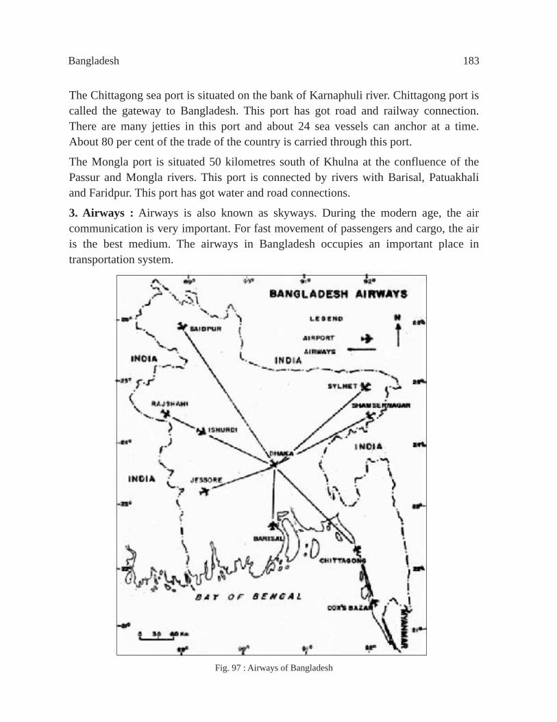
Bangladesh 183
The Chittagong sea port is situated on the bank of Karnaphuli river. Chittagong port is called the gateway to Bangladesh. This port has got road and railway connection. There are many jetties in this port and about 24 sea vessels can anchor at a time. About 80 per cent of the trade of the country is carried through this port.
The Mongla port is situated 50 kilometres south of Khulna at the confluence of the Passur and Mongla rivers. This port is connected by rivers with Barisal, Patuakhali and Faridpur. This port has got water and road connections.
3. Airways : Airways is also known as skyways. During the modern age, the air communication is very important. For fast movement of passengers and cargo, the air is the best medium. The airways in Bangladesh occupies an important place in transportation system.
Fig. 97 : Airways of Bangladesh

184 Secondary Geography
Two types of air services are available in Bangladesh, viz., internal air service and the international air service. Air services between the districts within the country is known as internal air service. Dhaka is connected with Chittagong, Jessore, Sylhet, Ishwardi, Saidpur, CoxÕs Bazar, Thakurgaon, Barisal and Rajshahi under the internal air service system and Jessore, CoxÕs Bazar, Sylhet, can also be travelled from Chittagong. On the other hand, when the Bangladesh Biman operates its air communication with other countries of the world, then it is called International Services of the Bangladesh Biman. Different countries of the world are linked with Dhaka and Chittagong in the international route (Fig. 97).
Kurmitola of Dhaka is an international airport. Its name is Hazrat Shahjalal International Airport. Hazrat Shahjalal International Airport is the biggest airport of the country, next to it is the Chittagong Shah Amanat and Sylhet Osmani International Airport. The name of the Bangladesh Biman Organisation is Bangladesh Biman Airlines.
Trade Selling and purchasing of goods to meet the demands of the people and the related activities are known as trade. Trade have influenced the economy of the country. In ancient times, trade was introduced through exchange of commercial goods due to non-existence of currency i.e. one would receive pulses or any other equal quantity of goods in exchange of same quantity of rice. Ordinarily it can be said that exchange of commodities is the trade. On the basis of kind and nature, trade can be divided into two, viz. Internal trade and International trade.
Internal trade : When the commodities are sold or exchanged between the different regions within the country, it is called internal trade. As for example, if the tea of Sylhet of Bangladesh is sent to other regions within the country for selling, then it comes under the category of internal trade.
International trade : When the commodities or goods are sold and purchased between different countries, then it is called international trade. International trade is of two types- import trade and export trade.
Import trade : To meet the requirements of the country when the goods are brought from another country, then it is called import trade. As for example, Bangladesh is to import baby food, machineries, food items, industrial raw materials and goods, medicine, chemicals, consumable items etc. to meet the needs of the country. Some of the major imported items are discussed below :
Consumable essential goods : To meet the food shortage, rice, wheat, edible oil, sugarcane, baby food, oil seeds are imported.

Bangladesh 185
Industrial goods : Main imported items for the industrial development are machineries, instruments, coal, cement, diesel, petrol, cotton yarn, electrical goods, iron and steel.
Machineries and raw materials : Though Bangladesh is an agricultural country, it is not developed in agriculture. Agricultural implements, insecticides, high quality seeds and fertilizers are necessary to increase agricultural productivity. On the other hand, to increase industrial production, high quality machineries, instruments, raw materials etc. are necessary. Therefore these materials are imported.
Besides these, Bangladesh imports medicine, glass, motor cars, bicycles, radioes, watches, televisions, refrigerators, buses, trucks, rubber goods etc, from foreign countries. The countries from where Bangladesh imports the goods are the U.S.A., Canada, the U.K., India, Japan, France, Singapore, China and Taiwan.
Export trade : When the commodities of our own country are sent to other countries, then it is known as export trade. As for example, the ready-made garments, jute, jute goods, leather and tea of Bangladesh are sent to other countries of the world. Some of the major exportable items are discussed below :
Ready-made garments : At present, Bangladesh earns its maximum foreign currency by exporting ready-made garments. During 1997-98, ready-made garments worth taka 12,924 crore, and during 2003-04 worth taka 20,853 crore were exported. Now, in 2009-10 it the export value has increased to 30,273 crores.
Raw jute : Once, about 75 per cent of the total world production of jute was produced in Bangladesh. The U.K., India, China, Japan, Indonesia, Pakistan, Turkey, Iran, and Russia are the main buyers of raw jute from Bangladesh.
Jute goods : Bangladesh earns foreign currency by exporting hessains, bags, gunny bags, carpets etc. to foreign countries. About 35 per cent of the total export earnings come from jute goods. The jute goods are exported to Japan, the U.S.A., the U.K., France, Germany, Italy, India and China.
Tea : Tea stands sixth in respect of earning foreign currency. There are 158 tea gardens in Bangladesh. She exports tea to the U.K., the U.S.A., Russia, Netherlands, Japan and Pakistan.
Leather and leather goods : Bangladesh every year earns foreign currency by exporting the cow, buffalow and goat leather. The leather and leather goods have occupied the fourth place in the field of exports. Bangladesh mainly exports leather and leather goods to the U.S.A., the U.K., Germany, France, Italy, Belgium and Japan.
Fish and frozen food : Fish and dried fish, frog leg, shrimp and other frozen foods are exported from Bangladesh.

186 Secondary Geography
Table 13 : Foreign currency earned through exports, Bangladesh, 2000-2010
Source : Bangladesh Economic Survey, 2010, Table 49
Paper and Newsprint : Bangladesh after meeting the local requirements, exports paper and newsprint every year. At present, paper is imported for our own consumption.Others : Other exportable items are naptha, furnace oil, handicrafts and agricultural products.A comparative statement of the expenses for imports and the earnings from exports is presented in the Table 14.We have got enough quantity of natural resources. But due to the shortage of capital and technical know how, the natural resources are not properly utilised. For this, there is no balance between imports and exports. During 2003-04, Bangladesh imported goods worth taka 64,262 crore and exported goods worth taka 44,812 crore. In 2009-10, Bangladesh imported goods worth taka 1,20,217 crore and exported goods worth taka 80,706 crore (Source : Bangladesh Economic Survey, 2010). Whole hearted co-operation is necessary to develop the economy of the country by increasing the exports and thereby to overcome the shortage in international trade. For this, increase in production, improvement of the quality of goods, reduction of the cost of production, reduction in internal consumption, reduction of export duties, development of transport system, wide advertisement of the exportable items are indespensible.
Item 2000-01 2001-02 2002-03 2003-04 2004-05 2005-06 2006-07 2007-08 2008-09 2009-10 1. Ready-made
garments 3364 3125 3258 3538 3598 4084 4658 5167 5919 4329
2. Jute and Jute goods
297 305 339 326 403 509 468 483 417 476
3. Frozen food 363 276 322 390 421 459 515 534 455 300 4. Leather 254 207 191 211 221 257 266 284 177 153 5. Chemical 97 67 100 121 197 206 215 216 280 149 6. Tea 22 17 15 16 16 12 7 15 12 5 7. Handicrafts 7 6 6 4 5 4 8 5 6 4 8. Others 2063 1983 2317 2995 3794 4995 6041 7407 8299 6126 Total 6467 5986 6548 7603 8655 10526 12178 14111 15565 11541
Year Import Export 8006 5324
8374 5752 9335 6467
8540 5986
9658 6548 10903 7603
13147 8655 14746 10526
17157 12178 21629 14111
22507 15565 17191 11541
Source : Bangladesh Economic Survey, 2010, Table 49 and 51
1998-991999-002000-012001-022002-032003-042004-052005-062006-072007-082008-092009-10
Table 14 : Imports and exports,Bangladesh, 1998-2010
(Million US Dollar)
(Million US Dollar)

Bangladesh 187
BangladeshWhat we learnt from this chapter :
Location and Area : Bangladesh is situated between 20°34¢ North latitude to 26°38¢ North latitude and 88°01 ¢ East longitude to 92°41 ¢ East longitude. The area is 1,47,570 square kilometres.
Physiography : Bangladesh is one of the largest islands of the world. Physiographically, Bangladesh can be divided into three divisions :
1. Hills of the Tertiary Age : The region includes the hills of the south-east and north and north-east.
2. The Pliestocene Terraces : These are (a) the Barind, (b) the Madhupur Tract and the Bhawal Garh, and (c) the Lalmai Hills.
3. The Recent Flood Plains : This region includes the piedmont plain, the flood plain, the deltaic plain and the mangrove plain.
Rivers : The main rivers of Bangladesh are the Padma, the Brahmaputra, the Jamuna, the Meghna, and the Karnaphuli.
Climate : The climate of Bangladesh is known as the Tropical Monsoon Climate. The climate of Bangladesh is divided into three divisions. On the basis of the monsoon winds, annual temperature and humidity. These are summer season, rainy season and the winter season. Highest temperature of 34° Celsius prevails in summer and the lowest of 11° Celsius in winter. Maximum rainfall occurs during rainy season.
Forest Resources : Accumulation of trees is known as forest or forestland. The products of forest are called the forest resources. The total forest cover is about 17 per cent of the total area of Bangladesh. The forestland is divided into three, (1) The Tropical Evergreen and Deciduous Forest, (2) The Tropical Deciduous Forest, and (3) The Mangrove Forest.
Power Resources : Coal, mineral and natural gas are the main sources of power. Bangladesh is abundant in natural resources, but not in coal and mineral oil.
Hydro-electricity : Hydro-electricity is one of the main sources of power. The electricity which is produced harnessing the water current is known as hydro-electricity. Karnaphuli Hydro-electric Power Plant is at Kaptai.
Thermal plant : Thermal electricity is one of the sources of power. There are thermal plants in Ashuganj, Ghorasal, Siddhirganj, Shahzibazar, Chittagong, Goalpara in Bangladesh.

188 Secondary Geography
Mineral Resources : Mineral resources are not abundant in Bangladesh. Coal, mineral oil, limestone, China clay, bronze, hard rock, silica sand, nuclear minerals, salt, sulphur, natural gas etc, are found in Bangladesh. Of all these, only natural gas is in abundant quantity.
Industries : Jute, textile, paper, fertilizer, sugar, and garments industries are notable industries in Bangladesh.
Population Resources : Bangladesh stands 9th in the world in respect of population. According to 1991 census, Bangladesh has got 11.15 crore of population with a density of 755 persons per square kilometre. The population growth rate is 2.17 per cent per annum. According to 2001 census, Bangladesh has got 12.93 crore, the rate of increase is 1.48 per cent and the density of population is about 876 persons per square kilometre. At present, the total population stands at 14.66 crore and the rate of increase is 1.39 per cent and the density of population is about 993 persons per square kilometre (Source : Bangladesh Statistical Pocketbook, 2009/February 2010, Page 7).
Communication System : The classification of communication system of Bangladesh is as follows :
1. Land transportation : Land transportation includes roads and railways. The roads and railways of Bangladesh is 2,86,507 kilometres and 2,835.04 kilometres respectively.
2. Waterways : Waterways include river and ocean routes. Bangladesh has got 8,400 kilometres of inland navigable waterways. There are two sea ports, viz., Chittagong and Mongla sea ports.
3. Airways : Domestic and international services are available in Bangladesh. The main airport is Hazrat Shahjalal International Airport.
Trade
Major imported goods : The major imported goods are baby food, machineries, food items, industrial raw materials, agricultural implements etc.
Major exportable goods : The major exported goods are ready-made garments, raw jute, jute goods, tea, leather and leather goods, fish and frozen food, paper and newsprint.

Bangladesh 189
ExerciseMultiple Choice QuestionsAnswer according to the information in the table below and on the light of the book.
1. The number of female employ ee employed in the garments sector in Bangladesh (%) - a. 80% b . 85% c. 90% d. 95%2. Which economic r eason has contributed a great deal in to build-up large number of garments industry?a. Easy access of ra w materialsb . The practical industrial policy of Govt. c. Labour at the cheapest w age d. Industrial loan at an easy term 3. What is the per centage of employment in Jute industry mention in the five sectors of the table?a. 6.02 b . 6.03 c. 6.04 d. 6.054. The demand f or Jute goods has declined greatly in the world market principally - i. Due to the widespread use of synthetic f ibbers in the worldii. The quality of the jute goods become lowiii. The production cost of the jute goods increased Which one is correct below? a. i b . ii c. iii d. i, ii and iii
Industry Number of Industries Employment
Jute 99 (Public) 1 lakh 10 thousand
Cotton textile 63 10 lakh
Paper 06 2 thousand 409
Fertilizer 07 6 thousand 318
Garments 715 7 lakh (Approximately)
Total = 18,18,757

190 Secondary Geography
5. In what kind of environmental situation is the Sunderban build-up?a. In the fertile plainsb . In the coastal region with sandstonec. In the coastal re gion of mixed-clayd. In the plain re gion of newly formed alluvial6. The most important role plays in respect to the strip of sandy land rising out of ri ver bed in Bangladesh - i. The change of the river direction ii. The change of the origin of the river iii. Frequent flood situation Which one is correct below?a. i and ii b . i and iii c. ii and iii d. i, ii and iii
RahelaÕs family live beside the river Padma. The sudden over flood has caused river erosion as a result RahelaÕs family along with other families become homeless. From the information above and your own knowledge about the flood in Bangladesh answer question number 7 to 9.
7. Which one belo w is the cause of flood in the river Padma?a. The water current originated from the Gangatri glacier b . The ebb and flood tide is created in the Bay of Bengal c. Hea vy rainfall in the Sylhet region d. Inadequate ri ver dragging
8. The best way to survive from the river erosion is - a. Tree plantation beside the bank of the river b . Dragging the river bed c. Embankment at the bank of the ri ver d. To control the flow of the river
9. The primary need for homeless RahelaÕs family - a. Relief b . Safe Shalter c. Medical Care d. Loan

Bangladesh 191
10. An important part of the recent flood plains is Southern coastal region. Its area is about 1,24,266 square kilometres. Upon the light of the information which statement is correct?
a. The rivers in the southern regions are less navigable and frequent floods cause landforms through deposition
b. New landforms are formed due to the deposition of the sediments in the waterlands and lowlands
c. The rivers in the southern region are wider and wild so landforms are always active
d. The rivers in the southern region are widely scattered around like a net as result river transportation is excessively used
11. The use of electricity for the last twenty years increased widely. Which one belo w is the major cause of increasing the use of electricity? i. The supply of the natural gas increased ii. The population towards the town is increased iii. The use of power engine increased in the rural area Which one is correct below? a. i and ii b . ii and iii c. i and iii d. i, ii and iii12. The ratio of the population in urban area increased enormously for the last 10 years. Which one below is the cause of such increase? a. The plenty of lodging facility in the urban area b . The birth rate of the urban area is more than that of the village c. Man y people are shifting their abode from village to town d. The necessary articles are available in fewer prices at the urban areaThree types of transport information of Bangladesh are shown below in the table of the year 2001 and 2005. From the information of the table and from your own knowledge regarding the kinds of transport system in Bangladesh answer question number 13 to 15.
Sour ce : BRTA, R and H BIWTA, quaded in Bangladesh Bureau of Statistics website
Kinds of Transportation 2001 2005 Main road (kms.) 20,797 21,571 Railways (kms.) - - Broad gauge 1,245 1,446 Narrow gauge 1,523 1,389 Riverways for movement (km s.) - - Monsoon period - 5,968 Dry season - 3,865

192 Secondary Geography
13. Which statement below is correct as per the table?i. The main road of Bangladesh is increased in between the year 2001 and 2005 ii. The length of the narrow gauge railway was longer than the broad gauge in the year 2005 iii. One-third of the riverways has become useless during the dry season of the year Which one is correct below?a. i and ii b . i and iii c. ii and iii d. i, ii and iii14. Which statement is correct according to the information above?
a. Passengers travel through road transport thrice more than riverways b. Some narrow gauge railway has been converted into broad gauge in between
the year 2001 and 2005c. The new main road has been constructed in between the year 2001 and 2005 d. The length of the useable river transport was about 9000 kilometres in
Bangladesh in the year 200515. Which statement below is correct against transport system in Bangladesh? a. Road transport construction is expensive due to the river b . There are railways in every district in Bangladesh c. Half of the passengers travelling by the river transport travel by steamer d. Chittagong is the only port in BangladeshAccording to the map stated below about the climate in Bangladesh answer question number 16 to 19.

Bangladesh 193
Financial Year Export Income Import Expenses
(Million US Dollar)
2004-05 8,655 13,147
2005-06 10,526 14,746
2006-07 12,178 17,157
16. Which city below is near to the line of the Tropic of Cancer?a. Sylhet b . Comilla c. K ushtia d. Gopalg anj
17. Which city below is located at the north-east region of Bangladesh? a. Mymensingh b . Chittagong c. Khagrachhari d. Sylhet
18. Which city below has become 28° Celsius average temperature in the month J uly? a. Noakhali b . Barisal c. P atuakhali d. Khulna
19. Draw a scale on the map and show the direct distance from Dhaka to Dinajpur.a. 240 kilometres b . 280 kilometres c. 320 kilometres d. 360 kilometres
Creative Questions1. The scenario of export income and import expenses are shown in the table belo w in different financial years of Bangladesh.
Sour ce : Bangladesh Economic Survey, 2010
a. What type of business is export and import?
b. Explain an important reason of the deficit of export income and import expenses in different economic years.
c. Draw a bar graph using the information from the table.
d. What are the ways in overcoming this sort of export income in Bangladesh? Give reasons for your answers.

194 Secondary Geography
Commodities Freezing Tea Chemical Leather Raw Jute Knitwear Garments Others Total food Substances materials goods
Countries Other countries of the world
363 22 97 254 67 230 1496 3364 535 6467
USA 132 0 1 1 0 13 467 1540 347 2501 The percentage of the USA
36 0 1 0 0 6 31 46 64 39
2. Answer the f ollowing questions from the information shown in the map.
a. What type of climate is prevailed in Bangladesh? b . Why Sylhet region is the highest rainfall area as shown in the map? Explain. c. By observing the map identif ies the different ingredients of the climate in Bangladesh and describe them. d. Under the influence of a special wind the climate of Bangladesh is equable, gi ve reasons for your answer in favour of the statement.3. The export information of Bangladesh in the USA and other countries of the
world in the year 2000-01 are included below in the table.
a. Which one was the principal export item of Bangladesh in many different
countries of the world in the year 2000-01?b. Why are the garments clothes important in the export business?c. Identify three important features of export business in Bangladesh using the
information given in the table.d. How is it possible to extend the export business of Bangladesh? Give your opinion.
150 Kilometres0

Bangladesh 195
4. Answer the questions from the map given below.
a. What is the name taken by the principal rivers to fall down in the Bay of Bengal combinedly as shown in the map?
b. Why is the direction of the main rivers of Bangladesh south-facing? c. Draw a copy of the map above and show the direction of the river Padma. d. Analyze the importance of the river in building-up shadow landform in the
map.5. Bangladesh is the largest Raw-jute and Jute goods exporting country. One-fourth
of the worldÕs Jute is produced in this country. Due to the widespread use ofsynthetic in the world, the demand for Jute and Jute goods has declined greatly. Of course, in between 1990Õs the production of Jute goods and export price has declined at the rate of 10 per cent. In order to restrict the less use of Polythene the Government of Bangladesh has partially prohibited the use of Polythene goods in the year 2002.a. Write the name of a country in Asia who exports Raw-jute and Jute goods in
Bangladesh. b. Explain an important reason of the less use of Jute and Jute goods in the
world. c. By drawing a map of Bangladesh identify Jute industries in three important
regions. d. Evaluate the partial restriction taken by the government of the use of
Polythene in the growth of Jute industry.
50 Mile0
50 Kilometres0
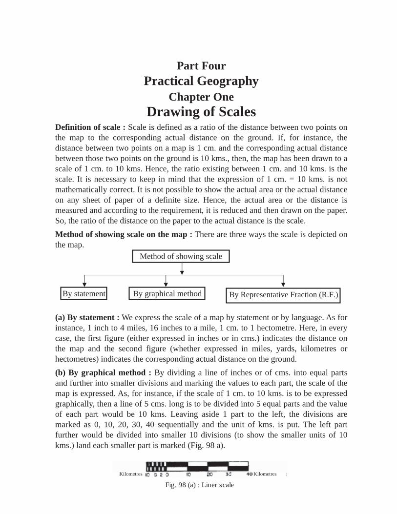
196 Practical Geography
Method of showing scale
By statement By graphical method By Representative Fraction (R.F.)
Fig. 98 (a) : Liner scale
Part FourPractical Geography
Chapter OneDrawing of Scales
Definition of scale : Scale is defined as a ratio of the distance between two points on the map to the corresponding actual distance on the ground. If, for instance, the distance between two points on a map is 1 cm. and the corresponding actual distance between those two points on the ground is 10 kms., then, the map has been drawn to a scale of 1 cm. to 10 kms. Hence, the ratio existing between 1 cm. and 10 kms. is the scale. It is necessary to keep in mind that the expression of 1 cm. = 10 kms. is not mathematically correct. It is not possible to show the actual area or the actual distance on any sheet of paper of a definite size. Hence, the actual area or the distance is measured and according to the requirement, it is reduced and then drawn on the paper. So, the ratio of the distance on the paper to the actual distance is the scale.Method of showing scale on the map : There are three ways the scale is depicted on the map.
(a) By statement : We express the scale of a map by statement or by language. As for instance, 1 inch to 4 miles, 16 inches to a mile, 1 cm. to 1 hectometre. Here, in every case, the first figure (either expressed in inches or in cms.) indicates the distance on the map and the second figure (whether expressed in miles, yards, kilometres or hectometres) indicates the corresponding actual distance on the ground.(b) By graphical method : By dividing a line of inches or of cms. into equal parts and further into smaller divisions and marking the values to each part, the scale of the map is expressed. As, for instance, if the scale of 1 cm. to 10 kms. is to be expressed graphically, then a line of 5 cms. long is to be divided into 5 equal parts and the value of each part would be 10 kms. Leaving aside 1 part to the left, the divisions are marked as 0, 10, 20, 30, 40 sequentially and the unit of kms. is put. The left part further would be divided into smaller 10 divisions (to show the smaller units of 10 kms.) land each smaller part is marked (Fig. 98 a).
Kilometres Kilometres

Practical Geography 197
Miles Miles 4 3 2 1 0 4 8
The same rule is also to be followed in case of scale of inches (Fig. 98 b). Here, a line of 3 inches long is to be divided, first, into three equal parts, then leaving one division to the left, each division is marked and the left part divided further into smaller divisions. At the time of expressing the statement of 1 inch to 4 miles graphically, a line of 3 inches long is to be divided into 3 equal parts, leaving one part to the left, the divisions are marked as 0, 4, 8 and the unit of mile is mentioned. The left part is also divided into 4 equal parts (1 inch = 4 miles). Sequentially, the values of 1, 2, 3, 4 miles starting from 0 to the left are put.
Fig. 98 (b) : Liner scale
(c) By Representative Fraction (R.F.) : An independent unit of scale is used to measure the distances for different countries. If the scale in a map is expressed in the unit of one country, then it may not be acceptable to another country due to language problem. To overcome this disadvantage, the R.F. method has been introduced. In English, it is known as Representative Fraction and the abbreviation is R.F. This expresses the proportion of the scale by a fraction in which the numerator is 1 which denotes the length on the map and the denominator in the same unit denotes the corresponding length on the ground. As for example, if we have to express the scale of 1 cm. to 1 metre in R.F., then the metre is to be converted into cms. and the symbol (t) in between such two figures is to be put. 1 mt. = 100 cms. Therefore, the numerator is 1 and the denominator is 100. So, the scale would be 1 t 100 or 1/100. It means that when the distance on the map is 1 cm., the corresponding distance on the ground is 100 cms.
Again, in the British system, the R.F. 1 t 36, means the distance of 1 inch on the map and the corresponding distance of 36 inches on the ground, i. e., 1 yard (36 inches = 1 yard). Hence, the statement scale is 1 inch to 1 yard. The scale of 1 inch to 1 mile is expressed as R.F. 1 t 63360, as 1 mile = 63360 inches
Conversion of scale From statement to R.F.1. 1 inch to 2 yards (1 yard = 36 inches)2 yards = 36 ´ 2 = 72 inches. So, R.F . is 1 t 722. 3 inches to 9 miles 1 inch to = 3 miles 3 miles = 63360 ´ 3 = 190080 inches. So, R.F . is 1 t 190080
9�3

198 Secondary Geography
3. 1 inch to 1 furlong I furlong = 7920 inches. (8 furlongs = 1 mile; or , 8 furlongs = 63360 inches,
I furlong = = 7920 inches)
So, R.F . 1t 7920
4. 1 centimetr e to 2 kilometres W e know, 100000 cms. = 1 km. 2 kms. = 100000 ´ 2 = 200000 cms. So, R.F . 1 t 2000005. 1 centimetr e to 5 metres W e know that 100 cms. = 1 mt. So, 5 mts. = 100 ´ 5 = 500 cms. 1 cm. = 500 cms. So, R.F . 1 t 500
From R.F. to statement1. The R.F. 1 t 633600. Here, it is easier to convert the given R.F. intoEnglish
system. W e know that 1 mile = 63360 inches. So, 633600 ¸ 63360 = 10 miles. Hence, the statement is 1 inch to 10 miles.
2. R.F. 1 t 10000. Here it is easier to convert the given R.F. into metric system. W e know that 10000 cms. = 1 hectometre. So, 10000 ¸ 10000 = 1 hectometre. Hence, the statement is 1 cm. to 1 hectometre.
3. R.F. 1 t 100. Here, it is easier to convert the given R.F. into metric system. W e know that 100 cms. = 1 metre. So, 100 ¸ 100 = 1 metre. Hence, the statement is 1 cm. to 1 metre.
4. R.F. 1 t 79200 W e know, 7920 cms. = 1 furlong. So, 79200 ¸ 7920 = 10 furlongs. Hence, the statement is 1 inch to 10 furlongs.
5. R.F. 1 t 120 W e know, 12 inches = 1 feet. So, 120 ¸ 12 =10 feet. Hence, the statement is 1 inch to 10 feet.
633608

Practical Geography 199
Classification of scales : The scale is classified into different groups. Generally, the simple scale, diagonal scale, comparative scale, time scale, scale of slope, proportional scale and vernier scale are in use.
Linear scale : In English, the terms-the Simple scale, Linear scale, Plain scale and Graphic scale are all the same but generally the term Simple scale is used.
Drawing of simple scale : A line of required length is divided into a number of big equal divisions and the values of each division is put leaving one division to the left which is further sub-divided into smaller divisions and each smaller division is marked. The big divisions are known as primary and the smaller divisions to the left as secondary part. It is remarkable to note that the length of the scale and the number of divisions would depend on the nature of the scales to be drawn.
Length of the scale : Scale of any length can be drawn. But it is necessary to draw the scale taking into consideration the beauty and the size of the paper. Generally, for classroom practical khata, the length of the scale should be within 4.5 inches to 6 inches or 12 kms. is 15 cms. So, it becomes befitting and gives a good look, otherwise it looks odd.
In small size maps of large scale, the scale of 5 to 6 cms. or 2 to 3 inches length is drawn. A thin scale looks nice. Hence, thin or narrow scales are drawn. Almost in all cases, the simple scale of 0.2 inch width or even less than this is chosen and divided horizontally into two parts.
Division of line : Different methods of dividing a line is shown below :
Say, the preliminary part of a line is to be divided into 4 equal parts and the secondary part into 5.
(a) It is possible to divide a line with the help of a divider by trial and error method.
(b) If the scale is 4.5 inches long, then the length of one division is 4.5 ¸ 4 = 1.125 inches. Now, it would be possible to divide the line with the help of a divider taking the length of 1.13 inches instead of 1.125 inches.
(c) Firstly, a line AB of any length is taken. Primarily, this line is to be divided into 4 equal parts. To the left of this line, an angle <BAC of 24° or 30° at A is drawn. With the help of a ruler, the line AC is divided into 4 parts each of 1 inch length. Mark these points as d, e, f, c. Then CB is joined. With the help of set squares the parallel lines to BC are drawn from d, e, f. The line AB primarily will be divided into 4 equal parts. Keeping one part to the left, the divisions are marked as 0, 1, 2 and 3.

200 Secondary Geography
For secondary part, two perpendiculars one above at ÔAÕ and the other below at Ô0Õ are drawn. These two lines are divided into 5 equal parts of any length. These are marked on both sides of AB as 1, 2, 3, 4, 5. The points 5, 4, 3, 2, 1, 0 of the above perpendicular line are joined respectively with 0, 1, 2, 3, 4, 5 of the line below. The left part would be divided into 5 equal parts. Starting from Ô0Õ at increasing rate towards left the points are marked as 1, 2, 3, 4, 5 (Fig. 99).
Fig. 99 : Dividing a line
Method of drawing simple scales : To make the drawing procedures easier few examples are cited below :Example 1 : 5 inches to 5 miles; draw a simple scale.Drawing procedure : A line of 5 inches long is divided into 5 equal parts. Each primary division will represent 1 mile. Keeping I primary part to the left, the points are marked towards right as 0, 1, 2, 3, 4. For secondary, the left part is divided into 8 equal parts (as 8 furlongs = 1 mile). On the right, the unit of mile and on the left the unit of furlongs is mentioned. 1 inch to 5 miles. So, 63360 x 5 = 316800 inches. Hence, R.F. 1 t 316800 (Fig. 100 a).
R. F. 1t 316800Fig. 100 (a) : Liner scale
Example 2 :1 cm. to 1 km.; a simple scale is to be drawn. 1 cm. to 1 km. as, 1 km. = 100000 cms. 12 cms. is 12 kms. Hence, R.F . 1 t 100000Drawing procedures : A line of 12 cms. long is divided primarily into 12 equal parts. Keeping 1 primary part to the left, the divisions, are marked as 0, 1, 2, .................11 and the unit of km. is mentioned. 1 km = 10 hectometres. So, the secondary part is further divided into 10 equal parts. The divisions are marked towards left starting from 0 as 1, 2, 3, ............. 10, and the unit of hectometre is mentioned. Just below the scale at central position, the R.F. 1 t 100000 is written (Fig. l00 b).
R.F. I t 100000Fig. 100 (b) : Linear scale
Hecms 10 5 0 1 2 3 4 5 6 7 8 9 10 11 Kms
Furlongs 1 2 3 4 Miles012345678

Practical Geography 201
Example 3 : 1 inch to 4 miles; a simple scale is to be drawn.When the distance between two points on the ground is 4 miles, then the map distance is 1inch.When the distence between two points on the ground is 1 mile then the map distance is inch.When the distance between two points on the ground is 20 miles then, the map distance is = 5 inches.
This calculation can be done in another way.Say, I will draw a scale of 5 inches in length.When the map distance is 1 inch, the ground distance is 4 miles.When the map distance is 5 inches the ground distance is 4 x 5" = 20 miles.
Drawing procedure : The values of the divisions on the scale have to be shown as 5, 10, 15 or as 10, 20, 30. It cannot be shown as 4, 8, 12 or 3, 6, 9. The 5 inches line as obtained through calculation is divided into 4 equal parts. Leaving I part to the left, the values of the divisions are put as 0, 5, 10, 15 sequentially to the right. As each of the primary divisions represents 5 miles, so the left part is divided into 5 equal parts. The mile unit is mentioned both to the left and right of the scale. 1 inch represents 4 miles. 4 miles = 63360 x 4 = 253440 inches. So, R. F. is 1t 253440. This R. F. is to be mentioned just below the scale. With the help of a divider, the distances of 7, 13 and 19 miles can easily be measured using this scale (Fig. l00 c)
Miles 5 4 3 2 1 0 5 10 15 MilesR.F. 1t 253440
Fig. 100 (c) : Linear scale
Example 4 : With 1 centimetre to 1 hectometre, a simple scale is to be drawn. 1 centimetre reprents 1 hectometre; as 1 hectometre = 10 centimetre Hence, R.F. 1 t 10000
Drawing procedure : Primarily, a line of 10 cms. long is divided into 10 equal parts. Keeping 1 part to the left, other divisions are marked as 0, 1, 2, 3, ...........9. As, 1 hec. is equal to 10 decametres, so the left part is divided into 10 equal parts (secondary).
14
1 x 204 SutonnyMJSutonnyMJ

202 Secondary Geography
The unit hectometre is mentioned to the right of the scale and the decametre to the left. Lastly, the R.F.1 t 10000, is written below the scale at its central position (Fig. 100 d).
R.F.I t 10000
Fig. 100 (d) : Linear scale
Example 5 : With 3 inches to 15 yards, draw a simple scale. 3 inches represents 15 yards. We know 36 inches = 1 yard.
1 inch represents = 5 yards. 5 yards = 36 x 5 = 180 inches.
Hence, R.F. 1 t 180When 5 yards is the ground distance, the map distance is 1 inch.
1 yard is the ground distance, the map distance is inch.
25 yards is the ground distance, the map distance is inches = 5 inches.
Drawing procedure : A line of 5 inches long is drawn. Primarily, it is divided into 5 equal parts. Each division represents 5 yards. Then the left part is divided into 5 equal parts. Each division on this secondary part would represents 1 yard each (Fig. l00 e).
Yards 5 4 3 2 1 0 5 10 11 20 Yards
R.F. I t 180
Fig. 100 (e) : Linear scale
Use of Scale1. Scale is used to measure correctly the distance between tw o points on the map.2.Scale is used during surv ey work.3. Scale is used to determine the area of a map or of a plan.4.Scale is used to f ind out the length of a railway track and the roads shown on the map.5. During map dra wing and map reading, the scale is used.
1 x 255
153
15
Decametres 10 5 0 1 2 3 4 5 6 7 8 9 Hectometres

Practical Geography 203
Advantages of Using the Scale1. The distance existing between two points on the map is known.2. The linear scale for general use is very simple to follow.3. A map with linear scale, if enlarged or reduced using photostat machine, the scale
is also proportionately enlarged or reduced.4. If R.F. is supplied in any map, then we can use it according to our unit.
Disadvantages of Using the Scale1. The measurement unit of length is different in different countries. Scale given in
a map of one country cannot be used by another country.2. If the scale drawn is faulty, and if used, would give wrong results.3. Language problem : Different countries have different languages. Map expressed
in the language of one country cannot be understood by the people of another country. As a result, the units used in the scale of a map cannot be followed by the people of other country.
Drawing of ScalesWhat we learnt from this chapter :
Scale : Scale is defined as a ratio of the distance between two points on the map to the corresponding distance on the ground.
Method of showing scale on the map : The scale is depicted on the map by three methods, (a) By statement, (b) By graphical method, and (c) By Representative Fraction (R.F.).
Length of the scale : A scale of 4.5" to 6" length should be drawn in practical khata.
ExerciseCreative Questions1. Anis wanted to know from his sister how the map of Bangladesh was drawn while
he was on a visit to the school library. His sister answered him and told him about the scale. Then she explained about the use of scale. Then the explained about the use of scale, features and also about map. a. What is scale?b. What is the use of scale publication? c. Draw a simple scale of 1 t 36 by showing yards and feet. d. What are the logical aspects of drawing map in respect to make it bigger and smaller? Gi ve reasons for your answer.

204 Secondary Gerography
Chapter Two
Drawing of PlansDefinition of plan : Representation of houses, schools, play grounds etc. on reduced size is a plan. Scale is also used to draw sketches as that of maps. The length, breadth and size of any area if reduced and presented on a paper according to specific scale one gets a clear idea of the size and the location of that area.
In reality, a big school and its yard occupies a great area on the ground. The whole complex can be shown in a plan on some reduced scale.
Drawing procedure of a plan : During plan preparation, a metallic tape of feet, inches or metre is used. First, a rough sketch map is prepared of the area which is to be sketched. The linear and the angular measurements are noted in a field book or in a sheet of paper. Afterwards, the plan of the area is drawn using a specific scale. Generally, the surveyors or Amins use a scale of 1 inch to 8 feet or 1 cm. to 10 metres, at the time of drawing the plans of houses, settlemens, schools etc. A procedure for plan drawing of a school is shown below (Fig. 101).
Plan of a school : The play ground, garden and the boundary wall is measured. The length of the boundary wall measured is 135 metres and the breadth is 70 metres. A scale of 1 cm. to 10 metres is chosen to draw the plan.
10 metres = 1000 centimetres So, R.F. is 1 t 1000The length of the boundary wall is 135 metres breadth is 70 metres. So,The length of the wall, 135 ¸ 10= 13.5 cms.The breadth of the wall, 70 ¸ 10= 7.0cms.Length of the school, 70 ¸ 10 = 7.0 cms.Breadth of the school, 55 ¸ 10 = 5.5cms.Length of the play ground, 55 ¸ 10= 5.5cms.Breadth of the play ground, 40 ¸ 10= 4.0cms.Length of the garden, 55 ¸ 10 = 5.5 cms.Breadth of the garden, 42 ¸ 10 = 4.2 cms.Location of the gate from the western side. 40 ¸ 10 = 4.0 cms.

Practical Geography 205
Fig. 101 : Plan of a school
Drawing procedure : Take a line of 13.5 cms. long and draw two perpendiculars of 7 cms. long at each end of this line to get the school premises. Leaving a space of 0.5 cm. to the north, 0.8 cm. to the east. 1.2 cms. to the west and 1 cm. to the south, the plan of the school has been prepared comprising of the school building, play ground and the garden (Fig. 101).
Fig. 102 : A model drawing of a house
Drawing of plansWhat we learnt from this chapter :
Plan : Representation of house, school, play ground etc. when drawn on some reduced scale is known as plan.
R. F. I t 1,000

206 Secondary Geography
Plan drawing procedure : Measurements with the help of a metallic tape is to be completed first before drawing a plan of any area. A draft sketch of the area is to be prepared. According to a selected scale, the plan is drawn as that of the draft sketch. North line and the scale are to be drawn in the plan.
ExerciseCreative Questions1. Answer the question from the given figure below.
a. What is the figure about above?
b Why is it important for sketches? Explain.
c. In the figure if you start from the arrow mark and reached at ÔAÕ sign then in which face you will be off and during the course of your travel what are the things that will come in your notice? Explain.
d. ÔThe figure above is a sketchÕ give reasons for your answers.

Practical Geography 207
Chapter ThreeInternational Conventional Signs
Definition : The internationally accepted signs used in maps and plan to show the boundary of any area, roads, railways, rivers, canals, wells, ponds, lakes, marshy lands, grasslands, deserts with oasis, mountains, mountain peaks, small and big towns, mosque, idgah, temple, church, pagoda, graveyard, port, lighthouse, oil-well, battlefield etc. are known as International Conventional Signs. The cartographers of the world use these conventional signs in maps and plans. Few of the generally used conventional signs are shown below to give an idea of these signs used by different countries of the world (Fig. 103 and 104).
Fig. 103 : International conventional signs

208 Secondary Geography
Fig. 104 : A map with conventional sign
International Conventional Signs What we learnt from this chapter :Conventional signs : The signs which are used in maps and plans to depict some specified features are known as conventional signs.International conventional signs : The cartographers of the world use special symbols and signs in maps and plans known as International Conventional Signs.
ExerciseCreative Questions1. Eshee crosses a railway crossing while she was travelling with her father. She
wants to know about the different signs used in the signboard while crossing over this railway crossing. In reply her father talked about the use of sketches and maps, geographical aspects and some other images.a. What are conventional signs? b. Why are the conventional signs used in maps? c. Draw a map of Bangladesh and show the rail-line from Dhaka to Chittagong.
d. ÔSketches and maps require to depict many specified features in order to show dif ferent geographical aspectsÕ explain.

Practical Geography 209
Chapter FourMap Reading
Definition of map : Map is a representation of any part of the earth or the earth as a whole on some reduced scale with latitudes and longitudes in a plain sheet of paper.
To draw a map of any part of the world (continent, country, district, thana, village etc.), an accurate survey work is to be conducted or if the area is small, then the photograph is to be taken.
Classification of map : There may be various types of maps. Generally, on the basis of the scale used in maps and the subject matter, the maps are classified into two groups. According to the scale used, again the maps are of two types :
(a) Large scale maps, and
(b) Small scale maps.
Navigation charts, aero-nautical charts, mouza maps or cadastral maps etc. are all large scale maps. As a small area is enlarged, so many data or information can be accommodated in the map. Atlasses, wall maps etc. are small scale maps. The whole world or the continent or any big region like that of a country when shown on a sheet of paper, small space remains in the map. So, not much information can be shown on this type of map.
According to subject matter, the maps are of two types :
(a) Qualitative map, and
(b) Quantitative map.
(a) Qualitative map : Geological map, topo-map, relief map, soil map, wall map, atlasses, topographical map and mouza map are of this type.
(b) Quantitative map : Air temperature, amount of rainfall, distribution of population, density of population, mineral extraction, forest production, agricultural production etc. shown on a map is known as quantitative map.
Map reading procedure : We not only see the map, but also read it. Map reading is necessary if we have to discuss the items shown in the map. The procedure to read the map according to the types and nature is also different. In the physical maps, the location of the mountains, plateaus, hills, valleys, plain lands, rivers, lakes, deltas,

210 Secondary Geography
oceans and seas etc. are shown using the conventional signs. The physical features of Asia have been shown in Fig. 57. Extension of the mountains from Pamir Knot, the location of plateaus between the mountains, existence of plain lands etc. in Asia can be studied using this map. With the help of contour lines, the elevation and the relief can be shown. It is not possible to study such maps without having the knowledge of the definition, the characteristics of contours, location of vertical and normal slope. The climatic divisions of Europe has been shown in Fig. 54. What type of climate is prevailing in which part of this map can be explained if properly studied. Again, the weather map is of different type. Ideas can be had regarding the high and low pressure areas, wind direction, amount of rainfall, cloud cover, ocean conditions etc. Boundary of each plot of a mouza is shown in the mouza map, hence, the boundary of the plot can be determined according to the Dag number of the plot and these maps are used to realise the government revenue. A topographical map is prepared of the villages situated side by side or enlarging such a small village. Physical features such as
Fig. 105 : A map of a village
mountains, plateaus, forests, lakes etc. can be shown using the conventional signs. Besides, the cultural aspects such as roads, railways, airports, settlements, towns, cities, canals, bridges, ferry ghats etc. too can be shown. One should have the knowledge about parallels, meridians, scales, different conventional signs etc. before reading such maps.

Practical Geography 211
Fig.105 represents a map of a village. Rivers, railways, roads have passed through this village. There are North Para, South Para, West Para, mosques, temples, post office, school, market, crop fields etc. shown in different places in this map.
To study this map, one should have the knowledge beforehand about the directions. Upper part of the map indicates the North, the opposite is the South, the right hand side of the reader, the East and the left side, the West. Then the location of the market, post office etc. according to scale is to be studied. It is better to give different titles of the subject matter studied. Reading procedure for Fig. 105, and the steps to be followed are explained below.
Terminal information : This map has been prepared at the scale of 1 inch to 4 miles. There does not exist any parallel and meridian in a topo map. So, no parallel and meridian has also been shown in this plan (Fig. 105).
Physical features : There is no hill or high land in this village. There is a marshy land to the east-central place and one swamp to the south-east. The normal slope is towards south-east.
Drainage system : A major meandering river is found to pass through the central part of the village from north-west to south-east. A small river flowing from the north joins the main stream at the north-west corner of the village. A bit bigger river coming from south-west joins the main stream. The main river comes under the influence of tide and as a result, the other rivers are also affected.
Communication system : An unmetalled road coming from the west has crossed the river. Some portion of the east-west road near the river is metalled and the rest is unmetalled. Two unmetalled roads coming from north and north-east join this metalled road. One unmetalled road coming from the railway station in the south terminates at the river side. The railway line in the south of this village runs from north-east to south-west. The steamer plies always in the main river. The water communication is maintained by boat in other rivers. The railway line and the road crossed the river through a bridge. The communication system of the village is developed.
Settlements : There are six scattered settlements in this village, viz., North Para, South Para, East Para, Central Para, West Para and FishermenÕs Para, there is a mosque by the side of the school at West Para and a temple in the FishermenÕs Para. The concentration of the houses is found to exist in the West Para only. There is a school located almost at the central place of the village. The market located by the

212 Secondary Geography
side of the river is the only marketing centre for the inhabitants. There is a post office in this village. The grassland situated in the northern part of the village is used as the grazing land for the cattles of the farmers.
Agricultural land : 80 per cent of the total land of the village is under crop. The land has been fragmented gradually due to the application of the law of inheritance. It is possible to irrigate the land from rivers and swamps during the dry season. Agriculture is the main occupation of the inhabitants of the village.
Map ReadingWhat we learnt from this chapter :
Definition of map : Map is the representation of any part of the earth or the earth as a whole on some reduced scale on a plain sheet of paper.
Classification of maps : According to the scale used and the subject matter, the maps are divided into two. According to the scale, the map can be sub-divided into two, (a) large scale map, and (b) small scale map. According to the subject matter presented, the map is classified into two as (a) qualitative, and (b) quantitative.
Map reading : The techniques of map reading of different maps are different. Different conventional signs and lines are used in the physical maps. For climatic map reading, one should have clear ideas about cloud cover, amount of rainfall, conditions of the ocean etc. Different types of maps should be studied using different techniques.
ExerciseCreative Questions1. By showing a figure to Asha the geography teacher Mr. Farid in reply to her
question about map said that, that was a map. Then he described its classification, drawing procedures and the differences with sketches. As a result, Asha was encouraged to learn how to draw map.a. What is map?b. Explain about qualitative map.c. Draw a map of Bangladesh at the scale of 1 inch to 100 kilometres.d. Draw a sketch map of your area and write the details of the map.

Practical Geography 213
27° N
26°
25°
24°
23°
22°
21°
20°
88° E 91°89° 90° 92° 93°
Chapter Five
Drawing of Bangladesh MapIt is easy to draw a map by square method and the learners will be able to acquire this method very quickly and easily. The north-south extension of the map of Bangladesh is about 1.4 times more than the east-west extension. The latitudes and longitudes are taken as the basis during drawing of squares, then by practice, the learners can have the knowledge about the location of important cities, towns, ports, hillocks, rivers, haors etc.
Fig. 106 : To make the squares for Bangladesh map boundary

214 Secondary Geography
Drawing techniques : Our country is generally located between 20° to 27° north latitudes and 88° to 93° east longitudes. Hence, for north to south extension 7 squares to cover 20° to 27° north parallels and for east to west extension, 5 squares to cover 88° to 93° of east longitude are to be drawn to accommodate 35 full squares. Small squares, if drawn at the margins, may cause errors in case of drawing the boundary line of the country. A vercal line of 5.6 inches long and a horizontal line of 4.0 inches long have to be divided into 7 and 5 equal parts respectively (Fig. 106). After this, a standard map of Bangladesh, is followed to draw the boundary line of the map in this net of squares (Fig. 106)
Fig. 107 : Drawing method of Bangladesh boundary map
In reality, though the latitudes and longitudes are not equally spaced, but for the learners these have been equally spaced for the convenience of the learners (Fig. 107). 7 squares from north to south and 5 squares from east to west i. e. a total of 35 squares have been drawn taking each side of vertical and horizontal squares as 1 inch (Fig. 107).
26°
25°
24°
23°
22°
21°
20°93°92°91°90°89°88° East
27° NorthNorthBangladesh

Practical Geography 215
To the drawn net of squares, put the values on the right line from bottom to the top (south to north) as 20, 21, 22, 23, 24, 25, 26, 27 degrees and 88, 89, 90, 91, 92 and 93 degrees to the bottom line from left to right (west to east).Then a standard map of Bangladesh is followed to draw the boundary line of Bangladesh in this net of squares. The learners would be able to draw the map themselves in the net of squares without using the original map if they practice on it for 4 to 5 times. The map would be large or small depending on whether the length of the side of squares would be big or small (Fig. 107).Sample 1 : An outline map of Bangladesh is drawn by square method and the important rivers and physiographic divisions are shown (Fig. 108 a).
Fig. 108 (a) : Drawing method of Bangladesh map
Hills of Tertiary AgePleistocene TerracsRecent Flood Plains
0
0
25
25
50
50
MILE
K. M.
LEGEND
N
INDIA
INDIA
B A Y O F B E N G A L
INDIA
MYA
NM
AR
BANGLADESHPHYSIOGRAPHY

216 Secondary Geography
Sample 2 : An outline map of Bangladesh is drawn and on it are shown the district boundaries, important cities and towns including the capital, Dhaka, river ports and sea ports (Fig. 108 b).
Fig. 108(b) : Drawing method of Bangladesh
030 50 Km

Practical Geography 217
Sample 3 : An outline map of Bangladesh is drawn and the broad gauge and metre gauge railways and their branch routes are shown on it (Fig. 108 c).
Fig. 108(c) : Drawing technique of Bangladesh

218 Secondary Geography
Sample 4 : An outline map of Bangladesh is drawn and the location of forest areas are shown on it (Fig. l08 d).
Fig. 108(d) : Drawing technique of Bangladesh map
Drawing of Bangladesh Map What we learnt from this chapter :An ideal or standard map of Bangladesh should be used while drawing the map by square method. While, drawing the boundary line of Bangladesh, an ideal map is to be followed strictly. The size of the map would be small or big depending on the size of the squares whether big or small.
Tropical Evergreen and Deciduous Forest
Tropical Deciduous Forest or Salban
Mangrove Forest or Sunderban
L E G E N D
B A N G L A D E S HF O R E S T S

Practical Geography 219
ExerciseCreative Questions1. Answer the question from the given figure below.
a. What is the method of drawing the map? b. Why does the square system use in drawing a map? Explain.c. Enlarge this map one and a half and draw it once more.d. ÔWhat is the importance of Latitude and Longitude in drawing mapÕ? Explain.
27° North
26°
25°
24°
23°
22°
21°
20°93°92°91°90°89°88° East

220 Secondary Gerography
Chapter SixRepresentation of Data
Definition : The information as available in the form of figures about temperature, rainfall, agriculture or industrial production is known as data. The data thus available when presented using some special techniques in graphical form is known as representation of data. Rainfall, frost, temperature, air pressure etc. related to climatic data and the area of any country or region, population, acreage of cropped area, production of crop, exports and imports or the money spent for imported goods, foreign currency earned through exports etc. are economic data. All the data in the form of statistics are known as geographical data.
Uses : Different graphical representation of data are used in the office rooms to exhibit openly the data for general information of the public and for advertisement in the news paper. The learners should know the techniques for graphical representation of data. In most cases, though the data are represented on a plain sheet of paper, but sometimes, the data are also graphically represented on the maps. Generally, the data are presented using isotherms, isobars, bar columns, pie-graphs, circular diagrams, dot method, shading etc. Some of the easier methods to represent data are discussed below :
1. Bar graph : It is better to use graph paper by the learners for practising for the first time and repeating the process for several times, the learners would be able to draw graphs on a plain sheet of paper. If the columns are erected, vertically, then it is known as bar column and if horizontally placed, called bar graph.
Sample 1 : In the following table, the rice productions of Bangladesh for different years are shown. These data are to be represented by bar columns (Fig. 109).
Table 15 : Rice production in Bangladesh.
Year Production in Ô000Õ tons If 1 inch represents 5000 tons
1987 - 88 15,413 15,413 5,000 = 3.08 inches.
1988 - 89 15,544 15,544 5,000 = 3.11 inches.
1989 - 90 17,856 17,856 5,000 = 3.57 inches.
1990 - 91 17,852 17,852 5,000 = 3.57 inches.
1991 - 92 18,251 18,251 5,000 = 3.65 inches.
1992 - 93 18,340 18,340 5,000 = 3.67 inches.
.�.
.�.
.�.
.�.
.�.
.�.

Practical Geography 221
Fig. 109 : Production of rice in Bangladesh
Sample 2 : The area and population of 6 districts of Bangladesh (1991) is given in the following table (Table 16). The data are to be represented by double bar columns (Fig. 110).
Table 16 : Compeare the area and population of 6 districts of Bangladesh
Name of the districts
Area (in sq. kms.)
Length of bar as per scale
Population (1991)
Length of bar as per scale
Bhola 3,400 3.40 14,76,328 0.98
Chandpur 1,704 1.70 20,32,449 1.35
Dhaka 1,464 1.46 38,39,642 3.89
Sylhet 3,490 3.49 21,53,301 1.44
Jessore 2,567 2.57 21,06,996 1.40
Lalmonirhat 1,242 1.24 9,53,460 0.63
Thousand Ton20,000
15,000
10,000
5,000
01987-88 88-89 89-90 90-91 91-92 92-93

222 Secondary Gerography
Fig. 110 : Bar graph of area and population
Line graph : The line graphs are used to represent the inter-related data. The line graphs are used to show the body temperature of the patients, the air temperature, air pressure, amount of water, moisture in the air, the amount of imports and exports in foreign trade of any country, the trend of development of any insurance company, the loss and profit of any business institution etc. The temperature and amount of rainfall of Bogra town is shown by line graphs (Fig. 112).
Area Population
3,400 • 1,000 = 3.40 inches. 1,704 • 1,000 = 1.70 inches. 1,464 • 1,000 = 1.46 inches.
3,490 • 1,000 = 3.49 inches. 2,567 • 1,000 = 2.57 inches. 1,242 • 1,000 = 1.24 inches.
14,76,328 • 15,00,000 = 0.98 inches. 20,32,449 • 15,00,000 = 1.35 inches. 38,39,642 • 15,00,000 = 3.89 inches.
21,53,301 • 15,00,000 = 1.44 inches. 21,06,996 • 15,00,000 = 1.40 inches. 9,53,460 • 15,00,000 = 0.63 inches.
.�.
.�.
.�.
.�.
.�.
.�.
.�.
.�.
.�.
.�.
.�.
.�.
For Area, 1 inch = 1000 sq. kms. and for population inch = 15,00,000persons are taken.
Sq. Kms.
4,000
3,000
2,000
1,000
0B H O L A CHANDPUR DHAKA SYLHET JESSORE LALMONIANAT
AREA
POPULATION

Practical Geography 223
Sample 1 : The production of yarn and cloth for the last five years are given in the following table. The data are to be represented by line graphs (Fig. 111).Table 17 : Production of textile mills of Bangladesh.
Fig. 111 : Graph of yarn and cloth production
Sample 2 : 1 inch has been taken to represent 10° Celsius of temperature and 10 cms. of rainfall of Bogra town. The name of 12 months havee been mentioned on the base line and the temperature on the left vertical line and the rainfall on the right vertical line (Fig. 112).
Fig 112 : Temperature and rainfall of Bogra town
Year Yarn Production (in lakh kg.)
Cloth Production (in lakh mits.)
1989-90 428 519
1990-91 425 474
1991-92 421 478
1992-93 440 338
1993-94 430 320
Observation Unit J. F. M. A. M. J. J. A. S. O. N. D.
Temperature Celsius 17.72 19.78 24.89 28.61 28.50 28.61 28.78 28.72 28.61 26.89 22.56 18.67
Rainfall Cms. 1.26 2.30 2.90 10.21 21.24 33.94 32.64 33.02 28.70 13.06 1.96 0.25
CELSIUS TEMPERATURE Cm
RAINFALL35°
30°
25°
10°
5°
0°
15°
20°
35°
30°
25°
10°
5°
0°
15°
20°
J F M A A S O N DM J J
Kg in Loc
88 89 90 91 92 93 94
300
330
400
450
500
550
300
330
400
450
500
600Matre in LocYARN
FABRICS
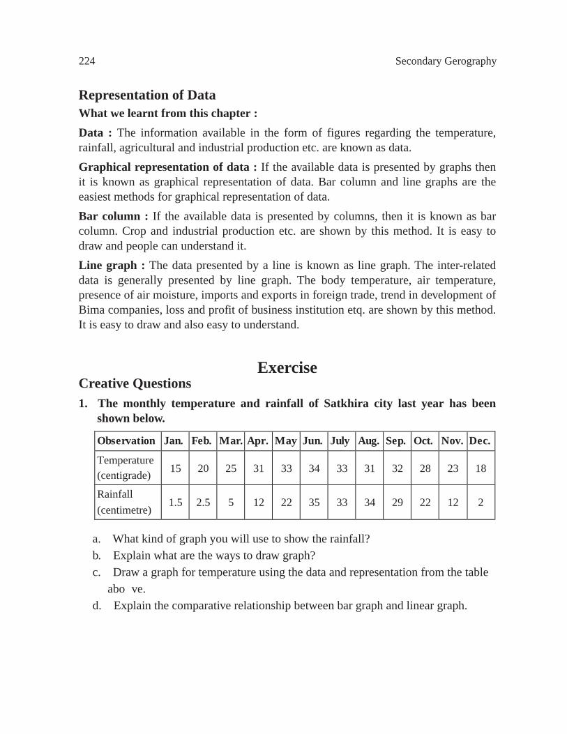
224 Secondary Gerography
Representation of DataWhat we learnt from this chapter : Data : The information available in the form of figures regarding the temperature, rainfall, agricultural and industrial production etc. are known as data.Graphical representation of data : If the available data is presented by graphs then it is known as graphical representation of data. Bar column and line graphs are the easiest methods for graphical representation of data.Bar column : If the available data is presented by columns, then it is known as bar column. Crop and industrial production etc. are shown by this method. It is easy to draw and people can understand it.Line graph : The data presented by a line is known as line graph. The inter-related data is generally presented by line graph. The body temperature, air temperature, presence of air moisture, imports and exports in foreign trade, trend in development of Bima companies, loss and profit of business institution etq. are shown by this method. It is easy to draw and also easy to understand.
ExerciseCreative Questions1. The monthly temperature and rainfall of Satkhira city last year has been
shown below.
a. What kind of graph you will use to show the rainfall?b. Explain what are the ways to draw graph?c. Draw a graph for temperature using the data and representation from the table above.d. Explain the comparative relationship between bar graph and linear graph.
Observation Jan. Feb. Mar. Apr. May Jun. July Aug. Sep. Oct. Nov. Dec.
Temperature (centigrade) 15 20 25 31 33 34 33 31 32 28 23 18
Rainfall (centimetre)
1.5 2.5 5 12 22 35 33 34 29 22 12 2