search methodologies for efficient planetary site selection
TRANSCRIPT

Search Methodologies for Efficient Planetary Site Selection
L.F. Simoes T.C. Pais R.A. Ribeiro G. Jonniaux S. Reynaud
Abstract— Landing on distant planets is always a challengingtask due to the distance and hostile environments found. Inthe design of autonomous hazard avoidance systems we findthe particularly relevant task of landing site selection, that hasto operate in real-time as the lander approaches the planet’ssurface. Seeking to improve the computational complexity ofprevious approaches to this problem, we propose the use ofnon-exhaustive search methodologies. A comparative study ofseveral algorithms, such as Tabu Search and Particle SwarmOptimization, was performed. The results are very promising,with Particle Swarm Optimization showing the capacity toconsistently produce solutions of very high quality, on distinctlanding scenarios.
I. INTRODUCTION
Landing on distant planets is always a challenging task
due to the distance and hostile environments found. It usually
takes the form of semi-hard or soft landings. In the first, the
lander has airbags inflated around it shortly before its release
from a parachute, and then bounces onto the ground until it
comes to rest. The second consists in achieving quasi null
velocity at landing by propulsive braking. For both cases the
landing zone has to be safe - gentle slopes, small boulders,
no cliffs or ridges - in order not to tear the airbags or have the
lander tip over at landing. This requires a detailed knowledge
of the planet’s surface features beforehand, and either the
selection of a safe area large enough to cope with the landing
trajectory dispersions, or a pin-point landing capability [1].
However, scientifically interesting zones often consist
precisely of inherently hazardous craterized and erosion-
modelled landscapes and detailed maps of the planet’s sur-
face, that might be available for Mars and the Moon, will
not be for less visited bodies. Moreover, even if maps were
available and pin-point landing a reality, there is no guarantee
that the ground characteristics would not change between the
time of the picture and the actual landing. Wind, geological
activity or meteorites could modify the surface. Since in ad-
dition real time monitoring of the descent is excluded due to
communication delays and high entry dynamics, autonomous
hazard avoidance capability is essential for mission success
in those areas (see. Figure 1).
Of particular relevance to an autonomous hazard avoidance
system is the ability to select landing sites in real-time as the
lander approaches the planet’s surface, and to dynamically
adjust that choice as better information becomes available
along the descent. In previous work, we have shown good
results using a Multi-Attribute Decision Making model [2],
[3] for this problem [4], [5], [1]. In this paper we present an
L.F. Simoes, T.C. Pais and R.A. Ribeiro are with CA3-UNINOVA,Portugal (email: {lfs,tpp,rar}@uninova.pt). G. Jonniaux and S.Reynaud are with Astrium Space Transportation, France (email:{gregory.jonniaux,stephane.reynaud}@astrium.eads.net).
Fig. 1. Landing with hazard avoidance (courtesy of NASA)
alternative approach, with significantly lower computational
complexity, based on non-exhaustive search methodologies
[6] for selecting the best landing site. We perform a com-
parative study of several non-exhaustive search algorithms,
from Hill Climbing to Tabu Search and Particle Swarm
Optimization, using a Random Walk as a baseline.
This paper is organized as follows. In the next section we
give a brief description of the Hazard Avoidance Problem,
and the landing site selection component, which is the subject
of this paper. In the third section we describe the motivation
for our approach, and the algorithms considered. Section
IV describes the criteria and procedures being used for
evaluating landing sites. We conclude with an experimental
analysis of the approach. Conclusions are drawn from the
present work, and directions for further study presented.
II. THE HAZARD AVOIDANCE PROBLEM
Hazard avoidance includes three separate critical functions
[1]:
• Hazard mapping that estimates ground features based
on imaging sensor data (camera or Lidar), and creates
hazard maps;
• Site selection that chooses a suitable landing site based
on available hazard maps, mission, propulsion and guid-
ance constraints;
• A robust guidance to reach the selected target.
Improving the landing site selection process implies
greater onboard autonomy, due to communication time de-
lays and data volume involved. ASTRIUM Space Transporta-
tion has been consistently improving the hazard avoidance
techniques for on-board piloting autonomy [7], [1] (denoted
piloting function).
1981978-1-4244-2959-2/09/$25.00 c© 2009 IEEE

Fig. 2. Representation of the Shadow criterion for all sites, in the 8thiteration of the CRATERS dataset
A. Landing site selection
In this work we focus our attention to the site selection
problem. The goal is to provide an adequate target-landing
site, evaluated with respect to a set of requirements:
• The site should be safe in terms of maximum local
slope, light level and terrain roughness;
• The site should be reachable with the available fuel;
• The site should be visible from the camera along the
descent phase.
In the final phase of descent, starting at around 2.7 km
above the surface, the lander is continuously mapping and
evaluating the terrain below it according to a set of criteria
(e.g. Figure 2 depicts the shadow criterion). It then feeds
that information to the site selection component, which
will in turn provide the navigation system with the landing
coordinates. At all times there is a degree of uncertainty
with the evaluations of each site, that decreases as the lander
approaches the surface.
III. SEARCH METHODOLOGIES
A. Motivation
In previous work, using the Multi-Attribute Decision ap-
proach [4], [1], pixels on the maps were seen as alternative
landing sites, and evaluated exhaustively. Though a feasible
solution on a regular PC, the time available on the on-
board processor is already exceeded with just the preliminary
data preparation task. We have a relatively small number of
alternatives (around 260000), nevertheless the amount of time
needed to evaluate them is still too high.
The solution we propose here is the application of non-
exhaustive search methodologies that try to locate the best
site using an intelligent navigation through a minimal sample
of the set of alternatives. We trade off absolute certainty
in finding the best site, for a very significant reduction in
computational time, and are interested in learning how that
affects the quality of the system’s choices.
As we will see below, the quality function, after normal-
izing and aggregating the criteria, generates a very regular
search space (see Figures 3 and 4), with a gradient pointing
in the direction of better sites. That structure is currently
not being exploited to guide the search. Another feature that
makes this a viable approach is the existence of functions
for converting between site’s terrain (3D) and image (2D)
coordinates. This allows us to map easily between pixels in
different maps. Given there is a significant similarity between
the search spaces encountered by the lander in successive
iterations along the descent, we can use those functions to
start immediately the search in a very good region on the
map.
The proposed approach can also contribute in different
ways to the performance of a hazard avoidance system.
A procedure that starts the search at already fairly good
sites, and gradually improves its choice is able to produce
an answer at any time, with an error rate that decreases
the longer the procedure is allowed to execute. Should the
guidance system, at some point in the descent, require an
answer before the end of the time allocated to the site
selection process, it is able to give an adequate one. This is
an advantage over procedures that have to execute a greater
number of steps before any solution can be returned. An
additional gain in performance can also be obtained through
a tighter integration of the hazard avoidance and site selection
systems: some hazard maps such as the reachability and
fuel costs need not be generated for all sites anymore, but
can instead be evaluated as sites are visited by the search
algorithm.
B. Algorithms
All algorithms implemented, with the exception of Par-
ticle Swarm Optimization, are based on the same type of
neighborhood structure, i.e, they are based on the same type
of movement (movement being defined as the process of
switching from one solution to another). In this work we use
a simple movement that consists of going to any position on
the search space that is at a distance of one unit from the
current position. On the maps being used, these are the sites
at a Chebychev distance of 1 from the current site.
1) Random Walk: This algorithm randomly chooses a
neighbor to the current solution, and indiscriminately moves
to it [6]. This algorithm was implemented as a baseline in
performance for the problem at hand.
2) Hill Climbing: The classic local search algorithm [6]. It
also randomly selects a candidate solution from the current
neighborhood at each step, but unlike Random Walk, the
candidate is only accepted as the new solution if it is better
than the current one.
3) Steepest Ascent: A variant of Hill Climbing, Steepest
Ascent [6] differs in the fact that the whole neighborhood
is evaluated, and the algorithm deterministically moves to
best solution in it if its quality exceeds that of the current
solution.
1982 2009 IEEE Congress on Evolutionary Computation (CEC 2009)
4) Great Deluge: This algorithm was initially proposed
[8] as an alternative to Simulated Annealing. The rational
for this method is the following: it begins with an initial
“water level” equivalent to the initial solution quality and a
pre-selected rate to increase it. At each step, the algorithm
randomly chooses a neighbor to the current solution, and
moves there, but only if its quality is above the rising water
level. The algorithm implemented in this work is based on
[9].
5) Tabu Search: Tabu search (TS) [10], [11] is a meta-
heuristic that has successfully been applied to find good
feasible solutions for hard optimization problems. In gen-
eral it can be described as a neighborhood search method
incorporating techniques for escaping local optima and avoid
cycling. A basic TS comprises the following concepts:
• Initial Solution - can be obtain randomly or using a
more sophisticated method;
• Movement - defines how the search goes from one
solution to another and also defines the neighborhood
structure;
• Tabu List - contains movements that are considered
tabu;
• Aspiration Criteria - may revoke tabu status.
A simple run’s step may be described as follows. Exhaus-
tively evaluate all neighboring points of current solution and
select the best one, amongst those that are not considered
tabu. Search proceeds from there and the tabu list is updated.
The tabu list will contain all solution that are considered
tabu. Solutions stay there for a period equal to the tabu tenure
value, one the system’s parameters.
We implemented an aspiration criterion by default, that is
applied when in one iteration all neighboring solutions are
considered tabu. Instead of terminating the search, the tabu
status of the “less” tabu solution is revoked, i.e., the one that
has been tabu for a longer period leaves the tabu list.
6) Particle Swarm Optimization (PSO): In the Particle
Swarm Optimization [12], [13] algorithm we have, as the
name indicates, a swarm of n particles collectively exploring
the search space. Each particle i ∈ {1, . . . , n} is defined
by �xi, its current position on the search space, �pi, the best
position visited by the particle so far, and �vi, its velocity.
At each step, the particle updates its velocity vector, and
afterwards updates its position in the search space with
�xi ← �xi + �vi.
The core of the PSO algorithm lies in the equation used to
update particles’ velocity. Though several alternatives exist,
the canonical algorithm uses the equation with “constriction
coefficients”:
�vi ← χ(�vi+ �U(0, φ1)⊗(�pi−�xi)+ �U(0, φ2)⊗(�pg−�xi)) (1)
where �U(0, φi) represents a vector of random numbers
uniformly distributed in [0, φi] which is randomly generated
at each step and for each particle, and ⊗ is the component-
wise multiplication. �pg refers to the best position visited so
far by the particle’s neighbors. The constriction factor χ is
usually set to 0.7298, along with both φ1 and φ2, also called
the acceleration coefficients, set to 2.05 [14].
An important concept in PSO is the population topology.
Particles are arranged in a graph, and only interact with their
immediate neighbors. Classical topologies that have been
used with PSO are the gbest (“global best”) and lbest (“local
best”) topologies. gbest is basically a fully connected graph,
where all particles influence each other. In gbest, information
on best positions found by each particle is immediately
available, and convergence is faster. In lbest, using a radius of
k, particles are arranged in a ring, and particle i is connected
to each particle in {(i + j) mod n : j = ±1,±2, . . . ,±k}.
Though slower to converge, lbest is less vulnerable than gbestto getting stuck in local optima [12].
IV. QUALITY FUNCTION
All criteria, corresponding to the hazard maps, are given
in a matrix structure of 512 by 512 candidate landing sites.
The slope map provides the minimum angle to be expected at
each pixel, in degrees. The texture map provides the variance
value for each pixel. The shadow map or camera image
provides the values of light in a grey scale (0-255). The fuel
map provides the fuel values, in kg, that are necessary to
reach the spot corresponding to each pixel. The reachability
map provides values between 0 and 1, meaning that for 0
value the site is not reachable and all other values until 1
mean reachable with a certain degree. The distance map
provides the Euclidean distance between the current target
and each site on the image.
Observing the different hazard maps provided, we can see
that we have both qualitative and quantitative variables and
we need to convert and normalize the data so we can compare
them. In our case, we have one more particularity: the data
has some degree of uncertainty. To deal with the two prob-
lems just mentioned we “normalize” the data by using fuzzy
sets [2], [15]. The rational for this approach is the following.
We define a fuzzy set that represents the linguistic concept
[16] that is considered best to represent the ideal alternative.
For instance, the ideal site is the one that has “high remaining
fuel”, “low slope”, “low texture”, “sufficient light”, “high
reachability” and “low distance”. This approach guarantees
normalized and comparable data definitions, besides allowing
us to represent data with linguistic concepts. To normalize
the slope and shadow criteria we use trapezoidal membership
functions. For the fuel, texture and distance criteria we
use gaussian membership functions. The reachability criteria
already has values between 0 and 1, hence we considered
that this map does not need normalization.
With our attributes already normalized we can apply the
aggregation operator to evaluate each site. The function
implemented is based on the generalized mixture operator. In
this particular case we use a weighted sum, where the weights
depend on criteria satisfaction levels, instead of having the
typical constant weights. The generalized mixture operator
2009 IEEE Congress on Evolutionary Computation (CEC 2009) 1983
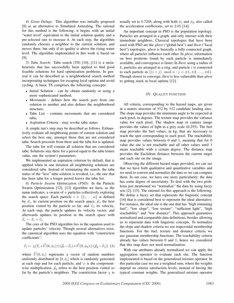
Fig. 3. Sites’ quality, in the 8th iteration of the CRATERS dataset
used is defined below [17], [18]:
W (x) =n∑
i=1
wi(x)xi (2)
where wi(x) =fi(xi)∑ni=1 fi(xi)
, i = 1, ..., n, and x is the vector
with information about the criteria values.
We compute the weights wi, that express the relative
importance of each criterion, using the following linear
weighting functions:
fi(xi) = αi1 + βixi
1 + βi, i = 1, ..., n (3)
where αi, βi ∈ [0, 1] [17].
As mentioned before the quality function was already
studied and detailed on previous works [4], [1] related to
hazard avoidance problems. See Figure 3 for a complete
representation of the search space generated by this quality
function. Observing the image surface we can see a strong
gradient, which is very positive when using search method
that are gradient-based; however some local optima can be
found.
V. EXPERIMENTAL ANALYSIS
A. Experimental Design and Setup
Our goal with the present study is to understand how
the different search methodologies perform on the site se-
lection problem, when using the quality function previously
described. For that purpose, we evaluate their performance
in simulated landings, where the algorithms have to provide
the lander at each iteration during the descent with the
coordinates of the best site, given the current observations.
The simulated landings used hazard maps provided by
EADS Astrium, depicting two distinct planetary surfaces.
The CRATERS dataset, shown in Figure 2, represents a
highly craterized surface, where good landing sites are in-
terspersed by many hazardous features, like high slope or
Fig. 4. Sites’ ranks, in the 8th iteration of the CRATERS dataset
texture. The DUNES dataset represents a smooth planetary
surface, punctuated by a high number of dunes, that make
sets of contiguous sites invalid choices.
Given that some of the criteria’s evaluations are dependent
on the lander’s history up to that point, measures had to be
taken to ensure that the search spaces encountered by each
algorithm along the descent were the same. Therefore, we
defined as current target at the beginning of each iteration
the best site from the previous iteration, even if the search
algorithm could not find it then (this information being
provided by the “oracle” described in the next section). In
the first iteration, the coordinates of the site in the middle of
the image are used instead. Being a population-based search
procedure, PSO implements this specification in a particular
way. One particle in the swarm is placed in the lander’s
current target, but all others are randomly initialized in the
search space, as usual. Furthermore, we also set the lander to
always perform a retargeting after each iteration towards the
best site on the current map, thus assuring that the descent
trajectory is always the same. Under these conditions, we
guarantee that the experimental conditions remain the same
for all search algorithms, in all iterations of the used datasets.
Several measures were also taken to reduce the number
of variables involved (simplifying the analysis), while trying
to keep conditions as close as possible to the ones produced
by our full system. For instance, in this paper we are only
considering the search algorithms’ ability to select the best
site, and not yet producing and dealing with lists containing
the k top sites from previous iterations, as done in [4].
The stopping criterion for all algorithms was defined as
the evaluation of 2621 sites’ quality, which correspond to
1% of the total number of sites on the image. When using
our exhaustive approach [1], a filtering step performed at the
beginning is able to remove around 40% of the sites from
further consideration. The computational cost of evaluating
the remaining sites is however still too high. By setting
this parameter to 1%, we aim for a significantly lower
1984 2009 IEEE Congress on Evolutionary Computation (CEC 2009)

computational cost, that places this approach at a clear
disadvantage. That way we’ll be better able to determine
the algorithm and parameter tuning that best compares with
the exhaustive approach. The final system will likely perform
a higher number of evaluations, though that will depend on
hardware constraints that aren’t completely defined at this
point.
All experiments with the PSO algorithm used the values
for the constriction factor and acceleration coefficients pa-
rameters presented in Section III-B.6. Several combinations
of values were tested in other parameters (e.g. swarm size
∈ {9, 16, 25} and neighbourhood topology ∈ {gbest, lbest−1, lbest − 2}). In the experiment using the Tabu Search
algorithm, the tabu tenure value was set to 250. These are
values which are frequently used in the literature.
B. Results
The algorithms’ performance is evaluated in terms of ranks
(see Figure 4). Prior to the experiments, an “oracle” with
complete knowledge of the search spaces was generated
for each dataset. For each iteration along the descent, an
exhaustive evaluation of all sites was performed. Then,
quality values were sorted, and ranks assigned to each site
based on its quality value’s position in the sorted list. The
best site is assigned a rank of 0, and the worst site a rank of
5122 − 1 (unless several sites share that same quality value,
in which case they all get assigned the rank of the first site
among them to occur on the sorted list). A site’s rank canbe interpreted as the number of sites on the map better thanitself. This gives us a basis for comparing performance that
is independent of the dataset and the iteration. Note that the
search algorithms only see the values returned by the quality
function. The ranks are only used for a posteriori analysis
of the results.
In each iteration of the descent the search algorithm will
run for 2621 steps, each step corresponding to the evaluation
of one site. We track the algorithm’s progress by measuring
at each step the rank of the best site it has found so far. At
the end of the descent, we average the values collected in
each iteration, and it is this time series that constitutes the
basic unit for evaluating the algorithms’ performance.
In Figure 5 we can see the performance of the several
tested algorithms, as they converge to the best site with each
additional evaluation. The presented time series, correspond-
ing to the non-deterministic algorithms (which all are, with
the exception of Steepest Ascent and Tabu Search), are the
average of 100 simulated landings.
In Table I we see the average and standard deviations of
the ranks of the best site found by each search algorithm
within the limit of 2621 site quality evaluations.
C. Analysis
In this section we analyze the results depicted in Table I
and Figure 5.
Random Walk, originally implemented to provide a lower
bound on performance, obtained very good solutions. That is
due to the careful selection of the site at which search starts,
TABLE I
AVERAGE RANKS OF THE BEST SITES FOUND BY EACH ALGORITHM (0 IS
OPTIMAL).
DatasetsAlgorithms CRATERS DUNES
Avg StDev Avg StDev
Random Walk 6.6942 5.4277 67.2381 44.9271Hill Climbing 57.0174 39.9457 1031.4153 318.2995Steepest Ascent 114.3226 – 1310.5938 –
Great Deluge 9.6742 7.7990 32.8322 19.4072Tabu Search 0.2258 – 12.2500 –
Particle SwarmOptimizationparticles topology
9 gbest 0.8448 0.3668 0.7416 0.7428
9 lbest-2 0.5758 0.2909 0.6362 1.487016 gbest 0.3826 0.2356 0.3153 0.270816 lbest-2 0.2494 0.1603 0.1437 0.101025 gbest 0.2606 0.1527 0.1800 0.143625 lbest-1 0.1665 0.0929 0.0953 0.0938
25 lbest-2 0.1584 0.0919 0.0859 0.0903
described in Section V-A. Being that site in the previous
iteration’s best region, we are already able to guarantee a
minimum acceptable level of performance. A Random Walk,
starting in the middle of a good region, more often than not
ends up stumbling on good sites in its neighborhood as it
moves. Being blind to sites’ quality, it succeeds where the
next algorithms fail.
Hill Climbing, and its variant Steepest Ascent, surprise
by their poor performance. This is especially evident on the
DUNES dataset, that despite corresponding to a smoother
planetary surface, presents many obstacles (the dunes) to
these local search algorithms. This is due to the structure of
the search space, that despite the apparent smooth gradient
that can be observed in Figures 3 and 4, contains enough
irregularities, or local optima, for blocking the progression
of the algorithms.
The Great Deluge algorithm showed a moderate perfor-
mance level, though its capacity to escape local optima
proved still insufficient.
Tabu Search was an early winner in our experiments. Its
tabu list proved to be the needed mechanism for moving
around in these search spaces, unhindered by the irregu-
larities in them that hampered the other algorithms’ perfor-
mance. Tabu Search is however also benefiting from the same
careful positioning of the starting location that gives Random
Walk its good performance. On a more general level, all
the previous approaches are still incomplete solutions, for
they lack a needed global exploration capability. Different
regions may, in time, become superior choices, but because
of their starting locations, the local search algorithms are very
limited in their capability to detect those changes. We could
add random-restart strategies to these algorithms, by which
they would be randomly reinitialized when they got stuck
in the search. Those different “epochs” would however be
independent of each other, and would not benefit from the
2009 IEEE Congress on Evolutionary Computation (CEC 2009) 1985

(a) Algorithms’ performance in the CRATERS dataset (b) Algorithms’ performance in the DUNES dataset
Fig. 5. Experimental results
knowledge the algorithm had previously acquired. Instead,
our focus shifted to PSO, which implements a more elegant
solution to this problem.
Particle Swarm Optimization showed very good levels of
performance. In the majority of iterations, it was able to find
the absolute best site, and when it did not, the alternative
provided had a rank very close to 0. It always outperformed
Tabu Search in the DUNES dataset. In the CRATERS dataset,
it can also outperform Tabu Search, conditional to the correct
parametrization. It is interesting to note that while all other
algorithms performed considerably worse in DUNES than
in CRATERS, PSO actually improved its performance. This
indicates PSO might be a good general solution for this
problem.
As expected, PSO configurations with the gbest topology
converge faster than those with the lbest-k topology, but
fail to reach the same quality level. It was expected during
implementation that better results would come out of the PSO
configurations with swarm size 9. A smaller swarm size, with
the same limit in the number of quality evaluations means
particles are updated a greater number of times. Experiments
showed the opposite. The greater the swarm size, the better
the quality tended to be, even though convergence was
slower. The PSO algorithm benefited from having additional
particles sampling the search space (and informing their
neighbors), even though collectively particles were updated
a smaller number of times.
VI. CONCLUSIONS
In this paper we present an alternative method to the
Multiple Attribute Decision approach for selecting the best
site to land a spacecraft. This new approach consists of
using search methodologies to iteratively explore potentially
good sites instead of evaluating all of them. Several search
methodologies were implemented and tested, namely, Hill
Climbing, Steepest Ascent, Great Deluge, Tabu Search and
Particle Swarm Optimization.
Fig. 6. Sites visited by a run of Particle Swarm Optimization, in the 8thiteration of the CRATERS dataset. Compare with Figures 3 and 4
Results show Particle Swarm Optimization to be able to
consistently produce solutions of very high quality, from
the evaluation of a small set of alternatives. Its regularity
in different datasets suggests it may also be the general
approach that was sought.
A. Future Work
Having identified in PSO a very efficient algorithm for this
problem, we plan to extend our studies with analysis of its
performance when using known variations on components
like the neighbourhood topology and the velocity update
equation.
The different iterations along a descent are currently seen
as mostly independent search problems. When switching
between iterations, we could map particles’ current position
as well as memory position vectors to locations in the new
1986 2009 IEEE Congress on Evolutionary Computation (CEC 2009)
map, and re-evaluate them. We would then see the whole
descent as a single search problem, in a dynamic environment
where the quality function changes over time. We would
gain better capability to track moving optima, at the cost
of decreased global exploration capability.
As future work we also plan to test an hybrid approach,
combining Particle Swarm Optimization and Tabu Search. It
is hoped the hybridization will provide PSO’s capacity for
global exploration, along with Tabu Search’s performance on
local exploration.
ACKNOWLEDGMENT
This work was partially financed by EADS-Astrium Space
Transportation under contract ASTRIUM-4572019617, and
by ESA under contract ESTEC 21744/08/NL/CBI.
REFERENCES
[1] Y. Devouassoux, S. Reynaud, G. Jonniaux, R. A. Ribeiro, and T. C.Pais, “Hazard avoidance developments for planetary exploration,” inGNC 2008: 7th International ESA Conference on Guidance, Naviga-tion & Control Systems, 2008.
[2] S.-J. Chen and C.-L. Hwang, Fuzzy Multiple Attribute DecisionMaking, Methods and Applications, ser. Lectures Notes in Economicsand Mathematical Systems. Springer-Verlag, 1992, no. 375.
[3] R. Ribeiro, “Fuzzy multiple attribute decision making: a review andnew preference elicitation techniques,” Fuzzy Sets and Systems, vol. 78,no. 2, pp. 155–181, 1996.
[4] T. C. Pais, R. A. Ribeiro, Y. Devouassoux, and S. Reynaud, “Dy-namic ranking algorithm for landing site selection,” in Proceedingsof the 12th International Conference on Information Processing andManagement of Uncertainty in Knowledge-Base Systems (IPMU),L. Magdalena, M. Ojeda-Aciego, and J. L. Verdegay, Eds., 2008, pp.608–613.
[5] ——, “Regions rating for selecting spacecraft landing sites,” in Com-putational Intelligence in Decision and Control - Proceedings of the8th International FLINS Conference, ser. World Scientific ProceedingsSeries on Computer Engineering and Information Science, D. Ruan,J. Montero, J. Lu, L. Martınez, P. D’hondt, and E. E. Kerre, Eds.,vol. 1. Singapore: World Scientific, Aug 2008, pp. 1039–1044.
[6] E. Burke and G. Kendall, Search Methodologies - Introductory Tu-torials in Optimization and Decision Support Techniques. Springer,2005.
[7] T. Jean-Marius and S. Strandmoe, “Integrated vision and navigationfor a planetary lander,” in 49 thInternational Astronautical Congress,Melbourne, Australia, Sept-Oct, 1998.
[8] G. Dueck, “New optimization heuristics: The great deluge algortihmand the record-to-travel.” Journal of Computational Physics, vol. 104,pp. 86–92, 1993.
[9] E. Burke, Y. Bykov, J. Newall, and S. Petrovic, “A time-predefined lo-cal search approach to exam timetabling problems,” IIE Transactions,vol. 36, no. 6, pp. 509–528, 2004.
[10] F. Glover, “Future paths for integer programming and links to artificialintelligence,” Computers and Operations Research, vol. 13, no. 5, pp.533–549, 1986.
[11] F. Glover and M. Laguna, Tabu Search. Kluwer Academic Publisher,1997.
[12] R. Poli, J. Kennedy, and T. Blackwell, “Particle swarm optimization,”Swarm Intelligence, vol. 1, no. 1, pp. 33–57, 2007.
[13] J. Kennedy, R. Eberhart, and Y. Shi, Swarm intelligence. Springer,2001.
[14] M. Clerc and J. Kennedy, “The particle swarm-explosion, stability,and convergence in amultidimensional complex space,” EvolutionaryComputation, IEEE Transactions on, vol. 6, no. 1, pp. 58–73, 2002.
[15] R. R. Yager, “Multiple objective decision-making using fuzzy sets,”International Journal on Man-Machine Studies, vol. 9, no. 4, pp. 375–382, 1977.
[16] L. Zadeh, “The concept of a linguistic variable and its application toapproximate reasoning, Part I,” Information Sciences, vol. 8, no. 3, pp.199–249, 1975.
[17] R. Pereira and R. Ribeiro, “Aggregation with generalized mixtureoperators using weighting functions,” Fuzzy Sets and Systems, vol.137, no. 1, pp. 43–58, 2003.
[18] R. Ribeiro and R. Marques Pereira, “Generalized mixture operatorsusing weighting functions: A comparative study with wa and owa,”European Journal of Operational Research, vol. 145, no. 2, pp. 329–342, 2003.
2009 IEEE Congress on Evolutionary Computation (CEC 2009) 1987