seabridge specific plan - huntington beach, california€¦ · the seabridge specific plan ......
TRANSCRIPT

SEABRIDGE SPECIFIC PLAN Beach Boulevard and Adams Avenue
City of Huntington Beach
Adopted By Huntington Beach City Council April 1982 Revised January 2, 1996

SEABRIDGE SPECIFIC PLAN
TABLE OF CONTENTS A. INTENT AND PURPOSE B. SPECIFIC PLAN BOUNDARIES C. ENVIRONMENTAL ASSESSMENT D. APPLICATION PROCEDURE 1. Conditional Use Permit 2. Site Plan Requirements 3. Preliminary Grading Plan Requirements 4. Floor and Elevation Plan Requirements 5. Tentative Tract Map Requirements 6. Statement Requirements E. FLOOD PROTECTION F. CIRCULATION 1. Perimeter Streets 2. Internal Circulation 3. Access to Adjacent Property G. TRAFFIC CONTROL H. TRANSIT FACILITIES I. GEOLOGY/SOILS/SEISMICITY J. HYDROLOGY K. NOISE L. PERIMETER BUFFER N. ESTABLISHMENT OF DISTRICT AREAS O. DEVELOPMENT STANDARDS 1. Uses Permitted 2. Density Standard 3. Building Height 4. Site Coverage 5. Perimeter Setback 6. Building Separation and Setback 7. Building Bulk 8. Common Open Space 9. Main Recreation Area - Minimum Size 10. Private Open Space 11. Minimum Floor Area 12. Private Access Ways 13. Parking
1

14. Landscaping 15. Address Signs 16. Antenna 17. Fire Hydrant System 18. Fire Protection 19. Laundry Areas 20. Lighting 21. Private Storage Space 22. Sewer and Water Systems 23. Signs 24. Street Signs 25. Street Trees 26. Trash Collection Areas 27. Vehicular Storage 28. Common Areas 29. Appearance Standards 30. Landscape Corridor 31. Project Signs P. HOMEOWNER’S OR COMMUNITY ASSOCIATION Q. APPROVAL PERIOD R. DEFINITIONS EXHIBITS Exhibit A - Reference Map - Following Page 3 Exhibit B - Perimeter Landscape Buffer - Following Page 10 Exhibit C- Subarea B-2 Site Plan - Following Page 11 Exhibit D - Subarea A-2 Site Plan - Following Page 21
2
SEABRIDGE SPECIFIC PLAN
November 16, 1981 February 2, 1982 February 10, 1982 February 13, 1982
A. PURPOSE - On June 15, 1981 the City Council of the City of Huntington Beach adopted an amendment to the Land Use Element of the General Plan. This amendment designated the 60+ acres of land located at the southeast corner of Adams Avenue and Beach Boulevard as a Planned Community. The General Plan Document, Land Use Element Amendment 81-1, states that the Planned Community designation is to be implemented through adoption of a Specific Plan. A Specific Plan includes policies and descriptive maps which are more detailed than the General Plan, but do not include the detail found in an application for a specific development proposal. The following policies were adopted by the City Council to provide direction for preparation of a Specific Plan: 1. The area east of the Orange County Flood Control Channel to the existing single family residential tracts be of a low density residential design with an adequate setback to buffer the two projects. 2. The area east and immediately adjacent to the flood control channel be of a medium density residential design. 3. All units east of the flood control channel be clustered to allow for a maximum amount of open space. Total units not to exceed four hundred twenty-two (422) east of the channel. 4. The area west of the flood control channel be of a high density residential design. This concept should take advantage of the natural topography for development. Area B-2 west of the flood control channel be of a medium density residential design. 5. Residential units be clustered throughout the project area which also accommodate the continuation of resource production activities. Total units for the overall project not to exceed eight hundred (800). The Seabridge Specific Plan is designed to meet the planning requirements of the Land Use Element of the General Plan. It is intended to serve as a general set of conditions and regulations that will promote the orderly development of the property and provide direction for preparing a plan for development while providing sufficient flexibility to permit design creativity.
3


B. SPECIFIC PLAN BOUNDARIES - The Seabridge Specific Plan encompasses that area as delineated on the map in subsection (a) hereof and described in subsection (b) hereof.
(b) Legal Description - The Seabridge Specific Plan includes the real property described as follows:
Parcels 1 and 2 in the City of Huntington Beach as per map filed in Book 154, Pages 11 and 12 of Parcel Maps, in the office of the County Recorder said County; and Parcel 3 in the City of Huntington Beach, as per map filed in Book 41, Page 24 of Parcel Maps, in the office of the County Recorder of said County.
C. Environmental Assessment. Environmental Impact Report No. 81-3, which analyzed the impacts of the Planned Community designation and specific plan development for 744 residential units, is on file in the Community Development Department. Subsequent development shall be subject to new environmental assessment. D. APPLICATION PROCEDURE - Any request for a development proposal shall be accompanied by an application for a Conditional Use Permit and Tentative Tract Map. Such applications shall include preliminary site plans, grading plans, floor and elevation plans and a
4
statement of statistics. All plans shall be submitted concurrently and shall meet the following requirements. 1. Conditional Use Permit - Any proposed development within the specific plan area shall be subject to Planning Commission approval of a conditional use permit as provided in Chapter 241 of the Huntington Beach Zoning and Subdivision Ordinance. 2. Site Plan - Site plans shall include the following: (a) Location of all proposed structures; (b) Preliminary landscaping proposal showing the location, and type of plant materials; (c) Location of pedestrian walkways; (d) Circulation pattern of vehicular traffic; (e) Structural street sections of all access ways; (f) Type and location of outside lighting; (g) Size and location of maintenance and storage facilities; (h) Type, size and location of trash area; (i) Size and location of private space areas; (j) Use of common open space areas; (k) Type and location of all vehicle parking; (l) Type and location of fences and signs; and (m) Layout showing proposed sewage and water facilities. 3. Preliminary Grading Plan Requirements - Preliminary grading plans shall indicate the following: (a) A full inventory of the natural features of site, including all trees exceeding a diameter of six (6) inches; (b) Preliminary soils report and chemical analysis of existing soils conditions; (c) Cut and fill proposed on the site;
5

(d) Proposed surface drainage of the site; (e) Ground Floor elevations of all proposed structures; (f) Difference in finished grades on the site and those grades on abutting property; (g) Underground services; (h) Statement on quantity of excavated material. 4. Floor And Elevation Plan Requirements: Floor and elevation plans shall indicate the following: (a) Proposed exterior materials to be used on all structures; (b) Colors of all exterior materials; (c) Height of all buildings and/or structures; (d) Energy sources proposed for heating and cooling of all buildings. 5. Tentative Tract Map Requirements - Tentative tract maps shall indicate the following: (a) Sufficient description to define the location and boundaries of the proposed subdivision; (b) Existing natural topography with contours at intervals of of two (2) feet up to 5% grade, five feet up to 10% grade, and ten (10) feet over 10% grade; (c) Locations, names, widths, and approximate grades of all streets within or adjacent to the proposed subdivision; (d) Approximate layout and number of each lot proposed and all dimensions of each said lot; (e) Outlines of all existing buildings on subject site; (f) Areas of property subject to inundation or storm water overflow and location, width, and direction of flow of all watercourses;
6

(g) Location, width, and purpose of all existing and/or proposed easements on or contiguous to the sub- division; (h) Typical street section; and (i) All existing or abandoned oil field wells and appurtenances and the proposed treatment of such facilities. 6. Statement Required - A detailed statement shall also be included containing the following information: (a) Distance from the property to any known geological hazard; (b) Gross area within the blue line border (area boundary) of the tentative map; (c) Net lot area (i.e., gross area minus all public and private streets and/or driveways); (d) Number and type of units and number of bedrooms; (e) Total number of units and number of units and bedrooms per gross acre; (f) Floor area of each unit; (g) Area and minimum dimensions of private patios (open space) and balconies; (h) Percentage of site coverage by all buildings; (i) Number and type of covered parking spaces; (j) Number of open parking spaces; (k) Amount of usable common open and recreational space provided, using regulations set forth in this article; (l) Types of recreation facilities proposed; and (m) Schedule and sequence of development if proposed in phases. E. FLOOD PROTECTION - All development within the specific plan area shall conform to all Federal Emergency Management Agency’s (FEMA) flood protection requirements subject to approval of the Community Development Director.
7

F. CIRCULATION - Standards for streets and drives shall be as follows: 1. Perimeter Streets - The Street right-of-way for Adams Avenue and Beach Boulevard shall be dedicated as public streets and fully improved to city standards. 2. Internal Circulation - Circulation within the Specific Plan Area shall be such that a collector street (s) connecting Adams Avenue with Beach Boulevard shall be provided. The point of intersection of the main collector street(s) with Beach Boulevard and Adams Avenue shall conform to the alignment shown on Exhibit “A.” All internal streets and drives shall be privately owned and maintained. The standards for such streets and drives, including width and construction, shall meet the requirement, of the Director of Public Works and conform to the requirements of this Specific Plan. 3. Access to Adjacent Property - Private streets and/or drives within this Specific Plan Area shall not be permitted to connect with the local streets within the adjacent single family areas to the east and south. G. TRAFFIC CONTROL - The Planning Commission, upon recommendation of the Department of Public Works, shall determine the need for traffic control devices (i.e., traffic signals). Such determination shall include the appropriate time of installation. The developer shall pay the entire cost of installing traffic signals on Adams Avenue and Beach Boulevard at the entrances to the development. The developer shall provide for the future installation of any such improvements prior to issuance of building permits. H. TRANSIT FACILITIES - Bus turnouts and bus shelters shall be provided at locations designated by the Department of Public Works and Orange County Transit District. The design of such shelters and turnouts shall be approved by the Department of Public Works and Orange County Transit District. I. GEOLOGY/SOILS/SEISMICITY - The following geology, soils and seismicity measures shall be employed prior to the issuance of building permits: 1. Submittal of a structural engineering study evaluating proposed foundation designs with respect to ground shaking and liquefaction hazards on the property. The study shall be subject to the review and approval of the Departments of Public Works and Community Development. Foundations and structural components of the buildings shall be designed according to recommendations contained within the structural engineering study. 2. Submittal of a soils study detailing grading and site preparation recommendations. This study shall be subject to the approval of the Departments of Public Works and Community Development. Grading and site preparation shall be accomplished in accordance with recommendations presented in the soils study.
8
J. HYDROLOGY - A water management system with respect to maintenance of water quality for both the amenity lakes and the freshwater pond shall be developed by the applicant and approved by the Departments of Public Works and Community Development. K. NOISE - Prior to the issuance of building permits, a noise study conducted by an acoustical engineer to determine existing ambient noise levels on Adams Avenue and Beach Boulevard shall be submitted to the Community Development Department for review and approval. Structural designs for proposed residential units shall be reviewed and design modifications recommended in the noise study shall be incorporated into the project design. L. PERIMETER BUFFER - A landscaped buffer shall be provided along the east and south property lines and at other appropriate locations within Subarea A-1. Such buffer shall be designated to visually buffer this project from the adjacent single-family areas with intensified landscaping in the manner shown on Exhibit “B.” A preliminary landscaping plan implementing this requirement shall be submitted along with the application for a Conditional Use Permit(s) and/or Tentative Tract Map(s). The final landscape plan shall be approved by the Department of Community Development. To further guarantee a proper buffering of this project from the adjacent single-family areas, the following requirements shall be complied with; 1. Only duplex units shall be permitted within Subarea A-1; and, 2. The finish grade within five (5) feet of the common property line shall not be higher than one (1) foot above the grade of the adjacent single-family area.
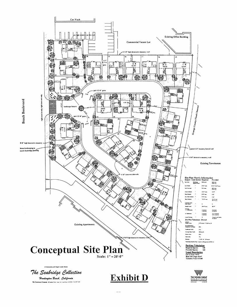
N. ESTABLISHMENT OF DISTRICT AREAS - The configuration of the property
for which this Specific Plan is prepared is such that there are two (2) distinct areas. These areas are delineated on the Specific Plan Map shown on Exhibit “A.” A description of development standards for these areas are included in the sections that follow. O. DEVELOPMENT STANDARDS - Proposed development within the Seabridge Specific Plan shall comply with the following standards: 1. Uses Permitted - The following uses are permitted within the specific plan area: (a) Area A Attached or detached residential units and related recreational facilities; (b) Area B Attached or detached residential units and related recreational facilities. The area designated as Subarea B-1 within Area B may be developed with office and /or commercial uses subject to the requirements and standards set forth in the CG District.
2. Density Standards -
9

(a) Area A - The total number of dwelling units within Area A shall not exceed four hundred twenty-two (422). Such units shall be clustered to allow for a maximum amount of open space. The maximum number of bedrooms per gross acre of land shall not exceed twenty-five (25). (b) Area B - The total number of dwelling units within Area B shall not exceed three hundred seventy six (376). The maximum number of bedrooms per gross acre shall not exceed (50). 3. Building Height - The maximum building height shall be as follows: Area A - Thirty-five (35) feet except within Subarea A1 where the maximum building height shall not exceed twenty-five (25) feet. (See Exhibit “A”) Area B - Five (5) stories or sixty (60 ) feet, except within Subarea B-2, where maximum height shall be two stories and thirty (30) feet. 4. Site Coverage - The maximum building site coverage shall be as follows: Area A - Forty-five percent (45%) of net acreage. Area B - Fifty percent (50%) of net acreage 5. Perimeter Setback - The minimum setback for all structures over six (6) feet in height which are located along the perimeter of the project shall conform to the building setback set forth in Exhibit “A”. This requirement shall not apply to entry monuments, landscape features, block walls and structures intended for safety or public use. 6. Building Separation and Setback - Area A - The minimum building separation or distance between buildings and access ways for Area A shall be as follows: (a) Between buildings, front to front, twenty-five (25) feet. (b) Between buildings, rear to rear or rear to front, twenty (20) feet. (c) Between buildings, side to front or side to rear, fifteen (15) feet.
10

11

(d) Between buildings, side to side, twenty (20) feet, except within Subarea A-1 where the minimum separation between duplex units shall be fifteen (15) feet, with an average separation of twenty (20) feet. (e) In order to provide for obliquely aligned buildings, the distance specified above may be decreased at one corner of a building if the separation at the other corner is increased by an equal or greater distance. In no case shall the separation be less than ten (10) feet. (f) Distance between detached accessory buildings shall not be less than ten (10) feet. (g) Where open parking is provided on the same level as that portion of the dwelling used for human habitation, the minimum separation shall be ten (10) feet on a horizontal plane. (h) Distance between vehicular access ways and habitable portion of the ground floor area of a dwelling shall not be less than fifteen (15) feet. (i) Distance between travel lanes on vehicular access ways and garages or parking structures shall not be less than five (5) feet. Area B - The minimum separation between buildings front to front shall be one hundred (100) feet. The minimum separation between buildings front to side or side to side shall be thirty-five (35) feet. The minimum separation between obliquely aligned buildings shall be fifty (50) feet with an average separation of seventy-five (75) feet. Subarea B-2 - The minimum building separation between buildings and access way shall be as follows: (a) Front Yard Setback 1. Dwellings - The minimum setback measured from the front property line for all dwelling units shall be fifteen (15) feet. Architectural columns and porches shall be set back a minimum of ten (10) feet. 2. Front Entry Garages - Eighteen (18) feet where sidewalk is provided and twenty (20) feet where sidewalk is not provided. (b) Side Yard Setback - The minimum setback measured from side property lines shall be as follows: 1. Interior Side Setback - Ten percent of lot width but not less than three (3) feet and need not exceed four (4) feet.
11

12

2. Street Side Yard - Minimum six (6) feet, except walls not less than five (5) feet. (c) Rear Yard Setback - The minimum setback measured from the rear property line shall be ten (10) feet. Unenclosed patios shall have a minimum five (5) feet setback. 7. Building Bulk - Area A - The following design standards are recommended for controlling building bulk within Area A. (a) Building length shall not exceed 180 feet. (b) Building exterior shall be provided with offsets in the building line to provide variation. (c) Building rooflines shall be designed to provide variation. (d) Within Subarea A-1, only duplex units shall be permitted. Area B - The following design standards are recommended for controlling building bulk within Area B. (a) Building exteriors shall be provided with offsets in the building line to provide variation. (b) Building rooflines shall be designed to provide variation. 8. Common Open Space - The site plan shall be designed so a maximum number of units abut open space. Open Space areas for recreation and leisure activities shall be provided according to the following standards: OPEN SPACE REQUIREMENT
Area A - 1,000 square feet per unit Area B - The net area set aside for common open space shall be equivalent to forty percent (40%) of the gross habitable area of the residential units, except no common open space shall be required in Subarea B-2.
(a) The common open space areas shall be designed and located for maximum use by all residents of the project. (b) Such areas shall be fully improved. Improvements may include paved surfaces, landscaped areas, water areas, and recreational facilities.
12

(c) Recreation and leisure areas shall not be located within ten (10) feet of any ground floor dwelling unit wall having a door or window. Also, such recreation and leisure areas shall have minimum dimension of twenty (20) feet if they are to be included within the open space calculations. (d) Lot coverage by recreation buildings and other recreation structures shall be included within the open space calculations. (e) At least one (1) main recreational area shall be provided. Satellite recreation areas may be distributed throughout the specific plan area. (f) Open space requirements of this section are not intended to supersede the Park and Recreational requirements of Chapter 254 of the Huntington Beach Zoning and Subdivision Ordinance. All applicable requirements of Chapter 254 of the Huntington Beach Zoning and Subdivision Ordinance shall be complied with. 9. Main Recreation Area - Minimum Size - The minimum size of the main recreational area shall not be less than ten thousand (10,000) square feet. (a) Two or more of the following shall be provided within the main recreational area: swimming pool, spa, sauna, tennis court, basketball court, putting green, playground equipment, volleyball court, lawn bowling, outdoor cooking facility, or similar facilities. (b) Residential units shall not be located closer to the main recreation area than twenty (20) feet. Where such residential units do not have windows or doors located on the same level the setback may be reduced to five (5) feet. (c) A clubhouse shall be provided in the main recreation area. Such clubhouse shall contain facilities to meet the recreational needs of the development. Additional clubhouse(s) and/or facilities may be located in the satellite recreation areas to satisfy this requirement. 10. Private Open Space - Private open space areas, in the form of patios or balconies shall be provided for each unit. Such areas shall be located adjacent to the unit they are intended to serve. The minimum size of such patios or balconies shall meet the following standards:
13

(a) Where patios are provided, the minimum areas shall be as follows: Minimum Area Minimum Unit Type (Sq. Ft.) Dimension (Ft.) Efficiency/or one 120 10 (1) bedroom Two (2) bedrooms 200 10 Three (3) or more 300 10 bedrooms (b) Where balconies are provided the minimum area shall be as follows: Minimum Area Minimum Unit Type (Sq. Ft.) Dimension (Ft.) Efficiency/or one 60 6 (1) bedroom Two (2), three (3) or four (4) bedrooms 120** 6 **This area may be divided into two (2) separate areas; however, neither area shall contain less than sixty (60) square feet.
14
(c) Two story units which are provided with a patio at the lower level are permitted a ten percent (10%) reduction in the patio area requirement if a balcony having a minimum area of sixty (60) sq. ft. is provided. Balconies which serve as entrances or exits shall not satisfy this requirement except where entrances or exits are for the sole use of a particular unit. 11. Minimum Floor Area - Each Dwelling within the development shall have the following minimum floor area: Area A Area B Minimum Floor Minimum Floor Unit Type Area (Sq. Ft.) Area (Sq. Ft.) Efficiency 450 450 One (1) Bedroom 650 600 Two (2) Bedrooms 900 800 Three (3) Bedrooms 1100 1000 Four (4) Bedrooms 1300 1200 12. Private Access Ways - The following standards shall apply to all private vehicular access ways: (a) The main entries to the Seabridge Specific Plan Area shall be provided with a minimum paved width equivalent to not less than two (2) - twelve (12) foot travel lanes in each direction of traffic flow, for a distance of not less than one hundred (100) feet measured from such intersection into the development. (b) Private ways serving as access shall be provided with a minimum paved width equivalent to not less than two (2) twelve (12) foot wide travel lanes. (c) Access ways exceeding one hundred fifty (150) feet in length but less than three-hundred (300) feet in length, shall be provided with a curbed turn-around having a minimum radius of thirty- one (31) feet or a “Hammerhead” turnaround per Fire Dept. Standards; (d) Access ways exceeding three hundred feet (300) feet in length but less than six hundred feet (600) in length shall be provided with a curbed turn-around having a minimum radius of forty (40) feet, a “Hammerhead” turn-around per Fire Department Standards, or an intertying loop circulation system; (e) Access ways exceeding six hundred (600) feet in length shall be provided with an intertying loop circulation system; a turn-around meeting the requirements of the Fire Department may be permitted where a loop system is impractical.
15
(f) Exceptions to the above standards may be granted by the Planning Commission upon the recommendation of the Department of Community Development and the Fire Department. 13. Parking - The required parking for the units within the Specific Plan Area shall be provided at the following ratio: (a) Efficiency and one (1) bedroom units shall be provided with two (2) on-site parking spaces. (b) Dwelling units with two (2) or more bedrooms shall be provided with two and one-half (2 1/2) on-site parking spaces. (c) Developments that are designed and restricted to use by persons fifty (50) years of age and older shall provide parking at the following ratios: (1) Efficiency and one (1) bedroom units- one (1) parking space; and, (2) Two (2) bedroom units - one and one-half (1 1/2) parking spaces. (d) Where parking spaces are provided on a drive approach to a carport or garage that is designed for the exclusive use of the owner of the garage or carport, such parking spaces shall be credited toward satisfying fifty percent (50%) of the open parking requirements. (e) At least one (1) parking space per unit shall be covered. The remaining spaces may be open. (f) All parking spaces required by this section shall be distributed at convenient locations to serve both residents and guests. (g) All residential buildings within Area A shall be designed to incorporate the required covered parking spaces for the residential units in the building. (h) All required covered parking within Area B, shall be located within two hundred (200) feet of the dwelling unit it is designed to serve. (i) Any allocation for compact car parking spaces within Area B shall be determined through the Conditional Use Permit process. (j) The access, dimensions, and turning radii for all parking shall conform to the provisions of Chapter 231 of the Huntington Beach Zoning and Subdivision Ordinance. (k) Guest parking for Subarea B-2 shall be at a minimum ratio of 0.5 spaces per unit and shall be located on the private street.
16

14. Landscaping - The purpose of this is to insure a more pleasant living environment through the use of plants and decorative design elements. (a) All setback areas fronting on or visible from an adjacent public street, and all recreation, leisure and open areas shall be landscaped and permanently maintained in an attractive manner. (b) Permanent irrigation facilities shall be provided in all landscaped areas. (c) One (1) thirty (30) inch box tree, or equivalent, shall be provided onsite for each residential unit. Seventy five percent (75%) of the total requirement shall be thirty (30) inch box trees. The remaining twenty five percent (25%) of such requirement may be provided at a ratio of one (1) inch for (1) inch through the use of twenty (20) or twenty-four (24) inch box trees. Additional trees and shrubs shall also be planted to provide a well balanced landscaped development. (d) A landscape and irrigation plan shall be submitted to the Department of Public Works for approval prior to the issuance of building permits. 15. Address Signs - The placement of address numbers shall be at a uniform location throughout the development, and the placement of such numbers shall be approved by the Fire Department. 16. Antenna. - No exterior television antenna shall be permitted. A common antenna with underground cable service to all dwelling units shall be permitted. 17. Fire Hydrant System - A fire hydrant system shall be installed to provide an adequate fire flow. The adequacy of such system shall be approved by the fire marshal after review of plans and engineering calculations have been submitted. Plans shall be submitted and approved prior to the issuance of building permits, and any fire hydrant system shall be in operation prior to the time of construction with any combustible materials. 18. Fire Protection - All fire protection appliances, appurtenances, emergency access and other applicable requirements pursuant to Chapter 17.56 of the Huntington Beach Municipal Code shall meet the standard plans and specifications on file with the Fire Department. 19. Laundry Areas - Where laundry areas, other than those located within individual dwelling units are provided, such areas shall be located to minimize visual and noise intrusion both within and outside the project. 20. Lighting - The developer shall install an on-site lighting system on all vehicular access ways and along major walkways. A lighting plan shall be submitted for approval to the Director of Community Development. Such lighting shall be directed onto driveways and walkways within the development and away from adjacent properties. Lighting shall also be installed within all covered and enclosed parking areas.
17

21. Private Storage Space - Where the proposed development is to be constructed with other than an attached garage for each dwelling unit, a minimum of one hundred (100) cubic feet of storage space shall be provided for each dwelling unit. 22. Sewer and Water System - Sewer and water systems shall be designed to city standards. Such systems shall be located within streets, alleys or drives. In no case shall individual sewer lines or sewer mains for one building be permitted to extend underneath any other building. 23. Signs - All signs in the development shall conform to applicable provisions of Chapter 233 of the Huntington Beach Zoning and Subdivision Ordinance. 24. Street Signs - The developer shall install on-site street name signs at the intersections of access ways, as approved by the Director of Community Development. Street names and signs shall be approved by the Fire Department. 25. Street Trees - Street trees along Beach Boulevard and Adams Avenue shall be provided pursuant to city standards with twenty (20) inch box trees planted at approximately forty-five (45) foot intervals. A plan showing the type and placement of such trees shall be approved by the Departments of Public Works and Community Development. An equivalent alternative to this basic requirement may be permitted subject to approval of the Department of Community Development. 26. Trash Collection Areas - Trash collection areas shall be provided within two hundred (200) feet of the units they are to serve. Such areas shall be enclosed or screened, and shall be situated in order to minimize noise and visual intrusion on adjacent property as well as to eliminate fire hazard to adjacent structures. Individual trash collection shall be permitted where the intent of this section is met. 27. Vehicular Storage - Outside uncovered and unenclosed areas for storage of boats, trailers, recreational vehicles and other similar vehicles shall be prohibited unless specifically designated areas for the exclusive storage of such vehicles are set aside on the final development plan and provided for in the association’s covenants, conditions, and restrictions. Where such areas are provided, they shall be screened from view on a horizontal plane from adjacent areas by a combination of six (6) foot high masonry wall or permanently maintained landscaping.
28. Common Areas - Common open space shall be guaranteed by a restrictive covenant describing the open space and its maintenance and improvement, running with the land for the benefit of residents of the development. The developer shall file with the Department of Community Development for recordation with the final subdivision map, legal documents which will provide for restricting the use of common spaces for the designated purpose, as approved on the final development plan. All plans to be conveyed to the homeowner’s association shall be subject to the right of the grantee or grantees to enforce maintenance and improvements of the common space.
18

29. Appearance Standards - The following standards shall be considered by the Planning Commission when reviewing a development proposal: (a) Architectural features and general appearance of the proposed development shall enhance the orderly and harmonious development of the area or the community as a whole. (b) Architectural features and complimentary colors shall be incorporated into the design of all vertical exterior surfaces of the buildings in order to create an aesthetically pleasing project. (c) Particular attention shall be given to incorporating the design of signs, including colors of signs, into the overall design of the entire development in order to achieve uniformity. (d) Vehicular access ways shall be designed with landscaping and building variation to eliminate an alley-like appearance.
30. Landscaping Corridor - The Seabridge Specific Plan Area is contiguous to the Beach Boulevard Landscape Corridor requiring that special consideration be given to the appearance of the project adjacent to Beach Boulevard. In view of this, the following minimum standards shall be met: (a) The area between the building line and the property line which is visible from the street shall be landscaped and permanently maintained. (b) The theme of the landscaping plan shall emphasize mature plantings. (c) Street trees equivalent to one twenty (20) inch box tree shall be planted at approximately forty - five (45) foot intervals. The size and placement of such trees may be rearranged pursuant to an approved landscape plan provided the plan has an equivalent size and number of trees. (d) Water features shall be designed to recreate a natural setting. (e) The public right-of-way between the curb and property line shall incorporate landscape features to complement the on-site landscaping. 31. Project Signs - All signs shall comply with of Chapter 233 of the Huntington Beach Zoning and Subdivision Ordinance. P. HOMEOWNER’S OR COMMUNITY ASSOCIATION - Approval of all development proposals shall be subject to submission of a legal instrument or instruments setting forth a plan or manner of permanent care and maintenance of open spaces, recreational area, and community facilities. No such instrument shall be acceptable until approved by the City Attorney as to legal form and effect, and by the Director of Community Development as to
19
suitability for the proposed use of the open space areas. If the common open spaces are to be conveyed to a homeowner’s association, the developer shall file a declaration of covenants to be submitted with the application for approval, that will govern the association. 1. The homeowner’s association shall be established prior to the sale of the last dwelling unit. 2. Membership shall be mandatory for each buyer and any successive buyer. 3. The open space restriction shall be permanent. 4. Provisions to prohibit parking upon other than approved and developed parking spaces shall be written into the covenants, conditions, and restrictions for each project. 5. If the development is constructed in increments or phases which require one or more final maps, reciprocal covenants, conditions and restrictions and reciprocal management and maintenance agreements shall be established which will cause a merging of increments as they are completed, and embody one homeowner’s association with common areas for the total development. Q. APPROVAL PERIOD - Notwithstanding the provisions of Chapter 241 of the Huntington Beach Zoning and Subdivision Ordinance, Conditional Use Permits, each Conditional Use Permit authorized under this Article shall become null and void within two (2) years unless a final tract map has been recorded with the County Recorder’s office on any portion of the approved plans within such two (2) year period and construction has commenced. Extensions of time may be granted pursuant to the provisions for extending approval of the tentative tract map. R. DEFINITIONS - The following definitions shall apply to the Seabridge Specific Plan. Terms not described under this section shall be subject to the definitions contained in Chapter 203 of the Huntington Beach Zoning and Subdivision Ordinance. Grade (Adjacent Ground Elevation) - is the lowest point of elevation of the finished surface of the ground, paving or sidewalk within the area between the building and the property line or, when the property line is more than five (5) feet from the building, between the building and a line five (5) feet from the building. Height of Building - is the vertical distance above a reference datum measured to the highest point of the coping of a flat roof or to the deck line of a mansard roof or the average height of the highest gable of a pitched or hipped roof. The reference datum shall be selected by either of the following, whichever yields a greater height of building: 1. The elevation of the highest adjoining sidewalk or ground surface within a 5-foot horizontal distance of the exterior wall of the building when such sidewalk or ground surface is not more than 10 feet above the lowest grade.
20

2. An elevation 10 feet higher than the lowest grade when the sidewalk or ground surface described in Item 1 above is more than 10 feet above lowest grade. The height of a stepped or terraced building is the maximum height of any segment of the building. Perimeter Setback - shall mean the required setback distance between the specific plan boundary line and any proposed buildings along said boundary lines. Specific Plan - shall mean the Seabridge Specific Plan as adopted by the City Council of the City of Huntington Beach. Specific Plan Map - shall mean the map described in Section B.
21
22