sdss strategy of slovenia spatial development
TRANSCRIPT

S p a t i a l D e v e l o p m e n tS t r a t e g y o f S l o v e n i aSDSS

CIP - Kataložni zapis o publikacijiNarodna in univerzitetna knjižnica, Ljubljana
711(497.4)
The SPATIAL development strategy of Slovenia / [editorsBlanka Bartol ... et al.]. - Ljubljana : Ministry of theEnvironment, Spatial Planning and Energy,Office for Spatial Development, 2004
ISBN 961-6276-36-01. Bartol Blanka216748288
Spatial DeSpatial DeSpatial DeSpatial DeSpatial Devvvvvelopment Strelopment Strelopment Strelopment Strelopment Stratatatatategy of Sloegy of Sloegy of Sloegy of Sloegy of Slovvvvveniaeniaeniaeniaenia
The Spatial Development Strategy of Slovenia is a strategicspatial planning document, adopted by the NationalAssembly of the Republic of Slovenia at its session as of 18June 2004, published in the Official Gazette of the Republicof Slovenia, no 76/2004, and in force since 20 July 2004.
The preparation of the Spatial Development Strategy ofSlovenia was conducted by the Office for SpatialDevelopment, Spatial Planning Directorate of the Ministry ofthe Environment, Spatial Planning and Energy.
Expert Team and Editors:Blanka BartolNataša Bratina – Jurkovič, M.Sc.Aleksandra FaturNatalija Fon – BoštjančičEva KošakAlenka LapanjaFranc Lenarčič, M.Sc.Frančiška Podlesnik, M.Sc.Jelena Torbica
Publisher:Ministry of the Environment, Spatial Planning and Energy,Spatial Planning Directorate,Office for Spatial DevelopmentDunajska cesta 21, 1000 Ljubljana, Sloveniahttp://www.gov.si/upp
Translated by: Mojca Japelj MužičDesign: Futura DDBCartographic design: Iva Božič, Boris Kralj, MOPE,Office for Spatial DevelopmentPrinted by: Tiskarna SIMČIČ,Edition: 500 copiesFirst published: 2004

The adoption of the Spatial Development Strategy of Slovenia (hereinafter: Spatial Strategy) signifies aturning point in spatial planning and management. It is an important and long awaited step in theprocess of spatial planning and management system reform, since it replaces the national-level spatialplanning documents made in the nineteen-eighties – i.e., during the previous socio-economic order andunder the social planning system.
The Spatial Strategy is the basic strategic spatial development document and an integrated planningdocument which implements the concept of sustainable spatial development. Together with the Strategyfor Economic Development of Slovenia, it represents the umbrella document for guiding developmentand forms the basis for the harmonization of sectoral policies. The Strategy preparation processinvolved all ministries and services, whose work is of relevance to the implementation of spatialdevelopment and to the territorial cohesion of the country and its participation in the European spatialdevelopment. The basic premises and policies, which they laid down, are included in spatialdevelopment objectives and policies of the Spatial Strategy. The implementation of these objectives willbe ensured, among others, through the programmes of these ministries and services as well as throughthe programmes of local communities and international cooperation.
Considering the variety and diversity of the Slovenian territory and based on its comparativeadvantages, the Spatial Strategy imposes conditions for balanced economic, social and culturaldevelopment while ensuring the kind of development which will also enable the conservation of theenvironment, nature, heritage, and the quality of living.
JANEZ KOPAČ, M. Sc.Minister of the Environment, Spatial Planning and Energy
Preface

.

5
Content
Introduction 8
1 GENERAL PRESENTATION 82 SUBSTANITIVE MEANING OF TERMS USED 9
I Basic Premises and Objectives of Slovenian Spatial Development 13
1 GENERAL GROUNDS 132 CHARACTERISTIC FEATURES OF SLOVENIAN SPACE 142.1 Geographic Features 142.2 Lanscape and Urban Structure Characteristic 142.3 Negative Impacts of the Current Situation 152.4 Spatial Development Trends 163 SLOVENIAN SPATIAL DEVELOPMENT OBJECTIVES 16
II The Concept of Slovenian Spatial Development with Priorities andGuidelines for Achieving Slovenian Spatial Development Objectives 17
1 INTEGRATION OF SLOVENIA INTO THE EUROPEAN SPACE UNDER EQUALTERMS 18
2 POLYCENTRIC URBAN SYSTEM AND REGIONAL SPATIAL DEVELOPMENT 203 VITAL AND WELL-MANAGED CITIES AND TOWNS 234 HARMONIZED DEVELOPMENT OF WIDER URBAN AREAS 245 INTEGRATED AND HARMONIZED DEVELOPMENT OF TRANSPORT AND
SETTLEMENT NETWORKS AND THE CONSTRUCTION OF PUBLICINFRASTRUCTURE FACILITIES 25
6 VITALITY AND ATTRACTIVENESS OF RURAL AREAS 277 ENHANCING THE RECOGNIZABILITY OF VALUABLE NATURAL AND
CULTURAL LANDSCAPE CHARACTERISTIC 298 SPATIAL DEVELOPMENT IN AREAS WITH SPECIAL
POTENTIALS AND PROBLEMS 29
III Development of Spatial Systems with Guidelines for Developmentat Regional and Local Levels 32
1 DEVELOPMENT OF HUMAN SETTLEMENT 321.1 Development of Cities, Towns and other Settlements 321.1.1 Iside development in settlements 331.1.1.1 Renewal of settlements as a priority 331.1.1.2 Renewal of the cultural heritage and other architectural
heritage in settlements 331.1.1.3 Renewal of degraded urban areas 341.1.1.4 Renewal of old industrial and mining sites/settlements 341.1.2 Settlement expansion 341.1.3 Construction outside the settlement development zones 351.1.4 Rural settlements, villages and hamlets 361.1.5 Tourist areas 361.1.6 Areas of secondary homes 361.2 Rational Use of Land and Structures in Settlements 361.2.1 Residential areas 371.2.2 Central activity areas 371.2.3 Production activity areas 38
6
1.2.4 Public areas in settlement 391.2.4.1 Green areas 391.2.4.2 Transport surfaces within settlements 391.3 Building Land Development 391.4 Architectural Identity of Cities, Towns and other Settlements 391.4.1 Architectural identity conservation guidelines 402 DEVELOPMENT OF PUBLIC INFRASTRUCTURE 432.1 Transport Infrastructure Development 432.1.1 Road network 432.1.2 Railway network 442.1.3 Ports 452.1.4 Airports and heliports 462.1.5 Air traffic management and air traffic control equipment 462.1.6 Public transport and public transport nodes 462.1.7 Transport terminals 472.1.8 Cableway transport 472.1.9 Cycling network 472.1.10 Footpath network 472.2 Telecommunication Infrastructure Development 472.3 Energy Infrastructure Development 492.3.1 Energy systems 492.3.2 Renewable energy sources and efficient use of energy 502.3.3 Electricity system 502.3.3.1 Electric power generation 502.3.3.2 Transmission and distribution 512.3.4 Gas pipeline systems 512.3.5 Oil supply 522.3.6 Municipal energy supply 522.4 Water Supply, and Discharge and Treatment of Waste Water and Rainwater 522.4.1 Water supply 522.4.2 Waste water and rainwater discharge and treatment 522.5 Waste Management 542.5.1 Radioactive waste 553 LANDSCAPE DEVELOPMENT 573.1 Identity of Slovenia from the Aspect of the Cultural and Symbolic
Significance of Landscape 583.1.1 General guidelines for preserving the identity of landscape areas 593.1.2 Ensuring the conservation of recognizable features at the level of
landscape regions 593.2 Natural Landscape Qualities 603.2.1 Nature conservation 603.2.2 Guidelines for conservation of natural qualities 603.3 Use of Natural Resources 613.3.1 Productive potential of soil for agricultural use 613.3.1.1 Land use guidelines 623.3.2 Increased sustainable wood production 623.3.3 Use of waters 633.3.4 Self-supply with minerals 643.3.5 Development of tourism and leisure activities 653.4 Defence Acitivities 663.5 Spatial Restrictions for Development in the Areas of Potential Natural
and other Disasters and in Water Deficient Areas 66
Content

7
IV Spatial Strategy Implementing Measures 72
1 PROGRAMMES OF IMPORTANCE FOR IMPLEMENTING THESPATIAL STRATEGY 72
2 TASKS AND ACTIVITIES OF SPATIAL PLANNING STAKEHOLDERSAND OTHER PARTIES RESPONSIBLE FOR IMPLEMENTINGTHE SPATIAL STRATEGY 73
2.1 Tasks and Activities of Particular Spatial Planning Stakeholders to implementthe Spatial Strategy 73
3 ENSURING THE COMPLIANCE OF DEVELOPMENT DOCUMENTSAND SPATIAL PLANNING DOCUMENTS WITH THESPATIAL STRATEGY 78
3.1 Guidelines for the Harmonization of Development Needs andConservation Requirements 78
3.2 Methods of Establishing the Compliance of Spatial PlanningDocuments with the Spatial Strategy 78
3.3 Methods of Establishing the Compliance of the DevelopmentDocuments with the Spatial Strategy 79
4 MONITORING OF THE SPATIAL STRATEGY IMPLEMENTATION 79
Content

8
1 General PresentationThe Spatial Development Strategy of Slovenia(hereinafter Spatial Strategy) is the basicnational developmental document for the guidingof spatial development. It provides the frameworkfor spatial development across the entire nationalterritory and sets guidelines for developmentwithin the European space. It provides theconcept of spatial planning and management,land use and spatial protection.
The Spatial Strategy is based on the considerationof social, economic, and environmental factors ofspatial development. In line with the principle ofsustainable development, which is its basicprinciple, the Spatial Strategy enforces prudentland use and provides for the safety of life andnatural resources. It emphasizes endeavours topreserve spatial identity and to enhance theSlovenian identity as well as its local and/orregional identities. In the context of Europeancompetition, this offers comparative advantages.The Spatial Strategy is composed of a textual and acartographic part.
The Spatial Strategy lays down general premisesand the Slovenian spatial characteristics on thebasis of which the objectives of Slovenian spatialdevelopment are defined.
In line with the Slovenian spatial developmentobjectives, the Spatial Strategy defines the conceptsfor future spatial development, as well as thepriorities and policies for its attainment. Prioritieswithin this concept are: the integration of Sloveniainto the European space under equal terms,polycentric urban system and regional spatialdevelopment, vital and well-managed cities andtowns, harmonized development of transport andsettlement networks, and the construction ofpublic infrastructure, vitality and attractiveness ofrural areas, the enhancement of the identity ofvaluable natural and cultural landscape features,and spatial development in areas with specificpotentials and problems. The seven mapcartographic material illustrates the concepts ofspatial development for particular priorities, i.e.:Slovenia within Europe and the internationalcooperation areas, Slovenian interests ininternational integration, the concept of humansettlement, the concept of a polycentric urbansystem and development of wider urban areas, theconcept of transport links, the concept oflandscape, and areas with problems and potentials.The Spatial Strategy determines guidelines for the
Introduction
development of individual spatial systems at theregional and local levels. For the development ofhuman settlement, it provides guidelines for thedevelopment of cities, towns and other settlements,emphasizing their internal development, rationaluse of land and facilities. To develop the publicinfrastructure, guidelines are provided for thedevelopment of transport, telecommunication andenergy infrastructure, and guidelines for watersupply, waste and rainwater drainage andtreatment, and guidelines for waste management.To develop landscape, the Strategy providesguidelines for the conservation of the Slovenianidentity from the aspect of the cultural andsymbolic significance of landscape, for theconservation of the natural qualities of landscape,and also for the use of natural resources. It alsoprovides guidelines for defence activities inphysical space and spatial restrictions ofdevelopment due to potential natural or otherdisasters, as well as for water deficiency. Thecartographic material consists of publication mapsof individual areas, placed at the end of individualsub-sections, i.e.: development of cities, towns andother settlements, architectural identity, guidelinesfor the development of the transport system,guidelines for the development of energy systems,identity in the light of cultural and symboliclandscape significance and natural landscapequalities, the use of natural resources, drinkingwater supply potentials, spatial restrictions fordevelopment.
The Spatial Strategy lays down its implementationmeasures in the form of various programmes, tasksand activities of spatial planning stakeholders, themanner of ensuring the conformity of thedevelopmental documents and the manner ofmonitoring the Spatial Strategy implementation.
Upon the enforcement of this Spatial Strategy, thevalidity of the spatial components of the Long-Term Plan of the Republic of Slovenia for theperiod 1986 to 2000, and the spatial componentsof the Medium-Term Social Plan of the Republicof Slovenia for the period 1986 to 1990 isexpired.

9
2 Substantive Meaning of Terms UsedTerms used in the Spatial Strategy have thefollowing meaning:
Analysis of development opportunitiesmeans the analysis of the development needs andspatial opportunities for the spatial developmentof activities, and the possibilities for land usealteration. The analysis of developmentopportunities comprises the spatial developmentgoals, the analysis of several alternatives of spatialdevelopment opportunities, and the proposals forspatial development concepts of individual areas.
Architectural landscapemeans that particular spatial unit in which it ispossible – because of specific geographic, culturaland historic, administrative, socio-economic,economic and other developmental conditions, andparticularly because of deliberate building and thepreservation of the characteristics of the livingenvironment – to identify uniform criteria for allthe types of constructions, which help in shapingthe spatial identity.
Architectural regionmeans an area of related architectural landscapesthat are not suitable for a detailed definition of thecomponents of their architectural and settlementdesign, but are rather a representation of widerareas in which certain common features were createdin the past and have been preserved until now.
Areas of protected forestscomprise protective forests, forest reserves, andother forests where forest management is subjectedto natural factors because of their sensitivity andvulnerability.
Centremeans a settlement with jobs, services, supply andother activities, supplying people in the settlementand its area of influence. The size of such areasdepends on the size and development of the centre.
City or townmeans an urban settlement, which functions asan economic, social, and cultural centre for a widerarea. As a rule, it has more than 3,000 inhabitants,and cultural, historic, urban-planning and archi-tectural features which distinguish it from othersettlements. The average population density inpredominantly residential areas is more than 30inhab./ha. Many cities have around 100,000inhabitants and more – a medium-sized town hasapproximately 10,000 inhabitants or more.
Coastlinemeans the boundary between the land and the seaat the mean tide.
Contiguous settlementmeans an area comprising public areas, civilengineering works, and land built up withresidential buildings arranged so as to give theappearance of contiguity.
Conurbationmeans a group of interconnected cities, townsand/or other settlements in which activities aredistributed according to the principle ofcomplementing the functions. The settlementsenhance their roles in the urban system byinterconnecting and distributing functions.
Core areasmeans rounded off settlement development zones,i.e., those already recognized as tourist areas witha specific range of services and amenities, comple-mented by services, amenities and attractionsprovided by their hinterland. Depending on thecurrent situation and the quality of the touristservices offered, they are classified into overloadedcore areas, developmentally exposed core areas,and other core areas.
Cultural landscapeis the result of the interaction of natural processesand man-made activities. Here we distinguishamong:– Cultural landscapes, which have been designed
and created by man for aesthetic reasons,– Organically evolved cultural landscapes, which
have originally evolved for economic, administra-tive and/or religious reasons,
– Associative cultural landscapes, in whichdistinctive religious, artistic or cultural links withnatural media exist.
Degraded areameans an area whose potential for use andactivities is decreased or limited due the emission-related, ecological, visual and other impacts of theexisting use. Degraded areas are the result ofownership or economic transformation, i.e.,abandoning of the active land use or even thedeliberate abandonment of land.
Degraded urban areasmeans those areas which are abandoned industrial,construction, storage, mining, military, railway, andmunicipal utility areas, as well as slums, dilapidatedand inadequate residential areas in suburbs ordistricts without any historical value, etc. or areaspolluted by activities.
Dispersed buildingmeans areas with low settlement density, withnon-contiguous, sparse spatial distribution ofbuildings with more than 100 m of unbuilt landor farmland between them.

10
Dispersed settlementmeans a type of settlement which is characterised by alarge number of scattered small settlements, which aretypologically classified as fragmented, dispersed,scattered, detached settlements as partof autochthonous settlement.
Distribution centremeans a surface area where various transhipment oralso storage activities are performed. It is intendedprimarily for the distribution of goods over shortdistances.
Economic zonemeans a large area of concentrated industrial activitieswith common administration, whose impact on jobdevelopment and on the economic, social and ecologi-cal development makes it an important factor in thespatial development of a wider area.
Environmental Vulnerability Studymeans the study of the impacts of planned activitiesshowing the impacts of individual activities on nature,including biodiversity and natural values, on the livingenvironment and cultural heritage, on naturalresources including impacts on potentials for thedevelopment of agriculture, forestry, water resourcesmanagement, recreation and tourism, as well as othernatural resources, and on potentials for regional andurban development, aiming to optimise the spatialposition of planned activities.
Functional regionsmeans geographically, functionally and economicallycomplete areas with 150,000 inhabitants on average,with a clearly recognizable settlement network and thestructure of centres and their impact areas, wheredevelopmental issues of the entire region and its everyparticular part are resolved in a consistent manner.The impact area of the centre of a functional regionalso includes areas of other regions.
Functional spatial unitsmeans units with a characteristic spatial pattern whereuniform basic premises and guidelines for detailedplanning and management are defined.
Green systemmeans the integrity of landscape components withinthe limits of a town or settlement area. Townscapeconsists of natural and built media, satisfying man’sspecial needs and significantly contributing to the townstructure and to experiencing it. The green systemcomponents of a town or settlement are individualparts of open space, which differ in function, struc-ture, and the degree of naturalness, yet are stillinterrelated. These components can be parks,children’s playgrounds, school gardens, squares,vegetation and greenery along the streets, roads, waterstreams, and in residential areas, suburban meadows,suburban and urban forests, and the like.
Hamletmeans an inhabited area with less than ten residentialbuildings.
Hinterland areasrepresent the hinterland of core areas and influencethe diversity and identity of tourist and leisureactivities in core areas.
Human Settlementmeans an area comprising land built up with residen-tial and other buildings, civil engineering works, andpublic areas. A settlement is formed by a group of atleast ten residential buildings. Settlements differ infunction and role in the settlement network, as well asin size, urban structure and architecture. Based onphysiognomic, morphological and functional criteriaand indices, settlements are classified into urban andrural settlements and villages.
Important sourcesmeans those bodies of water used for theabstraction of water intended for humanconsumption providing more than 10 m3 a dayas an average or serving more than 50 persons.
Infrastructure corridormeans an area where various infrastructure systems(transport, energy, telecommunications, publicutilities) are joined in a single connecting direction.
Infrastructure networkmeans the network of basic devices and facilitiesenabling the economic activity of a certaincommunity.
Infrastructure systemmeans a system of transport, energy,telecommunication and public utility infrastructurewith their respective subsystems, e.g., the transportsystem includes road, railway, and air transportsubsystems.
Landscape developmentmeans the rearrangement, restoration orpreservation of spatial proportions in landscape due tothe placement of new activities or modernisation ofexisting ones, while taking into consideration theactual natural and cultural landscape features.
Landscape patternmeans typological or morphological landscape featureswhich are the result of: climate, which defines thebasic landscape features and is recognized in both landuse and vegetative cover; relief, which together withwaters shapes the basic morphological foundation forlandscape structure; and land use or vegetative cover,which is the synthesis of climate and relief and alsoreveals the disintegration of traditional landscapepatterns. Characteristic for landscape patterns is theirspatial continuity, because of which they are notspatially defined by boundaries.

11
Landscape regionmeans a landscape area determined on the basisof its climatic and geological characteristics, relief andland use. In Slovenia, we distinguish among thelandscapes of the Alpine region, sub-Alpine region,sub-Pannonian region, Coastal region, and thelandscapes of the Slovenian Interior region.
Land usemeans the subdivision of physical space across theentire territory of a municipality as laid down in theMunicipal Spatial Order or in the Local Detailed Plan,determining the purpose for which the land and builtstructures may be used. We distinguish between thebasic land use areas and detailed land use areas.
Natural landscapecomprises those parts of the earth’s surface,which appear in the landscape image as distinctlynatural areas where the evolution process obeysthe laws of nature without any human interference.The criterion for the degree of naturalness of alandscape is how well the ecosystem is preserved ascompared to its climax ecosystem.
Natural landscape qualitiesmeans the properties of areas with a high levelof preservation and biodiversity, areas with continuousforests in natural landscape, areas with high-qualityaquatic ecosystems, high-mountainous areas wherehuman impact on nature is at the minimum, andareas with preserved natural processes.
Organized housing constructionmeans construction on large plots of land, whichpresumes an integrated and uniform approach to thedesign of buildings, and synchronized building,providing that the land is developed, i.e. provided withinfrastructure.
Outstanding landscapemeans a natural or cultural landscape of high scenicvalue, a reflection of a unique structure, generallyinvolving one or more of the following components:unique land use, an appropriate proportion of naturalmedia and/or specific settlement pattern.
Polycentric urban systemmeans a system of several hierarchically equivalentcentres and nodes.
Rail links of international significancemeans the main railway lines intended for long-distance railway transport, which interconnect thecentres of international significance and the majorityof centres of national significance with similar centresacross Europe, enable train speeds of up to 160 km/h,and represent a component part of the European TENinfrastructure network, and the lines of pan-EuropeanCorridors V and X (hereinafter referred to as: long-distance rail links of international significance). Theserail links also include high-speed tracks for train
speeds of up to 250 km/h, planned withinCorridor V, which is designed to interconnectthe centres of international significance withthe rest of Europe.
Rail links of national significancemean regional lines intended for long-distance andinternal railway transport, which interconnect othercentres of national significance and some centres ofregional significance, while their links with long-distance rail links provide connections with the centresof neighbouring countries.
Rail links of regional significancemeans other regional lines intended for internalrailway transport, which interconnect the majority ofregional centres, facilities and areas of nationalimportance, while their links with rail links of a higherorder provide connections with the centres ofneighbouring countries’ structures.
Reurbanizationmeans the planning and performance of otherreurbanization activities in urbanized areas currentlyin stagnation or lagging behind in development.
Revitalizationmeans the revival and renewal of a settlement or itspart, which includes a comprehensive spatial, socialand economic renewal.
Road links of cross-border significancemeans those roads which provide links from othercentres of national significance and the less accessibleareas in Slovenia to the central Slovenian area, whilelinking these centres to similar centres across bordersthrough their links to the roads of internationalsignificance and to the road network of equal signifi-cance in neighbouring countries.
Road links of international significancemeans those roads which are designed for long-distance road transport, and which connect centres ofinternational significance as well as the majority of thecentres of national significance with similar centresacross Europe, and represent a part of the pan-European road network through their links to themotorway network of neighbouring countries (herein-after: long-distance road links of internationalsignificance).
Road links of national significancemeans those roads which interconnect the centres ofnational and regional significance, and through linksto roads of a higher order provide connections betweenthese centres and similar centres in neighbouringcountries.
Rural areasmeans the zone outside urban areas. Rural areas arecharacterized by a lower population density, predomi-nant agricultural and forestry use in landscape. As arule, the settlements in rural areas are smaller with

12
inadequate provision of urban facilities. For the needsof spatial planning and management we differentiatebetween urbanized and less urbanized rural areas.Urbanized countryside includes settlements in thewider hinterland of towns and in the vicinity of trafficroutes and individual urban settlements. Less urban-ized countryside comprises less accessible border,rural, and mountainous areas with smaller settlementsand a sparse population.
Rural settlementmeans a settlement with more than 500 inhabitantsand at least 10 percent of the population engaged inagricultural activity as family workforces and/oremployees in family farms.
Secondary homesmeans buildings designed for periodic or vacationresidence of individuals and their families. In theirappearance, construction, provision with public utilityinfrastructure and the quality of living they differ fromother forms of housing, and therefore cannot easilyassume the function of a permanent residence.Because of their specific purpose, the provisions of theRules on the Minimum Technical Conditions for theConstruction of Residential Buildings and Dwellingsare applied to these buildings with due consideration.
Site-related attractiveness of a townmeans the property of a city or town to useits features, such as its well-developed publicinfrastructure, the diversity of industries andprogrammes, social inclusion of population,exploitation of abandoned urban areas, prudentmanagement of urban ecosystems, access to varioustypes of transport within the city, restriction ofuncontrolled urban expansion, to arouse interest ininvestors to place their investments in the urban areaof such a city.
Social public infrastructuresmeans spatial arrangements or facilities intended forthe activities of education, sports, health care, socialwelfare, culture, public administration, and religiousactivities.
Spatial potentialmeans the capacity or ability of physical space forspatial development, which predominantly enables orpromotes the development of settlement, infrastruc-ture, production and service activities, recreation andtourism.
Sustainable use of heritagemeans the use of heritage in the manner andscope which, on a long-term basis, causes no loss ofheritage so as to leave intact the ability of culturalheritage to satisfy the cultural needs and expectationsof the present and future generations.
Technological parkmeans a space with institutions acting as mediatorsbetween science and industry and providing
consultancy and support to enterprises orientedtowards high technology.
Traffic nodes for public transportare situated at the junction of transport routes, andprovide public transport stops (taxi parking, ports andmarinas, airports heliports, etc.).
Transport networkmeans a spatially interconnected road, rail, air andmaritime system enabling functional links betweenurban centres, efficient freight and modern passengertransport.
Transport nodemeans a junction of transport routes. One transportsubsystem can be exchanged for another (rail trans-port, maritime transport, air transport, and roadtransport) at a transport node.
Transport terminalmeans a contact point of road, rail, air and waterroutes, i.e., a place where various tasks oftranshipment to different means of transport areperformed. Intermodal transport terminals serve forstorage of goods as well as other logistic needs in theprocess of transporting goods.
Urban areasmeans urbanized and suburbanized settlementdevelopment areas. In urban areas, urban functionsprevail over the agrarian ones.
Urban networkmeans the network of urban settlements.
Urban settlementsmeans large, medium and small towns and otherurban settlements. An urban settlement providesservices, supply and other activities for inhabitants ofthe settlement. Urban settlements already are or havethe potential to become the centres of wider areas ofinfluence.
Urban structuremeans the distribution of buildings and the propor-tions of building complexes, roads, streets and openspaces in the town.
Villagemeans a settlement with less than 500 inhabitants andno developed activities, which are a characteristic ofurban settlements.
Wider urban areameans the area comprising the territories of severallocal communities surrounding a municipality. Thesecommunities are closely connected to the central city,which provides numerous jobs as well as diverse andvaried urban facilities. They are defined by intensiveurban flows. These areas are characterized by strongdaily migrations to work and other migrations causingdense traffic, particularly of personal vehicles,resulting in pressure on the entire area and the centralcity.

13
IBasic Premises and Objectives of Slovenian Spatial Development
(1) The national territory is the basis for thedevelopment of the nation and all the country’spopulation, for the strengthening of originality,prudent exploitation of spatial potentials, and forthe conservation of landscape diversity andnatural qualities. Regional features are the basisfor achieving the local, regional andinternational identity. The transitory character ofthe territory of the Republic of Slovenia is afeature which significantly influenced the spatialand socio-economic circumstances in the past, stilldoes and will continue to do so in the future.
(2) Globalization, Europeanization, liberaleconomy, rapid development of informationtechnology, urban system development, increasedecological awareness, and the sustainabledevelopment paradigm affect spatial developmentand require relevant responses in spatial plan-ning. More flexible strategic documents arerequired, as well as integrated planning, whichinvolves various organizational forms of publicprivate partnership with concurrent education ofthe professional and lay public.
(3) The Spatial Development Strategy ofSlovenia, together with the Strategy for EconomicDevelopment of Slovenia, presents the umbrelladocument for the guiding of development and thebasis for the harmonization of sectoral policies. Itis based on the already adopted SpatialManagement Policy of the Republic of Slovenia,and the Assessment of Spatial Development inSlovenia. The Strategy defines basic premises,development goals, and the global concept of thenational spatial development, lays downdevelopment guidelines for individual spatialsystems, human settlement, infrastructure andlandscape, and provides measures for theirimplementation.
1 General Grounds(1) The Spatial Strategy originates from aconsideration of the social, economic andenvironmental factors of spatial development. TheSlovenian Spatial Strategy is influenced by thechanged socio-economic and legal conditions andthe related development policies of the state,accelerated development of a market economy, thechanged geopolitical position of Slovenia andnewly established international relations,globalization and integration in the EuropeanUnion processes, and the transition to aninformation society. Important roles in this processare played by regionalization and an increasing
function of the regional level, enhancedsignificance of spatial relations in the role of site-related factors, demographic trends, migrationsand changes in the economic and social structureof the population, the changing of values and theway of life, increased mobility of Slovenianenterprises and Slovenian capital, a greater role offoreign capital, adaptation to European standardsand criteria, and the application of informationand communication technologies of transport andtelecommunications.
(2) The Spatial Strategy takes into considerationthe requirements for ensuring and protecting thequality of the environment. Nature conservation,the protection of spatial identity and culturalheritage, and the protection and improvement ofthe quality of the living and working environmentare the basic developmental requirements includedin the Spatial Strategy as a constituent part of theguiding of spatial development.
(3) As a European Union Member State, Sloveniais integrated in the wider European area and ispart of the European spatial developmentprocesses. Slovenia accepts and respects thesustainable spatial development policies of thebroader social community.
(4) Taking into consideration the Habitat Agenda(Istanbul, 1996), the Spatial Strategy upgradesprimarily the principles concerning theimprovement of the quality of housing in townsand other settlements in the sense of their humanscale, economic efficiency and environmentalsoundness, particularly by establishing conditionsfor the development of sustainable humansettlements.
(5) Based on the European Spatial DevelopmentPerspective – ESDP (European Commission,Potsdam, 1999), the Spatial Strategy upgrades, inparticular, the European policies concerning thedevelopment of a balanced and polycentric systemof cities and towns, the establishment of a newurban-rural relationship, provision of equalopportunities of access to infrastructure andknowledge, and for prudent management andconservation of nature and cultural heritage.
(6) From the Guiding Principles for SustainableSpatial Development of the European Continent(Conference Européenne des Ministres Responsablesde l’Aménagement du Territoire, Hannover, 2000,adopted as the Council of Europe Committee of
14
IMinisters’ Recommendation Rec (2002)1 for theCommittee of Ministers to Member States on theGuiding Principles for Spatial Development of theEuropean Continent, Strasbourg, 2002), the SpatialStrategy in the spirit of sustainable spatialdevelopment upgrades the proposals for spatialdevelopment measures concerning the areas ofcultural landscapes, urban and agricultural areas,mountainous and coastal areas, Europeancorridors, flood plains and border regions.
(7) In line with these international policies,Agenda 21 (Rio de Janeiro, 1992), and theLjubljana Declaration on the TerritorialDimension of Sustainable Development (Ljubljana,2003), which emphasizes the cultural dimension,and in line with the national developmentaldocuments, the principle of sustainabledevelopment is the basic starting point and guidefor Slovenian spatial development.
(8) Sustainable spatial development is the basicprinciple of the Spatial Strategy. It means theensuring of such land use and spatialarrangements which, together with theenvironmental protection, nature conservation andsustainable use of natural resources, theconservation of cultural heritage and otherqualities of the natural and living environment,enable satisfying the needs of the presentgeneration without endangering the future ones.
(9) By promoting and guiding the spatial develop-ment, we endeavour to develop and achieve socialprosperity and freedom of individuals. The basicprinciple used in defining the development policiesof spatial development is that the physical space is alimited resource which calls for careful harmoniza-tion of public benefits and private interests, andlong-term spatial planning.
2 Characteristic Features of Slovenian Space2.1 Geographic Features(1) Slovenia is a varied country as a result of theinteraction of different climatic and geomorpho-logic characteristics of the Alpine, Mediterraneanand Pannonian areas, as well as various culturalinfluences in the past. With its position in thenarrow band between the Alps and the northern-most gulf of the Adriatic Sea, it represents one ofthe most important European passages from South-western Europe to the East.
(2) Slovenian territory is recognizable for itsdiverse cultural landscape, architectural andsettlement heritage, and for its varied and extensivenatural systems. Important are its forest cover,presence of water and the conservation of waterstreams, karst features and phenomena,biodiversity and landscape diversity. The Slovenianupland, hills and the Karst areas are ranked amongless favourable areas for agriculture. Many fieldsand plots are being overgrown with forest, whichcauses changes in the cultural landscape. Themajority of high-quality farmland lies in the plains,where the attractiveness and hence the interests insettlement are the highest. Some parts are ofspecific national importance because of theirproperties and symbolic role.
2.2 Landscape and Urban StructureCharacteristic
(1) Geographical diversity and historicallygenerated differences in economic and socialdevelopment cause Slovenian territory to besegmented into smaller units. There is a prevailingtendency towards a strong concentration of powerin the national centre, and the fragmentation ofSlovenian territory into a large number of munici-palities, which – because of their small size – fail tocontrol their development processes, consequentlyleading to a reduction of protection against naturaland other disasters.
(2) The settlement pattern of Slovenia reflectsboth natural and historical conditions. It is charac-terized by highly scattered and small settlements inproportion to the number of inhabitants or surfacearea of the country. In Slovenia, there are 5961such small settlements, a quarter of which have lessthan 50 inhabitants. Only 90% of settlements have500 or fewer inhabitants and only 7 towns havemore than 20,000 inhabitants. Dense settlement inthe valleys and plains is characteristic. To adapt tothe physical conditions of Slovenian territory,small, scattered settlements evolved in mountainousareas, traditionally dependent on their ruralhinterland. The result of this type of settlementdevelopment is reflected in an exceptional architec-tural identity and cultural heritage, which ispresent in numerous settlements. The listed humansettlement characteristics can be an importantcomparative advantage of Slovenia, because theintertwining of urban and rural areas providesopportunities for high-quality living. The popula-tion in the broader hinterland of larger towns hasdoubled in the last three decades. Despite this fact,
15
ISlovenian towns are small compared to larger townsin both the neighbouring and other Europeancountries, and in view of the current demographicand varied cultural trends, they will not growenough – even on a long-term basis – to be compa-rable to them.
(3) Some Slovenian areas, particularly borderregions and mountainous areas, are being depopu-lated because of their inadequate transportaccessibility and hard living conditions. Dispersedsettlement also brings higher social costs incurreddue to stricter requirements concerning environ-mental protection, increased use of transportbecause of daily migrations, and due to therequirements for the quality of living. Depopula-tion areas encompass almost 40% of the Slovenianterritory. Population in these areas can no longermaintain both the local infrastructure and thecultural landscape. The consequence is a pro-nounced overgrowing of the landscape with forest,which already covers more than 56% of Slovenianterritory.
(4) Important media of Slovenian landscapes arewater and waterside areas, and the sea. Despite thefavourable hydrologic conditions, the spatial andseasonal distribution of water resources is uneven.The quality of surface waters is increasing, as is theconcern for the natural conservation of watersideareas.
(5) The Slovenian infrastructure network is linkedto various European infrastructure systems. Itstransport network is directly connected withtransport corridors TEN V and X (Map No 2), butits development is one-sided. Particularly thedevelopment of railway infrastructure, transportnodes, public transport, air traffic and non-motorized traffic are neglected. Particularlyimportant in the Slovenian transport system is theport of Koper, which is one of the most importantports of the northern Mediterranean Sea.
2.3 Negative Impacts of the Current Situation(1) Environmental pressures are strongest in theperiphery of larger towns and centres of employ-ment, areas at the links to the more significanttransport corridors, in areas with attractive land-scape, and along the seacoast.
(2) The migration of economic activities andservices to suburbs causes the degradation of towncores, reduces their functions and the quality of living.
(3) Inappropriate management of natural re-sources causing different kinds of degradation andforestation of land, as well as excessive concentra-tion of agriculture and human settlement expan-sion, which are not in harmony with the naturaland cultural spatial qualities, influence increasingstructural changes in the Slovenian landscape. Thisis also related to an increasing threat to certainareas and decreasing possibilities for effectiveprotection against the consequences of natural andother disasters.
(4) From the point of view of development, urbanareas are problematic due to the shortage ofbuilding land and nonexistent reconstructionprogrammes. The consequences of inadequate landpolicy, a badly organized real property market andexcessive building cause the degradation of builtareas. The construction policy is irrational,particularly in respect to the functionality, trans-port accessibility, energy consumption and theprovision of public utilities, and unsustainablewhen considering direct (emissions) and indirectimpacts on the environmental components.
(5) With dispersed settlement, a large number ofsettlements and topographic features stronglyinfluence the extent and structure of the publicutility infrastructure – there is either no publicutility infrastructure or it is fragmented, inefficientand obsolete in places. Particular problems areexcessive loss from water supply systems and aninadequate number of connections to the publicsewage system.
(6) Despite its strategically favourable transportposition, Slovenia has no modern terminals forcombined freight transport. The provision oftransport services to the economy and the connec-tion of centres with their respective hinterland areinadequate.
(7) The public transport network is not intercon-nected, and particularly in the sense ofintermodality and logistics it is underdeveloped. Itrepresents an increasingly smaller portion of thetotal transport system, and does not provide fastand high-quality accessibility. The existing publictransport system at the regional level does notprovide fast, comfortable and low-cost mobility.
(8) As the result of geographic features, differenttransport accessibility and consequently theunbalanced economic growth of individual parts ofSlovenia, the discrepancies between the weaker and

16
Imore developed areas in Slovenia are stillincreasing.
2.4 Spatial Development Trends(1) Development trends in urban and ruralpopulated areas are a spontaneous development inurbanized and suburbanized areas, stagnation ordecline in less urbanized or not urbanized areas,and depopulation and economic stagnation inremote rural areas. Further population growth canbe expected in urbanized plains and valleys(according to some estimates, even up to + 0.5%),and a continued decline in the countryside (at theannual rate of up to –2%). This is associated withthe negative impacts of urbanization reflected inthe spatial concentrations of population andactivities as a source of pollution, environmentaldegradation, as well as in the sources of socialproblems.
(2) Excessively slow modernization of the railwaytransport network and a continuous increase inroad traffic causes demands for new infrastructure.Public transport is losing significance, while theuse of personal transport is increasing.
(3) Access to the telecommunication infrastruc-ture is becoming a prerequisite for successfuldevelopment of numerous activities (industry,trade, banking, education …), and therefore aninadequate provision of telecommunications incertain areas of the country can present a seriousobstacle to the future development of these areas orof individual industries.
(4) With the integration of Slovenia into theEuropean Union the restructuring of agriculturecan be expected to cause further transformation ofthe cultural landscape. Foreign investments andprivate capital interests will increase the appeal ofconstruction in open areas, particularly in infra-structure corridors or in their vicinity, in the widerregion of Ljubljana and in the coastal conurbation.
3 Slovenian Spatial Development Objectives(1) Considering the basic premises, the spatialdevelopment objectives are defined with the aim toresolve the existing and expected spatial issues inSlovenia, to redirect negative trends, and thusachieve a higher degree of spatial order. Theseobjectives are:
1 Rational and effective spatial development1.1 To guide activities with spatial impact so as to
produce maximum positive effects towards a
spatially balanced and economically efficientdevelopment, social integration, and the qualityof the natural and living environment.
1.2 To ensure rational land use and the safety of thepopulation through appropriate planning,multipurpose use and the linking of sectors.
1.3 To improve situations involving negative spatialdevelopment trends by taking spatial andenvironmental measures.
2 Polycentric development of the network ofcities, towns and other settlements
2.1 To promote the development of urban centreswith national and regional significance as thecentres ofregional territories.
2.2 To encourage the functional and infrastructuralintegration of cities, towns and other settlements.
2.3 To ensure the interconnection of urban settlementswith their hinterland through more efficientmobility supported by public transport.
3 Increased competitiveness of Sloveniantowns in Europe
3.1 To develop regional development zones forproduction activities and services.
3.2 To effectively distribute activities in settlements,taking into consideration location-relatedpotentials and restrictions.
3.3 To ensure an adequate number of variousdwellings in urban settlements.
4 High-quality development and attractivenessof cities, towns and other settlements
4.1 Safe, socially equitable, vital, healthy and wellmanaged towns and other settlements.
4.2 To ensure the quality of the living environmentthrough the integration of cultural heritage inthe planning, restructuring and revitalization oftowns and other settlements.
4.3 To ensure the quality of the living environmentthrough the appropriate and rational provisionof infrastructure, a well-developed network ofeconomic activities and services, and access to thepublic services.
4.4 To ensure adequate water supply for thepopulation throughout the entire Slovenianterritory.
4.5 To ensure the protection of people, property,cultural heritage and the environment throughappropri ate protection against natural andother disasters.

17
I5 Harmonious development of areas with
common spatial development caracteristics5.1 Harmonious development of regions.5.2 Cooperation between urban and other regions
along the border.5.3 Harmonious development of other areas with
similar or common development opportunitiesand/or problems (coastal and mountainous,protected and planned to be protected areas,threatened by natural processes, wider urban areas,etc.).
6 Complementarity of rural and urban areafunctions
6.1 To exploit the spatial potential of the countr sideto develop varied economic activities in ruralareas.
6.2 To complement the urban and rural functions bydeveloping complementary activities.
7 Integration of infrastructure corridors withthe European infrastructure systems
7.1 Improved links between the transportinfrastructure networks and the Europeantransport corridors.
7.2 Improved interconnection of electrical and otherenergy distribution networks with the networksof neighbouring countries.
7.3 To improve telecommunication networks byensuring complete national coverage and theprovision of links to the internationaltelecommunication networks.
8 Prudent use of natural resources8.1 Economical and multipurpose use of land and
resources.8.2 Appropriate land use for urbanization and the
control of the enlargement of urban areas.8.3 Conservation of production potential of soil for
agricultural use.8.4 Balanced supply with raw mineral resources.8.5 To distribute activities so as to ensure balance
between the possibilities of supply and thedemand for water.
8.6 To encourage the use of renewable resourceswhere this is environmentally acceptable.
9 Spatial development harmonized with spatiallimitations
9.1 To steer spatial development away from areasthreatened by natural and other disasters.
9.2 To redirect the existing activities away fromareas threatened by natural and other disasters,or to improve protection against the consequencesof such events.
10 Cultural diversity as the foundation of thenational spatial identity
10.1 To promote the conservation and developmentof cultural diversity as the foundation of high-quality national spatial identity, high-qualityliving environment, and social integration.
10.2 To ensure access to heritage sites and areas andconsequently enhance their identification,edu cational and economic potentials, and theirsustainable use.
11 Nature conservation11.1 To encourage the conservation of biodiversity,
natural values and natural processes as theessential components of a high-quality naturalenvironment.
11.2 To ensure appropriate integration ofbiodiversity and natural values in naturalresources and spatial management.
11.3 To establish a network of special conservationareas and protected areas.
12 Environmental protection12.1 To integrate individual components of
environmental protection in the planning of thespatial development of activities.
12.2 To ensure the provision of public utilities inexisting and new plots of building land (watersupply, sewage, heating and air-conditioningsystems).
12.3 Rational management of municipal and otherwaste.

II The Concept of Slovenian Spatial Development with Priorities andGuidelines for Achieving Slovenian Spatial Development Objectives
(1) In accordance with the principle of sustain-able spatial development, the Spatial Strategyenforces rational land use, and the quality of lifeand resources. It encourages endeavours for theconservation of the identity of Slovenian territory,and its local and regional characteristics, whichrepresents a comparative advantage in theEuropean competitive environment, and at thesame time enriches the quality of living of itspopulation.
(2) With the implementation of the definitions ofthe Spatial Strategy development policies, theSlovenian territory will be recognizable for thefollowing spatial development features, in particu-lar:
1. Towns and other urban settlements shall besystematically interconnected within regions. Withtheir urban way of life they cover the majority ofthe populated Slovenian territory and integrateurban centres into an integrated polycentricnetwork whose adaptable and well-organized
structure at all levels enables it to respond to thechallenges of Europe. The network of rail and roadlinks, which is functionally connected to theEuropean transport system, shall be developed inharmony with the network of cities, towns andother settlements. A special role is played by thePort of Koper, which functions as our window tothe outside world.
2. Compared to other European cities and towns,Slovenian medium-sized towns and other urbansettlements are becoming our advantage since theirhigher quality of living and the combination ofurban and natural environment surpasses therange of services and amenities of theneighbouring countries, and thus this is a potentialfor the development of new activities, as well as anattractive environment for highly-skilled experts.
3. The countryside is becoming the place formixed activities, and in connection with towns,rural areas function as a harmonious mosaic of thenatural and cultural qualities. Agriculture is
Map No 1
Slovenia in Europe and International Cooperation Areas
18

IIdeveloping as a highly efficient activity in areaswith productive potential of soil for agriculturaluses, and takes care of maintaining a recognizablecultural landscape. The natural and valuablecultural landscape are becoming our greatest assetand largest comparative advantage. Slovenianinhabitants choose their place of residence andwork to suit their own criteria, since all modernconditions for living and working are providedwithin each individual region.
4. Systematic development of border regions andtheir centres, as well as the development of activi-ties, which meet not only Slovenian demands butalso extend their impact across borders, balance theimpact of large adjacent urban agglomerations, andenable enhanced integration of border areas withthe central Slovenian territory.
5. In accordance with the principles of thecoexistence of man and nature, Slovenia contrib-utes a unique living and working environment inEurope, where good neighbourly cooperationprovides for the implementation of an idea aboutEuropean territory without borders.
(3) The spatial development concept is definedby priorities, which are substantiated in detailbelow.
1 Integration of Slovenia into the EuropeanSpace under Equal Terms
1.1 Together with the promotion of the integra-tion into the wider European territory, thecompetitiveness of Slovenian cities and towns inthe European urban network shall be strength-ened, and efficient connection of Slovenianinfrastructure networks to the European infra-structure networks shall be provided – TransEuropean Network (hereinafter: TEN), panEuropean transport corridors, and the integrationof the most valuable parts of nature into net-works.
1.2 Conditions shall be created for the exploita-tion of the comparative advantages of theSlovenian territory, and our equivalent participa-tion in the creation of cross-border regions shall beprovided for.
Map No 2
Slovenian Interests in International Links
19

20
II
2 Polycentric Urban System and RegionalSpatial Development
2.1 The development of a polycentric urbansystem shall be encouraged to provide for thebalanced spatial development of Slovenia. Thispolycentric urban system shall consist of a two-level structured network of the national andregional centres, to which the network of othercentres shall be linked – through appropriatesharing of functions and transport links.
2.2 The development of urban centres, which areor will develop as such because of thecharacteristic of their position in the urbannetwork and of their hinterlands, shall be thepriority of the development of human settlement.
2.3 Public services, such as education, health,social security, cultural and other public services,shall develop in accordance with the network ofcentres.
(1) An urban system based on an integratednetwork of urban settlements shall be developed toensure the harmonious and balanced economicand social development of Slovenia and each of itsindividual regions. Coordinated and harmonizedplanning and implementation of projects in theorganization and function of the economy, publicservices and other activities in the urban networkshall be promoted at the national, regional andlocal levels.
(1) Slovenia, as a part of large European regions –Alpine, Mediterranean, Danubian and CentralEuropean region – must assume an active role andmake use of its position. Together withneighbouring countries, it shall encourage theformation of cross-border regions, particularly inmountainous, poorly accessible areas with numer-ous problems related to economic and demographicdecline. To resolve common issues, the creation ofdevelopment programmes and projects is alsoencouraged in other regions along the border withAustria, Italy and Hungary, and particularly alongthe European Union’s border, i.e. at the borderwith Croatia. On the basis of joint developmentprogrammes, cross-border regions will be able toobtain additional funds from the EE StructuralFunds. Slovenia has to be an equal partner in theseintegrations, which is the reason why urbansettlements along the border are strengthened toincrease the influence of Slovenian border regions.
(2) To jointly resolve spatial development issues,Slovenia participates in international cooperationin the form of various initiatives and workinggroups, in which various countries cooperatebecause of their common interests in the field ofspatial planning and management, economy,culture, social development, transport, the environ-ment, and similar interests. Issues related totransport links, spatial and environmental planningand management are being resolved within theQuadrilateral Initiative uniting Italy, Croatia,Hungary and Slovenia. The issues related to spatialdevelopment by the Adriatic and Ionian Seas shallbe studied in the framework of the Adriatic-IonianInitiative. The Central European Initiative dealswith the issues of development in the political,economic, social, spatial and cultural fields. TheAlpine-Adriatic Working Community deals withmatters concerning spatial and environmentalplanning and management, economy, culture,society, health care and social issues, agricultureand forestry. The Danubian Cooperation includescountries associated with the Danube river basin,resolving the issues of development in relation tothe environment and water protection. Thecooperation unifies the countries of South-easternEurope to resolve issues of significance for theirfuture development.
(3) Through its public infrastructure, Slovenia isbeing integrated with the European infrastructurenetworks (TEN), which are being implemented inSlovenia within the V and X pan-European corri-dors, and Trans-European Energy network (TEN-E)
corridor, maritime transport corridor with trans-verse transport links between transport corridorsand links to the Adriatic-Ionian Initiative. (Map No 2)
(4) One of the objectives in the formation ofregions, which include parts of neighbouringcountries, is to attract Slovenian minorities, i.e., toreintegrate Slovenian cultural space. This objectivehas an economic, historical and political signifi-cance for Slovenia. For this purpose, the transportaccessibility of border regions shall be improved,and their centres linked to other Slovenian regions.
(5) Accelerated spatial development of Slovenianterritory in the gravitational areas of largeneighbouring cities (Trieste, Zagreb, Gorizia, Graz,Rijeka) is promoted in order to ensure the competi-tiveness of Slovenian regions compared to itsneighbouring regions through planning efficientnetworks of cities, economic zones, tourist centresand other activities.

21
IILocated within an urban settlement system shall behealth, education and social protection activities,transport, trade, catering, financial, insurance andother business activities, cultural and informativeactivities, recreational and sport facilities, as wellas energy and water supply, and production areas.Social activities and services, and other functionsof a public nature shall be distributed in the urbansettlement network depending on the frequency oftheir use and rationality of operation, the numberand structure of the population, other social andeconomic features, and also on the natural andenvironmental conditions.
(7) Gravitational areas of urban centres ofnational significance comprising areas with150,000 inhabitants on average, whose impactreaches to the gravitation areas of other centres ofnational or regional significance, are functionalregions.
(8) The centres of national significance, whichhave the potential to become the centres offunctional regions, are suitable locations for thetertiary level of health care, university educationinstitutions, as well as high-level courts andadministrative institutions.
(9) The centres of national and regionalsignificance are the most important centres of thesocial infrastructure, supply activities, services,administrative and other activities, and the mostimportant economic areas and transport nodes.The most important public functions are steeredinto these centres. The centres of national andregional significance are suitable locations for thetertiary and secondary levels of health care,colleges and universities, other higher educationinstitutions, judicial and administrativeinstitutions, more specialized social care, andpublic research organizations.
(10) Equal access to various economic activitiesand services of the medium level is provided by thenetwork of inter-municipal centres. Theirgravitation areas can comprise the territories ofseveral local communities. Located in the centresof inter-municipal significance shall be social careactivities, elementary and secondary educationinstitutions, and courts (social welfare centres andemployment agencies, homes for the elderly,district courts).
(11) The development of appropriate services andsupply functions, and the development of jobs for
(2) Priority shall be given to the development ofhuman settlement selected communities wherecare shall be taken of an adequate provision ofhousing, jobs, and various activities, as well asadequate provision of infrastructure. The networkof appropriately qualified centres shall bedeveloped within the polycentric urban system toprovide all inhabitants with comfortable, low-priced, safe and environmentally acceptable accessto the public functions, jobs, services andknowledge. The network of functionally andphysically interconnected centres shall be plannedto ensure the spatially harmonized andcomplementary allocation of services, supply andother activities, as well as transport andtelecommunication links in order to providebalanced living and economic conditions in townsand in rural areas together with concern for thequality of space and the environment.
(3) A two-level polycentric structured network ofthe centres of national and regional significanceshall be developed as the basic framework of theurban system. At the local level, the centres ofinter-municipal significance, important localcentres and other local centres shall be developedwith efficient and balanced accessibility,appropriate distribution of functions, andtransport interconnections.
(4) Urban settlements with at least 10,000inhabitants and the potential for the developmentof services, supply and other activities to beprovided to the population in their areas ofinfluence shall be developed as the centres ofnational significance. Urban settlements with atleast 5,000 inhabitants, whose gravitation areasare remote, hilly, mountainous, or border areas, orare far away from the main transport corridors,shall be developed as regional centres.
(5) According to the distribution of populationand activities, natural assets of the environmentand the environmental vulnerability in thegravitation area, several interconnected urbansettlements can develop as a centre of national orregional significance. These settlements shall bedeveloped as conurbations through the integrationand complementing of functions.
(6) The gravitation area of an urban centre withnational or regional significance is the regionalterritory as a whole. The network of urbansettlements shall develop on a balanced andintegrated basis within the regional territory.
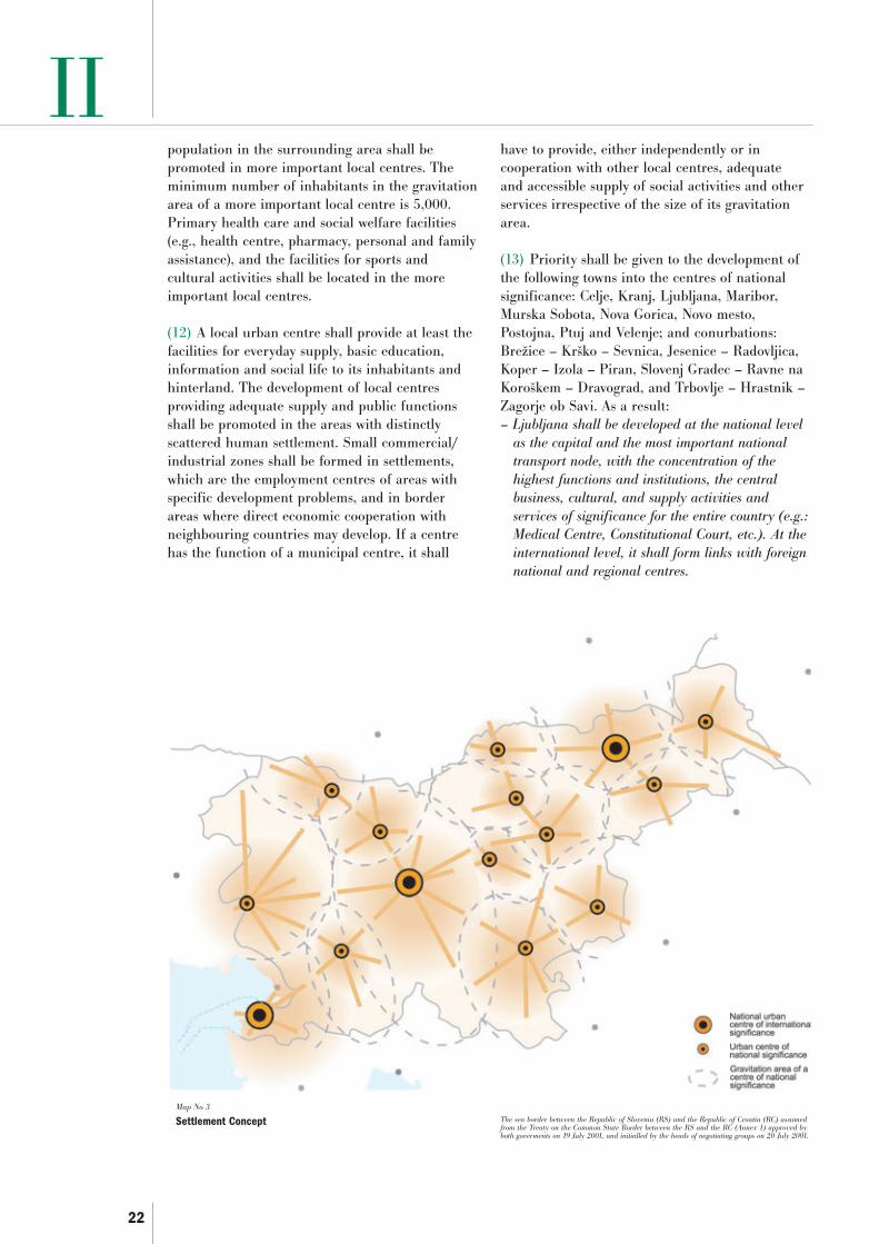
22
IIpopulation in the surrounding area shall bepromoted in more important local centres. Theminimum number of inhabitants in the gravitationarea of a more important local centre is 5,000.Primary health care and social welfare facilities(e.g., health centre, pharmacy, personal and familyassistance), and the facilities for sports andcultural activities shall be located in the moreimportant local centres.
(12) A local urban centre shall provide at least thefacilities for everyday supply, basic education,information and social life to its inhabitants andhinterland. The development of local centresproviding adequate supply and public functionsshall be promoted in the areas with distinctlyscattered human settlement. Small commercial/industrial zones shall be formed in settlements,which are the employment centres of areas withspecific development problems, and in borderareas where direct economic cooperation withneighbouring countries may develop. If a centrehas the function of a municipal centre, it shall
have to provide, either independently or incooperation with other local centres, adequateand accessible supply of social activities and otherservices irrespective of the size of its gravitationarea.
(13) Priority shall be given to the development ofthe following towns into the centres of nationalsignificance: Celje, Kranj, Ljubljana, Maribor,Murska Sobota, Nova Gorica, Novo mesto,Postojna, Ptuj and Velenje; and conurbations:Brežice – Krško – Sevnica, Jesenice – Radovljica,Koper – Izola – Piran, Slovenj Gradec – Ravne naKoroškem – Dravograd, and Trbovlje – Hrastnik –Zagorje ob Savi. As a result:– Ljubljana shall be developed at the national level
as the capital and the most important nationaltransport node, with the concentration of thehighest functions and institutions, the centralbusiness, cultural, and supply activities andservices of significance for the entire country (e.g.:Medical Centre, Constitutional Court, etc.). At theinternational level, it shall form links with foreignnational and regional centres.
Map No 3
Settlement Concept The sea border between the Republic of Slovenia (RS) and the Republic of Croatia (RC) assumedfrom the Treaty on the Common State Border between the RS and the RC (Annex 1) approved byboth goverments on 19 July 2001, and initialled by the heads of negotiating groups on 20 July 2001.

23
II– At the national level, Maribor shall be developed
as the second largest city in the country, and atransport node of national significance, linked atthe international level with the neighbouringregions in Austria, Croatia and Hungary.
– At the national and international level, Kopershall be developed into an important nationalfreight transport node and seaport. As a coastalconurbation including Piran and Izola, Kopershall develop the functions of a centre of nationalsignificance, and at the international level, it shallform links with the neighbouring regions in Italyand Croatia.
– Celje shall be developed as an important employ-ment, production, services centre and an importantregional transport node.
– Kranj shall be developed as a centre of nationalsignificance, the second largest centre of the widerurban area of Ljubljana, and an importantregional transport node.
– Murska Sobota shall be developed at an acceler-ated pace to become a centre which will be able tocooperate with cross-border regions in Hungaryand Austria on an equal basis, and as an impor-tant regional transport node.
– Because of its exposed position at the westernborder of Slovenia, Nova Gorica shall be devel-oped as a strong economic and cultural centre,which will be able to cooperate with cross-borderregions in Italy on an equal basis, and as animportant regional transport node.
– Novo mesto shall be developed as a centre ofnational significance and as an important regionaltransport node and centre, which will spread itsinfluence to the cross-border regions in Croatia.
– Postojna, Ptuj, Velenje and conurbations Brežice –Krško – Sevnica, Jesenice – Radovljica, SlovenjGradec – Ravne na Koroškem – Dravograd andTrbovlje – Hrastnik – Zagorje ob Savi shall bedeveloped as urban centres of national signifi-cance of their respective regional territories. Inview of their vicinity to the border and theirdevelopment potentials, these towns shall bedeveloped as centres which will spread theirinfluence to the areas across the border.
(14) Because of their role, size, and/or position,the towns of Ljubljana, Koper and Maribor shall bedeveloped as centres of international significance.Ljubljana provides political, administrative,transport, cultural, and other services to allinhabitants of Slovenia, and it is developing tobecome an internationally competitive capital.
(15) Among the centres of regional significance,priority is given to the development of towns andother urban settlements: Ajdovščina, Črnomelj, theDomžale – Kamnik conurbation, Gornja Radgona,Idrija, Ilirska Bistrica, Kočevje, Lendava, Ljutomer,Ormož, Sežana, Škofja Loka, the Šmarje pri Jelšah– Rogaška Slatina conurbation, Tolmin and Tržičwith Bistrica pri Tržiču.
(16) In the Kočevje region, because of the naturalconditions, vicinity to the border, sparse networkof centres, and inadequate access to the centres ofnational significance, the centre of regionalsignificance shall become the location of the mostimportant public functions and socialinfrastructure activities; various jobs will becreated, and production activities developed so asto create a higher function of a centre, togetherwith concern for balanced development and goodlinks over the entire regional territory so as toprovide conditions for its gradual development intoa centre of national significance.
(17) Inter-municipal centres to be given priority indevelopment are: Bovec, Cerknica, Cerkno, GornjiPetrovci, Grosuplje, Laško, Lenart v Slovenskihgoricah, Litija, Logatec, Metlika, Mozirje, Radljeob Dravi, Ribnica, Ruše, Slovenska Bistrica,Slovenske Konjice, Šentjur, Trebnje, Vrhnika andŽalec.
3 Vital and Well-managed Cities and Towns3.1 The development and management of cities andtowns shall be comprehensively planned to ensurethe vitality and quality of the living environment.
3.2 The site-related attractiveness of towns shall beincreased, economic development enabled, the safetyand quality of the living and working environmentsshall be provided for, and infrastructure systemsupgraded. The activities related to living, productionand consumption in cities shall be developed inharmony with the spatial features and environmen-tal restrictions.
(1) Cities and towns have a key role in theanticipated development changes and in theEuropean integration processes as the mostimportant urban development factor. Towns shallbe developed to become a vital, beautiful andplanned environment providing conditions foreconomic and social development and contributingto the quality of living for all inhabitants. Thereasons influencing the increasing dispersion ofconstruction, destroying the flexibility of towns and

24
II
Map No 4
Polycentric Urban System and Development of Wider Urban Areas
buildings, and causing monocultural suburbs,isolated peripheries and excessive environmentalpollution shall be eliminated.
(2) The reconstruction and revitalization of townsare the key strategic policies of internal urbandevelopment, taking into consideration urbanforms and architecture, the mixture of urban usesand appropriate density, possibilities of multipleland uses, social and cultural diversity, safety andquality living, protection and development ofcultural heritage, and the possibilities for reduceduse of personal vehicles and power. In city centres,the residential function shall be enhanced topreserve them as cultural centres and to developtheir tourist potential. When allocating activitiescharacterized by considerable goods traffic andfrequency of visits, appropriate public transportorganization shall be provided for.
(3) Cities and towns shall be organized accordingto the principle of multifunctionality. To develop anefficient city, it is necessary to provide for the
appropriate proportions in the use of land andstructures, aiming at a balanced combination ofdiverse functions and different types of activities.
(4) Natural components and well built publicassets such as traffic surfaces, squares, markets,playgrounds, parks, green areas etc., are of keysignificance for the quality of living in cities, andtherefore they shall be incorporated in the urbanstructures to the maximum possible extent. Watersurfaces and waterside areas, forests, natural valuesand individual components of biodiversity shall beincluded in the green system of cities.
4 Harmonized Development of WiderUrban Areas
4.1 To rationalize traffic flows, efficientlydistribute jobs, housing, services and productionactivities in the wider urban areas comprising theterritory of several local communities, the spatialneeds of the development of cities, towns andother settlements shall be planned and managedat the level of inter-municipal cooperation.
The sea border between the Republic of Slovenia (RS) and the Republic of Croatia (RC) assumedfrom the Treaty on the Common State Border between the RS and the RC (Annex 1) approved byboth goverments on 19 July 2001, and initialled by the heads of negotiating groups on 20 July 2001.

25
II4.2 Due to their size, population pressures,universal issues and/or anticipated development,special attention shall be devoted to the harmo-nized development of wider urban areas of thecentres of national significance, particularlyLjubljana, Maribor, Koper, Celje and Nova Gorica.
(1) Large cities, which are intensively connectedwith their wider surroundings, shall be developedas the areas of major urban agglomerations. Fromthe aspect of harmonized spatial development,wider urban areas have a specific role in thepolycentric urban system structure. These areas arecharacterized by strong everyday migrations towork and elsewhere causing dense traffic – particu-larly through the use of personal vehicles – andthus imposing pressure on the entire area and thecentral city. The wider urban area is closely linkedto the central city with numerous jobs, diverse andvaried production activities and services. As a rule,such an area comprises the territory of several localcommunities surrounding a municipality.
(2) A large number of mutually cooperating,interactive, and effectively interconnected centresshall be developed in a wider urban area. Urbandevelopment characterized by the concentration ofhousing construction, production and supplyactivities and services, shall be encouraged in theexisting centres or in human settlement develop-ment areas with potentials to develop into newcentres. Particularly the development of thosecentres, which are at the transport nodes andcrossroads of different traffic directions, shall bepromoted. The distribution and concentration offunctions within the wider urban areas shall beplanned in accordance with the development ofefficient public transport, integrated at all levels.
(3) Rational land use, the vulnerability of environ-mental quality, the necessity for reconstruction ofarchitectural and settlement heritage, possibilitiesfor the location of sports, recreational and othergreen areas, the existing network of transportroutes, and the possibility of links to the publictransport system shall be taken into considerationwhen planning and managing a wider urban area.
5 Integrated and Harmonized Development ofTransport and Settlement Networks and theConstruction of Public Infrastructure Facilities
5.1 Harmonized development of the transportnetwork and the network of settlements, integrationand development of transport nodes and transportlogistic terminals shall be developed primarily with
the aim of providing transport links to all areas,more harmonized development of the entire nationalterritory, and for the purposes of integration withthe wider European space. The transport systemshall be developed as an integrated transport systeminterconnecting all kinds and types of traffic.
5.2 Public transport shall be interconnected anddeveloped with the assistance of the state. Thedevelopment and expansion of public transportcomplemented by nonmotorized traffic and to alesser extent by motorized personal transport shallbe harmonized with the planned development ofurban areas, and consequently provide linksbetween towns and other settlements in these areas.Special concern shall be devoted to good publictransport links between the countryside and urbansettlements in individual regional territories.
5.3 Simultaneously, the construction of publicinfrastructure shall be promoted for the purposes ofadequate development of human settlement andeconomic activities, and their integration intointernational infrastructure networks.
(1) Road, rail, air and port networks shall beplanned to provide interconnections throughoutSlovenian space and between individual regions, aswell as the connection of Slovenia withinternational space. Efficient transport linksbetween cities and their respective hinterland, andbetween cities and peripheral, less developedregions shall be developed since this is animportant factor of polycentric development, whichcontributes to the strengthening of the competitiveposition of these regions and consequently to thesocial, economic and spatial cohesion. Whenplanning high-quality infrastructure, sectoralpolicies shall have to ensure that the infrastructurewill promote the development and integrity of theresources in weaker and border regions whencompared with the development of the centralSlovenian region.
(2) Slovenia shall support the development ofthose transport systems which directly serveSlovenia territory, follow the basic spatial policiesof Slovenia, and can be implemented in conformitywith the environmental protection requirements.
(3) The concept of the road and rail network,airports and ports consists of transport systems,which interconnect urban settlements on a prioritybasis to form a balanced and efficient structure.The transport network shall support or establish

26
II
Map No 5
Concept of Transport Links
conditions for the development of a polycentricurban system structure, economic developmentand improved competitiveness of the country. Thetransport network and the functionally balancednetwork of urban settlements shall link urbanareas with rural, remote, peripheral andstrategically or otherwise important areas, wherebypriority is given to public transport.
(4) The long-distance transport network shall linkthe Slovenian centres of national significance(Ljubljana, Maribor and Koper) with Europe, andthe centres of national significance with eachother. Adequate accessibility of all regions andtheir links with international flows shall beprovided by developing secondary (transverse)transport links connected to the Trans-EuropeanNetwork (TEN) infrastructure, the V and X pan-European transport corridors, and to the Adriatic-Ionian transport axis (Map no 2). From the
direction of the Austrian Carinthia through SlovenjGradec and Velenje, a new, third, transport axisshall be connected to the motorway in the vicinityof Celje to continue towards Novo mesto andfurther towards Karlovec, i.e., the link to theZagreb–Rijeka motorway. A new developmentgenerating transport axis shall interconnectregional centres in Austria, Slovenia and Croatia,and provide freight and personal transport from allregions along this axis with the links to the mainEuropean transport corridors. From the directionof Ljubljana, and after the branch from the maintransport axis towards Italy, a parallel transportroute shall be developed through the Vipavskadolina valley and Nova Gorica towards Udine (Italy).
(5) Intermodal transport links and development ofthe railway network – which will take over themajority of long distance transport in the future –shall be promoted to enhance the efficiency oftraffic flows. At the same time with the
The sea border between the Republic of Slovenia (RS) and the Republic of Croatia (RC) assumedfrom the Treaty on the Common State Border between the RS and the RC (Annex 1) approved byboth goverments on 19 July 2001, and initialled by the heads of negotiating groups on 20 July 2001.

27
IIconstruction of the Slovenian motorway network,Slovenia shall develop the circumferential systemof transport links depending on the needs at theregional level, and modernize the railway networkto make it suitable for higher train speeds requiredfor taking over the majority of long-distance freighttransport. (Map No 5).
(6) In air transport, airports and heliports shall bedeveloped in accordance with the network of urbancentres, international standards and relevant linksto the European transport corridors.
(7) Priority shall be given to the development ofthe port of Koper through its linkages with otherNorthern Adriatic ports and links to its continentalhinterland and to the European transport corridorsTEN V and X (Map No 2). An intercontinentalpassenger transport seaport shall be designed inKoper to improve transport links between towns inSlovenian Istria, and other towns in northernAdriatic coast and maritime public passengertransport shall be promoted.
(8) In order to reduce the negative impacts ofmotorized road traffic on spatial development andthe environment to the maximum possible extent,priority shall be given to the development of railtransport and public passenger transport, andemphasis placed on all kinds of nonmotorizedtraffic (cycling, walking). The integrity of thetransport system shall be ensured throughfunctional integration of all modes of passenger andgoods transport.
(9) The networks of cycling tracks and pedestrianfootpaths shall be developed in accordance with anecologically oriented range of tourist services toenable healthy physical exercise for the population.At the local level, the public transport network andcycling tracks shall link suburbs and outskirts toeach other and to the city. Within and among thegravitational areas of urban settlements, good accessto public facilities shall be provided in all populatedareas by means of public transport. Public transportin particular shall be supported and expanded,priority shall be given to cyclists and pedestrians,while car traffic shall be reduced and – through wellorganized parking facilities – stopped at the marginsof central areas.
(10) When constructing new infrastructure andmodernizing the existing one, support shall be givento the construction of those energy generation anddistribution facilities which enable a high-quality
and reliable energy supply for Slovenia. Whendetermining the location of new energy generationor distribution facilities, their optimal inclusion inthe Slovenian energy network shall be ensured andexcessive environmental impacts prevented whilerespecting the principles of sustainable spatialdevelopment.
6 Vitality and Attractiveness of Rural Areas6.1 To exploit the comparative advantages of thecountryside, support shall be given to thediversification of those economic activities which,together with agriculture and forestry, provideconditions for the population to stay in thecountryside, preserve vitality of countryside, andcontribute directly and indirectly to the highquality, identity and attractiveness of its naturaland cultural landscapes.
6.2 In urban settlements in rural areas, thedevelopment of new jobs shall be encouraged toreduce daily migrations to work.
(1) Because of their attractiveness and specificdevelopment potentials, rural areas are animportant living and working environment, andtherefore their integrated development inassociation with urban areas shall be promoted.Rural areas cover three quarters of Slovenia. Ruralareas are defined as physical space with a low degreeof urbanization, outside the areas with a highconcentration of human settlement, prevailingproportion of agricultural and forestry land use,conserved natural processes and natural media.Urbanized and less urbanized rural areas aredistinguished for the purposes of spatial planningand management. Urbanized rural areas comprisesettlements in the wider hinterland of cities andtowns and in the vicinity of transport routes, andindividual urban settlements, while less urbanizedcountryside comprises inadequately accessibleborder areas, rural and mountainous areas withsmall settlements and a sparse, scattered settlement.
(2) A harmonized development of the countryand individual regional territories is based on theinterdependence of the development dynamics ofrural and urban areas. Spatial disproportionsresulting from spontaneous concentration ofhuman settlement in the vicinity of major citiesand towns and the consequential depopulation ofcity cores and remote rural areas shall beovercome by integrating the spatial anddevelopment planning. Settlements and landscapein rural areas shall be developed as an integrated

28
II
Map No 6
Landscape Concept
economic and living environment, in whichlandscape and architectural qualities shall bepreserved to promote conservation of the identityof the Slovenian rural areas.
(3) The human settlement shall be preserved inthose rural areas which are important for reasonsof national defence and in the areas of valuablecultural landscapes. In border areas, urbansettlements in particular shall be strengthenedbecause of the gravitational influence of the majorcities and towns in neighbouring countries. Inthese settlements, support shall be given not onlyto the activities required for the needs of thepopulation in Slovenia but also to those activities,which will – upon harmonized development of thetransport network – expand the role of thesesettlements across the border and thus contributeto their competitiveness in international terms.
(4) Dispersed building shall be appropriatelyrehabilitated by functional completion where thisis spatially appropriate and environmentallyacceptable.
(5) Energy supply based on locally availableenergy sources such as wood biomass, biogas, solarenergy, geothermal energy etc., shall preserve andenhance the competitiveness, attractiveness andvitality of the countryside.
(6) The spatial potentials for the development ofmodern agriculture shall be provided primarily inplains where the conditions for agriculture arefavourable, and agriculture can be competitiveunder European conditions. The agriculturalactivities and cultures shall be adapted to the foodproduction potentials of individual areas and theavailability of water, particularly in areas affectedby drought, such as Prekmurje. In areas with thebest cultivating conditions, the agriculturalactivities can be specialized and spatially rationallyorganized. In areas with unfavourable cultivatingconditions, i.e., in the Karst and in mountainousareas, complementing programmes shall bedeveloped and agricultural activities integratedwith the maintenance of cultural landscape,prevention of forestation, conservation ofbiodiversity and natural values, promotion and
The sea border between the Republic of Slovenia (RS) and the Republic of Croatia (RC) assumedfrom the Treaty on the Common State Border between the RS and the RC (Annex 1) approved byboth goverments on 19 July 2001, and initialled by the heads of negotiating groups on 20 July 2001.

29
IIhigh-quality use of cultural heritage, andsustainable tourism.
(7) Forests are the most important medium of thenatural landscape, yet their scope shall not beadditionally and systematically increased. The useof forests for economic, recreational and otherpurposes, which pose no threat to the forestecosystems, shall be encouraged. Theirrecreational potential in the vicinity of settlementscan be suitably exploited in the framework ofplanning the green systems of settlements. Theforest continuity is a quality which shall beconserved to regulate the natural balance of thelandscape and to conserve wildlife habitats. In theflatland agricultural areas with a small share ofhigh vegetation, forests shall be conserved asstructural ecological landscape media.
7 Enhancing the Recognizability of ValuableNatural and Cultural LandscapeCharacteristics
7.1 Regarding its features and developmentpotentials, the landscape shall be developed as anatural and cultural landscape, urban landscapeand agriculturally intensive landscape.
7.2 Conservation and high-quality management inareas with recognizable natural and cultural valuesshall be encouraged in association with theeconomic opportunities provided by these features.
7.3 Individual qualities shall be determined inspatial planning procedures at the regional andlocal levels, and included in spatial development.
(1) The Slovenian landscape shall be developed asa natural landscape particularly in remote andpreserved areas, as a cultural landscape intraditional agricultural areas, i.e., in the Sloveniancountryside, as urban landscape in thesurroundings of major cities, and as agriculturallyintensive landscape in areas with high productivepotential. Spatial development shall ensure theconservation of key landscape identificationfeatures in each of these areas.
(2) Slovenia is recognizable for its varied landscapeand landscape patterns, architectural identity oftowns and rural settlements, conserved nature, greatbiodiversity, a large number of natural values andnatural processes, and the abundance of waters andforests. These features are particularly characteristicof the cultural heritage areas, ecologically significant
areas and reserves, e.g. in the Julian Alps, in theKarst, along the seacoast, in the Štajersko andPrekmurje regions, in the Ljubljanica river basin, andin the wine growing areas.
(3) Landscape, architectural and natural featuresof Slovenian space shall be conserved by guidingthe spatial development in such a way as tocontribute to the identification of the populationwith the national territory and at the same timeenable the development of other activities. Thespatial development shall enable the conservationof biodiversity and natural values, and theinterconnection and interrelation of ecologicalnetworks. The landscape and natural featuresrepresent a potential for the development ofspecific institutions and activities of nationalsignificance in major settlements, which arebecoming recognizable at the national level fortheir landscape, architectural and natural values.The integration of cultural tracks interconnectingthe structures and areas of cultural heritage,monuments, historic buildings, and open-airmuseums into the range of tourist attractions shallalso be enabled.
8 Spatial Development in Areas with SpecialPotentials and Problems
8.1 Spatial development in areas with specialpotentials and problems shall be promoted throughthe strengthening of urban settlements, rationallocation of public services, provision of necessaryplots of land, and the efficient provision ofinfrastructure in these areas.
8.2 In the coastal, hilly and mountainous areas,and in areas with natural and cultural qualities,spatial opportunities shall be provided for thedevelopment of those activities which can exploit thespatial potentials which are specific regionalfeatures of these areas.
8.3 In endangered areas, spatial development shallbe adapted to the threat of potential natural andother disasters, while in water deficient areasspatial development shall be adapted to the limitsimposed by water sources.
(1) The areas with special potentials and problems(Map No 7) are areas with specific spatial characteristics,such as position (border areas), natural features (coastal,hilly and mountainous areas), areas with natural andcultural qualities, and areas with spatial limitations fordevelopment (endangered and water deficient areas).

30
II(2) In border areas, conditions shall be provided forhigh quality employment and for achieving thedevelopment level of adjacent areas in neighbouringcountries, particularly in areas with developmentproblems.
(3) Slovenia endeavours to integrate and formcross-border regions with joint developmentprogrammes. The development and integrationpromoters are urban settlements, particularly thosewhich are the centres of large gravitation areas.Their integration into cross-border regions andcloser cooperation with regions in Italy, Austriaand Hungary will serve for gradualimplementation of the idea of Europe withoutborders.
(4) Support shall be given to the spatialopportunities for the development of activitiescovering needs and areas across borders so as tomake these areas competitive with the largeadjacent urban agglomerations. Particularly thoseactivities shall be developed which help to preserveand develop, on equal terms, the Slovenianminorities in neighbouring countries. Accountshall also be taken of the potentials of zones whichwere abandoned by forwarders and other activitiessituated in the area of the now open border withItaly, Austria and Hungary after the accession ofSlovenia to the European Union.
(5) In the area along the border with Croatia, theconsequences of a stricter border-crossing regimefor the life of the border area population, enforcedafter the integration of Slovenia in the EuropeanUnion, shall be mitigated through joint resolutionof spatial, environmental, infrastructural andeconomic issues so as to preserve the traditionalties among the population. The spatialdevelopment issue shall be resolved andencouraged in the framework of spatiallyhomogeneous units or units with shared problemssuch as the area of Istria, the Kolpa river, theKočevsko region, the Gorjanci, Kozjansko, Haloze,the area between the Drava and the Mura rivers,etc.
(6) Because of direct spatial connectedness of theGoriška region with adjacent Italian areas and thehistorical ties of the hinterland to Gorizia (Italy) asa natural centre, this region shall be developed atan accelerated pace as an equal partner. Anequivalent and competitive role of Nova Gorica andits functions in the wider cross-border area shall beensured in the gradual and natural fusion of the
two towns, Gorizia and Nova Gorica, into a singleurban structure.
(7) The coastal region combines the areas of high-quality natural and cultural landscape featureswith the conurbation of Koper, Izola, Piran andPortorož. Its coastal and border positiondetermines its orientation towards the furtherdevelopment of tourism, transport, industry,agriculture and fishing. The integrated spatialconcept of the Coast shall be ensured, by which theinterests of development activities are harmonizedwith spatial possibilities and protectionrequirements. At the same time, conditions for thedevelopment of a high-quality range of touristservices and amenities shall be established andpermanent public access to the seashore andbeaches shall be ensured.
(8) Because of their natural geographic featuressuch as height, slopes, relief and climate,consequences of natural disasters, anddepopulation, hilly and mountainous areas faceeconomic, social and environmental problems. Inthese areas, the basic economic and socialinfrastructure, and the natural resourcesmanagement shall be provided while consideringthe conservation of nature and cultural heritage.Ecologically oriented tourism, organic farming,and the use of renewable energy sources shall beencouraged since these areas have, as a rule, moreopportunities for such activities, and they alsoprovide support to communities in mountainousand hilly areas.
(9) Small and large areas of Alpine, sub-Alpine,Karst, and sub-Pannonian regions with thepresence of high-quality natural and culturalfeatures shall be treated as functional componentsof urban and rural areas. To preserve theirqualities and significance, encouragement shall begiven to activities which enable economicdevelopment based on the concepts ofconservation. In border areas along the Italian,Austrian, Hungarian and Croatian borders, wherethere are similar sites, joint consideration of spatialdevelopment issues shall be encouraged.
(10) Natural processes which endanger humansettlement and activities shall be mandatorilyconsidered as a limitation in planning land usesand spatial development activities. Spatialdevelopment in all areas, particularly endangeredones, shall be planned in accordance with thelimitations due to natural and other disasters, such
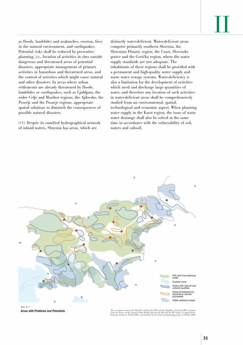
31
II
Map No 7
Areas with Problems and Potentials
as floods, landslides and avalanches, erosion, firesin the natural environment, and earthquakes.Potential risks shall be reduced by preventiveplanning, i.e., location of activities in sites outsidedangerous and threatened areas of potentialdisasters, appropriate management of primaryactivities in hazardous and threatened areas, andthe control of activities which might cause naturaland other disasters. In areas where urbansettlements are already threatened by floods,landslides or earthquakes, such as Ljubljana, thewider Celje and Maribor regions, the Ajdovsko, thePosočje and the Posavje regions, appropriatespatial solutions to diminish the consequences ofpossible natural disasters.
(11) Despite its ramified hydrographical networkof inland waters, Slovenia has areas, which are
distinctly water-deficient. Water-deficient areascomprise primarily southern Slovenia, theSlovenian Dinaric region, the Coast, Slovenskegorice and the Goričko region, where the watersupply standards are not adequate. Theinhabitants of these regions shall be provided witha permanent and high-quality water supply andwaste water sewage systems. Water-deficiency isalso a limitation for the development of activitieswhich need and discharge large quantities ofwater, and therefore any location of such activitiesin water-deficient areas shall be comprehensivelystudied from an environmental, spatial,technological and economic aspect. When planningwater supply in the Karst region, the issue of wastewater drainage shall also be solved at the sametime in accordance with the vulnerability of soil,waters and subsoil.
The sea border between the Republic of Slovenia (RS) and the Republic of Croatia (RC) assumedfrom the Treaty on the Common State Border between the RS and the RC (Annex 1) approved byboth goverments on 19 July 2001, and initialled by the heads of negotiating groups on 20 July 2001.

32
III1 Development of Human Settlement(1) The development of human settlementprovides for the location of activities, housing andinfrastructure in the network of settlements andensures adequate provision of developed land forliving, production supply and services in suitablesites, as well as land for recreation and leisureactivities.
(2) Human settlement development shall beplanned in accordance with spatial opportunitiesand limitations in such a way as to prevent spatialconflicts between different uses, provide for abetter quality and more attractive living andnatural environment, create opportunities foreconomic development and social equity, ensurerational expansion of settlements, emphasizeinternal development of settlements where it isimportant to create new and better qualitystructure and use of urban areas, as well as theconservation of cultural, particularly architecturaland settlement heritage, biodiversity and naturalvalues.
(3) The guidelines for development of humansettlement shall form the basis for the long-termsteering of human settlement development at theregional and local level, and its monitoring. Spatialcapacities, the rationality of land development, thecharacteristics of the existing settlement network,and the existing buildings shall be taken intoconsideration. They shall present the basis forsteering investments into the construction andrenewal of residential and non-residentialbuildings and public infrastructure facilities.
(4) An active land policy of the kind whichenables the enforcement of guidelines in humansettlement, contributes to harmonious regionaldevelopment and promotes internationalcompetitiveness, shall be encouraged. The nationaland the local level, in accordance with theirrespective competences, shall provide conditionsfor active participation of landowners and investorsin land development in the form of public privatepartnerships. The state and local authorities willbe responsible for acquiring adequate quantities ofland, particularly for non-profit housing and theoperation of public services. Finance obtained bylocal communities from land management shall beearmarked on priority basis for theimplementation of an active land policy, and themain concern shall be to ensure the preparation ofimplementing spatial planning documents, and
building land development based on thesedocuments.
(5) A part of the new building sites shall have thefunction of revitalizing the existing situation,which includes the activation of spatial and otherpotentials of the existing structures. An increasednumber of building sites shall be earmarked forbusiness development, particularly in areas withgood transport links and adequate spatialopportunities. Information systems shall be used toa much larger extent than at present to effectivelymanage land in the framework of an active landpolicy.
1.1 Development of Cities, Towns and otherSettlements
(1) Settlements differ in function and roles in theurban network, in size, urban structure andarchitecture. For the needs of human settlementdevelopment, the types of settlements shall bedefined on the basis of physiognomic,morphological, and functional criteria. Criteria, onthe basis of which settlements are classified intovarious types, are particularly the size of thesettlement, various activities, employmentopportunities, attractiveness, morphologicalfeatures, and the role of the settlement. Theindicators are particularly the number and thestructure of inhabitants, the size of populatedsurface areas, population density in the populatedareas, trends towards services or productionactivities, the number of inhabitants employed,diversification of activities and their number.Based on these criteria and indicators, settlementsshall be defined as large, medium and small citiesand towns, other urban and rural settlements,villages and hamlets. Urban settlements, inparticular, shall be classified as more or lessimportant centres, where care shall be taken todevelop adequate housing stock, and services,production activities and jobs.
(2) New urban development shall be directedprimarily to the settlement development zones ofurban settlements. The development and planningof cities, towns and other settlement shall be usedto provide safe, comfortable, and healthyconditions for living, while conserving, as much aspossible, biodiversity, natural values, culturalheritage and other qualities of the natural andliving environment, and enabling the links ofhabitats in settlements with nature outside thesettlements. When planning the urbandevelopment, cultural heritage shall be taken into
Development of Spatial Systems with Guidelinesfor Development at Regional and Local Levels

33
IIIconsideration as a living environment qualityfactor and spatial potential.
(3) Settlements shall be planned and managed inharmony with the natural and other restrictions sothat the inhabitants and their property are notendangered by natural processes and there is noeconomic damage. Settlements shall be planned insuch a way as to diminish the consequences of anyfire, flood, landslide, erosion, or war as far aspossible. The protection against floods, andtorrential waters in the existing settlements shallbe planned primarily by regulating standing andrunning waters in the hinterland of suchsettlements. Water reserves to provide for firefighting flow shall be planned. For safety reasons,there should be as many green areas in settlementsas possible to balance extreme temperatures andenable gradual drainage of rainwater.
(4) Settlements shall be planned so as to ensurerational energy consumption. Energy saving andthe reduction of energy use shall be taken intoconsideration in urban planning, in architecturalsolutions and in the selection of building materials.Rational use of energy shall be ensured throughappropriate planning of new structures and areas,and in the reconstruction of existing buildings, andparticularly through such orientation of buildingsand distance between buildings, which enablesunhindered exposure to the sun irrespective of theseason, and reduces the need for air-conditioning,through preventing the duplication of districtheating systems, moderate density of newresidential districts, and the arrangement ofbuildings which enables rational planning of thedistribution network, and the energy consumptionreducing renewal of buildings in the framework ofthe renewal of cities, towns and other settlementsor their parts.
1.1.1 Inside development in settlements(1) Inside development in settlements shall bepreferable to the expansion to new areas. Priorityshall be given to a better exploitation and improveduse of vacant and unsuitably exploited plots of landwithin settlements (abandoned or inappropriatesites, industrial complexes, etc.). Insidedevelopment in settlements and rational land useshall also be implemented through the altered useof existing structures and building sites,concentration of extensively used built areas,reconstruction, renovation, reurbanization,renewal, and rehabilitation of brownfields takinginto consideration in addition to the spatial
objectives also the opportunities for economicdevelopment, the resolving of social problems, andimproved quality of living while also consideringpotential threats. A balanced proportion of builtand green areas in the settlement and links to theopen landscape shall be provided for in theprocess.
1.1.1.1 Renewal of settlements as a priority(1) The renewal is a form of the urban planningof settlements, which includes in addition tospatial objectives also the opportunities foreconomic development, resolving of socialproblems, and improved quality of living whileconsidering potential threats, and it isimplemented in morphologically and functionallycompleted areas. The renewal of settlements, partsof settlements or individual buildings shallpreserve or improve the qualities of the livingenvironment, re-establish the use of abandonedsites, and rehabilitate degraded sites. In therenewal, the cultural heritage shall be consideredconcurrently and its vulnerability taken intoaccount.
(2) In settlements, which are not designated ascultural heritage, and as such enable no new,altered and improved use, renewal shall be givenpriority in individual parts or in the entiresettlement if it provides for more rational use andreuse of the existing capacities, financial savingsand/or energy use reduction. When planningrevitalization, account shall be taken of thepreserved identity of the settlement or its part, andconcern devoted to a balanced proportion of builtand green areas in the settlement.
1.1.1.2 Renewal of the cultural heritage andother architectural heritage insettlements
(1) Cultural heritage in settlements and othervaluable architectural heritage shape thecharacteristic image of individual settlements orwider areas. From the aspect of spatial planningand management, settlements shall be classified assettlements with architectural heritage recognizedas cultural heritage, settlements which are part ofa wider spatial identity, and settlements whosebuildings and the structure of other architecturalheritage present a value in the architectural andurban-planning sense, and an appropriate form ofrenewal shall be planned for them. Renewal shallbe carried out in all areas with valuablearchitectural heritage, which shall be defined as aspecial value and as such a part of the basic

34
IIIintegrated identity on the landscape, settlement orarchitectural scale, or protected by relevantregulation as architectural heritage.
(2) When managing and planning thedevelopment of settlements with valuablearchitectural heritage, protection and developmentplanning principles shall be applied, andparticularly high-quality architectural or urbanstructure and their recognizable features shall bepreserved, degraded architectural or urbanstructures shall be modernized, and their reuseintroduced.
(3) Renewal is given precedence over newconstruction in settlements which are part of awider spatial identity and represent valuablearchitectural heritage, particularly if some parts ofthese settlements have – despite certaindegradation – adequately preserved characteristiccomponents. The reuse or a new suitable use ofthe existing buildings and infrastructure shall beplanned.
1.1.1.3 Renewal of degraded urban areas(1) In settlements, revitalization shall be definedfor degraded urban areas where the potential foruse or activity is decreased or limited due to theabandoning of activities, pollution or inappropriateuse. Most frequently such areas are the sites ofconstruction industry facilities and mining sites,military, railway or residential sites.
(2) Comprehensive revitalization of degradedurban sites shall be carried out in spatiallycomplete areas based on harmonized programmesand spatial plans, and with financial sourcesprovided. Particularly important in therevitalization of degraded sites is the reconciliationof the interests of all participating entities,particularly property owners, investors, plannersand the municipality.
(3) The revitalization shall provide theinhabitants of degraded residential districts withan improved quality of living within the existinghousing stock, and their active participation in theplanning and preparation of measures for theimprovement of the value of housing and theresidential district environment.
(4) The physical progress of revitalization shallinvolve a reasonable renewal of the existingbuilding structures and their inclusion into newones. The revitalization process shall enable
gradual construction and upgrading ofinfrastructure networks. Transport infrastructureshall be provided to increase accessibility to theseareas.
1.1.1.4 Renewal of old industrial and miningsites/settlements
(1) Encouragement shall be given to thefunctional, social, ecological and architecturalrevitalization of old industrial and mining sites orentire settlements where spatial degradation is theconsequence of the decline of certain activities andsocial restructuring.
(2) The sites of former industry, which meet thespatial, environmental, infrastructural and otherconditions of modern production parks, shall berestored for production purposes. In accordancewith the needs of integrated development of thesettlement, these sites can be allocated for neweconomic activities and/or general development ofother diversified activities such as culture, sport,trade, tourism, leisure and other activities inharmony with the development of the ruralhinterland, if any.
1.1.2 Settlement expansion(1) In the case that there are no suitable buildingsites left within the settlement, the settlementexpansion shall provide the conditions fordevelopment of residential, economic and othercapacities, increased social security andcompetitiveness of the settlement, operation of thereal property market, and the development ofvarious services and production activities.
(2) The expansion zones can be designated for asettlement if it is defined as an urban settlement,and particularly if it is or has the potential todevelop into the centre of a certain area.Settlements in areas of significance for thedevelopment of tourist activities may increase theirsettlement development zones based on theirdevelopment programmes. The settlementexpansion shall be permitted if it complies with thebasic objectives of spatial planning andmanagement, the principles for steering humansettlement, the building land developmentprogramme, and the natural and other disastersthreat assessment.
(3) The development of integrated publictransport, particularly intercity and urban publictransport shall be planned concurrently and inconformity with the settlement expansion for

35
IIIhousing construction, production zones, centralactivities and public functions.
(4) Priority shall be given to the expansion ofsuburban settlements where access to publictransport is provided, where building up andcongestion of populated areas is possible, and themunicipal infrastructure network can be improved.Creation of new jobs shall be promoted, and smallproduction zones, whose scope is balanced with thesettlement, shall be located in an expedientmanner.
1.1.3 Construction outside the settlementdevelopment zones
(1) A recognizable spatial order and rationalspatial organization of activities shall be created bydeveloping populated areas outside settlementdevelopment zones. When planning these builtareas account shall be taken of the size and spatialarrangement of the buildings as well as the degreeof perfection of the design.
(2) Built areas outside settlement developmentzones and the manner of their planning andmanagement shall be defined with respect to thecharacteristics of the existing building, andparticularly on the basis of an analysis of locationand position, landscape features, structure andfragmentation, the functions of building units andthe building typology.
(3) In the case that a built area outside asettlement development zones is identified as anarea of human settlement, which – being anautochthonous settlement pattern – contributes tothe identity or conservation of the culturallandscape, it shall be conserved and protected by:– Restoration, renewal, reconstruction, and reuse or
altered use of the existing legally constructedstructures,
– Replacement construction of legally constructedstructures, and
– New construction, insofar as a functional comple-tion of an area provided with public utilities isconcerned.
(4) Dispersed buildings outside settlementdevelopment zones, which are the source ofenvironmental pressures or visual disturbances,shall be rectified. The dispersed buildingrehabilitation zones shall be identified with regardto the type of dispersion, degree of degradationand their improvement possibilities. Concentrationand filling in shall be applied particularly to those
areas of dispersed buildings, which have thepotential for appropriate transport and municipalutility services, supply of urban activities andconnection to public transport. The supplementarybuilding of structures, which represents thecompletion and rehabilitation of individual areasof dispersed building, shall be permitted.Dispersed construction in suburbs and settlementsin the vicinity of cities and towns shall berehabilitated by the concentration of housing andurban activities.
(5) The decisions of local communitiesconcerning the development of their potentialsshall be set out in their planning documents. Theconstruction outside settlement development zonesshould have the role of enhancing the quality ofthe cultural landscape, living conditions, andemployment opportunities. Historical developmentshall be taken into consideration and upgraded,and the autochthonous elements of Slovenianconstruction culture shall be complemented withnew designer solutions, developing Slovenian ruralsettlements as a commercial product. An importantcondition for successful development of rural areasand areas with developmental problems is the highquality of urban planning and architecturalsolutions, which is the basis for the settlements todevelop into beautiful, interesting places which areworth-visiting and where opportunities foremployment and earning are created.
(6) Outside of settlement development zones,building sites may be allocated for the constructionof farms, in the case of areas with high farmingproduction potential and adequate concentrationof agricultural property per farm, and inconformity with the requirements for theprotection of natural resources and with thequalities of the landscape and built environment.
(7) The construction of facilities for sports andrecreational purposes outside settlementdevelopment zones shall be permitted if:– Natural conditions enable such activities to be
performed and/or the spatial arrangement isconsistent with the existing use in terms of spatialarrangement and design, the dominant features ofthe site, its topographic position and views, and
– It is possible to provide connections to the trans-port and power system, a non-polluted drinkingwater supply of sufficient capacity, sewage andtreatment of waste water depending on the needsof tourist and recreation activity when consideringits environmental impact.
36
III1.1.4 Rural settlements, villages and hamlets(1) In rural settlements, villages and hamlets,construction shall be permissible inside theexisting plots of building land to improveconditions for living, farming and complementaryactivities. Such improvements shall be developedprimarily through filling in and replacementconstruction within the existing plots of buildingland or, if there is no other possibility, along theiredges. Priority shall be given to renewal andrestoration aimed at the modernization ofagriculture and the creation of conditions for thedevelopment of complementary activities.
(2) When planning and managing ruralsettlements and villages, development trends shallbe taken into consideration while conserving thetraditional structure of these settlements. Thehousing stock shall be renewed, developed,conserved and modernized, while newly builtstructures are adapted in terms of urban planningand architecture to the traditional structure.
(3) To prevent emission impacts, adequatedistance between residential buildings and farmingfacilities shall be provided for. The construction ofnew or replacement farms and the renewal ormodernization of functional facilities shall beenabled, capacities for modern farming shall bebuilt, and unhindered access to farmyards andtransport means shall be provided.
(4) Unhindered connections and fast access toarable land shall be provided by transport links.
1.1.5 Tourist areas(1) A tourist area is a settlement developmentzone with a developed tourist infrastructure andother contents of significance for the developmentof tourist services. A tourist area is the settlementin which, in a one-month period during peakseason, the number of tourists exceeds the numberof permanent residents by fifty percent. Whendeveloping tourist capacities in tourist areas,account shall be taken of the possibilities forproviding adequate infrastructure regarding thenatural assets and architectural heritage.
(2) In rural settlements and villages wheretourism is developing, the architectural identityshall be maintained and created. It is important toappropriately locate agricultural facilities,particularly those with distinct environmentalimpacts.
1.1.6 Areas of secondary homes(1) Secondary homes are intended for periodicalresidence or leisure time use by individuals andtheir families. The areas with secondary homesshall be planned in an attractive natural ambienceas contiguous, rationally subdivided areas, whichare in harmony with the regional and localarchitecture, with typical settlement and landscapecharacteristics, and which observe protectionguidelines. Such homes should support thedevelopment of remote, mountainous regions,particularly to develop tourism and other leisureactivities. They may differ from other forms ofresidence in their appearance, construction,provision of public utilities and the quality ofliving, which is why they cannot assume thefunction of a permanent residence.
(2) In areas with high-quality architecturalheritage and/or cultural landscape threatened bydeterioration, decline and decay, the function ofthe area and structures can be changed into that ofa secondary home area. The change in thefunction of such areas and structures shall beplanned in accordance with the professionalguidelines of the competent authorities and basedon the integrated development of a wider area,tourism and other leisure activities, andconservation of the architectural heritage.
1.2 Rational Use of Land and Structures inSettlements
(1) The planning of the use of land andstructures is the zoning of land by land use andactivities performed by various land users and thedetermination of instruments for theimplementation of the planned development.
(2) The aim of land use policy within settlementis to create a mixture of functions which arecompatible and will not disturb each other.Distinctive monofunctionality of individual partsof settlements shall be prevented by introducingdiversified activities and mixing the functions ofliving and working.
(3) Land use should provide for concurrent useby compatible activities, particularly those whichcomplement each other and will not degrade theliving, working, leisure and other environment.Spatially, building sites shall be zoned by land useand activity so as to prevent the pollution of air,water, soil, and excessive noise, and to take intoconsideration biodiversity, natural values and

37
IIIpositive influence on conservation of the culturalheritage.
(4) Zoning of building sites by land use andactivity shall be determined on the basis of thedevelopment opportunities analysis, and theenvironmental vulnerability and suitability study.Investments shall be targeted primarily in areaswith appropriate site-related advantages for certainuses.
(5) Because of the dispersed settlement inSlovenian territory, future development shall besteered towards the fuller utilization of alreadybuilt-up areas and not towards opening ever-newareas for the needs of building construction. Thepurpose of steering building towards high-densityconstruction is a rational land use with thesimultaneous provision of adequate green areas.For this reason, the upper limit of the density ofbuilding within individual built-up zones, andappropriate proportions between built-up andgreen areas shall be determined in order to providefor a high-quality living environment. The upperlimit of the density of buildings and the typology ofconstruction is subject to the structure ofindividual settlements. The density of constructionshall be in accordance with the limits imposed byurban design quality and the quality of living.When increasing the density in built-up areas theutmost attention shall be devoted to easilyaccessible areas with organized public transport.
(6) In urbanized seacoast and lake shore areas,support shall be given to the land use which isdirectly connected to the exploitation of water forleisure activities and which allows free access towater or the freedom of passage along the shore.Spatial capacities in the hinterland shall be usedfor new urban development.
1.2.1 Residential areas(1) Based on the relevant research, developedbuilding land shall be planned and provided inurban settlements for housing construction and forthe renewal of the existing residential areas,particularly where the functions of residentialareas will be thus completed and stabilized.
(2) The share of land for organized housingconstruction is increasing. Individual newresidential areas in settlements shall be linked intolarger units while considering the possibilities ofrehabilitating the existing dispersed settlement.
(3) Organized housing construction shall becarried out in new, larger areas allocated forhousing. Different types of dwellings shall beprovided in residential areas to enable a sociallymixed structure of inhabitants and also to meet thetypologically differentiated family structure. Thetypes of buildings shall be harmonized with theexisting buildings, while taking into considerationmodern trends in architecture. The principles of ahigh-quality living environment – ensured, interalia, by appropriate density of buildings andaesthetic design of the entire residential area(district) as well as of individual buildings – shallbe observed. The types of housing construction,arrangement and positioning, which encouragesocial contacts and enable proportionally higherdensity of buildings, while providing for adequatepublic and particularly green areas. Walking accessto all services required on a daily basis shall beprovided in a residential area. Land developingactivities in the existing urban structure shall beperformed only on the basis of a comprehensiveexpert assessment.
(4) Appropriate supply activities and services,sports facilities, recreational and green areas shallbe furnished in residential areas. Residential areascan also include elementary education and healthcare activities, social services, kindergartens, tradeand business activities, craftsmen services, touristand administrative activities, intellectual andartistic services, and other activities which causeno deterioration of the living environment quality,and contribute to a more rational exploitation ofland, public utility and transport networks and tothe integrated functioning of a settlement.
(5) Good access to the central and work areasshall be provided within residential areas.
(6) Single family house construction shall bepermissible to fill vacant areas and complete areaswithin settlements.
(7) In accordance with the National HousingProgramme, special concern shall be devoted tothe creation of conditions for accelerated buildingof rentable housing units, particularly non-profitrentable housing units in urban settlements.
1.2.2 Central activity areas(1) Good access to the areas of central activitiesshall be provided. These areas can include housingand other uses, and activities which prevent theoccurrence of monofunctionality, social exclusion

38
IIIand other forms of urban degradation. Within thesettlement, attractive, evenly distributed andaccessible central areas shall be formed, whereopportunities for the development of services,supply, business, servicing and other centralactivities shall be provided. Special concern shallbe devoted to the planning and management of thecity and historic centres and other old areas,particularly those that are inadequately equippedwith central activities.
(2) New shopping and other specialized areas maybe located at the periphery of settlements withgood transport accessibility only under conditionthat they complement the functions of thesettlement and do not endanger the vitality of thecity centre. Provided that they fill in and completethe urban structure, they may be located indegraded and inadequately exploited areas. Whenplanning shopping and other specialized areas, abalance between the development of the peripheryand the city core shall be considered so as toensure the vitality and attractiveness of the citycore.
1.2.3 Production activity areas(1) Adequate functionally and technologicallydifferent areas furnished with infrastructure forindustry, production, craft and other forms ofentrepreneurship shall be provided in urbansettlements.
(2) Conditions for the development of economiczones with modern equipment and technologicalparks at the national level shall be provided in thewider area of the centres of national significance,at the regional level in the areas of the centres ofregional significance, and at the local level in thoselocal centres which correspond to the requisitespatial criteria.
(3) In addition to the socio-economic conditions,the guaranteed availability of capital, high-techknowledge and qualified workforce, also thefollowing spatial criteria shall be taken intoconsideration in the development of commercial/industrial zones: optimum links to the transportand energy networks, and to other infrastructure;the vicinity and size of already existingcommercial/industrial zones and transportterminals; the size of settlements, their role in theurban system and accessibility to the plannedcommercial/industrial zone locations; spatialopportunities and limitations arising from the
condition or characteristics of the natural andcultural landscape in which an individualeconomic zone is located.
(4) To meet the long-term requirements of theregional economy, at least one economic zone shallbe developed within a regional territory. To ensureeconomic competitiveness and jobs, at least oneinternationally competitive industrial zone and onesmall-scale trade zone shall be developed in thecentres of national significance. Technological andindustrial parks, well connected with internationalmultimodal transport terminals, including arailway line, motorway, port, airport andwarehouse storage areas shall be developed in thecentres of international significance, i.e.,Ljubljana, Maribor and Koper. Conditions for thedevelopment of major production plants andhighly developed services shall be provided in thesecities in accordance with the guidelines forsettlement planning and management and in linewith the provision of optimum and rationalaccessibility.
(5) The state shall encourage the integration ofcommunities within a region to jointly establishlarger economic zones and thus prevent thefragmentation of regional potential in the light ofboth cost and international competition. The stateshall support the development of those economiczones which increase the competitiveness of theSlovenian economy.
(6) Commercial/industrial zones shall be locatedin the settlements next to the transport nodes so asto have good links with the railway and roadnetworks enabling public transport to work fromall areas of the region and from neighbouringregions. The vicinity of the existing infrastructure,such as a port or an airport, and the availability ofhigh capacity electric power, shall also be used.When choosing the location, the possibility ofrenewal and rehabilitation of abandonedindustrial, municipal, transport and similar areasshall be assessed. Former industrial areas, whichmeet the spatial, environmental, infrastructuraland other conditions of modern production parks,shall be redeveloped for production purposes.
(7) The location of production activities may notdegrade the living and working conditions in theirimmediate vicinity and may not hinder access toother areas.

39
III1.2.4 Public areas in settlements(1) When planning and developing settlements,priority shall be given to traffic surfaces, squares,plazas, population evacuation areas, promenades,food markets, parks, water and waterside areas,forests, various biotopes and natural values.
1.2.4.1 Green areas(1) When planning and managing the entiresettlement or its individual part, adequate greenareas shall be provided depending on the size ofthe area and the number of inhabitants. Thesettlement’s green system shall be designed,including green areas of the settlement, water andwaterside sites, agricultural and wooded areas.Design, ecological and social function shall bedefined for each individual part of the greensystem.
(2) The ratio between the urban and naturalareas shall be maintained through systematicconservation of green areas and development ofrecreational areas. In the hinterland of the city,the possibilities of simultaneous land use ofrecreational areas for agricultural and forestrypurposes shall be used. Those green and openareas which are of key significance for the city’sgreen system, particularly in the ecological andsocial sense, shall be protected against anyalteration of land use.
(3) In newly built-up or renewed areas, theexisting solitary trees or groups of trees shall betaken into consideration in accordance with theirecological significance or visual meaning in theurban structure or the settlement’s green system.
(4) The balance between open and built-up spaceis important in wider urban areas. The fusion ofsettlements or individual completed built-up areasinto integrated settlement development areas shallbe prevented by vegetational divisions, andparticularly wooded, agricultural or other greenareas. Built or natural edges of settlements shall beset up and protected to preserve the identity of theboundaries of a particular settlement.
1.2.4.2 Transport surfaces within settlements(1) When planning traffic surfaces, support shallbe given to the expansion of central pedestrianpaths, the development of an urban cyclingnetwork, and the development of public transport,such as railway, tram, and bus transport, and thealteration of green areas of significance for the cityinto parking areas shall be prevented.
1.3 Building Land Development(1) Building sites in settlement developmentzones shall be provided with minimum municipalinfrastructure ensuring water and power supply,sewage and waste disposal, and a link to the publicroad network. Any missing municipalinfrastructure shall be additionally constructedand worn out infrastructure rehabilitated.
(2) New structures in settlement developmentareas which are intended for permanent residence,work, health care, recreation, sport and otheractivities, shall be connected to the existingmunicipal infrastructure.
(3) After completion of any missing municipalinfrastructure, or after the construction of newinfrastructure, the existing structures, intended forthe activities mentioned in the precedingparagraph, shall be connected to such newconstruction.
(4) When planning settlements, the inhabitantsshall be provided with a reliable drinking watersupply of a quantity complying with applicablestandards, together with an efficient water supplyfor the fire hydrant network and fire-flow basins.
(5) Separated rainwater drainage and municipalwastewater sewage systems shall be built in newsettlements, wherever this is economically justifiedand technically feasible.
(6) Energy concepts including the analyses of thepossibilities of using locally available renewablesources of energy shall be prepared for both theexisting and new settlements.
(7) When planning new structures, they shall beincluded in the settlement’s energy concepts.
(8) Energy saving location of structures, energysaving urban planning solutions and the forms ofself-sufficiency of the structures shall be taken intoconsideration when planning new settlements.
1.4 Architectural Identity of Cities, Towns andother Settlements
(1) The planning and management of cities,towns and other settlements shall be aimed at well-managed, spatially balanced and visuallyharmonious development of individual settlements,so that the architectural identity is ensured at thelevel of the entire settlement and at the level of

40
IIIarchitectural features of individual areas. Whenrenewing, planning, designing and managingsettlements, account shall be taken of theconserved and recognizable culture of buildingfrom previous periods, and the basic premises ofmodern technology and design shall be balancedwith the existing values. Special sensitivity shall beused when modernizing individual characteristicarchitectural creations, which have a testimonialvalue and illustrate the characteristics of theperiod in which they originate, particularly thearchitecture of recent periods, which is not (yet)protected by the regulations applicable to culturalheritage protection. When modernizing aparticular area or structure, its characteristics,division, structure and other details shall bepreserved and protected.
(2) The differences and characteristic features ofopen and built-up areas shall be conserved bytaking into consideration the spatial topography,originality, integrity, identity and continuity. In thesettlements, emphasis shall be placed on theconservation, protection and renewal ofarchitectural heritage as an outstanding value ofnational and European significance. To protecthigh-quality features of settlements, particularlythose that are part of architectural heritage, theirskyline shall be taken into consideration andconserved. Deviations are permissible only in thecase that it denotes a new visual and spatialquality, and that this quality is acceptable from theaspect of cultural heritage protection.
(3) Regarding common architectural and urban-planning features in Slovenia, we have defined thefollowing architectural regions: the Soško –Vipavska, Kraško – Primorska, Idrijsko –Trnovska, Notranjsko – Brkinska, Gorenjska,Ljubljanska, Ribniško – Kočevska, Belokranjska,Dolenjska, Zasavska, Savinjsko – Kozjanska,Koroška, Dravska and the Pomurska architecturalregion. Detailed definitions of individualarchitectural regions and guidelines for theconservation of architectural identity and theconservation of settlement heritage within theseregions shall be determined on the basis of expertgroundwork while drawing up the RegionalConcepts of Spatial Development or MunicipalSpatial Development Strategies.
individual functional units or part of thesettlement.
(2) The design of settlements shall protect theimage, scale and landscape frame, improve visuallydegraded sites, and create new architecturalidentity in harmony with the existing spatialqualities, while respecting the spatialcharacteristics and inherited values, stressingvisual values of the settlement, and protectingdominant views, conserving – through plannedrenewal – historic settlements or their parts,particularly those which represent architecturalheritage. The characteristic outline of thesettlement shall be conserved and attentionfocused on the possibility of concentrating andfilling in of the urban structure. The heights ofnew buildings should follow the existing skylineand conform to the existing structure.
(3) Morphological features, which emphasize theidentity of cities, towns and other settlements, shallbe recognized and conserved in harmony with thelandscape in which they are located, conservingthe continuity of development and the integrity ofhigh-quality structures. The development ofsettlements shall be adapted to the geometry ofrelief forms, the network of water streams, thedirections of communications and regulations, andthe directions and configuration of construction.
(4) Water and waterside areas in a settlementshall be brought closer to the settlement by theimprovement of waterside areas, provision ofpedestrian trails, planting vegetation, creation ofmicro-ambiances, small parks, playgrounds andsimilar facilities enabling leisure activities.
(5) When planning and managing settlements,attention shall be paid to the design of the areas ofring roads, main roads into town, streets, roadsand areas along the roads, important junctions,green sites and other open areas.
1.4.1 Architectural identity conservationguidelines
(1) The architectural identity shall be preservedthrough systematic planning, management andrenewal of settlements. The architectural identityis reflected in regional urban-planning and

41
III

42
III

43
III2 Development of Public Infrastructure(1) The infrastructure systems provide the linksand supply to urban and rural areas, and enablethe integration of infrastructure networks into theEuropean infrastructure systems.The infrastructure systems shall be planned so thatthey contribute to the polycentric development ofthe network of cities, towns and other settlements,to high-quality development and attractiveness ofcities, towns and other settlements, to balanceddevelopment of areas with common spatialdevelopment features and to the mutualcomplementing of the rural and urban areafunctions.
(2) Harmonious development of transport, power,telecommunication and municipal infrastructureshall ensure economic opportunities and attractiveliving environment. As a rule, the development ofpublic infrastructure shall be steered towardscommon corridors, while taking account of thelimitations arising from the requirements toconserve biodiversity and natural values, to protectnatural resources and to protect cultural heritage.
2.1 Transport Infrastructure Development(1) The transport system is a set of coordinatedtransport activities in a functionally interconnectedinfrastructure network containing all kinds andforms of transport.
(2) The development of the transportinfrastructure shall support the polycentricdevelopment of the network of cities, towns andother settlements, harmonious development ofareas with common spatial developmentcharacteristics, mutual complementing of the ruraland urban area functions, and their links to theEuropean transport systems and urban network.
(3) Balanced transport subsystems with a uniformdistribution of traffic pressure shall be developedthrough optimum exploitation of all transportsystem elements. In this process, the economically,socially, environmentally and spatially mostrational and efficient forms of transport and trafficroutes shall be promoted.
(4) The development of transport networks shallenable the exploitation of spatial potentials forhuman settlement, infrastructure, production andsupply activities, recreation and tourism, andfunctional completion of settlements and the areasof other activities. The development of transportnetworks shall be planned in conformity with the
human settlement development and otherinfrastructure systems, while ensuring high-qualityliving and working conditions, reducing negativeimpacts on the natural and living environment,conserving cultural heritage, and protectingnatural resources, biodiversity and natural values.
(5) International border crossings shall bedesignated, generally, on long-distance roads ofinternational significance, connecting roads, androads of national significance, while local frontiercrossings shall be generally set up on the regionaltransport network. Border crossings for goodstraffic shall be set up at border crossings which arelocated in the most important directions of goodsflows, provided that their locations are acceptablefrom functional, urban-planning, traffic,environmental and financial aspects. Any deviationfrom these guidelines is permissible if justified bytraffic and tourist flows, specific volume and typeof traffic, general public interests, importance ofregional cross-border cooperation or for natureprotection reasons, while taking into considerationSlovenia’s international position.
2.1.1 Road network(1) The basic national road network consists ofthe network of long-distance road links ofinternational significance, the network of roadlinks of cross-border significance, and the networkof road links of national significance. The roadnetwork interconnects Slovenian centres ofinternational significance, Slovenian centres ofnational significance, and regional centres, andlinks them to the international European and cross-border territory.
(2) The network of long-distance road links ofinternational significance shall be linked to thenetwork of long distance road links of the samesignificance in neighbouring countries, and runfrom the direction of Villach through Jesenice toLjubljana and further towards Zagreb (CorridorX), from Koper through Ljubljana and Mariborto Lendava and further towards Budapest(Corridor V), with branches from Divača towardsTrieste, from Graz to Maribor, Ptuj and furthertowards Zagreb, with a branch from Lendavatowards Zalalovo, and a branch from Postojna/Divača through Ilirska Bistrica towards Rijeka(Adriatic-Ionian Initiative). With the integrationof Slovenia in the European Union, the networkof long-distance roads of internationalsignificance shall become part of the Pan-European road network (TEN, Pan-European

44
IIItransport corridors V and X, and Adriatic-IonianInitiative – Map No 2).
(3) Linked to the network of long-distanceroads of international significance shall be roadlinks of cross-border significance in thedirections from Razdrto through Nova Goricatowards Udine; from the direction of Triestethrough Škofije to Koper and across theDragonja river towards Buje; from Celje throughVelenje and Slovenj Gradec towardsVölkermarkt; and from Celje through Novomesto and Metlika towards Karlovac; fromMaribor to Dravograd; from Slovenska Bistricato Hajdine and further through Ptuj and Ormožtowards Varaždin; from Udine through Tolminand Škofja Loka on to Domžale; and from Želinthrough Idrija to Logatec with a link to theinternational long-distance road network; andfrom Ljubljana to Kočevje and further towardsDelnice.
(4) Ljubljana, Maribor and the Koper - Izola -Piran conurbation shall be linked to the long-distance road network of internationalsignificance by respective connecting roads.
(5) Slovenian regional centres shall beinterconnected and linked to the long-distanceroad network of international significance or tothe network of road links of cross-bordersignificance, and to the road networks ofneighbouring countries through road links ofnational significance in the directions from ČrniKal towards Sočerga; from Nova Gorica toTolmin and from Kobarid to Predil; fromHrušica to Rateče; from Podtabor to Ljubelj;from Lendava towards Čakovec in Croatia; fromCelje to Rogaška Slatina and further to Dobovec;from Kočevje through Črnomelj to Metlika; andfrom Šentjakob to Zidani Most and further toDrnovo; from Slovenska Bistrica past RogaškaSlatina to Brežice; from Murska Sobota toOrmož; from Sežana to Nova Gorica; from Unecto Žlebič; and from Kočevje to Novo mesto. Untila long-distance road link of internationalsignificance from Rijeka to Ilirska Bistrica andPostojna/Divača is constructed, the existing roadlink from Krvavi potok through Kozine to Starodand further towards Rijeka shall be maintained.
(6) The road ring of regional significance shallprovide for the connections to the regional andinter-municipal centres (Idrija, Cerkno, ŠkofjaLoka, Kranj, the Kamnik – Domžale
conurbation, the Trbovlje – Hrastnik – Zagorjeob Savi conurbation, Novo mesto, Kočevje,Ribnica, Cerknica, Postojna, Logatec, Idrija),which is to provide for the connections amongseparate regions past Ljubljana, thus improvingthe opportunities for their spatial development.
(7) The road ring along the borders is toprovide access to the underdeveloped regionsalong the border, and shall connect borderregions with the central Slovenian region.
(8) Road links of regional significance,interconnecting inter-municipal and importantlocal centres as well as tourist and border areasof importance for the country shall be linked tothe basic national road network.
(9) Settlements within a municipality shall belinked by road links of local significance tosettlements in neighbouring municipalities andwith other settlements and parts of settlementswithin the same municipality.
2.1.2 Railway network(1) The basic railway network consists of thenetwork of long-distance rail links of internationalsignificance, the network of long-distance rail linksof national significance and the network ofregional rail links. To provide links to the Trans-European network (TEN) and Pan-Europeantransport corridors X and V, long-distance raillinks of international significance enabling trainspeeds of up to 160 km/h shall be reconstructedand additionally constructed in directions fromSežana to Ljubljana and Maribor and furthertowards Graz (2nd track on the Maribor–Šentiljline), from Zidani most towards Zagreb, fromLjubljana to Jesenice and on towards Austria (2ndtrack on the Ljubljana–Jesenice–Podrožca line),Pivka through Ilirska Bistrica towards Rijeka, andfrom Pragersko through Ormož and MurskaSobota towards Budapest. The construction of anew and more efficient long-distance rail link ofinternational significance from Koper to Divača –2nd railway track – shall be enabled. These lines,which are linked directly to the European trafficflows, shall be directly connected to the nationaland regional freight and passenger transport nodesto provide competitive conditions for thedevelopment of activities across the Europeanterritory.
(2) The trans-European high-speed rail linkwithin the Pan-European transport corridor V

45
IIIconnecting Venice to Budapest through Ljubljanaand Zagreb is linked on the northern side with thehigh-capacity long-distance rail links fromLjubljana towards Munich, and from Zidani mostto Maribor and further towards Vienna. Transportnodes shall be linked to the high-speed longdistance railway line: in the area of Divača withlinks towards Koper and Nova Gorica, in the areaof Pivka with a link towards Istria, in the area ofLjubljana with a link towards Austria, in the areaof Zidani most with a link towards Maribor, andother transport subsystems accompanied byappropriate modernization of the existing railwaylines in the existing railway corridors wheretechnical and technological solutions allow andsuch modernization is spatially rational.
(3) Other national and regional centres inSlovenia shall be linked to the long-distance raillinks of international significance by long-distancerail links of national significance. The existingrailway infrastructure shall be reconstructed,modernized and, where necessary, extended toprovide for more efficient rail links in thedirections from Ljubljana towards Novo mesto andon towards Karlovec in Croatia, from Nova Goricato the connection to railway line (Corridor V) onthe Italian side, and from Nova Gorica to Sežanaand also from Nova Gorica through Tolmin toJesenice, from Maribor through Dravograd andfurther towards Klagenfurt in Austria, from Celjetowards Dravograd and from Ormož towardsČakovec in Croatia, from Ljubljana towardsKočevje, and from Murska Sobota towardsLendava.
(4) Regional rail links are to connect otherregional centres, some facilities of nationalsignificance, tourist and border areas of nationalsignificance, and link traffic to long-distance raillinks of international and national significance.The existing regional rail links connectingAjdovščina and Dornberg, Kreplje and Monrupino(Repentabor), Kočevje and Ljubljana, Kamnik andLjubljana, Sevnica and Trebnje, Novo mesto andStraža, Celje and Rogatec, Dravograd and Otiškivrh, Šmarje pri Jelšah (Stranje) and Imeno,Ljutomer and Gornja Radgona, and Lendava withGornji Petišovci, shall be maintained andmodernized. A direct rail link between Lendavaand Murska Sobota and the Slovenian railwaynetwork shall be provided for. New regional raillinks shall be studied, i.e. links to connect Tržičwith Kranj, Kočevje with Petrina or Črnomlje,
Poljčane with Slovenske Konjice and Zreče,Vrhnika with Ljubljana, Jesenice with Tarvisio(Trbiž), Lendava with Dolga vas and Brnik airportwith Ljubljana and Kranj.
(5) In Slovenia, and in cooperation withneighbouring countries, direct rail links shall beprovided from commercial zones and individualeconomic operators to the railway network aimingto improve accessibility and redirect traffic flowsfrom road to rail network.
2.1.3 Ports(1) In the port of Koper, further developmentof the port infrastructure, which is required forthe development of this sole Slovenian seaportfor international freight and passenger maritimetransport, shall be ensured. The railway andother transport infrastructure, connecting theport of Koper with the hinterland through amore efficient Koper–Divača line, shall becompleted and extended to promote thedevelopment and competitiveness of the port ofKoper at an international scale.The development of the port of Koper isinterrelated with the construction of transportinfrastructure in its hinterland.
(2) That part of the port of Koper, which isfunctionally associated with the city, shall bedesignated for the development of domestic andinternational maritime passenger transport and forthe provision of passenger terminals. The existingports in Izola, Piran and Portorož shall bedeveloped and modernized to promote maritimepublic passenger transport.
(3) In the context of developing anenvironmentally friendly and profitable nauticaltourist industry, it shall be made possible todevelop marinas and tourist ports at the existinglocations, and exceptionally as a way of restoringalready degraded areas. The development of touristboating activities and the necessary infrastructureon suitable rivers, lakes and artificial lakes shallbe permitted.
(4) A river port shall be developed on the Savariver at the border between the Republic ofSlovenia and the Republic of Croatia, provided thatthe Sava river from its outflow to the Danube riverto the point of border between the Republic ofSlovenia and the Republic of Croatia is madenavigable.

46
III2.1.5 Air traffic management and air traffic
control equipment(1) An efficient long-range radar system servingfor air traffic management and control of airroutes and airspace control on air routes shall beprovided by the renovation of the existing radarsystem and its upgrading by adding new elements.Considering the relief of Slovenian territory andthe international civil aviation standards, at leastfour radar data sources shall be provided, i.e., fourradar systems shall be set up at convenientlocations.
(2) Approach radar systems at airports, servingfor the management and control of aircraft atlower altitudes, and/or for safe approach anddeparture of aircraft from airports, shall bedeveloped. Satellite navigation systems shall alsobe developed.
(3) Radar systems shall be spatially planned insuch a manner that the minimum possible numberof radar locations provide for the maximum spatialcoverage for various needs, while producing theminimum impact on the environment and people’shealth.
(4) In accordance with international civil aviationstandards, the development of other infrastructurefacilities, structures, equipment and air trafficnavigation systems shall also continue.
2.1.6 Public transport and public transportnodes
(1) Public transport at the national, regional andlocal levels shall be developed into a logisticallyintegrated system. The entire public transportsystem shall be developed in combination with air,road and maritime transport, emphasizing railwaypublic transport in the directions of transportcorridors V and X through Slovenia (Map No 2).
(2) To accelerate the development of publictransport and provide better quality transportservices, the system of passenger terminals shall bedeveloped and the stops for different means ofpublic transport shall be logisticallyinterconnected. In accordance with thedevelopment of human settlement, regional centresshall be developed into transport nodes for publictransport.
(3) Accelerated development of public transport isto serve to improve access by public transportmeans to the centres of regional significance. The
(5) An appropriate radar system shall beprovided on the Slovenian coast for the needs ofmaritime cargo and passenger transport and forsearch and rescue operations at sea. This systemshall be used to ensure supervision of shippingtraffic and provide efficient coordination in thecase of accidents at sea.
2.1.4 Airports and heliports(1) The network of airports and heliports consistsof airports and heliports for international andlocal air traffic. The network shall be formed byappropriate spatial location of airports andheliports so as to ensure optimum territorialcoverage.
(2) At the national level, the concept ofinternational airports/heliports shall provide forthe needs of international air traffic and topreserve and develop the current three publicairports/heliports for international air traffic.
(3) Public airports/heliports for local air trafficshall be developed for the needs of domestic airtraffic at the national level with links to the centresof national and regional significance and also takeinto consideration the needs of rescue services.Near the centres of national significance and in theareas in the immediate hinterland of largeSlovenian cities and large cities abroad, thepossibility of developing public airports/heliportsof a lower category shall be permitted providedthat available space is ensured, and theinternational air traffic requirements are met. InCerklje ob Krki, the development of the airport forthe needs of the Slovenian air force traffic is tocontinue, and the airport will also be used in partfor the needs of civilian air traffic. The functionsof all the existing airports shall be maintained.
(4) When physically locating airports, airportinfrastructure and heliports, account shall betaken of the locations of existing airports,possibilities for providing public transport links toindividual centres, spatial possibilities andlimitations arising from the characteristics ofhuman settlement development and from ensuringa high-quality living environment, and theEuropean navigation plan. Airports and heliportsshall be planned so as to ensure the safety ofpeople and material assets.

47
IIItransport systems of public transport in urbanareas shall be efficiently interconnected to formthe public transport system of regional, nationaland international significance, and thereforesettlements in wider urban areas shall be linked bysuburban railway transport systems.
(4) Interdependently with the development ofhuman settlement, priority shall be given to allforms of public transport into the so-called “train-bus” transport system in connection with car parksand cycling tracks with the purpose of enabling the“park and ride” system. In the coastal area, thedevelopment of public maritime transport shall bepromoted. The development of nonmotorizedtraffic, such as cycling and walking, shall beencouraged along with the improvement ofintegrated public transport in the restricted urbanand local areas. Passenger transport nodes spatiallyseparated from freight transport nodes shall bedeveloped within multimodal transport nodes.
2.1.7 Transport terminals(1) Multimodal transport terminals at theinternational level shall be developed in Koper,Ljubljana and Maribor, and multimodal transportterminals of national significance at the nationaltransport nodes in Novo mesto, Celje, MurskaSobota, Divača (Sežana), Nova Gorica and in Kranj(Jesenice). Because of the existing capacities andexpected transport logistic requirements, atransport terminal in Brežice shall be developed atthe same level. The transport terminals of regionalsignificance or distribution centres shall also bedeveloped within other transport nodes – inBrežice, Dravograd, Ptuj, Ilirska Bistrica andothers – if there are transport logisticrequirements for such centres, and if the necessaryspace is available.
(2) Transport terminals shall be developed inclose connection with industrial and commercialzones, which shall be planned as their componentpart or as independent spatial units in theirvicinity.
2.1.8 Cableway transport(1) Cableway transport shall be developed withinthe uniform transport system wherever, due to therelief, other transport subsystems cannot performtheir transport task, i.e., where due to weather andother conditions the use of other transportsubsystems is temporarily prevented or disturbed.The mobility of passengers and freight to themountainous tourist centres of national
significance shall be enabled, and the needs ofindustry, mining, forestry and other activities willalso be taken into consideration.
2.1.9 Cycling network(1) The concept of a cycling trail network consistsof the network of national long-distance and maincycling links, which interconnect urban centresand tourist districts and provide links to the long-distance European cycling links No 8 and 9,running through Slovenia.
(2) Depending on the spatial possibilities andavailable road infrastructure, the existing transportroutes under little or no pressure from motorizedtraffic shall be used for cycling trails. New cyclingtrails shall be built where there is no suchpossibility.
(3) Regional cycling link networks shall bedeveloped in the directions of long-distance andmain road links and connected to the Europeancycling links. In the areas of cities, towns and othersettlements, cycling networks are also to be builtfor short-distance daily migration. Cycling trailsand lanes shall be provided in the most importantdirections of personal transport in urban areas,and linked to the public transport stops and carparks for motor vehicles.
2.1.10 Footpath network(1) The concept of footpaths comprises mountainpaths and thematic footpaths in urban and ruralareas, which are linked into a footpath networkand to the European footpaths E6 and E7, as wellas cultural (heritage) pathways through Slovenia. Afootpath network shall be developed in touristareas and linked to the cycling network. They shallbe used to provide for the connections betweenattractive landscape areas. When locatingfootpaths, the safety of pedestrians and hikers shallbe ensured.
2.2 Telecommunication InfrastructureDevelopment
(1) The telecommunication network consists ofsatellite networks, voice and data terrestrialnetworks (fixed and mobile), radio and televisionbroadcasting networks, and cable TV networks.Appropriately developed telecommunicationinfrastructure promotes social, cultural andregional development, decreases distance-relatedproblems, encourages the formation of newservices, and facilitates access to information andservices.
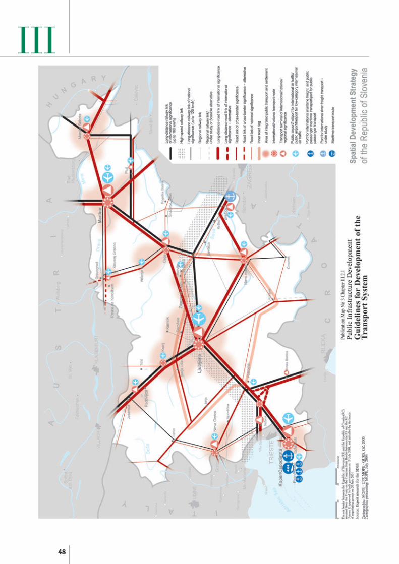
48
III

49
III(2) The telecommunication network shall provideaccess to the high-quality information societyservices important for everyday life, work anddevelopment, and ensure efficient operation of thesystem for the needs of safety, defence, protectionand rescue. For this reason it shall be developed asan efficient, reliable and spatially rational system.
(3) The two primary development generatingtelecommunication axes shall be developed in thedirections of infrastructure corridors V and X (Map No 2). Because of the favourable geographicposition of the country, the possibilities ofmarketing transit telecommunication services shallbe made possible.
(4) Priority shall be given to the interconnectionand integration of the existing telecommunicationnetworks, the optimisation of the use of each ofthem and the systematic introduction of newtechniques and technologies.
(5) Telecommunication cable routes shall beplanned on a priority basis in the existing andplanned infrastructure corridors. When locatingnew telecommunication network equipment andfacilities, preference shall be given to themaximum possible integration and use of theexisting telecommunication network equipmentand facilities, while keeping the health,environmental and spatial impacts as low aspossible.
(6) Because of the introduction of new forms ofteleworking in rural and remote areas, thepreparation of infrastructural conditions shall beensured. The inclusion of the widest circle of thepopulation into the information society shall beensured by providing high-quality access to theInternet. Optimum provision of telecommunicationequipment to educational institutions shall beensured to prepare young people for theinformation society.
2.3 Energy Infrastructure Development(1) The energy infrastructure development isdesigned in such a way as to enable theimplementation of Slovenian spatial developmentobjectives.
2.3.1 Energy systems(1) The energy system is a set of individual energyinfrastructure systems, which enable the country-wide supply of electricity, natural gas, oil and oilderivatives, heat, renewable and other energy
sources. When generating, transforming,transmitting, distributing and using energy –which, as a rule, causes adverse and long-termenvironmental and spatial impacts – account shallbe taken of the principles of sustainable spatialdevelopment and findings about limited resources,as well as about the possibilities for using all actualpotentials in efficient energy use.
(2) The national energy supply is based onindividual energy systems, enabling harmoniousdevelopment of Slovenia and ensuring high-quality,economical and adequate energy supply in therequired form in all regions, towns and othersettlements.
(3) Energy systems shall be developed so as toensure safe and reliable supply. In order to providesafe and reliable supply in all parts of the country,each energy system shall be upgraded in such away that they are integrated into the Europeannetworks, and that the diversification of supply isensured.
(4) Separate energy systems shall be developed tobecome coordinated and complementary, flexibleand adaptable to the changes in society, and aslittle as possible sensitive to any defects caused byman or natural disasters.
(5) The principles of protection of the living andother environment and the improvement of spatialquality shall be observed when developing energysystems. The development of energy systems shallbe based on economical and rational land usewhile conserving and developing spatial potentialsfor other land uses. The spatial development ofenergy infrastructure in common corridors shallbe ensured while endeavouring to decrease theirnumber.
(6) The locations of power facilities andstructures shall be planned by taking intoconsideration, as much as possible, thecharacteristic natural media such as forest edge,foothills, relief characteristics, as well as the visualrange of settlements and characteristic views.
(7) An efficient and economical use of energymust be a permanent development trend inmanaging and planning newly constructedbuildings or facilities, renewal and revitalization,which means a decreasing use of energy whileproviding for an equal or improved quality of lifeand competitiveness of the economy.

50
(8) When planning new structures andmodernizing or extending the existing ones,priority shall be given to the use of renewable andenvironmentally friendly energy sources and themaximum possible neutralization and reduction ofthe dust, greenhouse gases, SO2 and NOxemissions.
2.3.2 Renewable energy sources and efficientuse of energy
(1) Renewable sources of energy comprise waterpotential, biomass, wind energy, geothermalenergy, sun energy, environmental and waste heat,and heat released in combustion of wastes whichcannot be recycled. In planning, precedence shallbe given to the use of these energy sources overfossil energy sources.
(2) The use of renewable energy sources shall bepromoted to increase their share in the primaryenergy balance of the country. Fossil fuels shall bereplaced by the use of the potentials of renewablesources, which can be technologically andeconomically utilized.
(3) The use of renewable energy sources shall beincluded in the energy concepts of regions, townsand local communities. In addition to the analysesof the possibilities of including renewable sourcesand energy self-sufficiency, the energy concepts ofregions, towns and local communities shall also setforth the possibilities of energy conservation andthe methods of promoting efficient energy use.
(4) In the field of efficient energy use, thepreparation of programmes and conditions forefficient energy use shall be ensured throughinterministerial coordination.
(5) Energy-efficient urban planning andarchitectural designing, particularly in the locationof structures, human settlement systems, andenergy-saving methods of construction shall ensurea decrease in the use of energy.
(6) Efficient and economical use of energy shallbe ensured in managing and planning newlyconstructed buildings and facilities, reconstructionand renewal.
(7) The construction of new units for heat andelectric power cogeneration, and district heatingsystems using heat from cogeneration shall bepromoted.
III2.3.3 Electricity system(1) The electricity system consists of electricpower generation, transmission and distributionstructures, networks and equipment. Theelectricity system shall be developed and upgradedso as to ensure safe and reliable electric powersupply in all regions, cities, towns and settlementsin the country. When planning the electric powersupply, comprising generation, transmission,distribution and use, a positive impact on regionaland urban development must be demonstrated inaddition to the energy efficiency, cost-effectiveness,and environmental and social acceptability.
2.3.3.1 Electric power generation(1) To produce electric power, priority shall begiven to the renewal, modernization, ecologicalrehabilitation or replacement of the existing powergeneration units with newer and more effectivepower plants.
(2) Within the future development of electricpower generation, facilities using renewable energysources such as wind, geothermal energy andothers shall be planned, taking into considerationthe effectiveness of the chosen system, and itsspatial, environmental and social acceptability.
(3) Power generation shall be preserved primarilyin the existing hydropower plants on the Drava,Sava and Soča rivers, which will be adapted to theneeds of Slovenian electricity system throughpermanent maintenance, renewal, modernization,and optimisation of their energy potentialutilization. The construction of new hydropowerplants on the Sava river shall be planned. Thepossibility of hydroelectric power utilization in theupper stretches of the Mura river shall beexamined in the framework of an integratedsolution for the regulation of the river bottom. Thesolutions shall be adapted to other uses of water, ifany, while taking into consideration theconservation of biodiversity. To provide the peakpower, the construction of pumped storagehydropower plants on the Drava, Sava and Sočarivers shall be investigated.
(4) In the existing thermal power plants, powerblocks at the end of their life cycle shall bereplaced on priority basis with a cleanertechnology, i.e., power blocks using cleaner fuels.Modern technologies, including the use ofrenewable energy sources, shall be applied in thenew thermal power plants. New thermal powerplants shall be planned at the locations next to the

51
IIIexisting thermal power plants, in the vicinity oradjacent to available power transmission lines, andwithin industrial complexes with suitableinfrastructure and available space. No futureconstruction of coal-fired thermal power plantsshall be planned.
(5) In the scope of the efficient use of fossil fuels,priority shall be given to combined heat and powergeneration. The possibility of cogeneration shall beexamined in all newly constructed and existingthermal power plants, and in all district heatingplants.
(6) The Krško nuclear power plant shall remainin operation. It shall be modernized andrevitalized to maintain its safe operation, and tocreate conditions for a possible extension of its life.
2.3.3.2 Transmission and distribution(1) The power transmission and electricitydistribution network shall be renewed andrehabilitated and extended, and interconnectinglines with neighbouring countries shall be builtand strengthened, particularly with Hungary andItaly, and the transfer from the 220 kV network tothe 400 kV voltage level shall be made. Newelectricity transmission and distributiontechnologies shall be introduced to exploit theexisting routes and infrastructure corridors to themaximum, while new ones shall be planned wherethere are no other possible solutions.
(2) When locating transmission lines, the mostconvenient line routes shall be studied. In additionto the functional and technological aspects, theseline routes shall be spatially adapted to urbandevelopment and in harmony with available spaceand spatial limitations.
(3) The power transmission network of 110 kVand more shall be planned and extended to enablethe inclusion of new production sources, and toprovide – together with the distribution network –stable, reliable, and high-quality electricity supplyto settlements and other major consumers all overSlovenia.
(4) Electricity corridors shall generally becombined with other energy infrastructure and allother infrastructure corridors. In built-up orresidential areas and in cultural heritage areaspriority shall be given to the underground cablealternative.
2.3.4 Gas pipeline systems(1) The natural gas supply system comprisesnatural gas production, transport, distribution andstorage. Gas production in Slovenia is negligible,and therefore the provision of gas in the countrywill continue to depend on sources in various othercountries, which produce natural gas. A long-term,safe and reliable supply from various sources shallbe secured.
(2) To ensure a safe and reliable natural gassupply, the hydraulic flexibility of the pipelinesystem shall be increased, and additional gaspipelines and pipeline loops shall be constructed toincrease gas pipeline transport capacity.
(3) The existing gas pipeline system shall beextended and enhanced to provide for sufficientavailability of natural gas at locations where – inaccordance with the development of humansettlement and economy – an increased use of gasis planned.
(4) Natural gas storage facilities shall be providedto cover uneven consumption and seasonalfluctuations. Until Slovenia’s own storage facilitiesare built, storage facilities are provided for inseveral neighbouring countries.
(5) To ensure the most efficient utilization ofspace, coordinated planning of the gas transportpipeline system and gas distribution pipelinenetwork shall be ensured.
(6) Energy supply for general consumption incities, towns and settlements which are alreadyconnected to the gas pipeline network, and inplaces which – with reasonable investment – canbe connected to the existing gas pipeline network,shall be based on natural gas.
(7) In areas where natural gas supply is still notavailable and there is a possibility of a futuretransfer to natural gas, the supply based on the useof liquefied petroleum gas in the intermediateperiod shall be planned.
(8) Corridors for locating gas pipelines for theneeds of Slovenia’s inclusion into the Europeanenergy integration shall be planned so that themaximum functional connection to the Slovenianenergy and urban networks can be made, takinginto account the existing infrastructure corridors.Functional and technological aspects, spatialadaptation to urban development and conformity

52
IIIwith the environmental conditions shall bechecked.
2.3.5 Oil supply(1) To achieve a safe and reliable supply and todecease sensitivity to the instability of the oil andoil products market, and in accordance with theEU directives, adequate reserves of oil derivativesand safe transport shall be ensured.
(2) Until adequate oil and oil product (includingliquefied petroleum gas) storage capacities areprovided in Slovenia, at locations in Celje,Lendava, Ortnek, Rače, Sermin and Zalog, and inother spatially acceptable locations accessible totraffic, they shall be provided by leasing storagefacilities in neighbouring countries.
(3) In conformity with the environmental andspatial effectiveness, oil storage potential shall beplanned so that it meets the consumption bylocation, i.e., the consumption within thegravitation area of each location.
(4) Long-distance transport to major oil and oilderivatives storages shall be ensured by rail, or inthe case that transported quantities increaseconsiderably, precedence shall be given to theconstruction of an oil product pipeline.
(5) Oil pipeline corridors across Slovenia shall beplanned when these pipelines, in the sense ofsustainable spatial development, provide publicbenefits in the field of spatial development. For theneeds of Slovenia’s inclusion in European energyintegration, studies concerning the location of oilpipelines, whose corridors are planned acrossSlovenia, shall be prepared. Functional andtechnological aspects, spatial adaptation to urbandevelopment and conformity with theenvironmental conditions shall be checked.
2.3.6 Municipal energy supply(1) Municipal energy supply comprises the supplyof the settlements or communities with heat,natural gas, and liquefied petroleum gas throughlocal distribution networks. To improve the qualityof living and energy conservation in settlements,particularly those situated in areas withunfavourable weather conditions, district heatingshall be planned in such settlements.
(2) Cities, towns and local communities shalldefine energy saving and efficient energy supply intheir local energy concepts, taking into
consideration the possibilities of using renewableenergy sources and/or energy self-sufficiency.
(3) The possibility of heat and electricitycogeneration shall be checked in all newlyconstructed and existing district heating plants.
2.4 Water Supply, and Discharge and Treatmentof Waste Water and Rainwater
2.4.1 Water supply(1) To provide for an adequate drinking watersupply, renewal and modernization of water supplysystems and their integration into more rationaland efficient systems shall be promoted andsupervised by experts. The public water supplysystem shall be developed to ensure water supplyacross the entire settlement development zones.
(2) All existing and potentially important waterresources shall be conserved, and economical andrational use of drinking water shall be promoted tomeet the needs for quality drinking water. Sourcessuch as rainwater, treated waste water and seawater shall be used as sources for technological,fire flow, and other water not intended fordrinking.
(3) Only activities which enable spatialdevelopment and – in accordance with the waterprotection arrangement – present no threat to thequality of water resources, shall be steered to thewater protection zones. In the case that waterresources in the existing highly urbanized oragricultural areas are endangered, activeprotection and artificial groundwater rechargingmeasures shall be introduced.
(4) Problems related to water supply shall besolved on priority basis in water deficient areas. Nonew major water consumers shall be located insuch areas, and the use of the latest technologiesand the best technical solutions in the preparationand use of drinking and technological water shallbe promoted.
2.4.2 Waste water and rainwater discharge andtreatment
(1) Waste water and rainwater discharge andtreatment concluded by an appropriate treatmentplant shall be provided for in densely built-upareas, while everywhere else individual waste watertreatment facilities shall be arranged. Priority shallbe given to the provision of waste water and rainwater discharge and treatment arrangements in the

53
III

54
of secondary raw materials, and processing ofbiodegradable waste.
(5) At the regional or inter-municipal level, the so-called regional waste management centres shallsubsequently sort wastes, provide for theirtreatment and processing, as well as the recyclingand reuse of separately collected waste fractions,marketing of secondary raw materials,mechanically and biologically treatedbiodegradable waste, waste preparation for thermaltreatment, and the disposal of residual waste fromthese processes. To accomplish the wastemanagement objectives, regional centres shall beorganized in a spatially rational manner,particularly as regards gravitation areas andtransport possibilities. The centres of the first,second and third order shall be organized tomanage waste. Regional centres of the first ordershall also include the management of high-riskanimal waste, other organic waste and hazardouswaste.
(6) Thermal treatment of residual waste and thedisposal of residual waste following thermaltreatment in two, or maximum three, powergenerating installations with simultaneous energyutilization shall be planned so as to cover theentire Slovenian territory.
(7) Spatial arrangements for the thermaltreatment of waste shall be planned in such a wayas to ensure connection to the existing energynetworks, i.e., electricity and gas pipeline systems,the utilization of heat for district heating or forcommercial exploitation. Spatial arrangements forcoincineration of waste shall be planned ascommercial facilities in areas with access to therailway network and available space for thedisposal of residue from thermal treatment ofwaste.
(8) Complete functional areas with pertainingwaste management centres shall be formed ascollection areas for municipal waste management.The waste management areas shall be determinedon the basis of an adequate number of potentiallyinvolved inhabitants, homogeneous internaltransport links, the shortest possible transportdistance, and the existing waste disposal ormanagement.
(9) The centres of the first order or regionalwaste management centres, which are the highestform of merging preceding thermal treatment,
IIIareas of the centres of national, regional and inter-municipal significance and tourist settlements, andparticularly in settlements situated in areas whichare defined by regional regulations as sensitive andwater protection zones.
(2) Inadequate and overloaded sewerage systemsshall be rehabilitated and modernized. Priorityshall be given to such rehabilitation in sensitiveand water protection zones.
(3) Rainwater and waste water shall be dischargedseparately where this is economically justified andtechnically possible. Rainwater shall be retained atthe place where it fell for as long as possible, whilehinterland water shall be discharged by way ofsurface outflow past settlements to the nearestsurface water drainage system.
2.5 Waste Management(1) Waste management is an economic activitysubject to significant development generatedchanges. It is provided by means of variousfacilities, which are interconnected with thehuman settlement network and other sources ofwaste (industry, energy, construction, agricultureand forestry, and other production activities).
(2) Based on the established waste managementsystem, a hundred-percent coverage of the statewith waste management facilities shall be ensured.Waste management shall provide for the reuse ofwaste, reduction in the quantity of waste and in itsdanger potential at source, safe final disposal andabolition of unregulated waste landfills and otherhistoric burdens. Final waste disposal in a spatiallyrational way shall be ensured, while taking intoconsideration the environmental protectionrequirements and social acceptability of thelocation.
(3) Municipal waste management shall beprovided for at three levels: local, regional or inter-municipal, and national. A supplementary networkof minor centres is primarily the consequence ofalready existing relationships and allows for thepossibility of forming waste management alliancesbetween local communities at different levels.
(4) At the local level, separate collection ofmunicipal waste at the source shall be ensured,and – depending on the natural, spatial, transportand logistic, and other conditions – collection, alsosubsequent sorting, recycling, and reuse of someseparately collected fractions of waste, marketing

55
IIIshall be planned to be set up depending onparticipation of the population (90,000 inhabitantsor more) in the Pomurje, Podravje, Savinjska, andDolenjska region, in Ljubljana with surroundings,in the Gorenjska, Northern Primorska and theCoastal region.
(10) The centres of second order shall be plannedfor smaller areas having 55,000 and 90,000participating inhabitants in the framework of theEastern Prekmurje, Lower Podravje, Dravinjska,Koroška, Zgornja Savinjska valley, Zasavje,Vrhniško – Notranjska, Kraško – Notranjska, andPosavje regions.
(11) The centres of second order may be planned ifthey have adequate capacities for integrated wastemanagement for a certain area. They can alsoassume the function of centres of the first order ifthey provide for waste management for the entirearea as the centres of the first order and meetother conditions defined for centres of the firstorder.
(12) The centres of the third order or subcentresshall cover small areas which have insufficientnumber of inhabitants for economically rationalwaste management over long transport distances,yet they are homogeneous or else they alreadyindependently manage waste on a long-term basis.
(13) The existing inappropriately regulatedlandfills, or the so-called “illegal dump sites” –which can be a potential source of pollution ordisturbances in space – shall be regulated andrehabilitated on a priority basis. Within therehabilitation, environmental and technicalconditions measures preventing potential pollution
of natural resources shall be provided for, as wellas spatial restoration within which appropriate useof restored land shall be planned.
2.5.1 Radioactive waste(1) Permanent disposal of low- and intermediate-level radioactive waste (hereinafter: LILRW) shallbe provided for on the national territory inaccordance with applicable legislation on theprotection against ionising radiation, nuclearsafety, international conventions and treatiessigned by the Republic of Slovenia before theNuclear Power Plant at Krško comes to the end ofits life, while the solutions for permanent disposalof high-level radioactive waste (hereinafter: HLRW)shall be sought in collaboration with the widerinternational community.
(2) The initial areas for the selection of locationsfor LILRW repositories shall be prepared on thebasis of the results of expert evaluation of theterritory regarding its suitability for LILRWdisposal, and will be based on criteria determiningthe safety of the repository. The assessment ofalternative locations within the basic areas shall beperformed in accordance with internationalpolicies through assessing and evaluatingalternative solutions in terms of their effects on theenvironment and on the regional and urbandevelopment, in economic terms, in terms offunctional and technical suitability, and also ofsocial acceptability.
(3) The location shall be selected in a combinedprocedure including professional – expertassessment and the acquisition of local offers forlocations, and ensuring a high degree of publicparticipation.

56
III

57
(7) Predominantly urban and intensivelyagricultural landscape represents the hinterland ofmajor urban centres, mostly in the flatlands ofSlovenia, where the pressure of commercialactivities and services on the landscape, and theneeds for intensifying agriculture and the relatedconservation of the high productive potential ofthe soil are particularly strong. When resolvingconflicting interests between the intensification ofagriculture, conservation of farming land, andhuman settlement development, opportunities forhuman settlement shall also be sought in woods,providing that minimum impact on the essentialecological functions of forests is ensured. Specialattention shall be devoted to the location of urbanland uses in terms of the harmonious visualappearance of the built and natural components,i.e. the transition to cultural landscape.
(8) Natural qualities, the identity and quality ofnatural resources, and threats from hazardousnatural processes and other disasters are thecriteria to be used when locating individualactivities in the natural, cultural or urbanizedlandscape. Activities shall be located in areas withthe highest potentials for such activities wherethere are, at the same time, the least vulnerablecomponents of the natural and built environment,components of the cultural landscape and of theregional and urban development.
(9) Those spatial solutions and programmes,which enable long-term conservation of spatialqualities, shall be supported, and those initiativeswhich are based merely on short-term economicbenefit and prevent the establishment of high-quality spatial solutions shall be rejected. Suitableactivities shall be promoted in areas where theobjective is to permanently conserve the landscapeidentity, cultural variety and biodiversity, naturalvalues and the qualities of such personalexperience.
(10) Conservation requirements set forth inrelevant regulations shall be respected in thelandscape development planning.
(11) Joint conservation shall be promoted in areaswith expressed interests for the conservation ofbiodiversity, natural values and cultural heritage,and for the protection of natural resources andother qualities of the living and workingenvironment.
III3 Landscape Development(1) Landscape development is the rearrangement,renewal or conservation of the spatial proportionsin landscape to locate new activities or modernizethe existing ones, while considering the actualnatural and cultural features in such landscape.
(2) Landscape development is optimal, when bylocating the activities, we make landscape afunctional, ecologically and visually balancedsystem of spatial structures, which enables ahealthy, safe and pleasant living environment,when development conserves as much as possibleof the natural structure, retains cultural layers,and provides space for natural processes, and whenlandscape development enables the landscape tobecome the carrier of national and local identity.
(3) Landscape is developed in three prevailingdirections, i.e.: as predominantly naturallandscape, as predominantly cultural landscape,and as predominantly urban and agriculturallyintensive landscape.
(4) Predominantly natural landscape is mostlyshaped by the natural qualities of physical spacearising from the state of preservation of nature,biodiversity and natural values, which are alsoimportant for Slovenia’s identity.
(5) Natural landscape shall be developed inharmony with the natural dynamics within theremote and mountainous areas in the north, north-west and south of the country, where man’sdevelopment is limited due to the prevailingnatural features, difficult living and workingconditions, or dynamic natural processes. Humansettlement, unless endangered by hazardousnatural processes, shall be preserved for nationaldefence reasons, and therefore the transport linksto the local centres shall be improved, and specialdevelopment programmes in the field of organicfarming or sustainable tourism shall be promoted.
(6) Predominantly cultural landscape covers amajor part of Slovenia and, together witharchitectural and landscape heritage, shapes thecultural identity of Slovenia. Cultural landscapeshall be developed primarily in areas which areremote from major urban areas – in hilly,mountainous areas, plateaus, karstic areas, andpoorly percolated plains. The prevailing feature isa mosaic of forest interwoven with agrarianlandscape patterns and traditional settlementstructure.

58
experience, and a representative character of thearea at the national level.
(6) Landscape areas with recognizable features,which are important at the national level, are:Bohinj, the Fužinarsko-Studorske planine alps,Bled, Lipica, the Škocjanske jame caves, a part ofBrkini and the Matarsko podolje valley, theCerkniško polje plain, the Planinsko polje plain,the Snežnik castle, Loški Potok, the Ljubljanskobarje marshes, a part of the central SlovenskeGorice, Bitnje, Brdo pri Kranju; a part of Bržanijaand the Movraška dolina valley; the area of Rut,Grant, Stržišče and Kal; Srednji vrh above GozdMartuljek, the Kolpa valley under Stari trg, thearea of Strmica – Predjame, Strojna, the Kapelskegorice hills, the area of Gora, the area of Negovaand Trije Kralji; Polhov Gradec and Črni Vrh, theRadensko polje plain, Prem and Suhorje, the Borlcastle, Jezersko, the Soteska and Stare Žagevalleys, the area of Fala, a part of Goričko,Gorjanci and Podgorje, the area of Idrija, theJeruzalemske gorice hills, Kras, the Lipniškadolina valley, the Mirenska dolina valley, Otočec,the area of Kozjansko, Obsotelje, Bizeljsko, theRibniško Pohorje, the area of Rogatec andDonačka gora, the area of Strunjan, Šavrini, thearea of Šentjanž nad Dravčami, the area ofSmlednik and Šmarna gora, the Trenta valley, thearea of the villages below Čaven, Velika Planina,the Vipavska brda, Paški Kozjak, the wider area ofVolčji Potok, the Zgornja Mežiška dolina valley, theZgornja Selška dolina valley, the area of Žičkakartuzija (Carthusian monastery), the Zadrečkadolina valley, the area of Dolsko and Krumperk,southern Pohorje, Košenjak, the Zgornja Savinjskadolina valley, a part of Belokranjski ravnik, thelower part of Goriška Brda, a part of Haloze.
(7) The conservation and development oflandscape areas with recognizable features, whichare important at the national level, shall beensured primarily through appropriate planningand programming. Landscape areas withrecognizable features, which are important at thenational level, can also be protected if this providesfor additional opportunities for their successfulmanagement.
(8) In the landscape planning procedures, thelandscape areas with recognizable features shall bedealt with as rounded landscape areas, ensuring inthese areas such spatial development that theircomprehensive identity is preserved.
III3.1 Identity of Slovenia from the Aspect of the
Cultural and Symbolic Significance ofLandscape
(1) By preserving and establishing cultural andsymbolic landscape identity, we provide for anenhanced attractiveness of these areas, specificdevelopment opportunities, a high-quality livingenvironment, and the possibilities for inhabitantsto identify with the national territory. Diversecultural landscape, rural architectural heritageresulting from climatic, geological, relief, andhistorical conditions, and natural values withdistinctive and recognizable features shape thecultural and symbolic identity, and the value ofpersonal experience of the Slovenian landscape.
(2) The landscape identity factors are: structuralvalue denoting the visual quality of a landscapearea, degree of harmony between morphologicaland typological landscape characteristics and landuse, landscape structure composition withcombinations of natural and cultural media forms,complexity within the same structural unit, theauthenticity and historical significance ofstructure, the quality of the location of builtstructures or their placement patterns, the historicor symbolic meaning of individual parts or of thewhole, all of which represent the qualities ofpersonal experience of individual landscape areas.
(3) The general cultural and symbolic landscapeidentity of Slovenia is formed at the level of Alpine,sub-Alpine, sub-Pannonian, Karst and Coastallandscape regions.
(4) Landscape areas of importance at the nationallevel consist of areas which include recognizableand representative parts of the Slovenianlandscape with well-preserved landscape elements,and which are in particular outstanding landscapeswith rare or unique landscape structure patterns,as well as spatially emphasized cultural heritagewith high historical or monumental significance,frequently in combination with outstanding shapesof natural media, i.e., natural values.
(5) Nationally important landscape areas shall bedefined on the basis of criteria: the abundance andquality of architectural heritage, presence ofcultural landscape, the presented cultural heritageand museum network, interconnection of culturalheritage and territorial completion of ethnic space,spatial conservation and spatial identity, symbolicmeaning of natural media, high value of personal

59
(9) A special cultural and symbolic meaning isassigned to the Slovenian sea where such spatialdevelopment shall be ensured that the cultural andsymbolic meaning of the sea and its biodiversity isconserved.
3.1.1 General guidelines for preservingthe identity of landscape areas
(1) General guidelines for conserving the identityof landscape areas shall be adhered to inprogrammes and plans of individual sectors andlocal communities in such a way as to ensure thatthe recognizable and typological features oflandscape areas and the values of experiencingsuch landscape are taken into consideration. Thesuitability of their spatial location shall be assessedin terms of their contribution to the enhancementof landscape identity.
(2) The factors related to landscape identity shallbe treated as development generating factors,which enhance the attraction of the areas forinhabitants, investors, and visitors. Activities suchas sustainable use of heritage, tourismdevelopment in connection with cultural valuesand with traditional farming activities, formationof culture pathways etc. shall be promoted in theseareas, thus contributing to the economicdevelopment and increased recognizability.
(3) Special attention shall be devoted to theinterface between settlements and open landscape.The landscape identity factors shall be taken intoconsideration when expanding, designing andfunctionally locating activities in human settlementdevelopment areas in such a way that no activities,whose form and size has a negative impact on therecognizable appearance of cities, towns and othersettlements in the landscape, are placed at thefringe of cities, towns and settlements.
(4) Agricultural and other suitable land uses shallbe promoted in areas where overgrowing wouldmean the loss of a significant part of therecognizable cultural components of landscape, inorder to conserve such components. The basicspatial directions and field subdivision shall beadhered to when consolidating agricultural landinto larger plots.
(5) As a rule, no activity or development affectingthe environment shall be performed in forests onslopes; when any such activity is necessary, thepotential for generating the focal points of erosionshall be prevented and the minimum visibility of
such activities shall be ensured. As a rule, noactivity or development shall be performed inplaces exposed in terms of relief or geomorphologyand visible places; an exception applies tostructures, for which it is important that they arestressed as spatially dominant.
(6) When planning infrastructure or otherfacilities and structures or land development forthe needs of certain activities which involveextensive spatial developing activities, negativeimpacts shall be prevented and solutions whichhave the minimum possible effect on the landscapeidentity factors shall be selected.
3.1.2 Ensuring the conservation ofrecognizable features at the level oflandscape regions
(1) When planning land use and spatialarrangements in individual landscape regions,general guidelines for the conservation of identityof landscape areas and guidelines for theconservation of architectural identity shall beobserved. In addition, within individual landscaperegions, their specific features shall also be takeninto consideration.
(2) In Alpine landscapes, account shall be takenof the considerable natural dynamics, naturalprocesses, vulnerability of high-mountain areasand micro-relief, and the characteristic shapes ofrelief.
(3) In sub-Alpine landscapes, the spatialorganization in mountainous and hilly areas,characterized by “celek” (solitary farm enclosed byforest), the vulnerability of underground waters,and structural value of autochthonous vegetationin flatland areas shall be considered.
(4) In sub-Pannonian landscapes account shall betaken of the characteristic organization of landuse, related to relief and slope exposition, thevulnerability of underground waters,autochthonous vegetation and water ecosystems.
(5) The structure of karst fields (poljes) andvalleys, other specific karst features and thevulnerability of karst aquifers and subsoil shall betaken into consideration in the Interior Karstlandscapes of Slovenia.
(6) In the coastal landscapes, account shall betaken of the characteristics of relief andgeomorphology, vulnerability of natural parts of
III

60
the seashore and the sea, and the ecologicsignificance of natural vegetation for thelandscape.
3.2 Natural Landscape Qualities(1) The natural qualities of Slovenian territoryrepresent a Slovenian advantage compared toelsewhere in Europe. Natural qualities have afavourable influence on the environment inSlovenia, on the quality of living conditions, andpresent the basis for ecologically oriented activitiesin rural areas.
(2) Natural qualities are the features of areas witha high degree of conservation and biodiversity,areas with continuous forests in natural landscape,areas with high-quality water ecosystems, high-mountain areas where human influence on natureis the lowest, and areas with well-preserved naturalprocesses.
(3) These are ecologically important areas, specialconservation areas, natural values and other areaswhere such features are present.
(4) Natural qualities are particularlycharacteristic of the area of the Julian Alps, theKamniško Savinjske Alpe and Karavanke mountainchains, Snežnik, Krim and the Kočevsko region,Nanos and Trnovski gozd, the catchment areas ofthe Ljubljanica, Soča, Drava, Mura, Kolpa,Dravinja rivers and the upper stretches of the Sava.Other smaller areas with a predominant degree ofnature conservation throughout Slovenia are alsoclassified as areas with natural qualities.
3.2.1 Nature conservation(1) Conserved biodiversity and natural values arean important part of the natural landscapequalities.
(2) The conservation of biodiversity andprotection of natural values shall also be ensuredthrough spatial development, which respects thesequalities and integrates them in a suitable manner.
(3) In the areas of predominantly naturallandscape these are regions such as those listedabove, while in the areas of cultural landscapesthese are e.g., Kras, Goričko, Kozjansko, andPohorje.
(4) The existing national reserves are: the TriglavNational Park, the Škocjanske jame caves, theŠkocjanski zatok bay, the Sečoveljske soline
saltpans, Goričko, the Kozjanski park, the Sočariver, Strunjan, the Debeli rtič peninsula, the RtMadona peninsula, the Kolpa river, the Predjamaand Postojna caves system.
(5) The state is responsible for protectingoutstanding natural values of national significanceand the areas of importance for the conservationof biodiversity, i.e. ecologically significant areasand special conservation areas (Europeanecological network). Local communities areresponsible for the conservation of natural valuesof local significance.
3.2.2 Guidelines for conservation of naturalqualities
(1) Planned spatial development and location ofindividual activities shall serve to ensure thepreservation of natural processes and vitality oflarge and small areas with natural qualitiesthroughout Slovenia. The maintenance andestablishment of landscape structures, which areimportant for the conservation of biodiversity(continuity and interconnection), favourable statusof habitat types, which are conserved on prioritybasis, and the habitats of endangered species.
(2) In special conservation areas (Natura 2000),biodiversity, and particularly the habitats of plantand animal species which are of particularsignificance for the European Community, shall bemaintained by means of land use, which enablesthe establishment or maintenance of a favourablestatus of these species.
(3) In anthropogenic ecosystems, which areimportant for the conservation of the habitats ofplant and animal species, or of special significancefor the European Community, and include culturalqualities and particularly cultural heritage,solutions enabling satisfactory conservation of bothnatural and cultural qualities shall be developed.
(4) Land developing activities of greaterproportions in areas with natural qualities must bewell considered so as to ensure an unhinderedcourse of natural processes and to prevent thefragmentation of natural ecosystems and the lossof vital parts of habitats important for natureconservation. The extent of inundated areas orrun-off regimes shall, in principle, not be changed.When this is necessary, a suitable replacement forthese surfaces shall be provided. Wild animals shallbe provided with optimum passages acrosspermanent man-made barriers in physical space.
III
61
(5) In areas where man’s influence on nature issmall and natural ecosystems prevail, new humansettlement shall not be encouraged, yet it ispermissible on condition that this is important fordefence reasons, and providing that the impacts ofthe related settlement infrastructure will produceno fragmentation of natural areas.
(6) In the areas above the timberline, in areaswith severe weather conditions, and in protectiveforests, no interference with the subsoil orvegetation shall be permitted when it wouldimpede or significantly decrease the capability ofnatural vegetation restoration, and particularlywhen this would trigger erosion processes.
(7) Such forms of agricultural activities, whichenable coexistence of human activities and nature,shall be ensured in areas with natural qualities.
(8) Adapted and non-aggressive forms of tourism– excluding mass tourism – and recreation in thenatural environment shall be permitted in areaswith natural qualities, provided that the touristand recreational infrastructure is generallyprovided for in settlement development zones.
(9) Forests and other forms of natural media inthe areas of endangered species corridors and inareas enabling genetic interconnection of theirpopulations shall be maintained as natural aspossible, i.e., as an ecologic support structure,while new human settlement and other commercialactivities and services shall be spatially structuredto enable unhindered passages.
(10) The conservation of biodiversity, naturalvalues or natural qualities shall also be ensured byprotection, whereby in large protected areas theprotection and simultaneous spatial considerationshall be steered so as to provide for regionaldevelopment and the promotion of special forms ofdevelopment. In areas containing cultural andsymbolic qualities in addition to the natural assets,common spatial development solutions shall beprovided.
(11) In border areas with natural areas on bothsides of the border an integrated consideration ofnatural ecosystems shall enable theirinterconnection and integration into internationalecological networks and protected areas.
3.3 Use of Natural Resources(1) Natural resources, soil, water, air, forest,mineral resources and space are important forspatial development of the country and the qualityof life, whereby the country shall be made self-sufficient and independent of foreign resources toa degree which can be achieved considering theavailability of natural resources, which can beexploited for economic purposes, the socialacceptability of their use, and the lowest possibleenvironmental impacts.
(2) Cost effective, prudent, and spatially rationaluse of natural resources shall be ensured toconserve potentials, renewability and quality, toensure their long-term existence, and to conservebiodiversity, natural values and cultural heritage.
(3) Activities and spatial arrangements shall belocated in such a way that they will not reduce theopportunities for exploitation or use of non-renewable natural resources in the future, and alsoensure that there is the lowest possibility forcausing pollution of natural resources, which couldpotentially reduce their quality and usefulness.
(4) In addition to water, space is the mostimportant non-renewable natural resource. Landuse for individual activities shall be determinedwith regard to the quality of natural resourcesrequired by a particular activity.
3.3.1 Productive potential of soil foragricultural use
(1) Agricultural activities shall be steered onpriority basis to the areas with high productivepotential of soil for agricultural use. In Slovenia,such areas, which represent between 15 and 20%of all Slovenian agricultural land, are in theVipavska dolina valley, in the Ljubljansko, Sorško,Brežiško – Krško, Dravsko, and Mursko poljeplains, in Slovenske Gorice, in percolated plainsalong the rivers and in fields. The high productivepotential of soil for agricultural use is the featureof land with the best characteristics of soil,enabling the widest agricultural land use, and landwith good soil characteristics, particularly onvaried relief where there are the most convenientpositions for permanent crops (orchards,vineyards).
(2) Agricultural land with high and goodproductive potential of soil for agricultural useshall be defined – upon prior harmonization with
III

62
other interests and based on the vulnerability ofenvironmental components – as the bestagricultural land. The best agricultural land shallnot include wetlands on the assumption ofimprovement of their properties by land drainagemeasures. The excluding criterion in determiningthe best agricultural land also includes thoseerosion areas where the risk of erosion cannot bemitigated by means of farming technology.
(3) Agricultural land with poorer soilcharacteristics, position, inclination or expositionshall be defined as secondary agricultural land.Outstanding, rare types of soil, such as terra rosaand peat bogs shall be defined as agricultural landearmarked for permanent conservation.Agricultural land, which is unsuitable for foodproduction due to pollution, or suitable only forcertain agricultural activities, shall be separatelydefined.
(4) Agricultural activities shall be promoted inareas with poorer productive potential of soil foragricultural use, if this enables the conservation ofcultural and symbolic qualities of the landscape orbiodiversity and natural values.
3.3.1.1 Land use guidelines(1) In areas with the high and the goodproductive potential of soil for agricultural use,where no particular limitations concerning theprotection of groundwater as drinking waterresources apply, agricultural productionmodernization measures or land improvementmeasures can be performed, while taking intoconsideration the existing landscape structure, thenetwork of roads and pathways, spatial directions,natural corridors and the logic of landscapepattern.
(2) To protect underground waters as drinkingwater resources, the agricultural activity on landwith the high and the good productive potential ofsoil for agricultural use – i.e., in the plains:Dravsko, Mursko, Apaško, Prekmursko, Ptujsko,Sorško, Kranjsko and Ljubljansko polje, and in theSpodnja Savinjska dolina valley, the valleys of theKamniška Bistrica and Polskava rivers – shall betechnologically adapted to these requirements orredirected to the production of other crops. Theimplementation measure aimed at improving thequality of surface waters shall be to plantautochthonous vegetation while considering thevisual landscape image, and gradually to withdrawfarm activities from waterside building sites.
(3) Farming shall also be adapted accordingly inother water protection zones, in other conservationzones, in zones endangered by harmful action ofwaters and in areas endangered by unfavourableweather conditions.
(4) The reorganization of farms in rural areasshall be encouraged in areas with the highproductive potential of soil for agricultural usewhen, regarding the orientation in farming, anadequate concentration of property is ensured,while taking account of the settlement andlandscape patterns and environmentalvulnerability.
(5) Permanent crops (vineyards, orchards) shallbe planned in wine and fruit growing districts. Newpermanent crops shall not be located in erosion-prone, sliding, and landslide-prone areas or onunstable land. When renovating the existingpermanent crops, the selected form of cropplantation shall be such that the erosion hazard isreduced to the minimum.
(6) Areas where agrarian operations have causedlandscape and ecosystem depletion shall begradually restored, primarily by introducing alarger share of natural media, particularlyvegetation or water media, and/or by the exclusionof a certain portion of farmland from use.
(7) When locating new human settlement, thestructures of public infrastructure and economiczones, an adequate distance from areas with thehigh and the good productive potential of soil foragricultural use shall be ensured, or suitablevegetation belts shall be provided due to thepotential risk of soil pollution and the resultingreduction of production potential.
(8) The structural role of agricultural land in thelandscape and its socio-economic significance shallbe taken into consideration in the requests foralteration of the use of land. The publicinfrastructure facilities and arrangements shall belocated in the areas of agricultural land with thehigh productive potential of soil for agriculturaluse only if it is not possible to use land that is lesssuitable for farming, and in such a way that theimpact on the fragmentation of continuousfarming land is as low as possible.
3.3.2 Increased sustainable wood production(1) Forests, in terms of surface area, represent themost extensive use of land and the largest natural
III

63
system. Because of the very large Slovenian forestcover, the expansion of forested areas shall not bepromoted. However, wood production shall bepromoted wherever possible with regard to thenatural constants and at the same time when notin conflict with the protection of other resources,yet in a way ensuring that the most sustainablemethod of wood production is applied. Forests withsufficient wood reserves, with the exception ofprotective forests and protected forests, shall beearmarked for wood production. Wood productionin forests earmarked for specific purpose shall becarried out in line with this specific purpose.
(2) Activities which have no long-term impact onthe change of the forest condition and the qualityof natural resource, and which present nohindrance to forest management, shall bepermitted in forests.
(3) The management shall be adjustedaccordingly in forests with high landscape,ecological, cultural or recreational significance. Asa rule, forests in the plains, groups of trees orsolitary trees in agricultural landscape shall not becleared. Forestation with autochthonous species ispermissible in agricultural areas with a small shareof high vegetation, and also in water protectionzones.
(4) Forests in settlements, which have animportant role in ecological balance andlandscape, shall be conserved and integrated in thegreen systems of settlements with suitable forms ofrecreational use. In the vicinity of cities, forestsmay be assigned for human settlement when thisdoes not represent a critical interference with theecological balance.
(5) The utilization of forests requires acomprehensive system of forest roads, which are tobe planned rationally and in harmony with theenvironmental requirements. The construction offorest roads must not cause visible degradation,destroy natural values, or trigger any erosionprocesses.
(6) In forests degraded due to air pollution andother negative impacts, particularly in the Zasavjeregion, in the Mežiška and Šaleška dolina valleys,remedial measures shall be applied to graduallyrestore ecologically stable forests.
3.3.3 Use of waters(1) Waters are the most important resource forspatial development, and at the same time the mostvulnerable natural resource. The most importantinland water systems for spatial development arethe Sava hydrographic system including theLjubljanica river, the Drava, the Mura and theSoča hydrographic systems, lakes and the sea.Water from these systems provides the basis forresidential water supply, and for industrial andrecreational use.
(2) Waters are utilized for water supply,industrial, and recreational purposes, whileensuring their protection in the sense ofpermanent conservation of their chemical andecological status, natural resource renewability,and the protection of ecological, landscape andpersonal experience-related significance of watersin landscape, including with the high-quality man-made development (millraces, piers, cultural strata,etc.). When preparing spatial planning documents,their comprehensive consideration by river basinsand sub-basins shall be ensured.
(3) Because of the vulnerability of ground waters,which represent the largest drinking water reservesin Slovenia, and water resources for the watersupply to the population, activities shall be locatedin the least vulnerable areas, and the use shall betechnologically adapted so as not to degrade thequality of ground water or water resources, andnot to decrease their quantity. As a rule, spatialdevelopment of activities shall be planned whereadequate drinking water supply to the populationcan be provided without major spatial developmentactivities.
(4) Rivers to be assigned for recreation inaccordance with spatial possibilities and limitationsinclude: the Soča, the upper stretches of the Sava,the Krka, the Kolpa, the Ljubljanica, the Savinja,and other small rivers, as well as the Bohinj lake,the Bled lake, the Cerkniško jezero lake, and lakesof anthropogenic origin, made by building damson streams or by mining operations. Recreationalareas on waters with suitable water quality canbecome areas where it is possible to organizeaccess of such a form that the morphologicalcharacteristics of waters are not changed andwhere the recreational use of water is not contraryto the vulnerability of water ecosystems andpersonal experience-related features of water andwaterside landscapes. To decrease the pressure of
III

64
tourist activities on the seacoast, the use of inlandwater for recreational purposes shall be promoted.
(5) In the Slovenian Coastal zone, activitiesensuring the shaping or conservation of high-quality shore shall be promoted in accordance withspatial possibilities and limitations.
(6) The development of those activities whichindispensably require the presence of the sea fortheir performance, which cause no deterioration ofwater quality but rather enhance the quality ofuse, and in the process present no hindrance topublic access to the sea and shore, shall be enabledon the sea and in the coastal belt. No developmentactivities which might narrow the view of the seaand endanger the conservation of nature andcultural heritage shall be performed in the coastalor inshore belt. The shoreline shall not beshortened; it may be lengthened in conformitywith spatial possibilities and limitations.
(7) Arrangements and solutions provided tobridge water surfaces shall be such that the threatof flooding is not increased.
(8) Water infrastructure on surface waters shallserve to ensure appropriate management of watersystems, and consequently enable the functioningof natural processes on waters or beside them.Water infrastructure shall be located in harmonywith natural morphology at visually less exposedplaces, and by generally using such materials sothat the negative visual effect is minimized. Waterinfrastructure shall be positioned so that, in thecase of its disruption, the impact area shall notrepresent a major threat to people or their materialgoods.
(9) Appropriate measures shall be taken inregulated surface waters to enable theimprovement of their hydrological condition andits morphology, i.e., to establish the ecological andlandscape-related role of waters in the landscapewhere this is not in conflict with the provision offlood protection.
3.3.4 Self-supply with minerals(1) Minerals are a non-renewable naturalresource, which shall be managed in such a way asto ensure a balanced supply and to preserve accessto minerals for future generations. A balancedsupply, based on the harmonization ofenvironmental, economic and social aspects shallconsider the spatially rational optimisation of this
activity in view of the market and spatial needs andalso decrease the number of surface mineralmines.
(2) When exploiting mineral resources, attemptsshall be made to optimise the acquisition andgradual closing of small facilities, as well as torehabilitate illegal pits. The total number offacilities shall be optimised with respect to theenvironmental, economic and social criteria,including the geologic suitability, adequate reservequantity, adequate annual production, functionalconnections with the users the radius of saletransport, visual unnoticeableness of the areas andappropriate distance from human settlements.These criteria shall also be used when grantingconcessions for the exploitation of minerals.
(3) The spatial planning process shall ensure theprotection of mineral resources for futuregenerations, including the provision of restrictionsfor other land uses in these areas.
(4) New facilities shall be opened only in the caseof a considerable increase in demand, whichcannot be met from the existing facilities withinthe area of economical transport distance.
(5) Priority shall be given to the restoration ofsurface mines with a negative impact on theenvironmental components, and mines in areas,which are important because of their national,regional or local identity.
(6) In the areas with natural spatial qualities,surface mines shall be rehabilitated, primarily byrestoring their natural condition or a secondarybiotope, while in the areas where priority is givento the use of natural resources, they will berestored to land intended for primary activities, inurban areas to urban land uses, and in the areas ofidentity to a form which is optimal from theviewpoint of ensuring the spatial identity.
(7) The sites of strategic, economically significantand autochthonous, frequent or other mineralresources shall be designated in the light of useand accessibility.
(8) The sites of strategic minerals include theexisting and potential deposits of energy-producingminerals, important for the national energy supply.These are coal, uranium, oil and gas deposits, andgeothermal energy sources. Such sites of mineralresources shall be spatially protected.
III

65
III(9) The extraction sites of economically importantand autochthonous mineral resources include thedeposits of calcite, lacustrine carbonate laminite,bentonite, tuff, chart, quartz sand and quartzgravel, ceramic and brick clay, and minerals for thecement industry. The extraction of autochthonousminerals serves primarily to provide traditionalconstruction materials.
(10) The extraction sites of other (frequent)mineral resources are the sites where minerals forthe construction industry are extracted based onthe criteria of equable access to mineral resourcesat the level of regions, the possibility of restoringthe natural spatial features, and socialacceptability. Current deposits in rivers may beexploited to obtain fine sand, gravel and sand, butonly after having established the low vulnerabilityof the water ecosystem, water quality,geohydrological properties of the river upstreamand downstream, and of the qualities of personalexperience related to the water landscape andwaterside landscape.
(11) Locations for the exploitation of rare andunique mineral resources, e.g. granite, tonalite andmarble, shall also be allowed in the areas ofnational identity and natural qualities if onlyperiodical extractions are involved.
3.3.5 Development of tourism and leisureactivities
(1) Areas with natural qualities, culturalheritage and recognizable landscape areasprovide a comparative advantages for tourism inSlovenia. Also attractive for tourism are areasenabling certain specific and seasonal forms oftourism, particularly activities related to waterand winter sports, and areas provided with theappropriate tourist and recreationalinfrastructure. The development of tourism andrecreation should ensure the optimum – on along-term basis – exploitation of comparativeadvantages in individual areas. It should involvethe local population and local communities,particularly in border areas, in both rural areasand towns.
(2) The spatial development of tourist activitiesand the necessary infrastructure shall be enabledprimarily in the framework of the basic touristareas, i.e., the Julian Alps, the Coastal region,Karst, the Goriška region, Ljubljana, Maribor withPohorje, the Pomurje, the Obsotelje, and the
Dolenjska regions, Slovenian rural areas and townswith their hinterland. Cultural, health spa, rural,recreational, experiential, ecologic, gambling andentertainment, and business related tourism, andother forms of tourism shall be developed in thementioned areas in accordance with spatialfeatures and restrictions.
(3) Tourist activities shall be steered so that therange of tourist facilities, attractions and servicesincludes as many areas as possible with specificregional features where high-quality, diverse andregionally recognizable tourist products can bedeveloped, which have the minimum possibleimpacts on the environmental components, natureand cultural heritage. The inter-connectedness ofprogrammes and complementing the range oftourist facilities and services, with optimumutilization of tourist infrastructure shall beensured, and the restructuring of tourist areas atthe Coast and in the Julian Alps towards animproved quality of the environment, programmesand services. Excessive spatial concentration oftourist programmes and tourist infrastructure shallbe prevented in order to decrease pressure inexcessively frequented areas, such as the fringes ofthe Julian Alps and the Coast. The developmentopportunities of various components of culturalheritage or landscape for tourist and recreationalactivities shall be exploited.
(4) In the Coastal areas, the development oftourist activities shall be steered towards increasingthe quality and using advanced technologies todecrease the use of natural resources in order tocontribute to the reduction of environmental andspatial pressures. Support shall be given to thedevelopment of “bathing” towns on the Coast,which include the provision of modern andattractive bathing capacities, public and othermaritime passenger transport, accommodationcapacities and other programmes in connectionwith Slovenian lstria and Karst. When planningnew areas for tourism, the use of degraded andabandoned areas shall be verified initially.
(5) In the Alps and other mountainous areaswhere spatial opportunities exist, winter sports andcomplementary year-round activities shall bedeveloped. Spatial arrangements intended forwinter sports shall be planned so that they can alsobe used in other seasons for other activities, and sothat they will not trigger other undesirableconsequences or erosion processes.

66
III(6) In the Pannonian areas, primarily activitiesrelated to the use of thermal water shall bedeveloped. Health resorts shall be developed asattractive, well-managed and healthy areas forrelaxation, while considering the potential for theuse of thermal water, spatial possibilities for thedevelopment of spas, and environmentalrestrictions. The use of border rivers and thedevelopment of common tourist areas incooperation with Croatia shall be planned.
(7) In the Karst areas of Slovenia, tourism shallbe developed in connection with the specificnatural features of the Karst, such as caves,periodic lakes, forests, etc., while taking intoconsideration the vulnerability of these areas.
(8) Special attention is also devoted to the spatialdevelopment of leisure activities, intendedprimarily for the recreation and relaxation of theSlovenian population. Leisure activities shall bedeveloped within core areas comprising largeconcentrations of human settlement and inconnection with their hinterland. For reasons ofrationality and accessibility, recreationalinfrastructure shall be located in core areas, whileleisure activities, which require no specialrecreational infrastructure and complement coreareas in terms of programmes, shall be located inthe hinterland.
(9) Core areas for leisure activities shall bespatially evenly distributed to ensure that leisurefacilities and services are brought nearer toinhabitants, prevent the development of any newexcessive spatial concentrations of activities, and toprevent dispersion of programmes due to anoptimum utilization of comparative advantages.
(10) On the Coast, and in the Julian Alps,particularly in the valleys of the Sava Bohinjka, theSava Dolinka and the Soča river, tourist andleisure activities shall be restructured in terms ofhigh-quality programmes, and spatially balanced.In other core areas, i.e., in the Karst with thePodgrajsko podolje (Karst dolina), in the regions ofLjubljana, Nova Gorica, Kranj, Krško-Brežice, Novomesto, Celje, Maribor, Murska Sobota, the Zasavje,Cerkljanska, Notranjska, Koroška, and the Sotelskoregions, in the Zgornja Savinjska dolina valley, inthe Bela krajina region with the valley of the lowerKolpa river, and in the Goteniška dolina valleywith the upper valley of the Kolpa, the individualexisting or new programmes shall be integrated,
while excessive spatial concentrations ofprogrammes and infrastructure shall be avoided.
3.4 Defence Activities(1) Physical space is one of the most importantfactors in ensuring the national defence, and forthis reason the areas which are of strategicsignificance for national defence because of theirspecific natural features shall be conserved in theirprimary, i.e., forest or agricultural use.
(2) Appropriate military infrastructure and itsspatial distribution shall be provided for thedevelopment of the defence system to enablesuccessful performance of defence in the caseaggression or attack on the Republic of Slovenia.Defence activities shall be performed in defenceareas.
(3) The development of defence activities shall besteered primarily to areas which already serve thepurposes of defence. Areas allocated for defenceactivities in urban areas shall be graduallydecreased. The development of defence activitiesinvolves the adaptation of the existing militaryinfrastructure to new requirements, particularly tothe reorganization of the defence system associatedwith the inclusion of the Republic of Slovenia intothe Euro-Atlantic integration (NATO).
(4) When planning replacement and newinfrastructure for the needs of defence activities,special attention shall be devoted to its appropriatelocation, the reduction of environmental impacts,and to ensuring necessary protection distancesfrom residential areas, economic activities andservices, cultural monuments and areas significantfor nature conservation.
3.5 Spatial Restrictions for Development in theAreas of Potential Natural and otherDisasters and in Water Deficient Areas
(1) Safe living conditions in areas with distinctnatural dynamics shall be provided by remedyingthe sources of natural processes and restrictingdevelopment in proportion to the intensity andfrequency of natural processes, which mayendanger human lives or material goods. Areaswithout any residential buildings or economicactivities shall be left to the natural dynamics.
(2) In order to provide for adequate safety in theendangered areas, zones where protectivemeasures are necessary shall be determined, and

67
IIIzones from which the existing activities, which areincompatible with the natural processes, will bewithdrawn on a long-term basis, and the area leftto nature or other less conflicting activities.
(3) In flooding, erosion, and landslide-proneareas, no activities which can trigger theseprocesses shall be planned.
(4) Activities in the areas of risk due to apotential destruction of dams shall be planned insuch a way that the destructive effects, if any, willhave no severe spatial and material consequences.Human settlement shall be planned outside therange of torrential waters, while the existinghuman settlement shall be protected against theiraction by taking appropriate measures.
(5) In areas threatened by earthquakes, no spatialarrangements and activities, which might presentan environmental risk in the case of a destructiveearthquake, shall be planned. Structures andfacilities complying with the requirements forseismically safe structures shall be planned in the
settlement development areas threatened byearthquakes.
(6) In water deficient areas, priority shall be givento a reliable water supply to inhabitants in theseareas. As a rule, no activities which couldexceptionally increase demand for water shall beplanned in water deficient areas.
(7) In areas where drought occurs, agriculturalactivity shall be technologically adaptedaccordingly, crops shall be changed, and – basedon a comprehensive study of waters in a certainarea – appropriate long-term implementingmeasures shall be taken to reduce the possibility ofdamaging consequences.
(8) As a rule, in areas with significant threat offorest fires, no activities or spatial arrangementspresenting additional risk to people’s lives,material goods and nature shall be planned. Theforests shall be gradually transformed byintroducing tree species making them moreresistant and renewable in a shorter period of time.

68
III

69
III

70
III

71
III
72
IV(1) The Spatial Strategy implementing measurescomprise:– Coordination of programmes, which are
important for the Spatial Strategy implementa-tion,
– Tasks and activities of spatial planning stake-holders and other parties responsible forimplementing the Spatial Strategy,
– Activities for ensuring the conformity of develop-ment documents and spatial planning docu-ments with the Spatial Strategy,
– Monitoring of the effectiveness of the implemen-tation of the Spatial Strategy.
(2) The Spatial Strategy shall be implementedparticularly through the coordination ofdevelopment planning and spatial planning, bymeans of the national and European financialincentives, and by encouraging spatial developmentby means of the exchange of information, throughsteering the research, and coordinating theoperation of public administration bodies andspatial planning institutions.
1 Programmes of Importance for Implementingthe Spatial Strategy
(1) The basic premises for the coordination ofprogrammes and activities for implementing theSpatial Strategy are to:– Enforce the sustainable spatial development
principles and objectives at the national, regionaland local levels,
– Implement the concept of Slovenian spatialdevelopment including the priorities and guide-lines for the development of individual spatialsystems: human settlement, public infrastructureand landscape,
– Implement international treaties and other globalobligations, and to take part in internationalspatially oriented programmes,
– Acquire development funds from the Europeancommunities or other funds from transnationalorganizations.
(2) In the field of settlement development, theessential programmes concern in particular:– Development of cities, towns and their wider
urban areas, and other settlements with emphasison the management and planning of traffic,residential areas, economic zones, etc.,
– Development of the city of Ljubljana into aninternationally competitive capital, based on theregulation of the relationship between the stateand the capital city,
– Intensification of urban land use by steering the
use to insufficiently utilized land planned forbuilding, either built, abandoned or unbuilt land,
– Development of urban land policy and theestablishment of timely provision of locations forbuilding,
– Planning of public spaces in settlements, and thedevelopment of green systems and their publicfunction,
– Renewal of degraded urban areas such as residen-tial, industrial and other similar areas,
– Integrated conservation of settlements withemphasis on the revitalization and rehabilitationof protected urban areas,
– Integrated renewal of historic urban cores,– Development of energy saving structures,– Development of new forms of efficient generation,
distribution and management of energy systemsthrough increased use of renewable sources insettlements,
– Use of new forms of information technologies toprovide higher quality living conditions in theurban environment,
– Development of cities with special emphasis on theadaptation to spatial restrictions and protection ofalready endangered contiguous settlements,
– Promotion of the development of cities, towns andother settlements in areas where their developmentis restricted due to nature conservation (e.g.: in theKočevska, Notranjska, Cerkljanska regions, andthe Karst).
(3) Essential programmes in the field of ruralareas development concern particularly:– Functionality of the rural-urban relationship,– Renewal of rural settlements with emphasis on the
provision of the necessary urban functions andinfrastructure, and farming land for achieving thenecessary competitiveness of farming while takinginto consideration the recognizable landscapefeatures, biodiversity and natural values,
– Integration and comprehensive consideration ofcultural heritage as a development factor in ruralareas,
– Provision of suitable spatial and economicconditions for the development of tourism in ruralareas,
– Integrated planning of spatial development inspecial nature, cultural heritage and naturalresources conservation areas and protected areasof nature, cultural heritage and natural resources,
– Integrated planning of spatial development in theareas of national identity,
– Restoration of degraded landscape areas,– Suitable spatial development of rural areas in the
zones of spatial restrictions.
Spatial Strategy Implementing Measures

73
(4) In the field of public infrastructure, supportshall be given particularly to developmentprogrammes contributing to the implementation ofsustainable spatial development and providing thebasic premises for planning spatial arrangementsof national significance in the form of detailedplans.
(5) In areas with specific potentials and problems(border, hilly and mountainous areas, areas withnatural qualities and landscape areas of nationalimportance, areas threatened by dynamic naturalprocesses, water deficient and similar areas),programmes defining common development and thebasic conservation premises for preparation ofcommon spatial planning documents (RegionalConcepts of Spatial Development) shall be promoted.Aiming to encourage development, spatialdevelopment programmes including the developmentof settlements, road links, tourist development,energy supply, nature conservation etc. shall bedefined for individual geographically homogeneousareas or areas with similar problems at the borderwith Croatia (e.g. Istria, the area along the Kolpariver, Gorjanci, the Kozjansko and the Halozeregions, the area between the Drava and the Mura,etc.).
(6) Programmes outlined in the precedingparagraph shall be prepared in such a way thatthey will serve to implement the objectives ofSlovenian spatial development. Programmes at thenational, regional and local levels shall bedeveloped on the basis of interministerialcoordination and discussions in order also topresent the basis for acquiring development fundsfrom the European Communities or other fundsfrom transnational organizations.
2 Tasks and Activities of Spatial PlanningStakeholders and other Parties Responsiblefor Implementing the Spatial Strategy
(1) To achieve ve sustainable spatial developmentand its synergetic effects, the spatial planningstakeholders shall take into consideration theobjectives of the Spatial Planning Act and theguidelines of this Spatial Strategy when preparingtheir development policies, strategies andprogrammes in compliance with sector-specificinstruments.
(2) The Ministry responsible for the environmentshall, in the framework of its tasks, coordinateactivities in the field of spatial planning, establishthe conformity of development and spatial
planning documents with this Spatial Strategy,provide for the supervision of lawfulness, beresponsible for establishing the monitoring of thesituation in spatial planning and management andthe preparation of Spatial Reports, inform thepublic and enable its participation in the mattersof spatial planning and management, and promotespatial planning and spatial planning documents.
(3) In order to accomplish sustainable spatialdevelopment and its synergetic effects, localcommunities shall provide for the preparation ofthe spatial planning documents in accordance withthe spatial planning and management regulations,and strategic spatial planning documents at thenational level, and provide for the preparation ofreports concerning the situation in spatialplanning and management (Spatial Reports).
(4) Special attention shall also be devoted to thefinancial and tax mechanisms, the structure ofpublic finance revenues and the system of stateaid, which shall be structured in compliance withthe guidelines of this Spatial Strategy. Spatiallydifferentiated tax rates and additional taxation ofunbuilt building land shall be introduced, andmunicipalities shall be stimulated to rectify therecords of building sites.
(5) The acquisition of practical skills and thedevelopment of methodological starting points formodern spatial planning shall be encouragedwithin the framework of educational and researchwork in spatial planning. Harmonized, up-to-date,reliable and systematically interrelated nationalstatistics and supplementing statistical databaseswith data on spatial planning and managementshall be ensured to provide appropriate support tothe spatial planning and management.
(6) To support the implementation of the plannedspatial development based on this Spatial Strategy,the operations of public administration bodiesshall be coordinated, spatial planning institutionsshall be established and strengthened, and thequality of their work will be promoted at all levels.
2.1 Tasks and Activities of Particular SpatialPlanning Stakeholders to implement the SpatialStrategy
(1) Spatial planning stakeholder for the field ofsettlement development shall:– Steer the settlement development in such a way as
to provide decentralized space for the developmentof different public service activities, increase the
IV

74
IVcompetitiveness of Slovenian cities in Europe, andenhance high-quality development and attractive-ness of cities, towns and other settlements, theirquality of life, and spatial identity,
– Steer settlement development in such a way as tostrengthen the functional interaction and infra-structure links between cities, towns and othersettlements, whereby special emphasis is placed onthe links between urban settlements and theirhinterland,
– Steer settlement to urban settlements which havespatial and other potentials for economic, socialand cultural development,
– Ensure rational land use, prevent and rectifyuncontrolled dispersed building,
– Advise municipalities in which Romanies live onthe planning and management of Romanysettlements,
– Propose measures for the improvement of realestate records,
– Determine the areas of functional regions.
(2) Spatial planning stakeholder for the field ofactive land policy and housing construction shall: – Develop the programme of land policy measures
for stimulating the functioning of the land market,and consequently expand the accessibility ofbuilding land,
– Support the enforcement of various types of urbanland policy measures in local communities toincrease the availability of developed land,
– Develop criteria for the enforcement of theimplementation measures: legal pre-emptive rightof the municipality, transformation of the existingarrangements for payment of development tax,provisional implementation measures to protectspace in the area of the planned spatial arrange-ment, expropriation and restriction of ownershiprights, and consolidation of building land,
– Propose the development of financial initiatives forpurchasing and developing building land for theneeds of non-profit housing construction and otherpublic interests,
– Provide for adequate supply of various types ofhousing in terms of typology and ownershipstructure, and consequently ensure an adequatestock of non-profit and rental dwellings, andencourage increased utilization of the existinghousing stock.
(3) Spatial planning stakeholder for the field ofwater supply, sewage and treatment shall:– Be responsible for the provision of a reliable water
supply and the promotion of water saving use inall settlements,
– Provide for the development of integrated watersupply networks throughout the country, withpriority given to urban settlements and waterdeficient areas,
– Be responsible for the development of an inte-grated sewage network – terminating with wastewater treatment plants – throughout the country,while priority shall be given to sensitive areas.
(4) Spatial planning stakeholder for the field ofcultural heritage protection shall:– Develop the cultural heritage protection activities
and other activities related to culture in accor-dance with this Spatial Strategy in such a way asto enhance the cultural diversity,
– Provide for professional and legal protection ofcultural heritage, particularly heritage areas andindividual cultural monuments, and improvefinancial mechanisms for long-term conservationof the memorial features of heritage,
– Record cultural heritage, keep and maintain aheritage register, evaluate heritage in terms of itsnational or local significance, and determineconservation areas, and take care of the monu-ments of national significance and the monumentsowned by the state,
– Record the 20th century architecture,– Provide appropriate conservation programmes,
and finance or co-finance the renewal of culturalmonuments, including the post-war architecturalheritage,
– Provide professional concepts for protection of thememorial features of heritage and for enforcementof the cultural function of particular protectedareas, for the needs of evaluating impacts onheritage,
– Participate in the preparation of commonprogrammes for renewal, revitalization, tourism,and other programmes,
– Guide the development of various thematic culturepathways,
– Prepare expert research for protected areascontaining a large number of structures andcultural heritage areas and, on this basis, prepareguidelines, opinions, conditions and consents.
(5) Spatial planning stakeholder for the field ofculture shall develop culture-related activities inaccordance with the planned development ofsettlement.
(6) Spatial planning stakeholder for the field ofenvironmental protection shall:– Determine the degree of environmental vulnerabil-
ity, i.e. the basic environmental premises, and

75
provide for an integrated assessment of environ-mental impact of plans and programmes,
– Prepare natural resource management plans insuch a way as to ensure balance between naturalassets, the possibility of supply and demand fornatural resources, as well as the spatial acceptabil-ity of the necessary spatial arrangements.
(7) Spatial planning stakeholder for the field ofnature conservation shall:– Prepare expert research for the determination of
ecologically significant areas, natural values andspecial conservation areas,
– Prepare expert research for the establishment ofprotected areas and management plans,
– Take care of the implementation of the assessmentof the acceptability of the impacts of general plans,programmes, specific plans, spatial planning andother documents on nature,
– Prepare expert research for preparation of spatialplanning documents for protected areas,
– Prepare nature conservation guidelines for spatialplanning documents and any other expert re-search, if necessary, in accordance with theadopted spatial planning documents preparationprogrammes,
– Prepare regulations governing the assessment ofimpacts on nature.
(8) Spatial planning stakeholder for the field ofwater management shall:– Determine criteria for use and protection of
waters, and for granting water-use concessions,– Prepare water management plans for the aquatic
area of the Danube, and the aquatic area of theAdriatic rivers together with the waters of waterbasins and sub-basins or parts thereof,
– Determine surface and ground waters protectionareas and regimes in these areas,
– Determine bathing water areas where a largenumber of people usually bathe and bathing is notprohibited,
– Determine areas threatened by the action of water,and regimes in these areas (environmental riskevaluations and environmental risk maps),
– Prepare programmes and projects aimed atreducing threat from water (floods and erosion,landslides) in accordance with the planneddevelopment of settlement,
– Determine the areas of water and waterside land,and public access to waters and shores,
– Determine active water protection measures inaccordance with the degree of water resourcessensitivity, and define degraded areas andassociated remedial action plans.
(9) Spatial planning stakeholder for the field ofprotection and rescue, and protection against otherdisasters shall:– Prepare strategies and programmes for protection
against disasters, which present the biggest danger,in accordance with the planned development ofsettlement,
– Prepare protection and rescue plans.
(10) Spatial planning stakeholder for the field ofwaste management shall:– Promote a rational spatial organization of facilities
for municipal and other waste management, andcomprehensive coverage of the national territorywith such facilities,
– Determine technological and safety criteria forlocating waste management facilities, and promotethe rehabilitation and closing of unsuitablelandfills.
(11) Spatial planning stakeholder for the field ofradioactive waste disposal shall:– Provide for timely determination of the location of
a repository for low- and intermediate-levelradioactive waste,
– Define all technical conditions for the fulfilment ofLILW repositories, as well as for the operation,rehabilitation and closing of the existing reposito-ries or storage places.
(12) Spatial planning stakeholder for the field oftransport shall:– Provide for supplementing the transport system
and the integration of the national, regional andlocal transport system in such a way as to ensurerational connection between urban settlements andthe European transport corridors,
– Classify public transport links with respect to theneeds for access to particular areas,
– Develop, on a priority basis, urban public trans-port, particularly in wider urban areas and othersettlement development areas to ensure maximumpossible access to public services and to the placeof work,
– Ensure standards for planning and constructingpublic roads and parking areas, the standards ofincreased safety for pedestrians and other forms ofnonmotorized traffic, for slowing traffic in streetsand residential districts, and also to provide forthe development of cycling tracks,
– Promote public maritime transport, and providefor the development and modernization of ports,
– Promote air transport, and develop, build ormodernize public airports/heliports in accordancewith the guidelines of this Spatial Strategy,
IV
76
IV– Provide radar systems and other equipment of the
navigation services for air and maritime traffic inaccordance with the guidelines of this SpatialStrategy,
– Prepare programmes for the rehabilitation andrenewal of the existing traffic infrastructurefacilities and the construction of new ones inaccordance with the planned development ofsettlement and international connections,
– Provide national financial support for the moredemanding forms of public transport at theregional level.
(13) Spatial planning stakeholder for the field ofenergy shall:– Ensure reliable, economic, high-quality and
adequate energy supply in line with the objectivesof sustainable spatial development,
– Promote the implementation of preparationprogrammes for the energy concepts of cities,towns and other settlements,
– Promote programmes for energy saving uses, andthe utilization of different kinds of energy sources,
– Promote increased utilization of renewable energysources in accordance with the guidelines of thisSpatial Strategy.
(14) Spatial planning stakeholder for the field ofmining shall:– Determine potential deposits of mineral resources,
determine promising pits and/or mines where theextraction of mineral resources is planned toterminate, and other priority rehabilitation areas,
– Follow market requirements for mineral resources,and prepare regional mineral resource demandand use balances,
– Keep records of all mines and pits (includingillegal ones) and evaluate them with respect to theneeds at the national level and for each individualregion, and provide for the preparation of rehabili-tation programmes,
– Take account of spatial conditions in grantingmining rights and when issuing permits forperformance of mining works.
(15) Spatial planning stakeholder for the field ofthe economy, comprising the provision of 90-daymandatory reserves of oil derivatives, shall:– Provide locations for the storage and transport of
oil and oil derivatives in accordance with theguidelines of this Spatial Strategy.
(16) Spatial planning stakeholder for the field ofeconomic development, comprising the develop-
ment of economic activities, industry, smallbusiness, and the development of industrial/tradezones shall:– Provide an efficient, space saving and diversified
spatial development of economic activities andindustry in accordance with the planned develop-ment of settlement and the objectives of sustain-able spatial development.
(17) Spatial planning stakeholder for the field ofeconomic development, comprising thedevelopment of tourism, shall:– Promote diversified tourist activities in such a way
as to ensure optimum use of comparative advan-tages for tourism throughout the country,
– Promote qualitative restructuring of touristprogrammes and the range of tourist facilities andservices in areas of concentrated tourist activities,
– Promote the preparation of tourist programmeswhich enable the development of rural areas andinclude cultural heritage and biodiversity, andprogrammes which enable the development of thebathing potential of our rivers, lakes and sea,
– Develop criteria for the development of tourism,and tourist and recreational infrastructure,
– Create an recognizable range of tourist facilities,services and attractions for different areas inaccordance with this Spatial Strategy in such away as to enhance the identity of Slovenia.
(18) Spatial planning stakeholder for the field ofstructural policy and balanced regionaldevelopment shall:– Provide for the preparation of development
programmes for balanced spatial developmentwith special emphasis on the balanced develop-ment of regions and wider urban areas, and areaswith specific potentials and problems such as, inparticular, border areas, hilly and mountainousareas, areas with natural and cultural values,areas endangered by hazardous processes andwater deficient areas, and other areas defined inthe Spatial Strategy,
– Provide for the necessary measures to poolpartners at the regional, national and Europeanlevel in regional projects aimed at reducing thedifferences within Slovenia, and reducing differ-ences between Slovenian regions and the mostdeveloped European ones,
– Ensure conformity of regional developmentprogrammes with the national strategic develop-ment documents and this Spatial Strategy,
– Provide for the measures preventing the growth ofareas with major development problems,

77
– Promote development in border areas to make theSlovenian border areas competitive in relation tothe border areas of neighbouring countries.
(19) Spatial planning stakeholder for the field oftelecommunications and information technologydevelopment shall:– Provide for the development of the telecommunica-
tion network in accordance with the planneddevelopment of settlement,
– Provide for the coverage of the entire nationalterritory with such telecommunication networkand for links to international telecommunicationnetworks, and ensure universal services in allareas, even the remotest ones,
– Be responsible for the interconnection and integra-tion, and priority use of the existing networks,which must to be accessible to all operators underequal conditions,
– Prepare special measures for the protection of thepopulation against damaging effects of electromag-netic radiation from mobile telephony base stationsand for the reduction of the environmentalimpacts.
(20) Spatial planning stakeholder for the field ofagriculture shall:– Promote the conservation of the productive
potential of soil for agricultural use, ecologicallyoriented farming, diversified forms of agriculturalproduction, and the development of complemen-tary activities,
– Prepare the classification of agricultural landbased on the productive potential of soil as thefoundation for its classification,
– Provide for the preparation of agriculturalprogrammes and village renewal, with prioritygiven to the areas of outstanding landscapes,border, mountainous and protected areas.
(21) Spatial planning stakeholder for the field offorestry and hunting shall:– Conserve the continuity of forests,– Encourage more intensive yet sustainable use of
forests,– Designate protective forests and forest reserves,– Determine forests for specific purposes in accor-
dance with the guidelines of this Spatial Strategy,and ensure that wood production in these foreststakes place in accordance with their purpose,
– Be responsible for the populations of wild fauna insuch a way as to ensure a favourable status ofindividual species.
(22) Spatial planning stakeholder for the field ofdefence shall:– Define areas for the needs of defence together with
the protective and conservation requirements forthese areas,
– Ensure spatial distribution of military infrastruc-ture in accordance with the guidelines of thisSpatial Strategy,
– Provide conditions, which will enable the adapta-tion of the existing military infrastructure to theprospective needs of the defence system.
(23) Spatial planning stakeholder for the field oflabour, family and social affairs, socialdevelopment and protection shall develop publicservices networks for the needs of socialdevelopment and protection in accordance with theplanned development of human settlement.
(24) Spatial planning stakeholder for the field ofpublic health shall develop a network of healthcare establishments in accordance with theplanned development of human settlement.
(25) Spatial planning stakeholder for the field ofeducation shall develop a network of schools inaccordance with the planned development ofhuman settlement.
(26) Spatial planning stakeholder for the field ofsport shall develop sports facilities in accordancewith the planned development of humansettlement.
(27) Spatial planning stakeholder for the field ofjustice shall locate the functions and facilities ofjudicial bodies in accordance with the planneddevelopment of human settlement.
(28) Spatial planning stakeholder for the field ofthe administration of internal affairs, securityoperations and local communities shall locate thefunctions and facilities of the nationaladministrative bodies in accordance with theplanned development of human settlement.
(29) Spatial planning stakeholders responsible forother fields shall harmonize their activities andnetworks of facilities with this Spatial Strategy.
(30) The spatial planning and managementstakeholder at the local level shall:– Prepare the Municipal Spatial Development
Strategy in accordance with this Spatial Strategy
IV
78
IVand spatial planning and management regula-tions, whereby they shall provide and acquireexpert research defining, in particular, thenetworks of settlements with functions and roles ofindividual settlements, settlement developmentzones, public infrastructure of local significance,municipal infrastructure, architectural andlandscape regions, guidelines for the conservationof architectural identity, use of natural resources,identity of regions, natural qualities, and spatialrestrictions,
– Prepare the Municipal Spatial Order in accor-dance with the Municipal Spatial DevelopmentStrategy and spatial planning and managementregulations,
– Prepare Local Detailed Plans while respecting theapplicable national and local spatial planningdocuments, particularly for the planning of localinfrastructure network, the areas of settlementrevitalization, renewal and expansion in accor-dance with the Concept of Urban Development,landscape areas in accordance with the Concept ofLandscape Development and Protection, andareas where implementation measures areprovided to protect spatial planning and manage-ment,
– Ensure balanced spatial development, they shallcollaborate with other municipalities in resolvingcommon spatial issues, in the preparation of theRegional Concepts of Spatial Development, andcommon Local Detailed Plans,
– Apply tax mechanisms to support the plannedspatial development,
– Prepare Energy Concepts in accordance with theprinciple of energy-saving use,
– Ensure the performance of all tasks in the field oflocal community operations, which refer to spatialplanning and management and which are used toensure sustainable spatial development.
33333 Ensuring the Compliance of DevelopmentDocuments and Spatial Planning Documentswith the Spatial Strategy
3.1 Guidelines for the Harmonization ofDevelopment Needs and ConservationRequirements
(1) When planning spatial development, conflictsarise between the implementation of developmentneeds and conservation requirements in theenvironment. When confronting spatial develop-ment needs with spatial conservation requirementsit shall therefore be necessary to:– Check whether the planned spatial arrangement
pursues the basic objectives of sustainable spatialdevelopment,
– Check the justification for the development need orconservation requirement or another interest forcertain spatial arrangements with respect to theguidelines of strategic spatial planning documents,
– Prevent the predominance of the interest of aparticular activity in order to ensure the balanceof development needs and conservation require-ments,
– When the public benefit of a particular activity isestablished, ensure to the largest possible extentthe harmonization of economic, social andenvironmental aspects of spatial development.
(2) In the spatial planning documents preparationand adoption procedures, to mutually coordinatedevelopment needs, to harmonize developmentneeds with conservation requirements and conser-vation requirements among themselves, when theirland use requirements are in conflict. The basis forharmonization are the analyses of developmentopportunities of individual activities establishingthe spatial suitability for development of particularactivities, and the spatial vulnerability studiesestablishing the impacts of the planned activities onspatial components.
(3) When spatial development is planned inalternatives, these alternatives shall becrosschecked according to the spatial planning andmanagement regulations.
(4) Based on the suitability and vulnerabilityanalyses or on the comparison of alternatives, thespatial suitability or the proposal for the mostconvenient alternative shall be prepared, and it willform the basis for the (adoption) decision on spatialdevelopment, and the preparation of spatialplanning document proposal.
(5) Rules applying to the spatial planning andmanagement, provided in the regulation governingthe Spatial Order of Slovenia, shall be used toestablish the suitability, vulnerability and suitabil-ity of physical space, as well as of comparativestudies.
3.2 Methods of Establishing the Compliance ofSpatial Planning Documents with the SpatialStrategy
(1) The compliance of spatial planning documentswith this Spatial Strategy shall be established bychecking whether:– the basic premises and objectives of municipal
spatial development are in compliance with the

79
basic premises and objectives of Slovenian spatialdevelopment,
– the planned activities and/or spatial arrangementspursue the objectives and priorities provided in theConcept of Slovenian Spatial Development;
– the planned activities or spatial arrangementsrespect the guidelines for the development ofindividual spatial systems provided in this SpatialStrategy,
– the planned spatial planning documents implemen-tation measures represent the operationalisation ofmeasures for the implementation of this SpatialStrategy.
3.3 Methods of Establishing the Compliance ofthe Development Documents with the SpatialStrategy
(1) In the preparation procedure for regulationsand development documents directly or indirectlyrelated to spatial planning and management, therelevant ministries shall cooperate with the minis-try responsible for spatial planning (hereinafter:the producer) as the producer of the SpatialStrategy.
(2) Upon the enforcement of this Spatial Strategy,the producer shall permanently monitor develop-ment documents of individual areas and activities,and within the context of their competences, shalldraw attention to inconsistencies, if any, andpropose their harmonization with thisSpatial Strategy.
(3) The Government of the Republic of Sloveniashall provide for assuring the compliance of thedevelopment documents in the interministerialharmonization procedure. If any noncompliance isestablished, the Government of the Republic ofSlovenia shall impose on the proposer of a develop-ment document that it be harmonized with theSpatial Strategy.
4 Monitoring of the Spatial StrategyImplementation
(1) The implementation of this Spatial Strategyshall be monitored by the Ministry responsible forspatial planning, which shall prepare a report onthe situation in spatial planning and management(Spatial Report) every four years after the enforce-ment of this Spatial Strategy. The Spatial Reportcan form the basis for an amendment to the SpatialStrategy.
(2) The Spatial Report shall be based on manda-tory minimum uniform indicators, which form thebasis for the analysis of spatial development trends,and the analysis of this Spatial Strategy implemen-tation.
(3) An efficient monitoring of the situation inspatial planning and management in accordancewith the mandatory minimum uniform indicatorsshall be established for the purpose of preparingthe Spatial Report.
IV