sccs hydrographic solution - survey equipment · sccs hydrographic solution ... to use method to...
TRANSCRIPT
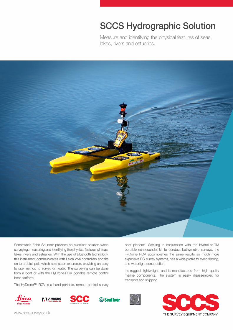
SCCS Hydrographic Solution Measure and identifying the physical features of seas, lakes, rivers and estuaries.
www.sccssurvey.co.uk
Sonarmite’s Echo Sounder provides an excellent solution when surveying, measuring and identifying the physical features of seas, lakes, rivers and estuaries. With the use of Bluetooth technology, this instrument communicates with Leica Viva controllers and fits on to a detail pole which acts as an extension, providing an easy to use method to survey on water. The surveying can be done from a boat or with the HyDrone-RCV portable remote control boat platform.
The HyDrone™ RCV is a hand-portable, remote control survey
boat platform. Working in conjunction with the HydroLite-TM portable echosounder kit to conduct bathymetric surveys, the HyDrone RCV accomplishes the same results as much more expensive RC survey systems, has a wide profile to avoid tipping, and watertight construction.
It’s rugged, lightweight, and is manufactured from high quality marine components. The system is easily disassembled for transport and shipping.

The Sonarmite Echo Sounder
The SonarMite Echo Sounder is the result of nearly two years research and development to further extend the boundaries of shallow water hydrographic surveying equipment. The introduction by Ohmex in 1997 of the SonarLite, the worlds first truly portable echo sounder system, has been a hard act to follow and it remains the portable instrument of choice in many survey companies around the world. The release of the SonarMite instrument marks the next stage introducing a series of equipment designed around the WinSTRUMENT concept making use of the latest portable computers integrated with new measurement technologies.
Throughout the Hydrographic world the term ‘Black Box’ has become a euphemism for a device that has a minimal user interface and normally requires connection to a PC to be of any use ! In most cases these boxes are a cut down version of a more conventional instrument without all the features of the full system. The SonarMite extends this idea of a rugged design and minimalist interface to produce a ‘Blue Box’ system where the user interface is provided by integrated software running on a portable computer connected via a Bluetooth link. The use of wireless technology enables the instrument to be waterproof and used in a hostile environment while the more sensitive computer features can be located in a more user friendly environment up to 50m away from the instrument.
The SonarMite MTX/BTX instrument uses the same ‘Smart’ integrated transducer technology used in previous systems, in addition to highly reliable bottom tracking algorithms using DSP techniques the system also outputs a quality value associated with every depth measurement made. The popular SonarW7 software has been updated to the latest Windows versions. Software for the ‘front end’ of the SonarMite is available to run on a wide range of devices from Pocket PCs through to the full range of desktop systems running the Windows operating system.
www.sccssurvey.co.uk
SonarMite Main Features
• Bluetooth technology integrated with Windows Pocket PC devices
• Proven ‘Smart’ transducer design with QA output
• Internal rechargeable battery for all day use in the field
• Easily integrated with other modern software and GPS technology
Communicate with Leica Total Stations and Controllers

www.sccssurvey.co.uk
The SonarMite MTX is supplied as standard with the following list of equipment.
• SonarMite MTX main processor unit c/w Bluetooth Antenna
• ‘Smart’ P66 depth transducer c/w 5m cable and embedded processor
• Serial data lead
• IP68 rugged plastic Transit case
• SonarW7 post process/import/export software
• External battery connector leads
Equipment Supplied
The following is a short list of accessories for the SonarMite
• SonarMite Windows Mobile PDA software
• SonarMite W7 software for Tablet/Portable PC
• USB serial lead
• Aluminium shoe to connect transducer to detail pole
• ‘Smart’ 200/30KHz depth transducer c/w 5m cable and embedded processor
• 2 x ‘Smart’ P66 depth transducer c/w 5m cable and embedded processor
The SonarMite MTX is a compact, portable, low power system for use in shallow water hydrographic surveys, it’s small size and low power requirements make the system easy to deploy and transport to remote or inaccessible sites. The SonarMite MTX is a development from the basic SonarMite single beam echo sounder providing a wider range of single beam solutions for surveyors working in shallow water hydrographic surveying. The SonarMite MTX can be configured in several ways.
• 1 x 235KHz single beam transducer used in BTX mode
• 1 x 200/30 dual beam transducer used in MTX mode
• 3 x 235KHz transducers spaced at 2 x depth in sweep mode
• 1 x 200KHz center with 2 x 235KHz port/starboard transducers
• 1 x 200/30KHz mixed frequency center with 2 x 235KHz side transducers
Configuration

www.sccssurvey.co.uk
The MTX multiple transducer ‘sweep’ configuration provides an intermediate stage between swathe and a single beam systems. These configurations consist of an array of single beam echo sounders located around the vessel, normally as a boom frame mounted over the stern but could also be around the vessel at various offset positions from the positioning antenna, for convenience the transducers are referred to as the ‘Port’, ‘Centre’ and ‘Starboard’ locations. The multiple channel device can be configured in two basic formats, a 3 x 235 KHz or a 235+200+235KHz array, the mixed frequency array giving the option to use the transducers in closer proximity without the problem of crosstalk between transducers operating at the same frequency.
A typical acoustic sweep system consists of a linear array of evenly spaced transducers mounted vertically around the vessel. These systems are used in critical shallow water areas (harbours, channels, etc.). The coverage of the bottom is 100%, depending on transducer spacing and water depth.
All models make use of a range of interchangeable smart transducers. In its simplest form the SonarMite SPX and BTX are 235KHz single beam systems in the same format as the previous SonarMite BT system. This single channel system can interchange its transducer for a dual frequency unit operating simultaneously at 200KHz and 30KHz . As with the previous SonarMite versions every measured depth is accompanied by a QA value which can be used for post analysis of the survey data.
BTX Single Beam SF and DF solution
MTX transducer array configurations

www.sccssurvey.co.uk
These systems are very accurate for IHO Special Order and Order 1 surveys where 100% coverage and high accuracy are required. By using multiple transducers the problems associated with swathe systems such as stray side shots caused by incorrect motion adjustment or water refraction errors are greatly reduced or eliminated. The speed of sound in water is approximately 1500 meters/second, however, this speed can vary with changes in temperature, salinity and pressure. These variations can drastically change the path that sound travels through water, as changes in sound speed between layers of water cause the trajectory of sound waves to bend by refraction. With a multiple transducer system all measurements are made vertically through the water column avoiding refraction errors caused by non homogenous or stratified water layers of different densities/temperatures. With a single beam sounder the forward and reverse sonar paths pass through the same vertical column so any velocity error is an ‘average’ over the entire path not a complex reflected and refracted flight route.
As with a swath system true heading is important for the accuracy of the system, the dynamic GPS heading message is sufficient for systems that do not change direction rapidly, rotate on a static location or travel in a rotated position. For more accurate systems a dual antenna GPS that provides both position and heading from the true bearing between the antennas is required.
The effects of pitch and roll do not so greatly affect a sweep system as they do a wide beam swath system. If a dual GPS antenna system is used then the roll of the mounting boom can also be calculated from the difference in height of the two antennas if they are mounted along the same axis as that of the boom.
Dual GPS Antenna Heading/Roll adjustment

www.sccssurvey.co.uk
Installation & Use
This chapter describes how the SonarMite Portable Echo Sounder would normally be installed and used. The typical way in which the device can be used for hydrographic surveying applications, is as a ‘Dumb’ sounder connected via a serial cable/Bluetooth Link to a PC or PDA running data logging and display software. Another option is to use both data streams with the serial output data for real time processing and the parallel Bluetooth output for graphic depth display.
Switching the System On
To turn the system on the user ensures the system is fully charged then connect the transducer to the ‘Txr’ connector on the front panel, the LED alongside the Bluetooth antenna will then turn on.
Data Collection Techniques
When not used as a ‘Dumb’ echo sounder in conjunction with a data logging package the SonarMite can be used in conjunction with the following data types to create full XYZ hydrographic data using the SonarW7 software package
• Total Station XYZ data plus Time
• XYZ data from RTKGPS plus Time
• XY data from DGPS plus Tide plus Time
• Range and Bearing from hand held laser plus Tide plus Time
• Simple event marketing past known position markers
The basis on which all data correlation is achieved is internal time base, so particularly when using the SonarMite with GPS data the clocks should be synchronised to GPS time (UTC).
Sound Velocity Settings
The SonarMite default Speed of Sound in Water(SoS) setting is 1500m/second, facilities to vary this have been provided in the calibration or in post processing. In practice this velocity value can vary due to several factors
• Water Temperature
• Water Salinity
• Water Turbidity
All of the above factors vary the density of the water in some way and effect the ‘time of flight’ of a pulse of ultrasound in water and hence the depth calculated from this time by the SonarMite. The
user can either measure the speed of sound in water by taking velocity profiles using a dedicated velocity measuring device or can use the SonarMite static over a known depth to a flat, firm base and then compare the measured value with the known depth. The difference in Sound Velocity between warm fresh water and cold salt water is about +/-30m/Second which represents a change of depth of +/-2%, this must be viewed in context with typical depths of the survey, if a typical depth is 10m then the error could be about 20cm. The Sound Velocity setting is the largest source of measurement error when care is not taken in setting it correctly.
Reverse Voltage Protection
The SonarMite is protected from reverse connection or direct short circuit by an internal diode and 1 Amp thermal fuse. If the fuse is tripped then the system will need to be disconnected for 1 minute for the fuse to cool down and reset itself.
Weatherproofing
The SonarMite has been designed to conform to the IP65 waterproofing standard, this benchmark describes equipment which can withstand a light spray of water from a hose for a short period of time, it does not imply the device is suitable for immersion in any depth of water or exposed to prolonged harsh weather conditions. The weatherproofing also assumes the connectors or cover caps are fully screwed on to their rubber sealing rings. The weatherproofing does not apply to certain components which are by definition not designed for outdoor use such as the mains battery charger and D9 serial cable connectors.

HyDrone-RCVtm
The HyDrone-RCV is a hand-portable, remotely controlled hydrographic survey platform. Working in conjunction with the HydroLite-TM portable echosounder kit to conduct bathymetric surveys in ponds, lakes, rivers, and streams, the HyDrone- RCV accomplishes the same results as more expensive RC survey systems, with a wide profile, making it very stable, and watertight construction. It is rugged, lightweight, and manufactured from high quality marine materials and components. The system is easily disassembled for transport and shipping. Work environments include mines, sewage treatment plants, contaminated lakes, harbors and rivers.
Benefits
• wide profile for stability• watertight, durable construction · up to 20mph• easy disassembly for transport and shipping
www.sccssurvey.co.uk
SpecificationsTop Speed 20 kts
Hull Length 1168mm / 48.0 in
Hull Width 736mm / 29 in
Battery Endurance 5–8 hours
Payload 11.3kg / 23 lbs
Power 2x 12v 10ah battery
ECU 2x 180 amp water-cooled
Motor 2x brushless water-cooled
Hull Material UV resistant ABS
Frame Aluminum powder coated
Steering Alternating prop power
Weight 14.9 kg / 30 lbs
Hardware Stainless steel
R/C Futaba 2.4GHz long range
Remote Range 2 km
Propeller Brass 3” dia / 4 blade
Hatches 6x water-tight abs plastic
GPS All brands
Echosounder Seafloor HydroLite-TM
Options (HyDrone-RCV)
Sound velocity profilerRTK GPSRadio telemetryOptional side scan sonar moduleEchosounderHYPACK software
Options (HydroLite-TM)
Sonarmite EchosounderHydroLite-TM Pole KitTrimble GPSSonarmite PDA/SonarVista softwareRange: 0.3m–75mI/O Serial, bluetoothPower: rechargeable 12v batteryCompatibility: Trimble, Leica, TopconSokkia, Epoch, Ashtech, Magellan, Carlson