salter township prospecting report sudbury mining division · salter township prospecting report...
TRANSCRIPT

Salter Township Prospecting Report Sudbury Mining Division
By: Mark Hall B.Se. Geology June 2001
41J08SK2004 2.21710SALTER
010
INDEX
. Introduction
. Property Description
. Location and Access
. Regional Geology
. Local Geology
. History of Exploration
. Recent Exploration by Bailey, Orchard and Hall
. Recommendations
. Figures
41J08SE2004 2.21710 SALTER 0 10C
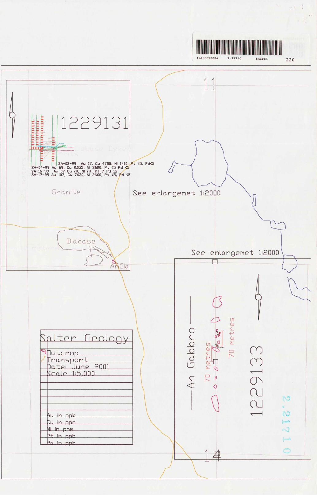
IntroductionThe location was selected by R. Orchard, B. Bailey and M. Hall on the basis of the similarity of the geology to the East Bull Lake - Shakespeare and Dunlop gabbros. The apparent correlation between these two intrusive bodies suggested the mineral potential here was favorable. Prospecting was carried out from 1999 to 2001. Focus was on determining the geology of this gabbro and examining knowing showings for platinum group element (PGE) mineralization. The partners found the geology on claim S-1229133 was comparable to that in May township and the Shakespeare - Dunlop geology (see previously filed report). S-1229131 was staked for the showing. Only Nippissing type diabase was present on this claim.
Property DescriptionThe property consists of 2 claims on 4 unit-1229131 and one 2unit S-1229133 un parented mining claims. They are held by Ron Orchard, Bob Bailey and Mark Hallnumber.
Location and access.The property is located in the SW 1//4 of section 11 and the Wl/2 of the NE 1/4 of section 14 of Salter Township. Both claims are accessible from Hwy. 553, running north from the town of Massey.
Regional GeologyThe regional geology consists of Huronian aged volcanics, gabbros, anorthosite gabbros, and sediments. Underlying these rocks are archean aged granites and gneisses. All are intruded by Nippissing diabase and later dykes. The anorthosite gabbros, the focus of exploration, lie at the contact between the archean basement and Huronian sediments.
This intrusive anorthosite gabbro extends easterly from Salter Township to Porter Township. It is apparently equivalent to the "East Bull Lake Gabbro" and Shakespeare - Dunlop gabbros. . It has been the subject of Copper - Nickel exploration in the past by WMC and others. Interest has been recently renewed in these gabbros for the platinum and palladium potential. Two properties, located in Salter Township, were the subject of minor copper production. They are the Hermina and Massey Mines situate in the northern half of the township. These deposits appear to be spatially associated with the Murray Fault and the previously Gabbro and/or Nippissing Diabase.
The Murray Fault is a major structural feature in the region. It strikes approximately west-southwest, and is represented by Robertson (GR - 136) as being located at the south boundary of S-1229133.
Local GeologyClaim S-1229133 covers part of a layered anorthosite gabbro equivalent to the Shakespeare - Dunlop and East Bull Lake Gabbros. It is situated between the archean basement (composed of granite and felsic gneisses), and Huronian sediments (Matinenda formation). The sediments are composed mainly of feldspathic quartzites. Robertson
(1976) suggests that this gabbro may have been partially eroded before sediments were deposited, implying that the section was originally much thicker. The gabbro is easily identifiable on magnetic maps as a mag high. The claims are within the "Massey Copper Area", recognized for its many copper showings.
History of ExplorationAir borne mag and EM survey by WMC 1990'sGeology mapping and radiometric survey by Kerr Addison in 1976Drilling and pitting by Lacelle 1967.
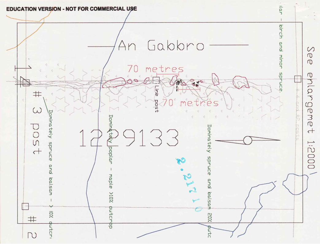
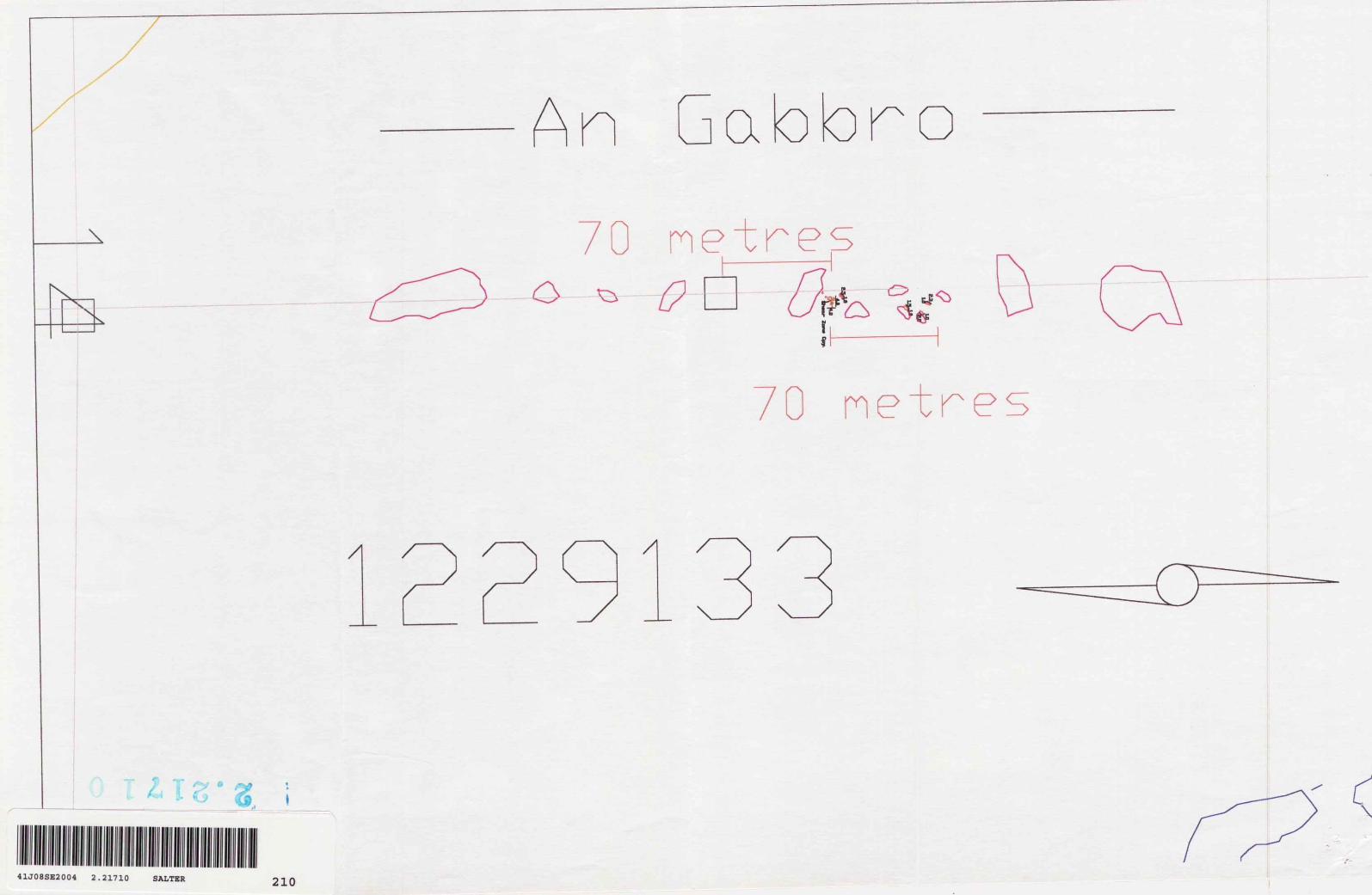
Recent Exploration by Bailey, Orchard and HallTraverses were run by Orchard Bailey and Hall on the western boundary of claim S- 1229133. The bedrock is a medium to very coarse-grained anorthositic gabbro comparable to that in May Township. (See previously submitted report). Minor chalcopyrite was discovered on this west boundary. The area was stripped to determine its extent. The mineralization is present in a 2 to 6 inch thick hear zone, with pervasive epidote alteration, striking at 70 C . This is same strike as more prominent topographic tows 200 to 300 meters south of the mineralization. These larger low areas may host other shear zones and better mineralization,
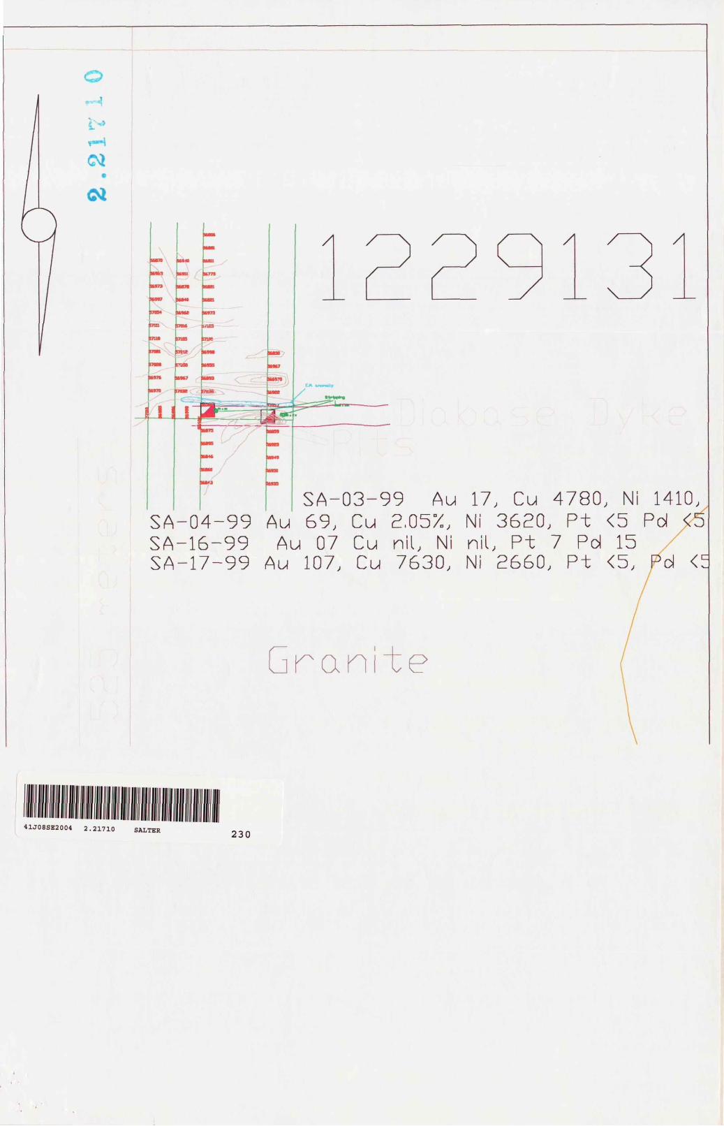
The Lacelle showing was located and sampled for PGE's. The pits are situate in a east- west striking dyke, within massive coarse grained granite. The area of the eastern pit appears to be the resident of at least one bear, who obviously frequents the area. The pits are in a fine to medium grained Nippissing Diabase Mineralization is disseminated to massive pyrrhotite and chalcopyrite over l to 3 feet and contained within the central portion of the dyke. Despite favorable copper assays, there were no anomalous PGE \alues in the samples. However, the showing may be more extensive than what is exposed and warrants further investigation.
Several lines of test magnetometer were run over the dyke and showing to determine if they could be distinguished, from the surrounding granite. Results are favorable and it appears that the dyke does exhibit a noticeable magnetic high relative to the surroundinghost rock.
An APEX II E. M was also used to determine if the mineralization is conductive. Conductivity was noted over the pits, but an even stronger anomaly was located parallel to and about 25 feet north of the pits.
Haifa day was spent by the partners and L. Orchard looking for trenches at the south end of the claim with no success. An anorthositic gabbro, visually equivalent to the gabbro on claim S-1229133, was located at the south boundary. This raises the possibility that the gabbro is thicker than mapped by Robertson.
RecommendationsIt is noted from the Robertson geology map that the dyke extends the full width of the claim and has at least 4 connecting branches. There is obvious mineralization in the dykes where pitted. Though narrow, there is potential for wider zones in extensions. Test lines show that a magnetometer survey will define the dyke. Such a survey might also define near surface pyrrhotite mineralization. An EM survey is also recommended as it appears the mineralization is responsive to EM instruments. Therefore geologic mapping, mag and EM surveys are recommended for future exploration. The north end of claim S- 1229133 should be examined in detail to determine if the gabbro is thicker than mapped.
Consideration should also be given to examination of the larger diabase body at the south west corner of claim S-1229131.
The topographic lows on claim S-1229133 should be examined as a secondary priority. These potential shear zones may host mineralization to the past producers. Given the size of these producers it does not seem probable that these would be any larger in tonnage.
Figures
1 Location Map2 Geology Map including traverses.
Mark Hall B.Se Geology

Laboratories 113:^056425300 HUb Ib'yy i4Oi INO.UI^ r.ui
Swastika LaboratoriesA Division of Assayers Corporation Ltd.
Assay ing - Consulting - Representation
Geochemical Analysis Certificate 9W-2197-RG1
Company: M . HALL Dalo: AUG-16-99Projccl:Aun: M . Hall
We hereby certify the following Geochemical Analysis of 5 Grab/Rock samples submitted AUG-11-99 by .
Sample Au Au Check Cu Cu Ni Pt Pd Number PPB PPB PRvl % PPM PPB PPBSA-14-99 "89"" 86 ^16666 " "i"27""""87l""" "ill"" " 192
SA-15-99 '93 - 5540 - 6770 62 158SA-16-99 7 - - - - l 1 5SA-17-99 107 178 7630 - 2660 C5 ^SA-18 99 2 - - - - ^ ^
One assay ton portion used for precious metals.
Certified by
l Cameron Avc., P.O. Box 10, Swastika, Ontario POK l TO
Swastika LaboratoriesA Division of Assayers Corporation Ltd.
Established 1928 Assaying - Consulting - Representation
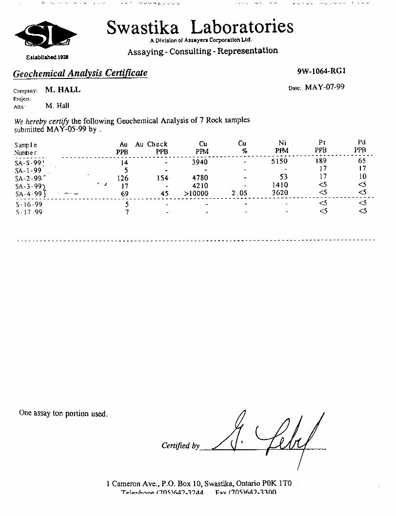
Geochemical Analysis Certificate 9W-1064-RG1
Company. M . HALL Dale: MAY-07-99
Project:Attii: M. Hall
We hereby certify the following Geochemical Analysis of 7 Rock samples submitted MAY-05-99 by .
Sampl eNumberSA-S-99' SA-1-99 SA-2-99." SA-3-99) SA-4-99J - -- -
S- 16 99S-I7 99
Au PPB
14 5
126 17 69
57
Au Check PPB
154
45-
Cu PRVl
3940
4780 4210
MOOOO-
Cu7o
2.05-
Ni PFM
5150
53 1410 3620
-
Pt PPB
189 17 17 *3 ^
^ <5
Pd PPB
65 17 10 ^ ^
^^
One assay ton portion used.
Certified by
l Cameron Ave., P.O. Box 10, Swastika, Ontario POK 1TO
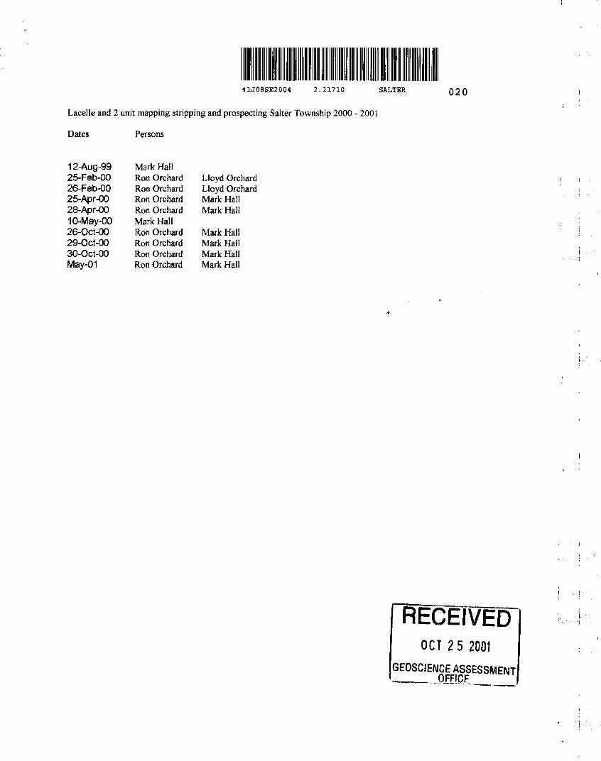
41J08SE2004 2.21710
Lacelle and 2 unit mapping stripping and prospecting Salter Township 2000 - 2001
Dates Persons
SALTER 020
12-Aug-9925-Feb-OQ26-Feb-OO25-Apr-OO28-Apr-OO10-May-OO26-Oct-QO29-Oct-OO30-Oct-OO May-01
Mark Hall Ron Orchard Ron Orchard Ron Orchard Ron Orchard Mark Hall Ron Orchard Ron Orchard Ron Orchard Ron Orchard
Lloyd Orchard Lloyd Orchard Mark Hal! Mark Halt
Mark Hall Mark Hall Mark Hall Mark Hall
RECEIVEDOCT 25 200I
EOSCIENCE ASSESSMENT ____OFFICE
EDUCATION VERSION - NOT FOR COMMERCIAL
Gabbro
" metres v i

EDUCATION VERSION - NOT FOR COMMERCIAL
C \i
V-

ONTARIO MINISTRY OF NORTHERN DEVELOPMENT AND MINES
Transaction No:
Recording Date:
Approval Date:
Client(s):
303181
Survey Type(s):
W0170.30395
2001-JUL-04
2001-OCT-29
Work Report Summary
Status: APPROVED
Work Done from: 1999-J U L-03
to: 2001-JUL-03
HALL, MARK
ASSAY PROSP
Work Report Details:
Claim*
S 1229131
S 1229133
Perform
S2,
S1,
S4,
380
796
176
Perform Approve
S2
S1
S4
,380
,796
,176
Applied
S1.600
3800
S2.400
Applied Approve
S1.600
S800
32,400
Assign Assign Approve
sososo
0
0
so
Reserve
S780
S996
S1.776
Reserve Approve
S780
S996
S1.776
Due Date
2002-JUL-05
2002-JUL-05
Status of claim is based on information currently on record.
41J08SE2004 2.21710 SALTER
900
2001-Nov-09 15:52 Armstrong-d Page 1 of 1
Ministry ofNorthern Developmentand Mines
Date: 2001-NOV-01
Ministers du Developpement du Nord et des Mines Ontario
GEOSCIENCE ASSESSMENT OFFICE 933 RAMSEY LAKE ROAD, 6th FLOOR SUDBURY, ONTARIO P3E6B5
MARK HALL 580 KANTOLA ROAD LIVELY, ONTARIO P3Y1H8 CANADA
Tel: (888) 415-9845 Fax:(877)670-1555
Dear Sir or Madam
Submission Number: 2 21710 Transaction Number(s): W0170 30395
Subject: Approval of Assessment Work
We have approved your Assessment Work Submission with the above noted Transaction Number(s). The attached Work Report Summary indicates the results of the approval.
At the discretion of the Ministry, the assessment work performed on the mining lands noted in this work report may be subject to inspection and/or investigation at any time.
The revisions outlined in the Notice dated September 14, 2001 have been corrected. Accordingly, assessment work credit has been approved as outlined on the Declaration of Assessment Work Form that accompanied this submission.
If you have any question regarding this correspondence, please contact JIM MCAULEY by email at [email protected] or by phone at (705) 670-5855.
Yours Sincerely,
Ron Gashinski
Supervisor, Geoscience Assessment Office
Cc: Resident Geologist
Mark Hall (Claim Holder)
Assessment File Library
Mark Hall (Assessment Office)
Visit our website at http://www.gov.on.ca/MNDM/LANDS/mlsmnpge.htm Page: 1 Correspondence 10:16535

?RosP
Genera! Information and Limitations
Mv Dnim: H Ml UU W |d IMW)
Ditttewtii. LMM MTniWMn Onwia L ait r BIVI Mule* PfoviK*M kvuni H icnid
miff* ollHtU t tMLWMV IB OWE
PMHIBHI "W"oHECOWIEfllOF^Ct
MINING LAND TENUREMAP
o o CM
H tt
O O CIM WCOo
Dale y Time of Issue Jul1B2001
TOWNSHIP /AR6A
SALTER
14:62h Eastern
PLAN
0-2984
ADMINISTRATIVE DISTRICTS /DIVISIONS
Mining Oivtaton Sudbury
Land Titles/Registry Division SUDBURY
Ministry of Nllurel Rttourctt Dlttriet SUDBURY
TOPOGRAPHIC
Adn imitrttnr't Bf un *H K
Twn*hte
ccnicwaflr |t cn
LJ
LANDTENURE
FrtrtnHPlW
^1 t-jrrpct " t* MWig R tf.la
m i-jf*E**p*u3-iii
LMMtlDlllPMnl
O l..-JKi-,r^,rlr-|RlgMi
|g| (..-''KlkiJ-.tlL.rl,'
^J Mhi- ? *|pnti J w
LICMC* "f accuf rtwr
^J Lie^a Spfettati
|jj 4ui1*;i.ii-. d M-nkqflflhn
^J lL-rrK.tni||n*OKiv
MBl LITHI fJll Ffc(l*l
w (tw ta Jim
H O" lim nrf -.C rf* W
^Itr- PlP*l L H19 ".flprfB-nErl
LAND TENURE WITHDRAWALS
IMPORTANT NOTICES
LAND TENURE WITHDRAWAL DESCRIPTIONS
1*7 WMH QKZ3 tB7 ICC.
IMPORTANT NOTICES
w-LL*^i'w:-"-WM^nw MHWLL*!?M*ft*T MlhVime U41
W-LL-PJi*** OUT MAVIP'H MM
W L L.*3*WM ait MfcV 1?i9M*S
W U J1 31*** OKI MAY 17*?M-I
Wt.M*7MFfi.J*li*T.W4lHmSIi
rht kiMimrionHIGH li *HMI nsnuiMW DM w**** in (M prnMHlnwiia uctnuir one* * ttituni of tUwoOMlMDjlr{m*lli*nMU(iy si mnhtiT.PwrtonMrt mi M hM Mb rt*.
o
metres
A
IS'8 \
41J08SE2004 2.21710 SALTER 210
33\_x \_x
netres
\
u 2. 3" 3 '
3 "
y
u -f 3" 3 -
3 3-
^. 5" D
. D
.3
J .- 3" 3 3 '
3
^ I 3~ 3 3 T
1
/*J TD Jl Z)
Z) ^
_ J
D rh 5 ^ Tl y ^j
Z)
Z)
—l D -n j^ ^ rf
J)
—1
^h
"1 D
C k
^ T) ' ——
1—
i 1
D ^ , __ D D <
An
Ga
bb
ro70
netr
eyr
w -Q
70
ne
tre
s
TT ^
*
t O
,.
to
to
o
*
A A
SA-03-99 Au 17, Cu 4780, Ni 1410, SA-04-99 Au 69, Cu 2.05X, Ni 3620, Pt K5 Pd O SA-16-99 Au 07 Cu nil, Ni nil, Pt 7 Pd 15 /' SA-17-99 Au 107, Cu 7630, Ni 2660, Pt K5, Pd
Gran t e
41J08SE2004 2.21710 SALTER230