s central entrance - miller hill - duluth€¦ · 1 central entrance - miller hill small ......
TRANSCRIPT
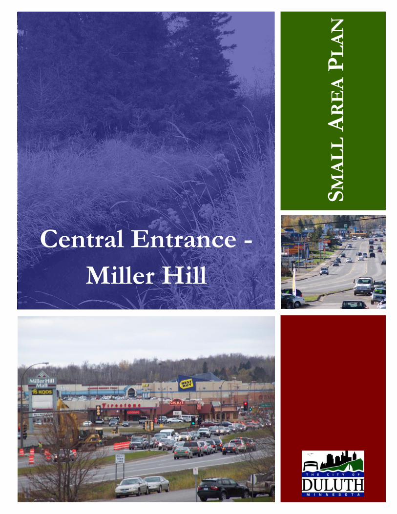
Central Entrance -
Miller Hill
SM
AL
L A
RE
A P
LA
N
i Central Entrance - Miller Hill Small Area Plan
ii September 2009
Mayor
Don Ness
City Council
Greg Gilbert, President
Jeff Anderson
Tony Cuneo
Gary Eckenberg
Todd Fedora
Jay Fosle
Sharla Gardner
Garry Krause
Jim Stauber
Planning Commission
Mike Akervik, President
Mindy Appold
Henry Banks
Joan Barrett
Katelyn Blazevic
Drew Digby
Mindy Granley
Frank Holappa
Joan Morrison
Heather Rand
David Sarvela
Jim Stebe
John Vigen
Plan Committee
Garry Krause, City Council
Joan Barrett, City Planning Commission
Diane Knudson, Resident
Jennifer Wutz, Resident
Gayle Ankarlo, CMRA Realty
Gordon Grant, Dairy Queen
Tracy Hansen, Daisies n‟ Daydreams
Ben Martin, Miller Hill Mall
Earl Richards, Property Owner
Tom Stender, Property Owner
Andy Peterson, Chamber of Commerce
Ron Chicka, Metropolitan Interstate Council
Dennis Johnson, MN Dept. of Transportation
R.C. Boheim, Soil and Water Conservation District
City Planning Division Staff
Kyle Deming, Planner II (Project Planner)
Cindy Petkac, AICP, Land Use Supervisor
John Judd, Senior Planner
Jenn Reed Moses, Planner II
Market Study Consultant
MXD Development Strategists, LLC
ACKNOWLEDGEMENTS
iii Central Entrance - Miller Hill Small Area Plan
Executive Summary ............................................................................................................................. 1
Assessment
Purpose ......................................................................................................................................... 2
Plan Objectives ............................................................................................................................. 2
Study Area Boundaries and Sub-Areas ......................................................................................... 3
Plan Committee ............................................................................................................................ 3
Plan Process .................................................................................................................................. 3
History/Background ..................................................................................................................... 3
Past Planning Efforts ..................................................................................................................... 5
Demographics ............................................................................................................................... 8
Land Use/Zoning/Public Lands ................................................................................................... 10
Transportation ............................................................................................................................... 14
Utilities ......................................................................................................................................... 20
Environmental Characteristics ..................................................................................................... 20
Comprehensive Land Use Plan Principles .................................................................................... 22
Market Analysis ............................................................................................................................ 23
Plan Recommendations
Vision Statement .......................................................................................................................... 32
Recommendations 1 ..................................................................................................................... 33
Recommendations 2 ..................................................................................................................... 34
Recommendations 3 ..................................................................................................................... 35
Recommendations 4 ..................................................................................................................... 38
Recommendations 5 ..................................................................................................................... 38
Recommendations 6 ..................................................................................................................... 39
Implementation Plan
Land Use Map Amendments ......................................................................................................... 41
Unified Development Code (UDC) Recommendations ................................................................ 42
Place-Making Recommendations ................................................................................................. 43
Transportation Recommendations ............................................................................................... 44
TABLE OF CONTENTS
iv September 2009
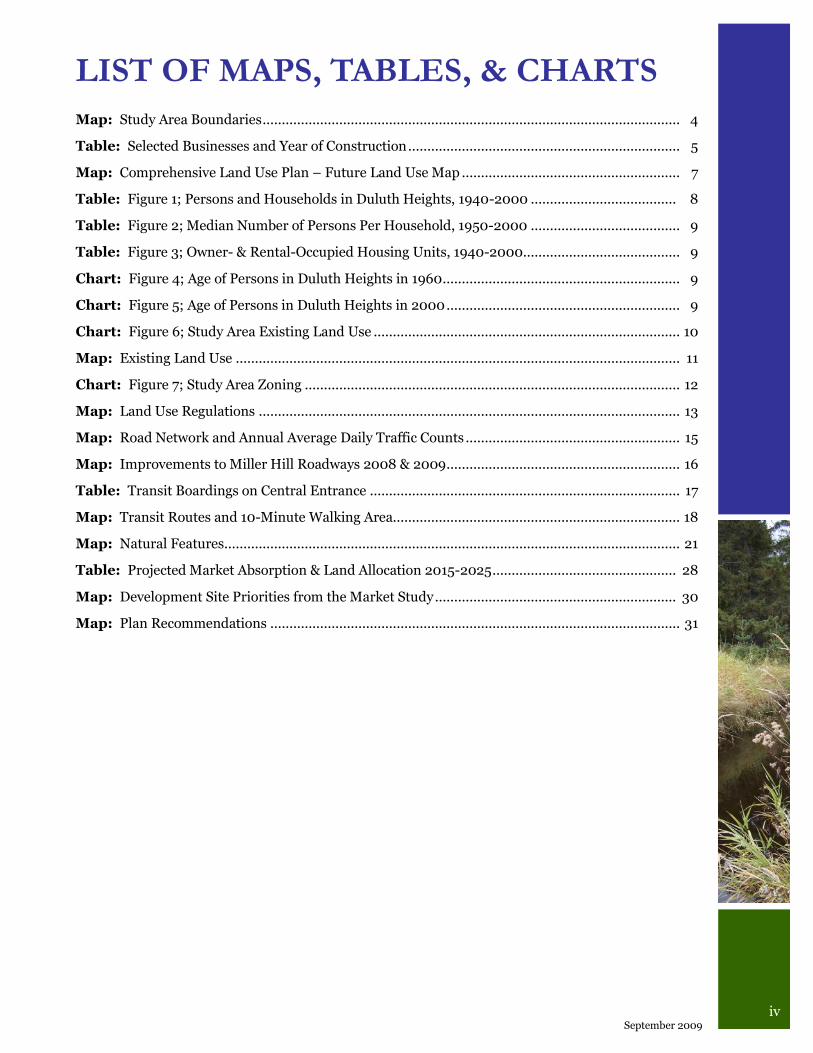
Map: Study Area Boundaries ............................................................................................................. 4
Table: Selected Businesses and Year of Construction ....................................................................... 5
Map: Comprehensive Land Use Plan – Future Land Use Map ......................................................... 7
Table: Figure 1; Persons and Households in Duluth Heights, 1940-2000 ...................................... 8
Table: Figure 2; Median Number of Persons Per Household, 1950-2000 ....................................... 9
Table: Figure 3; Owner- & Rental-Occupied Housing Units, 1940-2000 ......................................... 9
Chart: Figure 4; Age of Persons in Duluth Heights in 1960 .............................................................. 9
Chart: Figure 5; Age of Persons in Duluth Heights in 2000 ............................................................. 9
Chart: Figure 6; Study Area Existing Land Use ................................................................................ 10
Map: Existing Land Use .................................................................................................................... 11
Chart: Figure 7; Study Area Zoning .................................................................................................. 12
Map: Land Use Regulations .............................................................................................................. 13
Map: Road Network and Annual Average Daily Traffic Counts ........................................................ 15
Map: Improvements to Miller Hill Roadways 2008 & 2009 ............................................................. 16
Table: Transit Boardings on Central Entrance ................................................................................. 17
Map: Transit Routes and 10-Minute Walking Area........................................................................... 18
Map: Natural Features ....................................................................................................................... 21
Table: Projected Market Absorption & Land Allocation 2015-2025 ................................................ 28
Map: Development Site Priorities from the Market Study ............................................................... 30
Map: Plan Recommendations ........................................................................................................... 31
LIST OF MAPS, TABLES, & CHARTS
1 Central Entrance - Miller Hill Small Area Plan
EXECUTIVE
SUMMARY
Planning is about setting a vision today for to-
morrow‟s future. It was for this reason that the
City‟s Planning Division undertook the Central
Entrance-Miller Hill Small Area Plan and
worked with the community to define the future
of this area.
The vision for Central Entrance is of a more
attractive and walkable place with wide side-
walks on both sides of the street and businesses
that front the sidewalks with inviting store-
fronts. The motoring public will enjoy traveling
to and through the district as the roadway is
redesigned to provide better access to busi-
nesses. Central Entrance will regain its previ-
ous function as the “main street” of Duluth
Heights.
The vision for the Miller Hill area is for it to
continue as the region‟s regional retail destina-
tion by expanding its offerings to include more
“fast-casual” restaurants, adult fashion stores, a
specialty food market, and an outdoor recrea-
tion store that will anchor a new type of devel-
opment called a “Suburban Town Center.” This
new mixed-use “center” for the Miller Hill area
will build on the strengths of the existing mall
and surrounding businesses and offer a differ-
ent shopping experience for Duluthians with
businesses, offices, and upper floor residential
units surrounding a public amenity such as a
small park or fountain in a pedestrian-friendly
environment.
The vision for Central Entrance and Miller Hill
described above was prepared with the assis-
tance of a 14-member Plan Committee and pre-
sented to the public at two open house gather-
ings. The need for this study was identified in
the Comprehensive Land Use Plan and was
conducted at this time because of the recent
improvements to Miller Trunk Highway and
surrounding roads.
The planning process began by identifying objec-
tives such as encouraging the continued viability
of the Miller Hill business district as a regional
retail destination, improving the function and
appearance of the Central Entrance business dis-
trict, planning for business growth and redevel-
opment in a way that minimizes potential nega-
tive impacts to surrounding residential neighbor-
hoods, and considering pedestrians, bicyclists
and transit users in the future business districts.
Early in the process, a nationally-recognized firm
was hired to conduct a market analysis to guide
our land use planning efforts. In the market
study, MXD Development Strategists forecasted
that the Miller Hill area will grow at an annual
average increase of 27,000 square feet of space,
roughly adding retail space similar to a Target
store every five years. MXD strongly recom-
mended that Duluth pursue the “place-making”
strategies described above in an effort to consoli-
date the sprawling land use pattern through infill,
densification, and redevelopment of sites in the
study area.
For many of the place-making recommendations
to be implemented, it will be helpful for the busi-
nesses in the area to organize themselves into a
merchants association and then into a business
improvement district. Significant changes are
needed to the development standards for the area
and the City‟s new Unified Development Code
will incorporate plan recommendations relating
to building and parking placement and other de-
sign enhancements to improve the appearance
and walkability of the area. When funding is
available, transportation improvements to Cen-
tral Entrance will be necessary to balance the
needs of motorists with those of pedestrians and
transit users through the redesign of the street
with a “Context Sensitive Solution.” And changes
to the designation of land uses in order to focus
development on the core areas will require
amendment of the Comprehensive Land Use Plan
– Future Land Use Map. Adoption of this plan
will set the ball in motion toward accomplishing
this new vision for Central Entrance and the
Miller Hill area.
2 September 2009
ASSESSMENT
Plan Objectives Early in the planning process the following ob-
jectives were identified:
1. To guide new development opportunities
that compliment existing development
while minimizing potential negative
impacts to surrounding residential
neighborhoods.
2. To encourage the continued viability of the
Miller Hill business district as a regional
retail destination.
3. To determine the commercial function of
the Central Entrance business district and
plan for its future.
4. To improve and enhance the natural
environment.
5. To provide safe and convenient non-
motorized transportation options
throughout the study area.
6. To enhance the appearance of the area.
Purpose of the Plan The Central Entrance business district, Miller
Hill business district, and the area surrounding
each are the first places of the city to be studied
by the City‟s Planning Division using the “small
area plan” format (see description at right). The
purposes for conducting the plan are:
1. The Comprehensive Land Use Plan,
adopted in June of 2006, recognized that
there were areas of the City where uncer-
tainty about market conditions, ownership
patterns or infrastructural capacity was
particularly high, and that those areas
would require additional study to guide
possible modifications to the future land
use map. Central Entrance was one of the
areas identified for additional study.
2. Current changes and improvements to
Miller Trunk Highway, including the exten-
sion of Burning Tree Rd and new connec-
tion to Sundby Rd, realignment of W. Ma-
ple Grove Rd and elimination of access at
Miller Trunk Highway, and connection of
Joshua Ave to W. Maple Grove Rd, will re-
sult in new traffic patterns and changes to
existing land uses. Therefore, it is necessary
for the City to study the area in greater de-
tail to determine if any new areas that have
opened up for development, as well as any
changes in market conditions, would re-
quire modifications to the future land use
map.
A small area plan is a plan that is
developed for a clearly defined
area and gives more detailed rec-
ommendations than would be pro-
vided in a comprehensive plan. A
small area plan does not replace
the comprehensive plan but rather
serves to augment it. The small
area plan builds on the goals, poli-
cies and implementation strate-
gies in the comprehensive plan to
provide a finer level of detail.
3 Central Entrance - Miller Hill Small Area Plan
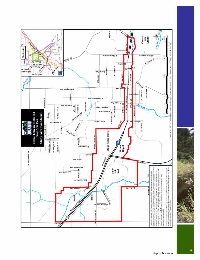
Study Area Boundaries and Sub-areas The study area includes an approximately three
mile long stretch along Central Entrance and
Miller Trunk Highway from Pecan Avenue to
Haines Road (see Study Area Boundaries map
on the next page). It includes adjacent and
nearby properties designated on the Compre-
hensive Plan Future Land Use Map as auto-
oriented and large scale commercial, neighbor-
hood mixed use and urban residential. This
study area contains two sub-areas:
1. Central Entrance district – From Pecan
Avenue to Anderson Road,
2. Miller Hill district – From Anderson Road
to Haines Road.
Plan Committee A committee was assembled for this study and
met to assist the Planning Division in the devel-
opment of the small area plan. There were 14
members, including:
1 – Planning Commission member
1 – City Councilor
4 – Business owners
2 – Residents
2 – Property owners
1 – Chamber of Commerce staff rep.
1 – Environmental rep.
2 – Transportation reps. (MIC and MN-DOT)
Plan Process The planning process took place between No-
vember 2008 and August 2009. As part of the
process the City contracted with a consultant to
conduct a market study. From January through
April 2009, MXD Development Strategists as-
sessed the supply and demand for retail, resi-
dential, office, hotel land uses in the study area,
and prepared a land use allocation strategy and
fiscal benefits summary. The Plan Committee
met three times in February, April, and July.
Public meetings were held in March and July to
review information and plan recommendations.
See Appendix B for agendas, meeting notes and
comments.
History/Background
The following is excepted from the 1980 Miller Hill Corridor Plan:
“The formation of the Duluth Heights
neighborhood began in 1891 when the
area was annexed to the City of Duluth
and a street car line was constructed al-
lowing residents to settle the area on
small lots. The street car trip took 25
minutes to get downtown via Orange
Street to the Incline Railway that was
constructed on 7th Avenue West. The
neighborhood focused on the Basswood
Avenue-Central Entrance intersection
consisted of about 125 homes in 1902.
In the 1920s Upham Road and Swan
Lake Road were constructed connecting
Duluth Heights to downtown and in
1934 the current alignment of Central
Entrance was constructed.
“Small commercial areas formed at
Central Entrance and Stroll Avenue and
the point where Miller Trunk Highway
intersects Trinity Road, Maple Grove
Road and Haines Road. The City‟s first
zoning plan in 1927 formalized this pat-
tern of “strip” development by establish-
ing commercial use districts in six loca-
tions along Central Entrance and Miller
Trunk Highway. The 1958 Comprehen-
sive Plan expanded this to include 345
acres of “C-2 Highway Commercial” and
“M-1 Manufacturing” zoning.
“In 1964 a sanitary sewer line was
constructed along Miller Creek to serve
the Duluth Air Base. This stimulated
additional commercial development
with Target opening in 1962
(anticipating the sewer extension) and
4 September 2009
5 Central Entrance - Miller Hill Small Area Plan
the Miller Hill Mall opening in 1973.
A nucleus of commercial development
had formed which has caused the ad-
ditional spin-off commercial and of-
fice developments that exist today.”
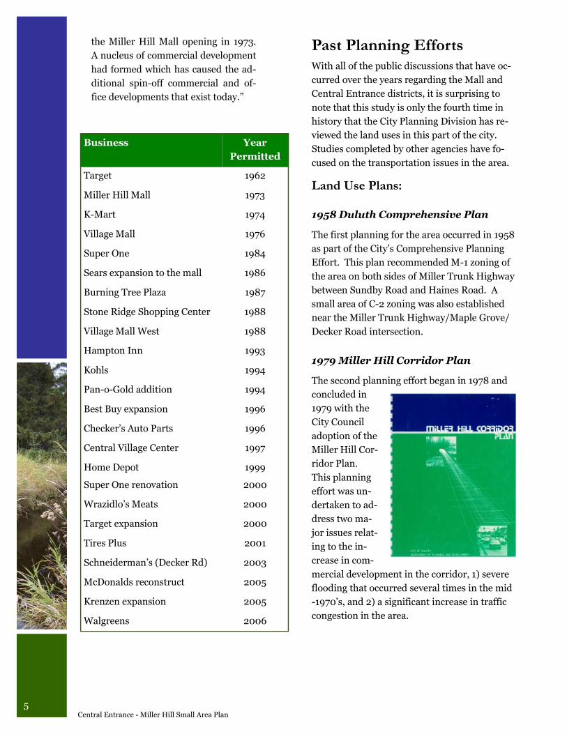
Business Year
Permitted
Target 1962
Miller Hill Mall 1973
K-Mart 1974
Village Mall 1976
Super One 1984
Sears expansion to the mall 1986
Burning Tree Plaza 1987
Stone Ridge Shopping Center 1988
Village Mall West 1988
Hampton Inn 1993
Kohls 1994
Pan-o-Gold addition 1994
Best Buy expansion 1996
Checker‟s Auto Parts 1996
Central Village Center 1997
Home Depot 1999
Super One renovation 2000
Wrazidlo‟s Meats 2000
Target expansion 2000
Tires Plus 2001
Schneiderman‟s (Decker Rd) 2003
McDonalds reconstruct 2005
Krenzen expansion 2005
Walgreens 2006
Past Planning Efforts With all of the public discussions that have oc-
curred over the years regarding the Mall and
Central Entrance districts, it is surprising to
note that this study is only the fourth time in
history that the City Planning Division has re-
viewed the land uses in this part of the city.
Studies completed by other agencies have fo-
cused on the transportation issues in the area.
Land Use Plans:
1958 Duluth Comprehensive Plan
The first planning for the area occurred in 1958
as part of the City‟s Comprehensive Planning
Effort. This plan recommended M-1 zoning of
the area on both sides of Miller Trunk Highway
between Sundby Road and Haines Road. A
small area of C-2 zoning was also established
near the Miller Trunk Highway/Maple Grove/
Decker Road intersection.
1979 Miller Hill Corridor Plan
The second planning effort began in 1978 and
concluded in
1979 with the
City Council
adoption of the
Miller Hill Cor-
ridor Plan.
This planning
effort was un-
dertaken to ad-
dress two ma-
jor issues relat-
ing to the in-
crease in com-
mercial development in the corridor, 1) severe
flooding that occurred several times in the mid
-1970‟s, and 2) a significant increase in traffic
congestion in the area.
6 September 2009
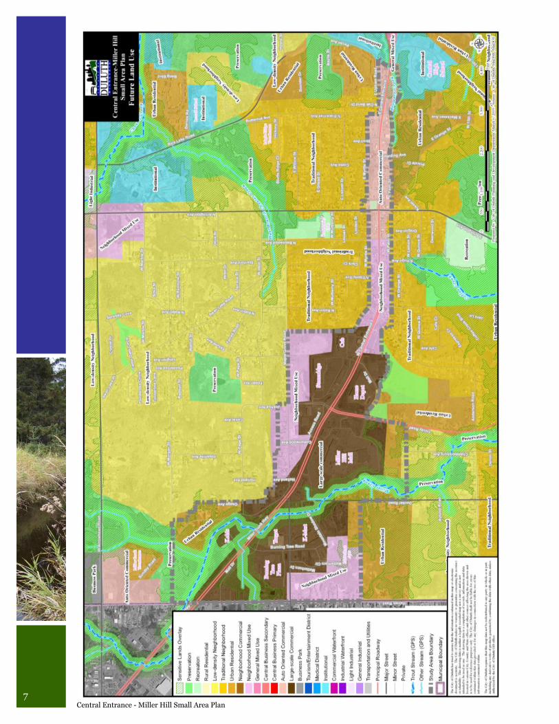
graphically the arrangement of land uses that
the city desires to achieve over the next 20
years. In the Central Entrance-Miller Hill Small
Area Plan study area, the five Future Land Use
categories that predominate include:
Large-Scale Commercial is the designation
for areas of mall and big box retail develop-
ments with buildings typically exceeding
50,000 square feet in area with the possibil-
ity of allowing limited office use,
Auto-Oriented Commercial includes com-
mercial and office uses focused primarily on
the needs of motorists with buildings typi-
cally less than 50,000 square feet in area,
Neighborhood Mixed Use is a transitional
use between more intensive commercial
uses and purely residential neighborhoods
with commercial uses oriented to neighbor-
hood or specialty retail markets,
Urban Residential includes medium- to high
-density residential developments located
adjacent to activity centers and allowing
only very limited commercial uses to serve
the neighborhood,
The Miller Hill Corridor Plan had 6 goals:
Future development and improvements
should be directed towards making the
plan area attractive to residential uses,
The viability of existing commercial and
light industrial developments within the
plan area should be maintained,
The irreversible alteration of critical natu-
ral resources within the plan areas should
be prevented,
A pattern of land use which does not neces-
sitate excessive expenditures should be en-
couraged,
Property within the plan area should be
protected from flood damage,
Improvements within the plan area should
reduce traffic congestion and increase traf-
fic safety.
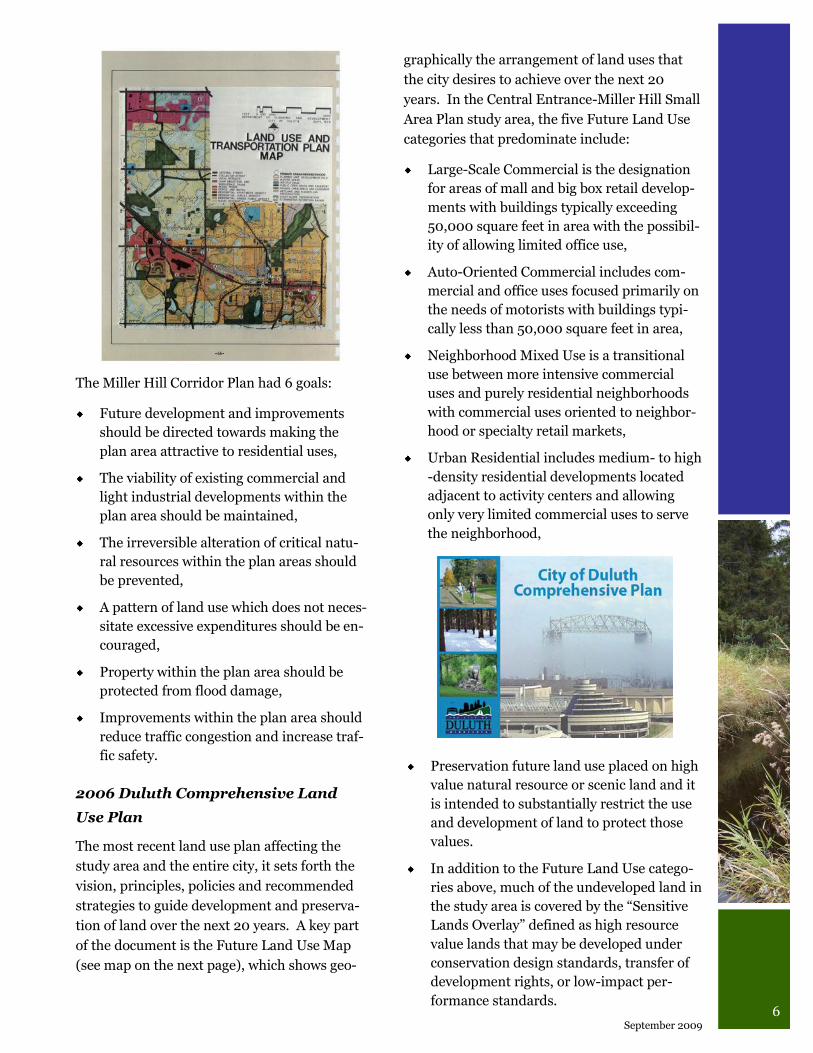
2006 Duluth Comprehensive Land
Use Plan
The most recent land use plan affecting the
study area and the entire city, it sets forth the
vision, principles, policies and recommended
strategies to guide development and preserva-
tion of land over the next 20 years. A key part
of the document is the Future Land Use Map
(see map on the next page), which shows geo-
Preservation future land use placed on high
value natural resource or scenic land and it
is intended to substantially restrict the use
and development of land to protect those
values.
In addition to the Future Land Use catego-
ries above, much of the undeveloped land in
the study area is covered by the “Sensitive
Lands Overlay” defined as high resource
value lands that may be developed under
conservation design standards, transfer of
development rights, or low-impact per-
formance standards.
7 Central Entrance - Miller Hill Small Area Plan
8 September 2009
Transportation Studies:
1992-2006 Metropolitan Interstate
Council studies
In addition to the City sponsored plans listed
above, the Metropolitan Interstate Council
(MIC) has studied the transportation system
on several occasions, including the 1992 Miller
Trunk Highway Corridor Traffic Analysis
Study, the 1995 Miller Hill Corridor Traffic
Study and a 1998 status report on the 1995
study. The MIC also conducted the Duluth
Heights Traffic Circulation Study (2006) to
document cut through traffic and identify solu-
tions to those problems in the Duluth Heights
neighborhood.
2002 Miller Trunk Highway Implementation Plan
In December 2002, Minnesota Department of
Transportation (MN-DOT) completed the
Miller Trunk Highway Implementation Plan
which focused on building from the past plan-
ning efforts, applying updated data, and en-
hancing previous recommendations with new
actions to address congestion, safety, access,
pedestrian, bicycle, and transit issues in the
Central Entrance and Miller Hill corridor. The
study was adopted by MN-DOT, Saint Louis
County, Duluth, Hermantown, and ARDC.
The plan proposed many of the roadway im-
provements that have been made int the Miller
Hill area in 2008 and 2009 as well as the wid-
ening of Trinity Road to five lanes that was
done in 2006. For Central Entrance the plan
recommended, in the long term, pursuing one
of two alternatives. Either develop a one-way
road system using Central Entrance for west-
bound traffic and Palm Street for eastbound
traffic or make more moderate changes to Cen-
tral Entrance such as installing raised medians
and turn lanes at Blackman Avenue, Arlington
Avenue, Basswood Avenue, and Anderson
Roads as well as making improvements to local
streets, such as Palm Street, to give more op-
tions for vehicle circulation.
Demographics
Population and Households
The small area plan study area is situated in the
Duluth Heights neighborhood. An analysis of
U.S. Census statistics was conducted examining
data for Census Tract 3 (see map in Appendix
A), an area that has roughly the same bounda-
ries as the Duluth Heights neighborhood. A
summary of the analysis is presented below and
additional information can be found in Appen-
dix A.
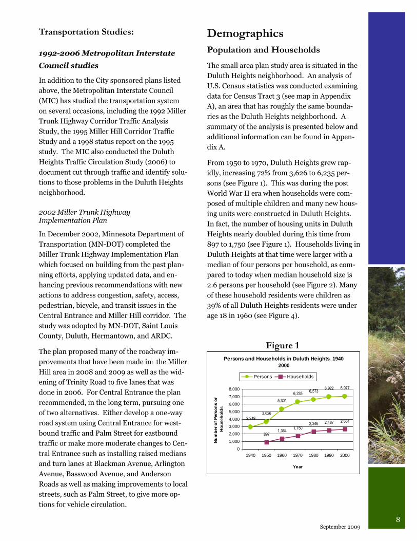
From 1950 to 1970, Duluth Heights grew rap-
idly, increasing 72% from 3,626 to 6,235 per-
sons (see Figure 1). This was during the post
World War II era when households were com-
posed of multiple children and many new hous-
ing units were constructed in Duluth Heights.
In fact, the number of housing units in Duluth
Heights nearly doubled during this time from
897 to 1,750 (see Figure 1). Households living in
Duluth Heights at that time were larger with a
median of four persons per household, as com-
pared to today when median household size is
2.6 persons per household (see Figure 2). Many
of these household residents were children as
39% of all Duluth Heights residents were under
age 18 in 1960 (see Figure 4).
Persons and Households in Duluth Heights, 1940-
2000
2,919
3,626
5,301
6,2356,573
6,922 6,977
8971,364
1,7502,346 2,487 2,661
0
1,000
2,000
3,000
4,000
5,000
6,000
7,000
8,000
1940 1950 1960 1970 1980 1990 2000
Year
Nu
mb
er
of
Pers
on
s o
r
Ho
useh
old
s
Persons Households
Figure 1
9 Central Entrance - Miller Hill Small Area Plan
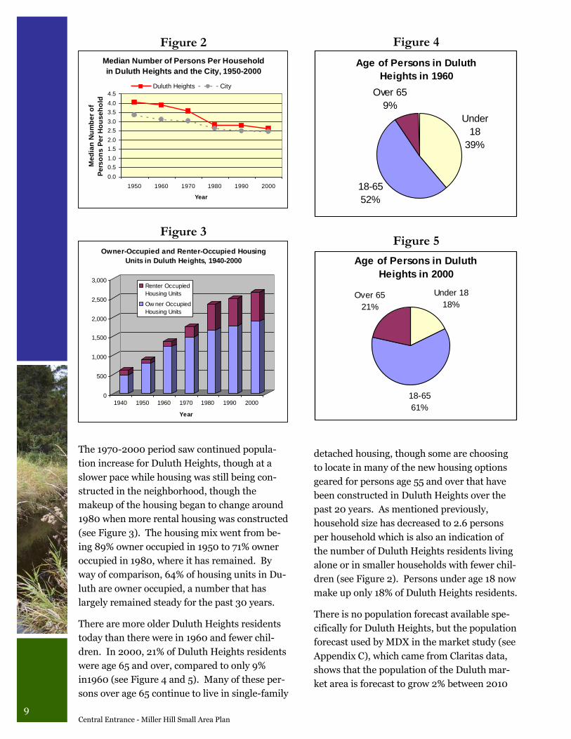
The 1970-2000 period saw continued popula-
tion increase for Duluth Heights, though at a
slower pace while housing was still being con-
structed in the neighborhood, though the
makeup of the housing began to change around
1980 when more rental housing was constructed
(see Figure 3). The housing mix went from be-
ing 89% owner occupied in 1950 to 71% owner
occupied in 1980, where it has remained. By
way of comparison, 64% of housing units in Du-
luth are owner occupied, a number that has
largely remained steady for the past 30 years.
There are more older Duluth Heights residents
today than there were in 1960 and fewer chil-
dren. In 2000, 21% of Duluth Heights residents
were age 65 and over, compared to only 9%
in1960 (see Figure 4 and 5). Many of these per-
sons over age 65 continue to live in single-family
Age of Persons in Duluth
Heights in 1960
Under
18
39%
18-65
52%
Over 65
9%
Figure 3
0
500
1,000
1,500
2,000
2,500
3,000
1940 1950 1960 1970 1980 1990 2000
Year
Owner-Occupied and Renter-Occupied Housing
Units in Duluth Heights, 1940-2000
Renter Occupied
Housing Units
Ow ner Occupied
Housing Units
Figure 4
Age of Persons in Duluth
Heights in 2000
18-65
61%
Over 65
21%
Under 18
18%
Figure 5
Median Number of Persons Per Household
in Duluth Heights and the City, 1950-2000
0.0
0.5
1.0
1.5
2.0
2.5
3.0
3.5
4.0
4.5
1950 1960 1970 1980 1990 2000
Year
Me
dia
n N
um
be
r o
f
Pe
rso
ns
Pe
r H
ou
se
ho
ld
Duluth Heights City
Figure 2
detached housing, though some are choosing
to locate in many of the new housing options
geared for persons age 55 and over that have
been constructed in Duluth Heights over the
past 20 years. As mentioned previously,
household size has decreased to 2.6 persons
per household which is also an indication of
the number of Duluth Heights residents living
alone or in smaller households with fewer chil-
dren (see Figure 2). Persons under age 18 now
make up only 18% of Duluth Heights residents.
There is no population forecast available spe-
cifically for Duluth Heights, but the population
forecast used by MDX in the market study (see
Appendix C), which came from Claritas data,
shows that the population of the Duluth mar-
ket area is forecast to grow 2% between 2010
10 September 2009
and 2020, that the age 65 and over population
will increase 30% during the decade, and that
the under age 18 population will remain con-
stant.
In summary, Duluth Heights has changed over
the past 60 years from being a neighborhood
consisting of larger households living in owner
-occupied housing units to consisting of more
persons over age 65, in much smaller house-
holds with fewer children, and that the make
up of housing units now includes nearly 30%
rental units.
Income
Median household income for Duluth Heights
in 2000 was $34,534, which is just slightly
above the median household income for the
Duluth overall. Duluth Heights is ranked 15th
of the 39 Census Tracts in Duluth. Neighbor-
hoods with median household incomes similar
to Duluth Heights include Lower Kenwood,
Bayview Heights, Gary-New Duluth/Fond du
Lac, and Denfeld. The market study prepared
by MXD Development Strategists found that,
comparatively speaking, Duluth‟s incomes are
slightly lower than average for the nation, but
that Duluth‟s disposable income is slightly
higher than the average due to the low cost of
living in the area. See the “Location Analysis”
section of the market study (Appendix C) for
more information about the composition of
households.
Home Sales Price
According to the Duluth Area Association of
Realtors, Duluth Heights‟ median home sale
price in 2008 was $168,900, which ranked
fourth in Duluth behind Park Point
($290,000), Congdon ($215,000) and Hunters
Park ($192,750). Sixty-five homes sold in Du-
luth Heights in 2008 with homes on the mar-
ket an average of 59 days, which was just
slightly longer than the 57 days average for Du-
luth overall.
Number of Automobiles Per House-
hold
An interesting statistic to note is that the num-
ber of automobiles per household in Duluth has
increased significantly from 1960-2000. In
1960, more than half of the people had only one
car and roughly one quarter had no car at all.
In 2000, roughly one third had one car, one
third had two cars, and 14% had three or more
cars, while 14% still had no car. This is a large
reason why traffic has increased throughout
Duluth and in the study area.
Land Use/Zoning/Public Lands
Existing Land Use
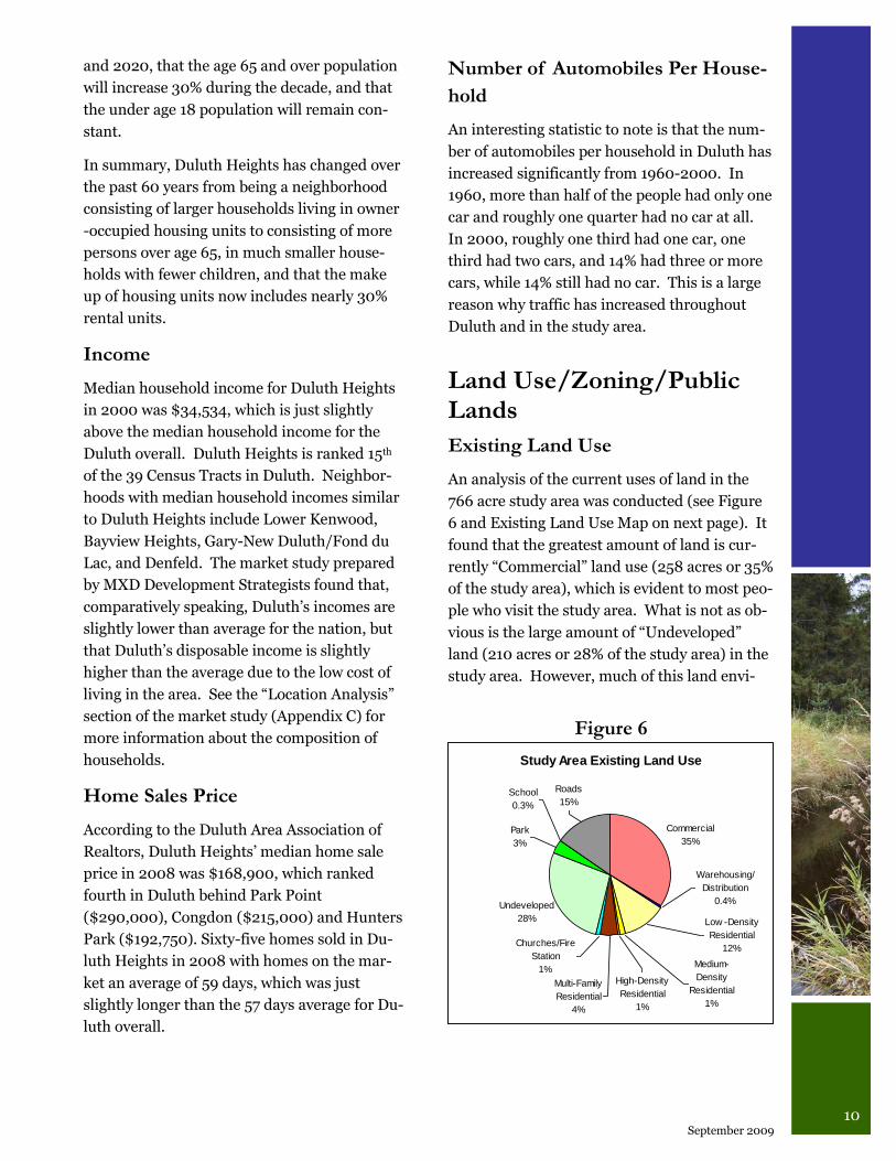
An analysis of the current uses of land in the
766 acre study area was conducted (see Figure
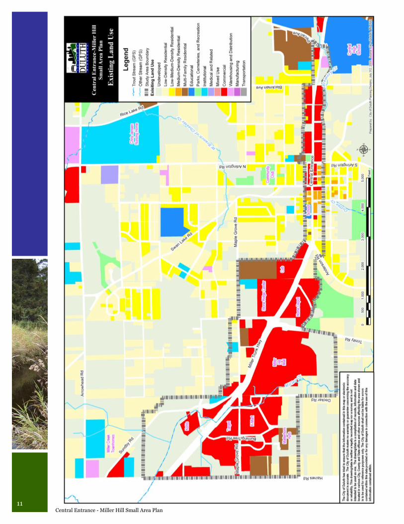
6 and Existing Land Use Map on next page). It
found that the greatest amount of land is cur-
rently “Commercial” land use (258 acres or 35%
of the study area), which is evident to most peo-
ple who visit the study area. What is not as ob-
vious is the large amount of “Undeveloped”
land (210 acres or 28% of the study area) in the
study area. However, much of this land envi-
Study Area Existing Land Use
Commercial
35%
Undeveloped
28%
Park
3%
High-Density
Residential
1%
Medium-
Density
Residential
1%
Low -Density
Residential
12%
Warehousing/
Distribution
0.4%
Multi-Family
Residential
4%
Churches/Fire
Station
1%
School
0.3%
Roads
15%
Figure 6
11 Central Entrance - Miller Hill Small Area Plan
12 September 2009
ronmentally challenged containing many wet-
lands, flood plains, and steep slopes. It is inter-
esting to note that, when all residential land
uses categories are combined, they make up
18% (141 acres) of the study area which is
slightly more land than is used for road right-of
-way (118 acres, 16%).
Zoning
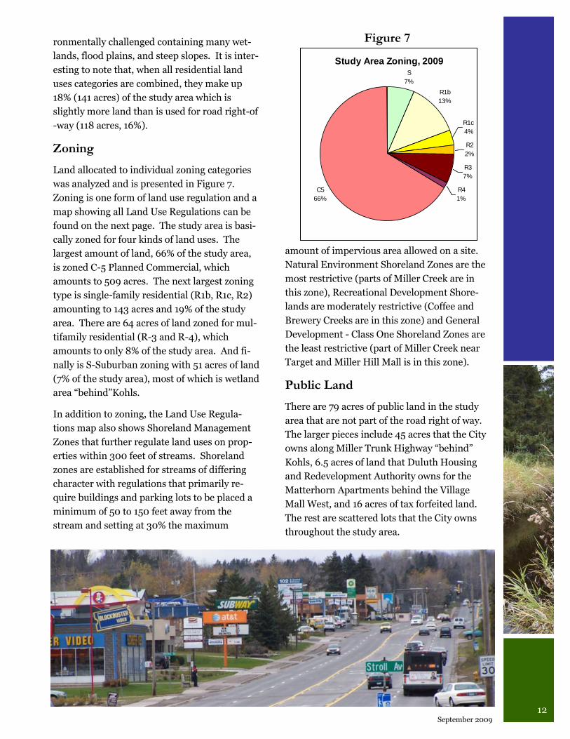
Land allocated to individual zoning categories
was analyzed and is presented in Figure 7.
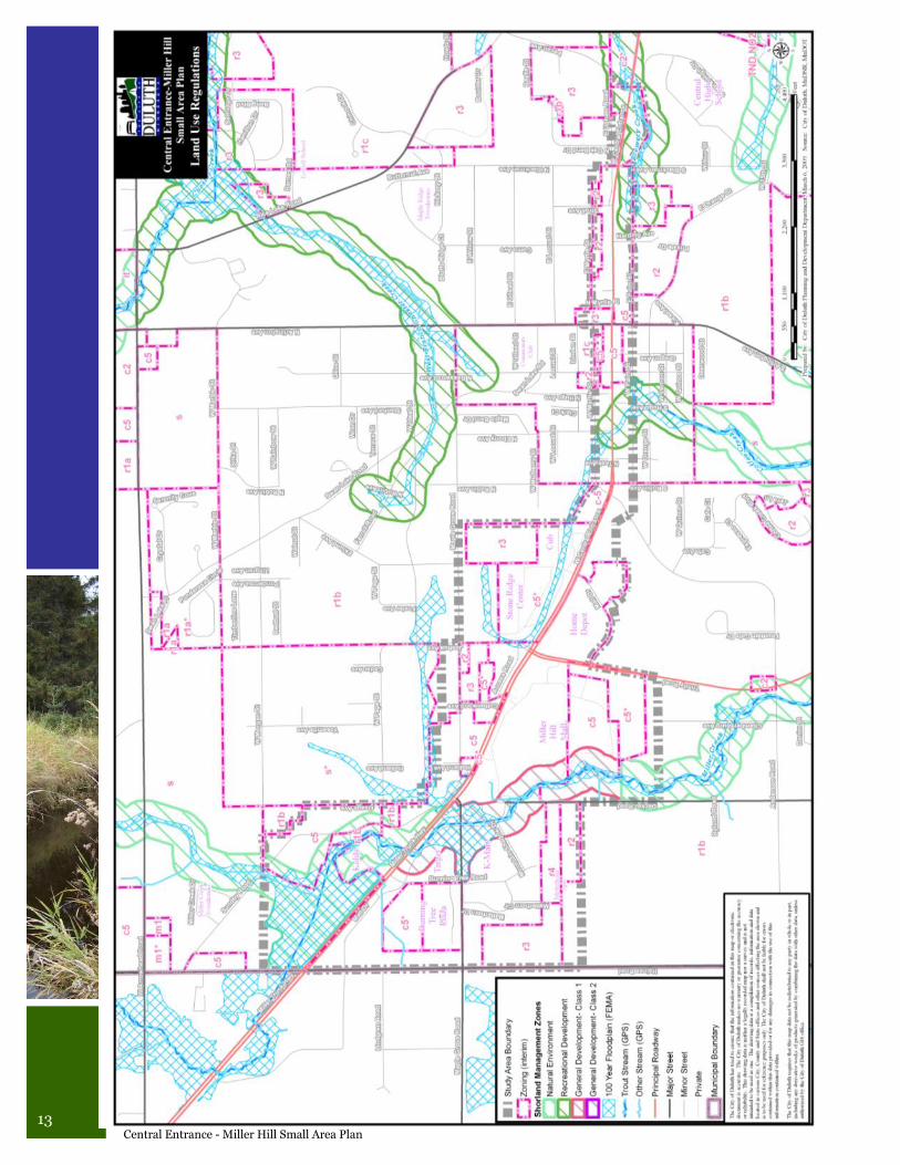
Zoning is one form of land use regulation and a
map showing all Land Use Regulations can be
found on the next page. The study area is basi-
cally zoned for four kinds of land uses. The
largest amount of land, 66% of the study area,
is zoned C-5 Planned Commercial, which
amounts to 509 acres. The next largest zoning
type is single-family residential (R1b, R1c, R2)
amounting to 143 acres and 19% of the study
area. There are 64 acres of land zoned for mul-
tifamily residential (R-3 and R-4), which
amounts to only 8% of the study area. And fi-
nally is S-Suburban zoning with 51 acres of land
(7% of the study area), most of which is wetland
area “behind”Kohls.
In addition to zoning, the Land Use Regula-
tions map also shows Shoreland Management
Zones that further regulate land uses on prop-
erties within 300 feet of streams. Shoreland
zones are established for streams of differing
character with regulations that primarily re-
quire buildings and parking lots to be placed a
minimum of 50 to 150 feet away from the
stream and setting at 30% the maximum
amount of impervious area allowed on a site.
Natural Environment Shoreland Zones are the
most restrictive (parts of Miller Creek are in
this zone), Recreational Development Shore-
lands are moderately restrictive (Coffee and
Brewery Creeks are in this zone) and General
Development - Class One Shoreland Zones are
the least restrictive (part of Miller Creek near
Target and Miller Hill Mall is in this zone).
Public Land
There are 79 acres of public land in the study
area that are not part of the road right of way.
The larger pieces include 45 acres that the City
owns along Miller Trunk Highway “behind”
Kohls, 6.5 acres of land that Duluth Housing
and Redevelopment Authority owns for the
Matterhorn Apartments behind the Village
Mall West, and 16 acres of tax forfeited land.
The rest are scattered lots that the City owns
throughout the study area.
Study Area Zoning, 2009
R1b
13%
R1c
4%
R2
2%
R3
7%
R4
1%
C5
66%
S
7%
Figure 7
13 Central Entrance - Miller Hill Small Area Plan
14 September 2009
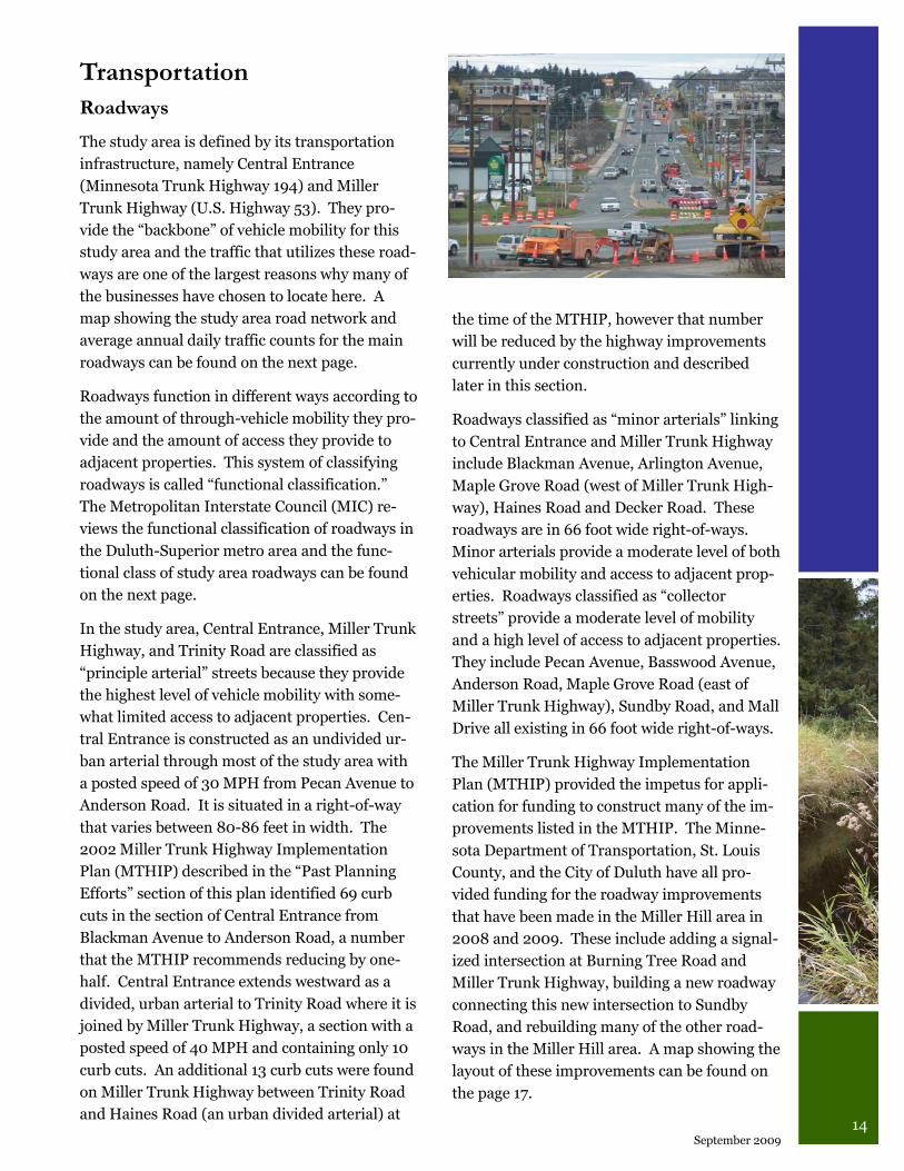
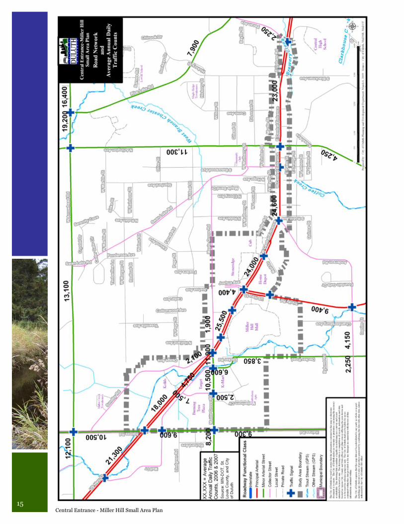
Transportation
Roadways
The study area is defined by its transportation
infrastructure, namely Central Entrance
(Minnesota Trunk Highway 194) and Miller
Trunk Highway (U.S. Highway 53). They pro-
vide the “backbone” of vehicle mobility for this
study area and the traffic that utilizes these road-
ways are one of the largest reasons why many of
the businesses have chosen to locate here. A
map showing the study area road network and
average annual daily traffic counts for the main
roadways can be found on the next page.
Roadways function in different ways according to
the amount of through-vehicle mobility they pro-
vide and the amount of access they provide to
adjacent properties. This system of classifying
roadways is called “functional classification.”
The Metropolitan Interstate Council (MIC) re-
views the functional classification of roadways in
the Duluth-Superior metro area and the func-
tional class of study area roadways can be found
on the next page.
In the study area, Central Entrance, Miller Trunk
Highway, and Trinity Road are classified as
“principle arterial” streets because they provide
the highest level of vehicle mobility with some-
what limited access to adjacent properties. Cen-
tral Entrance is constructed as an undivided ur-
ban arterial through most of the study area with
a posted speed of 30 MPH from Pecan Avenue to
Anderson Road. It is situated in a right-of-way
that varies between 80-86 feet in width. The
2002 Miller Trunk Highway Implementation
Plan (MTHIP) described in the “Past Planning
Efforts” section of this plan identified 69 curb
cuts in the section of Central Entrance from
Blackman Avenue to Anderson Road, a number
that the MTHIP recommends reducing by one-
half. Central Entrance extends westward as a
divided, urban arterial to Trinity Road where it is
joined by Miller Trunk Highway, a section with a
posted speed of 40 MPH and containing only 10
curb cuts. An additional 13 curb cuts were found
on Miller Trunk Highway between Trinity Road
and Haines Road (an urban divided arterial) at
the time of the MTHIP, however that number
will be reduced by the highway improvements
currently under construction and described
later in this section.
Roadways classified as “minor arterials” linking
to Central Entrance and Miller Trunk Highway
include Blackman Avenue, Arlington Avenue,
Maple Grove Road (west of Miller Trunk High-
way), Haines Road and Decker Road. These
roadways are in 66 foot wide right-of-ways.
Minor arterials provide a moderate level of both
vehicular mobility and access to adjacent prop-
erties. Roadways classified as “collector
streets” provide a moderate level of mobility
and a high level of access to adjacent properties.
They include Pecan Avenue, Basswood Avenue,
Anderson Road, Maple Grove Road (east of
Miller Trunk Highway), Sundby Road, and Mall
Drive all existing in 66 foot wide right-of-ways.
The Miller Trunk Highway Implementation
Plan (MTHIP) provided the impetus for appli-
cation for funding to construct many of the im-
provements listed in the MTHIP. The Minne-
sota Department of Transportation, St. Louis
County, and the City of Duluth have all pro-
vided funding for the roadway improvements
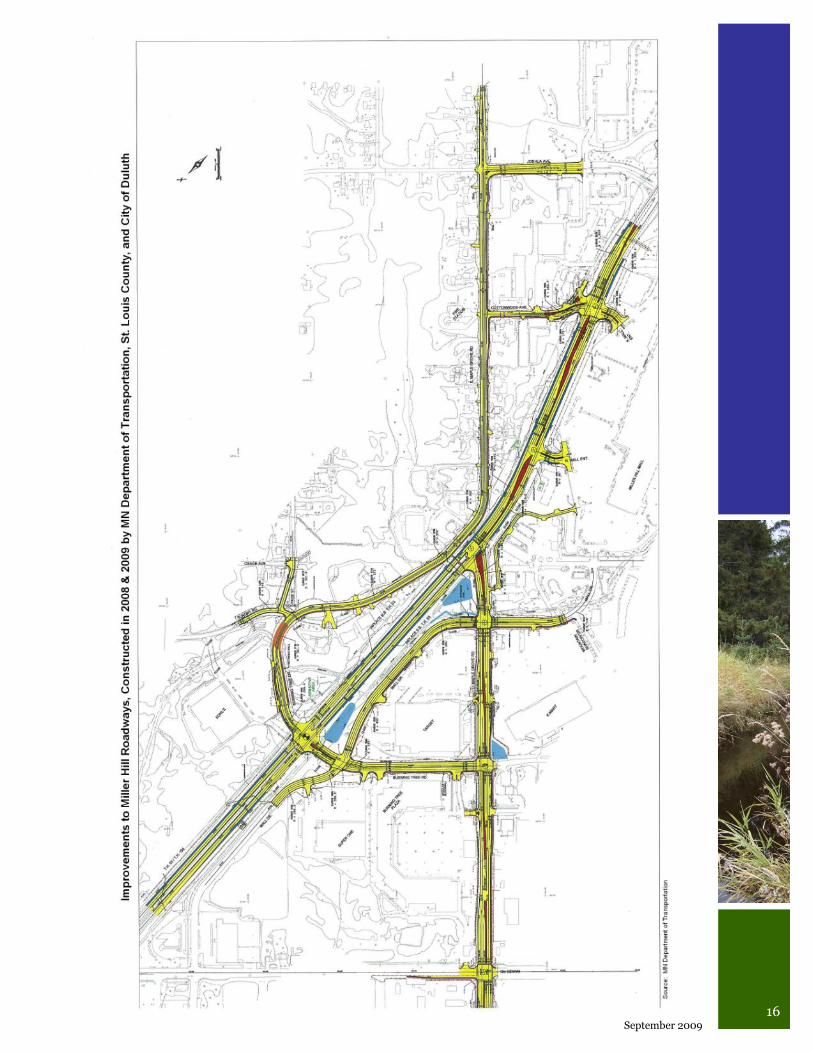
that have been made in the Miller Hill area in
2008 and 2009. These include adding a signal-
ized intersection at Burning Tree Road and
Miller Trunk Highway, building a new roadway
connecting this new intersection to Sundby
Road, and rebuilding many of the other road-
ways in the Miller Hill area. A map showing the
layout of these improvements can be found on
the page 17.
15 Central Entrance - Miller Hill Small Area Plan
16 September 2009
17 Central Entrance - Miller Hill Small Area Plan
Vehicle traffic volumes in the study area is con-
siderably high with the “Average Annual Daily
Traffic” count hovering around 25,000 vehicles
per day along sections of Central Entrance and
Miller Trunk Highway. By comparison, Maple
Grove Road west of Miller Trunk Highway and
Haines Road see about half the volume of traf-
fic. High traffic volumes can be handled by cer-
tain roadway designs and the improvements
being made in the Miller Hill area in 2008 and
2009 are designed to handle the traffic volume
today through 2025. Traffic volumes on Cen-
tral Entrance today are acceptable, with the ex-
ception of vehicles attempting to access the
roadway from Blackman Avenue and left turn-
ing movements from eastbound Central En-
trance at Arlington Avenue and westbound
Central Entrance at Anderson Road, according
to the background research conducted for the
Miller Trunk Highway Implementation Plan.
Even with the considerable traffic volumes on
Central Entrance and Miller Trunk Highway,
traveling these roadways is quite safe as evi-
denced by vehicle crash rates being below the
statewide average on all segments. Data gath-
ered for the Miller Trunk Highway Implemen-
tation Plan show the 1998-2000 crash rates for
Central Entrance between Blackman Avenue
and Anderson Road as 1.8 crashes per million
vehicle miles per year compared with 5.9 for
roadways of a similar type statewide. Also low
was the crash rate for Central Entrance/Miller
Trunk between Anderson Road and west of Ma-
ple Grove Road where only 1.5 crashes occurred
per million vehicle miles per year compared
with the statewide rate of 2.1
Transit Service
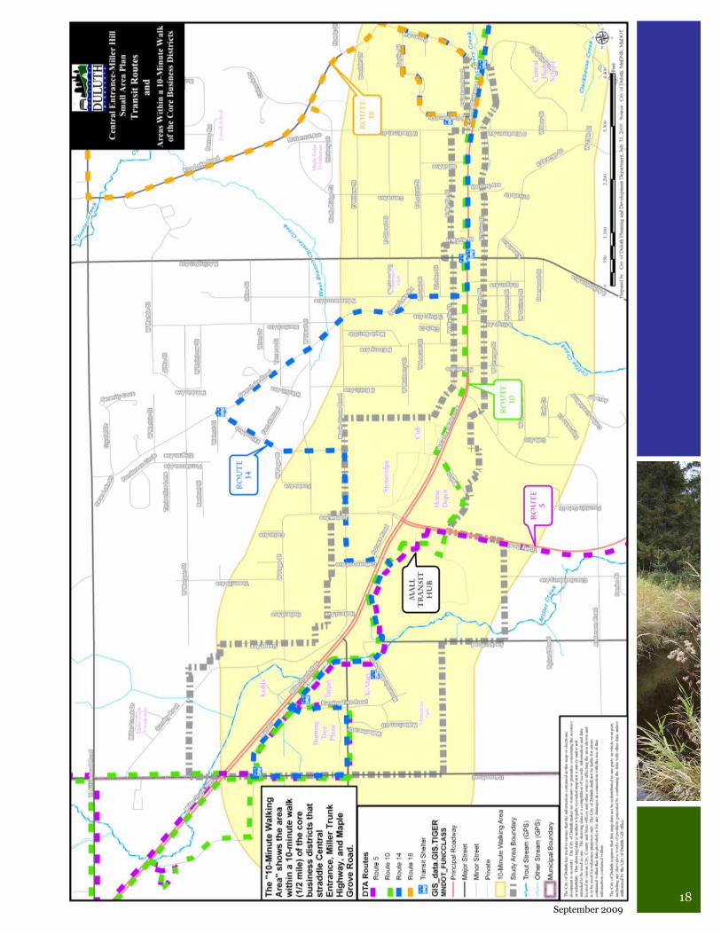
The Duluth Transit Authority (DTA) operates a
transit hub at the Miller Hill Mall between Sears
and Old Navy (Mall Door #8). Buses utilizing
this hub serve the study area with connections
(see map on the next page) to the Downtown
transit hub via Route 10 (hourly off-peak ser-
vice, ½ hourly peak service), Spirit Valley/
Lincoln Park via Route 5 (hourly service), the
Duluth Heights neighborhood via Route 14
(hourly peak service, no off-peak service), and
the airport (hourly service). On weekends,
buses are routed differently to make it more
convenient for people from many Duluth
neighborhoods to arrive at the mall without
transferring to another bus downtown. The Mall
Area Connector (MAC) circulates every 30 min-
utes between the Mall, K-Mart, Burning Tree
Plaza, Target, and then back to the K-Mart and
the Mall, though this route will change when the
roadway improvements are completed.
There is weekday hourly service to the UMD
transit hub but riders must transfer to Route 18
at Central Entrance and Pecan Avenue, though
the schedules have been coordinated to reduce
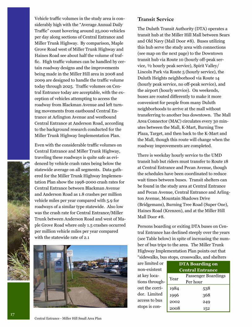
wait times between buses. Transit shelters can
be found in the study area at Central Entrance
and Pecan Avenue, Central Entrance and Arling-
ton Avenue, Mountain Shadows Drive
(Bridgemans), Burning Tree Road (Super One),
Haines Road (Krenzen), and at the Miller Hill
Mall Door #8.
Persons boarding or exiting DTA buses on Cen-
tral Entrance has declined steeply over the years
(see Table below) in spite of increasing the num-
ber of bus trips to the area. The Miller Trunk
Highway Implementation Plan points out that
“sidewalks, bus stops, crosswalks, and shelters
are limited or
non-existent
at key loca-
tions through-
out the corri-
dor. Limited
access to bus
stops is con-
DTA Boarding on
Central Entrance
Year Passenger Boardings
Per hour
1984 538
1996 368
2002 249
2008 152
18 September 2009
19 Central Entrance - Miller Hill Small Area Plan
sidered to be one factor in a significant decrease
in transit ridership over the past 20 years.”
DTA Route 10 provides the most direct and fre-
quent service to the Central Entrance and
Miller Hill business districts. It largely trav-
erses the two business districts core areas. The
Transit Route map on the previous page shows
a shaded polygon that represents the area
within ½ mile of the business districts and
transit routes, an area from which a typical per-
son would likely walk to access businesses and
transit, the “10-minute walking area.” From
this map it is evident that much of the Duluth
Heights neighborhood is within a 10-minute
walk of the Central Entrance and Miller Hill
business districts and frequent transit service.
Bicycle Routes
The Metropolitan Interstate Council prepared
the MIC Bikeways Plan in 1994 and published
the Duluth-Superior Metropolitan Bike Route
Map in 2003. From these documents, two pri-
mary bike routes are found in the study area.
There is a signed on-street route that follows
Palm Street to Orange Street and then on to
Anderson Road where Decker Road provides a
connection to the mall area. This route is con-
nected to an off-street bike path that parallels
Palm Street east of Arlington Avenue past Cen-
tral High School and into the Harbor Highlands
neighborhood (formerly Harborview Homes).
There is also an unsigned on-street bike route
that follows Mulberry Street to Swan Lake and
on to Maple Grove Road where it then follows
Cottonwood Avenue to the Miller Hill Mall.
Bicycling on Central Entrance and Miller Trunk
Highway is “not recommended” by the 2003
Bike Route Map.
Pedestrian Facilities
Pedestrian facilities in the study area are in-
complete, inconvenient, and often uncomfort-
able for people to use. The Miller Trunk High-
way Implementation Plan found that
“pedestrian and transit movement is a major
problem throughout the corridor.” The re-
building of TH 53 in the mall area will improve
the situation somewhat by adding sidewalks on
streets that previously had none. Unfortu-
nately, sidewalks will only be added to one side
of the streets. There are existing sidewalks
along one side of Palm Street, Arlington Ave-
nue, Trinity Road, Mountain Shadows Drive,
Matterhorn Circle, and Decker Road. The off-
street bicycle path along the south side of Palm
Street from Arlington Avenue east to Central
High School and Harbor Highlands can also
serve pedestrians.
Central Entrance has a sidewalk only on the
south side of the street from Pecan Avenue to
Arlington Avenue with a +/- 5 foot wide paved
boulevard separating it from the driving lanes.
There is a sidewalk on both sides of Central
Entrance from Arlington Avenue to a block
short of Anderson Road where the sidewalk
ends on the south side of the street, but contin-
ues on the north side. A sidewalk will be con-
structed in front of the Residence Inn between
Anderson Road/Myrtle Street and Midas Muf-
fler. As is the case in many locations in the
study area, an existing well worn path connects
the end of the sidewalk to the Stoneridge Shop-
20 September 2009
ping Center via Midas Muffler‟s parking lot.
There is also a well worn path on the north side
of Central Entrance from Blackman Avenue to
Arlington Avenue, indicating significant de-
mand for pedestrian facilities.
Throughout the study area, speed and volume
of traffic often makes it difficult to cross princi-
ple and minor arterials. People can often be
witnessed darting across the street mid-block.
Another significant problem is the lack of pe-
destrian facilities on existing commercial sites.
Many of the shopping centers and large com-
mercial sites were developed without consid-
eration to pedestrian travel.
Utilities Municipal potable water, sanitary sewer, and
natural gas utilities are available throughout
the study area with the exceptions of the
Sundby Road area north of Page Street and the
interior area between Haines Road and Decker
Road south of the Schneiderman‟s Furniture
store.
According to the City Engineering Division, wa-
ter service within the study is generally good
with acceptable pressure and volume for nor-
mal domestic or commercial use. Fire flows
within certain areas are less than desirable due
to small mains and lower pressures. The City
intends to construct a new elevated water stor-
age tank in 2011 that will increase both fire sup-
ply and pressure to remedy this situation.
Overall sanitary sewer capacity within the area
is acceptable. However, sanitary sewers within
this area are upstream from documented sani-
tary sewer overflows, therefore, minimal devel-
opment restrictions are in place. For develop-
ments with wet weather wastewater flows less
than 10,000 gallons per day (gpd), there are no
restrictions. For developments with wastewater
flows greater than 10,000 gpd, the developer is
required to remove sources of infiltration and
inflow within the system equal to 3 times the
estimated average wet weather flow. The infil-
tration and inflow removal can generally be ac-
complished by paying for installation of sump
pumps in private residences or replacement of
private leaking sanitary sewer laterals.
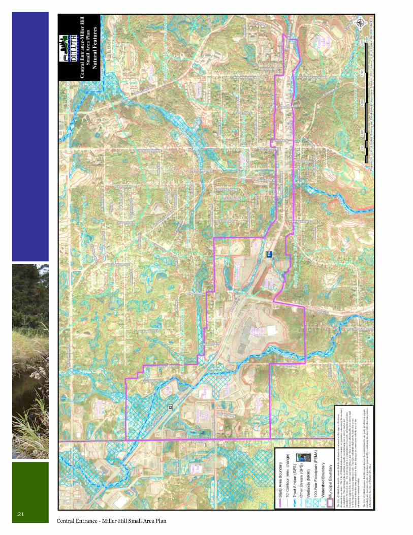
Environmental Characteristics In addition to the human-made features and
characteristics outlined in the sections above,
the study area also contains important natural
features (see Natural Features map on the next
page). The study area straddles three water-
sheds, Brewery Creek, Coffee Creek, and Miller
Creek, the latter two are designated “trout
streams” by the Minnesota Department of
Natural Resources. This means that the
streams are, or have been in the past, able to
support populations of trout. A watershed is
the entire geographical area drained by a creek
and its tributaries.
Miller Creek is listed as an “impaired waterway”
by the Minnesota Pollution Control Agency due
to the temperatures reached in the stream and
its impacts on trout populations. Because of
this listing, a Total Maximum Daily Load
(TMDL) study must be conducted to determine
the maximum amount of pollutants that Miller
Creek can receive and still safely meet federal
water quality standards. This study is under-
way and is expected to be completed this year.
After the completion of the study, an Imple-
mentation Plan will be written as guidance for
how to achieve the TMDL. The Implementation
Plan might include anything from where to
21 Central Entrance - Miller Hill Small Area Plan
22 September 2009
plant more trees to new storm water discharge
standards.
Stream water quality is linked to impervious
surfaces, which heat up in sunlight and trans-
mit that heat to streams during rain events.
Uncontrolled or poorly controlled runoff from
impervious surfaces flowing at high rates tends
to erode stream channels and carry pollutants,
which affect streams.
Undeveloped sections of the study area contain
numerous wetlands, many associated with the
trout streams above. Stream water quality is
linked to wetland quantity and quality because
wetlands give rainwater a place to slow down
and cool off before some of it is discharged into
streams.
Each stream has an area prone to flooding,
called a flood plain. Most new developments
are designed to stay out of flood plains. How-
ever, it is interesting to note that the Target and
K-Mart parking lots are both within the 100-
year flood plain of Miller Creek.
Comprehensive Land Use Plan Principles The 12 Governing Principles adopted in the
2006 Comprehensive Land Use Plan provide
the fundamental concepts guiding all of the
Comprehensive Plan‟s recommendations.
They provide direction when details of the plan
itself are insufficiently clear to resolve issues or
make decisions. It is these principles that pro-
vide the context for many of the recommenda-
tions in this small area plan. The 12 Governing
Principles are:
1. Reuse previously developed lands,
2. Declare the necessity and secure the future
of undeveloped places,
3. Support Duluth‟s traditional economic
base,
4. Support emerging economic growth sec-
tors,
5. Strengthen neighborhoods,
6. Reinforce the place-specific,
7. Create and maintain connectivity,
8. Encourage a mix of activities, uses and
densities,
9. Support private actions that contribute to
the public realm,
10. Take sustainable actions,
11. Include considerations for education
systms in land use actions,
12. Create efficiencies in delivery of public ser-
vices.
23 Central Entrance - Miller Hill Small Area Plan
Market Analysis It is important for a land use plan, such as this
small area plan, to be grounded in reality con-
cerning the supply and demand for each type of
land use in the marketplace. Early in the study
process, a request for proposals was widely dis-
tributed and, from the contractors who submit-
ted proposals, MXD Development Strategists
was selected to conduct a market study for the
study area. Specifically, they were hired to as-
sess the supply and demand for retail, residen-
tial, office and hotel land uses in the study area,
and to prepare a land use allocation strategy
and fiscal benefits summary. The complete
market study can be found in Appendix C. Fol-
lowing is the executive summary of the market
study prepared by MXD.
Central Entrance - Miller Hill Mall
Corridor
Context Summary & Implications
A review of Miller Hill‟s regional setting, local
context (particularly the sensitivity to the well-
being of Downtown Duluth) and site qualities,
results in several recommendations:
The Central Entrance – Miller Hill district
is the dominant retail hub in Duluth, itself
the most important regional hub in north-
eastern Minnesota and northwestern Wis-
consin. As it is primarily a retail corridor,
future development should build upon this
critical mass and momentum of shopping,
dining and entertainment as the basis of its
further development.
A new type of development format is re-
quired to provide a better sense of place in
the area, so critical to success in today‟s real
estate market.
Where possible, residential uses should be
introduced to the area, particularly on the
periphery, to provide a more multi-purpose
Town Center setting.
Office uses should continue to be focused in
the Downtown, although smaller boutique
office space, particularly oriented to local
professional services (lawyers, insurance,
etc.) would be an important function to
round out the corridor.
Additional Hotel/Motel accommodation
could be a good addition to the corridor,
subject to sufficient demand.
A public gathering space should be inte-
grated into the overall strategy from which
to center the entire corridor.
Existing land uses are fragmented and dis-
persed, so the highest priority should be
given to inner locations to fill in the gaps in
the corridor before concentrating on ex-
panding the core retail activity.
The competitive effect of Hermantown and
its critical mass of retail needs to be miti-
gated by an effective districting strategy.
Specifically, priority should be given to de-
velopment sites that are located away from
the city boundary, as this will serve to con-
tain the level of cross-shopping and sales
leakage from Duluth.
Evening activity is lacking in the area. Uses
such as Entertainment (Cinema and other
Family Entertainment) could ideally fulfill
this role.
Retail concepts which have thrived in the Study
Area are large format “big box” stores and the
Miller Hill Mall, both of which provide an inter-
nal retail experience and effectively turn their
backs to the streets surrounding them.
24 September 2009
However, American shoppers, already report-
ing “mall fatigue,” are increasingly being en-
ticed by new pedestrian-friendly, multipurpose
places, such as Lifestyle Centers and Suburban
Town Centers. As a consequence, such multi-
purpose, pedestrian-friendly places are being
introduced throughout the country.
Based upon the Location Analysis, it is recom-
mended that Miller Hill be transformed over
time to include such a “place.” This should
form part of a wider strategy to concentrate
activity within the area, and round out its com-
mercial offering, while also introducing poten-
tial residential uses to round out its sense of
activity during off-peak hours.
Mixed-use development would provide a num-
ber of solutions to the challenges faced by the
Study Area. Mixed-use development provides
a sense of place so missing in the area. It also
provides a natural “center” and public gather-
ing place, which is also needed. Such a multi-
purpose development could include housing
(subject to Demand Analysis) and/or office
space, as well as accommodation.
Supply Summary & Implications
The evaluation of Duluth‟s retail environment
relating to competitive forces, merchandise
voids, sector performance and supply metrics
reveals some key findings and resulting oppor-
tunities for the Central Entrance – Miller Hill
Corridor.
Miller Hill is the dominant force in the regional
marketplace for retail anchored regionally by
the Miller Hill Mall. The current inventory of
the Miller Hill Mall area is estimated at 2.16
million square feet (sf) (excluding auto dealer-
ships and auto servicing). This represents ap-
proximately 58% of the total City of Duluth
retail inventory (3.74 million sf). The current
vacancy rate for Miller Hill (4.0%) is below the
City average and at a healthy level, suggesting
there is demand for retail in the Corridor, but
more in the Miller Hill area than along Central
Entrance, which has developed into a pedes-
trian unfriendly, highly fragmented, highway
strip retail core dominated by fast food and
auto services
The City of Duluth retail inventory does not in-
clude the retail west of Haines Rd in the City of
Hermantown. In recent years however, the role
of Hermantown has increased significantly to a
point whereby Hermantown has now become a
major player in attracting commercial develop-
ments, such as Wal-Mart, Sam‟s Club, Menards
and Gander Mountain. Consequently the ap-
proximately 685,000 sf of large format retail
located within a 3-minute drive time of the
Miller Hill Mall has contributed to likely sales
outflow from Duluth to Hermantown and is a
primary reason why the City is facing develop-
ment pressures for non-commercially zoned
lands.
Much of the retail along the Corridor, and in
particular around the Miller Hill Mall is value
oriented and in some cases, as evidenced by the
relocation of Gander Mountain, is obsolete re-
tail space for new-to-market tenants or tenants
wishing to relocate to the Miller Hill area. Av-
erage lease rates for the majority of retail space
in the Miller Hill area (excluding the Miller Hill
Mall) is in the $10 - $15 per square foot (psf)
range, which represents a challenge for any new
developers wishing to create a newer modern
retail environment, given current construction
costs.
Miller Hill is the dominant shopping area for
Duluth, but the scattered pattern of historic de-
velopment has created a position whereby lar-
ger areas of contiguous developable land have
become perceived as scarce, which is why
neighboring Hermantown has been so success-
ful in luring tenants (and corresponding retail
sales tax revenue) away from Duluth. Miller
Hill is too important a corridor to further allow
this outflow to occur and therefore infill, densi-
fication and redevelopment should be looked at
as solutions to creating a cohesive, more com-
pact environment.
25 Central Entrance - Miller Hill Small Area Plan
One void in the local market is a Suburban
Town Center that does not compete with Down-
town, but instead provides a core for people
living in this area of the city. Such a Suburban
Town Center typically works well with enter-
tainment concepts, particularly a cinema, and
restaurants and could potentially attract an in-
vestor based on the lack of strong competition
in the area. While it is acknowledged there was
a cinema at Miller Hill Mall and the Lakes 10
Cinema is located in Hermantown, this facility
is isolated from the core population and retail
concentration. Therefore, the City of Duluth
could look to pursue a more modern multiplex
Cinema that would be a more suitable fit for the
market and contribute to higher retention of
spending in Duluth given the adjacency of com-
patible retail functions.
In the immediate Miller Hill Mall area, there is
a clear need to mix automobile-oriented big box
spaces (that afford wide vistas of the whole
area) with smaller, intimate and more contem-
plative spaces geared towards pedestrians. This
infill would promote not only a critical mass of
retail, but more importantly a critical mix of
retail. Among the targeted retail functions are
Outdoor Sporting Goods, Casual Restaurants
and more adult-oriented Fashions.
The impact of Miller Hill‟s evolution over the
past 30 years has been evidenced in the chal-
lenges faced in Downtown Duluth. Therefore,
local retail tenants, specialty fashion stores and
urban grocery concepts should be left for
Downtown Duluth to pursue, which will always
have an advantage in stimulating an eclectic
retail mix. In this way, the tenant mix alloca-
tion of the Miller Hill area could be 70% Na-
tional/Regional to 30% Local, while Downtown
could evolve to become 70% Local to 30% Na-
tional/Regional. Popular Downtown restau-
rants, may also potentially want to open a sec-
ond location “over the hill” to garner evening
patronage as well.
The overall supply of office space along the
Central Entrance – Miller Hill Corridor is very
limited and largely comprised of older Class B
& C office space targeting local professional ser-
vices. There are no defined office campuses
along the corridor and the two most recent de-
velopment proposals, namely the Sande Office
Project on Central Entrance and the Arrowhead
Crossing on Haines Road have both been im-
pacted by limited demand, which has affected
their development and/or construction status.
With regard to the Sande Office Project, its lo-
cation may well become an important site in
the future, but the project itself is likely ahead
of its time for that area, given the adjacency of
uses and demand.
In general, the majority of quality office space
for larger users should continue to be focused
in the Downtown area, while the Central En-
trance – Miller Hill Corridor should pursue op-
portunities for smaller local and professional
services integrated within a mixed-use develop-
ment format. For example, boutique office
space for small firms, particularly individuals
seeking a work space close to home, kids‟
schools etc, and who would not necessarily
benefit from synergies downtown. Potential
smaller office space would be particularly at-
tractive if amenities located very close by
(shopping, dining, services, pub, etc.).
In terms of hotel/motel supply, it is currently in
balance with demand. Since 2001, Duluth has
averaged an occupancy rate of between 62%
and 64%. Duluth‟s 2007 average occupancy was
63.9%, which was over one percentage point
higher than the National average (62.7%). Av-
erage Daily Room Rates (ADR) ($84.35 in Du-
luth) are lower than the national average. From
a revenue perspective, the lower ADR suggests
lesser potential revenues which may result in
lower demand by hoteliers, given the current
economic downturn. The Miller Hill Corridor
has a ratio of Tier 1 to Tier 2 weighted more
towards a more value-oriented price point.
Given the slow growth in supply in the market,
and the current trend to upgrade Downtown/
Canal Park properties, the most likely scenario
for accommodation would be additional Tier 2
development over a long time horizon.
26 September 2009
Demand Summary & Implications
A Demand Analysis was undertaken to identify
and quantify the various potential markets for
retail, office, residential and hotel/motel uses
within the Miller Hill corridor. The findings,
coupled with the Supply Analysis findings, pro-
vide the foundation of the Land Use Allocation
Analysis undertaken in the next Section.
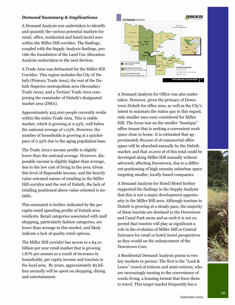
A Trade Area was delineated for the Miller Hill
Corridor. This region includes the City of Du-
luth (Primary Trade Area), the rest of the Du-
luth-Superior metropolitan area (Secondary
Trade Area), and a Tertiary Trade Area com-
prising the remainder of Duluth‟s designated
market area (DMA).
Approximately 425,000 people currently reside
within the entire Trade Area. This is stable
market, which is growing at 0.23%, well below
the national average of 1.03%. However, the
number of households is growing at a quicker
pace of 0.55% due to the aging population base.
The Trade Area‟s income profile is slightly
lower than the national average. However, dis-
posable income is slightly higher than average,
due to the low cost of living in the area. Given
this level of disposable income, and the heavily
value-oriented nature of retailing in the Miller
Hill corridor and the rest of Duluth, the lack of
retailing positioned above value-oriented is no-
table.
This mismatch is further indicated by the per
capita retail spending profile of Duluth area
residents. Retail categories associated with mall
shopping, particularly fashion categories, are
lower than average in this market, and likely
indicate a lack of quality retail options.
The Miller Hill corridor has access to a $4.01
billion per year retail market that is growing
1.87% per annum as a result of increases in
households, per capita income and tourism in
the local area. By 2020, approximately $5 bil-
lion annually will be spent on shopping, dining
and entertainment.
A Demand Analysis for Office was also under-
taken. However, given the primacy of Down-
town Duluth for office uses, as well as the City‟s
intent to maintain the status quo in this regard,
only smaller uses were considered for Miller
Hill. The focus was on the smaller “boutique”
office tenant that is seeking a convenient work
space close to home. It is estimated that ap-
proximately 80,000 sf of commercial office
space will be absorbed annually by the Duluth
market, and that 10,000 sf of this total could be
developed along Miller Hill annually without
adversely affecting Downtown, due to a differ-
ent positioning of high amenity suburban space
targeting smaller, locally-based companies.
A Demand Analysis for Hotel/Motel further
supported the findings in the Supply Analysis
that this is not a major development opportu-
nity in the Miller Hill area. Although tourism to
Duluth is growing at a steady pace, the majority
of these tourists are destined to the Downtown
and Canal Park areas and as such it is not ex-
pected that tourists will play as significant a
role in the evolution of Miller Hill or Central
Entrance for retail or hotel/motel perspectives
as they would on the enhancement of the
Downtown Core.
A Residential Demand Analysis points to two
key markets to pursue: The first is the “Lock &
Leave” crowd of retirees and semi-retirees, who
are increasingly turning to the convenience of
condo living, a housing format that frees them
to travel. This target market frequently has a
27 Central Entrance - Miller Hill Small Area Plan
second condo in a Sunbelt state. The second
group is the “Local Downsizer” market, who are
also older, but not as affluent as the Lock &
Leave set. This second group also is seeking the
convenience of condo living but for the entire
year.
Both residential demand segments value access
to nature, health care and amenities such as
coffee shops, fitness facilities and grocery
stores. This group increasingly has driven sales
at mixed-use projects built above retail in a pe-
destrian-friendly village-type setting. Such a
development in the Miller Hill corridor could
position itself at the heart of the consumer mar-
ket.
Land Use Allocation Summary
& Implications
A Land Use Allocation analysis was applied to
the locational, supply and demand conditions
for each of the retail, office, accommodation
and residential land uses along the Central En-
trance – Miller Hill study area. The following
projections were calculated:
Retail demand is expected to grow at an
average annual increase of 27,345 sf over
the next decade. As such by 2015 approxi-
mately 150,000 sf of new retail could be
absorbed and by 2020, 302,000 sf, fol-
lowed by an additional 150,000 sf by 2030.
Based upon the retail void analysis and a
target tenant profiling analysis, this amount
of square footage is expected to constitute a
number of fast casual restaurants, adult
fashion stores, an outdoor recreation “mini-
anchor” as well as a smaller specialty food
market. The recommended retail mix is
considered achievable if the right kind of
development format was introduced along
the study area, namely a strategically-
located Suburban Town Center.
Office space is recommended for at most
10,000 sf a year based upon the City‟s in-
tention to concentrate business activity in
the Downtown Core. The recommended
amount of space would be targeted at
smaller companies seeking work space
close to homes and schools, particularly in
high amenity settings close to a number of
convenience and food & beverage opportu-
nities.
Support for additional Accommodation is
anticipated to grow slowly over the coming
years, particularly based on the likely com-
pletion of the Residence Inn. Based upon
current projections, it would likely be 2021
at the earliest before sufficient demand
warranted additional accommodation fa-
cilities within the study area.
For-sale multi-family residential demand is
estimated at approximately 162 new units
by 2015 and 235 by 2020. An additional 41
rental multi-family units are projected to be
absorbable by 2015 and 59 by 2020.
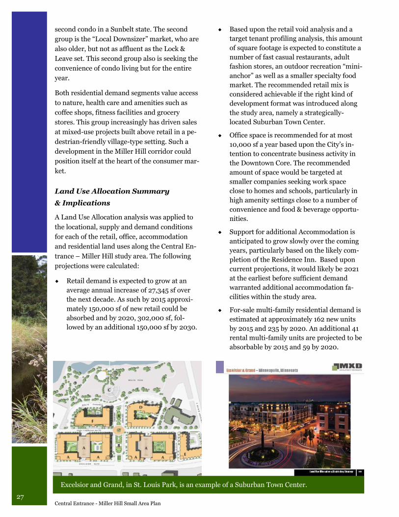
Excelsior and Grand, in St. Louis Park, is an example of a Suburban Town Center.
28 September 2009
Districting Strategies Summary
& Implications
The forecasted rates of absorption illustrate a
more pragmatic and slower rate of growth
whereby, short term (2010 to 2015), develop-
ment priority is allocated to infill and intensify-
ing the immediate area west and north of the
Miller Hill Mall. Over the period 2015 to 2025
development will transition to infill east along
Central Entrance joining up with Miller Trunk
Hwy at Anderson Road.
Miller Hill – Duluth Heights Land Allocation
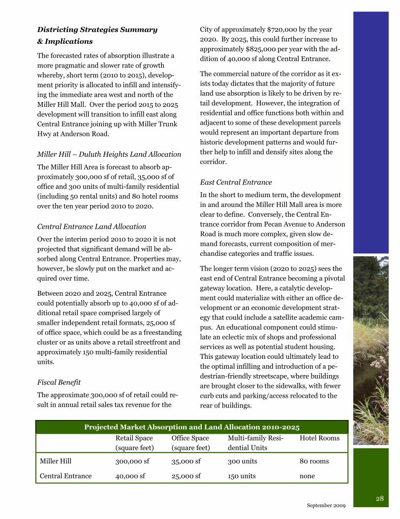
The Miller Hill Area is forecast to absorb ap-
proximately 300,000 sf of retail, 35,000 sf of
office and 300 units of multi-family residential
(including 50 rental units) and 80 hotel rooms
over the ten year period 2010 to 2020.
Central Entrance Land Allocation
Over the interim period 2010 to 2020 it is not
projected that significant demand will be ab-
sorbed along Central Entrance. Properties may,
however, be slowly put on the market and ac-
quired over time.
Between 2020 and 2025, Central Entrance
could potentially absorb up to 40,000 sf of ad-
ditional retail space comprised largely of
smaller independent retail formats, 25,000 sf
of office space, which could be as a freestanding
cluster or as units above a retail streetfront and
approximately 150 multi-family residential
units.
Fiscal Benefit
The approximate 300,000 sf of retail could re-
sult in annual retail sales tax revenue for the
City of approximately $720,000 by the year
2020. By 2025, this could further increase to
approximately $825,000 per year with the ad-
dition of 40,000 sf along Central Entrance.
The commercial nature of the corridor as it ex-
ists today dictates that the majority of future
land use absorption is likely to be driven by re-
tail development. However, the integration of
residential and office functions both within and
adjacent to some of these development parcels
would represent an important departure from
historic development patterns and would fur-
ther help to infill and densify sites along the
corridor.
East Central Entrance
In the short to medium term, the development
in and around the Miller Hill Mall area is more
clear to define. Conversely, the Central En-
trance corridor from Pecan Avenue to Anderson
Road is much more complex, given slow de-
mand forecasts, current composition of mer-
chandise categories and traffic issues.
The longer term vision (2020 to 2025) sees the
east end of Central Entrance becoming a pivotal
gateway location. Here, a catalytic develop-
ment could materialize with either an office de-
velopment or an economic development strat-
egy that could include a satellite academic cam-
pus. An educational component could stimu-
late an eclectic mix of shops and professional
services as well as potential student housing.
This gateway location could ultimately lead to
the optimal infilling and introduction of a pe-
destrian-friendly streetscape, where buildings
are brought closer to the sidewalks, with fewer
curb cuts and parking/access relocated to the
rear of buildings.
Projected Market Absorption and Land Allocation 2010-2025
Retail Space
(square feet)
Office Space
(square feet)
Multi-family Resi-
dential Units
Hotel Rooms
Miller Hill 300,000 sf 35,000 sf 300 units 80 rooms
Central Entrance 40,000 sf 25,000 sf 150 units none
29 Central Entrance - Miller Hill Small Area Plan
Central Entrance Transition “Flex” Area
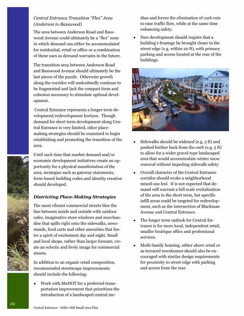
(Anderson to Basswood)
The area between Anderson Road and Bass-
wood Avenue could ultimately be a “flex” zone
in which demand can either be accommodated
for residential, retail or office or a combination
of these uses as demand warrants in the future.
The transition area between Anderson Road
and Basswood Avenue should ultimately be the
last pieces of the puzzle. Otherwise growth
along the corridor will undoubtedly continue to
be fragmented and lack the compact form and
cohesion necessary to stimulate optimal devel-
opment.
Central Entrance represents a longer term de-
velopment/redevelopment horizon. Though
demand for short term development along Cen-
tral Entrance is very limited, other place-
making strategies should be examined to begin
establishing and promoting the transition of the
area.
Until such time that market demand and/or
economic development initiatives create an op-
portunity for a physical manifestation of the
area, strategies such as gateway statements,
form-based building codes and identity creation
should developed.
Districting Place-Making Strategies
The most vibrant commercial streets blur the
line between inside and outside with outdoor
cafes, imaginative store windows and merchan-
dise that spills right onto the sidewalks, news-
stands, food carts and other amenities that fos-
ter a spirit of excitement day and night. Small
and local shops, rather than larger formats, cre-
ate an eclectic and lively image for commercial
streets.
In addition to an organic retail composition,
recommended streetscape improvements
should include the following:
Work with MnDOT for a preferred trans-
portation improvement that prioritizes the
introduction of a landscaped central me-
dian and forces the elimination of curb cuts
to ease traffic flow, while at the same time
enhancing safety.
New development should require that a
building‟s frontage be brought closer to the
street edge (e.g. within 20 ft), with primary
parking and access located at the rear of the
buildings.
Sidewalks should be widened (e.g. 5 ft) and
pushed further back from the curb (e.g. 5 ft)
to allow for a wider gravel-type landscaped
area that would accommodate winter snow
removal without impeding sidewalk safety.
Overall character of the Central Entrance
corridor should evoke a neighborhood
mixed-use feel. It is not expected that de-
mand will warrant a full scale revitalization
of the area in the short term, but specific
infill areas could be targeted for redevelop-
ment, such as the intersection of Blackman
Avenue and Central Entrance.
The longer term outlook for Central En-
trance is for more local, independent retail,
smaller boutique office and professional
services.
Multi-family housing, either above retail or
as terraced townhomes should also be en-
couraged with similar design requirements
for proximity to street edge with parking
and access from the rear.
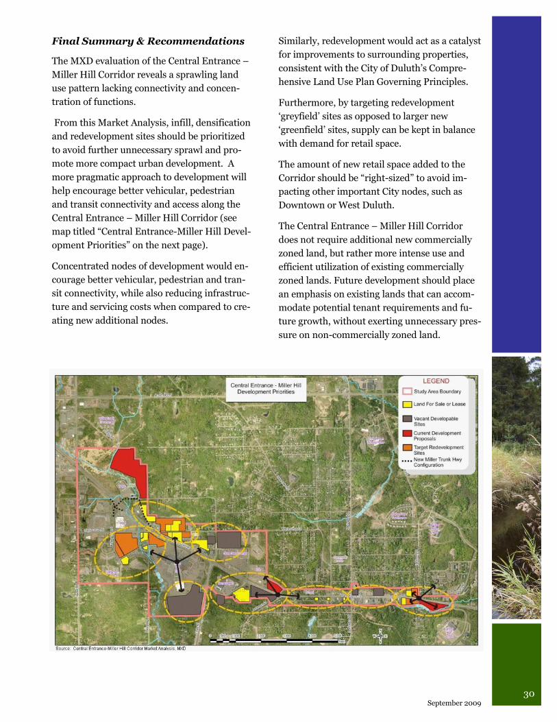
30 September 2009
Final Summary & Recommendations
The MXD evaluation of the Central Entrance –
Miller Hill Corridor reveals a sprawling land
use pattern lacking connectivity and concen-
tration of functions.
From this Market Analysis, infill, densification
and redevelopment sites should be prioritized
to avoid further unnecessary sprawl and pro-
mote more compact urban development. A
more pragmatic approach to development will
help encourage better vehicular, pedestrian
and transit connectivity and access along the
Central Entrance – Miller Hill Corridor (see
map titled “Central Entrance-Miller Hill Devel-
opment Priorities” on the next page).
Concentrated nodes of development would en-
courage better vehicular, pedestrian and tran-
sit connectivity, while also reducing infrastruc-
ture and servicing costs when compared to cre-
ating new additional nodes.
Similarly, redevelopment would act as a catalyst
for improvements to surrounding properties,
consistent with the City of Duluth‟s Compre-
hensive Land Use Plan Governing Principles.
Furthermore, by targeting redevelopment
„greyfield‟ sites as opposed to larger new
„greenfield‟ sites, supply can be kept in balance
with demand for retail space.
The amount of new retail space added to the
Corridor should be “right-sized” to avoid im-
pacting other important City nodes, such as
Downtown or West Duluth.
The Central Entrance – Miller Hill Corridor
does not require additional new commercially
zoned land, but rather more intense use and
efficient utilization of existing commercially
zoned lands. Future development should place
an emphasis on existing lands that can accom-
modate potential tenant requirements and fu-
ture growth, without exerting unnecessary pres-
sure on non-commercially zoned land.
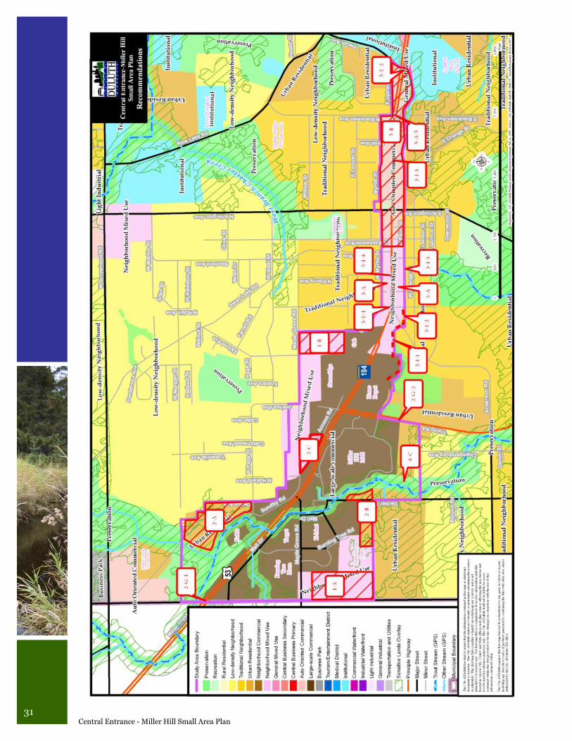
31 Central Entrance - Miller Hill Small Area Plan
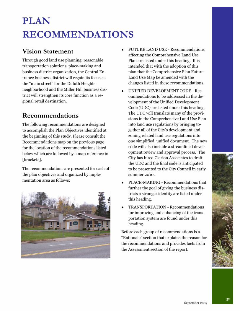
32 September 2009
Vision Statement Through good land use planning, reasonable
transportation solutions, place-making and
business district organization, the Central En-
trance business district will regain its focus as
the “main street” for the Duluth Heights
neighborhood and the Miller Hill business dis-
trict will strengthen its core function as a re-
gional retail destination.
Recommendations The following recommendations are designed
to accomplish the Plan Objectives identified at
the beginning of this study. Please consult the
Recommendations map on the previous page
for the location of the recommendations listed
below which are followed by a map reference in
[brackets].
The recommendations are presented for each of
the plan objectives and organized by imple-
mentation area as follows:
PLAN
RECOMMENDATIONS
FUTURE LAND USE - Recommendations
affecting the Comprehensive Land Use
Plan are listed under this heading. It is
intended that with the adoption of this
plan that the Comprehensive Plan Future
Land Use Map be amended with the
changes listed in these recommendations.
UNIFIED DEVELOPMENT CODE - Rec-
ommendations to be addressed in the de-
velopment of the Unified Development
Code (UDC) are listed under this heading.
The UDC will translate many of the provi-
sions in the Comprehensive Land Use Plan
into land use regulations by bringing to-
gether all of the City‟s development and
zoning related land use regulations into
one simplified, unified document. The new
code will also include a streamlined devel-
opment review and approval process. The
City has hired Clarion Associates to draft
the UDC and the final code is anticipated
to be presented to the City Council in early
summer 2010.
PLACE-MAKING - Recommendations that
further the goal of giving the business dis-
tricts a stronger identity are listed under
this heading.
TRANSPORTATION - Recommendations
for improving and enhancing of the trans-
portation system are found under this
heading.
Before each group of recommendations is a
“Rationale” section that explains the reason for
the recommendations and provides facts from
the Assessment section of the report.
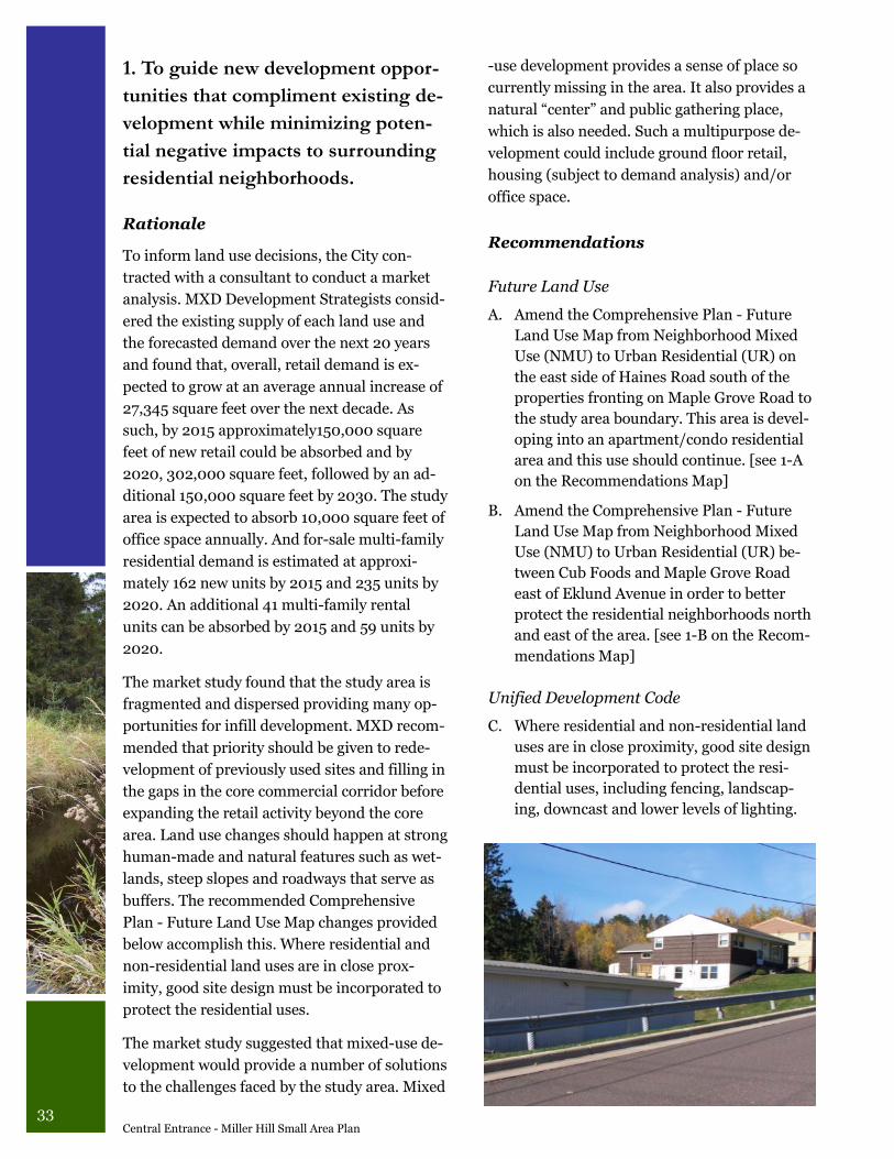
33 Central Entrance - Miller Hill Small Area Plan
1. To guide new development oppor-
tunities that compliment existing de-
velopment while minimizing poten-
tial negative impacts to surrounding
residential neighborhoods.
Rationale
To inform land use decisions, the City con-
tracted with a consultant to conduct a market
analysis. MXD Development Strategists consid-
ered the existing supply of each land use and
the forecasted demand over the next 20 years
and found that, overall, retail demand is ex-
pected to grow at an average annual increase of
27,345 square feet over the next decade. As
such, by 2015 approximately150,000 square
feet of new retail could be absorbed and by
2020, 302,000 square feet, followed by an ad-
ditional 150,000 square feet by 2030. The study
area is expected to absorb 10,000 square feet of
office space annually. And for-sale multi-family
residential demand is estimated at approxi-
mately 162 new units by 2015 and 235 units by
2020. An additional 41 multi-family rental
units can be absorbed by 2015 and 59 units by
2020.
The market study found that the study area is
fragmented and dispersed providing many op-
portunities for infill development. MXD recom-
mended that priority should be given to rede-
velopment of previously used sites and filling in
the gaps in the core commercial corridor before
expanding the retail activity beyond the core
area. Land use changes should happen at strong
human-made and natural features such as wet-
lands, steep slopes and roadways that serve as
buffers. The recommended Comprehensive
Plan - Future Land Use Map changes provided
below accomplish this. Where residential and
non-residential land uses are in close prox-
imity, good site design must be incorporated to
protect the residential uses.
The market study suggested that mixed-use de-
velopment would provide a number of solutions
to the challenges faced by the study area. Mixed
-use development provides a sense of place so
currently missing in the area. It also provides a
natural “center” and public gathering place,
which is also needed. Such a multipurpose de-
velopment could include ground floor retail,
housing (subject to demand analysis) and/or
office space.
Recommendations
Future Land Use
A. Amend the Comprehensive Plan - Future
Land Use Map from Neighborhood Mixed
Use (NMU) to Urban Residential (UR) on
the east side of Haines Road south of the
properties fronting on Maple Grove Road to
the study area boundary. This area is devel-
oping into an apartment/condo residential
area and this use should continue. [see 1-A
on the Recommendations Map]
B. Amend the Comprehensive Plan - Future
Land Use Map from Neighborhood Mixed
Use (NMU) to Urban Residential (UR) be-
tween Cub Foods and Maple Grove Road
east of Eklund Avenue in order to better
protect the residential neighborhoods north
and east of the area. [see 1-B on the Recom-
mendations Map]
Unified Development Code
C. Where residential and non-residential land
uses are in close proximity, good site design
must be incorporated to protect the resi-
dential uses, including fencing, landscap-
ing, downcast and lower levels of lighting.
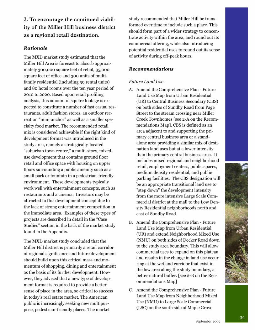
34 September 2009
2. To encourage the continued viabil-
ity of the Miller Hill business district
as a regional retail destination.
Rationale
The MXD market study estimated that the
Miller Hill Area is forecast to absorb approxi-
mately 300,000 square feet of retail, 35,000
square feet of office and 300 units of multi-
family residential (including 50 rental units)
and 80 hotel rooms over the ten year period of
2010 to 2020. Based upon retail profiling
analysis, this amount of square footage is ex-
pected to constitute a number of fast casual res-
taurants, adult fashion stores, an outdoor rec-
reation “mini‐anchor” as well as a smaller spe-
cialty food market. The recommended retail
mix is considered achievable if the right kind of
development format was introduced in the
study area, namely a strategically-located
“suburban town center,” a multi-story, mixed-
use development that contains ground floor
retail and office space with housing on upper
floors surrounding a public amenity such as a
small park or fountain in a pedestrian-friendly
environment. These developments typically
work well with entertainment concepts, such as
restaurants and a cinema. Investors may be
attracted to this development concept due to
the lack of strong entertainment competition in
the immediate area. Examples of these types of
projects are described in detail in the “Case
Studies” section in the back of the market study
found in the Appendix.
The MXD market study concluded that the
Miller Hill district is primarily a retail corridor
of regional significance and future development
should build upon this critical mass and mo-
mentum of shopping, dining and entertainment
as the basis of its further development. How-
ever, they advised that a new type of develop-
ment format is required to provide a better
sense of place in the area, so critical to success
in today‟s real estate market. The American
public is increasingly seeking new multipur-
pose, pedestrian-friendly places. The market
study recommended that Miller Hill be trans-
formed over time to include such a place. This
should form part of a wider strategy to concen-
trate activity within the area, and round out its
commercial offering, while also introducing
potential residential uses to round out its sense
of activity during off-peak hours.
Recommendations
Future Land Use
A. Amend the Comprehensive Plan - Future
Land Use Map from Urban Residential
(UR) to Central Business Secondary (CBS)
on both sides of Sundby Road from Page
Street to the stream crossing near Miller
Creek Townhomes [see 2-A on the Recom-
mendations Map]. CBS is defined as an
area adjacent to and supporting the pri-
mary central business area or a stand-
alone area providing a similar mix of desti-
nation land uses but at a lower intensity
than the primary central business area. It
includes mixed regional and neighborhood
retail, employment centers, public spaces,
medium density residential, and public
parking facilities. The CBS designation will
be an appropriate transitional land use to
"step down" the development intensity
from the more intensive Large Scale Com-
mercial district at the mall to the Low Den-
sity Residential neighborhoods north and
east of Sundby Road.
B. Amend the Comprehensive Plan - Future
Land Use Map from Urban Residential
(UR) and extend Neighborhood Mixed Use
(NMU) on both sides of Decker Road down
to the study area boundary. This will allow
commercial uses to expand on this plateau
and results in the change in land use occur-
ring at the wetland corridor that exist in
the low area along the study boundary, a
better natural buffer. [see 2-B on the Rec-
ommendations Map]
C. Amend the Comprehensive Plan - Future
Land Use Map from Neighborhood Mixed
Use (NMU) to Large Scale Commercial
(LSC) on the south side of Maple Grove
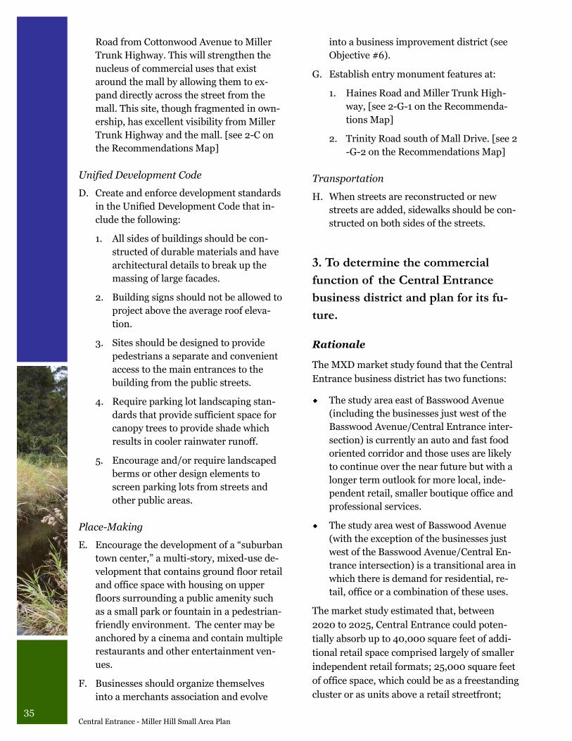
35 Central Entrance - Miller Hill Small Area Plan
Road from Cottonwood Avenue to Miller
Trunk Highway. This will strengthen the
nucleus of commercial uses that exist
around the mall by allowing them to ex-
pand directly across the street from the
mall. This site, though fragmented in own-
ership, has excellent visibility from Miller
Trunk Highway and the mall. [see 2-C on
the Recommendations Map]
Unified Development Code
D. Create and enforce development standards
in the Unified Development Code that in-
clude the following:
1. All sides of buildings should be con-
structed of durable materials and have
architectural details to break up the
massing of large facades.
2. Building signs should not be allowed to
project above the average roof eleva-
tion.
3. Sites should be designed to provide
pedestrians a separate and convenient
access to the main entrances to the
building from the public streets.
4. Require parking lot landscaping stan-
dards that provide sufficient space for
canopy trees to provide shade which
results in cooler rainwater runoff.
5. Encourage and/or require landscaped
berms or other design elements to
screen parking lots from streets and
other public areas.
Place-Making
E. Encourage the development of a “suburban
town center,” a multi-story, mixed-use de-
velopment that contains ground floor retail
and office space with housing on upper
floors surrounding a public amenity such
as a small park or fountain in a pedestrian-
friendly environment. The center may be
anchored by a cinema and contain multiple
restaurants and other entertainment ven-
ues.
F. Businesses should organize themselves
into a merchants association and evolve
into a business improvement district (see
Objective #6).
G. Establish entry monument features at:
1. Haines Road and Miller Trunk High-
way, [see 2-G-1 on the Recommenda-
tions Map]
2. Trinity Road south of Mall Drive. [see 2
-G-2 on the Recommendations Map]
Transportation
H. When streets are reconstructed or new
streets are added, sidewalks should be con-
structed on both sides of the streets.
3. To determine the commercial
function of the Central Entrance
business district and plan for its fu-
ture.
Rationale
The MXD market study found that the Central
Entrance business district has two functions:
The study area east of Basswood Avenue
(including the businesses just west of the
Basswood Avenue/Central Entrance inter-
section) is currently an auto and fast food
oriented corridor and those uses are likely
to continue over the near future but with a
longer term outlook for more local, inde-
pendent retail, smaller boutique office and
professional services.
The study area west of Basswood Avenue
(with the exception of the businesses just
west of the Basswood Avenue/Central En-
trance intersection) is a transitional area in
which there is demand for residential, re-
tail, office or a combination of these uses.
The market study estimated that, between
2020 to 2025, Central Entrance could poten-
tially absorb up to 40,000 square feet of addi-
tional retail space comprised largely of smaller
independent retail formats; 25,000 square feet
of office space, which could be as a freestanding
cluster or as units above a retail streetfront;
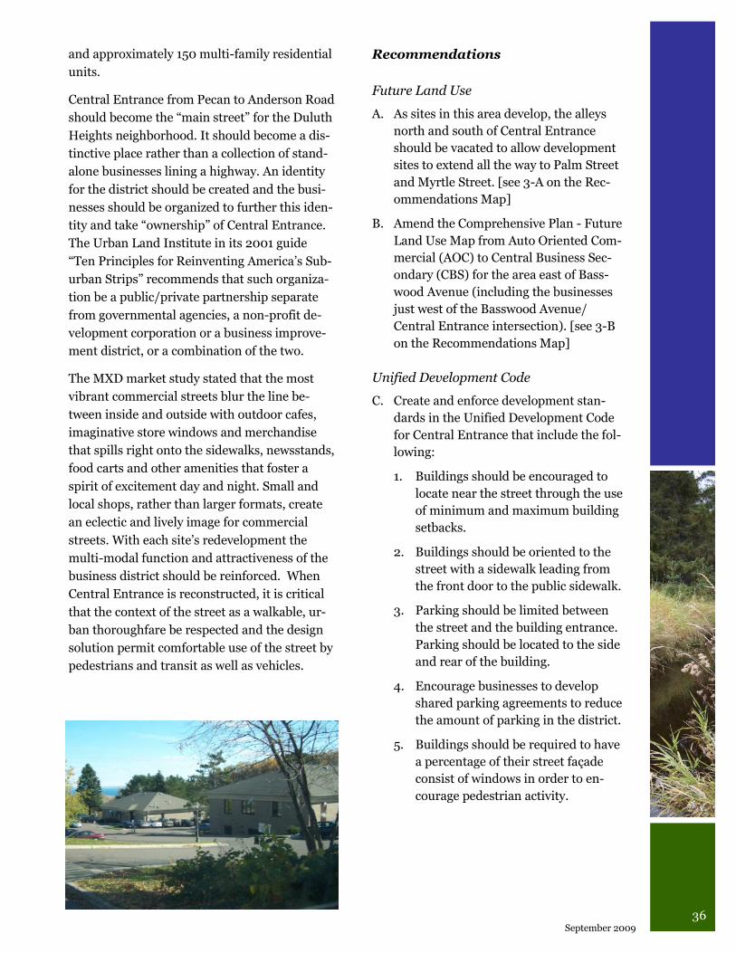
36 September 2009
and approximately 150 multi-family residential
units.
Central Entrance from Pecan to Anderson Road
should become the “main street” for the Duluth
Heights neighborhood. It should become a dis-
tinctive place rather than a collection of stand-
alone businesses lining a highway. An identity
for the district should be created and the busi-
nesses should be organized to further this iden-
tity and take “ownership” of Central Entrance.
The Urban Land Institute in its 2001 guide
“Ten Principles for Reinventing America‟s Sub-
urban Strips” recommends that such organiza-
tion be a public/private partnership separate
from governmental agencies, a non-profit de-
velopment corporation or a business improve-
ment district, or a combination of the two.
The MXD market study stated that the most
vibrant commercial streets blur the line be-
tween inside and outside with outdoor cafes,
imaginative store windows and merchandise
that spills right onto the sidewalks, newsstands,
food carts and other amenities that foster a
spirit of excitement day and night. Small and
local shops, rather than larger formats, create
an eclectic and lively image for commercial
streets. With each site‟s redevelopment the
multi-modal function and attractiveness of the
business district should be reinforced. When
Central Entrance is reconstructed, it is critical
that the context of the street as a walkable, ur-
ban thoroughfare be respected and the design
solution permit comfortable use of the street by
pedestrians and transit as well as vehicles.
Recommendations
Future Land Use
A. As sites in this area develop, the alleys
north and south of Central Entrance
should be vacated to allow development
sites to extend all the way to Palm Street
and Myrtle Street. [see 3-A on the Rec-
ommendations Map]
B. Amend the Comprehensive Plan - Future
Land Use Map from Auto Oriented Com-
mercial (AOC) to Central Business Sec-
ondary (CBS) for the area east of Bass-
wood Avenue (including the businesses
just west of the Basswood Avenue/
Central Entrance intersection). [see 3-B
on the Recommendations Map]
Unified Development Code
C. Create and enforce development stan-
dards in the Unified Development Code
for Central Entrance that include the fol-
lowing:
1. Buildings should be encouraged to
locate near the street through the use
of minimum and maximum building
setbacks.
2. Buildings should be oriented to the
street with a sidewalk leading from
the front door to the public sidewalk.
3. Parking should be limited between
the street and the building entrance.
Parking should be located to the side
and rear of the building.
4. Encourage businesses to develop
shared parking agreements to reduce
the amount of parking in the district.
5. Buildings should be required to have
a percentage of their street façade
consist of windows in order to en-
courage pedestrian activity.
37 Central Entrance - Miller Hill Small Area Plan
Place-Making
D. Businesses should organize themselves
into a merchants association and evolve
into a business improvement district (see
Objective #6).
E. Establish entry monument features at
both ends of the business district:
1. West end features should be located
at Anderson Road. [see 3-E-1 on the
Recommendations Map]
2. East end features should be located at
Pecan Avenue. [see 3-E-2 on the Rec-
ommendations Map]
Transportation
F. When Central Entrance is reconstructed,
do not pursue the option listed in the
Miller Trunk Highway Implementation
Plan that designates Central Entrance and
Palm Street as “one-way” streets.
G. When Central Entrance is reconstructed,
pursue a “context sensitive solution” as
identified in the Institute for Transporta-
tion Engineers document “Context Sensi-
tive Solutions in Designing Major Urban
Thoroughfares for Walkable Communi-
ties.” The context should be a walkable,
urban thoroughfare that permits comfort-
able use of the street by pedestrians and
transit users as well as vehicles.
H. Encourage site designs that limit curb
cuts on Central Entrance, where possible,
through requiring shared driveways and
only allow “right-in, right-out” driveways
where necessary.
I. To provide for good vehicular, pedestrian
and bicycle circulation in the Central En-
trance business district, the following are
recommended depending on funding
availability:
1. When the area on the south side of
Central Entrance between Home De-
pot and Anderson Road redevelops,
explore the possibility of creating a
“backage road” to connect Anderson
Road to Mall Drive (near Home De-
pot). This street should be designed for
pedestrian and bicycle travel in addi-
tion to vehicles and it should be signed
as a bike route. [see 3-I-1 on the Rec-
ommendations Map]
2. Extend Palm Street west of Robin Ave-
nue to intersect with Anderson Road
and close Robin Avenue access to Cen-
tral Entrance to vehicular traffic. De-
sign this street extension to accommo-
date pedestrian and bicycle travel. This
should be done in conjunction with the
redevelopment of the area along Ander-
son Road. The bike route that diverts to
Orange Street should be relocated to
this new street. [see 3-I-2 on the Rec-
ommendations Map]
3. Plan to have Palm Street west of Arling-
ton Avenue function as a “backage
road” providing circulation for the re-
developed sites along Central Entrance.
This street should be designed to serve
bicycles and pedestrians. [see 3-I-3 on
the Recommendations Map]
4. Create a “right-in, right-out” intersec-
tion at Ebony Avenue, as necessary for
development, including signalization of
a full intersection (when warranted) to
allow for better vehicle circulation to
sites on both sides of Central Entrance
and to provide another crossing point
for pedestrians and bicycles. A median
at the intersection will also allow a pe-
destrian refuge. [see 3-I-4 on the Rec-
ommendations Map]
5. Create a “right-in, right-out” intersec-
tion at Harding Avenue, as necessary
for development, including signaliza-
tion of a full intersection (when war-
ranted) to allow for better vehicle circu-
lation to sites south of Central Entrance
and to provide another crossing point
for pedestrians and bicycles. A median
at the intersection will also allow a pe-
destrian refuge. [see 3-I-5 on the Rec-
ommendations Map]
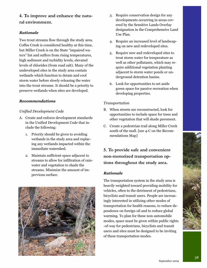
38 September 2009
4. To improve and enhance the natu-
ral environment.
Rationale
Two trout streams flow through the study area.
Coffee Creek is considered healthy at this time,
but Miller Creek is on the State “impaired wa-
ters” list and suffers from rising temperatures,
high sediment and turbidity levels, elevated
levels of chlorides (from road salt). Many of the
undeveloped sites in the study area contain
wetlands which function to detain and cool
storm water before slowly releasing the water
into the trout streams. It should be a priority to
preserve wetlands when sites are developed.
Recommendations
Unified Development Code
A. Create and enforce development standards
in the Unified Development Code that in-
clude the following:
1. Priority should be given to avoiding
wetlands in the study area and replac-
ing any wetlands impacted within the
immediate watershed.
2. Maintain sufficient space adjacent to
streams to allow for infiltration of rain-
water and vegetation to shade the
streams. Minimize the amount of im-
pervious surface.
3. Require conservation design for any
developments occurring in areas cov-
ered by the Sensitive Lands Overlay
designation in the Comprehensive Land
Use Plan.
4. Require an increased level of landscap-
ing on new and redeveloped sites.
5. Require new and redeveloped sites to
treat storm water for temperature as
well as other pollutants, which may re-
quire additional vegetation planting
adjacent to storm water ponds or un-
derground detention basins.
6. Look for opportunities to set aside
green space for passive recreation when
developing properties.
Transportation
B. When streets are reconstructed, look for
opportunities to include space for trees and
other vegetation that will shade pavement.
C. Create a pedestrian trail along Miller Creek
south of the mall. [see 4-C on the Recom-
mendations Map]
5. To provide safe and convenient
non-motorized transportation op-
tions throughout the study area.
Rationale
The transportation system in the study area is
heavily weighted toward providing mobility for
vehicles, often to the detriment of pedestrians,
bicyclists and transit users. People are increas-
ingly interested in utilizing other modes of
transportation for health reasons, to reduce de-
pendence on foreign oil and to reduce global
warming. To plan for these non-automobile
modes, space must be given within public rights
-of-way for pedestrians, bicyclists and transit
users and sites must be designed to be inviting
of these transportation modes.
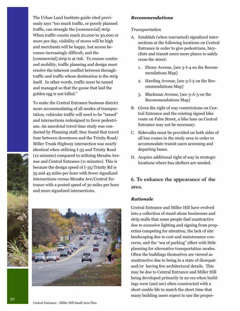
39 Central Entrance - Miller Hill Small Area Plan
The Urban Land Institute guide cited previ-
ously says “too much traffic, or poorly planned
traffic, can strangle the [commercial] strip.
When traffic counts reach 20,000 to 30,000 or
more per day, visibility of stores will be high
and merchants will be happy, but access be-
comes increasingly difficult, and the
[commercial] strip is at risk. To ensure contin-
ued mobility, traffic planning and design must
resolve the inherent conflict between through-
traffic and traffic whose destination is the strip
itself. In other words, traffic must be tamed
and managed so that the goose that laid the
golden egg is not killed.”
To make the Central Entrance business district
more accommodating of all modes of transpor-
tation, vehicular traffic will need to be “tamed”
and intersections redesigned to favor pedestri-
ans. An anecdotal travel time study was con-
ducted by Planning staff; they found that travel
time between downtown and the Trinity Road/
Miller Trunk Highway intersection was nearly
identical when utilizing I-35 and Trinity Road
(12 minutes) compared to utilizing Mesaba Ave-
nue and Central Entrance (11 minutes). This is
because the design speed of I-35/Trinity Rd is
55 and 45 miles per hour with fewer signalized
intersections versus Mesaba Ave/Central En-
trance with a posted speed of 30 miles per hour
and more signalized intersections.
Recommendations
Transportation
A. Establish (when warranted) signalized inter-
sections at the following locations on Central
Entrance in order to give pedestrians, bicy-
clists and transit users more places to safely
cross the street:
1. Ebony Avenue, [see 3-I-4 on the Recom-
mendations Map]
2. Harding Avenue, [see 3-I-5 on the Rec-
ommendations Map]
3. Blackman Avenue, [see 5-A-3 on the
Recommendations Map]
B. Given the right of way constrictions on Cen-
tral Entrance and the existing signed bike
route on Palm Street, a bike lane on Central
Entrance may not be necessary.
C. Sidewalks must be provided on both sides of
all bus routes in the study area in order to
accommodate transit users accessing and
departing buses.
D. Acquire additional right of way in strategic
locations where bus shelters are needed.
6. To enhance the appearance of the
area.
Rationale
Central Entrance and Miller Hill have evolved
into a collection of stand-alone businesses and
strip malls that some people find unattractive
due to excessive lighting and signing from prop-
erties competing for attention, the lack of site
landscaping due to cost and maintenance con-
cerns, and the “sea of parking” effect with little
planning for alternative transportation modes.
Often the buildings themselves are viewed as
unattractive due to being in a state of disrepair
and/or having few architectural details. This
may be due to Central Entrance and Miller Hill
being developed primarily in an era when build-
ings were (and are) often constructed with a
short usable life to match the short time that
many building users expect to use the proper-
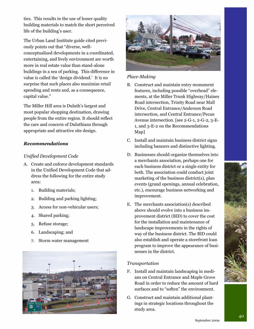
40 September 2009
ties. This results in the use of lesser quality
building materials to match the short perceived
life of the building‟s user.
The Urban Land Institute guide cited previ-
ously points out that “diverse, well-
conceptualized developments in a coordinated,
entertaining, and lively environment are worth
more in real estate value than stand-alone
buildings in a sea of parking. This difference in
value is called the „design dividend.‟ It is no
surprise that such places also maximize retail
spending and rents and, as a consequence,
capital value.”
The Miller Hill area is Duluth‟s largest and
most popular shopping destination, drawing
people from the entire region. It should reflect
the care and concern of Duluthians through
appropriate and attractive site design.
Recommendations
Unified Development Code
A. Create and enforce development standards
in the Unified Development Code that ad-
dress the following for the entire study
area:
1. Building materials;
2. Building and parking lighting;
3. Access for non-vehicular users;
4. Shared parking;
5. Refuse storage;
6. Landscaping; and
7. Storm water management
Place-Making
B. Construct and maintain entry monument
features, including possible “overhead” ele-
ments, at the Miller Trunk Highway/Haines
Road intersection, Trinity Road near Mall
Drive, Central Entrance/Anderson Road
intersection, and Central Entrance/Pecan
Avenue intersection. [see 2-G-1, 2-G-2, 3-E-
1, and 3-E-2 on the Recommendations
Map]
C. Install and maintain business district signs
including banners and distinctive lighting.
D. Businesses should organize themselves into
a merchants association, perhaps one for
each business district or a single entity for
both. The association could conduct joint
marketing of the business district(s), plan
events (grand openings, annual celebration,
etc.), encourage business networking and
improvement.
E. The merchants association(s) described
above should evolve into a business im-
provement district (BID) to cover the cost
for the installation and maintenance of
landscape improvements in the rights of
way of the business district. The BID could
also establish and operate a storefront loan
program to improve the appearance of busi-
nesses in the district.
Transportation
F. Install and maintain landscaping in medi-
ans on Central Entrance and Maple Grove
Road in order to reduce the amount of hard
surfaces and to “soften” the environment.
G. Construct and maintain additional plant-
ings in strategic locations throughout the
study area.
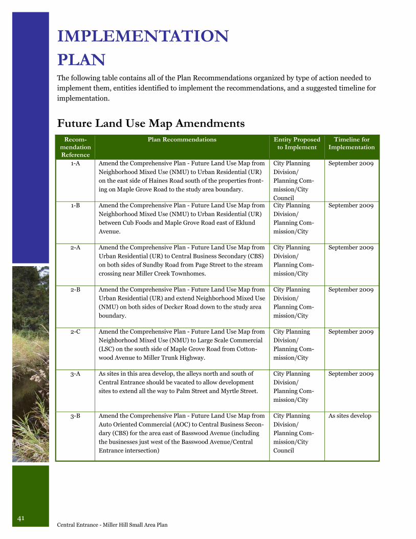
41 Central Entrance - Miller Hill Small Area Plan
IMPLEMENTATION
PLAN The following table contains all of the Plan Recommendations organized by type of action needed to
implement them, entities identified to implement the recommendations, and a suggested timeline for
implementation.
Future Land Use Map Amendments
Recom-mendation Reference
Plan Recommendations Entity Proposed to Implement
Timeline for Implementation
1-A Amend the Comprehensive Plan - Future Land Use Map from
Neighborhood Mixed Use (NMU) to Urban Residential (UR)
on the east side of Haines Road south of the properties front-
ing on Maple Grove Road to the study area boundary.
City Planning
Division/
Planning Com-
mission/City
Council
September 2009
1-B Amend the Comprehensive Plan - Future Land Use Map from
Neighborhood Mixed Use (NMU) to Urban Residential (UR)
between Cub Foods and Maple Grove Road east of Eklund
Avenue.
City Planning
Division/
Planning Com-
mission/City
September 2009
2-A Amend the Comprehensive Plan - Future Land Use Map from
Urban Residential (UR) to Central Business Secondary (CBS)
on both sides of Sundby Road from Page Street to the stream
crossing near Miller Creek Townhomes.
City Planning
Division/
Planning Com-
mission/City
September 2009
2-B Amend the Comprehensive Plan - Future Land Use Map from
Urban Residential (UR) and extend Neighborhood Mixed Use
(NMU) on both sides of Decker Road down to the study area
boundary.
City Planning
Division/
Planning Com-
mission/City
September 2009
2-C Amend the Comprehensive Plan - Future Land Use Map from
Neighborhood Mixed Use (NMU) to Large Scale Commercial
(LSC) on the south side of Maple Grove Road from Cotton-
wood Avenue to Miller Trunk Highway.
City Planning
Division/
Planning Com-
mission/City
September 2009
3-A As sites in this area develop, the alleys north and south of
Central Entrance should be vacated to allow development
sites to extend all the way to Palm Street and Myrtle Street.
City Planning
Division/
Planning Com-
mission/City
September 2009
3-B Amend the Comprehensive Plan - Future Land Use Map from
Auto Oriented Commercial (AOC) to Central Business Secon-
dary (CBS) for the area east of Basswood Avenue (including
the businesses just west of the Basswood Avenue/Central
Entrance intersection)
City Planning
Division/
Planning Com-
mission/City
Council
As sites develop
42 September 2009
Recommen-
dation
Reference
Plan Recommendations Entity Proposed
to Implement
Timeline for
Implementation
1-C Where residential and non-residential land uses are in
close proximity, good site design must be incorporated to
protect the residential uses, including fencing, landscaping,
downcast/lower levels of lighting.
City Planning Di-
vision/Planning
Commission/City
Council
As UDC is devel-
oped in
2009-2010
2-D Create and enforce development standards in the UDC that
include the following:
1. All sides of buildings should be constructed of durable
materials and have architectural details to break up the
massing of large facades.
2. Building signs should not be allowed to project above the
average roof elevation.
3. Sites should be designed to provide pedestrians a sepa-
rate and convenient access to the main entrances to the
building from the public streets.
4. Require parking lot landscaping standards that provide
sufficient space for canopy trees to provide shade which
results in cooler rainwater runoff.
5. Encourage and/or require landscaped berms or other
design elements to screen parking lots from streets and
other public areas.
City Planning Di-
vision/Planning
Commission/City
Council
As UDC is devel-
oped in 2009-
2010
3-C Create and enforce development standards in the UDC for
Central Entrance that include the following:
1. Buildings should be encouraged to locate near the street
through the use of minimum and maximum building set-
backs.
2. Buildings should be oriented to the street with a side-
walk leading from the front door to the public sidewalk.
3. Parking should be limited between the street and the
building entrance. Parking should be located to the side
and rear of the building.
4. Encourage businesses to develop shared parking agree-
ments to reduce the amount of parking in the district.
5. Buildings should be required to have a percentage of
their street façade consist of windows in order to encourage
pedestrian activity.
City Planning Di-
vision/Planning
Commission/City
Council
As UDC is devel-
oped in 2009-
2010
Unified Development Code (UDC) Recommendations
43 Central Entrance - Miller Hill Small Area Plan
Recom-
mendation
Reference
Plan Recommendations Entity Proposed
to Implement
Timeline for
Implementation
4-A Create and enforce development standards in the UDC that
include the following:
1. Priority should be given to avoiding wetlands in the study
area and replacing any wetlands impacted within the immedi-
ate watershed.
2. Maintain sufficient space adjacent to streams to allow for
infiltration of rainwater and vegetation to shade the streams.
Minimize the amount of impervious surface.
3. Require conservation design for any developments occurring
in areas covered by the Sensitive Lands Overlay designation in
the Comprehensive Land Use Plan.
4. Require an increased level of landscaping on new and rede-
veloped sites.
5. Require new and redeveloped sites to treat storm water for
temperature as well as other pollutants, which may require
additional vegetation planting adjacent to storm water ponds
or underground detention basins.
6. Look for opportunities to set aside green space for passive
recreation when developing properties.
City Planning
Division/
Planning Com-
mission/City
Council
As UDC is devel-
oped in 2009-
2010
6-A Create and enforce development standards in the UDC that
address the following for the entire study area: building mate-
rials, building and parking lighting, access for non-vehicular
users, shared parking, refuse storage, landscaping, storm water
management.
City Planning
Division/
Planning Com-
mission/City
Council
As UDC is devel-
oped in 2009-
2010
Unified Development Code (UDC) Recommendations continued
Place-Making Recommendations
Recom-
mendation
Reference
Plan Recommendations Entity Proposed
to Implement
Timeline for
Implementation
2-E Encourage the development of a “suburban town center,” a
multi-story, mixed-use development that contains ground
floor retail and office space with housing on upper floors sur-
rounding a public amenity such as a small park or fountain in
a pedestrian-friendly environment.
DEDA and
other City staff
work at attract-
ing a private
developer
When market
conditions war-
rant
2-F/3-D Miller Hill and Central Entrance businesses should organize
themselves into a merchants association and evolve into a
business improvement district (see 6-E below). The associa-
tion could conduct joint marketing of the business district(s),
plan events (grand openings, annual celebration, etc.), encour-
age business networking and improvement.
Businesses with
assistance from
the Chamber of
Commerce and
City
2009-2010 mer-
chants associa-
tion, 2010-2015
business im-
provement dis-
trict
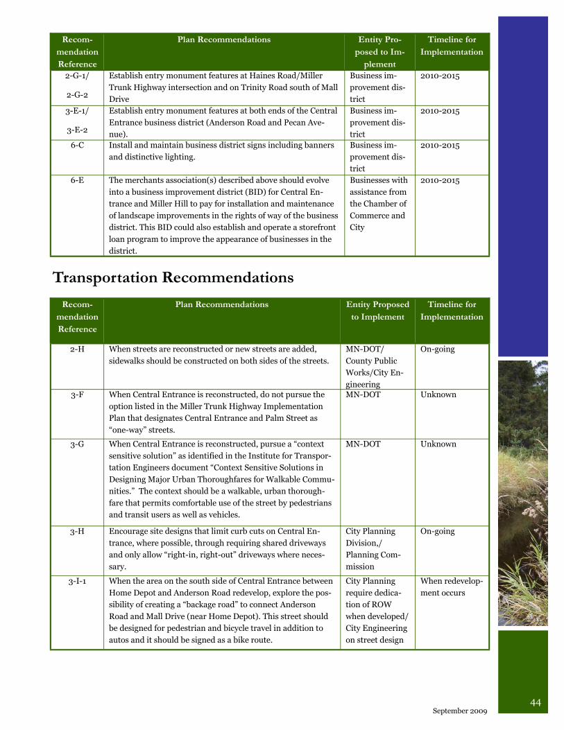
44 September 2009
Recom-
mendation
Reference
Plan Recommendations Entity Pro-
posed to Im-
plement
Timeline for
Implementation
2-G-1/
2-G-2
Establish entry monument features at Haines Road/Miller
Trunk Highway intersection and on Trinity Road south of Mall
Drive
Business im-
provement dis-
trict
2010-2015
3-E-1/
3-E-2
Establish entry monument features at both ends of the Central
Entrance business district (Anderson Road and Pecan Ave-
nue).
Business im-
provement dis-
trict
2010-2015
6-C Install and maintain business district signs including banners
and distinctive lighting.
Business im-
provement dis-
trict
2010-2015
6-E The merchants association(s) described above should evolve
into a business improvement district (BID) for Central En-
trance and Miller Hill to pay for installation and maintenance
of landscape improvements in the rights of way of the business
district. This BID could also establish and operate a storefront
loan program to improve the appearance of businesses in the
district.
Businesses with
assistance from
the Chamber of
Commerce and
City
2010-2015
Recom-
mendation
Reference
Plan Recommendations Entity Proposed
to Implement
Timeline for
Implementation
2-H When streets are reconstructed or new streets are added,
sidewalks should be constructed on both sides of the streets.
MN-DOT/
County Public
Works/City En-
gineering
On-going
3-F When Central Entrance is reconstructed, do not pursue the
option listed in the Miller Trunk Highway Implementation
Plan that designates Central Entrance and Palm Street as
“one-way” streets.
MN-DOT Unknown
3-G When Central Entrance is reconstructed, pursue a “context
sensitive solution” as identified in the Institute for Transpor-
tation Engineers document “Context Sensitive Solutions in
Designing Major Urban Thoroughfares for Walkable Commu-
nities.” The context should be a walkable, urban thorough-
fare that permits comfortable use of the street by pedestrians
and transit users as well as vehicles.
MN-DOT Unknown
3-H Encourage site designs that limit curb cuts on Central En-
trance, where possible, through requiring shared driveways
and only allow “right-in, right-out” driveways where neces-
sary.
City Planning
Division,/
Planning Com-
mission
On-going
3-I-1 When the area on the south side of Central Entrance between
Home Depot and Anderson Road redevelop, explore the pos-
sibility of creating a “backage road” to connect Anderson
Road and Mall Drive (near Home Depot). This street should
be designed for pedestrian and bicycle travel in addition to
autos and it should be signed as a bike route.
City Planning
require dedica-
tion of ROW
when developed/
City Engineering
on street design
When redevelop-
ment occurs
Transportation Recommendations
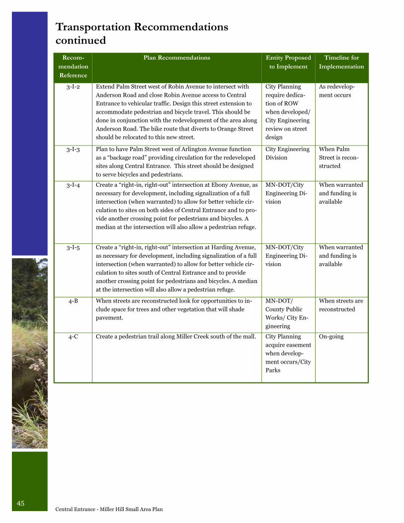
45 Central Entrance - Miller Hill Small Area Plan
Transportation Recommendations continued
Recom-
mendation
Reference
Plan Recommendations Entity Proposed
to Implement
Timeline for
Implementation
3-I-2 Extend Palm Street west of Robin Avenue to intersect with
Anderson Road and close Robin Avenue access to Central
Entrance to vehicular traffic. Design this street extension to
accommodate pedestrian and bicycle travel. This should be
done in conjunction with the redevelopment of the area along
Anderson Road. The bike route that diverts to Orange Street
should be relocated to this new street.
City Planning
require dedica-
tion of ROW
when developed/
City Engineering
review on street
design
As redevelop-
ment occurs
3-I-3 Plan to have Palm Street west of Arlington Avenue function
as a “backage road” providing circulation for the redeveloped
sites along Central Entrance. This street should be designed
to serve bicycles and pedestrians.
City Engineering
Division
When Palm
Street is recon-
structed
3-I-4 Create a “right-in, right-out” intersection at Ebony Avenue, as
necessary for development, including signalization of a full
intersection (when warranted) to allow for better vehicle cir-
culation to sites on both sides of Central Entrance and to pro-
vide another crossing point for pedestrians and bicycles. A
median at the intersection will also allow a pedestrian refuge.
MN-DOT/City
Engineering Di-
vision
When warranted
and funding is
available
3-I-5 Create a “right-in, right-out” intersection at Harding Avenue,
as necessary for development, including signalization of a full
intersection (when warranted) to allow for better vehicle cir-
culation to sites south of Central Entrance and to provide
another crossing point for pedestrians and bicycles. A median
at the intersection will also allow a pedestrian refuge.
MN-DOT/City
Engineering Di-
vision
When warranted
and funding is
available
4-B When streets are reconstructed look for opportunities to in-
clude space for trees and other vegetation that will shade
pavement.
MN-DOT/
County Public
Works/ City En-
gineering
When streets are
reconstructed
4-C Create a pedestrian trail along Miller Creek south of the mall. City Planning
acquire easement
when develop-
ment occurs/City
Parks
On-going
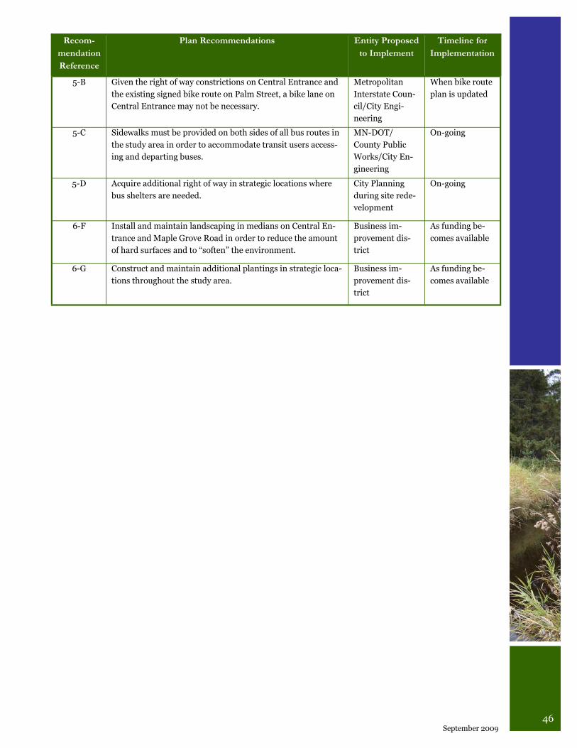
46 September 2009
Recom-
mendation
Reference
Plan Recommendations Entity Proposed
to Implement
Timeline for
Implementation
5-B Given the right of way constrictions on Central Entrance and
the existing signed bike route on Palm Street, a bike lane on
Central Entrance may not be necessary.
Metropolitan
Interstate Coun-
cil/City Engi-
neering
When bike route
plan is updated
5-C Sidewalks must be provided on both sides of all bus routes in
the study area in order to accommodate transit users access-
ing and departing buses.
MN-DOT/
County Public
Works/City En-
gineering
On-going
5-D Acquire additional right of way in strategic locations where
bus shelters are needed.
City Planning
during site rede-
velopment
On-going
6-F Install and maintain landscaping in medians on Central En-
trance and Maple Grove Road in order to reduce the amount
of hard surfaces and to “soften” the environment.
Business im-
provement dis-
trict
As funding be-
comes available
6-G Construct and maintain additional plantings in strategic loca-
tions throughout the study area.
Business im-
provement dis-
trict
As funding be-
comes available