rudgate village, wetherby environmental statement non … village nts... · 2018-07-20 ·...
TRANSCRIPT

Rockspring Hanover Property Unit Trust
Rudgate Village, Wetherby
Environmental Statement Non Technical Summary
November 2015
Rudgate Village - Environmental Statement,
Non-Technical Summary
Contents 1.0 Introduction .................................................................................. 1 2.0 The Proposals ............................................................................... 3 3.0 Consultation ................................................................................ 10 4.0 Environmental Impacts ................................................................ 12
4.1 Socio-Economic ....................................................................... 12 4.2 Traffic and Transport ............................................................... 12 4.3 Noise and Vibration .................................................................. 13 4.4 Air Quality ............................................................................... 13 4.5 Archaeology and Cultural Heritage ............................................ 13 4.6 Landscape and Visual Impact ................................................... 14 4.7 Hydrology and Flooding ........................................................... 14 4.8 Ecology ................................................................................... 14 4.9 Geology, Soils and Hydrogeology .............................................. 15 4.10 Waste ..................................................................................... 15
5.0 Summary .................................................................................... 16
EIA Quality This Environmental Statement, and the Environmental Impact
Assessment (EIA) carried out to identify the significant
environmental effects of the proposed development, was
undertaken in line with the EIA Quality Mark Commitments.
The EIA Quality Mark is a voluntary scheme, operated by the
Institute of Environmental Management and Assessment (IEMA),
through which EIA activity is independently reviewed, on an
annual basis, to ensure it delivers excellence in the following
areas:
EIA Management
EIA Team Capabilities
EIA Regulatory Compliance
EIA Context & Influence
EIA Content
EIA Presentation
Improving EIA practice
To find out more about the EIA Quality Mark please visit:
www.iema.net/qmark

Rudgate Village - Environmental Statement,
Non-Technical Summary
1
1.0 Introduction
1.1 Background
1.1.1 This document summarises the Environmental Statement (ES) which accompanies the planning application by Rockspring Hanover Property
Unit Trust (hereafter termed the Applicant) for the development of
Rudgate Village.
1.1.2 This document is a summary of the Environmental Impact Assessment
(EIA) process in non-technical language. The main Environmental Statement (ES) (Volume 1) and the supporting Appendices (Volume 2)
contain detailed information on the project and each of the
environmental topics considered.
1.2 Environmental Assessment
1.2.1 EIA is a formal process by which the likely environmental effects of a project are assessed, and where there is potential for a significant
negative effect that cannot be avoided, works are identified to lessen
the effect (mitigation). The ES reports on the findings of the EIA and sets out those areas where likely significant environmental effects
have been identified and the mitigation proposed to lessen predicted effects. It forms an important part of the planning application decision
making process.
1.2.2 Under the Town and Country Planning (Environmental Impact Assessment) Regulations 2011 (as amended) the Proposed
Development is considered to be large enough to require an Environmental Impact Assessment.
1.2.3 The topics to be studied as part of the EIA were decided in an informal ‘scoping’ process carried out internally. These topics have the
potential to result in a significant environmental effect and have
therefore been subject to further assessment.
• Socio-economic
• Traffic and Transport
• Noise and Vibration;
• Air Quality;
• Landscape and Visual Impact;
• Archaeology & Cultural Heritage;
• Ecology;
• Hydrology and Flooding;
• Geology, Soils and Hydrogeology; and
• Waste.
1.2.4 The EIA project team has been led by EIA co-ordinators from WYG,
with input from other specialists within the company.

Rudgate Village - Environmental Statement,
Non-Technical Summary
2
1.3 Site Description
1.3.1 The Site is located approximately 1km to the north east of the existing settlements of Thorp Arch and Boston Spa, approximately 3km to the
south east of the town of Wetherby and approximately 3km to the north west of the town of Tadcaster.
1.3.2 The general land use is agricultural, with a rural character. The
agricultural land use is interspersed with small settlements such as Walton, Wighill and Newton Kyme and smaller individual farm
settlements, for example, Sykes House Farm, Hall Parks Farm, Syningthwaite Farm and Walton Lodge Farm.
1.3.3 There are also a small number of small sized wooded areas the largest of which are Hall Wood to the west and Walton Wood to the
north east.
1.3.4 The nearest trunk road to the site is the A1 motorway to the west. The surrounding area and settlements are serviced by B roads and
the A659. The A659 provides a main road connection between Wetherby, Boston Spa and Tadcaster to the A64 to the east.
1.3.5 The River Wharfe and its floodplain, located to the south of the site is
a key feature of the surrounding landscape. The river runs under the A1 at Wetherby and flows in a south easterly direction to the north
eastern side of Boston Spa and south western edge of Thorp Arch effectively dividing the two settlements.
1.3.6 The river corridor passes through farmland to the south of the site
prior to meandering south east prior to flowing through Tadcaster.

Rudgate Village - Environmental Statement,
Non-Technical Summary
3
2.0 The Proposals
2.1 Background and Need
2.1.1 The Site is under the ownership of the applicant and is within the existing Thorp Arch Estate. The Site is classified as ‘brownfield land’,
being part of the former munitions factory which was built during the
Second World War.
2.1.2 There is a requirement for new houses within the county, therefore
Leeds County Council have produced a number of housing targets outlined in The Adopted Core Strategy. These include a target of at
least 3600 new dwellings per annum within the County and 5000 new
dwellings in the Outer North East of Leeds between 2012 and 2028.
2.2 Consideration Alternatives
Alternative Sites
2.2.1 The proposed site has been identified as one which has ‘the greatest
potential to be allocated for housing’.
2.2.2 Rudgate Village is being promoted as a site for allocation within the Site Allocations Plan.
2.2.3 A key driver to bringing this site forward is that it can be shown to be demonstrably sustainable. In part this is because of the key
relationship between the site and the wider TAE employment park and
other employers locally (HMP Wealstun, the British Library and Moores) which jointly employ over 4,000 people.
2.2.4 In conclusion, it is considered that the process in selecting the Site for promotion for an allocation was robust and appropriate and therefore
there is no further need to consider alternative sites at this stage of the application. The Site is the only appropriate site for the Proposed
Development for the following reasons:
• The Application Site is available;
• The Application Site is brownfield land;
• The Application Site has been identified as a site of great
potential for housing;
• The Application Site is deliverable by the Applicant and
demonstrably sustainable; and
• The Application Site will fulfil a need for housing in the area.
Alternative Uses
2.2.5 Alternate uses for the site have been considered including the use of
the Site for employment.
2.2.6 Housing however was determined to be the most suitable due to the
sustainability of the proposed development and its impact in helping achieve the regions housing targets.
2.2.7 It was concluded that the loss of allocated employment sites to
alternative uses would also not harm the Council’s policy aims of providing opportunities for local employment.
Alternative Layouts
During the design of the project, a number of different options have
been explored for the Site that seek to accommodate both the
aspirations of the client, Leeds County Council, consultees and the general public.
2.2.8 The overall layout of the Proposed Development has followed an extensive process of design development, as detailed below:
2013 Application
2.2.9 The proposed site has been previously bought forward as part of a
larger residential containing 2000 dwellings. The proposal was
presented to the Plans Panel on the 12th December 2013 with a recommendation for approval.
Rudgate Village - Environmental Statement,
Non-Technical Summary
4
2.2.10 This scheme was subsequently not pursued as it was determined to
not be deliverable and included land outside the applicant’s control.
Design Evolution
2.2.11 As part of the evolution of the scheme design, a number of alternative
layouts were proposed which were based on Site constraints (see Figure 1) such as access, topography, existing landscape features and
neighbouring uses.
2.2.12 These constraints were fed into the creation of a conceptual
masterplan (see Figure 2).
2.2.13 Following consideration of both environmental constraints and local consultation on the conceptual masterplan an Illustrative Masterplan
is proposed (Figure 5). This incorporated:
• The exclusion of the vast majority of the recently designated
Thorp Arch Local Wildlife Site (LWS) which is designated for its
species rich calcareous (GR2) grassland;
• Creation of a ‘Country Park’;
• A landscape strategy designed to maintain connectivity across
the site and provide semi-natural habitats of ecological and recreational benefit; and
• A number of dwellings to support the new primary school and
local centre to ensure it functions in a way that provides the opportunity to use non-car mode trips for day to day needs.

Rudgate Village - Environmental Statement,
Non-Technical Summary
5
Figure 2 – Constraints Plan Figure 3 – Conceptual Masterplan

Rudgate Village - Environmental Statement,
Non-Technical Summary
6
2.3 Description of the Development
2.3.1 The Environmental Statement will accompany an outline planning
application for the site with all further matters (additional detail) reserved for subsequent approval. This allows for a decision on the
general principles of how a site can be developed.
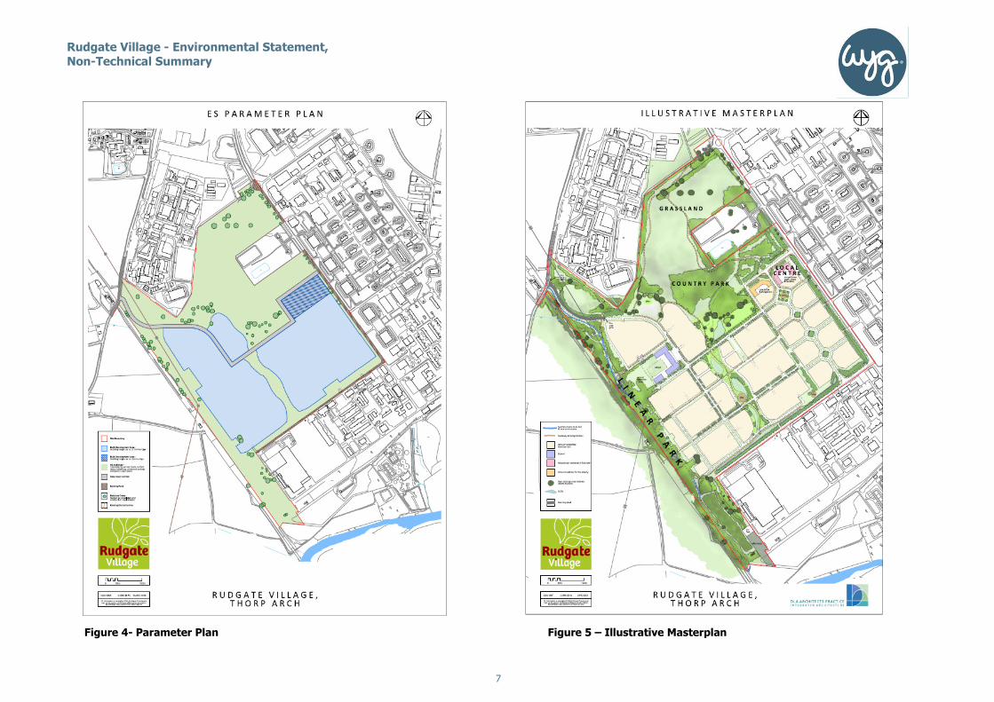
2.3.2 The proposed development that has been assessed is identified in the
Parameters Plan, (Figure 3); this also identified the maximum height
of built form development on the site.
2.3.3 Whilst not specifically identified in every case, existing trees and
hedgerows worthy of retention are to be retained unless required for access or lost as part of the remediation works.
2.3.4 The ‘no-build’ areas on the Parameters Plan incorporate landscape planting, open space uses and ecological enhancement areas,
integrated with a sustainable urban drainage system.
2.3.5 The planning application is for comprehensive mixed use development comprising the following:
Outline planning application with all matters reserved, for the erection of up to 874 dwellings (max 840 dwellings with 2 or more bedrooms); a 66 bed care home; a 1 form entry primary school; a new local centre including a Class A1 convenience store (up to 420m2), a 5 unit parade of small retail units (up to 400m2), Class D1 uses (up to 750m2); onsite open space, including areas for both public access and biodiversity enhancements, together with associated highway and drainage and infrastructure.
2.3.6 These proposals are shown on the Illustrative Masterplan (Figure 5); this has not been subject to EIA but is provided to show how the site
is intended to eventually look.
2.3.7 However, the following key principles shown in the Illustrative layout
are integral to the development and have been taken into account as part of the mitigation provided within the submitted design sections of
the EIA.
• Retention of trees worthy of retention and hedgerows, with new
planting to mitigate unavoidable losses;
• Integration of Sustainable urban drainage systems (SUDS) with
landscape and open space strategies within the development’s build and no build and no build zones;
• Achievement of a high quality development as defined in the
accompanying Design and Access Statement;
• 31.82 hectares of open space (in both ‘build’ and ‘no-build’ area
of the Parameters Plan); and,
• Reference to historic ROF layout.
2.3.8 The schedule of development is provided in Table 1 below:
Table 1 Schedule of Development
Development Type Area (ha)
Developable area 27.93ha
Open Space Area 31.82ha
Sustainable Urban Drainage (SUDs) 0.95ha
Total 60.7 ha (Indicative and Fixed)
Rudgate Village - Environmental Statement,
Non-Technical Summary
Figure 4- Parameter Plan
7
Figure 5 – Illustrative MasterplanIllustrative Masterplan
Rudgate Village - Environmental Statement,
Non-Technical Summary
8
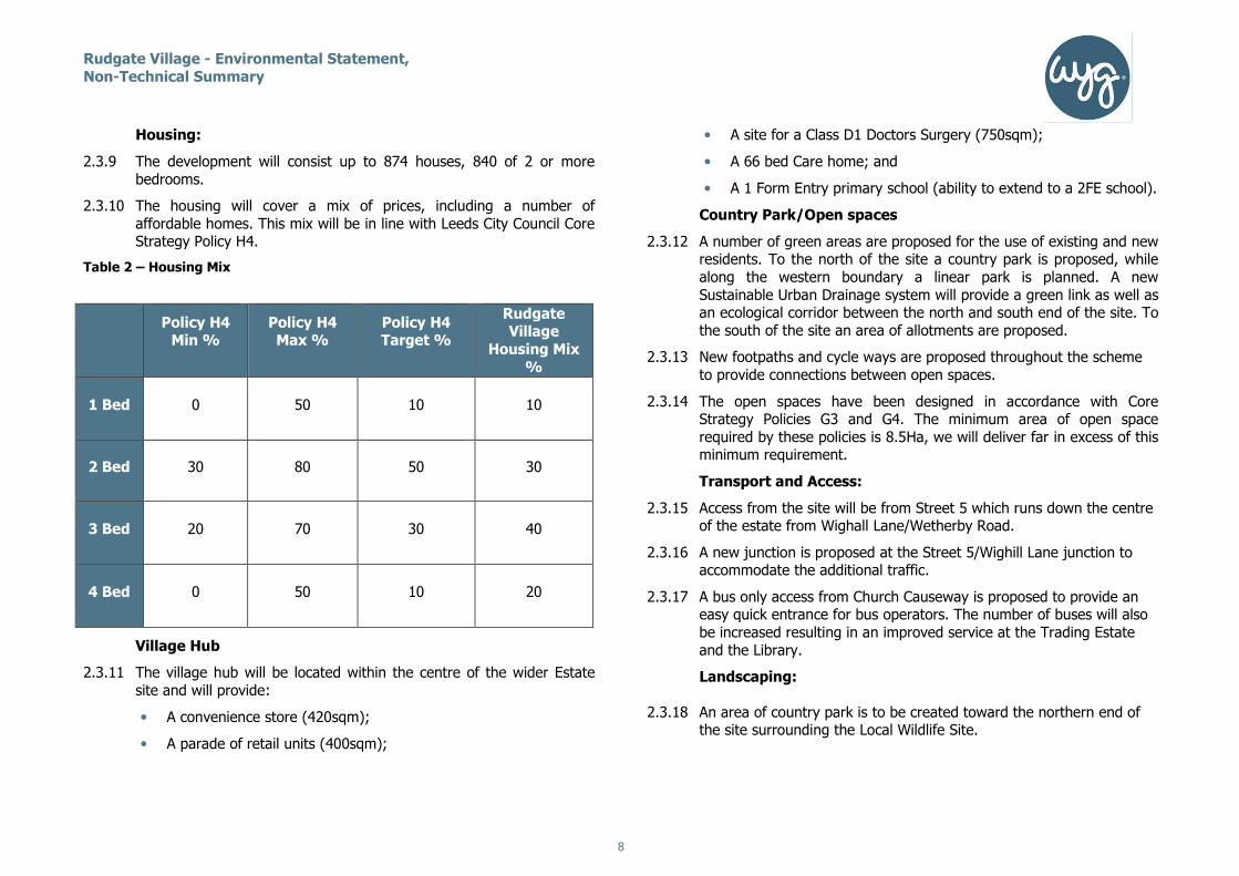
Housing:
2.3.9 The development will consist up to 874 houses, 840 of 2 or more
bedrooms.
2.3.10 The housing will cover a mix of prices, including a number of
affordable homes. This mix will be in line with Leeds City Council Core Strategy Policy H4.
Table 2 – Housing Mix
Village Hub
2.3.11 The village hub will be located within the centre of the wider Estate
site and will provide:
• A convenience store (420sqm);
• A parade of retail units (400sqm);
• A site for a Class D1 Doctors Surgery (750sqm);
• A 66 bed Care home; and
• A 1 Form Entry primary school (ability to extend to a 2FE school).
Country Park/Open spaces
2.3.12 A number of green areas are proposed for the use of existing and new residents. To the north of the site a country park is proposed, while
along the western boundary a linear park is planned. A new
Sustainable Urban Drainage system will provide a green link as well as an ecological corridor between the north and south end of the site. To
the south of the site an area of allotments are proposed.
2.3.13 New footpaths and cycle ways are proposed throughout the scheme
to provide connections between open spaces.
2.3.14 The open spaces have been designed in accordance with Core Strategy Policies G3 and G4. The minimum area of open space
required by these policies is 8.5Ha, we will deliver far in excess of this minimum requirement.
Transport and Access:
2.3.15 Access from the site will be from Street 5 which runs down the centre of the estate from Wighall Lane/Wetherby Road.
2.3.16 A new junction is proposed at the Street 5/Wighill Lane junction to accommodate the additional traffic.
2.3.17 A bus only access from Church Causeway is proposed to provide an easy quick entrance for bus operators. The number of buses will also
be increased resulting in an improved service at the Trading Estate
and the Library.
Landscaping:
2.3.18 An area of country park is to be created toward the northern end of the site surrounding the Local Wildlife Site.
Policy H4 Min %
Policy H4 Max %
Policy H4 Target %
Rudgate Village
Housing Mix
%
1 Bed 0 50 10 10
2 Bed 30 80 50 30
3 Bed 20 70 30 40
4 Bed 0 50 10 20
Rudgate Village - Environmental Statement,
Non-Technical Summary
9
2.3.19 Vegetation will be removed as part of the remediation works and
housing development, however, within the proposed green spaces,
wherever feasible, existing trees and vegetation will be retained.
2.3.20 A landscape buffer of vegetation and trees will be retained along the
western boundary.

Rudgate Village - Environmental Statement,
Non-Technical Summary
10
3.0 Consultation
3.1 Approach to Consultation
3.1.1 The Client and their consultants have undertaken extensive discussions with technical consultees, the local community and
landowners.
3.1.2 The findings of these discussions have then had an influence over the evolution of the design and the scope of the EIA.
3.1.3 Consultation began at the earliest stage of the development to establish feasibility and has progressed all the way through to the
submission of the planning application.
3.1.4 This process has been conducted in line with the Council’s Statement of Community Involvement (SCI) (2007).
Pre-Application Advice
3.1.5 Early consultation on the proposals began in February 2016 when
representatives from St Congar and Pegasus held a meeting with the Chief Planning Officer at Leeds City Council.
Engagement Strategy
3.1.6 An Engagement Strategy was submitted to the council on 3rd March 2016 seeking approval for the method of engagement with the
council and local community. The strategy was confirmed by the council to be an appropriate method of engagement for a large scale
development.
Invite only Stakeholder Event
3.1.7 In April 2016 the development team held an invite-only stakeholder
event. This event provided local parish councillors and other local stakeholders, with an update on the reasons for why the 2,000-unit
application was withdrawn, an introduction to the development team
and a presentation of a new illustrative masterplan for the site.
3.1.8 The feedback and views shared in the stakeholder meeting
expressed an indication of local opinion on the renewed proposals
highlighting transportation and contamination concerns. As a result of this stakeholder event a locally suggested name for the scheme
was arrived at - ‘Rudgate Village’.
Ward Member Briefing
3.1.9 In the run up to the public exhibition members of the team met with ward members to provide a briefing for the upcoming public
exhibition. This meeting was held on the 19th May 2016, which
provided ward members an opportunity to speak to team members and discuss their views on renewed proposals at Thorp Arch Estate.
3.1.10 Through the course of this meeting it was clear that there was concern over the issues of contamination and how the previous
application on the site had failed to address local concern and
opinion. It was agreed at the meeting that following the public exhibition event there would be a further ward members meeting to
present feedback on the exhibition.
Public Consultation Event
3.1.11 The public exhibition was held at Unit 603, Avenue D, Thorp Arch Estate on Tuesday the 24th May 2016. Parish Councillors, Local
Councillors and Officers were invited to a preview session to the
event which ran between 2pm and 3pm. This provided an opportunity to discuss the proposals with the development team in
advance of the public session which ran 3pm until 8pm.
3.1.12 Details of the exhibition material can be viewed on the website:
www.rudgatevillage.co.uk.
3.1.13 207 people attended the event and the feedback received has informed the now proposed Masterplan.
3.1.14 Copies of the feedback forms have been forwarded to the Local Planning Authority and neighbouring Parish Councils for information.
Rudgate Village - Environmental Statement,
Non-Technical Summary
11
3.1.15 Transportation was the biggest concern raised by those attending,
together with concerns expressed over contamination, sustainability
and the impact upon the local environment. The scheme has responded to this feedback.
3.1.16 There were also a small number of comments which acknowledged positive aspects of the proposals.
3.1.17 A full summary of the comments received can be found within the Statement of Community Involvement (SCI) which has been
submitted in support of the Planning Application for the Proposed
Development.
Rudgate Village - Environmental Statement,
Non-Technical Summary
12
4.0 Environmental Impacts
4.1 Socio-Economic
4.1.1 An assessment of the effects on Socio-economics has been undertaken for the Proposed Development. This looked at the
potential impacts on existing amenities and facilities in the area and
the potential increased employment. The scheme was assessed against current policy guidelines as set out in local and regional policy
documents.
4.1.2 The assessment showed that the scheme is likely to result in a
number of positive impacts for the local community.
4.1.3 The most significant impacts of the proposed development would be:
• Approximately 105 construction job opportunities per year will be
created during the expected 9 years construction period.
• A total of £24.1 million expenditure per annum by residents living
within the development.
• The development will help meet the identified need for new
affordable housing.
4.1.4 The proposed development of Rudgate Village represents a significant new capital investment in the area, will raise the level spending in the
area, and will therefore have a beneficial economic impact within the
community.
4.1.5 Not only would the alternative – do nothing – option prevent these
benefits from coming forward, but it would also result in a further deterioration of the affordability of housing and a reduction in the
local workforce as a result of the ageing population. This would have
significant adverse impacts in social and economic terms.
4.2 Traffic and Transport
4.2.1 An assessment has been undertaken to assess the baseline data and
to identify the potential impacts of both the construction and operation of the Proposed Development.
4.2.2 The main implication in traffic and transport terms is the resulting increase in road traffic for the construction and occupation phases of
the development and the potential impact that this will have on other
road users.
4.2.3 It is proposed to access the site from three external locations:
• Wighill Lane/Street 5. This will be the primary access point into
the development;
• Wighill Lane/Avenue C East; and
• A new junction onto Church Causeway. Note that the current
solution here will include a bus gate that will exclude general
traffic from entering and exiting the site.
4.2.4 Within the Thorp Arch Estate there will be a new priority junction into
the development site from Street 5 and the existing access into the
retail site will form a southern access junction into the development.
4.2.5 The bus gate onto Church Causeway is proposed in response to Leeds
City Council concerns about routeing traffic towards Boston Spa.
4.2.6 A Travel Plan has also been prepared for the development containing
a number of measures to help reduce traffic once the development is
operational.
4.2.7 With these mitigation measures in place it is considered that there are
no significantly adverse effects in terms of Traffic and Transport as a result of the development proposals.
Rudgate Village - Environmental Statement,
Non-Technical Summary
13
4.3 Noise and Vibration
4.3.1 The nearest potential receptors to noise and vibration include nearby
residential properties, which are located on Wighill Lane and Walton Road. In addition located adjacent to the northern boundary of the
site, is HMP Wealston Prison.
4.3.2 During construction there is the likelihood that noise from building
works will be audible at the nearest receptors to the site although
such occurrences will be temporary and of a short term duration. Through standard construction measures implemented by the
Contractor, noise and vibration levels will not be unacceptable.
4.3.3 Once the development is built, the most likely noise generating source
will be road traffic noise. However, the assessment demonstrates that traffic noise will not result in unacceptable noise levels at existing and
proposed receptors in accordance with relevant guidance documents.
4.4 Air Quality
4.4.1 The Air Quality chapter of the ES considers the likely significant
effects of the Proposed Development on local air quality.
4.4.2 The development is located in an area where the greatest influence to air quality is emissions from road transport. At present air quality
limits in the vicinity of the Site do not exceed the nationally recognised threshold.
4.4.3 A number of sensitive receptor locations along road-links close to the development site were identified in order to predict the likely air
quality impacts from construction activities and the increased levels of
traffic as a result of the proposed development.
4.4.4 Within the development there is designated wildlife site, therefore the
impact upon this Site was also assessed.
4.4.5 During the construction phase, dust control and exhaust emissions
mitigation measures will be implemented reducing the effects to a non
significant level.
4.4.6 For the operational phase of the development, the effects of air
quality will not change from existing conditions. The effects are
predicted to be within the UK Air Quality Objectives.
4.5 Archaeology and Cultural Heritage
4.5.1 The proposed development lies within an area of extensive late prehistoric and Roman settlement with significant late prehistoric and
Roman Scheduled sites to the east and south of the development site.
The area is thought to have been largely agricultural in the medieval and later periods. In 1941 the Royal Ordnance Filling Factory (ROF)
Thorp Arch was constructed as part of the war effort. It closed in 1945 and then re opened to supply the Korean War. It finally closed
in 1958.
4.5.2 A number of features associated with the original ROF layout have
been incorporated into the masterplan design. This includes
references to the gird and layout of the ROF.
4.5.3 In addition, due to the potential for previously unrecorded
archaeological remains to be identified within parts of the main site, it is proposed that a programme of archaeological geophysical survey
and trial trenching takes place before construction work begins.
4.5.4 Considering the aforementioned there is still predicted to be adverse significant impacts upon the historic landscape and layout of the
former ROF and the site of the former ROF through removal of extant buildings in development.
4.5.5 Whilst the residual impacts upon the layout, historic landscape and
historic buildings within the ROF are considered to be Significant in EIA terms, they are considered to be acceptable within the context of
the development proposals. The proposed masterplan conserves key aspects of the significance within the layout. A key feature of the
former ROF is its ability to adapt to changes of use. Whilst each change of use or conversion is significant, characteristics of the site
are taken forward to the next phase of development. This can also
allow the site to adapt to changing circumstances and avoid areas of
Rudgate Village - Environmental Statement,
Non-Technical Summary
14
the site becoming derelict and/or redundant if there are no longer
viable economic uses.
4.6 Landscape and Visual Impact
4.6.1 A detailed study has been made of the Site and its immediate
surroundings. An assessment has then been made of the impact of the Proposed Development on landscape character and on views both
during construction and once complete.
4.6.2 There are a number of landscape enhancement measures within the scheme including the retention of a landscape buffer along the
western boundary and the creation of a large open country park towards the north of the site.
4.6.3 In terms of impacts on landscape character there will be a moderate adverse impact on tree and scrub vegetation due to their unavoidable
removal as part of the confidence scrape. However the vegetation
removal would have a limited effect upon the wider landscape character due to the restricted intervisibility of the site with the
surrounding landscape. There would be no effect experienced upon both the Green Belt and Special Landscape Area designations as a
result of the proposed development.
4.6.4 The visual impact from a total of seven representative view locations and two sequential routes was assessed. The Proposed Development
is not anticipated to have a significant impact on any of these viewpoints.
4.7 Hydrology and Flooding
4.7.1 As assessment has been undertaken to assess the potential effects of the Proposed Development in terms of surface water quality, water
use and flood risk.
4.7.2 Best practice standards and techniques will be used to address all
activities that have the potential to pollute surface water, including
contingency planning for natural disasters and accidents. The impact
on surface water quality and nearby watercourses will therefore be
non significant.
4.7.3 Water efficiency measures will be implemented during both construction works and operational usage. Therefore, the impact on
water use will therefore be non significant.
4.7.4 To reduce the risk of flooding the development will include site
surface water storage in the form of an attenuation basin and a sustainable drainage scheme (SUDS) which comprises of swales and
ponds. The impact on flood risk will therefore be not significant.
4.7.5 Overall, through the implementation of this mitigation there is expected to be no significant adverse effects on hydrology or flooding.
4.8 Ecology
4.8.1 An Ecological Impact Assessment was undertaken for the
development following guidelines set by the Institute of Ecology and
Environmental Management. Baseline information was collected from comprehensive desk-based and field studies to evaluate the Site's
ecological and nature conservation value and to determine the potential impacts of the Proposed Development.
4.8.2 The Site currently comprises boundary hedgerows, areas of grassland,
scrub and semi-natural broadleaved woodland.
4.8.3 There is a Local Wildlife Site within the site. This has been designated
for rare grassland (GR1) and species rich calcareous grassland (GR2).
4.8.4 The scheme has been designed to exclude the vast majority of this
from development, with only minimal loss required for access or
where contamination requires remediation.
4.8.5 The scheme includes proposals for large-scale scrub removal and
thinning of these areas to create a more open ‘Country Park’, linking the LWS across the site with the former railway corridor.

Rudgate Village - Environmental Statement,
Non-Technical Summary
15
4.8.6 An Ecological and Habitat Management Plan will be produced and
implemented. This management plan will lay out a management and
maintenance schedule for each habitat within the site.
4.8.7 The assessment identified a number of potential impacts as a result of
the construction phase. These included adverse impacts on a number of species, habitats and the Local Wildlife Site. The implementation of
the above mitigation and a Construction Environmental Management Plan (CEMP) will however reduce these impacts to a non significant
level.
4.8.8 The only significant impacts of the construction phase were positive. As part of the development invasive species including Himalayan
Balsam and Japanese Knotweed will be removed. There will also be a significant positive impact on invertebrates as part of the mitigation
scheme a number of features will be created that will have a
beneficial impact upon them.
4.8.9 Once operational adverse impacts could be experienced however
through the implementation of the Ecological and Habitat Management Plan these can be mitigated.
4.8.10 The only significant impacts of the operational phase were positive. These included significant positive impacts on the Thorp Arch Disused
Railway LNA, Unimproved and Semi improved Calcareous Grassland,
dense scrub and calcareous mosaic. These positive impacts can be achieved through the implementation of the management plan
preserving and enhancing the overall biodiversity value.
4.9 Geology, Soils and Hydrogeology
4.9.1 Historically the site was in agricultural use until the development of
ROF Thorp Arch in the 1940s. By 1959 the ROF was closed and the current Trading Estate was established. The past use of the site as an
ROF indicates the potential for land contamination.
4.9.2 During the construction phase of the project there is a potential risk
of injury to construction workers due to exposure to explosives and/or
ground contamination. In addition there is the potential for impacts
on vegetation and wildlife and groundwater from ground
contamination.
4.9.3 To mitigate these risks, further ground investigation will be carried out prior to the start of any works; this will allow the development of
a detailed remediation strategy.
4.9.4 The potential for contaminated land requires that the disposal of soils
off-site be controlled. To reduce any adverse impacts soils will be separated by type and stockpiled on site for re-use or treatment
where necessary.
4.9.5 Overall, through the implementation of this mitigation there is expected to be no significant adverse effects on geology, soils and
hydrology.
4.10 Waste
4.10.1 The assessment of waste impacts arising from the Rudgate Village
considers waste generated during the construction and operational phases of the development.
4.10.2 The assessment identifies the key sensitive receptors to impacts arising from waste generation as waste infrastructure capacity and
people. It is assumed that all legal requirements would be met when
carrying out the development and that all waste would be handled in a manner that would not impact upon human health.
4.10.3 A review of local facilities for the management of waste shows that sufficient capacity exists to cater for the predicted levels of
construction waste. As such no significant impacts are predicted.
4.10.4 In respect to operational waste it will be collected from households by Leeds City Council. In addition there are a number of local Household
Waste Recycling Centres within the local area, the closest of which is the Thorp Arch Household Waste Sorting Site on Thorp Arch Industrial
Estate. As such no significant impacts are predicted.
Rudgate Village - Environmental Statement,
Non-Technical Summary
16
5.0 Summary
5.1 Conclusions
5.1.1 The ES has considered how the environment and the local community would be affected by the development.
5.1.2 A range of potential environmental effects have been predicted to
occur as a result of the development, both positive and negative. However, mitigation and compensation measures have been identified
to appropriately reduce, minimise or offset any potential negative environmental effects.
5.1.3 Once these measures have been implemented the only significant
adverse residual effect from the proposed development is considered to be upon the layout, historic landscape and historic buildings within
the ROF.
5.1.4 This is considered to be acceptable within the context of the
development proposals as the proposed masterplan conserves key aspects of the significance within the layout. A key feature of the
former ROF is its ability to adapt to changes of use. Whilst each
change of use or conversion is significant, characteristics of the site are taken forward to the next phase of development. This can also
allow the site to adapt to changing circumstances and avoid areas of the site becoming derelict and/or redundant if there are no longer
viable economic uses.
5.1.5 A number of positive significant impacts were also identified with respect to ecology. Through the green spaces within the design and
the implementation of a management plan the Proposed Development has the potential to enhance the biodiversity of a number of different
habitats.
5.2 Management of Environmental Impacts
5.2.1 The impacts of the construction activities will be managed through a
Construction Environmental Management Plan. This will ensure that
working hours, traffic management, control of pollution, waste
management, noise, dust and vibration are all managed and
controlled. Other mitigation includes an Ecological and Habitat Management Plan.
5.3 What happens next?
5.3.1 Prior to making a decision on the planning application, Leeds City
Council will seek advice from statutory and non-statutory consultees
as part of the determination process for the submitted planning application.
5.3.2 Leeds City Council will make the full Environmental Statement available for examination by members of the public at the Council’s
offices.

17
Printed copies of the Non-technical Summary and ES (including figures and appendices) may be obtained from:
Executive Park, Avalon Way,
Anstey, Leicester,
Leicestershire,
LE7 7GR
Tel: +44 116 234 8000
The Non-technical Summary is available free of charge, and a limited number of hard copies of the Environmental Statement
are available for £350* per copy (plus p&p). Alternatively, these
documents are available as adobe acrobat files on CD from the same address at £25 (plus p&p) per copy.
Copies of the ES may also be viewed on Leeds City Council’s
online services (http://www.leeds.gov.uk/)
* Includes VAT @20%