ruby rides
DESCRIPTION
ÂTRANSCRIPT
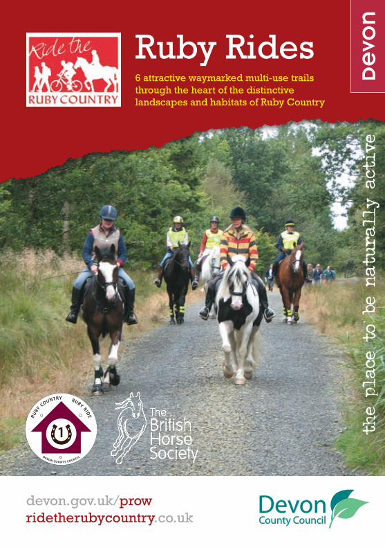
Ruby Rides6 attractive waymarked multi-use trails through the heart of the distinctive landscapes and habitats of Ruby Country
the place to b
e na
tura
lly
active
devon.gov.uk/prow ridetherubycountry.co.uk
DEVON COUNTY COUNCIL
RUBY COUNTRY RUBY RID
E
1
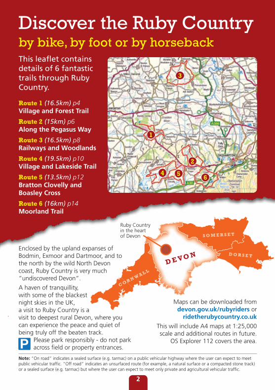
Discover the Ruby Countryby bike, by foot or by horsebackThis leaflet contains details of 6 fantastic trails through Ruby Country.
Route 1 (16.5km) p4 Village and Forest Trail
Route 2 (15km) p6 Along the Pegasus Way
Route 3 (16.5km) p8 Railways and Woodlands
Route 4 (19.5km) p10 Village and Lakeside Trail
Route 5 (13.5km) p12 Bratton Clovelly and Boasley Cross
Route 6 (16km) p14 Moorland Trail
2
1
3
4 5 6
D E VO N
C O R N W A L L
S O M E R S E T
D O R S E T
Ruby Country in the heart of Devon
Enclosed by the upland expanses of Bodmin, Exmoor and Dartmoor, and to the north by the wild North Devon coast, Ruby Country is very much “undiscovered Devon”.
A haven of tranquillity, with some of the blackest night skies in the UK, a visit to Ruby Country is a visit to deepest rural Devon, where you can experience the peace and quiet of being truly off the beaten track. Please park responsibly - do not park across field or property entrances.
Maps can be downloaded from devon.gov.uk/rubyriders or
ridetherubycountry.co.uk
This will include A4 maps at 1:25,000 scale and additional routes in future.
OS Explorer 112 covers the area.
Note: “On road” indicates a sealed surface (e.g. tarmac) on a public vehicular highway where the user can expect to meet public vehicular traffic. “Off road” indicates an unsurfaced route (for example, a natural surface or a compacted stone track) or a sealed surface (e.g. tarmac) but where the user can expect to meet only private and agricultural vehicular traffic.
2
What is Ruby Country?Ruby Country is a rural area in north west Devon, enclosed by the North Devon AONB, Dartmoor, Bodmin Moor and the north Cornwall coast, covering the 45 parishes surrounding Holsworthy and Hatherleigh.
Ruby Country is renowned for some of Devon’s most beautiful and unspoilt countryside. Visitors are always struck by its diversity, the wonderful views of Bodmin Moor, Dartmoor and Exmoor, the range of wildlife and clarity of its night skies.
Named after the Ruby Red cattle typical of the area, Ruby Country has historically been reliant upon agriculture to generate income. Agriculture, in particular livestock farming, has shaped the landscape for generations, creating distinctive field patterns, hedges, banks and small woodlands. Ruby Country is the result of people, their social and economic activities and nature working together and adapting to create this awe inspiring, tranquil and special place.
Ruby Country supports one of the world’s most endangered habitats, typical of the local landscape. Culm grassland is now globally scarse and threatened, with Ruby
Country being one of the few remaining strongholds of this challenging habitat.
The culm measures continue to flourish in Ruby Country supporting a healthy range of unique and wonderful plant, animal and insect species.
The Ruby Country Partnership Ltd works to promote all aspects Ruby Country, including tourism, public access, wildlife and natural areas, small businesses, local produce, crafts and culture. The Ruby Country Partnership is delighted to be working closely with Devon County Council on the Ride the Ruby Country project. This has improved access to the natural environment for horse riders, walkers and cyclists as well as creating economic and social opportunities for many people in Ruby Country.
Why not visit Ruby Country and sample some of the things that make the area unique. Join these rides together and come up with your own trekking holiday, staying at one or more of the growing number of establishments welcoming horses and offering high class accommodation. To find places to stay with your horse and more about Ruby Country in general visit: ridetherubycountry.co.uk
We welcome you to Ruby Country and hope you enjoy your visit.
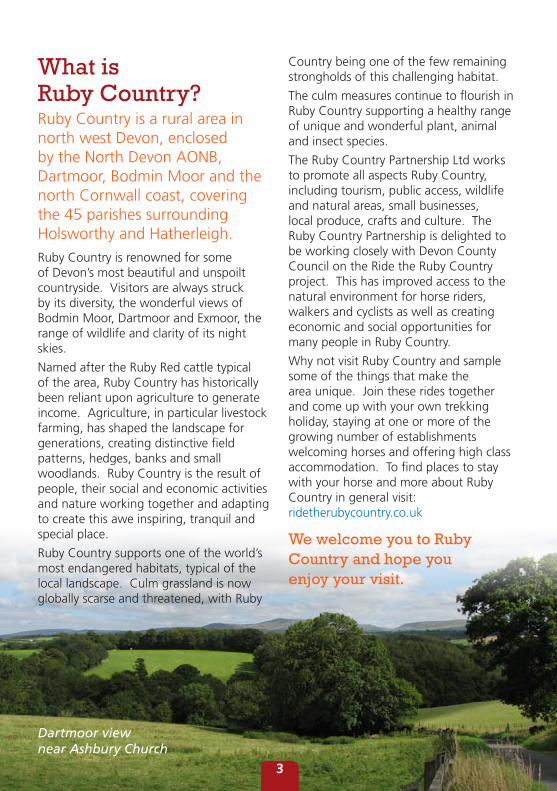
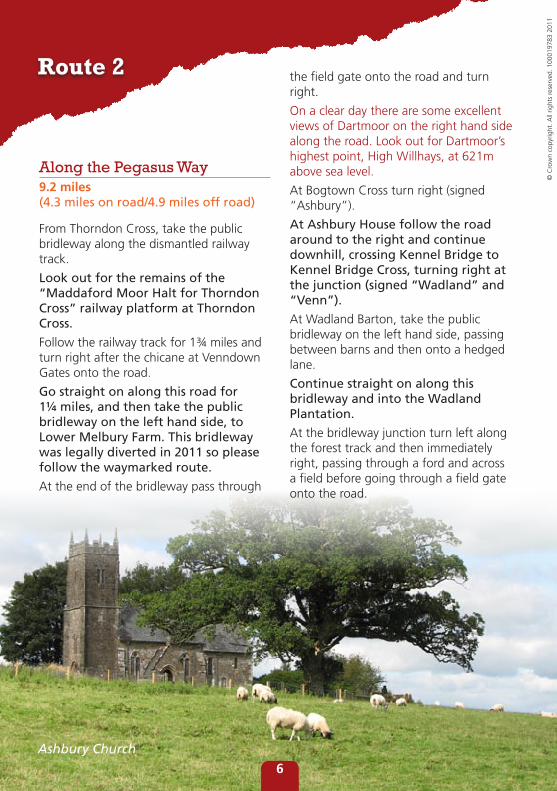
Dartmoor view near Ashbury Church
3
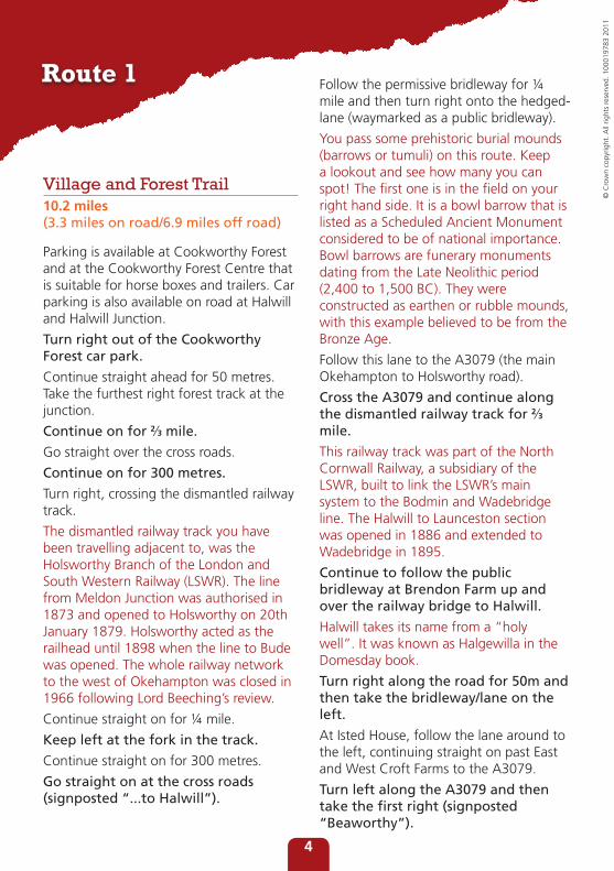
Village and Forest Trail10.2 miles (3.3 miles on road/6.9 miles off road)
Parking is available at Cookworthy Forest and at the Cookworthy Forest Centre that is suitable for horse boxes and trailers. Car parking is also available on road at Halwill and Halwill Junction.
Turn right out of the Cookworthy Forest car park.
Continue straight ahead for 50 metres. Take the furthest right forest track at the junction.
Continue on for 2⁄3 mile.
Go straight over the cross roads.
Continue on for 300 metres.
Turn right, crossing the dismantled railway track.
The dismantled railway track you have been travelling adjacent to, was the Holsworthy Branch of the London and South Western Railway (LSWR). The line from Meldon Junction was authorised in 1873 and opened to Holsworthy on 20th January 1879. Holsworthy acted as the railhead until 1898 when the line to Bude was opened. The whole railway network to the west of Okehampton was closed in 1966 following Lord Beeching’s review.
Continue straight on for ¼ mile.
Keep left at the fork in the track.
Continue straight on for 300 metres.
Go straight on at the cross roads (signposted “...to Halwill”).
Follow the permissive bridleway for ¼ mile and then turn right onto the hedged-lane (waymarked as a public bridleway).
You pass some prehistoric burial mounds (barrows or tumuli) on this route. Keep a lookout and see how many you can spot! The first one is in the field on your right hand side. It is a bowl barrow that is listed as a Scheduled Ancient Monument considered to be of national importance. Bowl barrows are funerary monuments dating from the Late Neolithic period (2,400 to 1,500 BC). They were constructed as earthen or rubble mounds, with this example believed to be from the Bronze Age.
Follow this lane to the A3079 (the main Okehampton to Holsworthy road).
Cross the A3079 and continue along the dismantled railway track for 2⁄3 mile.
This railway track was part of the North Cornwall Railway, a subsidiary of the LSWR, built to link the LSWR’s main system to the Bodmin and Wadebridge line. The Halwill to Launceston section was opened in 1886 and extended to Wadebridge in 1895.
Continue to follow the public bridleway at Brendon Farm up and over the railway bridge to Halwill.
Halwill takes its name from a “holy well”. It was known as Halgewilla in the Domesday book.
Turn right along the road for 50m and then take the bridleway/lane on the left.
At Isted House, follow the lane around to the left, continuing straight on past East and West Croft Farms to the A3079.
Turn left along the A3079 and then take the first right (signposted “Beaworthy”).
Route 1
© C
row
n co
pyrig
ht. A
ll rig
hts
rese
rved
. 100
0197
83 2
011
4
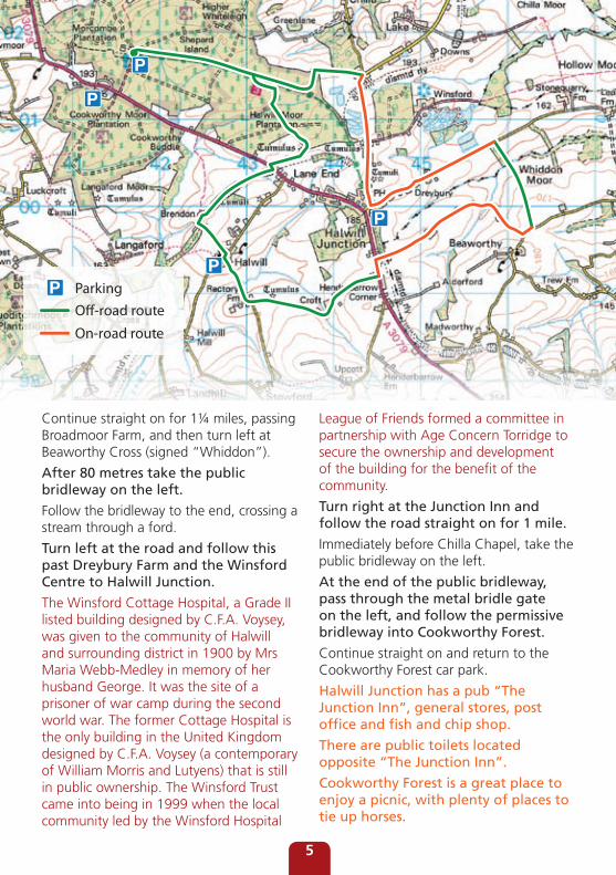
Continue straight on for 1¼ miles, passing Broadmoor Farm, and then turn left at Beaworthy Cross (signed “Whiddon”).
After 80 metres take the public bridleway on the left.
Follow the bridleway to the end, crossing a stream through a ford.
Turn left at the road and follow this past Dreybury Farm and the Winsford Centre to Halwill Junction.
The Winsford Cottage Hospital, a Grade II listed building designed by C.F.A. Voysey, was given to the community of Halwill and surrounding district in 1900 by Mrs Maria Webb-Medley in memory of her husband George. It was the site of a prisoner of war camp during the second world war. The former Cottage Hospital is the only building in the United Kingdom designed by C.F.A. Voysey (a contemporary of William Morris and Lutyens) that is still in public ownership. The Winsford Trust came into being in 1999 when the local community led by the Winsford Hospital
League of Friends formed a committee in partnership with Age Concern Torridge to secure the ownership and development of the building for the benefit of the community.
Turn right at the Junction Inn and follow the road straight on for 1 mile.
Immediately before Chilla Chapel, take the public bridleway on the left.
At the end of the public bridleway, pass through the metal bridle gate on the left, and follow the permissive bridleway into Cookworthy Forest.
Continue straight on and return to the Cookworthy Forest car park.
Halwill Junction has a pub “The Junction Inn”, general stores, post office and fish and chip shop.
There are public toilets located opposite “The Junction Inn”.
Cookworthy Forest is a great place to enjoy a picnic, with plenty of places to tie up horses.
ParkingO�-road route
On-road route
5
Along the Pegasus Way9.2 miles (4.3 miles on road/4.9 miles off road)
From Thorndon Cross, take the public bridleway along the dismantled railway track.
Look out for the remains of the “Maddaford Moor Halt for Thorndon Cross” railway platform at Thorndon Cross.
Follow the railway track for 1¾ miles and turn right after the chicane at Venndown Gates onto the road.
Go straight on along this road for 1¼ miles, and then take the public bridleway on the left hand side, to Lower Melbury Farm. This bridleway was legally diverted in 2011 so please follow the waymarked route.
At the end of the bridleway pass through
the field gate onto the road and turn right.
On a clear day there are some excellent views of Dartmoor on the right hand side along the road. Look out for Dartmoor’s highest point, High Willhays, at 621m above sea level.
At Bogtown Cross turn right (signed “Ashbury”).
At Ashbury House follow the road around to the right and continue downhill, crossing Kennel Bridge to Kennel Bridge Cross, turning right at the junction (signed “Wadland” and “Venn”).
At Wadland Barton, take the public bridleway on the left hand side, passing between barns and then onto a hedged lane.
Continue straight on along this bridleway and into the Wadland Plantation.
At the bridleway junction turn left along the forest track and then immediately right, passing through a ford and across a field before going through a field gate onto the road.
Route 2
Ashbury Church
© C
row
n co
pyrig
ht. A
ll rig
hts
rese
rved
. 100
0197
83 2
011
6
Turn right along the road and, opposite the entrance to the Ashbury Hotel, take the public bridleway on the right hand side.
Continue down the left hand side of the Ashbury Golf Course. Cross the bridle bridge and follow the bridleway to the left to return to Maddaford Moor Halt and Thorndon Cross.
Off-road route
On-road route
7
Railways and Woodlands10.2 miles (6.0 miles on road/4.2 miles off road)
From Northtown Cross at Petrockstowe, take the road signed to Merton, Hatherleigh and the Tarka Trail.
Continue along this road for ¾ mile and then take the Tarka Trail on the left towards Barnstaple. This is a multi-use section of the Tarka Trail so expect to meet walkers, cyclists and other riders.
The Tarka Trail is a 162 mile walking route, which incorporates a 31 mile shared use walking and cycling section between Braunton and Meeth, of which 10½ miles is also open to riders (from Torrington Servis Farm to Meeth Halt). Cantering or galloping and riding in groups of more
than 6 horses is not permitted. Please pass other users in single file and refer to any code of conduct signs on site. There is limited car parking along the Tarka Trail. Horse boxes and trailers should not be parked in Tarka Trail car parks but you may unload and load your horses in the car parks. More information about the Tarka Trail can be found at devon.gov.uk/tarkatrail
Continue along the Tarka Trail for 2¼ miles to a cross roads at Dunsbear Halt.
Turn left along the road and go straight on for ½ mile.
Turn right at Winscott Cross, signposted for Peters Marland and Torrington.
After ¼ mile turn left signed to Shebbear.
Continue straight on for 1¼ miles continuing to follow signs for Shebbear.
At Stonemoor Cross and the Chapel, turn left and then follow the road around to the right, signed to Shebbear.
After 150 metres take the road on the left, signed as a public bridleway.
Route 3
© C
row
n co
pyrig
ht. A
ll rig
hts
rese
rved
. 100
0197
83 2
011
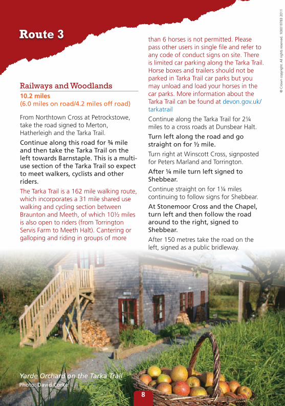
Yarde Orchard on the Tarka TrailPhoto: David Corke
8
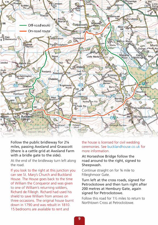
Follow the public bridleway for 2¼ miles, passing Awsland and Grasscott (there is a cattle grid at Awsland Farm with a bridle gate to the side).
At the end of the bridleway turn left along the road.
If you look to the right at this junction you can see St. Mary’s Church and Buckland House. The House goes back to the time of William the Conqueror and was given to one of William’s returning soldiers, Richard de Filleigh. Richard had used his shield to save William from arrows on three occasions. The original house burnt down in 1790 and was rebuilt in 1810. 15 bedrooms are available to rent and
the house is licensed for civil wedding ceremonies. See bucklandhouse.co.uk for more information.
At Horseshoe Bridge follow the road around to the right, signed to Sheepwash.
Continue straight on for ¾ mile to Filleighmoor Gate.
Turn left at the cross roads, signed for Petrockstowe and then turn right after 200 metres at Hembury Gate, again signed for Petrockstowe.
Follow this road for 1½ miles to return to Northtown Cross at Petrockstowe.
Off-road route
On-road route
9
Village and Lakeside Trail12.0 miles (4.8 miles on road/7.2 miles off road)
Free parking is available at Roadford Lake. To access the ride, use the Forest or Gaddacombe car parks, both of which are near the route. From Gaddacombe Cross you can access a permissive bridleway which runs northwards and around the perimeter of the lake, courtesy of the South West Lakes Trust. You can also ride on the cycleway here in dry weather. These routes are shown in green on the route map. Alternatively, paid parking is available at the main visitor centre. If parking with a horse-box or trailer, please use the top two (unsurfaced) tiers of the car park.
From the Forest car park access track, turn right along the road to Headson Cross.
At Headson Cross, turn left and follow the road for 1¾ miles to Bratton Clovelly.
Turn right at the junction near the Clovelly Inn, and then turn left along the road signed “Boasley” and “South Reed Fisheries”.
Continue straight on for 1⁄3 mile then take the public bridleway on the left hand side.
Follow this bridleway for 2 miles passing Voaden and Blackbroom.
Take the bridleway on the left where the two bridleways split (if you get to the A3079 you have gone too far)!
Follow this bridleway for 1 mile passing
Black Bangworthy Cottage to the road. Turn left along the road passing West Grindhill.
At the end of this road, turn left (signed “Bratton Clovelly”) and continue straight on for 2⁄3 mile.
Take the public bridleway on the right hand side and cross Brock’s Moor Field.
Cross straight over the lane and follow the public bridleway straight ahead.
Where the bridleway meets a road, follow the road straight on. Do not follow the public bridleway that runs off to the left, but continue straight on along the road for 1¼ miles, passing Southweek and ending at a road.
Enjoy the excellent views over Roadford Lake on this part of the route. Roadford Lake, also known as Roadford Reservoir, is a man-made reservoir fed by the River Wolf. It is the largest area of fresh water in the South West of England. Operated by South West Water, it directly supplies water for North Devon. It also supplies Plymouth and south west Devon via releases into the River Tamar for abstraction at Gunnislake.
Route 4
© C
row
n co
pyrig
ht. A
ll rig
hts
rese
rved
. 100
0197
83 2
011
Bratton Clovelly
10
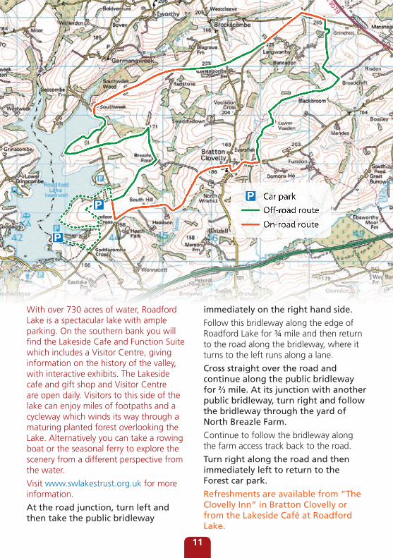
With over 730 acres of water, Roadford Lake is a spectacular lake with ample parking. On the southern bank you will find the Lakeside Cafe and Function Suite which includes a Visitor Centre, giving information on the history of the valley, with interactive exhibits. The Lakeside cafe and gift shop and Visitor Centre are open daily. Visitors to this side of the lake can enjoy miles of footpaths and a cycleway which winds its way through a maturing planted forest overlooking the Lake. Alternatively you can take a rowing boat or the seasonal ferry to explore the scenery from a different perspective from the water.
Visit www.swlakestrust.org.uk for more information.
At the road junction, turn left and then take the public bridleway
immediately on the right hand side.
Follow this bridleway along the edge of Roadford Lake for ¾ mile and then return to the road along the bridleway, where it turns to the left runs along a lane.
Cross straight over the road and continue along the public bridleway for 2⁄3 mile. At its junction with another public bridleway, turn right and follow the bridleway through the yard of North Breazle Farm.
Continue to follow the bridleway along the farm access track back to the road.
Turn right along the road and then immediately left to return to the Forest car park.
Refreshments are available from “The Clovelly Inn” in Bratton Clovelly or from the Lakeside Café at Roadford Lake.
Car parkO�-road route
On-road route
11
Bratton Clovelly and Boasley Cross7.6 miles (3.0 miles on road/4.6 miles off road)
From Bratton Clovelly (Chapel Road) take the road signed “Boasley” and “South Reed Fisheries”.
Continue straight on for 1 mile then take the public bridleway on the right hand side.
Follow this bridleway past Fursden Farm towards Great Burrow.
Take the public bridleway on the right hand side immediately before “North Burrow”.
Follow this bridleway to the end, where it comes out onto a road immediately to the north of the road bridge over the A30.
Turn left along this road and continue straight ahead for 2 miles to Boasley Cross.
At Boasley Cross take the second exit, straight ahead, and continue for ½ mile.
Take the public bridleway on the left hand side before reaching the A3079.
Route 5
© C
row
n co
pyrig
ht. A
ll rig
hts
rese
rved
. 100
0197
83 2
011
Pastoral Landscape
Clovelly Inn
12
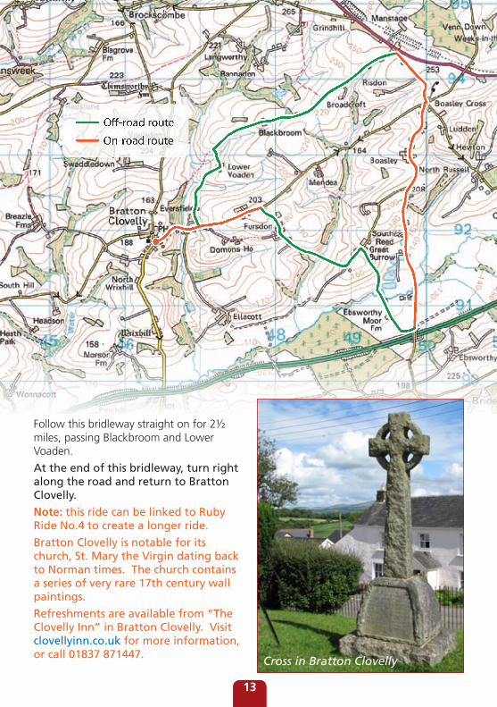
Follow this bridleway straight on for 2½ miles, passing Blackbroom and Lower Voaden.
At the end of this bridleway, turn right along the road and return to Bratton Clovelly.
Note: this ride can be linked to Ruby Ride No.4 to create a longer ride.
Bratton Clovelly is notable for its church, St. Mary the Virgin dating back to Norman times. The church contains a series of very rare 17th century wall paintings.
Refreshments are available from “The Clovelly Inn” in Bratton Clovelly. Visit clovellyinn.co.uk for more information, or call 01837 871447.
Off-road route
On-road route
Cross in Bratton Clovelly
13
Moorland Trail8.7 miles (4.6 miles on road/4.1 miles off road)
From the Meldon Reservoir car park, turn left along the access road.
At the junction, turn right and go under the railway bridge (which now carries the Granite Way).
The Granite Way is an 11 mile cycle / walkway which runs along the northwest edge of the granite massif of Dartmoor, suitable for families and those new to cycling.
Follow the road through Meldon and on over the road bridge over the A30.
Take the road on the left after crossing the A30 road bridge (signed “Bowerland”) (not the A30 slip road but the next road on the left)!
Follow this road, crossing the A386, and following signs to “Bowerland”.
Follow the lane around a left hand bend and then take the public bridleway on the right hand side which goes on to join a dismantled railway track.
Follow this bridleway along the edge of the West Bowerland Plantation, and then take the public bridleway on the left immediately after passing beneath a brick arch railway bridge.
Follow this bridleway to its junction with a road, by following the waymarking through the Plantation.
Turn left along the road, passing Thorndon Farm. Go straight on at the staggered cross-roads (signed “Week”).
Pass beneath the subway under the A30.
Take the lane on the left after Week Farm (signed “Unsuitable for motors”).
Follow this lane to its junction with a road.
Cross straight over the road and continue straight ahead (signed “Forda”).
Continue straight on to the Highwayman Inn and the A386.
Route 6
© C
row
n co
pyrig
ht. A
ll rig
hts
rese
rved
. 100
0197
83 2
011
Sourton Tors
14
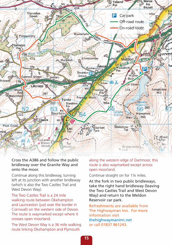
Cross the A386 and follow the public bridleway over the Granite Way and onto the moor.
Continue along this bridleway, turning left at its junction with another bridleway (which is also the Two Castles Trail and West Devon Way).
The Two Castles Trail is a 24 mile walking route between Okehampton and Launceston (just over the border in Cornwall) on the western side of Devon. The route is waymarked except where it crosses open moorland.
The West Devon Way is a 36 mile walking route linking Okehampton and Plymouth
along the western edge of Dartmoor, this route is also waymarked except across open moorland.
Continue straight on for 1¼ miles.
At the fork in two public bridleways, take the right hand bridleway (leaving the Two Castles Trail and West Devon Way) and return to the Meldon Reservoir car park.
Refreshments are available from The Highwayman Inn. For more information visit thehighwaymaninn.net or call 01837 861243.
Car parkO�-road route
On-road route
15
Local Enterprise Action Fund
If you enjoy Devon’s coast and countryside . . .Why not pick up one of our free booklets at Tourist Information Centres across Devon or visit www.visitdevon.co.uk and click on the ‘brochure request’ page.
Many of the walks promoted on Devon County Council’s website are accessible to everyone. Details of stiles, gradients and the level of
difficulty of routes are described. For accessible walks, visit devon.gov.uk/accessforall
If you would like a copy of this in a different format such as large print. Braille or tape, or in a different language, please contact our Customer Service Centre on 0845 1551 004 or email: [email protected] County Council has made every effort to ensure that the contents of this publication are accurate at the time of printing however walks and rides are undertaken at your own risk. January 2012
Cover photo: Walkers and riders in Cookworthy Forest, © Steve James JN01374 • Corporate Communications Design Service
This is printed on recycled paper
When you have finished with it please recycle and
help the environment