robotics - universität klagenfurt
TRANSCRIPT

Decisional issues in multi UAV systemsDecisional issues in multi-UAV systems
Simon LacroixLaboratoire d’Analysey
et d’Architecture des SystèmesCNRS, Toulouse
Where do I come from?
Robotics at LAAS/CNRS Toulouse FranceRobotics at LAAS/CNRS, Toulouse, France
• Research topicsA�keyword:�autonomy
p– Perception, planning and decision-making, control– Plus: control architecture, interactions, ambient
intelligence systems, learningg y g
3�research�groups�:12�full�time�researchers10 university researchers
� Research�domains� Cognitive�and�interactive�Robotics
10�university�researchers4�visitors50�PhD�students10 post docs
� Aerial�and�Terrestrial�Field�Robotics� Human�and�anthropomorphic�motion� Bio�informatics,�Molecular�motion
10�post�docs
� Considered�applications: Planetary exploration,�Service�and�personalrobotics virtual worlds and animation biochemistry embedded systemsrobotics,�virtual worlds and�animation,�biochemistry,�embedded systems,�transport,�driver�assistance,�defense,�civil�safety
Robotics @
otic
sUAVs
d
Fiel
d ro
bo
UGVs
Constructive�and�integrative�approach
ids
Hum
ano
erso
nal
obot
ics
2013
Pe ro
1979 1985 1990 1995 2000 2005 2011
Open source software tools: www.openrobots.org
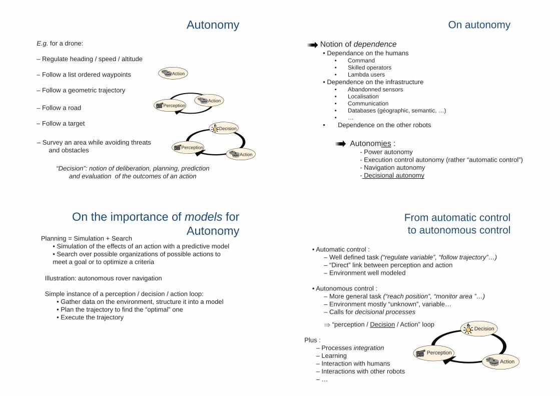
On autonomy
On autonomy
Notion of dependence• Dependance on the humansDependance on the humans
• Command• Skilled operators• Lambda usersa bda use s
• Dependence on the infrastructure• Abandonned sensors• Localisation• Communication• Databases (géographic, semantic, …)• …
Autonomies :
• Dependence on the other robots
Autonomies :- Power autonomy- Execution control autonomy (rather “automatic control”)- Navigation autonomy- Decisional autonomy
From automatic control to autonomous control
• Automatic control :
to autonomous control
– Well defined task (“regulate variable”, “follow trajectory”…)– “Direct” link between perception and action– Environment well modeled
• Autonomous control :– More general task (“reach position” “monitor area ” )More general task ( reach position , monitor area …)– Environment mostly “unknown”, variable…– Calls for decisional processes
� “perception / Decision / Action” loopDecision
Plus :
Perception
Action
Plus :– Processes integration– Learning
Interaction with humans– Interaction with humans– Interactions with other robots– …
AutonomyE.g. for a drone:
– Regulate heading / speed / altitude
– Follow a list ordered waypoints ActionFollow a list ordered waypoints
– Follow a geometric trajectory
– Follow a road PerceptionAction
Decision
Survey an area while avoiding threats
– Follow a target
PerceptionAction
– Survey an area while avoiding threatsand obstacles
“Decision”: notion of deliberation, planning, prediction and evaluation of the outcomes of an action
On the importance of models forAutonomyAutonomy
Planning = Simulation + Search • Simulation of the effects of an action with a predictive model• Search over possible organizations of possible actions to• Search over possible organizations of possible actions tomeet a goal or to optimize a criteria
Illustration: autonomous rover navigation
Simple instance of a perception / decision / action loop:• Gather data on the environment, structure it into a model• Plan the trajectory to find the “optimal” one• Execute the trajectoryj y

On the importance of models forAutonomyAutonomy
Planning = Simulation + Search • Simulation of the effects of an action with a predictive model• Search over possible organizations of possible actions to• Search over possible organizations of possible actions tomeet a goal or to optimize a criteria
Illustration: autonomous rover navigation
Environment models:at the heart of a tonomSimulation = convolution of • at the heart of autonomy
• at the heart of cooperationaction and environment models
Multiple robots call for more autonomyMain drivers for autonomy
• Dirty, Dull, Dangerous tasks• Operations in remote areas• Allows the deployment of complex systemsAllows the deployment of complex systems• Money savings !
Multiple robotics systems
Are inherently more complex• Are inherently more complex• Call for new specific processes :
• Cooperation T k ll i• Task allocation
• Task coordination• Implies new decisional architectures
Outline
Notion of AutonomyNotion of Autonomy
M lti l UAV i th kMultiple UAVs in the sky
Multiple UAV/UGV systems
Current projects
Multiple UAVs in the sky
Environment model ? an empty space !Environment model ? an empty space !(possibly with a non uniform atmospheric flow field)
Allows for “easy” development at the core of decision
Example 1: “Monitoring a set of locations” missionExample 1: Monitoring a set of locations mission
For a fleet of UAVs, mainly a task allocation problem:which UAV will observe which location?which UAV will observe which location?

The task allocation problem
The�“canonical”�task�allocation�problem:Gi• Given:
• A�set�of�robots�• A�set�of�tasks�
{ } �� � { }
{R}{T}
• A�cost�function• Find�the�allocation�������that�minimizes�the�cost�sum�(or�the�max.�of�individual�costs,�or�the�individual�cost�repartition,�or…)�
�c :{R �T}��� � {��}A�
A�well�known�and�well�posed�problem�(also�name�“optimal�allocation�problem)�– but�highly�combinatorial
Main�approaches:• Centralized�:�optimization�(MILP),�genetic�algorithm,�simulated�annealingDi t ib t d• Distributed�:�
• DCOP,�distributed�protocols• Negotiation�based�approaches:�market�based�approaches
Market based task allocation Auctions (tasks) are published, robots bid, the “best” bidder gets the task
Basic functions required• Ability to bid: task insertion cost evaluation• Auctioning strategies: who places auctions ?• Overall objective function to minimize
Many possibilities for each function, e.g.:• Task insertion
F i l t dditi• From a simple cost addition…• … to a (complex) plan update • Mix costs, risks, utilities…
• Auctioning strategiesAuctioning strategies• Centralized vs. bidders can emit auctions• When to close the market ? • Auctions can concern a set of tasks…
• Objective function• Sum of individual costs, dispersion of individual costs, max of individual costs…
B. Dias “Market-Based Multirobot Coordination: A Survey and Analysis” 2006
Market based task allocation
Illustration 1: the Multiple travelling salesman problem
• White dot = auction tokenSi l t k i ti• Simple task insertion
• The cost includes an “equity” constraint• All tasks are allocated before moving• All robots must fly back yhome
Market based task allocation
Main features of market-based approachesA simple protocol applicable to a ide ariet of comple• A simple protocol, applicable to a wide variety of complex
problems• Can be distributed (can bear with communication constraints)• Can handle dynamic events:
• Robot failures• Unexpected events• New tasks
• No guarantee on any optimalityo gua a tee o a y opt a ty

Satisfying communication constraints
• One�single�“survey”�task�(=�square�pattern)
• The�constraint�satisfaction�yields�new�tasks�(“com�relay”)
Satisfying communication constraints
Illustration:�multi�TSP�+�several�constrained�“survey”�tasks
• 4�robots5 k• 5�survey�tasks
• 18�places�to�visit
Multiple UAVs in the sky
Environment model ? an empty space !Environment model ? an empty space !(possibly with a non uniform atmospheric flow field)
Allows for “easy” development at the core of decision
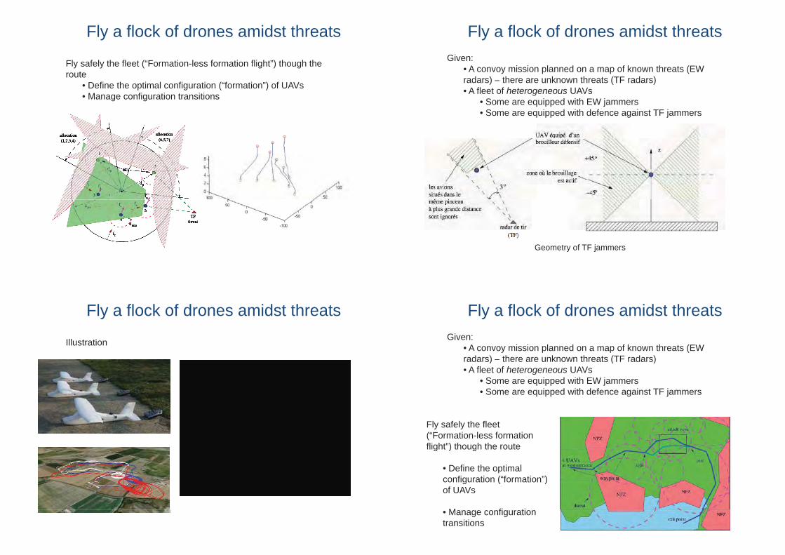
Example 2: “Fly a flock of drones amidst threats”Example 2: Fly a flock of drones amidst threats
For a fleet of UAVs, again mainly a task allocation problem: which UAV will jam a threat / protect others?problem: which UAV will jam a threat / protect others?
Fly a flock of drones amidst threatsGiven:
• A convoy mission planned on a map of known threats (EW d ) h k h (TF d )radars) – there are unknown threats (TF radars)
• A fleet of heterogeneous UAVs• Some are equipped with EW jammers• Some are equipped with defence against TF jammers
Geometry of EW jammers
Fly a flock of drones amidst threatsGiven:
• A convoy mission planned on a map of known threats (EW d ) h k h (TF d )radars) – there are unknown threats (TF radars)
• A fleet of heterogeneous UAVs• Some are equipped with EW jammers• Some are equipped with defence against TF jammers
Geometry of TF jammers
Fly a flock of drones amidst threatsGiven:
• A convoy mission planned on a map of known threats (EW d ) h k h (TF d )radars) – there are unknown threats (TF radars)
• A fleet of heterogeneous UAVs• Some are equipped with EW jammers• Some are equipped with defence against TF jammers
Fly safely the fleet (“Formation-less formation flight”) though the routeflight ) though the route
• Define the optimal configuration (“formation”)configuration ( formation )of UAVs
M fi ti• Manage configurationtransitions
Fly a flock of drones amidst threats
Fly safely the fleet (“Formation-less formation flight”) though the routeroute
• Define the optimal configuration (“formation”) of UAVs• Manage configuration transitions
Fly a flock of drones amidst threats
Illustration
Outline
Notion of AutonomyNotion of Autonomy
M lti l UAV i th kMultiple UAVs in the skyMonitoring a set of locationsFly a flock of drones amidst threats
Multiple UAV/UGV systemsp y
Current projectsCurrent projects
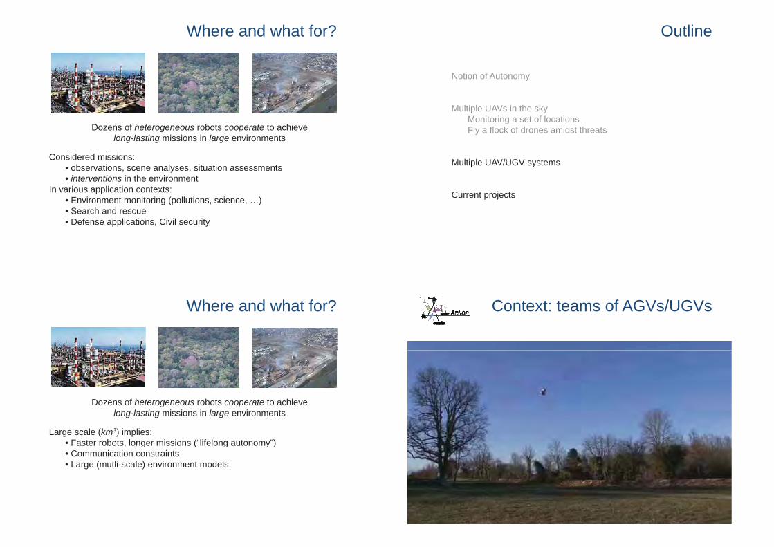
Context: teams of AGVs/UGVs
Where and what for?
Dozens of heterogeneous robots cooperate to achieve l l ti i i i l i tlong-lasting missions in large environments
Considered missions:observations scene analyses situation assessments• observations, scene analyses, situation assessments
• interventions in the environmentIn various application contexts:
E i i i ( ll i i )• Environment monitoring (pollutions, science, …)• Search and rescue• Defense applications, Civil security
Where and what for?
Dozens of heterogeneous robots cooperate to achieve l l ti i i i l i t
Large scale (km3) implies:Faster robots longer missions (“lifelong autonomy”)
long-lasting missions in large environments
• Faster robots, longer missions ( lifelong autonomy )• Communication constraints• Large (mutli-scale) environment models

1. Planning a surveillance missionGiven:
• A team of robots
• An environment to monitor
• A set of constraints to satisfy (e.g. communications)
Find the (optimal) trajectories to observe the whole environment
1. Planning a surveillance missionGiven:
• A team of robots• An environment to monitor• A set of constraints to satisfy (e.g. communications)
Actions to plan:Ob ti t k (h ti t k )• Observation tasks (hence motion tasks)
• Communications
Approach:• A task allocation process (distributed• A task allocation process (distributedmarket-based approach)• Large scale: necessity to interleave ll ti d d itiallocation and decomposition processes
1. Planning a surveillance mission
The�overall�mission�is�not�necessarily�expressed�as�a�set�of�elementary�k h b d d/ f dtasks:�it�has�to�be�decomposed/refined
Decompose�then�allocate Allocate�then�decompose
1. Planning a surveillance mission
Decomposition�made�according�to�a�Hierarchical�Task�Network�scheme�(HTN)(HTN)
• Breaks�down�the�planning�complexity• Allows�auctions�on�variable�complexity�structures

1. Planning a surveillance mission
2. Navigating a rover in an unknown environment
Given:
• A team of robots
• An unknown environment
• A set of constraints to satisfy (e.g. communications)
Find the (optimal) trajectory for the rover to reach a given goal
2. Navigating a rover in an unknown environment
Given:• A team of robots• An unknown environment• A set of constraints to satisfy (e.g. communications)
Actions to plan:E i t d lli t k• Environment modelling tasks
• Rover Motions• Communications
Approach:• The UAV serves the UGV, by providing traversability maps• Find the areas to perceive relevant for the mission
2. Navigating a rover in an unknown environment
(simulation with http://morse.openrobots.org )

Decision and environment modelsPlanning = Simulation + Search
• Simulation of the effects of an action with a predictive modelp• Search over possible organizations of possible actions to meet a goal or to optimize a criteria
Decision and environment modelsPlanning = Simulation + Search
• Simulation of the effects of an action with a predictive modelp• Search over possible organizations of possible actions to meet a goal or to optimize a criteria
Surveillance Rover navigation
• Environment�observations�
• Environment�modeling
• Motions• Communications
• Motions• Communications
Task�allocation�scheme Heuristic graph�search
En ironment modelsEnvironment models:• at the heart of autonomy• at the heart of cooperation
Simulation = convolution of action and environment models
Decision and environment modelsPlanning = Simulation + Search
• Simulation of the effects of an action with a predictive modelpby “convolving” action models with environment
models
What are the actions to plan / decide?• Motions• Environment observations (payload)Environment observations (payload)• Communications (within robots, with the control station)
L li ti• Localization• Environment perception and modeling
Decision and environment models
Planning motions
• At a coarse level (itinerary)notion of traversability
(geometry terrain nature)(geometry, terrain nature)

Decision and environment models
Planning motions
• At a coarse level (itinerary)notion of traversability
(geometry terrain nature)(geometry, terrain nature)
At a fine level• At a fine levelgeometry, terrain nature
(Digital Terrain Map)
Decision and environment models
Planning observations
• Need to predict visibilitiesgeometry (2.5D or 3D)
Decision and environment models
Planning observations
• Need to predict visibilitiesgeometry (2.5D or 3D)
Planning communications
• Need to predict radio visibilities
geometry, physicalg y, p yproperties
Decision and environment models
Planning localization
• GPS coverage• INS / Odometry: terrain nature• Exteroceptive sensors: landmarks• Exteroceptive sensors: landmarksor other models (geometry, appearance models, …)

Decision and environment models
Planning localization
• GPS coverage• INS / Odometry: terrain nature• Exteroceptive sensors: landmarks• Exteroceptive sensors: landmarksor other models (geometry, appearance models, …)
Planning environment perception & modeling
• Need to predict the informationNeed to predict the informationgain
amount of information in the environment modelsenvironment models(uncertainty, entropy…)
A database of environment models
Orthoimage
DTM
Models for�localization
Orthoimage
Traversability
DTM
Motion�servoing supports
3D�model
Building envt. models: information flow
Exhaustivei t Exteroceptive Environment environment
description
psensor data models
Geometry
LightingSemantics
Images n
Physicalproperties
Chemical
Lightingconditions
Thermalproperties
Images
Point clouds
Radar echoesSen
sors
erce
ptio
n
Dec
isio
n
Chemicalproperties
properties
Temperature, humidity
…
Radar echoes
…
S Pe D
humidity…
Actionmodels
Initial models (GIS)
Building a digital terrain modelWith a rover, using point clouds (here stereovision)
Resampling data to obtain a z=f(x,y) representation on a regular Cartesian grid

Building a digital terrain modelWith a rover, using point clouds (here Velodyne Lidar)
Resampling data to obtain a z=f(x,y) representation on a regular Cartesian grid
Building a digital terrain modelWith a UAV, using a Lidar
Resampling data to obtain a z=f(x,y) representation on a regular Cartesian grid
[Paul Chavent @ Onera Toulouse]
Building a traversability modelWith a rover, using point clouds (here stereo)
Probabilistic labeling (Bayesian supervised learning)
Possibility to introduce luminance / texture attributesMuch more up-to-date classification / learning processes existMuch more up to date classification / learning processes exist
Building a traversability modelWith a drone, using vision
img1
img2

Building a traversability modelWith a drone, using vision
img1
img2
Building a traversability modelWith a drone, using vision
img1
img2
Building a traversability modelWith a drone, using vision
“True”�orthoimages
Terrain models: data structures“Raster” models: regular Cartesian grids
“Raster” models: hierarchical Cartesian grids
Graph structures easily derivedGraph structures easily derived
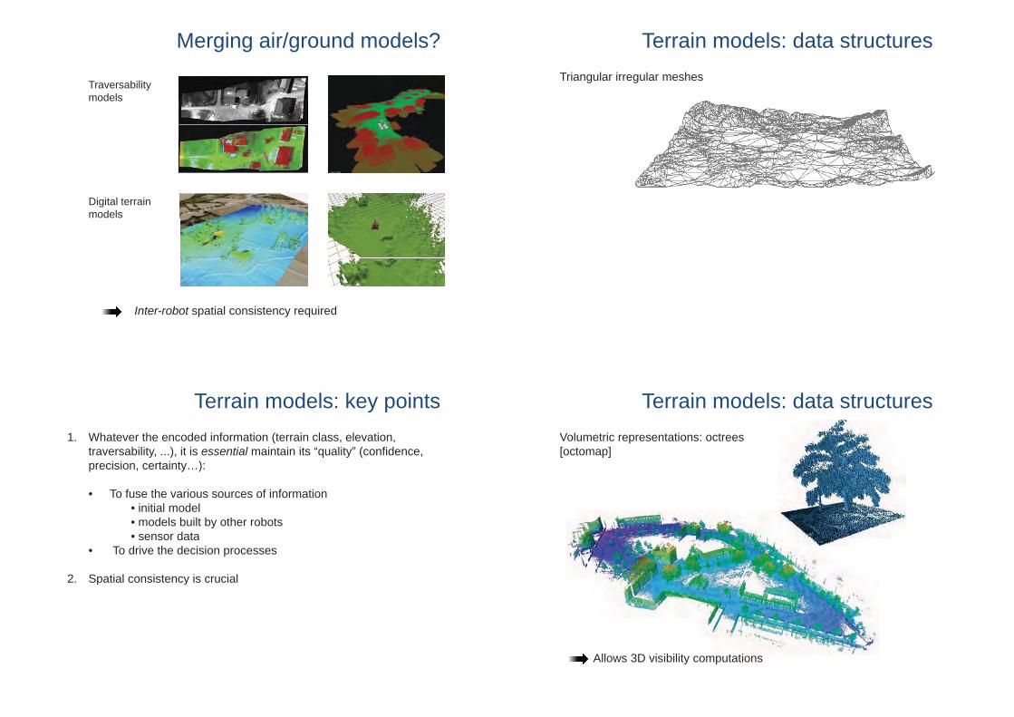
Terrain models: data structuresTriangular irregular meshes
Terrain models: data structuresVolumetric representations: octrees[octomap]
Allows 3D visibility computationsAllows 3D visibility computations
Merging air/ground models?
Traversability modelsmodels
Digital terrain models
Inter-robot spatial consistency required
Terrain models: key points1. Whatever the encoded information (terrain class, elevation,
traversability, ...), it is essential maintain its “quality” (confidence, precision, certainty…):
• To fuse the various sources of information • initial model • models built by other robots• sensor datasensor data
• To drive the decision processes
2 Spatial consistency is crucial2. Spatial consistency is crucial
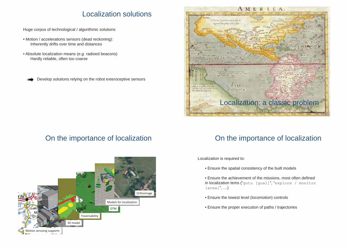
Localization: a classic problemLocalization: a classic problem
On the importance of localization
Localization is required to:Localization is required to:
• Ensure the spatial consistency of the built models
• Ensure the achievement of the missions, most often defined in localization tems (“goto [goal]”, “explore / monitor [area]”, …)
• Ensure the lowest level (locomotion) controls( )
• Ensure the proper execution of paths / trajectories
Localization solutions
Huge corpus of technological / algorithmic solutions
• Motion / accelerations sensors (dead reckoning):Inherently drifts over time and distances
• Absolute localization means (e.g. radioed beacons)Hardly reliable, often too coarse
Develop solutions relying on the robot exteroceptive sensors
On the importance of localization
OrthoimageOrthoimage
DTM
Models for�localization
DTM
Models for�localization
3D�model
Traversability
3D�model
Traversability
Motion�servoing supportsMotion�servoing supports

But… what localization?Essential questions to answer:
1. With which precision ?
2. In which frame ?
From cm to meters
Absolute vs. local
3. At which frequency? From kHz to “sometimes”
• Ensure the lowest level (locomotion) controlscm accuracy,
• Ensure the proper execution of paths / trajectories
• Ensure the spatial consistency of the built models
cm accuracy,@ > 100 Hz,local frame
Ensure the spatial consistency of the built models
• Ensure the achievement of the missions, most often defined in localization tems (“goto [goal]” “explore / monitor
~m accuracy, “sometimes” in localization tems ( goto [goal] , explore / monitor
[area]”, …)sometimes ,
global frame
Localization precision required for a DTM
DTM resolution ~ 10cm, height precision ~ 3cm
• Velodyne lidar provides chunks of 64 points @ 3.5 kHz:1° error on pitch yields a 17cm elevation error @ 10m
2m/s GPS RTK @ 20Hz2m/s, GPS RTK @ 20Hz+ Xsens AHRS @ 100Hz
+ FOG gyro @ 50Hz
Localization precision required for a DTM
• DTM built by an UAV with a Lidar2m/s, GPS RTK @ 20Hz
+ INS @ x Hz+ dynamic model+ dynamic model+ compass x Hz
Localization precision required for a DTM
• DTM built by an UAV with a Lidar2m/s, GPS RTK @ 20Hz
+ INS @ x Hz+ dynamic model+ dynamic model+ compass x Hz
During a calm day With a 10 km/h wind

Visual odometry: principle
1. Stereovision
2 Pixels selection3 Pixels tracking 4. Motion2. Pixels selection3. Pixels tracking estimation
Stereovision
Visual odometry on a MAV (+ 3D modelling)
“Simultaneous Localization and Mapping”
• Dead reckoning– Monotonic�increase�of�the�
position uncertaintyposition�uncertainty
• SLAM– “memory effect”�of�the�
mapping– Loop�closures:�position�
uncertainty�decrase
Vision-based SLAM
Illustration: 100 Hz vision / low cost INS SLAM
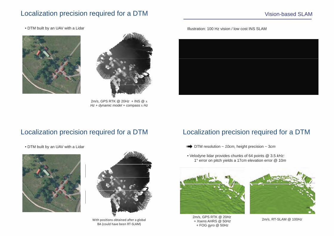
Vision-based SLAM
Illustration: 100 Hz vision / low cost INS SLAM
Localization precision required for a DTM
DTM resolution ~ 10cm, height precision ~ 3cm
• Velodyne lidar provides chunks of 64 points @ 3.5 kHz:1° error on pitch yields a 17cm elevation error @ 10m
2m/s GPS RTK @ 20Hz2m/s, GPS RTK @ 20Hz+ Xsens AHRS @ 50Hz
+ FOG gyro @ 50Hz
2m/s, RT-SLAM @ 100Hz
Localization precision required for a DTM
• DTM built by an UAV with a Lidar
2m/s, GPS RTK @ 20Hz + INS @ xHz + dynamic model + compass x Hz
Localization precision required for a DTM
• DTM built by an UAV with a Lidar
With�positions�obtained�after�a�global�BA�(could�have�been�RT�SLAM)

SLAM issues
• SLAM processes complexity grows with the number of landmarks
The map size can’t scale up
• The convergence of Kalman filter based solutions can’t be guaranteed
The map size can’t scale up, loop closures may lead p p p yinconsistencies
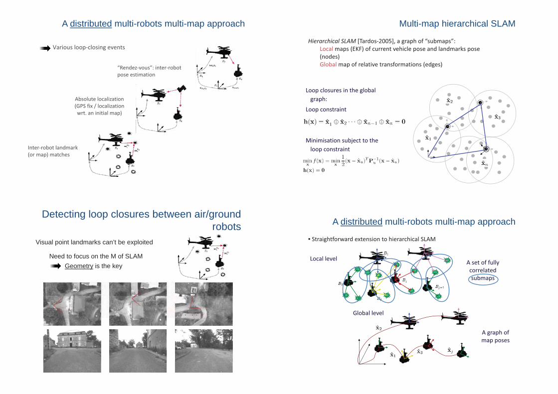
Multi-map hierarchical SLAM
Hierarchical�SLAM [Tardos�2005],�a�graph�of�“submaps”:Local�maps�(EKF)�of�current�vehicle�pose�and�landmarks�pose�( d )(nodes)Global�map�of�relative�transformations�(edges)
Local maps:
• Fully�correlated maps�(robot�and�landmark�states)
f h d b l l• No�information�shared between�local�maps
• Each map is initialized with no• Each�map�is�initialized�with�no�uncertainty
Multi-map hierarchical SLAM
Hierarchical�SLAM [Tardos�2005],�a�graph�of�“submaps”:Local�maps�(EKF)�of�current�vehicle�pose�and�landmarks�pose�( d )(nodes)Global�map�of�relative�transformations�(edges)
Global�graph�of�maps:
• Robot’s�pose
• The�state�is�the�relative�transformationbetween local mapsbetween�local�maps
• Block�diagonal covariance�before�loop�closure
Multi-map hierarchical SLAM
Hierarchical�SLAM [Tardos�2005],�a�graph�of�“submaps”:Local�maps�(EKF)�of�current�vehicle�pose�and�landmarks�pose�( d )(nodes)Global�map�of�relative�transformations�(edges)
Loop�closures�in�the�global�graphgraph:
Loop�constraint
Minimisation subject to theMinimisation�subject�to�the�loop�constraint
A distributed multi-robots multi-map approach
• Straightforward�extension�to�hierarchical�SLAM
Local�level A�set�of�fully�correlated�submaps
Global�level
A�graph�of�map posesmap�poses
A distributed multi-robots multi-map approach
Various loop�closing events
“Rendez�vous”:�inter�robotpose estimation
Absol te locali ation
pose�estimation
Absolute�localization�(GPS�fix�/�localization�wrt.�an�initial�map)
Inter�robot�landmark�(or�map)�matches
Detecting loop closures between air/ground robots
Visual point landmarks can’t be exploited
Geometry is the keyNeed to focus on the M of SLAM

Points vs. lines in vision
Preliminary multi-robot SLAM results
Research perspectives on envt. modelsFocus on geometric (3d, vectorized) representations
ExhaustiveExhaustiveenvironmentdescription
Geometry
Semantics
Exteroceptivesensor data
Environmentmodels
n
Integrate existing data (GIS)
y
Physical properties
Chemical properties
Lighting conditions
Thermalproperties
Temperature …
Images
Point clouds
Radar echoes
…
Sen
sors
Per
cept
ion
Dec
isio
n
Temperature,humidity…
Initial models (GIS)
Actionmodels
Distributed models Management
Humans in the loop: information sharing (spatial ontologies ?)
Outline
Notion of AutonomyNotion of Autonomy
M lti l UAV i th kMultiple UAVs in the skyMonitoring a set of locationsFly a flock of drones amidst threats
Multiple UAV/UGV systemsp yIllustrations: need for environments modelsIllustration of environment model building processesImportance of localizationImportance of localization
Current projects

The ARCAS project
www.arcas-project.eu/ : “development and experimental validation of cooperative UAV systems for assembly andvalidation of cooperative UAV systems for assembly and
structure construction”
The SkyScanner project
Adaptive synchronous sampling of clouds with p g
a fleet of UAVs
(energy harvesting)(energy harvesting)
The SkyScanner project
Adaptive synchronous sampling of clouds with p g
a fleet of UAVs
(energy harvesting)(energy harvesting)
At each At time t
1. Collect infos. where ?
2. Who fliesh ?where ?
The SkyScanner project
Adaptive synchronous sampling of clouds with p g
a fleet of UAVs
(energy harvesting)(energy harvesting)
?
À un instant t
1. Collect infos.
?
where ?
2. Who fliesh ?where ?

Take home messages
• Autonomy calls for specific decisional processes
• Good representations are the foundations of goodp gdecisions, and hence of good cooperations
• A variety of representations is requiredA variety of representations is required
• Geometry is certainly the most important information to represent (but not only)represent (but not only)
• Maintaining the quality of information is essential