roads and floods - mekong river commission · 'roads and floods' best practice guidelines...
TRANSCRIPT
ISSN: 1683-1489
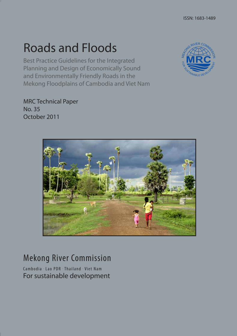
Roads and Floods
Roads and Floods: Synthesis Report 2011M
RC Technical Paper No. 35
Best Practice Guidelines for the Integrated Planning and Design of Economically Sound and Environmentally Friendly Roads in the Mekong Floodplains of Cambodia and Viet Nam
Mekong River CommissionC a m b o d i a . L a o P D R . T h a i l a n d . V i e t N a m
For sustainable development
Mekong River Commissionwww.mrcmekong.org
Office of the Secretariat in Phnom Penh (OSP)576 National Road, #2, Chak Angre Krom,
P.O. Box 623, Phnom Penh, CambodiaTel: (855-23) 425 353Fax: (855-23) 425 363
Office of the Secretariat in Vientiane (OSV)Office of the Chief Executive Officer
184 Fa Ngoum Road, P.O. Box 6101, Vientiane, Lao PDR
Tel: (856-21) 263 263Fax: (856-21) 263 264
MRC Technical PaperNo. 35October 2011
Mekong River Commission
'ROADS AND FLOODS'
Best Practice Guidelines for the
Integrated Planning and Design of Economically Sound and
Environmentally Friendly Roads in the Mekong Floodplains of Cambodia and Viet Nam
MRC Technical Paper No 35
October 2011
Report prepared by the MRC Flood Management and Mitigation Programme
i
Published in Phnom Penh, Cambodia in October 2011 by Mekong River Commission, Office of the Secretariate in Phnom Penh Suggested citation: Douven, W.J.A.M., M. Goichot and H.J. Verheij (2009), Best Practice Guidelines for the Integrated Planning and Design of Economically Sound and Environmentally Friendly Roads in the Mekong Floodplains of Cambodia and Viet Nam, synthesis report of the ‘Roads and Floods’ project (part of MRC-FMMP Component 2. MRC Technical Paper No. 35, Mekong River Commission, Office of the Secretariate in Phnom Penh. 143 pp The opinions and intepretation expressed within are those of the authors and do not necessarily reflect the views of the Delft Cluster, WWF and Mekong River Commission Contributing authors: Eddie Akinyemi, Lindsay Beevers, Tumukunde Felix Beinamaryo, Joost Buurman, Mina Raj Dhakal, Klaas Jan Douben, Wim Douven, Marc Goichot, Phan Thi Thu Ha, Kencho Namgyal, Elena Ostrovskaya, Javier Patarroyo Quintero, Kathirgamathaiyah Pratheepan, Michiel van der Ruyt, Do Nguyen Anh Tu, and Henk Verheij. Editors: Wim Douven, Marc Goichot and Henk Verheij © Mekong River Commission Office of the Secretariate in Phnom Penh P.O Box 623 #576, National Road 2, Chak Angre Krom Meanchey, Phnom Penh, Kingdom of Cambodia Tel: 855-23 425 353 Fax: 855-23 425 363 Email: [email protected] Website: www.mrcmekong.org
ii
Table of contents
Preface ...................................................................................................................................... v
Acknowledgements................................................................................................................. vi
Executive Summary ..............................................................................................................vii
List of Abbreviations............................................................................................................ xiv
Glossary.................................................................................................................................. xv
1. Introduction ................................................................................................................. 1
1.1 Roads and floods in the Lower Mekong Basin........................................................... 1
1.2 Road development and rehabilitation and environmental assessment ....................... 1
1.3 Objectives and target group of the report ................................................................... 3
1.4 Towards Best Practice Guidelines for road development .......................................... 3
1.5 Development and scope of the Best Practice Guidelines ........................................... 5
1.6 Methodology............................................................................................................... 6
1.7 Reading guide ............................................................................................................. 7
2. The Mekong Floodplains and Interactions Between Roads and Floods ................ 9
2.1 Introduction ................................................................................................................ 9
2.2 The floodplains of the Mekong River basin ............................................................... 9
2.3 Costs (damage) and benefits of floods ..................................................................... 11
2.4 Interactions between roads and floods...................................................................... 14
2.5 Conclusions .............................................................................................................. 16
3. Current Practices of Road Development and Rehabilitation in the Mekong Floodplains ................................................................................................................. 17
3.1 Introduction .............................................................................................................. 17
3.2 Current practices of road development and rehabilitation in Cambodia .................. 17
3.3 Current practices of road development and rehabilitation in Viet Nam................... 22
3.4 Environmental assessments at the Mekong Basin level ........................................... 24
3.5 Conclusions .............................................................................................................. 25
iii
4. Road Development in Floodplains: Balancing Economic, Social and Environmental Dimensions....................................................................................... 27
4.1 Introduction .............................................................................................................. 27
4.2 International practice on planning and design of structures in floodplains.............. 27
4.3 An integrated approach to road development and rehabilitation in floodplains....... 32
4.4 Conclusions .............................................................................................................. 35
5. Analysis of Four Road Development and Rehabilitation Cases in Cambodia and Viet Nam..................................................................................................................... 36
5.1 Introduction .............................................................................................................. 36
5.2 Case 1: Rehabilitation of NR 11 and PR 317 (Cambodia) ....................................... 37
5.3 Case 2: Construction of new National Road 8 (Cambodia) ..................................... 45
5.4 Case 3: Rehabilitation of PR-855 (Viet Nam)......................................................... 51
5.5 Case 4: Construction of new NR1A and HCM road (Viet Nam)............................. 57
5.6 Discussion of the case study results ......................................................................... 63
6. A Set of Best Practice Guidelines for Road Development and Rehabilitation in the Mekong Floodplains of Cambodia and Vietnam.................................................... 71
6.1 Introduction .............................................................................................................. 71
6.2 Best Practice Guidelines for Integrated Planning of Road Development and Rehabilitation in the Mekong Floodplains of Cambodia and Viet Nam............................. 71
6.3 Best Practice Guidelines for Environmental Assessment of Road Development and Rehabilitation in the Mekong Floodplains of Cambodia and Viet Nam............................. 79
6.4 Best Practice Guidelines for Technical Design of Road Development and Rehabilitation in the Cambodian and Vietnamese Floodplain............................................ 85
7. Recommendations for Application of the Best Practice Guidelines ..................... 95
8. References .................................................................................................................. 97
Appendix 1 – Case Study Methodology............................................................................. 103
1. Introduction ............................................................................................................ 103
2. Road development and rehabilitation in the (pre-)feasibility stage........................ 103
3. Problem identification (Step 1)............................................................................... 104
iv
4. Determination of objectives and criteria (Step 2)................................................... 105
5. Analysis of present situation and identification of scenarios (Step 3) ................... 107
6. Identification of road alternatives (Step 4) ............................................................ 115
7. Assessment and evaluation of alternatives (Step 5) ............................................... 117
8. Further reading ....................................................................................................... 121
Appendix 2 – Checklists...................................................................................................... 122
1. EIA / IEE Screening Checklist .............................................................................. 122
2. EIA SCOPING Checklist ...................................................................................... 122
3. A Review Checklist ............................................................................................... 123

v
Preface In the Mekong Delta, yearly floods provide a crucial dimension to the livelihoods of local people, as they improve the agricultural and fishery resources. However, with growing economies and rapidly increasing population, values of the floodplain are being threatened. One of these threats is the construction or upgrading of roads. Roads influence the duration and extent of the inundations and the dynamics of the flooding. On the other hand, floods cause severe damage to roads. The likely impacts of infrastructure development, roads in particular, on the Mekong floodplain system was addressed by various studies, including Cross (1995). For the MRC Basin Development Plan the need was expressed to assess the impact of embankments (like roads) in the Mekong floodplains on its flood behaviour, including guidelines for minimum water openings (MRC, 2007a; MRC, 2007b). With the aim to ‘reduce the socio-economic costs of flooding in the Lower Mekong Basin, whilst preserving the environmental and other benefits of floods, through a better understanding of the management of flood risk and flood behaviour by MRC ..’ (MRC, 2007a). The underlying question is how to further develop roads in a sensitive ecosystem like the floodplain of the Mekong in a sustainable manner that minimizes the impact on the benefits of the annual inundations and at the same time reduces damage to roads. The ‘Roads and Floods’ project - a cooperation between MRC-FMMP, WWF Living Mekong Programme and three Delft Cluster research institutes (UNESCO-IHE, Delft Hydraulics and GeoDelft) - studied this question over the past two years. This synthesis report of the Roads and Floods project presents an overview of the project results including Best Practice Guidelines for integrated planning, environmental assessment and technical design of road development and rehabilitation in the Mekong floodplains. The Best Practice Guidelines are presented in Chapter 6. The synthesis report includes key recommendations of the following studies carried out under the Roads and Floods project:
Inundation modelling report (Verheij, in preparation). Road damage analysis report (Van der Ruyt and Verheij, in preparation). Pre-flood, flood and post-flood monitoring plan and 2006 and 2007 survey reports (Verheij et al.,
2006). UNESCO-IHE MSc theses (Nyangu (2006), Phan Thi Thu Ha (2007), Beinamaryo (2007), Patarroyo
(2007), Pratheepan (2007), Namgyal (2007), Dhakal (2007)). Wageningen University MSc theses (Do Nguyen Anh Tu, 2008).
Readers interested in further details on the synthesis report are referred to the above-mentioned source reports. Those interested in receiving the reports please consult either the Regional FMMP Centre (Phnom Penh) or UNESCO-IHE (Delft, The Netherlands). The ‘Roads and Floods’ Best Practice Guidelines for road development and rehabilitation in the Mekong floodplains of Cambodia and Viet Nam presented in this report, are part of the set of guidelines under development by the FMMP-Component 2 Programme ‘Structural Measures and Flood Proofing’. The aim of the FMMP-C2 Best Practice Guidelines is to enable the MRC and national line agencies to better take into account flood-related considerations in their day-to-day technical activities. There is, however, a difference in approach between the FMMP-C2 Best Practice Guidelines and the ‘Roads and Floods’ Best Practice Guidelines specifically. The former specifically focus at flood risk management, while the latter focus on road development and rehabilitation. The ‘Roads and Floods’ Best Practice Guidelines consider multiple objectives in the road planning and design process, such as transport, flood protection, and ecology, and give guidance on how to optimise between these multiple objectives in the road development and rehabilitation planning and design process.
vi
Acknowledgements This project was financially supported and implemented by Delft Cluster, MRC Flood Management and Mitigation Programme (FMMP) and WWF Living Mekong Programme. The project was carried out in collaboration with the Cambodian National Mekong Committee and the Vietnamese National Mekong Committee. The research team is grateful to the VNMC and CNMC for their support throughout the implementation of the project, particularly Ms. Phuong and Mr. Trinh Hoang Ngan (VNMC) and Mr. Hak Socheath (CNMC). They were very instrumental in coordinating the data and information collection and organising input and feedback on the study and its results. Also thanks to the Southern Institute of Water Resources Planning (SIWRP) in Viet Nam and the Department of Hydrology and River Works (DHRW) in Cambodia for carrying out the pre-flood, flood and post-flood surveys in 2006 and 2007. We are grateful to the input and feedback on the study given by the participants of the four workshops /consultative meetings held during the study period. Thanks to the VNMC, the CNMC, the MRC ICCS, the MRC Fisheries Programme and the MRC Flood Management and Mitigation Programme, as well as Rinus Vis, Herman van der Most and Meindert Van (Deltares) and Eddie Akinyemi and Anne van Dam (UNESCO-IHE) for providing valuable comments on earlier versions. Also thanks to Martijn Wieriks for providing excellent support in the production of the report.
vii
Executive Summary 1. Introduction During recent decades the regional economic development of the four countries of the Lower Mekong Basin has evolved at a fast pace. Such development goes in parallel with the upgrading and development of roads. For a number of reasons road development in a floodplain, like the still quite natural Mekong floodplain, requires a different approach to planning and technical design, compared to road development in areas that are not (regularly) inundated. On the one hand, floods can severely damage infrastructure including roads, whilst on the other hand, roads and associated infrastructure fragment the floodplains and interrupt the natural flow of water, sediments, nutrients and aquatic life. This is particularly relevant in the environmentally and economically valuable floodplains of the Lower Mekong Basin, where the total direct-use value of the fishery resources has been estimated at about $US 2 billion per annum. The underlying question addressed by the ‘Roads and Floods’ project, is how to develop roads in a sensitive ecosystem like the floodplain of the Mekong in a sustainable manner that minimizes the impact on the benefits of the annual inundations and at the same time reduces damage to roads. The project (2006-2008) is part of the FMMP-Component 2 Programme ‘Structural Measures and Flood Proofing’ and is a cooperation between Delft Cluster, WWF and MRC-FMMP. The objectives of the project are (1) to raise awareness on the benefits of the Mekong floods and possible impacts of road developments on these benefits, (2) an in-depth analysis of the interactions between roads and floods, and (3) to develop Best Practice Guidelines for the improvement of road planning and design. The main findings of the project are presented in this synthesis report. 2. Current practice in Cambodia and Viet Nam Both in Cambodia and Viet Nam, road planning and design takes into account the local flood flow patterns, however it focuses less on the floodplain hydraulics and related ecology. Road planning and design in Cambodia is based on international guidelines for roads located outside the floodplain, with the exception of the national guidelines for rural roads. As a result, roads are constructed under different international criteria. Viet Nam has a comprehensive set of road construction standards, but this set is not particularly aimed at planning and rehabilitation of roads in the Mekong floodplains. Both Viet Nam and Cambodia have an Environmental Impact Assessment system in place, although experience in its application, particularly in Cambodia, is limited. There are developments towards an environmental assessment system for the Lower Mekong Basin addressing the trans-boundary dimension at basin level. The findings of the review of current practice in Cambodia and Viet Nam support the need for better guidance on integrated planning and design of roads in the Mekong floodplains. 3. International experience and guidance International literature provides ample guidance on planning and design of roads. Literature on the development of roads in ecologically sensitive areas is limited, and only a few studies were found on the development in floodplains. There is a broad range of environmental assessment guidelines available, although they only address the interaction between roads and surface water, or floods specifically, to a limited extent. Few international examples and studies were found on strategies and measures for building infrastructure in river floodplains. Two general road development strategies – a strategy based on resistance and a strategy based on resilience - can be distinguished, both having their advantages and disadvantages. The resistance strategy, in principle, aims at preventing and regulating floods and hence has a strong impact on the natural floodplain dynamics, while the resilience strategy aims at minimizing the consequences of floods, but at the same time intends to maintain the natural floodplain dynamics as much as possible. The hypothesis behind the resilience strategy in the light of this study is that, although the strategy might require higher initial investment, the longer term costs in terms of road damage and ecological impacts, will be lower. It is clear that the selection of a strategy requires an integrated assessment of all relevant aspects and impacts. For this purpose, the report presents a framework for an integrated assessment of road development and rehabilitation in
viii
floodplains 4. Results of the analysis of Cambodian and Vietnamese case studies The report presents four road development and rehabilitation case studies in Cambodia and Viet Nam (Table 1). The case studies aim to understand the interactions between roads and floods better, as well as to investigate the impacts of the different road development strategies; namely resistance and resilience (see above). More specifically, the case studies were undertaken to answer the four main research questions underlying the ‘Roads and Floods’ project, which will be addresssed below. To analyse and present the cases a policy analysis approach was applied that helped to structure the road development process, in particular its planning phase where the concept development and pre-feasibility studies are undertaken. The analysis of the case studies was based on inundation modelling and analysis, damage analysis, economic analysis and environmental impact analysis supported by flood surveys carried out in both Cambodia and Viet Nam. Table 1 The four case studies of the ‘Roads and Floods’ project.
Country Case Road Description road and flow-through condition
1 NR 11 and PR 317
Existing road with damage problems. Currently limited flow-through and partly elevated.
Cambodia
2 NR8 Construction new road crossing floodplain zone 5, perpendicular to the floodplain.
3 PR855 Rehabilitation of Provincial Road. Viet Nam 4 NR1A
and HCM road Development of new section National Road number 1 and Ho Chi Minh Road.
What is the significance of roads in the Cambodian and Vietnamese floodplains in changing flow patterns (including cumulative impacts)? The case studies show that, both in Cambodia and Viet Nam, flow patterns are taken into account in road planning and design, as roads are often aligned not to block water flows and contain flow-through structures. The cases show that the impact of roads on water depth are less significant than the impact on velocities which may cause damage to the road and the flow through structures. Impacts on flood extent and duration of new planned roads without flow through structures are limited. Impacts are neglectable for roads that have sufficient flow-through capacity. Although small changes in flood dynamics may occur (flooded area, duration and beginning of the flooding) and have consequent impacts to aquatic ecology and related functions. These impacts may become more serious if more road developments take place. The cases (e.g. case NR8 in Cambodia or case PR855 in Viet Nam) show that such cumulative impacts should be investigated because they might lead to more serious consequences in terms of road damage and ecological deterioration at a larger floodplain scale. Obviously, extreme alternatives like increasing the levees along the Mekong have significant impacts because inundation will not occur anymore. What is the significance of flow patterns in Cambodia and Viet Nam in terms of road damage? The case studies show that there is limited impact on the flood levels (water height) and the corresponding damage mechanisms (macro-instability, waves, overtopping) if road embankments and flow structures are properly designed. For example embankments should not be too steep and measures to intercept waves should be incorporated into designs. The main damage mechnisms can be related to significant changes on flow velocities. Flow velocities well above critical values for the initiation of erosion may occur in the floodplains, in some occasions protection materials, for example small rocks, are eroded. To reduce these velocities to an acceptable level by increasing the number of flow through structures or their dimensions is too expensive. Properly designed protection, together with streamlined abutments, is a cheaper option and very often the best way to provide protection or at least to minimize the damage. The latter is demonstrated by several case studies. In the previous section several alternative impact mechanisms were mentioned which influence floodplain dynamics at larger scale. These may result in damage to a road at a similar scale. E.g. if alternatives that aim at
ix
flood protection are chosen, for example: raising levees along the Mekong, damage to roads in the flood plain reduces, but ecological consequences may be considerable. What are the impacts of different road development and rehabilitation strategies (resistance and resilience) in Cambodia and Viet Nam on floodplain hydraulics and related benefits of floods and on economic costs of roads? The results of this part of the study are based on the results of the hydraulic and damage analysis as presented above, and rapid assessments of ecological and socio-economic impacts. Hence, the results indicated below should be considered as indicative and should be used to illustrate possible impacts. The results of the study show that several resilience alternatives (alternatives 2 and 4 for Case 1, alternative 3 for Case 4, and alternative 4 for Case 5), indicate that higher initial investments in road design, are expected to result in positive effects on the medium term costs and the floodplain ecosystem. This is reflected in the overall high ranking of these alternatives with respect to sustainability considerations. Resilience alternatives score higher than resistance alternatives not only from the perspective of sustainability, but also from the perspective of flood protection and ecology. This is in contrast to the transport perspective, where resistance alternatives score slighlty higher then resilience alternatives. The results of the cases do not give indications that there are differences between Cambodia and Viet Nam. However, it is expected that it is easier to rehabilitate or design a road in line with the resilience strategy in Cambodia than in Viet Nam. The reason for this is that in Cambodia the floodplain is in a more natural state than Viet Nam where water in the flood zones is intensively managed already. The analysis illustrates that, in the process of choosing a strategy (resistance or resilience) and related alternatives, the objectives and priorities of the project play an important role. Additionally, project objectives can be conflicting. The cases show, for instance, that if an alternative scores highly (hence good) on road costs and ecological impacts it also has a low score on flood protection. Conversely, resistance alternatives which aim to protect the land from flooding, score badly (not good) on the maintenance of floodplain hydraulics and ecology. The purpose of the this part of the case study presentations is to illustrate how these trade-offs can be made more transparent to decision-makers. The financial analysis has followed a relative simple approach using averages for flood damage. The analysis shows that in all cases the cheapest alternative will lead to the lowest cost for the owner of the roads. Hence, the extra investment costs are not covered by less damage and / or maintenance costs. However, road investments are usually not evaluated in a narrow financial sense as roads lead to many benefits for the economy as whole. Part of these benefits can be expressed in money and part of these benefits are non-monetary, such as less road casualties. Similarly, more sustainable roads, i.e. the more expensive alternatives, can lead to additional monetary and non-monetary benefits compared to the cheapest alternative that are not taken into account in a financial analysis. An economic analysis would provide more insight in these additional benefits. The results from such an an economic cost-benefit analysis (as opposed to a financial cost benefit analysis) will more likely lead to higher NPV and IRR figures for more sustainable options. It should also be mentioned that the costs and benefits may affect the poor relatively more: improved access to rural areas could help poor to start business that would otherwise not be possible. What road development and rehabilitation practice would contribute most to the reduction of the socio-economic costs of flooding in the Lower Mekong Basin, whilst preserving the environmental and other benefits of floods? The cases illustrate that road planning and design in the Mekong floodplain, while reducing the socio-economic costs of flooding and preserving the benefits of floods, is a complicated task that requires an integrated approach. The cases clearly show that:
During the development process of roads in the Mekong floodplains, coordination between the road and transport sector, the water sector, the flood risk management / dike sector, the environment sector, and the social sector is essential. Different sectors have a different perspective on floods and how to deal with them, and these perspectives should be balanced during floodplain development.
x
The character of the floodplain system requires not only local (project) impacts to be considered, but
also impacts and implications at a larger scale. The cases show that cumulative impacts of structural developments (including roads) occur. A solution at one location, might impact other locations. This requires coordination and integration at the (sub-) floodplain scale.
It is important that the financial sector and donors better work together, in order to link infrastructure
investment budgets to operation and maintenance and damage repair budgets, and hence have the possibility to use limited financial resources more efficiently. The results of the case studies indicate that higher initial investments may lead to lower medium term costs and ecological impacts. This requires an integrated financial assessment - integrated in terms of investment, operation and maintenance, and damage risk - at the early planning stages.
The report also discusses quality and representativeness of the case study results. The case studies undertaken in both Cambodia and Viet Nam allow us to answer the four research questions posed. Due to some data limitations and the fact that assessment of environmental and economic impact assessment was limited, the answers to questions 3 and 4 should be regarded as indicative. For the pupose of supporting the Best Practice Guidelines, the cases, do however, provide a sufficient basis. The case studies are representative for the Cambodian and Vietnamese Mekong floodplain. In general terms, the results give an indication of what could happen in Thailand and Laos as well, in, as far as the area considered has comparable flood characteristics. 5. A set of Best Practice Guidelines for road development and rehabilitation
in the Cambodian and Vietnamese Mekong floodplain Main output of the ‘Roads and Floods’ project presented in the report is a set of Best Practice Guidelines for road development and rehabilitation in the Mekong floodplains of Cambodia and Viet Nam. The Best Practice Guidelines are based on the case study results, the review of current international practice as well as the practice in the Mekong Basin. The guidelines are presented in the report and summarised below. They are intended for use by professionals and organisations involved in road planning and design in the Mekong floodplains, as well as those involved in environmental and integrated assessments of road developments in the Mekong basin or structural developments in this basin in general. Best Practice Guidelines for Integrated Planning of Road Development and Rehabilitation in the Mekong Floodplains of Cambodia and Viet Nam These Best Practice Guidelines are a list of recommendations proposed to take into account in the development and rehabilitation of a road in the Mekong floodplain (Box 1). Box 1 Best Practice Guidelines for Integrated Planning of Road Development and Rehabilitation
in the Mekong Floodplains of Cambodia and Viet Nam. General recommendations related to planning process Apply an integrated planning approach when developing roads in the vulnerable and highly
valuable Mekong floodplain system, that considers the consequences of the development throughout the system including environmental and social impacts.
Strengthen the relationship between road development and rehabilitation and environmental assessment.
Apply a (sub)-floodplain system’s approach in which not only local impacts of roads but also regional and cumulative impacts are considered.
Provide sufficient coordination between road development and rehabilitation planning and other sector planning.
Assess possible transboundary (provincial, national, international) impacts of road development and rehabilitation in the Mekong floodplain and cooperate at the inter-provincial and/or international level.
xi
Tailor alignment and design solutions to the specific floodplain hydraulic and ecological situation of the local situation.
Economic considerations Recognise and quantify the value of the Mekong floodplain and its benefits for local population as
much as possible. Apply integrated cost-benefit analyses while assessing and evaluating road development and
rehabilitation alternatives. Consider road development and rehabilitation alternatives that allow for a gradual upgrading of
the road system. Institutional arrangements and financial resources Improve/strengthen the institutional framework to support integration between the relevant
sectors and at the necessary scales. Enhance (or develop and maintain) sustainable financing mechanisms in order to facilitate
implementation of integrated road policies/projects. Research and capacity building Improve knowledge of the floodplain system in terms of interactions between floodplain hydraulics
and basin developments, functions of the system, particularly the ecological functions, critical thresholds to maintain these functions and values of the functions.
Invest in education, training and technical support to introduce and/or strengthen practice of integrated planning and environmental assessments of road development and rehabilitation.
Promote Mekong-riparian countries cooperation and exchange of knowledge and practices. Best Practice Guidelines for Environmental Assessment of Road Development and Rehabilitation in the Mekong Floodplains of Cambodia and Viet Nam These Best Practice Guidelines are recommendations proposed to be followed in Environmental Impact Assessment (EIA) and/or Strategic Environmental Assessment (SEA) procedures related to the development and rehabilitation of roads (Box 2). Box 2 Best Practice Guidelines for Environmental Assessment of Road Development and
Rehabilitation in the Mekong Floodplains of Cambodia and Viet Nam. General recommendations Strengthen the system and process of Environmental Impact Assessment, specifically the coverage
of floodplain hydraulics and related ecology. Amend environmental regulations if they do not currently require EIA for most projects. Mainstream environmental assessment with road development and rehabilitation. Include at the EIA scoping and Environmental Impact Statement (EIS) review phases the
assessment of impacts of road development and rehabilitation projects on the floodplain hydro-dynamics and ecology.
Initiate and / or strengthen the use of Strategic Environmental Assessments of infrastructure policies, plans and programmes.
Adopt regional initiatives to address transboundary environmental impacts, like the GMS and proposals for a environmental assessment system for the MRC.
Improve the capacity of EIA practitioners in implementing and reviewing the EIA processes. Recommendations for sectoral guidelines for the road sector Review the current EIA screening list in order to address the environmental impacts of building
infrastructure (roads) in a floodplain system like the Mekong.
xii
Consult the screening checklist (Appendix 2) as a guidance to whether an EIA for a road developments in the Mekong floodplain is needed.
Consult the scoping checklist (Appendix 2) as a guidance to develop terms of reference for EIS for road developments in the Mekong floodplains.
Consult the EIS review guidance (Appendix 2) to produce better quality EIS’s of road developments in the Mekong floodplains, and to review them more effectively.
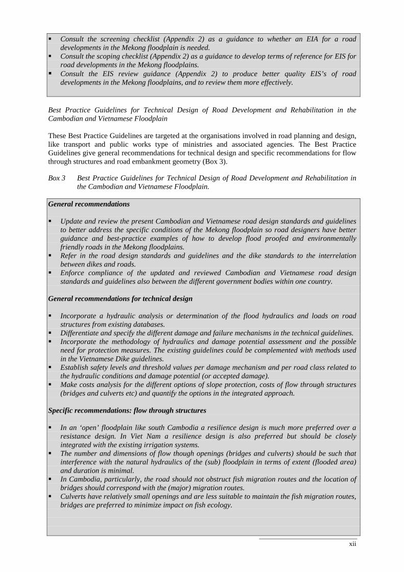
Best Practice Guidelines for Technical Design of Road Development and Rehabilitation in the Cambodian and Vietnamese Floodplain These Best Practice Guidelines are targeted at the organisations involved in road planning and design, like transport and public works type of ministries and associated agencies. The Best Practice Guidelines give general recommendations for technical design and specific recommendations for flow through structures and road embankment geometry (Box 3). Box 3 Best Practice Guidelines for Technical Design of Road Development and Rehabilitation in
the Cambodian and Vietnamese Floodplain. General recommendations Update and review the present Cambodian and Vietnamese road design standards and guidelines
to better address the specific conditions of the Mekong floodplain so road designers have better guidance and best-practice examples of how to develop flood proofed and environmentally friendly roads in the Mekong floodplains.
Refer in the road design standards and guidelines and the dike standards to the interrelation between dikes and roads.
Enforce compliance of the updated and reviewed Cambodian and Vietnamese road design standards and guidelines also between the different government bodies within one country.
General recommendations for technical design Incorporate a hydraulic analysis or determination of the flood hydraulics and loads on road
structures from existing databases. Differentiate and specify the different damage and failure mechanisms in the technical guidelines. Incorporate the methodology of hydraulics and damage potential assessment and the possible
need for protection measures. The existing guidelines could be complemented with methods used in the Vietnamese Dike guidelines.
Establish safety levels and threshold values per damage mechanism and per road class related to the hydraulic conditions and damage potential (or accepted damage).
Make costs analysis for the different options of slope protection, costs of flow through structures (bridges and culverts etc) and quantify the options in the integrated approach.
Specific recommendations: flow through structures In an ‘open’ floodplain like south Cambodia a resilience design is much more preferred over a
resistance design. In Viet Nam a resilience design is also preferred but should be closely integrated with the existing irrigation systems.
The number and dimensions of flow though openings (bridges and culverts) should be such that interference with the natural hydraulics of the (sub) floodplain in terms of extent (flooded area) and duration is minimal.
In Cambodia, particularly, the road should not obstruct fish migration routes and the location of bridges should correspond with the (major) migration routes.
Culverts have relatively small openings and are less suitable to maintain the fish migration routes, bridges are preferred to minimize impact on fish ecology.
xiii
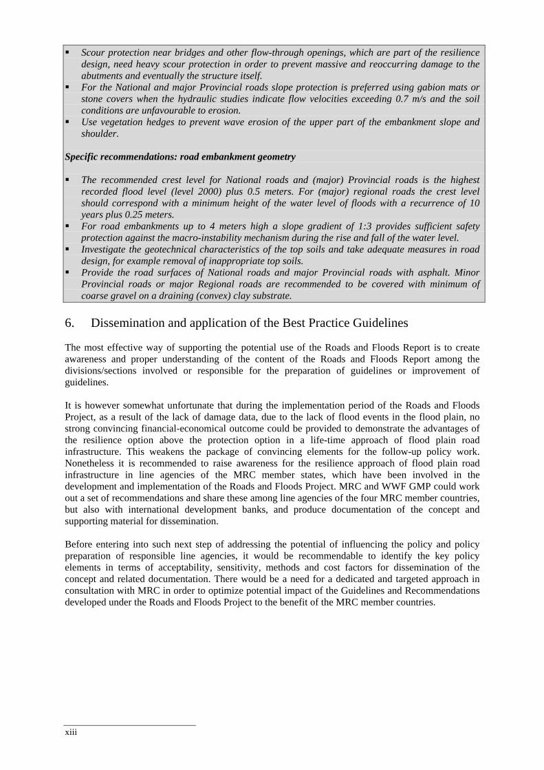
Scour protection near bridges and other flow-through openings, which are part of the resilience design, need heavy scour protection in order to prevent massive and reoccurring damage to the abutments and eventually the structure itself.
For the National and major Provincial roads slope protection is preferred using gabion mats or stone covers when the hydraulic studies indicate flow velocities exceeding 0.7 m/s and the soil conditions are unfavourable to erosion.
Use vegetation hedges to prevent wave erosion of the upper part of the embankment slope and shoulder.
Specific recommendations: road embankment geometry The recommended crest level for National roads and (major) Provincial roads is the highest
recorded flood level (level 2000) plus 0.5 meters. For (major) regional roads the crest level should correspond with a minimum height of the water level of floods with a recurrence of 10 years plus 0.25 meters.
For road embankments up to 4 meters high a slope gradient of 1:3 provides sufficient safety protection against the macro-instability mechanism during the rise and fall of the water level.
Investigate the geotechnical characteristics of the top soils and take adequate measures in road design, for example removal of inappropriate top soils.
Provide the road surfaces of National roads and major Provincial roads with asphalt. Minor Provincial roads or major Regional roads are recommended to be covered with minimum of coarse gravel on a draining (convex) clay substrate.
6. Dissemination and application of the Best Practice Guidelines
The most effective way of supporting the potential use of the Roads and Floods Report is to create awareness and proper understanding of the content of the Roads and Floods Report among the divisions/sections involved or responsible for the preparation of guidelines or improvement of guidelines. It is however somewhat unfortunate that during the implementation period of the Roads and Floods Project, as a result of the lack of damage data, due to the lack of flood events in the flood plain, no strong convincing financial-economical outcome could be provided to demonstrate the advantages of the resilience option above the protection option in a life-time approach of flood plain road infrastructure. This weakens the package of convincing elements for the follow-up policy work. Nonetheless it is recommended to raise awareness for the resilience approach of flood plain road infrastructure in line agencies of the MRC member states, which have been involved in the development and implementation of the Roads and Floods Project. MRC and WWF GMP could work out a set of recommendations and share these among line agencies of the four MRC member countries, but also with international development banks, and produce documentation of the concept and supporting material for dissemination. Before entering into such next step of addressing the potential of influencing the policy and policy preparation of responsible line agencies, it would be recommendable to identify the key policy elements in terms of acceptability, sensitivity, methods and cost factors for dissemination of the concept and related documentation. There would be a need for a dedicated and targeted approach in consultation with MRC in order to optimize potential impact of the Guidelines and Recommendations developed under the Roads and Floods Project to the benefit of the MRC member countries.
xiv
List of Abbreviations General AASHTO American Association of State Highway and Transportation Officials ADB Asian Development Bank AusAID Australian Agency for International Development BDP Basin Development Plan BPG Best Practice Guidelines CIA Cumulative Impact Assessment DC Delft Cluster EA Environmental Assessment EIA Environmental Impact Assessment EIS Environmental Impact Statement EPA Environmental Performance Assessment ERM Environmental Resources Management Group Inc FMM Flood Management and Mitigation FMMP Flood Management and Mitigation Programme FRM Flood Risk Management GIS Geographical Information System GMS Greater Mekong Subregion IEIA Initial Environmental Impact Assessment IFM Integrated Flood Management IFRM Integrated Flood Risk Management IRBM Integrated River Basin Management IWRM Integrated Water Resource Management JICA Japan International Cooperation Agency Lao PDR Lao People’s Democratic Republic LMB Lower Mekong Basin MCA Multi Criteria Analysis MRC Mekong River Commission MRCS Mekong River Commission Secretariat MTIDP Mekong Transport Infrastructure Development Project NGO Non-Governmental Organisation NMCs National Mekong Committees PPP Policy, Plans and Programmes RFMMC Regional Flood Management and Mitigation Centre (MRC) SEA Strategic Environmental Assessment SEF Strategic Environmental Framework UNESCO-IHE UNESCO Institute for Water Education USD US Dollar ($) WWF World Wide Fund for Nature Cambodia MLMUPC Ministry of Land Management, Urban Planning and Construction MND Ministry of National Defence Cambodia MoE Ministry of Environment Cambodia MoPWT Ministry of Public Works and Transportation Cambodia MRD Ministry of Rural Development Cambodia Viet Nam DoNRE Department of Natural Resources and Environment DoSTE Department of Science, Technology and Environment Viet Nam MoC Ministry of Construction Viet Nam MoSTE Ministry of Science, Technology and Environment Viet Nam MoT Ministry of Transportation Viet Nam PPC Provincial Peoples Committee RA Road Administration
xv
Glossary Best practice: A way or method of accomplishing a business function or process that is considered to be superior to all other known methods. (www.qaproject.org/methods /resglossary.html) Best practice guideline: An information resource/tool to be adapted according to each country and project context. In the context of FMMP-C2 BPG’s can for instance be a reference to summarize an annexed set of tools or data collection method, a process that is to be followed step by step; a checklist to evaluate and improve national guidelines such as construction guidelines/building codes. Biodiversity: The variability among living organisms from all sources including, inter alia, terrestrial, marine and other aquatic ecosystems and the ecological complexes of which they are part: this includes diversity within species, between and of ecosystems. (CBD) The totality of genes, species and ecosystems in a region (GBS). Convention on Biological Diversity, Secretariat. www.biodiv.org/secretariat (CBD) Global Biodiversity Strategy. www.wri.org/biodiv/pubs_description.cfm?pid=2550 (GBS) As read in ‘Dictionary & Introduction to Global Environmental Governance’ by Saunier and Meganck (Earthscan: 2007). Culvert: A closed conduit used for the conveyance of surface drainage water under a roadway, railroad, canal, or other impediment. www.laportecounty.org/departments/ surveyor/glossary.html Cumulative impacts: The aggregate impacts from multiple activities (in this report road developments). They can be either additive (due to projects that do not require EIA according to existing legislation) or synergistic (when total impacts of several activities greatly exceed the sum of individual impacts). (UNIGIS, EIA module). Ecosystem: A dynamic complex of plant, animal and microorganism communities and their non-living environment interacting as a functional unit. Ecosystems boundaries are not fixed and their parameters are set according to the scientific, management or policy question being examined (Saunier and Meganck, 2007). Environmental assessment (EA): A term used almost interchangeably with environmental impact assessment, environmental appraisal and environmental analysis that refers to a formal procedure structured to ensure that selected environmental issues are considered in the early stages of the project cycle (Sanier and Meganck, 2007). Environmental impact: Any change to the environment, whether bad or helpful, that wholly or partially results from an organisation's activities, products or services. www.actewagl.com.au/Education/Glossary/default.aspx Environmental impact assessment (EIA): A process of evaluating and suggesting management and mitigation scenarios for the impacts arising for a new development at the various stages of the project cycle (Saunier and Meganck, 2007). Floodplain: Any land area susceptible to being inundated by floodwaters from any source. www.floodsmart.gov/floodsmart/pages/glossary_A-I.jsp Flood zone: Based on the ISIS report where the Mekong floodplains of Cambodia and Viet Nam are divided into several zones, based on hydraulic conditions and characteristics. Habitat: The place where an organism lives and/or the conditions of that environment including the soil, vegetation, water and food (EES). Encyclopedia of Environmental Science. www.wkap.nl/prod/b/0-412-74050-8 (EES) as read in ‘Dictionary & Introduction to Global Environmental Governance’ by Saunier and Meganck (Earthscan: 2007).
xvi
Holistic: Looking at the whole system rather than just concentrating on individual components. The overall sum can be greater than a simple totalling of the individual parts, because the ‘system’ adds something in addition. Another term is ‘systems thinking’. ag.arizona.edu/futures/home/glossary.html Integrated planning: Planning using an holistic approach. IRBM: Integrated River Basin Management (IRBM) can be considered as a tool to deliver IWRM at the basin scale (3rd World Water Forum). IWRM: Integrated Water Resources Management (IWRM) is based on the understanding that in order to promote efficiency, equity and ecological integrity of natural resources, an integrated approach to engineering, policies, institutional development and management is essential. Plan: A set of co-ordinated and timed objectives for the implementation of the policy; usually, it involves the identification of the different options to achieve the policy objectives. Policy: A framework that provides inspiration and guidance for actions usually in the form of a broad statement of intent that defines and focuses the political agenda of a government. Programme: A set of projects in a particular area or for a particular sector; it deals with the practical questions of how, when and where specific actions will be carried out. Project development: Project development consists of the following phases: concept development, pre-feasibility, feasibility, project design, construction, operation and maintenance and monitoring. Projects: the individual actions (i.e. a specific road rehabilitation project) set to implement the goals indicated by the plan and ultimately by the policy. Rehabilitation: Rehabilitation of a building or property returns it to a state of utility by means of repair or alteration, which makes possible an efficient contemporary use while preserving those sections or features that are significant to its historical, architectural and cultural values. www.loudoun.gov/controls/speerio/resources/RenderContent.aspx Resilience: The capacity of a system, community or society potentially exposed to hazards to adapt, by resisting or changing in order to reach and maintain an acceptable level of functioning and structure. This is determined by the degree to which the social system is capable of organizing itself to increase its capacity for learning from past disasters for better future protection and to improve risk reduction measures. (http://www.adrc.or.jp/publications/terminology/top.htm#R) Resilience strategy: In this report the resilience strategy aims at minimizing the consequences of floods, but at the same time allow some flooding (Vis et al., 2003). Resistance strategy: In contrast to the resilience strategy (see above) the resistance strategy, in this report, aims at the prevention of flooding by regulating and hence has a strong impact on the natural floodplain dynamics (Vis et al., 2003). Road design: Relates to the engineering design step in road development, and includes structural/pavement design and geometric design. Structural design involves selection of materials and thicknesses of the layers while geometric design involves selection of detailed alignment and cross-section of a road. Road development: Consists of the following phases: project plannning (concept development, pre-feasibility, and feasibility), project design, construction, operation and maintenance and monitoring. Road planning: Relates to two levels of road development: (1) the policy, plan and programme level, and (2) the project level, particularly the first phases - concept, pre-feasibility and feasibility - of road
xvii
development. Alignment of a road under planning is the very general alignment in terms of the location of a road between e.g. two cities. Road rehabilition: Refers to the upgrading of an existing road and includes renewed structural/pavement design and / or geometric design. Structural design involves selection of materials and thicknesses of the layers while geometric design involves selection of detailed alignment and cross-section of a road. Stakeholder: A person or organisation representing the interests and opinions of a group with an interest in the outcome of (for example) a review or policy decision. (http://cot.food.gov.uk/moreinfo/cotglossary#s) Strategic Environmental Assessment (SEA): A technique similar to environmental impact assessment (EIA) but normally applied to policies, plans, program and groups of projects. There are two main types of SEA: Sectoral, which is applied when many new projects fall within one sector and Regional, which is applied to cover development within a region (EEA). European Environmental Agency. www.eea.eu.int/; glossary. eea.eu.int/EEAGlossary/ As read in ‘Dictionary & Introduction to Global Environmental Governance’ by Saunier and Meganck (Earthscan: 2007). Sustainability: Sustainability is an economic, social, an environmental concept. It is intended to be a means of configuring civilization and human activity so that society and its members are able to meet their needs and express their greatest potential in the present, while preserving biodiversity and natural ecosystems, and planning and acting for the ability to maintain these ideals indefinitely. Sustainability affects every level of organization from the local neighbourhood to the entire planet. ‘Dictionary & Introduction to Global Environmental Governance’ by Saunier and Meganck (Earthscan: 2007). Wetland: ‘Wetlands are areas of marsh, fen, peatland or water, whether natural or artificial, permanent or temporary, with water that is static or flowing, fresh, brackish or salt, including areas of marine water the depth of which at low tide does not exceed six metres.’ Classification System for Wetland Type (www.ramsar.org).

Best Practice Guidelines for the Integrated Planning and Design of Economically Sound and Environmentally Friendly Roads in the Mekong Floodplains of Cambodia and Viet Nam
1
1. Introduction 1.1 Roads and floods in the Lower Mekong Basin Over the last few decades the regional economic development of the four countries of the Lower Mekong Basin has evolved at a fast pace. Such development goes in parallel with the upgrading and development of roads in order to transport goods and services and people. For a number of reasons road development in a floodplain system like the still quite natural floodplain system of the Lower Mekong Basin (LMB), requires a different approach to planning as well as technical design, compared to road developments in areas that are not (regularly) inundated. On the one hand, floods can severely damage infrastructure including the roads. On the other hand, roads and associated infrastructure can themselves have a considerable effect on the floods. They fragment the floodplains and interrupt natural flow of water, sediments, nutrients and aquatic life, which is particularly relevant in the floodplains of the LMB, as they are well-known for their biological diversity, fertile agricultural land and productive fishery sector. Moreover, future developments regarding urbanisation, climate change and economic growth in the Lower Mekong Basin, require higher quality roads. Hence, the question: how to further develop roads in a sensitive ecosystem like the floodplain of the Mekong in a sustainable manner that minimizes the impact on the benefits of the annual inundations and at the same time reduces the damage? This introductory chapter starts with an introduction to road development planning and environmental assessment, with specific reference to the Cambodian and Vietnamese context since the report is structured along these concepts. Then, the objectives and target group of the report will be presented (Section 1.3), together with the main output of the project, the Best Practice Guidelines for road development and rehabilitation in the Mekong floodplains (Section 1.4). This section will also clarify how these Best Practice Guidelines link to the FMMP-Component 2 Best Practice Guidelines under development. The chapter continues with a brief description of the methodology in Section 1.7, and concludes with a reading guide of the report.
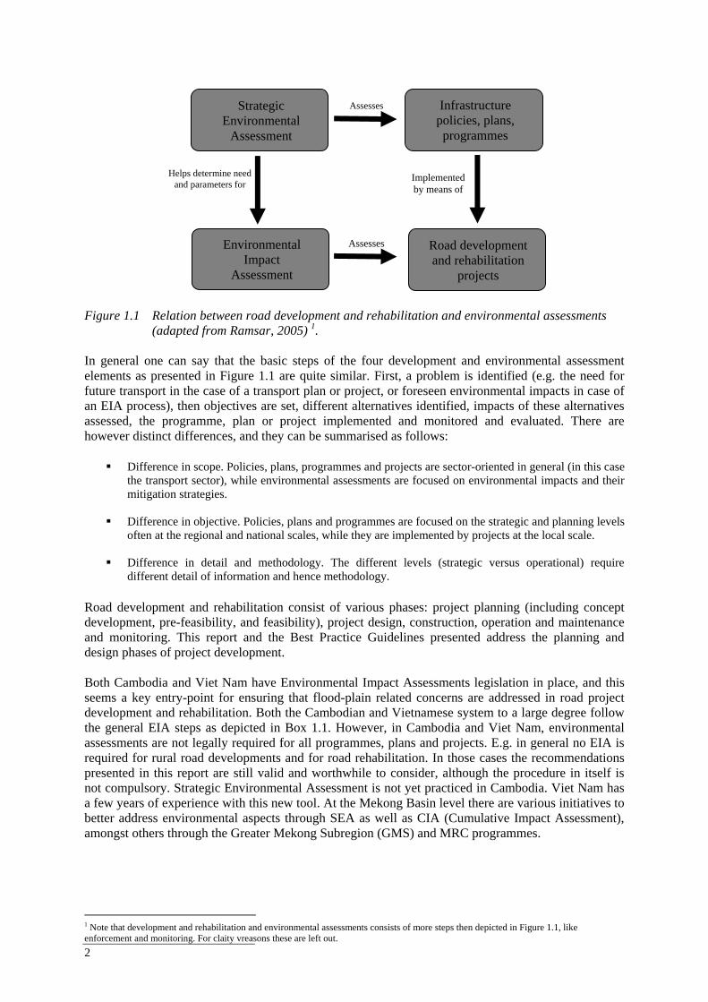
1.2 Road development and rehabilitation and environmental assessment The development of roads and the role of environmental assessment in these processes are very much country and context specific. The two countries in focus in this project, Cambodia and Viet Nam, each have their own specific rules and regulations with respect to the procedures, guidelines and practice of the development and rehabilitation of roads. An overview of these aspects for both countries will be given in Chapter 3. Below, a generic development and environmental assessment framework will be presented that will be used in this report to structure the analysis of road development and rehabilitation in Cambodia and Viet Nam, as well as the Best Practice Guidelines. This framework (Figure 1.1) based on Ramsar (2005), consists of the following four inter-related elements of road development and rehabilitation and environmental assessment:
At the strategic and sub-basin level infrastructure policies, plans and programmes (PPP) are developed that are implemented through operational road development and rehabilitation projects.
Environmental assessments analyse environmental impacts of development activities and
identify mitigation measures. Strategic Environmental Assessment (SEA) assesses at the strategic level decisions (policies, plans and programmes) and help determine the need for assessments at the project level which are usually completed through an Environmental Impact Assessment (EIA).
2
Figure 1.1 Relation between road development and rehabilitation and environmental assessments
(adapted from Ramsar, 2005) 1. In general one can say that the basic steps of the four development and environmental assessment elements as presented in Figure 1.1 are quite similar. First, a problem is identified (e.g. the need for future transport in the case of a transport plan or project, or foreseen environmental impacts in case of an EIA process), then objectives are set, different alternatives identified, impacts of these alternatives assessed, the programme, plan or project implemented and monitored and evaluated. There are however distinct differences, and they can be summarised as follows:
Difference in scope. Policies, plans, programmes and projects are sector-oriented in general (in this case
the transport sector), while environmental assessments are focused on environmental impacts and their mitigation strategies.
Difference in objective. Policies, plans and programmes are focused on the strategic and planning levels
often at the regional and national scales, while they are implemented by projects at the local scale.
Difference in detail and methodology. The different levels (strategic versus operational) require different detail of information and hence methodology.
Road development and rehabilitation consist of various phases: project planning (including concept development, pre-feasibility, and feasibility), project design, construction, operation and maintenance and monitoring. This report and the Best Practice Guidelines presented address the planning and design phases of project development. Both Cambodia and Viet Nam have Environmental Impact Assessments legislation in place, and this seems a key entry-point for ensuring that flood-plain related concerns are addressed in road project development and rehabilitation. Both the Cambodian and Vietnamese system to a large degree follow the general EIA steps as depicted in Box 1.1. However, in Cambodia and Viet Nam, environmental assessments are not legally required for all programmes, plans and projects. E.g. in general no EIA is required for rural road developments and for road rehabilitation. In those cases the recommendations presented in this report are still valid and worthwhile to consider, although the procedure in itself is not compulsory. Strategic Environmental Assessment is not yet practiced in Cambodia. Viet Nam has a few years of experience with this new tool. At the Mekong Basin level there are various initiatives to better address environmental aspects through SEA as well as CIA (Cumulative Impact Assessment), amongst others through the Greater Mekong Subregion (GMS) and MRC programmes. 1 Note that development and rehabilitation and environmental assessments consists of more steps then depicted in Figure 1.1, like enforcement and monitoring. For claity vreasons these are left out.
Infrastructure policies, plans, programmes
Road development and rehabilitation
projects
Implemented by means of
Environmental Impact
Assessment
Assesses
Strategic Environmental
Assessment
Assesses
Helps determine need and parameters for
Best Practice Guidelines for the Integrated Planning and Design of Economically Sound and Environmentally Friendly Roads in the Mekong Floodplains of Cambodia and Viet Nam
3
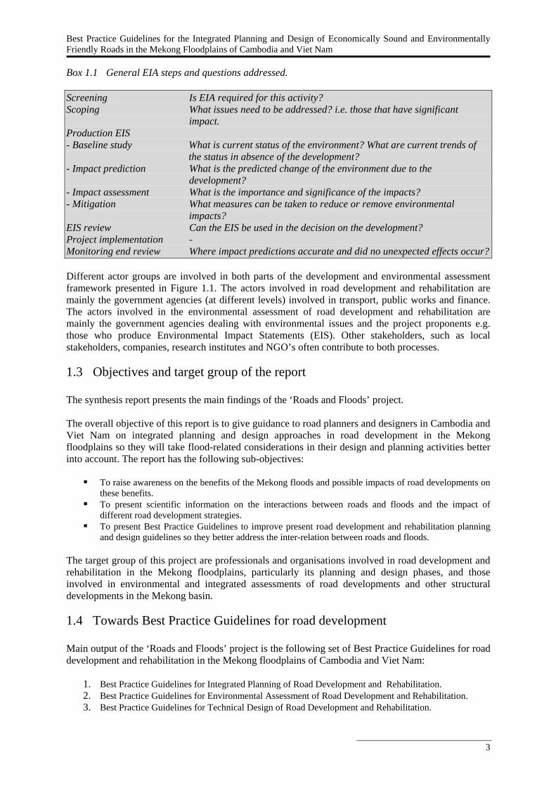
Box 1.1 General EIA steps and questions addressed. Screening Is EIA required for this activity? Scoping What issues need to be addressed? i.e. those that have significant
impact. Production EIS - Baseline study What is current status of the environment? What are current trends of
the status in absence of the development? - Impact prediction What is the predicted change of the environment due to the
development? - Impact assessment What is the importance and significance of the impacts? - Mitigation What measures can be taken to reduce or remove environmental
impacts? EIS review Can the EIS be used in the decision on the development? Project implementation - Monitoring end review Where impact predictions accurate and did no unexpected effects occur? Different actor groups are involved in both parts of the development and environmental assessment framework presented in Figure 1.1. The actors involved in road development and rehabilitation are mainly the government agencies (at different levels) involved in transport, public works and finance. The actors involved in the environmental assessment of road development and rehabilitation are mainly the government agencies dealing with environmental issues and the project proponents e.g. those who produce Environmental Impact Statements (EIS). Other stakeholders, such as local stakeholders, companies, research institutes and NGO’s often contribute to both processes.
1.3 Objectives and target group of the report The synthesis report presents the main findings of the ‘Roads and Floods’ project. The overall objective of this report is to give guidance to road planners and designers in Cambodia and Viet Nam on integrated planning and design approaches in road development in the Mekong floodplains so they will take flood-related considerations in their design and planning activities better into account. The report has the following sub-objectives:
To raise awareness on the benefits of the Mekong floods and possible impacts of road developments on these benefits.
To present scientific information on the interactions between roads and floods and the impact of different road development strategies.
To present Best Practice Guidelines to improve present road development and rehabilitation planning and design guidelines so they better address the inter-relation between roads and floods.
The target group of this project are professionals and organisations involved in road development and rehabilitation in the Mekong floodplains, particularly its planning and design phases, and those involved in environmental and integrated assessments of road developments and other structural developments in the Mekong basin.
1.4 Towards Best Practice Guidelines for road development Main output of the ‘Roads and Floods’ project is the following set of Best Practice Guidelines for road development and rehabilitation in the Mekong floodplains of Cambodia and Viet Nam:
1. Best Practice Guidelines for Integrated Planning of Road Development and Rehabilitation. 2. Best Practice Guidelines for Environmental Assessment of Road Development and Rehabilitation. 3. Best Practice Guidelines for Technical Design of Road Development and Rehabilitation.
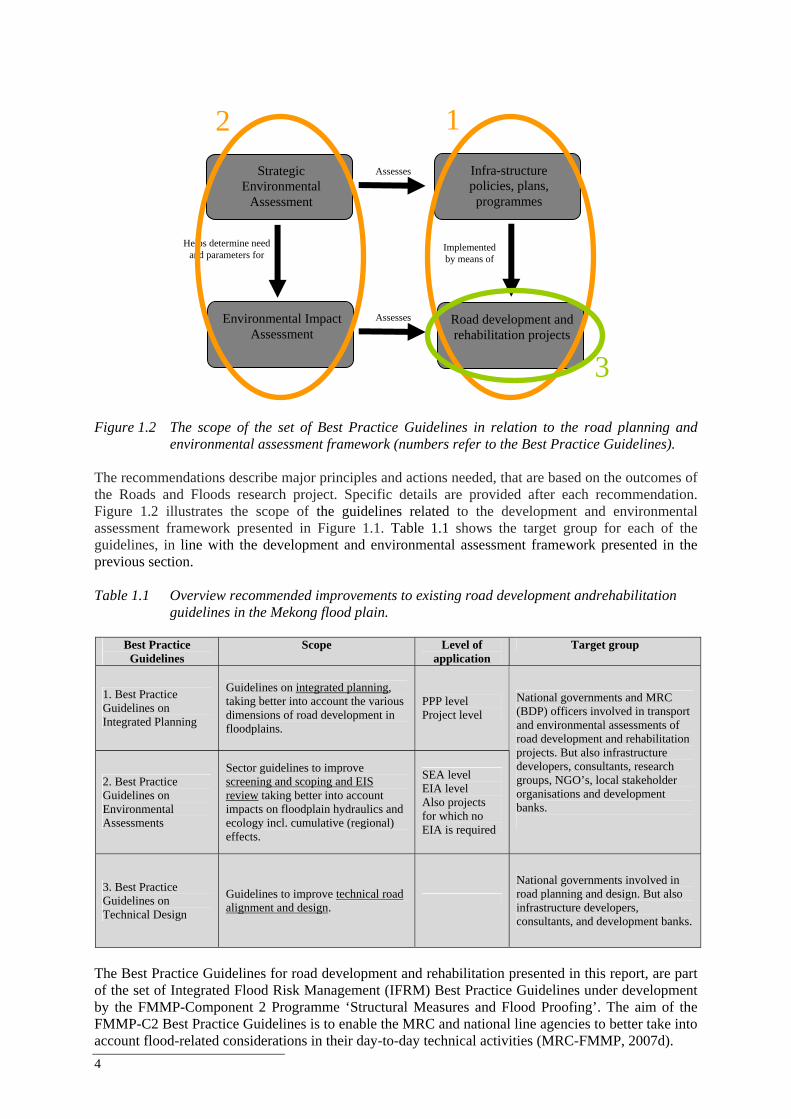
4
Figure 1.2 The scope of the set of Best Practice Guidelines in relation to the road planning and
environmental assessment framework (numbers refer to the Best Practice Guidelines). The recommendations describe major principles and actions needed, that are based on the outcomes of the Roads and Floods research project. Specific details are provided after each recommendation. Figure 1.2 illustrates the scope of the guidelines related to the development and environmental assessment framework presented in Figure 1.1. Table 1.1 shows the target group for each of the guidelines, in line with the development and environmental assessment framework presented in the previous section. Table 1.1 Overview recommended improvements to existing road development andrehabilitation
guidelines in the Mekong flood plain.
Best Practice Guidelines
Scope Level of application
Target group
1. Best Practice Guidelines on Integrated Planning
Guidelines on integrated planning, taking better into account the various dimensions of road development in floodplains.
PPP level Project level
2. Best Practice Guidelines on Environmental Assessments
Sector guidelines to improve screening and scoping and EIS review taking better into account impacts on floodplain hydraulics and ecology incl. cumulative (regional) effects.
SEA level EIA level Also projects for which no EIA is required
National governments and MRC (BDP) officers involved in transport and environmental assessments of road development and rehabilitation projects. But also infrastructure developers, consultants, research groups, NGO’s, local stakeholder organisations and development banks.
3. Best Practice Guidelines on Technical Design
Guidelines to improve technical road alignment and design.
National governments involved in road planning and design. But also infrastructure developers, consultants, and development banks.
The Best Practice Guidelines for road development and rehabilitation presented in this report, are part of the set of Integrated Flood Risk Management (IFRM) Best Practice Guidelines under development by the FMMP-Component 2 Programme ‘Structural Measures and Flood Proofing’. The aim of the FMMP-C2 Best Practice Guidelines is to enable the MRC and national line agencies to better take into account flood-related considerations in their day-to-day technical activities (MRC-FMMP, 2007d).
Infra-structure policies, plans, programmes
Road development and rehabilitation projects
Implemented by means of
Environmental Impact Assessment
Assesses
Strategic Environmental
Assessment
Assesses
Helps determine need and parameters for
2
3
1
Best Practice Guidelines for the Integrated Planning and Design of Economically Sound and Environmentally Friendly Roads in the Mekong Floodplains of Cambodia and Viet Nam
5
There is, however, a difference in approach between the FMMP-C2 Best Practice Guidelines and the ‘Roads and Floods’ Best Practice Guidelines specifically. The former specifically focus at flood risk management, while the latter focus on road development and rehabilitation, while roads in the Mekong floodplain are often on top of levees that have a flood protection function. The ‘Roads and Floods’ Best Practice Guidelines consider multiple objectives in the road planning and design process, such as transport, flood protection, and ecology, and give guidance on how to optimise between these multiple objectives in the road development and rehabilitation planning and design process. Moreover, the Roads and Floods guidelines focus specifically at Cambodia and Viet Nam and not the Lower Mekong Basin as a whole. The FMMP-C2 Best Practice Guidelines are presented in Box 1.2. The ‘Roads and Floods’ Best Practice Guidelines main contribution is to IFRM guideline set 2 with respect to the planning and design of roads. The ‘Roads and Floods’ guidelines, however, also contribute to set 3 with respect to the planning of roads, as planning of roads in the Mekong context strongly links to IFRM, and the evaluation of impacts of road developments. Box 1.2 Four sets of IFRM guidelines to be developed by the MRC-FMMP-Component 2 (MRC-
FMMP). 1. Best Practice Guidelines on Flood Risk Assessment 2. Best Practice Guidelines on Structural Measures and Flood Proofing 3. Best Practice Guidelines on IFRM Planning and Impact Evaluation 4. Best Practice Guidelines to Evaluate the Impacts of Sub-Area Development Scenarios on Flood Risk (IFRM Guidelines for BDP)
1.5 Development and scope of the Best Practice Guidelines Criteria for the development of the Best Practice Guidelines, included:
The guidelines are based on existing planning and design practice and they do not substitute the Mekong countries guidance.
The guidelines are appropriate for the Cambodian and Vietnamese context.
The guidelines take financial considerations into account (given the development context).
The guidelines are based on scientific research and relevant international experience.
The guidelines are consistent with the FMMP-C2 Best Practice Guidelines.
The recommendations given in this report are suggested improvements of the existing road planning and design guidelines in Cambodia and Viet Nam. They can be regarded as suggestions how the existing guidelines can be improved to arrive at more sustainable solutions. The Best Practice Guidelines on Integrated Planning and Environmental Assessments specifically have been designed for Cambodia and Viet Nam, but this guidance will also be useful across the Lower Mekong Basin (see discussion Section 5.6). The Best Practice Guidelines concentrate on roads and related structures (e.g. dykes and levees) in the floodplains of the Mekong and only addresses the issues relevant to the Mekong floodplains. They do not address sea dikes. Social aspects will not be a main element of the Best Practice Guidelines, but some dimensions of social development will be covered in the recommendations, for instance the resettlement problem due to road rehabilitation and development.
6
Box 1.3 The use of terms ‘standards’ and ‘guidelines’ and FMMP-C2 Best Practice Guidelines In road development, the term ‘standards’ is mostly used in a technical context. Road design and planning standards are detailed technical references e.g. the minimum width of a national road, or the minimum thickness of asphalt cover. They are usually determined by and agreed upon by (groups of) engineers and need to be followed in the planning and design process. Guidelines are more general, they leave more flexibility for the user also to adapt to specific and local circumstances. Guidelines can be divers, e.g. a recommended approach, a course of action (e.g. how to apply standards) or a parameter, and can range from a few lines up to a complete document. They are prescribed by government and can be part of legislation. Standards and guidelines, both, can be either philosophical (e.g.‘in planning and design environmental aspects should be taken into account’) or technical. Best practice can be regarded as a way or method of accomplishing a business function or process that is considered to be superior to all other known methods. Best Practice Guidelines in the context of FMMP-C2 do not attempt to summarize or replace the national guidelines, nor are they intended as a recipe for carrying out planning or project design for FMM in the Lower Mekong Basin. Rather the BPGs are provided as an information resource/tool to be adapted according to each country and project context. BPG’s can for instance be a reference to summarize an annexed set of tools or data collection method, a process that is to be followed step by step; a checklist to evaluate and improve national guidelines such as construction guidelines/building codes. 1.6 Methodology The recommendations presented in this ‘Roads and Floods’ report are based on two interrelated project activities: a scientific research component and a policy component (Delft Cluster-WWF-MRC, 2006). The scientific component, led by three Delft Cluster institutes (UNESCO-IHE, Delft Hydraulics and GeoDelft) adressed four main research questions:
What is the significance of roads in the Cambodian and Vietnamese floodplains in changing flow patterns (including cumulative impacts)?
What is the significance of flow patterns in Cambodia and Viet Nam in terms of road damage?
What are the impacts of different road development and rehabilitation strategies (resistance and
resilience2) in Cambodia and Viet Nam on floodplain hydraulics and related benefits of floods and on economic costs of roads?
What road development and rehabilitation practice would contribute most to the reduction of the socio-
economic costs of flooding in the Lower Mekong Basin, whilst preserving the environmental and other benefits of floods?
To address these questions a multi-disciplinary research approach was applied integrating policy analysis and technical analysis. The policy analysis was undertaken to better understand the institutional context of road development and rehabilitation as well as the current road development practice in both countries. Moreover, the policy analysis approach helped to structure the road development process, in particular its planning phase where concept development and (pre-feasibility) studies take place. The planning phase can be divided into the following general steps: problem analysis, analysis present and future situation, identification of alternatives, assessment of impacts of alternatives and evaluation of alternatives. The analysis of the different steps was supported by large flood surveys in 2006 and 2007 in four Cambodian and Vietnamese pilot sites and the technical analysis activities including inundation modelling and analysis, damage analysis, economic analysis and environmental impact analysis.
2 See Section 4.2 for an explanation of the terms ‘resistance’ and ‘resilience’ in the context of road development in floodplains.
Best Practice Guidelines for the Integrated Planning and Design of Economically Sound and Environmentally Friendly Roads in the Mekong Floodplains of Cambodia and Viet Nam
7
The results of these analyses were important input to the development of the set of Best Practice Guidelines. Both the technical and policy analysis were supported by several field visits during the project period and regular interactions with stakeholders. Further details of the technical and policy analysis can be found in the folowing project documents:
Inundation modelling report (Verheij, in preparation). Road damage analysis report (Van der Ruyt and Verheij, in preparation).
Pre-flood, flood and post-flood monitoring plan and 2006 and 2007 survey reports (Verheij et al.,
2006).
Review technical design guidelines and suggestions for improvements (Verheij and Van der Ruyt, in preparation).
UNESCO-IHE MSc theses (Phan Thi Thu Ha (2007), Beinamaryo (2007), Patarroyo (2007),
Pratheepan (2007), Namgyal (2007), Dhakal (2007)).
Wageningen University MSc theses (Do Nguyen Anh Tu, 2008). The policy component under the joint responsibility of WWF and MRC, aimed at raising awareness of impacts of road developments in floodplains amongst decision makers in the relevant government agencies representing e.g. road development, economic development, environment, fisheries and agriculture and senior staff of development banks. Moreover, to assist them in the translation of the findings of the scientific component into national road planning and design practice and investment policy. At various moments during the course of the study, meetings with stakeholders were held, including the inception workshops, January 2007 workshops, October 2007 technical consultations and November 2008 final workshops. Further details of the technical and policy analysis can be found in the folowing project documents:
Roads and Floods mission and consultation reports. Policy plan (Goichot et al., in preparation).
1.7 Reading guide The structure of the report is depicted in Table 1.2 that also serves as a reading guide for those interested in selected parts of the report. The rationale behind the Best Practice Guidelines will be described in Chapters 2, 3, 4 and 5. Chapter 5 presents the results of the five case studies in Cambodia and Viet Nam in which the results of the technical and policy analysis are presented. The Best Practice Guidelines are presented in Chapter 6. Chapter 7 gives recommendations for the further dissemination and application of the guidelines.
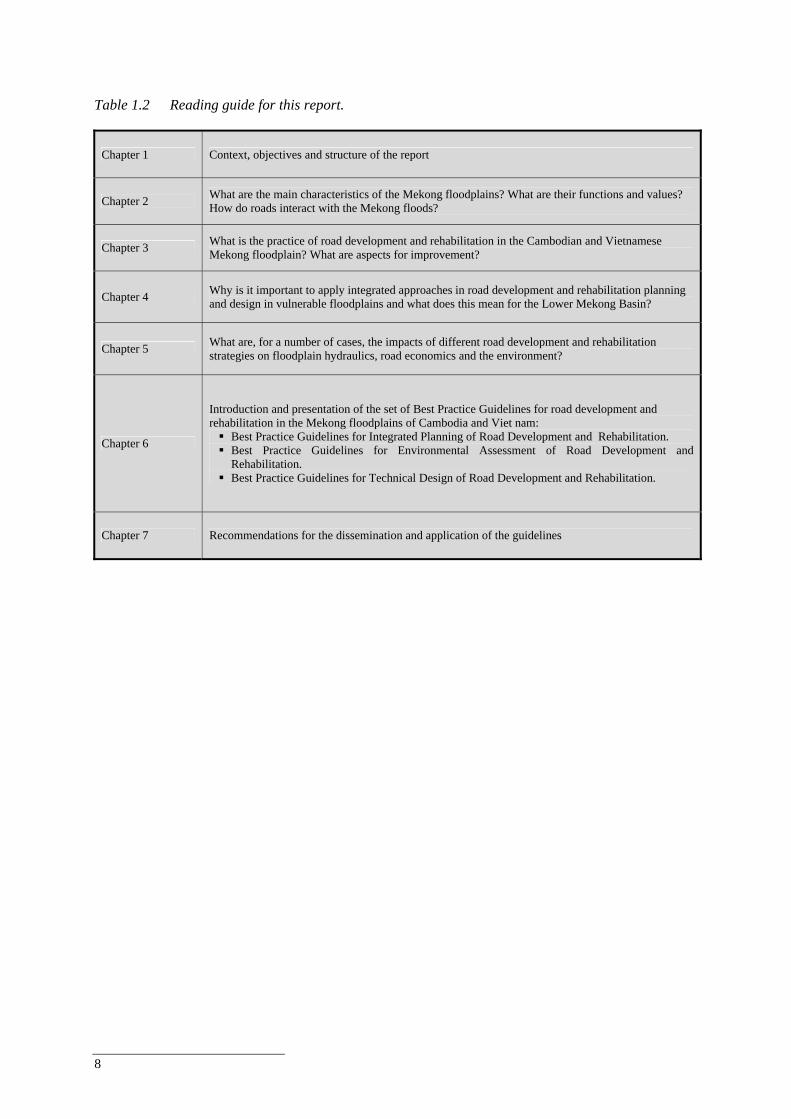
8
Table 1.2 Reading guide for this report.
Chapter 1 Context, objectives and structure of the report
Chapter 2 What are the main characteristics of the Mekong floodplains? What are their functions and values? How do roads interact with the Mekong floods?
Chapter 3 What is the practice of road development and rehabilitation in the Cambodian and Vietnamese Mekong floodplain? What are aspects for improvement?
Chapter 4 Why is it important to apply integrated approaches in road development and rehabilitation planning and design in vulnerable floodplains and what does this mean for the Lower Mekong Basin?
Chapter 5 What are, for a number of cases, the impacts of different road development and rehabilitation strategies on floodplain hydraulics, road economics and the environment?
Chapter 6
Introduction and presentation of the set of Best Practice Guidelines for road development and rehabilitation in the Mekong floodplains of Cambodia and Viet nam:
Best Practice Guidelines for Integrated Planning of Road Development and Rehabilitation. Best Practice Guidelines for Environmental Assessment of Road Development and
Rehabilitation. Best Practice Guidelines for Technical Design of Road Development and Rehabilitation.
Chapter 7 Recommendations for the dissemination and application of the guidelines
Best Practice Guidelines for the Integrated Planning and Design of Economically Sound and Environmentally Friendly Roads in the Mekong Floodplains of Cambodia and Viet Nam
9
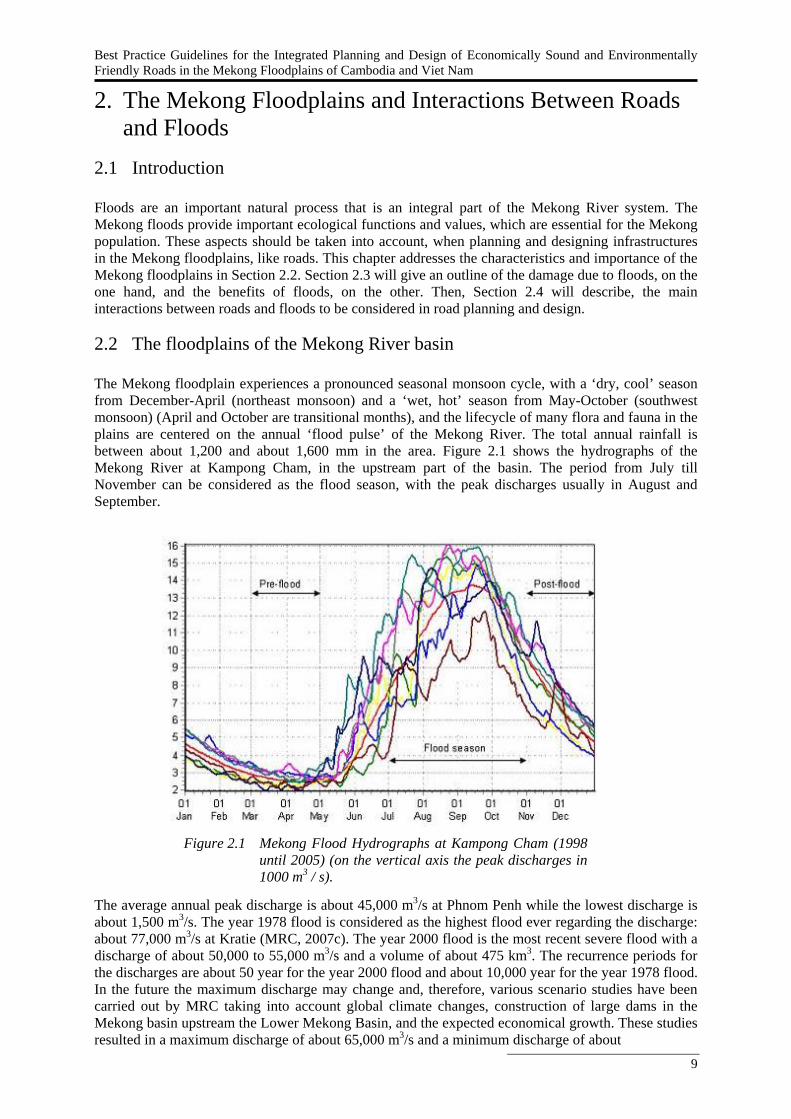
2. The Mekong Floodplains and Interactions Between Roads and Floods
2.1 Introduction Floods are an important natural process that is an integral part of the Mekong River system. The Mekong floods provide important ecological functions and values, which are essential for the Mekong population. These aspects should be taken into account, when planning and designing infrastructures in the Mekong floodplains, like roads. This chapter addresses the characteristics and importance of the Mekong floodplains in Section 2.2. Section 2.3 will give an outline of the damage due to floods, on the one hand, and the benefits of floods, on the other. Then, Section 2.4 will describe, the main interactions between roads and floods to be considered in road planning and design.
2.2 The floodplains of the Mekong River basin The Mekong floodplain experiences a pronounced seasonal monsoon cycle, with a ‘dry, cool’ season from December-April (northeast monsoon) and a ‘wet, hot’ season from May-October (southwest monsoon) (April and October are transitional months), and the lifecycle of many flora and fauna in the plains are centered on the annual ‘flood pulse’ of the Mekong River. The total annual rainfall is between about 1,200 and about 1,600 mm in the area. Figure 2.1 shows the hydrographs of the Mekong River at Kampong Cham, in the upstream part of the basin. The period from July till November can be considered as the flood season, with the peak discharges usually in August and September. The average annual peak discharge is about 45,000 m3/s at Phnom Penh while the lowest discharge is about 1,500 m3/s. The year 1978 flood is considered as the highest flood ever regarding the discharge: about 77,000 m3/s at Kratie (MRC, 2007c). The year 2000 flood is the most recent severe flood with a discharge of about 50,000 to 55,000 m3/s and a volume of about 475 km3. The recurrence periods for the discharges are about 50 year for the year 2000 flood and about 10,000 year for the year 1978 flood. In the future the maximum discharge may change and, therefore, various scenario studies have been carried out by MRC taking into account global climate changes, construction of large dams in the Mekong basin upstream the Lower Mekong Basin, and the expected economical growth. These studies resulted in a maximum discharge of about 65,000 m3/s and a minimum discharge of about
Figure 2.1 Mekong Flood Hydrographs at Kampong Cham (1998 until 2005) (on the vertical axis the peak discharges in 1000 m3 / s).
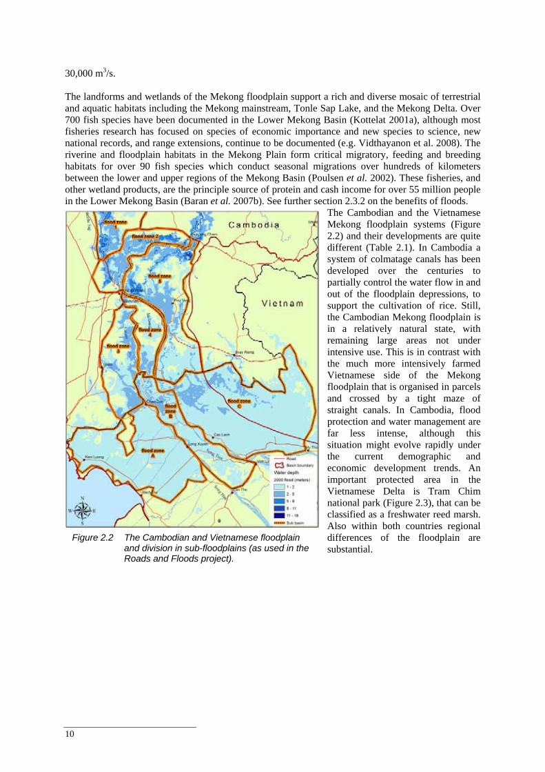
10
30,000 m3/s. The landforms and wetlands of the Mekong floodplain support a rich and diverse mosaic of terrestrial and aquatic habitats including the Mekong mainstream, Tonle Sap Lake, and the Mekong Delta. Over 700 fish species have been documented in the Lower Mekong Basin (Kottelat 2001a), although most fisheries research has focused on species of economic importance and new species to science, new national records, and range extensions, continue to be documented (e.g. Vidthayanon et al. 2008). The riverine and floodplain habitats in the Mekong Plain form critical migratory, feeding and breeding habitats for over 90 fish species which conduct seasonal migrations over hundreds of kilometers between the lower and upper regions of the Mekong Basin (Poulsen et al. 2002). These fisheries, and other wetland products, are the principle source of protein and cash income for over 55 million people in the Lower Mekong Basin (Baran et al. 2007b). See further section 2.3.2 on the benefits of floods.
The Cambodian and the Vietnamese Mekong floodplain systems (Figure 2.2) and their developments are quite different (Table 2.1). In Cambodia a system of colmatage canals has been developed over the centuries to partially control the water flow in and out of the floodplain depressions, to support the cultivation of rice. Still, the Cambodian Mekong floodplain is in a relatively natural state, with remaining large areas not under intensive use. This is in contrast with the much more intensively farmed Vietnamese side of the Mekong floodplain that is organised in parcels and crossed by a tight maze of straight canals. In Cambodia, flood protection and water management are far less intense, although this situation might evolve rapidly under the current demographic and economic development trends. An important protected area in the Vietnamese Delta is Tram Chim national park (Figure 2.3), that can be classified as a freshwater reed marsh. Also within both countries regional differences of the floodplain are substantial.
Figure 2.2 The Cambodian and Vietnamese floodplain and division in sub-floodplains (as used in the Roads and Floods project).
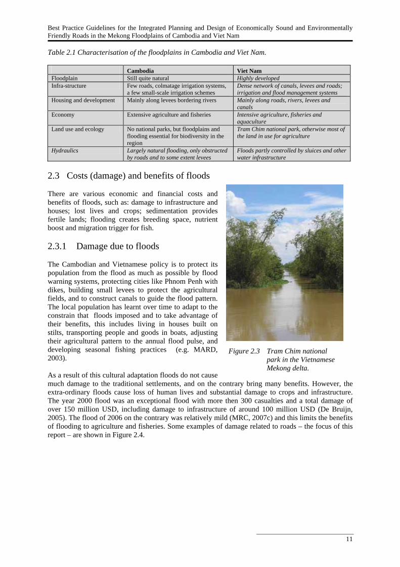
Best Practice Guidelines for the Integrated Planning and Design of Economically Sound and Environmentally Friendly Roads in the Mekong Floodplains of Cambodia and Viet Nam
11
Table 2.1 Characterisation of the floodplains in Cambodia and Viet Nam.
Cambodia Viet Nam Floodplain Still quite natural Highly developed Infra-structure Few roads, colmatage irrigation systems,
a few small-scale irrigation schemes Dense network of canals, levees and roads; irrigation and flood management systems
Housing and development Mainly along levees bordering rivers Mainly along roads, rivers, levees and canals
Economy Extensive agriculture and fisheries Intensive agriculture, fisheries and aquaculture
Land use and ecology No national parks, but floodplains and flooding essential for biodiversity in the region
Tram Chim national park, otherwise most of the land in use for agriculture
Hydraulics Largely natural flooding, only obstructed by roads and to some extent levees
Floods partly controlled by sluices and other water infrastructure
2.3 Costs (damage) and benefits of floods There are various economic and financial costs and benefits of floods, such as: damage to infrastructure and houses; lost lives and crops; sedimentation provides fertile lands; flooding creates breeding space, nutrient boost and migration trigger for fish. 2.3.1 Damage due to floods The Cambodian and Vietnamese policy is to protect its population from the flood as much as possible by flood warning systems, protecting cities like Phnom Penh with dikes, building small levees to protect the agricultural fields, and to construct canals to guide the flood pattern. The local population has learnt over time to adapt to the constrain that floods imposed and to take advantage of their benefits, this includes living in houses built on stilts, transporting people and goods in boats, adjusting their agricultural pattern to the annual flood pulse, and developing seasonal fishing practices (e.g. MARD, 2003). As a result of this cultural adaptation floods do not cause much damage to the traditional settlements, and on the contrary bring many benefits. However, the extra-ordinary floods cause loss of human lives and substantial damage to crops and infrastructure. The year 2000 flood was an exceptional flood with more then 300 casualties and a total damage of over 150 million USD, including damage to infrastructure of around 100 million USD (De Bruijn, 2005). The flood of 2006 on the contrary was relatively mild (MRC, 2007c) and this limits the benefits of flooding to agriculture and fisheries. Some examples of damage related to roads – the focus of this report – are shown in Figure 2.4.
Figure 2.3 Tram Chim national park in the Vietnamese Mekong delta.
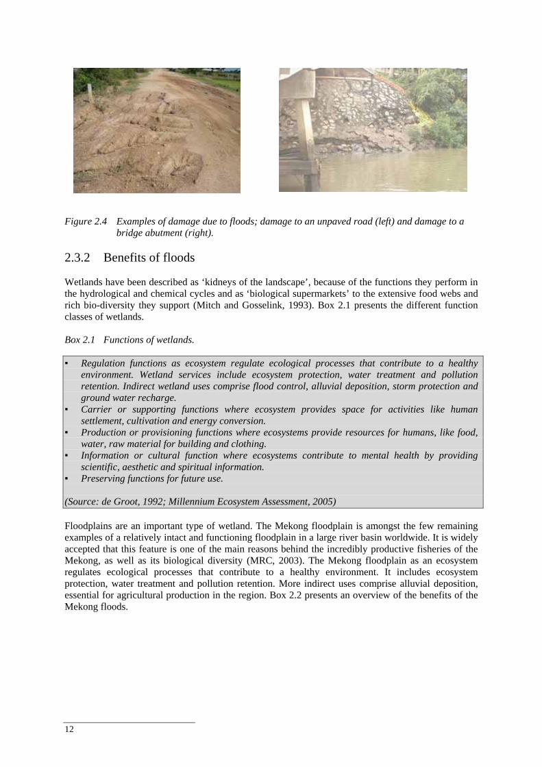
12
Figure 2.4 Examples of damage due to floods; damage to an unpaved road (left) and damage to a
bridge abutment (right). 2.3.2 Benefits of floods Wetlands have been described as ‘kidneys of the landscape’, because of the functions they perform in the hydrological and chemical cycles and as ‘biological supermarkets’ to the extensive food webs and rich bio-diversity they support (Mitch and Gosselink, 1993). Box 2.1 presents the different function classes of wetlands. Box 2.1 Functions of wetlands. ▪ Regulation functions as ecosystem regulate ecological processes that contribute to a healthy
environment. Wetland services include ecosystem protection, water treatment and pollution retention. Indirect wetland uses comprise flood control, alluvial deposition, storm protection and ground water recharge.
▪ Carrier or supporting functions where ecosystem provides space for activities like human settlement, cultivation and energy conversion.
▪ Production or provisioning functions where ecosystems provide resources for humans, like food, water, raw material for building and clothing.
▪ Information or cultural function where ecosystems contribute to mental health by providing scientific, aesthetic and spiritual information.
▪ Preserving functions for future use. (Source: de Groot, 1992; Millennium Ecosystem Assessment, 2005) Floodplains are an important type of wetland. The Mekong floodplain is amongst the few remaining examples of a relatively intact and functioning floodplain in a large river basin worldwide. It is widely accepted that this feature is one of the main reasons behind the incredibly productive fisheries of the Mekong, as well as its biological diversity (MRC, 2003). The Mekong floodplain as an ecosystem regulates ecological processes that contribute to a healthy environment. It includes ecosystem protection, water treatment and pollution retention. More indirect uses comprise alluvial deposition, essential for agricultural production in the region. Box 2.2 presents an overview of the benefits of the Mekong floods.
Best Practice Guidelines for the Integrated Planning and Design of Economically Sound and Environmentally Friendly Roads in the Mekong Floodplains of Cambodia and Viet Nam
13
Box 2.2 Benefits of flooding in the Lower Mekong Basin (FMMP-C2 IFRM lecture note). ▪ Increased agricultural productivity. ▪ Maintenance of freshwater ecosystems and of its resource productivity (e.g. fisheries). ▪ Improved possibilities for inland water transport / navigation. ▪ Flushing of stagnant water and pollutants. ▪ Reduction of the saltwater intrusion. ▪ Delta growth and maintenance of marine ecosystem productivity. ▪ Cultural / religious values. ▪ Aesthetic and recreational / leisure values (flood dependent wetlands). One of the key benefits of the Mekong floodplain is that it provides resources for agricultural and fisheries production, which both are essential for local livelihoods and have large economic value (Box 2.3). Box 2.3 Importance of fisheries in the Lower Mekong Basin. The total direct-use value of the fishery resources of the Lower Mekong Basin has been estimated about $US 2 billion (Baran et al., 2007b), which demonstrates the overall importance of the fisheries. Typical floodplain fish production is in the order of 100 kg-1 ha-1 y-1 (Halls et al. 2006). Hortle (2007) reports a per capita consumption of inland fish and other aquatic animals averages 34 kg/year as actual consumption. Cambodia and Viet Nam have above-average per capita consumption, while in Lao PDR and Thailand per capita consumption is below-average. Inland fish and OAAs provide 47 – 80% (country range) of animal protein with an average intake of 18.3 g/capita/day of a total animal protein intake of 32.5 g/capita/day, a high intake compared with the recommended daily allowance (Hortle, 2007). The following fisheries are supported by the migratory fishes of the Lower Mekong Migration System: Floodplain fisheries, of which migratory species constitute a proportion of the total catch (e.g.
Tonle Sap River floodplains, Great Lake floodplains and the Mekong-Bassac floodplains in southern Cambodia).
Great Lake fisheries, of which migratory species constitute a proportion of the total catch. Fisheries which target migratory fishes when they leave the floodplain (lateral migration). The Samrah (brush park) fishery in the upper Tonle Sap River. Fisheries targeting migratory fisheries in the Tonle Sap (dai fisheries). Fisheries of the Mekong Delta in Viet Nam. Fisheries targeting migratory fishes in the Mekong between Phnom Penh and the Khone Falls. Fisheries at dry season refuges in northern Cambodia. Khone Falls fisheries – a proportion of which constitutes migratory fishes. Larvae and juvenile drift fisheries in southern Cambodia and Viet Nam.
In many cases existing data does not allow a quantitative estimate of the contribution of different types of fisheries that would be needed for planning and impact assessment purposes. The differences in development between the Cambodian and Vietnamese Mekong floodplain gives rise to a marked difference in the fisheries sectors: the Vietnamese Mekong Delta is a very important area for aquaculture - 80% of the national land devoted to aquaculture is located in the delta (SCP Fisheries Consultants Australia, 1996; Torell and Salamanca, 2003) - while in Cambodia the fisheries sector consists mainly of freshwater fishing. Most fishes in the Mekong River basin are migratory and travel long distances (Poulsen et al., 2002) (Figure 2.5).
14
2.4 Interactions between roads and floods Road development is closely inter-related with economic growth. Economic growth means that the demand for transportation (and also the budget for roads) increases. The reverse causality is also true as roads facilitate economic development. The construction of roads is very often seen as a means to develop regions and provide people access to markets. For a number of reasons road developments in a floodplain system like the still quite natural Mekong floodplain, requires a different approach to planning and technical design, compared to road developments in areas that are not (regularly) inundated. On the one hand, as we saw in Section 2.3.1, Mekong floods cause yearly damage to infrastructure, including roads. On the other hand, roads and road development can themselves also have considerable effects on the natural flood patterns and its functions (Section 2.3.2). They fragment habitats and interrupt the flow of water, sediments, nutrients and aquatic life, thereby impacting the beneficial effects normally brought by the natural flood cycle. Construction of roads, e.g. could adversely affect the migration routes and thus negatively affect the livelihood of a large number of people. Road development in floodplains will always alter the floodplain hydraulics and have its impact on the related aquatic ecosystems. Roads in floodplains are often built on dikes, which can have many intended and unintended external effects. Roads can act for instance as ‘reservoir dam’ to keep water for irrigation in the dry season and roads act as a dam to protect spring crop from the early stages of the flood. Floods can also damage roads with negative effects on transportation. This can hamper economic development, but also emergency relief actions, for instance. There are both direct and indirect effects of roads on the environment (Box 2.4). Direct effects are easily seen and are easier to comprehend. In contrast, many indirect environmental effects of roads are cumulative and involve changes in community structures and ecological processes that may not be well understood. Yet, these long-term effects signal deterioration in ecosystems that far surpasses in importance the visual ones. As an example Figure 2.5 illustrates how the location of roads (in this case the international road between Phnom Penh and Ho-Chi-Minh City; map on the left) can interfere with the fish migration routes (map on the right). Box 2.4 Effects roads on wetlands (Nyangu, 2006). The main effects of roads on wetlands identified by most studies include the following: Alteration of the physical environment; Alteration of the chemical environment; Fragmentation of habitat; Increase in wildlife mortality rates due to collisions with vehicles; Modification of animal behaviour; Spread of exotic species Concentrating and accelerating sediment runoff (particularly from construction); Fill including alteration of circulation and movements of fish and wildlife; Channel straightening, deepening and widening; Water level increases or decreases, (most result from inadequate culverting, water table
disturbance, or accelerated runoff); Constraining and diverting surface and subsurface flows and intercepting groundwater flow; Increasing sediment loading; Clearing vegetation and conversion to barren road surfaces and facilities; Introducing toxic runoff.
These above-mentioned impacts could be either short term or long term. Spellerberg and Morrison (1998) and Noss (2002) list a large number of short and long-term effects. Cusic (2000) mentions that even if the culverts are properly installed, roads act as dams, altering water flow from one side to the other. This can result in flooding on one side of the road and drying out on the other, altering vegetation and associated species. Roads also can cause subtle changes to hydrologic flow that appear

Best Practice Guidelines for the Integrated Planning and Design of Economically Sound and Environmentally Friendly Roads in the Mekong Floodplains of Cambodia and Viet Nam
15
only in extreme conditions. For example, roads can reduce nutrient transport during infrequent (25 year) storm events. Such storms may indirectly be critical to the productivity of downstream fishery food chains. See also World Bank (1997) for an extensive overview of environmental impacts of road development and rehabilitation and how to manage and mitigate these impacts.
Figure 0.5 An example for the need of integration of road development and floodplain ecology. The
international road from Ho-Chi-Minh City to Phnom Penh (left) and fish migration and endangered species distribution (right) (Source: MRCS Database and MRC Interactive Atlas). If the road alignment is incorporated in the pictures you can see clearly the potential blockage by the road end obstruction of fich migration.
The likely impacts of infra-structure development, roads in particular, on the Mekong floodplain system were addressed by various studies, including Cross (1995). Kruskopf (2006) in the context of the World Fish study on structures on Tonle Sap, carried out an extensive literature review on the Impacts of different types of built structures such as embankments, roads, canalization, mining and fishing gear. Of these, dams and canalization has been discussed most in literature, due to their significant impacts on floodplain environments, fish and fisheries (Box 2.5). Box 2.5 Effects of stress caused by built structures on fish (Kruskopf, 2006). The effects of stress caused by built structures, such as dams or levees, on fish have been identified as the following: Obligate migratory species will tend to disappear in systems where the main channels are locked
by large dams Floodplain spawners are selected against by chanellisation or other stream regulation processes
which reduce or eliminate the annual flood. Within modified channels there is a tendency to lose obligate migratory species although
management is usually directed at their protection through installation of fish pass structures or through stocking.
There is a tendency for dominance in fish assemblages to shift from floodplain spawners toward main channel spawners.
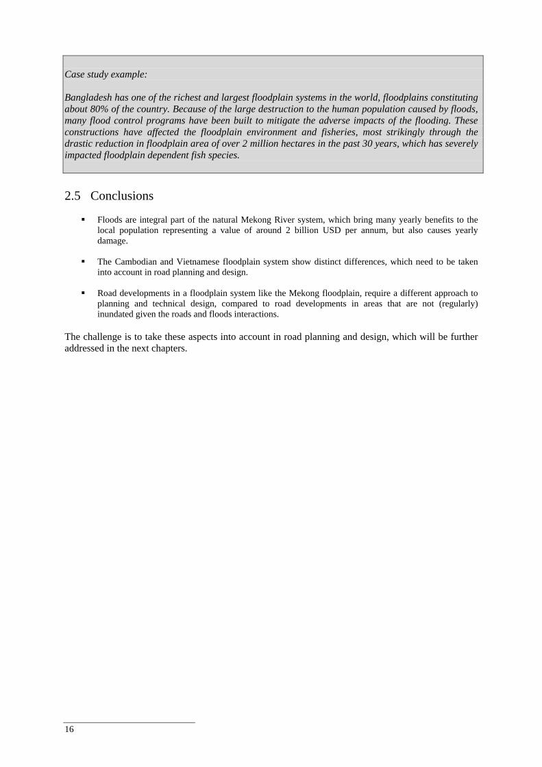
16
Case study example: Bangladesh has one of the richest and largest floodplain systems in the world, floodplains constituting about 80% of the country. Because of the large destruction to the human population caused by floods, many flood control programs have been built to mitigate the adverse impacts of the flooding. These constructions have affected the floodplain environment and fisheries, most strikingly through the drastic reduction in floodplain area of over 2 million hectares in the past 30 years, which has severely impacted floodplain dependent fish species. 2.5 Conclusions
Floods are integral part of the natural Mekong River system, which bring many yearly benefits to the local population representing a value of around 2 billion USD per annum, but also causes yearly damage.
The Cambodian and Vietnamese floodplain system show distinct differences, which need to be taken
into account in road planning and design.
Road developments in a floodplain system like the Mekong floodplain, require a different approach to planning and technical design, compared to road developments in areas that are not (regularly) inundated given the roads and floods interactions.
The challenge is to take these aspects into account in road planning and design, which will be further addressed in the next chapters.
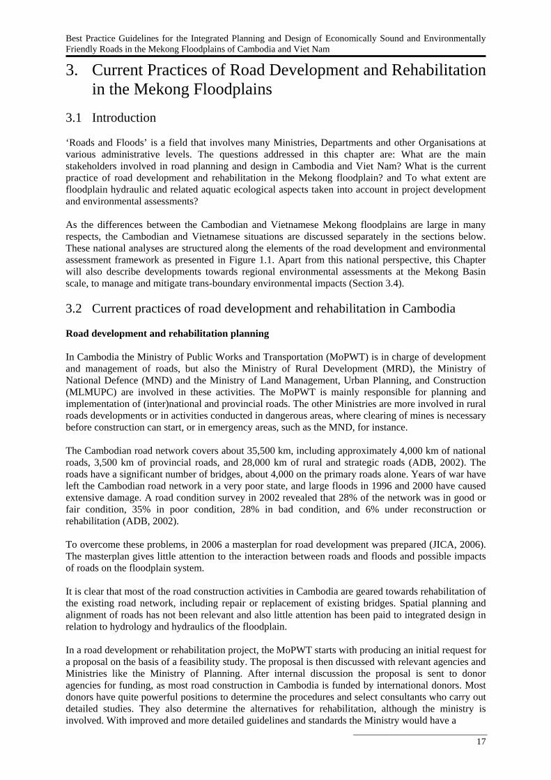
Best Practice Guidelines for the Integrated Planning and Design of Economically Sound and Environmentally Friendly Roads in the Mekong Floodplains of Cambodia and Viet Nam
17
3. Current Practices of Road Development and Rehabilitation in the Mekong Floodplains
3.1 Introduction ‘Roads and Floods’ is a field that involves many Ministries, Departments and other Organisations at various administrative levels. The questions addressed in this chapter are: What are the main stakeholders involved in road planning and design in Cambodia and Viet Nam? What is the current practice of road development and rehabilitation in the Mekong floodplain? and To what extent are floodplain hydraulic and related aquatic ecological aspects taken into account in project development and environmental assessments? As the differences between the Cambodian and Vietnamese Mekong floodplains are large in many respects, the Cambodian and Vietnamese situations are discussed separately in the sections below. These national analyses are structured along the elements of the road development and environmental assessment framework as presented in Figure 1.1. Apart from this national perspective, this Chapter will also describe developments towards regional environmental assessments at the Mekong Basin scale, to manage and mitigate trans-boundary environmental impacts (Section 3.4). 3.2 Current practices of road development and rehabilitation in Cambodia Road development and rehabilitation planning In Cambodia the Ministry of Public Works and Transportation (MoPWT) is in charge of development and management of roads, but also the Ministry of Rural Development (MRD), the Ministry of National Defence (MND) and the Ministry of Land Management, Urban Planning, and Construction (MLMUPC) are involved in these activities. The MoPWT is mainly responsible for planning and implementation of (inter)national and provincial roads. The other Ministries are more involved in rural roads developments or in activities conducted in dangerous areas, where clearing of mines is necessary before construction can start, or in emergency areas, such as the MND, for instance. The Cambodian road network covers about 35,500 km, including approximately 4,000 km of national roads, 3,500 km of provincial roads, and 28,000 km of rural and strategic roads (ADB, 2002). The roads have a significant number of bridges, about 4,000 on the primary roads alone. Years of war have left the Cambodian road network in a very poor state, and large floods in 1996 and 2000 have caused extensive damage. A road condition survey in 2002 revealed that 28% of the network was in good or fair condition, 35% in poor condition, 28% in bad condition, and 6% under reconstruction or rehabilitation (ADB, 2002). To overcome these problems, in 2006 a masterplan for road development was prepared (JICA, 2006). The masterplan gives little attention to the interaction between roads and floods and possible impacts of roads on the floodplain system. It is clear that most of the road construction activities in Cambodia are geared towards rehabilitation of the existing road network, including repair or replacement of existing bridges. Spatial planning and alignment of roads has not been relevant and also little attention has been paid to integrated design in relation to hydrology and hydraulics of the floodplain. In a road development or rehabilitation project, the MoPWT starts with producing an initial request for a proposal on the basis of a feasibility study. The proposal is then discussed with relevant agencies and Ministries like the Ministry of Planning. After internal discussion the proposal is sent to donor agencies for funding, as most road construction in Cambodia is funded by international donors. Most donors have quite powerful positions to determine the procedures and select consultants who carry out detailed studies. They also determine the alternatives for rehabilitation, although the ministry is involved. With improved and more detailed guidelines and standards the Ministry would have a
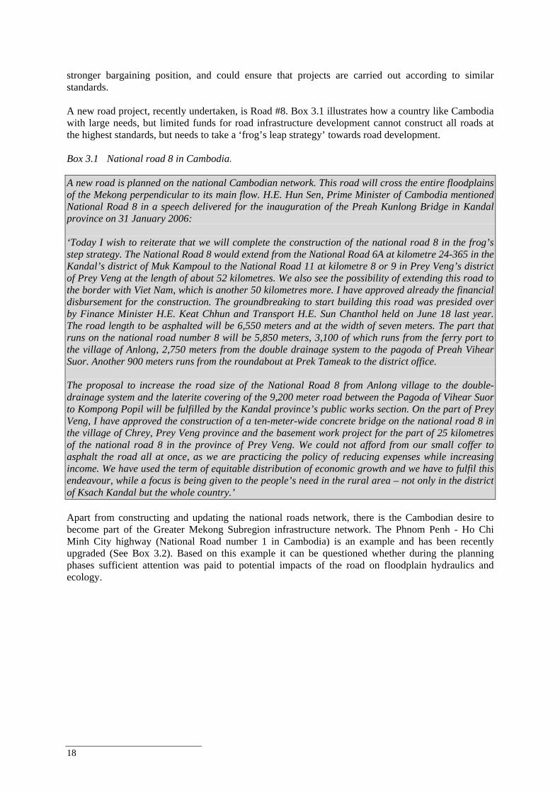
18
stronger bargaining position, and could ensure that projects are carried out according to similar standards. A new road project, recently undertaken, is Road #8. Box 3.1 illustrates how a country like Cambodia with large needs, but limited funds for road infrastructure development cannot construct all roads at the highest standards, but needs to take a ‘frog’s leap strategy’ towards road development. Box 3.1 National road 8 in Cambodia. A new road is planned on the national Cambodian network. This road will cross the entire floodplains of the Mekong perpendicular to its main flow. H.E. Hun Sen, Prime Minister of Cambodia mentioned National Road 8 in a speech delivered for the inauguration of the Preah Kunlong Bridge in Kandal province on 31 January 2006: ‘Today I wish to reiterate that we will complete the construction of the national road 8 in the frog’s step strategy. The National Road 8 would extend from the National Road 6A at kilometre 24-365 in the Kandal’s district of Muk Kampoul to the National Road 11 at kilometre 8 or 9 in Prey Veng’s district of Prey Veng at the length of about 52 kilometres. We also see the possibility of extending this road to the border with Viet Nam, which is another 50 kilometres more. I have approved already the financial disbursement for the construction. The groundbreaking to start building this road was presided over by Finance Minister H.E. Keat Chhun and Transport H.E. Sun Chanthol held on June 18 last year. The road length to be asphalted will be 6,550 meters and at the width of seven meters. The part that runs on the national road number 8 will be 5,850 meters, 3,100 of which runs from the ferry port to the village of Anlong, 2,750 meters from the double drainage system to the pagoda of Preah Vihear Suor. Another 900 meters runs from the roundabout at Prek Tameak to the district office. The proposal to increase the road size of the National Road 8 from Anlong village to the double-drainage system and the laterite covering of the 9,200 meter road between the Pagoda of Vihear Suor to Kompong Popil will be fulfilled by the Kandal province’s public works section. On the part of Prey Veng, I have approved the construction of a ten-meter-wide concrete bridge on the national road 8 in the village of Chrey, Prey Veng province and the basement work project for the part of 25 kilometres of the national road 8 in the province of Prey Veng. We could not afford from our small coffer to asphalt the road all at once, as we are practicing the policy of reducing expenses while increasing income. We have used the term of equitable distribution of economic growth and we have to fulfil this endeavour, while a focus is being given to the people’s need in the rural area – not only in the district of Ksach Kandal but the whole country.’ Apart from constructing and updating the national roads network, there is the Cambodian desire to become part of the Greater Mekong Subregion infrastructure network. The Phnom Penh - Ho Chi Minh City highway (National Road number 1 in Cambodia) is an example and has been recently upgraded (See Box 3.2). Based on this example it can be questioned whether during the planning phases sufficient attention was paid to potential impacts of the road on floodplain hydraulics and ecology.
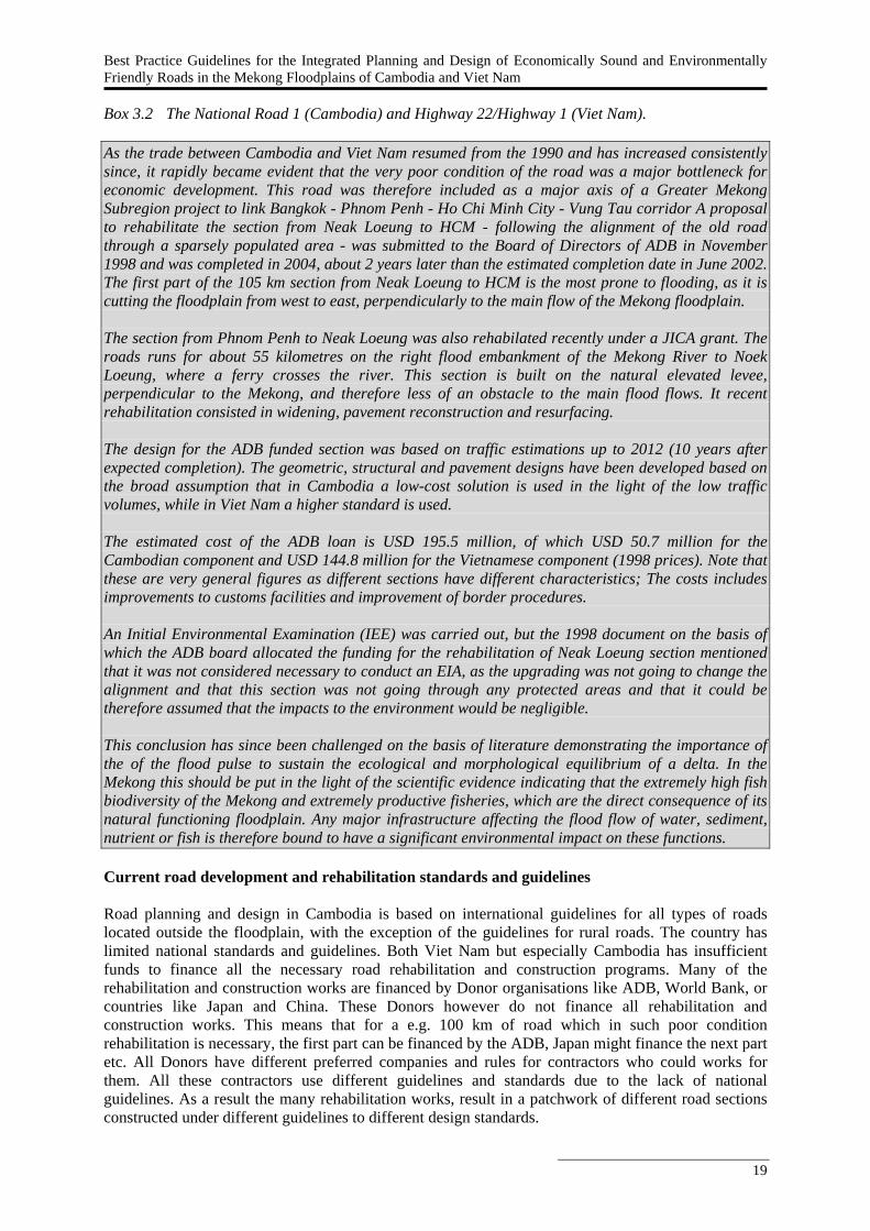
Best Practice Guidelines for the Integrated Planning and Design of Economically Sound and Environmentally Friendly Roads in the Mekong Floodplains of Cambodia and Viet Nam
19
Box 3.2 The National Road 1 (Cambodia) and Highway 22/Highway 1 (Viet Nam). As the trade between Cambodia and Viet Nam resumed from the 1990 and has increased consistently since, it rapidly became evident that the very poor condition of the road was a major bottleneck for economic development. This road was therefore included as a major axis of a Greater Mekong Subregion project to link Bangkok - Phnom Penh - Ho Chi Minh City - Vung Tau corridor A proposal to rehabilitate the section from Neak Loeung to HCM - following the alignment of the old road through a sparsely populated area - was submitted to the Board of Directors of ADB in November 1998 and was completed in 2004, about 2 years later than the estimated completion date in June 2002. The first part of the 105 km section from Neak Loeung to HCM is the most prone to flooding, as it is cutting the floodplain from west to east, perpendicularly to the main flow of the Mekong floodplain. The section from Phnom Penh to Neak Loeung was also rehabilated recently under a JICA grant. The roads runs for about 55 kilometres on the right flood embankment of the Mekong River to Noek Loeung, where a ferry crosses the river. This section is built on the natural elevated levee, perpendicular to the Mekong, and therefore less of an obstacle to the main flood flows. It recent rehabilitation consisted in widening, pavement reconstruction and resurfacing. The design for the ADB funded section was based on traffic estimations up to 2012 (10 years after expected completion). The geometric, structural and pavement designs have been developed based on the broad assumption that in Cambodia a low-cost solution is used in the light of the low traffic volumes, while in Viet Nam a higher standard is used. The estimated cost of the ADB loan is USD 195.5 million, of which USD 50.7 million for the Cambodian component and USD 144.8 million for the Vietnamese component (1998 prices). Note that these are very general figures as different sections have different characteristics; The costs includes improvements to customs facilities and improvement of border procedures. An Initial Environmental Examination (IEE) was carried out, but the 1998 document on the basis of which the ADB board allocated the funding for the rehabilitation of Neak Loeung section mentioned that it was not considered necessary to conduct an EIA, as the upgrading was not going to change the alignment and that this section was not going through any protected areas and that it could be therefore assumed that the impacts to the environment would be negligible. This conclusion has since been challenged on the basis of literature demonstrating the importance of the of the flood pulse to sustain the ecological and morphological equilibrium of a delta. In the Mekong this should be put in the light of the scientific evidence indicating that the extremely high fish biodiversity of the Mekong and extremely productive fisheries, which are the direct consequence of its natural functioning floodplain. Any major infrastructure affecting the flood flow of water, sediment, nutrient or fish is therefore bound to have a significant environmental impact on these functions. Current road development and rehabilitation standards and guidelines Road planning and design in Cambodia is based on international guidelines for all types of roads located outside the floodplain, with the exception of the guidelines for rural roads. The country has limited national standards and guidelines. Both Viet Nam but especially Cambodia has insufficient funds to finance all the necessary road rehabilitation and construction programs. Many of the rehabilitation and construction works are financed by Donor organisations like ADB, World Bank, or countries like Japan and China. These Donors however do not finance all rehabilitation and construction works. This means that for a e.g. 100 km of road which in such poor condition rehabilitation is necessary, the first part can be financed by the ADB, Japan might finance the next part etc. All Donors have different preferred companies and rules for contractors who could works for them. All these contractors use different guidelines and standards due to the lack of national guidelines. As a result the many rehabilitation works, result in a patchwork of different road sections constructed under different guidelines to different design standards.
20
There have been two donor-financed studies to develop guidelines; the Cambodian Road Standards of the Ministry of Public Works and Transportation (AusAID) and guidelines for the design of rural roads of the Ministry of Rural Development (ADB). Cambodia is currently in a process of harmonizing road standards and guidelines, focused at re-settlement issues, with the support of development banks like the ADB. This project could pave the path to harmonization of other aspects of road standards in Cambodia such as environmental impacts. In road planning and design in Cambodia the floodplain is only considered from a hydraulics perspective focusing exclusively on stability, damage and passability of roads during floods. The impact of the road on the floodplain dynamics or ecology of the floodplains (hence beyond the immediate vicinity of the road) is often not included. The MRD guidelines for rural roads are an exception as they do include to some extent floodplain dynamics. Environmental assessments of road development and rehabilitation The first EIA legislation in Cambodia started in 1995. Main responsible agency is the Ministry of Environment (MoE) that was established in 1993. The different stages of the Cambodian EIA and the responsible parties are listed in Table 3.1. The screening to evaluate if an EIA or Initial Environmental Examination (IEE) is required is undertaken by the project proponent in accordance with the 1999 Sub Decree. Table 3.1 Organizations responsible for EIA in Cambodia and Viet Nam (ERM and MRC, 2002).
EIA steps Cambodia
Viet Nam
Screening Project proponent via the relevant Ministry or Department
National Environment Agency; MoSTE (at national level) or DoSTE (at regional level)
Completing the EIA study Project proponent via the relevant Ministry or Department
Project proponent
Reviewing the EIS
Ministry of Environment
Appraisal Council (set up by MoSTE/DoSTE)
Approving the EIS
Ministry of Environment
MoSTE - at national level DoSTE - at regional level
The road and embankment projects mentioned in the 1999 Sub Decree are (ERM and MRC, 2002): construction of bridge roads (> 30 Tons weight), and national road construction (> 100 km). Hence, EIA is not necessary for rural and provincial roads as well as the rehabilitation of roads. In general, environmental aspects are taken into account only at the construction stage. Broader environmental issues, like fish migration routes and the impact on the agriculture, are hardly taken into account. Box 3.3 presents some results of a review of EIA reports of structural developments around Tonle Sap (Baran et al. 2007b). It shows that environmental impacts to the Tonle Sap system are not sufficiently taken into account in most EIS’s.
Best Practice Guidelines for the Integrated Planning and Design of Economically Sound and Environmentally Friendly Roads in the Mekong Floodplains of Cambodia and Viet Nam
21
Box 3.3 Review of EIA process in Tonle Sap region (Baran et al., 2007b). Environmental Impact Assessments (EIAs) should be improved for Tonle Sap infrastructure projects that may have a significant impact on water and aquatic resources. Access to Environmental Impact Assessments for Tonle Sap development projects is difficult, reports being scattered across various ministries and provincial and district government offices or with project developers. Very few are available at the Ministry of Environment or other relevant Ministries. Assessments are not systematically recorded or classified. The study evaluated in detail only 10 reports, mostly involving projects funded by external donors. Reports for other projects were unavailable because they were either inaccessible or did not exist. Tonle Sap EIA’s tend to be narrowly focused, covering a fraction of the area, the resources, the time period, and the people possibly impacted. These EIA’s are often geographically limited to the project area, which provides at best a partial estimate of the impact on fisheries. They tend to be narrowly focused on short-term biological and physical changes to water flows and fish; few assessments mention other aquatic resources like crabs, shrimps and snails - important sources of food for many people, especially the poor. They neglect longer-term impacts on the ecological system and livelihoods. Moreover, they do not systematically address socioeconomic consequences of impacts on fisheries and there are wide variations in coverage. Last, participation of stakeholders is generally very limited due to lack of a systematic mechanism for the consultation of local communities, provincial authorities, and local or international NGOs in the EIA process. There is a sectoral guideline for roads and highways under development financed by Swedish International Development Agency. Apart from the Cambodian EIA guidelines, ADB and JICA use their own EIA procedures. ERM and MRC (2002) conclude that EIA experience in Cambodia is limited, EIA requirements are not well known or used within the government agencies. There is limited capacity to conduct EIA and environmental issues are seen by many parties as secondary in comparison with the need of development. The EIA department under the Ministry of Land Management, Urban Planning, and Construction has not been involved yet in RN8 development, due to lack of funds and capacity. The result is limited awareness among the Cambodian people (specifically the public) regarding environmental issues arising from road developments. The inexperience and low priority within the responsible governmental bodies is illustrated by the fact that the government considered an EIA not necessary for the construction of NR8. The same is seen in rehabilitation works; an environmental impact assessment is in many cases not considered necessary as it is assumed that the improved roads would not cause any (new) impacts on the environment (see, for instance the Emergency Flood Rehabilitation Project). The MoE also reported that it hardly had any influence to change designs if the environmental impacts are negative, although they do suggest considering alternative designs. Their intention is to consider local and regional impacts, as well as impacts during construction and operational stages of roads. However, they suffer from insufficient funding, even for developing guidelines. Main conclusions Cambodia
Inclusion of natural floodplain dynamics in transport and road planning and management is limited, particularly the impacts or disturbance of the floodplain hydraulics on sub-floodplain level are not taken into consideration (with the exception of the MRD guidelines for rural roads). Impacts as far as they affect the stability of and damage to the road under construction are considered.
Road planning and design is based on international guidelines for all types of roads located outside the floodplain, with the exception of the national guidelines for rural roads. As a result, different sections of the same road could be constructed under different international criteria depending on the choice of funding donors.
There is a need for harmonisation of standards and guidelines and inclusion of the specifics of developing roads in a dynamic floodplain system.
Cambodia has an EIA system in place, although experience in its application, is limited. In EIA, environmental aspects are only taken into account as far as it concerns the construction stage of the road.
22
3.3 Current practices of road development and rehabilitation in Viet Nam Road development and rehabilitation planning In Viet Nam the Ministry of Transportation (MoT) is the main actor in road infrastructure development at the national level, while the Ministry of Construction (MoC) for the planning of rural and regional roads. The Road Administration (RA), under the MoT, is the national body in charge of the development of roads for the national network. The Road Administration is involved in the road development planning and approves designs which are made by consultants and contractors according to the Vietnamese standards. The Sub-institute for Transportation Science and Technology, operating under the Road Administration, is responsible for the planning and design for both national and provincial roads and bridges. Their activities concern both construction of new roads and rehabilitation of existing roads. At the provincial or local levels roads are managed by the PPC. The national highway network in Vietnamese Mekong Delta covers about 700 km. The road condition ranges from poor to good (MoT/Worldbank, 2005). Very poor sections are mostly secondary links with low traffic volume. In recent years, some sections of the national highway network have been rehabilitated and/or upgraded. One example, is the section of highway 1A between Ho Chi Minh City and Vinh Long, of which a part runs through the Mekong floodplain. At the end of 2005 the sections between Can Tho and Ca Mau of highway 1A and between Can Tho and Go Quao of highway 61 were being upgraded. The provincial road network is about 2,400 km and nearly half of this is in fair to good condition (MoT/Worldbank, 2005). Very poor sections are mostly secondary links with low traffic volume. Many roads are however not passable during the flooding season, either because of floods level or inadequate rain drainage. Many households cannot be accessed by roads and use boats as the main means of transport. The Vietnamese government has formulated a project with the World Bank to upgrade the transportation network (including waterways), the Mekong Transport Infrastructure Development Project (MTIDP). Rehabilitation and reconstruction of bridges is evaluated for each road section individually. For provincial roads the policy is to maintain roads at tolerable standards and ensuring roads remain passable all year round. This implies that many dirt tracks need to be upgraded to roads. The MTIDP project has defined a preliminary short-list of priority projects. These include sections of national roads 54, 80 and 91 totalling 149 km. For provincial roads 13 sections have been proposed, about 245 km in total. Road planning should be in compliance with flood control planning. Implicitly, this means that existing standards such as the design standards of river dykes and sea dykes should be considered. Current road development and rehabilitation standards and guidelines In Viet Nam, an extensive set of road construction and design standards is used (Verheij and Van der Ruyt, in prep.). The specifications and guidelines for road design are based on the AASHTO Guide for design of pavement structures, 1993 and very detailed. For the national roads the most comprehensive and extensively used manuals are the TCN’s: 22TCN-273-01 for guidelines for road design, 22TCN-273-01 for the design of flexible pavements, and 22TCN-272-05 for Bridge Design. The impression is that they are adjusted to the Vietnamese situation, however, they are not particularly aiming at planning and rehabilitation of roads in flood plains. Although they recommend taking into account the effect of a proposed bridge on flood flow patterns, the potential for creating new or augmenting existing flood hazards, and the environmental aspects, particular guidance is not presented in the road and bridge manuals. From the interviews it seems that in road planning and design floodplain hydraulics as far as it affects the stability of or damage to the road were considered, and if the road remains passable during a flood. Effects of the road on the floodplain hydraulics and ecology in a larger area than only the vicinity of the road is not directly considered. The guidelines also prescribe the execution of EIA (see next section). In practice, environmental aspects in Viet Nam are mainly taken into account as far as it concerns the construction stage of the road. Furthermore, Viet Nam has standards for design of river or sea dikes, which can be useful since most of the roads are on top of an
Best Practice Guidelines for the Integrated Planning and Design of Economically Sound and Environmentally Friendly Roads in the Mekong Floodplains of Cambodia and Viet Nam
23
embankment which is comparable with a river or sea dike. Environmental assessments of road development and rehabilitation Environmental assessment in Viet Nam was first mentioned in the Law on Environmental Protection (1993) and its implementation further elaborated in various legal documents since then. EIA is required for a number of projects, as well as at a more strategic level for regional development plans and strategies, plans for development of provinces and cities under central government and strategies for urban and population development (ERM and MRC, 2002). The National Ministry of Natural Resources and Environment (MONRE) is responsible for the EIA process in Viet Nam. The main steps in the Vietnamese EIA system are screening, scoping, preparation of detailed EIA, and appraisal of EIA report. Table 3.1 presents the responsibilities for each step. Screening is the process to determine if an EIA is needed for a particular project. Projects are classified into two categories in Viet Nam: Category 1 projects which have an impact on the environment and for which an EIA report is mandatory and Category 2 projects for which no EIA is required. The road and embankments projects requiring submission of an EIA report for appraisal and approval in Viet Nam are: railways, highways, roads for car transportation (from level I to level III according to the standard TCVN 4054-85) with length greater than 50 km. (ERM and MRC, 2002). There is limited guidance on how to carry out an EIA, as a result international or donor standards or guidelines are often used. The execution of EIA and SEA (Strategic Environment Assessment) are included in the revised Law on Environment Protection in 2006, then MONRE has issued a Circular to guide the implementation of the Law. Viet Nam has a separate guideline for EIA of transportation projects developed by Ministry of Science, Technology and Environment in 1999, particularly for roads, railways, and bridges and sluices. Environmental aspects, according to the guideline, should be taken into account for the whole span of a project, including 3 stages: stage of selection and preparation of construction site, construction stage, and operation stage. In all the stages, all aspects including hydraulic regime of water bodies, soil, status of natural resources like aquatic, forestry and wildlife are taken into account. In the guideline for EIA of transportation projects developed by Ministry of Science, Technology and Environment in 1999, wetlands and floodplains are not mentioned. The EIA’s are undertaken by consultants on behalf of the investor. The EIA report has to be submitted together with the technical design report. If funds are insufficient the design should be modified i.e. cheaper mitigating measures for reducing environmental impact and a new approval procedure is required. Monitoring of environmental effects is carried out during the first 3 years and done by the management departments of the Ministry of Transport. MONRE receives these reports. Environmental aspects of road development under MTIDP (MoT/World Bank, 2005) will be studied under separate environmental assessment studies. The chapter on environmental assessment does list a number of environmental aspects, mainly related to impacts during construction of the roads. MoT (2004) gives an environmental review of the Mekong Transport and Flood Protection (MTFP) project, mainly focusing on impacts during construction, but also with some reference to through-flow capacity of the road (upgrade existing culverts and add new ones) to relieve the water flow. Despite the sectoral guidelines produced by MoSTE and other guidelines available in Viet Nam (e.g. from donor-financed projects), the effectiveness and quality of EIA reports is still limited (ERM and MRC, 2002). Many research centres who carried out and/or were consulted in the EIA preparation process appear reluctant to show their data or their EIA’s and the EIA divisions in the NEA and provincial Department of Science, Technology and environment (DoSTEs) only collect paper copies of EIAs (ERM and MRC, 2002).
24
Main conclusions Viet Nam
Viet Nam has a comprehensive set of road construction standards, but they are not particularly aiming
at planning and rehabilitation of roads in floodplains. Although they recommend taking into account the effect of a proposed bridge on flood flow patterns, the potential for creating new or augmenting existing flood hazards, and the environmental aspects, detailed and specific guidance in what way this should be done is not presented in the manuals.
Inclusion of natural floodplain dynamics in infrastructure policies, plans and programmes is limited,
particularly the impacts or disturbance of the floodplain hydraulics on sub-floodplain level are not taken into account.
There is a need for harmonisation of standards and guidelines and inclusion of the specifics of
developing roads in a dynamic floodplain system.
There is an EIA as well as SEA system in place in Viet Nam. Viet Nam also has a sectoral EIA guideline of transportation projects, although wetlands and floodplains are not mentioned.
Various ministries and agencies in Viet Nam are involved in road infrastructure planning. There is a
need for better cooperation. 3.4 Environmental assessments at the Mekong Basin level Beside of national legislation regulating the environmental assessment procedures within their borders, the Mekong riparian countries tries to find ways for cooperation at the basin level in the fields related to harmonisation of their environmental assessments. This basin level perspective on environmental assessments is particularly relevant when dealing with transboundary impacts of wide range. As roads can also cause transboundary environmental impacts, this section presents some of the regional developments in this field. Environmental assessments of the donor countries In general, procedures for environmental assessments by the donor countries active in the Lower Mekong Basin appear to be similar to those adopted by the member countries of the MRC (ERM and MRC, 2002). ERM and MRC (2002) also note a number of differences between the donor EA systems and the MRC riparian countries systems. First, the decision-making framework that supports implementation of the donors’ EA systems, is different. The donors are individual, decision-making bodies who have ultimate control over what developments they will support in contrast to the four separate MRC jurisdictions that are involved in decision-making. The donor procedures relate to project-level activities and those at programme, plan and policy levels and do not provide a specific model for EA in a transboundary context. Finally, because of the very wide audience that needs to use and understand the EA requirements of the donor agencies, they have issued an extensive range of guidance scrutinized by the development and NGO community (ERM and MRC, 2002). Towards a EIA/SEA system for the Lower Mekong Basin The MRC Agreement 1995 laid the foundation for the establishment and improvement of environmental assessments in the Lower Mekong Basin. In 1998, the Secretariat proposed an MRC Environmental Policy and an outline of a method for EIA specifically focusing on the prevention and mitigation of transboundary environmental impacts. This outline was further detailed in ERM and MRC (2002) that provide initial technical background information for the development of an EIA/SEA system appropriate to the Lower Mekong Basin. The types of activities and developments specifically examined in this study are those that are of most relevance to the sustainable development and protection of the water and related resources of the lower Mekong River. These are the construction and operation of hydropower dams, inland navigation, ports and harbours, agriculture and irrigation, and flood management. Road infrastructure development, the subject of the report at hand, was not explicitly mentioned as a main activity relevant to the development and protection of the Mekong’s water and related resources.
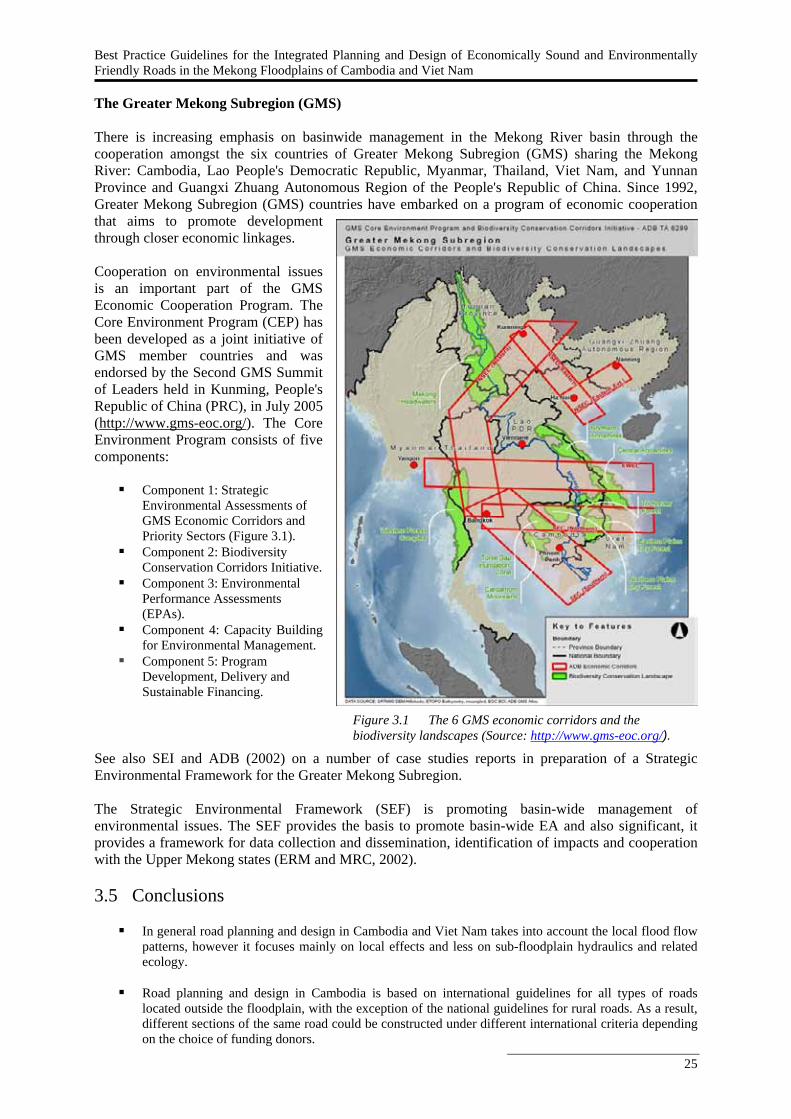
Best Practice Guidelines for the Integrated Planning and Design of Economically Sound and Environmentally Friendly Roads in the Mekong Floodplains of Cambodia and Viet Nam
25
Figure 3.1 The 6 GMS economic corridors and the biodiversity landscapes (Source: http://www.gms-eoc.org/).
The Greater Mekong Subregion (GMS) There is increasing emphasis on basinwide management in the Mekong River basin through the cooperation amongst the six countries of Greater Mekong Subregion (GMS) sharing the Mekong River: Cambodia, Lao People's Democratic Republic, Myanmar, Thailand, Viet Nam, and Yunnan Province and Guangxi Zhuang Autonomous Region of the People's Republic of China. Since 1992, Greater Mekong Subregion (GMS) countries have embarked on a program of economic cooperation that aims to promote development through closer economic linkages. Cooperation on environmental issues is an important part of the GMS Economic Cooperation Program. The Core Environment Program (CEP) has been developed as a joint initiative of GMS member countries and was endorsed by the Second GMS Summit of Leaders held in Kunming, People's Republic of China (PRC), in July 2005 (http://www.gms-eoc.org/). The Core Environment Program consists of five components:
Component 1: Strategic Environmental Assessments of GMS Economic Corridors and Priority Sectors (Figure 3.1).
Component 2: Biodiversity Conservation Corridors Initiative.
Component 3: Environmental Performance Assessments (EPAs).
Component 4: Capacity Building for Environmental Management.
Component 5: Program Development, Delivery and Sustainable Financing.
See also SEI and ADB (2002) on a number of case studies reports in preparation of a Strategic Environmental Framework for the Greater Mekong Subregion. The Strategic Environmental Framework (SEF) is promoting basin-wide management of environmental issues. The SEF provides the basis to promote basin-wide EA and also significant, it provides a framework for data collection and dissemination, identification of impacts and cooperation with the Upper Mekong states (ERM and MRC, 2002). 3.5 Conclusions
In general road planning and design in Cambodia and Viet Nam takes into account the local flood flow patterns, however it focuses mainly on local effects and less on sub-floodplain hydraulics and related ecology.
Road planning and design in Cambodia is based on international guidelines for all types of roads
located outside the floodplain, with the exception of the national guidelines for rural roads. As a result, different sections of the same road could be constructed under different international criteria depending on the choice of funding donors.

26
Viet Nam has a comprehensive set of road construction standards, but they are not particularly aiming
at planning and rehabilitation of roads in floodplains. Although they recommend taking into account the effect of a proposed bridge on flood flow patterns, the potential for creating new or augmenting existing flood hazards, and the environmental aspects, detailed and specific guidance in what way this should be done is not presented in the manuals.
The review also shows that infrastructure investment budgets and operation and maintenance and
damage repair budgets are separated in both countries. This implies that an integrated financial assessment - integrated in terms of investment, operation and maintenance, damage risk – is difficult, which hampers a more efficient use of limited financial resources.
Both Viet Nam and Cambodia have an EIA system in place, although experience in its application,
particularly in Cambodia, is limited. There are developments towards an environmental assessment system for the LMB addressing the trans-boundary dimension at basin level.
It can be concluded that there is a need for better guidance of road development and rehabilitation in the
Mekong floodplains in both countries.
Best Practice Guidelines for the Integrated Planning and Design of Economically Sound and Environmentally Friendly Roads in the Mekong Floodplains of Cambodia and Viet Nam
27
4. Road Development in Floodplains: Balancing Economic, Social and Environmental Dimensions
4.1 Introduction The key issues of the Mekong floodplain system and its interactions with floods have been presented in Chapter 2. Chapter 3 showed that road planning and design practice in Cambodia and Viet Nam needs to better consider interactions with the floods in terms of road damage and ecological damage. This Chapter will start with an overview of regional and international guidance on developments in floodplain systems based on literature review (Section 4.2). To address the challenge of road development in the vulnerable Mekong floodplains there is a need for an integrated approach in road planning and design, which will be further discussed in Section 4.3. 4.2 International practice on planning and design of structures in floodplains Road planning and design principles There is a large number of publications discussing road planning and design principles (e.g., Brockenbrough and Boedecker, 2003; EMU, 2004; Jackson, 2003; Walder, 2005). The documents found for the literature study discuss the planning and design principles from a wide range of perspectives: some are purely technical, some analyse environmental impacts, while others focus on tools and methodologies for design. Road planning and design and the environment Various studies within these address impacts of developments on floods and hydraulics in general. Some studies specifically mention effects of roads on floods, though a systematic study has not been carried out yet (e.g., Hoban and Tsunokawa, 1997; Konrad and Booth, 2002; Transportation Research Board of the National Academies, 2003). See also Kruskopf (2006) on impacts of structures on fish (Section 2.4). In the international literature many standards and guidelines can be found for developments in environmentally sensitive areas. No specific standards or guidelines, however, exist other than engineering guidelines to avoid flood damage to a road or guidelines to deal with environmental effects of roads (Asian Development Bank, 1993). The topic that comes closest to the Roads and Floods project is the discussion of standards and guidelines for road construction in wetland areas (Marble and Riva, 2002) and stream and river crossing standards (MRSCSC, 2004). Environmental assessment guidance There is a broad range of environmental assessment guidelines available. These guidelines assist stakeholders involved in development projects - project proponents and developers, EIA practitioners, environmental agencies, research institutes and universities - to manage and mitigate environmental impacts of development projects. Most guidance is given to development projects in general, whereas larger road constructions often require an EIA (Environmental Agency, 2006; Nairn and Fossitt, 2001). To a limited extent guidelines address the interaction between roads and surface water or floods specifically. Box 4.1 and 4.2 present some examples from international guidelines. The examples cover both direct impacts to the water environment and indirect impacts to its dependent ecosystems.
28
Box 4.1 Example of scoping guidelines for surface water of Australia (source:
http://www.dpi.vic.gov.au/CA256F310024B628/0/9DB9D60517A6DA42CA2573060008403C/$File/Assessment+Scoping+Guidelines+Geelong+Bypass.pdf).
The Environment Effects Statement (EES) should assess potential impacts related to surface drainage, water quality, flooding/hydrology, and the conditions and ecology of floodplains and waterways. Specifically the EES should: Assess the existing conditions of waterways including the Barwon River, Armstrong Creek and Waurn Ponds Creek,
floodplains and drainage paths in the vicinity of the road alternatives. Assess the existing hydraulic behaviour of drainage paths, waterways and floodplains, with particular reference to
known and potential flood levels in the vicinity of the road alternatives. Identify and assess the potential short- and long-term impacts of construction and operation of the Proposal on the
quantity and quality of surface runoff, floodplain inundation and waterway water quality, as well as on the hydrology and character of local waterway and floodplain environments.
Detail the proposed short- and long-term environmental mitigation measures to minimise the impact of the construction and operation of the Proposal on waterway functions and values.
The EES will need to address all relevant requirements for managing discharges and protecting water quality, in the context of the State Environment Protection Policy (Waters of Victoria), floodplain management plans and other water-related policies and strategies. Box 4.2 DMRB guidance of the UK. Guidance given in the Design Manual for Roads and Bridges (DMRB) indicates that any environmental assessment of roads crossing a floodplain should consider both the potential flood risk and the area of functional floodplain lost. The guidance manual asks the following questions: ▪ Will the project affect an existing water course or floodplain? ▪ Will the project change either the road drainage or natural land drainage catcments? ▪ Will the project lead to an increase in traffic flow of more than 20%? ▪ Will the project change the number or type of junctions? ▪ Is any of the project located within an Indicative Floodplain or Source Protection Zone? ▪ Will earthworks result in sediment being carried to watercourses? ▪ Will the project allow drainage discharges to the ground? If the answer to any of the above questions is yes then some form of assessment, ranging from hydrological to hydraulic study should be undertaken with liaison with the relevant EPA. Further, the guidance states that if flood risk is increased (i.e. a resultant higher water level), then mitigation must be included to reduce the risk to an acceptable level. A range of measures may be considered for this purpose, however upstream and downstream impacts should be considered as well as the loss of functional floodplain area. Advice is then given on the design of these structures within the floodplain. The Ramsar convention on the conservation and wise use of wetlands (www.ramsar.org ) has various guidance on how to integrate conservation and wise use of wetlands in planning and management (Box 4.3). This concentrates on impacts on biodiversity and ecosystems. Box 4.3 Relevant Ramsar resolutions (www. ramsar.org). Guidelines for incorporating biodiversity-related issues into environmental impact assessment legislation and/or processes and in strategic environmental assessment’ adopted by the Convention on Biological Diversity (CBD), and their relevance to the Ramsar Convention, Resolution VIII.9. (Ramsar, 2002) An Integrated Framework for Wetland Inventory, Assessment and Monitoring (IF-WIAM), Resolution IX.1 Annex E. (Ramsar, 2005)
Best Practice Guidelines for the Integrated Planning and Design of Economically Sound and Environmentally Friendly Roads in the Mekong Floodplains of Cambodia and Viet Nam
29
Guidelines for integrating wetland conservation and wise use into river basin management, Resolution VII.18. (Ramsar, 1999) For the Mekong River many studies focussing on fish ecology related to the wetland and floodplain ecosystems have been carried out in the past decade (See Chapter 2; Poulsen et al., 2002; Kottelat 2001a; Baran et al. 2005, 2007a, 2007b; Halls et al. 2006; Hortle, 2007). Box 6.2 gives an example how this knowledge has resulted in a number of recommendations on how to maintain the fish stocks and ecosystem of the Mekong. Box 4.4 Recommendations for maintaining the fish stocks and ecosystem of the Mekong River
(Poulsen et al., 2002). ▪ In a complex, multi-species ecosystem, such as the Mekong River basin, single-species
management is not feasible. Instead, a more holistic ecosystem approach is suggested for management and planning. The migration systems mentioned above could be used as the initial, large-scale framework under which ecosystem attributes can be identified and, in turn, transboundary management and basin development planning can be implemented.
▪ The ecosystem attributes should be taken into account when assessing impacts of development
activities. A pre-requisite for impact assessments is a valuation of the impacted resource (e.g. migratory fishes) from a fishery perspective. Undertaking such a valuation of migratory fishes is extremely difficult because they are targeted throughout their distribution range in many different ways, and with many different fishing gears and operations. Given the scale and complexity of such an undertaking in the Mekong River, it is probably not possible to fully assess the economic value of migratory fishes.
▪ However, a partial assessment of value, together with an assessment of information gaps is in
many cases sufficient for planning and assessment purposes. It is also important to emphasize that in the decision-making process, qualitative information and knowledge from various sources should be included on equal terms with quantitative data. Furthermore, along with the direct value of fishery resources, the Mekong River ecosystem provides numerous intrinsic, non-quantifiable goods and services.
▪ To ensure that the Mekong River basin can continue to provide these important goods and
services, we propose that development planning and environmental assessment should be based on an ecosystem approach within which the ecological functioning, productivity and resilience of the ecosystem are maintained. Experiences from other river basins suggest that from an economic, social and environmental point of view, this is best way to utilise a river.
Developments in floodplains: resistance versus resilience strategies The topic of ‘Roads and Floods’ touches upon the discussion how one builds in a floodplain system. A common strategy is the so-called resistance strategy where embankments and roads are constructed to protect and/or extract areas from the influence of floods (Figure 4.1a). This strategy, however, has its disadvantages as pressure on the structure can be severe causing damage - thus high maintenance costs resulting from the inevitable repair - as well as the fact that the floodplain hydraulics are disrupted which negatively impacts on the floodplain ecosystem (Table 4.1). Also, water quality problems may arise because dirt and polluted water are no longer removed by the flood waters. Internationally there is increased attention for so-called resilience strategies in flood risk management (e.g. Bruijn de, 2005; Vis et al. 2003). The resilience strategy basically employs a more natural way to mitigate flood risk, as it aims at minimizing the consequences of floods, but at the same time intends to maintain the natural floodplain dynamics as much as possible. This strategy hence could present a way to sustainability. The hypothesis behind the resilience strategy in the light of this study is that although the strategy might requires higher initial investment, the longer term costs in terms of road damage and ecological impacts, will be lower.
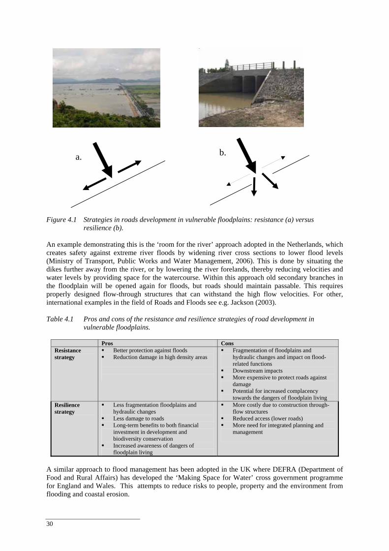
30
Figure 4.1 Strategies in roads development in vulnerable floodplains: resistance (a) versus
resilience (b). An example demonstrating this is the ‘room for the river’ approach adopted in the Netherlands, which creates safety against extreme river floods by widening river cross sections to lower flood levels (Ministry of Transport, Public Works and Water Management, 2006). This is done by situating the dikes further away from the river, or by lowering the river forelands, thereby reducing velocities and water levels by providing space for the watercourse. Within this approach old secondary branches in the floodplain will be opened again for floods, but roads should maintain passable. This requires properly designed flow-through structures that can withstand the high flow velocities. For other, international examples in the field of Roads and Floods see e.g. Jackson (2003). Table 4.1 Pros and cons of the resistance and resilience strategies of road development in
vulnerable floodplains.
Pros Cons Resistance strategy
Better protection against floods Reduction damage in high density areas
Fragmentation of floodplains and hydraulic changes and impact on flood-related functions
Downstream impacts More expensive to protect roads against
damage Potential for increased complacency
towards the dangers of floodplain living Resilience strategy
Less fragmentation floodplains and hydraulic changes
Less damage to roads Long-term benefits to both financial
investment in development and biodiversity conservation
Increased awareness of dangers of floodplain living
More costly due to construction through-flow structures
Reduced access (lower roads) More need for integrated planning and
management
A similar approach to flood management has been adopted in the UK where DEFRA (Department of Food and Rural Affairs) has developed the ‘Making Space for Water’ cross government programme for England and Wales. This attempts to reduce risks to people, property and the environment from flooding and coastal erosion.
b. a.
Best Practice Guidelines for the Integrated Planning and Design of Economically Sound and Environmentally Friendly Roads in the Mekong Floodplains of Cambodia and Viet Nam
31
The programme is arranged around four themes:
Holistic approach. Achieving sustainable development. Increasing resilience to flooding. Funding.
It aims to reduce vulnerability by ustilising a range of approaches to flood risk management from the provision of defences, flood forecasting and warning systems, increased flood resilience of property, to beneficial land management changes and discouragement of inappropriate development in areas at risk of flooding (DEFRA, 2008). A number of best practice examples can be found on the webbsite (DEFRA,2008) where recent land planning and resilience strategies have been employed with the purpose of reducing vulnerability. English (PPS25, Planning Policy Guidance) and Scottish guidance (SPP7 – Scottish Planning Policy) follows the same approach, which shapes development policy with regard to flood risk within the UK. The latter states that no new development should increase the probability of flooding elsewhere. This would require that the design of any bridge across a major river or floodplain would require to demonstrate minimal change to flood levels either upstream or downstream of the structure (www.sepa.org.uk/flooding ). These examples indicate the European trend towards a different approach to flood risk and resilience and this has recently been translated into a strategic directive at the European level. The EU Floods Directive 2007/60/EC controls the management of flood risk considerations within Member States. It requires that all members should assess flood risk (both fluvial and coastal), ascertain vulnerable people and assets and take measures to reduce the risk, with the focus on prevention, protection and preparedness. Sustainable flood management is now at the heart of the European strategic level approach to flooding and indicates the trend to towards the adoption of Integrated Flood Management principles. Integrated River Basin Management The discussion on the two strategies of road development in floodplains and their pros and cons shows the need for integration, as road development in floodplains relate to many aspects, including regional development, agriculture, ecology, water management, social welfare. Integrated Water Resources Management (IWRM) and Integrated Flood Risk Management (IFRM) are two concepts that adress this integration, although from different perspectives. Integrated Water Resources Management (IWRM) is based on the understanding that in order to promote efficiency, equity and ecological integrity of natural resources, an integrated approach to engineering, policies, institutional development and management is essential. IWRM, particularly in a region like the Mekong, implies allocation of water resources, implementation of strategies, and the operation of agencies and utilities in doing so. It brings together major technical and non technical aspects, including hydrological, biophysical, chemical, economic, institutional, legal, policy-making and planning aspects. Integrated River Basin Management (IRBM) can be considered as a tool to deliver IWRM at the basin scale (3rd World Water Forum). See also Box 4.5.
32
Box 4.5 Integrated Water Resources Management (IWRM) and Integrated River Basin Management
(IRBM). IWRM is a process that (GWP, 2000): ▪ Favours the co-ordinated management and development of water resources and of related land and other resources. ▪ For the purpose of maximising in an equitable way the economic and the resulting social welfare. ▪ Without compromising the sustainability of vital ecosystems. ‘IRBM is now recognized as the tool, perhaps the best tool, to deliver IWRM at the basin scale.’ (3rd World Water Forum) As many roads in the Lower Mekong Basin, particularly in Cambodia and Viet Nam, are built on levees, they also have the purpose of flood protection. Hence, the development and planning of roads is strongly related to Integrated Flood Risk Management. It is the immediate objective of FMMP Component 2 to reduce the vulnerability of people living in the LMB to the negative impacts of floods. It does so by establishing sustainable flood risk management capacity in the MRC, the MRCS, NMCs and national line agencies to effectively and appropriately address flood-related considerations in the BDP, other MRC programs and in national FMM programmes. Flood risk management is an approach to identify, analyse, evaluate, control and manage the flood risks in a given system (Inception report FMMP-C2; MRC, 2007d). The following steps are identified:
Definition of the system, the analysed hazards and the scale and scope of the analysis. A quantitative analysis where the probabilities and consequences are assessed and combined / displayed
into a risk number, a graph or a flood risk map (see also section 1.1.4). Risk evaluation: With the results of the former analyses the risk is evaluated. In this phase the decision
is made whether the risk is acceptable or not. Risk reduction and control: Dependent on the outcome of the risk evaluation measures can be taken to
reduce the risk. Measures can be structural or non-structural. It should also be determined how the risks can be controlled, for example by monitoring, inspection or maintenance.
Flood risk management measures should be evaluated based on their environmental impacts, hence there is a need to identify measures that on the one hand reduce flood risk and on the other hand maintain benefits of floods. 4.3 An integrated approach to road development and rehabilitation in
floodplains The question is how to develop infrastructures in a sensitive floodplain ecosystem as the Mekong Delta in a sustainable manner. This question becomes even more relevant as the population in the lower Mekong River basin is expected to rise from about 60 million to 100 million by 2025 and roads will be increasingly needed in the future. Considering the effects of road development and rehabilitation on the natural flood system, future developments should be addressed. Some development will be regional. Flood mitigation measures upstream such as protection dikes, drainage from protected areas (irrigation schemes, cities, towns) or flushing of flood water from reservoirs will increasingly affect flood conditions downstream. Land-use development and construction of roads and through-flow structures have changed the natural flood flow patterns and have increased flood risks to adjacent areas as well. Other developments will influence the whole Mekong basin, such as the greenhouse effect, the construction of dams with large reservoirs in the upstream catchments of the Mekong, and socio-economic effects. This all shows that road alignment and design in the Mekong floodplain needs more attention to reduce impacts on floodplain functions and values in order to maintain its vulnerable and highly valuable floodplain system. Figure 4.2 presents a framework for integrated analysis of road planning and design. The figure shows the relation between road development design and planning (A) and the various effects (B), and links this to the use of standards and guidelines (C). In road development and planning all effects should be
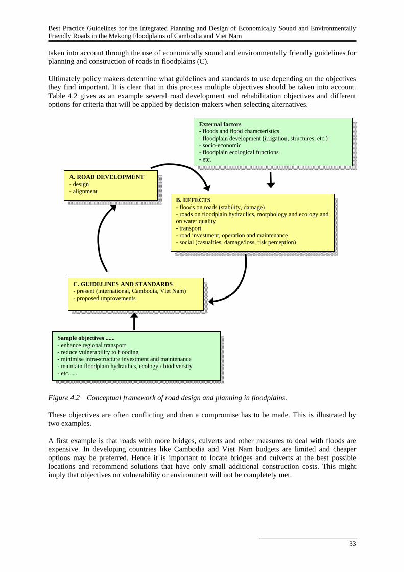
Best Practice Guidelines for the Integrated Planning and Design of Economically Sound and Environmentally Friendly Roads in the Mekong Floodplains of Cambodia and Viet Nam
33
taken into account through the use of economically sound and environmentally friendly guidelines for planning and construction of roads in floodplains (C). Ultimately policy makers determine what guidelines and standards to use depending on the objectives they find important. It is clear that in this process multiple objectives should be taken into account. Table 4.2 gives as an example several road development and rehabilitation objectives and different options for criteria that will be applied by decision-makers when selecting alternatives. Figure 4.2 Conceptual framework of road design and planning in floodplains. These objectives are often conflicting and then a compromise has to be made. This is illustrated by two examples. A first example is that roads with more bridges, culverts and other measures to deal with floods are expensive. In developing countries like Cambodia and Viet Nam budgets are limited and cheaper options may be preferred. Hence it is important to locate bridges and culverts at the best possible locations and recommend solutions that have only small additional construction costs. This might imply that objectives on vulnerability or environment will not be completely met.
B. EFFECTS - floods on roads (stability, damage) - roads on floodplain hydraulics, morphology and ecology and on water quality - transport - road investment, operation and maintenance - social (casualties, damage/loss, risk perception)
External factors - floods and flood characteristics - floodplain development (irrigation, structures, etc.) - socio-economic - floodplain ecological functions - etc.
A. ROAD DEVELOPMENT - design - alignment
C. GUIDELINES AND STANDARDS - present (international, Cambodia, Viet Nam) - proposed improvements
Sample objectives ...... - enhance regional transport - reduce vulnerability to flooding - minimise infra-structure investment and maintenance - maintain floodplain hydraulics, ecology / biodiversity - etc......
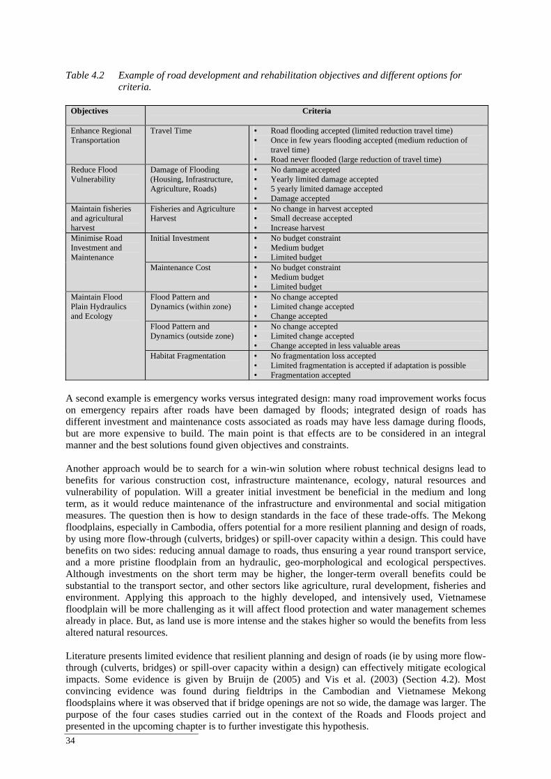
34
Table 4.2 Example of road development and rehabilitation objectives and different options for
criteria.
Objectives Criteria
Enhance Regional Transportation
Travel Time ▪ Road flooding accepted (limited reduction travel time) ▪ Once in few years flooding accepted (medium reduction of
travel time) ▪ Road never flooded (large reduction of travel time)
Reduce Flood Vulnerability
Damage of Flooding (Housing, Infrastructure, Agriculture, Roads)
▪ No damage accepted ▪ Yearly limited damage accepted ▪ 5 yearly limited damage accepted ▪ Damage accepted
Maintain fisheries and agricultural harvest
Fisheries and Agriculture Harvest
▪ No change in harvest accepted ▪ Small decrease accepted ▪ Increase harvest
Initial Investment ▪ No budget constraint ▪ Medium budget ▪ Limited budget
Minimise Road Investment and Maintenance
Maintenance Cost ▪ No budget constraint ▪ Medium budget ▪ Limited budget
Flood Pattern and Dynamics (within zone)
▪ No change accepted ▪ Limited change accepted ▪ Change accepted
Flood Pattern and Dynamics (outside zone)
▪ No change accepted ▪ Limited change accepted ▪ Change accepted in less valuable areas
Maintain Flood Plain Hydraulics and Ecology
Habitat Fragmentation ▪ No fragmentation loss accepted ▪ Limited fragmentation is accepted if adaptation is possible ▪ Fragmentation accepted
A second example is emergency works versus integrated design: many road improvement works focus on emergency repairs after roads have been damaged by floods; integrated design of roads has different investment and maintenance costs associated as roads may have less damage during floods, but are more expensive to build. The main point is that effects are to be considered in an integral manner and the best solutions found given objectives and constraints. Another approach would be to search for a win-win solution where robust technical designs lead to benefits for various construction cost, infrastructure maintenance, ecology, natural resources and vulnerability of population. Will a greater initial investment be beneficial in the medium and long term, as it would reduce maintenance of the infrastructure and environmental and social mitigation measures. The question then is how to design standards in the face of these trade-offs. The Mekong floodplains, especially in Cambodia, offers potential for a more resilient planning and design of roads, by using more flow-through (culverts, bridges) or spill-over capacity within a design. This could have benefits on two sides: reducing annual damage to roads, thus ensuring a year round transport service, and a more pristine floodplain from an hydraulic, geo-morphological and ecological perspectives. Although investments on the short term may be higher, the longer-term overall benefits could be substantial to the transport sector, and other sectors like agriculture, rural development, fisheries and environment. Applying this approach to the highly developed, and intensively used, Vietnamese floodplain will be more challenging as it will affect flood protection and water management schemes already in place. But, as land use is more intense and the stakes higher so would the benefits from less altered natural resources. Literature presents limited evidence that resilient planning and design of roads (ie by using more flow-through (culverts, bridges) or spill-over capacity within a design) can effectively mitigate ecological impacts. Some evidence is given by Bruijn de (2005) and Vis et al. (2003) (Section 4.2). Most convincing evidence was found during fieldtrips in the Cambodian and Vietnamese Mekong floodsplains where it was observed that if bridge openings are not so wide, the damage was larger. The purpose of the four cases studies carried out in the context of the Roads and Floods project and presented in the upcoming chapter is to further investigate this hypothesis.
Best Practice Guidelines for the Integrated Planning and Design of Economically Sound and Environmentally Friendly Roads in the Mekong Floodplains of Cambodia and Viet Nam
35
4.4 Conclusions The main conclusions of this chapter are:
Ample guidance exists on planning and design of roads in general, mainly in (inter)national standards and guidelines. Literature on the development of roads in ecologically sensitive areas is limited, and only a few studies were found on the development in floodplains.
There is a broad range of environmental assessment guidelines available, although they only to a limited extent address the interaction between roads and surface water or floods specifically.
Few international examples and studies were found on different strategies to building infrastructure in river floodplains. Two general road development strategies – resistance and resilience - can be distinguished, both having their pros and cons.
Selection of a strategy requires an integrated assessment of all relevant aspects and impacts, and the report presents a framework for an integrated assessment of road development and rehabilitation in floodplains. The Chapter presented a framework for integrated assessment of road development and rehabilitation.
Next Chapter, presents for four case studies in Cambodia and Viet Nam impacts of a number of road development and rehabilitation alternatives and addresses the underlying question whether it can be expected that a resilience strategy (Section 4.3) indeed leads to lower road damage and reduced ecological impacts at the longer term compared to a resistance strategy. Chapter 6 presents the set of Best Practice Guidelines for road development and rehabilitation in the Mekong floodplains of Cambodia and Viet Nam floodplains, which are based on the case study results of Chapter 5, as well as the findings of Chapters 2, 3 and 4.

36
5. Analysis of Four Road Development and Rehabilitation Cases in Cambodia and Viet Nam
5.1 Introduction Chapters 2 and 3 presented the context of road development and rehabilitation in the Mekong floodplain and Cambodian and Vietnamese practice. One of the conclusions was that there is a need for better guidance in Cambodia and Viet Nam on the planning and design of roads in the Mekong floodplains. Chapter 4 gave an overview of international practice in this area and presented a framework for an integrated approach of road development in the Mekong floodplain. This Chapter will present four case studies aimed to understand the interactions between roads and floods better, as well as to investigate the impacts of the different road development strategies; namely resistance and resilience (see Chapter 4). More specifically the cases are applied to answer the four main research questions underlying this report which were presented in Chapter 1. The cases considered are presented in Table 5.1 and cover both road rehabilitation and new road development. The location of the cases in both countries is presented in Figure 5.1. Table 5.1 The four case studies of the ‘Roads and Floods’ project.
Country Case Road Description road and flow-through condition options
1 NR 11 and PR 317
Existing road with damage problems. Currently limited flow-through and partly elevated.
Cambodia
2 NR8 Construction new road crossing floodplain zone 5, perpendicular to the floodplain.
3 PR855 Rehabilitation of Provincial Road. Viet Nam 4 NR1A
and HCM road Development of new section National Road number 1 and Ho Chi Minh Road.
To analyse and present the cases a policy analysis approach was applied that helped to structure the road development process, in particular its planning phase where concept development and (pre-feasibility) studies take place. The planning phase can be divided into the following general steps: problem analysis, analysis present and future situation, identification of alternatives, assessment of impacts of alternatives and evaluation of alternatives. The analysis of the different steps was supported by the surveys carried out in both Cambodia and Viet Nam and the technical analysis activities including inundation modelling and analysis, damage analysis, economic analysis and environmental impact analysis. For further details on the methodology followed the reader is referred to Appendix 1 of this Synthesis Report.
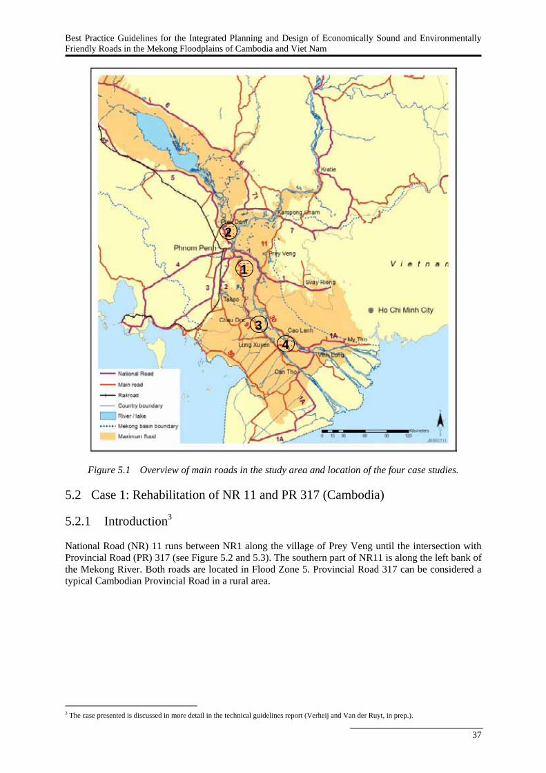
Best Practice Guidelines for the Integrated Planning and Design of Economically Sound and Environmentally Friendly Roads in the Mekong Floodplains of Cambodia and Viet Nam
37
Figure 5.1 Overview of main roads in the study area and location of the four case studies. 5.2 Case 1: Rehabilitation of NR 11 and PR 317 (Cambodia) 5.2.1 Introduction3 National Road (NR) 11 runs between NR1 along the village of Prey Veng until the intersection with Provincial Road (PR) 317 (see Figure 5.2 and 5.3). The southern part of NR11 is along the left bank of the Mekong River. Both roads are located in Flood Zone 5. Provincial Road 317 can be considered a typical Cambodian Provincial Road in a rural area.
3 The case presented is discussed in more detail in the technical guidelines report (Verheij and Van der Ruyt, in prep.).
1
2
3 4
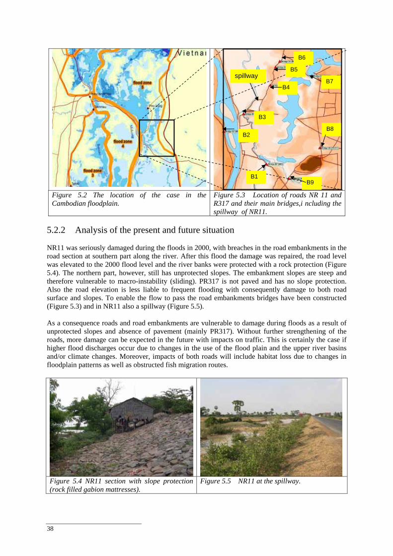
38
Figure 5.2 The location of the case in the Cambodian floodplain.
Figure 5.3 Location of roads NR 11 and R317 and their main bridges,i ncluding the spillway of NR11.
5.2.2 Analysis of the present and future situation NR11 was seriously damaged during the floods in 2000, with breaches in the road embankments in the road section at southern part along the river. After this flood the damage was repaired, the road level was elevated to the 2000 flood level and the river banks were protected with a rock protection (Figure 5.4). The northern part, however, still has unprotected slopes. The embankment slopes are steep and therefore vulnerable to macro-instability (sliding). PR317 is not paved and has no slope protection. Also the road elevation is less liable to frequent flooding with consequently damage to both road surface and slopes. To enable the flow to pass the road embankments bridges have been constructed (Figure 5.3) and in NR11 also a spillway (Figure 5.5). As a consequence roads and road embankments are vulnerable to damage during floods as a result of unprotected slopes and absence of pavement (mainly PR317). Without further strengthening of the roads, more damage can be expected in the future with impacts on traffic. This is certainly the case if higher flood discharges occur due to changes in the use of the flood plain and the upper river basins and/or climate changes. Moreover, impacts of both roads will include habitat loss due to changes in floodplain patterns as well as obstructed fish migration routes.
Figure 5.4 NR11 section with slope protection (rock filled gabion mattresses).
Figure 5.5 NR11 at the spillway.
spillway
B1 B9
B8
B7
B6
B5
B4
B3
B2
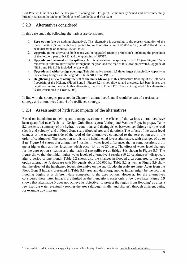
Best Practice Guidelines for the Integrated Planning and Design of Economically Sound and Environmentally Friendly Roads in the Mekong Floodplains of Cambodia and Viet Nam
39
5.2.3 Alternatives considered In this case study the following alternatives are considered:
1. Zero option (the do nothing alternative). This alternative is according to the present condition of the roads (Section 2), and with the expected future flood discharge of 65,000 m3/s (the 2000 flood had a peak discharge of about 50-55,000 m3/s).
2. Upgrade. In this alternative both roads will be upgraded (mainly protection4), including the protection of the northern part of NR11 and the upgrading of PR317.
3. Upgrade and removal of the spillway. In this alternative the spillway in NR 11 (see Figure 5.5) is removed in order to allow traffic throughout the year, and the road at this location elevated. Upgrade of NR 11 and PR 317 is included here as well.
4. Upgrade and wider bridge openings. This alternative creates 1.5 times larger through-flow capacity at the existing bridges and the upgrade of both NR 11 and PR 317.
5. Heigthening of levees along the left of the bank Mekong. In this alternative flooding of the left bank floodplain of the Mekong (Flood Zone 5; Figure 5.2) is not allowed and therefore, left bank levees are heigthened up to 6 meter. In this alternative, roads NR 11 and PR317 are not upgraded. This alternative is also considered in Cross (2005).
In line with the strategies presented in Chapter 4, alternatives 3 and 5 would be part of a resistance strategy and alternatives 2 and 4 of a resilience strategy. 5.2.4 Assessment of hydraulic impacts of the alternatives Based on inundation modelling and damage assessment the effects of the various alternatives have been quantified (see Technical Design Guidelines report; Verheij and Van der Ruyt, in prep.). Table 5.2 presents a summary of the hydraulic conditions and distinguishes between conditions near the road (depth and velocity) and at Flood Zone scale (flooded area and duration). The effects of the water level changes at the upstream side of the road of the alternatives compared to the zero option are in the order of centimetres. The exception to this is the heighthened levees alternative, with changes of up to 8 m. Figure 5.6 shows that alternative 5 results in water level differences that at some locations are 1 meter higher than at other locations which occur for up to 20 days. The effect of water level changes for the zero option situation and alternative 3 (no spillway) at Bridge 4 is shown in Figure 5.7. The figure shows that the initial higher water levels of alternative 3 results (10-20 centimetres), disappears after a period of one month. Table 5.2 shows also the changes in flooded area compared to the zero option alternative. A decrease with 5% equals about 100,000 ha. Table 5.2 as well as Figure 5.9 show that the effect of the heightened levees alternative on the sub-floodplain scale are large. Apart from the Flood Zone 5 impacts presented in Table 5.6 (area and duration), another impact might be the fact that flooding begins at a different date compared to the zero option. However, for the alternatives considered these latter impacts are limited as the inundations starts only a few days later. Figure 5.9 shows that alternative 5 does not achieve its objective ‘to protect the region from flooding’ as after a few days the water eventually reaches the area (although smaller and shorter), through different paths, for example downstream.
4 Henk needs to check to what extent upgrading in sense of heigthening of roads is taken into account in the model calculations.
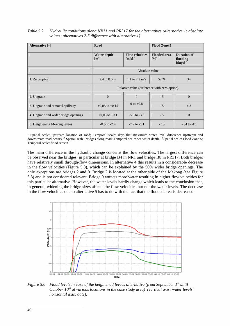
40
Table 5.2 Hydraulic conditions along NR11 and PR317 for the alternatives (alternative 1: absolute
values; alternatives 2-5 difference with alternative 1).
Alternative [-] Road Flood Zone 5
Water depth
[m] 1 Flow velocities [m/s] 2
Flooded area [%] 3
Duration of flooding [days] 3
Absolute value
1. Zero option 2.4 to 8.5 m 1.1 to 7.2 m/s 52 % 34
Relative value (difference with zero option)
2. Upgrade 0 0 - 5 0
3. Upgrade and removal spillway +0,05 to +0,15 0 to +0.8 - 5 + 3
4. Upgrade and wider bridge openings +0,05 to +0,1 -5.0 to -3.0 - 5 0
5. Heigthening Mekong levees -8.5 to -2.4 -7.2 to -1.1 - 13 - 34 to -15
1 Spatial scale: upstream location of road; Temporal scale: days that maximum water level difference upstream and downstream road occurs, 2 Spatial scale: bridges along road; Temporal scale: see water depth,, 3 Spatial scale: Flood Zone 5; Temporal scale: flood season. The main difference in the hydraulic change concerns the flow velocities. The largest difference can be observed near the bridges, in particular at bridge B4 in NR1 and bridge B8 in PR317. Both bridges have relatively small through-flow dimensions. In alternative 4 this results in a considerable decrease in the flow velocities (Figure 5.8), which can be explained by the 50% wider bridge openings. The only exceptions are bridges 2 and 9. Bridge 2 is located at the other side of the Mekong (see Figure 5.3) and is not considered relevant. Bridge 9 attracts more water resulting in higher flow velocities for this particular alternative. However, the water levels hardly change which leads to the conclusion that, in general, widening the bridge sizes affects the flow velocities but not the water levels. The decrease in the flow velocities due to alternative 5 has to do with the fact that the flooded area is decreased.
Figure 5.6 Flood levels in case of the heightened levees alternative (from September 1st until
October 10th at various locations in the case study area) (vertical axis: water levels; horizontal axis: date).
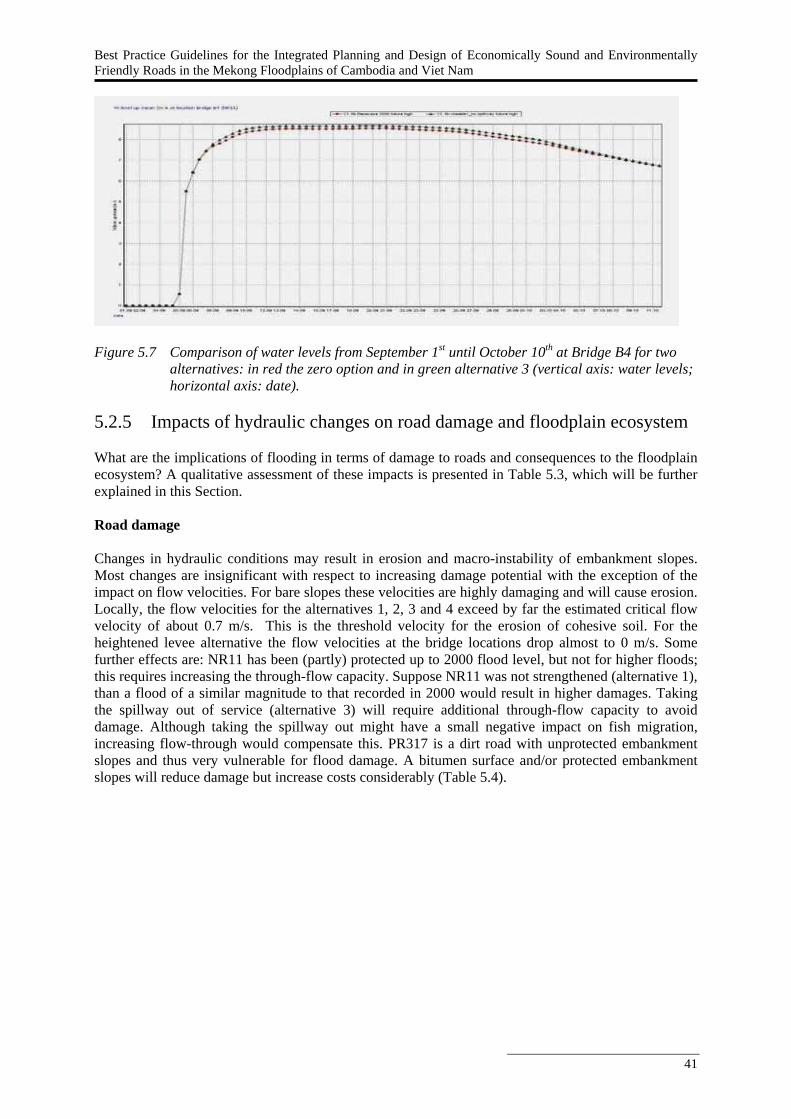
Best Practice Guidelines for the Integrated Planning and Design of Economically Sound and Environmentally Friendly Roads in the Mekong Floodplains of Cambodia and Viet Nam
41
Figure 5.7 Comparison of water levels from September 1st until October 10th at Bridge B4 for two
alternatives: in red the zero option and in green alternative 3 (vertical axis: water levels; horizontal axis: date).
5.2.5 Impacts of hydraulic changes on road damage and floodplain ecosystem What are the implications of flooding in terms of damage to roads and consequences to the floodplain ecosystem? A qualitative assessment of these impacts is presented in Table 5.3, which will be further explained in this Section. Road damage Changes in hydraulic conditions may result in erosion and macro-instability of embankment slopes. Most changes are insignificant with respect to increasing damage potential with the exception of the impact on flow velocities. For bare slopes these velocities are highly damaging and will cause erosion. Locally, the flow velocities for the alternatives 1, 2, 3 and 4 exceed by far the estimated critical flow velocity of about 0.7 m/s. This is the threshold velocity for the erosion of cohesive soil. For the heightened levee alternative the flow velocities at the bridge locations drop almost to 0 m/s. Some further effects are: NR11 has been (partly) protected up to 2000 flood level, but not for higher floods; this requires increasing the through-flow capacity. Suppose NR11 was not strengthened (alternative 1), than a flood of a similar magnitude to that recorded in 2000 would result in higher damages. Taking the spillway out of service (alternative 3) will require additional through-flow capacity to avoid damage. Although taking the spillway out might have a small negative impact on fish migration, increasing flow-through would compensate this. PR317 is a dirt road with unprotected embankment slopes and thus very vulnerable for flood damage. A bitumen surface and/or protected embankment slopes will reduce damage but increase costs considerably (Table 5.4).

42
-8.00
-6.00
-4.00
-2.00
0.00
2.00
4.00
1 2 3 4 5 6 7 8 9
bridge number
chan
ge in
flow
vel
ocity
(m
/s)
difference upgrade and removal spillway with zero option
difference upgrade and wider bridge openings with zero option
difference increased levees with zero option
Figure 5.8 Differences in flow velocities at bridges for alternatives 3, 4 and 5 compared to 1 (see Figure 5.3 for the bridge locations).
Figure 5.9 Heightened left Mekong levees: maximum water level differences with zero option (time scale: days).
Table 5.3 Impact of the hydraulic conditions of NR11 and PR317 alternatives on road and
ecological damage.
Alternative [-]
Related to water level (macro-instability, waves, overtopping/overflow)
Related to flow velocities (toe scour, abutment scour)
Related to duration and extent (fish, agriculture)
1. Zero option Medium negative Medium negative None
2. Upgrade None Low negative Low negative
3. Upgrade and removal spillway None Low / medium negative Low / medium negative
4. Upgrade and wider bridge openings None Low negative Low positive
5. Heigthening Mekong levees High positive Low positive High negative
Impact on the floodplain ecosystem A significant decrease in flooded area and flood duration as a result of road planning and design is considered to be important as this seriously influences fish migration, agriculture and wetland characteristics. Such a decrease can be observed in alternative 5 (13% or 250,000 ha of the flood zone will not inundate anymore), but also for the other alternatives (5% or 100,000 ha reduction of flooded area). This has serious implication to the fisheries sector as every hectare of floodplain lost due to road development could lead to a loss of 100 kg of fish each year (Halls et al. 2006). Ecological impacts and particularly those related to blocking fish migration routes are expected to be considerable. The main impact of alternatives 2, 3 and 5 will be on fish migration. However, alternative 4 will have a positive effect on migration, although the exact location and dimensions of bridges would need further study. 5.2.6 Costs of the alternatives The results for the financial analysis for the NR11 and PR317 are presented in Table 5.4. See Appendix 1 (Section 9.5.2) of the Synthesis Report for an explanation of how the financial analysis is carried out. For reasons of comparison all costs for each of the alternatives are included, including the past costs of construction (column ‘Total investment cost’).
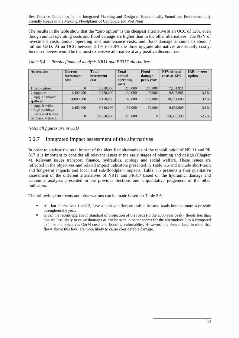
Best Practice Guidelines for the Integrated Planning and Design of Economically Sound and Environmentally Friendly Roads in the Mekong Floodplains of Cambodia and Viet Nam
43
The results in the table show that the “zero option” is the cheapest alternative at an OCC of 12%, even though annual operating costs and flood damage are higher than in the other alternatives. The NPV of investment costs, annual operating and maintenance costs, and flood damage amounts to about 7 million USD. At an OCC between 3.1% to 3.8% the three upgrade alternatives are equally costly. Increased levees would be the most expensive alternative at any positive discount rate. Table 5.4 Results financial analysis NR11 and PR317 alternatives.
Alternative Current investment cost
Total investment cost
Total annual operating costs
Flood damage per 5 year
NPV of total costs at 12%
IRR <> zero option
1. zero option 0 5,350,000 270,000 270,000 7,101,911 - 2. upgrade 4,400,000 9,750,000 130,000 95,000 9,807,085 3.8% 3. upg. + removal spillway 4,800,000 10,150,000 145,000 100,000 10,281,689 3.1%
4. upg. & wider bridge openings 4,460,000 9,810,000 135,000 60,000 9,839,009 3.8%
5. increased leeves left bank Mekong 0 20,350,000 270,000 0 24,955,333 -2.2%
Note: all figures are in USD 5.2.7 Integrated impact assessment of the alternatives In order to analyse the total impact of the identified alternatives of the rehabilitation of NR 11 and PR 317 it is important to consider all relevant issues at the early stages of planning and design (Chapter 4). Relevant issues transport, finance, hydraulics, ecology and social welfare. These issues are reflected in the objectives and related impact indicators presented in Table 5.5 and include short-term and long-term impacts and local and sub-floodplain impacts. Table 5.5 presents a first qualitative assessment of the different alternatives of NR11 and PR317 based on the hydraulic, damage and economic analyses presented in the previous Sections and a qualitative judgement of the other indicators. The following comments and observations can be made based on Table 5.5:
All, but alternatives 1 and 2, have a positive effect on traffic, because roads become more accessible throughout the year.
Given the recent upgrade in standard of protection of the roads (to the 2000 year peak), floods less than this are less likely to cause damages as can be seen in better scores for the alternatives 2 to 4 compared to 1 for the objectives O&M costs and flooding vulnerablity. However, one should keep in mind that flows above this level are more likely to cause considerable damage.

44
Table 5.5 Integrated impact table (+++ best alternative, --- worst alternative).
Objectives Impact indicators 1. Zero option
2. Up-grade
3. Up-grade and no spill-way
4. Upgrade and wider bridges
5. Heigthen Mekong levees
Enhance regional transportation
Travel time (road) --- - + + +++
Minimise road investment
Initial current investment costs (road) ++ -- -- -- ++
Minimise road operation and maintenance costs
Operation and maintenance (damage rehabilitation) costs (road)
--- ++ + ++ -
Damage of flooding to structures in the vicinity of the road -- + + ++ +++ Reduce
flooding vulnerability (vicinity of the road)
Damage of flooding to NR11 and PR317 -- - + ++ +++
Reduce flooding vulnerability
Damage of flooding to other roads than NR11 and PR317 (sub-floodplain)
- - + -- +++
Resettlement (road) + - - - - Minimise
social impacts Water quality (sub-floodplain) + + + ++ -
Flood pattern and dynamics (sub-floodplain) + + - ++ -- Maintain
floodplain hydraulics and ecology
Habitat fragmentation (sub-floodplain) + - - ++ ---
The zero option alternative results in flow velocities above 0.7 m/s. Strengthening and erosion
protection or annual repair is needed. Alternatives 2 and 3 lead to a very limited change of the flow velocities (see Table 5.2) because the upgrading does hardly or not effect the flows near the existing bridges. There is still a need for protection of the bridge abutments.
Alternative 5, aimed to increase the height of the levees, reduces flow velocities to a minimum, reducing rehabilitation costs and thus the need for damage protection.
Both the alternatives 3 (upgrade and removal spillway) and 4 (upgrade and wider openings) are expected to have limited impacts on fisheries, agriculture or wetlands ecology. Obviously, the alternative 5 will affect these uses of the floodplain as it will result in less flooding. Fish migration routes will be blocked, agricultural area will lack yearly nutrient supply by the flooding, and the floodplain will be fragmented resulting in negative effects on the wetlands.
The alternatives show that higher initial investments (alternatives 2, 3 and 4) are likely to lead to lower operation and maintenance costs as well as lower damage. Alternative 4 is expected to achieve the highest damage reduction.
5.2.8 Ranking of the alternatives In this Section, we illustrate that a different perspective on road development (e.g. transport, flood protection, ecology) will lead to a different ranking of alternatives as each perspective prioritizes objectives differently. An example of this different weighting of objectives (listed in Table 5.5) for each perspective is illustrated by Table 5.6 The weights in Table 5.6 are exaggerated to make differences between the perspectives more explicit; in reality objectives and their relative importance are set by decision-makers during the planning process. Apart from the transport, ecology and flood protection perspectives a fourth perspective is added called ‘sustainable development’ that aims to minimise long-term ‘costs’ in terms of investment, road maintenance and flood damage repair costs, social costs and ecological costs.
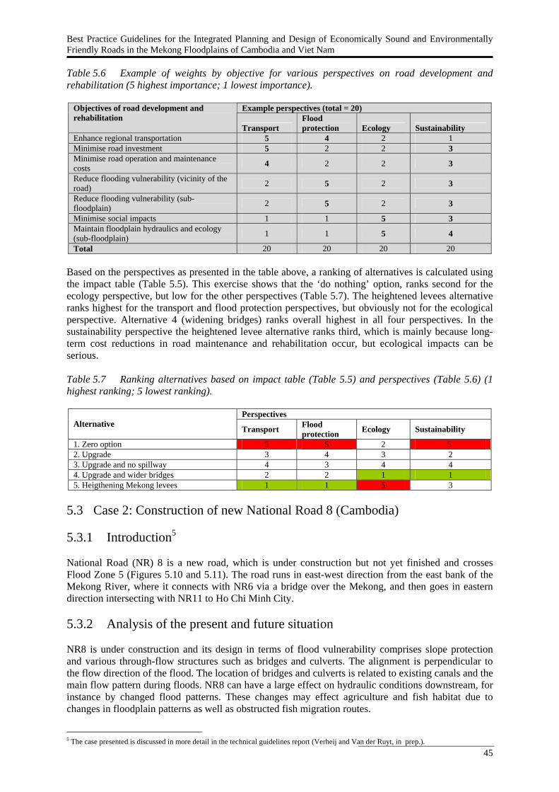
Best Practice Guidelines for the Integrated Planning and Design of Economically Sound and Environmentally Friendly Roads in the Mekong Floodplains of Cambodia and Viet Nam
45
Table 5.6 Example of weights by objective for various perspectives on road development and rehabilitation (5 highest importance; 1 lowest importance).
Example perspectives (total = 20) Objectives of road development and rehabilitation
Transport Flood protection Ecology Sustainability
Enhance regional transportation 5 4 2 1 Minimise road investment 5 2 2 3 Minimise road operation and maintenance costs 4 2 2 3
Reduce flooding vulnerability (vicinity of the road) 2 5 2 3
Reduce flooding vulnerability (sub-floodplain) 2 5 2 3
Minimise social impacts 1 1 5 3 Maintain floodplain hydraulics and ecology (sub-floodplain) 1 1 5 4
Total 20 20 20 20 Based on the perspectives as presented in the table above, a ranking of alternatives is calculated using the impact table (Table 5.5). This exercise shows that the ‘do nothing’ option, ranks second for the ecology perspective, but low for the other perspectives (Table 5.7). The heightened levees alternative ranks highest for the transport and flood protection perspectives, but obviously not for the ecological perspective. Alternative 4 (widening bridges) ranks overall highest in all four perspectives. In the sustainability perspective the heightened levee alternative ranks third, which is mainly because long-term cost reductions in road maintenance and rehabilitation occur, but ecological impacts can be serious. Table 5.7 Ranking alternatives based on impact table (Table 5.5) and perspectives (Table 5.6) (1 highest ranking; 5 lowest ranking).
Perspectives Alternative Transport Flood
protection Ecology Sustainability
1. Zero option 5 5 2 5 2. Upgrade 3 4 3 2 3. Upgrade and no spillway 4 3 4 4 4. Upgrade and wider bridges 2 2 1 1 5. Heigthening Mekong levees 1 1 5 3
5.3 Case 2: Construction of new National Road 8 (Cambodia) 5.3.1 Introduction5 National Road (NR) 8 is a new road, which is under construction but not yet finished and crosses Flood Zone 5 (Figures 5.10 and 5.11). The road runs in east-west direction from the east bank of the Mekong River, where it connects with NR6 via a bridge over the Mekong, and then goes in eastern direction intersecting with NR11 to Ho Chi Minh City. 5.3.2 Analysis of the present and future situation NR8 is under construction and its design in terms of flood vulnerability comprises slope protection and various through-flow structures such as bridges and culverts. The alignment is perpendicular to the flow direction of the flood. The location of bridges and culverts is related to existing canals and the main flow pattern during floods. NR8 can have a large effect on hydraulic conditions downstream, for instance by changed flood patterns. These changes may effect agriculture and fish habitat due to changes in floodplain patterns as well as obstructed fish migration routes.
5 The case presented is discussed in more detail in the technical guidelines report (Verheij and Van der Ruyt, in prep.).
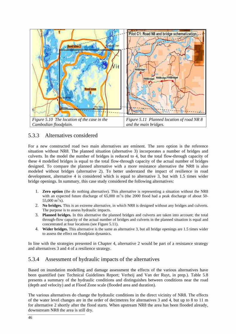
46
Figure 5.10 The location of the case in the Cambodian floodplain.
Figure 5.11 Planned location of road NR 8 and the main bridges.
5.3.3 Alternatives considered For a new constructed road two main alternatives are eminent. The zero option is the reference situation without NR8. The planned situation (alternative 3) incorporates a number of bridges and culverts. In the model the number of bridges is reduced to 4, but the total flow-through capacity of these 4 modelled bridges is equal to the total flow-through capacity of the actual number of bridges designed. To compare the planned alternative with a more resistance alternative the NR8 is also modeled without bridges (alternative 2). To better understand the impact of resilience in road development, alternative 4 is considered which is equal to alternative 3, but with 1.5 times wider bridge openings. In summary, this case study considered the following alternatives:
1. Zero option (the do nothing alternative). This alternative is representing a situation without the NR8 with an expected future discharge of 65,000 m3/s (the 2000 flood had a peak discharge of about 50-55,000 m3/s).
2. No bridges. This is an extreme alternative, in which NR8 is designed without any bridges and culverts. The purpose is to assess hydraulic impacts.
3. Planned bridges. In this alternative the planned bridges and culverts are taken into account; the total through-flow capacity of the actual number of bridges and culverts in the planned situation is equal and concentrated at four locations (see Figure 5.11).
4. Wider bridges. This alternative is the same as alternative 3, but all bridge openings are 1.5 times wider to assess the effect on floodplain dynamics.
In line with the strategies presented in Chapter 4, alternative 2 would be part of a resistance strategy and alternatives 3 and 4 of a resilience strategy. 5.3.4 Assessment of hydraulic impacts of the alternatives Based on inundation modelling and damage assessment the effects of the various alternatives have been quantified (see Technical Guidelines Report; Verheij and Van der Ruyt, in prep.). Table 5.8 presents a summary of the hydraulic conditions and distinguishes between conditions near the road (depth and velocity) and at Flood Zone scale (flooded area and duration). The various alternatives do change the hydraulic conditions in the direct vicinity of NR8. The effects of the water level changes are in the order of decimetres for alternatives 3 and 4, but up to 8 to 11 m for alternative 2 shortly after the flood starts. When upstream NR8 the area has been flooded already, downstream NR8 the area is still dry.
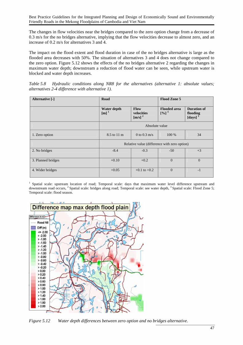
Best Practice Guidelines for the Integrated Planning and Design of Economically Sound and Environmentally Friendly Roads in the Mekong Floodplains of Cambodia and Viet Nam
47
The changes in flow velocities near the bridges compared to the zero option change from a decrease of 0.3 m/s for the no bridges alternative, implying that the flow velocities decrease to almost zero, and an increase of 0.2 m/s for alternatives 3 and 4. The impact on the flood extent and flood duration in case of the no bridges alternative is large as the flooded area decreases with 50%. The situation of alternatives 3 and 4 does not change compared to the zero option. Figure 5.12 shows the effects of the no bridges alternative 2 regarding the changes in maximum water depth; downstream a reduction of flood water can be seen, while upstream water is blocked and water depth increases. Table 5.8 Hydraulic conditions along NR8 for the alternatives (alternative 1: absolute values; alternatives 2-4 difference with alternative 1).
Alternative [-] Road Flood Zone 5
Water depth
[m] 1 Flow velocities [m/s] 2
Flooded area [%] 3
Duration of flooding [days] 3
Absolute value
1. Zero option 8.5 to 11 m 0 to 0.3 m/s 100 % 34
Relative value (difference with zero option)
2. No bridges -8.4 -0.3 -50 +3
3. Planned bridges +0.10 +0.2 0 0
4. Wider bridges +0.05 +0.1 to +0.2 0 -1
1 Spatial scale: upstream location of road; Temporal scale: days that maximum water level difference upstream and downstream road occurs, 2 Spatial scale: bridges along road; Temporal scale: see water depth, 3 Spatial scale: Flood Zone 5; Temporal scale: flood season.
Figure 5.12 Water depth differences between zero option and no bridges alternative.
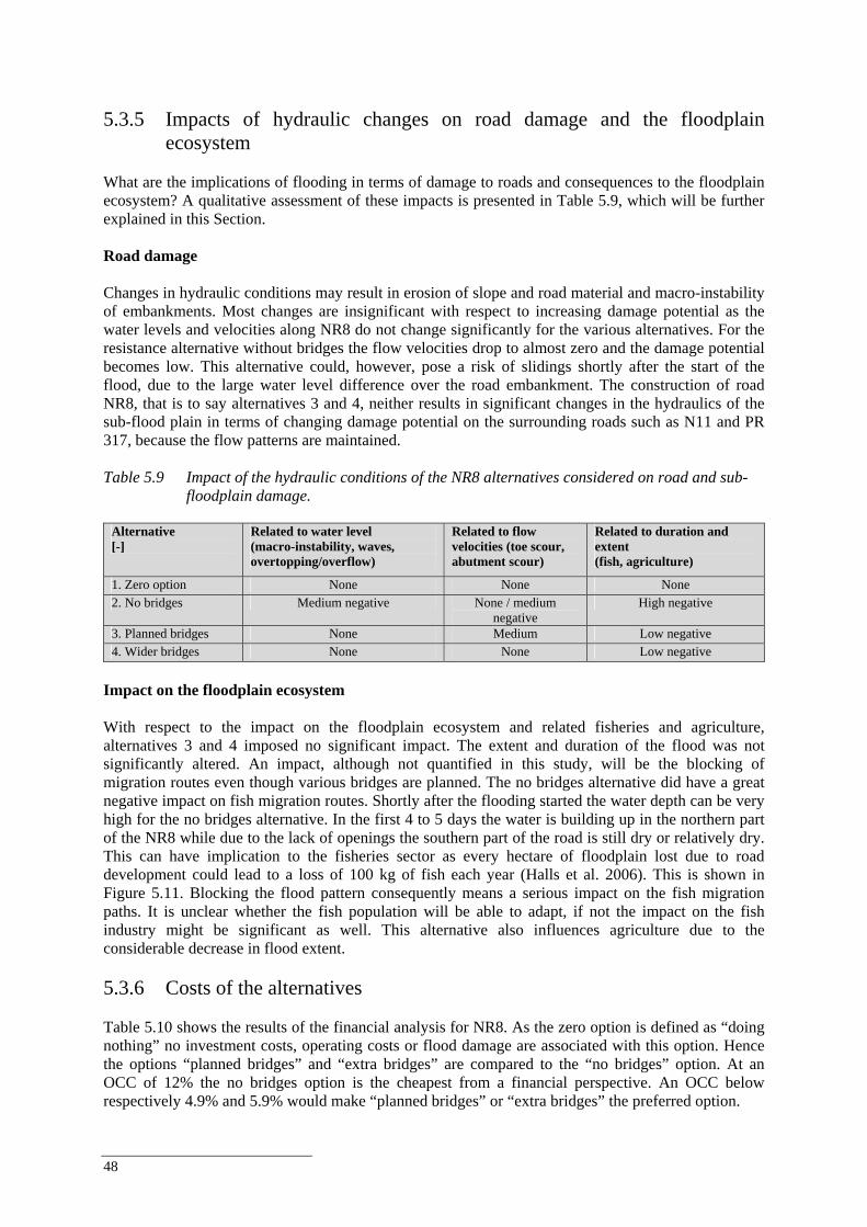
48
5.3.5 Impacts of hydraulic changes on road damage and the floodplain
ecosystem What are the implications of flooding in terms of damage to roads and consequences to the floodplain ecosystem? A qualitative assessment of these impacts is presented in Table 5.9, which will be further explained in this Section. Road damage Changes in hydraulic conditions may result in erosion of slope and road material and macro-instability of embankments. Most changes are insignificant with respect to increasing damage potential as the water levels and velocities along NR8 do not change significantly for the various alternatives. For the resistance alternative without bridges the flow velocities drop to almost zero and the damage potential becomes low. This alternative could, however, pose a risk of slidings shortly after the start of the flood, due to the large water level difference over the road embankment. The construction of road NR8, that is to say alternatives 3 and 4, neither results in significant changes in the hydraulics of the sub-flood plain in terms of changing damage potential on the surrounding roads such as N11 and PR 317, because the flow patterns are maintained. Table 5.9 Impact of the hydraulic conditions of the NR8 alternatives considered on road and sub-
floodplain damage.
Alternative [-]
Related to water level (macro-instability, waves, overtopping/overflow)
Related to flow velocities (toe scour, abutment scour)
Related to duration and extent (fish, agriculture)
1. Zero option None None None 2. No bridges Medium negative None / medium
negative High negative
3. Planned bridges None Medium Low negative 4. Wider bridges None None Low negative
Impact on the floodplain ecosystem With respect to the impact on the floodplain ecosystem and related fisheries and agriculture, alternatives 3 and 4 imposed no significant impact. The extent and duration of the flood was not significantly altered. An impact, although not quantified in this study, will be the blocking of migration routes even though various bridges are planned. The no bridges alternative did have a great negative impact on fish migration routes. Shortly after the flooding started the water depth can be very high for the no bridges alternative. In the first 4 to 5 days the water is building up in the northern part of the NR8 while due to the lack of openings the southern part of the road is still dry or relatively dry. This can have implication to the fisheries sector as every hectare of floodplain lost due to road development could lead to a loss of 100 kg of fish each year (Halls et al. 2006). This is shown in Figure 5.11. Blocking the flood pattern consequently means a serious impact on the fish migration paths. It is unclear whether the fish population will be able to adapt, if not the impact on the fish industry might be significant as well. This alternative also influences agriculture due to the considerable decrease in flood extent. 5.3.6 Costs of the alternatives Table 5.10 shows the results of the financial analysis for NR8. As the zero option is defined as “doing nothing” no investment costs, operating costs or flood damage are associated with this option. Hence the options “planned bridges” and “extra bridges” are compared to the “no bridges” option. At an OCC of 12% the no bridges option is the cheapest from a financial perspective. An OCC below respectively 4.9% and 5.9% would make “planned bridges” or “extra bridges” the preferred option.
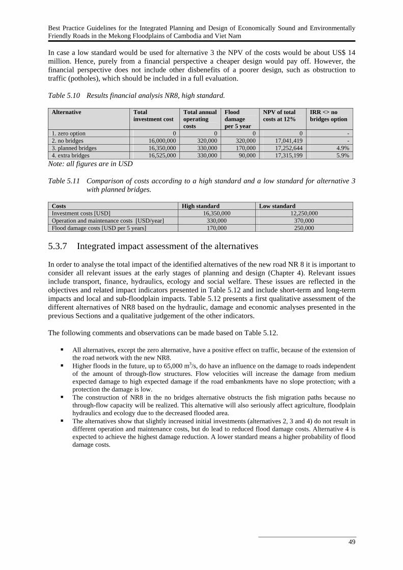
Best Practice Guidelines for the Integrated Planning and Design of Economically Sound and Environmentally Friendly Roads in the Mekong Floodplains of Cambodia and Viet Nam
49
In case a low standard would be used for alternative 3 the NPV of the costs would be about US$ 14 million. Hence, purely from a financial perspective a cheaper design would pay off. However, the financial perspective does not include other disbenefits of a poorer design, such as obstruction to traffic (potholes), which should be included in a full evaluation. Table 5.10 Results financial analysis NR8, high standard.
Alternative Total investment cost
Total annual operating costs
Flood damage per 5 year
NPV of total costs at 12%
IRR <> no bridges option
1. zero option 0 0 0 0 - 2. no bridges 16,000,000 320,000 320,000 17,041,419 - 3. planned bridges 16,350,000 330,000 170,000 17,252,644 4.9% 4. extra bridges 16,525,000 330,000 90,000 17,315,199 5.9%
Note: all figures are in USD Table 5.11 Comparison of costs according to a high standard and a low standard for alternative 3
with planned bridges.
Costs High standard Low standard Investment costs [USD] 16,350,000 12,250,000 Operation and maintenance costs [USD/year] 330,000 370,000 Flood damage costs [USD per 5 years] 170,000 250,000
5.3.7 Integrated impact assessment of the alternatives In order to analyse the total impact of the identified alternatives of the new road NR 8 it is important to consider all relevant issues at the early stages of planning and design (Chapter 4). Relevant issues include transport, finance, hydraulics, ecology and social welfare. These issues are reflected in the objectives and related impact indicators presented in Table 5.12 and include short-term and long-term impacts and local and sub-floodplain impacts. Table 5.12 presents a first qualitative assessment of the different alternatives of NR8 based on the hydraulic, damage and economic analyses presented in the previous Sections and a qualitative judgement of the other indicators. The following comments and observations can be made based on Table 5.12.
All alternatives, except the zero alternative, have a positive effect on traffic, because of the extension of the road network with the new NR8.
Higher floods in the future, up to 65,000 m3/s, do have an influence on the damage to roads independent of the amount of through-flow structures. Flow velocities will increase the damage from medium expected damage to high expected damage if the road embankments have no slope protection; with a protection the damage is low.
The construction of NR8 in the no bridges alternative obstructs the fish migration paths because no through-flow capacity will be realized. This alternative will also seriously affect agriculture, floodplain hydraulics and ecology due to the decreased flooded area.
The alternatives show that slightly increased initial investments (alternatives 2, 3 and 4) do not result in different operation and maintenance costs, but do lead to reduced flood damage costs. Alternative 4 is expected to achieve the highest damage reduction. A lower standard means a higher probability of flood damage costs.
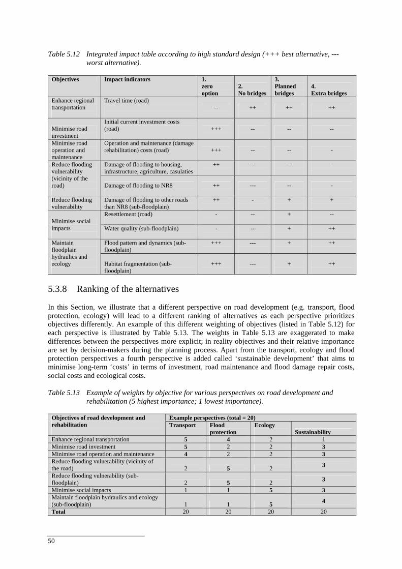
50
Table 5.12 Integrated impact table according to high standard design (+++ best alternative, ---
worst alternative).
Objectives Impact indicators 1. zero option
2. No bridges
3. Planned bridges
4. Extra bridges
Enhance regional transportation
Travel time (road)
--
++
++
++
Minimise road investment
Initial current investment costs (road)
+++
--
--
--
Minimise road operation and maintenance
Operation and maintenance (damage rehabilitation) costs (road) +++
--
--
-
Damage of flooding to housing, infrastructure, agriculture, casulaties
++
---
--
-
Reduce flooding vulnerability (vicinity of the road)
Damage of flooding to NR8
++
---
--
-
Reduce flooding vulnerability
Damage of flooding to other roads than NR8 (sub-floodplain)
++
-
+
+
Resettlement (road)
-
--
+
-- Minimise social
impacts
Water quality (sub-floodplain)
-
--
+
++
Flood pattern and dynamics (sub-floodplain)
+++
---
+
++
Maintain floodplain hydraulics and ecology
Habitat fragmentation (sub-floodplain)
+++
---
+
++
5.3.8 Ranking of the alternatives In this Section, we illustrate that a different perspective on road development (e.g. transport, flood protection, ecology) will lead to a different ranking of alternatives as each perspective prioritizes objectives differently. An example of this different weighting of objectives (listed in Table 5.12) for each perspective is illustrated by Table 5.13. The weights in Table 5.13 are exaggerated to make differences between the perspectives more explicit; in reality objectives and their relative importance are set by decision-makers during the planning process. Apart from the transport, ecology and flood protection perspectives a fourth perspective is added called ‘sustainable development’ that aims to minimise long-term ‘costs’ in terms of investment, road maintenance and flood damage repair costs, social costs and ecological costs. Table 5.13 Example of weights by objective for various perspectives on road development and
rehabilitation (5 highest importance; 1 lowest importance).
Example perspectives (total = 20) Objectives of road development and rehabilitation
Transport
Flood protection
Ecology Sustainability
Enhance regional transportation 5 4 2 1 Minimise road investment 5 2 2 3 Minimise road operation and maintenance 4 2 2 3 Reduce flooding vulnerability (vicinity of the road) 2 5 2 3
Reduce flooding vulnerability (sub-floodplain) 2 5 2 3
Minimise social impacts 1 1 5 3 Maintain floodplain hydraulics and ecology (sub-floodplain) 1 1 5 4
Total 20 20 20 20
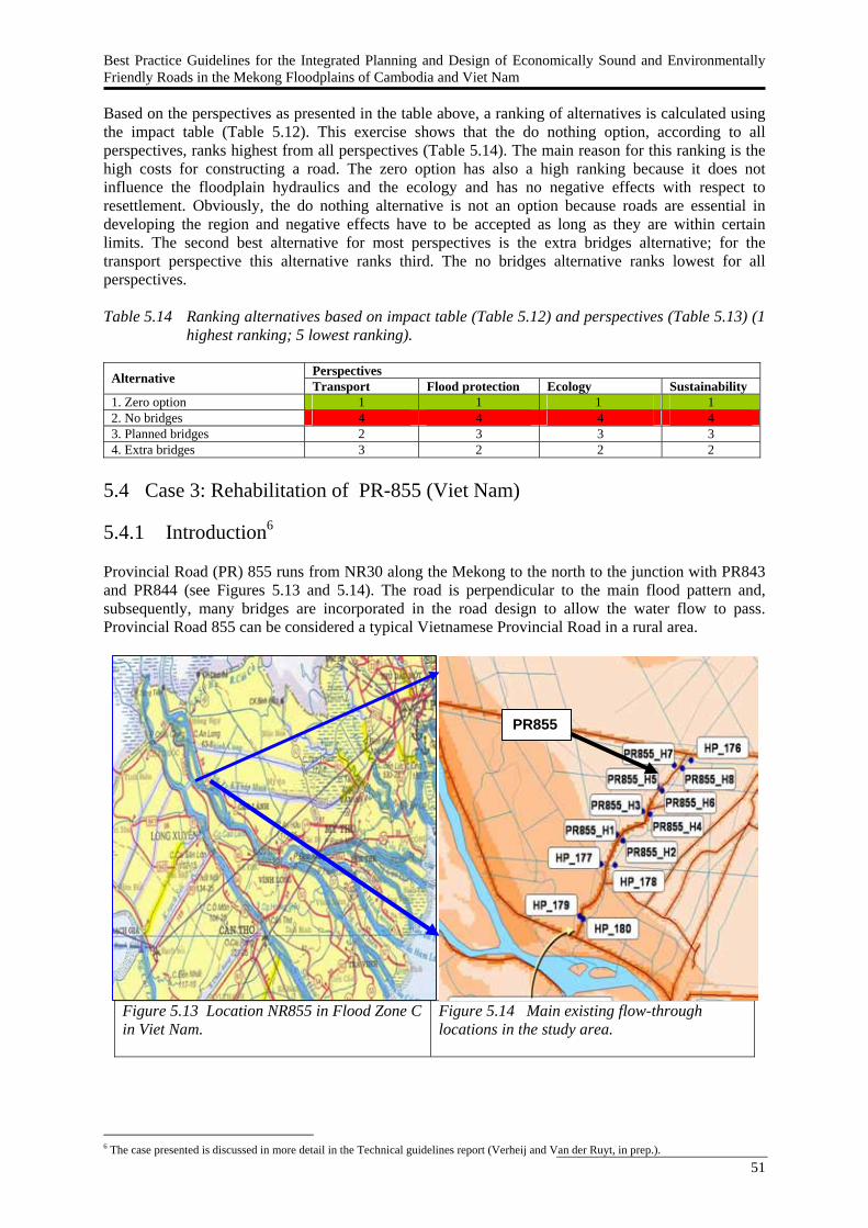
Best Practice Guidelines for the Integrated Planning and Design of Economically Sound and Environmentally Friendly Roads in the Mekong Floodplains of Cambodia and Viet Nam
51
Based on the perspectives as presented in the table above, a ranking of alternatives is calculated using the impact table (Table 5.12). This exercise shows that the do nothing option, according to all perspectives, ranks highest from all perspectives (Table 5.14). The main reason for this ranking is the high costs for constructing a road. The zero option has also a high ranking because it does not influence the floodplain hydraulics and the ecology and has no negative effects with respect to resettlement. Obviously, the do nothing alternative is not an option because roads are essential in developing the region and negative effects have to be accepted as long as they are within certain limits. The second best alternative for most perspectives is the extra bridges alternative; for the transport perspective this alternative ranks third. The no bridges alternative ranks lowest for all perspectives. Table 5.14 Ranking alternatives based on impact table (Table 5.12) and perspectives (Table 5.13) (1
highest ranking; 5 lowest ranking).
Perspectives Alternative Transport Flood protection Ecology Sustainability 1. Zero option 1 1 1 1 2. No bridges 4 4 4 4 3. Planned bridges 2 3 3 3 4. Extra bridges 3 2 2 2
5.4 Case 3: Rehabilitation of PR-855 (Viet Nam) 5.4.1 Introduction6 Provincial Road (PR) 855 runs from NR30 along the Mekong to the north to the junction with PR843 and PR844 (see Figures 5.13 and 5.14). The road is perpendicular to the main flood pattern and, subsequently, many bridges are incorporated in the road design to allow the water flow to pass. Provincial Road 855 can be considered a typical Vietnamese Provincial Road in a rural area.
Figure 5.13 Location NR855 in Flood Zone C in Viet Nam.
Figure 5.14 Main existing flow-through locations in the study area.
6 The case presented is discussed in more detail in the Technical guidelines report (Verheij and Van der Ruyt, in prep.).
PR855 NR30
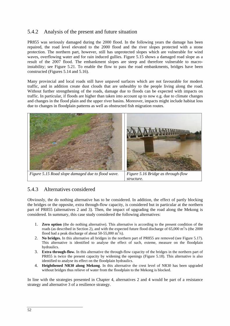
52
5.4.2 Analysis of the present and future situation PR855 was seriously damaged during the 2000 flood. In the following years the damage has been repaired, the road level elevated to the 2000 flood and the river slopes protected with a stone protection. The northern part, however, still has unprotected slopes which are vulnerable for wind waves, overflowing water and for rain induced gullies. Figure 5.15 shows a damaged road slope as a result of the 2007 flood. The embankment slopes are steep and therefore vulnerable to macro-instability; see Figure 5.21. To enable the flow to pass the road embankments, bridges have been constructed (Figures 5.14 and 5.16). Many provincial and local roads still have unpaved surfaces which are not favourable for modern traffic, and in addition create dust clouds that are unhealthy to the people living along the road. Without further strengthening of the roads, damage due to floods can be expected with impacts on traffic. In particular, if floods are higher than taken into account up to now e.g. due to climate changes and changes in the flood plain and the upper river basins. Moreover, impacts might include habitat loss due to changes in floodplain patterns as well as obstructed fish migration routes.
Figure 5.15 Road slope damaged due to flood wave. Figure 5.16 Bridge as through-flow
structure. 5.4.3 Alternatives considered Obviously, the do nothing alternative has to be considered. In addition, the effect of partly blocking the bridges or the opposite, extra through-flow capacity, is considered but in particular at the northern part of PR855 (alternatives 2 and 3). Then, the impact of upgrading the road along the Mekong is considered. In summary, this case study considered the following alternatives:
1. Zero option (the do nothing alternative). This alternative is according to the present condition of the roads (as described in Section 2), and with the expected future flood discharge of 65,000 m3/s (the 2000 flood had a peak discharge of about 50-55,000 m3/s).
2. No bridges. In this alternative all bridges in the northern part of PR855 are removed (see Figure 5.17). This alternative is identified to analyse the effect of such, exteme, measure on the floodplain hydraulics.
3. Extra through-flow. In this alternative the through-flow capacity of the bridges in the northern part of PR855 is twice the present capacity by widening the openings (Figure 5.18). This alternative is also identified to analyse its effect on the floodplain hydraulics.
4. Heighthened NR30 along Mekong. In this alternative the crest level of NR30 has been upgraded without bridges thus relieve of water from the floodplain to the Mekong is blocked.
In line with the strategies presented in Chapter 4, alternatives 2 and 4 would be part of a resistance strategy and alternative 3 of a resilience strategy.
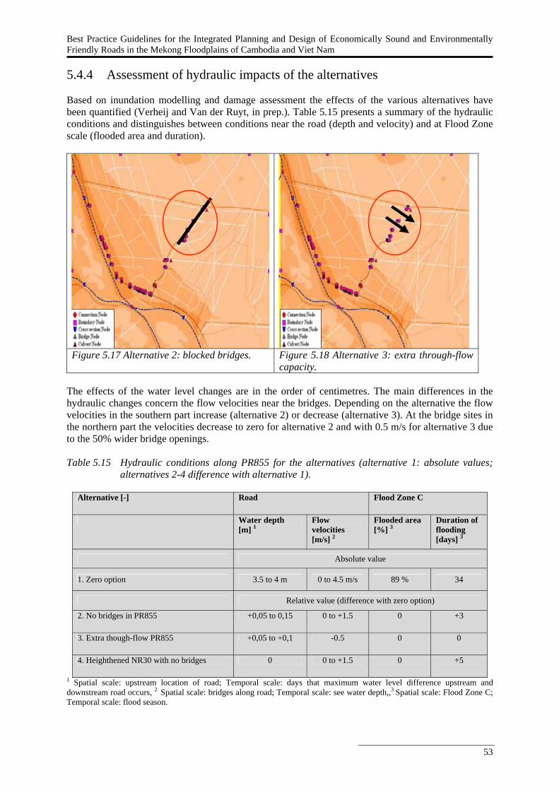
Best Practice Guidelines for the Integrated Planning and Design of Economically Sound and Environmentally Friendly Roads in the Mekong Floodplains of Cambodia and Viet Nam
53
5.4.4 Assessment of hydraulic impacts of the alternatives Based on inundation modelling and damage assessment the effects of the various alternatives have been quantified (Verheij and Van der Ruyt, in prep.). Table 5.15 presents a summary of the hydraulic conditions and distinguishes between conditions near the road (depth and velocity) and at Flood Zone scale (flooded area and duration).
Figure 5.17 Alternative 2: blocked bridges. Figure 5.18 Alternative 3: extra through-flow
capacity. The effects of the water level changes are in the order of centimetres. The main differences in the hydraulic changes concern the flow velocities near the bridges. Depending on the alternative the flow velocities in the southern part increase (alternative 2) or decrease (alternative 3). At the bridge sites in the northern part the velocities decrease to zero for alternative 2 and with 0.5 m/s for alternative 3 due to the 50% wider bridge openings. Table 5.15 Hydraulic conditions along PR855 for the alternatives (alternative 1: absolute values;
alternatives 2-4 difference with alternative 1).
Alternative [-] Road Flood Zone C
Water depth
[m] 1 Flow velocities [m/s] 2
Flooded area [%] 3
Duration of flooding [days] 3
Absolute value
1. Zero option 3.5 to 4 m 0 to 4.5 m/s 89 % 34
Relative value (difference with zero option)
2. No bridges in PR855 +0,05 to 0,15 0 to +1.5 0 +3
3. Extra though-flow PR855 +0,05 to +0,1 -0.5 0 0
4. Heighthened NR30 with no bridges 0 0 to +1.5 0 +5
1 Spatial scale: upstream location of road; Temporal scale: days that maximum water level difference upstream and downstream road occurs, 2 Spatial scale: bridges along road; Temporal scale: see water depth,,3 Spatial scale: Flood Zone C; Temporal scale: flood season.
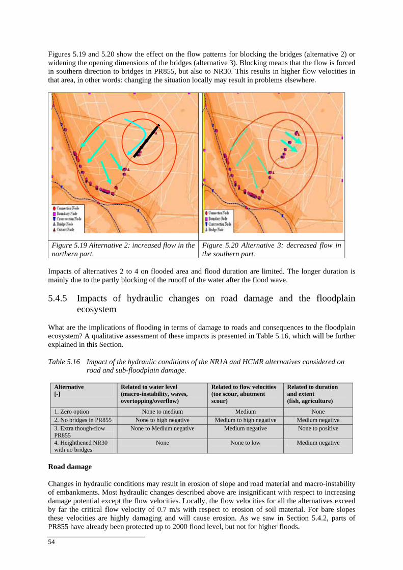
54
Figures 5.19 and 5.20 show the effect on the flow patterns for blocking the bridges (alternative 2) or widening the opening dimensions of the bridges (alternative 3). Blocking means that the flow is forced in southern direction to bridges in PR855, but also to NR30. This results in higher flow velocities in that area, in other words: changing the situation locally may result in problems elsewhere.
Figure 5.19 Alternative 2: increased flow in the northern part.
Figure 5.20 Alternative 3: decreased flow in the southern part.
Impacts of alternatives 2 to 4 on flooded area and flood duration are limited. The longer duration is mainly due to the partly blocking of the runoff of the water after the flood wave. 5.4.5 Impacts of hydraulic changes on road damage and the floodplain
ecosystem What are the implications of flooding in terms of damage to roads and consequences to the floodplain ecosystem? A qualitative assessment of these impacts is presented in Table 5.16, which will be further explained in this Section. Table 5.16 Impact of the hydraulic conditions of the NR1A and HCMR alternatives considered on
road and sub-floodplain damage.
Alternative [-]
Related to water level (macro-instability, waves, overtopping/overflow)
Related to flow velocities (toe scour, abutment scour)
Related to duration and extent (fish, agriculture)
1. Zero option None to medium Medium None 2. No bridges in PR855 None to high negative Medium to high negative Medium negative 3. Extra though-flow PR855
None to Medium negative Medium negative None to positive
4. Heighthened NR30 with no bridges
None None to low Medium negative
Road damage Changes in hydraulic conditions may result in erosion of slope and road material and macro-instability of embankments. Most hydraulic changes described above are insignificant with respect to increasing damage potential except the flow velocities. Locally, the flow velocities for all the alternatives exceed by far the critical flow velocity of 0.7 m/s with respect to erosion of soil material. For bare slopes these velocities are highly damaging and will cause erosion. As we saw in Section 5.4.2, parts of PR855 have already been protected up to 2000 flood level, but not for higher floods.

Best Practice Guidelines for the Integrated Planning and Design of Economically Sound and Environmentally Friendly Roads in the Mekong Floodplains of Cambodia and Viet Nam
55
Part of PR855 is a dirt road with unproctected slopes and thus very vulnerable for flood damage. A bitumen surface and/or protected slopes would reduce damage cost considerably. The examples of damage are shown in Figures 5.21 and 5.22.
Figure 5.21 Sliding of PR855 after the 2007 flood.
Figure 5.22 Damaged bridge abutment PR855.
Impact on the floodplain ecosystem With respect to the impact on fisheries and agriculture alternative 1 (zero option). Alternatives 2 and 4 show medium negative impacts in the sense that the duration of the flooding days increases. The extra flow-through alternative shows no impact on flooded area as well flood duration given the calculations made. 5.4.6 Costs of the alternatives The results of the financial analysis are also provided in Table 5.17. For reasons of comparison, the total investment costs are calculated assuming no construction has taken place yet. The “no bridges” option is the cheapest option, closely followed by the “zero option” (the current design) and the “extra bridges” option. At an OCC of 6.3% the costs of the zero option would be equal to the “no bridges” option. At an OCC of 2.5% the costs of the zero option would be equal to the “extra bridges” option. Evaluation of the upgrade of the other road is difficult as the benefits to that road are not known. Table 5.17 Results financial analysis PR855.
Alternative Current investment cost
Total investment cost
Total annual operating costs
Flood damage per 5 year
NPV of total costs at 12%
IRR <> zero option
1. zero option 0 4,225,000 211,250 256,250 5,644,220 - 2. no bridges 0 4,000,000 200,000 400,000 5,527,982 6.3% 3. extra bridges 4,450,000 4,450,000 222,500 165,000 5,821,947 2.5% 4. upgrade other road 0 44,225,000 211,250 312,500 41,424,386 N/A
Note: all figures are in USD 5.4.7 Integrated impact assessment of the alternatives In order to analyse the total impact of the identified alternatives of the rehabilitation of PR855 it is important to consider all relevant issues at the early stages of planning and design (Chapter 4). Relevant issues include transport, finance, hydraulics, ecology and social welfare. These issues are reflected in the objectives and related impact indicators presented in Table 5.18 and include short-term and long-term impacts and local and sub-floodplain impacts.

56
Table 5.18 presents a first qualitative assessment of the different alternatives of PR855 based on the hydraulic, damage and economic analyses presented in the previous Sections and a qualitative judgement of the other indicators. Table 5.18 Integrated impact table (+++ best alternative, --- worst alternative).
Objectives
Impact indicators
1. Zero option
2. No bridges PR855
3. Extra through-flow PR855
4. Heighthened NR30
Enhance regional transportation
Travel time (road)
+
+
+
++
Minimise road investment
Initial current investment costs (road)
++
++
--
++
Minimise road operation and maintenance
Operation and maintenance (damage rehabilitation) costs (road)
-
-
+
-
Damage of flooding to structures in vicinity of road
+
-
+
--
Reduce flooding vulnerability (vicinity of the road)
Damage of flooding to PR855
-
---
+
--
Reduce flooding vulnerability
Damage of flooding to other roads than PR855 (sub-floodplain)
-
--
+
+
Resettlement (road)
-
--
+
-- Minimise social
impacts
Water quality (sub-floodplain)
-
--
+
++
Flood pattern and dynamics (sub-floodplain)
++
---
+
++
Maintain floodplain hydraulics and ecology
Habitat fragmentation (sub-floodplain)
++
---
+
++
The following comments and observations can be made based on Table 5.18.
All alternatives have a positive effect on traffic, because of the improved road condition of PR855 and the heighthened of NR30.
Alternative 3 have highest initial investment (heighthened NR30 is not considered in the impact table), while operation and maintenance costs do not differ much. In alternative 2 the highest damage to the road is foreseen, while in alternative 3 the lowest.
The construction of PR855 in the no bridges alternative obstructs the fish migration paths because no through-flow capacity will be realized. This alternative will also seriously affect agriculture, floodplain hydraulics and ecology due to the decreased flooded area.
5.4.8 Ranking of the alternatives In this Section, we illustrate that a different perspective on road development (e.g. transport, flood protection, ecology) will lead to a different ranking of alternatives as each perspective prioritizes objectives differently. An example of this different weighting of objectives (listed in Table 5.18) for each perspective is illustrated by Table 5.19. The weights in Table 5.19 are exaggerated to make differences between the perspectives more explicit; in reality objectives and their relative importance are set by decision-makers during the planning process. Apart from the transport, ecology and flood protection perspectives a fourth perspective is added called ‘sustainable development’ that aims to minimise on long-term ‘costs’ in terms of investment, road maintenance and flood damage repair costs, social costs and ecological costs.
Best Practice Guidelines for the Integrated Planning and Design of Economically Sound and Environmentally Friendly Roads in the Mekong Floodplains of Cambodia and Viet Nam
57
Table 5.19 Example of weights by objective for various perspectives on road development and
rehabilitation (5 highest importance; 1 lowest importance).
Example perspectives (total = 20) Objectives of road development and rehabilitation
Transport
Flood protection
Ecology Sustainability
Enhance regional transportation 5 2 2 1 Minimise road investment 4 3 2 3 Minimise road operation and maintenance 4 3 2 3 Reduce flooding vulnerability (vicinity of the road) 2 4 4 3 Reduce flooding vulnerability (sub-floodplain) 2 5 2 3 Minimise social impacts 2 3 3 3 Maintain floodplain hydraulics and ecology (sub-floodplain) 1 0 5 4 Total 20 20 20 20
Based on the perspectives as presented in the table above, a ranking of alternatives was calculated using the impact table (Table 5.18). This exercise shows that the zero option alternative, ranks highest for the ecology and sustainability perspective (Table 5.20); it does not influence the floodplain hydraulics and the ecology and has no negative effects with respect to resettlement. Obviously, the do nothing alternative is not an option because roads are essential to develop the region, and negative effects have to be accepted as long as they are within certain limits. From transport perspective an upgraded NR 30 is the best alternative. Alternative 3 (extra through-flow) scores high for all perspectives, except for the transport perspective. Table 5.20 Ranking alternatives based on impact table (Table 5.18) and perspectives (Table 5.19) (1
highest ranking; 5 lowest ranking). Note that in both the ecology and sustainability perspective two alternatives rank the same.
Perspectives Alternative Transport Flood protection Ecology Sustainability
1. Zero option 2 2 1 1 2. No bridges in PR855 4 4 4 4 3. Extra through-flow PR855 3 1 1 2 4. Heighthened NR30 1 3 3 2
5.5 Case 4: Construction of new NR1A and HCM road (Viet Nam) 5.5.1 Introduction7 National Road (NR) 1A is a new road, which is soon to be constructed. The road runs just north of the existing NR1 with bypasses at most villages. HCM road is a new road connecting Cao Lanh and the south with NR 2 in the north. 5.5.2 Analysis of the present and future situation NR1A and HCM road are not yet constructed. The design in terms of flood vulnerability is still open, but many flow-through structures such as bridges and culverts are planned. The alignment is perpendicular to the flow direction of the flood. The locaton of bridges and culverts is related to existing canals and the main flow pattern during floods. NR1A and HCM road can have a large effect on hydraulic conditions downstream, which may effect agricultural production. The consequences of a non-optimal road design can be local damage or less agricultural crops. Also ecological impacts should be considered like agricultural imopacts and impacts on fish habitat as well as obstructed fish migration routes.
7 The case presented is discussed in more detail in the Technical guidelines report (Verheij and Van der Ruyt, in prep.).
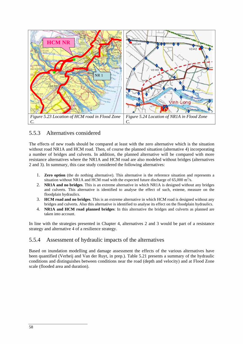
58
HCM NR
NR 1
Figure 5.23 Location of HCM road in Flood Zone C.
Figure 5.24 Location of NR1A in Flood Zone C.
5.5.3 Alternatives considered The effects of new roads should be compared at least with the zero alternative which is the situation without road NR1A and HCM road. Then, of course the planned situation (alternative 4) incorporating a number of bridges and culverts. In addition, the planned alternative will be compared with more resistance alternatives where the NR1A and HCM road are also modeled without bridges (alternatives 2 and 3). In summary, this case study considered the following alternatives:
1. Zero option (the do nothing alternative). This alternative is the reference situation and represents a situation without NR1A and HCM road with the expected future discharge of 65,000 m3/s.
2. NR1A and no bridges. This is an extreme alternative in which NR1A is designed without any bridges and culverts. This alternative is identified to analyse the effect of such, exteme, measure on the floodplain hydraulics.
3. HCM road and no bridges. This is an extreme alternative in which HCM road is designed without any bridges and culverts. Also this alternative is identified to analyse its effect on the floodplain hydraulics.
4. NR1A and HCM road planned bridges: In this alternative the bridges and culverts as planned are taken into account.
In line with the strategies presented in Chapter 4, alternatives 2 and 3 would be part of a resistance strategy and alternative 4 of a resilience strategy. 5.5.4 Assessment of hydraulic impacts of the alternatives Based on inundation modelling and damage assessment the effects of the various alternatives have been quantified (Verheij and Van der Ruyt, in prep.). Table 5.21 presents a summary of the hydraulic conditions and distinguishes between conditions near the road (depth and velocity) and at Flood Zone scale (flooded area and duration).
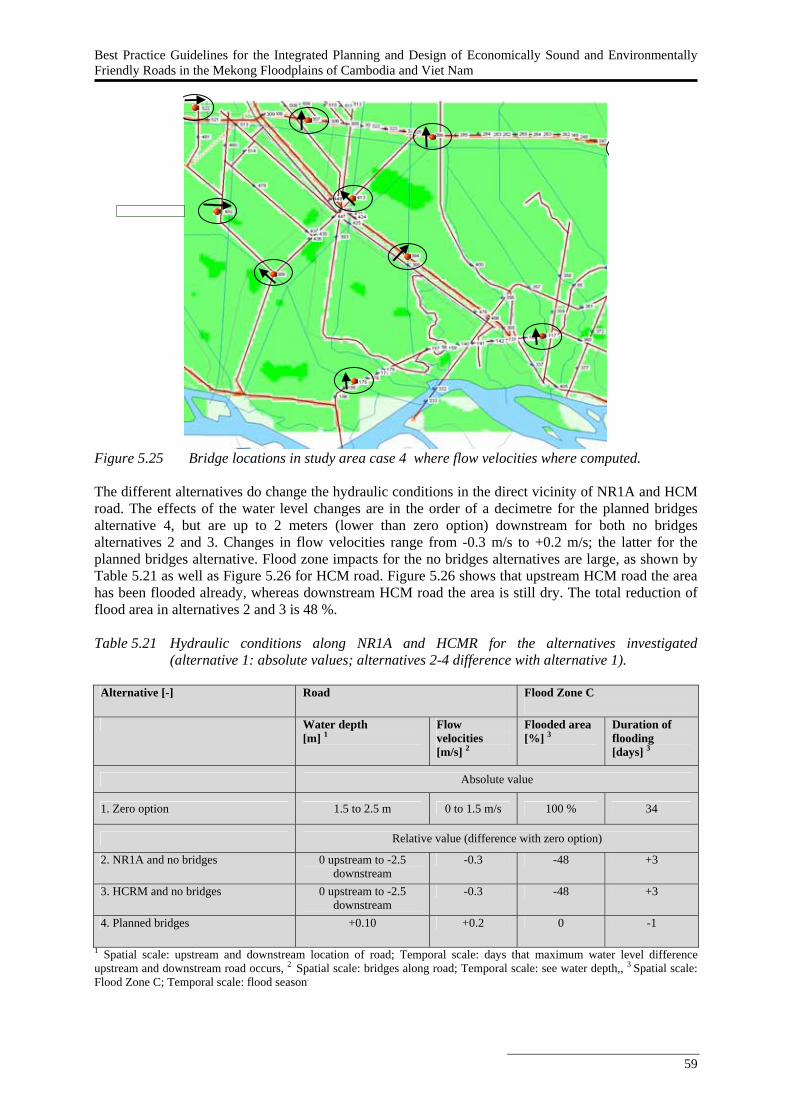
Best Practice Guidelines for the Integrated Planning and Design of Economically Sound and Environmentally Friendly Roads in the Mekong Floodplains of Cambodia and Viet Nam
59
Figure 5.25 Bridge locations in study area case 4 where flow velocities where computed. The different alternatives do change the hydraulic conditions in the direct vicinity of NR1A and HCM road. The effects of the water level changes are in the order of a decimetre for the planned bridges alternative 4, but are up to 2 meters (lower than zero option) downstream for both no bridges alternatives 2 and 3. Changes in flow velocities range from -0.3 m/s to +0.2 m/s; the latter for the planned bridges alternative. Flood zone impacts for the no bridges alternatives are large, as shown by Table 5.21 as well as Figure 5.26 for HCM road. Figure 5.26 shows that upstream HCM road the area has been flooded already, whereas downstream HCM road the area is still dry. The total reduction of flood area in alternatives 2 and 3 is 48 %. Table 5.21 Hydraulic conditions along NR1A and HCMR for the alternatives investigated
(alternative 1: absolute values; alternatives 2-4 difference with alternative 1).
Alternative [-] Road Flood Zone C
Water depth
[m] 1 Flow velocities [m/s] 2
Flooded area [%] 3
Duration of flooding [days] 3
Absolute value
1. Zero option 1.5 to 2.5 m 0 to 1.5 m/s 100 % 34
Relative value (difference with zero option)
2. NR1A and no bridges 0 upstream to -2.5 downstream
-0.3 -48 +3
3. HCRM and no bridges 0 upstream to -2.5 downstream
-0.3 -48 +3
4. Planned bridges +0.10 +0.2 0 -1
1 Spatial scale: upstream and downstream location of road; Temporal scale: days that maximum water level difference upstream and downstream road occurs, 2 Spatial scale: bridges along road; Temporal scale: see water depth,, 3 Spatial scale: Flood Zone C; Temporal scale: flood season.
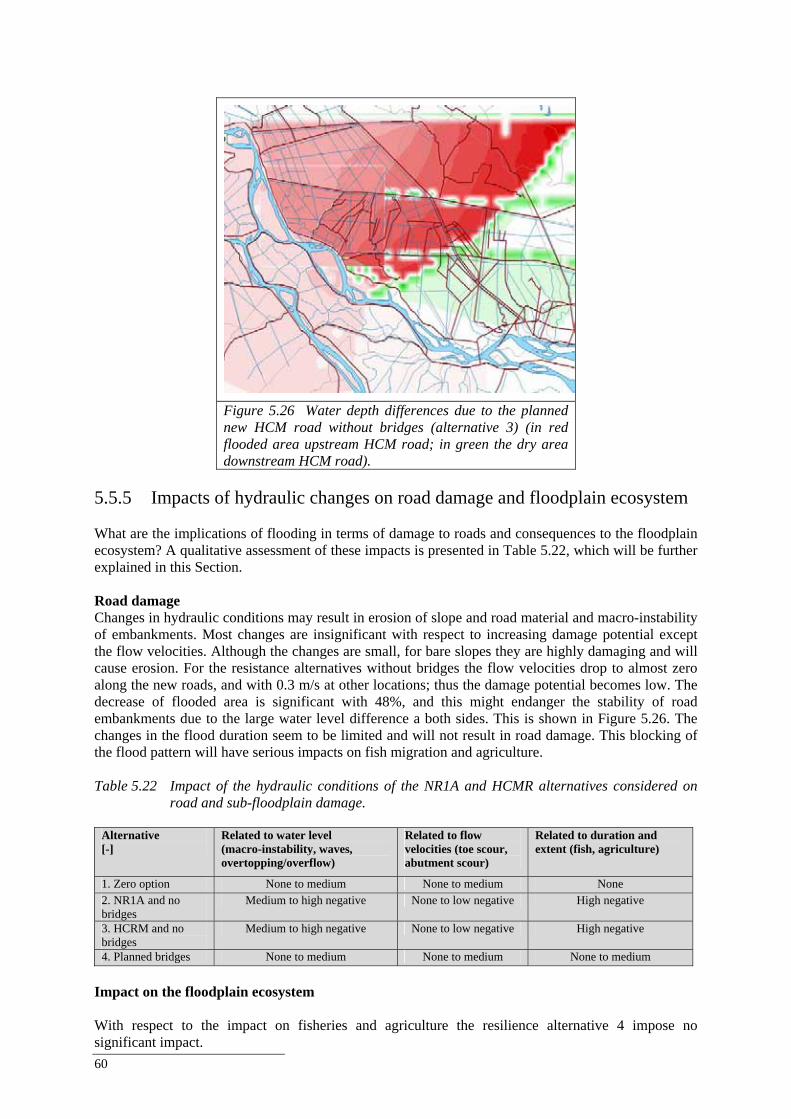
60
Figure 5.26 Water depth differences due to the planned new HCM road without bridges (alternative 3) (in red flooded area upstream HCM road; in green the dry area downstream HCM road).
5.5.5 Impacts of hydraulic changes on road damage and floodplain ecosystem What are the implications of flooding in terms of damage to roads and consequences to the floodplain ecosystem? A qualitative assessment of these impacts is presented in Table 5.22, which will be further explained in this Section. Road damage Changes in hydraulic conditions may result in erosion of slope and road material and macro-instability of embankments. Most changes are insignificant with respect to increasing damage potential except the flow velocities. Although the changes are small, for bare slopes they are highly damaging and will cause erosion. For the resistance alternatives without bridges the flow velocities drop to almost zero along the new roads, and with 0.3 m/s at other locations; thus the damage potential becomes low. The decrease of flooded area is significant with 48%, and this might endanger the stability of road embankments due to the large water level difference a both sides. This is shown in Figure 5.26. The changes in the flood duration seem to be limited and will not result in road damage. This blocking of the flood pattern will have serious impacts on fish migration and agriculture. Table 5.22 Impact of the hydraulic conditions of the NR1A and HCMR alternatives considered on
road and sub-floodplain damage.
Alternative [-]
Related to water level (macro-instability, waves, overtopping/overflow)
Related to flow velocities (toe scour, abutment scour)
Related to duration and extent (fish, agriculture)
1. Zero option None to medium None to medium None 2. NR1A and no bridges
Medium to high negative None to low negative High negative
3. HCRM and no bridges
Medium to high negative None to low negative High negative
4. Planned bridges None to medium None to medium None to medium Impact on the floodplain ecosystem With respect to the impact on fisheries and agriculture the resilience alternative 4 impose no significant impact.
Best Practice Guidelines for the Integrated Planning and Design of Economically Sound and Environmentally Friendly Roads in the Mekong Floodplains of Cambodia and Viet Nam
61
The duration and extent hardly change. For the resistance alternatives 2 and 3 the extent of the flood does change significantly, and this effect is not temporarily as it is assumed that the levees along the Mekong River do not allow inundation of the flood zone from downstream. This has serious implication to the fisheries sector as every hectare of floodplain lost due to road development could lead to a loss of 100 kg of fish each year (Halls et al. 2006). If the levees are not raised the downstream area will be inundated later than the upstream area because the water has to enter this area form downstream. Then, the effects are temporarily. The duration of the flooding in the upstream area will be a few days longer due to the limited ways for the water to flow back to the river. The resistance alternative without bridges does have a significant negative impact on fish migration routes. The resistance alternatives influence also the agriculture due to the considerable decrease in flood extent. 5.5.6 Costs of the alternatives Table 5.23 shows that designs without bridges are the least expensive and that the OCC should be below respectively 5.5% and 3.6% for the other alternatives to be less expensive than the NR1a & no bridges option. Design against a lower standard, for which the figures are given in Table 5.24, will lead to a NPV of US$ 275 million. Table 5.23 Results financial analysis NR1a and HCMC Road.
Alternative Total investment cost
Total annual operating costs
Flood damage per 5 year
NPV of total costs at 12%
IRR <> NR1a & no bridges
1. zero option 0 0 0 0 - 2. NR1a & no bridges 120,000,000 2,400,000 2,400,000 127,810,641 - 3. HCM & no bridges 300,000,000 6,000,000 6,000,000 319,526,602 5.5% 4. NR1a & HCM road & planned bridges 490,000,000 9,800,000 6,400,000 517,911,405 3.6%
Note: all figures are in USD Table 5.24 Comparison of costs according to a high standard and a low standard for alternative 4
with planned bridges.
Costs High standard Low standard Investment costs [USD] 490,000,000 240,000,000 O & M costs [USD/year] 9,800,000 7,200,000 Flood damage costs [USD per 5 years] 6,400,000 5,700,000
5.5.7 Integrated impact assessment of the alternatives In order to analyse the total impact of the identified alternatives of the construction of the NR1A and HCM road it is important to consider all relevant issues at the early stages of planning and design (Chapter 4). Relevant issues include transport, finance, hydraulics, ecology and social welfare. These issues are reflected in the objectives and related impact indicators presented in Table 5.25 and include short-term and long-term impacts and local and sub-floodplain impacts. Table 5.25 presents a first qualitative assessment of the different alternatives of the NR1A and HCM road based on the hydraulic, damage and economic analyses presented in the previous Sections and a qualitative judgement of the other indicators. The following comments and observations can be made based on Table 5.25.
All alternatives, except the zero option, have a positive effect on traffic, because of the extension of the road network with the new NR1A and HCMR.
Higher floods in the future, up to 65.000 m3/s, do have a slight influence on the damage to roads independent of the amount of through-flow structures. Flow velocities will increase from medium expected damage to high expected damage (considering no slope protection, with a protection the damage is low).
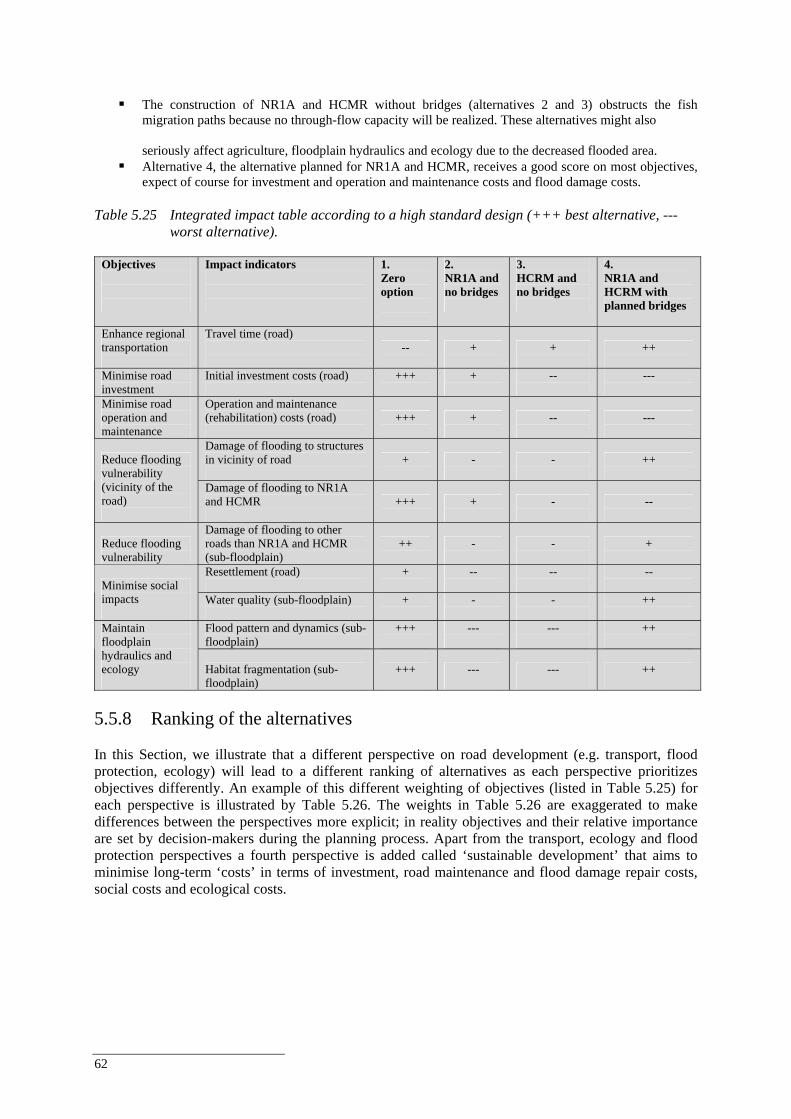
62
The construction of NR1A and HCMR without bridges (alternatives 2 and 3) obstructs the fish
migration paths because no through-flow capacity will be realized. These alternatives might also seriously affect agriculture, floodplain hydraulics and ecology due to the decreased flooded area.
Alternative 4, the alternative planned for NR1A and HCMR, receives a good score on most objectives, expect of course for investment and operation and maintenance costs and flood damage costs.
Table 5.25 Integrated impact table according to a high standard design (+++ best alternative, ---
worst alternative).
Objectives
Impact indicators
1. Zero option
2. NR1A and no bridges
3. HCRM and no bridges
4. NR1A and HCRM with planned bridges
Enhance regional transportation
Travel time (road)
--
+
+
++
Minimise road investment
Initial investment costs (road)
+++
+
--
---
Minimise road operation and maintenance
Operation and maintenance (rehabilitation) costs (road)
+++
+
--
---
Damage of flooding to structures in vicinity of road
+
-
-
++
Reduce flooding vulnerability (vicinity of the road)
Damage of flooding to NR1A and HCMR
+++
+
-
--
Reduce flooding vulnerability
Damage of flooding to other roads than NR1A and HCMR (sub-floodplain)
++
-
-
+
Resettlement (road)
+
--
--
-- Minimise social
impacts
Water quality (sub-floodplain)
+
-
-
++
Flood pattern and dynamics (sub-floodplain)
+++
---
---
++
Maintain floodplain hydraulics and ecology
Habitat fragmentation (sub-floodplain)
+++
---
---
++
5.5.8 Ranking of the alternatives In this Section, we illustrate that a different perspective on road development (e.g. transport, flood protection, ecology) will lead to a different ranking of alternatives as each perspective prioritizes objectives differently. An example of this different weighting of objectives (listed in Table 5.25) for each perspective is illustrated by Table 5.26. The weights in Table 5.26 are exaggerated to make differences between the perspectives more explicit; in reality objectives and their relative importance are set by decision-makers during the planning process. Apart from the transport, ecology and flood protection perspectives a fourth perspective is added called ‘sustainable development’ that aims to minimise long-term ‘costs’ in terms of investment, road maintenance and flood damage repair costs, social costs and ecological costs.
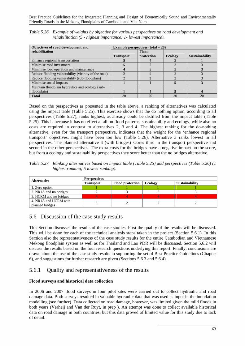
Best Practice Guidelines for the Integrated Planning and Design of Economically Sound and Environmentally Friendly Roads in the Mekong Floodplains of Cambodia and Viet Nam
63
Table 5.26 Example of weights by objective for various perspectives on road development and
rehabilitation (5 - highest importance; 1- lowest importance).
Example perspectives (total = 20) Objectives of road development and rehabilitation
Transport Flood protection Ecology Sustainability
Enhance regional transportation 5 4 2 1 Minimise road investment 5 2 2 3 Minimise road operation and maintenance 4 2 2 3 Reduce flooding vulnerability (vicinity of the road) 2 5 2 3 Reduce flooding vulnerability (sub-floodplain) 2 5 2 3 Minimise social impacts 1 1 5 3 Maintain floodplain hydraulics and ecology (sub-floodplain) 1 1 5 4 Total 20 20 20 20
Based on the perspectives as presented in the table above, a ranking of alternatives was calculated using the impact table (Table 5.25). This exercise shows that the do nothing option, according to all perspectives (Table 5.27), ranks highest, as already could be distilled from the impact table (Table 5.25). This is because it has no effect at all on flood patterns, sustainability and ecology, while also no costs are required in contrast to alternatives 2, 3 and 4. The highest ranking for the do-nothing alternative, even for the transport perspective, indicates that the weight for the ‘enhance regional transport’ objectives, might have been too low (Table 5.26). Alternative 3 ranks lowest in all perspectives. The planned alternative 4 (with bridges) scores third in the transport perspective and second in the other perspectives. The extra costs for the bridges have a negative impact on the score, but from a ecology and sustainability perspectives they score better than the no bridges alternative. Table 5.27 Ranking alternatives based on impact table (Table 5.25) and perspectives (Table 5.26) (1
highest ranking; 5 lowest ranking).
Perspectives Alternative Transport Flood protection Ecology Sustainability 1. Zero option 1 1 1 1 2. NR1A and no bridges 2 3 3 3 3. HCRM and no bridges 4 4 4 4 4. NR1A and HCRM with planned bridges 3 2 2 2
5.6 Discussion of the case study results This Section discusses the results of the case studies. First the quality of the results will be discussed. This will be done for each of the technical analysis steps taken in the project (Section 5.6.1). In this Section also the representativeness of the case study results for the entire Cambodian and Vietnamese Mekong floodplain system as well as for Thailand and Lao PDR will be discussed. Section 5.6.2 will discuss the results based on the four research questions underlying this report. Finally, conclusions are drawn about the use of the case study results in supporting the set of Best Practice Guidelines (Chapter 6), and suggestions for further research are given (Sections 5.6.3 and 5.6.4). 5.6.1 Quality and representativeness of the results Flood surveys and historical data collection In 2006 and 2007 flood surveys in four pilot sites were carried out to collect hydraulic and road damage data. Both surveys resulted in valuable hydraulic data that was used as input in the inundation modelling (see further). Data collected on road damage, however, was limited given the mild floods in both years (Verheij and Van der Ruyt, in prep ). An attempt was done to collect available historical data on road damage in both countries, but this data proved of limited value for this study due to lack of detail.
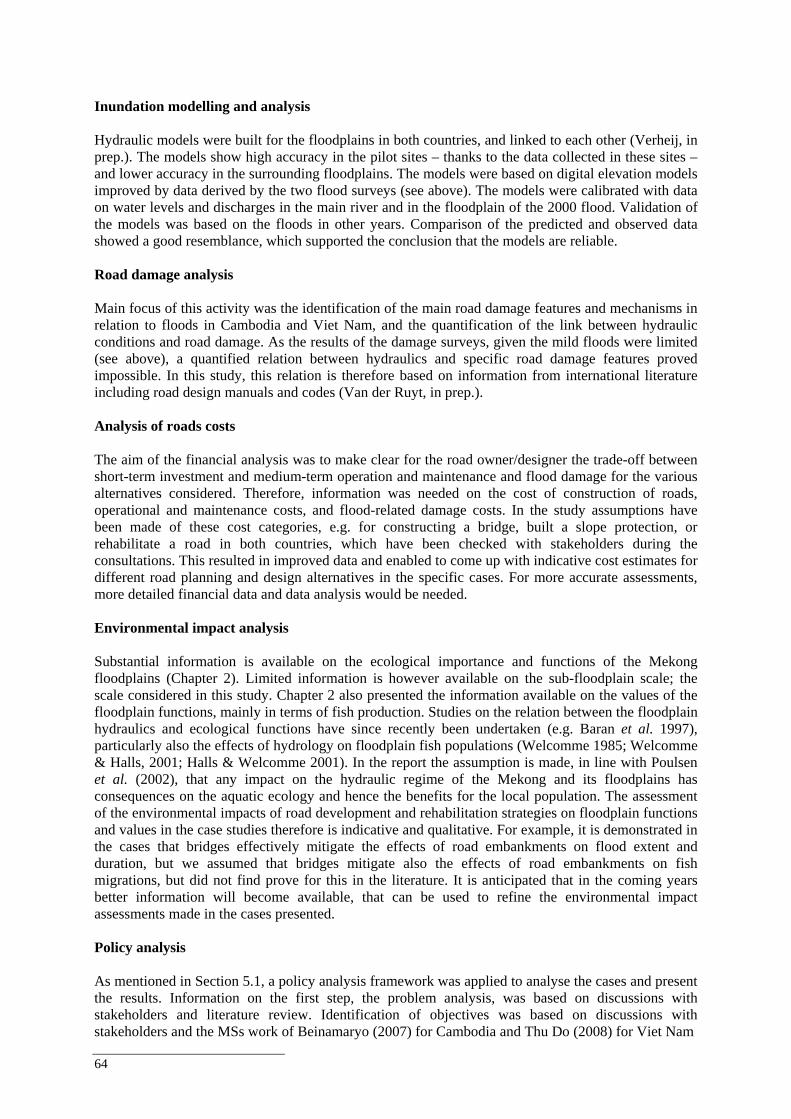
64
Inundation modelling and analysis Hydraulic models were built for the floodplains in both countries, and linked to each other (Verheij, in prep.). The models show high accuracy in the pilot sites – thanks to the data collected in these sites – and lower accuracy in the surrounding floodplains. The models were based on digital elevation models improved by data derived by the two flood surveys (see above). The models were calibrated with data on water levels and discharges in the main river and in the floodplain of the 2000 flood. Validation of the models was based on the floods in other years. Comparison of the predicted and observed data showed a good resemblance, which supported the conclusion that the models are reliable. Road damage analysis Main focus of this activity was the identification of the main road damage features and mechanisms in relation to floods in Cambodia and Viet Nam, and the quantification of the link between hydraulic conditions and road damage. As the results of the damage surveys, given the mild floods were limited (see above), a quantified relation between hydraulics and specific road damage features proved impossible. In this study, this relation is therefore based on information from international literature including road design manuals and codes (Van der Ruyt, in prep.). Analysis of roads costs The aim of the financial analysis was to make clear for the road owner/designer the trade-off between short-term investment and medium-term operation and maintenance and flood damage for the various alternatives considered. Therefore, information was needed on the cost of construction of roads, operational and maintenance costs, and flood-related damage costs. In the study assumptions have been made of these cost categories, e.g. for constructing a bridge, built a slope protection, or rehabilitate a road in both countries, which have been checked with stakeholders during the consultations. This resulted in improved data and enabled to come up with indicative cost estimates for different road planning and design alternatives in the specific cases. For more accurate assessments, more detailed financial data and data analysis would be needed. Environmental impact analysis Substantial information is available on the ecological importance and functions of the Mekong floodplains (Chapter 2). Limited information is however available on the sub-floodplain scale; the scale considered in this study. Chapter 2 also presented the information available on the values of the floodplain functions, mainly in terms of fish production. Studies on the relation between the floodplain hydraulics and ecological functions have since recently been undertaken (e.g. Baran et al. 1997), particularly also the effects of hydrology on floodplain fish populations (Welcomme 1985; Welcomme & Halls, 2001; Halls & Welcomme 2001). In the report the assumption is made, in line with Poulsen et al. (2002), that any impact on the hydraulic regime of the Mekong and its floodplains has consequences on the aquatic ecology and hence the benefits for the local population. The assessment of the environmental impacts of road development and rehabilitation strategies on floodplain functions and values in the case studies therefore is indicative and qualitative. For example, it is demonstrated in the cases that bridges effectively mitigate the effects of road embankments on flood extent and duration, but we assumed that bridges mitigate also the effects of road embankments on fish migrations, but did not find prove for this in the literature. It is anticipated that in the coming years better information will become available, that can be used to refine the environmental impact assessments made in the cases presented. Policy analysis As mentioned in Section 5.1, a policy analysis framework was applied to analyse the cases and present the results. Information on the first step, the problem analysis, was based on discussions with stakeholders and literature review. Identification of objectives was based on discussions with stakeholders and the MSs work of Beinamaryo (2007) for Cambodia and Thu Do (2008) for Viet Nam
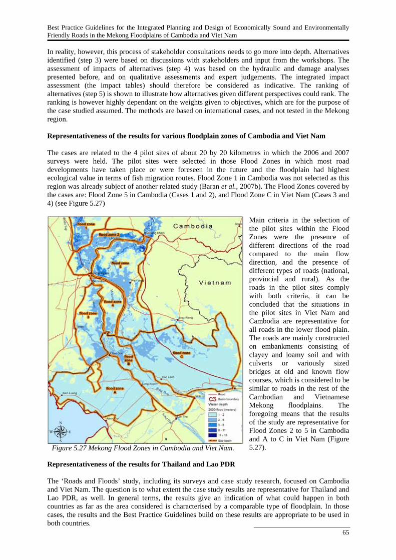
Best Practice Guidelines for the Integrated Planning and Design of Economically Sound and Environmentally Friendly Roads in the Mekong Floodplains of Cambodia and Viet Nam
65
In reality, however, this process of stakeholder consultations needs to go more into depth. Alternatives identified (step 3) were based on discussions with stakeholders and input from the workshops. The assessment of impacts of alternatives (step 4) was based on the hydraulic and damage analyses presented before, and on qualitative assessments and expert judgements. The integrated impact assessment (the impact tables) should therefore be considered as indicative. The ranking of alternatives (step 5) is shown to illustrate how alternatives given different perspectives could rank. The ranking is however highly dependant on the weights given to objectives, which are for the purpose of the case studied assumed. The methods are based on international cases, and not tested in the Mekong region. Representativeness of the results for various floodplain zones of Cambodia and Viet Nam The cases are related to the 4 pilot sites of about 20 by 20 kilometres in which the 2006 and 2007 surveys were held. The pilot sites were selected in those Flood Zones in which most road developments have taken place or were foreseen in the future and the floodplain had highest ecological value in terms of fish migration routes. Flood Zone 1 in Cambodia was not selected as this region was already subject of another related study (Baran et al., 2007b). The Flood Zones covered by the cases are: Flood Zone 5 in Cambodia (Cases 1 and 2), and Flood Zone C in Viet Nam (Cases 3 and 4) (see Figure 5.27)
Main criteria in the selection of the pilot sites within the Flood Zones were the presence of different directions of the road compared to the main flow direction, and the presence of different types of roads (national, provincial and rural). As the roads in the pilot sites comply with both criteria, it can be concluded that the situations in the pilot sites in Viet Nam and Cambodia are representative for all roads in the lower flood plain. The roads are mainly constructed on embankments consisting of clayey and loamy soil and with culverts or variously sized bridges at old and known flow courses, which is considered to be similar to roads in the rest of the Cambodian and Vietnamese Mekong floodplains. The foregoing means that the results of the study are representative for Flood Zones 2 to 5 in Cambodia and A to C in Viet Nam (Figure 5.27).
Representativeness of the results for Thailand and Lao PDR The ‘Roads and Floods’ study, including its surveys and case study research, focused on Cambodia and Viet Nam. The question is to what extent the case study results are representative for Thailand and Lao PDR, as well. In general terms, the results give an indication of what could happen in both countries as far as the area considered is characterised by a comparable type of floodplain. In those cases, the results and the Best Practice Guidelines build on these results are appropriate to be used in both countries.
Figure 5.27 Mekong Flood Zones in Cambodia and Viet Nam.
66
However, when applying the guidelines, the specific physical environment and flood characteristics of the region should be considered, as this can be quite different from the Cambodia and Viet Nam one, e.g. more flash floods in tributaries in more mountainous areas (MRC, 2007d). 5.6.2 Discussion of the results This Section will discuss the results, along the four research questions presented:
What is the significance of roads in the Cambodian and Vietnamese floodplains in changing flow patterns (including cumulative impacts)?
What is the significance of flow patterns in Cambodia and Viet Nam in terms of road damage? What are the impacts of different road development and rehabilitation strategies (resistance and
resilience) in Cambodia and Viet Nam on floodplain hydraulics and related benefits of floods and on economic costs of roads?
What road development and rehabilitation practice would contribute most to the reduction of the socio-economic costs of flooding in the Lower Mekong Basin, whilst preserving the environmental and other benefits of floods?
What is the significance of roads in the Cambodian and Vietnamese floodplains in changing flow patterns (including cumulative impacts)? The cases show that existing roads in the Cambodian and Vietnamese floodplains to a large extent are tailored to the local flow channels. Either they are situated on top of the main levees following the alignment of the channels (see Case 1 with road 11), or they are designed to obstruct the flow patterns as less as possible during floods (such as bridges in Case 3 and spillways or low-water crossings in Case 1). In general, this is more the situation for rural and Provincial Roads, and less for National Roads, for instance National Road 1 in Cambodia (Case 1) which is aligned perpendicular to the Mekong flows. In Viet Nam particularly, most existing roads are part of the diking system used to protect from floods and to manage water for agricultural purposes, but many flow-through structures are part of the system. Rehabilitation of existing roads (e.g. increasing the road elevation like after the 2000 floods, replacing old bridges by new ones, removal of a spillway) is unavoidable because modern society requires their upgrading to enhance traffic. However, rehabilitation of roads in floodplains (like presented in Cases 1, and 3) requires mitigating measures to reduce the effect of the road on the flow pattern locally as well as on sub-floodplain level. This holds even more when planning and constructing a new road (presented in Cases 2 and 4). In the cases presented in this Chapter we analysed in detail the impacts of different road development and rehabilitation alternatives on water depth, flow velocities, flooded area and flood duration. These impacts will be discussed below. The case results show that the different alternatives had a limited impact on the flood level (water height). In Cambodia this is mainly due to the ‘open’ character of its Mekong floodplain. The newly constructed road NR8 (Case 2) for instance will result in a local obstruction of the flood, because the flood is forced to pass the planned bridges. Even in the alternative with no bridges the area downstream of road 8 will be inundated from downstream due to the so ‘open’ (sub) flood plain. Thus, temporarily the water depth at both sides of the road embankment will show some difference, but after a few days the water levels will be equal again. In Viet Nam the flood pattern is much less ‘open’; rather it is more controlled and channelled by irrigation works. Existing and new roads are expected to be tailored to this situation and the water levels are much less likely to be attenuated on the floodplain as it is observed in Cambodia (as is also shown by the results of the Vietnamese Cases 3 and 4). Impacts on flood extent and duration in the case of alternatives of new planned roads without flow-through structures that block the flow patterns, such as alternative 5 Case NR 11 and PR 317 in Cambodia, are significant. These alternatives obstruct the flood pattern completely. The consequences are fragmentation of the floodplain which blocks the fish migration routes, but also significant change in duration and extent of the flooded area downstream of the new road. For instance, a decrease of about 50% of the flooded area.
Best Practice Guidelines for the Integrated Planning and Design of Economically Sound and Environmentally Friendly Roads in the Mekong Floodplains of Cambodia and Viet Nam
67
These impacts are less significant for those alternatives that include flow-through structures. In Case 1 these alternatives result in a change in flooded area of 5% which still is about 100,000 ha of mainly agricultural area that will not be fertilised by the floods. Hence, although these alternatives cause relatively small changes in flood dynamics (flooded area, duration, flood beginning), impacts on aquatic ecology and related functions should be considered. However, as more (road) developments in the flood zone and upstream of the zone can be anticipated in the near future, these effects will become larger. The cases (e.g. Case NR8 in Cambodia or Case PR855 in Viet Nam) show that such cumulative impacts are relevant to consider and might lead to more serious consequences in terms of road damage and ecological deterioration at a larger sub-floodplain scale. Apart from the impacts of individual roads, also cumulative impacts, being aggregated impacts from multiple (road development) activities, have been analysed in the cases. Blocking the flow patterns also means that the flood has to find another way in downstream direction. The consequence is that other areas might be exposed more than before and with higher damage due to the flood. These impacts are e.g. illustrated in Case 3 where in alternative 2 the flow-through openings in the northern part of the road are blocked. More specific, it is not only the change of flow pattern but also the characteristics of the new flow patterns: higher discharges with higher flow velocities. Another example is the removal of the spillway in Case 1 road 11. This results in larger amounts of water elsewhere, for instance at the bridges in the northern part of road 317, and higher flow velocities if no compensating measures are taken in a sense of adjusting the opening size to the increased flow. More dramatically is the heighthening of the left Mekong levees in alternative 5. This will result in an increase of the water level in the Mekong River with about 0.5m at Phnom Penh because the water can not flow anymore over Flood Zone 5 (see also Cross, 2003). Not only new roads cause cumulative effects, also road rehabilitation might have the same impacts, but their effects are mainly local. What is the significance of flow patterns in Cambodia and Viet Nam in terms of road damage? During a flood period large areas are inundated and flow patterns cross sub-floodplains. During the initial stages of the inundation the flood follows the irrigation canals in Viet Nam and the colmatage system in Cambodia. At higher flood stages the land will inundate and the flood patterns may cross roads with an alignment perpendicular to the flow pattern alignment, for example existing National Road 1 (Case 1) and the new road 8 (Case 2) in Cambodia, and the Provincial Road PR855 in Cambodia (Case 3). Obviously, if a flood pattern and a road embankment meet each other the forces exerted by the flood might cause damage to the road embankment including its flow-through structures (bridges, culverts, spillways). The damage is the result of water level differences over the road embankment, or flow velocities in the flow-through structures or along the slopes of the road embankments, or water flowing over the embankment in the case the water levels are higher than the road level, or wind waves. In Case 3 a picture is shown of a sliding during the 2007 flood. This type of damage is the result of a too steep road embankment. Slidings (macro instability) may also occur in the early stages of a flood when there is a water level difference between both sides of the road embankment. In particular, this happens for resistance alternatives such as in Case 4 with the alternatives 2 and 3 with new roads without any flow-trough openings. The flow velocities are the most important effect of the flow patterns on the roads, as a not properly designed road with bridges may suffer serious damage. Flow velocities well above critical values for the initiation of erosion of 0.5 m/s occur, sometimes even above critical values for protection materials as for instance small rock. See for instance Case 3 in Viet Nam. To reduce these velocities to an acceptable level by increasing the amount of flow-through structures or the opening dimensions is economically not possible. A proper protection together with streamlined abutments is a cheaper option, and very often the best way to protect the bare soil or to minimize the damage. The latter is demonstrated by alternative 4 of Case 2. The resistance alternatives which block the flow patterns reduce the flow velocities to zero for the particular road section and, subsequently, do not result in damage but are likely to cause damage elsewhere (as shown in Case 3 for the alternative with the blocked bridges in the northern part).
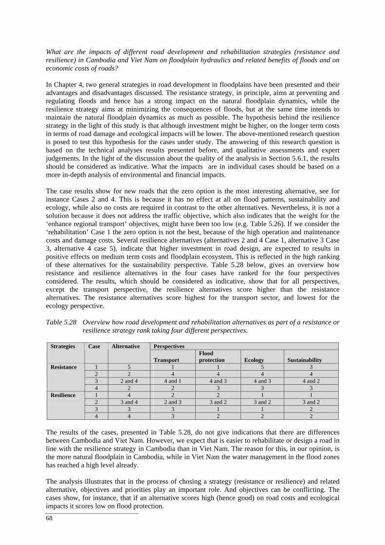
68
What are the impacts of different road development and rehabilitation strategies (resistance and resilience) in Cambodia and Viet Nam on floodplain hydraulics and related benefits of floods and on economic costs of roads? In Chapter 4, two general strategies in road development in floodplains have been presented and their advantages and disadvantages discussed. The resistance strategy, in principle, aims at preventing and regulating floods and hence has a strong impact on the natural floodplain dynamics, while the resilience strategy aims at minimizing the consequences of floods, but at the same time intends to maintain the natural floodplain dynamics as much as possible. The hypothesis behind the resilience strategy in the light of this study is that although investment might be higher, on the longer term costs in terms of road damage and ecological impacts will be lower. The above-mentioned research question is posed to test this hypothesis for the cases under study. The answering of this research question is based on the technical analyses results presented before, and qualitative assessments and expert judgements. In the light of the discussion about the quality of the analysis in Section 5.6.1, the results should be considered as indicative. What the impacts are in individual cases should be based on a more in-depth analysis of environmental and financial impacts. The case results show for new roads that the zero option is the most interesting alternative, see for instance Cases 2 and 4. This is because it has no effect at all on flood patterns, sustainability and ecology, while also no costs are required in contrast to the other alternatives. Nevertheless, it is not a solution because it does not address the traffic objective, which also indicates that the weight for the ‘enhance regional transport’ objectives, might have been too low (e.g. Table 5.26). If we consider the ‘rehabilitation’ Case 1 the zero option is not the best, because of the high operation and maintenance costs and damage costs. Several resilience alternatives (alternatives 2 and 4 Case 1, alternative 3 Case 3, alternative 4 case 5), indicate that higher investment in road design, are expected to results in positive effects on medium term costs and floodplain ecosystem. This is reflected in the high ranking of these alternatives for the sustainability perspective. Table 5.28 below, gives an overview how resistance and resilience alternatives in the four cases have ranked for the four perspectives considered. The results, which should be considered as indicative, show that for all perspectives, except the transport perspective, the resilience alternatives score higher than the resistance alternatives. The resistance alternatives score highest for the transport sector, and lowest for the ecology perspective. Table 5.28 Overview how road development and rehabilitation alternatives as part of a resistance or
resilience strategy rank taking four different perspectives.
Perspectives Strategies Case Alternative
Transport Flood protection Ecology Sustainability
1 5 1 1 5 3 2 2 4 4 4 4 3 2 and 4 4 and 1 4 and 3 4 and 3 4 and 2
Resistance
4 2 2 3 3 3 1 4 2 2 1 1 2 3 and 4 2 and 3 3 and 2 3 and 2 3 and 2 3 3 3 1 1 2
Resilience
4 4 3 2 2 2 The results of the cases, presented in Table 5.28, do not give indications that there are differences between Cambodia and Viet Nam. However, we expect that is easier to rehabilitate or design a road in line with the resilience strategy in Cambodia than in Viet Nam. The reason for this, in our opinion, is the more natural floodplain in Cambodia, while in Viet Nam the water management in the flood zones has reached a high level already. The analysis illustrates that in the process of chosing a strategy (resistance or resilience) and related alternative, objectives and priorities play an important role. And objectives can be conflicting. The cases show, for instance, that if an alternative scores high (hence good) on road costs and ecological impacts it scores low on flood protection.

Best Practice Guidelines for the Integrated Planning and Design of Economically Sound and Environmentally Friendly Roads in the Mekong Floodplains of Cambodia and Viet Nam
69
Resistance alternatives aiming at protecting the land from flooding, scores low (not good) on maintaining floodplain hydraulics and ecology. The purpose of the methodology applied to structure and present the cases, is to illustrate how these trade-offs could be made more transparent to decision-makers. The financial analysis has followed a relative simple approach using averages for flood damage. A more sophisticated analysis could include a probability analysis of flood damage occurrence and variation in the amount of damage sustained with different levels of floods. The financial analysis shows that in all cases the cheapest alternative will lead to the lowest cost for the owner of the roads. Hence, the extra investment costs are not covered by less damage and / or maintenance costs. However, road investments are usually not evaluated in a narrow financial sense as roads lead to many benefits for the economy as whole. Part of these benefits can be expressed in money and part of these benefits are non-monetary, such as less road casualties. Similarly, more sustainable roads, i.e. the more expensive alternatives, can lead to additional monetary and non-monetary benefits compared to the cheapest alternative that are not taken into account in a financial analysis. An economic analysis would provide more insight in these additional benefits. However, at (sub) floodplain level economic costs and benefits of roads and floods are difficult to determine. For instance, resilient and resistant roads provide a more reliable transport system, reducing transportation costs (less days with flooded roads; higher speeds due to less holes, lower vehicle operating costs etc.) and providing indirectly more (hard-to-quantify) economic opportunities to areas in the floodplain, including trade opportunities, increased land values. Roads that are not or less affected by flood damage are also safer roads, hence reducing road fatalities and traffic injuries. Similarly, floods have even harder-to-assess benefits. Although the hydraulic analysis shows that in most cases the impacts on the flood plain are minimal or small, roads or networks of roads that do have significant impacts could lead to negative externalities in the form of a reduction in environmental services that the floodplains provide, such as reduced revenues from fisheries and poorer soil quality, subsidence or salt infiltration in the Delta leading for instance to lower agricultural revenues. Some studies on benefits of roads have been carried out in the past, though not specifically for flood plains. For instance a World Bank study by Buys et al. (2006) estimates that a road upgrade project for the African continent would lead to an increase in trade of US$ 250 billion over 15 year with major direct and indirect benefits for the rural poor. Financing the program would require about $20 billion for initial upgrading and $1 billion annually for maintenance. Hence, the result from an economic cost-benefit analysis (as opposed to a financial cost benefit analysis) will more likely lead to higher NPV and IRR figures for more sustainable options. It should also be mentioned that the costs and benefits may affect the poor relatively more: improved access to rural areas could help poor to start business that would otherwise not be possible. (For instance road accessibility during the flood season could support fishery-based industries). What road development and rehabilitation practice would contribute most to the reduction of the socio-economic costs of flooding in the Lower Mekong Basin, whilst preserving the environmental and other benefits of floods? The cases make clear that road planning and design in the Mekong floodplain while reducing the socio-economic costs of flooding, and preserving the environmental and other benefits of floods is a complicated task that requires an integrated approach. The cases clearly show the need for the following types of integration:
The cases show that when developing roads in the Mekong floodplains, coordination between the road and transport sector and the water sector, flood risk management / dike sector, environment sector, and social sector is essential. Different sectors have a different perspective on floods and how to deal with them, and these objectives should be balanced in developments in floodplains, like road developments.
70
The character of the floodplain system, also requires that not only local (project) impacts are
considered, but also impacts and implications at a larger scale. The cases show that cumulative impacts of structural developments (including roads) occur. A solution at one location, might impact other locations. This requires coordination and integration at (sub-)floodplain scale.
Also integration / coordination with the financial sector and donors, in order to link infrastructure investment budgets with operation and maintenance and damage repair budgets. The case results indicate that a higher initial investments might probably lead to lower medium-term costs and ecological impacts. This requires an integrated financial assessment - integrated in terms of investment, operation and maintenance, damage risk - at the early planning stages. Such analysis would also contribute to a more efficient use of limited financial resources.
These different dimensions of integration will be reflected in the set of Best Practice Guidelines for road development and rehabilitation in the Mekong floodplains of Cambodia and Viet Nam which will presented in Chapter 6. 5.6.3 Conclusions and suggestions for further research The case studies undertaken in both Cambodia and Viet Nam allow us to answer the four research questions posed. Due to some data limitations and the fact that assessment of environmental and economic impact assessment was limited, the answers to questions 3 and 4 should be regarded as indicative. For the pupose of supporting the Best Practice Guidelines, the cases, do however, provide a sufficient basis. Moreover, apart from the case study results, the Best Practice Guidelines are based on the review of current international practice as well as the practice in the Mekong Basin. Based on this discussion the following suggestions for further research are identified:
Gathering geological and geotechnical data to classify geotechnical units to be coupled with hydraulic units within the LMB to allow the development of road damage relations.
Developing of detailed road damage functions and flow-through structure damage functions based on observed flood related damage and observed hydraulic conditions. Therefore, more surveys during flood conditions should be carried out in order to built up a data base.
Detailed hydraulic modelling of the flow conditions near and in flow-through structures in order to determine accurate flow velocities. This is important for the design of the protection of bridge abutments and guiding structures to culverts.
Study of the requirements of design and location of culverts and related structures for fish to pass these type of structures.
More in-depth economic analysis of costs and benefits of road development and its impacts, further supporting the integrated analysis and assessment of alternatives.
Further quantification of functions and values of the Mekong floodplain, also at Flood Zone level. Also analysis of minimum flow requirements to sustain the floodplain functions and analysis of how to incorporate in decision-making processes.
Best Practice Guidelines for the Integrated Planning and Design of Economically Sound and Environmentally Friendly Roads in the Mekong Floodplains of Cambodia and Viet Nam
71
6. A Set of Best Practice Guidelines for Road Development and Rehabilitation in the Mekong Floodplains of Cambodia and Vietnam
6.1 Introduction Main output of the ‘Roads and Floods’ project is a set of Best Practice Guidelines for road development and rehabilitation in the Mekong floodplains of Cambodia and Viet Nam. The guidelines are based on the review of local practice, international experience, and case study results. They are intended for use by professionals and organisations involved in road planning and design in the Mekong floodplains, as well as those involved in environmental and integrated assessments of road developments in the Mekong basin or structural developments in this basin in general. The Best Practice Guidelines are based on the case study results, the review of current international practice as well as the practice in the Mekong Basin. In the presentation of the Best Practice Guidelines, each of the recommendations is followed by an explanation including reference to their origin. The set of Best Practice Guidelines for road development and rehabilitation in the Mekong floodplains of Cambodia and Viet Nam consists of the following three Best Practice Guidelines:
Best Practice Guidelines for Integrated Planning of Road Development and Rehabilitation. Best Practice Guidelines for Environmental Assessment of Road Development and Rehabilitation. Best Practice Guidelines for Technical Design of Road Development and Rehabilitation.
The Best Practice Guidelines are presented underneath in section 6.2, 6.3 and 6.4 respectively. 6.2 Best Practice Guidelines for Integrated Planning of Road Development and
Rehabilitation in the Mekong Floodplains of Cambodia and Viet Nam 6.2.1 Introduction to the Best Practice Guidelines of FMMP-C2 In the FMMP-C2 ‘Structural Measures and Flood Proofing’ a number of Best Practice Guidelines are developed. The aim of these Best Practice Guidelines is to enable the MRC and national line agencies to better take into account flood-related considerations in their day-to-day technical activities. The ‘Roads and Floods’ Best Practice Guidelines are part of the FMMP-C2 Best Practice Guidelines.
The ‘Roads and Floods’ Best Practice Guideline do not provide detailed guidance, also because the local situations in Cambodia and Vietnam vary quite a lot and request tailored solutions. The guidelines do provide recommendations how to improve existing guidance. 6.2.2 How to use this Best Practice Guideline The Best Practice Guideline for integrated plannning is targeted at the following audiences:
National and provincial government agencies charged with planning and the land transport sector in
order to take into account flood-related considerations in the assessment and evaluation of their activities in an improved way. Additionally, transport and public works type of ministries and their associated agencies plus MRC and related riparian staff, particularly of BDP, in order to assess basin developments.
Development banks that often fund infra-structural works and / or studies producing guidelines for infra-structural planning and design.
Developers of road development and rehabilitation projects in the Mekong floodplains, consultants, research groups and NGO’s who are involved in environmental assessments in the LMB.
72
The Best Practice Guideline for integrated plannning is a set of recommendations which may be followed during the process of road development and planning in the Mekong floodplains. The Best Practice Guideline can be used for both infrastructure and road policies, plans and programmes (at strategic levels) and individual development and rehabilitation projects.
6.2.3 Background on development of the Best Practice Guideline This Best Practice Guideline for integrated plannning was designed on the basis of:
Review of current planning systems in Cambodia and Viet Nam. Review of international guidelines and best practices. In-depth analysis of a number of road development and rehabilitation cases in Cambodia and Viet
Nam. The above-listed activities were part of the ‘Roads and Floods’ project and detailed information on the project, its activities and results can be found in the Roads and Floods Synthesis Report (Douven et al., 2009). 6.2.4 Purpose and scope The overall goal of the Best Practice Guideline is to mainstream the planning and development of roads within the vulnerable and highly valuable Mekong floodplain system with their consequences including economic, environmental and social impacts, both short- and long-term ones.
The specific objectives of the Best Practice Guideline are the following:
To promote the adoption of integrated planning approaches to road development and planning in the Mekong floodplain.
To provide guidance on the application of integrated planning approaches in road development and planning in the Mekong floodplain.
The Best Practice Guideline can be used for both infrastructure and road policies, plans and programmes (at strategic levels) and individual development and rehabilitation projects. The Best Practice Guideline is particularly relevant at the following stages of road development and rehabilitation:
Concept development. (pre)-feasibility studies.
The Best Practice Guideline for integrated planning is a set of recommendations to improve existing guidance on the process of road development and planning in the Mekong floodplains. The structure of the recommendations is the following:
General recommendations related to the planning process. Recommendations for economic considerations. Recommendations for institutional arrangements and financial resources. Recommendations for research and capacity building.
Best Practice Guidelines for the Integrated Planning and Design of Economically Sound and Environmentally Friendly Roads in the Mekong Floodplains of Cambodia and Viet Nam
73
6.2.5 Recommendations for integrated planning GENERAL RECOMMENDATIONS RELATED TO PLANNING PROCESS
#
RECOMMENDATION
CONTENT
1
Apply an integrated planning approach when developing roads in the vulnerable and highly valuable Mekong floodplain system, that considers the consequences of the development throughout the system including environmental and social impacts
This is an overall recommendation addressing the importance of integrated planning in road planning and development in the Lower Mekong Basin. This integrated approach is required because of the strong interaction between structures (roads) and the vulnerable and valuable Mekong floodplain.
The recommendation distinguishes two important elements in the integrated planning approach; ‘Considering consequences throughout the system’ and ‘Including environmental and social impacts’, which will be both addressed in recommendations given below. Recent and future regional-wide and national-wide transportation development and planning are important factors supporting the integrated planning for road development and rehabilitation. Some of the recent and future developments in this repect are mentioned in the Roads and Floods project Synthesis Report (Chapter 3). Recommended reading: The Roads and Floods Synthesis report presents a planning process with accompanying methods and approaches particularly focussed at (pre-)feasibility planning stages. The approach is presented in Appendix 1 and was applied to the project’s case studies and used to structure the presentation of the cases (Chapter 5 of the Synthesis Report).
2
Strengthen the relationship between road development and rehabilitation and environmental assessment
In order to sufficiently consider environmental impacts of road development and rehabilitation in the planning processes it is important to strengthen the link between development and environmental assessment procedures. In both Cambodia and Viet Nam, these environmental assessment procedures exist (Chapter 3 of the Roads and Floods project Synthesis Report), but need strengthening in order to consider impacts on floodplain hydraulics and related ecology more comprehensively. Viet Nam and Cambodia have an EIA system in place, while Viet Nam has also established an SEA system.
Figure 1 illustrates how road planning and management can be interrelated with environmental assessment procedures, like Environmental Impact Assessment (EIA) and Strategic Environmental Assessment (SEA). Viet Nam has both the EIA and SEA system in place; Cambodia doed not have a SEA system in place at the moment. Still, if no SEA system is in place, it is relevant to consider environmental impacts at the strategic level. Figure 1 shows the different steps in the infrastructure project cycle, and how the EIA and SEA procedures help assess, manage and mitigate environmental impacts. At the strategic level this will lead to greater integration of a government’s environmental commitments in national economic planning and provide a framework under which diverse private sector interests can operate. Addressing potential damage to infrastructure earlier in the project cycle can avoid ‘last–minute’ problems that in the past have led to disruption of transport traffic, important loss of investment and, high maintenance costs. Moreover, it will facilitate consideration of alternative design options, which will be included in the cost estimates, help avoid irreversible environmental outcomes and protect natural resources for future generations, and foster a higher degree of acceptability for projects among stakeholders.
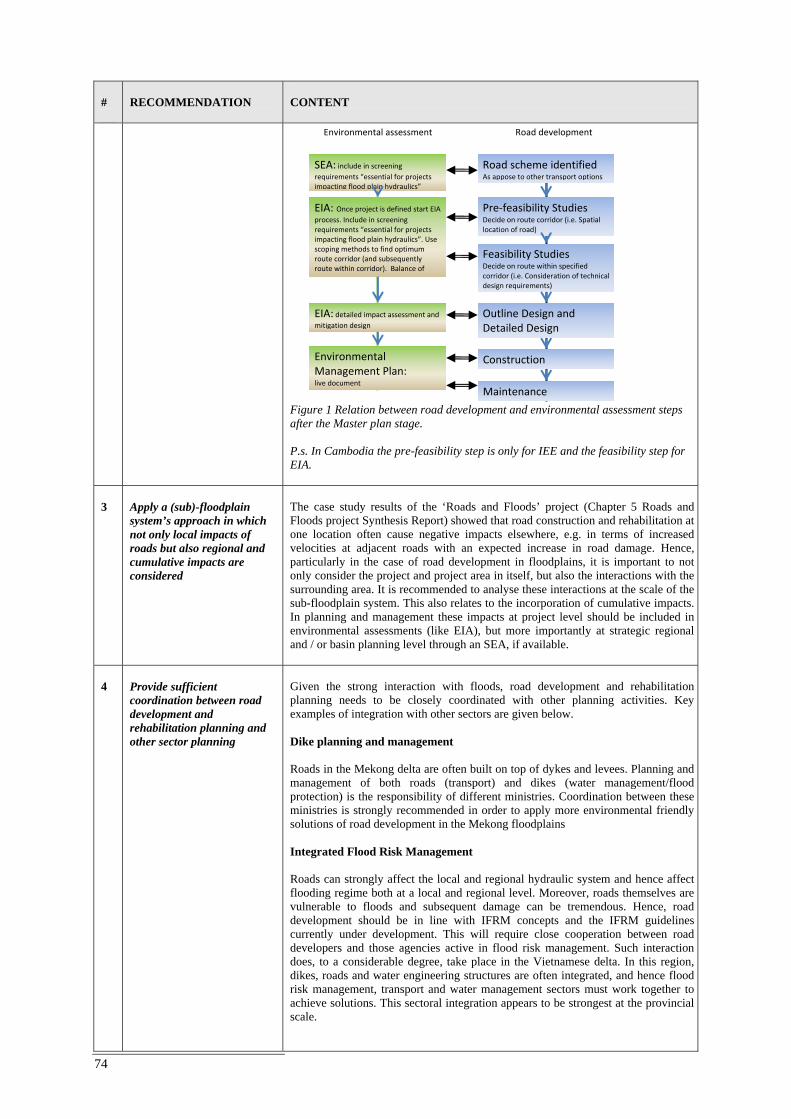
74
#
RECOMMENDATION
CONTENT
Figure 1 Relation between road development and environmental assessment steps after the Master plan stage. P.s. In Cambodia the pre-feasibility step is only for IEE and the feasibility step for EIA.
3
Apply a (sub)-floodplain system’s approach in which not only local impacts of roads but also regional and cumulative impacts are considered
The case study results of the ‘Roads and Floods’ project (Chapter 5 Roads and Floods project Synthesis Report) showed that road construction and rehabilitation at one location often cause negative impacts elsewhere, e.g. in terms of increased velocities at adjacent roads with an expected increase in road damage. Hence, particularly in the case of road development in floodplains, it is important to not only consider the project and project area in itself, but also the interactions with the surrounding area. It is recommended to analyse these interactions at the scale of the sub-floodplain system. This also relates to the incorporation of cumulative impacts. In planning and management these impacts at project level should be included in environmental assessments (like EIA), but more importantly at strategic regional and / or basin planning level through an SEA, if available.
4
Provide sufficient coordination between road development and rehabilitation planning and other sector planning
Given the strong interaction with floods, road development and rehabilitation planning needs to be closely coordinated with other planning activities. Key examples of integration with other sectors are given below. Dike planning and management Roads in the Mekong delta are often built on top of dykes and levees. Planning and management of both roads (transport) and dikes (water management/flood protection) is the responsibility of different ministries. Coordination between these ministries is strongly recommended in order to apply more environmental friendly solutions of road development in the Mekong floodplains Integrated Flood Risk Management Roads can strongly affect the local and regional hydraulic system and hence affect flooding regime both at a local and regional level. Moreover, roads themselves are vulnerable to floods and subsequent damage can be tremendous. Hence, road development should be in line with IFRM concepts and the IFRM guidelines currently under development. This will require close cooperation between road developers and those agencies active in flood risk management. Such interaction does, to a considerable degree, take place in the Vietnamese delta. In this region, dikes, roads and water engineering structures are often integrated, and hence flood risk management, transport and water management sectors must work together to achieve solutions. This sectoral integration appears to be strongest at the provincial scale.
Road development Environmental assessment
Road scheme identified As appose to other transport options
Pre‐feasibility Studies Decide on route corridor (i.e. Spatial location of road)
Feasibility Studies Decide on route within specified corridor (i.e. Consideration of technical design requirements)
Outline Design and Detailed Design
Construction
Maintenance
SEA: include in screening requirements “essential for projects impacting flood plain hydraulics”
EIA: Once project is defined start EIA process. Include in screening requirements “essential for projects impacting flood plain hydraulics”. Use scoping methods to find optimum route corridor (and subsequently route within corridor). Balance of
EIA: detailed impact assessment and mitigation design
Environmental Management Plan: live document
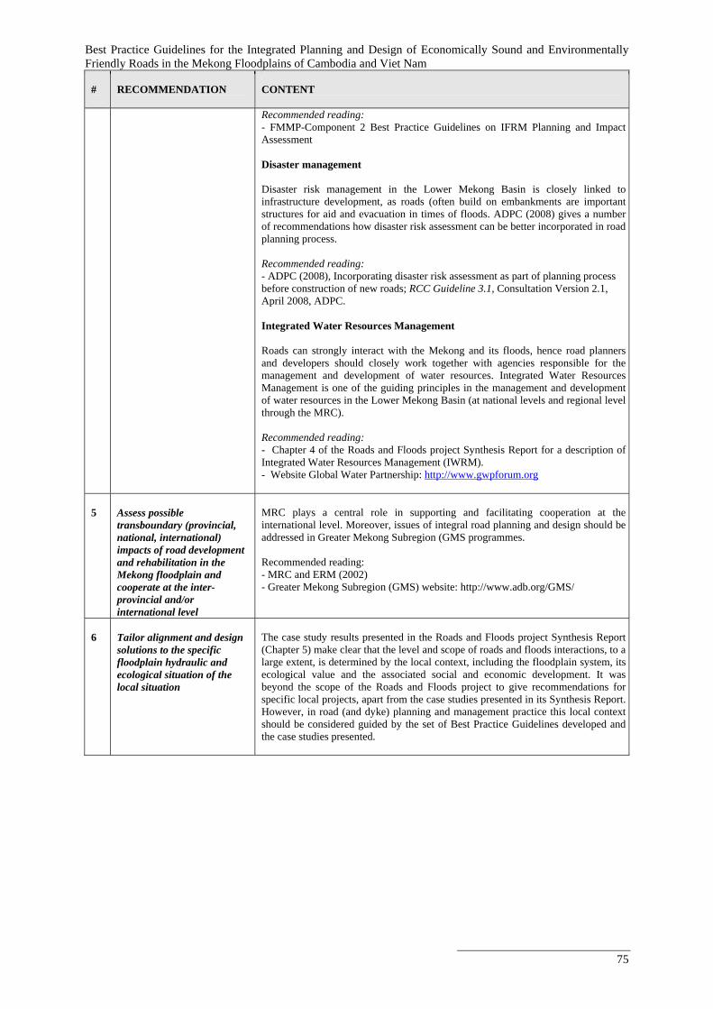
Best Practice Guidelines for the Integrated Planning and Design of Economically Sound and Environmentally Friendly Roads in the Mekong Floodplains of Cambodia and Viet Nam
75
#
RECOMMENDATION
CONTENT
Recommended reading: - FMMP-Component 2 Best Practice Guidelines on IFRM Planning and Impact Assessment Disaster management Disaster risk management in the Lower Mekong Basin is closely linked to infrastructure development, as roads (often build on embankments are important structures for aid and evacuation in times of floods. ADPC (2008) gives a number of recommendations how disaster risk assessment can be better incorporated in road planning process.
Recommended reading: - ADPC (2008), Incorporating disaster risk assessment as part of planning process before construction of new roads; RCC Guideline 3.1, Consultation Version 2.1, April 2008, ADPC. Integrated Water Resources Management
Roads can strongly interact with the Mekong and its floods, hence road planners and developers should closely work together with agencies responsible for the management and development of water resources. Integrated Water Resources Management is one of the guiding principles in the management and development of water resources in the Lower Mekong Basin (at national levels and regional level through the MRC). Recommended reading: - Chapter 4 of the Roads and Floods project Synthesis Report for a description of Integrated Water Resources Management (IWRM). - Website Global Water Partnership: http://www.gwpforum.org
5
Assess possible transboundary (provincial, national, international) impacts of road development and rehabilitation in the Mekong floodplain and cooperate at the inter-provincial and/or international level
MRC plays a central role in supporting and facilitating cooperation at the international level. Moreover, issues of integral road planning and design should be addressed in Greater Mekong Subregion (GMS programmes. Recommended reading: - MRC and ERM (2002) - Greater Mekong Subregion (GMS) website: http://www.adb.org/GMS/
6
Tailor alignment and design solutions to the specific floodplain hydraulic and ecological situation of the local situation
The case study results presented in the Roads and Floods project Synthesis Report (Chapter 5) make clear that the level and scope of roads and floods interactions, to a large extent, is determined by the local context, including the floodplain system, its ecological value and the associated social and economic development. It was beyond the scope of the Roads and Floods project to give recommendations for specific local projects, apart from the case studies presented in its Synthesis Report. However, in road (and dyke) planning and management practice this local context should be considered guided by the set of Best Practice Guidelines developed and the case studies presented.
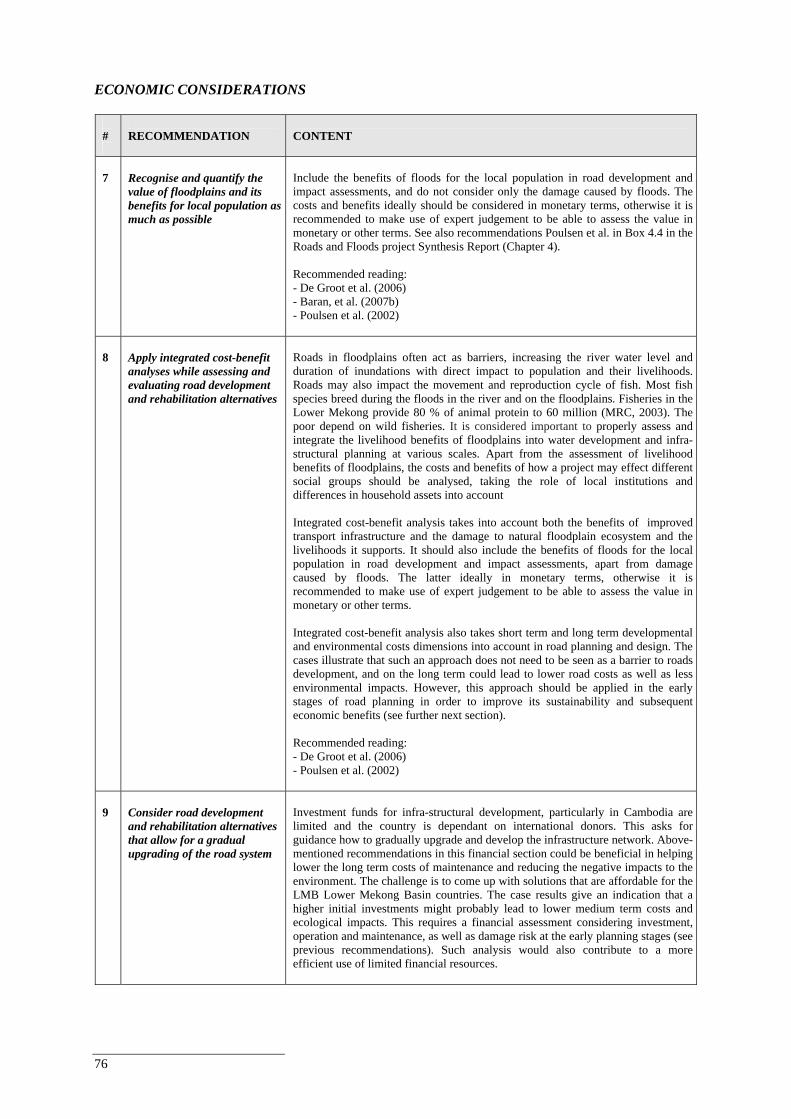
76
ECONOMIC CONSIDERATIONS
#
RECOMMENDATION
CONTENT
7
Recognise and quantify the value of floodplains and its benefits for local population as much as possible
Include the benefits of floods for the local population in road development and impact assessments, and do not consider only the damage caused by floods. The costs and benefits ideally should be considered in monetary terms, otherwise it is recommended to make use of expert judgement to be able to assess the value in monetary or other terms. See also recommendations Poulsen et al. in Box 4.4 in the Roads and Floods project Synthesis Report (Chapter 4). Recommended reading: - De Groot et al. (2006) - Baran, et al. (2007b) - Poulsen et al. (2002)
8
Apply integrated cost-benefit analyses while assessing and evaluating road development and rehabilitation alternatives
Roads in floodplains often act as barriers, increasing the river water level and duration of inundations with direct impact to population and their livelihoods. Roads may also impact the movement and reproduction cycle of fish. Most fish species breed during the floods in the river and on the floodplains. Fisheries in the Lower Mekong provide 80 % of animal protein to 60 million (MRC, 2003). The poor depend on wild fisheries. It is considered important to properly assess and integrate the livelihood benefits of floodplains into water development and infra-structural planning at various scales. Apart from the assessment of livelihood benefits of floodplains, the costs and benefits of how a project may effect different social groups should be analysed, taking the role of local institutions and differences in household assets into account
Integrated cost-benefit analysis takes into account both the benefits of improved transport infrastructure and the damage to natural floodplain ecosystem and the livelihoods it supports. It should also include the benefits of floods for the local population in road development and impact assessments, apart from damage caused by floods. The latter ideally in monetary terms, otherwise it is recommended to make use of expert judgement to be able to assess the value in monetary or other terms.
Integrated cost-benefit analysis also takes short term and long term developmental and environmental costs dimensions into account in road planning and design. The cases illustrate that such an approach does not need to be seen as a barrier to roads development, and on the long term could lead to lower road costs as well as less environmental impacts. However, this approach should be applied in the early stages of road planning in order to improve its sustainability and subsequent economic benefits (see further next section). Recommended reading: - De Groot et al. (2006) - Poulsen et al. (2002)
9
Consider road development and rehabilitation alternatives that allow for a gradual upgrading of the road system
Investment funds for infra-structural development, particularly in Cambodia are limited and the country is dependant on international donors. This asks for guidance how to gradually upgrade and develop the infrastructure network. Above-mentioned recommendations in this financial section could be beneficial in helping lower the long term costs of maintenance and reducing the negative impacts to the environment. The challenge is to come up with solutions that are affordable for the LMB Lower Mekong Basin countries. The case results give an indication that a higher initial investments might probably lead to lower medium term costs and ecological impacts. This requires a financial assessment considering investment, operation and maintenance, as well as damage risk at the early planning stages (see previous recommendations). Such analysis would also contribute to a more efficient use of limited financial resources.
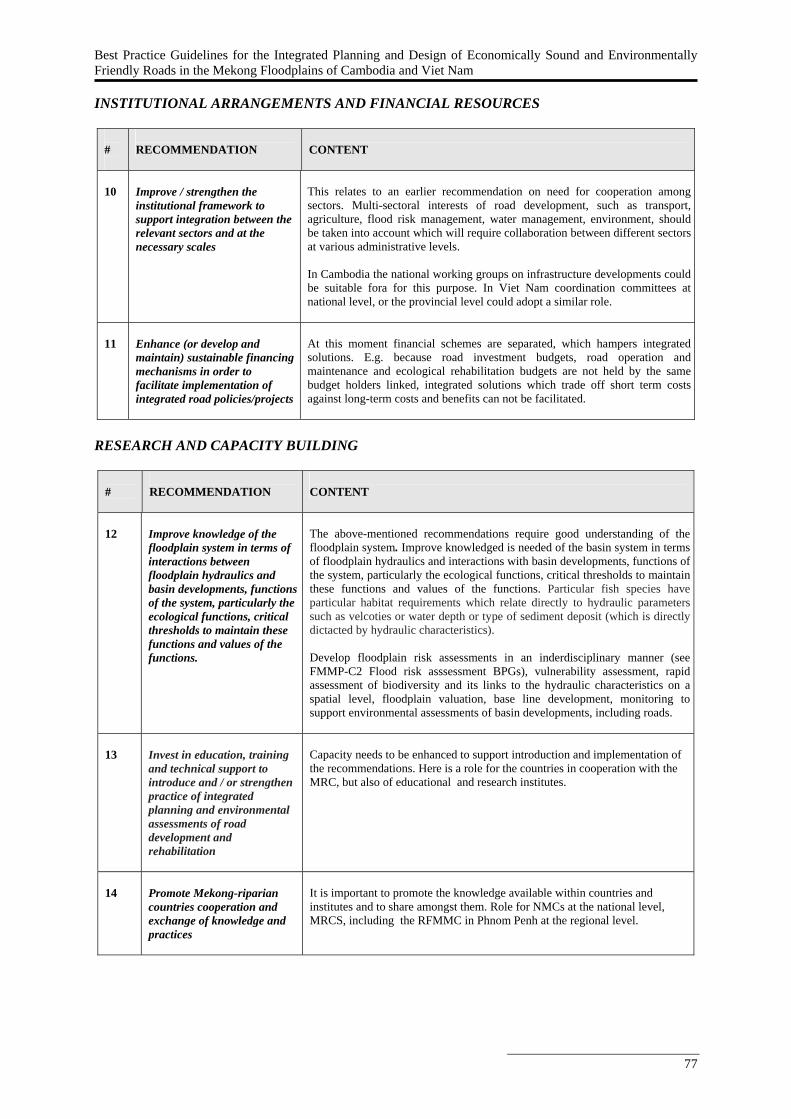
Best Practice Guidelines for the Integrated Planning and Design of Economically Sound and Environmentally Friendly Roads in the Mekong Floodplains of Cambodia and Viet Nam
77
INSTITUTIONAL ARRANGEMENTS AND FINANCIAL RESOURCES
#
RECOMMENDATION
CONTENT
10
Improve / strengthen the institutional framework to support integration between the relevant sectors and at the necessary scales
This relates to an earlier recommendation on need for cooperation among sectors. Multi-sectoral interests of road development, such as transport, agriculture, flood risk management, water management, environment, should be taken into account which will require collaboration between different sectors at various administrative levels.
In Cambodia the national working groups on infrastructure developments could be suitable fora for this purpose. In Viet Nam coordination committees at national level, or the provincial level could adopt a similar role.
11
Enhance (or develop and maintain) sustainable financing mechanisms in order to facilitate implementation of integrated road policies/projects
At this moment financial schemes are separated, which hampers integrated solutions. E.g. because road investment budgets, road operation and maintenance and ecological rehabilitation budgets are not held by the same budget holders linked, integrated solutions which trade off short term costs against long-term costs and benefits can not be facilitated.
RESEARCH AND CAPACITY BUILDING
#
RECOMMENDATION
CONTENT
12
Improve knowledge of the floodplain system in terms of interactions between floodplain hydraulics and basin developments, functions of the system, particularly the ecological functions, critical thresholds to maintain these functions and values of the functions.
The above-mentioned recommendations require good understanding of the floodplain system. Improve knowledged is needed of the basin system in terms of floodplain hydraulics and interactions with basin developments, functions of the system, particularly the ecological functions, critical thresholds to maintain these functions and values of the functions. Particular fish species have particular habitat requirements which relate directly to hydraulic parameters such as velcoties or water depth or type of sediment deposit (which is directly dictacted by hydraulic characteristics). Develop floodplain risk assessments in an inderdisciplinary manner (see FMMP-C2 Flood risk asssessment BPGs), vulnerability assessment, rapid assessment of biodiversity and its links to the hydraulic characteristics on a spatial level, floodplain valuation, base line development, monitoring to support environmental assessments of basin developments, including roads.
13
Invest in education, training and technical support to introduce and / or strengthen practice of integrated planning and environmental assessments of road development and rehabilitation
Capacity needs to be enhanced to support introduction and implementation of the recommendations. Here is a role for the countries in cooperation with the MRC, but also of educational and research institutes.
14
Promote Mekong-riparian countries cooperation and exchange of knowledge and practices
It is important to promote the knowledge available within countries and institutes and to share amongst them. Role for NMCs at the national level, MRCS, including the RFMMC in Phnom Penh at the regional level.
78
6.2.6 References
ADPC (2008), Incorporating disaster risk assessment as part of planning process before construction of new roads; RCC Guideline 3.1, Consultation Version 2.1, April 2008, ADPC.
Baran, E., T. Jantunen, and C. K. Chong (2007a), Values of inland fisheries in the Mekong River
basin. WorldFish Center, Phnom Penh. De Groot, R.S. (1992), Functions of nature: Evaluation of nature in environmental planning,
management and decision making, Wolters-Noordhoff, Amsterdam, 1992. 315 pp. Douven, W.J.A.M., M. Goichot and H.J. Verheij (2011), Best Practice Guidelines for the Integrated
Planning and Design of Economically Sound and Environmentally Friendly Roads in the Mekong Floodplains of Cambodia and Viet Nam, synthesis report of the ‘Roads and Floods’ project (part of MRC-FMMP Component 2) by Delft Cluster, WWF and MRC, RFMMC, Phnom Penh, Cambodia.
ERM (2002), Development of an EIA/SEA System for the Lower Mekong Basin: Background review,
April 2002, London. Poulsen A.F., Ouch Poeu, Sintavong Viravong, Ubolratana Suntornratana and Nguyen Thanh Tung
(2002) Fish migrations of the Lower Mekong River Basin: implications for development, planning and environmental management. MRC Technical Paper No. 8, Mekong River Commission, Phnom Penh. 62 pp. ISSN: 1683-1489.
Best Practice Guidelines for the Integrated Planning and Design of Economically Sound and Environmentally Friendly Roads in the Mekong Floodplains of Cambodia and Viet Nam
79
6.3 Best Practice Guidelines for Environmental Assessment of Road
Development and Rehabilitation in the Mekong Floodplains of Cambodia and Viet Nam
6.3.1 Introduction to the Best Practice Guidelines of FMMP-C2 In the FMMP-C2 ‘Structural Measures and Flood Proofing’ a number of Best Practice Guidelines are developed. The aim of these Best Practice Guidelines is to enable the MRC and national line agencies to better take into account flood-related considerations in their day-to-day technical activities. The ‘Roads and Floods’ Best Practice Guidelines are part of the FMMP-C2 Best Practice Guidelines. The ‘Roads and Floods’ Best Practice Guideline do not provide detailed guidance, also because the local situations in Cambodia and Vietnam vary quite a lot and request tailored solutions. The guidelines do provide recommendations how to improve existing guidance.
6.3.2 How to use this Best Practice Guideline The Best Practice Guideline for environmental assessment is specifically targeted at the following audiences:
National and provincial government agencies involved in environmental assessments of road projects (incl. EIA, IEE, CIA and SEA8) and / or the screening, scoping (preparing ToR for EIS9), and EIS review phases. Hence, mainly ministries of environment and associated agencies.
Development banks that often fund infra-structural works and / or studies producing guidelines for infra-structural planning and design.
Developers of road development and rehabilitation projects in the Mekong floodplains, consultants, research groups and NGO’s who are involved in environmental assessments in the Lower mekong Basin.
This section presents recommendations to improve the present Cambodian and Vietnamese EIA guidelines and specifically the sectoral EIA guidelines on infrastructure (under development) in both countries. The focus of the recommendations is on the screening (including IEE), scoping and EIS review phases, as these are the key entry points for the competent authority either sets the boundary conditions for project design or plays a role in reviewing project design. Checklists are included that help improve national EIS screening, scoping and EIS reviews guidelines. 6.3.3 Background on development of the Best Practice Guideline This Best Practice Guideline for environmental assessment was designed on the basis of:
Review of environmental assessment systems in Cambodia and Viet Nam. Review of international guidelines and best practice documents in the field. In-depth analysis of various cases in Cambodia and Viet Nam.
The above-listed activities were part of the ‘Roads and Floods’ project and detailed information on the project, its activities and results can be found in the Roads and Floods Synthesis Report (Douven et al., 2009). 6.3.4 Purpose and scope The overall goal of the Best Practice Guideline for environmental assessment is to strenghthen environmental assessments of the development and rehabilitation of roads in the vulnerable and highly 8 Environmental Impact Assessment (EIA), Initial Environmental Examination (IEE), Cumulative Impact Assessment (CIA), Strategic Environmental Assessment (SEA). 9 Environmental Impact Statement (EIS)
80
valuable Mekong floodplain system and to cover the specific floodplain hydraulic and ecological conditions of the Mekong floodplain. The specific objectives of the guideline are the following:
To give general recommendations on how to improve environmental assessments of road development in Cambodia and Viet Nam.
To give specific recommendations on how to include floodplain related considerations in the EIA / IEE screening, scoping and review phases.
The Best Practice Guideline is particularly relevant at the following stages of road development and rehabilitation:
Concept development. (pre)-feasibility studies. Design studies.
The Best Practice Guideline for environmental assessment consists of a list of recommendations to improve existing guidance on EIA / SEA type of procedures related to the developing and planning a road in the Mekong floodplain. Apart from a set of general recommendations it contains specific input to the screening and scoping phases of EIA as well as the review of Environmental Impact Statements. Checklists are included that help improve national EIS screening, scoping and EIS reviews guidelines. The structure of the guideline is:
General recommendations. Recommendations EIA / IEE Screening. Recommendations EIA Scoping. Recommendations EIS review.
6.3.5 General Recommendations for environmental assessment
#
RECOMMENDATION
CONTENT
1
Strengthen the system and process of Environmental Impact Assessment, specifically the coverage of floodplain hydraulics and related ecology
Environmental Impact Assessments (EIAs) for large infra-structural developments are mandatory in Cambodia and Viet Nam (like the other MRC countries). Hence, the EIA process would be the most logical entry point for considering impacts of roads on the floodplain system. There is room for improvement, as the current EIA guidelines only to a very limited extent address floodplain hydraulic and ecological aspects.
2
Amend environmental regulations if they do not currently require EIAs for most projects
In the screening phase, improvement is needed to specifically address development in a vulnerable floodplain system like the Mekong. In general EIA is only mandatory for (inter)national and larger provincial road developments. It is recommended to review the current EIA screening guidance to assess whether adjustments are needed.
3
Mainstream environmental assessment with road development and rehabilitation
In order to sufficiently consider environmental impacts of road development and rehabilitation in planning processes it is important to strengthen the relationship to environmental assessment procedures. In both, Cambodia and Viet Nam, these environmental assessment procedures are existing, but need strengthening in order to better consider impacts on floodplain hydraulics and related ecology. Viet Nam and Cambodia have an EIA system in place, while Viet Nam also has an SEA system established.
Figure 1 illustrates how road planning and management can be interrelated with environmental assessment procedures, like EIA and SEA. The different steps in infrastructure project cycle are shown, and how the EIA and SEA procedures help assess, manage and mitigate environmental impacts. Infra-structural sector policies, plans and programmes define individual projects. Strategic Environmental Assessments (SEA) provide the framework for implementing Environmental Impact Assessments (EIA). At the strategic level this will lead to
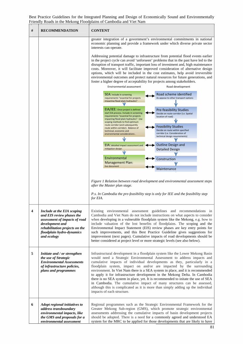
Best Practice Guidelines for the Integrated Planning and Design of Economically Sound and Environmentally Friendly Roads in the Mekong Floodplains of Cambodia and Viet Nam
81
#
RECOMMENDATION
CONTENT
greater integration of a government’s environmental commitments in national economic planning and provide a framework under which diverse private sector interests can operate. Addressing potential damage to infrastructure from potential flood events earlier in the project cycle can avoid ‘unforseen’ problems that in the past have led to the disruption of transport traffic, important loss of investment and, high maintenance costs. Moreover, it will facilitate improved consideration of alternative design options, which will be included in the cost estimates, help avoid irreversible environmental outcomes and protect natural resources for future generations, and foster a higher degree of acceptability for projects among stakeholders.
Figure 1 Relation between road development and environmental assessment steps after the Master plan stage. P.s. In Cambodia the pre-feasibility step is only for IEE and the feasibility step for EIA.
4
Include at the EIA scoping and EIS review phases the assessment of impacts of road development and rehabilitation projects on the floodplain hydro-dynamics and ecology
Existing environmental assessment guidelines and recommendations in Cambodia and Viet Nam do not include instructions on what aspects to consider when developing in a vulnerable floodplain system like the Mekong, e.g. how to include valuation of the lost benefits of floodplains. The scoping and the Environmental Impact Statement (EIS) review phases are key entry points for such improvements, and this Best Practice Guideline gives suggestions for improvement (next pages). Cumulative impacts of road developments should be better considered at project level or more strategic levels (see also below).
5
Initiate and / or strengthen the use of Strategic Environmental Assessments of infrastructure policies, plans and programmes
Infrastructural development in a floodplain system like the Lower Mekong Basin would need a Strategic Environmental Assessment to address impacts and cumulative impacts of individual developments as they, particularly in a floodplain system, impact on and/or are impacted by the surrounding environment. In Viet Nam there is a SEA system in place, and it is recommended to apply it for infrastructure development in the Mekong Delta. In Cambodia there is no SEA system in place, yet. It is recommended to initate the use of SEA in Cambodia. The cumulative impact of many structures can be assessed, although this is complicated as it is more than simply adding up the individual impacts of each structure.
6
Adopt regional initiatives to address transboundary environmental impacts, like the GMS and proposals for a environmental assessment
Regional programmes such as the Strategic Environmental Framework for the Greater Mekong Sub-region (GMS), which promote strategic environmental assessments addressing the cumulative impacts of basin development projects should be adopted. There is a need for a commonly agreed and understood EA system for the MRC to be applied for those developments that are likely to have
Road development Environmental assessment
Road scheme identified As appose to other transport options
Pre‐feasibility Studies Decide on route corridor (i.e. Spatial location of road)
Feasibility Studies Decide on route within specified corridor (i.e. Consideration of technical design requirements)
Outline Design and Detailed Design
Construction
Maintenance
SEA: include in screening requirements “essential for projects impacting flood plain hydraulics”
EIA/IEE: Once project is defined start EIA process. Include in screening requirements “essential for projects impacting flood plain hydraulics”. Use scoping methods to find optimum route corridor (and subsequently route within corridor). Balance of technical, economic and environmental considerations .
EIA: detailed impact assessment and mitigation design
Environmental Management Plan: live document
82
#
RECOMMENDATION
CONTENT
system for the MRC.
transboundary impacts (ERM, 2002). Recommended reading: - ERM (2002)
7
Improve the capacity of EIA practitioners in implementing and reviewing the EIA processes.
The capacity of EIA practitioners needs improvement in various aspects: in implementing the EIA process in general (including stakeholder participation), producing terms of references for EISs taking a holistic approach (scoping), consulting local stakeholders and scientists to make use of available knowledge, producing EIS (developers, consultants), reviewing EISs and monitoring project implementation and environmental impacts.
6.3.6 General Recommendations for sectoral EIA guidelines for the road
sector
This section presents recommendations to improve the present Cambodian and Vietnamese EIA guidelines and specifically the sectoral EIA guidelines on infrastructure (under development) in both countries. Recommendations are targeted at the screening, scoping and EIS review phases. This needs to follow through, ie. into design and EMP follow up.
RECOMMENDATIONS EIA / IEE SCREENING The screening guidelines are intended to ensure that at an early stage of the EIA process the floodplain hydraulic and ecological aspects are considered, and hence better decisions on the need for EIA are made.
#
RECOMMENDATION
CONTENT
8
Review the current EIA screening list in order to address the environmental impacts of building infrastructure (roads) in a floodplain system like the Mekong
In both Cambodia and Viet Nam, EIA is only required for the construction of (inter)national road developments. Road development at provincial and local level as well as road rehabilitation do not require EIA. The development of infra-structural works in a vulnerable floodplain system like the Mekong, can cause not only environmental impacts during construction, but particularly also during operation at local scale but also at the sub-floodplain scale. Therefore, it is recommended to review the current screening lists and e.g. add road projects in the floodplain to current screening lists (e.g. provincial roads and large rehabilitation works). For individual cases the screening checklist presented in Appendix 2 – Section 10.1 (see recommendation #9), could further guide in deciding upon whether an EIA is needed.
9
Consult the screening checklist as a guidance to whether an EIA or IEE for road developments in the Mekong floodplain is needed
Appendix 2 – Section 10.1 presents parts of the screening checklist that was developed by the European Community (EC, 2001a). This appendix section presents those parts of the EC checklist most relevant for checking possible impacts related to road developments in a floodplain system.
RECOMMENDATIONS EIA SCOPING The scoping guidelines, like the screening guidelines are intended to ensure that at an early stage of the EIA process the floodplain related aspects are sufficiently considered. The scoping guidelines, however, particularly focus on improving the terms of reference for EIS of road development and rehabilitation projects.
Best Practice Guidelines for the Integrated Planning and Design of Economically Sound and Environmentally Friendly Roads in the Mekong Floodplains of Cambodia and Viet Nam
83
#
RECOMMENDATION
CONTENT
10
Consult the scoping checklist as a guidance to develop terms of reference for EIS for road developments in the Mekong floodplains
Appendix 2 – Section 10.2 presents parts of the scoping checklist that was developed by the European Community (EC, 2001b). The appendix section presents those parts of the EC checklist most relevant for scoping impacts related to road developments in a floodplain system that can be used as input for the development of the terms of reference for EIS for road developments in the Mekong floodplains.
RECOMMENDATIONS EIS REVIEW The EIS review guidance has two intended objectives: (1) to help developers and their consultants to produce better quality EIS’s, and (2) to help the relevant authorities to review the EIS’s more effectively, so that decisions can be made on the best informed information.
#
RECOMMENDATION
CONTENT
11
Consult the EIS review guidance to produce better quality EIS’s of road developments in the Mekong floodplains, and to review them more effectively
The checklist in Appendix 2 – Section 10.3 (EC, 2001c) is designed as a method for reviewing the adequacy of the EIS in terms of addressing environmental impacts by road developments in the Mekong floodplains and generally accepted good practice in EIA. By adequacy it is meant that the completeness and suitability of the information from a content and decision-making viewpoint is considered. The EIS review checklist can be used in one of two ways (EC, 2001c), either:
To assess the adequacy of an EIS for decision making in which case the
output of the checklist is an assessment of the adequacy of the information. If the information is inadequate the checklist prompts the user to identify what further information is required; or
To assess the quality of EIS generally for either research or monitoring purposes. So for example the checklist can be used to investigate which parts of the information required by the Directive are usually best or worst in quality across a number of EIS, or to investigate the overall quality of EIS submitted for different types of projects, or to investigate trends in quality over time.
Appendix 2 – Section 10.3 presents parts of the EIS review checklist that was developed by the European Community (EC, 2001c). The following parts most relevant for reviewing EIS’s of road developments in a floodplain system are presented in Appendix 2 – Section 10.3:
Description of the environment likely to be affected by the project Description of the likely significant effects of the project Description of Mitigating Measures
84
6.3.7 References EC (2001a), Guidance on EIA: Screening, Office for Official Publications of the European
Communities, Luxembourg. EC (2001b), Guidance on EIA: Scoping, Office for Official Publications of the European
Communities, Luxembourg. EC (2001c), Guidance on EIA: EIS review, Office for Official Publications of the European
Communities, Luxembourg. ERM (2002), Development of an EIA/SEA System for the Lower Mekong Basin: Background review,
April 2002, London. Douven, W.J.A.M., M. Goichot and H.J. Verheij (2011), Best Practice Guidelines for the Integrated
Planning and Design of Economically Sound and Environmentally Friendly Roads in the Mekong Floodplains of Cambodia and Viet Nam, synthesis report of the ‘Roads and Floods’ project (part of MRC-FMMP Component 2) by Delft Cluster, WWF and MRC, RFMMC, Phnom Penh, Cambodia.
Best Practice Guidelines for the Integrated Planning and Design of Economically Sound and Environmentally Friendly Roads in the Mekong Floodplains of Cambodia and Viet Nam
85
6.4 Best Practice Guidelines for Technical Design of Road Development and
Rehabilitation in the Cambodian and Vietnamese Floodplain 6.4.1 Introduction to the Best Practice Guidelines of FMMP-C2 In the FMMP-C2 ‘Structural Measures and Flood Proofing’ a number of Best Practice Guidelines are developed. The aim of these Best Practice Guidelines is to enable the MRC and national line agencies to better take into account flood-related considerations in their day-to-day technical activities. The ‘Roads and Floods’ Best Practice Guidelines are part of the FMMP-C2 Best Practice Guidelines.
The ‘Roads and Floods’ Best Practice Guideline do not provide detailed guidance, also because the local situations in Cambodia and Vietnam vary quite a lot and request tailored solutions. The guidelines do provide recommendations how to improve existing guidance. 6.4.2 How to use this Best Practice Guideline The Best Practice Guideline for technical design is targeted at those organisations involved in road planning and design (hence, transport and public works type of ministries and associated agencies). The following four groups of users can be distinguished:
Technical staff who actually plan and design roads (so who are the direct users of national guidelines), including companies carrying out technical studies.
Staff in charge of the construction and monitoring of road projects. Staff involved in the review of technical guidelines.
The Best Practice Guideline for technical design specifically supports the planner and designer during the phase in which the road design alternatives are identified (figure 1). During this phase, road planners and designers identify design alternatives on the basis of, amongst others, the local context (ecologically important area) and policy objectives, which are both derived from earlier steps in the planning process. The technical guidelines give guidance on how to use the technical design options (Box 1) to identify alternatives that match the objectives set. Alternatives can combine different technical design options.
Box 1 Technical design options in road development and rehabilitation.
The resistance of the road structure to erosion (e.g. type of pavement or protection of embankment slopes).
The elevation of the road structure (e.g. increasing or lowering the elevation of roads). The through-flow structures of the road (e.g. culverts and bridges). The alignment of the road. The distance to the river.
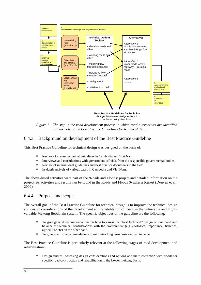
86
Figure 1 The step in the road development process in which road alternatives are identified
and the role of the Best Practice Guidelines for technical design. 6.4.3 Background on development of the Best Practice Guideline This Best Practice Guideline for technical design was designed on the basis of:
Review of current technical guidelines in Cambodia and Viet Nam. Interviews and consultations with government officials from the responsible governmental bodies. Review of international guidelines and best practice documents in the field. In-depth analysis of various cases in Cambodia and Viet Nam.
The above-listed activities were part of the ‘Roads and Floods’ project and detailed information on the project, its activities and results can be found in the Roads and Floods Synthesis Report (Douven et al., 2009).
6.4.4 Purpose and scope The overall goal of the Best Practice Guideline for technical design is to improve the technical design and design considerations of the development and rehabilitation of roads in the vulnerable and highly valuable Mekong floodplain system. The specific objectives of the guideline are the following:
To give general recommendations on how to assess the “best technical” design on one hand and balance the technical considerations with the environment (e.g. ecological importance, fisheries, agriculture etc) on the other hand.
To give specific recommendations to minimize long term costs on maintenance. The Best Practice Guideline is particularly relevant at the following stages of road development and rehabilitation:
Design studies. Assessing design considerations and options and their interaction with floods for specific road construction and rehabilitation in the Lower mekong Basin.
Technical Options Toolbox
- elevation roads and dikes - lowering roads and dikes - widening flow-through structures - increasing flow-through structures - re-alignment - resistance of road
4. Identification of design and alignment alternatives
2. Determination of objectives and criteria
5. Assessment and evaluation of alternatives
1. Problem identification
6. Selection of alternative
3. Analysis present situation and development
New/existing road (from Step 1)
Objectives and criteria (from Step 2)
Local context, e.g. ecosystem value (from Step 3)
Alternatives
Alternative 1 locally elevate roads + widen through flow structures Alternative 2 lower roads locally (spillway) + re-align roads Alternative 3 ..........
Best Practice Guidelines for Technical design: how to use design options to
achieve policy objectives
Best Practice Guidelines for the Integrated Planning and Design of Economically Sound and Environmentally Friendly Roads in the Mekong Floodplains of Cambodia and Viet Nam
87
The Best Practice Guideline provides a list of recommendations to improve existing guidance in order to come to a best design and provides general rules and options in order to prevent damage and make reliable damage potential assessments. It has to be mentioned that if the road embankment also has a primary function as a levee there will be more and strict demands to the embankment body. The structure of the Best Practice Guideline is the following:
General recommendations for technical design guidelines and enforcement. Recommendations on technical design road structures.
o General recommendations. o Recommendations to improve guidelines and practices on flow-through structures. o Recommendations to improve guidelines and practices on road embankments. o Recommendations to improve guidelines and practices on the road surface.
6.4.5 General recommendations for technical design guidelines and
Enforcement
# RECOMMENDATION CONTENT
1
Update and review the present Cambodian and Vietnamese road design standards and guidelines to better address the specific conditions of the Mekong floodplain so road designers have better guidance and best-practice examples of how to develop flood proofed and environmentally friendly roads in the Mekong floodplains
Both Cambodia and Vietnam have standards and guidelines on road development and rehabilitation. For instance, in Cambodia the MPWT/AusAID (2003) and MRD/ADB (2004) are in use, while in Viet Nam TCN and TCXDVN manuals are in use- However, these guidelines are based on guidelines of foreign countries. It is recommended to adjust these guidelines to the specific conditions in the Lower Mekong Delta.
2
Refer in the road design standards and guidelines and the dike standards to the interrelation between dikes and roads
Very often the functions of flood protection and transport are integrated. Roads are constructed on top of dykes. In that situation not only the standards for raods and bridges should be used but standards for dikes should also be taken into account. Viet Nam for example has independent standards for sea and river dikes published by MARD and standards for roads and bridges published by MoT. In general, roads often act (intentionally or not) as an obstruction or resistance to the flood pattern.
3
Enforce compliance of the updated and reviewed Cambodian and Vietnamese road design standards and guidelines also between the different government bodies within one country.
Both Cambodia and Viet Nam have many standards and guidelines on road development and rehabilitation. At the moment there is however a patchwork. Cross-sectoral coordination needs to be improved to harmonize these standards. Link to harmonisation initiatives in Cambodia with ADB.
6.4.6 Recommendations for improved technical design guidelines in the
lower mekong delta As illustrated in the Roads and Floods project Synthesis Report the ecological value of the floodplains in the Lower Mekong Delta are great and support a florishing and rich fisheries and agriculture industry. Industries which are a major source of income and livelyhood of large groups of the population and very depending on the typical (partly undisturbed) flood characteristics of the floodplains. Although both Cambodia and especially Viet Nam do have (comprehensive) guidelines
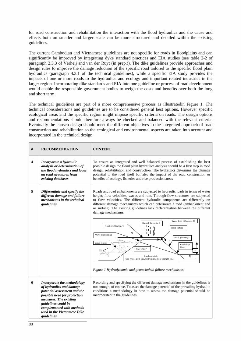
88
for road construction and rehabilitation the interaction with the flood hydraulics and the cause and effects both on smaller and larger scale can be more structured and detailed within the existing guidelines.
The current Cambodian and Vietnamese guidelines are not specific for roads in floodplains and can significantly be improved by integrating dyke standard practices and EIA studies (see table 2-2 of paragraph 2.3.3 of Verheij and van der Ruyt (in prep.)). The dike guidelines provide approaches and design rules to improve the damage reduction of the specific road tailored to the specific flood plain hydraulics (paragraph 4.3.1 of the technical guidelines), while a specific EIA study provides the impacts of one or more roads to the hydraulics and ecology and important related industries in the larger region. Incorporating dike standards and EIA into one guideline or process of road development would enable the responsible government bodies to weigh the costs and benefits over both the long and short term.
The technical guidelines are part of a more comprehensive process as illustratedin Figure 1. The technical considerations and guidelines are to be considered general best options. However specific ecological areas and the specific region might impose specific criteria on roads. The design options and recommendations should therefore always be checked and balanced with the relevant criteria. Eventually the chosen design should meet the different objectives in the integrated approach of road construction and rehabilitation so the ecological and environmental aspects are taken into account and incorporated in the technical design.
# RECOMMENDATION
CONTENT
4
Incorporate a hydraulic analysis or determination of the flood hydraulics and loads on road structures from existing databases
To ensure an integrated and well balanced process of establishing the best possible design the flood plain hydraulics analysis should be a first step in road design, rehabilitation and construction. The hydraulics determine the damage potential to the road itself but also the impact of the road construction or benefits of ecology, fisheries and rice production areas
5
Differentiate and specify the different damage and failure mechanisms in the technical guidelines
Roads and road embankments are subjected to hydraulic loads in terms of water height, flow velocities, waves and rain. Through-flow structures are subjected to flow velocities. The different hydraulic components act differently on different damage mechanisms which can deteriorate a road (embankment and or surface). The existing guidelines lack differentiation between the different damage mechanisms.
Figure 1 Hydrodynamic and geotechnical failure mechanisms.
6
Incorporate the methodology of hydraulics and damage potential assessment and the possible need for protection measures. The existing guidelines could be complemented with methods used in the Vietnamese Dike guidelines
Recording and specifying the different damage mechanisms in the guidelines is not enough, of course. To asses the damage potential of the prevailing hydraulic conditions a methodology in how to assess the damage potential should be incorporated in the guidelines.
Wave overtopping
Wave run-up
Flood overflowing, V Rainfall Intensity, I
V
Q
Road geometry s
Road materials (Soil types, grain size, unit weight, shear strength etc.)
Road surface
Road slope Cover
V
Water level difference, H
HPore water
Best Practice Guidelines for the Integrated Planning and Design of Economically Sound and Environmentally Friendly Roads in the Mekong Floodplains of Cambodia and Viet Nam
89
# RECOMMENDATION
CONTENT
7
Establish safety levels and threshold values per damage mechanism and per road class related to the hydraulic conditions and damage potential (or accepted damage)
If the methodology, the link between hydraulics and damage potential is incorporated, the different safety levels or threshold values for the different road types should be incorporated in the guidelines. The Vietnamese TCN’s already mention flood levels for roads and bridges.
8
Make costs analysis for the different options of slope protection, costs of flow through structures (bridges and culverts etc) and quantify the options in the integrated approach
In order to evaluate and weight the different design options with different protection grades cost indicators must be established. It is important to estimate costs for different levels of investment costs according high standards and lower standards as this affects the operational and maintenance costs. Also damage costs should be estimated taking into account the probabilities of floods.
6.4.7 Recommendations to improve guidelines and practices on flow-through
structures The previous recommendations purely focused on the methodology and the “technical” tools that support the integrated approach. Besides the reference to these basic tools and methodologies which should be incorporated in the guidelines the examined cases in this project revealed some other recommendations and possible best practices. The recommendations in this paragraph are related to the different design options like flow-through structures, road embankment (crest level and steepness) and road surfaces.
#
RECOMMENDATION
CONTENT
9
In an ‘open’ floodplain like south Cambodia a resilience design is much more preferred over a resistance design. In Viet Nam a resilience design is also preferred but should be closely integrated with the existing irrigation systems
The main impact and goal of an integrated approach is a better understanding of the broader impacts of road development in a fragile floodplain like the Lower Mekong Delta. The analysed cases in this project support the general concept of resilience being the preferred general design option over a resistance approach design. This is best illustrated from the case NR 8 (paragraph 5.3). A newly constructed road crosses over valuable fish migration paths. A resistance design would lead to (possible) irreversible and great damage to ecology and fishery.
10
The number and dimensions of flow through openings (bridges and culverts) should be such that interference with the natural hydraulics of the (sub) floodplain in terms of extent (flooded area) and duration is minimal
The “level” of resilience is dependent on the number and dimensions of flow-through openings (bridges, culverts etc) and determines the change in flood duration (time) and extent (area). However it is impossible to mention how many flow through structures per unit length of road are required. This depends on the discharge. In case of a valuable flood plain ecology or agriculture the duration and extent are of great importance.
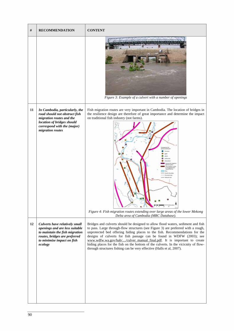
90
#
RECOMMENDATION
CONTENT
Figure 3: Example of a culvert with a number of openings
11
In Cambodia, particularly, the road should not obstruct fish migration routes and the location of bridges should correspond with the (major) migration routes
Fish migration routes are very important in Cambodia. The location of bridges in the resilience design are therefore of great importance and determine the impact on traditional fish industry (not farms).
Figure 4: Fish migration routes extending over large areas of the lower Mekong
Delta area of Cambodia (MRC Database). 12
Culverts have relatively small openings and are less suitable to maintain the fish migration routes, bridges are preferred to minimize impact on fish ecology
Bridges and culverts should be designed to allow flood waters, sediment and fish to pass. Large through-flow structures (see Figure 3) are preferred with a rough, unprotected bed offering hiding places to the fish. Recommendations for the designs of culverts for fish passage can be found in WDFW (2003); see www.wdfw.wa.gov/hab/..../culver_manual_final.pdf. It is important to create hiding places for the fish on the bottom of the culverts. In the vicicnity of flow-through structures fishing can be very effective (Halls et al, 2007).
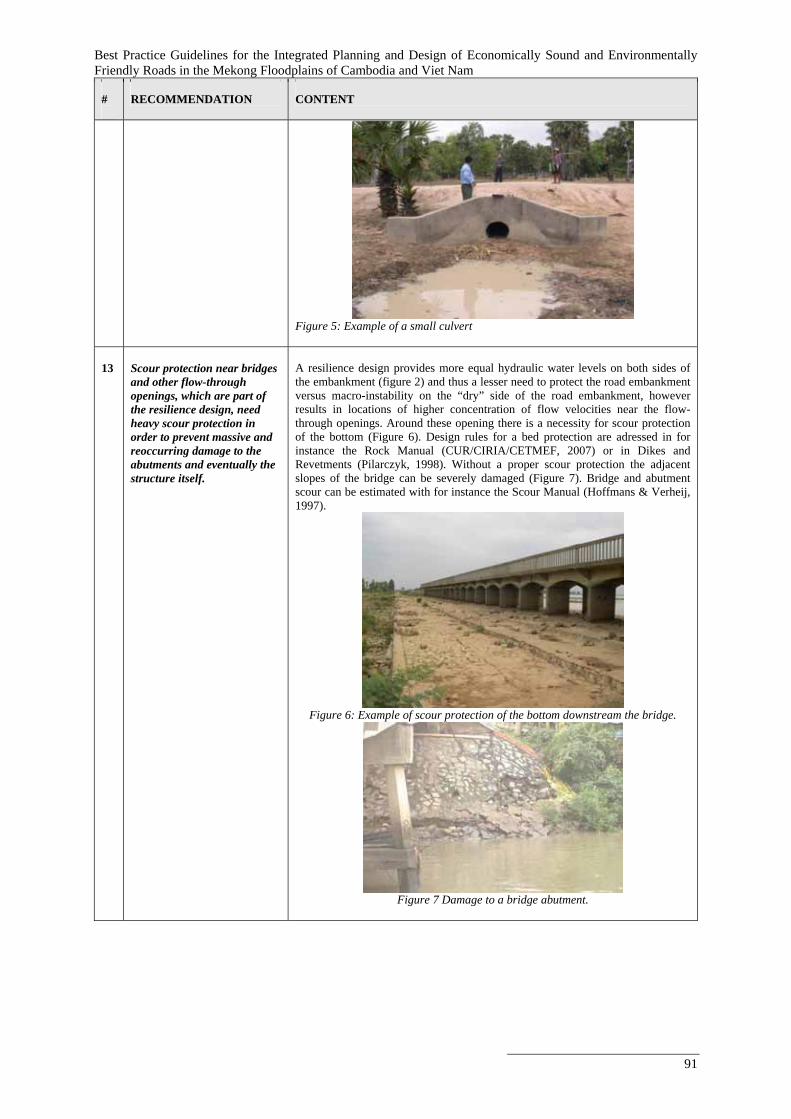
Best Practice Guidelines for the Integrated Planning and Design of Economically Sound and Environmentally Friendly Roads in the Mekong Floodplains of Cambodia and Viet Nam
91
#
RECOMMENDATION
CONTENT
Figure 5: Example of a small culvert
13
Scour protection near bridges and other flow-through openings, which are part of the resilience design, need heavy scour protection in order to prevent massive and reoccurring damage to the abutments and eventually the structure itself.
A resilience design provides more equal hydraulic water levels on both sides of the embankment (figure 2) and thus a lesser need to protect the road embankment versus macro-instability on the “dry” side of the road embankment, however results in locations of higher concentration of flow velocities near the flow-through openings. Around these opening there is a necessity for scour protection of the bottom (Figure 6). Design rules for a bed protection are adressed in for instance the Rock Manual (CUR/CIRIA/CETMEF, 2007) or in Dikes and Revetments (Pilarczyk, 1998). Without a proper scour protection the adjacent slopes of the bridge can be severely damaged (Figure 7). Bridge and abutment scour can be estimated with for instance the Scour Manual (Hoffmans & Verheij, 1997).
Figure 6: Example of scour protection of the bottom downstream the bridge.
Figure 7 Damage to a bridge abutment.
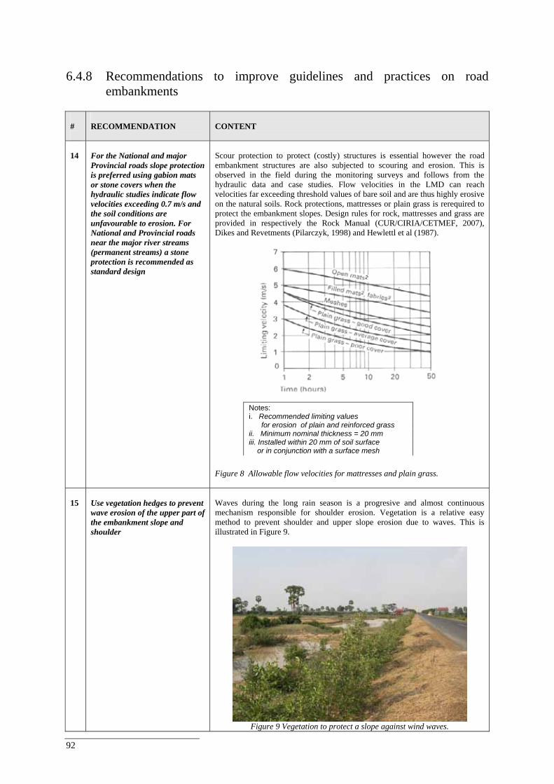
92
6.4.8 Recommendations to improve guidelines and practices on road
embankments #
RECOMMENDATION
CONTENT
14
For the National and major Provincial roads slope protection is preferred using gabion mats or stone covers when the hydraulic studies indicate flow velocities exceeding 0.7 m/s and the soil conditions are unfavourable to erosion. For National and Provincial roads near the major river streams (permanent streams) a stone protection is recommended as standard design
Scour protection to protect (costly) structures is essential however the road embankment structures are also subjected to scouring and erosion. This is observed in the field during the monitoring surveys and follows from the hydraulic data and case studies. Flow velocities in the LMD can reach velocities far exceeding threshold values of bare soil and are thus highly erosive on the natural soils. Rock protections, mattresses or plain grass is rerequired to protect the embankment slopes. Design rules for rock, mattresses and grass are provided in respectively the Rock Manual (CUR/CIRIA/CETMEF, 2007), Dikes and Revetments (Pilarczyk, 1998) and Hewlettl et al (1987).
Figure 8 Allowable flow velocities for mattresses and plain grass.
15
Use vegetation hedges to prevent wave erosion of the upper part of the embankment slope and shoulder
Waves during the long rain season is a progresive and almost continuous mechanism responsible for shoulder erosion. Vegetation is a relative easy method to prevent shoulder and upper slope erosion due to waves. This is illustrated in Figure 9.
Figure 9 Vegetation to protect a slope against wind waves.
Notes: i. Recommended limiting values for erosion of plain and reinforced grass ii. Minimum nominal thickness = 20 mm iii. Installed within 20 mm of soil surface or in conjunction with a surface mesh
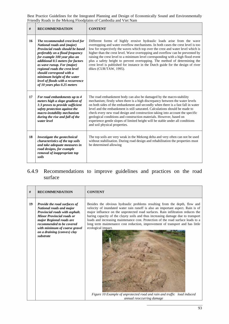
Best Practice Guidelines for the Integrated Planning and Design of Economically Sound and Environmentally Friendly Roads in the Mekong Floodplains of Cambodia and Viet Nam
93
#
RECOMMENDATION
CONTENT
16
The recommended crest level for National roads and (major) Provincial roads should be based preferably on a flood frequency for example 100 year plus an additional 0.5 meters for factors as wave runup. For (major) regional roads the crest level should correspond with a minimum height of the water level of floods with a recurrence of 10 years plus 0.25 meters
Different forms of highly erosive hydraulic loads arise from the wave overtopping and water overflow mechanisms. In both cases the crest level is too low for respectively the waves which top over the crest and water level which is higher than the crest level. Wave overtopping and overflow can be prevented by raising the crest level to a minimum level corresponding with a high flood event plus a safety height to prevent overtopping. The method of determining the crest level is published for instance in the Dutch guide for the design of river dikes (CUR/TAW, 1995).
17
For road embankments up to 4 meters high a slope gradient of 1:3 proves to provide sufficient safety protection against the macro-instability mechanism during the rise and fall of the water level
The road embankment body can also be damaged by the macro-stability mechanism; firstly when there is a high discrepancy between the water levels on both sides of the embankment and secondly when there is a fast fall in water level and the embankment is still saturated. Calculations should be made to check every new road design and construction taking into account the specific geological conditions and construction materials. However, based on experience gentle slopes of limited height will be stable under all conditions and soil physical properties.
18
Investigate the geotechnical characteristics of the top soils and take adequate measures in road designs, for example removal of inappropriate top soils
The top soils are very weak in the Mekong delta and very often can not be used without stabilisation. During road design and rehabilitation the properties must be determined allowing
6.4.9 Recommendations to improve guidelines and practices on the road
surface
#
RECOMMENDATION
CONTENT
19
Provide the road surfaces of National roads and major Provincial roads with asphalt. Minor Provincial roads or major Regional roads are recommended to be covered with minimum of coarse gravel on a draining (convex) clay substrate
Besides the obvious hydraulic problems resulting from the depth, flow and velocity of inundated water rain runoff is also an important aspect. Rain is of major influence on the unprotected road surfaces. Rain infiltration reduces the baring capacity of the clayey soils and thus increasing damage due to transport loads and increasing maintenance cost. Protection of the road surface leads to a long term maintenance cost reduction, improvement of transport and has little ecological impact.
Figure 10 Example of unprotected road and rain and traffic load induced
annual reoccurring damage
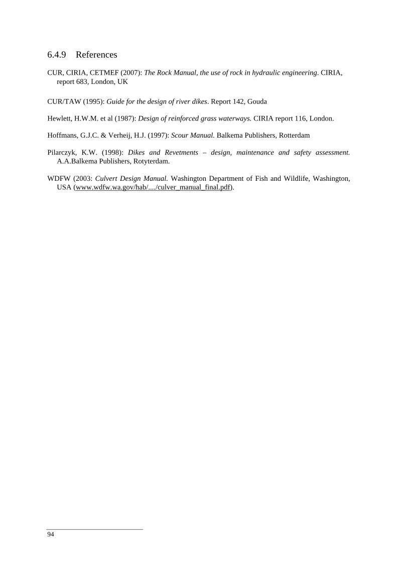
94
6.4.9 References CUR, CIRIA, CETMEF (2007): The Rock Manual, the use of rock in hydraulic engineering. CIRIA,
report 683, London, UK CUR/TAW (1995): Guide for the design of river dikes. Report 142, Gouda Hewlett, H.W.M. et al (1987): Design of reinforced grass waterways. CIRIA report 116, London. Hoffmans, G.J.C. & Verheij, H.J. (1997): Scour Manual. Balkema Publishers, Rotterdam Pilarczyk, K.W. (1998): Dikes and Revetments – design, maintenance and safety assessment.
A.A.Balkema Publishers, Rotyterdam. WDFW (2003: Culvert Design Manual. Washington Department of Fish and Wildlife, Washington,
USA (www.wdfw.wa.gov/hab/..../culver_manual_final.pdf).
Best Practice Guidelines for the Integrated Planning and Design of Economically Sound and Environmentally Friendly Roads in the Mekong Floodplains of Cambodia and Viet Nam
95
7. Recommendations for Application of the Best Practice Guidelines
The aim of this report was to highlight the importance of evaluating the environmental, social and economic arguments for sustainable road planning and construction by considering the advantages of the resilience option and the application of lifetime approaches for roads/bridges construction in the Mekong floodplains. The national staffs in the divisions or section responsible for policy preparation may look into the need of strengthening, complementing the existing guidelines. The technical divisions/sections of the line agencies of the MRC member countries will have to come-up with their internal plan to propose and develop the improvements of rules, procedures and guidelines, related to the development, design and construction of road infrastructure in flood plain areas. Generally this is not undertaken through the simple publication of a report (such as the ‘Roads and Floods’ Report). It generally is undertaken, if and when such a subject or intention is identified as a requirement/activity in a year plan of Ministries like the Ministry of Land Management, Ministry of Transport, and / or Ministry of Agriculture and Rural Development. This leads to the conclusion that a Roads and Floods Report will not directly lead to adjustments/improvements of existing guidelines, or the drafting of hitherto not existing guidelines. The most effective way of supporting the potential use of the Roads and Floods Report is to create awareness and proper understanding of the content of the Roads and Flood Report among the divisions/sections involved or responsible for the preparation of guidelines or improvement of guidelines. Particularly WWF GMP, being part of the initiators of the Roads and Floods Project, has earlier shown interest in implementing a targeted project to actively sharing the information with these target groups, however such implementation would be considered a post project phase. Relevant for such a “policy oriented’ project is to identify clearly what are the specific “lessons learned” from the Roads and Floods Project. It is however somewhat unfortunate that during the implementation period of the Roads and Floods Project, as a result of the lack of damage data, due to the lack of flood events in the flood plain, no strong convincing financial-economical outcome could be provided to demonstrate the advantages of the resilience option above the protection option in a life-time approach of flood plain road infrastructure. This weakens the package of convincing elements for the follow-up policy work. Even though many will understand and support the resilience option theory in view of securing the sustainability of flood plain infrastructure at lowest life time costs, for very practical reasons protection options will continue to be applied, due to a variety of reasons (lack of funds, limited funds, lack of availability of loans, limited availability of loan funds, limiting engineering knowledge and experience or existing models to refer too, hydrodynamic modelling capacities in line agencies, preference to limit construction period, preference to limit complexity, gaps in integrated water resources strategy for the flood plain, weaknesses in the strategy for infrastructure development in the flood plain, weak level of interaction and exchange between technical and policy levels in water resources sector, etc.). Nonetheless it is recommended to raise awareness for the resilience approach of flood plain road infrastructure in line agencies of the MRC member states, which have been involved in the development and implementation of the Roads and Floods Project. MRC and WWF GMP could work out a set of recommendations and share these among line agencies of the four MRC member countries, and produce documentation of the concept and supporting material in the riparian languages for dissemination. By making the information available in the riparian languages and by disseminating the material to policy and technical divisions/sections of line agencies in Cambodia and Vietnam, but also to the other MRC member countries like Lao PDR and Thailand, the possibilities for later uptake and use of the concept and recommendations is facilitated.
96
The international development banks are among the target group, as these institutions provide loans for infrastructure to “qualifying” MRC member countries. These institutions, could explore how this report can contribute to improve their own safeguards. They could also be invited to contribute to a dialogue on the need and feasibility of developing national guidelines under following phases of the Roads and Floods project. The dialogue may result into a commitment by these institutions to further look into options for improving their technical criteria/requirements for loan projects related to infrastructure development in flood plain areas. Before entering into a next step of addressing the potential of influencing the policy and policy preparation of responsible line agencies, it would be recommendable to identify the key policy elements in terms of acceptability, sensitivity, methods and cost factors for dissemination of the concept and related documentation. There would be a need for a dedicated and targeted approach in consultation with MRC in order to optimize potential impact of the Guidelines and Recommendations developed under the Roads and Floods Project to the benefit of the MRC member countries.
Best Practice Guidelines for the Integrated Planning and Design of Economically Sound and Environmentally Friendly Roads in the Mekong Floodplains of Cambodia and Viet Nam
97
8. References ADB (2002), Report and recommendation of the president to the board of directors on a proposed
loan to the Kingdom of Cambodia for the Greater Mekong Subregion: Cambodia road improvement project, Asian Development Bank, 2002.
ADB (1998), Report and recommendation of the president to the board of directors on proposed loans
to the Kingdom of Cambodia and to the Socialist Republic of Viet Nam for the Greater Mekong Subregion: Phnom Penh to Ho Chi Minh City Highway, Asian Development Bank, 1998.
Asian Development Bank (1993), Highway and Roads. Environmental Guidelines for Selected
Infrastructure Projects, Asian Development Bank. ADPC (2008), Incorporating disaster risk assessment as part of planning process before construction
of new roads; RCC Guideline 3.1, Consultation Version 2.1,April 2008, ADPC. Baltzer, M.C., N.T. Dao, and R. Shore, compilers (2001), Towards a Vision for Biodiversity in the
Forests of the Lower Mekong Ecoregion Complex. WWF Indochina and WWF US, Ha Noi and Washington, D.C.
Baran, E., I. G. Baird, and G. Cans (2005), Fisheries bioecology at the Khone Falls (Mekong River,
southern Lao PDR). WorldFish Centre, Penang. Baran, E., T. Jantunen, and C. K. Chong (2007a), Values of inland fisheries in the Mekong River
basin. WorldFish Center, Phnom Penh. Baran E., P. Starr, and Y. Kura (2007b), Influence of built structures on Tonle Sap fisheries. Cambodia
National Mekong Committee and the WorldFish Center. Phnom Penh, Cambodia. 44 pages. Beinamaryo, F. (2007), Multi-Criteria Decision Aid method for Road Planning and Development in
Floodplains: A Case Study of the Mekong Flood Plains, MSc thesis UNESCO-IHE, Delft. Brockenbrough, R.L. and G. Boedecker (2003), Highway engineering handbook: building and
rehabilitating the infrastructure (2nd edition) New York: McGraw-Hill. Bruijn de, K. (2005), Resilience and Flood Risk Management – A systems approach applied to
lowland rivers, PhD thesis, Delft University Press, Technical University, Delft. Buys, Piet, Uwe Deichmann and David Wheeler, Road Network Upgrading and Overland Trade
Expansion in Sub-Saharan Africa, World Bank Policy Research Working Paper 4097, December 2006.
Cusic K (2000) the effects of roads on wetlands, with some mitigation alternatives. [7 paragraphs]
Wildlands CPR [online] http://www.wildlandscpr.org /resourcelibrary/reports/roads_wetlands.htm [Accessed 5 August 2007]
Cross, H. (2005), A report on likely infrastructure developments on the Mekong floodplain in
Cambodia and their significance in changing flow patterns, MRC, Vientiane, 2005 DEFRA (2008) http://www.defra.gov.uk/environ/fcd/policy/ strategy.htm (accessed 20/08/ 08). Delft Cluster-WWF-MRC (2006), Project Plan ‘Roads and Floods’, Developing Economically Sound
and Environmentally Friendly Guidelines for the Planning and Design of Roads in the Mekong Floodplains of Cambodia and Viet Nam, Part of output 1.3 of MRC-FMMP Component #2, Delft Cluster, WWF and MRC, 6 April 2006.
98
EC (2001a), Guidance on EIA: Screening, Office for Official Publications of the European
Communities, Luxembourg. EC (2001b), Guidance on EIA: Scoping, Office for Official Publications of the European
Communities, Luxembourg. EC (2001c), Guidance on EIA: EIS review, Office for Official Publications of the European
Communities, Luxembourg. EMU (2004), Procedures Manual for Environmental and Social Management in the Roads Sector,
Users Manual, Ministry of Works and Supply, Roads Department. Environmental Agency (2006), Scoping Guidelines for the Environmental Impact Assessment of
Projects Business and Industry. ERM (2002), Development of an EIA/SEA System for the Lower Mekong Basin: Background review,
April 2002, London. ERM (2002), Development of an EIA/SEA System for the Lower Mekong Basin: Proposed system,
April 2002, London. De Groot, R.S., Stuip, M.A.M., Finlayson, C.M. and N. Davidson (2006), Valuing wetlands: guidance
for valuing the benefits derived from wetland ecosystem services, Ramsar Technical Report No. 3/CBD Technical Series No. 27. Ramsar Convention Secretariat, Gland, Switzerland & Secretariat of the Convention on Biological Diversity, Montreal, Canada. ISBN 2-940073-31-7.
De Groot, R.S. (1992), Functions of nature: Evaluation of nature in environmental planning,
management and decision making, Wolters-Noordhoff, Amsterdam, 1992. 315 pp. Dhakal, M.R. (2007), Assessment of Hydrodynamic impacts of floods on Roads and Road structures in
Lower Mekong Floodplains, MSc thesis UNESCO-IHE, Delft. Do Nguyen Anh Tu (2008), Towards a sustainable strategy for road development in the Vietnamese
Mekong Delta floodplain, MSc thesis Wageningen University, Wageningen. Douven, W.J.A.M, Douben, K.J., Goichot, M., Ngoc, H.M., Ruyt, M. van der, and H.J. Verheij
(2007), Roads and Floods: Towards improved guidelines for road development and reconstruction in the Mekong floodplains of Cambodia and Viet Nam, 5th Annual Mekong Flood Forum, Regional Flood Management and Mitigation Centre, Phnom Penh, Cambodia.
Goichot, M. et al. (2008), Roads and Floods policy plan, WWF, June 2008. Hoban, C. and K. Tsunokawa (eds.) (1997), Roads and the environment: a handbook, Washington,
D.C.: The World Bank, ISBN 0-8213-4031-X. Hortle, K.G. (2007) Consumption and the yield of fish and other aquatic animals from the Lower
Mekong Basin. MRC Technical Paper No. 16, Mekong River Commission, Vientiane. 87 pp. Jackson, S.D. (2003), Ecological Considerations in the Design of River and Stream Crossings. In:
Irwin, C.L., Garrett, P. & K.P. McDermott (eds.) Proceedings of the International Conference on Ecology and Transportation. Raleigh, NC: Centre for Transportation and the Environment, North Carolina State University. pp 10.
JICA (2006), The Study on the Road Network Development in The Kingdom of Cambodia, Draft Final
Report, Volume II-1 Main Text and Draft Final Report, Volume II-2 Main Text, July 2006.
Best Practice Guidelines for the Integrated Planning and Design of Economically Sound and Environmentally Friendly Roads in the Mekong Floodplains of Cambodia and Viet Nam
99
Konrad, C.P. and D.B. Booth (2002), Hydrologic trends associated with urban development for
selected streams in western Washington. U.S. Geological Survey Water-Resources Investigations Report 02-4040, 40 p.
Kruskopf, M. (2006), Impacts of built structures on tropical floodplains worldwide, Cambodia
National Mekong Committee and the WorldFish Center. Phnom Penh, Cambodia. Kottelat, M. (2001a), Fishes of Laos. WHT Publications, Colombo. MacKinnon, J., and K. MacKinnon (1986), Review of the Protected Areas System in the Indo-Malayan
Realm. IUCN, Gland and Cambridge. Marble, A.D. and X. Riva (2002), Guidelines for Selecting Compensatory Wetlands Mitigation
Options, NCHRP Report 482. MARD (2003), ‘Living with Floods in the Mekong River Delta of Viet Nam’. Proceedings of the
International Seminar on Flood Management, Ministry of Agriculture and Rural Development, Hanoi, 17-21 November 2003, pp 85-92.
Ministry of Transport, Public Works and Water Management (2006), Spatial Planning Key Decision
‘Room for the River’- investing in the safety of the Dutch river basin region, September 2006. Mitsch WJ, and J.G. Gosselink (2000), The value of wetlands: importance of scale and landscape
setting. Journal of Ecological Economics: 35, pp. 25-33. MoT/Worldbank (2005), Mekong Transport Infrastructure Development Project, Summary Interim
Report / Option Report, Ministry of Transport and World Bank, December 2005. MoT (2004), Mekong Transport and Flood protection project, Environmental Review report E286. MRC (2008), Annual Mekong Flood Report 2007, Mekong River Commission, Vientiane, 86 pp. MRC (2007a), Best practice IFRM guidelines for the BDP. Volume 1: Framework for developing of
guidelines. MRC (2007b), Best practice IFRM guidelines for the BDP. Volume 2: Background information. MRC (2007c), Annual Flood Report 2006, Mekong River Commission, Vientiane. MRC (2007d), Draft Inception Report of the Flood Management and Mitigation Program Component
2 ‘Structural Measures and Flood Proofing’, Haskoning, Deltares, UNESCO-IHE, Phnom Penh, Cambodia.
MRC (2005a), A Report on Likely Infrastructure Developments on the Mekong Floodplain in
Cambodia & Their Significance in Changing Flow Patterns, Report prepared by Ecosphere Solutions Pty Ltd for Mekong River Commission, May 2005.
MRC (2005b), Overview of the hydrology of the Mekong Basin, Mekong River Commission,
Vientiane, November 2005. MRC (2004c), ‘Development Strategy for the Lower Mekong Basin: Draft BDP Discussion Paper’ ,
BDP Publication No. BDP034, June 2004. MRC (2003a), Social Atlas of the Lower Mekong Basin, Mekong River Commission, March 2003. MRC (2003b). State of the Basin Report, Mekong River Commission, Phnom Penh, June 2003.
100
MRSCSC (2004) Massachusetts River and Stream Crossing Standards; Technical Guidelines
Massachusetts River and Stream Continuity Steering Committee, August 2004. Nairn, R. and J. Fossitt (2001) Guidelines for Assessment of Ecological Impacts of National Road
Schemes National Roads Authority, Ireland. Namgyal, K. (2007), Effect of hydraulic changes due to road development on the Cambodian Mekong
floodplain functions, MSc thesis UNESCO-IHE, Delft. Nguyen Khoa, S. and P. Chet. (@@), Review of Tonle Sap built structure Environmental Impact Assessments (EIA) with regard to fisheries, Cambodia National Mekong Committee and the
WorldFish Center. Phnom Penh, Cambodia. Noss R (2002) The Ecological Effects of Roads [8 Paragraphs] Eco-Action [online] http://www.eco-
action.org/dt/roads.html [Accessed 7 August 2007]. Nyangu, R. (2006), An Integral Analysis of Environmental, Economic and Infrastructure Aspects of
Road Development in the Barotse Flood Plain, Zambia. MSc thesis UNESCO-IHE, Delft. Olson, D. M., E. Dinerstein, E. D. Wikramanayake, N. D. Burgess, G. V. N. Powell, E. C.
Underwood, J. A. D’Amico, I. Itoua, H. E. Stand, J. C. Morrison, C. J. Loucks, T. F. Allnutt, T. H. Ricketts, Y. Kura, J. F. Lamoreaux, W. W. Wettengel, P. Hedao, and K. R. Kassem. 2001. Terrestrial Ecoregions of the World: A New Map of Life on Earth. BioScience 51: 933-938.
Patarroyo Quintero, J.O. (2007), Hydraulic Modelling Cambodian Floodplain , MSc thesis UNESCO-
IHE, Delft. Phan Thi Thu Ha (2007), Road Development in the Mekong Delta in Viet Nam, MSc thesis UNESCO-
IHE, Delft. Poulsen A.F., Ouch Poeu, Sintavong Viravong, Ubolratana Suntornratana and Nguyen Thanh Tung
(2002) Fish migrations of the Lower Mekong River Basin: implications for development, planning and environmental management. MRC Technical Paper No. 8, Mekong River Commission, Phnom Penh. 62 pp. ISSN: 1683-1489.
Pratheepan, K. (2007), Hydraulic Modelling VietnameseCambodian Floodplain, MSc thesis
UNESCO-IHE, Delft. Ramsar (2002), Guidelines for incorporating biodiversity-related issues into environmental impact
assessment legislation and / or processes and in strategic environmental assessment, adopted by the Convention on Biological Diversity (CBD), and their relevance to the Ramsar Convention, Resolution VIII.9.
Ramsar (2005), An Integrated Framework for wetland inventory, assessment and monitoring (IF-
WIAM), Resolution IX.1 Annex E. Ramsar (1999), Guidelines for integrating wetland conservation and wise use into river basin
management, Resolution VII.18. Ruyt, M. van der and H.J. Verheij (in preparation), Road damage analysis, Delft Cluster, WWF and
MRC-FMMP, Delft, The Netherlands. Scottish Executive ‘Scottish Planning Policy (2004), Scottish Planning Policy SPP 7: Planning and
Flooding (accessible online http://www.scotland.gov.uk /Publications/2004/02/18880/32952; accessed 13/08/2008)
Best Practice Guidelines for the Integrated Planning and Design of Economically Sound and Environmentally Friendly Roads in the Mekong Floodplains of Cambodia and Viet Nam
101
SEI and ADB (2002), Strategic Environmental Framework for the Greater Mekong Subregion:
Integrating Development and Environment in the Transport and Water Resource Sectors, Volume IV: SEF Case Study Reports, March 2002.
Spellerberg I. F, Morrison T (1998) The Ecological Effects of Roads- A Literature Review [2
Paragraphs] Science for Conservation [Online] http://www.doc.gov.nz/publications /004~science-and-research /…/PDF/sfc084.pdf [Accessed 6 August 2007].
The Highways Agency et al. (1993), Design Manual for Roads and Bridges Volume 11 Section 3 Part
10. Updated 2006. The Highways Agency, Scottish Executive, Welsh Assembly Government, The Department for
Regional Development Northern Ireland (2006), Design Manual for Roads and Bridges (DMRB) Volume 4, Section 2 ‘Drainage’.
Thorncraft, G., L.J. Baumgartner and T. Marsden (2005), Fish passage and fishways in the Mekong
Basin: getting past the barriers. In: proceedings of the 7th technical symposium on Mekong fisheries. Ubon Ratchathani, Thailand.
Tordoff, A.W., R.J. Timmins, A. Maxwell, K. Huy, V. Lic and E. H. Khou (eds.) (2005), Biological
assessment of the Lower Mekong Dry Forests Ecoregion. Final report. WWF Indochina Programme, Phnom Penh.
Transportation Research Board of the National Academies (2003), Sustainability and environmental
concerns in transportation Washington. Transportation Research Board, ISBN 0-309-08596-9. Turner R.K., C.J.M. van den Bergh, Sodeerqvist, A. Barendregt., J.V.D. Straaten, E. Maltby and E.C.
van Ierland (2000), The values of wetlands: landscape and institutional perspectives, Ecological-economic analysis of wetlands: Scientific integration of management and policy, Journal of Ecological Economics, 25: 7-23.
UK Government Planning Policy Statement 25 (2006) PPS25: Development and Flooding, TSO,
London (accessible online http://www.floodforum.org.uk/infoanddownloads /consultations/pps25 accessed 13/08/2008).
Verheij, H.J (in preparation), Inundation modelling of five pilot sites in the Mekong delta, Delft
Cluster, WWF and MRC-FMMP, Delft, The Netherlands. Verheij, H.J. and M. van der Ruyt (in preparation), Pre-flood, flood and post-flood monitoring plan
and 2006 and 2007 survey reports, Delft Cluster, WWF and MRC-FMMP, Delft, The Netherlands. Verheij, H.J. and M. van der Ruyt (in preparation), Review technical design guidelines and
suggestions for improvements, Delft Cluster, WWF and MRC-FMMP, Delft, The Netherlands. Vidthayanon, C., C. Phalla, T. Nyro and S. Lieng (2008). Fish In: Bezuijen, M.R., R.J. Timmins and
T. Seng (eds.). Biological surveys of the Mekong River between Kratie and Stung Treng Towns,
northeast Cambodia, 2006-2007. WWF Greater Mekong – Cambodia Country Programme, Cambodia Fisheries Administration and Cambodia Forestry Administration, Phnom Penh.
Vis, M., F. Klijn, K.M. de Bruijn, and M. van Buren (2003), Resilience strategies for flood risk
management in the Netherlands, Int. J. River Basin Management, Vol 1, No. 1 (2003), pp. 33-40. Walder (2005) Roads and wetlands [5 paragraphs] Road RIporter 2.4 [online]
http://www.wildrockies.org/WILDCPR/notes/biblionotes/roads-wetlands.html [Accessed 5 August 2007].

102
Wikramanayake, E., E. Dinerstein, C. J. Loucks, D. M. Olson, J. Morrison, J. Lamoreux, M.
McKnight, and P. Hedao (eds.) (2002), Terrestrial Ecoregions of the Indo-Pacific. A Conservation Assessment. Island Press, Washington, D.C.
World Bank (1997), Roads and the Environment Handbook, K. Tsunokawa and C. Hoban (eds.),
Technical Paper No. 376, World Bank, Washington DC, 1997.
Best Practice Guidelines for the Integrated Planning and Design of Economically Sound and Environmentally Friendly Roads in the Mekong Floodplains of Cambodia and Viet Nam
103
Appendix 1 – Case Study Methodology 1. Introduction Chapter 5 of the ‘Roads and Floods’ synthesis report presents four road development and rehabilitation case studies in Cambodia and Viet Nam. The studies aim to better understand interactions between roads and floods as well as the impacts of the different road development strategies; resistance and resilience. More specifically the cases are applied to answer the four main research questions underlying this report (Chapter 1):
What is the significance of roads in the Cambodian and Vietnamese floodplains in changing flow patterns (including cumulative impacts)?
What is the significance of flow patterns in Cambodia and Viet Nam in terms of road damage? What are the impacts of different road development and rehabilitation strategies (resistance and
resilience) in Cambodia and Viet Nam on floodplain hydraulics and related benefits of floods and on economic costs of roads?
What road development and rehabilitation practice would contribute most to the reduction of the socio-economic costs of flooding in the Lower Mekong Basin, whilst preserving the environmental and other benefits of floods?
This Appendix presents the methodology applied in the case studies. To analyse and present the cases a policy analysis approach was applied. This approach structured the road development and rehabilitation process along the following general planning steps: problem analysis, analysis present and future situation, identification of alternatives, assessment of impacts of alternatives and evaluation of alternatives. The analysis of the different steps was supported by the surveys carried out in both Cambodia and Viet Nam and the technical analysis activities including inundation modelling and analysis, damage analysis, economic analysis and environmental impact analysis. The methodology might not be entirely new for Cambodia and Viet Nam, still it could be used as a Best Practive Guidance to support the (pre-) feasibility stages of the process of integrated planning of road development and rehabilitation. 2. Road development and rehabilitation in the (pre-)feasibility stage Figure 1 shows a generic planning procedure that is used in the (pre-)feasibility stages of road development and rehabilitation. The procedure was also used in the ‘Roads and Floods’ project to illustrate how impacts of road development, including environmental impacts, can be taken into account in an integral manner. This section will describe the different steps of the procedure. The first step in the procedure is to identify the ‘problem’ (or ‘issue’) and its scope by involving the relevant stakeholders. The ‘problem’ can be the fact that a roads needs rehabilitation due to flood damage or that a new road needs to be developed crossing an ecologically valuable sub-floodplain. The second step is the determination of objectives and criteria by the stakeholders. Obviously, this will result in a variety of objectives as the stakeholders will represent different stakes, like transport, rural development, agriculture, fisheries, environment. This is illustrated by Table 1, taken from a pilot study carried out in Cambodian (Beinamaryo, 2007), where stakeholders where asked to give objectives and select criteria. The objectives and criteria are the boundary conditions in the planning and design process (Step 4). The third step is the analysis of the present situation, used as a baseline in the procedure. The fourth step is a creative process in which the different design and alignment alternatives are identified by experts. The process is guided by the technical guidelines (Chapter 6). If no design and alignment alternatives are possible given the objectives and constraints, step 2 will be revisited. In Step 5, an in-depth assesssment of road alternatives is carried out. Each objective and criteria is linked to indicators and their scores assessed by experts. The assessment of the hydraulic and damage indicators is carried out on the basis of detailed modelling and analysis. The assessment of impacts on floodplain ecology is linked to changes in hydraulics; if hydraulic conditions change there is an impact on floodplain ecology. The assessment of economic and financial aspects will be done on the basis of expert information and literature.
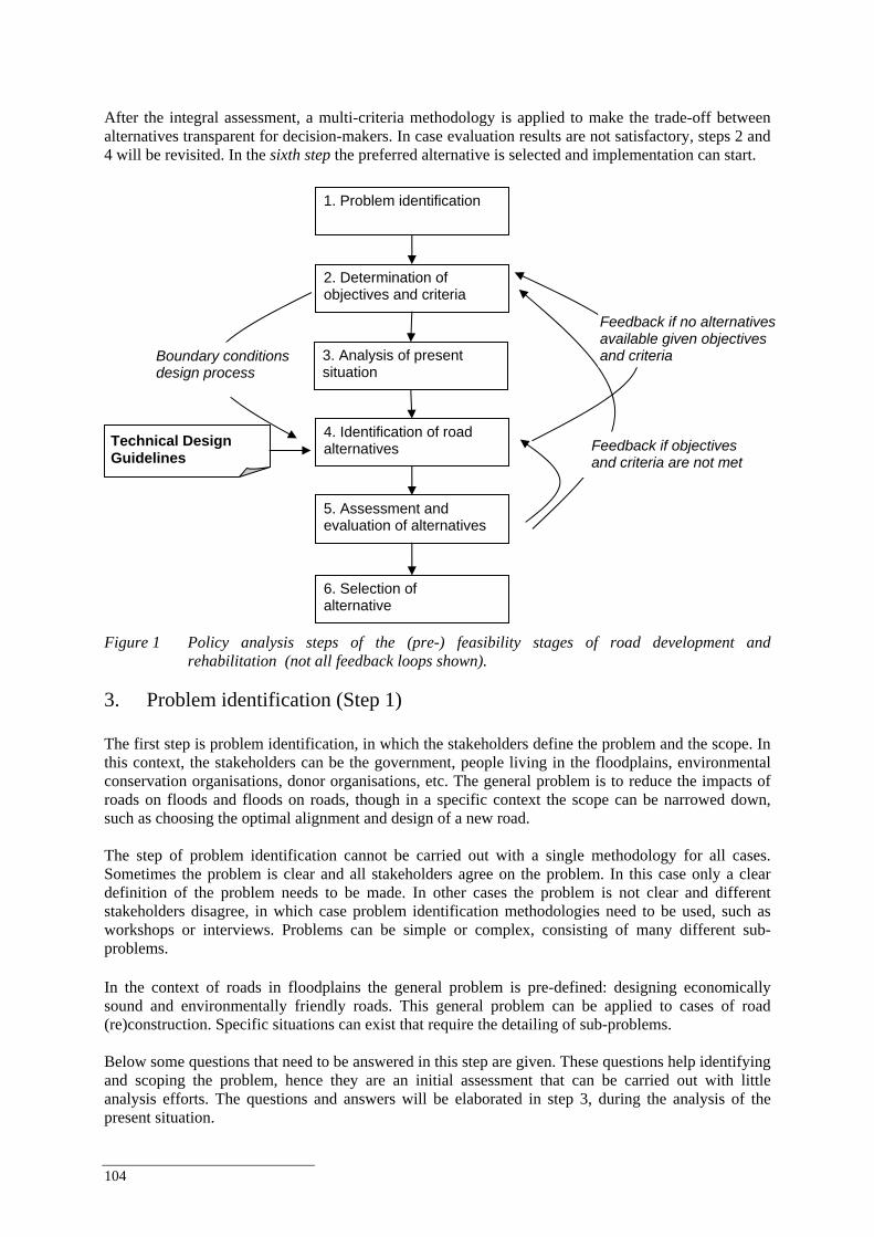
104
After the integral assessment, a multi-criteria methodology is applied to make the trade-off between alternatives transparent for decision-makers. In case evaluation results are not satisfactory, steps 2 and 4 will be revisited. In the sixth step the preferred alternative is selected and implementation can start.
Figure 1 Policy analysis steps of the (pre-) feasibility stages of road development and
rehabilitation (not all feedback loops shown).
3. Problem identification (Step 1) The first step is problem identification, in which the stakeholders define the problem and the scope. In this context, the stakeholders can be the government, people living in the floodplains, environmental conservation organisations, donor organisations, etc. The general problem is to reduce the impacts of roads on floods and floods on roads, though in a specific context the scope can be narrowed down, such as choosing the optimal alignment and design of a new road. The step of problem identification cannot be carried out with a single methodology for all cases. Sometimes the problem is clear and all stakeholders agree on the problem. In this case only a clear definition of the problem needs to be made. In other cases the problem is not clear and different stakeholders disagree, in which case problem identification methodologies need to be used, such as workshops or interviews. Problems can be simple or complex, consisting of many different sub-problems. In the context of roads in floodplains the general problem is pre-defined: designing economically sound and environmentally friendly roads. This general problem can be applied to cases of road (re)construction. Specific situations can exist that require the detailing of sub-problems. Below some questions that need to be answered in this step are given. These questions help identifying and scoping the problem, hence they are an initial assessment that can be carried out with little analysis efforts. The questions and answers will be elaborated in step 3, during the analysis of the present situation.
5. Assessment and evaluation of alternatives
2. Determination of objectives and criteria
6. Selection of alternative
4. Identification of road alternatives
3. Analysis of present situation
1. Problem identification
Boundary conditions design process
Technical Design Guidelines
Feedback if no alternatives available given objectives and criteria
Feedback if objectives and criteria are not met
Best Practice Guidelines for the Integrated Planning and Design of Economically Sound and Environmentally Friendly Roads in the Mekong Floodplains of Cambodia and Viet Nam
105
1. Is it a new road or an existing road? The impacts of a new road project versus an existing road project are substantially different (World Bank, 1997). From an environmental perspective, the key issue for new road projects is to prevent impacts, while the key issue for existing roads is rehabilitating previous negative impacts and prevent further impacts. A new road has more degrees of freedom for its design; the major one being the alignment. 2. Is it a National, Provincial or Local Road? National, Provincial and Local Roads are built according to different standards, have different objectives, different capacities, different purposes, etc. The type of road already pre-defines some of the objectives, criteria and guidelines to be used. 3. What are the reasons for constructing the road? A general description of the reasons for constructing the road should be given for understanding the problem. Detailed reasons will come back in the next step when objectives and criteria for the road project are defined. 4. What is the general socio-economic setting? The general socio-economic setting provides background information on population, the road network, development plans, income per capita, regional GDP, industries, etc. Detailed information is needed for the analyses in steps 3, 4 and 5. External costs and benefits of the road project, such as less traffic casualties, development of road-side commerce, and resettlement, should also be discussed here. 5. What are the floodplain values? This provides general information on the environmental and ecological dimensions (agriculture, fisheries, ecological value), but also on some socio-economic values of the floodplain, such as residential value and value for tourism, for instance. 6. What is the general hydraulic setting and previous damage? The general hydraulic setting provides background information on flood levels, discharges, direction and force of currents, etc. In addition, if available a brief description of previous damages should be given. Again detailed information is needed for the analyses. 4. Determination of objectives and criteria (Step 2) The second step is the determination of objectives and criteria, which should again be defined by the stakeholders. Generally, road projects aim at improving economic and social welfare. However, roads often have many more positive and negative impacts, particularly on the natural and social environment. Hence many people and organisations will be affected by a road project or have interest in involvement of a road project, other than the government. This requires involvement of interest groups. Public involvement can be useful in several steps of the management analysis approach for gathering data, understanding impacts, determining preferences, selecting project alternatives, and developing compensation and mitigation plans (World Bank, 1997, chapter 5). Particularly in step 2, the involvement of stakeholders is important as objectives and criteria should be determined by the stakeholders. As there are many different stakeholders, there are many different objectives and criteria and for each road project there are different stakeholders. Depending on the size of the project, the resources for analysis and expected impacts, stakeholders should be identified and a plan should be developed for information dissemination, information solicitation and consultation with stakeholders (World Bank, 1997, chapter 5). The plan should include an analysis of potential stakeholders and the public involvement format, such as interview surveys, public meetings, on-site consultation and rapid appraisal.

106
Stakeholder involvement is generally an activity within a road project and determination of objectives and criteria could be carried out within this activity. Objectives and criteria could, for instance, be determined at a workshop with representatives of the different stakeholders or during interviews with stakeholders. Within the present Roads & Floods project the objectives and criteria will be discussed during workshops with line agencies and using secondary data sources. The result of step 2 should be an overview of different objectives and criteria for different types of impacts that can be used in the evaluation of options. Hence, the criteria should be measurable, either quantitative or qualitative. The objectives and criteria could be presented, for instance, in an overview as shown in Table 1. This table gives as an example several road development and rehabilitation objectives and different options for criteria that will be applied by decision-makers when selecting alternatives. The objectives are needed amongst others to evaluate the different options in step 5. Examples of objectives are ensuring the least impact on agricultural areas, fish migration, reducing damage costs during large floods, keeping roads above the highest known flood level or reduce transportation costs between two cities. Different stakeholders will have different objectives; environmental groups focus on biodiversity objectives while the government may focus on monetary objectives. An interactive process, such as organising workshops, may be needed to determine the objectives of all the stakeholders. The criteria (Table 1) form the boundary conditions for the optimal solution. Examples of criteria are the available budget, technical possibilities, hydraulic conditions, etc. The list of objectives and criteria can become very long if many stakeholders are involved in the decision making process. It is likely that this will lead to the definition of different sets of standards (medium, low, high). Also, some criteria will be easier to measure and quantify than others. Table 1 Example of road development and rehabilitation objectives and different options for criteria.
Objectives Criteria
Enhance Regional Transportation
Travel Time ▪ Road flooding accepted (limited reduction travel time) ▪ Once in few years flooding accepted (medium reduction of
travel time) ▪ Road never flooded (large reduction of travel time)
Reduce Flood Vulnerability
Damage of Flooding (Housing, Infrastructure, Agriculture, Roads)
▪ No damage accepted ▪ Yearly limited damage accepted ▪ 5 yearly limited damage accepted ▪ Damage accepted
Maintain fisheries and agricultural harvest
Fisheries and Agriculture Harvest
▪ No change in harvest accepted ▪ Small decrease accepted ▪ Increase harvest
Initial Investment ▪ No budget constraint ▪ Medium budget ▪ Limited budget
Minimise Road Investment and Maintenance
Maintenance Cost ▪ No budget constraint ▪ Medium budget ▪ Limited budget
Flood Pattern and Dynamics (within zone)
▪ Change accepted ▪ Limited change accepted ▪ Change accepted
Flood Pattern and Dynamics (outside zone)
▪ No change accepted ▪ Limited change accepted ▪ Change accepted in less valuable areas
Maintain Flood Plain Hydraulics and Ecology
Habitat Fragmentation ▪ No fragmentation loss accepted ▪ Limited fragmentation is accepted if adaptation is possible ▪ Fragmentation accepted
Best Practice Guidelines for the Integrated Planning and Design of Economically Sound and Environmentally Friendly Roads in the Mekong Floodplains of Cambodia and Viet Nam
107
5. Analysis of present situation and identification of scenarios (Step 3) The third step is the analysis of the present situation and the development of future scenarios. The present situation forms the starting point for identification, evaluation and selection and implementation of options, hence it can be called the ‘reference’ case for future development. The analysis consists of monitoring and modelling of the hydraulic circumstances near the road and in the region of the road, monitoring of damage during floods, analysis of historical data and a study of all other elements relevant to the objectives and criteria as defined in the previous step (Section 1.4). The lifespan of roads is several decades and once a road has been built following some alignment this could remain the same for centuries. Hence, it is important to define scenarios to analyse the impact of future trends and events. Future changes are mostly related to socio-economic developments and climate variability and change. Step 3 can consist of several analysis and modelling activities. Central activities are monitoring, which leads to a road damage analysis, hydraulic modelling, and secondary data collection. Other types of analysis are socio-economic analysis, floodplain value analysis and a financial analysis. In addition, different climate, economic and population scenarios should be included in these analyses. The monitoring and modelling activities are not discussed in this report, but in separate documents. This section only gives a general description of these activities. Socio-economic analysis, floodplain value analysis and financial analysis will be carried out using secondary data. For these types of analysis a brief description is given below. Development of future scenarios is carried out using existing publications of the MRCS. Hence, referring to 4, the analysis of the present situation consist of:
Hydraulic analysis. Road damage analysis. Floodplain value analysis. Socio-economic analysis. Financial analysis.
Which is supported by:
Secondary data collection and analysis. Monitoring. Modelling preparations. Scenario development.
First the supporting activities are described, as they precede the analysis activities, followed by a description of the different analysis and modelling activities. 5.1 Analysis support Secondary data and literature search and analysis The data and literature search consists of 3 activities on one or more different levels (Figure): a. Secondary data collection. In addition to the primary data collection carried out by the monitoring
activities (ad. B), secondary data collection is required for the development of the hydraulic model and damage analysis, socio-economic analysis, floodplain value analysis and financial analysis. Secondary data can be collected at regional and national basin organisations, line agencies and other relevant sources.
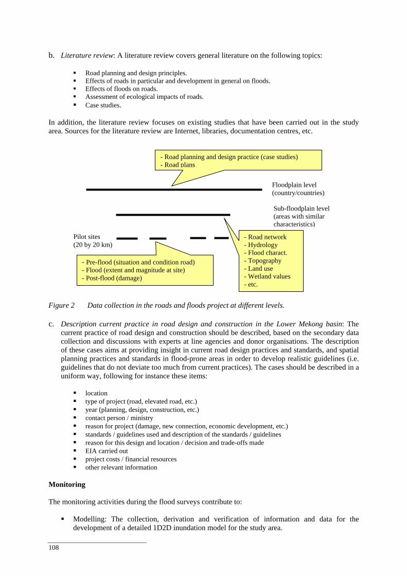
108
b. Literature review: A literature review covers general literature on the following topics:
Road planning and design principles. Effects of roads in particular and development in general on floods. Effects of floods on roads. Assessment of ecological impacts of roads. Case studies.
In addition, the literature review focuses on existing studies that have been carried out in the study area. Sources for the literature review are Internet, libraries, documentation centres, etc.
Figure 2 Data collection in the roads and floods project at different levels. c. Description current practice in road design and construction in the Lower Mekong basin: The
current practice of road design and construction should be described, based on the secondary data collection and discussions with experts at line agencies and donor organisations. The description of these cases aims at providing insight in current road design practices and standards, and spatial planning practices and standards in flood-prone areas in order to develop realistic guidelines (i.e. guidelines that do not deviate too much from current practices). The cases should be described in a uniform way, following for instance these items:
location type of project (road, elevated road, etc.) year (planning, design, construction, etc.) contact person / ministry reason for project (damage, new connection, economic development, etc.) standards / guidelines used and description of the standards / guidelines reason for this design and location / decision and trade-offs made EIA carried out project costs / financial resources other relevant information
Monitoring The monitoring activities during the flood surveys contribute to:
Modelling: The collection, derivation and verification of information and data for the development of a detailed 1D2D inundation model for the study area.
Floodplain level (country/countries)
Sub-floodplain level (areas with similar characteristics)
Pilot sites (20 by 20 km)
- Road planning and design practice (case studies) - Road plans
- Road network - Hydrology - Flood charact. - Topography - Land use - Wetland values - etc.
- Pre-flood (situation and condition road) - Flood (extent and magnitude at site) - Post-flood (damage)
Best Practice Guidelines for the Integrated Planning and Design of Economically Sound and Environmentally Friendly Roads in the Mekong Floodplains of Cambodia and Viet Nam
109
Road damage analysis: Damage assessments to infrastructure (roads and permeability
structures) due to flooding events. The type of damage and the underlying failure mechanisms will be determined from monitoring data and possibly historical data. Ideally, the damage should be expressed in unit costs specified to different road classes.
Modelling and monitoring should be carried out for selected representative pilot sites, as resources are usually limited. The selection of pilot sites and monitoring locations is based on the following:
Field trips. Meetings with local experts. Data and information available at various local and national agencies and institutions involved in river
basin development and management, road construction and maintenance, wetland preservation, etc. The ‘Roads and Floods’ project distinguishes pilot sites and monitoring locations. Pilot sites are defined as focal areas within the Cambodian and Vietnamese floodplain of about 20 by 20 kilometres, which will be subjected to various monitoring activities. The monitoring locations are selected within the pilot sites. The hydraulic monitoring locations consist of approximately 5 to 10 pre-determined locations within each pilot site, which have been selected based on the field visits and in consultation with amongst others FMMP staff. The locations could be subject to change if results of initial analyse would recommend so. The exact selection of damage assessment locations needs to be determined during the monitoring campaigns. However, results of a preparatory analysis should be used to develop a preliminary selection of locations for damage assessments within each pilot site. Ideally damage reports from previous years would indicate possible locations where damage might occur in the upcoming flood seasons. If these are not available, likely damage locations during the upcoming flood season can only be roughly determined from the pre-flood surveys on the basis of:
Local low lying parts within the same road section or a low lying section next to a higher section within the same road alignment.
Sharp bends (particular perpendicular or at a sharp angles to the flow direction). Local small/narrow parts within the same road section. Unprotected slopes next to a (newly) protected slope. Highly vegetated slopes next to a non vegetated slope.
If elevation of the road from a certain reference level is known the low lying parts can be determined from this information. Monitoring and the results of the monitoring campaigns are described in a separate report. Modelling preparations The modelling preparation activities consist of setting-up an hydraulic model, calibration of the model and carrying out a sensitivity analysis. Once the model is finalised, it can be used to carry out simulations of the base case scenario (in the present step 3) and effects of other scenarios and various design options on hydraulics with respect to changed road alignments and increased through-flow capacity of bridges and culverts (in step 5). Scenario development An important activity in step 3 is the development of future scenarios. Three types of scenarios are used:
1. Climate scenarios. Climate variability most likely affects the flow regime in the Mekong River and hence the magnitude and frequency of floods. As roads are a long-term investment, future climate variability should be taken into account.
110
2. Economic scenarios. Economic development will change the environment in which roads are used and
in which road projects are being carried out. Economic growth will lead for instance to a higher demand for transportation, though at the same time more funds may be available for sustainable solutions.
3. Population scenarios. Population growth will affect traffic demand and use of floodplains. Hence the effects of population growth should be analysed.
In the present study the scenarios for future developments are taken from existing publications. Box 1 describes the scenarios used in the ‘Roads and Floods’ project. Box 1 Scenarios and related discharges as used in the ‘Roads and Floods’ project. Hydraulic behaviour is determined by local changes on the subfloodplain level as well as external changes outside the Mekong Delta. Examples of local changes include newly-constructed roads, increased levees along the Mekong River, extra through-flow structures upstream of the pilot sites. External changes included are climate change and construction of dams with large reservoirs in the upstream catchment. In the hydraulic calculations the following scenarios and related discharges are considered: • Past 2000 (discharge 50,000 m3/s = flood year 2000) • Present according to autonomous development scenario (discharge 55,000 m3/s = year 2000 flood plus 10%) • High development scenario + Climate Change 1 (discharge 65,000 m3/s = autonomous development
scenario plus 20%) • Low development scenario + Climate Change 2 (discharge 30,000 m3/s = autonomous development scenario
minus 50%) These scenarios are taken from MRC studies. 5.2 Analyses As can be seen in 4, the supporting activities are linked in several ways to the five analysis activities (1. Hydraulic analysis; 2. Road damage analysis; 3. Floodplain value analysis; 4. Socio-economic analysis; and 5. Financial analysis). Modelling and monitoring specifically link to the hydraulic and road damage analysis, while scenario development impacts on all analyses. Secondary data collection also supports all five types analysis. A good understanding of the present situation and practice is important in order to establish relevant and feasible road development options (step 4) and relevant and feasible improvements of road development guidelines (step 6). Road development and floods take place in a socio-economic context and have financial consequences. The floodplain values (ecological, agriculture, fisheries, land use, etc.) give an indication of impacts caused by changes in floods as a result of road projects. Hence the aim of the analysis in step 3 is to determine the base case (the present situation) and analyse the effects of external events and future trends (scenario analysis). Box 1 presents the scenarios used by the ‘Roads and Floods’ project and used in the impact assessment of the cases presented in Chapter 5. Hydraulic analysis Hydraulic modelling provides input for floodplain value analysis and road damage analysis. The objective of hydraulic analysis is to simulate local/regional flooding patterns in order to quantify the impact on roads and wetlands, and the hydraulic behaviour of the river as a function of the options considered regarding the guidelines for road construction. This analysis takes place at the scale of the pilot sites as well as the scale of the representative sub-floodplain regions (Figure 3). At the pilot site scale interactions between roads and floods are analysed and hydraulic and structural behaviour of roads and through-flow structures (bridges, weirs, culverts) are modelled. The findings in the pilot sites are ‘scaled up’ to the representative sub-floodplain regions.
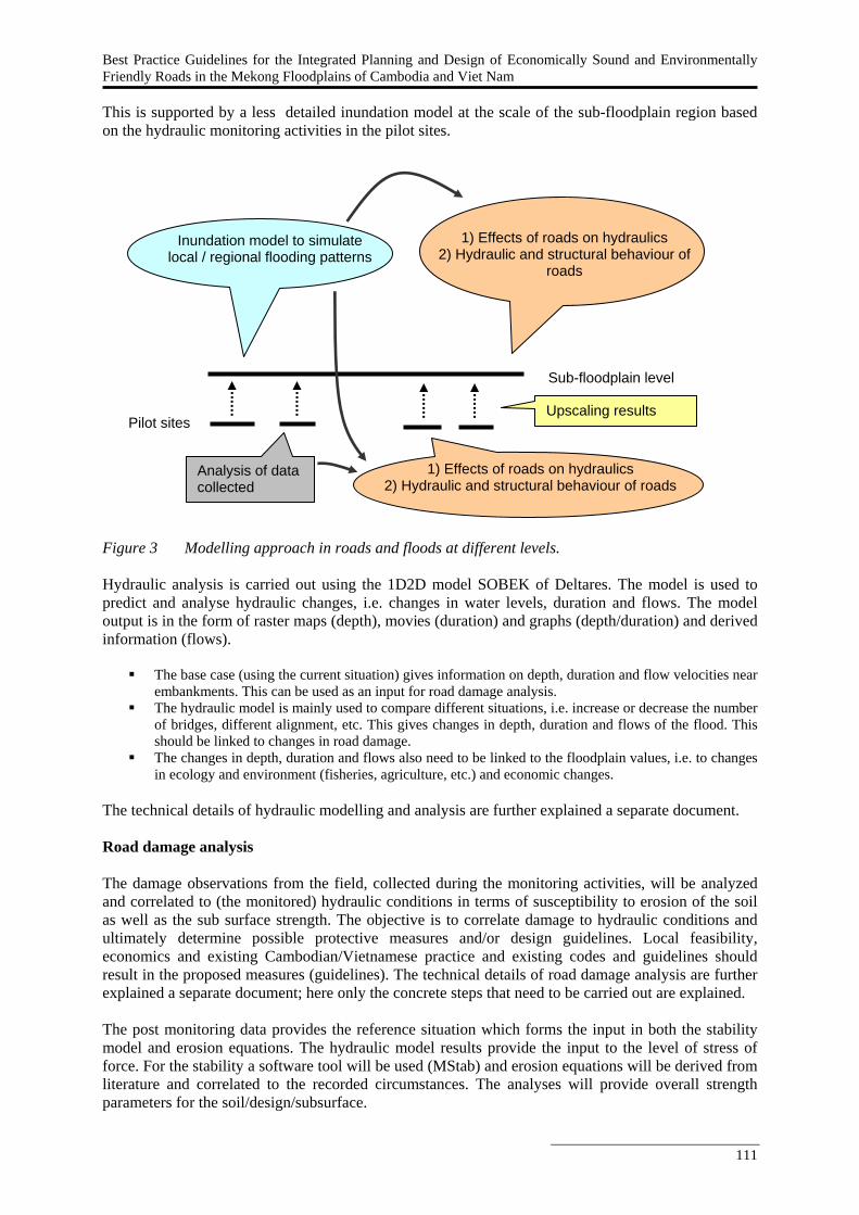
Best Practice Guidelines for the Integrated Planning and Design of Economically Sound and Environmentally Friendly Roads in the Mekong Floodplains of Cambodia and Viet Nam
111
This is supported by a less detailed inundation model at the scale of the sub-floodplain region based on the hydraulic monitoring activities in the pilot sites.
Figure 3 Modelling approach in roads and floods at different levels. Hydraulic analysis is carried out using the 1D2D model SOBEK of Deltares. The model is used to predict and analyse hydraulic changes, i.e. changes in water levels, duration and flows. The model output is in the form of raster maps (depth), movies (duration) and graphs (depth/duration) and derived information (flows).
The base case (using the current situation) gives information on depth, duration and flow velocities near embankments. This can be used as an input for road damage analysis.
The hydraulic model is mainly used to compare different situations, i.e. increase or decrease the number of bridges, different alignment, etc. This gives changes in depth, duration and flows of the flood. This should be linked to changes in road damage.
The changes in depth, duration and flows also need to be linked to the floodplain values, i.e. to changes in ecology and environment (fisheries, agriculture, etc.) and economic changes.
The technical details of hydraulic modelling and analysis are further explained a separate document. Road damage analysis The damage observations from the field, collected during the monitoring activities, will be analyzed and correlated to (the monitored) hydraulic conditions in terms of susceptibility to erosion of the soil as well as the sub surface strength. The objective is to correlate damage to hydraulic conditions and ultimately determine possible protective measures and/or design guidelines. Local feasibility, economics and existing Cambodian/Vietnamese practice and existing codes and guidelines should result in the proposed measures (guidelines). The technical details of road damage analysis are further explained a separate document; here only the concrete steps that need to be carried out are explained. The post monitoring data provides the reference situation which forms the input in both the stability model and erosion equations. The hydraulic model results provide the input to the level of stress of force. For the stability a software tool will be used (MStab) and erosion equations will be derived from literature and correlated to the recorded circumstances. The analyses will provide overall strength parameters for the soil/design/subsurface.
Inundation model to simulate local / regional flooding patterns
1) Effects of roads on hydraulics 2) Hydraulic and structural behaviour of
roads
Sub-floodplain level
Pilot sites Upscaling results
Analysis of data collected 1) Effects of roads on hydraulics
2) Hydraulic and structural behaviour of roads
112
The aim is to translate the results to damage functions per road class and provide discriminating recommendations and guidelines with respect to flood proofing roads. The road damage analysis consists of the following steps:
Select a number of damage locations from the post-flood survey (preferably as close as possible to the hydraulic monitoring locations for actual hydraulic input conditions).
Model/schematically represent the pre-flood situation from pre-flood survey results in stability software erosion equations.
Determine best guess/expert judgement and literature values for geotechnical parameters. Calculate and correlate the extend and nature of the damage features with stability software and erosion
equations. Determine possible mitigation measures for flood proofing, design rules or constructive measures. Recommendations for improvement of the current design situation.
N.B.
The road damage analysis focuses mostly on the ‘impacts of floods on roads’-part of study. The road damage analysis provides input for the financial analysis, in particular for the yearly
investment costs and annual maintenance costs. Road damage is one of the dimensions that is evaluated in the assessment of different options.
Floodplain value analysis A floodplain value analysis can be carried out in many different ways, using methodologies, techniques and tools developed by social and technical sciences. In the present study the floodplain value analysis will link the changes in hydraulic conditions to ecological functions and values.
Hydraulic modelling will provide information on changes in floodplain hydraulics as a result of a road project.
Ecological functions will be determined and valued on the basis of existing studies. Depending on the quality and types of data available, the values can be more specific (monetary, quantities) or less specific (for instance a ranking between 1 and 5).
Minimum and maximum hydraulic requirements will be identified on the basis of existing studies. The result is a model (or framework) that links changes in hydraulics as predicted by the hydraulic
model to changes to environmental functions and their values. This provides input to the evaluation of different options.
A GIS analysis could be applied to combine different values. Maps of different aspects of the floodplain, such as land use, population density, fish migration routes, flood depth and duration, can be combined to a map indicating areas with high and low values. Combining this information can indicate if the areas affected have a high or a low value. Socio-economic analysis A socio-economic analysis provides context information for the other analyses, by incorporating related factors and for the development of realistic options for balancing conflicting interests. The analysis attempts to explain how a decision affects the overall economy and the distributional effects among different socio-economic groups (in terms of industries, households, and others). In the context of the present framework, a limited socio-economic analysis is carried out, covering a descriptive analysis of the macro-economic environment and a description of the region where the road project is carried out. The social analysis will describe household characteristics, including sources of income. Financial analysis The financial analysis is primarily used in the evaluation of options to evaluate the costs of different alternatives. The analysis of the present situation is used to determine a base case for comparison with different alternatives. The financial analysis calculates the investment and maintenance costs of different options.
Best Practice Guidelines for the Integrated Planning and Design of Economically Sound and Environmentally Friendly Roads in the Mekong Floodplains of Cambodia and Viet Nam
113
In addition, the net present value and internal rates of return are computed as a measure to compare the different alternatives. The financial analysis looks at the financial feasibility of the different options for road development in the floodplains. Financial feasibility means it looks at the costs and revenues of the “owner” (in this case government) of the roads10 . The costs consist of:
• Initial investment costs: it is assumed that the investment costs are borne in year 0 (the year of construction of the road).
• The annual operation and maintenance costs, which start in year 1. • Damage costs due to high floods.: it is assumed that damage costs arise every 5 years, starting in year
5.11 There are no direct financial revenues from the roads. However, more resilient and resistant roads have in most cases less annual operation and maintenance costs, and sustain less damage during years with significant floods, hence these roads could be a cheaper alternative in the long run. As the life span of a road is very long, as long as regular maintenance and epairs are carried out, the cost of the different alternatives is calculated over a 100-year period.12 For each of the alternatives the Net Present Value (NPV) is computed using a discount rate of 12%. 12% is often used as the Opportunity Cost of Capital (OCC) by international financing agencies in developing countries. The OCC indicates the threshold performance for public investments13. In addition to the NPV, the Internal Rate of Return (IRR) is used in this analysis as an indicator of what the OCC should be for the alternative have the same NPV as the “zero option”. If the discount rate (hence OCC) is lower, cost savings in the future have a higher value. (Compare it with the following situation: to have $ 100 after one year at 12% interest you need to invest 100/1.12 = $89.30. If the interest is 2% you would need 100/1.02 = $98.04). Hence, the IRR is the OCC at which the alternative would be equally expensive than the “zero option”. A low discount rate could reflect “cheap” loans from donors for projects in the Mekong floodplain.
10 As opposed to economic feasibility which looks at the costs and revenues for society as a whole and includes costs and benefits of “non-marketable” goods and services such as pollution and road safety. 11 This is an approximation as damage could take place in any year. The financial analysis is sensitive to the occurrence of damage in time: the nearer to the present date, the higher the (negative) impact of damage. 12 The Net Present Value (NPV) of a dollar after 100 years is with most discount rates very small, hence does not add up much to the total NPV. 13 The OCC recognizes that budgets are limited and investments should be channeled to the most profitable investments.
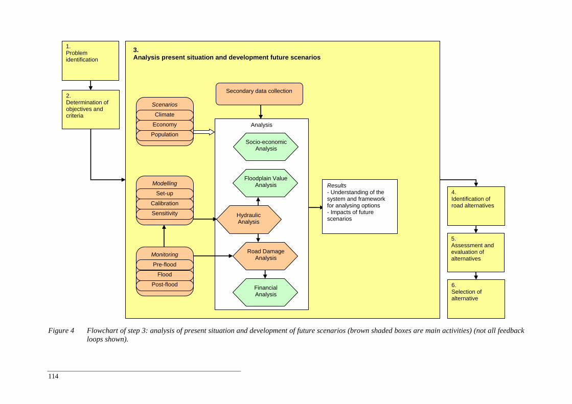
114
Figure 4 Flowchart of step 3: analysis of present situation and development of future scenarios (brown shaded boxes are main activities) (not all feedback
loops shown).
Analysis
Road Damage Analysis
Hydraulic Analysis
3. Analysis present situation and development future scenarios
2. Determination of objectives and criteria
5. Assessment and evaluation of alternatives
1. Problem identification
Financial Analysis
Floodplain Value Analysis
Socio-economic Analysis
6. Selection of alternative
4. Identification of road alternatives
Monitoring
Pre-flood
Flood
Post-flood
Modelling
Set-up
Calibration
Sensitivity
Scenarios
Climate
Economy
Population
Results - Understanding of the system and framework for analysing options - Impacts of future scenarios
Secondary data collection
Best Practice Guidelines for the Integrated Planning and Design of Economically Sound and Environmentally Friendly Roads in the Mekong Floodplains of Cambodia and Viet Nam
115
6. Identification of road alternatives (Step 4) This is a creative process in which the different design options are determined, based on the conditions and findings from the previous steps. This step is mostly a technical design process. In developing a road system in a floodplain there are a number of design options that can be varied, including:
1. The alignment of the road, and the orientation to the river (parallel or perpendicular); 2. The distance of the road to the main river channel; 3. The elevation of the road, related to the surface level of the floodplain and various water levels in the
floodplain and near the roads; 4. The presence, location and capacity of related structures through which water may flow into and over
the floodplain (incl. the permeability of the road); 5. The resistance to flooding of a road (inclusive the strength and stability of the road); the period that a
road may influence the progression of flooding of the floodplain. The options will be based on a critical review of the design and alignment of roads, permeability structures and spillways. Obviously, former adjustments of the design due to damages during historical floods and damages due to actual floods will be taken into account. This will be mainly a creative process based on experience and expertise. During this step, road planners and designers will identify design alternatives on the basis of, amongst others, the local context (ecologically important area) and policy objectives, which are both derived from earlier steps in the planning process. The technical guidelines (Chapter 6) give guidance on how to use the technical options to identify alternatives (that can combine design options) that match the set objectives (Figure 5 below). The design of options is bounded by the objectives and criteria and the present situation. The rehabilitation of an existing road has for instance less possible technical options than the design of a new road. Financial possibilities also limit the design of options; low-cost options are preferred in the context of developing countries. It should be noted, however, that the creative process of identification different options should not be restricted completely by the objectives and criteria, as the evaluation takes place in the next step. The aim is, however, to develop realistic options.
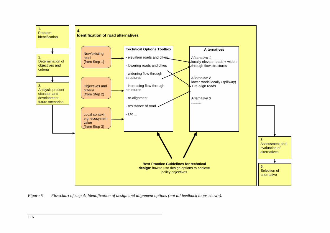
116
Figure 5 Flowchart of step 4: Identification of design and alignment options (not all feedback loops shown).
4. Identification of road alternatives
2. Determination of objectives and criteria
5. Assessment and evaluation of alternatives
1. Problem identification
6. Selection of alternative
3. Analysis present situation and development future scenarios
Technical Options Toolbox
- elevation roads and dikes - lowering roads and dikes - widening flow-through structures - increasing flow-through structures - re-alignment - resistance of road - Etc ...
New/existing road (from Step 1)
Objectives and criteria (from Step 2)
Local context, e.g. ecosystem value (from Step 3)
Alternatives
Alternative 1 locally elevate roads + widen through flow structures Alternative 2 lower roads locally (spillway) + re-align roads Alternative 3 ..........
Best Practice Guidelines for technicaldesign: how to use design options to achieve
policy objectives
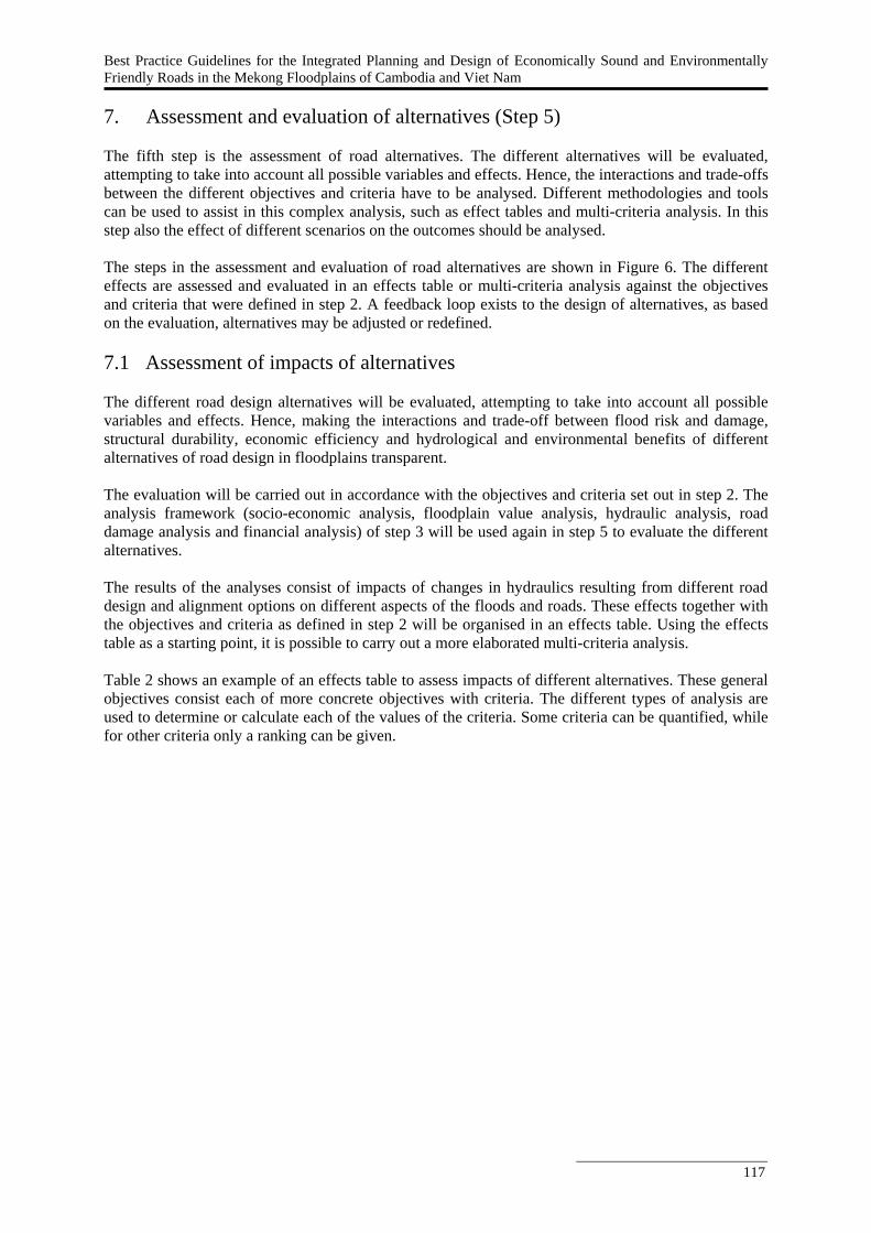
Best Practice Guidelines for the Integrated Planning and Design of Economically Sound and Environmentally Friendly Roads in the Mekong Floodplains of Cambodia and Viet Nam
117
7. Assessment and evaluation of alternatives (Step 5) The fifth step is the assessment of road alternatives. The different alternatives will be evaluated, attempting to take into account all possible variables and effects. Hence, the interactions and trade-offs between the different objectives and criteria have to be analysed. Different methodologies and tools can be used to assist in this complex analysis, such as effect tables and multi-criteria analysis. In this step also the effect of different scenarios on the outcomes should be analysed. The steps in the assessment and evaluation of road alternatives are shown in Figure 6. The different effects are assessed and evaluated in an effects table or multi-criteria analysis against the objectives and criteria that were defined in step 2. A feedback loop exists to the design of alternatives, as based on the evaluation, alternatives may be adjusted or redefined. 7.1 Assessment of impacts of alternatives The different road design alternatives will be evaluated, attempting to take into account all possible variables and effects. Hence, making the interactions and trade-off between flood risk and damage, structural durability, economic efficiency and hydrological and environmental benefits of different alternatives of road design in floodplains transparent. The evaluation will be carried out in accordance with the objectives and criteria set out in step 2. The analysis framework (socio-economic analysis, floodplain value analysis, hydraulic analysis, road damage analysis and financial analysis) of step 3 will be used again in step 5 to evaluate the different alternatives. The results of the analyses consist of impacts of changes in hydraulics resulting from different road design and alignment options on different aspects of the floods and roads. These effects together with the objectives and criteria as defined in step 2 will be organised in an effects table. Using the effects table as a starting point, it is possible to carry out a more elaborated multi-criteria analysis. Table 2 shows an example of an effects table to assess impacts of different alternatives. These general objectives consist each of more concrete objectives with criteria. The different types of analysis are used to determine or calculate each of the values of the criteria. Some criteria can be quantified, while for other criteria only a ranking can be given.
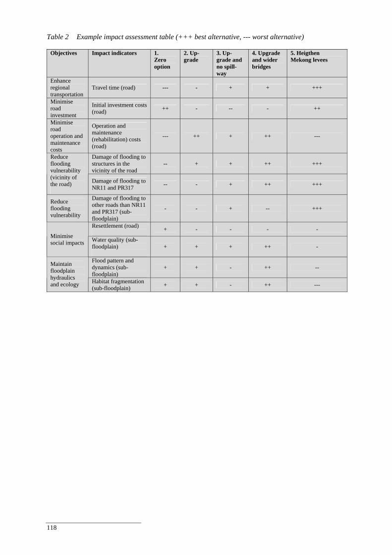
118
Table 2 Example impact assessment table (+++ best alternative, --- worst alternative)
Objectives Impact indicators 1. Zero option
2. Up-grade
3. Up-grade and no spill-way
4. Upgrade and wider bridges
5. Heigthen Mekong levees
Enhance regional transportation
Travel time (road) --- - + + +++
Minimise road investment
Initial investment costs (road) ++ - -- - ++
Minimise road operation and maintenance costs
Operation and maintenance (rehabilitation) costs (road)
--- ++ + ++ ---
Damage of flooding to structures in the vicinity of the road
-- + + ++ +++ Reduce flooding vulnerability (vicinity of the road)
Damage of flooding to NR11 and PR317 -- - + ++ +++
Reduce flooding vulnerability
Damage of flooding to other roads than NR11 and PR317 (sub-floodplain)
- - + -- +++
Resettlement (road) + - - - -
Minimise social impacts Water quality (sub-
floodplain)
+ + + ++ -
Flood pattern and dynamics (sub-floodplain)
+ + - ++ -- Maintain floodplain hydraulics and ecology Habitat fragmentation
(sub-floodplain) + + - ++ ---
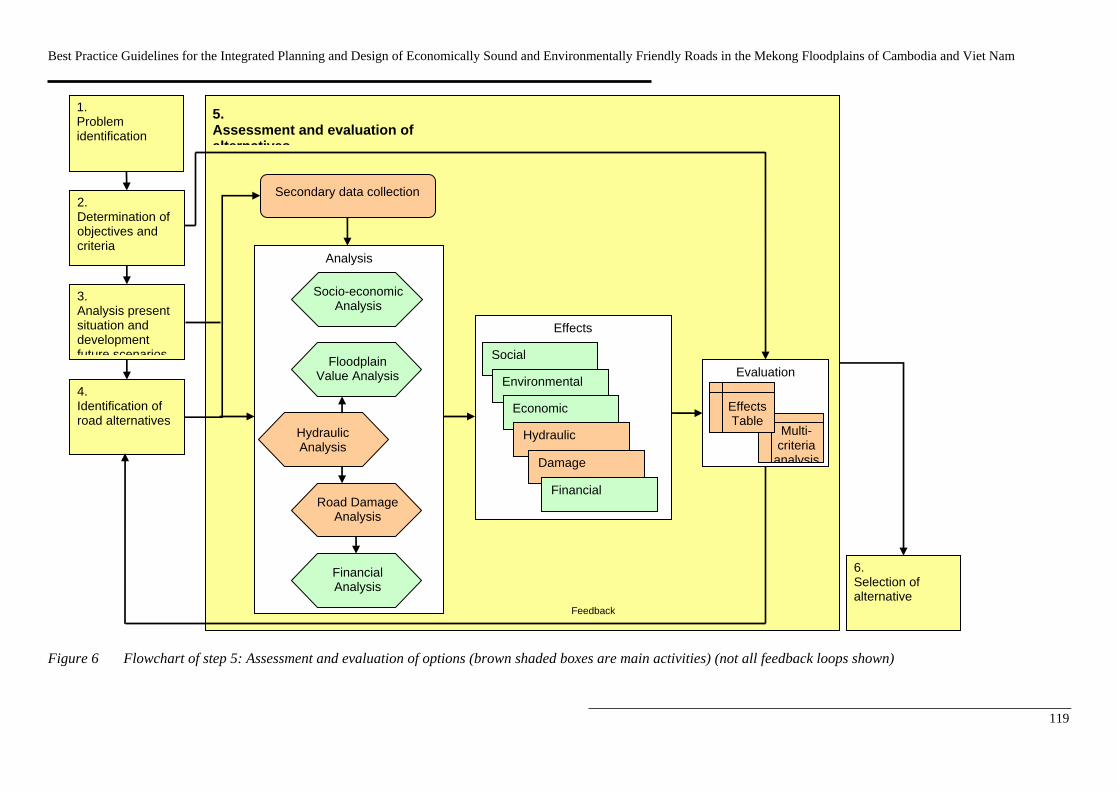
Best Practice Guidelines for the Integrated Planning and Design of Economically Sound and Environmentally Friendly Roads in the Mekong Floodplains of Cambodia and Viet Nam
119
Figure 6 Flowchart of step 5: Assessment and evaluation of options (brown shaded boxes are main activities) (not all feedback loops shown)
Analysis
Road Damage Analysis
Hydraulic Analysis
5. Assessment and evaluation of alternatives
4. Identification of road alternatives
2. Determination of objectives and criteria
3. Analysis present situation and development future scenarios
1. Problem identification
Financial Analysis
Floodplain Value Analysis
Socio-economic Analysis
Effects
Social
Environmental
Economic
Hydraulic
Damage
Evaluation
Feedback
Multi-criteria
analysis
Effects Table
6. Selection of alternative
Financial
Secondary data collection
120
The assessment of the scores of the effect table can be done in various ways, e.g. quantitative, qualitative, dependant on the knowledge of the impacts. Table 3 presents how assessments of all indicators for the case studies of the Roads and Floods project are made (not complete). Table 3 List of impact indicators and description of the computation process.
Objectives Impact indicators How is the indicator calculated
Enhance regional transportation Travel time (road) Expert judgement (+++ best; --- worst)
Minimise road investment Initial investment costs (road) Assessment based on limited local data (+++ best; --- worst)
Minimise road operation and maintenance costs
Operation and maintenance (rehabilitation) costs (road)
Assessment based on limited local data (+++ best; --- worst)
Damage of flooding to structures in the vicinity of the road
Expert judgement based on hydraulic model results (+++ best; --- worst) Reduce flooding vulnerability
(vicinity of the road) Damage of flooding to the road
Assessment based on output hydraulic modelling (flood level, duration and velocity) and geotechnical calculations/models (+++ best; --- worst)
Reduce flooding vulnerability Damage of flooding to other roads (sub-floodplain)
Expert judgement based on hydraulic model results (+++ best; --- worst)
Resettlement (road) Expert judgement (+++ best; --- worst) Minimise social impacts Water quality (sub-floodplain) Expert judgement (+++ best; --- worst) Flood pattern and dynamics (sub-floodplain)
Based on hydraulic model results (+++ best; --- worst) Maintain floodplain
hydraulics and ecology Habitat fragmentation (sub-floodplain) Expert judgement based on hydraulic model results (+++ best; --- worst)
7.2 Evaluation of alternatives A technique that is often used for complex problems involving many objectives is multi-criteria analysis (MCA). MCA is a structured approach to find the most preferred option among a set of options when multiple criteria or goals are aimed. MCA includes several techniques; usually weighted score matrices are applied which can be used to evaluate qualitative and quantitative criteria. The effects table above is actually the first step in a MCA. After an effects table has been developed, the different scores on the criteria of the options should be evaluated. This is done by standardising them to make the scores comparable. In addition, the weight of the different scores should be determined. Different techniques exists to standardise and weigh the scores, which can result in different outcomes. The method of standardising and weighing of scores is often determined by the stakeholders or by some predetermined procedure (for instance in environmental impact assessments). Finally, MCA usually includes techniques to analyse the outcome and carry out sensitivity analysis. Table 4 gives example policy objectives and their importance (weights). The table comes from a simple Multi Criteria Analysis (MCA) tool. The table illustrates that a different perspective on road development (e.g. transport, flood protection, ecology) will lead to a different ranking of alternatives as each perspective prioritizes objectives differently. The weights in Table 4 are exaggerated to make differences between the perspectives more explicit; in reality objectives and their relative importance are set by decision-makers during the planning process. Apart from the transport, ecology and flood protection perspectives a fourth perspective is added called ‘sustainable development’ that aims to minimise long-term ‘costs’ in terms of investment, road maintenance and flood damage repair costs, social costs and ecological costs.
Best Practice Guidelines for the Integrated Planning and Design of Economically Sound and Environmentally Friendly Roads in the Mekong Floodplains of Cambodia and Viet Nam
121
Table 4 Example of weights by objective for various perspectives on road development and rehabilitation (5 highest importance; 1 lowest importance).
Example perspectives (total = 20) Objectives of road development and
rehabilitation Transport Flood protection
Ecology Sustainability
Enhance regional transportation 5 4 2 1 Minimise road investment 5 2 2 3 Minimise road operation and maintenance costs 4 2 2 3 Reduce flooding vulnerability (vicinity of the road) 2 5 2 3 Reduce flooding vulnerability (sub-floodplain) 2 5 2 3 Minimise social impacts 1 1 5 3 Maintain floodplain hydraulics and ecology (sub-floodplain) 1 1 5 4
Total 20 20 20 20 The weights in Table 4 relate to the criteria presented in Table 1. E.g. In case the objective ‘Enhance regional transportation’ is very important (so a 5), no flooding of the road will be accepted. In case the importance is lower some temporary flooding of the road will be accepted, like in the case of a rural road. Based on the perspectives as presented in the table above, a ranking of alternatives is calculated by combining the weights and scores of the impact table. In the case study presentation this is just used to illustrate the impact weights can have on ranking of alternatives. Table 5 Ranking alternatives based on impact table (Table 5.5) and perspectives (Table 5.6) (1
highest ranking; 5 lowest ranking).
Perspectives Alternative Transport Flood
protection Ecology Sustainability
1. Zero option 5 5 4 5 2. Upgrade 3 4 2 2 3. Upgrade and no spillway 4 3 3 4 4. Upgrade and wider bridges 2 2 1 1 5. Heigthening Mekong levees 1 1 5 3
8. Further reading Readers interested in further details on the synthesis report are referred to the above-mentioned source reports. Those interested in receiving the reports please consult either the Regional FMM Centre (Phnom Penh) or UNESCO-IHE (Delft, The Netherlands).
Inundation modelling report (Verheij, in preparation). Road damage analysis report (Van der Ruyt and Verheij, in preparation). Pre-flood, flood and post-flood monitoring plan and 2006 and 2007 survey reports (Verheij et al.,
2006). Review technical design guidelines and suggestions for improvements (Verheij and Van der Ruyt, in
preparation). UNESCO-IHE MSc theses (Phan Thi Thu Ha (2007), Beinamaryo (2007), Patarroyo (2007),
Pratheepan (2007), Namgyal (2007), Dhakal (2007)). Wageningen University MSc theses (Do Nguyen Anh Tu, 2008).
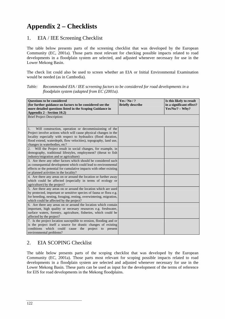
122
Appendix 2 – Checklists 1. EIA / IEE Screening Checklist The table below presents parts of the screening checklist that was developed by the European Community (EC, 2001a). Those parts most relevant for checking possible impacts related to road developments in a floodplain system are selected, and adjusted whenever necessary for use in the Lower Mekong Basin. The check list could also be used to screen whether an EIA or Initial Environmental Examination would be needed (as in Cambodia). Table: Recommended EIA / IEE screening factors to be considered for road developments in a
floodplain system (adapted from EC (2001a). Questions to be considered (for further guidance on factors to be considered see the more detailed questions listed in the Scoping Guidance in Appendix 2 - Section 10.2)
Yes / No / ? Briefly describe
Is this likely to result in a significant effect? Yes/No/? – Why?
Brief Project Description: 1. Will construction, operation or decommissioning of the Project involve actions which will cause physical changes in the locality especially with respect to hydraulics (flood duration, flood extend, waterdepth, flow velocities), topography, land use, changes in waterbodies, etc?
2. Will the Project result in social changes, for example, in demography, traditional lifestyles, employment? (threat to fish industry/migration and or agriculture)
3. Are there any other factors which should be considered such as consequential development which could lead to environmental effects or the potential for cumulative impacts with other existing or planned activities in the locality?
4. Are there any areas on or around the location or further away which could be affected (especially in terms of ecology or agriculture) by the project?
5. Are there any areas on or around the location which are used by protected, important or sensitive species of fauna or flora e.g. for breeding, nesting, foraging, resting, overwintering, migration, which could be affected by the project?
6. Are there any areas on or around the location which contain important, high quality or necesary resources e.g. freshwater, surface waters, forestry, agriculture, fisheries, which could be affected by the project?
7. Is the project location susceptible to erosion, flooding and or is the project itself a source for drastic changes of existing conditions which could cause the project to present environmental problems?
2. EIA SCOPING Checklist The table below presents parts of the scoping checklist that was developed by the European Community (EC, 2001a). Those parts most relevant for scoping possible impacts related to road developments in a floodplain system are selected and adjusted whenever necessary for use in the Lower Mekong Basin. These parts can be used as input for the development of the terms of reference for EIS for road developments in the Mekong floodplains.
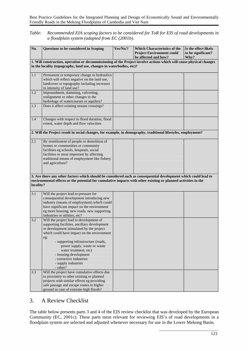
Best Practice Guidelines for the Integrated Planning and Design of Economically Sound and Environmentally Friendly Roads in the Mekong Floodplains of Cambodia and Viet Nam
123
Table: Recommended EIA scoping factors to be considered for ToR for EIS of road developments in a floodplain system (adapted from EC (2001b).
No. Questions to be considered in Scoping Yes/No/? Which Characteristics of the
Project Environment could be affected and how?
Is the effect likely to be significant? Why?
1. Will construction, operation or decommissioning of the Project involve actions which will cause physical changes in the locality (topography, land use, changes in waterbodies, etc)? 1.1 Permanent or temporary change in hydraulics
which will reflect negative on the land use, landcover or topography including increases in intensity of land use?
1.2 Impoundment, damming, culverting, realignment or other changes to the hydrology of watercourses or aquifers?
1.3 Does it affect existing stream crossings?
1.4 Changes with respect to flood duration, flood extent, water depth and flow velocities
2. Will the Project result in social changes, for example, in demography, traditional lifestyles, employment? 2.1 By resettlement of people or demolition of
homes or communities or community facilities eg schools, hospitals, social facilities or most important by affecting traditional means of employment like fishery and agriculture?
3. Are there any other factors which should be considered such as consequential development which could lead to environmental effects or the potential for cumulative impacts with other existing or planned activities in the locality? 3.1 Will the project lead to pressure for
consequential development introducing new industry (means of employment) which could have significant impact on the environment eg more housing, new roads, new supporting industries or utilities, etc?
3.2 Will the project lead to development of supporting facilities, ancillary development or development stimulated by the project which could have impact on the environment eg:
- supporting infrastructure (roads, power supply, waste or waste water treatment, etc)
- housing development - extractive industries - supply industries - other?
3.3 Will the project have cumulative effects due to proximity to other existing or planned projects with similar effects eg providing safe passage and escape routes to higher ground in case of extreme high floods?
3. A Review Checklist The table below presents parts 3 and 4 of the EIS review checklist that was developed by the European Community (EC, 2001c). These parts most relevant for reviewing EIS’s of road developments in a floodplain system are selected and adjusted whenever necessary for use in the Lower Mekong Basin.
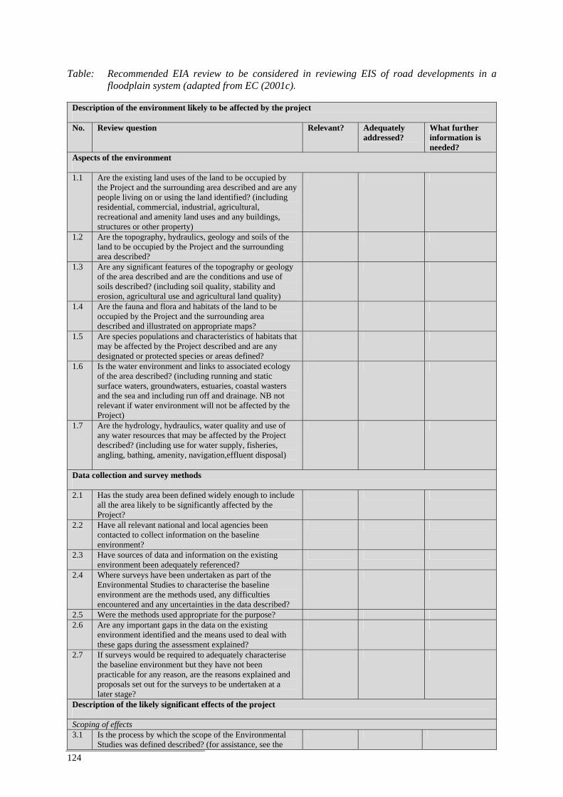
124
Table: Recommended EIA review to be considered in reviewing EIS of road developments in a
floodplain system (adapted from EC (2001c).
Description of the environment likely to be affected by the project No. Review question Relevant? Adequately
addressed? What further information is needed?
Aspects of the environment 1.1 Are the existing land uses of the land to be occupied by
the Project and the surrounding area described and are any people living on or using the land identified? (including residential, commercial, industrial, agricultural, recreational and amenity land uses and any buildings, structures or other property)
1.2 Are the topography, hydraulics, geology and soils of the land to be occupied by the Project and the surrounding area described?
1.3 Are any significant features of the topography or geology of the area described and are the conditions and use of soils described? (including soil quality, stability and erosion, agricultural use and agricultural land quality)
1.4 Are the fauna and flora and habitats of the land to be occupied by the Project and the surrounding area described and illustrated on appropriate maps?
1.5 Are species populations and characteristics of habitats that may be affected by the Project described and are any designated or protected species or areas defined?
1.6 Is the water environment and links to associated ecology of the area described? (including running and static surface waters, groundwaters, estuaries, coastal wasters and the sea and including run off and drainage. NB not relevant if water environment will not be affected by the Project)
1.7 Are the hydrology, hydraulics, water quality and use of any water resources that may be affected by the Project described? (including use for water supply, fisheries, angling, bathing, amenity, navigation,effluent disposal)
Data collection and survey methods 2.1 Has the study area been defined widely enough to include
all the area likely to be significantly affected by the Project?
2.2 Have all relevant national and local agencies been contacted to collect information on the baseline environment?
2.3 Have sources of data and information on the existing environment been adequately referenced?
2.4 Where surveys have been undertaken as part of the Environmental Studies to characterise the baseline environment are the methods used, any difficulties encountered and any uncertainties in the data described?
2.5 Were the methods used appropriate for the purpose? 2.6 Are any important gaps in the data on the existing
environment identified and the means used to deal with these gaps during the assessment explained?
2.7 If surveys would be required to adequately characterise the baseline environment but they have not been practicable for any reason, are the reasons explained and proposals set out for the surveys to be undertaken at a later stage?
Description of the likely significant effects of the project Scoping of effects 3.1 Is the process by which the scope of the Environmental
Studies was defined described? (for assistance, see the
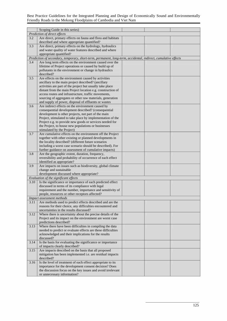
Best Practice Guidelines for the Integrated Planning and Design of Economically Sound and Environmentally Friendly Roads in the Mekong Floodplains of Cambodia and Viet Nam
125
Scoping Guide in this series) Prediction of direct effects 3.2 Are direct, primary effects on fauna and flora and habitats
described and where appropriate quantified?
3.3 Are direct, primary effects on the hydrology, hydraulics and water quality of water features described and where appropriate quantified?
Prediction of secondary, temporary, short-term, permanent, long-term, accidental, indirect, cumulative effects 3.4 Are long term effects on the environment caused over the
lifetime of Project operations or caused by build up of pollutants in the environment or change in hydraulics described?
3.5 Are effects on the environment caused by activities ancillary to the main project described? (ancillary activities are part of the project but usually take place distant from the main Project location e.g. construction of access routes and infrastructure, traffic movements, sourcing of aggregates or other raw materials, generation and supply of power, disposal of effluents or wastes
3.6 Are indirect effects on the environment caused by consequential development described? (consequential development is other projects, not part of the main Project, stimulated to take place by implementation of the Project e.g. to provide new goods or services needed for the Project, to house new populations or businesses stimulated by the Project)
3.7 Are cumulative effects on the environment off the Project together with other existing or planned developments in the locality described? (different future scenarios including a worst case scenario should be described). For further guidance on assessment of cumulative impacts)
3.8 Are the geographic extent, duration, frequency, reversibility and probability of occurrence of each effect identified as appropriate?
3.9 Are impacts on issues such as biodiversity, global climate change and sustainable development discussed where appropriate?
Evaluation of the significant effects 3.10 Is the significance or importance of each predicted effect
discussed in terms of its compliance with legal requirement and the number, importance and sensitivity of people, resources or other receptors affected?
Impact assessment methods 3.11 Are methods used to predict effects described and are the
reasons for their choice, any difficulties encountered and uncertainties in the results discussed?
3.12 Where there is uncertainty about the precise details of the Project and its impact on the environment are worst case predictions described?
3.13 Where there have been difficulties in compiling the data needed to predict or evaluate effects are these difficulties acknowledged and their implications for the results discussed?
3.14 Is the basis for evaluating the significance or importance of impacts clearly described?
3.15 Are impacts described on the basis that all proposed mitigation has been implemented i.e. are residual impacts described?
3.16 Is the level of treatment of each effect appropriate to its importance for the development consent decision? Does the discussion focus on the key issues and avoid irrelevant or unnecessary information?

ISSN: 1683-1489
Roads and Floods
Roads and Floods: Synthesis Report 2011M
RC Technical Paper No. 35
Best Practice Guidelines for the Integrated Planning and Design of Economically Sound and Environmentally Friendly Roads in the Mekong Floodplains of Cambodia and Viet Nam
Mekong River CommissionC a m b o d i a . L a o P D R . T h a i l a n d . V i e t N a m
For sustainable development
Mekong River Commissionwww.mrcmekong.org
Office of the Secretariat in Phnom Penh (OSP)576 National Road, #2, Chak Angre Krom,
P.O. Box 623, Phnom Penh, CambodiaTel: (855-23) 425 353Fax: (855-23) 425 363
Office of the Secretariat in Vientiane (OSV)Office of the Chief Executive Officer
184 Fa Ngoum Road, P.O. Box 6101, Vientiane, Lao PDR
Tel: (856-21) 263 263Fax: (856-21) 263 264
MRC Technical PaperNo. 35October 2011