rjw odyssey the 1980s
TRANSCRIPT

Dr R.J. (Bob) Williams [Retired]Cartographer
Topographic SurveyorGeographer
Geospatial Scientist
QUALIFICATIONS – ProfessionalBA Computing Studies (Canberra CAE)MSc (Cartography) (U Wisconsin)PhD (UNSW)
QUALIFICATIONS – TradeTopographic SurveyorPhotogrammetristCartographic Technician
Videre Parare Est
An Odysseyby
DR BOB’S VISION AND ODYSSEYTowards
A Virtual World and an Intelligent [Artificial] Cartographer
The 1980s … …
A Decade of Innovation … …… … with Experience and Vision … …
2008 photo

2
So, in 1980 I wrote the first draft of a paper titled Who or what is DES?”. The abstract to the paper reads “an emergency situation, whether it be military in nature or a natural disaster, often tests the speed of response of sub-units of an organisation. Planning, staffing, coordinating, directing and controlling decisions are required in a limited time frame”.
The paper examined the feasibility of developing a computer-based system that I called DES (Defence Enquiry System).
VISIONARY IDEAS – DES Types of queries, include:
Show the location of 4 Fd Regt, RAA. List all airfields capable of taking C130 aircraft and located in 1MD. What is the status (trafficability) of the Bruce Highway between Tully and Cairns today?
Applications include:
Route charting and assessment (land, maritime and air) Terrain analysis and site selection Shortest path algorithms Imagery, e.g. Orthophotomaps replaced by digital images Object recognition
It might be feasible that digital terrestrial cameras of the future could be used to identify features.
In December 1976 I was given the opportunity to undertake Long Term Schooling at the Canberra College of Advanced Education (CCAE) by the Director of Survey of Survey-Army (COL Jim Stedman). I was asked, on completion of my course, to write a discussion paper on where I thought the Royal Australian Survey Corps should be heading by DSVY-A(COL John Hillier).
This paper was to provide a vision for the future.
Photo taken in December 1979 of [then] SSGT Bob WilliamsMilitary symbols produced using TEKTRONIX PLOT10 software
Following 1970’s decade and hearing and talking to its Visionaries came a decade of opportunity - A decade of innovation!
This directive, supplemented by exposure to 1970’s visionaries, provided my guidance for the next quarter of a century PLUS !
Towards a Virtual World and an Intelligent [Artificial] Cartographer
CCAERASVY

3
Visionary presenters & presentations
Academic theses, awards, etc
Studies & reviews & scientific reports
Journal publications
Conference & seminar Presentations
Concept papers & initiatives
1980 1985 1990
American futurist Ben Bova [1989] "I don't think of what I do as science fiction, I think of it as historical reports of events that haven't happened yet”
Automated cartography: the next development
Evolution in cartography: data intelligence
Analysis of the road transportation network
Geographic information:aspects of phenomenology and cognition
Analysis of Geographic Information: A cognitive approach
Enquiry systems for the interrogation of infrastructure in areas of large geographic extent
Who or what is DES?[Disaster Enquiry System]
An overview of a cartographic mapping package
ASTIS: An Information Structuring Approach
Enquiry systems for the interrogation of infrastructure
Automated cartography with navigational applications
Who or what is DES?
1980’s Timeline
YAMPIMISTI
ANU GIS ADFA GISWIMS

4
Who or what is DES?[Defence Enquiry System]
1980
Typical object recognition enquiries might take the form:• What is the feature 5KM north-west of the junction of road A and road B?• Give details of this building (pointed to on a screen).• What is this feature (pointed to on a screen)?
Examples of these types of queries may take the form:• Show a base map bounded by 20OS, 25OS, 130OE and 132OEand highlight the bores.• Locate and list details of the nearest airfield tothe town of Kyogle, NSW• Plot all roads between Dubbo NSW and Bourke NSW to adistance of 100KM from the centre line
A DEFENCE ENQUIRY SYSTEM (DES)LT R.J.Williams
1980
The world is moving so fast these days that the man who says it can’t be done is generally interrupted by someone doing it!
Elbert HubbardCirca 1890
In December 1976 I was given the opportunity to undertake Long Term Schooling at the Canberra College of Advanced Education (CCAE) by the Director of Survey-Army (Colonel Jim Stedman).
I was asked, on completion of my course, to write a discussion paper on where I thought that the Corps should be heading by DSVY-A (Colonel John Hillier).
This paper is a re-typed copy of the original paper with scanned copies of the original illustrations.Photo taken in December 1979 of (then) SSGT Bob
Williams.Military symbols produced using Tektronix PLOT 10 software.

5
An overview of acartographic
mapping packageR.J.Williams
Bachelor of Artsin Computing Studies
(CCAE)AMAIC
CARTOGRAPHYVolume 11 No.3 March 1980
1980
An overview of a cartographic mapping package
This is an overview of a cartographic mapping package developed at the Canberra College of Advanced Education. The package demonstrates educational and navigational applications and was produced for the semester unit Special Studies in Computing in the course for the award of Bachelor of Arts in Computing Studies.
Vision – CARTOGRAPHIC INFORMATION SYSTEM
MAPPACK Communications – Appendix 1 RUN MAPPACK; MAXPROCTIME = 30; MAXIOTIME = 20 #Collect any printout from Print 6 #Running #? *Mappack* Cartographic Mapping Package Types of maps available include …. Atlas Strip map Pre-history mapping Distance to coastline Which would you prefer? ATLAS Enter region - If World type WORLD - - Strip map of type A TO B
DARWIN Enter projection number 0 … Orthographic 1 … Stereographic 2 … Gnomonic 3 … Postel (Azimuthal Equidistant) 4 … Perspective 5 … Mercator 6 … Lambert (Cylindrical Equal Area) 7 … Bonne 8 … Sanson-Flamsteed 9 … Mollweide 3
You may nominate your scale options:You may nominate your … Own scale Computer printout size … A4 size Maximum available size Which would you like? A4 Map scale is 20,000,000 Is oblique aspect required? YES Place centred on? DARWIN Postel Equidistant Projection Enter radial distance in 1000KM (max 20) 5 Map scale is now 1:75,000,000 Are distance range rings required? YES The following options are available Enter YES if required … Geographic data … YES Geographic graticule … YES Nomenclature … NO Legend … YES ***MAPPACK running**

6
YAMPI – A digital mapping experience!
1980 3665-III STRICKLAND [1:50000] was the first map published using the AUTOMAP I system in 1978. Compilation was by digital photogrammetric methods 1976.
YAMPI JOG [1:250000]
The first, and only ever, !;250,000 map - SE51-3 YAMPI - was produced from source digital data of the 1:50,000 maps compiled by stereo-photogrammetric techniques during June – August 1980.
MAP GENERATION
The YAMPI: A Digital Mapping Experience, described the area; discussed the map production describing the available source data, detailing production time limitations and method of production; analyzed various aspects observed during the production including the integrity of the data bank, cost of data manipulation processes, the effect of management and operational procedures and the quality of the graphic; and, finally examined some future applications and recommendations.
Future applications include: Command, control &
communication systems Infrastructure directories Radar simulation

7
Automated cartography with navigational applications
1980
Vision – CARTOGRAPHIC INFORMATION SYSTEM
Projections, transformations, spherical trigonometry
Natural language interactive communicationQuery languages
Recursive & heuristic algorithms
AutomatedCartography
withNavigationalApplications
R.J.Williams MAIC

8
MISTI – A Management Information System for Topographic Intelligence!
1982
I rewrote my mapping software in FORTRAN77 for use on a PDP11/70 computer. I called my software MISTI (Management Information for Topographic Intelligence) and, as I was IC RAAF Charting Troop, focused on trying to automate EN ROUTE Chart base map production.
My vision was that it would be possible to automatically generate en route charts along with relational database access to information contained in RAAF EN ROUTE SUPPLEMENTS and that the route should be along a great circle.

9
WIMS – World (or Williams) Interactive Mapping System
1983
I again rewrote my mapping software in FORTRAN77 this time for use by the Joint Intelligence Organisation (JIO) for use on a HP2100 series computer.
I called my software WIMS (World Interactive Mapping Software).
Vision – World (or Williams) Interactive Mapping System that could automatically extract information from a world data base determined by place names and search criteria.
Applications would include producing background maps in normal, radial and oblique rectangle formats anywhere in the world.

10
1982 - 85
1982 - Digital Topographic Database – A structured and formatted collection of sets of random accessed files organised into evaluated Military, Geographic and Intelligence Data (MGID) available to meet the needs and requirements of the user – command and control systems, route classification, cross-country going, engineer intelligence data, resources data, meteorological data. - US Exchange Officer Major David Bowen, USA
1984 - Future Applications of a Topographic Database - Permit the Transportation Officer to point to a bridge and have the system return the width, allowable load and
structural components of the bridge. Permit the Medical Officer to point to all hospitals in an area and have the number of beds currently available. Permit the Commander to point to a geographical area and have the system return enemy unit designations,
locations, strength and equipment status, and have the system designed to permit data base update so that the information returned is current and accurate.
Expectations are high that digital terrain models have a significant role to play in a number of diverse areas of interest to the Defence Force. Areas of immediate impact are command, control and communications; artillery and other weapons systems; training, simulation and war gaming; terrain analysis; manned and unmanned navigation systems; and map production. - US Exchange Officer Major John Charland, USA
1985 - Future Applications of a Topographic Database - Perhaps the most significant military breakthrough related to computer technology of the future will be the rendering of integrated circuitry to enemy sabotage. This, combined with high speed, secure data communications to the field, will permit the transfer of vital information about the terrain and its effects in real time to the ground commander currently operating on that terrain. Intervisibility and mobility computations and realistic computer-generated views will be components of this information.A more profound area of application is expected in the field of airborne navigation systems. It will include both military and civilian aircraft, particularly low-flying manned and unmanned weapons systems. In all these cases, DTMs will afford real time information about the terrain below and the effects of distant terrain on the aircraft whether it is using terrain matching for navigation or making use of natural cover to avoid enemy detection - US Exchange Officer Major Doug Campbell, USA
RASVY
Royal Australian Survey Corps – Army Survey Regiment - Technical Development Cell
FORTUNA VILLA, BENDIGO

11
Who or what isDES?
Robert Williams MAICRoyal Australian Survey Corps
CARTOGRAPHYVolume 13 No.3 March 1984
1984
An overview of a cartographic mapping package
An emergency situation, whether it be created by man or be it a natural disaster, often tests the speed of response of sub-units of an organisation. Planning, staffing, coordinating, directing and controlling decisions are required in a limited time frame.
This paper questions the feasibility of a computer-based Disaster Enquiry System.
Typical queries might take the form: Show the location of major fire-fighting units; List all radio stations in South Australia; Detail the characteristics of all airfields in Tasmania; List all airfields capable of taking cargo aircraft and
located in Queensland; Show details of all bridges along the Stuart Highway
between Pine Creek and Katherine; What is the weather forecast for the Kimberley Region
tomorrow? How much rain has been recorded in Rockhampton in
the last 48 hours? What is the status (trafficability) of the Bruce Highway
between Tully and Cairns today?
Some applications which involve processing could be: Searching a geographic region for a particular feature
or characteristic; Air route charting; Sea route charting; Route assessment and evaluation; Terrain analysis; Site selection; and Object recognition.
Searching a geographical area. Examples of these types of queries may take the form:
Show a base map bounded by 20OS, 25OS, 130OE and 132OE and highlight the bores.
Locate and list details of the nearest airfield to the town of Kyogle, NSW
Plot all roads between Dubbo NSW and Bourke NSW to a distance of 100 km from the centre line
Show a base map of the Pilbara Region highlighting railways.
Vision – CARTOGRAPHIC INFORMATION SYSTEM

12
1983-85
The Madison WI experience
During the 1980s the Directors of Survey-Army sponsored long-term schooling both within Australia and overseas. I was fortunate to be asked if I would like to study at the University of Wisconsin (UW) at Madison in the USA for the award of Master of Science (Cartography). UW was chosen because it is a major university; generally ranked in the top twenty in the world. UW’s Geography Department was ranked first in the US at that time with a number of professors, including Morrison and Meuhrcke, being internationally recognized as leaders in their fields. When I arrived at Madison in August Morrison had left to take up a position as Chief Scientist at the National Mapping Division at USGS (United States Geological Survey).
However, a new professor arrived at Madison. He was Dr Nicholas Chrisman coming from Laboratory of Computer Graphics, Harvard University. Whilst at the UW I participated in several courses lectured by Nick Chrisman. In addition, being an Australian and having practical experience in digital mapping, Nick invited me to participate in working groups and forums, either as an observer or as a student and to provide advice on initiatives.CAPTAIN BOB WILLIAMS 1983
The Dane County Land Records Project - a four year cooperative research venture involving numerous local, state, and federal agency co-operators. The project has developed, tested, and evaluated a concept for a multipurpose land information system. Components of this concept have included reliance on individual data layers maintained by legislatively mandated agencies, and a common mathematical reference system to permit integration of the layers.
Working Group II of the U.S. National Committee for Digital Cartographic Data Standards – known as the Data Quality group. The groups’ topics included fidelity of graphical data, metric and topological, coding reliability, update and other temporal information, lineage of a data set, and checking procedures used by the producer to verify quality.
During my time at Madison, the UW, coordinated by the Institute of Environmental Studies, encouraged inter-departmental programs. One of the programs was called “The Modernisation of Land Records in North America”. This program included a series of half-day seminars, workshops and guest forums held over a couple of years. I participated in the activity as a graduate student.
My workload for my MSc included graduate level courses in cartography and land information systems plus a thesis. The thesis addressed the analysis of infrastructure information in areas of large geographic extent. Prof. Nick Chrisman, in 1985, was the Chairman of the Technical Committee of the Auto-Carto 7 Conference and invited me to present my work at Auto-Carto 7 – Digital Representation of Spatial Knowledge
Prior to working at UW-Madison, Nick Chrisman was a programmer at the Harvard Laboratory for Computer Graphics (1972-82). While there he participated in the design of prototype GIS software – ODYSSEY. I did a number of assignments using ODYSSEY.
The importance of addressing Government policy and legal aspects.
This group introduced the concept of "truth in labeling". Properly applied, this approach can provide the recipient with the information needed to determine "fitness for use”.Data quality description is now referred to at “meta-data.” I suggested the “concept” of “truth in labeling”.
This program was, probably, developed as part of the University of Wisconsin’s bid for the establishment of the NCGIA (National Center for Geographic Information and Analysis).
My project addressed topics associated with future Cartographic enquiry systems – visualisation, user communication, analysis via data structure and heuristic algorithms, etc. Research into complex spatial data structures; user interfaces including the use of natural language; local and global processing techniques; concepts of information, knowledge and experience in databases.
That experience influenced my approach to programming for geographic information system applications
The University of Wisconsin – Madison experience influenced my approach to programming for geographic information system applications

13
Enquiry systems for the interrogation of infrastructure
1985
Up until now the major effort by organizations which encode data covering large geographic areas has been in the data base creation phase with relatively little effort on the use, or interrogation, of that data, particularly with respect to establishing enquiry systems of infrastructure. It seems that the next stage in development of systems will be in specialist enquiry systems, or expert systems – an expert system being defined as “a set or arrangement of things so related or connected as to form a unity or whole and being skilful and having training and knowledge in some special field”. One important application of an expert system is the interrogation of infrastructure which is required for relief operations for natural disasters, search and rescue operations, and also for route planning and charting.
Vision – CARTOGRAPHIC ENQUIRY SYSTEM
Natural language interactive communication
Complex data structuresLocal and global processing
Knowledge databases
Enquiry Systemsfor the
Interrogation ofInfrastructure
R.J.WilliamsUniversity of Wisconsin
Madison
Auto-Carto 7Washington, DC
March 11-14, 1985
AN AUDACIOUS PRESENTATION“I have no doubts that Bob Williams had great ideas ahead of the crowd… Who else would have demonstrated a hierarchical network path algorithm LIVE at AC7 (live on an Apple II of course…)From [email protected] Wed, Jan 4, 1995 4:17 AM

14
Enquiry systems for the interrogation of infrastructure in areas of large geographic extent
1985
Definition of extent and use of infrastructure
Determination of geographic extent of applications
Planning functions investigated using case studies
Different styles of communication
Prediction and tactical planning examined using complex heuristic applications
This research examined the feasibility of developing enquiry systems for the interrogation of infrastructure through areas of large geographic extent. The study focused two distinct components of enquiry systems; one dealing with the examination of infrastructure applications and the other dealing with user communication modes. The feasibility of designing enquiry systems was examined via the use of four case studies; each one dealing with a different type of application at varying degrees of detail. If the case studies were examined out of context, they might be viewed as being unrelated. But these apparently different topics were related in this research through the use of the scope of infrastructure concepts.
ENQUIRY SYSTEMS FOR THE INTERROGATION
OF INFRASTRUCTURE IN AREAS OF LARGE GEOGRAPHIC EXTENT
Robert John Williams

15
ASTIS: An information structuring approach
1986
The Royal Australian Survey Corps is experiencing a growth in the amount of topographic data that it is producing. Increased needs in topographic maps and a requirement for a range of new digital products has contributed to this growth.
RASVY investigated a system that records mapping aspects and enables more informative reporting and interrogation capabilities than previously possible. The Army Survey Topographic Information System (ASTIS), gathers fundamental map production data. The first application was the production of a Map Catalogue. While the Map Catalogue is a document of value, the concept of information has more importance than graphics oriented data. So, the second phase of the ASTIS project was to design an information structure which would enable a wide range of queries to be performed and, therefore, positively affect decision making processes.
What is the map coverage of a geographical area? Show the maps produced by an agency within a radial
distance of a point or place. Provide an area description of a geographical area. Show the maps compiled or produced by an agency within a
geographical area before (or after) a date. Show the relationship between formats of different map
series. Provide photogrammetric control details of a map.
Army SurveyTopographic
Information System:An information
structuring approach
R.J.WilliamsMAIC
MASPRS
1986

16
TEXTREPORT
GRAPHICDISPLAY
TASKPLANNING
INFORMATIONDIRECTORIES
DATA
FILE
SLIBRARIES
ALGO
RITH
MS
APPLICATIONCOMMUNICATIOIN
SYSTEMINTERACTION
Automated cartography: the next development
1986
Automated Cartography:
The next development
R.J.WilliamsMAIC
MASPRS
1986
The cartographer’s role is changing as a result of advances in technology.
Computers and associated techniques have provided cartographers with a variety of new and powerful capabilities to digitally collect, manipulate, analyse and display digital data.
The first development in automated cartography is that of automating the map making process. This has become known as computer-assisted cartography. This development has been adopted by many of the traditional mapping agencies. The second development in automated cartography arose through increasing demands by users for data and information of a spatial nature. These systems became known as geographic information systems.
This paper discusses the future direction of automated cartography and offers views on CARTOGRAPHIC ENQUIRY SYSTEMS. The paper questions if such systems will be the next development in automated cartography.

17
ANU – GIS – Workshop –Geographic Information Systems and the Australian Defence Requirements
1987
The Strategic and Defence Studies Centre organized a two-day workshop on Geographic Information Systems held on20-21 August 1987 in the Combs Building at the Australian National University. The purpose of the workshop was to discuss:
The current state of the art and the potential of GIS in Australia; The requirements of the Australian Defence Force (ADF) for GIS; The ways in which the ADF might make optimum use of GIS.
“The Government’s Defence policy and program is comprehensively covered in the Policy Information Paper, The Defence of Australia, which I tabled in Parliament on 19 March 1987. At the core of that policy is the concept of defence self-reliance and a strategy of defence in depth. Defence self-reliance in Australia’s strategic and unique geographic circumstances is achievable. Self-reliance as a goal is based on a realistic assessment of our strengths, as well as on a rigorous appraisal of our weaknesses. It draws on the skilful harnessing of Australia’s national resources in the defence of Australia and its interests. The remoteness and harsh environment of the most likely areas of entry to Australia would pose considerable difficulties for a would-be enemy as indeed it would for the development and operations of our own forces. To ensure that the balance is tilted in our favour we need to know, understand and make use of our environment and our infrastructure. The knowledge and judicious exploitation of resources, both natural and man-made, will play a vital role in any contingency.While it is true that the importance of geographic information has long been recognised, little has been done in Australia to develop a comprehensive geographic information system. Quite simply, until now, Australia’s defence policies have not accorded priority to geographic information on Australia. The Policy Information Paper on defence clearly corrects that deficiency . The question now is how are we to establish and maintain a system which will meet the comprehensive needs of defence planners. Much of the information is already there. It has been compiled by various governmental and private bodies concerned with, for example, land use and resource applications. What is required is good management to exploit this information and to fill any gaps in the particular requirements of defence.Recent developments in technologies and systems relevant to geographic information systems show promise. Advances in data collection and storage technologies as well as transmission and display systems point the way to defence planners having access to accurate and detailed geographic information in the near future and at relatively low cost. A comprehensive geographic information system is vital to the development of a national defence capability and consequently this book is a welcome contribution to this area of Australia’s defence effort. I hope it will provide stimulus for further research and discussion”.
Kim C. Beazley November 1987
The proceedings of the workshop were published in 1989 and included a foreword by the Minister for Defence, the Honorable Kim C. Beazley.
Desmond Ball and Ross Babbage (eds), Geographic Information Systems: Defence Applications, Brassey's Australia, 1989.

18
1987
Evolution in cartography:Data intelligence
Evolutionin cartography:
Data intelligence
Robert Williams MAICRoyal Australian Survey Corps
CARTOGRAPHYVolume 16 No.2 September 1987
The mapping market is seeing a major shift toward decision support and operations management based on digital map data bases and geographic information systems. Current approaches, both CAD and GIS, have developed and provided benefits to both government and private organisations. But evolving analytical uses for data highlight deficiencies in both approaches indicating that there is a need to research structure of geographic data and systems to utilize geographic data.
1. Knowledge = Facts + Beliefs + Heuristics
2. Success = Finding a good-enough answer with the resources available
3. Search efficiency directly affects success
4. Aids to efficiency:
a. Applicable, correct, discriminating knowledge
b. Rapid elimination of blind alleys
c. Elimination of redundant computation
d. Increased speed of computer operation
e. Multiple cooperative sources of knowledge
f. Reasoning at varying levels of abstraction
5. Sources of increased problem difficulty:
a. Errorful data or knowledge
b. Dynamically changing data
c. The number of possibilities to evaluate
d. Complex procedures for ruling out possibilities
Knowledge-based data and techniques for decision-making
Vision – INTELLIGENT CARTOGRAPHY

19
ADFA – UNSW– Workshop – Geographic Information Systems and the Defence of Australia
1988
Seminar sponsored by the Directorate of Intelligence Headquarters ADF and the Department of Geography and Oceanography University College UNSW
I was posted to the Australian Defence Force Academy (ADFA) in 1988 and, after the success of the ANU workshop, I discussed the idea with Major Dennis Puniard, HQADF, and the Head of the Department of Geography and Oceanography of having a seminar at ADFA with a general invitation to Defence personnel.
Geographic Information in the Defence of Australia Seminar – 28-30 June 1988.
The aim of the seminar was to widen the awareness of the existence and application of geographic information systems throughout the Defence organisation, and in the Australian community at large.
Additional aims of the seminar was to: Provide HQADF with the necessary input to allow policy and
guidance to be developed including a strategy for implementing an ADF geographic information system.
To update users and providers of geographic information on research and development being carried out.
To demonstrate state of the art technology in geographic information systems.
Vision – 250 participants left with a belief that GIS capabilities were about to become a reality

20
Analysis of the road transportation network
1988
Within the scope of digital cartography, the problem of route assessment has been examined predominately from the viewpoint of vehicle navigation. Sophisticated systems have been developed to track a vehicle’s route and display this on a visual display unit. Receiving less analysis has been that of route planning.
This paper concentrates on the route planning capability by examining the structure of road and related information and techniques to process that information.
Hierarchical networks Heuristic algorithmsPlanning functions investigated using case studies
Vision – DECISION MAKING in Real-Time
Analysis of the road transportation
network
R.J.WilliamsMAIC
MASPRS
1988

21
Geographic Information:Aspects of Phenomenology and cognition
1989
Concept and Role Schemas
World View Categories
Cognitive Views of Geographic Information
Concepts of Feature, Entity and Object
Vision - TOWARDS INTELLIGENT SYSTEMS
Geographic Information:
Aspects of Phenomenology and Cognition
R.J.WilliamsUNSW @ Australian
Defence Force Academy
AUTO-CARTO 9Baltimore, MDApril 2-7, 1989

22
Ben Bova – American futurist "I don't think of what I do as science fiction, I think of it as historical reports of events that haven't happened yet”
1989
Keynote Address - ASPRS/ACSM/AUTO-CARTO 9 Conference1989
“Welcome to Moonbase”Ben Bova
American Society of Photogrammetry and Remote Sensing - American Congress on Surveying and Mapping
ASPRS/ACSM/AUTO-CARTO 9 Conference - Baltimore, MD - 2-7 April 1989
With the premise that man returns to the moon in 1999 and establishes a permanent base there by 2020, science fiction author and editor Ben Bova fashions an intriguing “manual'' for pioneers arriving at the lunar community. With 50 detailed illustrations by NASA artist Rawlings, the guidebook covers Moonbase history, architecture, ecology, transportation, science projects, jobs, training, industries, tourism, sports (“lunar jai alai''), entertainment, day-to-day life, duties, rights and laws. Combining fact and fiction in this “future history”, Bova presents a compelling and persuasive argument for mankind's continual exploration of the moon and the establishment of a base on the lunar surface.
Dr. Ben Bova's has written more than 120 futuristic novels and nonfiction books, and has been involved in science and high technology since the very beginnings of the space age. President Emeritus of the National Space Society and a past president of Science Fiction Writers of America, Dr. Bova received the Lifetime Achievement Award of the Arthur C. Clarke Foundation in 2005, "for fueling mankind's imagination regarding the wonders of outer space.”
In his various writings, Dr. Bova has predicted the Space Race of the 1960s, solar power satellites, the discovery of organic chemicals in interstellar space, virtual reality, human cloning, the Strategic Defense Initiative (Star Wars), the discovery of life on Mars, stem cell therapy, the discovery of ice on the Moon, electronic book publishing and zero-gravity sex.

23
1988-89
The PhD experience at UNSW@ADFA
Harold MoelleringVisiting Research Scientist, Centre for Spatial Information Systems, CSIRO., Canberra, Australia, July-August, 1988.Harold Moellering is currently Professor of Geography at Ohio State University. He is past Chairman of the ACSM Committee on Automation in Cartography and Surveying and has served as a member of the Committee on Cartography of the U.S. National Academy of Sciences/National Research Council.
David Mark1988 Visiting Scientist, CSIRO Division of Information Technology, Australia (August 28-November 7, 1988).David M. Mark is a Professor of Geography at the University at Buffalo, the State University of New York, and is the Director of the Buffalo site of the National Center for Geographic Information and Analysis (NCGIA).David Mark's research interests include ontology of the geospatial domain, geographic cognition, cultural differences in geographic concepts, geographic information systems, human-computer interaction, and digital elevation models.
Timothy Nyerges, Full Prof, Dept of Geography, U of Washington, Seattle
6/82 - 3/87. Chairman, Technical Working Group on Data Organization, National Committee for Digital Cartographic Data Standards. 3/82 - 3/87. Steering Committee, National Committee for Digital Cartographic Data Standards.
Another period of long-term schooling. At the end of 1987, being aware of the upcoming initiative to report on an Australian Defence Force (ADF) GIS initiative, my Corps Director asked me if I would undertake a further period of long-term schooling. This time I would attend the University of New South Wales (UNSW) at the Australian Defence Force Academy. My guidance, as for the two previous periods of long-term schooling, was to undertake research that would inform my Director on capability development. A secondary request was to take the opportunity to talk about issues to ADFA staff and visitors. As my sons were in high school in Bendigo I lived in in the Officer’s Mess for two years and commuted back to Bendigo every second weekend. That gave me a unique opportunity to fulfill that second request.
The Geography Department did not have the expertise to fully supervise and guide my research in my specialist area. However, the Head of the Department then encouraged my participation in external activities including attendance at Auto-Carto 9 and meetings with visiting scientists at the Australian National University (ANU) and CSIRO.
UNSW @ ADFA
AUTO-CARTO 9Spatial Relations and Data Base ModelsModerator – Dr Donna PeuquetPresenters – D.M. Mark & A.U. Frank, R.J. Williams,
T.L. Nyerges, M.McGranaghan
Wednesday, April 5, 1989

24
Analysis of geographic information:A cognitive approach
1989
ANALYSIS OF GEOGRAPHIC INFORMATION:
A COGNITIVE APPROACH
Robert John Williams1989
The University of New South Wales -
Australian Defence ForceAcademy
GEOGRAPHIC KNOWLEDGE BASES
GEOGRAPHIC KNOWLEDGE RULES
EXPERTISEDATABASES
Apple Macintosh II
The approach taken in this thesis has been to investigate the representation and analysis of geographic information from phenomenological and cognitive viewpoints. This approach implies that structural relationships have been investigated based on their occurrence in the 'real world' and the way in which features are managed and processed in the 'real world'. This approach differs from most other research which essentially investigates geographic data based on cartographic representations of features, thereby commencing with an abstraction and symbolic representation of data.
This phenomenological and cognitive approach has emphasized high-level formalization and the importance of knowledge of general properties, significant properties, inter-relations and regularities of 'real world' geographic data. In expounding this methodology, the theory has been presented in a more abstract logical form than most other contemporary research in geographic data structures and automated cartography.
25
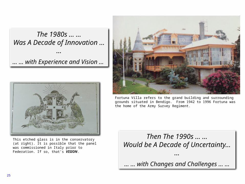
The 1980s … …Was A Decade of Innovation …
…… … with Experience and Vision …
Then The 1990s … …Would be A Decade of Uncertainty… …
… … with Changes and Challenges … …
Fortuna Villa refers to the grand building and surrounding grounds situated in Bendigo. From 1942 to 1996 Fortuna was the home of the Army Survey Regiment.
This etched glass is in the conservatory (at right). It is possible that the panel was commissioned in Italy prior to Federation. If so, that’s VISION.