rising groundwater levels in london and...
TRANSCRIPT

Hydrogeology in the Service of Man, Mémoires of the 18th Congress of the International Association of Hydrogeologists, Cambridge, 1985.
RISING GROUNDWATER LEVELS IN LONDON AND POSSIBLE EFFECTS ON ENGINEERING STRUCTURES
BRIAN WILKINSON
Professor of Civil Engineering, Royal Military College of Science, Shrivenham, Swindon, Wilts. UK.
ABSTRACT The development of industry in several of the major cities in the
UK and elsewhere in Europe owes a great deal to the availability of good quality and readily available groundwater. From the early 1800s to the 1940s groundwater levels fell as demand increased until, over large areas of the cities, they were tens of metres below ground level. Meanwhile the cities spread and demand for city centre sites rose leading to higher buildings with deeper basements and foundations. Tunnels for transport and other services were also built. As the water tables were perhaps tens of metres below foundation level it was often assumed that they were stable and could be safely ignored. Over the last 10 to 20 years a reduction in groundwater abstraction has led to a rise in water levels. In Central London this has occurred at a rate of about 1 m/year. A simple model has been developed which makes preliminary predictions of future rises and shows their dependence on pumping rate. The geotechnical consequences of elevated water levels below London are considered. Data is sparse and a systematic investigation of the problem is needed.
INTRODUCTION The development of industry in many of the major cities in Europe
during the 19th and early 20th centuries owes a great deal to the availability of good quality and readily available groundwater. In the United Kingdom, the Chalk and Permo-Triassic sandstone aquifers were heavily exploited for this purpose. From the early 1800s through to the 1940s thousands of wells were drilled and groundwater was extensively developed. The groundwater levels fell as demand increased over and above natural aquifer recharge. The excess of demand over recharge was made up by water drawn from aquifer storage. By the 1940s, there were large areas below several of the industrial cities in the UK where groundwater levels had fallen tens of metres below ground level. As the development of the groundwater resources proceeded, natural springs dried and artesian boreholes ceased to overflow. Many of the sites of the early water supplies from springs and artesian bores were forgotten as they were replaced by deeper wells with powerful pumps.
Meanwhile the cities spread and as demand for city centre sites rose, so higher buildings with deeper basements and foundations were constructed. The natural spring lines which had dried up were built over as city development proceeded. Tunnels for underground transport and other services were also built. The foundations, basements and the tunnels were designed and constructed following
- 145 -

good engineering practice and often with detailed site investigations. In some situations drilling or enquiries may have revealed that the water table was tens of metres below foundation level, and furthermore, had been at that level for decades. The assumption was often made that these groundwater levels were static and were not a factor to be considered in the geotechnical design of a particular structure.
However, over the last decade a rise in water levels has been observed below several of our major cities and there are indications, for example in Birmingham, where flooded basements have been reported, and in Liverpool where flooding of a British Rail tunnel has occurred, that problems are beginning to arise (Wilkinson, 1984; Slater, 1983).
There has also been a rapid rise in groundwater levels below Central London (Marsh and Davies, 1983; Wilkinson, 1984). Although the water table is still very deep, modifications to the design of the foundations of the new British Library building have been made to resist groundwater pressures that may develop in the future (Simpson, 1983).
There are several factors to account for this rise in water levels below some of the industrial cities of the UK. The destruction of large areas of the inner cities during World War II caused many wells to be lost or fall into disuse. The policy of industrial decentralisation and the control of abstraction through the licensing provision of the 1945 Water Act reduced the number of new wells being constructed.
The phenomena is not restricted to the UK. Several similar cases have been reported from France and West Germany (Bergeron, et ai 1983; West German Federal Institute of Geo-Science and Raw Materials, 1984) . The New York Transit Authority is reported to be experiencing some difficulties with the operation of its underground network due to rising water levels. The situation in the Paris Basin is of particular interest in that its geology and industrial development resembles that of the London Basin. In the mid 19th Century, artesian conditions existed in the Tertiary aquifer with groundwater levels about 4 m above the level of the Seine. With increasing abstraction the levels fell about 45 m and were at their lowest in 1970. During the 1960s underground car parking, storage facilities and extensions to the Metro were constructed in the dewatered strata. Recovery of the levels has led to several incidents of severe basement flooding (Bergeron et al, 1983).
The present paper considers the rise in groundwater levels that is occurring in the London Basin and the long term effects that this may have on major engineering structures in London.
HYDROGEOLOGY Geology
To assess the feasibility of artificial recharge in the London Basin, a major study of its hydrogeology was undertaken by the Water Resources Board (1972). This remains the definitive work on the area.
- 146 -

The London Basin is a syncline in Cretaceous and Tertiary strata (Fig. 1). A simplified cross section is shown in Fig. 2. Cretaceous Chalk crops out in the Chiltern Hills to the north and the North Downs 40 km to the south. The Chalk lies below younger Tertiary deposits in the centre of the Basin. The Chalk is a soft, finegrained white limestone. It attains a maximum thickness of about 240 m. Groundwater flow is predominantly through fissures and joints. The transmissivity of the Chalk varies markedly. Values range from greater than 1000 m2/d to less than 40 m2/d. The unconfined storage coefficient is about 0.02.
The Tertiary deposits comprise thick London Clay resting on a sequence of clays and sands. The lower deposits in the series are sandy and were referred to in the Water Resources Board Study as the Basal Sands. They comprise the Thanet Beds, parts of the Woolwich and Reading Beds and the Blackheath Beds. The Basal Sands may attain a thickness of up to 35 m to the east of the Lea Valley but they thin to the west. It is not possible to quote a representative permeability value for the Basal Sands due to their heterogeneity. The Thanet Beds which are the most uniform part of the sequence are fine, partly cemented grey-green sands and have an hydraulic conductivity of about 2.5 ni/d. Their unconfined storage coefficient lies between 0.02 and 0.1.
London Clay and Bagshot Beds [_ ;
Lower London Ter t i a r ies !:v.::vV';'i
Chalk 2 x 4 3 Base of the Chalk —
Study area Boundary
Fig. 1. Generalised geological map of the London Basin
- 147 -

London
Lower
London
Clay
(Clays
Tertiaries < B a s a l
Chalk
and S
Sands
SECTION A-A
Fig. 2. Simplified geological cross section
The strata between the top of the Basal Sands and the London Clay are predominantly clays with occasional layers of more coarse-grained material. It is generally accepted that these clay strata act as a confining layer to the Chalk and Basal Sand aquifers.
Original Groundwater Levels On the basis of early records of water levels in wells and the
hydrogeological boundaries within the London Basin, a map which shows the original groundwater levels prior to any major abstractions was prepared by the Water Resources Board (1972). The groundwater flow was essentially from the northern and southern outcrops of the Chalk towards the River Thames to the east of the Isle of Dogs where the Lower London Tertiaries and the Chalk are exposed (Fig. 3).
Groundwater Abstraction The total groundwater abstraction in the confined area of the
London Basis rose steadily from about 9 million m3/year in the early 1800s to a peak of 83 million m3/year in 1940. From World War II onwards the quantity abstracted steadily declined to about 62 million m /year in 1965. More recent data supplied by the Thames Water Authority has also shown a fall to 43 million m /year in 1982 (Fig. 4).
- 148 -

Fig. 3. Estimated groundwater levels and flow directions under natural conditions.
100 - i GROUNDWATER ABSTRACTIONS
LONDON BASIN - CONFINED AREA
E
O
GO z g H O < ce \r-C/J
<
z z <
60 -
l l ^ M W i p & l d l i i M i l ^ ^
2000 1850
Fig. 4.
1900 1950
Abstractions of groundwater from the confined area of the London Basin between 1850 and 1982.
- 149 -

Fig. 5. Estimated groundwater levels and flow directions in 1965.
The cut back in abstraction during the 1950s and 1960s halted the. fall in water levels which were probably at their lowest during the early 1960s. The groundwater flow directions show marked changes when compared with the original flow paths (Fig. 3). Flow in 1965 was from the outcrops towards the depression in Central London. The River Thames to the east of the Isle of Dogs also became a source of recharge (Fig. 5) and this led to saline intrusion of the aquifer adjacent to the river.
RISE IN GROUNDWATER LEVELS The reduction in groundwater abstraction has led to a steady rise
in groundwater levels since 1965. The groundwater level contours for 1983 are shown in Fig. 6. In Central London the rise over the past 15 years has been about 15 to 20 m. Along the Chalk outcrop to the north and south of the Basin, abstractions have been maintained or in some cases increased and consequently the water levels have remained unchanged or shown a modest decline.
The data on which the 1983 contours are based was supplied by the Thames Water Authority from their groundwater archives. There is good coverage in some areas, for example in the Lea Valley due to the Authority's artificial recharge scheme, but for much of the Basin the data points are very sparse and the contours are much less reliable.
The artificial recharge scheme in the Lea Valley has certainly contributed locally to the rise in levels but its effect on the regional pattern is likely to be very limited.
- 150 -
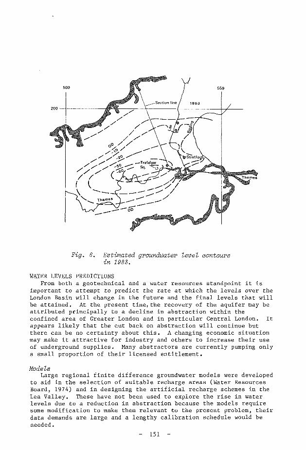
Fig. 6. Estimated groundwater level contours in 1983.
WATER LEVELS PREDICTIONS From both a geotechnical and a water resources standpoint it is
important to attempt to predict the rate at which the levels over the London Basin will change in the future and the final levels that will be attained. At the present time, the recovery of the aquifer may be attributed principally to a decline in abstraction within the confined area of Greater London and in particular Central London. It appears likely that the cut back on abstraction will continue but there can be no certainty about this. A changing economic situation may make it attractive for industry and others to increase their use of underground supplies. Many abstractors are currently pumping only a small proportion of their licensed entitlement.
Models Large regional finite difference groundwater models were developed
to aid in the selection of suitable recharge areas (Water Resources Board, 1974) and in designing the artificial recharge schemes in the Lea Valley. These have not been used to explore the rise in water levels due to a reduction in abstraction because the models require some modification to make them relevant to the present problem, their data demands are large and a lengthy calibration schedule would be needed.
- 151 -

60
40
20
rn OD 0
20
60
A \ \
LONDON CLAY
AND
WOOLWICH AND
READING CLAYS
1983 ABSTRACTION RATE
(a)
^•fe, 'rea >«*!
\ C H A L K ^ ? r6-.- -^L- jS,
GWL
1983
Glvt
River
km
10 20 30 40 50 60
m OD
HALF 1983 ABSTRACTION RATE
(b)
River
10 20 30 40 50 60
Fig. 7. One dimensional model showing the rise in water levels with the abstraction rate (a) held constant at the -present value (b) halved.
- 152 -
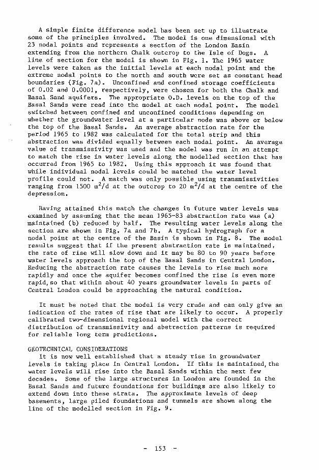
A simple finite difference model has been set up to illustrate some of the principles involved. The model is one dimensional with 23 nodal points and represents a section of the London Basin extending from the northern Chalk outcrop to the Isle of Dogs. A line of section for the model is shown in Fig. 1. The 1965 water levels were taken as the initial levels at each nodal point and the extreme nodal points to the north and south were set as constant head boundaries (Fig. 7a). Unconfined and confined storage coefficients of 0.02 and 0.0001, respectively, were chosen for both the Chalk and Basal Sand aquifers. The appropriate O.D. levels on the top of the Basal Sands were read into the model at each nodal point. The model switched between confined and unconfined conditions depending on whether the groundwater level at a particular node was above or below the top of the Basal Sands. An average abstraction rate for the period 1965 to 1982 was calculated for the total strip and this abstraction was divided equally between each nodal point. An average value of transmissivity was used and the model was run in an attempt to match the rise in water levels along the modelled section that has occurred from 1965 to 1982. Using this approach it was found that while individual nodal levels could be matched the water level profile could not. A match was only possible using transmissivities ranging from 1500 m2/d at the outcrop to 20 m2/d at the centre of the depression.
Having attained this match the changes in future water levels was examined by assuming that the mean 1965-83 abstraction rate was (a) maintained (b) reduced by half. The resulting water levels along the section are shown in Fig. 7a and 7b. A typical hydrograph for a nodal point at the centre of the Basin is shown in Fig. 8. The model results suggest that if the present abstraction rate is maintained, the rate of rise will slow down and it may be 80 to 90 years before water levels approach the top of the Basal Sands in Central London. Reducing the abstraction rate causes the levels to rise much more rapidly and once the aquifer becomes confined the rise is even more rapid,so that within about 40 years groundwater levels in parts of Central London could be approaching the natural condition.
It must be noted that the model is very crude and can only give an indication of the rates of rise that are likely to occur. A properly calibrated two-dimensional regional model with the correct distribution of transmissivity and abstraction patterns is required for reliable long term predictions.
GEOTECHNICAL CONSIDERATIONS It is now well established that a steady rise in groundwater
levels is taking place in Central London. If this is maintained, the water levels will rise into the Basal Sands within the next few decades. Some of the large structures in London are founded in the Basal Sands and future foundations for buildings are also likely to extend down into these strata. The approximate levels of deep basements, large piled foundations and tunnels are shown along the line of the modelled section in Fig. 9.
- 153 -

Q O
—I UJ
> UJ —I
a: UJ H < Q
10
0
10
20
30
40 3 O g -50
HALF 1983 ABSTRACTION RATE
Top of Basal Sands
1983 ABSTRACTION RATE
1965 75 85 95 2005 15 25 35 45
Fig. 8. Hydrographs for Central London based on the one dimensional model.
60 -
40
20
m OD 0
20 -
40 -
60
\ \ \
\
LONDON CLAY AND
WOOLWICH AND
READING CLAYS
Chalk - ' 3 : y — s r -
""vT GWL * - f ^
J983^-rCi5>
River
\ ' * • * .
— 7^ TTT/Tunnel
GWL1965 " V " \ ^ V * . ^ / ^ ' "
eep asements
10 20 30 40 50 60
Fig. 9. Cross section showing the approximate levels of deep basements, piled foundations and tunnels.
- 154 -

The consequences of an elevated water table on these structures requires investigation. The effects are likely to be most marked and rapid in the strata with high permeability such as the Basal Sands. In the London Clay and other thick clays in the sequence, the consequences are likely to be relatively minor and slow to develop.
The principal effects on engineering structures would be from flooding, swelling of clays, reduction in bearing capacity, hydrostatic uplift pressures, chemical attack and difficulties during construction.
Flooding In Central London groundwater levels are too low to pose any
leakage problems but in Birmingham, Liverpool and elsewhere in Europe, basements and tunnels have been subject to severe flooding. If the rise continues similar problems will occur in London. Remedial measures are difficult and expensive.
Swelling The fall in groundwater levels and the associated increase in
effective stress that occurred as pore water drained from the London Clay and the Woolwich and Reading Clays led to consolidation of the clays and a slow surface settlement of up to 180 mm (Wilson and Grace, 1942; Downing and Pontin, 1984). With rising groundwater levels the process would be reversed and the clays would swell. The amount of swelling will be less than the preceding consolidation. It is unlikely to cause any major engineering problems.
Bearing capacity and hydrostatic uplift Simplified calculations have shown that the bearing capacity of
deep basement foundations and piles in Central London may show a loss of bearing capacity of between 25 to 50 percent if water levels in the Basal Sands were to approach ground level (Chlsholm, 1984). Water pressures on the walls of deep basements could also increase the lateral pressure substantially. High artesian pressures may also lead to uplift on the base slabs of deep basements. In composite raft/pile foundations this could cause redistribution of load between the piles and the raft. Such problems have been considered in the design of the new British Library building at a site close to St Paneras Station. The deepest basement is to extend down to some 25 m below ground level, penetrating 4 m into the Woolwich and Reading Clays. Large diameter piles extend about 12 m into the Woolwich and Reading Sands (Basal Sands). The groundwater level at present lies in the Chalk and the original design assumed that this level would remain stable during the life of the building. Realisation that the water levels were rising led to a redesign to increase the bearing capacity of the piles and to strengthen the basement retaining walls. A drainage system below the basement slab connected to relief wells which extend into the Chalk has been designed to prevent a rise in artesian pressure above the basement slab level (Simpson, 1984).
Construction High artesian pressures at the base of the Woolwich and Reading
Clays or the London Clay could be hazardous during the excavation of deep foundations. These would need to be controlled by a dewatering system. Difficulties may also arise with artesian pressure when
- 155 -

constructing bored pile foundations in sandy strata or in clays with more permeable sand or silt layers.
Chemical Attack During the recharge experiments in the Lea Valley very high
sulphate concentrations of up to 2000 ppm were measured in the groundwater recovered from a few of the boreholes. Such high concentration coming into contact with foundations could lead to concrete attack and deterioration.
CONCLUDING REMARKS
1. It is now well established that the groundwater levels in Central London are rising at a rate of about 1 m/year and that this is predominantly due to the reduction in industrial abstraction.
2. If groundwater levels continue to rise there may be adverse geotechnical effects particularly on those structures that are founded in the sandy facies of the Lower London Tertiaries and the lower clay horizons which contain layers of sand or silt. There is a need to assess systematically the geotechnical risk to engineering structures in the London Basin in relation to the type of foundation, stratigraphy, present and possible future groundwater levels.
3. Groundwater level data is abundant in some areas but very sparse in others and a data collection programme is required if the problem is to be properly addressed and detailed modelling work carried out.
4. There is no cause for alarm at the present time as the preliminary modelling work suggests that it will be several decades before water levels in Central London rise towards the top of the Basal Sands. However investigations are needed now so that problems can be properly anticipated and solutions developed in good time.
At present no single organisation has the responsibility to evaluate an overall control policy through increased abstraction or other appropriate actions. It is therefore suggested that the investigations of the extent of the problem and remedial measures both in London and elsewhere in the UK should be supported by Central Government.
ACKNOWLEDGEMENTS The author wishes to thank Mr D B Oakes (Water Research Centre) for
help in developing the model and Dr M Owen (Thames Water Authority) for supplying recent abstraction and water level data.
REFERENCES
Bergeron, G., Dehays, H. and Pointet, T., 1983. Remontées des nappes d'eau souterraine: cause et effets. Bureau de Recherches Géologiques et Minières.
Chisholm, F.A., 1984. Rising groundwater levels under Greater London and their geotechnical significance. M.Sc Report. University of London.
- 156 -

Downing, R.A. and Pontin, J.M.A., 1984. Discussion on the decline and partial recovery of groundwater levels below London by Marsh, T.J. and Davies, P.A. Proa. Instn. Civ. Engs. Part I, 76, Aug. 731-733.
Federal Institute of Geo-Sciences and Raw Materials, 1984. Renewed rise of groundwaer following discontinuation of draw-down measures in the Federal Republic of Germany. Archive No. 95 678. Hanover.
Marsh, T.J. and Davies, P.A., 1983. The decline and partial recovery of groundwater levels below London. Proa. Instn. Civ. Engs. Vol I, Part I. 263-276.
Simpson, R., 1983. Verbal contribution to an informal discussion on Rising groundwater levels and geotechnical consequences at the Institution of Civil Engineers. Reported in Proa. Instn. Civ. Engs. 1984. Part I, 76. pp 791-793.
Slater, P.M., 1983. A finite element model and predictions of Birmingham groundwaters. M.Sc. Report. University of London.
Water Resources Board. 1972. Artificial recharge of the London Basin. I: Hydrogeology. HMSO.
Water Resources Board. 1974. Artificial recharge of the London Basin, III: Economic and Engineering Desk Studies. HMSO.
Wilkinson, W.B. 1984. Rising ground-water levels and geotechnical consequences. Informal Discussion Ground Engineering Group and Water Engineering Group. Proa. Instn. Civ. Engs. Part I, 76, Aug. 791-793.
Wilson, G. and Grace, H. 1942. The settlement of London due to under-drainage of the London Clay. J, Instn. Civ. Engs. Vol 19 pp 100-127.
- 157 -