review of groundwater information in the lower...
TRANSCRIPT

Review of Groundwater Information in the Lower Mekong Basin
Khem Sothea
Hydrology Team (Component-2)
17-19 February 2014
Bangkok & Khon Kean, Thailand

FIRST MISSION OF USGS IN THE LMB
(April 27 – July 22, 2011)

Objectives of Groundwater Review
• Compile data and information from historical and current groundwater monitoring and assessment studies by National agencies, MRCS, and other sources
• Summarize current understanding of the conditions and monitoring of the regional groundwater system in the LMB
• Identify priority concerns for groundwater conditions and gaps in monitoring
• Propose a preliminary action plan and strategy for future MRCS groundwater monitoring programs in cooperation with National agencies

Products and Outcome
• First mission of USGS Expert (Matthew Landon) 3 months period, two draft manuscripts were produced:
– Review of Groundwater Resources, Monitoring, and Status in the Lower Mekong River Basin
– Preliminary Action Plan for MRC Groundwater Monitoring in the Lower Mekong River Basin (LMRB)
• These manuscripts and the information compiled are intended to serve as a foundation for proposals seeking funding for expanded future analysis of groundwater in the LMRB by MRCS and cooperators
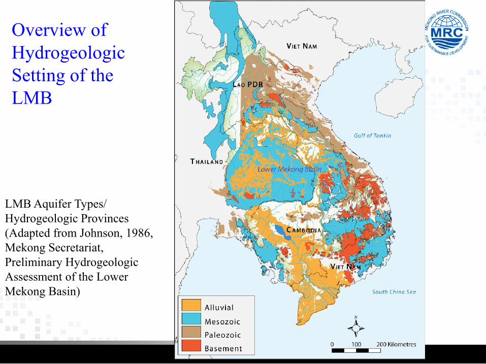
LMB Aquifer Types/ Hydrogeologic Provinces(Adapted from Johnson, 1986, Mekong Secretariat, Preliminary HydrogeologicAssessment of the Lower Mekong Basin)
Overview of HydrogeologicSetting of theLMB

LMRB Groundwater Yield Map
Source: Charuratna and Phu (1992

Reviewing Existing Groundwater Monitoring in the LMB
Yield Map Source: Charuratna and Phu (1992)
VietnamCentral Highlands~150 points inNat. GW network
VietnamMekongDelta~225 points inNat. GW network
ThailandNat. GW networks

LMB Saline Groundwater Map
Source: Charuratna and Phu (1992)

Historical and Current GW Monitoring

A Historical Overview of Mekong Committee/National Agency
Groundwater Monitoring
• LMB-scale hydrogeologic assessments (Johnson, 1986) and map compilations (Charuratna and Phu, 1992)
• Bimonthly monitoring of water levels and water-quality in wells in Lao PDR, Thailand, and Vietnam during 1990-98 (Groundwater Investigation Programme)

Groundwater Investigation Programme,1990-98(Mekong Secretariatand National agencies)
Source: Interim Mekong
Committee (1993)

Areas of primary aquifers and low-yield or non-aquifers in Cambodia and Lao PDR.
Delineation of Areas for Monitoring
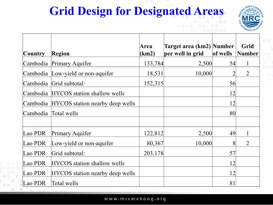
Grid Design for Designated Areas
Country RegionArea (km2)
Target area (km2) per well in grid
Number of wells
Grid Number
Cambodia Primary Aquifer 133,784 2,500 54 1
Cambodia Low-yield or non-aquifer 18,531 10,000 2 2
Cambodia Grid subtotal: 152,315 56
Cambodia HYCOS station shallow wells 12
Cambodia HYCOS station nearby deep wells 12
Cambodia Total wells 80
Lao PDR Primary Aquifer 122,812 2,500 49 1
Lao PDR Low-yield or non-aquifer 80,367 10,000 8 2
Lao PDR Grid subtotal: 203,178 57
Lao PDR HYCOS station shallow wells 12
Lao PDR HYCOS station nearby deep wells 12
Lao PDR Total wells 81

Grid Design
• There are well-established procedures for generating grids for designing groundwater monitoring networks
• A GIS method of Scott (1990) has been widely used by the USGS in National and California groundwater monitoring programs

SECOND MISSION OF USGS EXPERTS IN THE LMB
(3 weeks in November 2013)
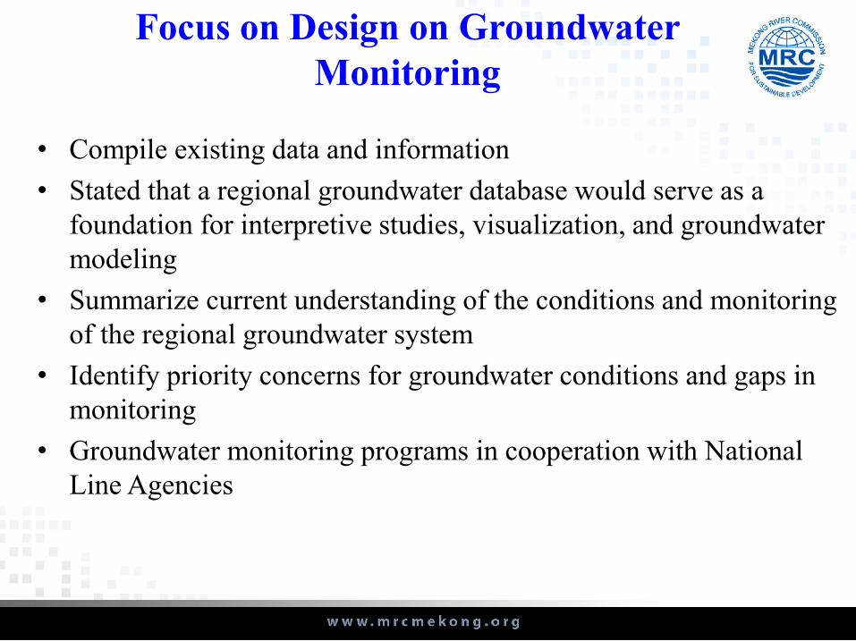
Focus on Design on Groundwater Monitoring
• Compile existing data and information
• Stated that a regional groundwater database would serve as a foundation for interpretive studies, visualization, and groundwater modeling
• Summarize current understanding of the conditions and monitoring of the regional groundwater system
• Identify priority concerns for groundwater conditions and gaps in monitoring
• Groundwater monitoring programs in cooperation with National Line Agencies

Database – Data Management Principles (USGS)
• Data conform to published standards
• Validity of the data
• Integrity and internal consistency of the data
• Secure and maintain primary data
• Allow easy access to primary data
• Process the data efficiently
• Allow integration of different datasets
• All data should have an owner
• Flexible structure
• Metadata
• Update specific data sources
• Data dictionaries
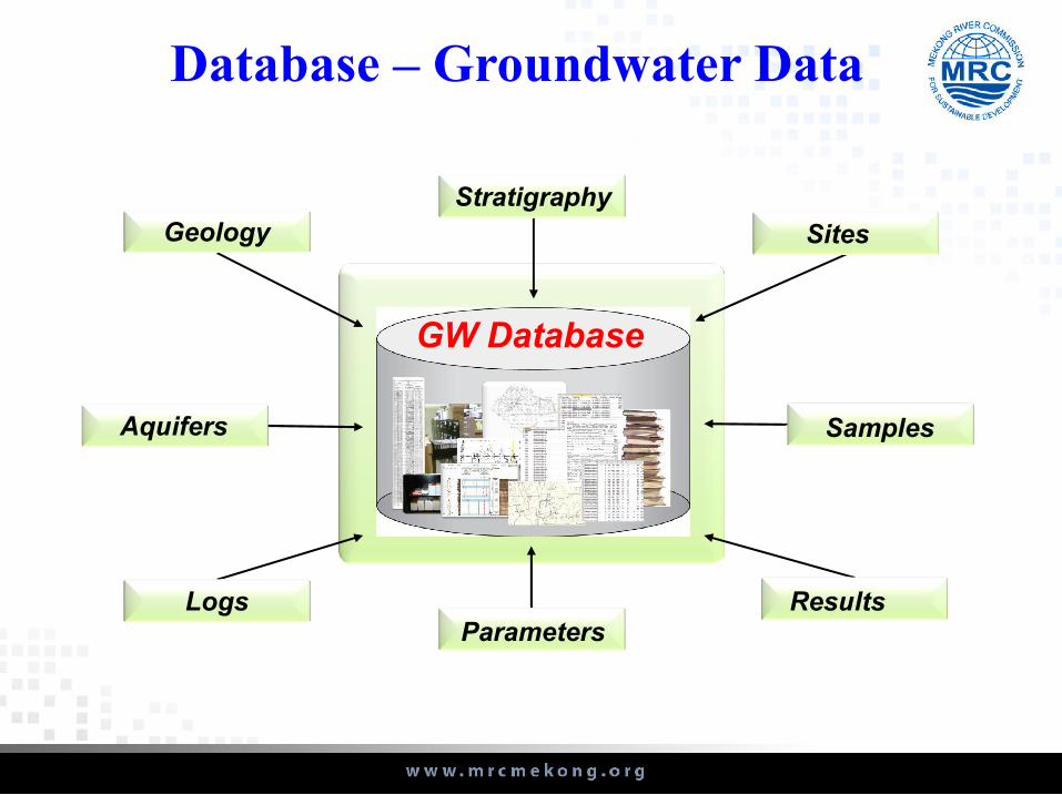
Database – Groundwater Data
Sites
Stratigraphy
Geology
Aquifers
LogsParameters
Results
Samples
GW DatabaseGW Database

Need for Ongoing Groundwater Resource Assessment – Independent of Monitoring
• Including:– Ongoing geologic mapping
– Distribution of unconfined and confined aquifers
– Hydraulic and storage properties and thickness
– Recharge rates
– Groundwater discharge to streams (baseflow)
– Groundwater utilization: well numbers, locations, construction, and withdrawal rates
– Groundwater levels: water-level elevation maps and seasonal fluctuations
– Groundwater-quality assessments
– Water-balance analysis
– Groundwater-age investigations
– Groundwater-flow modeling

Summary
• Groundwater is an important supplemental source of water supply for anthropogenic and natural demands
• Groundwater monitoring and resource assessments have primarily been conducted in Thailand and Vietnam portions of the LMB and selected areas of Cambodia and Lao PDR – the principal gaps in monitoring are in the latter countries

Next Plan Activity
Ground water (GW) monitoring in place to provide information on exchange and interaction between groundwater and surface water. The
GW activity will focus on:
1. Finalize the framework and action plan for GW activity for each Member country
2. Collect and analysis all available GW data in the LMB 3. Install pilot wells for GW level monitoring at various selected sites,
bases on fund availability4. Develop GW Database, bases on USGS’s guideline5. Build up capacity on groundwater data management in regional and
national levels

Thank you for your attention
