review and recommendations for climate change vulnerability
TRANSCRIPT
United StatesDepartmentof Agriculture
Forest Service
Rocky MountainResearch Station
General Technical Report RMRS-GTR-309
September 2013
Review and Recommendations for Climate Change Vulnerability
Assessment Approaches With Examples From the Southwest
Megan M. Friggens, Karen E. Bagne, Deborah M. Finch, Donald Falk, Jack Triepke, Ann Lynch
Friggens, M.; Bagne, K.; Finch, D.; Falk, D.; Triepke, J.; Lynch, A. 2013. Review and recommendations for climate change vulnerability assessment approaches with examples from the Southwest. Gen. Tech. Rep. RMRS-GTR-309. Fort Collins, CO: U.S. Department of Agriculture, Forest Service, Rocky Mountain Research Station. 106 p.
AbstrActClimate change creates new challenges for resource managers and decision-makers with broad and often complex effects that make it difficult to accurately predict and design management actions to minimize undesirable impacts. We review pertinent information regarding methods and approaches used to conduct climate change vulnerability assessments to reveal assumptions and appropriate application of results. Secondly, we provide managers with an updated summary of knowledge regarding vulnerability of species and habitats to climate change in the American Southwest. Overall, vulnerability assessments provided valuable information on climate change effects and possible management actions but were far from a comprehensive picture for the future of the Southwest. Scales, targets, and assessment approaches varied widely and focused on only a subset of resources. We recommend land managers critically examine methods when using assessment results; select scale, methods, and targets carefully when planning new assessments; and communicate assessment needs to researchers of climate change response.
Keywords: Resource management, wildlife, wildlands, conservation, global change
AuthorsMegan Friggens is a Research Ecologist with the U.S. Department of Agriculture, Forest Service, Rocky Mountain Research Station.
Karen Bagne is an Ecologist and Wildlife Biologist with the USDA Forest Service, Rocky Mountain Research Station.
Deborah Finch is the Program Manager for the Grassland, Shrubland, and Desert program of the USDA Forest Service, Rocky Mountain Research Station.
Donald Falk is Associate Professor in the University of Arizona School of Natural Resources and the Environment, with joint appointments in the Laboratory of Tree-Ring Research and Institute of the Environment.
Jack Triepke is a Regional Ecologist for the USDA Forest Service Southwestern Region in Albuquerque, New Mexico. Jack is also a Ph.D. candidate at the University of New Mexico where he is studying the effects of climate change on Southwest ecosystems.
Ann Lynch is a Research Entomologist with the Rocky Mountain Research Station, stationed in Tucson, AZ.
Acknowledgments
Funding for this project was provided by the Western Wildlands Environmental Threats Assessment Center. We thank Aimee Roberson and Cathryn Dowd whose comments improved this manuscript.
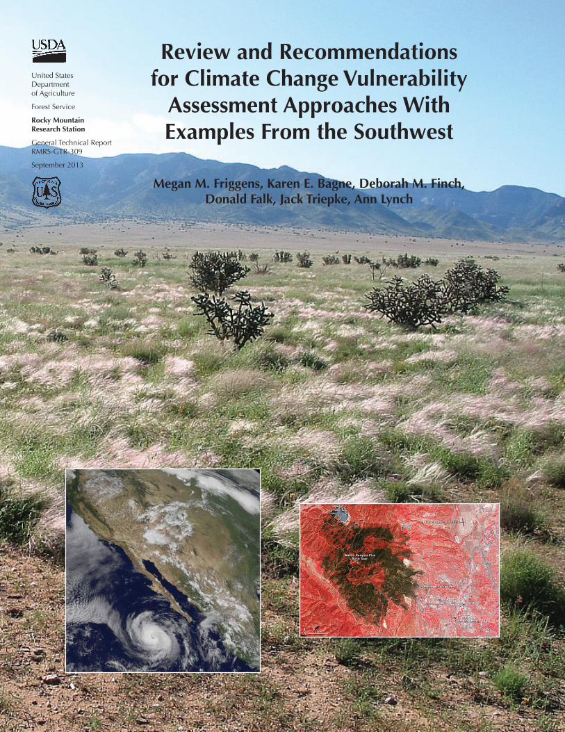
Cover photo: Sevilleta National Wildlife Refuge LTER Grassland (photo by Megan Friggens); hurricane Ileana approaches the Baja Peninsula August 24, 2006 (NASA-Goddard Space Flight Center, data from NOAA GOES); Waldo Canyon burn scar (brown) outside of Colorado Springs, Colorado, 2012 (NASA).
executive summAry
The intent of this report is, first, to review pertinent information regarding methods and approaches used to conduct climate change vulnerability assessments and, second, to provide managers with an updated summary of knowledge regarding vulnerability to climate change of species and habitats in the American Southwest. We begin by defining and discussing climate change vulnerability assessment concepts and approaches and then examine major methods by which such assessments are conducted. Finally, we review and synthesize the information presented in vulnerability assessments conducted for the southwestern United States.
Climate change creates new challenges for resource managers and decision-makers, with broad and often complex effects that make it difficult to design management actions that can minimize undesirable impacts. A wide range of approaches have been used to predict how and why resources will change in response to climate change. Assessments can be useful in addressing climate change issues because they synthesize large amounts of complex information. Vulnerability assessments seek to synthesize available information on climate change for a region, sector, or resource of interest and glean recommendations for management actions. Vulnerability is a combination of exposure, sensitivity, and adaptive capacity, components that are not always distinct nor are they integrated into every vulnerability assessment (USGCRP 2011). By specifically examining vulnerability to climate change, managers can rank needs as well as pinpoint the causes of vulnerability for valued resources. Most vulnerability assessments fit one of four broad categories: mathematical models, conceptual frameworks, indices, and syntheses.
A number of important elements must be considered when preparing to conduct a vulnerability assessment, including selecting targets, scales, and the measure of vulnerability. Vulnerability assessments that address questions that managers and stakeholders can act upon are more applicable than assessments that lack immediate relevance to on-the-ground actions. Depending upon the objective, identified assessment targets may include individuals, populations, species, landscapes, and ecosystem processes. Selection of appropriate biological, spatial, and temporal scales influences the relevance of biological analysis in any assessment of climate change vulnerability. Assessments also need to integrate considerations of critical thresholds and important ecosystem tipping points. Modeling and empirical studies suggest that changes due to climate alone are likely to be expressed at multi-annual to decadal time scales (Allen and Breshears 1998). In contrast, severe large-scale disturbances can reorganize mass and energy of ecosystems on much shorter time scales of days to months (Overpeck and others 1990). In some scenarios, combinations of gradual climate change and disturbance events will trigger abrupt ecosystem transitions into novel configurations, rather than either factor acting alone.
Methods for measuring climate change response are organized into four groups: hydrologic models, adaptive capacity models, distribution models, and indices. Hydrologic models are a critical component of assessments based within aquatic systems and often inform other modeling approaches aimed at species or biomes. Hydrologic models encompass a variety of mostly statistical approaches that estimate the impact of climate change on hydrological function and aquatic systems and can incorporate both ecological and economic aspects of system vulnerability. Various approaches, grouped together in this report in the Adaptive Capacity Models section, identify individual characteristics that may influence the capacity of species to survive changes to climate. Although diverse, adaptive capacity models include estimates of species survival (or, alternatively, risk of extinction) as well as mechanisms of local adaptation (for example, latent genetic variation that may confer resistance to emerging climate conditions). Distribution models, the most commonly used method to predict response, encompass a variety of statistical, simulation, and other approaches to estimate future effects of climate on the range distributions of species, communities, and biomes. These models may generate predictions of future habitat suitability for species or communities, habitat characteristics, or patterns of biodiversity. Finally, a variety of methods aim to prioritize the identification and management of species or habitats. Our discussion focuses on a subset of these
i
methods, termed indices or index-based measures that identify relative vulnerability within a group of targeted study subjects through a quantitative comparison of traits or issues. Index-based measures have emerged within the literature only recently in response to limitations in directly measuring climate change response.
A vulnerability assessment examines the expected response of resources, how the resource becomes more or less in need of management, especially in relation to other resources or a critical level, and identifies management intervention points. A vulnerability assessment is a specific type of product that identifies how current management strategies may change under changing climate by combining information on the expected response of individual resources with information on how such impacts change relative management needs among multiple resources. Thus, vulnerability is often measured in relation to a reference level that is relevant to contemporary human societies. The specific measure of vulnerability used in an assessment is important to understanding the conclusions and possible limitations of the assessment. Six common measures of vulnerability to climate change are used in natural resource management:
(1) Direct observations of response to recent versus historic conditions.
(2) Departure of modeled future of climate, species distributions, biodiversity, and other measures from baseline observations.
(3) Observations from experiments or of past events equivalent to projected future conditions.
(4) Proximity to thresholds or probability of exceeding a critical threshold.
(5) Estimates of adaptive capacity to future conditions.
(6) Relative importance of modeled factors affecting response.
Projections for the United States indicate that the Southwest is likely to experience more extreme climate changes than other regions. These changes exacerbate existing problems associated with sustaining valued natural resources. For example, longer duration droughts and higher temperatures will tax the already scarce water sources critical to plants, fish, and wildlife as well as to the rapidly expanding human population that occupies the Southwest. For these reasons, we focus our review of climate change vulnerability assessments on those applicable to natural resource management in the Southwest. Several common themes are found among these assessments:
• Vulnerability of grasslands to invasive species is likely to increase under climate change (reviews by Morgan and others 2010; Chambers and Pellant 2008; Neilson and others 2010)
• Hydrological systems will be taxed by multiple impacts, including:
ο higher water temperatures with multiple effects for temperature dependent species (Johnson and others 2005; Eaton and Scheller 1996).
ο changes in precipitation events leading to less snowpack, changes to the timing of flood regimes, less flow, and reduced water tables (Theobald and others 2009).
ο spread of invasive species in both aquatic and riparian habitats (Theobald and others 2009; Rood and Conrad 2008).
• Many studies show that temperature alone drives or is sufficient to lead to observed or predicted changes (see Williams and others 2010 for tree growth; Currie 2001 for biodiversity; Garfin and Lenart 2007 for loss of cool water fish species; Notaro and others 2012; Williams and others 2012 trees; Eaton and Scheller 1996 and Meyers and others 1999 describe many effects on aquatic systems,) but note exception to temperature-driven patterns for cheatgrass invasion (see Bradley 2009).
• Areas near ecotones are more vulnerable to change (e.g., Madrean habitats see Kupfer and others 2005).
Overall, vulnerability assessments reviewed in this synthesis provided valuable information on climate change effects and possible management actions, but were unable to provide a comprehensive picture for the future of the Southwest. Scales,
ii
targets, and assessment approaches varied widely and focused on only a subset of resources. Assessments of animal species typically involved special status species and were primarily assessed using index-based approaches though reports from these assessments provide detailed information on sources and causes of species vulnerability. Community level assessments varied more and included statistical modeling methods. Plant assessments tended to cover a wider geographic range than those focused on animals. Distribution models were used more widely for plant species and functional groups but were biased towards forested ecosystems. From many of these assessments, researchers are able to provide spatially explicit estimates of future climate and habitat suitability for animal and plant species. The applicability of vulnerability assessments for the Southwest is limited by the degree to which they include accurate measures of future change. Measuring future vulnerability was difficult where projected climate change impacts in the region exceed historical events, emphasizing the need for process-based models and the inclusion of critical thresholds. In addition, there were few assessments that integrate multiple complex interactions and threats such as those posed by disease, pests, invasive species, and hydrological changes. These gaps are likely mirrored for assessments in other regions. We recommend land managers critically examine methods when using assessment results; select scale, methods, and targets carefully when planning new assessments; and communicate assessment needs to researchers of climate change response.
iii

contents
Executive Summary .............................................................................................................i
Chapter 1. Vulnerability Assessments in Natural Resource Management: Overview and Application .......................................................................1
1.1 The Climate Change Challenge ..............................................................................................11.2 Climate Change Vulnerability Assessments .............................................................................11.3 Vulnerability Assessment Approaches .....................................................................................31.4 Steps for Conducting a Vulnerability Assessment ....................................................................31.5 Vulnerability Assessments in Natural Resource Management ..................................................4Literature Cited ............................................................................................................................7
Chapter 2. Targets, Scope, and Scale ..................................................................................8
2.1 Assessment Targets .................................................................................................................82.2 Scope .....................................................................................................................................92.3 Biological Scale ...................................................................................................................11
2.3.1 Species Scale ................................................................................................................................ 112.3.2 Ecosystem Scale ............................................................................................................................ 12
2.4 Case Study: Landscape Analysis ...........................................................................................122.4.1 Ecosystem Attributes ..................................................................................................................... 132.4.2 Cross-Scale Applications ............................................................................................................... 14
Literature Cited ..........................................................................................................................14
Chapter 3. Predicting Response to Climate Change .........................................................18
3.1 Introduction .........................................................................................................................183.2 General Methods .................................................................................................................19
3.2.1 Hydrological Models .................................................................................................................... 193.2.2 Adaptive Capacity Models ............................................................................................................ 233.2.3 Distribution Models ...................................................................................................................... 263.2.4 Prioritization Methods ................................................................................................................... 30
3.3 Issues in Predicting Response ...............................................................................................343.3.1 Critical Thresholds, Ecosystem Tipping Points, and Other Considerations ...................................... 343.3.2 Interactive Effects .......................................................................................................................... 363.3.3 Uncertainty ................................................................................................................................... 37
Literature Cited ..........................................................................................................................38
Chapter 4. Translating Response into Vulnerability and Management Recommendations ........................................................................................................43
4.1 Measures of Vulnerability .....................................................................................................434.1.1 Degree of Recent Change From Historic ....................................................................................... 434.1.2 Degree of Modeled Future Change From a Baseline ...................................................................... 454.1.3 Observed Impacts Under Comparable Conditions ........................................................................ 474.1.4 Exceeding Thresholds .................................................................................................................... 494.1.5 Capacity to Adapt to Change ........................................................................................................ 504.1.6 Relative Degree of Response to Climate Variation ......................................................................... 51
4.2 Informing Natural Resource Management Recommendations ...............................................524.2.1 Planning for the Future .................................................................................................................. 534.2.2 Promoting Resistance and Resilience ............................................................................................ 544.2.3 Landscape-Level Planning ............................................................................................................. 554.2.4 Limitations .................................................................................................................................... 554.2.5 Assessment Tools and Guidance .................................................................................................... 55
Literature Cited ..........................................................................................................................56
iv

Chapter 5. Vulnerability of Southwestern Species and Ecosystems to Climate Change: A Review ...........................................................................................60
5.1 Introduction .........................................................................................................................605.2 Methods ...............................................................................................................................615.3 Southwest Vulnerability Assessments ....................................................................................67
5.3.1 Vulnerability of Southwestern Species and Communities ............................................................... 695.3.2 Vulnerability of Southwestern Habitats .......................................................................................... 775.3.3 Vulnerability of Southwestern Water .............................................................................................. 815.3.4 Comprehensive Assessments ......................................................................................................... 87
5.4 Future Assessment Needs .....................................................................................................885.5 Using Assessments to Develop Adaptive Management Strategies for the Southwest ..............905.6 Additional Information .........................................................................................................91Literature Cited ..........................................................................................................................92
Appendix 1. ...................................................................................................................102
Appendix 2. ...................................................................................................................105
v
TablesTable 2.1. Relevance of spatial scale for assessing vulnerability to climate change
(from Peterson and others 2011). .......................................................................................... 8
Table 3.1. A general overview of models and methods used to evaluate vulnerability for climate change assessment. ........................................................................................... 20
Table 3.2. Best use, strengths, and weaknesses of analyses commonly used for predicting future conditions. All methods require climate inputs such as future temperature and precipitation but vary in how data is processed to determine vulnerability. At the most flexible, natural history data on species traits is sufficient for many index based measuring methods. More intensive analyses require detailed data on CO2 uptake and nutrient cycling obtained from experimental data. All methods are sensitive to bias and uncertainties in climate data. .......................................... 24
Table 3.3. Examples of methods used to provide relative measures of vulnerability or identify areas of vulnerability. Type refers to the method employed. Quantifications typically tally traits associated with vulnerability. Models typically combine some type of tallying method and extrapolate it to spatially explicit issues (e.g., landscape fragmentation). .......................................................................................... 31
Table 3.4. Examples of frameworks that can be used to create or organize climate change vulnerability assessments. ....................................................................................... 33
Table 4.1. Summary of common measures of vulnerability, applicable time scales, key limitations, and common applications. ......................................................................... 52
Table 4.2. Resources, including data repositories, for exploring management options and for use in climate change vulnerability assessments. .................................................... 56
Table 5.1. Reviews and syntheses of climate change projections and impacts for species and habitat specific to the SW United States. .......................................................... 62
Table 5.2. Climate change vulnerability assessments that contain information for the SW United States. We indicate the scale and spatial focus of the assessment as well as identify the emphasis and primary methods for determining or measuring vulnerability. Climate parameters are listed as reported. “na” indicates not applicable or not available. ................................................................................................. 63
Table 5.3. Number of assessments focused on animal, plant, or both types of organisms and the various scales presented in 36 assessments of climate change vulnerability for the SW. ..................................................................................................... 68
Table 5.4. Spatial and biological scale of 36 climate change vulnerability assessments conducted for the SW United States. Landscape here refers to studies that address composition of multiple communities across a large area (e.g., North America). ................. 69
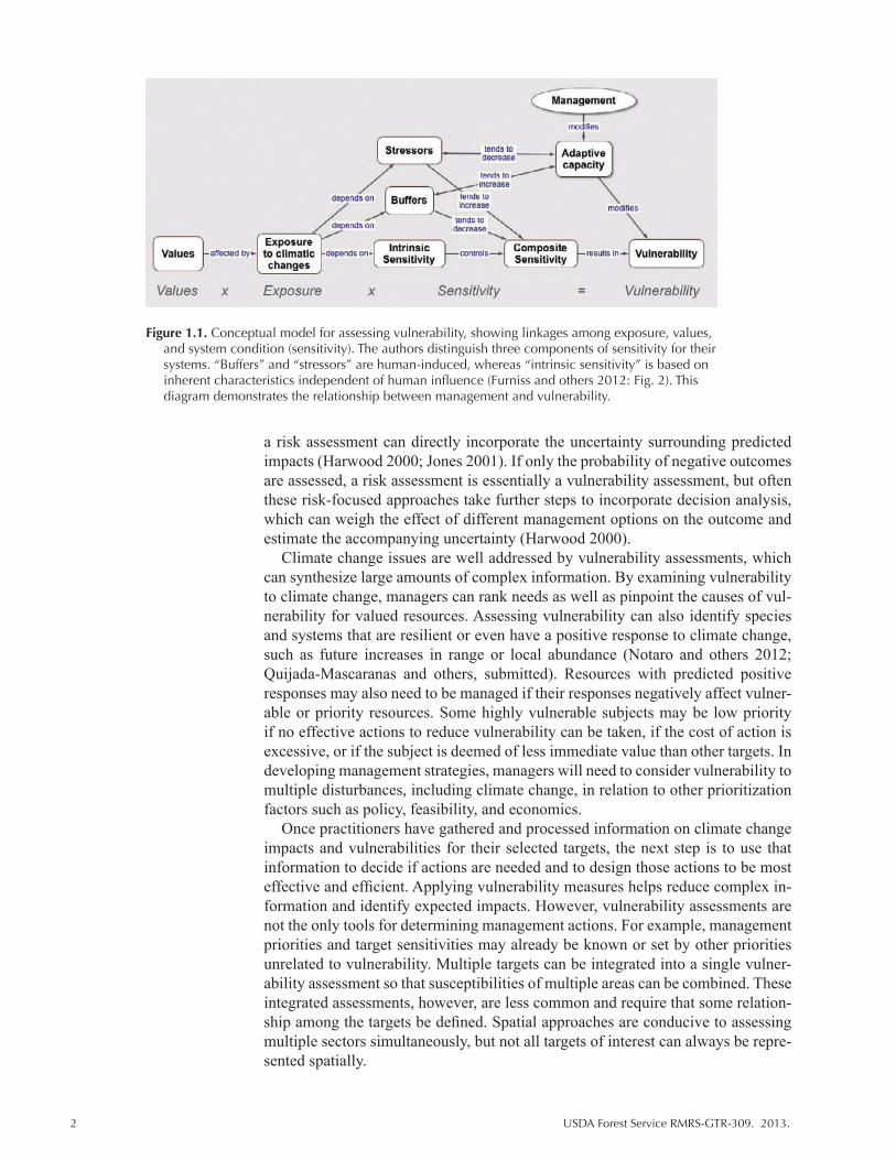
FiguresFigure 1.1. Conceptual model for assessing vulnerability, showing linkages among
exposure, values, and system condition (sensitivity). The authors distinguish three components of sensitivity for their systems. “Buffers” and “stressors” are human-induced, whereas “intrinsic sensitivity” is based on inherent characteristics independent of human influence (Furniss and others 2012: Fig. 2). This diagram demonstrates the relationship between management and vulnerability. ................................ 2
Figure 1.2. An overview of assessment components and some key considerations for designing or applying a vulnerability assessment. An assessment will include all elements of scope (reviewed Chapter 2) and one or more measures of response (Chapter 3) and vulnerability (Chapter 4). ............................................................................ 4
Figure 2.1. Adapted from Poiani and others 2000. Biodiversity at various spatial scales. Levels of biological organization include ecosystems and species. Ecosystems and species are defined at four geographic scales: local, intermediate, coarse, and regional. The general range in hectares for each spatial scale is indicated (left of pyramid), as are common characteristics of ecosystems and species at each of the spatial scales (right of pyramid). ........................................................ 10
vi
Figure 3.1. Top. Temporal and spatial variation among biological scales (light blue) and the impact of common disturbances (dark blue) for forested ecosystems (patterned after Bunnel and Huggard 1999). See Chapter 2 for a detailed discussion. Bottom. Spatial and temporal extent of target ouput for methods for assessing impact of climate change on various ecological parameters. Disturbance parameters (grey) are shown for reference. This figure represents the common geographic scale at which certain analyses are conducted. GCMs (dark blue) produce daily and monthly estimates of a of broad-scale climate parameters. BCE models (light green) are commonly used for species-level analysis and are often used to estimate distribution over a wide area. Process based models (light green) usually involve plant functional groups and use physiological processes to estimate distribution of groups across a wide spatial scale. Successional models (light green) are oriented toward patch-level interactions. The spatial extent of frameworks and indices (yellow) is typically defined by the user’s objectives. Hydrological models (blue) can focus on the entire reach of a target river or, more commonly, on a watershed of interest. Most methods focus on estimating conditions over the next century and few address seasonal variations. Exceptions include hydrological models, process-based models, and some index-based methods. .................. 22
Figure 3.2. Example of the Gallatin National Forest watershed vulnerability model (from Louie 2012). .............................................................................................................. 25
Figure 3.3. From IPCC (2007: 2-2). Range of major uncertainties that are typical in impact assessments, showing the “uncertainty explosion” as these ranges are multiplied to encompass a comprehensive range of future consequences, including physical, economic, social, and political impacts and policy responses (modified after Jones 2000, and “cascading pyramid of uncertainties” in Schneider 1983). ................. 36
Figure 4.1. Observed response of terrestrial wildlife to climate change effects from 189 studies reviewed by Joyce and others (2008). These patterns can be translated into information that identifies which species might be most affected by future climate conditions. Adapted from Joyce and others (2008). ................................................. 44
Figure 4.2. Richness of American tree species under current (A) and future (B and C) climate scenarios. Future (B) represents projections under increasing CO2 whereas future (C) represents conditions with future decrease in CO2. This study presents an estimate of future effects based upon current understood relationships between tree richness and climate variables. CE=Climate envelope richness. Adapted from McKenney and others 2007. ............................................................................................... 46
Figure 4.3. An example of how the degree of response (species richness) might be used to measure vulnerability. Here, darker colors represent areas that are expected to experience the greatest change and are therefore at greatest risk of negative impact, in species composition under a A1B greenhouse gas scenario. (A) represents projections for a 100 x 100-km grid and (B) represents 200 x 200-km grid projections. Adapted from Lawler and others (2009). ................................................... 47
Figure 4.4. Observed changes in nesting attempts and fledglings per pair among four bird species in California due to extreme drought. Year 2002 was the driest year on record for the past 150 years. This study provides an example of how and to what degree future populations might be affected by particular climate trends. Adapted from Bolger and others (2005). ............................................................................. 48
Figure 4.5. Transitions between carbon (C) states: C4 to C3 (red) and C3 to C4 (blue) grass communities in response to increased temperatures and atmospheric pCO2 since the last glacial maximum (approximately 20,000 years before present). Adapted from Collatz and others (1998). ............................................................................ 48
Figure 4.6. Results of this study identified the critical thresholds that lead to widespread mortality in pine species in the Southwest. From Breshears and others (2005). Copyright 2005 National Academy of Sciences, USA. ....................................................... 49
Figure 4.7. Schematic of the relationship between adaptive capacity and species vulnerability. Adaptive capacity affects species vulnerability by modulating exposure and sensitivity. Adapted from Engle 2011. ............................................................ 50
vii

Figure 4.8. Effect of each driver on biodiversity change for each terrestrial biome and freshwater ecosystem type calculated as the product of the expected change of each driver times its impact for each terrestrial biome or freshwater ecosystem. Values are relative to the maximum possible value. Bars: 1, land use; 2, climate; 3, nitrogen deposition; 4, biotic exchange; 5, atmospheric CO2. From Sala and others (2000). Reprinted with permission from American Association for the Advancement of Science (AAAS). ................................................................................................. 51
Figure 4.9. Steps for developing and implementing adaptation options. This diagram, first presented in Peterson and others (2011), represents an iterative process and includes repetitive review and ranking steps. ...................................................................... 53
Figure 4.10. Example of work-flow used to create a vulnerability assessment that is translated to on-the-ground management strategies. Endpoints are determined by the questions and objectives of managers and are largely influenced by management strategies to mitigate, improve, or facilitate response to climate change. Target selection depends upon the desired endpoint and influences the relevant measures used to gauge target vulnerability. Targets also influence the availability of relevant measures. ........................................................................................................................... 54
Figure 5.1. Figure from the U.S. Global Change Research Program’s 2009 report showing relative changes in precipitation. Predicted change in spring precipitation for 2080-2099 as compared to 1961-1979 for lower and higher emission scenarios. Hatched areas indicate greatest confidence. Report available at: http://nca2009. globalchange.gov/southwest ............................................................................................... 61
Figure 5.2. Vulnerability of species from the Barry M. Goldwater Range (from Bagne and Finch 2013). This study used a vulnerability index tool that assessed exposure, sensitivity, and adaptive capacity through scenario building and a questionnaire that results in scoring system. Scores were generated for four categories as well as for the collective (overall) expected vulnerability. .......................................................... 72
Figure 5.3. Forest responses to two climate change scenarios (OSU, GFDL-Q at 10-km (fine grid) and 50-km (coarse grid) scales. From Chapter 4 of Joyce and Birdsey (2000). ................................................................................................................... 78
Figure 5.4. Projected changes in median runoff for 2041-2060 as compared to 1901-1970 based on modest emission scenario. Grey lines represent water-resource region. Hatched areas indicate greatest confidence in model projections. From the U.S. Global Change Research Program, 3rd National Climate Assessment. ................... 82
Figure 5.5. Vulnerability of watershed (blue outline) as estimated by combining scored estimates of water resource values, sensitivity, and exposure. .................................. 86
viii
USDA Forest Service RMRS-GTR-309. 2013. 1
Chapter 1. Vulnerability Assessments in Natural Resource Management: Overview and Application
1.1 The Climate Change Challenge
The impacts of climate change on global ecosystems are apparent, and future change is likely to be dramatic (Nicholls Cazenave 2010; Williams and others 2010; Chen and others 2011; Notaro and others 2012). Climate change is emerging as a dominant challenge for resource managers and decision-makers. The breadth and complexity of climate change effects make it difficult to accurately detect, pre-dict or understand the full range of impacts on ecosystems and, therefore, to design management actions that can minimize undesirable effects. Management based only on current or recent past conditions may not be adequate to address long-term changes in resources prompted by climate change (Millar and others 2007). Consequently, it is critical to plan ahead based on evidence and predictions of future climate and related impacts. Climate change vulnerability assessments seek to synthesize the available information on changes of and responses to climate for a region, sector, or resource of interest. Through this synthesis, assessments can be used to identify priority and effective management options that are essential considering the limitations of time, money, and personnel. The need for assess-ments accompanied by proactive and targeted management is great because a large number of stressors affect natural and human systems, the pace of environmental change is rapid, and management resources are limited. Vulnerability assessments cover a wide range of topics, methods, and scales. In this report, we outline key concepts, assessment methods, modeling approaches, and provide guidance for us-ing assessments for natural resource management under climate change.
1.2 Climate Change Vulnerability Assessments
The Intergovernmental Panel on Climate Change (IPCC) defines vulnerability to climate change as “the degree to which a system is susceptible to, and unable to cope with, adverse effects of climate change, including climate variability and ex-tremes” (Solomon and others 2007). Vulnerability assessments are a fundamental tool available to many disciplines and sectors but are particularly applicable to man-agement of natural resources, which is the focus of this document. Vulnerability is a combination of exposure, sensitivity, and adaptive capacity, although these components are not always distinct nor are all three always integrated into every vulnerability assessment (USGCRP 2011; Fig. 1.1). Essentially, the response of a system, species, or individual to climate change will depend on: (1) the effects to which it is exposed, (2) how it responds to or is sensitive to those impacts, and (3) its capacity to ameliorate the effects it experiences. Vulnerability assess-ments generally differ from impact assessments, which identify and quantify the effects of climate change, by focusing on the causes of and variation in expected impacts with the specific intent to identify effective and efficient management ac-tions that will reduce the negative impacts predicted (Füssel and Klein 2005; Glick and others 2011). Another approach similar to a vulnerability assessment is a risk assessment or decision analysis, which focuses on the probability of negative out-comes and their consequences. The negative outcome is a set impact threshold, and
2 USDA Forest Service RMRS-GTR-309. 2013.
a risk assessment can directly incorporate the uncertainty surrounding predicted impacts (Harwood 2000; Jones 2001). If only the probability of negative outcomes are assessed, a risk assessment is essentially a vulnerability assessment, but often these risk-focused approaches take further steps to incorporate decision analysis, which can weigh the effect of different management options on the outcome and estimate the accompanying uncertainty (Harwood 2000).
Climate change issues are well addressed by vulnerability assessments, which can synthesize large amounts of complex information. By examining vulnerability to climate change, managers can rank needs as well as pinpoint the causes of vul-nerability for valued resources. Assessing vulnerability can also identify species and systems that are resilient or even have a positive response to climate change, such as future increases in range or local abundance (Notaro and others 2012; Quijada-Mascaranas and others, submitted). Resources with predicted positive responses may also need to be managed if their responses negatively affect vulner-able or priority resources. Some highly vulnerable subjects may be low priority if no effective actions to reduce vulnerability can be taken, if the cost of action is excessive, or if the subject is deemed of less immediate value than other targets. In developing management strategies, managers will need to consider vulnerability to multiple disturbances, including climate change, in relation to other prioritization factors such as policy, feasibility, and economics.
Once practitioners have gathered and processed information on climate change impacts and vulnerabilities for their selected targets, the next step is to use that information to decide if actions are needed and to design those actions to be most effective and efficient. Applying vulnerability measures helps reduce complex in-formation and identify expected impacts. However, vulnerability assessments are not the only tools for determining management actions. For example, management priorities and target sensitivities may already be known or set by other priorities unrelated to vulnerability. Multiple targets can be integrated into a single vulner-ability assessment so that susceptibilities of multiple areas can be combined. These integrated assessments, however, are less common and require that some relation-ship among the targets be defined. Spatial approaches are conducive to assessing multiple sectors simultaneously, but not all targets of interest can always be repre-sented spatially.
Figure 1.1. Conceptual model for assessing vulnerability, showing linkages among exposure, values, and system condition (sensitivity). The authors distinguish three components of sensitivity for their systems. “Buffers” and “stressors” are human-induced, whereas “intrinsic sensitivity” is based on inherent characteristics independent of human influence (Furniss and others 2012: Fig. 2). This diagram demonstrates the relationship between management and vulnerability.
USDA Forest Service RMRS-GTR-309. 2013. 3
1.3 Vulnerability Assessment Approaches
A wide range of approaches has been used to assess natural resources impact-ed by climate change and to glean management recommendations. Mathematical modeling approaches to estimate change or probability of change are common and can range from complex sets of equations representing multiple influencing factors or aspects of the resource to indices that distill response into ranks or classification representing vulnerability. Mathematical modeling covers a large number of meth-ods, which are outlined in Table 3.1 and detailed in Appendix 1. All models are limited in their ability to represent all contributing processes and factors. Indices simplify response and are specifically designed to address vulnerability and tran-sition easily to management recommendations. More complex models focus on improving predicted response, but their results often need to be translated into a measure of vulnerability (see Chapter 4). Conceptual frameworks focus on the re-lationships and linkages among factors, resource targets, and interacting elements. Conceptual frameworks can be used to clarify goals or identify key elements and are often used when vulnerability is assessed through a consensus of experts or stakeholders (Table 3.2). Frameworks are well suited to incorporating local is-sues and, like indices, can be effective even when information is sparse. Synthesis is a common assessment approach that collects available information on impacts and the resource of interest to compile knowledge and glean recommendations. Included information may be derived from any number of approaches, including modeling, experimental studies, or expert opinion. Because a synthesis gathers, re-views, and integrates information, there is no specific methodology for ranking or formally integrating information sources, but a large number of disparate aspects can be combined and factors other than vulnerability can be included (e.g., legal requirements, costs, and cultural values). Note that these approaches are not mutu-ally exclusive and a single assessment may integrate multiple approaches.
1.4 Steps for Conducting a Vulnerability Assessment
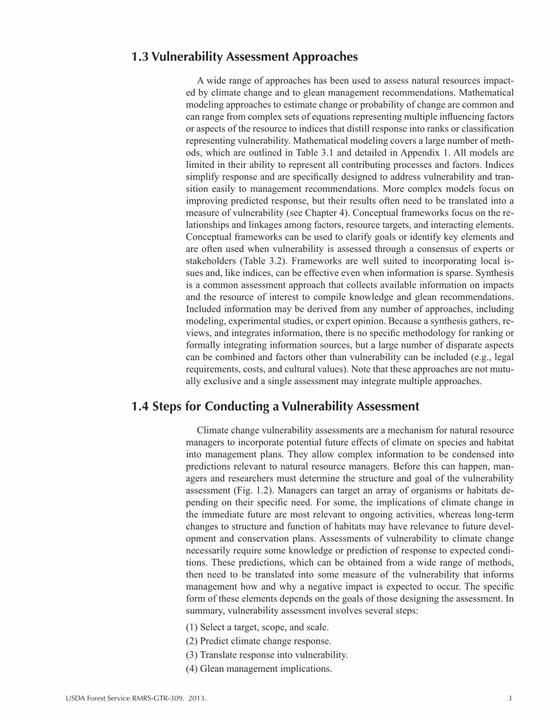
Climate change vulnerability assessments are a mechanism for natural resource managers to incorporate potential future effects of climate on species and habitat into management plans. They allow complex information to be condensed into predictions relevant to natural resource managers. Before this can happen, man-agers and researchers must determine the structure and goal of the vulnerability assessment (Fig. 1.2). Managers can target an array of organisms or habitats de-pending on their specific need. For some, the implications of climate change in the immediate future are most relevant to ongoing activities, whereas long-term changes to structure and function of habitats may have relevance to future devel-opment and conservation plans. Assessments of vulnerability to climate change necessarily require some knowledge or prediction of response to expected condi-tions. These predictions, which can be obtained from a wide range of methods, then need to be translated into some measure of the vulnerability that informs management how and why a negative impact is expected to occur. The specific form of these elements depends on the goals of those designing the assessment. In summary, vulnerability assessment involves several steps:
(1) Select a target, scope, and scale.(2) Predict climate change response.(3) Translate response into vulnerability.(4) Glean management implications.
4 USDA Forest Service RMRS-GTR-309. 2013.
These steps, whether or not they are highlighted explicitly, are key components of all vulnerability assessments. The chapters that follow discuss how assessments target appropriate subjects and scope (Chapter 2). In Chapter 3, we cover the tools and methods commonly used to predict climate change response and then discuss how to translate that response into vulnerability (Chapter 4). Finally, we synthesize the use and application of climate change vulnerability assessments conducted for the southwestern United States (Chapter 5).
1.5. Vulnerability Assessments in Natural Resource Management
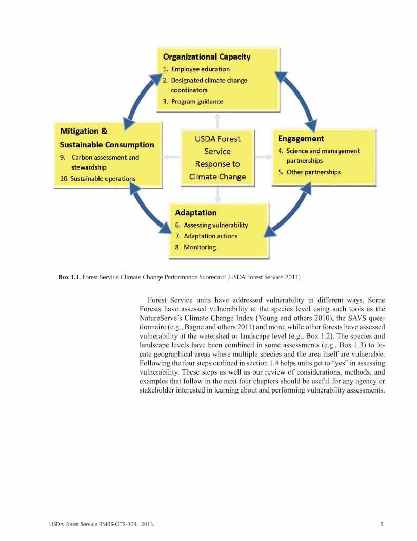
Many natural resource agencies are conducting vulnerability assessments at var-ious levels of sophistication and for different purposes, often in relation to agency strategic plans and requirements. As an example, the USDA Forest Service has developed a National Roadmap for Responding to Climate Change (USDA Forest Service 2011) based on its strategic framework (USDA Forest Service 2009). The Scorecard identifies vulnerability assessment and adaptation as 2 of 10 elements in four dimensions of accountability for responding to climate change (Box 1.1).
Managers must be able to respond “yes” to 7 of the 10 elements, posed as ques-tions, in the agency’s “performance scorecard.” The vulnerability assessment question, “Has the Unit engaged in developing relevant information about the vul-nerability of key resources, such as human communities and ecosystem elements, to the impacts of climate change?” can be answered through a variety of approach-es. Another element focused on adaptation is linked to vulnerability: “Does the Unit conduct management actions that reduce the vulnerability of resources and places to climate change?”
Figure 1.2. An overview of assessment components and some key considerations for designing or applying a vulnerability assessment. An assessment will include all elements of scope (reviewed Chapter 2) and one or more measures of response (Chapter 3) and vulnerability (Chapter 4).
USDA Forest Service RMRS-GTR-309. 2013. 5
Forest Service units have addressed vulnerability in different ways. Some Forests have assessed vulnerability at the species level using such tools as the NatureServe’s Climate Change Index (Young and others 2010), the SAVS ques-tionnaire (e.g., Bagne and others 2011) and more, while other forests have assessed vulnerability at the watershed or landscape level (e.g., Box 1.2). The species and landscape levels have been combined in some assessments (e.g., Box 1.3) to lo-cate geographical areas where multiple species and the area itself are vulnerable. Following the four steps outlined in section 1.4 helps units get to “yes” in assessing vulnerability. These steps as well as our review of considerations, methods, and examples that follow in the next four chapters should be useful for any agency or stakeholder interested in learning about and performing vulnerability assessments.
Box 1.1. Forest Service Climate Change Performance Scorecard (USDA Forest Service 2011)

6 USDA Forest Service RMRS-GTR-309. 2013.
Box 1.3. Reports showing applications of the SAVS tool at the species and landscape levels for the Coronado National Forest.
Spatial patterns of cross-species vulnerability were identified by applying SAVS scores to species habitat distribution models.
RMRS applied the SAVS tool to 30 at risk species on the Coronado National Forest
SAVS, an RMRS tool, uses a questionnaire of 22 predictive criteria to create vulnerability scores for terrestrial vertebrate species
Vulnerability Assessments: What Are Forests Doing?
Vulnerability of forest tree species and non-forested habitat to climate change and proposed management actions under future climate scenarios in Washington.
Impacts and vulnerability of tree species and forest types to climate change in northern Wisconsin.
Assesses past climate history, future climate scenarios and natural resource vulnerabilities in Wyoming
Box 1.2 Examples of vulnerability assessments conducted on forests.
USDA Forest Service RMRS-GTR-309. 2013. 7
Literature Cited
Bader, D.C., C. Covey, W.J. Gutowski, Jr., I.M. Held, K.E. Kunkel, R.L. Miller, R.T. Tokmakian, and M.H. Zhang. 2008. Climate Models: An Assessment of Strengths and Limitations. A Report by the U.S. Climate Change Science Program and the Subcommittee on Global Change Research. Department of Energy, Office of Biological and Environmental Research, Washington, DC, USA. 124 pp.
Füssel, H., and R. Klein. 2006. Climate Change Vulnerability Assessments: An Evolution of Conceptual Thinking. Climatic Change 75: 301-329.
Glick, P., B.A. Stein, and N.A. Edelson, eds. 2011. Scanning the conservation horizon: a guide to climate change vulnerability assessment. National Wildlife Federation, Washington, DC.
Harwood, J. 2000. Risk assessment and decision analysis in conservation. Biological Conservation 95: 219-226.
Iverson, Louis R., M.W. Schwartz, and Anantha M. Prasad. 2004. Potential colonization of newly available tree-species habitat under climate change: an analysis for five eastern US species. Landscape Ecology 19: 787-799.
Jenni, L., and M. Kery. 2003. Timing of autumn bird migration under climate change: advances in long–distance migrants, delays in short–distance migrants. Proceedings of the Royal Society, London 270: 1467-1471.
Jones, R. 2001. An Environmental Risk Assessment/Management Framework for Climate Change Impact Assessments. Natural Hazards 23: 197-230.
Parmesan, C. 2006. Ecological and Evolutionary Responses to Recent Climate Change. Annual Review of Ecology, Evolution, and Systematics 37: 637-669.
Peterson, D.L., C.I. Millar, L.A. Joyce, M.J. Furniss, J.E. Halofsky, R.P. Neilson, and T.L. Morelli. 2011. Responding to climate change in National Forests: a guidebook for developing adaptation options. USDA Forest Service, Pacific Northwest Research Station, Gen. Tech. Rep. PNW-GTR-855.
Schmitz, O.J., E. Post, C.E. Burns, and K.M. Johnston. 2003. Ecosystem Responses to Global Climate Change: Moving Beyond Color Mapping. BioScience, 53(12):1199-1205.
Smith, J.B., S.H. Schneider, M. Oppenheimer, [and others]. 2009. Assessing dangerous climate change through an update of the Intergovernmental Panel on Climate Change (IPCC) “reasons for concern.” Proceedings of the National Academy of Sciences 106:4133-4137.
Solomon, S., D. Quin, M. Manning, eds. 2007. Climate change 2007: the physical science basis. Contribution of working group I to the fourth assessment report of the Intergovernmental Panel on Climate Change. Cambridge University Press, Cambridge, UK.
U.S. Global Change Research Program [USGCRP]. 2011. Uses of vulnerability assessments for the National Climate Assessment. U.S. National Climate Assessment, Report 9.
USDA Forest Service. 2007. Strategic Plan FY 2007-2012, United States Department of Agriculture, Forest Service, FS-880. Available at: http://www.fs.fed.us/publications/strategic/fs-sp-fy07-12.pdf.
USDA Forest Service. 2011. Navigating the Climate Change Performance Scorecard. A Guide for National Forest and Grasslands, Version 2. Available at: http://www.fs.fed.us/climatechange/advisor/scorecard/scorecard-guidance- 08-2011.pdf.
8 USDA Forest Service RMRS-GTR-309. 2013.
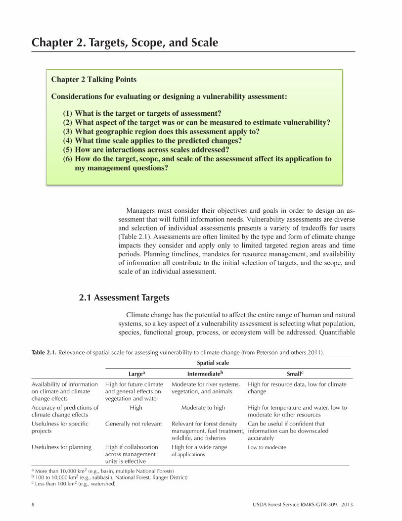
Chapter 2. Targets, Scope, and Scale
Chapter 2 Talking Points
Considerations for evaluating or designing a vulnerability assessment:
(1) What is the target or targets of assessment? (2) What aspect of the target was or can be measured to estimate vulnerability? (3) What geographic region does this assessment apply to? (4) What time scale applies to the predicted changes? (5) How are interactions across scales addressed? (6) How do the target, scope, and scale of the assessment affect its application to
my management questions?
Managers must consider their objectives and goals in order to design an as-sessment that will fulfill information needs. Vulnerability assessments are diverse and selection of individual assessments presents a variety of tradeoffs for users (Table 2.1). Assessments are often limited by the type and form of climate change impacts they consider and apply only to limited targeted region areas and time periods. Planning timelines, mandates for resource management, and availability of information all contribute to the initial selection of targets, and the scope, and scale of an individual assessment.
2.1 Assessment Targets
Climate change has the potential to affect the entire range of human and natural systems, so a key aspect of a vulnerability assessment is selecting what population, species, functional group, process, or ecosystem will be addressed. Quantifiable
Table 2.1. Relevance of spatial scale for assessing vulnerability to climate change (from Peterson and others 2011).
Spatial scale
Largea Intermediateb Smallc
Availability of information High for future climate Moderate for river systems, High for resource data, low for climate on climate and climate and general effects on vegetation, and animals change change effects vegetation and water
Accuracy of predictions of High Moderate to high High for temperature and water, low to climate change effects moderate for other resources
Usefulness for specific Generally not relevant Relevant for forest density Can be useful if confident that projects management, fuel treatment, information can be downscaled wildlife, and fisheries accurately
Usefulness for planning High if collaboration High for a wide range Low to moderate across management of applications units is effectivea More than 10,000 km2 (e.g., basin, multiple National Forests)b 100 to 10,000 km2 (e.g., subbasin, National Forest, Ranger District)c Less than 100 km2 (e.g., watershed)
USDA Forest Service RMRS-GTR-309. 2013. 9
aspects of the target as they relate to management objectives will determine the variable upon which vulnerability measures are based. For example, population growth rates could be used to assess a group of frog species at risk of extinction and stream flow would be an appropriate variable for a target watershed that provides water to urban or agricultural areas. Vulnerability assessments are most useful when they address the critical needs of managers or conservationists. A wide range of assessment targets, from individuals or populations to landscapes and processes, can be evaluated for vulnerability. Targets represent the resource value of interest and will depend on management objectives, but targets will also be constrained by policies, budgets, and available information (see Chapter 4, Table 4.1). Important considerations for target selection include the available information regarding po-tential system or species to be assessed, the time line of desired outcomes, and the specific objectives of the user. The audience for which the vulnerability assessment is being prepared and the input of stakeholders can also be important consider-ations for selecting targets (Glick and others 2011). If the target is a single subject (e.g., one species, one watershed), the purpose of a vulnerability assessment is to dissect the nature of expected impacts to that target. When the target includes multiple subjects (e.g., plant functional groups, watersheds of Oregon, and en-dangered species), ranking or prioritization of the subjects is possible along with information on the particular vulnerabilities of the individual subjects. There are also new efforts to integrate vulnerability across multiple targets or sectors to get a more complete picture of vulnerability (USGCRP 2011). When using assessment results to generate management strategies, it is critical to consider how and why targets were selected to ensure that the information provided by the assessment is used appropriately.
Limitations in data availability influence the feasibility of assessing of particu-lar targets. Data limitations reduce the applicability of many types of vulnerability assessments. For example, although species’ vulnerability can be assessed with minimal data in some situations (Bagne and others 2011), a relatively complete understanding of species biology provides better prediction of response and thus a better approximation of vulnerability. Response of broader plant function-al groups or community types (e.g., mixed-conifer forest, semi-arid shrubland, and grasslands) can be very useful for managers because they encompass many whole-system properties that may be missed when single species are the focus of assessment. Similarly, estimates of climate change effects for ecosystem processes, which are very useful for identifying fundamental large-scale vulnerability, require a great deal of data and an understanding of complex dynamics among multiple contributing components. Though vulnerability assessments will be most useful and applicable when used on systems that have adequate data, assessments that focus on more general targets are possible and still valuable where data are limited.
2.2 Scope
Assessments are generally prepared for a specific geographic region and time period. The scope of the assessment considers both temporal and spatial scale, which will be determined by the availability of suitable input data, the manage-ment unit, selected assessment target(s), and timeline for management planning. For natural resource managers, management units and jurisdiction often dictate the focal region. Time scale is an important aspect of climate projections that affects application to management goals. Management strategies may focus on short-term goals relating to preserving or restoring current conditions or on long-term goals
10 USDA Forest Service RMRS-GTR-309. 2013.
that aim to maintain ecosystem function and stability over time. These distinct temporal components naturally lead to different targets and objectives for a vulner-ability assessment. Scope also applies to the range of stressors used (i.e., the source of vulnerability) in the assessment because climate change includes not just tem-perature and precipitation but also related phenomena such as stream flow, erosion, disturbance (fire and insect outbreaks), and extreme weather events. Therefore, the range of climate-related stressors considered can be quite broad and encompass multiple interrelated stressors or focus more narrowly on a single stressor of inter-est (e.g., drought, sea level rise) that has a strong effect on the target. Inclusion of non-climate change stressors can also broaden scope of the assessment.
Difficulties arise when the temporal and spatial scales of available data are lim-ited and/or differ from the desired scope of the assessment. Available data such as outputs from climate models are scale limited and generally much larger than typical management units. To produce projections at finer scales, many down-scaling methods are available for climate projections. The most commonly used approaches are dynamic (in which climate physics and chemistry are modeled at regional scales, in the same way used in General Circulation Models or GCMs), and statistical downscaling, which is accomplished by interpolating coarser resolu-tion GCM data using a variety of spatial statistical methods. Downscaling brings climate projections to a spatial scale that can be very useful for managers (e.g., 25 km2 grid cells). Downscaling can also correct regional bias found in many global climate projections and is inherent to results of efforts to produce projections that are averaged across multiple climate models (Bader and others 2008). However, these methods, along with the unknown progression of greenhouse gas inputs, add error, which contributes to variability and uncertainty in the predictions made by a vulnerability assessment.
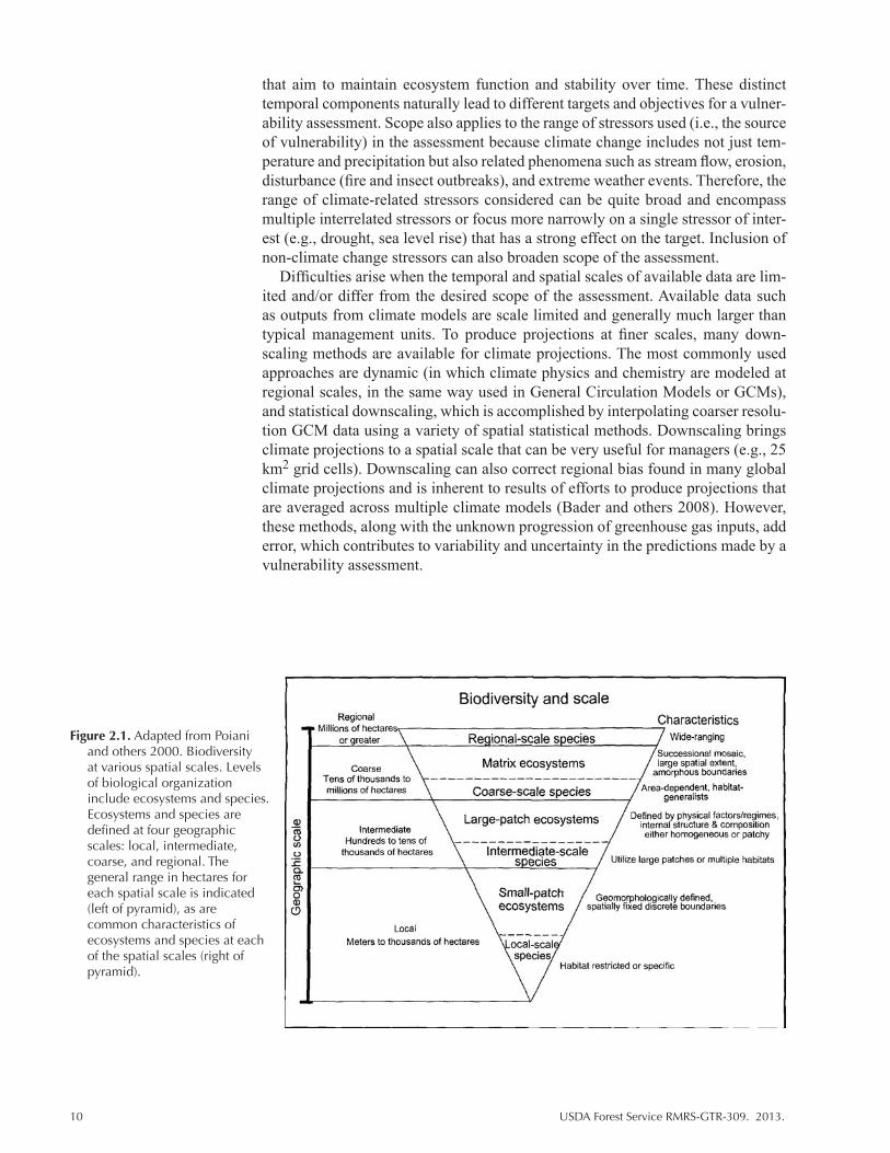
Figure 2.1. Adapted from Poiani and others 2000. Biodiversity at various spatial scales. Levels of biological organization include ecosystems and species. Ecosystems and species are defined at four geographic scales: local, intermediate, coarse, and regional. The general range in hectares for each spatial scale is indicated (left of pyramid), as are common characteristics of ecosystems and species at each of the spatial scales (right of pyramid).

USDA Forest Service RMRS-GTR-309. 2013. 11
2.3 Biological Scale
Biological scales range from the levels of genomes and species (e.g., Durance and Ormerod 2007; Triepke and others 2012) to continent-scale ecological biomes (e.g., Rehfeldt and others 2012) (Fig. 2.1). The appropriate scale depends on the target defined for the vulnerability assessment, as mentioned in the previous sec-tion. Furthermore, assessments may include evaluation targets across multiple scales or cross-scale. Both spatial and temporal scales may be considered simulta-neously with any given biological entity. Time scales vary from years (e.g., Allen and Breshears 1995) to a century or more (e.g., Parmesan and Yohe 2003), while spatial scales vary from individual niches and biotic communities (e.g., Hofstetter and others 2007) to intercontinental levels (Allen 2009). From the standpoint of conservation biology, biological scales are typically expressed simultaneously in terms of space and time. It is important to understand how biological processes operate across a range of spatial and temporal scales and how those processes are ultimately manifested in biological diversity.
Biological scales provide key concepts in linking temporal and spatial—lo-cal, regional, and biogeographical—scales where dynamics are driven by climate change. For example, the effects of landscape homogenization, as a result of warm-er temperatures and uncharacteristic fires, are sometimes treated as static when, in reality, the spatial effects of changing landscape patterns on the distribution of specific species may be apparent only at the population level. Spatial responses of populations and metapopulations to disturbances must be understood and quanti-fied at a range of spatial scales concurrently with the frequencies and intensities of disturbance.
Here, we provide a brief look at biological scale in respect to conservation is-sues and climate change. Biological scales are an initial response to management or research inquiries—for example, “how will climate change projections affect the willow flycatcher?” At broader scales, one might ask “where is pinyon die-off most likely?” At continental scales, “what is the potential range of suitable habitat for Douglas-fir 100 years from now?” While there is a considerable range of bio-logical scales, we briefly consider two—species and ecosystems. We then present a review of the Forest Service landscape analysis, which provides an example of one way in which an assessment manages scope and scale.
2.3.1 Species Scale
Individual species are a common concern for managers and researchers in re-gard to climate change vulnerability, and their response will filter up to targets at broader scales. Species often reflect a familiar operational level and a suitable biological scale, given that species protection is fundamental to conservation and is embedded in core mandates of Federal agencies (e.g., 7 USC § 136, 16 U.S.C. § 1531 et seq.). The rationale for these mandates is that those species that are sensitive to climate change can be identified, their locations and habitats can be catalogued and mapped, and species can be managed through protective habitat measures, including adaptation (Millar and others 2007). The Nature Conservancy identified approximately 120 plant and animal species in the Southwest that are at risk according to the habitats most vulnerable to climate change (Robles and Enquist 2011). Problems arise at the species scale because of sparse information on the vast majority of species.
12 USDA Forest Service RMRS-GTR-309. 2013.
2.3.2 Ecosystem Scale
Ecosystems are the relevant biological scale for application of coarse filter methodology, which estimates biodiversity based largely on environmental fac-tors (Cushman and others 2008). Like species, ecosystem entities are familiar to managers and researchers alike, in regard to ecological analysis and conservation strategies. While definitions for ecosystem vary, in general, ecosystems consist of biota that share common habitat features, biogeography, and climate, making them a particularly relevant biological scale for the evaluation of climate change.
Ecosystems, however, are problematic to delineate. Ecosystems are far from homogenous, spatially or temporally, and are a dynamic and shifting mixture of various stages of ecological succession whose expression in time and space bear on biological development and disturbance patterns. Nevertheless, ecosystems are of-ten mapped to facilitate vulnerability assessment and ecological analysis (Cleland and others 2007; Triepke and others 2008). Once mapped, key questions are posed for those evaluating the effects of climate change at the ecosystem scale: (1) to what extent are ecosystems affected by climate change in regards to their natural functioning; and (2) how can ecosystem function be accommodated through ad-aptation strategies for the persistence of the species that ecosystems contain (via coarse filter analysis). Landscape analysis, for which the ecosystem scale is most associated with, is discussed in the next section.
2.4 Case Study: Landscape Analysis
Following is a summary of landscape analysis in the context of climate change and vulnerability assessment. This is not an exhaustive overview, but rather a de-scription of common features found in landscape analyses, particular those of the USDA Forest Service (e.g., USDA Forest Service 2006). The biological scale most easily adapted to landscape-scale analysis is the ecosystem level discussed in the previous section; however, a landscape analysis provides the requisite coarse-filter framework for the analysis of fine-filter elements (Cushman and others 2008), in-cluding individual species of concern and interest. Unlike biological scale, the scales associated with landscape analyses are usually spatially and temporally explicit. Within the Forest Service, landscape analysis normally includes three in-terdependent sustainability components, ecological, social, and economic, though the focus here is on the ecological component.
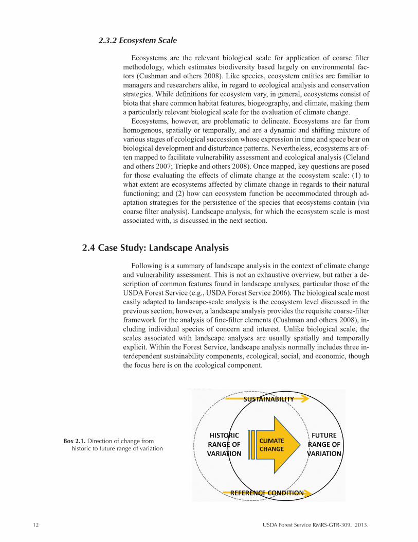
Box 2.1. Direction of change from historic to future range of variation

USDA Forest Service RMRS-GTR-309. 2013. 13
Another factor common to landscape analyses of the Forest Service is the ap-plication of a reference condition–a benchmark range of conditions that reflect ecological sustainability for a given attribute (FRCC 2010). Reference condition concepts, including their importance in evaluating sustainability, have not been lost on the Forest Service’s new Planning Rule (2012), though the definition of reference condition is shifting in light of climate change (see Box 2.1). The Forest Service recognizes that as ecosystem potentials shift with changing climate that the historic range of variation, often used to help describe the reference condition, may lose significance. Either way, in the course of landscape analysis, reference condi-tions are typically identified for key attributes of vegetation community structure and composition, disturbance regimes, and other attributes that collectively reflect ecosystem structure, function, and process.
In sum, landscape analysis usually involves: (1) the selection of appropriate attributes along with spatial and temporal scales for analysis; (2) describing the reference condition, current condition, and trends of ecosystem attributes; and (3) analyzing the status of those attributes, often as departure from reference condi-tions (USDA Forest Service 2006).
2.4.1 Ecosystem Attributes
Ecosystem attributes should be meaningful for the characterization of struc-ture, function, and process, and meaningful to past, current, or future management. Ecosystem abundance and diversity, for instance, are often described by quantify-ing successional states, each state delineated by their differences in structure and composition—canopy cover class, size class, dominance type (Triepke and oth-ers 2005). The proportion of successional stages is compared among reference, current, and future conditions. Both reference and future conditions are often iden-tified through landscape simulation models (Weisz and others 2009, 2010), using different parameterizations for the type, frequency, and severity of disturbance. The degree to which current and reference conditions differ, or to which future and reference conditions differ, is shown in tabular summaries and expressed in departure index values where lower departure reflects a greater degree of ecologi-cal sustainability.
Other ecosystem attributes involve major disturbances. For instance, the fre-quency of fire, both wildfire and planned ignitions, is quantified by each severity class (non-lethal, mixed severity, and stand replacement). Here again, comparisons are made between current and reference conditions, or future and reference condi-tions. Insect and disease agents are likewise quantified by frequency and severity for forest and woodland systems (e.g., Lynch and others 2008). Other major distur-bance processes include herbivory, erosion, and flooding.
Spatial attributes are not often evaluated with landscape analyses, though we recognize the importance of evaluating landscape metrics such as patch size, con-nectivity, interior forest, and other spatial features significant to the biota of an area (Forman and Godron 1986). Though various geographic information sys-tems (GIS) and spatial analysis tool exist for quantitative analysis (McGarigal and Marks 1995), the difficulty has often been in establishing reference conditions for each ecosystem from which to assess sustainability. Sometimes uncharacteristic levels of fragmentation are simply assumed so that analysis is relegated to a com-parison of management scenarios and their ability to affect landscape connectivity.
To fully address climate change, much more sophisticated landscape simula-tion models are necessary, models that can project vegetation patterns based on future climate and along with growth and disturbance patterns in natural plant

14 USDA Forest Service RMRS-GTR-309. 2013.
communities (Bachelet and others 2001). These models have has limited applica-tion in the Southwest but will be needed not only to project ecosystem conditions but to reestablish reference conditions. Reference conditions of the future will re-flect shifting site potential patterns, biological migrations, and new disturbance potentials.
2.4.2 Cross-Scale Applications
Any one of the attributes mentioned above can be analyzed at multiple scales. As an example, Forest Plan revision analyses that were conducted in the Southwestern Region (USDA Forest Service 2006) focused on three nesting scales—ecological sections (Cleland and others 2007), Plan Unit (e.g., at the scale of a National Forest or National Grassland), and ecological subsections. These three scales have been used successfully to assess overall ecological sustainability at the scale of the Plan Unit, to identify diversity patterns within the Plan Unit (i.e., a comparison among subsections), and to assess the Plan Unit in reference to contiguous ecological sections. The analysis of ecological sections provides planners and managers a means to determine conservation burden, for instance where ecosystem conditions are degraded within other ownerships of the same section for a given ecosystem type. Multi-scalar analysis is likewise important for cross-scale interactions that can occur with climate change. The diversity within some plant communities, for example, may actually increase by the effects of climate change and subsequent invasion by novel plant and animal components, while the overall diversity of an area may be in decline at upward spatial scales.
While a particular biologic scale may be suited to the chosen target, it is im-portant to simultaneously consider other scales when interpreting a vulnerability assessment (Table 2.1). Linking biological scales is necessary if a conservation concern occurs at a scale different from its solution. For example, climate change is occurring at scales of entire biomes, but the required adaptation strategies for fragmented landscapes are more likely to be applied at the scales of individu-al ecosystems and ecoregions (Cleland and others 2007). Research and analysis resulting from the application of different biological scales has shown different patterns of vulnerability. For instance, increases in diversity may occasionally oc-cur at the population scale as driven by climate change (Bale and others 2002) but may contradict patterns at ecosystem or biome scales where diversity is in decline. While many vulnerability assessments consider the scale effect, its inclusion in practice is largely missing from the range of studies regarding ecological effect of climate change and results from multiple scales are seldom explicitly addressed. Others argue that landscape scales are requisite for fully determining cross-scale patterns (e.g., Stevens and others 2006), admittedly making assessment more com-plicated. Interactive effects and disturbance regimes are covered in greater detail in Chapter 3.
Literature Cited
Allen, C.D. 2009. Climate-induced forest dieback: An escalating global phenomenon? Unasylva 231/232 60(1-2): 43-49.
Allen, C.D., and D.D. Breshears. 1995. A drought-induced shift in a forest/woodland ecotone: rapid response to variation in climate. Supplement to Bulletin of the Ecological Society of America 76(2): 3.

USDA Forest Service RMRS-GTR-309. 2013. 15
Allen, C.D., and D.D. Breshears. 1998. Drought-induced shift of a forest-woodland ecotone: Rapid response to climate variation. Proceedings of the National Academy of Sciences U.S. 95(25): 14839-14842.
Andersen, T., J. Carstensen, E. Hernandez-Garcia, and C.M. Duarte. 2008. Ecological thresholds and regime shifts: approaches to identification. Trends in Ecology and Evolution 24(1): 49-57.
Bachelet, D., J.M. Lenihan, C. Daly, R.P. Neilson, D.S. Ojima, and W.J. Parton. 2001. MC1—A dynamic vegetation model for estimating the distribution of vegetation and associated ecosystem fluxes of carbon, nutrient, and water. Gen. Tech. Rep. PNW-GTR-508. Corvallis, OR: USDA Forest Service, Forest Service, Pacific Northwest Research Station.
Bagne, K.E., M.M. Friggens, and D.M. Finch. 2011. A system for assessing vulnerability of species (SAVS) to climate change. Gen. Tech. Rep. RMRS-GTR-257. Fort Collins, CO: USDA Forest Service, Rocky Mountain Research Station.
Bale, J.S., G.J. Masters, I.D. Hodkinson, [and others]. 2002. Herbivory in global climate change research: direct effects of rising temperature on insect herbivores. Global Change Biology 8: 1-16.
Breshears, D.D., [and others]. 2005. Regional vegetation die-off in response to global-change-type drought. Proceedings of the National Academy of Sciences U.S. 102(42): 15144-15148.
Cleland, D.T., J.A. Freeouf, G.J. Nowacki, C. Carpenter, J.E. Keys, and W.H. McNab. 2007. Ecological subregions: Sections and subsections of the conterminous United States. USDA Forest Service, Washington Office, Washington, DC. 1:3,500,000 scale geodatabase available at: http://fsweb.wo.fs.fed.us/em/rig/index.html.
Cushman, S.A., K.S. McKelvey, C.H. Flather, and K. McGarigal. 2008. Do forest community types provide a sufficient basis to evaluate biological diversity? Frontiers in Ecology and the Environment 6: 13-17.
Durance, I., and S.J. Ormerod. 2007. Climate change effects on upland stream macroinvertebrates over a 25-year period. Global Change Biology 13: 942-957.
Fire Regime Condition Class [FRCC]. 2010. Interagency fire regime condition class guidebook, v. 3.0. National Interagency Fuels, Fire, & Vegetation Technology Transfer guide. Available at: www.frcc.gov.
Flannigan, M., B. Stocks, and B. Wotton. 2000. Climate change and forest fires. The Science of the Total Environment 262:221-229.
Forman, R.T.T., and M. Godron. 1986. Landscape ecology. New York: John Wiley & Sons.
Hobbs, R. J., Higgs, E., and Harris, J. A. 2009. Novel ecosystems: implications for conservation and restoration. Trends in Ecology and Evolution 24: 599-605.
Hofstetter, R.W., T.D. Dempsey, K.D. Klepzig, and M.P. Ayres. Temperature-dependent effects on mutualistic, antagonistic, and commensalistic interactions among insects, fungi, and mites. Community Ecology 8: 47-56.
Kitzberger T., E. Araoz, J.H. Gowda, M. Mermoz, and J.M. Morales. 2011. Decreases in fire spread probability with forest age promote alternative community states, reduced resilience to climate variability and large fire regime shifts. Ecosystems DOI: 10.1007/s10021-011-9494-y.
16 USDA Forest Service RMRS-GTR-309. 2013.
Lentile, L., P. Morgan, A. Hudak, M. Bobbitt, S. Lewis, A. Smith, and P. Robichaud. 2007. Post-fire burn severity and vegetation response following eight large wildfires across the western United States. Fire Ecology 3: 91-108.
Loehman, R.A., J.A. Clark, and R.E. Keane. 2011. Modeling Effects of Climate Change and Fire Management on Western White Pine (Pinus monticola) in the Northern Rocky Mountains, USA. Forests 2: 832-860.
Lynch, A.M., J.A Anhold, J.D. McMillin, S.M. Dudley, R.A. Fitzgibbon, and M.L. Fairweather. 2008. Forest insect & disease activity on the Prescott NF 1918-2006. USDA Forest Service unpublished technical report on file. Rocky Mountain Research Station and Southwestern Region. Tucson, AZ.
Mayer, A.L., and A.H. Khalanyi. 2011. Grass trumps trees with fire. Science 334: 188-189.
McGarigal, K., and B.J. Marks. 1995. FRAGSTATS: Spatial analysis program for quantifying landscape structure. Oregon State University technical guide. Corvallis, OR.
Millar, C.I., N.I. Stephenson, and S.L. Stephens. 2007. Climate change and forests of the future: Managing in the face of uncertainty. Ecological Applications 17: 2145-2151.
Opdam, P., and D. Wascher. 2004. Climate change meets habitat fragmentation: linking landscape and biogeographical scale levels in research and conservation. Biological Conservation 117: 285-297.
Overpeck J.T., D. Rind, and R. Goldberg. 1990. Climate-induced changes in forest disturbance and vegetation. Nature 343: 51-53.
Parmesan, C., and G. Yohe. A globally coherent fingerprint of climate change impacts across natural systems. Nature 421: 37-42.
Rehfeldt, G.E., N.L. Crookston, C. Saenz-Romero, and E.M. Campbell. 2012. North American vegetation model for land-use planning in a changing climate: a solution to large classification problems. Ecological Applications 22: 119-141.
Rehfeldt, G.E., N.L. Crookston, M.V. Warwell, and J.S. Evans. 2006. Empirical Analyses of Plant-Climate Relationships for the Western United States. International Journal of Plant Sciences 167(6): 1123-1150.
Robles, M., and C. Enquist. 2011. Managing changing landscapes in the southwestern United States. The Nature Conservancy, technical guide. Tucson, AZ.
Savage, M., and J.N. Mast. 2005. How resilient are ponderosa pine ecosystems after crown fires? Canadian Journal of Forest Research 35: 967-977.
Scheffer, M., [and others]. 2001. Catastrophic shifts in ecosystems. Nature 413: 591-596.
Stevens, V.M., C. Verkenne, S. vandewoestijne, R.A. Wesselingh, and M. Baguette. 2006. Gene flow and functional connectivity in the natterjack toad. Molecular Ecology 15: 2333-2344.
Symrnioudis, I., A.D. Watt, and J.B. Whittaker. 2002. Herbivory in global climate change research: direct effects of rising temperatures on insect herbivores. Global Change Biology 8: 1-16.
Triepke, F.J., C.K. Brewer, D.M. Leavell, and S.J. Novak. 2008. Mapping forest alliances and associations using fuzzy systems and nearest neighbor classifiers. Remote Sensing of Environment 112(3): 1037-1050.
USDA Forest Service RMRS-GTR-309. 2013. 17
Triepke, F.J., T.E. DeMeo, M. Al Otoum, and L. Al-Azzam. 2012. Composition and structure of Aleppo pine (Pinus halepensis) communities in the Dibeen Forest Reserve, Jordan. Natural Areas Journal 32(4): 356-366.
Triepke, F.J., W.A. Robbie, and T.C. Mellin. 2005. Dominance type classification—Existing vegetation classification for the Southwestern Region. Forestry Report FR-R3-16-1. Albuquerque, NM: USDA Forest Service.
U.S. Global Change Research Program [USGCRP]. 2011. Uses of vulnerability assessments for the National Climate Assessment. U.S. National Climate Assessment, Report 9.
USDA Forest Service. 2006. Ecological sustainability: Developing a framework for ecological sustainability on National Forest Lands and National Grasslands in the Southwestern Region, v. 4.11. Unpublished USDA Forest Service technical guide on file. Southwestern Region, Regional Office, Albuquerque, NM.
Weisz, R., F.J. Triepke, and R. Truman. 2009. Evaluating the ecological sustainability a ponderosa pine ecosystem on the Kaibab Plateau in Northern Arizona. Fire Ecology 5:114-128.
Weisz, R., F.J. Triepke, D. Vandendriesche, M. Manthei, J. Youtz, J. Simon, and W. Robbie. 2010. Evaluating the ecological sustainability of a piñon-juniper grassland ecosystem in northern Arizona. Pp. 321-336 in: T. B. Jain, R. T. Graham, and J. Sandquist, eds., Proceedings of the 2009 National Silviculture Workshop, 15-19 June 2009, Boise, ID. Proc. RMRS-P-61. Fort Collins, CO: USDA Forest Service, Rocky Mountain Research Station.
Westerling, A.L., H.G. Hidalgo, D.R. Cayan, and T.W. Swetnam. 2006. Warming and earlier spring increase western U.S. wildfire activity. Science 313 (5789): 940-943.
Zinck, R.D., M. Pascual, and V. Grimm. 2011. Understanding shifts in wildfire regimes as emergent threshold phenomena. American Naturalist 178(6): E149-E161.
18 USDA Forest Service RMRS-GTR-309. 2013.
Chapter 3. Predicting Response to Climate Change
Chapter 3 Talking Points
(1) All approaches are limited by the input data available.(2) Like assessments, analysis of response is generally limited to a particular target,
scope, and scale.(3) Be aware of assumptions and limitations in predictive methodologies.(4) Anticipate tipping points, interactive effects, and uncertainty even if not
addressed by assessments.(5) The future is always uncertain but methods vary in their capacity to address it.
3.1. Introduction
A variety of methods have been developed to explore how climate change will affect basic biological processes, ecological function, population dynamics, and/or species composition. Although the focus of a vulnerability assessment is of-ten negative or undesirable impacts to valued resources, response can cover the full range of impacts from negative to positive, and findings of positive effects or resilience can be equally important for informing management decisions (e.g., Bradley 2009, 2010). In this chapter, we review several of the approaches used to measure one or more aspects of response to climate change (Tables 3.1-3.3). We also briefly discuss how frameworks are used in the vulnerability assessment process (Table 3.4).
Climate change predictions are derived from one or more GCMs based on atmospheric physics and ocean-atmosphere interactions, under a multiple pre-defined greenhouse gas (GHG) scenarios, which estimate future greenhouse gas emissions (Nakićenović and others 2000). The models provide estimates of a wide range of climate variables. This approach naturally lends itself to studies that re-late climate response directly to changes in precipitation, temperature, and other variables that are predicted across broad scales of space and time. Indeed, the great majority of analyses that address ecological effects of climate change fo-cus on change in species, community type, or habitat distributions in response to changes in environmental variables. A smaller but important subset of modeling techniques uses aspects of bioenergetic and metapopulation theories to identify re-lationships between critical processes and climate variables as a measure of impact or vulnerability. Studies using these methods may focus on one element, combine bioenergetics and population analyses, or use them in conjunction with distribution analyses to generate spatially explicit predictions. A second, growing class of stud-ies uses ranking or scoring processes to quantify relative vulnerabilities between groups of species, habitats, or even regions. Climate change impacts to hydrologi-cal systems and function are assessed through a variety of methods ranging from watershed models that simulate expected hydrological conditions to more com-prehensive methods that include both biotic and abiotic components. Though both terrestrial and aquatic assessments may incorporate similar modeling methods for biological diversity, aquatic assessment methods typically contain an additional emphasis on the physics of natural systems and specific hydrological components.
USDA Forest Service RMRS-GTR-309. 2013. 19
In the next chapter, we cover how these estimates or measures of response are translated into expected vulnerability and, ultimately, management application.
3.2. General Methods
The following discussion centers on the major approaches used in climate change analyses that inform vulnerability assessments (Tables 3.1, 3.2). As discussed here and in Chapter 1, assessments may use one or more of these approaches or sum-marize multiple studies to determine relative vulnerability of assessment targets (see Chapter 4). These approaches cover a diverse range of biological and geo-graphic scales (Fig. 3.1) and have unique qualities for addressing management questions. In this chapter, we highlight studies that demonstrate the application of the methods described for estimating response to climate change. However, in most instances, these studies do not represent vulnerability assessments in and of themselves.
Hydrological models include approaches that predict changes in streamflow, water temperature, and quality or other features, such as flood regime and water source, that influence watershed resilience. Hydrological models encompass a va-riety of mostly statistical approaches that estimate the impact of climate change on water systems and can incorporate both ecological and economical aspects of sys-tem vulnerability. Hydrological models often inform other modeling approaches focused on species or biomes. A second group comprises a variety of approaches that model characteristics believed to influence the capacity of species or eco-systems to survive or absorb changes to climate; these are grouped together here under the heading of adaptive capacity models. Adaptive capacity measures are also commonly used in assessments of socio-economic vulnerability and, although relevant to natural resource management, are beyond the scope of this review. The largest group includes distribution models, which encompass a range of ap-proaches to estimate future impact to species/communities/biome distributions (Appendix 1). These models may generate predictions of future habitat suitability for species or communities, future habitat characteristics, patterns of biodiversity, or physiological stress for a single species. Finally, a variety of methods aim to identify the relative vulnerability or priority of targets through a comparison of traits or issues among a group of study subjects. Within this group of tools and methods, we focus on those referred to as index-based measures, which have only recently emerged within the literature and arose in response to limitations in di-rectly measuring vulnerability (Table 3.3). We briefly discuss some of the strengths and weaknesses of each of these approaches (Table 3.2).
3.2.1 Hydrological Models
Hydrological models are a distinct group of models that represent mostly physi-cal processes within an ecosystem. However, this can also refer to models that incorporate other methods (bioenergetic models for instance) to present a com-prehensive but water-based estimate of future impact. Hydrological models are considered a distinct group here due to their specialized nature and their applica-tion to the field of water related vulnerability assessments (Table 3.2; see Chapter 5). Hydrological models are useful for exploring climate effects on a variety of aquatic and non-aquatic riparian areas. Most models rely on the understanding that many fundamental ecological processes are determined by or related to flow varia-tion (Meyers and others 1999; Guertin and others 2000). Meyers and others (1999)

20 USDA Forest Service RMRS-GTR-309. 2013.
Tabl
e 3.
1. A
gen
eral
ove
rvie
w o
f mod
els
and
met
hods
use
d to
eva
luat
e vu
lner
abili
ty fo
r cl
imat
e ch
ange
ass
essm
ent.
D
escr
ipti
on
Targ
et
Scop
e an
d Sc
ale
Exam
ples
1. H
ydro
logi
cal M
odel
s M
odel
cha
nges
in g
roun
d w
ater
, str
eam
flow
, W
ater
flow
, In
divi
dual
str
eam
s to
C
hris
tens
en a
nd o
ther
s 20
08
ev
apor
atio
n, a
nd p
rodu
ctiv
ity a
nd n
utri
ent c
ycle
s un
der
nu
trie
nt c
ycle
s,
wat
ersh
eds.
vari
ous
clim
ate
scen
ario
s. C
an in
fer
tren
ds fo
r bo
th
prod
uctiv
ity
ab
iotic
and
bio
tic s
yste
ms
asso
ciat
ed w
ith w
ater
.
2. A
dapt
ive
Cap
acit
y M
odel
s
Mod
els
focu
s on
trai
ts im
port
ant t
o sp
ecie
s or
sys
tem
A
nim
al o
r pl
ant
Spec
ies,
has
bee
n ap
plie
d to
Pe
ery
and
othe
rs 2
012
pe
rsis
tenc
e un
der
chan
ging
con
ditio
ns, i
n pa
rtic
ular
ad
aptiv
e ec
osys
tem
s
clim
ate
chan
ge. T
his
may
incl
ude
stud
ies
of la
ndsc
ape
ca
paci
ty
co
nnec
tivity
, spe
cies
dis
pers
al, i
ntra
spec
ific
gene
tic
va
riat
ion,
or
colo
nizi
ng a
bilit
y. A
ltern
ativ
ely,
met
hods
mig
ht q
uant
ify o
bser
ved
chan
ges
to s
peci
es r
ange
s,
re
prod
uctiv
e su
cces
s, o
r, fo
r la
rger
sca
les,
eco
syst
em
re
silie
nce.
3. D
istr
ibut
ion
Mod
els
A. S
imul
atio
n/Pr
oces
s-ba
sed
Si
mul
ate
proc
esse
s to
pre
dict
beh
avio
r of
mod
el ta
rget
M
odel
s
Bio
geog
raph
ic M
odel
s M
odel
s si
mul
ate
limiti
ng c
ondi
tions
rel
atin
g to
pot
entia
l Pl
ant d
istr
ibu-
V
eget
atio
n ty
pe
Nei
lson
199
5; IP
CC
199
6
vege
tatio
n ty
pe u
sing
diff
erin
g cl
imat
e an
d hy
drol
ogic
al
tions
/pri
mar
y
cond
ition
s an
d in
clud
e m
easu
res
of tr
ansp
irat
ion
rate
s,
prod
uctiv
ity
ph
otos
ynth
etic
pat
hway
, soi
ls, d
istu
rban
ce, a
nd C
O2.
Bio
geoc
hem
ical
Mod
els
Th
ese
mod
els
sim
ulat
e ec
osys
tem
pro
cess
suc
h as
N
PP, c
arbo
n V
eget
atio
n ty
pe
IPC
C r
epor
t
(B
GC
) ph
otos
ynth
esis
, tra
nspi
ratio
n, li
tter
fall,
soi
l moi
stur
e,
stor
age
N
PP a
nd n
utri
ent c
yclin
g gi
ven
a se
t of v
aria
bles
,
incl
udin
g te
mpe
ratu
re, p
reci
pita
tion,
sol
ar r
adia
tion,
soil
text
ure,
and
CO
2.
Dyn
amic
Glo
bal
Com
bine
s bi
ogeo
grap
hic,
bio
geoc
hem
ical
mod
els,
and
Pl
ant s
peci
es
Veg
etat
ion
type
, mul
tiple
M
cMah
on 2
011;
Not
aro
and
Veg
etat
ion
Mod
els
hydr
olog
y an
d/or
dis
turb
ance
var
iabl
es to
gen
erat
e
com
posi
tion
spat
ial a
nd te
mpo
ral s
cale
s ot
hers
201
2
estim
ates
on
a w
ide
vari
ety
of fu
nctio
ns. T
hese
est
imat
es
acro
ss s
tudy
(s
ee te
xt)
ar
e th
en u
sed
to c
reat
e di
stri
butio
n m
aps
of p
lant
s
area
(e.g
., pl
ant l
ife fo
rm).
GA
P M
odel
s A
lso
know
n as
suc
cess
ion
or p
atch
mod
els,
thes
e ad
d
Plan
ts,
Spec
ies
com
posi
tion.
dist
urba
nce
and
expl
icitl
y in
corp
orat
e de
mog
raph
ic
Com
posi
tion,
M
ultip
le s
patia
l sca
les;
is a
com
pone
nts
(tree
gro
wth
, com
petit
ion,
and
dea
th) t
o
age
clas
s,
tem
pora
lly d
ynam
ic m
odel
.
pred
ict p
roba
bilit
y of
spe
cies
pre
senc
e.
rela
tive
abun
danc
e
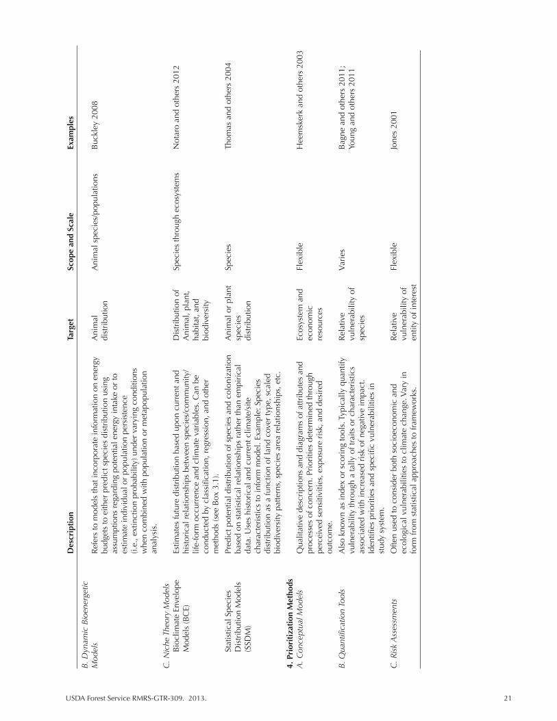
USDA Forest Service RMRS-GTR-309. 2013. 21
D
escr
ipti
on
Targ
et
Scop
e an
d Sc
ale
Exam
ples
B. D
ynam
ic B
ioen
erge
tic
Mod
els
Ref
ers
to m
odel
s th
at in
corp
orat
e in
form
atio
n on
ene
rgy
A
nim
al
Ani
mal
spe
cies
/pop
ulat
ions
B
uckl
ey 2
008
bu
dget
s to
eith
er p
redi
ct s
peci
es d
istr
ibut
ion
usin
g
dist
ribu
tion
as
sum
ptio
ns r
egar
ding
pot
entia
l ene
rgy
inta
ke o
r to
estim
ate
indi
vidu
al o
r po
pula
tion
pers
iste
nce
(i.e.
, ext
inct
ion
prob
abili
ty) u
nder
var
ying
con
ditio
ns
w
hen
com
bine
d w
ith p
opul
atio
n or
met
apop
ulat
ion
anal
ysis
.
C. N
iche
The
ory
Mod
els
Bio
clim
ate
Enve
lope
Es
timat
es fu
ture
dis
trib
utio
n ba
sed
upon
cur
rent
and
D
istr
ibut
ion
of
Spec
ies
thro
ugh
ecos
yste
ms
Not
aro
and
othe
rs 2
012
Mod
els
(BC
E)
hist
oric
al r
elat
ions
hips
bet
wee
n sp
ecie
s/co
mm
unity
/ A
nim
al, p
lant
,
life-
form
occ
urre
nce
and
clim
ate
vari
able
s. C
an b
e
habi
tat,
and
co
nduc
ted
by c
lass
ifica
tion,
reg
ress
ion,
and
oth
er
biod
iver
sity
met
hods
(see
Box
3.1
).
Stat
istic
al S
peci
es
Pred
ict p
oten
tial d
istr
ibut
ion
of s
peci
es a
nd c
olon
izat
ion
A
nim
al o
r pl
ant
Spec
ies
Thom
as a
nd o
ther
s 20
04
Dis
trib
utio
n M
odel
s ba
sed
on s
tatis
tical
rel
atio
nshi
ps r
athe
r th
an e
mpi
rica
l sp
ecie
s
(S
SDM
) da
ta. U
ses
hist
oric
al a
nd c
urre
nt c
limat
e/si
te
dist
ribu
tion
ch
arac
teri
stic
s to
info
rm m
odel
. Exa
mpl
e: S
peci
es
dist
ribu
tion
as a
func
tion
of la
nd c
over
type
, sca
led
bi
odiv
ersi
ty p
atte
rns,
spe
cies
are
a re
latio
nshi
ps, e
tc.
4. P
rior
itiz
atio
n M
etho
ds
A. C
once
ptua
l Mod
els
Qua
litat
ive
desc
ript
ions
and
dia
gram
s of
attr
ibut
es a
nd
Ecos
yste
m a
nd
Flex
ible
H
eem
sker
k an
d ot
hers
200
3
proc
esse
s of
con
cern
. Pri
oriti
es d
eter
min
ed th
roug
h
econ
omic
perc
eive
d se
nsiti
vitie
s, e
xpos
ure
risk
, and
des
ired
re
sour
ces
ou
tcom
e.
B. Q
uant
ifica
tion
Tool
s A
lso
know
n as
inde
x or
sco
ring
tool
s. T
ypic
ally
qua
ntify
R
elat
ive
Var
ies
Bag
ne a
nd o
ther
s 20
11;
vu
lner
abili
ty th
roug
h a
tally
of t
raits
or
char
acte
rist
ics
vu
lner
abili
ty o
f
Youn
g an
d ot
hers
201
1
asso
ciat
ed w
ith in
crea
sed
risk
of n
egat
ive
impa
ct.
spec
ies
Id
entifi
es p
rior
ities
and
spe
cific
vul
nera
bilit
ies
in
st
udy
syst
em.
C. R
isk
Ass
essm
ents
O
ften
used
to c
onsi
der
both
soc
ioec
onom
ic a
nd
Rel
ativ
e Fl
exib
le
Jone
s 20
01
ec
olog
ical
vul
nera
bilit
ies
to c
limat
e ch
ange
. Var
y in
vu
lner
abili
ty o
f
form
from
sta
tistic
al a
ppro
ache
s to
fram
ewor
ks.
entit
y of
inte
rest

22 USDA Forest Service RMRS-GTR-309. 2013.
Figure 3.1. Top. Temporal and spatial variation among biological scales (light blue) and the impact of common disturbances (dark blue) for forested ecosystems (patterned after Bunnel and Huggard 1999). See Chapter 2 for a detailed discussion. Bottom. Spatial and temporal extent of target ouput for methods for assessing impact of climate change on various ecological parameters. Disturbance parameters (grey) are shown for reference. This figure represents the common geographic scale at which certain analyses are conducted. GCMs (dark blue) produce daily and monthly estimates of a of broad-scale climate parameters. BCE models (light green) are commonly used for species-level analysis and are often used to estimate distribution over a wide area. Process based models (light green) usually involve plant functional groups and use physiological processes to estimate distribution of groups across a wide spatial scale. Successional models (light green) are oriented toward patch-level interactions. The spatial extent of frameworks and indices (yellow) is typically defined by the user’s objectives. Hydrological models (blue) can focus on the entire reach of a target river or, more commonly, on a watershed of interest. Most methods focus on estimating conditions over the next century and few address seasonal variations. Exceptions include hydrological models, process-based models, and some index-based methods.

USDA Forest Service RMRS-GTR-309. 2013. 23
provided a review of aquatic assessments as well as assessment modeling methods. In-stream flow modeling is a habitat-based method that describes a natural envi-ronmental regime, which can be used to assess the extent of hydrologic alteration resulting from climate change (Meyers and others 1999). Models that estimate nu-trient uptake and hydrodynamic properties (nutrient spiraling model) quantify the simultaneous processes of nutrient cycling by biota and downstream transport of nutrients by water flow. This can be translated to measure of biological productiv-ity or nutrient retentiveness through the use of bioenergetic models. Bioenergetic models are also used to estimate the growth rate of fish and other organisms as well as the effects of changing temperature regimes. Food web models allow user to analyze the indirect effects of climate change through observed changes in food web interactions. For instance, loss of fish because of extreme temperatures or of algae due to anthropogenic disturbance has cascading effects on river and lake sys-tems (Meyers and others 1999). Watershed-level vulnerability assessments (e.g., Fig. 3.2), which integrate information from multiple sources, are very useful from a management perspective, and recent advances in methodologies have been pub-lished (USDA 2011; Furniss and others 2012).
3.2.2 Adaptive Capacity Models
This category covers a variety of methods that focus on aspects of adaptive capacity, which often can be directly translated into vulnerability (Tables 3.1, 3.2). Adaptive capacity can apply to resources at a variety of scales. For example, plant communities at ecotones are often considered to be less resilient or to have limited adaptive capacity because of their occurrence in a narrow band of environ-mental conditions (Allen and Breshears 1998). Greater species diversity has been suggested as an ecosystem characteristic incurring greater resilience to climate change because of functional redundancy, overlap, and connectivity (Peterson and others 1998). Because adaptive capacity can directly tie to genetic diversity and adaptation through natural selection, species-level models of adaptive capacity are common applications. Species dispersal ability (e.g., Cushman and others 2011), species range (Thomas and others 2004), thermal tolerance (Sinervo and others 2010), bioenergetics, and other variables have been used to measure the adaptive capacity of species to deal with changing conditions. Models within this category are useful in that they often consider density, extinction rates, and similar vari-ables rather than focusing on presence-absence (Buckley 2008). However, these methods rely on a certain degree of information regarding species physiological processes and, in many cases, demographic data. Adaptive capacity models are of-ten limited by available data; for example, some species may contain unexpressed genetic variation that would permit adaptation to novel climate conditions such as increased temperatures or dryness, but such information is often not available to researchers and managers (Davis and Shaw 2001).
Processes such as survival, growth, reproduction, and dispersal may change sto-chastically (e.g., weather-related fluctuations in survival rates) or deterministically (e.g., temporal trends in average survival rates because of climate change) and in-form how species may be vulnerable to climate change. In one example of a study of an adaptive capacity, Kearney and others (2009) integrated biophysical models and evolutionary theory to predict climate affects for future habitat suitability of mosquitoes as well as traits such as egg resistance to desiccation, which is known to limit dispersal. Interestingly, the potential habitat of the mosquito was predicted to increase due to warming trends, although water availability might continue to be limited in some regions. The authors found evidence that the mosquito may
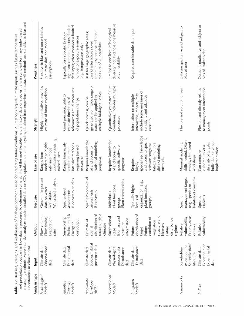
24 USDA Forest Service RMRS-GTR-309. 2013.
Tabl
e 3.
2. B
est u
se, s
tren
gths
, and
wea
knes
ses
of a
naly
ses
com
mon
ly u
sed
for
pred
ictin
g fu
ture
con
ditio
ns. A
ll m
etho
ds r
equi
re c
limat
e in
puts
suc
h as
futu
re te
mpe
ratu
re
and
prec
ipita
tion
but v
ary
in h
ow d
ata
is p
roce
ssed
to d
eter
min
e vu
lner
abili
ty. A
t the
mos
t flex
ible
, nat
ural
his
tory
dat
a on
spe
cies
trai
ts is
suf
ficie
nt fo
r m
any
inde
x ba
sed
mea
suri
ng m
etho
ds. M
ore
inte
nsiv
e an
alys
es r
equi
re d
etai
led
data
on
CO
2 up
take
and
nut
rien
t cyc
ling
obta
ined
from
exp
erim
enta
l dat
a. A
ll m
etho
ds a
re s
ensi
tive
to b
ias
and
unce
rtai
ntie
s in
clim
ate
data
.
Ana
lysi
s ty
pe
Inpu
t O
utpu
t B
est
use
Ease
of u
se
Stre
ngth
W
eakn
ess
Hyd
rolo
gica
l C
limat
e da
ta
Flow
vol
ume
Gen
erat
e im
port
ant
Ran
ges
from
H
ighl
y qu
antit
ativ
e, p
rovi
des
Sens
itive
to b
ias
and
unce
rtai
ntie
s M
odel
s O
bser
vatio
nal
Flow
tim
ing
data
on
wat
er
mod
erat
e to
hig
hly
estim
ate
of fu
ture
con
ditio
n in
clim
ate
data
and
mod
el
da
ta
Evap
orat
ion
avai
labi
lity
inte
nsiv
e m
odel
assu
mpt
ions
ra
tes
Wat
ersh
ed a
naly
sis
appl
icat
ion
requ
irin
g
trai
ned
user
s
Ada
ptiv
e
Clim
ate
data
Su
rviv
orsh
ip
Spec
ies-
leve
l R
ange
s fr
om e
asily
G
ood
prec
isio
n; a
ble
to
Typi
cally
ver
y sp
ecifi
c to
stu
dy
Cap
acity
Ex
peri
men
tal
Extin
ctio
n ri
sk
asse
ssm
ents
ap
plie
d to
mor
e es
timat
e th
resh
olds
of
orga
nism
; can
req
uire
con
side
rabl
e M
odel
s da
ta
Ener
getic
B
iodi
vers
ity s
tudi
es
inte
nsiv
e m
etho
ds
tole
ranc
es; a
ctua
l mea
sure
s da
ta in
put;
ofte
n co
nsid
er a
lim
ited
cost
/out
put
re
quir
ing
trai
ned
of
pop
ulat
ion
chan
ge
num
ber
of e
xpos
ure
sour
ces
rese
arch
er
(e
.g.,
tem
pera
ture
onl
y)
Bio
clim
ate
C
limat
e da
ta
Estim
ate
of
Spec
ies/
biom
e-le
vel
Req
uire
s kn
owle
dge
Qui
ck p
roce
ss; c
an b
e B
est f
or la
rge
geog
raph
ic a
reas
; En
velo
pe
Spec
ies/
habi
tat
spat
ial
asse
ssm
ents
of
and
acc
ess
to
gene
rate
d fr
om w
ide
rang
e of
ca
nnot
infe
r fu
ture
nov
el
(BC
E)
pres
ence
dat
a di
stri
butio
n of
B
iodi
vers
ity
stat
istic
al m
odel
ing
data
; can
be
appl
ied
to
com
mun
ities
; not
a s
tand
-alo
ne
futu
re s
uita
ble
prog
ram
s m
ultip
le b
iolo
gica
l sca
les
mea
sure
of v
ulne
rabi
lity
clim
ates
Succ
essi
onal
C
limat
e da
ta
Succ
essi
onal
In
divi
dual
s R
equi
res
know
ledg
e Q
uant
itativ
e; e
stim
ates
futu
re
Lim
ited
to o
ne le
vel o
f bio
logi
cal
Mod
els
Phys
iolo
gica
l st
age
Plan
t fun
ctio
nal
of a
nd a
cces
s to
co
nditi
ons,
incl
udes
mul
tiple
di
vers
ity; n
ot a
sta
nd-a
lone
mea
sure
proc
ess
data
B
iom
ass
and
grou
ps
spec
ific
softw
are
proc
esse
s of
vul
nera
bilit
y
Dis
turb
ance
st
ruct
ure
Plan
t com
mun
ities
pr
ogra
ms
da
ta
info
rmat
ion
Inte
grat
ed
Clim
ate
data
Fu
ture
Ty
pica
lly h
ighe
r R
equi
res
Info
rmat
ion
on m
ultip
le
Req
uire
s co
nsid
erab
le d
ata
inpu
t M
odel
s D
istu
rban
ce
dist
ribu
tion
of
leve
ls o
f hi
ghly
in
tera
ctin
g im
pact
s; m
ay
d
ata
targ
et
orga
niza
tion
(e.g
., sp
ecia
lized
kno
wle
dge
incl
ude
som
e m
easu
res
of
Futu
re
plan
t fun
ctio
nal
and
acce
ss to
spe
cific
se
nsiti
vity
and
ada
ptiv
e
co
nditi
on o
f gr
oups
) so
ftwar
e pr
ogra
ms.
ca
paci
ty
vege
tatio
n
In
tegr
ates
mul
tiple
st
ruct
ure
and
dist
inct
mod
elin
g
bi
omas
s
met
hods
.
Fu
ture
di
stur
banc
e
regi
mes
Fram
ewor
ks
Stak
ehol
der/
R
elat
ive
Spec
ific
Min
imal
mod
elin
g Fl
exib
le a
nd s
olut
ion
driv
en
Dat
a ar
e qu
alita
tive
and
subj
ect t
o
expe
rt o
pini
on
vuln
erab
ility
m
anag
emen
t tar
gets
sk
ills
need
ed. O
ften
bi
as o
f use
r
Scie
ntifi
c da
ta/
Prio
rity
are
as
(e.g
., sp
ecie
s or
em
ploy
s fa
cilit
ated
liter
atur
e or
task
s ha
bita
ts o
f con
cern
) w
orks
hops
.
Indi
ces
Clim
ate
data
R
elat
ive
Spec
ies
Can
com
pare
Fl
exib
le a
nd d
irec
tly r
elat
es
Out
put i
s qu
alita
tive
and
subj
ect t
o
Expe
rt o
pini
on
vuln
erab
ility
H
abita
ts
vuln
erab
ility
of a
to
man
agem
ent i
nter
vent
ion
bias
of
stak
ehol
der
Ex
peri
men
tal
dive
rsity
of t
arge
ts.
poin
ts.
da
ta
Indi
vidu
al o
r gr
oup
impl
emen
tatio
n.
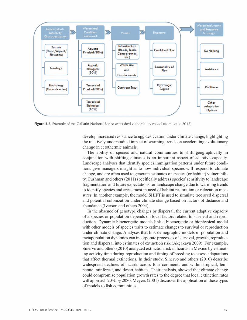
USDA Forest Service RMRS-GTR-309. 2013. 25
develop increased resistance to egg desiccation under climate change, highlighting the relatively understudied impact of warming trends on accelerating evolutionary change in ectothermic animals.
The ability of species and natural communities to shift geographically in conjunction with shifting climates is an important aspect of adaptive capacity. Landscape analyses that identify species immigration patterns under future condi-tions give managers insight as to how individual species will respond to climate change, and are often used to generate estimates of species (or habitat) vulnerabili-ty. Cushman and others (2011) specifically address species’ sensitivity to landscape fragmentation and future expectations for landscape change due to warming trends to identify species and areas most in need of habitat restoration or relocation mea-sures. In another example, the model SHIFT is used to simulate tree seed dispersal and potential colonization under climate change based on factors of distance and abundance (Iverson and others 2004).
In the absence of genotype changes or dispersal, the current adaptive capacity of a species or population depends on local factors related to survival and repro-duction. Dynamic bioenergetic models link a bioenergetic or biophysical model with other models of species traits to estimate changes to survival or reproduction under climate change. Analyses that link demographic models of population and metapopulation dynamics can incorporate processes of survival, growth, reproduc-tion and dispersal into estimates of extinction risk (Akçakaya 2009). For example, Sinervo and others (2010) analyzed extinction risk in lizards in Mexico by estimat-ing activity time during reproduction and timing of breeding to assess adaptations that affect thermal extinctions. In their study, Sinervo and others (2010) describe widespread declines of lizards across four continents and within tropical, tem-perate, rainforest, and desert habitats. Their analysis, showed that climate change could compromise population growth rates to the degree that local extinction rates will approach 20% by 2080. Meyers (2001) discusses the application of these types of models to fish communities.
Figure 3.2. Example of the Gallatin National Forest watershed vulnerability model (from Louie 2012).
26 USDA Forest Service RMRS-GTR-309. 2013.
3.2.3 Distribution Models
Distribution models are used to estimate future habitat suitability or species distributions given projections for changes in climate conditions. These models are based on the relationship between species distribution and climate or other environmental variables (Pearson and others 2003). For this discussion, we group species distribution models into four primary categories: environmental envelope models, process or simulation based models, succession models, and integrated models (Appendix 1).
Environmental envelope and process based models are able to analyze indi-vidual species and higher levels of organization but do not necessarily provide estimates of abundance (as compared to adaptive capacity models). Succession or Forest gap models are able to provide estimates of abundance but primarily focus on changes to species assemblages for a particular landscape. Integrated models represent an expanding diversity of models that incorporate elements of the other three categories of models and sometimes include adaptive capacity. These meth-ods differ in their use of temporal variability: where bioclimate envelopes tend to estimate future suitable habitat or conditions at predefined points in time, process-based models are often able incorporate and output rates of change or generate estimates of change over time.
There are a number of assumptions common to both environmental envelope and process-based models (from Hansen and others 2001 and others):
• Climate-species relationships will remain constant over time.• Both correlative (climate envelope) and more mechanistic models tend to ignore
dispersal and species interactions (McMahon and others 2011). Dispersal or tracking to new suitable climates will be unhindered by other factors. In reality, communities may experience barriers and transitions may lag where long-lived species persist many decades.
• Many modeling techniques use mean temperature or precipitation values, which assumes that changes in averages over time will be as or more important than changes in extreme weather events and short-term variability patterns (Gonzales and others 2010). Depending upon the organisms studied, this may not be a valid assumption.
• Many studies do not consider the timing or seasonality of changes, which may be more important than averages.
Environmental envelope models
The first group of distribution models, environmental envelope models, en-compasses a variety of different statistical approaches to describe the relationship between species/biome/habitat presence and climate and, sometimes, other vari-ables (Box 3.1; Appendix 1). This family of models is based on species niche theory, which views the niche as an evolved characteristic comprising the total range of multiple factors that determine where a species can maintain a positive population growth rate over time (Hutchinson 1957; Chase and Liebold 2003; Colwell and Rangel 2009). An example is bioclimate envelope (BCE) models, which are applied to both plant and animal species. A large proportion of studies used in vulnerability assessments incorporate BCE models to predict the effect of climate change on species distributions (Parmesan and Yohe 2003; Pearson and others 2003; Rehfeldt and others 2006; Chen and others 2011; Notaro and oth-ers 2012). Estimates of the degree or magnitude of shifts in distribution are used to identify species or habitats that are likely to experience the greatest negative

USDA Forest Service RMRS-GTR-309. 2013. 27
impact due to projected climate effects. Because these analyses focus around cli-mate mediated patterns of distribution, they are best used to predict changes in distribution over large scales where climate is a primary driver. However, within this, the physical range can be quite flexible (see Appendix 1; Table 3.2)
There are a number of advantages and disadvantages of BCE models for esti-mating response to climate change. BCE models are useful in that they can provide data on species presence or absence with relatively general input data (e.g., Notaro and others 2012; Table 3.2). However, BCE models are less effective for predicting species extinctions because they do not incorporate measures of actual population dynamics (Buckley 2008) or adaptive potential. They also cannot reliably predict
Box 3.1. Statistical and non-statistical approaches for estimating the relationship between climate and species, habitats, or biodiversity.
Box 3.1. Statistical and non-statistical approaches for estimating the relationship between climate and species, habitats, or biodiversity.
• Regression Methods (General Linear Models (GLM), regression trees). Describes the influence of numerous predictors (climate conditions) on a variable of interest (presence, mortality). Results often form the basis of maps that represent spatial influence of predictors. Example: DISTRIB (Iverson and Prasad 1998 or Iverson and others 1999a). These models project distribution of tree species and aggregate results to present changes in community type. Projections are modeled from the current relationships between tree presence and climate and soil characteristics. Physiological data are not required, which allows for its application to a large number of species. However, these models are not able to integrate the effects of competition, CO2, or dispersal (though Iverson and others [1999] have developed a model that considers dispersal ability) and establishment capacities. Like many such approaches, these models also assume that the relationship between environment and species will remain constant over time.
o Bagging Trees—Similar to above but uses resampling technique to reduce error. Species that are not well described by predictors will show large variation in output trees, indicating uncertainty.
o Multivariate Adaptive Regression—Splines are used for analysis of continuous variables, which are effectively partitioned into intervals. Example: Rehfeldt and others 1999.
o Mahalanobis Distance (MD)—Multivariate technique. Defines perpendicular major and minor axes and then calculates distance from centroid in n-dimensional space based on covariance of axes lengths. Allows user to consider relative influence of predictor variables. Example: Bradley 2009.
o Random Forest—Classification system that produces robust estimates of species presence. Used in Rehfeldt and others 2006.
o Multiple regression models—Example: Energy theory (Biodiversity). Currie (2001) related biodiversity of a broad spectrum of organisms to spatial patterns of summer and winter precipitation and temperatures using multiple regression. Methods assume that the relationship between biodiversity and climate will remain constant.
• Machine learning methods (non-statistical) (Artificial Neural Networks, genetic algorithms [GA], GARP, classification analysis and decision tree [CART])—A group of methods that use algorithms to allow computers to “learn” from experience and improve performance over time. Output is generally in the form of if-then and do not rely on assumptions of relationships between the environment and species suitability. An example is presented in Termansen and others 2006.
• Cellular Automata—Used to predict succession, spread of invasive species, plant migration, and, in MigClim, species distribution. This analysis predicts the status of cells over time according to rules about influences of adjacent cells.
28 USDA Forest Service RMRS-GTR-309. 2013.
shifts in species distribution at small spatial scales. However, new methods are continually being developed to incorporate factors such as dispersal (e.g., Iverson and others 2008; Cushman and others 2010). There may also be problems where models assume species’ realized niche, the niche space that a species occupies when other factors such as competition and ability to reach suitable habitat are taken into account, can be adequately described by climate variables (Colwell and Rangel 2009). Similarly, BCE models assume species are in equilibrium with their environment, which may limit the capacity of some models to generate realistic predictions of future range shifts. Further, analyses may assume that current lo-cations of species represent environmental conditions suitable for all life history stages (seedlings and adult trees for instance), which, if incorrect, may overesti-mate suitability when used to predict future site potential (Falk, in press). Many of these issues are being addressed by combining results generated from BCE models with other methods that can measure non-climate impacts (see Appendix 1 for examples). Indeed, one advantage of BCE models is that they appear to be readily integrated into synthetic approaches for estimating species response (e.g., Iverson and others 2004, 2008; Davison and others 2012).
By combining projections for several species, BCE analyses are also able to generate data regarding biodiversity. In some instances, BCE analysis has been applied directly to estimates of species richness (e.g., Currie 2001). However, re-lationships between species richness and temperature and precipitation tend to be nonlinear, and, given that predicted changes often fall outside of observed ranges, extrapolation of richness patterns or other diversity measures may not accurately predict future change (Currie 2001). Still, BCE models provide a powerful tool for estimating future loss or potential degree of changing in suitable habitats (Heikkinen and others 2006). Estimating the impact of global change on aggregate indices of biodiversity through analysis with BCE models has many applications for large scale assessments of climate impacts (Currie 2001; Notaro and others 2012). Estimating biodiversity or species richness is particularly useful for iden-tifying hotspots of vulnerability and potentially important areas for prioritized conservation action. Where information is limited regarding factors that influence species range, BCE models remain a good way to estimate climate change effects on biodiversity and may provide more precise estimates of future effects than spe-cies assemblage models (Heikkinen and others 2006).
Process-based or simulation models
The second group of models includes process-based or simulation models, which simulate ecosystem processes by creating mathematical representations of biological and physical processes. A large number of process-based or simu-lation type models focus on vegetation, which is often defined by a type or by dominant life forms. Thus, output of process-based analyses is commonly gener-ated at higher levels of organization like biome or ecosystem. Since these types of models examine a much more fundamental aspect of ecosystems, they tend to be more responsive to environmental changes such as climate (Swantson and others 2011). These models may also incorporate important elements that have influence at smaller scales. These models range in complexity from biogeographic (equi-librium) model that require only long-term average climate and use biogeographic rules to determine vegetation type and density, to the more complicated succes-sional models that simulate dynamic changes based on biogeochemical processes. Biogeochemical models are valuable because they incorporate dynamic climate variables as well as a high degree of interaction among variables to simulate im-portant processes over time and space (Feenstra 2009). They can provide results

USDA Forest Service RMRS-GTR-309. 2013. 29
relevant to biodiversity-focused assessments, including the functional and struc-ture characteristics of the modeled community. However, biogeochemical models do not directly determine what vegetation is likely to exist at a given location.
Dynamic global vegetation models (DGVMs) combine biogeographic and biogeochemical model methods to model the response of broader plant functional groups or community types (Bachelet and others 2001; Notaro and others 2012; Table 3.1, Appendix 1). DGVMs can incorporate disturbance, ecophysiological processes, soil and litter dynamics, and hydrologic variables to simulate vegetation response. Vegetation response is based upon the dynamic feedback of biochemi-cal processes on vegetation distribution (Peng 2000) Importantly, DGVMs also include carbon fertilization effects, which might reduce the impact of warming on plant distribution change and is an issue not addressed by BCE models. Many DGVMs also model carbon cycling (sinks, sources, and fluxes), an important ele-ment in climate-biosystem feedbacks (Moritz and others 2012). Though they do not estimate distributions of individual species, DGVMs can incorporate competi-tive effects by simulating changes in cover (biomass and NPP) and distribution of plant functional types.
Successional models (e.g., JABOWA, Forest Gap Models) are a class of pro-cess based models (also called dynamic biogeographical model, Peng 2000) used for studying communities by simulating the influence of growth, ecophysiology, disturbance, and species interactions on composition, biomass, and structure over time (Tables 3.1, 3.2). Forest Gap models are typically individual based models, i.e., they simulate population and community dynamics based on the modeled re-sponse of individual organisms (e.g., trees or shrubs). Species distributions are determined at larger scales in modeling by the dominant influence of climate and at smaller scales by a variety of influences. Unlike other model methods, this group is able to output estimates of plant cover, composition, and relative abundance at relatively fine spatial scales (e.g., individual trees and stands). Like other models, successional models tend to focus on plant communities, although these results can be fed into habitat suitability models for animals and other biota.
An equivalent approach on the animal side is the ecophysical model, which estimates potential activity hours and food requirements to meet certain energetic costs (Buckley 2008). When data are available, these can be coupled with popula-tion dynamic models to create dynamic bioenergetic models (see adaptive capacity model discussion) from which species range can be predicted (e.g., Buckley 2008). However, these models, as with most process based studies, are only as good as the empirical data upon which they are based and are often computationally intense.
Integrated modeling methods
Analysis, especially those that attempt to inform multi-scale perspectives, must take into account both large-scale, climate-driven patterns in biodiversity as well as more local-scale processes relating to species interactions and disturbance re-gimes. In recognition of this and in an attempt to address shortcomings in species distribution models, a number of efforts have combined methods to improve the accuracy of predictions as well as generate more biologically meaningful data. This group, referred to here as integrated modeling methods, represents a grow-ing body of analyses methods used to inform vulnerability or impact assessments (Table 3.1; Appendix 1). Some examples are:
• Buckley (2008) linked population dynamics and energetics/biophysical mod-els to estimate population growth as a function of activity hours. The authors then integrate individual energetic and population dynamic models with spatial
30 USDA Forest Service RMRS-GTR-309. 2013.
environmental data to predict distribution and abundance of vertebrate and plant species.
• MigClim (Engler and Guisan 2009; Appendix 1) is a recently developed pro-gram that couples predictive distribution maps, representing a species’ habitat suitability as a function of evolving climate, with a cellular automaton that simulates adaptive capacity relating to dispersal, colonization, growth, and ex-tinction of the species in the landscape under differing conditions. This model runs in ArcGIS to simulate plant dispersal under climate change and landscape fragmentation scenarios and, used in conjunction with envelope type analysis (requires maps of current and future suitable habitat distributions), gives a spa-tially explicit prediction that can be used to assess species vulnerability.
• Iverson and others (2008) combined bioclimate distribution analyses with a model for species dispersal and a qualitative system for identifying the relative influence of species traits (modification factors or MODFAC) that accounts for climate and non-climate-related response variables for tree species in the east-ern United States. This analysis produces an estimate of species ranges under future conditions.
• Barrio and others (2006) described a process that integrates four models in a scale-dependent hierarchical framework to study the impacts of climate and land use change scenarios on species’ distributions at fine resolutions. This method combines two distribution models: SPECIES, a continental scale bio-climatic envelope model and downscaled SPECIES, a regional-scale bioclimate and land use suitability model; a dispersal model; and ALCOR, a connectivity model. SPECIES is a model that employs an artificial neural network (ANN) to define BCE based on inputs generated through a climate-hydrological linked process model. Applied to systems in the United Kingdom and Spain, this analysis was able to attribute specific patterns of landscape change to climate change. Specifically, increased fragmentation in landscapes derived from the development of gaps within existing habitat structure rather than shifts in habi-tat zonal types.
• LANDFIRE uses spatially explicit modeling of dynamic interactions between vegetation, climate and disturbance to create probabilities regarding future con-ditions. These probabilities represent departure from preset reference conditions (see Chapter 4.1) and vulnerability is represented as future departure from norm (e.g., Baker 1989; Keane and others 2006; Mladenoff 2004; used in LandFire Project to compute FRCC).
• FireBGCv2 is a simulation modeling platform that merges a Gap model (FIRESUM); a mechanistic vegetation succession model (BIOME-BGC); a spa-tially explicit fire model (FARSITE) incorporating ignition, spread, and effects on ecosystem components; and a detailed fuel treatment module (FIRESUM, Keane and others 2011). FireBGCv2 dynamically simulates synergistic and in-teracting effects of weather and climatology, vegetation growth and succession, disturbance (e.g., wildfire and bark beetles), and land management (e.g., pre-scribed fire and thinning) on landscape structure and ecosystem processes.
3.2.4 Prioritization Methods
Indices
Indices are generally suitable for questions that explore biological diversity in the aggregate since they provide a ranking or relative measure of vulnerability among a group of species (Feenstra and others 1998) or in cases where multiple datasets are

USDA Forest Service RMRS-GTR-309. 2013. 31
Tabl
e 3.
3. E
xam
ples
of m
etho
ds u
sed
to p
rovi
de r
elat
ive
mea
sure
s of
vul
nera
bilit
y or
iden
tify
area
s of
vul
nera
bilit
y. T
ype
refe
rs to
the
met
hod
empl
oyed
. Qua
ntifi
catio
ns ty
pica
lly
tally
trai
ts a
ssoc
iate
d w
ith v
ulne
rabi
lity.
Mod
els
typi
cally
com
bine
som
e ty
pe o
f tal
lyin
g m
etho
d an
d ex
trap
olat
e it
to s
patia
lly e
xplic
it is
sues
(e.g
., la
ndsc
ape
frag
men
tatio
n).
Nam
e Sc
ale
Type
D
escr
ipti
on
Targ
et
Ava
ilabl
e fr
om
Nat
ureS
erve
’s
Glo
bal-
fixed
; Q
uant
ifica
tion
CC
VI c
onsi
sts
of r
anki
ng s
yste
m th
at c
onsi
ders
A
nim
al a
nd
ww
w.n
atur
eser
ve.o
rg/p
rodS
ervi
ces/
C
limat
e C
hang
e
rang
e of
spe
cies
spat
ial e
stim
ates
of e
xpos
ure
and
spec
ies
trai
ts
plan
t spe
cies
cl
imat
echa
nge/
Clim
ateC
hang
e.js
p V
ulne
rabi
lity
Inde
x or
hab
itats
indi
cativ
e of
sen
sitiv
ity a
nd a
dapt
ive
capa
city
an
d ha
bita
ts
for
spec
ies
(CC
VI)
an
d ca
tego
rize
s sp
ecie
s ac
cord
ing
to th
eir
leve
l an
d ha
bita
ts (H
CC
VI)
of v
ulne
rabi
lity.
HC
CV
I use
s re
sults
of C
CV
I as
w
ell a
s es
timat
es o
f hab
itat c
hang
e, in
clud
ing
dist
urba
nce
effe
cts,
to r
ank
habi
tat v
ulne
rabi
lity.
Syst
em fo
r Ass
essi
ng
Flex
ible
Q
uant
ifica
tion
Scor
ing
syst
em b
ased
upo
n 22
trai
ts p
redi
ctiv
e Te
rres
tria
l ht
tp://
ww
w.fs
.fed.
us/r
m/g
rass
land
V
ulne
rabi
lity
of
of s
peci
es v
ulne
rabi
lity
to c
limat
e ch
ange
. ve
rteb
rate
sh
rubl
and-
dese
rt/p
rodu
cts/
spec
ies
Spec
ies
(SA
VS)
Pr
oduc
es v
alue
use
d to
com
pare
rel
ativ
e sp
ecie
s vu
lner
abili
ty/
vu
lner
abili
ty a
mon
g sp
ecie
s.
Envi
ronm
enta
l Fl
exib
le
Qua
ntifi
catio
n Fr
amew
ork
for
cate
gori
zing
the
rela
tive
Thre
aten
ed a
nd
EPA
/600
/R-0
9/01
Pr
otec
tion
Age
ncy
vu
lner
abili
ty o
f thr
eate
ned
and
enda
nger
ed
enda
nger
ed
Fram
ewor
k
spec
ies
to c
limat
e ch
ange
. For
ms
a m
atri
x th
at
spec
ies
si
mul
tane
ousl
y co
nsid
ers
spec
ies
vuln
erab
ility
to o
ngoi
ng p
opul
atio
n de
clin
es a
nd fu
ture
nega
tive
impa
cts
from
clim
ate
chan
ge. A
ims
to
fo
cus
man
agem
ent a
ctio
ns.
Wat
er S
uppl
y St
ress
Fl
exib
le
Qua
ntifi
catio
n M
odel
s lo
cal w
ater
shed
str
ess
by c
ompa
ring
W
ater
ht
tp://
ww
w.fs
.fed.
us/c
crc/
tool
s/w
assi
. In
dex
Mod
el(W
aSSI
)
w
ater
sup
ply
and
dem
and
in a
par
ticul
ar a
rea.
shtm
l
Vul
nera
bilit
y Su
rfac
e Fl
exib
le
Mod
el
Use
s a
thre
e-di
men
sion
al a
naly
tical
sur
face
to
Ani
mal
s Lu
ers
2005
; Lue
rs a
nd o
ther
s 20
03
de
term
ine
rela
tive
vuln
erab
ility
. App
licab
le to
vari
ety
of s
yste
ms.
Am
enda
ble
to ta
rget
s th
at a
re
no
t eas
ily d
escr
ibed
by
mat
hem
atic
s.
Fore
st T
ree
Gen
etic
Fl
exib
le
Mod
el/
Cre
ates
a v
ulne
rabi
lity
inde
x fr
om fo
ur d
iffer
ent
Plan
ts
Potte
r an
d C
rane
201
0 R
isk
Ass
essm
ent
Q
uant
ifica
tion
mea
sure
s of
futu
re e
xpec
ted
chan
ge in
spe
cies
Sy
stem
(For
GR
AS)
di
stri
butio
n. R
ates
spe
cies
acc
ordi
ng to
intr
insi
c
at
trib
utes
and
ext
erna
l thr
eats
that
influ
ence
spec
ies
vuln
erab
ility
to c
limat
e ch
ange
.

32 USDA Forest Service RMRS-GTR-309. 2013.
combined (Sullivan and Meigh 2005). Indices are often applied at scales ranging from management unit to regional or subregional levels (Table 3.3). Alternatively, an index might be applied across a species’ range (e.g., NatureServe). These meth-ods are relatively easy to compute and are flexible to a diversity of input type but may reflect more generalized relationships at the cost of accurate predictions (Table 3.2). Variables used in such indices are often given equal weight, which can provide misleading results where individual species have particular overriding influences. Still, indices, unlike many of the mathematical modeling approaches discussed earlier, can be constructed to measure aspects of vulnerability directly and can be used alone to generate climate change vulnerability assessments (e.g., Coe and others 2012; Bagne and Finch 2012). Two primary approaches are used to generate scores: Quantification of traits considered important predictors of spe-cies sensitivity and adaptive capacity (e.g., SAVS, NatureServe’s Climate Change Vulnerability Index, and NCCVI) and methods that model vulnerability based upon predetermined schemes that categorize relative impact and response (e.g., Luers 2005).
Many of the systems listed in Table 3.3 were developed in direct response to the recognition of the need for specific measures of species and ecosystem vul-nerability to climate change. As such, they are tailored to help managers and conservationists identify critical elements, whether species or species trait, most vulnerable to future, expected conditions. The specific nature of these systems, which relates directly to the goal of understanding climate change impacts, lends them considerable weight for addressing vulnerability assessment needs. In addi-tion, many of these scoring systems use data generated from distribution models or otherwise build upon data regarding future expected conditions. Therefore, indices represent a synthetic product based on data from a variety of sources. However, as such, many of these systems are only as good as the data used to generate a score, and a well-developed application of a scoring system can be quite labor intensive. In addition, though very good at focusing the user’s attention toward climate im-pacts, these tools often do not incorporate other interacting stressors and require additional and separate analyses to create comprehensive management strategies. Future developments are likely to integrate additional methods into the scoring process to create new approaches that can simultaneously consider multiple stress-ors as well as distinguish vulnerability across a landscape.
Frameworks
Frameworks (Table 3.4) are similar to indices in that they provide a relative measure of vulnerability. However, they are often focused on targets that are not easily described by mathematical relationships and commonly have a socio-eco-nomic focus. Where indices use scores to quantify vulnerability, frameworks are generally based around the identification of targets and hazards and employ an algorithm to relate vulnerability to sensitivity and exposure divided by conditions that ameliorate negative impacts on the target (exceeds threshold, e.g., Leurs 2005; adaptive capacity, e.g., Fontaine and Steinemann 2009). Targets and hazards are often defined by consensus of opinions or responses generated by interviews or facilitated workshops. As such, frameworks are not necessarily a method for mea-suring vulnerability so much as a tool to identify vulnerabilities within a system of interest.
Fontaine and Steinemann (2009) presented a simple framework and algorithm to assess vulnerability for social sectors that could be applied to natural systems as well. In their system, each element, exposure, sensitivity, and adaptive capac-ity, is considered on a 1-5 Likert scale (psychometric commonly used in research
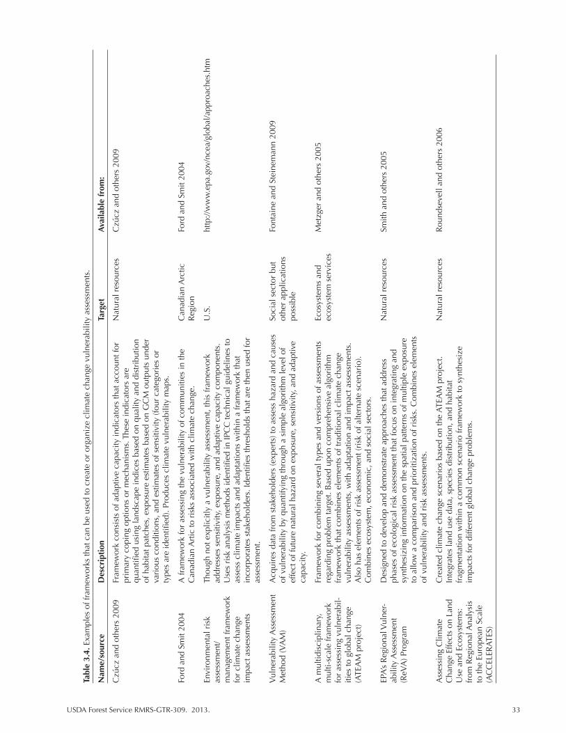
USDA Forest Service RMRS-GTR-309. 2013. 33
Tabl
e 3.
4. E
xam
ples
of f
ram
ewor
ks th
at c
an b
e us
ed to
cre
ate
or o
rgan
ize
clim
ate
chan
ge v
ulne
rabi
lity
asse
ssm
ents
.
Nam
e/so
urce
D
escr
ipti
on
Targ
et
Ava
ilabl
e fr
om:
Czú
cz a
nd o
ther
s 20
09
Fram
ewor
k co
nsis
ts o
f ada
ptiv
e ca
paci
ty in
dica
tors
that
acc
ount
for
N
atur
al r
esou
rces
C
zúcz
and
oth
ers
2009
prim
ary
copi
ng o
ptio
ns o
r m
echa
nism
s. T
hese
indi
cato
rs a
re
qu
antifi
ed u
sing
land
scap
e in
dice
s ba
sed
on q
ualit
y an
d di
stri
butio
n
of
hab
itat p
atch
es, e
xpos
ure
estim
ates
bas
ed o
n G
CM
out
puts
und
er
va
riou
s co
nditi
ons,
and
est
imat
es o
f sen
sitiv
ity (f
our
cate
gori
es o
r
ty
pes
are
iden
tified
). Pr
oduc
es c
limat
e vu
lner
abili
ty m
aps.
Ford
and
Sm
it 20
04
A fr
amew
ork
for
asse
ssin
g th
e vu
lner
abili
ty o
f com
mun
ities
in th
e
Can
adia
n A
rctic
Fo
rd a
nd S
mit
2004
Can
adia
n A
rtic
to r
isks
ass
ocia
ted
with
clim
ate
chan
ge.
Reg
ion
Envi
ronm
enta
l ris
k
Thou
gh n
ot e
xplic
itly
a vu
lner
abili
ty a
sses
smen
t, th
is fr
amew
ork
U.S
. ht
tp://
ww
w.e
pa.g
ov/n
cea/
glob
al/a
ppro
ache
s.ht
m
asse
ssm
ent/
ad
dres
ses
sens
itivi
ty, e
xpos
ure,
and
ada
ptiv
e ca
paci
ty c
ompo
nent
s.
man
agem
ent f
ram
ewor
k
Use
s ri
sk a
naly
sis
met
hods
iden
tified
in IP
CC
tech
nica
l gui
delin
es to
fo
r cl
imat
e ch
ange
as
sess
clim
ate
impa
cts
and
adap
tatio
ns w
ithin
a fr
amew
ork
that
im
pact
ass
essm
ents
in
corp
orat
es s
take
hold
ers.
Iden
tifies
thre
shol
ds th
at a
re th
en u
sed
for
asse
ssm
ent.
Vul
nera
bilit
y A
sses
smen
t A
cqui
res
data
from
sta
keho
lder
s (e
xper
ts) t
o as
sess
haz
ard
and
caus
es
Soci
al s
ecto
r bu
t Fo
ntai
ne a
nd S
tein
eman
n 20
09
Met
hod
(VA
M)
of v
ulne
rabi
lity
by q
uant
ifyin
g th
roug
h a
sim
ple
algo
rith
m le
vel o
f ot
her
appl
icat
ions
effe
ct o
f fut
ure
natu
ral h
azar
d on
exp
osur
e, s
ensi
tivity
, and
ada
ptiv
e
poss
ible
capa
city
.
A m
ultid
isci
plin
ary,
Fr
amew
ork
for
com
bini
ng s
ever
al ty
pes
and
vers
ions
of a
sses
smen
ts
Ecos
yste
ms
and
Met
zger
and
oth
ers
2005
m
ulti-
scal
e fr
amew
ork
rega
rdin
g pr
oble
m ta
rget
. Bas
ed u
pon
com
preh
ensi
ve a
lgor
ithm
ec
osys
tem
ser
vice
s fo
r as
sess
ing
vuln
erab
il-
fram
ewor
k th
at c
ombi
nes
elem
ents
of t
radi
tiona
l clim
ate
chan
ge
ities
to g
loba
l cha
nge
vu
lner
abili
ty a
sses
smen
ts, w
ith a
dapt
atio
n an
d im
pact
ass
essm
ents
. (A
TEA
M p
roje
ct)
Als
o ha
s el
emen
ts o
f ris
k as
sess
men
t (ri
sk o
f alte
rnat
e sc
enar
io).
Com
bine
s ec
osys
tem
, eco
nom
ic, a
nd s
ocia
l sec
tors
.
EPA’
s R
egio
nal V
ulne
r-
Des
igne
d to
dev
elop
and
dem
onst
rate
app
roac
hes
that
add
ress
N
atur
al r
esou
rces
Sm
ith a
nd o
ther
s 20
05
abili
ty A
sses
smen
t ph
ases
of e
colo
gica
l ris
k as
sess
men
t tha
t foc
us o
n in
tegr
atin
g an
d (R
eVA
) Pro
gram
sy
nthe
sizi
ng in
form
atio
n on
the
spat
ial p
atte
rns
of m
ultip
le e
xpos
ure
to
allo
w a
com
pari
son
and
prio
ritiz
atio
n of
ris
ks. C
ombi
nes
elem
ents
of v
ulne
rabi
lity
and
risk
ass
essm
ents
.
Ass
essi
ng C
limat
e
Cre
ated
clim
ate
chan
ge s
cena
rios
bas
ed o
n th
e AT
EAM
pro
ject
. N
atur
al r
esou
rces
R
ound
seve
ll an
d ot
hers
200
6 C
hang
e Ef
fect
s on
Lan
d
Inte
grat
es la
nd u
se d
ata,
spe
cies
dis
trib
utio
n, a
nd h
abita
t U
se a
nd E
cosy
stem
s:
frag
men
tatio
n w
ithin
a c
omm
on s
cena
rio
fram
ewor
k to
syn
thes
ize
from
Reg
iona
l Ana
lysi
s
impa
cts
for
diffe
rent
glo
bal c
hang
e pr
oble
ms.
to
the
Euro
pean
Sca
le
(AC
CEL
ERAT
ES)
34 USDA Forest Service RMRS-GTR-309. 2013.
questionnaires) representing very low to extreme likelihood of effect. In a case study of drought in Washington State, this scale corresponds to the frequency and severity of drought, where, for instance, the likelihood of frequent droughts could be considered very low, low, moderate, high, or extreme. Fontaine and Steinemann (2009) used stakeholder (various water users) interviews to populate their dataset. Vulnerability was calculated according to well recognized equation, V = (E+S)/A (IPCC 2007), where exposure and sensitivity are additive effects leading to vul-nerability that is reduced to a lesser or greater degree by adaptive capacity. In this way, Fontaine and Steinmann use knowledge and values of stakeholders to measure vulnerability. Importantly, though this type of method may rely on human interpretation, it is able to quantify and integrate all three elements of vulnerability. To apply this to a natural setting, expert interviews might be substituted for stake-holder provided information.
A more biologically oriented system was presented by Czúcz and others (2009) who developed a framework that consists of adaptive capacity indicators that ac-count for primary coping options or mechanisms. These indicators are quantified using landscape indices based on quality and distribution of habitat patches, ex-posure estimates based on GCM outputs under various conditions, and estimates of sensitivity (four categories or types are identified). Ultimately, this process pro-duces climate vulnerability maps.
3.3 Issues in Predicting Response
It is critical to understand how response measures relate to vulnerability to best identify strategies that prepare for and cope with climate change (see Chapter 1, Figure 1.2). As part of the assessment process, we must understand how well mea-sures of response represent the range of potential effects on species, habitats, and ecosystems. However, the complexity of biological systems prevents a perfect representation by any one or combination of methods. Only through a careful con-sideration of biological complexities can we identify strengths and weaknesses in various approaches as well as provide insight into best management practices.
3.3.1 Critical Thresholds, Ecosystem Tipping Points, and Other Considerations
As discussed in section 3.2, many studies predict changes in species distribu-tions in response to changing climate (e.g., Rehfeldt and others 2006; Notaro and others 2012). At local scales, community composition reflects changes in the suit-ability of existing habitat for species persistence. Both modeling and empirical studies suggest that such changes due to climate alone are likely to be expressed at multi-annual to decadal time scales (Allen and Breshears 1998; Parmesan and Yohe 2003; Chen and others 2011). In contrast, severe, large-scale disturbances can reorganize ecosystems mass and energy on much shorter time scales of days to months (Overpeck and others 1990; Falk, in press). In many cases it may be combinations of climate change and severe disturbance that is most likely to trig-ger abrupt ecosystem transitions into novel configurations, rather than either factor acting separately.
Following major disturbances that occur during periods of climate stress, ecosys-tems may recover not into the pre-disturbance conditions but into novel community types. For example, conversion of pine-dominated communities to dominance by Gambel oak (Quercus gambellii), New Mexico locust (Robinia Neomexicana),
USDA Forest Service RMRS-GTR-309. 2013. 35
and interior chaparral species is frequently observed in the Southwest following major fires (Savage and Mast 2005). These new configurations can be resilient in their new state and resistant to return to pre-disturbance conditions (Kitzberger and others 2011). In addition to ecological effects, these transitions also include potentially persistent alterations to geomorphic, soil, hydrological, and biogeo-chemical systems (Scheffer and others 2001). Such abrupt transitions are predicted to become more common under conditions of altered future climate and ampli-fied disturbance regimes (Flannigan and others 2000; Westerling and others 2006; Zinck and others 2011).
Abrupt ecological change is generally defined as a threshold response in key biotic and abiotic parameters and ecosystem components (Anderson and others 2008). Such changes may be expressed in shifts in dominant vegetation physiog-nomy (for example, from forest to shrub communities), especially if established individuals of dominant species do not survive a disturbance event. Altered soil, hydrologic, and biogeochemical conditions can reinforce shifts in vegetation types and disturbance regimes, such as a transition from a low-severity forest surface fire regime to a high-severity chaparral shrubland regime (Mayer 2011). Climate provides the envelope within which these dynamics occur; disturbance provides the trigger for abrupt system reorganization.
A variety of mechanisms may contribute to rapid or even abrupt post-fire eco-system change under current and near-term climate. First, by definition, severe disturbances such as wildfires leave relatively few surviving established indi-viduals, opening up niche and physical space for community level turnover. This mechanism operates by differential mortality among species, which may relate in turn to life histories adapted to low- or high-severity fire respectively. Second, early post-fire successional pathways may produce different post-fire communities by processes of community assembly, including dispersal distances, order of ar-rival (or, in the case of sprouting species, vegetative response), tolerance of harsh post-fire physical conditions, competitive ability, and other factors. Third, even where pre-fire community members are present, altered climate conditions may not include climate space suitable for regeneration of previously dominant species, even when these species were able to persist pre-fire as established individuals (Breshears and others 2005). The recruitment niche for many Southwestern spe-cies is concentrated in the cooler, wetter region of the species tolerance space as established adults, and during extended drought periods these climate conditions may not occur during recruitment season (Notaro and others 2012). Finally, altered landscape structure (such as anomalously large high-severity patches) following extreme disturbance events (such as anomalously large high-severity patches) may restrict establishment where distance to seed source exceeds the scale of propagule dispersal of previously dominant species, while favoring other species with rapid long-range dispersal.
The collective effect of these disturbance-climate interactions can be to rapidly and persistently change landscape patterns and processes including disturbance re-gimes, vegetation composition, carbon dynamics, and hydrologic balance (Lentile and others 2007). At broad spatial scales these changes may constitute a feedback mechanism to the climate system through changes in surface albedo and vegeta-tion productivity. Together with an altered climate envelope, these mechanisms may limit recruitment of previously dominant species while favoring establish-ment of a different suite of species better adapted to new conditions (Bachelet and others 2001; Loehman and others 2011). Once established, the new community may support novel disturbance regimes that then further exclude prior dominants.

36 USDA Forest Service RMRS-GTR-309. 2013.
3.3.2 Interactive Effects
No species exists in complete isolation from others. These interactions can be adverse to a given organism (e.g., competitive exclusion, resource competition, disease interactions, and parasitism), leading to reduced population growth rates or local abundance. Species interactions may also be beneficial or even essential, as in the case of mycorrhizal associations between plants and fungi, or dispersal and pollination agents for plants. Thus, a complete assessment of species climate vulnerability needs to include the sensitivity and exposure to alterations in these critical species interactions.
An example of climate-driven vulnerability that is amplified by species inter-actions involves changes in the phenology (seasonal timing) of plants and their pollinators. Abundant evidence has been compiled of changes in phenology as one of the most pervasive ecological responses to climate change (Walther and others 2002; Weltzin and others 2001; Parmesan 2006).This includes the timing of migrational movements as well as timing of seasonal life cycles. Plants and their herbivores (e.g., insect larvae who use them as food plants) and pollinators rely on being present at the correct relative time in the annual cycle; for example, plants that produce nectar must be in flower to provide the energy source required by hum-mingbirds and for insects such as bees that gather pollen. Conversely, plant species that rely on particular agents for cross pollination must be ready with mature flow-ers when those agents are present. Several cases have now been documented of amplified vulnerability of a target species due to climate-driven asynchrony with essential symbionts or mutualists (e.g., Parmesan and others 2003).
A different form of interaction is the amplification of negative impacts of cli-mate change with other ecological processes or agents. For example, in many forests throughout western North America, climate change is interacting with fire and biotic responses such as defoliating insects or bark beetles, in some cases lead-ing to accelerated local extirpation of species (Smithwick 2008; Hicke and Logan 2009). Betancourt and Swetnam (1993) documented the accelerated decline of pinyon (Pinus edulis)in New Mexico during a severe drought in the 1950s; while drought was the overall driver of mortality, bark beetles (Ips and Dendroctonus spp.) were probably the immediate agents of mortality in many areas. Similar die-offs have been observed in other areas (Allen and Breshears 1998). Extensive mortality of Engelmann spruce (Picea engelmanii) has been documented in the Pinaleño Mountains of southeastern Arizona, the ecologically tallest of the Sky
Figure 3.3. From IPCC (2007: 2-2). Range of major uncertainties that are typical in impact assessments, showing the “uncertainty explosion” as these ranges are multiplied to encompass a comprehensive range of future consequences, including physical, economic, social, and political impacts and policy responses (modified after Jones 2000, and “cascading pyramid of uncertainties” in Schneider 1983).
USDA Forest Service RMRS-GTR-309. 2013. 37
Islands, due to interactions of climate stress, insect outbreaks, and a series of high-severity fires (O’Connor and others 2011). Such interactions of stressors would predict enhanced vulnerability of many species when compared to the effects of climate change alone.
3.3.3 Uncertainty
Models can never perfectly describe the real world and the future can never be known. Thus vulnerability assessments reflect a degree of uncertainty (Fig. 3.3). The key for dealing with uncertainty is to recognize its sources, amplitude, and significance. We have highlighted a number of sources relating to unknown pro-cesses within the biological community, but we also need to highlight technical sources of uncertainty. For example, the variability among projections generated by different GCMs can be reduced, or at least bracketed, by using outputs from multiple models (Notaro and others 2012; Quijada-Mascarenas, in review). In one approach, model projections are weighted along a performance scale based upon estimates of past climate conditions (Notaro and others 2012). Variation among GCMs for a given emission scenario (the amount of greenhouse gases, or GHGs, including CO2 and CH4) tends to be small relative to the uncertainty associated with projecting future GHG emissions (Nakicenovic and others 2000 in IPCC 2007). Future emissions will be affected by a wide variety of variables globally, including human population growth, regulations, and energy development, and thus are influenced strongly by political and economic forces as well as the degree of social consensus about reducing GHG emissions. Consequently, a best-practice approach for vulnerability assessments has traditionally been to include results un-der a range of possible emissions scenarios. However, recent studies show that the trajectory of GHG output since emissions scenarios began to be used has consis-tently exceeded the highest scenarios used by the IPCC, and recorded temperatures are correspondingly at the high end of the range of projections (Smith and others 2009). Vulnerability assessments may be best served when based upon projections of models run under the higher range of emissions.
There is also inherent uncertainty in estimates of vulnerability that rely on in-complete knowledge. Management decisions are limited by available information and the feasibility of measuring vulnerability of the target of interest. For example, experimental observations can be made for sedentary organisms at a small scale (e.g., plants in a patch of prairie) but are less feasible for highly mobile organ-isms or landscape scale processes, thus, uncertainty is a function of the selected assessment targets. As discussed in previous sections, ecological thresholds and in-teractive effects are often undefined but likely to have strong influences on species or community response to climate change. Scenario planning is a common ap-proach to coping with uncertainty in climate models where impacts on targets and their vulnerability are assessed across a range of possible climate futures so that ro-bust management options can be identified (Peterson and others 2003). Similarly, multiple response measures (Chapter 4) may be used to estimate vulnerability for a target and identify common sources of sensitivity and exposure (e.g., VEMAP, Notaro and others 2012).

38 USDA Forest Service RMRS-GTR-309. 2013.
Literature Cited
Akçakaya H.R. 2009. RAMAS GIS: linking spatial data with population viability analysis, Version 6 beta. Setauket, NY: Applied Biomathematics.
Allen, C.D., and D.D. Breshears. 1998. Drought-induced shift of a forest-woodland ecotone: Rapid response to climate variation. Proceedings of the National Academy of Sciences U.S. 95: 14839-14842.
Bachelet, D., J. M. Lenihan, C. Daly, [and others]. 2001. MC1: A dynamic vegetation model for estimating the distribution of vegetation and associated ecosystem fluxes of carbon, nutrients, and water, Version 1.0., US Forest Service, Pacific Northwest Research Station, Gen. Tech. Rep. PNW-GTR-508: 95 pp.
Baker, W. L. 1989. Classification of the riparian vegetation of the montane and subalpine zones in western Colorado. Great Basin Naturalist 49: 214-228.
Barrio G., P.A. Harrison, P.M. Berry, [and others]. 2006. Integrating multiple modeling approaches to predict the potential impacts of climate change on species’ distributions in contrasting regions: comparison and implications for policy. Environmental Science and Policy 9: 129-147
Berry, P.M., M.D.A. Roundsevell, P.A. Harrison, and E. Audsley. 2006. Assessing the vulnerability of agricultural land use and species to climate change and the role of policy in facilitating adaptation. Environmental Science and Policy 9: 189-204.
Buckley, L.B. 2008. Linking traits to energetics and population dynamics to predict lizard ranges in changing environments. The American Naturalist 171: E1-E19.
Chase, J. M. and M. A. Leibold 2003. Ecological niches: linking classical and contemporary approaches. University of Chicago Press, Chicago.
Chen, I. C., Hill, J. K., Ohlemüller, R., Roy, D. B., and C. D. Thomas. 2011. Rapid range shifts of species associated with high levels of climate warming. Science 333: 1024-1026.
Colwell R. K., and T. F. Rangel. 2009. Hutchinson’s duality: the once and future niche. Proceeding of the National Academy of Science, USA, 106: 651–19 658.
Crookston, N.L., G.E. Rehfeldt, G.E. Dixon, and A.R. Weiskittel. 2010. Addressing climate change in the forest vegetation simulator to assess impacts on landscape forest dynamics. Forest Ecology and Management 260: 1198-1211.
Currie, D. J. 2001. Projected effects of climate change on patterns of vertebrate and tree species richness in the conterminous United States. Ecosystems 4: 216-225.
Cushman, S.A., E.L. Landguth, and C.H. Flather. 2010. Climate change and connectivity: Assessing Landscape and Species Vulnerability. Phase 1. Final Report for the Great Plains Landscape Conservation Cooperative. Available at: http://treesearch.fs.fed.us/pubs/39233
Cushman, S.A., M.J. Chanse, and C. Griffin. 2010. Mapping landscape resistance to identify corridors and barriers for elephant movements in southern Africa. Pages 349-368 in: S. A. Cushman, and F. Heuttman, eds. Spatial complexity, informatics and wildlife conservation. Springer, Tokyo.
Czúcz, B., G. Kröel-Dulay, G. Torda, Z. Molnár, and L. Tõkei. 2009. Regional scale habitat-based vulnerability assessment for the natural ecosystems. IOP Conf. Series: Earth and Environmental Science 6: 442006.
Davison, J.E, S. Coe, D. Finch, [and others]. 2012. Bringing indices of species vulnerability to climate change into geographic space: an assessment across the Coronado National Forest. Biodiversity Conservation 21: 189-204.
USDA Forest Service RMRS-GTR-309. 2013. 39
Engle, N.L. 2011. Adaptive capacity and its assessment. Global Environmental Change: 647-656.
Engler, R., and A. Guisan. 2009. MIGCLIM: prediction plant distribution and dispersal in a changing climate. Diversity and Distributions 15: 590-601.
Feenstra, J. F., Burton, I. Smith, J.B, and R. S. J. Tol. (eds.) 1998. Handbook on methods for climate change impact assessment and adaptation strategies version 2.0. United Nations Environment Programme, Institute for Environmental Studies.
Fontaine, M., and A.C. Steinemann. 2009. Assessing vulnerability to natural hazards: An impact-based method and application to drought in Washington State. Natural Hazards Review 10:11-18.
Furniss, M. J., K. B. Roby, D. Cenderelli, [and others]. 2012. Assessing the Vulnerability of Watersheds to Climate Change: Results of National Forest Watershed Vulnerability Pilot Assessments. Climate Change Resource Center. U.S. Department of Agriculture, Forest Service 305p. www.fs.fed.us/ccrc/wv.
Gonzalez, P., R. P. Neilson, J. M. Lenihan, R. and J. Drapek. 2010. Global patterns in the vulnerability of ecosystems to vegetation shifts due to climate change. Global Ecology and Biogeography 19: 755–768.
Guertin, D.P., R.H. Fiedler, S.N. Miller, and D.C. Goodrich. 2000. Fuzzy logic for watershed assessment. Proceedings of the ASCE Conference on Science and Technology for the New Millennium: Watershed Management 2000, Fort Collins, CO, June 21-24, 2000.
Gutsche, A., S. Stuart, and E. Turak. 2008. In: J.-C. Vie, C. Hilton-Taylor and S. N. Stuart (eds). The 2008 Review of the IUCN Red List of threatened species. International Union for Conservation of Nature, Gland, Switzerland.
Heikkinen, R. K., Luoto, M., Araújo, [and others]. 2006. Methods and uncertainties in bioclimatic envelope modeling under climate change. Progress in Physical Geography 30: 751-777.
Hicke J.A. and J.A. Logan. 2009. Mapping whitebark pine mortality caused by a mountain pine beetle outbreak with high spatial resolution satellite imagery. International Journal of Remote Sensing 30: 4427-4441.
Hutchinson, G.E. 1957. The multivariate niche. Cold Spring Harbor Symposium. Quantitative Biology 22: 415-421.
Iverson, L.R., M.W. Schwartz, and A.M. Prasad. 2004. How fast and far might tree species migrate in the eastern United States due to climate change? Global Ecology and Biogeography 13: 209-219.
Iverson, L.R., A.M. Prasad, S.N. Matthews, and M. Peters. 2008. Estimating potential habitat for 134 eastern US tree species under six climate scenarios. Forest Ecology and Management 254: 390-406.
Johnson, T., and C. Weaver. 2009. A Framework for Assessing Climate Change Impacts on Water and Watershed Systems. Environmental Management 43: 118-134.
Keane, R.E., L. M. Holsinger, and S.D. Pratt. 2006. Simulating historical landscape dynamics using the landscape fire succession model LANDSUM version 4.0. US Forest Service, Rocky Mountain Research Station. Gen. Tech. Rep. RMRS-GTR-171CD: 73 p.
40 USDA Forest Service RMRS-GTR-309. 2013.
Keane, Robert E., Rachel A. Loehman, Lisa M. Holsinger. 2011. The FireBGCv2 landscape fire and succession model: a research simulation platform for exploring fire and vegetation dynamics. Gen. Tech. Rep. RMRS-GTR-255. Fort Collins, CO: U.S. Department of Agriculture, Forest Service, Rocky Mountain Research Station. 137 p.
Kearney, M., W.P. Porter, C. Williams, S. Ritchie, and A. Hoffmann. 2009. Integrating biophysical models and evolutionary theory to predict climatic impacts on species’ ranges: the dengue mosquito Aedes aegypti in Australia. Functional Ecology 23: 528-538.
Keith, D.A., H.R. Akcakaya, W. Thuiller, [and others]. 2008. Predicting extinction risks under climate change: coupling stochastic population models with dynamic bioclimatic habitat models. Biology Letters 4: 560-563.
Lentile, L., P. Morgan, A. Hudak,[and others]. 2007. Post-fire burn severity and vegetation response following eight large wildfires across the western United States. Fire Ecology 3: 91-108.
Leurs, A.L. 2005. The surface of vulnerability: An analytical framework. Global Environmental Change 15: 214-223.
Lischke, H., N.E. Zimmermann, J. Bolliger, S. Rickebusch, and T.J. Loffler. 2006. TreeMig: A forest-landscape model for simulating spatio-temporal patterns from stands to landscape scale. Ecological Modeling 199: 409-420.
Loehman, R.A., J.A. Clark, and R.E. Keane. 2011. Modeling Effects of Climate Change and Fire Management on Western White Pine (Pinus monticola) in the Northern Rocky Mountains, USA. Forests 2: 832-860.
Louei, J.Y. 2012. Assessment of Watershed Vulnerability to Climate Change, Gallatin National Forest. In: M. J. Furniss, Roby, K. B., Cenderelli, D.; Chatel, J.; Clifton, C. F.; Clingenpeel, A., and others. 2012. Assessing the Vulnerability of Watersheds to Climate Change: Results of National Forest Watershed Vulnerability Pilot Assessments. Climate Change Resource Center. U.S. Department of Agriculture, Forest Service. 305 p.
Metzger, M.J., R. Leemans, and D. Schröter. 2005. A multidisciplinary multi-scale framework for assessing vulnerabilities to global change. International Journal of Applied Earth Observation and Geoinformation 7: 253-267.
Mladenoff, D.J. 2004. LANDIS and forest landscape models. Ecological Modelling180: 7-19.
Moritz, M. A., Parisien, M. A., Batllori, E., [and others]. 2012. Climate change and disruptions to global fire activity. Ecosphere 3: 49.
Nakicenovic, N., [and others]. 2000. Special Report on Emissions Scenarios: A Special Report of Working Group III of the Intergovernmental Panel on Climate Change, Cambridge University Press, Cambridge, U.K., 599 p. Available at: http://www.grida.no/climate/ipcc/emission/index.htm.
Notaro, M., Mauss, A., and J.W. Williams. 2012. Projected vegetation changes for the American Southwest: combined dynamic modeling and bioclimatic-envelope approach. Ecological Applications 22: 1365-1388.
O’Connor, C. D., G. M. Garfin, [and others]. 2011. “Human Pyrogeography: A New Synergy of Fire, Climate and People is Reshaping Ecosystems across the Globe.” Geography Compass 5: 329-350.
Overpeck, J.T., D. Rind, and R. Goldberg. 1990: Climate- induced changes in forest disturbance and vegetation. Nature 343: 51-53
USDA Forest Service RMRS-GTR-309. 2013. 41
Parmesan C. and G. Yohe. 2003. Globally coherent fingerprints of climate change impacts across natural systems. Nature 421: 37-42.
Parmesan, C. 2006. Ecological and Evolutionary Responses to Recent Climate Change. Annual Review of Ecology, Evolution, and Systematics 37: 637-669.
Pearson, R.G., T.P. Dawson, P.M. Berry, and P.A. Harrison. 2002. Ecological Modeling 154: 289-300.
Peng, C. 2000. From static biogeographical model to dynamic global vegetation model: a global perspective on modelling vegetation dynamics. Ecological Modelling 135: 33-54.
Peterson, Garry, Craig R. Allen, and C.S. Holling. 1998. Ecological Resilience, Biodiversity, and Scale. Nebraska Cooperative Fish and Wildlife Research Unit—Staff Publications. Paper 4.
Peterson, G.D., G.S. Cumming, and S.R. Carpenter. 2003. Scenario Planning: a Tool for Conservation in an Uncertain World. Conservation Biology 17: 358-366.
Rehfeldt, G.E., N.L. Crookston, M.V. Warwell, and J.S. Evans. 2006. Empirical Analyses of Plant-Climate Relationships for the Western United States. International Journal of Plant Sciences 167: 1123-1150.
Rehfeldt, G.E., N.L. Crookston, C. Saenz-Romero, and E.M. Campbell. 2012. North American vegetation model for land-use planning in a changing climate: a solution to large classification problems. Ecological Applications 22: 119-141.
Roundsevell, M.D.A., P.M. Berry, and P.A. Harrison. 2006. Future environmental change impacts on rural land use and biodiversity: a synthesis of the ACCELERATES project. Environmental Science and Policy 9: 93-100.
Savage, M., and J.N. Mast. 2005. How resilient are ponderosa pine ecosystems after crown fires? Canadian Journal of Forest Research 35: 967-977.
Scholes, R.J., S. Linder, and K.M. Siddiqui. 1998. 12. Forests. In: Feenstra, J. F., Burton, I. Smith, J.B, and R. S. J. Tol. (eds.) 1998. Handbook on methods for climate change impact assessment and adaptation strategies version 2.0. United Nations Environment Programme, Institute for Environmental Studies.
Sinervo, B., F. Méndez-de-la-Cruz, D.B. Miles, [and others]. 2010. Erosion of Lizard Diversity by Climate Change and Altered Thermal Niches Science 14: 894-899.
Smith, E.R., L.T. Tran, and R.V. O’Neill. 2005. Regional Vulnerability assessment for the Mid-Atlantic Region: Evaluation of Integration Methods and Assessment Results. U.S Environmental Protection Agency RPT 009LCB04.RPT. 77 p.
Smithwick, E.A.H., M.G. Ryan, D.M. Kashian [and others]. 2008. Modeling the effects of fire and climate change on carbon and nitrogen storage in lodgepole pine (Pinus contorta) stands. Global Change Biology 15: 535–548
Steinke, R. 2012. Assessment of Watershed Vulnerability to Climate Change, Coconino National Forest. In: M. J. Furniss, Roby, K. B., Cenderelli, D.; Chatel, J.; Clifton, C. F.; Clingenpeel, A., and others. 2012. Assessing the Vulnerability of Watersheds to Climate Change: Results of National Forest Watershed Vulnerability Pilot Assessments. Climate Change Resource Center. U.S. Department of Agriculture, Forest Service. 305 p.
Sullivan, C.A., and J.R. Meigh. 2005. Targeting attention on local vulnerabilities using an integrated index approach: the example of the climate vulnerability index. Water Science & Technology 51: 69-78.
Thomas, C.D., A. Cameron, R.E., Green, [and others]. 2004. Extinction risk from climate change. Nature 427: 145-148.

42 USDA Forest Service RMRS-GTR-309. 2013.
Thuiller, W., B. Lafourcade, R. Engler, and M.B. Araújo. 2009. BIOMOD—a platform for ensemble forecasting of species distributions. Ecography 32: 369-373.
Turner, B.L., II, R.E. Kasperson, P.A. Matson, [and others]. 2003. A framework for vulnerability analysis in sustainability science. Proceedings of the National Academy of Sciences 100: 8074-8079.
Walker, P.A., and K.D. Cocks. 1991. HABITAT: A Procedure for Modeling a Disjoint Environmental Envelope for a Plant or Animal Species. Ecology and Biogeography Letters 1: 108 of 108-118.
Walther, G. R., E. Post, P. Convey, [and others]. 2002. Ecological responses to recent climate change. Nature 416: 389-395.
Weltzin, J.F., K.A. Snyder, and D.G. Williams. 2001. Experimental manipulations of precipitation seasonality: effects on oak (Quercus) seedling demography and physiology. Western North American Naturalist 61: 463-472.

USDA Forest Service RMRS-GTR-309. 2013. 43
Chapter 4. Translating Response into Vulnerability and Management Recommendations
Chapter 4 Talking Points
(1) Vulnerability is implicated from a variety of measures that have different assumptions.
(2) The vulnerability measure(s) used will determine applicability to specific management problems.
(3) All assessments contain uncertainty but that need not limit their ability to inform management.
Vulnerability or the susceptibility of a resource to negative impact is the key measure of a vulnerability assessment. It helps us to interpret climate change re-sponse for management purposes. In some cases, vulnerability may be equivalent to prediction of response or observed effects, but in others, further measurement and assumptions will be needed to translate expected response into vulnerability. Because management goals and negative impacts are shaped by human percep-tions, climate change response needs to be translated into a measure relevant to contemporary society; this is often achieved by examining response in relationship to something else (e.g., historic baseline, response of other targets, or threshold of suitability). For example, consider models of future tree distribution (Iverson and others 2004, 2008). Vulnerability is not the distribution of a given species at a giv-en time, but how different that projected distribution is from the distribution where the species is currently managed. The distance or amount of overlap between dis-tributions provides a measure of the degree of negative impact or vulnerability and can be used to compare multiple tree species to give a sense of relative vulner-ability. A wide variety of measures, both direct and inferred, have been used to estimate vulnerability of a given target to climate change. Assessments can use a single measure of vulnerability, combine several measures, or record identified vulnerabilities in a synthesis. Targets, scope, and scale will affect how vulnerabil-ity is quantified (Chapter 2).
4.1 Measures of Vulnerability
The measure of vulnerability is important to understanding assessment conclu-sions and possible limitations to applying the results. Six common measures of vulnerability to climate change used in natural resource management are outlined below (Box 4.1).
4.1.1 Degree of Recent Change From Historic
Because global and regional climates have been warming for several decades, vulnerability can be measured from recent departure of targets to known back-ground variability (Fig. 4.1). Background or historic levels can be taken from
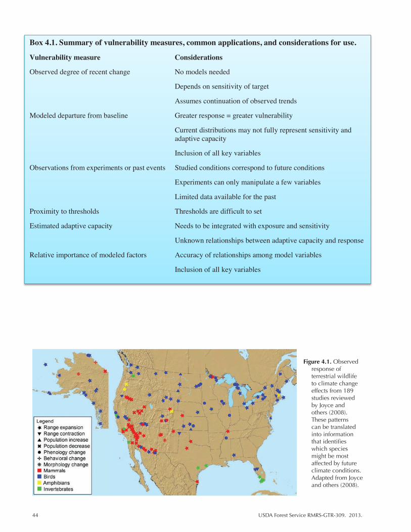
44 USDA Forest Service RMRS-GTR-309. 2013.
Box 4.1. Summary of vulnerability measures, common applications, and considerations for use.
Vulnerability measure Considerations
Observed degree of recent change No models needed
Depends on sensitivity of target
Assumes continuation of observed trends
Modeled departure from baseline Greater response = greater vulnerability
Current distributions may not fully represent sensitivity and adaptive capacity
Inclusion of all key variables
Observations from experiments or past events Studied conditions correspond to future conditions
Experiments can only manipulate a few variables
Limited data available for the past
Proximity to thresholds Thresholds are difficult to set
Estimated adaptive capacity Needs to be integrated with exposure and sensitivity
Unknown relationships between adaptive capacity and response
Relative importance of modeled factors Accuracy of relationships among model variables
Inclusion of all key variables
Figure 4.1. Observed response of terrestrial wildlife to climate change effects from 189 studies reviewed by Joyce and others (2008). These patterns can be translated into information that identifies which species might be most affected by future climate conditions. Adapted from Joyce and others (2008).

USDA Forest Service RMRS-GTR-309. 2013. 45
various sources and time periods as a baseline for comparison. This method is commonly used to assess vulnerability of individual species to climate change but has also been applied to communities. For example, phenological or timing responses to climate change are often based on recent observations, such as the difference in date over the past decade for initial spring bud burst or the arrival date of a migratory bird species. A study of recent shifts in bird migration timing in the fall found differences in the degree of timing change (i.e., vulnerability) by species, depending on migration distance and variability in annual brood number (Jenni and Kery 2003). Spatial measures can also be accommodated, such as the change in distance from the historic center of a species range to the current center. This is akin to methods that use historic conditions (such as the natural range of variability, see case study in Chapter 2) as a benchmark or reference to examine the degree of change in a system. The assumption of this group of approaches is that greater change is indicative of greater vulnerability.
Recent change is an appropriate measure for targets that are particularly sensi-tive to climate variables allowing for a measurable effect, less so for targets that are resistant at current levels of change. Because the degree of change is measured directly, interactions and multiple contributing factors to response are included, but this also makes it difficult to pinpoint the primary causes for the observed changes. This approach does not require projecting into the future but assumes that the degree of vulnerability in the future, and similarly the rate of climate change, will follow the observed trend, which is uncertain considering that climate effects and interactions are unlikely to be linear.
4.1.2 Degree of Modeled Future Change From a Baseline
The magnitude of departure of future projections of climate, species distribu-tions, biodiversity, and other measures from baseline observations is a common measure of vulnerability (Figs. 4.2, 4.3). Modeling approaches are commonly used for the future projections so targets are limited to those that can be modeled or that can be correlated with modeled variables. Greater divergence between the baseline and the projected future conditions is equated with greater exposure and increasing vulnerability. This measure of vulnerability is useful for large-scale targets such as ecosystems or regions. For smaller scales, a correlative approach is often taken. Distribution models, a common approach, correlate species presence with cli-mate and environmental variables, which can then be used to project distributions give future climate conditions. Vulnerability is the change in distance or over-lap of current climate conditions to the projected location of similar conditions. Alternatively, vulnerability might relate to the estimated magnitude or velocity of change. Distribution approaches primarily focus on the exposure aspect of vulner-ability, but some efforts include other aspects of vulnerability such as the potential for dispersal. For example, Iverson and others (2004) predicted potential habitat for five tree species in eastern North America by combining a species distribution model with a spatial model of migration potential to estimate the probability of the species colonizing new potential habitat; species with lower colonization potential would be more vulnerable to climate change.
Accuracy of these measures of vulnerability depends on the ability of the model to project future conditions, and considerable discussion has evolved about the limitations of these models and subsequent improvements (see Chapter 3.2). Modeling approaches are numerous, but they can be generally categorized as mod-eling the future based on observation of outcomes (empirical or statistical models) or based on the processes that determine outcomes (mechanistic or process-based

46 USDA Forest Service RMRS-GTR-309. 2013.
Figure 4.2. Richness of American tree species under current (A) and future (B and C) climate scenarios. Future (B) represents projections under increasing CO2 whereas future (C) represents conditions with future decrease in CO2. This study presents an estimate of future effects based upon current understood relationships between tree richness and climate variables. CE=Climate envelope richness. Adapted from McKenney and others 2007.

USDA Forest Service RMRS-GTR-309. 2013. 47
Figure 4.3. An example of how the degree of response (species richness) might be used to measure vulnerability. Here, darker colors represent areas that are expected to experience the greatest change and are therefore at greatest risk of negative impact, in species composition under a mid A1B greenhouse gas scenario. (A) represents projections for a 100 x 100-km grid and (B) represents 200 x 200-km grid projections. Adapted from Lawler and others (2009).
models). Correlative approaches assume that the modeled climate and environ-mental variables rather than sensitivity or adaptive capacity are the key drivers of distribution and that current distributions can capture ecological limitations of the target (Schmitz and others 2003).
4.1.3 Observed Impacts Under Comparable Conditions
Comparable climate conditions to those projected for the future can be found from the paleoclimate when carbon dioxide levels were much higher, from re-cent extreme events, or from experimental treatments. Response of the chosen target can be measured or estimated under those comparable conditions to predict climate change response (Figs. 4.4, 4.5). Episodic events, such as drought or El Niño, are expected to be more frequent under a warming climate and are good for identifying the vulnerability of targets because these events occur frequently enough to observe (Fig 4.5). Vulnerability is identified by comparing the target’s responses to the episodic event to responses during a period outside the event or from a control site for an experiment. An examination of recent vegetation die-off in the Southwest due to drought and bark beetle infestation highlighted how extreme events and biotic interactions can lead to rapid and large-scale change in the distribution of pinyon (Pinus edulis) (Breshears and others 2005). Similarly, paleoclimatic conditions similar to those projected can offer insights into expected responses. Experiments can directly measure the response of a target to climate change by manipulating variables such as CO2 or temperature and can even be conducted in the field where the target is subject to important ecological processes.
Experiments are often limited to short time periods and only a few climate variables can be manipulated at relatively small scales. Data available from paleoclimatic conditions or extreme events are also limited in terms of spatial dis-tribution, thus limiting the range of targets and responses that can be examined using this approach. While the inclusion of responses to extreme events is relevant given their absence in most models, inference is limited in that responses are gen-erally only examined in the short term and extreme events under future climate
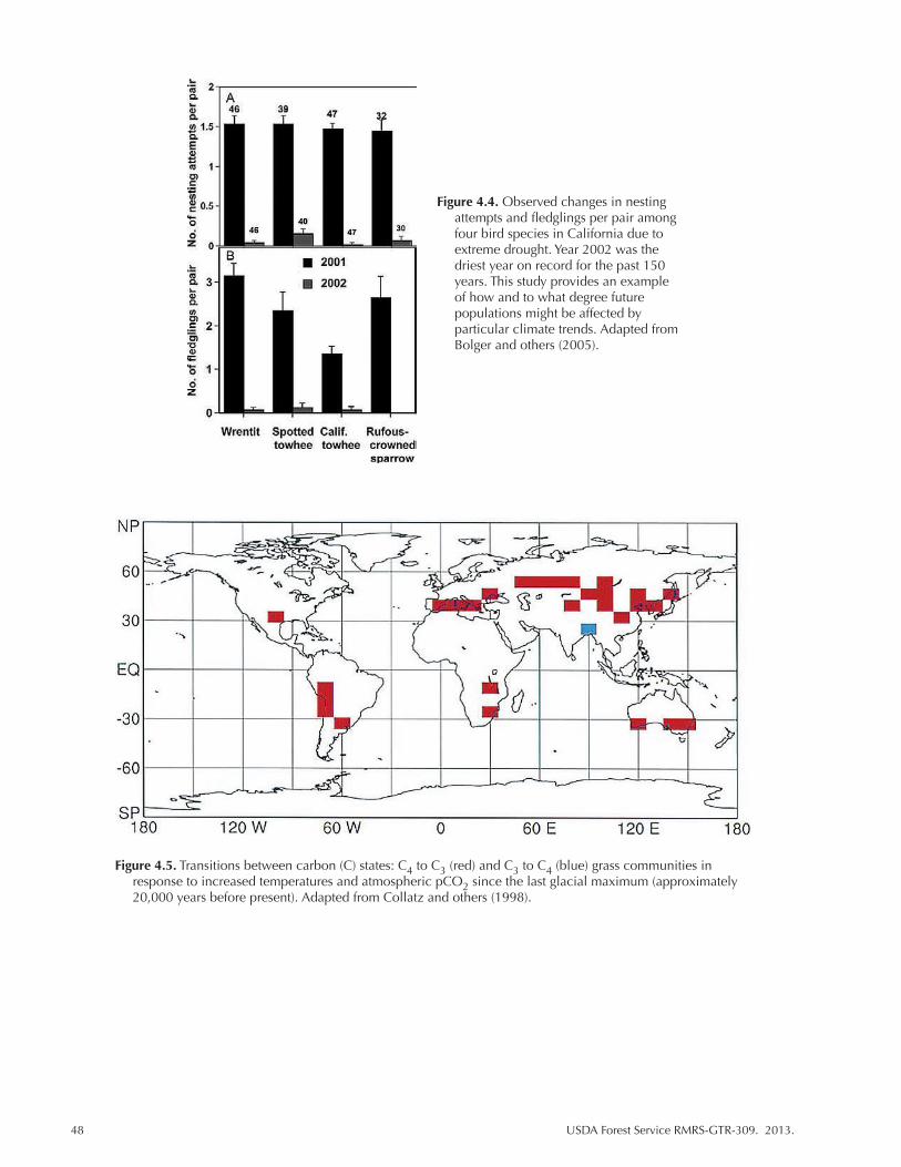
48 USDA Forest Service RMRS-GTR-309. 2013.
Figure 4.4. Observed changes in nesting attempts and fledglings per pair among four bird species in California due to extreme drought. Year 2002 was the driest year on record for the past 150 years. This study provides an example of how and to what degree future populations might be affected by particular climate trends. Adapted from Bolger and others (2005).
Figure 4.5. Transitions between carbon (C) states: C4 to C3 (red) and C3 to C4 (blue) grass communities in response to increased temperatures and atmospheric pCO2 since the last glacial maximum (approximately 20,000 years before present). Adapted from Collatz and others (1998).
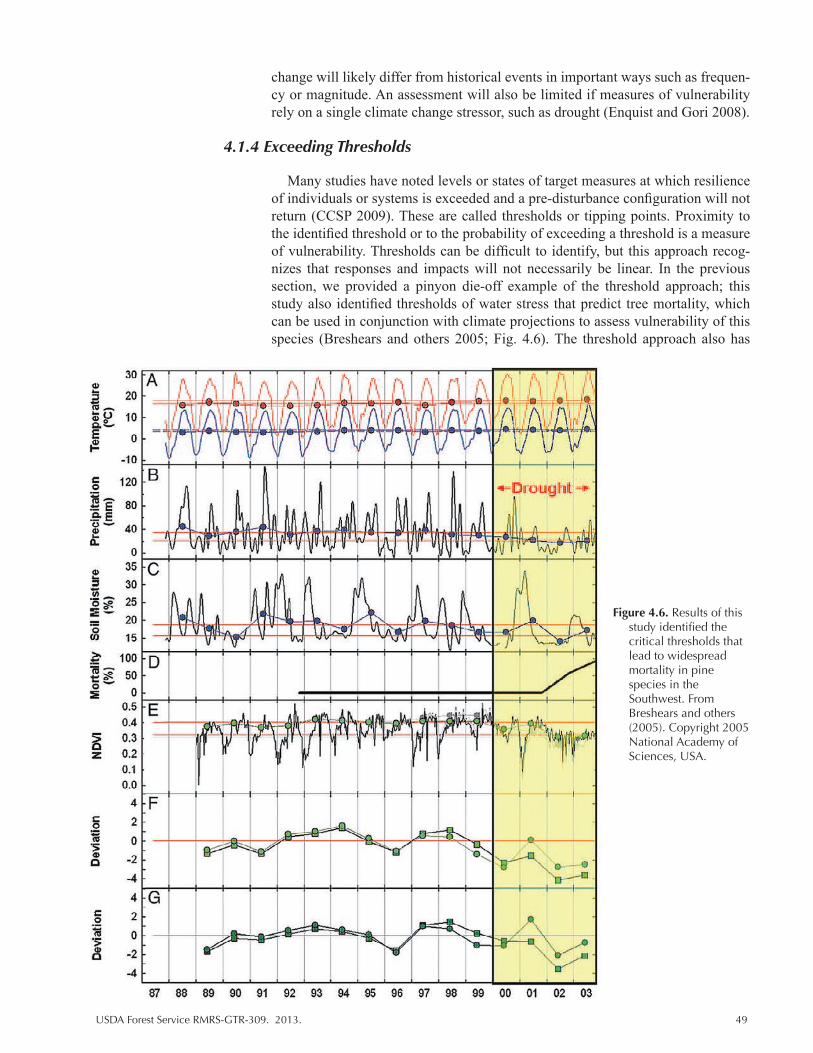
USDA Forest Service RMRS-GTR-309. 2013. 49
Figure 4.6. Results of this study identified the critical thresholds that lead to widespread mortality in pine species in the Southwest. From Breshears and others (2005). Copyright 2005 National Academy of Sciences, USA.
change will likely differ from historical events in important ways such as frequen-cy or magnitude. An assessment will also be limited if measures of vulnerability rely on a single climate change stressor, such as drought (Enquist and Gori 2008).
4.1.4 Exceeding Thresholds
Many studies have noted levels or states of target measures at which resilience of individuals or systems is exceeded and a pre-disturbance configuration will not return (CCSP 2009). These are called thresholds or tipping points. Proximity to the identified threshold or to the probability of exceeding a threshold is a measure of vulnerability. Thresholds can be difficult to identify, but this approach recog-nizes that responses and impacts will not necessarily be linear. In the previous section, we provided a pinyon die-off example of the threshold approach; this study also identified thresholds of water stress that predict tree mortality, which can be used in conjunction with climate projections to assess vulnerability of this species (Breshears and others 2005; Fig. 4.6). The threshold approach also has

50 USDA Forest Service RMRS-GTR-309. 2013.
implications for management in that actions are targeted to a specific level of im-pact rather than requiring a sustained effort to reduce impacts. Because there is non-linear change in vulnerability over time, the time scale of the assessment and the uncertainty surrounding the threshold level need to be considered carefully.
4.1.5 Capacity to Adapt to Change
Adaptive capacity is a key component of vulnerability, often thought of as a species-specific measure, but it can also apply to individuals or systems as well as to the ability of the managing organization to ameliorate negative impacts (Fig. 4.7). Flexibility, such as behavioral or morphological plasticity, can increase the ability of the target to cope with changing conditions, thus increasing resil-ience (i.e., reducing vulnerability). Where this plasticity arises from intraspecific genetic variation, it may be heritable and thus provide the basis for adaptation to novel conditions. Examination of population dynamics and variability in the heritable traits that control timing of budburst in the Scottish birch revealed that budburst, although advancing with warmer temperatures, was unlikely to keep up with warming of 2 °C in the next 60 years (Billington and Pellham 1991).
Resilience of ecosystems and communities has been related to level of biodi-versity or functional diversity (Naeem 2006; Petchey and Gaston 2009). Dispersal ability, which can confer a species` capacity to track favorable environmental con-ditions, is an important adaptive strategy that can be measured by mobility, rates of movement, and dispersal vectors. Traits may also characterize adaptive capac-ity where they are associated with the ability to cope with the expected effects of climate change. For example, species that are habitat or resource generalists may be at an advantage under varying conditions, because they have greater flexibility in habitat use than a species that specializes in a particular habitat or resource (Parmesan 2006). Vulnerability may be measured by the strength of a given capacity measure for alleviating negative impacts, the presence or absence of a distinguishing trait, or as the number of traits possessed that limit the target’s
Figure 4.7. Schematic of the relationship between adaptive capacity and species vulnerability. Adaptive capacity affects species vulnerability by modulating exposure and sensitivity. Adapted from Engle 2011.

USDA Forest Service RMRS-GTR-309. 2013. 51
response to change. Difficulty in addressing vulnerability through traits arises be-cause the strength and nature of the relationship between the adaptive traits and the associated reduction of vulnerability is generally not well known.
4.1.6 Relative Degree of Response to Climate Variation
This measure of vulnerability is commonly conducted using a sensitivity analy-sis and examines quantitatively how much the target measure changes when model parameters are varied (Fig. 4.8). These analyses start with a modeled representation of climate-related variables (e.g., timing of peak runoff) and the expected response in the target (e.g., aquifer recharge). The relative response or degree of change in the target is determined by varying the climate inputs across a range of val-ues. Sensitivity to the climate variables infers vulnerability. The rangze of climate variables inputted is often the range produced by different emissions scenarios or projections from different global climate models, which is helpful in evaluating the uncertainty surrounding model selection and which climate parameters most affect the target. Keller and others (2005) examined duration of snow cover and its interaction with plants at high altitudes and found duration most sensitive to mean temperature and identified plant habitat zones subject to the greatest advancement in snowmelt, which may indicate greater vulnerability. Sala and others (2000) looked at the relative influence of various drivers on declines in biodiversity by region (Fig. 4.8). Potential management actions can be incorporated into models to evaluate their effectiveness at reducing vulnerability. A model that accurately links the target to climate is critical to this type of analysis.
Figure 4.8. Effect of each driver on biodiversity change for each terrestrial biome and freshwater ecosystem type calculated as the product of the expected change of each driver times its impact for each terrestrial biome or freshwater ecosystem. Values are relative to the maximum possible value. Bars: 1, land use; 2, climate; 3, nitrogen deposition; 4, biotic exchange; 5, atmospheric CO2. From Sala and others (2000). Reprinted with permission from American Association for the Advancement of Science (AAAS).

52 USDA Forest Service RMRS-GTR-309. 2013.
4.2 Informing Natural Resource Management Recommendations
Vulnerability measures provide a ranking of vulnerability and, in doing so, iden-tify priority targets or actions (Table 4.1). In their review, Peterson and others (2011) outlined how to translate climate vulnerability data into adaptive management options (Fig. 4.9). Implementation of adaptive management strategies combines climate data and prioritization schemes to develop and assess management ac-tions that are most likely to achieve management goals to promote resistance and resilience or facilitate transition. Ranking species according to their relative vul-nerability provides a means to identify priority species and potential actions that, implemented in the near future, might prevent further population decline. This may also apply to critical ecosystems services, such as water quality, where assess-ment targets may include variables (processes, critical species) believed essential to continued functioning. Vulnerability measures may also consider how well current management strategies reflect the likely future state of the system under study. A vulnerability assessment that considers the degree of change in vegeta-tion community distributions identifies vulnerable systems with a high likelihood of not persisting under future climate regimes. This type of assessment might also identify species that are likely to colonize the area in the future and thereby pro-vide information regarding potential new management goals. Sensitivity to climate change as inferred by observations of response to past climate change, is a good measure of which species or habitats are likely to need the greatest degree of in-tervention. Probability of occurrence or likelihood of distribution shifts are useful measures to gauge the applicability of current management strategies under future conditions. Degree of vulnerability, as generated with a quantified vulnerability score, can inform both short- and long-term goals.
Table 4.1. Summary of common measures of vulnerability, applicable time scales, key limitations, and common applications.
Measure of vulnerability Time scales Limitations Common applications
Degree of recent Short-term only Sensitive targets only Phenology of flowering plants and change from historic (extrapolate to migrating birds longer)
Degree of modeled Any Relation of target to modeled Species distributions, exposure future change from climate variables baseline
Observed impacts Any (but older Historic or paleo record data Effects of extreme events and high levels under comparable data more available, manipulations of few of CO2 at a large scale, experimental conditions limited) variables response in plants
Exceeding thresholds Any Difficulty identifying ecological Vegetation communities thresholds
Ability to adapt to Varies by target Relationship between adaptations Single species change and population parameters
Relative degree of Any Relation of target to modeled Single species response to climate climate variables variation
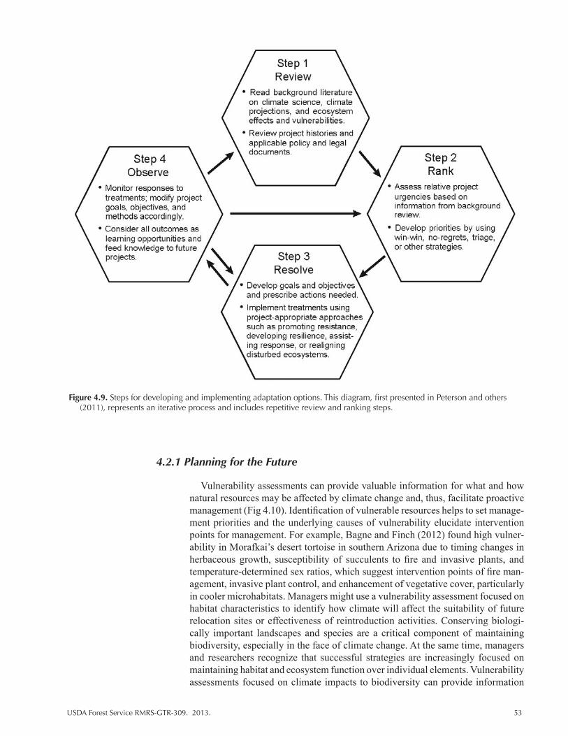
USDA Forest Service RMRS-GTR-309. 2013. 53
4.2.1 Planning for the Future
Vulnerability assessments can provide valuable information for what and how natural resources may be affected by climate change and, thus, facilitate proactive management (Fig 4.10). Identification of vulnerable resources helps to set manage-ment priorities and the underlying causes of vulnerability elucidate intervention points for management. For example, Bagne and Finch (2012) found high vulner-ability in Morafkai’s desert tortoise in southern Arizona due to timing changes in herbaceous growth, susceptibility of succulents to fire and invasive plants, and temperature-determined sex ratios, which suggest intervention points of fire man-agement, invasive plant control, and enhancement of vegetative cover, particularly in cooler microhabitats. Managers might use a vulnerability assessment focused on habitat characteristics to identify how climate will affect the suitability of future relocation sites or effectiveness of reintroduction activities. Conserving biologi-cally important landscapes and species are a critical component of maintaining biodiversity, especially in the face of climate change. At the same time, managers and researchers recognize that successful strategies are increasingly focused on maintaining habitat and ecosystem function over individual elements. Vulnerability assessments focused on climate impacts to biodiversity can provide information
Figure 4.9. Steps for developing and implementing adaptation options. This diagram, first presented in Peterson and others (2011), represents an iterative process and includes repetitive review and ranking steps.

54 USDA Forest Service RMRS-GTR-309. 2013.
on potential hotspots and refugia (e.g., Davison and others 2012), thus allowing managers to focus resources where there is the greatest benefit. Vulnerability as-sessments are also useful for identifying monitoring strategies, especially where current programs exclude potentially sensitive species.
4.2.2 Promoting Resistance and Resilience
Vulnerability assessments can be used to gauge the effectiveness of management strategies focused along a wide biological spectrum as well as determine the best practices for increasing resilience and resistance of our landscapes under climate change (Peterson and others 2011; Lou Comer and others 2012). Species-level assessments are valuable for identifying high priority species and potential new sources of concern. For instance, a manager might use a vulnerability assessment to determine whether ecologically important species might be negatively impacted by climate impacts or whether an invasive species will be favored by future con-ditions. Depending on the degree and nature of the change, managers can choose whether specific areas or species warrant actions to mitigate loss of biodiversity or prevent establishment of exotic species. For species already of concern, vulner-ability assessments can improve our ability to foresee and reduce additive stressor impacts that arise from both the direct and indirect consequences of climate change. Restoration practices to enhance resilience include habitat restoration and reestab-lishment of natural and important disturbance processes such as floods and fire. A vulnerability assessment that compares the degree of expected change across the landscape could be used to prioritize restoration activities to areas with the great-est promise for sustaining populations. Alternatively, post-fire seeding activities may be informed by estimations of future conditions produced by a vulnerability assessment. Assessments are also helpful for facilitated transformation strategies
Figure 4.10. Example of work-flow used to create a vulnerability assessment that is translated to on-the-ground management strategies. Endpoints are determined by the questions and objectives of managers and are largely influenced by management strategies to mitigate, improve, or facilitate response to climate change. Target selection depends upon the desired endpoint and influences the relevant measures used to gauge target vulnerability. Targets also influence the availability of relevant measures.
USDA Forest Service RMRS-GTR-309. 2013. 55
(USFS Scorecard Guidelines), which aim to work with anticipated changes in or-der to facilitate transitions to new stable states with minimal ecological disruption. Adaptation strategies aimed at improving genetic adaptive capacity, translocation and relocation activities can be informed by multiple types of vulnerability mea-sures and assessments.
4.2.3 Landscape-Level Planning
Future climate envelopes inform landscape practices that involve the develop-ment and preservation of corridors, relocation of individuals, and preservation of high quality habitats (Glick and others 2011). Increasingly, conservation and management must cross political and jurisdictional boundaries. Common objec-tives and strategies for maintaining wildlife and habitat across landscapes can be informed by a vulnerability assessment conducted at regional levels or involving species relevant to multiple stakeholder groups. For example, increasing adaptive capacity of populations threatened by climate change commonly involves improv-ing genetic stock through translocations. Assessments that outline future suitable conditions can guide practices that aim to improve the expression of drought tol-erance or other favorable traits through translocations, which often must cross political boundaries.
4.2.4 Limitations
Predicting response to climate change and measuring climate change vulnera-bility is difficult because it is part of a complex and dynamic process. Vulnerability measures address effects through various means that highlight unique aspects of natural systems. The relevance of any one measure of change or impact relates to its capacity to accurately provide information regarding future trends and the po-tential for actions to ameliorate or mitigate effects. The dynamic and progressive nature of climate change also requires managers to carefully consider values and management goals. Divergence from current or historic conditions highlights the need for managers to identify appropriate and desirable benchmarks for natural resources. As noted in Chapters 1 and 2, benchmarks are often set on reference conditions but, in light of climate change, are now moving away from emulating historic conditions and toward a focus on preserving ecosystem function and ser-vices. Our understanding of the full range of potential changes and responses, as well as our ability to address them, will grow as more researchers and managers participate in the assessment process.
4.2.5 Assessment Tools and Guidance
Vulnerability assessments and the methods used to generate them can supply managers with the tools and resources needed to make decisions that incorpo-rate considerations of climate change and climate change vulnerability (Fig. 4.10). There are a number of tools available to facilitate vulnerability assessment, several of which are specifically designed to inform management decisions (Table 4.2). Many of these sources (e.g., VEMAP) provide estimates of future impact, which can then be used within an assessment of vulnerability. Some sources provide criti-cal baseline data, such as natural history information, that are useful for conducting analyses or applying an index scoring systems (e.g., NatureServe Explorer and BISON-M). Others (e.g., Treeage Pro) are methods to use the results of a vul-nerability assessment to create management strategies or guide decision-making
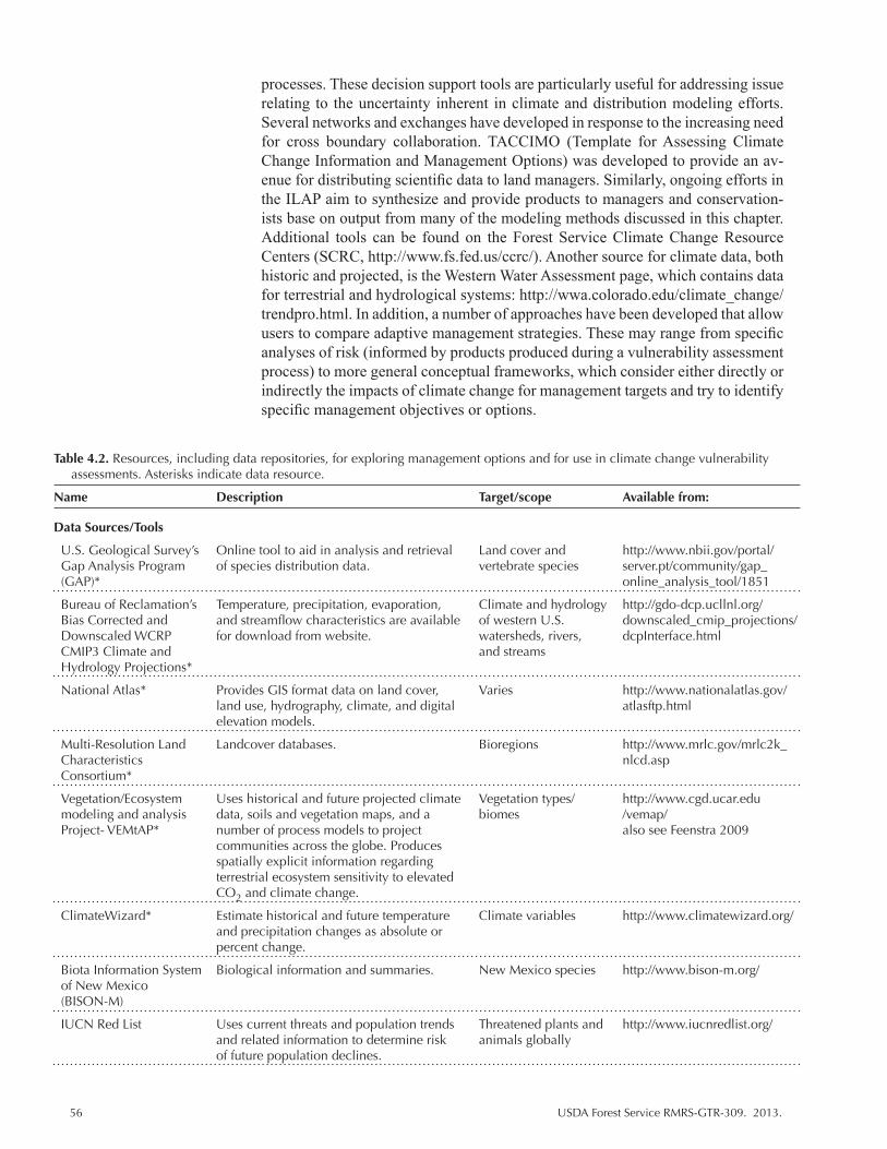
56 USDA Forest Service RMRS-GTR-309. 2013.
processes. These decision support tools are particularly useful for addressing issue relating to the uncertainty inherent in climate and distribution modeling efforts. Several networks and exchanges have developed in response to the increasing need for cross boundary collaboration. TACCIMO (Template for Assessing Climate Change Information and Management Options) was developed to provide an av-enue for distributing scientific data to land managers. Similarly, ongoing efforts in the ILAP aim to synthesize and provide products to managers and conservation-ists base on output from many of the modeling methods discussed in this chapter. Additional tools can be found on the Forest Service Climate Change Resource Centers (SCRC, http://www.fs.fed.us/ccrc/). Another source for climate data, both historic and projected, is the Western Water Assessment page, which contains data for terrestrial and hydrological systems: http://wwa.colorado.edu/climate_change/trendpro.html. In addition, a number of approaches have been developed that allow users to compare adaptive management strategies. These may range from specific analyses of risk (informed by products produced during a vulnerability assessment process) to more general conceptual frameworks, which consider either directly or indirectly the impacts of climate change for management targets and try to identify specific management objectives or options.
Table 4.2. Resources, including data repositories, for exploring management options and for use in climate change vulnerability assessments. Asterisks indicate data resource.
Name Description Target/scope Available from:
Data Sources/Tools
U.S. Geological Survey’s Online tool to aid in analysis and retrieval Land cover and http://www.nbii.gov/portal/ Gap Analysis Program of species distribution data. vertebrate species server.pt/community/gap_ (GAP)* online_analysis_tool/1851
Bureau of Reclamation’s Temperature, precipitation, evaporation, Climate and hydrology http://gdo-dcp.ucllnl.org/ Bias Corrected and and streamflow characteristics are available of western U.S. downscaled_cmip_projections/ Downscaled WCRP for download from website. watersheds, rivers, dcpInterface.html CMIP3 Climate and and streams Hydrology Projections*
National Atlas* Provides GIS format data on land cover, Varies http://www.nationalatlas.gov/ land use, hydrography, climate, and digital atlasftp.html elevation models.
Multi-Resolution Land Landcover databases. Bioregions http://www.mrlc.gov/mrlc2k_ Characteristics nlcd.asp Consortium*
Vegetation/Ecosystem Uses historical and future projected climate Vegetation types/ http://www.cgd.ucar.edu modeling and analysis data, soils and vegetation maps, and a biomes /vemap/ Project- VEMtAP* number of process models to project also see Feenstra 2009 communities across the globe. Produces spatially explicit information regarding terrestrial ecosystem sensitivity to elevated CO2 and climate change.
ClimateWizard* Estimate historical and future temperature Climate variables http://www.climatewizard.org/ and precipitation changes as absolute or percent change.
Biota Information System Biological information and summaries. New Mexico species http://www.bison-m.org/ of New Mexico (BISON-M)
IUCN Red List Uses current threats and population trends Threatened plants and http://www.iucnredlist.org/ and related information to determine risk animals globally of future population declines.
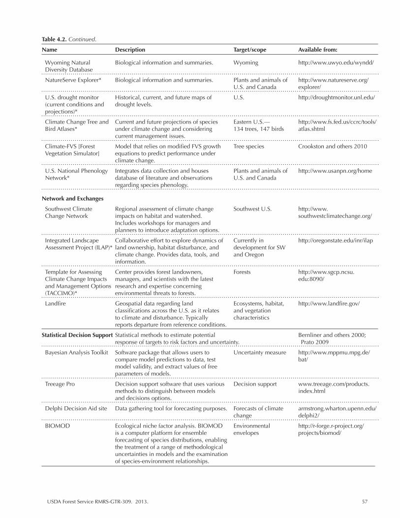
USDA Forest Service RMRS-GTR-309. 2013. 57
Wyoming Natural Biological information and summaries. Wyoming http://www.uwyo.edu/wyndd/ Diversity Database
NatureServe Explorer* Biological information and summaries. Plants and animals of http://www.natureserve.org/ U.S. and Canada explorer/
U.S. drought monitor Historical, current, and future maps of U.S. http://droughtmonitor.unl.edu/ (current conditions and drought levels. projections)*
Climate Change Tree and Current and future projections of species Eastern U.S.— http://www.fs.fed.us/ccrc/tools/ Bird Atlases* under climate change and considering 134 trees, 147 birds atlas.shtml current management issues.
Climate-FVS [Forest Model that relies on modified FVS growth Tree species Crookston and others 2010 Vegetation Simulator] equations to predict performance under climate change.
U.S. National Phenology Integrates data collection and houses Plants and animals of http://www.usanpn.org/home Network* database of literature and observations U.S. and Canada regarding species phenology.
Network and Exchanges
Southwest Climate Regional assessment of climate change Southwest U.S. http://www. Change Network impacts on habitat and watershed. southwestclimatechange.org/ Includes workshops for managers and planners to introduce adaptation options.
Integrated Landscape Collaborative effort to explore dynamics of Currently in http://oregonstate.edu/inr/ilap Assessment Project (ILAP)* land ownership, habitat disturbance, and development for SW climate change. Provides data, tools, and and Oregon information.
Template for Assessing Center provides forest landowners, Forests http://www.sgcp.ncsu. Climate Change Impacts managers, and scientists with the latest edu:8090/ and Management Options research and expertise concerning (TACCIMO)* environmental threats to forests.
Landfire Geospatial data regarding land Ecosystems, habitat, http://www.landfire.gov/ classifications across the U.S. as it relates and vegetation to climate and disturbance. Typically characteristics reports departure from reference conditions.
Statistical Decision Support Statistical methods to estimate potential Bernliner and others 2000; response of targets to risk factors and uncertainty. Prato 2009
Bayesian Analysis Toolkit Software package that allows users to Uncertainty measure http://www.mppmu.mpg.de/ compare model predictions to data, test bat/ model validity, and extract values of free parameters of models.
Treeage Pro Decision support software that uses various Decision support www.treeage.com/products. methods to distinguish between models index.html and decisions options.
Delphi Decision Aid site Data gathering tool for forecasting purposes. Forecasts of climate armstrong.wharton.upenn.edu/ change delphi2/
BIOMOD Ecological niche factor analysis. BIOMOD Environmental http://r-forge.r-project.org/ is a computer platform for ensemble envelopes projects/biomod/ forecasting of species distributions, enabling the treatment of a range of methodological uncertainties in models and the examination of species-environment relationships.
Table 4.2. Continued.
Name Description Target/scope Available from:

58 USDA Forest Service RMRS-GTR-309. 2013.
Literature Cited
Bagne, Karen E., Deborah M. Finch. 2012. Vulnerability of species to climate change in the Southwest: threatened, endangered, and at-risk species at the Barry M. Goldwater Range, Arizona. Gen. Tech. Rep. RMRS-GTR-284. Fort Collins, CO: U.S. Department of Agriculture, Forest Service, Rocky Mountain Research Station. 139 p.
Billington, H.L., and J. Pelham. 1991. Genetic Variation in the Date of Budburst in Scottish Birch Populations: Implications for Climate Change. Functional Ecology 5: 403-409.
Bolger, D.T., M.A. Patten, and D.C. Bostock. 2005. Avian reproductive failure in response to an extreme climatic event. Oecologia 142: 398-406.
Breshears, D.D., N.S. Cobb, P.M. Rich, [and others]. 2005. Regional vegetation die-off in response to global-change-type drought. Proceedings of the National Academy of Sciences 102:15144-15148.
Fagre, D.B., C.W. Charles, C.D. Allen, C. Birkeland, F.S. Chapin III, P.M. Groffman, G.R Guntenspergen, A.K. Knapp, A.D. McGuire, P.J. Mulholland, D.P.C. Peters, D.D. Roby, and G. Sugihara. 2009. Thresholds of climate change in Ecosystems: Final Report, Synthesis and Assessment Product 4.2. : U.S. Geological Survey A report by the U.S. Climate Change Science Program and the Subcommittee on Global Change Research. 157+ p. Collatz, G.J., J.A. Berry, and J.S. Clark. 1998. Effects of climate and atmospheric CO2 partial pressure on the global distribution of C4 grasses: present, past, and future. Oecologia 114: 441-454.
Davison, J.E, S. Coe, D. Finch, [and others]. 2012. Bringing indices of species vulnerability to climate change into geographic space: an assessment across the Coronado National Forest. Biodiversity Conservation 21: 189-204.
Enquist, C., and D. Gori. 2008a. Implications of Recent Climate Change and Conservation Priorities in New Mexico. The Nature Conservancy New Mexico Conservation Science Program, 79 p. Available at: http://www.nmconservation.org. (Accessed December 2008.)
Iverson, L.R., A.M. Prasad, S.N. Matthews, and M. Peters. 2008. Estimating potential habitat for 134 eastern US tree species under six climate scenarios. Forest Ecology and Management 254(3): 390-406.
Iverson, L.R., M.W. Schwartz, and A.M. Prasad. 2004. Potential colonization of newly available tree-species habitat under climate change: an analysis for five eastern US species. Landscape Ecology 19: 787-799.
Jenni, L., and M. Kery. 2003. Timing of autumn bird migration under climate change: advances in long–distance migrants, delays in short-distance migrants. Proceedings of the Royal Society, London 270: 1467-1471.
Joyce, L.A., C.H. Flather, and M. Koopman. 2008. WHPRP Final Project Report: 1.B: Analysis of Potential Impacts of Climate Change on Wildlife Habitats in the U.S. Available at: http://www.tribesandclimatechange.org/docs/tribes_214.pdf.
Keller, F., S. Goyette, and M. Beniston. 2005. Sensitivity analysis of snow cover to climate change scenarios and their impact on plant habitats in alpine terrain. Climatic Change 72:299-319.
Lawler, J.J., S.L. Shafer, D. White, [and others]. 2009. Projected climate-induced faunal change in the Western Hemisphere. Ecology 90: 588-597.
USDA Forest Service RMRS-GTR-309. 2013. 59
Parmesan, C. 2006. Ecological and Evolutionary Responses to Recent Climate Change. Annual Review of Ecology, Evolution, and Systematics 37: 637-669.
Petchey, Owen L., and Kevin J. Gaston. 2009. Effects on ecosystem resilience of biodiversity, extinctions, and the structure of regional species pools. Theoretical Ecology 2:177-187.
Peterson, D.L., C.I. Millar, L.A. Joyce, M.J. Furniss, J.E. Halofsky, R.P. Neilson, and T. Lyn Morelli. 2011. Responding to climate change in National Forests: a guidebook for developing adaptation options. Gen. Tech. Rep. PNW-GTR-855. Portland, OR: U.S. Department of Agriculture, Forest Service, Pacific Northwest Research Station. 109 p.
Schmitz, O.J., E. Post, C.E. Burns, and K.M. Johnston. 2003. Ecosystem Responses to Global Climate Change: Moving Beyond Color Mapping. BioScience 53(12):1199-1205.
USDA Forest Service. 2011. Navigating the Climate Change Performance Scorecard. A Guide for National Forest and Grasslands, Version 2. Available at: http://www.fs.fed.us/climatechange/advisor/scorecard/scorecard-guidance-08-2011.pdf.

60 USDA Forest Service RMRS-GTR-309. 2013.
Chapter 5. Vulnerability of Southwestern Species and Ecosystems to Climate Change: A Review
5.1 Introduction
Climate change vulnerability assessments link scientific information of future change to specific features, species, or areas that must be managed to success-fully mitigate the negative consequences of climate change for natural ecosystems. Ideally, vulnerability assessments would provide a comprehensive view of both small and large issues regarding species conservation across multiple regions of interest. In reality, the body of literature available for managers for any one region is immense and can be difficult to access, and few publications fulfill the specific characteristics of a climate change vulnerability assessments (see Chapter 1) that make them useful to managers. These shortcomings limit our capacity to under-stand and interpret the ecologically relevant issues relating to climate changes. In this chapter, we review and synthesize the current body of climate change vulner-ability assessment literature for southwestern species, habitats, and ecosystems to provide a starting point upon which to build comprehensive and targeted assess-ments and plans in the future.
The Southwest United States (henceforth, “SW”) has undergone rapid expan-sion in the last half of the century with consequences for resident populations and the natural environment. Climate projections for the United States indicate that the SW will experience more extreme change with respect to temperature increases and drought than other regions (Fig. 5.1). These changes exacerbate existing prob-lems with sustaining valued natural resources. For example, longer droughts and higher temperatures will reduce the already scarce water sources critical to plants, fish, and wildlife as well as the large human population that occupies the region. It is imperative to address these issues and develop a clear understanding of where and to what degree climate change will affect SW species and habitats in order that future management and development plans can be created to effectively balance human and environmental needs.
As discussed in Chapters 3 and 4, vulnerability assessments include a wide va-riety of approaches and measures. This is reflected in the information available for SW systems, which encompass a broad array of methods and output. Within this review, we identify trends where studies overlap and gaps in our knowledge, and we discuss implications for future assessment work, climate change studies and management plans. We focus primarily on synthesizing climate change vulner-ability assessments that relate specifically to natural resource management than on the large and developing body of literature that addresses human-environmental systems (see Turner and others 2003 for discussion). We identify 12 reviews that summarize our understanding of climate projections and potential effects for the SW (Table 5.1). We have also compiled articles that contain information either used in SW assessments or of value for conducting future assessments of the SW (Appendix 2).
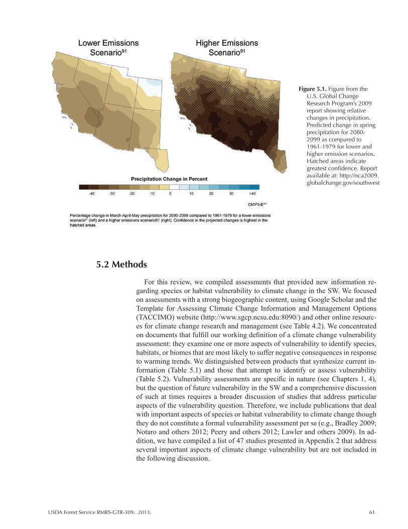
USDA Forest Service RMRS-GTR-309. 2013. 61
Figure 5.1. Figure from the U.S. Global Change Research Program’s 2009 report showing relative changes in precipitation. Predicted change in spring precipitation for 2080-2099 as compared to 1961-1979 for lower and higher emission scenarios. Hatched areas indicate greatest confidence. Report available at: http://nca2009.globalchange.gov/southwest
5.2 Methods
For this review, we compiled assessments that provided new information re-garding species or habitat vulnerability to climate change in the SW. We focused on assessments with a strong biogeographic content, using Google Scholar and the Template for Assessing Climate Change Information and Management Options (TACCIMO) website (http://www.sgcp.ncsu.edu:8090/) and other online resourc-es for climate change research and management (see Table 4.2). We concentrated on documents that fulfill our working definition of a climate change vulnerability assessment: they examine one or more aspects of vulnerability to identify species, habitats, or biomes that are most likely to suffer negative consequences in response to warming trends. We distinguished between products that synthesize current in-formation (Table 5.1) and those that attempt to identify or assess vulnerability (Table 5.2). Vulnerability assessments are specific in nature (see Chapters 1, 4), but the question of future vulnerability in the SW and a comprehensive discussion of such at times requires a broader discussion of studies that address particular aspects of the vulnerability question. Therefore, we include publications that deal with important aspects of species or habitat vulnerability to climate change though they do not constitute a formal vulnerability assessment per se (e.g., Bradley 2009; Notaro and others 2012; Peery and others 2012; Lawler and others 2009). In ad-dition, we have compiled a list of 47 studies presented in Appendix 2 that address several important aspects of climate change vulnerability but are not included in the following discussion.

62 USDA Forest Service RMRS-GTR-309. 2013.
Tabl
e 5.
1. R
evie
ws
and
synt
hese
s of
clim
ate
chan
ge p
roje
ctio
ns a
nd im
pact
s fo
r sp
ecie
s an
d ha
bita
t spe
cific
to th
e SW
Uni
ted
Stat
es.
Sour
ce
Des
crip
tion
Ta
rget
To
pic
Loca
tion
H
abit
at t
ype
Cha
mbe
rs a
nd P
ella
nt
Rev
iew
s pr
ojec
tions
and
impl
icat
ions
of c
limat
e ch
ange
for
Plan
ts/ h
abita
t C
limat
e ch
ange
G
reat
Bas
in, C
olum
bia
Ran
gela
nds
2008
w
ater
qua
ntity
and
qua
lity
for
wild
and
dom
estic
spe
cies
.
Pl
atea
u, C
olor
ado
Id
entif
y a
num
ber
of tr
ends
in r
espo
nse
to c
hang
es in
Pl
atea
u
tem
pera
ture
and
CO
2.
Dal
e an
d ot
hers
200
1 R
evie
ws
clim
ate
effe
cts
on d
istu
rban
ce p
roce
sses
, inc
ludi
ng
Dis
turb
ance
C
limat
e an
d U
.S.
Fore
sts
and
fir
e, in
sect
, and
pat
hoge
n ou
tbre
ak; i
ntro
duce
d sp
ecie
s an
d
and
clim
ate
dist
urba
nce
G
rass
land
s
drou
ght;
hurr
ican
es; i
ce s
torm
s; w
inds
torm
s; la
ndsl
ides
; and
ch
ange
inte
ract
ions
of v
ario
us d
istu
rban
ces.
Dis
cuss
es s
trat
egie
s fo
r
de
alin
g w
ith fo
rest
dis
turb
ance
. Inc
lude
s so
cioe
cono
mic
cons
ider
atio
ns.
Gar
in a
nd L
enar
t 200
7 R
evie
ws
the
tren
ds a
nd la
test
res
earc
h. C
oncl
uded
that
W
ater
C
limat
e ch
ange
SW
U.S
. W
ater
res
ourc
es
te
mpe
ratu
re e
ffect
s tr
ump
unce
rtai
nty
asso
ciat
ed w
ith
avai
labi
lity
pr
ecip
itatio
n be
caus
e w
ater
is v
ery
likel
y to
bec
ome
less
avai
labl
e du
e to
tem
pera
ture
effe
cts.
Hug
hes
and
Dia
z 20
08
Com
pile
s da
ta a
nd in
form
atio
n on
futu
re c
limat
e im
pact
s fo
r
Clim
ate
Clim
ate
chan
ge
Inte
rior
Wes
tern
U.S
. A
rid
land
s
arid
land
s w
ith p
artic
ular
focu
s on
the
effe
ct o
f inc
reas
ed
va
riab
ility
on
the
prov
isio
n of
eco
syst
em s
ervi
ces.
Koliv
ras
and
Com
rie
R
evie
ws
pote
ntia
l con
sequ
ence
s an
d ob
serv
ed c
hang
es to
A
nim
als
Dis
ease
SW
U.S
. V
ario
us
2004
in
fect
ious
dis
ease
s in
the
SW U
.S.
Lena
rt a
nd o
ther
s 20
07
Rev
iew
s th
e m
ajor
exp
ecte
d cl
imat
e ch
ange
s fo
r th
e SW
. W
ater
, for
ests
, C
limat
e SW
U.S
. Fo
rest
s an
d
Elab
orat
es o
n so
me
of th
e in
dire
ct, d
owns
trea
m c
ause
s
gras
slan
d pr
ojec
tions
gras
slan
ds
(e
.g.,
mon
soon
sea
sons
, soi
l moi
stur
e) a
nd d
iscu
sses
rec
ent
fin
ding
s.
Lynn
and
oth
ers
2011
R
evie
ws
dire
ct a
nd in
dire
ct a
spec
ts o
f soc
ial v
ulne
rabi
lity
to
Soci
o-
Soci
al
U.S
. Ec
onom
ic s
ecto
rs
cl
imat
e ch
ange
. ec
onom
ic
vuln
erab
ility
McP
hers
on a
nd W
eltz
in
Sum
mar
izes
lite
ratu
re r
egar
ding
pas
t veg
etat
ion
chan
ge a
nd
Live
stoc
k,
Dis
turb
ance
and
So
uthe
aste
rn A
rizo
na a
nd
Ran
gela
nds
2000
im
port
ance
of v
ario
us d
istu
rban
ces.
Iden
tifies
exp
erim
ents
na
tive
clim
ate
chan
ge
sout
hwes
tern
New
nece
ssar
y to
det
erm
ine
caus
al m
echa
nism
s un
derl
ying
ve
rteb
rate
s
Mex
ico
cu
rren
t and
futu
re c
hang
e. A
lso
eval
uate
s th
e ef
fect
s an
d
and
inve
rteb
rate
s
impo
rtan
ce o
f dis
turb
ance
and
clim
ate
chan
ge o
n pl
ant
co
mm
uniti
es.
Perr
y an
d ot
hers
201
2 R
evie
ws
dire
ct a
nd in
dire
ct im
pact
s of
clim
ate
chan
ge a
nd
Wat
er
Glo
bal c
hang
e W
este
rn N
orth
Am
eric
a W
ater
sys
tem
s
disc
usse
s re
sear
ch p
rior
ities
and
str
ateg
ies
(pre
serv
ing
rese
rvoi
rs a
s a
stra
tegy
).
Petti
t and
Nai
man
200
7 R
evie
ws
fire
effe
cts
for
soil
and
vege
tatio
n an
d di
scus
ses
W
ater
Fi
re
Wes
tern
Ore
gon
Ari
d sa
vann
a
adap
tatio
n of
sys
tem
s to
fire
and
futu
re im
plic
atio
ns u
nder
clim
ate
chan
ge.
Poff
and
othe
rs 2
011
Rev
iew
s lit
erat
ure
to d
ate
rega
rdin
g th
reat
s to
rip
aria
n
Wat
er
Thre
ats
Wes
tern
Nor
th A
mer
ica
Rip
aria
n ha
bita
ts
sy
stem
s. C
limat
e ch
ange
is o
ne o
f man
y co
nsid
erat
ions
.
Sam
mis
200
1 D
iscu
sses
cur
rent
, pas
t, an
d fu
ture
clim
ate
of N
ew M
exic
o.
Clim
ate
Clim
ate
New
Mex
ico
Var
ious
Vas
quez
-Leo
n an
d A
com
para
tive
asse
ssm
ent o
f clim
ate
vuln
erab
ility
: So
cial
and
So
cio-
econ
omic
SW
U.S
. V
ario
us
othe
rs 2
003
agri
cultu
re a
nd r
anch
ing
on b
oth
side
s of
the
ec
onom
ic
U
.S.-
Mex
ico
bord
er.
sect
ors
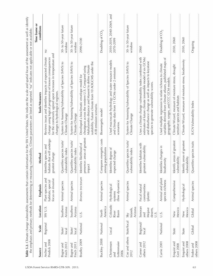
USDA Forest Service RMRS-GTR-309. 2013. 63
Tabl
e 5.
2. C
limat
e ch
ange
vul
nera
bilit
y as
sess
men
ts th
at c
onta
in in
form
atio
n fo
r th
e SW
Uni
ted
Stat
es. W
e in
dica
te th
e sc
ale
and
spat
ial f
ocus
of t
he a
sses
smen
t as
wel
l as
iden
tify
the
emph
asis
and
pri
mar
y m
etho
ds fo
r de
term
inin
g or
mea
suri
ng v
ulne
rabi
lity.
Clim
ate
para
met
ers
are
liste
d as
rep
orte
d. “
na”
indi
cate
s no
t app
licab
le o
r no
t ava
ilabl
e.
Tim
e fr
ame
or
Sour
ce
Scal
e Lo
cati
on
Emph
asis
M
etho
d To
ols/
Mea
sure
s co
ndit
ions
Arc
her
and
R
egio
nal
SW U
.S.
Plan
t spe
cies
and
Id
entifi
es s
peci
es a
nd
Rev
iew
s is
sues
and
iden
tifies
impa
cts
of e
xpec
ted
clim
ate
na
Pred
ick
2008
ha
bita
ts; s
peci
al
habi
tats
that
will
und
ergo
ch
ange
usi
ng lo
gica
l pro
gres
sion
of k
now
n co
nseq
uenc
es
fo
cus
on in
vasi
ve
grea
test
cha
nge
for
the
com
mon
ly a
gree
d up
on in
crea
ses
in te
mpe
ratu
re a
nd
ch
ange
s to
hyd
rolo
gica
l reg
imes
.
Bag
ne a
nd
Stat
e/
Sout
hern
A
nim
al s
peci
es
Qua
ntifi
es s
peci
es tr
aits
/ Sy
stem
for A
sses
sing
Vul
nera
bilit
y of
Spe
cies
(SA
VS)
to
30-
to 5
0-ye
ar fu
ture
Fi
nch
2012
lo
cal
Ari
zona
vuln
erab
ility
inde
x C
limat
e C
hang
e w
indo
w
Bag
ne a
nd
Stat
e/
Sout
hern
A
nim
al s
peci
es
Qua
ntifi
es s
peci
es tr
aits
/ Sy
stem
for A
sses
sing
Vul
nera
bilit
y of
Spe
cies
(SA
VS)
to
30-
to 5
0-ye
ar fu
ture
Fi
nch
2013
lo
cal
Ari
zona
vuln
erab
ility
inde
x C
limat
e C
hang
e w
indo
w
Bra
dley
200
9 N
atio
nal
U.S
. B
rom
us tr
ecto
rum
Id
entifi
es li
kelih
ood
of
Dev
elop
ed a
bio
clim
atic
env
elop
e m
odel
for
2090
-210
0
pr
esen
ce: a
reas
of g
reat
est
chea
tgra
ss a
cros
s th
e w
este
rn U
.S. C
ompa
red
usin
g
im
pact
M
ahal
anob
is d
ista
nce
and
Max
ent t
o de
fine
clim
ate
suita
bilit
y. F
utur
e cl
imat
e fr
om 1
0 A
OG
CM
S un
der
the
A1B
em
issi
on s
cena
rio.
Buc
kley
200
8 N
atio
nal
Nor
th
Ani
mal
spe
cies
C
ompa
res
ener
getic
cos
ts
Bio
ener
getic
mod
el
Dou
blin
g of
CO
2
A
mer
ica
am
ong
popu
latio
ns
Chr
iste
nsen
Lo
cal
Col
orad
o H
ydro
logi
cal
Iden
tifies
deg
ree
of
Use
d m
acro
scal
e hy
drol
ogy
and
wat
er r
esou
rce
mod
els
2010
-203
9, 2
040-
2069
, and
an
d
R
iver
sy
stem
s ex
pect
ed c
hang
e an
d cl
imat
e da
ta fr
om 1
1 G
CM
s un
der
2 em
issi
on
2070
-209
9 Le
ttenm
aier
Bas
in
(flow
dyn
amic
s)
sc
enar
ios.
20
06
Coe
and
oth
ers
Sta
te/lo
cal
Sky
Ani
mal
spe
cies
Q
uant
ifies
spe
cies
trai
ts/
Syst
em fo
r Ass
essi
ng V
ulne
rabi
lity
of S
peci
es (S
AV
S) to
30
- to
50-
year
futu
re
2012
Isla
nds,
vuln
erab
ility
inde
x C
limat
e C
hang
e w
indo
w
Ari
zona
Com
er a
nd
Reg
iona
l/ So
nora
n Fo
cal n
atur
al
Iden
tifies
hab
itats
with
U
ses
a cl
imat
e ch
ange
vul
nera
bilit
y in
dex
com
bine
d w
ith
2060
ot
hers
201
2 lo
cal
and
co
mm
uniti
es
grea
test
vul
nera
bilit
y es
timat
es o
f fut
ure
clim
ate
(ens
embl
e m
odel
of s
ix G
CM
s)
Moj
ave
(p
lant
s)
an
d di
stur
banc
e ch
ange
as
wel
l as
impa
cts
to k
eyst
one
dese
rts,
sp
ecie
s to
gen
erat
e vu
lner
abili
ty s
core
s.
U.S
.
Cur
rie
2001
N
atio
nal
U.S
. A
nim
al a
nd p
lant
Id
entifi
es c
hang
es in
U
sed
mul
tiple
reg
ress
ion
to r
elat
e ri
chne
ss to
clim
ate
Dou
blin
g of
CO
2
spec
ies
rich
ness
bi
odiv
ersi
ty
vari
able
s de
rived
from
clim
ate
atla
ses,
pub
lishe
d m
aps
of
ge
ogra
phic
ran
ges,
and
CC
C G
CM
mod
els.
Enqu
ist a
nd
Stat
e N
ew
Com
preh
ensi
ve
Iden
tify
area
s of
gre
ates
t C
limat
e W
izar
d, m
easu
re o
f moi
stur
e st
ress
, dro
ught
20
30, 2
060
Gor
i 200
8
Mex
ico
vu
lner
abili
ty
sens
itive
spe
cies
and
hab
itats
Enqu
ist a
nd
Stat
e N
ew
Hyd
rolo
gica
l Id
entif
y ar
eas
of g
reat
est
Clim
ate
Wiz
ard,
mea
sure
of m
oist
ure
stre
ss, b
iodi
vers
ity
2030
, 206
0 ot
hers
200
8
M
exic
o
vuln
erab
ility
Fode
n an
d G
loba
l G
loba
l A
nim
al s
peci
es
Qua
ntifi
es s
peci
es tr
aits
IU
CN
Vul
nera
bilit
y In
dex
Ong
oing
ot
hers
200
8
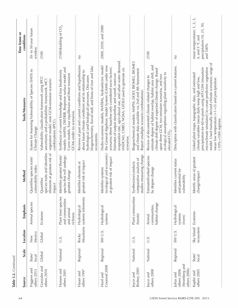
64 USDA Forest Service RMRS-GTR-309. 2013.
Frig
gens
and
St
ate/
N
ew
Ani
mal
spe
cies
Q
uant
ifies
spe
cies
trai
ts/
Syst
em fo
r Ass
essi
ng V
ulne
rabi
lity
of S
peci
es (S
AV
S) to
30
- to
50-
year
futu
re
othe
rs 2
013
loca
l M
exic
o
vuln
erab
ility
inde
x C
limat
e C
hang
e w
indo
w
Gon
zale
s an
d
Glo
bal
Glo
bal
Ecot
ones
Q
uant
ifies
V
ulne
rabi
lity
clas
sific
atio
n fr
amew
ork
usin
g IP
CC
21
00
othe
rs 2
010
sp
ecie
s tr
aits
and
iden
tifies
un
cert
aint
y an
d a
prob
abili
stic
fram
ewor
k. M
C1
elem
ents
at g
reat
est r
isk
of
vege
tatio
n m
odel
; nin
e G
CM
-em
issi
on s
cena
rio
impa
ct
com
bina
tions
(IPC
C).
Han
sen
and
N
atio
nal
U.S
. Pl
ant (
tree
) spe
cies
Id
entifi
es g
reat
est t
hrea
ts/
Synt
hesi
ze o
f cur
rent
kno
wle
dge
and
four
bio
dive
rsity
21
00/d
oubl
ing
of C
O2
othe
rs 2
001
and
com
mun
ities
sp
ecie
s th
at w
ill u
nder
go
mod
els:
MA
PSS,
DIS
TRIB
, Res
pons
e su
rfac
e m
odel
and
and
anim
al
grea
test
cha
nge
Cur
rie
mod
els.
Fou
r eq
uilib
rium
and
thre
e tr
ansi
ent
ri
chne
ss
G
CM
s un
der
six
scen
ario
s.
Hau
er a
nd
Reg
iona
l R
ocky
H
ydro
logi
cal
Iden
tifies
ele
men
ts a
t R
evie
ws
of p
ast a
nd c
urre
nt c
ondi
tions
and
hyp
othe
size
s na
ot
hers
199
7
Mou
ntai
ns s
yste
ms
(ele
men
ts)
grea
test
ris
k of
impa
ct
abou
t fut
ure
clim
ate
cond
ition
s an
d its
rel
atio
nshi
p to
hydr
olog
ical
(and
bio
logi
cal)
proc
esse
s. D
iscu
sses
biog
eoch
emis
try,
fluv
ial s
tuff,
and
bio
ta o
f riv
er a
nd la
ke
ec
osys
tem
s.
Hur
d an
d
Reg
iona
l SW
U.S
. H
ydro
logi
cal
Iden
tifies
sys
tem
s H
ydro
-eco
nom
ic m
odel
s, W
ATBA
L, h
ydro
elec
tric
mod
el
2000
, 203
0, a
nd 2
080
Coo
nrod
200
8
sy
stem
s (e
colo
gica
l and
eco
nom
ic)
the
Gen
eral
Alg
ebra
ic M
odel
Sys
tem
(GA
MS)
und
er n
ine
at g
reat
est r
isk
of im
pact
sc
enar
ios
(thre
e ba
selin
e on
ly c
onsi
dere
d so
cio
fact
ors)
.
Estim
ates
of o
utpu
t str
eam
flow
and
run
off,
rese
rvoi
r
ev
apor
atio
n ra
te, a
gric
ultu
ral u
se, a
nd u
rban
wat
er d
eman
d.
H
AD
CM
3, C
SIR
O, N
OA
A, G
FDL0
use
d to
gen
erat
e si
x
sc
enar
ios.
Joyc
e an
d
Nat
iona
l U
.S.
Plan
t com
mun
ities
Sy
nthe
size
s/co
nduc
ts
Bio
geoc
hem
ical
mod
els:
MA
PSS,
DO
LY, B
IOM
E2, B
IOM
E3
Bir
dsey
200
1
(fo
rest
s)
com
para
tive
anal
ysis
of
and
clim
ate
data
ava
ilabl
e vi
a 2n
d an
d 4t
h A
sses
smen
t
st
udie
s m
easu
ring
cha
nge
Rep
ort (
mul
tiple
sce
nari
o co
mbi
natio
ns).
Joyc
e an
d
Nat
iona
l U
.S.
Ani
mal
Es
timat
ed/r
anke
d sp
ecie
s R
evie
w o
f doc
umen
ted
clim
ate
rela
ted
chan
ges
to
2100
ot
hers
200
8
co
mm
uniti
es,
by d
egre
e ch
ange
es
timat
e de
gree
of h
abita
t ove
rlap
, hab
itat a
rea
shift
, and
habi
tat c
hang
e
clim
ate
shift
deg
ree
of e
xpec
ted
clim
ate
chan
ge. B
ased
upon
thre
e G
CM
, tw
o em
issi
on s
cena
rios
, and
two
ecol
ogic
al a
ssum
ptio
ns r
egar
ding
pla
nt s
ensi
tivity
to
el
evat
ed C
O2.
Juliu
s an
d R
egio
nal
SW U
.S.
Hyd
rolo
gica
l Id
entifi
es c
urre
nt s
tatu
s D
escr
iptiv
e w
ith c
lass
ifica
tion
base
d on
cur
rent
feat
ures
. na
ot
hers
200
6
sy
stem
s an
d po
tent
ial f
or
(Str
ombe
rg a
nd
(riv
ers)
vu
lner
abili
ty
othe
rs 2
006)
Kupf
er a
nd
Stat
e/
Sky
Isla
nd
Ecot
ones
Id
entif
y ar
eas
of g
reat
est
Link
ed p
lant
map
s, to
pogr
aphi
c da
ta, a
nd e
stim
ated
m
ean
tem
pera
ture
s: 1
, 2, 3
, ot
hers
200
5 lo
cal
ecos
yste
m
ch
ange
/impa
ct
clim
ate
vari
able
s (m
ean
daily
tem
p hi
gh a
nd lo
w,
4, a
nd 5
°C
and
prec
ipita
tion
for
60-m
pix
els
usin
g M
T-C
LIM
[m
ount
ain
prec
ipita
tion:
10, 2
5, 5
0,
m
icro
clim
ate
sim
ulat
or])
to c
reat
e pr
edic
tive
vege
tatio
n an
d 10
0%
m
odel
. Use
d m
anua
lly d
eriv
ed c
limat
e sc
enar
ios:
ran
ge o
f
mea
n lo
w te
mpe
ratu
re (+
1-+
5) a
nd p
reci
pita
tion
(-
10%
-+10
0) r
egim
es.
Tabl
e 5.
2. C
ontin
ued.
Tim
e fr
ame
or
Sour
ce
Scal
e Lo
cati
on
Emph
asis
M
etho
d To
ols/
Mea
sure
s co
ndit
ions
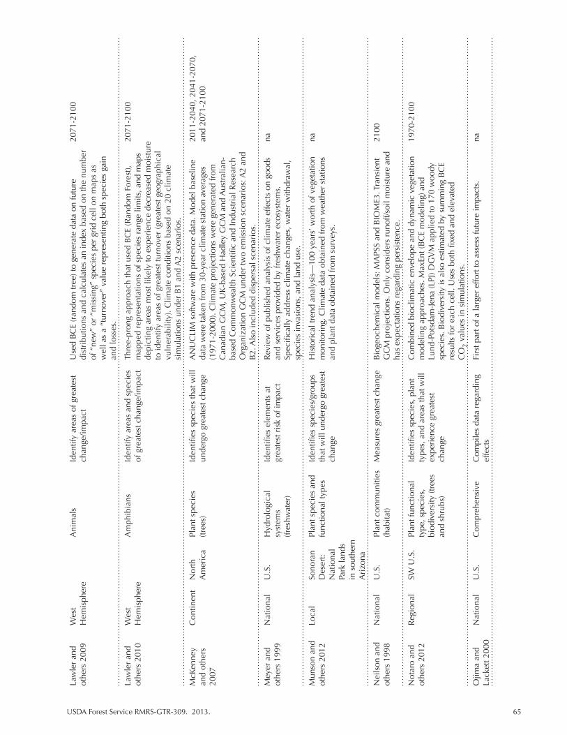
USDA Forest Service RMRS-GTR-309. 2013. 65
Law
ler
and
W
est
A
nim
als
Iden
tify
area
s of
gre
ates
t U
sed
BC
E (r
ando
m tr
ee) t
o ge
nera
te d
ata
on fu
ture
20
71-2
100
othe
rs 2
009
Hem
isph
ere
chan
ge/im
pact
di
stri
butio
ns a
nd c
alcu
late
s an
inde
x ba
sed
on th
e nu
mbe
r
of
“ne
w”
or “
mis
sing
” sp
ecie
s pe
r gr
id c
ell o
n m
aps
as
w
ell a
s a
“tur
nove
r” v
alue
rep
rese
ntin
g bo
th s
peci
es g
ain
and
loss
es.
Law
ler
and
W
est
A
mph
ibia
ns
Iden
tify
area
s an
d sp
ecie
s Th
ree-
pron
g ap
proa
ch th
at u
sed
BC
E (R
ando
m F
ores
t),
2071
-210
0 ot
hers
201
0 H
emis
pher
e
of
gre
ates
t cha
nge/
impa
ct
map
ped
repr
esen
tatio
ns o
f spe
cies
ran
ge li
mits
, and
map
s
de
pict
ing
area
s m
ost l
ikel
y to
exp
erie
nce
decr
ease
d m
oist
ure
to id
entif
y ar
eas
of g
reat
est t
urno
ver
(gre
ates
t geo
grap
hica
l
vuln
erab
ility
). C
limat
e co
nditi
ons
base
d on
20
clim
ate
sim
ulat
ions
und
er B
1 an
d A
2 sc
enar
ios.
McK
enne
y
Con
tinen
t N
orth
Pl
ant s
peci
es
Iden
tifies
spe
cies
that
will
A
NU
CLI
M s
oftw
are
with
pre
senc
e da
ta. M
odel
bas
elin
e 20
11-2
040,
204
1-20
70,
and
othe
rs
A
mer
ica
(tree
s)
unde
rgo
grea
test
cha
nge
data
wer
e ta
ken
from
30-
year
clim
ate
stat
ion
aver
ages
an
d 20
71-2
100
2007
(1
971-
2000
). C
limat
e pr
ojec
tions
wer
e ge
nera
ted
from
Can
adia
n G
CM
, UK
-bas
ed H
adle
y G
CM
and
Aus
tral
ian-
base
d C
omm
onw
ealth
Sci
entifi
c an
d In
dust
rial
Res
earc
h
O
rgan
izat
ion
GC
M u
nder
two
emis
sion
sce
nari
os: A
2 an
d
B
2. A
lso
incl
uded
dis
pers
al s
cena
rios
.
Mey
er a
nd
Nat
iona
l U
.S.
Hyd
rolo
gica
l Id
entifi
es e
lem
ents
at
Rev
iew
of p
ublis
hed
anal
ysis
of c
limat
e ef
fect
s on
goo
ds
na
othe
rs 1
999
syst
ems
gr
eate
st r
isk
of im
pact
an
d se
rvic
es p
rovi
ded
by fr
eshw
ater
eco
syst
ems.
(fres
hwat
er)
Sp
ecifi
cally
add
ress
clim
ate
chan
ges,
wat
er w
ithdr
awal
,
spec
ies
inva
sion
s, a
nd la
nd u
se.
Mun
son
and
Lo
cal
Sono
ran
Plan
t spe
cies
and
Id
entifi
es s
peci
es/g
roup
s H
isto
rica
l tre
nd a
naly
sis—
100
year
s’ w
orth
of v
eget
atio
n na
ot
hers
201
2
Des
ert:
fu
nctio
nal t
ypes
th
at w
ill u
nder
go g
reat
est
mon
itori
ng. C
limat
e da
ta o
btai
ned
from
wea
ther
sta
tions
N
atio
nal
ch
ange
an
d pl
ant d
ata
obta
ined
from
sur
veys
.
Pa
rk la
nds
in
sou
ther
n
Ari
zona
Nei
lson
and
N
atio
nal
U.S
. Pl
ant c
omm
uniti
es
Mea
sure
s gr
eate
st c
hang
e B
ioge
oche
mic
al m
odel
s: M
APS
S an
d B
IOM
E3. T
rans
ient
21
00
othe
rs 1
998
(hab
itat)
G
CM
pro
ject
ions
. Onl
y co
nsid
ers
runo
ff/so
il m
oist
ure
and
has
expe
ctat
ions
reg
ardi
ng p
ersi
sten
ce.
Not
aro
and
R
egio
nal
SW U
.S.
Plan
t fun
ctio
nal
Iden
tifies
spe
cies
, pla
nt
Com
bine
d bi
oclim
atic
env
elop
e an
d dy
nam
ic v
eget
atio
n 19
70-2
100
othe
rs 2
012
type
, spe
cies
, ty
pes,
and
are
as th
at w
ill
mod
elin
g ap
proa
ches
. Max
Ent (
BC
E m
odel
ing)
and
biod
iver
sity
(tre
es
expe
rien
ce g
reat
est
Lund
-Pot
sdam
-Jen
a (L
PJ) D
GV
M a
pplie
d to
170
woo
dy
an
d sh
rubs
) ch
ange
sp
ecie
s. B
iodi
vers
ity is
als
o es
timat
ed b
y su
mm
ing
BC
E
re
sults
for
each
cel
l. U
ses
both
fixe
d an
d el
evat
ed
C
O2
valu
es in
sim
ulat
ions
.
Ojim
a an
d
Nat
iona
l U
.S.
Com
preh
ensi
ve
Com
pile
s da
ta r
egar
ding
Fi
rst p
art o
f a la
rger
effo
rt to
ass
ess
futu
re im
pact
s.
na
Lack
ett 2
000
ef
fect
s
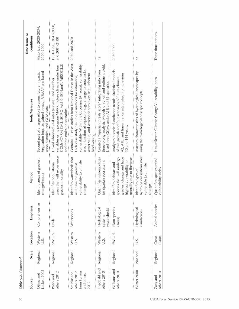
66 USDA Forest Service RMRS-GTR-309. 2013.
Ojim
a an
d
Reg
iona
l W
este
rn
Com
preh
ensi
ve
Iden
tify
area
s of
gre
ates
t Se
cond
par
t of a
larg
er e
ffort
to a
sses
s fu
ture
impa
cts.
H
isto
rica
l, 20
25-2
034,
La
cket
t 200
2
U.S
.
chan
ge/im
pact
V
eget
atio
n im
pact
s ga
ined
thro
ugh
VEM
AP
and
base
d
2090
-209
9
upon
his
tori
cal a
nd G
CM
dat
a.
Peer
y an
d
Reg
iona
l SW
U.S
. O
wls
Id
entifi
es p
opul
atio
ns/
Link
ed o
bser
ved
vita
l rat
es (s
urvi
val)
and
wea
ther
19
61-1
990,
204
1-20
60,
othe
rs 2
012
ar
eas
that
will
exp
erie
nce
va
riab
les
usin
g pr
ogra
m M
AR
K. F
utur
e cl
imat
e un
der
four
an
d 20
81-2
100
grea
test
mor
talit
y G
CM
s (C
NR
M-C
M3,
SC
IRO
-Mk3
.0, E
CH
am5,
MIR
OC
3.2)
and
thre
e em
issi
on s
cena
rios
.
Stei
nke
and
R
egio
nal
Wes
tern
W
ater
shed
s Id
entifi
es w
ater
shed
s th
at
Con
tain
s 11
cas
e st
udie
s fr
om N
atio
nal F
ores
ts in
the
Wes
t. 20
30 a
nd 2
070
othe
rs 2
012
U.S
.
will
hav
e th
e gr
eate
st
Each
cas
e st
udy
has
uniq
ue m
etho
ds fo
r es
timat
ing
from
Fur
niss
vuln
erab
ility
to c
limat
e vu
lner
abili
ty. W
ithin
the
Coc
onin
o (A
rizo
na),
vuln
erab
ility
an
d ot
hers
chan
ge
was
a fu
nctio
n of
exp
osur
e (e
.g.,
chan
ge to
sno
wpa
ck),
2012
w
ater
val
ue, a
nd w
ater
shed
sen
sitiv
ity (e
.g.,
inhe
rent
biod
iver
sity
).
Theo
bald
and
R
egio
nal
Wes
tern
H
ydro
logi
cal
Qua
ntifi
es v
ulne
rabi
litie
s C
reat
ed a
“ri
pari
an th
reat
s sc
ore”
inte
grat
ing
info
from
na
ot
hers
201
0
U.S
. sy
stem
s
for
ripa
rian
eco
syst
ems
thre
e-pr
ong
anal
ysis
. Mod
els
of r
unof
f and
sed
imen
t yie
ld.
(w
ater
shed
s)
U
sed
thre
e G
CM
s un
der A
1B a
nd B
1 sc
enar
ios.
Will
iam
s an
d
Reg
iona
l SW
U.S
. Pl
ant s
peci
es
Iden
tifies
hab
itats
and
A
naly
zes
hist
oric
dis
turb
ance
tren
ds. S
tatis
tical
mod
els
2050
-209
9 ot
hers
201
0
(T
rees
) sp
ecie
s th
at w
ill u
nder
go
of tr
ee g
row
th a
nd fo
ur s
cena
rios
of f
utur
e cl
imat
e:
grea
test
cha
nge
and
have
A
2, A
1B, a
nd li
near
tren
ds e
stab
lishe
d fr
om p
revi
ous
high
est v
ulne
rabi
lity
to
30 a
nd 1
44 y
ears
.
m
orta
lity
due
to fi
re/p
ests
Win
ter
2000
N
atio
nal
U.S
. H
ydro
logi
cal
Iden
tifies
type
s of
A
sses
ses
char
acte
rist
ics
of h
ydro
logi
cal l
ands
cape
s by
na
(land
scap
e)
hydr
olog
ical
sys
tem
s m
ost
usin
g th
e hy
drol
ogic
-lan
dsca
pe c
once
pts.
vu
lner
able
to c
limat
e
chan
ge
Zac
k an
d
Reg
iona
l G
reat
A
nim
al s
peci
es
Qua
ntifi
es s
peci
es tr
aits
/ N
atur
eSer
ve’s
Clim
ate
Cha
nge
Vul
nera
bilit
y In
dex
Thre
e tim
e pe
riod
s ot
hers
201
0
Plai
ns
vu
lner
abili
ty in
dex
Tabl
e 5.
2. C
ontin
ued.
Tim
e fr
ame
or
Sour
ce
Scal
e Lo
cati
on
Emph
asis
M
etho
d To
ols/
Mea
sure
s co
ndit
ions
USDA Forest Service RMRS-GTR-309. 2013. 67
5.3 Southwest Vulnerability Assessments
Our search identified 36 vulnerability assessments published over the last 17 years addressing climate change in the SW (Table 5.2). These assessments span spatial scales ranging from the local/state level through national, continental, and global ranges (Tables 5.2, 5.3). Two global assessments (Foden and others 2008; Gonzales and others 2010), though not specific to the SW, relate to spe-cies sensitivity and adaptive capacity to climate change that has relevance for SW animal species and plant functional types (Table 5.4). Two studies focused on the western hemisphere (Lawler 2009, 2010) and, though broadly focused, provide some insight as to future areas of concern for animal biodiversity. One continen-tal assessment focused on North American animal species (McKenney and others 2007). A large number of assessments (10) focused at the national scale (Tables 5.2, 5.3, 5.4) and most specifically addressed species or habitats (6 of 10) found within the SW. Of the 12 regionally focused assessments, 6 centered on the SW, 3 were more generally focused on the West, and 3 focused on specific habitats: the Great Plains, which includes some of New Mexico and Texas, and the Mojave and Sonoran Deserts, which includes Arizona, California, and Nevada. Of those assessments that dealt with water, 2 were conducted at the national level, 5 were regionally based (Furniss and others 2012 contained cases studies from 11 National Forests), and 1 each focused specifically within New Mexico and the Colorado River Basin (Table 5.3). Two analyses assessed plants and animals within New Mexico (Enquist and others 2008; Enquist and Gori 2008), one assessed plants (Kupfer and other 2005), and two assessments (Coe and others 2012; Friggens and others 2013) considered animal vulnerability and animal and plant vulnerability (Bagne and Finch 2012; Bagne and Finch 2013) at locales within states.
Assessment targets cover biological scales ranging from species to communities for both plants and animals (Table 5.4). Ecosystem-level analyses are quite com-mon in our assessment pool and invariably dealt with habitat changes. One of the published studies (Peery and others 2012) addressed vulnerability at the level of populations. Eight assessments focused on vertebrate animal species, 11 dealt with plant species, and seven dealt with both animal and plant species.
Several common themes were found among SW assessments and climate-relat-ed studies:
• Vulnerability of grasslands to invasive species is likely to increase under climate change (Morgan and others 2008; Chambers and Pellan 2008; Neilson and oth-ers 1998).
• Changes to hydrological systems include: ο Higher water temperatures with multiple effects for temperature-dependent
species (Johnson and others 2005; Eaton and Scheller 1996). ο Changes in precipitation events leading to less snowpack, changes to the
timing of flood regimes, less flow, and reduced water tables (Theobald and others 2010).
ο Expansion of invasive species in both aquatic and riparian habitats (Theobald and others 2010; Rood and Conrad 2008).
• Many studies show that temperature alone drives or is sufficient to lead to ob-served or predicted changes (Williams and others 2010, tree growth; Currie 2001, biodiversity; Garfin and Lenart, 2007; Eaton and Scheller 1996, loss of cool water fish species; Meyers and others 1999, many effects on aquatic sys-tems; Hansen and others 2001, plant and animal species richness; Notaro and
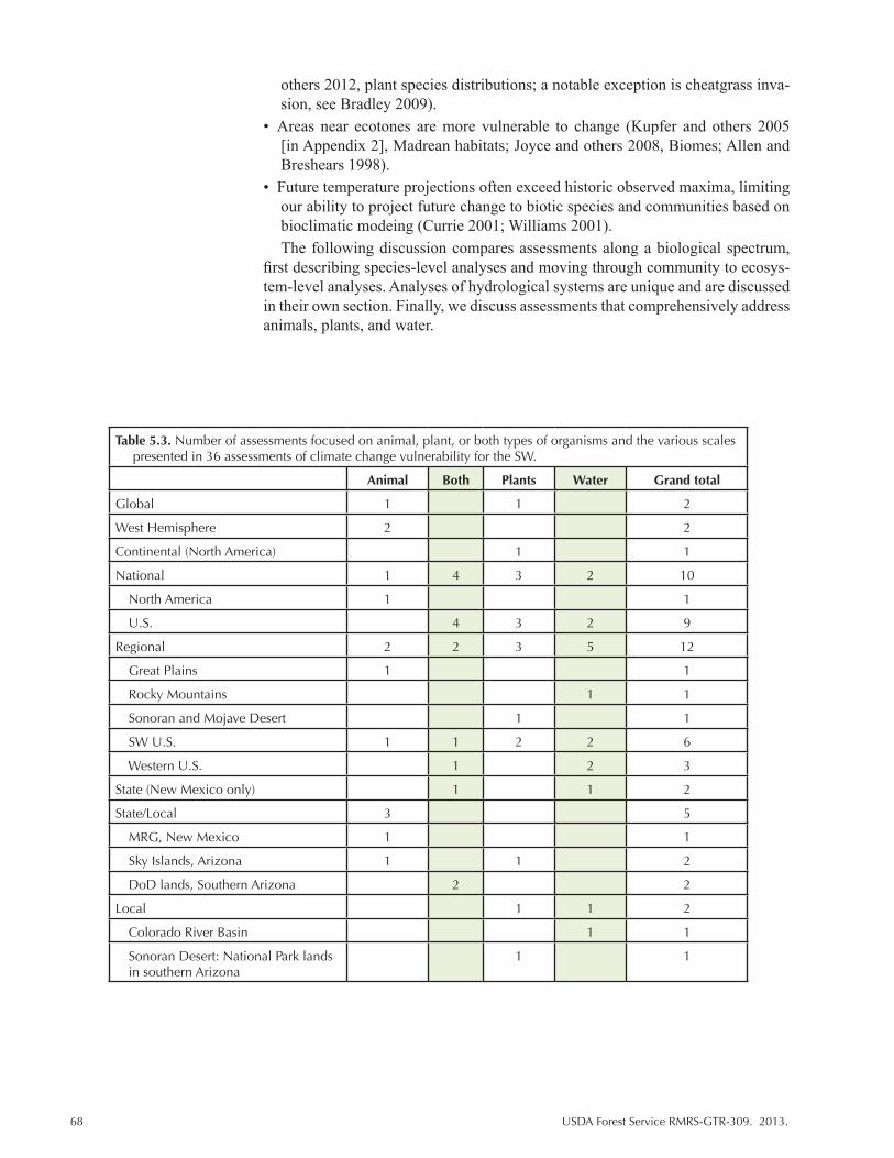
68 USDA Forest Service RMRS-GTR-309. 2013.
others 2012, plant species distributions; a notable exception is cheatgrass inva-sion, see Bradley 2009).
• Areas near ecotones are more vulnerable to change (Kupfer and others 2005 [in Appendix 2], Madrean habitats; Joyce and others 2008, Biomes; Allen and Breshears 1998).
• Future temperature projections often exceed historic observed maxima, limiting our ability to project future change to biotic species and communities based on bioclimatic modeing (Currie 2001; Williams 2001).The following discussion compares assessments along a biological spectrum,
first describing species-level analyses and moving through community to ecosys-tem-level analyses. Analyses of hydrological systems are unique and are discussed in their own section. Finally, we discuss assessments that comprehensively address animals, plants, and water.
Table 5.3. Number of assessments focused on animal, plant, or both types of organisms and the various scales presented in 36 assessments of climate change vulnerability for the SW.
Animal Both Plants Water Grand total
Global 1 1 2
West Hemisphere 2 2
Continental (North America) 1 1
National 1 4 3 2 10
North America 1 1
U.S. 4 3 2 9
Regional 2 2 3 5 12
Great Plains 1 1
Rocky Mountains 1 1
Sonoran and Mojave Desert 1 1
SW U.S. 1 1 2 2 6
Western U.S. 1 2 3
State (New Mexico only) 1 1 2
State/Local 3 5
MRG, New Mexico 1 1
Sky Islands, Arizona 1 1 2
DoD lands, Southern Arizona 2 2
Local 1 1 2
Colorado River Basin 1 1
Sonoran Desert: National Park lands in southern Arizona
1 1
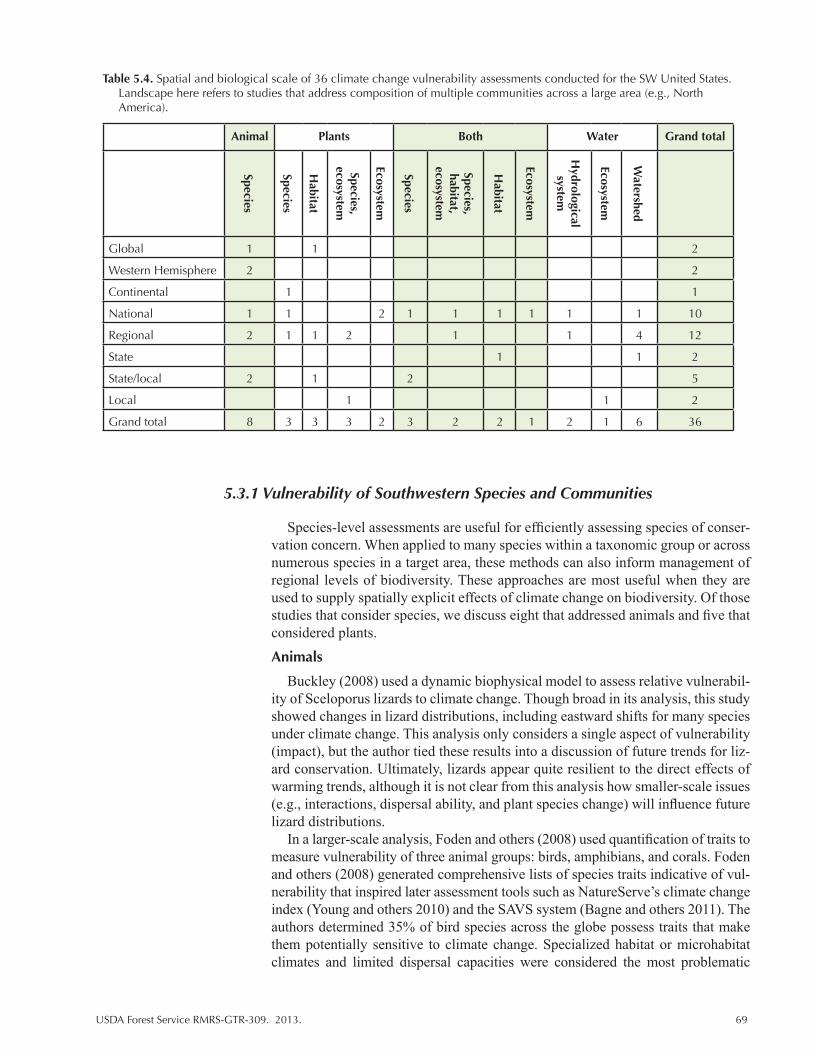
USDA Forest Service RMRS-GTR-309. 2013. 69
Table 5.4. Spatial and biological scale of 36 climate change vulnerability assessments conducted for the SW United States. Landscape here refers to studies that address composition of multiple communities across a large area (e.g., North America).
Animal Plants Both Water Grand total
Species
Species
Habitat
Species, ecosystem
Ecosystem
Species
Species, habitat,
ecosystem
Habitat
Ecosystem
Hydrological
system
Ecosystem
Watershed
Global 1 1 2
Western Hemisphere 2 2
Continental 1 1
National 1 1 2 1 1 1 1 1 1 10
Regional 2 1 1 2 1 1 4 12
State 1 1 2
State/local 2 1 2 5
Local 1 1 2
Grand total 8 3 3 3 2 3 2 2 1 2 1 6 36
5.3.1 Vulnerability of Southwestern Species and Communities
Species-level assessments are useful for efficiently assessing species of conser-vation concern. When applied to many species within a taxonomic group or across numerous species in a target area, these methods can also inform management of regional levels of biodiversity. These approaches are most useful when they are used to supply spatially explicit effects of climate change on biodiversity. Of those studies that consider species, we discuss eight that addressed animals and five that considered plants.
Animals
Buckley (2008) used a dynamic biophysical model to assess relative vulnerabil-ity of Sceloporus lizards to climate change. Though broad in its analysis, this study showed changes in lizard distributions, including eastward shifts for many species under climate change. This analysis only considers a single aspect of vulnerability (impact), but the author tied these results into a discussion of future trends for liz-ard conservation. Ultimately, lizards appear quite resilient to the direct effects of warming trends, although it is not clear from this analysis how smaller-scale issues (e.g., interactions, dispersal ability, and plant species change) will influence future lizard distributions.
In a larger-scale analysis, Foden and others (2008) used quantification of traits to measure vulnerability of three animal groups: birds, amphibians, and corals. Foden and others (2008) generated comprehensive lists of species traits indicative of vul-nerability that inspired later assessment tools such as NatureServe’s climate change index (Young and others 2010) and the SAVS system (Bagne and others 2011). The authors determined 35% of bird species across the globe possess traits that make them potentially sensitive to climate change. Specialized habitat or microhabitat climates and limited dispersal capacities were considered the most problematic
70 USDA Forest Service RMRS-GTR-309. 2013.
issues. The taxonomic group with the greatest number of vulnerable species was the thrush (Turdidae) family, whereas cuckoos (Cuclidae), woodpeckers (Picidae), and doves and pigeons (Columbidae) were the least threatened. A greater propor-tion (52%) of amphibians than birds was considered vulnerable to future climate changes. Many species were from families not found within the SW. An exception is the Bufonidae family (toads and true toads), which had more than 50% of its species considered susceptible to climate change. Within the Caecilians only 18% of species were considered vulnerable though the authors note this might be due to a lack of information. Traits associated with amphibian vulnerability, including specialized habitat requirements, exclusive occurrence or reliance on threatened or unbuffered aquatic habitats, and dispersal issues related to barriers created by un-suitable habitats were most relevant to amphibians living the in the SW.
Lawler and others (2009) used a consensus based BCE model (see Chapter 3) to assess the effects of climate change as simulated by 10 GCMs under 3 emission scenarios (B1, A1B, and A2) on the range of 1818 birds, 723 mammals, and 413 amphibians across the western United States. In addition to the basic BCE analysis, they compared results of analyses that assumed no dispersal versus unlimited dis-persal and calculated a species turnover measure that represented degree of change in species composition. For the majority of climate scenarios (80%), Lawler and others’ (2009) analysis showed a loss of 11 and 17% for all species under B1 and A1 scenarios, respectively. Of importance to the SW, Lawler and others (2009) estimated that the greatest turnover for all taxa will occur in mountainous regions and that amphibians are most likely to experience range contractions and loss. In a second analysis focused on amphibians, Lawler and others (2010) combined dis-tribution analysis with data on range limits and expected moisture changes across the western hemisphere to specifically identify sensitive species and areas prone to species loss under climate change. They identified vulnerability according to an index generated by the number of times certain conditions exist within an area. Specifically, one score was given for each of these conditions: (1) area has an esti-mated turnover (species loss and gain) of at least a 50%; (2) area contains at least 50% range restricted species; and (3) at least 20% of grid cells within the area are projected to experience decreases in precipitation. Their analysis showed that the warm deserts of the United States were projected to have high vulnerability due to decreased precipitation and high species turnover (potential vulnerability of 2 on a scale of 0-3).
Zack and others (2010) examined several species native to the Great Plains re-gion using the Natureserve’s Climate Change Vulnerability Index (CCVI, Young and others 2010). They found none of the 30 species ranked in their assessment fell within the highest vulnerability class. Zack and others (2010) did find the Lesser-prairie chicken, regal fritallary, and black-footed ferret moderately vulnerable to climate change effects. Overall, the authors concluded that climate change is not a driving negative force for many species and most species were presumed stable. Zack and others (2010) also examined range location relative to the study site (the Great Plains Landscape Conservation Cooperative) but did not draw additional conclusions regarding species vulnerability.
Four other assessments (Bagne and Finch 2012, 2013; Coe and others 2012; Friggens and others 2013) focused on vertebrate animal species with another vul-nerability scoring system, SAVS (Bagne and others 2012). Coe and others (2012) focused on species in southern Arizona and specifically across the Sky Island re-gion. Species were selected based upon criteria set forth by USDA Forest Service Region 3 biologists and included species of conservation and management con-cern. Riparian associated birds (elegant trogon, western yellow-billed cuckoo) and

USDA Forest Service RMRS-GTR-309. 2013. 71
amphibians (Tarahumara frog, Chiricauhua leopard frog) were among the highest scoring species. Arid adapted species such as the desert tortoise, mesquite mouse, desert bighorn sheep, and Slevin’s bunchgrass lizard were the least vulnerable. Coe and others (2012) also provided a comprehensive review of climate projec-tions and evidence for future effects of climate warming trends within the region. Bagne and Finch (2012, 2013) examined species inhabiting two Department of Defense (DoD) installations in Southwestern Arizona (Fig. 5.2). This study was focused on Threatened, Endangered and At-risk species including 21 animals and 2 plants from Ft. Huachuca and 15 animals and 1 plant from Barry M. Goldwater Range (Bagne and Finch 2012, 2013). Their findings suggest that many already threatened species are at risk of additional issues due to climate change. The north-ern Mexican garter snake, southwest willow flycatcher and Arizona tree frog were the most vulnerable, whereas the Desert massagauga, aplomado falcon, and black-tailed prairie dog were the least vulnerable on Fort Huachuca. Both plant species, the Lemmon fleabane and Huachuca water umbel, received scores indicating in-creased vulnerability under climate change. For the Barry M. Goldwater Range, the Sonoran pronghorn was the highest scoring species followed by the desert tortoise and cactus ferruginous pygmy owl. The desert bighorn was moderately vulnerable while the California leaf-nosed bat, gilded flicker, and saddled leaf-nosed snake were least vulnerable. Friggens and others (2013) examined 117 species inhabiting the Middle Rio Grande of New Mexico. The species list included both common and rare species that inhabited the riparian corridor of the study area. Their results show many common species have higher vulnerability scores than rare species. In part, this pattern is explained by the natural division between riparian dependent species and those that use the riparian corridor more opportunistically. Within am-phibians, frogs (northern leopard frog, western chorus frog) were most vulnerable and spadefoot toads the least vulnerable. Within reptiles, the Great Plains skink and gartersnakes (followed by aquatic turtle species) were the most vulnerable, whereas the rattlesnakes (western diamond back and prairie), kingsnake, and des-ert grassland whiptail were the least vulnerable. Riparian obligate birds such as the southwest willow flycatcher and the common yellowthroat were the most vulner-able to future changes, whereas the brown-headed cowbird and greater roadrunner were least vulnerable. Within the mammals, the New Mexican meadow jumping mouse and hoary bat received the highest scores whereas the jackrabbit and desert shrew appeared to be the least vulnerable.
Peery and others (2012) conducted a risk analysis that predicted survival and reproduction for three spotted owl (Strix occidentalis) populations in the SW (including California). Their analyses show that growing season precipita-tion (Arizona and New Mexico populations), nesting season temperature (New Mexico), annual precipitation, and minimum nesting season temperatures (Arizona and California) explained most of the observed variation in reproductive status. Survival was positively associated with previous year’s precipitation (previous two years in California) and negatively associated with growing season tempera-ture (New Mexico, Arizona). Population projections show rapid declines for owls residing in New Mexico and Arizona under warming trends, whereas Southern Californian populations remain more stable. Peery and others (2012) also assessed potential effects of increased weather variation by doubling variations in precipita-tion and temperature changes but found little additional effect. For New Mexico and Arizona, populations are already predicted to be nearly extinct by the end of the century so additional decreases in survival rates due to increased variability had little effect on outcome. Southern Californian populations were little affected by projected weather changes whether those projections showed high variability
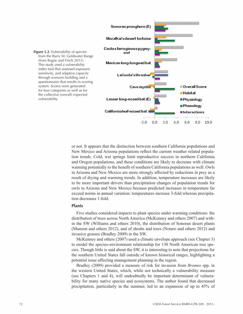
72 USDA Forest Service RMRS-GTR-309. 2013.
or not. It appears that the distinction between southern California populations and New Mexico and Arizona populations reflect the current weather related popula-tion trends. Cold, wet springs limit reproductive success in northern California and Oregon populations, and these conditions are likely to decrease with climate warming potentially to the benefit of southern California populations as well. Owls in Arizona and New Mexico are more strongly affected by reductions in prey as a result of drying and warming trends. In addition, temperature increases are likely to be more important drivers than precipitation changes of population trends for owls in Arizona and New Mexico because predicted increases in temperature far exceed norms in annual variation: temperatures increase 3-fold whereas precipita-tion decreases 1-fold.
Plants
Five studies considered impacts to plant species under warming conditions: the distribution of trees across North America (McKenney and others 2007) and with-in the SW (Williams and others 2010), the distribution of Sonoran desert plants (Munson and others 2012), and of shrubs and trees (Notaro and others 2012) and invasive grasses (Bradley 2009) in the SW.
McKenney and others (2007) used a climate envelope approach (see Chapter 3) to model the species-environment relationship for 130 North American tree spe-cies. Though little is said about the SW, it is interesting to note that projections for the southern United States fall outside of known historical ranges, highlighting a potential issue affecting management planning in the region.
Bradley (2009) provided a measure of risk for invasion from Bromus spp. in the western United States, which, while not technically a vulnerability measure (see Chapters 1 and 4), will undoubtedly be important determinant of vulnera-bility for many native species and ecosystems. The author found that decreased precipitation, particularly in the summer, led to an expansion of up to 45% of
Figure 5.2. Vulnerability of species from the Barry M. Goldwater Range (from Bagne and Finch 2013). This study used a vulnerability index tool that assessed exposure, sensitivity, and adaptive capacity through scenario building and a questionnaire that results in scoring system. Scores were generated for four categories as well as for the collective (overall) expected vulnerability.
USDA Forest Service RMRS-GTR-309. 2013. 73
suitable habitat for Bromus. Increased precipitation was associated with reductions in suitable habitat by as much as 70%. This study is interesting in that identified precipitation as an important if not primary element determining future suitability for invasive Bromus spp., in contrast to many other modeling efforts. There are also interesting implications for future Bromus spp. spread because precipitation patterns are likely to vary across the Great Plains with increases to the north and decreases to the south. As noted by Bradley (2009), many others have modeled invasive species (Beerling 1993 [Europe]; Sutherst 1995 [IUCN]; Zavaleta and Royval 2002 [Appendix 1]; Kriticaos and others 2003 [Australia]; Mika and oth-ers 2008). Among these, Zalaleta and Royval (2002) and Mika and others (2008) provide important discussions regarding the risk of existing habitats to future inva-sion or expansion of exotic species (Appendix 2). Zavaleta and Royval (2002), in particular, provide information and predictions for plant and animals species that are relevant to the United States though outside our study region.
Williams and others (2010) focused specifically on Pinus (P. edulis and P. pon-derosa) species and Pseudotsuga menziesii (Douglas-fir) within the West. Williams and others (2010) used statistical models of tree growth based upon tree ring data to estimate growth under future conditions. They also explored contrasts between wildfire and tree mortality due to beetles over a two-decade period to evaluate trends and magnitude of disturbance effect. This analysis projects that the great-est and most widespread decreases in growth will occur in the SW and Colorado Rockies. Their findings also point to the influence of temperature on these obser-vations; SW ponderosa pine and Douglas-fir are likely to be at greatest risk for drought induced mortality at lower level elevations, whereas pinyon pine appears sensitive throughout its range.
Munsen and others (2012), used historic data for plant species and communities types to produce information regarding relative vulnerability among the study spe-cies. Using 100 years of vegetation monitoring, the authors described population trends in response to recent changes in climate for Sonoran Desert habitats. They then extrapolated these findings to expectations for future trends in plant species composition. In mesic mesquite savanna, perennial grasses declined with declin-ing precipitation, cacti increased, and Prosopis velutina declined in response to increased mean annual temperature. In xeric upland areas, leguminous Cercidium microphyllum declined in hillslopes and Fouquieriea spledens decreased on south and west facing slopes in response to increasing mean annual temperature. In xe-ric shrublands, Larrea tridetata and hemiparasite Krameria Grayi decreased with decreasing cool season precipitation and increasing aridity.
Notaro and others (2012) conducted a comprehensive analysis of future plant distributions for the SW United States that includes New Mexico Arizona, Colorado, and Utah. Their analysis is presented here because it represents valuable information regarding future changes with relevance to the assessment of plant vul-nerability to climate change though this study is not in and of itself a vulnerability assessment. Similar studies exist (Bachelet and others 2001; Daly and others 2000; Thompson and others 1998; Shafer and others 2001; Rehfeldt and others 2006) that represent early versions of this type of analysis, which are not reviewed here but are listed in Appendix 2. Notaro and others (2012) simulated future distributions of 170 tree and shrub species. Their analysis compared 14 GCMS under the A2 emission scenario. Using Maxent (Table 3.2), Notaro and others (2012) identified three important predictors of future range of North American species: tempera-ture (with precipitation changes modifying patterns driven by warming trends), growing degree days, and annual mean temperature. Their analysis showed that 83 species will experience a shift northward in ideal conditions, whereas 32 species

74 USDA Forest Service RMRS-GTR-309. 2013.
are expected to shift southward. Overall, 76 species will experience range expan-sions and 70 species will experience range contractions. For species with the most robust results (agreement between 12 and 14 of the 14 GCMs used), the authors found 29 species with expected increases in range, whereas 39 were expected to experience range contractions, indicating that declines may be more frequent. Two species, Engelmann spruce (Picea engelmannii) and Mesquite (Prosopis juliflora), were well modeled by current climate conditions and represent plants limited by either high or low temperatures, respectively. Engelmann spruce is a cold tolerant, high elevation, evergreen conifer and the most abundant tree species in the SW (Notaro and others 2012), and mesquite, a drought tolerant tree/shrub, is found in the hotter regions. The distribution of Englemann spruce is expected to decline in the SW, whereas mesquite is likely to expand and shift northward, with the greatest changes seen for those scenarios that predict both warming and drying. Among evergreen species, Tumey oak (Quercus toumeyi) and Pringle Manzanita (Arctostaphylos pringlei), showed the largest predicted increase in range, whereas limber pine (Pinus flexilis) and big sage brush (Artemisia tridentate) had the larg-est projected range contractions. For deciduous species, the greatest expansions were seen for Tracy’s hawthorn (Crataegus tracyi) and Knowlton’s hophornbeam (Ostrya knowltonii), and the greatest contractions were seen for Willow hawthorn (Crataegus saligna) and narrow leaf cottonwood (Populus angustifolia). Climate changes are predicted to lead to an expansion of all yucca species and a majority of the oak species but contractions in most pine species, including ponderosa pine (Pinus ponderosa).
Community-level assessments
Analyses based on plant species often form the basis of community level assess-ments of climate change impacts on habitat (see MAPSS in Chapter 2). From our review, we found three assessments that consider community response as derived from analysis of species, each using quite different methods to measure future vulnerability. One assessment considered plant species and communities and the implication for animal species (Hansen and others 2001), one study (Currie 2001) examined patterns of biodiversity for both plants and animals, and one study fo-cused on the impact of climate changes on distributions of plant groups (Kupfer and others 2005).
Hansen and others (2001) provided the most comprehensive assessment. Their report is broken in two parts: one models vegetation and biodiversity change under three different GCMs, and a second synthesis draws together current knowledge of interactions among climate, land use, and biodiversity with the distribution analy-sis to discuss future biodiversity and provide strategies and future research needs. Hansen and others (2001) used 4 biodiversity models: MAPSS (biogeographic approach) for biomes, DISTRIB (statistical regression tree) for tree species/for-est community type, response surface model (statistical local regression) for tree/shrub species, and Currie (statistical) models for species richness of trees, mam-mals, birds reptiles, and amphibians. Though their efforts are based upon climate parameters generated from early and now obsolete GCMs, their results identify a number of interesting trends. Statistical regression methods for individual spe-cies show that suitable habitat for ponderosa pine is likely to expand westward, whereas sagebrush (Artemesia), mountain hemlock, and Engelmann spruce will experience decreases in suitable habitat. MAPSS results showed alpine habitat all but disappears, whereas shrublands and arid woodlands expand into grasslands of the Interior West and Great Plains. The same models predict grasslands expan-sion into the deserts of the SW. Analysis of community richness revealed a strong
USDA Forest Service RMRS-GTR-309. 2013. 75
correlation of richness with temperature but not precipitation. For trees, species richness is positively related to temperature up to a threshold where the relation-ship becomes negative. Importantly, richness in SW deserts is expected to decline as conditions get hotter and drier. Endotherms are expected to increase in northern (cooler) areas and experience moderate decreases in warmer areas, whereas ec-totherms show monotonic increases along a latitudinal gradient from northern to southern areas. The authors noted great variability in results across GCMs.
Kupfer and others (2005) created predictive models of plant community dis-tributions under 36 different scenarios of temperature and precipitation change with the intent to identify the most sensitive areas within the Sky Island region of southern Arizona. The authors focused on four dominant ecotones: desert scrub, desert grassland, Madrean evergreen woodland, and montane conifer. Increased temperatures alone were predicted to increase desert scrub habitat and lead to upslope movement of most other habitat types. Downslope movements were ob-served under scenarios of higher precipitation, indicating a high degree of moisture limitation in this system. Desert scrub and montane conifer habitats experienced greater than 50% change in area. However, these patterns could be partially attrib-uted to their limited distribution in the lower and upper reaches of the Sky Islands, respectively, and to the current low abundance values, which led to relatively dra-matic changes. In their assessment of vulnerability, Madrean evergreen classes and areas near ecotones were most sensitive and showed the greatest change in area with change in climate variables.
Currie (2001) used bioenergetics approaches to estimate future changes in bio-diversity and predicted significant declines in tree, bird and mammal species in the SW. Currie’s predictions were based upon relationships between maximum July temperature and biodiversity, which appear to be closely linked. Species richness increased with increasing temperature though eventually reached a plateau and fell (decreases) as temperatures continued to rise. Importantly, Currie noted, as did Williams (2001), that projections for the SW often exceed the hottest observed July temperature predictions and, therefore, these models may underestimate the true effect of temperature increases on species richness in the SW.
Results of Notaro and others (2012) bioclimate analysis (see previous section) were used to estimate shifts in biodiversity across the region. They predicted major declines in high elevation evergreen forests, especially in Utah and Colorado, as well as Sonoran desert habitat but expected some level of enhancement to biodi-versity of prairie ecosystems of eastern New Mexico. Changes to high elevation species appeared to be driven mostly by increases in mean July temperature, and the Sonoran desert species appear to be most sensitive to projected January tem-peratures. Interestingly, drier hotter conditions were predicted to favor diversity in New Mexico grasslands by providing an environment conducive to the establish-ment of Sonoran or Chihuahuan desert habitat, which are relatively species rich.
Animal species of the southwestern United States
Though a number of important areas of concern were noted for species inhabit-ing the SW, results from species-level vulnerability assessments were generally not comparable because they lack broad applicability. There were no instances where a single species was assessed by more than one of the studies reviewed here in a way that allows direct and meaningful comparisons. However, we did find a tendency for riparian associated species to be among the highest ranking or most vulnerable species within each assessment (Bagne and Finch 2012, 2013; Coe and others 2012; Friggens and others 2013). In addition, lizard species were not found to be particularly vulnerable to climate change effects where they were studied
76 USDA Forest Service RMRS-GTR-309. 2013.
(Buckley 2008; Friggens and others 2013). Peery and others (2012) was the only study to model survival and reproduction for three SW sites, and their analysis showed important regional differences relating to current limiting conditions (cold versus dry weather).
Species-level studies covered a variety of spatial scales (Tables 5.3, 5.4). Foden (2008) examined species across their range and made general conclusions about taxonomic group vulnerability that did not consider local-level influences. Peery and others (2012) examined three owl populations in three states and found dis-tinct differences in predictions across the region but also recognized that their predictions for local extinctions may not reflect trends at larger scales. Buckley considered lizard distributions at the national level, and Bagne and Finch (2012, 2013), Coe and others (2012), and Friggens and others (2013) created ranks based on local-level responses to predict future population trends for species inhabiting specifically defined areas. Though information gathered from these latter assess-ments could be applied to other populations, issues noted for a specific region cannot be extrapolated to new regions without careful consideration. However, smaller-scale assessments that address specific species within their current habi-tats provide information that is highly relevant to managers. In addition, fine-scale analyses of species of specific concern or inhabiting areas of management interest are likely to be necessary for most management plans.
The focal target of each vulnerability assessment varied with important impli-cations for the interpretation of assessment results. The ranking reported in Foden (2008) compliments the results found for the MRG bird study (Friggens and oth-ers 2013) but differs somewhat from Bagne and Finch (2012, 2013) and Coe and others (2012). The latter assessments focus on species already of concern, a status related to life history traits (e.g., specialization and sensitivity to habitat loss) that not only influence population vulnerability to declines but relate, in many cases, to additional vulnerability to climate-related effects.
Most species-level assessments relied on a quantification technique to rank spe-cies rather than statistical modeling. In such systems, uncertainty is considered by the user and appended to the output of the ranking typically as a separate associated value. This measure of uncertainty addresses data gaps and the general confidence in methods that model climate and habitat change. Foden (2008) indicated high levels of data insufficiency for amphibians. Coe and others (2012), Bagne and Finch (2012; 2013), and Friggens and others (2013) identified species and areas that require more research as related to species information, but do not estimate uncertainty related to climate modeling or other estimates of exposure. For Peery and others (2012), who did use a statistical model, uncertainty relates to varia-tion in climate projections and the complex relationship between environmental change and population size. For instance, behavioral avoidance mechanisms like seeking cool roosts or shifting ranges northward are expected to prevent overall extinction of owls.
Plant species and community data
Within the studies that considered plant species and communities, estimates and predictions of future responses relied mostly on modeled projections relating either growth or habitat suitability to climate conditions. As with animal species, varia-tions in scale and targets of the various assessments limit generalized conclusions for the SW. However, trends for species and communities tended to compliment on another. In general, tree species did well until reaching a temperature threshold be-yond which trees and forested habitats are expected to decline. These patterns are more evident for high altitude areas, where temperature thresholds are generally
USDA Forest Service RMRS-GTR-309. 2013. 77
lower, and for low elevation areas in the hottest part of New Mexico and Arizona. In particular, Engelmann spruce was predicted to experience declines in suitable habitat in multiple assessments. Interestingly, at a national level, SW forests are not expected to be the most vulnerable to climate change relative to other North American habitats. Still, at a smaller spatial scales, it is evident that tree species will undergo significant changes in habitat suitability as a result of climate change. Changes to forest systems may have wide reaching implications as the composi-tion of these systems affect biogeochemistry and hydrological processes.
An important implication of these plant studies, particularly at those that look at the collective response of species to increasing temperatures (Hansen and others 2001; Currie 2001) is the notion that there is a threshold effect where either species do well (e.g., richness increases) up to a certain temperature level or species within a region do well provided conditions are not already near a particular temperature limit. There are areas that may experience increases in biodiversity as warmer temperatures extend growing seasons and lead to range expansions of species and biomes (e.g. northward shifts of Sonoran and Chihuahuan deserts). Alternatively, areas that already experience hot and dry conditions (e.g., the SW) may experience temperatures beyond the tolerances of many native species. Ultimately, changes in biodiversity will vary across the landscape with variations in preexisting species and communities and the exact nature of temperature and precipitation changes.
5.3.2 Vulnerability of Southwestern Habitats
Neilson and others (1998) provided the earliest estimates for species composi-tion change. In their national assessment, they compared MAPSS and BIOME3 results under a variety of projections and assessed habitat change based on tran-sient GCMs. These early climate projections are less xeric than those produced by later models. Perhaps the most interesting result of this analysis is their projection for an overall increase in Leaf Area Index (LAI, commonly used as a measure of productivity) in direct response to increased CO2. Though their predictions do not consider other factors commonly known to limit LAI, and are projected for a somewhat mesic future, these results are reflected in later analyses. Joyce and Birdsey (2000) took a different approach and presented a comparative analysis of trends and impacts of climate change on America’s forest communities (Fig. 5.3). This extensive report contains several chapters that outline major biomes shifts under various climate projections, addresses ecosystem productivity, and discusses the implications of climate change for carbon budgets as well as the forest sector. Bachelet and Neilson (2000) compared multiple simulations generated through MAPSS, BIOME2 and BIOME3, and DOLY from three distinct studies. Each study was conducted either at a regional or continental scale under varying cli-mate change scenarios. Comparisons among DOLY, BIOME2, and MAPSS using projections from the Fourth Assessment Report (FAR) show a large degree of di-vergence between models. Ultimately, the results of their comparison showed that the strongest agreement centered on expectation for large decreases in the area of arid lands, which ultimately become grasslands. All models predict a decrease in runoff for all habitat types under all scenarios. However, their comparison also highlights the influence of CO2 on model performance where notable differences existed for the same model run with and without CO2 effects. Only two trends were consistent among the model results: where CO2 inputs were included, all models agreed that shrubland areas decreased; when CO2 effects were excluded, all models agreed that tundra and alpine habitats decline. MAPSS and BIOME2 simulated loss of boreal forests and increases in savanna and grassland habitat.

78 USDA Forest Service RMRS-GTR-309. 2013.
MAPSS also predicted a decrease in temperate forest and increase in savannas and grasslands in direct contrast to predictions by BIOME. With respect to arid lands, both DOLY and MAPSS simulated increases though DOLY produced the greatest increase in southwestern deserts.
Joyce and others (2008) reviewed 50 State Wildlife Action Plans to assess cli-mate change as potential threat to wildlife terrestrial habitats. Using descriptions provided by the wildlife action plans they ranked areas along a gradient of high to low threat via a “climate stress index.” The index incorporates information on the degree of expected climate change as well as climate induced shifts in habitat area and quality and expected plant species response based on ecological assumptions regarding the effects of elevated CO2. Habitat specific analyses were conducted for Arizona, Minnesota, and Tennessee. From 189 studies that document climate related changes, Joyce and others (2008) identified multiple range expansions for mammals in Arizona and New Mexico, one bird phenology change in Arizona, and a single instance of mammal morphological change in New Mexico (Fig. 4.1). The authors also provided a detailed analysis that considers current land use prac-tices, prevalence of at risk species, and expected change in total habitat area. They found that areas of greatest stress are associated with biome transitions zones and areas with high topographic relief. They also noted that areas expected to be most stressed by climate change did not overlap areas currently considered at high risk (due to fragmentation, urbanization, etc.), which might complicate future management priorities. The southern great plains were considered least sensitive according to their stress scale (northern Arizona and New Mexico scored high). Habitat-level analysis showed that species gains and losses were relatively rare events in Arizona though xeric habitats are identified as potential high stress areas. For Arizona, temperate mixed xeromorphic woodlands were considered at risk of
Figure 5.3. Forest responses to two climate change scenarios (OSU, GFDL-Q at 10-km (fine grid) and 50-km (coarse grid) scales. From Chapter 4 of Joyce and Birdsey (2000).

USDA Forest Service RMRS-GTR-309. 2013. 79
complete loss, and the area covered by temperate coniferous forest, tropical thorn woodland, and warm temperate/subtropical mixed savanna is expected to increase. Temperate arid shrublands were among the most stressed habitat types but were also generally rarer.
Enquist (2008) and Enquist and Gori (2008) summarized data for New Mexico regarding climate effects on habitats and watersheds. Both studies are entirely ret-rospective but use the data to infer future vulnerability and are focused across the entire state of New Mexico. In their first report, Enquist and Gori (2008) used the number of drought sensitive species inhabiting an area and the magnitude of recent climate changes to compare the relative and likely vulnerability of New Mexican habitats. They identified 11 areas potentially vulnerable to climate change. Three areas, the Sierra San Luis/Peloncillo Mountains, the Jemez Mountains, and the southern Sangre de Cristo Mountains, were considered particularly vulnerable. They also identified 10 sites that were less vulnerable. These sites, despite har-boring large numbers of drought-sensitive species, experienced lower climate exposure and include Bottomless Lakes, Bitter Lake, and Blue River/Eagle Creek. Sites with few drought sensitive species or little observed change in climate, such as the western plains of San Augustine, the Middle Pecos River, Saldo Creek, and Patura Grasslands, were not considered particularly vulnerable to future climate change.
Gonzales and others (2010) used observed and expected biome distributions to estimate vulnerability. Vulnerability represented a composite of the probability of change in climate and the degree overlap between historic and projected vegeta-tion as generated using MC1 (Gonzales and others 2010). Their findings reinforce the notion that the SW has and will continue to undergo a relatively large change in temperature. At the global scale, temperate shrublands, temperate grassland, and deserts had high fractions of their coverage area within a vulnerable or highly vulnerable classification as determined by measures of observed change. Future projections and degree of overlap between current and future distributions were not substantially different for these habitats, however, and these vegetation com-munities were not among those considered most vulnerable.
Notaro and others (2012) simulated future changes in plant functional types in the SW using dynamic vegetation modeling. Their analysis, which considered high (A1) and medium (B1) emission scenarios under fixed and increasing (CO2 enriched) CO2 for 17 GCMs provides several informative trends. First, vegetation is generally expected to decline. Second, some areas and vegetation types are more likely to experience loss. For example, deciduous forests in Utah and Colorado are expected to undergo the greatest declines. Spatial patterns of vegetation loss cor-responded with the greatest expected declines in associated plant types. Grasses were predicted to increase into areas formerly occupied by deciduous trees at lower elevations but trees (evergreens) may expand at higher elevations. Third, regional changes in vegetation cover are influenced differentially by temperature and precipitation changes. Precipitation strongly influenced estimates of vegeta-tion die off, particularly for grasslands. Conversely, tree cover was strongly and inversely correlated to temperature. Fourth, CO2 enrichment mitigates some of the expected declines in vegetation, especially for grassland habitats (as found for Neilson and other 1998; Joyce and others 2000). Loss of grass cover in the eastern Colorado, New Mexico, and northern Sonaran/Chihuahuan deserts were the most robust trends under fixed CO2 scenarios. These changes were much smaller under enriched CO2 conditions.
A more specific assessment was conducted for the Mojave and Sonoran Deserts in Arizona, Nevada, California, and Mexico (Comer and others 2012). Using an

80 USDA Forest Service RMRS-GTR-309. 2013.
index-based system derived from the NatureServe’s CCVI (see Appendix 1) for species, Comer and others (2012) integrated estimates of climate exposure, change to disturbance processes, and species distribution models to develop a system for assessing a wide variety of ecosystem or community types. The authors also em-ployed a series of workshops to incorporate expert opinions. For the purpose of their case study, the authors apply this system to 10 focal natural communities and provide estimates of vulnerability due to combined influence of indirect and direct climate change effects as well as adaptive capacity. The assessment is com-prehensive and brings together estimates of the degree change in temperature and precipitation from average, climate envelope shift, forecasts of fire and hydro-logical events, and multiple indicators of current landscape condition as generated from a number of modeling techniques as well as a ranking system to integrate multiple effects into one indicator value. Climate change vulnerability is calcu-lated by generating scores for direct effects, which represents exposure elements (e.g., climate change stress, BCE analysis of habitat change, and forecasts of dis-turbance processes) and a resilience score, which combines several elements of the indirect effect of climate change (e.g., invasive species, departures from dis-turbance regimes) as well as inherent characteristics that might lend the ecoregion greater adaptive capacity (e.g., biodiversity, narrow distribution).
Overall, three of eight communities within the Sonoran ecoregion, North American warm desert riparian woodland and stream, North American warm desert mesquite bosque, and Sonora-Mojave creosotebush-white bursage desert scrub had high climate change vulnerability (Comer and others 2012). The re-maining communities, desert springs and seeps, Sonaran Palo verde-mixed cacti desert scrub, Sonora-Mojave mixed salt desert scrub, North American warm des-ert active and stabilized dunes, and Apacherian-Chihuahuan semi-desert grassland were considered moderately vulnerable to climate change. Each of the moderately vulnerable communities was considered highly sensitive to the direct effects of climate change but had a high resilience score, whereas, high vulnerability was associated with highly sensitivity to direct climate change effects but only moder-ately resilience scores. For the Mojave ecoregion, three of seven community types, Mojave mid-elevation mixed desert scrub, North American warm desert mesquite bosque, and North American warm desert riparian woodland and stream had high overall vulnerability scores (Comer and others 2012). Each of these community types had high sensitivity scores for direct climate effects and moderate resiliency scores. The remaining five community types, Sonora-Mojave mixed salt desert scrub, Sonora-Mohave creosotebush-white bursage desert scrub, Great Basin pin-yon-juniper woodland, North American warm desert active and stabilized dunes, and desert springs and seeps were moderately vulnerable to climate change. The Sonora-Mojave mixed salt desert scrub and Sonora-Mohave creosotebush-white bursage desert scrub were moderately sensitive to direct climate effects and mod-erately and highly resilient, respectively, due to low risks of indirect impacts and generally good adaptive capacity. Great Basin pinyon-juniper woodlands and North American warm desert active and stabilized dunes were considered highly sensi-tive but also had a high resilience score. Community types received similar ranks across both ecoregions with the exception of Sonora-Mojave creostebush-white Bursage desert scrub, which was given moderate and high vulnerability for the Mojave and Sonoran ecoregions, respectively. Direct impacts of climate change were scored as vulnerable for this habitat within the Sonoran desert ecoregions, which appeared to be driven by less drastic shifts in temperature and precipitation and predicted distribution of this habitat within the Mojave region (see Comer and others 2012).

USDA Forest Service RMRS-GTR-309. 2013. 81
Summary and discussion: Habitat-level assessments
From the studies conducted for the SW, we found several indications for wide-spread shifts in many plant functional groups. As with species and community level analyses, most studies show a significant reduction in habitats associated with high elevations but increases in the area suitable for desert grassland and shrubland habitat. Shifts in suitable habitat were evident for most plant functional groups but results were strongly influenced by CO2, and temperature and precipi-tation changes with varying results across the SW region. The greatest confidence lies with predictions for expansions northward and up in elevation of most habitats and functional groups.
Studies of suitable habitat were difficult to compare because output targets varying time frames (see Table 5.3) and varying levels of biological organization (plant species versus plant functional groups versus habitat types) and are based upon a large and variable subset of model parameters (see chapter 3, Tables 3.1, 3.2). For instance, the studies conducted for the SW and discussed or incorporated into vulnerability assessments are based on a subset of 12 different GCM out-puts, 3 possible emission scenarios, and 8 unique vegetation modeling approaches (Table 5.2). In addition, CO2 has a strong but variable influence on models and its treatment across the current analyses is not consistent. Joyce and Birdsey (2000) provided the most comprehensive review of model output for a single habitat type—forests. It is clear from this work that the individual needs and expectations of a management problem will be important for identifying the relevance of a par-ticular effort for informing management actions.
Habitat-level vulnerability assessments are useful for predicting impact of cli-mate change on diversity patterns where specific taxonomic group are not well studied or in areas with high species richness (which creates a burden to con-ducting numerous individual assessments). Large-scale analyses tend to rely on modeling methods, which provide valuable tools to create and compare scenarios. However, the tradeoff in these types of approaches is that they are less suited for generating analyses of well-known taxa and results can be somewhat generalized. In addition, analyses that are done at the scale of a biome may not be able to dis-tinguish between fine-scaled effects and cannot account for changes in community structure. In one example, the effect of reduced tree density on biomass as might occur from diebacks would not be modeled in habitat level studies because these changes do not change biome classification. It has been argued that such broad-brush approaches can lead to underestimations in rate of change (Gonzales and others 2010). Uncertainty is also harder to measure and mitigate for these analyses because it is incorporated through statistical means that can be rather obscure to interpret or even notice. Joyce and others (2008) observed variation in stress scores were more closely related to the GCM selected than either emission or ecological scenario assumptions, an interesting observation that reflects the impact of various methodologies.
5.3.3 Vulnerability of Southwestern Water
Water is important to arid regions such as the SW. Riparian systems typically support a disproportionate amount of the regional biodiversity. These systems are also likely to be strongly affected by changes in climate with a concordant disproportionate effect on surrounding landscapes and features (Fig. 5.4). The primary factor understood to determine vulnerability of water systems to climate change is its reliance on atmospheric versus ground water sources. The former are
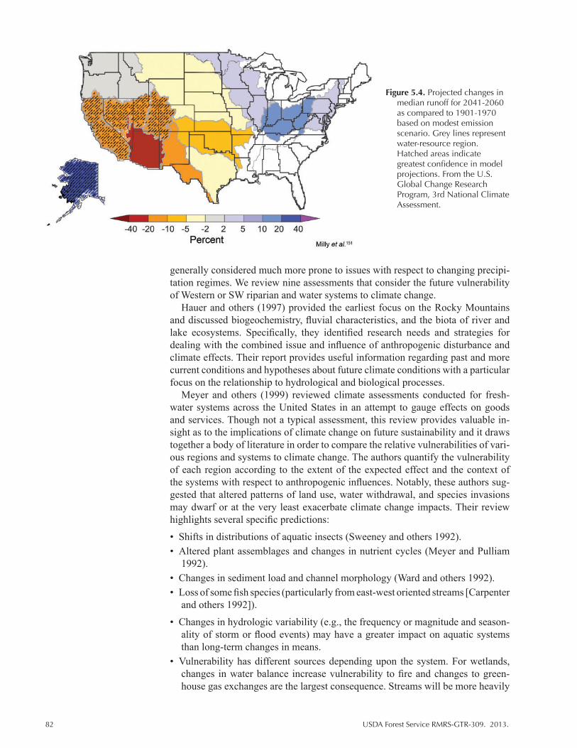
82 USDA Forest Service RMRS-GTR-309. 2013.
generally considered much more prone to issues with respect to changing precipi-tation regimes. We review nine assessments that consider the future vulnerability of Western or SW riparian and water systems to climate change.
Hauer and others (1997) provided the earliest focus on the Rocky Mountains and discussed biogeochemistry, fluvial characteristics, and the biota of river and lake ecosystems. Specifically, they identified research needs and strategies for dealing with the combined issue and influence of anthropogenic disturbance and climate effects. Their report provides useful information regarding past and more current conditions and hypotheses about future climate conditions with a particular focus on the relationship to hydrological and biological processes.
Meyer and others (1999) reviewed climate assessments conducted for fresh-water systems across the United States in an attempt to gauge effects on goods and services. Though not a typical assessment, this review provides valuable in-sight as to the implications of climate change on future sustainability and it draws together a body of literature in order to compare the relative vulnerabilities of vari-ous regions and systems to climate change. The authors quantify the vulnerability of each region according to the extent of the expected effect and the context of the systems with respect to anthropogenic influences. Notably, these authors sug-gested that altered patterns of land use, water withdrawal, and species invasions may dwarf or at the very least exacerbate climate change impacts. Their review highlights several specific predictions:
• Shifts in distributions of aquatic insects (Sweeney and others 1992).• Altered plant assemblages and changes in nutrient cycles (Meyer and Pulliam
1992).• Changes in sediment load and channel morphology (Ward and others 1992).• Loss of some fish species (particularly from east-west oriented streams [Carpenter
and others 1992]).
• Changes in hydrologic variability (e.g., the frequency or magnitude and season-ality of storm or flood events) may have a greater impact on aquatic systems than long-term changes in means.
• Vulnerability has different sources depending upon the system. For wetlands, changes in water balance increase vulnerability to fire and changes to green-house gas exchanges are the largest consequence. Streams will be more heavily
Figure 5.4. Projected changes in median runoff for 2041-2060 as compared to 1901-1970 based on modest emission scenario. Grey lines represent water-resource region. Hatched areas indicate greatest confidence in model projections. From the U.S. Global Change Research Program, 3rd National Climate Assessment.
USDA Forest Service RMRS-GTR-309. 2013. 83
influenced by impacts on the riparian zone, species-specific thermal tolerances, and changes in flow regime.
Meyer and others (1999) identified the Arctic, Great Lakes, and Great Plains (particularly the prairie potholes) as vulnerable to climate change effects. For the Rocky Mountains, warmer temperatures are likely to lead to fragmentation of cold water fish habitat and change aquatic insect distributions. This region is overtly affected by human activities, however, so many of the climate effects may be dwarfed by ongoing issues (Meyer and others 1999). The Great Plains contain a variety of aquatic ecosystems under a strong east-west precipitation gradient. Warming is expected to dramatically influence the form of precipitation and timing of floods. As a result, the Great Plains and Prairie regions of the United States and California are considered particularly vulnerable to climate change. Increased salinity as a result of increases in evaporation rates, especially in the western Great Plains, is a leading factor predicted to lead to loss of endemic fish species, many of which are already near their thermal tolerance limit. The authors also noted that the arid SW should be considered vulnerable to climate effects but that the nature of predicted changes, which have a great deal of uncertainty, prevent accurate assessments. The arid SW is already characterized by its variable and unpredictable weather patterns, which may be one reason why the riparian systems in this region are so sensitive to changes in precipitation and, potentially, temperature. In addition, the isolated nature of many systems increases the vul-nerability of endemic species to extinction as a result of climate change. Increases in salinity due to increase evaporation and reduced precipitation may exacerbate the rate of species invasions and lead to widespread changes in riparian structure and food webs (Meyer and others 1999). Interestingly, the authors considered the degree of change in flow components from current conditions to be more impor-tant in determining the extent of impact on streams than increased temperature along. Finally, changes to the periodicity of flow (from episodic to perennial or vice versa) are much more likely to result in irreversible changes and reduce eco-system function in the short term.
In another review, Perry and others (2011) (Table 5.1) identified specific out-comes under a set of assumptions about future stream flow. Specifically, changes in streamflow are expected to reduce the abundance of native early successional species but favor greater herbaceous species and late successional and drought-tolerant woody species. Climate changes will also reduce nutrient cycling and litter decomposition and, in general, decrease habitat quality for many species.
Winter (2000) used hydrological landscapes characteristics to determine climate change vulnerability and concluded that systems that rely primarily on rainwater are the most vulnerable. Specifically, vulnerability is related to the inherent ca-pacity of the system to compensate (through reliance on other water sources) for variation in precipitation variables. This study does not, however, identify specific scenarios of exposure or identify the specific water bodies that are likely to be vulnerable. Rather, this acts as a measure of how and why a hydrological system is vulnerable to climate change, which then can be applied to classify systems. Winter (2000) classified six types of hydrological landscapes. Among these, wet-lands in mountainous landscapes, wetlands associated with glacial landscapes and broad interior basins (playas) are predicted to be the most vulnerable. Vulnerability of wetlands in plateaus and high plains and riverine landscapes vary according the degree to which upper and lower regions depend upon precipitation and according to the size of the hydrological systems. Those that rely on precipitation (typical of upland areas) and are small are most vulnerable.
84 USDA Forest Service RMRS-GTR-309. 2013.
Christensen and Lettenmaier (2006) conducted a quantitative analysis to esti-mate the implications of future climate change on runoff for the Colorado River Basin. Though not a climate change vulnerability assessment as technically de-fined, this publication represents a comprehensive modeling effort for their study region and is the first to identify specific outcomes as a result of climate change. Christensen and Lettenmaier (2006) considered output from 11 GCMs under 2 emission scenarios for 3 time periods. Most models predict increased winter pre-cipitation and decreased summer precipitation and all showed substantial declines in runoff. The authors found evapotranspiration had greatest influence on runoff estimates and runoff declines were reflected in reservoir performance, which led to lost reservoir storage and declines in hydropower. The role of evapotranspiration in driving trends in runoff is likely to be important for determining system vulner-ability in light of the conclusions of Meyer and others (1999) who argued that the changes in flow regime are most important for determining future condition.
A recent case study for the San Pedro National Conservation area in Southern Arizona, though based on a risk assessment approach, provides detailed informa-tion regarding issues related to climate effects for a SW system (Julius and others 2006). The authors evaluated the influence of five climate scenarios on species, vegetation, and habitat suitability and linked vegetation data into ground water and surface water models to characterize evaporation processes. Results were gen-erated by linking climate, hydrology, and ecosystems models to simulate future change and then incorporating land use stressors. They used historic weather data to create transient climate scenarios for the period 2003-2102 and created mul-tiple possible future scenarios that were based on projections provided by SRAG, 2000. Climate change clearly affected riparian communities leading to greater fragmentation of habitats and a transition to more xeric plant communities. Some variability existed for predictions of future recruitment of native species where winter precipitation timing and amount could lead to lower or higher than currently observed recruitment rates. The authors also determined a strong negative effect for avian biodiversity, particularly for currently abundant species.
Hurd and Coonrod (2008) focused within the SW and conducted analysis using models of streamflow and runoff. They also incorporated a land use component and estimated future agricultural and urban water demands. Their analysis shows that peak flow and total stream flow declines across both wetter and drier sce-narios. Further, their results suggest increased monsoons will not offset effects of reduced snowpack in headwaters. Finally, over time, they model a pronounced shift to an early peak flow and significant shift in late winter runoff. This leads to greater reliance on reservoirs and aquifers. The southern reaches of the Rio Grande are likely to be more impacted by these effects.
In the second of three reports regarding New Mexico ecosystems, Enquist and others (2008) ranked watersheds in New Mexico according to two measures: mag-nitude of exposure and biological diversity. Exposure is estimated using climate data generated from the Climate Wizard site, which allows a user to map and ana-lyze long-term trends in climate data. They also combined that information with recent trends in snowpack and water runoff patterns to generate an estimate in moisture stress (identified as a rate or trend). Biodiversity and, in particular, diver-sity of sensitive species was used as an indicator of importance of each watershed. In addition to important conservation species, Enquist and others (1998) identified species as sensitive if they were reported as a species of greatest conservation need by the New Mexico Department of Game and Fish’s State Wildlife Action Plan. In general, lower elevation watersheds have experienced greater drying than high elevation watersheds though about 93% of watersheds overall showed some

USDA Forest Service RMRS-GTR-309. 2013. 85
decrease in moisture availability over the 1970-2006 study periods. In addition, there was a tendency to find more drying at drier watersheds (versus more me-sic sites). Some watersheds appeared to experience less drying, primarily in the southeast quadrant of the state, for summer and fall seasons. Enquist and others (1998) found 45 to 109 sensitive species across individual watersheds. Though there were no significant trends overall, they did find a strong and significant rela-tionship between increasing moisture stress and species richness when considering only the most species-rich watersheds. They identified the Jemez Cloverdale and Playas Lake watersheds as the most vulnerable due to the magnitude of observed moisture stress. The Pecos Headwaters, Upper Rio Grande, Upper Gila, and San Francisco watersheds have experienced little moisture stress but are species rich and were identified as potential targets for successful conservation. In their conclu-sion, Enquist and others noted that changes in climate and hydrology affect species in numerous ways and, within the SW, may be especially important where species face critical thresholds relating to metabolic and reproductive success (noted first in Burkett and others 2005 and Ryan and others 2008). The authors also identi-fied two types of watersheds that should be focused upon: those that were found most vulnerable and those that are less vulnerable but ecologically important due to high levels of biodiversity. This study is particularly useful for summarizing trends specifically within the SW because it supports many of the suppositions of the previous reviews.
Theobald and others (2010) reviewed and analyzed threats to riparian ecosys-tems in the western United States. Again framed as a risk assessment that formally quantifies (by definition of RAP) risk, sensitivity, resilience, threat and vulnerabil-ity of the systems, this study warrants review here. The authors created “riparian threats score” integrating information from a three-prong analysis. They devel-oped three scenarios that classify three system components—longitudinal, upland, and riparian zone—consisting themselves of multiple variables. Using geospatial data, models of runoff and sediment yield were generated and past and future sce-narios of climate and land-use change were used to characterize landscape-scale processes influencing riverine and riparian areas. They also integrated two key stressors: urbanization and changes in climate (primarily precipitation). Similar to other analyses and assessments, Theobald and others (2010) expected decreases in flow for Rio Grande region due to increased discharge. However, they also predict-ed increased flow for Colorado and Great Basin Regions. Still, southern Arizona and New Mexico received very high riparian threats scores. Flow fragmentation was among the worst for watersheds in Arizona and New Mexico though these same watersheds were not among those with the highest degree of modified ripar-ian area. Lower Arizona watersheds are expected to be most heavily impacted by future changes. Southern New Mexico watersheds were considered among those in the worst condition (furthest from natural setting) with respect to future in-creases in sedimentation. Additional considerations were also noted for riparian systems in the study region. For instance, higher order streams have most severe and widespread modifications (versus lower order). This study designed a broad approach method for scoring systems to identify high scoring riparian areas in need of further investigation at smaller spatial scales.
Most recently, the USDA Forest Service Climate Change Resource Center in collaboration with National Forest conducted a pilot watershed assessment of 11 National Forests (Furniss and others 2012). The primary goal of this assessment was to link and integrate the relatively well known hydrological impacts of climate change with existing programs and policies currently applied to western National Forests. Each participating Forest independently assessed watershed vulnerability
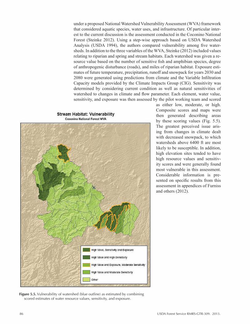
86 USDA Forest Service RMRS-GTR-309. 2013.
under a proposed National Watershed Vulnerability Assessment (WVA) framework that considered aquatic species, water uses, and infrastructure. Of particular inter-est to the current discussion is the assessment conducted in the Coconino National Forest (Steinke 2012). Using a step-wise approach based on USDA Watershed Analysis (USDA 1994), the authors compared vulnerability among five water-sheds. In addition to the three variables of the WVA, Steinke (2012) included values relating to riparian and spring and stream habitats. Each watershed was given a re-source value based on the number of sensitive fish and amphibian species, degree of anthropogenic disturbance (roads), and miles of riparian habitat. Exposure esti-mates of future temperature, precipitation, runoff and snowpack for years 2030 and 2080 were generated using predictions from climate and the Variable Infiltration Capacity models provided by the Climate Impacts Group (CIG). Sensitivity was determined by considering current condition as well as natural sensitivities of watershed to changes in climate and flow parameter. Each element, water value, sensitivity, and exposure was then assessed by the pilot working team and scored
as either low, moderate, or high. Composite scores and maps were then generated describing areas by these scoring values (Fig. 5.5). The greatest perceived issue aris-ing from changes in climate dealt with decreased snowpack, to which watersheds above 6400 ft are most likely to be susceptible. In addition, high elevation sites tended to have high resource values and sensitiv-ity scores and were generally found most vulnerable in this assessment. Considerable information is pre-sented on specific results from this assessment in appendices of Furniss and others (2012).
Figure 5.5. Vulnerability of watershed (blue outline) as estimated by combining scored estimates of water resource values, sensitivity, and exposure.

USDA Forest Service RMRS-GTR-309. 2013. 87
Summary and discussion: Hydrological systems
It is clear from most assessments, and particularly those focused on SW sys-tems, that there are wide ranging effects for the precipitation driven systems of the SW. Temperature alone drives these changes and precipitation effects are largely a matter of delaying or accelerating the consequences of increased temperatures. Riparian analyses and assessments invariably considered human land use change to determine future vulnerability. It is clear from a review of the literature that ri-parian and aquatic scientists consider human influences as a critical component of systems. Overall, higher elevation watersheds and those in southern New Mexico and Arizona were considered most vulnerable to climate changes. A cross-site analysis of three U.S. systems showed that the impact of climate change on an individual watershed was largely determined by the extent of its influence on cur-rent stressors, which directly relate to human use issues (Julius and others 2006). For the SW, water draw is the primary issue, and many of the assessments (e.g., Hurd and Coonrod 2008) show some reason for concern with respect to future water availability under warming scenarios. In addition, many SW systems rely on hydrological characteristics driven by seasonal precipitation patterns, in particular, winter snow pack. Given the relationship between river flow and riparian habitat, there seems a high probability that western riparian habitats will decline under future warming trends, particularly in the SW.
Scale influences the degree to which SW ecosystems are considered at risk of climate change effects. In their national analysis, Theobald and others (2010) con-sidered SW riparian systems to be in a relatively undegraded state. However, this may be a matter of identifying the lesser of a suite of negative future expectations, and it is clear from their report that the future of these systems under the combined stress of human water use and climate induced changes to the hydrological regime will create substantial issues for species conservation and human consumption.
5.3.4 Comprehensive Assessments
Ojima and Lackett (2000) compiled climate change impact data for the entire United States into an assessment as part of the National Assessment Synthesis Team for the Global Change Research Program Report. This assessment reviewed knowledge and extrapolated information to identify areas of greatest concern. Many of the issues drawn from this report continue to be reflected in the studies and assessments identified in this synthesis of SW climate change vulnerability assessments. Though general in its applicability, this report succinctly summarizes ongoing issues with respect to climate change in the United States.
Ojima and Lackett (2002) assessed future impacts of climate change on both natural and social systems. Though not formatted as a traditional assessment, this report combines several elements that relate to aspects of vulnerability. Ojima and Lackett (2002) employed a stakeholder driven assessment where stakeholders from multiple economic sectors directed analysis of future vulnerability. A major product of this effort was to provide coping strategies for future expected changes. Both climate projections and response of vegetation were modeled (historical and GCM data for 2025-2034 and 2090-2099,VEMAP). Output from these efforts was used to inform workshops that were conducted to identify additional issues (so-cioeconomic), potential vulnerabilities, and coping strategies. This report is the second of a larger effort to assess future impacts and focused on agriculture, ranch-ing/livestock systems, conservation, and natural areas and water (Appendix 2). From these efforts, Ojima and Lackett (2002) identified areas of greatest change.

88 USDA Forest Service RMRS-GTR-309. 2013.
Their analysis shows that the greatest increases in winter temperature are expected along the western parts of the Great Plains, especially along the Front Range. They also identified elements that will experience the greatest impact. For instance, winter moisture will favor cool season invasive species, woody perennials, and sagebrush; will reduce shallow aquifer recharge; will change streamflow timing; and will have consequences for forage availability and quality and disease inci-dence. Warmer winters will affect pest outbreaks, soil organic matter, community composition, grass, and exotic invasions (leafy spurge and Japanese brome may move south). Summer temperature increases are likely to impact hail, the spread of invasive tree species, and fire. From the social perspective, farm/ranch families will experience modified vulnerability as a result of climate impacts to ecological and market systems. Water use competition will change and will affect human residence as well as natural resource management.
Archer and Predick (2008) reviewed issues affecting SW habitats to identify impacts of expected climate change for plant and wildlife species. They based their analysis on a logical progression of expected outcomes for increases in tempera-ture and changes to habitats and hydrological regimes within the SW. For instance, water availability will become more limited and riparian areas will shrink resulting in a decline of native fish species. They also expected a decrease in net prima-ry productivity to lead to decreased carbon storage and increases in erosion and nonnative species. Ultimately, they predicted upward elevational shifts in plant communities and conditions, which increase mortality for dominant woody veg-etation and open the door for greater establishment of nonnative annual grasses. Saguaros are expected to decline but increasing CO2 may promote Joshua tree seedling survival leading to a shift in species dominance rather than loss of spe-cies. However, increased fires pose a major threat to this region’s plant species. The impact of interactions of climate with non-climate stressors was emphasized in this study and, in particular, the authors noted that fire management will be a priority, particularly in shrublands, woodlands, and areas invaded by nonnative plants and exposed to increasing urbanization. Livestock enterprises may also be challenged on many fronts: reduced forage, forage quality, and more physiological stress reduces summer weight gains (high temps) and potentially increases disease.
5.4 Future Assessment Needs
The SW United States is biologically diverse, mirroring the diversity of habitats and microclimates present within this region. There is a clear need for more as-sessments that address many of the unique and at-risk habitats within this region. Animal species were almost exclusively assessed with index based methods, which though useful, often lack spatially relevant data that could be used to prioritize ar-eas for management actions. Species level analyses for the SW need more efforts that incorporate distribution modeling and site specific studies. In addition, most animal species assessed were rare or special status, which limits application to broader assessments of natural communities or ecosystems. Only one assessment addressed fish (Furniss and others 2012) and none addressed invertebrates (though see Appendix 2 for some studies). Plants were typically assessed with niche model analyses and in particular BCE analysis. These approaches have different target scales, which leaves gaps in our knowledge for many species and habitats. Future assessments that address multiple scales and combine several methods for measur-ing vulnerability would create a more balanced understanding of future conditions and greater translatability of data to solutions for resource managers. We also
USDA Forest Service RMRS-GTR-309. 2013. 89
noticed some inequality in the target area of the assessments conducted to date. No species-level assessments addressed areas in Northern New Mexico and northern Arizona. Data for this region could only be derived from larger-scale analyses. In addition, most modeling efforts have been conducted for tree species. More as-sessments are needed that focus on native grasslands and, in particular, incorporate recent findings with respect to invasive grassland species. We also identify new potential focus areas for future assessment work. Many studies of grassland and rangeland systems note the potential for change in forage quality through changes in both plant species composition and quality. However, we do not currently have any assessments that explore these relationships under climate change. Impacts from larger-scale analyses appear to identify greater vulnerability in transitional habitats. There is a need for more research and assessment of the importance of the types of habitats or transient habitat dynamics for ecosystem function and species conservation.
Many estimates for future climate fall outside of observed extreme events (e.g., Currie 2006). For species in the hot dry climates of the semiarid and arid SW that are already near their physiological limits, small changes in climate variables may have a disproportionate effect on population status and overall species composi-tion (Enquist and Gori 2008; Enquist and others 2008). Measures of vulnerability that examine response experimentally or using process-based models may provide better information for an extreme future than bioclimate models or response based on past observations. Future studies and assessments need to incorporate physi-ological limitations to better model impacts. There is also a general need to explore thresholds of ecological change for many of these species and systems.
We also did not find studies that integrate the indirect and direct effects of cli-mate change in an effective manner. For terrestrial systems, little work has focused on the influence of pathogens and pests. However, Dale and others (2001) and McPherson and Weltzin (2000) (Appendix 1) considered the effects of pest and disease in their reviews of climate change issues. Many modeling procedures used for habitat and larger-scale analyses in the SW are not adequate for estimating future species response because they do not consider dispersal, species interac-tions, and extreme events. McKenney and others (2007) incorporated dispersal considerations albeit in a somewhat limited manner, but none considered competi-tive interactions. This is a particularly important topic given recent findings that indicate a growing issue for invasive grass species (Bradley 2009). Better regional models of climate change, multiscale models linking climate variability and eco-logical processes, and integrated assessment of the potential impacts will allow managers and conservationist to provide viable response options for alternative climate futures.
Similar gaps were noted for assessments of water resources. Greater emphasis on assessments of terrestrial-aquatic linkages (Meyers and others 1999) is needed since many of the predicted changes to aquatic systems are mediated by surround-ing terrestrial landscape (nutrient load, silt, etc.). Meyers and others (1999) noted that future information needs include more extensive datasets and better models to link hydrologic regime with various ecosystem processes and interactions. In particular, Meyers and others (1999) suggested vegetation composition and hy-drology within the riparian zones as critical targets. This sentiment is echoed in the Environmental Protection Agency’s report that considers climate change effects for three riparian systems in the United States (Julius and others 2006) as well as previous assessments of National Water Resources (Gleick and Adams 2000).

90 USDA Forest Service RMRS-GTR-309. 2013.
5.5 Using Assessments to Develop Adaptive Management Strategies for the Southwest
Vulnerability assessments are needed to better integrate climate change into current and future management plans. Through the assessment process, managers and researchers are able to pinpoint where and how species and habitats are likely to be influenced by global changes. Many current management practices, including restoration, reintroductions, and habitat preservation are based on the assumption that climatic variables will remain relatively stable. Climate change vulnerability assessments allow us to test this assumption and develop contingency plans where dramatic change is likely.
With increased knowledge, managers will also need more flexible planning strategies to allow them to focus on economically feasible actions (Chambers and Pellant 2008; Morgan and others 2008). This type of planning is likely to be better achieved through focus on output that identifies areas of greatest risk and recovery potential rather than on historic practices and knowledge (e.g., as is generated by state and transition models). This is especially true for the water sector where climate change is likely to result in widespread and irreversible changes to water availability and quality (Hurd and Coonrod 2003). Glick and others (2011) noted that future water management strategies will need to focus on the promotion of water conservation through protection and restoration of riparian areas and shifts in human land use practices. In addition, managers will increasingly need to con-sider the vulnerability not only of natural systems but of human systems. Turner and others (2003) detailed a framework for integrating environmental and human systems into traditional assessment processes.
Within the Forest Service, adaptive actions focus in the traditional areas of promoting ecosystem or habitat resilience and resistance under climate change as well as facilitating transition (FS Guide to Climate Change Scorecard; Peterson and others 2011). Climate change vulnerability assessments provide valuable information for managers who must determine the appropriate strategy for their natural resources. From the information generated by assessments of potential cli-mate impacts and sensitivities, managers develop adaptation strategies (Fig. 1.1). Ultimately, managers must decide whether they are aiming to implement short-term stop gap measures to prevent damage and improve ecosystem resilience, or to plan for inevitable long-term changes. Where resources are available and highly desirable resources are at risk, short-term measures to improve resilience and resis-tance are warranted and desirable. In these situations, management activities will focus on preserving and restoring current communities and promoting resilience to disturbance. These activities may include promoting genetic adaptation, mini-mizing the impact of other stressors such as drought or reducing the likelihood of catastrophic disturbance (Williams and others 2010). Vulnerability assessments can be used to achieve these goals by identifying targets that are the least vulner-able to future changes (refugia in the sense of Gonzales and others 2010) or most able to adapt to new conditions. Vulnerability assessments provide a mechanism for identifying priorities both within and across a landscape by identifying areas of sensitivity and importance (see Gonzales and others 2010 for discussion). For example, vegetation models can identify areas at risk of invasions by exotic spe-cies (e.g., Aldridge 2008) or native invasive species (e.g., Zavaleta and Royval 2002); species-level assessments can point to additional climate related stresses for species already of conservation concern; and assessments can highlight op-portunities to mitigate climate related impacts (e.g., Coe and others 2012; Bagne
USDA Forest Service RMRS-GTR-309. 2013. 91
and others 2012). In the long-term, goals include strategies that focus more on sustaining ecosystem services such as clean air or water rather than conserving specific species or assemblages. This approach may become increasingly impor-tant as research points to the likely transition of many SW forest and habitats to new habitats under the combined pressures of climate and anthropogenic change. Management activities focused on assisting transition to a new state and poten-tially preserving some areas or communities that are expected to be reestablished elsewhere are examples of long-term approaches (Hansen and others 2001; Suttle and Thomsen 2007). Specific examples include replanting with drought-tolerant species, accelerating natural migration or dispersal of warm tolerant species, and transplanting schemes that use plants rather than seeds (Suttle and Thomsen 2007). Vulnerability assessments may also help form restoration strategies for areas most at risk of exceeding historic measures of variability and or be applied in analy-sis to determine the relative importance of lands for corridor preservation. The individual needs and interests of managers will determine the use of the informa-tion presented here. Climate change assessments are not meant to stand alone as a measure of future conditions but are meant to add to the body of knowledge on future threats and the sensitivity and strengths of individual components within the ecosystem. However, by nature, assessments are a valuable tool for identifying potential management intervention points. We hope that managers will use this report to locate potentially useful sources of information that are relevant to their own management plans.
5.6 Additional Information
The body of climate change literature and related assessment work is growing at an ever increasing rate from a diversity of disciplines. Within these assessments, there is considerable knowledge regarding potential climate change effects and we continue to improve the link between this knowledge of climate related im-pacts and decision-making processes (NCA 2011; Peterson and others 2011). The assessment process has its greatest value when it effectively evaluates potential responses to climate change and leads to improved planning efforts. Integration of climate change data is the first step toward developing effective adaptation options (Peterson and others 2011). However, variation in assessment methodologies and objectives creates challenges for managers and researchers who need information that both synthesizes data and provides comprehensive data on the vulnerability of biological systems and components.
The Forest Service Resources Planning Act assessment contains a number of chapters relating to climate change and synthesizes a great amount of literature regarding this topic (Joyce and Birdsey 2000). The USDA Forest Service Climate Change Science Center (http://www.fs.fed.us/ccrc/) is a repository of data, re-search, and tools for managing natural resources under a changing climate. In addition, many assessments are routinely conducted by the Forest Service at Unit, State, and Regional levels (e.g., Furniss and others 2012; various presented at http://www.fs.fed.us/ccrc/). Multiagency efforts are also generated in the form of Bureau of Land Management rapid ecological assessments. A series of resource based articles are available from Volume 21 of Climate Research (http://www.int-res.com/abstracts/cr/v21/n3/), which focuses on climate effects in the SW. This journal contains several articles that review current and forecasted weather and hydrology for the region and includes vulnerability analyses for social issues such as urban water use and ranching (Ojima and others 2002).
92 USDA Forest Service RMRS-GTR-309. 2013.
Accessibility is an important requirement for the successful integration of vul-nerability assessments into management plans. Products such as Scanning the Conservation Horizons, which reviews vulnerability assessment methods and provides several working examples, are integral to improving the utility of infor-mation derived from these efforts (Glick and others 2011). A recent effort by the United States National Climate Assessment report (2011) developed guidelines and standards to structure the 2013 National Climate Vulnerability Assessment (NCA 2011) and the resulting framework has applications beyond that of the NCA. Several publications, including this synthesis, are designed to bridge the science-management gap (e.g., Peterson and others 2011). Peterson and others (2011) provided a toolkit for applying adaptation options to a variety of situations.
Finally, interagency collaborations and working groups play an increasing-ly important role in the dissemination of climate science information. Many of these programs and organizations have demonstrated successful strategies for organizing science and management across diverse user and stakeholder groups. The Malpai Borderlands Group and United Nations Educational, Scientific, and Cultural Organization biosphere reserve program, are examples of collaborations among Federal, state, tribal, and private groups to conserve SW ecosystems. These organizations are often able to reach goals together that might be more difficult than when approached on their own. The Sustainable Rivers Project collaboration between the Nature Conservancy and the U.S. Army Corps of Engineers aims to marry river conservation and dam management (Theobald and others 2005). The Southwestern Climate Change Initiative brings together non-profit, tribal, state, and Federal organizations to generate research that identifies ongoing and future issues relating to climate change in the SW. The Department of the Interior has established several regional Climate Science Centers (CSCs) to improve coordi-nated research efforts to better address the needs of land management agencies. A primary goal of this organization is to improved forecasts of conditions as well as the assessment of climate change vulnerability, risks and uncertainties. Federal programs such as the recently implemented CSCs and the Landscape Conservation Cooperatives (LCC) aim to support development of research programs and tools that deal with ongoing management issues. The Southcentral and Southwestern CSCs are organizing science needs and research for the SW, and the Desert and Southern Rockies LCCs are coordinating the development of tools and science delivery to managers within this region.
Literature Cited
Aldridge, C.L., [and others]. 2008. Region-wide Patterns of Greater Sage-Grouse Persistence. Diversity and Distributions 14: 983-994.
Allen Consulting Group. 2005. Climate Change Risk and Vulnerability: Promoting an Efficient Adaptation Response in Australia. Canberra, ACT: Australian Greenhouse Office, Department of the Environment and Heritage.
Archer, S., D.S. Schimel, and E.A. Holland. 2004. Mechanisms of Shrubland Expansion: Land Use, Climate, or CO2? Climatic Change 29: 91-99.
Austin, D., P. Barabe, N. Benequista, A. Fish, [and others]. 2000. An assessment of climate vulnerability in the Middle San Pedro River. P. Finan, (ed.) T.J. West (ed.) Institute for the Study of Planet Earth, The University of Arizona Tucson, AZCLIMAS Report Series CL3-00.
USDA Forest Service RMRS-GTR-309. 2013. 93
Bachelet, D., J.M. Lenihan, C. Daly, R.P. Neilson, D.S. Ojima, and W.J. Parton. 2001a. MC1: A dynamic vegetation model for estimating the distribution of vegetation and associated ecosystem fluxes of carbon, nutrients and water. Department of Agriculture, Forest Service, Pacific Northwest Research Station. Gen. Tech. Rep. PNW-GTR-508: 1-95.
Bachelet, D., R.P. Neilson, J.M. Lenihan, and R.J. Drapek. 2001b. Climate change effects on vegetation distribution and carbon budget in the United States. Ecosystems 4:164-185.
Bagne, K.E., M.M. Friggens, and D.M. Finch. 2011. A System for Assessing Vulnerability of Species (SAVS) to Climate Change. Gen. Tech. Rep. RMRS-GTR-257. Fort Collins, CO. U.S. Department of Agriculture, Forest Service, Rocky Mountain Research Station. 28 p.
Bagne, K. E., and D. M. Finch. 2012. An assessment of vulnerability of threatened, endangered, and at-risk species to climate change at Fort Huachuca, Arizona. Gen. Tech. Rep. RMRS-GTR-284. Fort Collins, CO. U.S. Department of Agriculture, Forest Service, Rocky Mountain Research Station. 139 p.
Bagne, K. E., and D. Finch. 2013. Vulnerability of species to climate change in the Southwest: threatened, endangered, and at-risk species at Fort Huachuca, Arizona. Gen. Tech. Rep. RMRS-GTR-302. Fort Collins, CO: U.S. Department of Agriculture, Forest Service, Rocky Mountain Research Station. 183 p.
Bale, J. S., G. J. Masters, I. D. Hodkinson, [and others]. 2002. Herbivory in global climate change research: direct effects of rising temperature on insect herbivores. Malcolm C. Press, Ilias Symrnioudis, Allan.
Barron-Gafford, G., R. Scott, G.D. Jenerette, E.P. Hamerlynck, and T.E. Huxman. 2012. Temperature and precipitation controls over leaf- and ecosystem-level CO2 flux along a woody plant encroachment gradient. Global Change Biology 18: 1389-1400.
Biringer, J. 2003. Forest Ecosystems Threatened by Climate Change: Promoting Long-term Forest Resilience. In: Hansen, L., Biringer, J.L., and Hoffman, J.R. (eds.) Buying Time: A User’s A New Era for Conservation: Review of Climate Change Adaptation Literature March 12, 2009. 55 p.
Bradley, B.A. 2009. Regional analysis of the impacts of climate change on cheatgrass invasion shows potential risk and opportunity. Global Change Biology15: 196-208
Brennan, E.J. 2008. Reducing the Impact of Global Warming on Wildlife: The Science, Management, and Policy Challenges Ahead. Washington, DC: Defenders of Wildlife.
Breshears, D.D., [and others]. 2005. Regional Vegetation Die-off in Response to Global-change-type Drought. Proceedings of the National Academy of Sciences 102: 15144-15148.
Buckley, L.B. 2008. Linking traits to energetics and population dynamics to predict lizard ranges in changing environments. The American Naturalist 171: E1-E19.
Burkett, V.R., D.A. Wilcox, R. Stottlemyer, [and others]. 2005. Nonlinear dynamics in ecosystem response to climatic change: case studies and policy implications. Ecological Complexity 2: 357-394.
Chambers, J.C., and M. Pellant. 2008. Climate Change Impacts on Northwestern and Intermountain United States Rangelands. Wheat Ridge, CO: Society for Range Management.

94 USDA Forest Service RMRS-GTR-309. 2013.
Christensen, N.S., and D.P. Lettenmaier. 2007. A multimodal ensemble approach to assessment of climate change impacts on the hydrology and water resources of the Colorado River Basin, Hydrology and Earth System Sciences 11: 1417-1434. doi:10.5194/hess-11-1417-2007.
Climate Change Science Program [CCSP]. 2008b. The Effects of Climate Change on Agriculture, Land Resources, Water Resources, and Biodiversity in the United States. In: Buckland, P., Janetos, A. and Schimel, D., Synthesis and Assessment Product 4.3 Report by the U.S. Climate Change Science Program and the Subcommittee on Global Change Research. Washington, DC: U.S. Department of Agriculture 362 p.
Coe, S., D.M. Finch, and M.M. Friggens. 2012. An assessment of climate change and the vulnerability of wildlife in the Sky Islands of the Southwest. Gen. Tech. Rep. RMRS-GTR-273. Fort Collins, CO: U.S. Department of Agriculture, Forest Service, Rocky Mountain Research Station. 208 p.
Comer, P.J, B. Young, G. Schulz, [and others]. 2012. Climate Change Vulnerability and Adaptation Strategies for Natural Communities: Piloting Methods in the Mojave and Sonoran Deserts. Report to the U.S. Fish and Wildlife Service. NatureServe, Arlington, VA.
Currie, D. J. 2001. Projected effects of climate change on patterns of vertebrate and tree species richness in the conterminous United States. Ecosystems 4: 216-225.
Currie, D. J. 2001. Projected effects of climate change on patterns of vertebrate and tree species richness in the conterminous United States. Ecosystems 4: 216-225
Dale, V.H., L.A. Joyce, S. McNulty, [and others]. 2001. Climate change and forest disturbances. BioScience 51:723-734.
Daly, C., R.P. Neilson, and D.L. Phillips. 1994. A statistical topographic model for mapping climatological precipitation over mountainous terrain. Journal of Applied Meteorology 33: 140-158.
Daly, C., D. Bachelet, J.M. Lenihan, W. Parton, R.P. Neilson, and D. Ojima. 2000. Dynamic simulation of tree-grass interactions for global change studies. Ecological Applications 10(2): 449-469.
Diffenbaugh, N.S., F. Giorgi, and J.S. Pal. 2008. Climate change hotspots in the United States. Geophysical Research Letters 35: L16709, doi:10.1029/2008GL035075.
Dukes, J.S. 2002. Species Composition and Diversity Affect Grassland Susceptibility and Response to Invasion. Ecological Applications 12: 602-617.
Eaton, J.G. and R. M. Scheller. 1996. Effects of climate warming on fish thermal habitat in streams of the United States. Limnology Oceanography 41: 1109-1115.
Enquist, C., and D. Gori 2008a. Implications of Recent Climate Change and Conservation Priorities in New Mexico. The Nature Conservancy New Mexico Conservation Science Program, 79 p. Available at: http://www.nmconservation.org.
Enquist, C.F., E.H. Girvetz, and D.F. Gori. 2008b. A climate change vulnerability assessment for biodiversity in New Mexico, part II: Conservation implications of emerging moisture stress due to recent climate changes in New Mexico. Technical Report for Climate change ecology and adaptation program, The Nature Conservancy in New Mexico. 32 p.
USDA Forest Service RMRS-GTR-309. 2013. 95
Flather, C.H., M.S. Knowles, and J. McNees, 2008. Geographic patterns of at-risk species: A technical document supporting the USDA Forest Service Interim Update of the 2000 RPA Assessment. Gen. Tech. Rep. RMRS-GTR-211. Fort Collins, CO: U.S. Department of Agriculture, Forest Service, Rocky Mountain Research Station. 21 p.
Foden, W., G. Mace, J.-C. Vié, [and others]. 2008. Species susceptibility to climate change impacts. In: J.-C. Vié, C. Hilton-Taylor and S.N. Stuart (eds). The 2008 Review of The IUCN Red List of Threatened Species. IUCN Gland, Switzerland.
Fuhlendorf, S.D., and D.M. Engle. 2001. Restoring Heterogeneity on Rangelands: Ecosystem Management Based on Evolutionary Grazing Patterns. BioScience 51: 625-632.
Furniss, M. J., K.B. Roby, D. Cenderelli, [and others]. 2012. Assessing the Vulnerability of Watersheds to Climate Change: Results of National Forest Watershed Vulnerability Pilot Assessments. Climate Change Resource Center. U.S. Department of Agriculture, Forest Service. 305 p.
Galbraith, H., M.D. Dixon, J.C. Stromberg, and J.T. Price. 2010. Predicting climate change risks to riparian ecosystems in arid watersheds: the Upper San Pedro as a case study. In: Environmental Risk and Management from a Landscape Perspective. L.A. Kapustka and W.G. Landis, eds. John Wiley & Sons.
Gelbard, J.L. 2003. Grasslands at a Crossroads: Protecting and Enhancing Resilience to Climate Change. In: Hansen, L., Biringer, J.L., and Hoffman, J.R. (eds.) Buying Time: A User’s Manual for Building Resistance and Resilience to Climate Change in Natural Systems (Berlin, Germany: World Wildlife Fund).
Glick, P., D. Inkley, and C. Tufts. 2001. Climate Change and Wildlife: Integrating Global Climate Policy Implementation with Local Conservation Action. Transactions of the 66th North American Wildlife and Natural Resources Conference. Washington, DC: Wildlife Management Institute.
Glick, P. 2005. Fish Out of Water: A Guide to Global Warming and Pacific Northwest Rivers Seattle, WA: National Wildlife Federation.
Glick, P., and J. Martin. 2008. A Great Wave Rising: Solutions for Columbia and Snake River Salmon in the Age of Global Warming. Seattle, WA: Light in the River.
Glick, P., J. Clough, and B. Nunley. 2008. Sea-Level Rise and Coastal Habitats in the Chesapeake Bay Region–Technical Report. Reston, VA: National Wildlife Federation.
Glick, P., A. Stuadt, and B. Stein. 2009. A new era for conservation; Review of climate change adaptation literature. National Wildlife Federation.
Gonzalez, P., R. P. Neilson, J. M. Lenihan, R. and J. Drapek. 2010. Global patterns in the vulnerability of ecosystems to vegetation shifts due to climate change. Global Ecology and Biogeography 19: 755–768.
Guisan, A., and R. Carsten. 2011. SESAM–a new framework integrating macroecological and species distribution models for predicting spatio-temporal patterns of species assemblages. Journal of Biogeography 38: 8.
Hamilton, D. 2008. Climate Change and the Challenges of Restoring Process-Driven Great Plains Grasslands. Presentation to the Western Stewardship Summit: Restoring Community and the Land, September 24-26, 2008, Sunriver, Oregon.

96 USDA Forest Service RMRS-GTR-309. 2013.
Hansen, A. J., R. P. Neilson, V. H. Dale, [and others]. 2001. Global Change in Forests: Responses of Species, Communities, and Biomes: Interactions between climate change and land use are projected to cause large shifts in biodiversity. BioScience 51: 765-779.
Hansen, L.J., J.L. Binger, and J.R. Hoffman (eds). 2003. Buying Time: Manual for Building Resistance and Resilience to Climate Change in Natural Systems. Berlin, Germany: World Wildlife Fund Climate Change Program. 246 p.
Hauer, F.R., J.S. Baron, D.H. Campbell, [and others]. 1997. Assessment of climate change and freshwater ecosystems of the Rocky Mountains, USA and Canada. Hydrological Processes 11: 903-924.
Herrick, J., Balnap, J., Bestelmeyer, B.T.,[and others]. 2004. Experimental Definition of Resilience for State-and-Transition Models. Proceedings 57th Annual Meeting for the Society of Range Management. Salt Lake City, UT, January 24-30.
Hunt, H.W., M.J. Trilica, E.F. Frenete, [and others]. 1991. Simulation model for the effects of climate change on temperate grassland ecosystems. Ecological Modeling 53: 205-246.
Hurd, B.H., and J. Coonrod. 2008. Climate Change and its implications for New Mexico’s Water resources and economic opportunities. New Mexico State University Technical Report 45. 28 p.
Hurtt, G.C., S.W. Pacala, P.R. Moorcroft, [and others]. 2002. Projecting the future of the U.S. carbon sink. Proceedings of the National Academy of Sciences 99: 1389-1394
Inkley, D.B., [and others]. 2004. Global Climate Change and Wildlife in North America. Bethesda, MD: The Wildlife Society.
Jiguet, F.. 2006. Thermal range predicts bird population resilience to extreme high temperatures. Ecology Letters 9: 1321-30.
Johnson, W.C., B.V. Millett, T. Gilmanov, R.A. [and others]. 2005. Vulnerability of northern prairie wetlands to climate change. BioScience 55: 863-872.
Joyce, L.A., and R. Birdsey (tech eds.). 2000. The impact of climate change on America’s forests: a technical document supporting the 2000 USDA forest service RPA assessment. Gen. Tech. Rep. RMRS-GTR-59. Fort Collins, CO: U.S. Department of Agriculture, Forest Service, Rocky Mountain Research Station. 133 p.
Joyce, L., [and others]. 2001. Potential Consequences of Climate Variability and Change for the Forests of the United States. Chapter 17. Climate Change Impacts on the United States: The Potential Consequences of Climate Variability and Change, Report by the National Assessment Synthesis Team. Cambridge, U.K.: Cambridge University Press: 489-522.
Joyce, L.A., [and others]. 2008. National Forests. Chapter 3 in S.H. Julius and J.M. West (eds.) Preliminary Review of Adaptation Options for Climate-Sensitive Ecosystems and Resources. A Report by the U.S. Climate Change Science Program and the Subcommittee on Global Change Research. Washington, DC: 3-1 to 3-127.
Joyce, L.A., C.H. Flather, and M. Koopman. 2008. WHPRP Final Project Report: 1.B: Analysis of Potential Impacts of Climate Change on Wildlife Habitats in the U.S. Available at: http://www.tribesandclimatechange.org/docs/tribes_214.pdf

USDA Forest Service RMRS-GTR-309. 2013. 97
Kearney, M., W.P. Porter, C. Williams, S. Ritchie, and A. Hoffmann. 2009. Integrating biophysical models and evolutionary theory to predict climatic impacts on species’ ranges: the dengue mosquito Aedes aegypti in Australia. Functional Ecology 23: 528-538.
Klopfenstein, N.B., M.-S. Kim, J.W. Hanna, B.A. Richardson, and J. Lundquist. 2009. Approaches to predicting potential impacts of climate change on forest disease: An example with Armillaria root disease. USDA Forest Service. Res. Pap. RMRS-RP-76.
Kranjcec, J., F.M. Mahoney, and S.B. Rood. 1998. The responses of three riparian cottonwood species to water table declines. Forest Ecology and Management 110: 77-87.
Kupfer, J.A, J. Balmat, and J.L. Smith. 2005. Shifts in the potential distribution of Sky Island plant communities in response to climate change. USDA Forest Service. Proc. RMRS-P-36.
Lawler, J.J., S.L. Shafer, B.A. Bancroft, and A.R. Blaustein. 2010. Projected Climate Impacts for the Amphibians of the Western Hemisphere. Conservation Biology 24:1, 38-50.
Lawler, J. J., S. L. Shafer, D. White, [and others]. 2009. Projected climate-induced faunal change in the Western Hemisphere. Ecology 90: 588-597.
McCabe, G.J., and D.M. Wolock. 1999. General Circulation Model Simulations of Future Snowpack in the Western United States. Journal of the American Water Resources Association 35: 1473-1484.
McKenney, D. W., Pedlar, J. H., Lawrence, K., Campbell, K., and M. F. Hutchinson. 2007. Potential impacts of climate change on the distribution of North American trees. Bioscience 57: 939-948.
Meyer, J. L., Sale, M. J., Mulholland, P. J., & Poff, N. L. 1999. Impacts of climate change on aquatic ecosystem functioning and health. Journal of the American Water Resources Association 35: 1373-1386.
Mitchell, C.E., D. Tilman, and J.V. Groth. 2002. Effects of Grassland Plant Species Diversity, Abundance, and Composition on Foliar Fungal Disease. Ecology 83: 1713-1726.
Mokany, K., and S. Ferrier. 2011. Predicting impacts of climate change on biodiversity: a role for semi-mechanistic community-level modeling. Diversity and Distributions 17: 2.
Morgan, J.A., J.D. Derner, D.G. Milchunas, and E. Pendall. 2008. 57th Annual Meeting, Society for Range Management, Abstract No. 142. Management Implications of Global Change for Great Plains Rangelands. Wheat Ridge, CO: Society for Range Management. June 2008, Vol. 30: 18-22.
Neilson, R.P., I.C. Prentice, B. Smith, T.G.F. Kittel, and D. Viner.1998. Simulated changes in vegetation distribution under global warming. In: The Regional Impacts of Climate Change: An Assessment of Vulnerability. R.T. Watson, M.C. Zinyowera, R.H. Moss, and D.J. Dokken (eds.) Cambridge University Press, Cambridge: 439-456.
New Mexico Department of Game and Fish [NMDGF]. 2006. Comprehensive Wildlife Conservation Strategy for New Mexico. Technical Report, New Mexico Department of Game and Fish, New Mexico Cooperative Fish and Wildlife Research Unit. Santa Fe, New Mexico. 526 p. + appendices. Available at: http://fws-case10.nmsu.edu/cwcs/sortspatialdata.php.
98 USDA Forest Service RMRS-GTR-309. 2013.
Notaro, M., Mauss, A., and J.W. Williams. 2012. Projected vegetation changes for the American Southwest: combined dynamic modeling and bioclimatic-envelope approach. Ecological Applications 22: 1365-1388.
Ojima, D.S., and J.M. Lackett, (comps). 2000. National Assessment Synthesis Team. Climate Change Impacts on the United States: The Potential Consequences of Climate Variability and Change. Report for the Global Change Research Program. New York: Cambridge University Press.
Ojima, D.S., and J.M. Lackett, and the Central Great Plains Steering Committee and Assessment Team. 2002. Preparing for a Changing Climate: The Potential Consequences of Climate Variability and Change–Central Great Plains. Report for the U.S. Global Change Research Program. Colorado State University. 103 p.
Patrick, L.D., K. Ogle, C.W. Bell, J. Zak, D. Tissue. 2009. Physiological responses of two contrasting desert plant species to precipitation variability are differentially regulated by soil moisture and nitrogen dynamics. Global Change Biology 15: 1214-1229.
Peery, M.Z., R.J. Gutièrrez, R. Kirby, O.E. Ledee, and W. Lahaye. 2012. Climate change and spotted owls: potentially contrasting responses in the Southwestern U.S. Global Change Biology 18: 865-880.
Peters, D.P.C., R.A. Pielke, B.T. Bestelmeyer, [and others]. 2004. Cross-scale interactions, nonlinearities, and forecasting catastrophic events. Proceedings of the National Academy of Sciences (USA) 101: 15130-15135.
Peterson, D.L., C.I. Millar, L.A. Joyce, [and others]. 2011. Responding to climate change in National Forests: a guidebook for developing adaptation options. Gen. Tech. Rep. PNW-GTR-855. Portland, OR: U.S. Department of Agriculture, Forest Service, Pacific Northwest Research Station. 109 p.
Peterson, G.D., G.S. Cumming, and S.R. Carpenter. 2003. Scenario Planning: A Tool for Conservation in an Uncertain World. Conservation Biology 17: 358-366.
Pierce, D.W., [and others]. 2008. Attribution of Declining Western U.S. Snowpack to Human Effects. Journal of Climate 21: 6425-6444.
Poiani, K.A., W.C. Johnson, G.A. Swanson, and T.C. Winter. 1996. Climate change and northern prairie wetlands: Simulations of long-term dynamics. Limnology and Oceanography 41: 871-881.
Rehfeldt, G.E., N.L. Crookston, M.V. Warwell, and J.S. Evans. 2006. Empirical analyses of plant-climate relationships for the western United States. International Journal of Plant Science 167:1123-1150.
Root, T.L., and S.H. Schneider. 2002. Climate Change: Overview and Implications for Wildlife. In: Schneider and Root (eds.) Wildlife Responses to Climate Change: North American Case Studies. Washington, DC: Island Press.
Rowland, E.L., J.E. Davison, and L.J. Graumlich. 2011. Approaches to Evaluating Climate Change Impacts on Species: A Guide to Initiating the Adaptation Planning Process. Environmental Management 47(3): 322-337.
Ryan, M., S. Archer, R. Birdsey, [and others]. 2008. Land Resources. In: The effects of climate change on agriculture, land resources, water resources, and biodiversity. A Report by the U.S. Climate Change Science Program and the Subcommittee on Global Change Research. Washington, DC. 362 p.
USDA Forest Service RMRS-GTR-309. 2013. 99
Schimel, D., J. Melillo, H. Tian, [and others]. 2000. Contribution of increasing CO2 and climate to carbon storage by ecosystems in the United States. Science 287: 2004-2006.
Schloss, C.A., T.A. Nunez, and J.J. Lawler. 2012. Dispersal will limit ability of mammals to track climate change in the Western Hemisphere. Proceedings of the National Academy of Sciences 109: 8606-8611.
Seager, R., [and others]. 2007. Model Predictions of an Imminent Transition to a More Arid Climate in Southwestern North America. Science 316: 1181-1184.
Sekercioglu, C.H., S.H. Schneider, J.P. Fay, and S.R. Loarie. 2008. Climate change, elevation range shifts, and bird extinctions. Conservation Biology 22: 140-150.
Shafer, S.L., P.J. Bartlein, and R.S. Thompson. 2001. Potential changes in the distribution of western North America tree and shrub taxa under future climate scenarios. Ecosystems 4:200-215.
Sheppard, P.R., A.C. Comrie, [and others]. 2002. The climate of the US Southwest. Climate Research 21: 219-238.
Skirvin, S.M., S.E. Drake, M.P. McClaran, S.E. March, and D.M. Meko. 2000. Climate change and land tenure: potential impacts on vegetation and developments in the San Pedro River watershed, southeastern Arizona. 4th International Conference on Integrating GIS and Environmental Modeling: Problems, Prospects and Research Needs; Banff, Alberta, Canada; Sept 2-8.
Smith, S.D., T.E. Huxman, S.F. Zitzer, T.N.[and others]. 2000. Elevated CO2 increases productivity and invasive species success in an arid ecosystem. Nature 408:79-82.
Steinke, R. 2012. Assessment of Watershed Vulnerability to Climate Change, Coconino National Forest. In: M. J. Furniss, Roby, K. B., Cenderelli, D., Chatel, J., Clifton, C. F., Clingenpeel, A., and others. Assessing the Vulnerability of Watersheds to Climate Change: Results of National Forest Watershed Vulnerability Pilot Assessments. Climate Change Resource Center. U.S. Department of Agriculture, Forest Service. 305 p.
Stewart, I.T., D.R. Cayan, and M.D. Detinger. 2004. Changes in snowmelt runoff timing in western North America under a “business as usual” climate change scenario. Climate Change 62: 217-232.
Stromberg, J. C. 2001. Restoration of riparian vegetation in the south-western United States: importance of flow regimes and fluvial dynamism. Journal of Arid Environments 49: 17-34.
Stromberg, J., M.D. Dixon, R.L. Scott, T. Maddock, K. Baird, and B. Tellman. 2009. Status of the Upper San Pedro River (United States) Riparian Ecosystem. In: Ecology and Conservation of the San Pedro River. Ed. by J. C. Stromberg and B. J. Tellman. Tucson: University of Arizona Press: 371-387.
Suttle, K.B., and M.A. Thomsen. 2007. Climate Change and Grassland Restoration in California: Lessons from Six Years of Rainfall Manipulation in a North Coast Grassland. Madroño 54: 225-233.
Theobald, D.M., D.M. Merritt, and J.B. Norman, III. 2010. Assessment of Threats to Riparian Ecosystems in the Western U.S. A report presented to The Western Environmental Threats Assessment Center, Priveville, OR: USDA Stream Systems Technology Center and Colorado State University, Fort Collins. 61 p.
Thomas, C.D., A. Cameron, R.E. Green, [and others]. 2004. Extinction risk from climate change. Nature 427: 145-148.
100 USDA Forest Service RMRS-GTR-309. 2013.
Thompson, R.S., S.W. Hostetler, P.J. Bartlein, and K.H. Anderson. 1998. A strategy for assessing potential future change in climate, hydrology, and vegetation in the western United States. USGS Circular 1153. U.S. Geological Survey, Washington, DC.
Turner, B.L., II, R.E. Kasperson, P. Matson, [and others]. 2003. A framework for vulnerability analysis in sustainability science. Proceedings of the National Academy of Sciences 100: 8074-8079.
U.S. Global Change Research Program [USGCRP]. 2011. The United States National Climate Assessment. Uses of Vulnerability Assessments for the National Climate Assessment. NCA Report Series, Volume 9. Washington, DC. Available at: http://www.globalchange.gov/images/NCA/NCA-Vulnerability-Assessments-Workshop-Report.pdf.
USDA Forest Service. 2011. Navigating the Climate Change Performance Scorecard. A Guide for National Forest and Grasslands, Version 2. Available at: http://www.fs.fed.us/climatechange/advisor/scorecard/scorecard-guidance- 08-2011.pdf.
Van Mantgem, P.J., [and others]. 2009. Widespread Increase of Tree Mortality Rates in the Western United States. Science 323: 521-524.
Watt, D., and John B. Whittaker. 2002. Herbivory in global climate change research: direct effects of rising temperature on insect herbivores. Global Change Biology 8: 1-16.
Weiss, J.L., and J.T. Overpeck. 2005. Is the Sonoran desert losing its cool? Global Change Biology 11: 2065-2077.
Welling, L. 2008. Climate Change Scenario Planning: A Tool for Managing Resources in an Era of Uncertainty. Presentation to Mountain Climate 2008, 9-12 June, Silverton, CO. Sponsored by the Consortium for Integrated Climate Research in the Western Mountains.
Westerling, A.L., [and others]. 2006. Warming and Earlier Spring Increases Western U.S. Forest Wildfire Activity. Science 313: 940-943.
Wilcove, D.S., D. Rothstein, J. Dubow, A. Phillips, and E. Losos. 1998. Quantifying threats to imperiled species in the United States. BioScience 48: 607-615.
Williams, A.P., C.D. Allen, C.I. Millar, [and others]. 2010. Forest Responses to increasing aridity and warmth in the southwestern United States. Proceedings of the National Academy of Sciences 107: 21289-21294.
Williams, A.P., C.D. Allen, A.K. Macalady, [and others]. 2012. Temperature as a potent driver of regional forest drought stress and tree mortality. Nature Climate Change 1693: 1-6.
Wilson, R. and S. Turton. 2011. Climate change adaptation options, tools and vulnerability. Contribution of Work Package 4 to the Forest Vulnerability Assessment. Report. National Climate Change Adaptation Research Facility (NCCARF), Gold Coast, QLD, Australia.
Winter, T.C. 2000. The vulnerability of wetlands to climate change: A hydrologic landscape perspective. Journal of the American Water Resources Association 36: 305-311.
Young, J.A., and R.R. Blank. 1995. Cheatgrass and Wildfires in the Intermountain West. 1995 Symposium Proceedings. California Exotic Pest Plant Council, California. Available at: http://www.cal-ipc.org/symposia/archive/pdf/1995_symposium_proceedings1792.pdf

USDA Forest Service RMRS-GTR-309. 2013. 101
Young, B., Byers, E., Gravuer, [and others]. 2010. Guidelines for using the NatureServe climate change vulnerability index. NatureServe, Arlington, VA.
Zack, S., K. Ellison, M. Cross, and E. Rowland. 2010. Climate change planning for the Great Plains: Wildlife vulnerability assessment and recommendations for land and grazing management. Summary Report, Wildlife Conservation Society, North America Program.
Zavaleta, E.S., and J.L. Royval. 2002. Climate Change and the Susceptibility of U.S. Ecosystems to Biological Invasions: Two Cases of Expected Range Expansion. In: S.H. Schneider and T.L. Root (eds.), Wildlife Responses to Climate Change: North American Case Studies. Washington, DC: Island Press: 277-341.
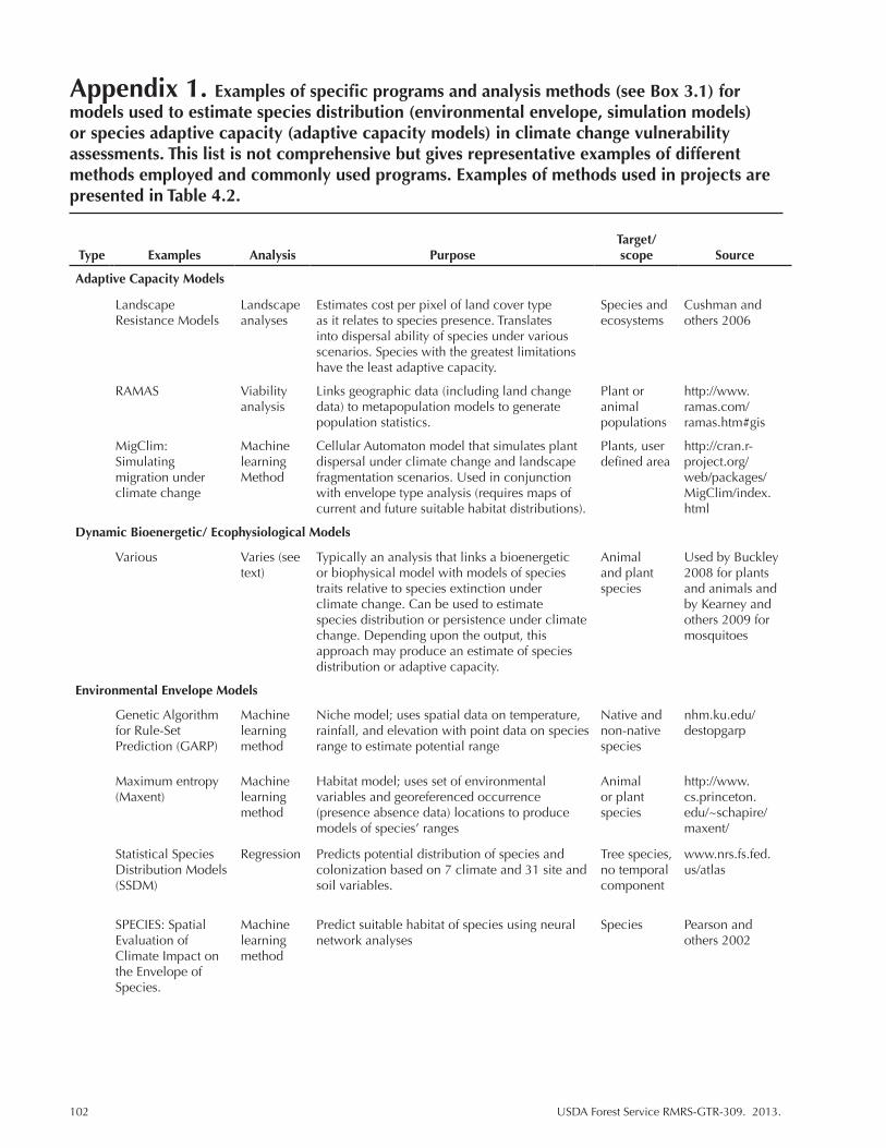
102 USDA Forest Service RMRS-GTR-309. 2013.
Appendix 1. Examples of specific programs and analysis methods (see Box 3.1) for models used to estimate species distribution (environmental envelope, simulation models) or species adaptive capacity (adaptive capacity models) in climate change vulnerability assessments. This list is not comprehensive but gives representative examples of different methods employed and commonly used programs. Examples of methods used in projects are presented in Table 4.2.
Type Examples Analysis PurposeTarget/scope Source
Adaptive Capacity Models
Landscape Resistance Models
Landscape analyses
Estimates cost per pixel of land cover type as it relates to species presence. Translates into dispersal ability of species under various scenarios. Species with the greatest limitations have the least adaptive capacity.
Species and ecosystems
Cushman and others 2006
RAMAS Viability analysis
Links geographic data (including land change data) to metapopulation models to generate population statistics.
Plant or animal populations
http://www.ramas.com/ramas.htm#gis
MigClim: Simulating migration under climate change
Machine learning Method
Cellular Automaton model that simulates plant dispersal under climate change and landscape fragmentation scenarios. Used in conjunction with envelope type analysis (requires maps of current and future suitable habitat distributions).
Plants, user defined area
http://cran.r-project.org/web/packages/MigClim/index.html
Dynamic Bioenergetic/ Ecophysiological Models
Various Varies (see text)
Typically an analysis that links a bioenergetic or biophysical model with models of species traits relative to species extinction under climate change. Can be used to estimate species distribution or persistence under climate change. Depending upon the output, this approach may produce an estimate of species distribution or adaptive capacity.
Animal and plant species
Used by Buckley 2008 for plants and animals and by Kearney and others 2009 for mosquitoes
Environmental Envelope Models
Genetic Algorithm for Rule-Set Prediction (GARP)
Machine learning method
Niche model; uses spatial data on temperature, rainfall, and elevation with point data on species range to estimate potential range
Native and non-native species
nhm.ku.edu/destopgarp
Maximum entropy (Maxent)
Machine learning method
Habitat model; uses set of environmental variables and georeferenced occurrence (presence absence data) locations to produce models of species’ ranges
Animal or plant species
http://www.cs.princeton.edu/~schapire/maxent/
Statistical Species Distribution Models (SSDM)
Regression Predicts potential distribution of species and colonization based on 7 climate and 31 site and soil variables.
Tree species, no temporal component
www.nrs.fs.fed.us/atlas
SPECIES: Spatial Evaluation of Climate Impact on the Envelope of Species.
Machine learning method
Predict suitable habitat of species using neural network analyses
Species Pearson and others 2002

USDA Forest Service RMRS-GTR-309. 2013. 103
Type Examples Analysis PurposeTarget/scope Source
Hydrological Models
Regional Hydro-Ecologic Simulation System (RHESSys)
Regression GIS-based hydro-ecological model simulates water, carbon, and nutrient flow
Watershed fiesta.bren.ucsb.edu/~rhessys/setup/downloads/downloads.html
Sea Level Affecting Marshes Model (SLAMM)
Regression Models processes dominating wetland conversion and shoreline modification
Coastal areas http://www.slammview.org.
Variable Infiltration Capacity
Physically based distributed hydrological model; suited for water/energy balance studies, so used extensively in climate change studies
River/stream/reservoir systems
Christensen and Lettenmaier, 2007
Dynamic Ecophysiological Models
Ecophysio-logical model
Models fish growth rates, algae production, and similar under various environmental conditions
Fish Keith and others, 2008.
Simulation/Process-Based Models
Biogeographic Models
BIOME, DOLY, MAPSS
Regression Biogeographic equilibrium models that calculate plant available water and temperature thresholds according to climatic zone, life form, and plant type.
Vegetation types; area defined by user
www.fs.fed.us/pnw/corvaliis/mdr/mapss
Biogeochemical Models
Instantaneous Canopy Flux Model (PnET)
Regression Biogeochemical model that merges three computational models that simulate carbon, water, and nitrogen dynamics
Forest ecosystems; typical scale = 5 km
http://www.pnet.sr.unh.edu/download.html
Soil Organic Matter Model (CENTURY)
Regression Biogeochemical model that simulates nutrient/hydrological flows and includes fire/harvest frequency on monthly scale
Watershed; typical scale = 5 km
www.nrel.colostate.edu/project/century5/
BIOCLIM (BIOMAP) Regression Prediction system (biogeochemical model) that uses mean monthly climate estimates to predict energy and water balances at specified location
Vegetation type; area defined by user
software.infromer.com/getfree-bioclim-download-software
DAYCENT Simulation model
Biogeochemical model that simulates nutrient/hydrological flows and includes fire/harvest frequency on a daily scale. Daily version of CENTURY.
Vegetation types; watershed; typical scale = 5km.
www.nrel.colostate.edu/project/century5/
Dynamic Global Vegetation Model (DGVM)
LANDIS, LANDIS II Simulation Model
Simulates dynamic interactions between vegetation, climate and disturbance. Can also incorporate dispersal as the probability of a seed moving to a new cell. Like other process based models, LANDIS can be used to develop projections of future distribution but does not in and of itself do so. LANDIS II relies on FIA data
Tree species age classes. Multiple scales though typically =10km.
http://www.fs.fed.us/pnw/mdr/mapss
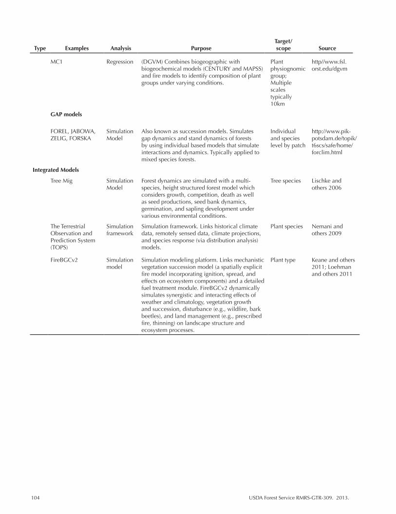
104 USDA Forest Service RMRS-GTR-309. 2013.
Type Examples Analysis PurposeTarget/scope Source
MC1 Regression (DGVM) Combines biogeographic with biogeochemical models (CENTURY and MAPSS) and fire models to identify composition of plant groups under varying conditions.
Plant physiognomic group; Multiple scales typically 10km
http//www.fsl.orst.edu/dgvm
GAP models
FOREL, JABOWA, ZELIG, FORSKA
Simulation Model
Also known as succession models. Simulates gap dynamics and stand dynamics of forests by using individual based models that simulate interactions and dynamics. Typically applied to mixed species forests.
Individual and species level by patch
http://www.pik-potsdam.de/topik/t6scs/safe/home/forclim.html
Integrated Models
Tree Mig Simulation Model
Forest dynamics are simulated with a multi-species, height structured forest model which considers growth, competition, death as well as seed productions, seed bank dynamics, germination, and sapling development under various environmental conditions.
Tree species Lischke and others 2006
The Terrestrial Observation and Prediction System (TOPS)
Simulation framework
Simulation framework. Links historical climate data, remotely sensed data, climate projections, and species response (via distribution analysis) models.
Plant species Nemani and others 2009
FireBGCv2 Simulation model
Simulation modeling platform. Links mechanistic vegetation succession model (a spatially explicit fire model incorporating ignition, spread, and effects on ecosystem components) and a detailed fuel treatment module. FireBGCv2 dynamically simulates synergistic and interacting effects of weather and climatology, vegetation growth and succession, disturbance (e.g., wildfire, bark beetles), and land management (e.g., prescribed fire, thinning) on landscape structure and ecosystem processes.
Plant type Keane and others 2011; Loehman and others 2011
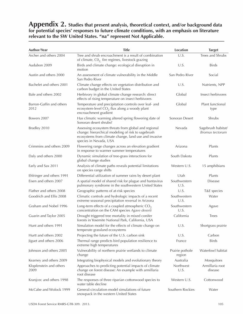
USDA Forest Service RMRS-GTR-309. 2013. 105
Appendix 2. Studies that present analysis, theoretical context, and/or background data for potential species’ responses to future climate conditions, with an emphasis on literature relevant to the SW United States. “na” represent Not Applicable.
Author/Year Title Location Target
Archer and others 2004 Tree and shrub encroachment is a result of combination U.S. Trees and Shrubs of climate, C02, fire regimes, livestock grazing
Audubon 2009 Birds and climate change: ecological disruption in U.S. Birds motion
Austin and others 2000 An assessment of climate vulnerability in the Middle San Pedro River Social San Pedro River
Bachelet and others 2001 Climate change effects on vegetation distribution and U.S. Nutrients, NPP carbon budget in the United States
Bale and others 2002 Herbivory in global climate change research: direct Global Insect herbivores effects of rising temperature on insect herbivores
Barron-Gaffin and others Temperature and precipitation controls over leaf- and Global Plant functional 2012 ecosystem-level CO2 flux along a woody plant type encroachment gradient
Bowers 2007 Has climatic warming altered spring flowering date of Sonoran Desert Shrubs Sonoran desert shrubs?
Bradley 2010 Assessing ecosystem threats from global and regional Nevada Sagebrush habitat/ change: hierarchical modeling of risk to sagebrush Bromus tectorum ecosystems from climate change, land use and invasive species in Nevada, USA
Crimmins and others 2009 Flowering range changes across an elevation gradient Arizona Plants in response to warmer summer temperatures
Daly and others 2000 Dynamic simulation of tree-grass interactions for South Dakota Plants global change studies
Early and Sax 2011 Analysis of climate paths reveals potential limitations Western U.S. 15 amphibians on species range shifts
Ehlringer and others 1991 Differential utilization of summer rains by desert plant Utah Plants
Eisen and others 2007 A spatial model of shared risk for plague and hantavirus Southwestern Disease pulmonary syndrome in the southwestern United States U.S.
Flather and others 2008 Geographic patterns of at-risk species U.S. T&E species
Goodrich and Ellis 2008 Climatic controls and hydrologic impacts of a recent Southwestern Water extreme seasonal precipitation reversal in Arizona U.S.
Graham and Nobel 1996 Long-term effects of a coupled atmospheric CO2 Southwestern Agave concentration on the CAM species Agave deserti U.S.
Guarin and Taylor 2005 Drought triggered tree mortality in mixed conifer California Trees forests in Yosemite National Park, California, USA
Hunt and others 1991 Simulation model for the effects of climate change on U.S. Shortgrass prairie temperate grassland ecosystems
Hurtt and others 2002 Projecting the future of the U.S. carbon sink U.S. Carbon
Jiguet and others 2006 Thermal range predicts bird population resilience to France Birds extreme high temperatures
Johnson and others 2005 Vulnerability of northern prairie wetlands to climate Prairie pothole Waterfowl habitat change region
Kearney and others 2009 Integrating biophysical models and evolutionary theory Australia Mosquitoes
Klopfenstein and others Approaches to predicting potential impacts of climate Northwest Armillaria root 2009 change on forest disease: An example with armillaria U.S. disease root disease
Kranjcec and others 1998 The responses of three riparian cottonwood species to Western U.S. Cottonwood water table decline
McCabe and Wolock 1999 General-circulation-model simulations of future Southern Rockies Water snowpack in the western United States

106 USDA Forest Service RMRS-GTR-309. 2013.
Author/Year Title Location Target
McDonald and Brown 1992 Using montane mammals to model extinctions due to Western U.S. Vegetation/ global change mammals
Morgan and others 2011 Management Implications of global change for great Western U.S. Rangelands plains rangelands
Patrick and others 2009 Physiological responses of two contrasting desert plant Texas Plants species to precipitation variability are differentially regulated by soil moisture and nitrogen dynamics
Pierce and others 2008 Attribution of Declining Western U.S. Snowpack to Western U.S. Water Human Effects
Poiani and others 1996 Climate change and northern prairie wetlands: Western U.S. Habitats Simulations of long-term dynamics
Root 1988 Energy constraints on avian distribution and abundances U.S. Birds
Rowland and others 2011 Approaches to evaluating climate change impacts on na Plants, animal, species: A guide to initiating the adaptation planning water process
Schimel 2000 Contribution of increasing CO2 and climate to carbon Habitats storage by ecosystems of the United States
Seager and others 2007 Model projections of an imminent transition to a more Southwestern Climate arid climate in southwestern North America U.S. projections
Sekercioglu and others 2008 Climate change, elevation range shifts, and bird Global Birds extinctions
Sheppard and others 2002 The climate of the US Southwest Southwestern Climate U.S. projections
Skirvin and others 2000 Climate change and land tenure: potential impacts on Arizona Plant species in vegetation and developments in the San Pedro River Sand Pedro River watershed, southwestern Arizona
Smith and others 2000 Elevated CO2 increases productivity and invasive Western U.S. Cheatgrass species success in an arid ecosystem
Stewart and others 2004 Changes in snowmelt runoff timing in western North Western U.S. Water America under a “business as usual” climate change scenario
Weiss and Overpeck 2005 Is the Sonoran desert losing its cool? Southwestern Climate U.S. projections
White and others 2009 Past and projected rural land conversion in the US U.S. by region Socio-economic at state, regional, and national levels Land use
Zavaleta and Royval 2002 Climate change and the susceptibility of U.S. ecosystems to biological invasions: Two cases of expected range expansion
Schloss and others 2012 Dispersal will limit ability of mammals to track climate Western Mammals change in the Western Hemisphere Hemisphere
Shafer and others 2001 Potential changes in the distribution of western North Western U.S. Tree and shrub America tree and shrub taxa under future climate species scenarios
Williams and others 2012 Temperature as a potent driver of regional forest drought na Tree productivity stress and tree mortality and survival
Thompson and others 1998 A strategy for assessing potential future change in Western U.S. Vegetation and climate, hydrology, and vegetation in the western water United States
Rehfeldt and others 2006 Empirical analyses of plant-climate relationships for Western U.S. Plant biotic the western United States communities

You may order additional copies of this publication by sending your mailing information in label form through one of the following media. Please specify the publication title and series number.
Publishing Services Telephone (970) 498-1392 FAX (970) 498-1212 E-mail [email protected] Website http://www.fs.fed.us/rm/publications Mailing address Publications Distribution Rocky Mountain Research Station 240 West Prospect Road Fort Collins, CO 80526
The Rocky Mountain Research Station develops scientific information and technology to improve management, protection, and use of the forests and rangelands. Research is designed to meet the needs of the National Forest managers, Federal and State agencies, public and private organizations, academic institutions, industry, and individuals. Studies accelerate solutions to problems involving ecosystems, range, forests, water, recreation, fire, resource inventory, land reclamation, community sustainability, forest engineering technology, multiple use economics, wildlife and fish habitat, and forest insects and diseases. Studies are conducted cooperatively, and applications may be found worldwide. For more information, please visit the RMRS web site at: www.fs.fed.us/rmrs.
Station Headquarters Rocky Mountain Research Station
240 W Prospect RoadFort Collins, CO 80526
(970) 498-1100
Research Locations
The U.S. Department of Agriculture (USDA) prohibits discrimination against its customers, employees, and applicants for employment on the bases of race, color, national origin, age, disability, sex, gender identity, religion, reprisal, and where applicable, political beliefs, marital status, familial or parental status, sexual orientation, or all or part of an individual’s income is derived from any public assistance program, or protected genetic information in employment or in any program or activity conducted or funded by the Department. (Not all prohibited bases will apply to all programs and/or employment activities.) For more information, please visit the USDA web site at: www.usda.gov and click on the Non-Discrimination Statement link at the bottom of that page.
Reno, NevadaAlbuquerque, New MexicoRapid City, South Dakota
Logan, UtahOgden, UtahProvo, Utah
Flagstaff, ArizonaFort Collins, Colorado
Boise, IdahoMoscow, Idaho
Bozeman, MontanaMissoula, Montana
To learn more about RMRS publications or search our online titles:
www.fs.fed.us/rm/publications
www.treesearch.fs.fed.us
Federal Recycling Program Printed on Recycled Paper