resource assessment - houston
TRANSCRIPT

Page 1, June 2019 Northshore
DescriptionNorthshore is an area immediately north of the Houston Ship Channel, east of Loop 610. The community includes subdivisions such as Songwood, Holiday Forest, Wood Bayou, Cimarron, Home Owned Estates, Woodland Acres, Hidden Forest and Greens Bayou. Neighborhoods east of Greens Bayou and those south of Market Street are in Galena Park ISD. The balance of the area is in Hous-ton ISD. This heavily wooded area includes a variety of home styles and prices. In the 1980s, the Brown Foundation donated a large tract of land that the Crosby Freeway (Highway 90) passes through.
Highlights Houston City Council Districts I & E
Houston Independent School District
Galena Park Independent School
District
3 Police beats (includes bordering beats)
5,928 acres (9.26 sq. miles)
Super Neighborhood HoustonPop. characteristics 2000 2017 2000 2017Total population 27,350 28,827 1,953,631 2,267,336 Persons per sq. mile 297 3,109 3,166 3,394
Age of PopulationUnder 5 years 11% 10% 8% 8%5 - 17 years 23% 21% 19% 17%18 - 64 years 59% 61% 64% 65%65 and over 7% 8% 9% 10%
EthnicityNon Hispanic Whites 22% 9% 31% 25%Non Hispanic Blacks 17% 14% 25% 22%Hispanics 59% 76% 37% 44%Non Hispanic Asians 1% 1% 6% 7%Non Hispanic Others 1% 0% 1% 2%
IncomeUnder $25,000 35% 31% 33% 26%$25,000 to $49,999 35% 30% 31% 25%$50,000 to $99,999 26% 31% 24% 26%Over $100,000 4% 8% 12% 23%
Median Household Income $33,899 $42,064 $36,616 $49,399
Educational StatusNo Diploma 45% 44% 30% 22%High School Diploma 28% 27% 20% 23%Some College 20% 22% 23% 23%Bachelor's or Higher 8% 7% 27% 32%
Housing and HouseholdsTotal housing units 8,914 9,410 782,378 943,183 Occupied 91% 93% 92% 89% Vacant 9% 7% 8% 11%Total households 8,109 8,750 717,945 838,950Family households 6,335 6,360 457,549 491,778Median Housing Value $55,315 $79,048 $79,300 $149,000
NORTHSHORENO. 58
R E S O U R C E A S S E S S M E N T
Super Neighborhood Houston

Page 2, June 2019 Northshore
Northshore: Land Use
IH 610
IH 10
WALLISVILLE
FREEPORT
GELLHORN
FIELDS
HOLLAN
D
WOODFOREST
MESA
BEAUMONT
UVAL
DE
MAX
EY
MCC
ARTY
FEDERAL
MARKET
FIDELITY
NORM
ANDY
MERCU
RY
PURPLE SAGE
LIBERTY
HOU
STON
LAKE
HOUST
ON
OATES
CLINTON
INDUSTRIAL
TRAI
LMO
BILE
Freeway
Rail Road
Super Neighborhood Boundary
Single-family Residential
Multi-family Residential
Commercial
Office
Industrial
Public and Institutional
Transportation and Utilities
Parks and Open Space
Undeveloped
Agricultural Production
Open Water
Unknown
Source: City of Houston GIS Database,
Date: May 24, 2019
Harris County Appraisal District
I 0 0.5 10.25Miles

Page 3, June 2019 Northshore
Northshore: Public Facilities Source: City of Houston GIS Database
Date: May 2019
Council District I
Council District E
Council District B
Council District B
Council District H
MARKET
WALLISVILLE
CLINTON
UVALDE
FEDERAL
FIDELITY
HOLLAN
D
MAXEY
OATES
NO
RMAN
DY
INDUSTRIAL
WOODFOREST
FREEPORT
MCC
ARTY
GELLHORN
MERCU
RY
MESA
BEAUMONT
HOU
STON
LAKE
HOUST
ON
LIBERTY
PURP
LE S
AGE
TRAI
LMO
BILE
MES
A
OATES
IH 610
IH 10
IH 10
IH 610
IH 10
Community Centers
Fire Station
ÆP Harris County Hospitals
ÆP Private Hospitals
ÆP Other Health Facilities
Æc Library
Metro Rail Stations
Police Station
Rail Road
å School
Parks
I0 0.5 10.25
Miles
Super Neighborhood Boundary
Metro Rail Line¬(Å
AirportsZ
TIRZ
Council District E
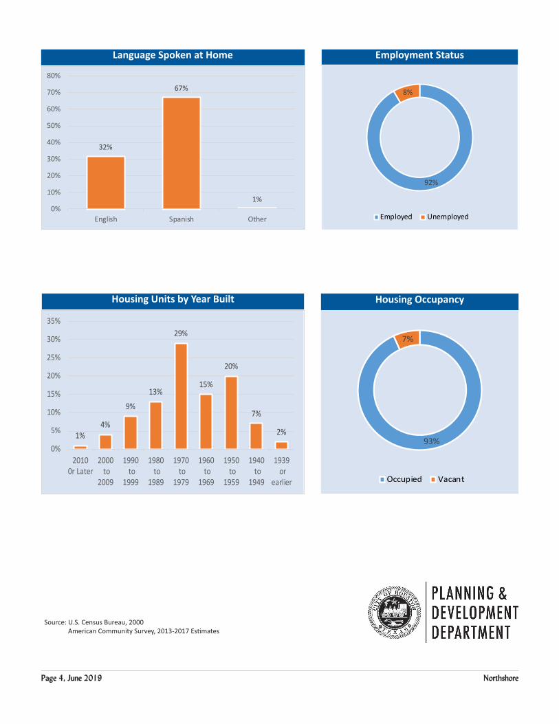
Page 4, June 2019 Northshore
Language Spoken at Home Employment Status
Housing Units by Year Built Housing Occupancy
92%
8%
Employed Unemployed
1%4%
9%
13%
29%
15%
20%
7%
2%
0%
5%
10%
15%
20%
25%
30%
35%
20100r Later
2000 to
2009
1990 to
1999
1980 to
1989
1970 to
1979
1960 to
1969
1950 to
1959
1940 to
1949
1939 or
earlier
32%
67%
1%0%
10%
20%
30%
40%
50%
60%
70%
80%
English Spanish Other
93%
7%
Occupied Vacant
Source: U.S. Census Bureau, 2000 American Community Survey, 2013-2017 Estimates