regular meeting agenda city of madera … · 8/8/2018 · change the zoning of the project parcels...
TRANSCRIPT

REGULAR MEETING AGENDA CITY OF MADERA
PLANNING COMMISSION
COUNCIL CHAMBERS - CITY HALL TUESDAY
AUGUST 14, 2018 6:00 pm
CALL TO ORDER ROLL CALL
Commissioner Robert Gran, Jr. (Chairperson) Commissioner Israel Cortes (Vice Chairperson) Commissioner Bruce Norton Commissioner Kenneth Hutchings Commissioner Pamela Tyler Commissioner Jim DaSilva Commissioner Richard Broadhead
INTRODUCTION OF STAFF PLEDGE OF ALLEGIANCE PUBLIC COMMENT The first fifteen minutes of the meeting are reserved for members of the public to address the Commission on items which are within the subject matter jurisdiction of the Commission. Speakers shall be limited to three minutes. Speakers will be asked to identify themselves and state the subject of their comment. If the subject is an item on the Agenda, the Chairperson has the option of asking the speaker to hold the comment until that item is called. Comments on items listed as a Public Hearing on the Agenda should be held until the hearing is opened. The Commission is prohibited by law from taking any action on matters discussed that are not on the Agenda and no adverse conclusions should be drawn if the Commission does not respond to public comment at this time. MINUTES: July 10, 2018 CONSENT ITEMS: None PUBLIC HEARING ITEMS:
1. PPL 2005-01 MOD2 – Tierra Vista Estates Amendment A continued noticed public hearing to consider an application for amendment to a precise plan to allow for the addition of four (4) home models to be built upon thirty-six (36) vacant lots within the Tierra Vista Estates subdivision, located at the northwest corner of the intersection of Emily Way and Gary Lane in the PD 3000 (Planned Development) Zone District with an MD (Medium Density Residential) General Plan land use designation (Multiple APNs). The project has been determined to be categorically exempt under the California Environmental Quality Act (CEQA) guidelines, Section 15332 (In-Fill Development Projects).

2. CUP 2018-10 – La Quinta Inn Alcohol Sales A continued noticed public hearing to consider a conditional use permit to allow for the sale of beer and wine for on-site consumption in conjunction with the La Quinta Inn remodel located at the northeast corner of the intersection of East 4th Street and North G Street (317 North G Street) in the C2 (Heavy Commercial) Zone District with a C (Commercial) General Plan land use designation (APN: 006-095-010). The project has been determined to be categorically exempt under the California Environmental Quality Act (CEQA) guidelines, Section 15301 (Existing Facilities).
3. TSM 2017-02 – CVI Subdivision Map A noticed public hearing to consider a tentative subdivision map that will provide for the subdivision of two (2) existing parcels encompassing a total of approximately 2.9 acres into a twenty (20) lot single-family residential subdivision. The project will include major infrastructural improvements including the construction of a collector street that will connect Kennedy Drive and Adell Street between Austin Street and Lake Street. The project site is located at the southwest corner of the intersection of North Lake Street and East Adell Street in the PD 4500 (Planned Development) Zone District with a LD (Low Density Residential) General Plan land use designation. A Negative Declaration will also be considered by the Planning Commission (APNs: 004-170-007 and 008).
4. GPA 2018-03 and REZ 2018-03 – City of Madera, Successor Agency, Housing
Authority A noticed public hearing to consider a General Plan Amendment and Rezone of four parcels located in proximity to the intersection of North C Street and East 5th Street (121, 125, 200 and 204 North C Street). The General Plan Amendment would change the General Plan land use designations from the P&SP (Public and Semi-Public) and C (Commercial) to the HD (High Density) land use designation. The Rezone would change the zoning of the project parcels from the PF (Public Facilities) and the C1 (Light Commercial) Zone Districts to the PD-1500 (Planned Development) Zone District. A Negative Declaration will also be considered by the Planning Commission (APN’s 007-082-004 and 005, 007-112-014 and 015).
5. CUP 2013-14 MOD – Brar Interim Agriculture
A noticed public hearing to consider an amendment to Conditional Use Permit 2013-14, which allows for interim agricultural activities on approximately 137 acres located at the southwest corner of East Pecan Avenue and Golden State Drive within the Ventana Specific Plan area. The amendment request would allow for the continued farming of an almond orchard for a period not to exceed five years (APN: 012-490-002). An initial study and Negative Declaration were adopted by the Planning Commission in May of 2014.
6. CUP 2016-36 MOD – Arco Beer and Wine Off-Site Consumption Amendment
A noticed public hearing to consider an amendment to Conditional Use Permit 2016-36. Condition No. 67 only allows for a transferred Type 20 ABC license to allow for the off-site consumption of beer and wine in conjunction with a mini mart. The applicant would like to alter the condition of approval to allow for a new Type 20 ABC license. The project site is located at the northeast corner of the intersection of Madera Avenue and East Pecan Avenue in the C2 (Heavy Commercial) Zone District with a C (Commercial) General Plan land use designation (APN: 012-133-039). An initial study and Mitigated Negative Declaration were adopted by the Planning Commission in December of 2017.
7. CUP 2018-13 and SPR 2018-21 – Mad Fitness #2
A noticed public hearing to consider a conditional use permit and site plan review to allow for the establishment of a group exercise studio in conjunction with an Herbalife

business within an existing tenant suite on property located at the southeast corner of the intersection of Country Club Drive and East Clark Street (1475 Country Club Drive, Suite 103) in the C1 (Light Commercial) Zone District with a C (Commercial) General Plan land use designation. The project has been determined to be categorically exempt under California Environmental Quality Act (CEQA) guidelines, Section 15301 (Existing Facilities) (APN: 003-210-009).
8. VAR 2018-02 – Walmart Sign Variance
A noticed public hearing to consider a variance from the Sign Ordinance of the Madera Municipal Code that would allow for 563 square feet of on-building signage where 439 square feet of on-building signage was allowed. The project site is located approximately 1,000 feet east of the intersection of North Schnoor Avenue and West Cleveland Avenue (1977 West Cleveland Avenue) in the C1 (Light Commercial) Zone District with a C (Commercial) General Plan land use designation. The project has been determined to be categorically exempt under California Environmental Quality Act (CEQA) guidelines, Section 15301 (Existing Facilities) (APN: 013-160-014).
9. VAR 2018-03 – Non-conforming Accessory Structure
A noticed public hearing to consider a variance from the R (Residential) Zone District setback standards of the Madera Municipal Code that would allow for a 2’-4” interior side yard setback where a minimum of five (5’) feet is allowed on property located approximately 270 feet north of the intersection of Maple Street and Stadium Road (201 ½ Stadium Road) in the R1 (Low Density Residential) Zone District with a MD (Medium Density Residential) General Plan land use designation. The project has been determined to be categorically exempt under California Environmental Quality Act (CEQA) guidelines, Section 15305 (Minor Alterations to Land) (APN: 012-091-009).
10. VAR 2018-04 and SPR 2018-23 – United Rentals Electric Fence
A noticed public hearing to consider a variance from Section 10-3.412 (fences, walls, and hedges of the Madera Municipal Code that would allow for an electric security fence ten (10’) feet in height where a maximum of six (6’) feet in height is allowed. The project site is located at the northwest corner of the intersection of West Almond Avenue and Madera Avenue (750 Madera Avenue) in the C1 (Light Commercial) Zone District with a C (Commercial) General Plan land use designation. The project has been determined to be categorically exempt under California Environmental Quality Act (CEQA) guidelines, Section 15311 (Accessory Structures) (APN: 012-133-015).
11. PPL 2014-01 MOD3 – Capistrano 16 Precise Plan Modification A noticed public hearing to consider a request for modification of Precise Plan 2014-01 to allow for a change in the approved home plans and amendment of certain development standards applicable to the 103-lot Capistrano 16 subdivision generally located north of Almond Avenue and east of Westberry Boulevard in the PD-4500 (Planned Development) Zone District with an LD (Low Density) General Plan land use designation (APN: 009-600-006). An initial study and Negative Declaration were adopted by the Planning Commission in October of 2014.
12. CUP 2018-12 – Manriquez Large Family Daycare A noticed public hearing to consider a request to consider an appeal of a Conditional Use Permit to allow for the expansion of family daycare facility due to opposition from the surrounding community. The residential site is located at 639 Macadamia Avenue in the PD4500 (Planned Development) Zone District with a LD (Low Density) General Plan land use designation. The project has been determined to be categorically exempt under California Environmental Quality Act (CEQA) guidelines, Section 15274 (Family Day Care Homes) (APN: 012-350-019).
NON-PUBLIC HEARING ITEMS: ADMINISTRATIVE REPORTS: COMMISSIONER REPORTS: ADJOURNMENT: The next regular meeting will be held on September 11, 2018.

In compliance with the Americans with Disabilities Act, the meeting room is accessible to the physically disabled and the services of a translator can be made available. Requests for additional accommodations for the disabled, signers, assistive listening devices or translators needed to assist participation in the public meeting should be made at least seventy-two (72) hours before the meeting. If you need special assistance to participate in a City meeting or other services offered by this City, please contact the Planning Department office at (559) 661-5430. Those who are hearing impaired, may call 711 or 1-800-735-2929 for TTY Relay Services. Any and all persons interested in this matter may provide comments. Any writing related to an agenda item for the open session of this meeting distributed to the Planning Commission less than 72 hours before this meeting is available for inspection at the City of Madera – Planning Department, 205 W. 4th Street, Madera, CA 93637 during normal business hours. Pursuant to Section 65009 of the Government Code of the State of California, notice is hereby given that if any of the foregoing projects or matters is challenged in Court, such challenge may be limited to only those issues raised at the public hearing, or in written correspondence delivered to the Planning Commission at or prior to the public hearing. All Planning Commission actions may be appealed to the City Council. The time in which an applicant may appeal a Planning Commission action varies from 10 to 30 days depending on the type of project. The appeal period begins the day after the Planning Commission public hearing. There is NO EXTENSION for an appeal period. If you have any questions or comments regarding this hearing notice, you may call the Planning Department at (559) 661-5430. Si usted tiene preguntas, comentarios o necesita ayuda con interpretación, favor de llamar el Departamento de Planeamiento por lo menos 72 horas antes de esta junta (559) 661-5430.

Staff Report: Tierra Vista Estates Precise Plan Modification
PPL 2005-01 MOD2 and Environmental Determination Item # 1 August 14, 2018
PROPOSAL: An application for precise plan to allow for the development of four home models with three varying elevations each on thirty-six (36) of the remaining fifty-one (51) vacant lots within the Tierra Vista Estates subdivision. ___________________________________________________________________________ APPLICANT: Joseph Crown OWNER: Madera Vista Estates LLC
ADDRESS: Multiple APN: Multiple
APPLICATIONS: PPL 2005-01 MOD2 CEQA: Categorical Exemption
___________________________________________________________________________ LOCATION: The project site is located on the northwest corner of Emily Way and Gary Lane. STREET ACCESS: The subdivision has access from Emily Way and Gary Lane. PARCEL SIZE: Average lot size is approximately 4,500 square feet. GENERAL PLAN DESIGNATION: MD (Medium Density) ZONING DISTRICT: PD 3000 (Planned Development) ____________________________________________________________________________ SITE CHARACTERISTICS: Tierra Vista Estates is a 78-lot single family residential subdivision. Commercial development is located immediately to the west and north. Property to the south is a single-family residential neighborhood. Property to the east is vacant multifamily residential land. Portions of the subdivision have been developed in the past via two separate precise plan approvals. ENVIRONMENTAL REVIEW: The project has been determined to be categorically exempt under the California Environmental Quality Act (CEQA) guidelines, Section 15332, (In-Fill Development Projects) ____________________________________________________________________________ SUMMARY: Precise Plan 2005-01 MOD2, as conditioned, provides for the development of new homes on thirty-six vacant parcels within the Tierra Vista Estates subdivision consistent with the Zoning Ordinance and the General Plan.
CITY OF MADERA PLANNING COMMISSION
205 W. Fourth Street Madera CA 93637 (559) 661-5430
Return to Agenda

PC 08/14/18 (PPL 2005-01 MOD2 Tierra Vista Estates) 2
APPLICABLE CODES AND PROCEDURES MMC §10-3-4.101 Planned Development Zones MMC §10-3-4.104 Precise Plan Application California Public Resources Code §21000, California Environmental Quality Act “CEQA”. Precise plans are utilized within the PD (Planned Development) Zone District to establish the specific development and improvement standards for a proposed project. Precise plans address site features such as infrastructure and services, circulation and access, appearance, landscaping and open space. The City’s Zoning Ordinance allows for the granting of an amendment to a precise plan by the Planning Commission subject to the Planning Commission being able to make findings that the establishment, maintenance or operation of the development will not, under the circumstances of the particular case, be detrimental to the health, safety, peace, morals, comfort and general welfare of persons residing or working in the neighborhood of the development, or be detrimental or injurious to property and improvements in the neighborhood or to the general welfare of the city. If the Commission cannot make the appropriate findings, the development should be denied. Conditions may be attached to the approval of the precise plan to ensure compatibility. Project design may be altered and on or off-site improvements required in order to make the project compatible with nearby uses. In addition, the application may be subject to further review, modification or revocation by the Commission as necessary. PRIOR ACTION Tentative Subdivision Map 2005-02 and Precise Plan 2005-01 were approved by the Planning Commission on March 8, 2005. The precise plan was then amended on November 12, 2013 to include three new floor and elevation plans as part of Precise Plan 2005-01 MOD. Precise Plan 2005-01 MOD was developed inconsistent with the required findings and approved conditions. Not associated with the recordation of the map, the precise plan expired when development ceased for a period in excess of one year. The Planning Commission continued the public hearing on this item at its June 12, 2018 meeting in order to review the elevations proposed for construction on the thirty-six (36) lots. ANALYSIS Background The approved tentative subdivision map for the Tierra Vista Estates subdivision created 78 residential lots with a minimum size of 4,500 square feet. Although the majority of lots are 4,500 square feet, lots range to as high as 8,208 square feet. The subdivision has twenty-seven (27) constructed homes and fifty-one (51) vacant lots. Previously approved floor plans offered homes between 1,200 and 2,300 square feet, with varying front elevations offered for each plan. Front yard irrigation, landscaping and street trees were provided as part of the home package on each lot. In past subdivisions, staff required only one elevation that was offered with either a gable or hipped roofline. It was anticipated that optional enhanced elevations would provide for the required variation in architecture. Regrettably, within a recently approved subdivision, less than ten (10%) percent of buyers selected the enhanced elevational option, creating a condition where findings of conformance with Policy CD-33 could not be made.

PC 08/14/18 (PPL 2005-01 MOD2 Tierra Vista Estates) 3
Policy CD-33 requires that “the exterior of residential buildings shall be varied and articulated to provide visual interest to the streetscape.” Moreover, the reliance on optional elevational embellishments (such as stone) was not consistent with Action Item CD-33.1 which states “builders may not offer the buyers an option for a “base” or “standard” model which fails to provide variation and articulation in the exterior elevation.” In order to resolve the lack of variation in previously approved subdivisions, and to provide full compliance with CD-33, three varying stylistic elevations shall be required of all residential development moving forward. After an additional review period, the applicant has provided three varying elevations that reflect this standard. Modification Request The applicant proposes to complete the construction of homes on thirty-six (36) of the remaining fifty-one (51) vacant lots. The applicant does not control the remaining fifteen (15) vacant lots. The applicant proposes to construct four floor plans, each with three distinct architectural elevations. Models range from 1,393 square feet to 2,318 square feet. Three of the models fit within the optimal setbacks for residential construction on all of the thirty-six (36) lots. The 1,777 square foot Sienna model can be accommodated on only nineteen (19%) percent of the applicable lots when standard setbacks are applied. The four models are as follows: Proposed Home Models • Urbina 1,393 sq. ft. 3 bedrooms, 2 bathrooms Garage subordinate 100% • Abbey 1,576 sq. ft. 3 bedrooms, 2 bathrooms Garage subordinate 100% • Sienna 1,777 sq. ft. 4 bedrooms, 2 bathrooms Garage subordinate 19% • Amelia 2,318 sq. ft. 4 bedrooms, 2 bathrooms Garage neutral 100%
General Plan Conformance Model Elevations The proposed four models will be offered in a Spanish, Traditional or Craftsman elevation style. All models will include a two-car garage, a front porch and a rear patio which are an “encouraged” feature as stated in General Plan policy CD-35. In addition, models will include tile roofing, varying architectural treatments including wall sconces, varying window shutters, gable decorations and hatched window treatments. The developer is proposing optional Spanish tile or flat tile roofing for both the Spanish and the Traditional elevations as a standard feature, all of which cumulatively “reflect attention to detail as necessary to produce high architectural design and construction quality” (CD-34). The Traditional elevation on all four models will offer a stone/rock treatment. The Spanish style elevation will not incorporate stone/rock treatments, meanwhile the Craftsman style will include unique gable treatments while offering stone/rock treatments as an upgrade option. Garage Subordinate Design General Plan policy CD-32 states that “Garages for new single-family houses, duplexes, and townhouses should be subordinate in visual importance to the house itself, especially the entry. This may be achieved in a number of ways, such as by locating garages toward the back of the properties, constructing alleys, building garages as separate structures from the house, requiring garages to be set back from the front facade of the house and encouraging the orientation of garage doors at 90 degrees to the street.” Three of the proposed home models fully satisfy CD-32. In the case of the 2,318 sq. ft. Amelia model with a garage neutral layout, staff is comfortable including the model as part of the precise plan modification, while being mindful that the General Plan mandates that garage subordinate designs be a prevalent feature within the neighborhood. With staggered setbacks alongside a mix of garage subordinate and

PC 08/14/18 (PPL 2005-01 MOD2 Tierra Vista Estates) 4
garage neutral homes, the overall “exterior of residential buildings [will] be varied and articulated to provide visual interest of the streetscape (CD-33). Side-yard Elevations In addition to providing a varied primary elevation, the General Plan requires that where side and/or rear exterior elevations are visible from the right-of-way, architectural treatments be incorporated in keeping with the front (primary) elevation (CD- 34). For the number of lots that will have exterior elevations visible from the public right-of-way, it will be required that the side and/or rear elevations provide architectural features consistent with the primary elevation. Setbacks As identified earlier in this report, the Sienna elevation can be readily accommodated on only nineteen (19%) percent of the lots. As a result, on all lots where the Sienna model may be proposed with a rear yard setback of less than ten (10”) feet, approval of a Zoning Administrator Permit will be required. In no case shall the rear yard setback be less than six (6’) feet. Conditions of approval reflect these standards. Precise Plan Additionally, revised landscaping plans have been required as a component of the modified precise plan. In review of current landscaping design, additional attention to detail and aesthetic design is necessary. Staff recommends revised landscape plans for each proposed model be submitted to the Planning Department for approval so as to better satisfy Community Design Goal 4, which requires “Attractive streetscapes in all areas of Madera.” Combined with existing requirements for varying setbacks and model distribution, Precise Plan 2005-01 MOD2 is consistent with the goals and policies of the General Plan. CONSISTENCY WITH THE VISION MADERA 2025 PLAN The first of the four core vision statements in the Vision Plan is “a well-planned city”. The Commission, by considering how this development connects to other developments and how the neighborhood and infrastructure can be maintained, is actively implementing this key concept of the Vision Plan. Moreover, approval of the project is specifically consistent with Strategy 131, “Create Well-Planned neighborhoods throughout Madera that promote connectivity and inclusiveness with a mix of densities and commercial components”. SUMMARY OF RECOMMENDATIONS The modification to the precise plan allows for the logical completion of a residential neighborhood. As conditioned, the proposed homes and their supporting development standards provide conformity with the General Plan. The information presented supports approval of the project. It is recommended that the Commission consider this information, together with testimony provided at the public hearing, and approve the modification to the precise plan. PLANNING COMMISSION ACTION The Commission will be acting on the precise plan modification. Motion 1: Move to approve Precise Plan 2005-01 MOD2 to allow for the modification of the precise plan for Tierra Vista Estates to include the addition of four new floor plans and elevations, based on and subject to the findings and conditions of approval:

PC 08/14/18 (PPL 2005-01 MOD2 Tierra Vista Estates) 5
Findings - The project has been determined to be categorically exempt under the California
Environmental Quality Act (CEQA) guidelines, Section 15332, (In-Fill Development Projects).
- Precise Plan 2005-01 MOD2 is consistent with the purpose and intent of the PD (Planned Development) Zone District and does not conflict with City standards or other provisions of the code.
- Precise Plan 2005-01 MOD2 is consistent with the requirements for Precise Plans per Section 10-3-4.104.
- Precise Plan 2005-01 MOD2 is consistent with the goals and policies of the
General Plan. - Precise Plan 2005-01 MOD2 continues to implement the tentative map and
conditions of approval for the Tierra Vista Estates subdivision. - The proposed modification is compatible with the neighborhood and is not
expected to be detrimental to the health, safety, peace, comfort or general welfare of the neighborhood or the City.
CONDITIONS OF APPROVAL General Conditions 1. The conditions of approval for Precise Plan 2005-01 MOD2 replace, in their entirety, the
previous precise plan approvals for Tierra Vista Estates. 2. All conditions of approval shall be the sole financial responsibility of the applicant/owner,
except where specifically noted in the conditions or mandated by statutes. 3. Any minor deviation from the approved plan or any condition contained herein shall
require prior written request by the applicant and, at a minimum, approval by the Planning Manager.
4. Any substantial future modifications to the site involving, but not limited to, building exteriors, parking/loading areas, fences/walls, new buildings or landscaping shall require an amendment to the Precise Plan.
5. It shall be the responsibility of the property owner to ensure that any required permits, inspections and approvals from any regulatory agency shall be obtained from the concerned agency prior to establishment of the use.
6. It shall be the developer’s responsibility to assure that all homes on all lots are compliant with the conditions herein.
Engineering Department General 7. The applicant shall complete all the improvements as described in the Agreement for
the Construction of Improvements for Tierra Vista Estates Subdivisions executed in April of 2006 to allow the City of Madera to accept the subdivision and maintain public improvements associated with the subdivision.
PC 08/14/18 (PPL 2005-01 MOD2 Tierra Vista Estates) 6
8. Impact fees shall be paid at the time of building permit issuance.
9. Improvements within the City right-of-way require an Encroachment Permit from the
Engineering Division.
10. Any existing improvements that may have become substandard/deficient over the years due to weathering, vandalism or updated standards shall be replaced per current City standards. Surface deterioration in streets such as potholes shall be repaired by the developer.
Water 11. Water service connections, inclusive of any non-compliant materials that may have been
installed, shall be replaced and constructed per current City standards including water meters located within public right-of-way or public utility easements.
12. Developers shall install backflow prevention devises within landscaped areas as shown
on original improvement drawings per current city standards.
Sewer 13. Sewer service connections inclusive of any non-compliant materials that may have
already been installed, shall be replaced and constructed per current City standards including sewer cleanouts located within public right-of-way or public utility easements.
14. The developer shall be responsible for cleaning existing utility stub outs to prevent any
dirt, debris, or contamination of any type from entering the public sewer system. Streets 15. An ADA accessible path of travel shall be constructed across the existing driveway
approaches. 16. Substandard and damaged sidewalk, curb and gutter shall be removed and replaced
per current City standards. Limit of repairs shall be established by the City Engineering Inspector.
Planning Department
17. Four new models are approved as part of PPL 2005-01 MOD2.
• Urbina Model 1,393 sq. ft. - single-story floor plan, three bedrooms, two bathrooms • Abbey Model 1,576 sq. ft. - single-story floor plan, three bedrooms, two bathrooms • Sienna Model 1,777 sq. ft. - single-story floor plan, four bedrooms, two bathrooms • Amelia Model 2,318 sq. ft. - two-story floor plan, four bedrooms, two bathrooms
All models shall include a two-car garage.
18. The floor plans of all units shall be reversible and driveway approaches on corner lots shall be located on the interior side of the property.
19. Each approved model shall be available for construction in accordance with the approved architectural styles (Spanish, Traditional, Craftsman). Each elevation shall be a standard elevation, approved by the Planning Commission, available for purchase by the client as a standard feature of the home’s construction. Each approved model shall
PC 08/14/18 (PPL 2005-01 MOD2 Tierra Vista Estates) 7
include the following features as standard elements of construction:
• Tile roofing • Three-color exterior paint • Architectural treatments, including wall sconces, window shutters, gable
decorations, decorative moldings, wood corbels and/or hatched window treatments unique to and sufficient in quality and quantity to provide the required thematic variation and architectural quality.
20. The Sienna Model (1,777 sq. ft.) shall require the approval of a Zoning Administrator
Permit on lots where a rear yard setback less than 10’ feet is proposed. Rear yard setback for the Sienna Model shall not be less than six (6’) feet.
21. For corner, reverse corner and interior lots, where side and/or rear exterior elevations of
residential buildings are visible from any street or public right-of-way, architectural treatments in keeping with the front (primary) elevation shall be incorporated. Exhibits which demonstrate conformance with this condition of approval shall be submitted for approval as a component of submittal for a building permit.
22. For corner lots, street side yard setbacks shall be ten (10’) feet from property line for
structure and five (5’) feet from property line for fencing. For reverse corner lots, street side yard setbacks shall be ten (10’) feet minimum to fence and structure.
23. All standards for location and design of buildings (including accessory structures) and
fences which are not specifically included in the Precise Plan, as amended by these conditions of approval, shall conform to R1 (Residential) zoning standards.
24. Attached covered patios may encroach into the required fifteen (15’) foot rear yard setback by up to five (5’) feet.
25. Except as noted above, all driveways and encroachments shall conform to City standards in regard to setbacks from adjacent property lines, and near intersections. All approaches shall conform to City standards.
26. Minor adjustments in the width of corner lots may be approved by the Planning Manager
in order to comply with these precise plan requirements. 27. No side yard street access shall be allowed on any corner lot. No rear yard street
access shall be allowed from Lots 55 – 58.
Fences and Walls 28. Rear yard wood fencing shall be required for all single-family homes. Any retaining
walls greater than 18 inches in height shall be split block masonry. Residential fencing shall have a gate that will allow for easy access by an automated solid waste container provided by the City. The width of the gate shall be a minimum of 36 inches.
Landscaping 29. Revised MWELO compliant landscape and irrigation plans shall be submitted to the
Planning Department for each of the approved models. The revised landscape and irrigation plans shall be approved by the Planning Manager prior to issuance of building permit.

PC 08/14/18 (PPL 2005-01 MOD2 Tierra Vista Estates) 8
30. Front yard and street side yard landscaping shall be planted in conjunction with construction of all single-family homes. Two City approved street trees shall be planted in the street side yards of corner lots. No trees shall be planted within thirty (30’) feet of any streetlight or five (5’) feet from any fire hydrant. Each street tree shall be planted with a City approved root barrier. In addition to the previously mentioned street tree(s), a minimum of one City approved tree shall be provided in the front yard of all lots.
31. Rear yard fencing and front and street side yard landscaping and irrigation systems shall be installed in accordance with the approved landscaping and irrigation plans before the final building inspection of any residential units. All maintenance shall be by the individual homeowner.
32. Along Emily Way, landscaping shall include a minimum of one City approved street tree every fifty (50’) feet, along with root guards. Any existing landscaping along Emily Way and Gary Lane, shall be rehabilitated and maintained in a well-manicured manner. No trees shall be planted within thirty (30’) feet of any street light or five (5’) feet from any fire hydrant. Each tree shall be planted with a City approved root barrier.
33. Trees should be carefully selected and located to shade the structures during the hot
summer months. This measure should be implemented on southern and western exposures. Deciduous trees should be preferentially considered since they provide shade in the summer and allow the sun to reach the residences during winter months.
34. If fireplaces are installed, they must be either gas-burning or EPA certified wood-
burning. Natural gas and electric outlets are recommended to be installed in the back yard for barbecues. Outside electric outlets are recommended in the front and rear yards of the units to facilitate the use of electric lawn mowers, edgers, etc. Electric or low nitrogen oxide (Nox) emitting gas-fired water heaters should be installed.
35. HVAC units shall be ground mounted, located in the rear or interior side yard of the lot. No roof mounted air conditioning and heating ventilation units shall be allowed.
36. The following criteria shall be applied to the location of homes on individual lots:
• The appearance of a home is affected by at least three (3) primary features,
including: 1. home plan 2. alternative elevations for each plan; and 3. color
Homes built on side-by-side lots shall not repeat more than one these primary home features. The model floor plans shall not be repeated on more than two (2) consecutive lots.
37. The front structural setback shall vary from the minimum 15 feet to a maximum of 24
feet, with at least a one-foot variation amongst any two adjacent lots, and a five (5’) foot variation over any five consecutive lots, regardless of home models.
38. The minimum front setbacks for all lots shall be:
• 20 feet minimum depth to garage • 15 feet minimum to living space • 12 feet minimum to porch

PC 08/14/18 (PPL 2005-01 MOD2 Tierra Vista Estates) 9
Construction Trailer & Sales Center 39. The development of any temporary construction trailer and/or materials storage yard on
any lot in the subdivision requires the approval of a Zoning Administrator Permit in advance of installation/placement.
40. The development of any model home sales center on any lot in the subdivision requires the approval of a Zoning Administrator Permit.
Fire Department 41. All residential properties are required to be equipped with automatic fire sprinkler
protection. Permits must be obtained prior to the framing inspection of each dwelling, as individual dwelling is constructed.
(OR) Motion 2: Move to continue the application for Precise Plan 2005-01 MOD2 to the September 11, 2018 Planning Commission hearing for the following reasons or in order for the following information to be provided: (specify) (OR) Motion 3: Move to deny the application for Precise Plan 2005-01 MOD2, based on and subject to the following findings: (specify) ATTACHMENTS Aerial Photo Map of Affected Lots Models in Varied Arrangements
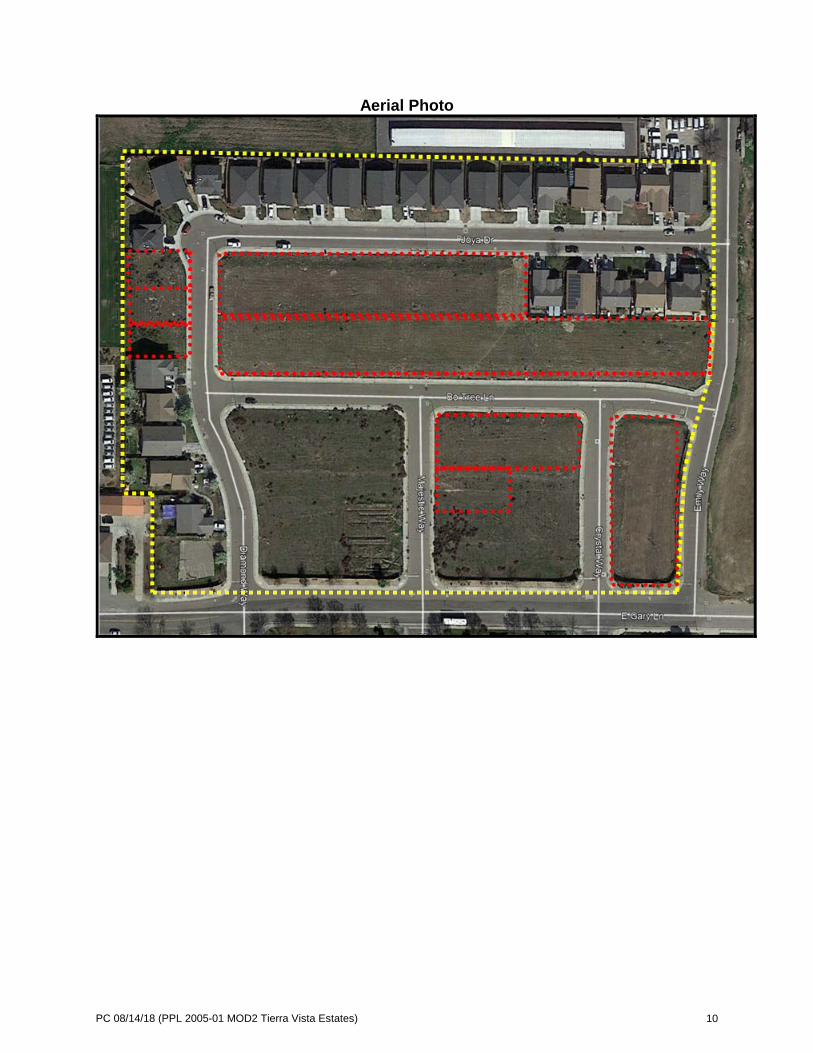
PC 08/14/18 (PPL 2005-01 MOD2 Tierra Vista Estates) 10
Aerial Photo

PC 08/14/18 (PPL 2005-01 MOD2 Tierra Vista Estates) 11
Map of Affected Lots “Outlined” lots are not a part of the Precise Plan Modification


CITY OF MADERA PLANNING COMMISSION
Staff Report: La Quinta Inn Alcohol Sales CUP 2018-10 & Environmental Determination
Item #2 - August 14, 2018 PROPOSAL: An application for a conditional use permit to allow for the sale of alcoholic beverages at a recently remodeled hotel. APPLICANT: Sanjiv Chopra OWNER: HLM Investments, LLC ADDRESS: 317 North G Street APN: 006-095-010 APPLICATION: CUP 2018-10 CEQA: Categorical Exemption
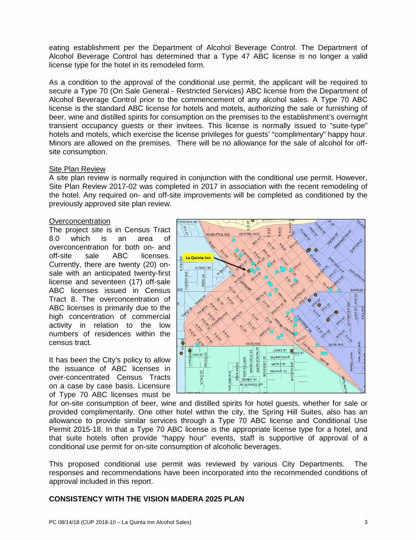
LOCATION: The property is located on the northeast corner of West 4th Street and North G Street. STREET ACCESS: The site has access to West 4th Street, West 3rd Street and North G Street. PARCEL SIZE: Approximately 1.2 acres GENERAL PLAN DESIGNATION: C (Commercial) ZONING DISTRICT: C2 (Commercial) SITE CHARACTERISTICS: There is commercial development to the east and south, with a residential neighborhood located directly north. City Hall is located immediately west of the project site. ENVIRONMENTAL REVIEW: The project has been determined to be categorically exempt under the California Environmental Quality Act (CEQA) guidelines, Section 15301, (Existing Facilities). SUMMARY: The applicant is proposing to re-establish the sale of beer, wine, and distilled spirits for on-site consumption after the previously approved use permit for alcohol sales expired. The applicant is proposing to utilize an owner transferred Type 47 ABC license. The remodeled hotel does not include a kitchen which previously qualified the site as a bona fide eating establishment for a Type 47 ABC license. The Department of Alcohol Beverage Control (ABC) has determined the remodeled hotel no longer qualifies for a Type 47 ABC license and will be required to secure a Type 70 ABC license which is typically required for hotel and motel uses. Although the hotel is within a census tract with an over-concentration of ABC licenses, the use is consistent with the purpose and intent of the Zoning Ordinance.
205 W. Fourth Street Madera CA 93637 (559) 661-5430
Return to Agenda
PC 08/14/18 (CUP 2018-10 – La Quinta Inn Alcohol Sales) 2
APPLICABLE CODES AND PROCEDURES MMC § 10-3.901 et. al.; C2, Heavy Commercial Zones MMC § 10-3.1202 Parking Spaces Required MMC § 10-3.1301 Use Permits The City’s Zoning Ordinance allows for the granting of a use permit by the Planning Commission subject to the Planning Commission being able to make findings that the establishment, maintenance or operation of the use or building will not, under the circumstances of the particular case, be detrimental to the health, safety, peace, morals, comfort and general welfare of persons residing or working in the neighborhood of the use, or be detrimental or injurious to property and improvements in the neighborhood or to the general welfare of the City. If the Commission cannot make the appropriate findings, the use should be denied. Conditions may be attached to the approval of the use permit to ensure compatibility. Project design may be altered and on- or off-site improvements required in order to make the project compatible with nearby uses. In addition, the application may be subject to further review, modification or revocation by the Commission as necessary. PRIOR ACTION The hotel was originally established without a use permit or site plan review. It was not until March of 2017, when the site went through a conditional use permit and site plan review process which remedied the nonconforming use. Prior to the 2017 entitlements, Conditional Use Permit 1973-06 was approved for the sale of alcohol for on-site consumption for the former Madera Valley Inn. Site Plan Review 1976-04 was completed as part of a sign permit for Madera Valley Inn. The Planning Commission continued the public hearing on this item at its July 10, 2018 meeting, to provide a representative of La Quinta Inn with an opportunity to acknowledge or contest the conditions of approval. ANALYSIS Background Originally built in the early 1970’s as a 98-room hotel, seven rooms have been converted over time into meeting rooms, retail space, offices and an exercise room. The property also once included a restaurant as a component of operations. The five-story structure encompasses over 56,000 square feet of floor area. Use Permit Request The applicant is requesting an allowance to reestablish alcohol sales as a component of the La Quinta Inn’s business model. The applicant has acquired an owner-transferred Type 47 ABC license which allows for the sale of beer, wine, and distilled spirits for on- and off-site consumption when ancillary to a bona fide eating establishment. The applicant is proposing the sale of alcohol in a bar/lounge area formerly used as a restaurant. Alcohol sales are proposed to occur from between 4:00 pm and 11:00 pm, for both hotel guests and the general public alike. Analysis As a component of the hotel’s remodeling, the kitchen facilities of the former Madera Valley Inn were removed. Having kitchen facilities is a requirement necessary to qualify as a bona fide
PC 08/14/18 (CUP 2018-10 – La Quinta Inn Alcohol Sales) 3
eating establishment per the Department of Alcohol Beverage Control. The Department of Alcohol Beverage Control has determined that a Type 47 ABC license is no longer a valid license type for the hotel in its remodeled form. As a condition to the approval of the conditional use permit, the applicant will be required to secure a Type 70 (On Sale General - Restricted Services) ABC license from the Department of Alcohol Beverage Control prior to the commencement of any alcohol sales. A Type 70 ABC license is the standard ABC license for hotels and motels, authorizing the sale or furnishing of beer, wine and distilled spirits for consumption on the premises to the establishment’s overnight transient occupancy guests or their invitees. This license is normally issued to “suite-type” hotels and motels, which exercise the license privileges for guests’ “complimentary” happy hour. Minors are allowed on the premises. There will be no allowance for the sale of alcohol for off-site consumption. Site Plan Review A site plan review is normally required in conjunction with the conditional use permit. However, Site Plan Review 2017-02 was completed in 2017 in association with the recent remodeling of the hotel. Any required on- and off-site improvements will be completed as conditioned by the previously approved site plan review. Overconcentration The project site is in Census Tract 8.0 which is an area of overconcentration for both on- and off-site sale ABC licenses. Currently, there are twenty (20) on-sale with an anticipated twenty-first license and seventeen (17) off-sale ABC licenses issued in Census Tract 8. The overconcentration of ABC licenses is primarily due to the high concentration of commercial activity in relation to the low numbers of residences within the census tract. It has been the City’s policy to allow the issuance of ABC licenses in over-concentrated Census Tracts on a case by case basis. Licensure of Type 70 ABC licenses must be for on-site consumption of beer, wine and distilled spirits for hotel guests, whether for sale or provided complimentarily. One other hotel within the city, the Spring Hill Suites, also has an allowance to provide similar services through a Type 70 ABC license and Conditional Use Permit 2015-18. In that a Type 70 ABC license is the appropriate license type for a hotel, and that suite hotels often provide “happy hour” events, staff is supportive of approval of a conditional use permit for on-site consumption of alcoholic beverages. This proposed conditional use permit was reviewed by various City Departments. The responses and recommendations have been incorporated into the recommended conditions of approval included in this report. CONSISTENCY WITH THE VISION MADERA 2025 PLAN
PC 08/14/18 (CUP 2018-10 – La Quinta Inn Alcohol Sales) 4
Though approval of sales of alcoholic beverages is not specifically addressed in the vision or action plans, the overall project does indirectly support Action 115.2 – As a component of the General Plan Update, increase retail outlets and promote Shop Madera …” RECOMMENDATION The information presented in this report supports conditional approval of the use permit request. PLANNING COMMISSION ACTION The Commission will be taking action regarding Conditional Use Permit 2018-10, determining to either:
• approve the applications with or without conditions • continue the hearing, or • deny the applications
Any action by the Commission approving or denying the application is subject to appeal to the City Council within 15 calendar days of the Commission’s action. Motion 1: Move to approve the requested Conditional Use Permit 2018-10 and based on and subject to the findings and conditions of approval as listed. Findings - This project is categorically exempt under Section 15301, Existing Facilities, of the
California Environmental Quality Act (CEQA) since there will be negligible expansion of the existing use of the structure.
- The sale of alcoholic beverages is consistent with the purposes of the C (Commercial) General Plan designation and the C2 (Heavy Commercial) Zone District which provide for the use, subject to the issuance of a conditional use permit.
- As conditioned, the development will be compatible with surrounding properties. - As conditioned, the establishment, maintenance or operation of the use will not under
the circumstances of this particular case be detrimental to the health, safety, peace, morals, comfort and general welfare of persons residing or working in the neighborhood of such proposed use or be detrimental or injurious to property and improvements in the neighborhood or general welfare of the City.
CONDITIONS OF APPROVAL General Conditions 1. Project approval is conditioned upon acceptance of the conditions of approval contained
herein, as evidenced by receipt in the Planning Department of the applicant’s signature upon an Acknowledgement and Acceptance of Conditions within thirty days of the date of approval for this use permit.
2. Conditional Use Permit 2018-10 allows for the sale of beer, wine and distilled spirits for
on-site consumption only, consistent with the stated conditions of approval.

PC 08/14/18 (CUP 2018-10 – La Quinta Inn Alcohol Sales) 5
3. The applicant’s failure to utilize this use permit within one year following the date of this approval shall render the conditional use permit null and void unless a written request for extension has been submitted to and approved by the Planning Commission.
4. The use permit may be made null and void without any additional public notice or hearing at any time by the owners of the property voluntarily submitting to the City a written request to permanently extinguish the conditional use permit.
5. This conditional use permit will expire if the use is discontinued for a twelve-month
period.
6. This use permit shall be subject to periodic reviews and inspection by the City to determine compliance with the conditions of approval and applicable codes. If at any time, the use is determined by Staff to be in violation of the conditions of approval, Staff may schedule a public hearing before the Planning Commission within 45 days of the violation to consider revocation of the permit.
Engineering Department 7. The following condition of project approval associated with Conditional Use Permit 2017-
05 and Site Plan Review 2017-02 shall be completed prior to the commencement of alcohol sales:
(a) Offsite landscape and irrigation improvements shall be completed. 8. Improvements within the City right-of-way require an Encroachment permit from the
Engineering Department. 9. The developer shall pay all required fees for the completion of the project. Fees due
may include but shall not be limited to the following: encroachment permit processing and improvement inspection fees.
Planning Department 10. This use permit allows for the sale of beer, wine and distilled spirits for on-site
consumption (Type 70) within the dining/lounge area of the hotel. The applicant shall secure a Type 70 ABC license prior to the commencement of any alcohol sales.
11. All conditions applicable to the approval of Conditional Use Permit 2017-05 and Site Plan Review 2017-02 shall remain effective and are not revised in any way by this approval except as modified herein.
12. Vandalism and graffiti shall be corrected per the Madera Municipal Code. 13. No outdoor displays or storage of materials shall be allowed.
14. No outdoor consumption of alcoholic beverages shall be allowed on the premise, except
as allowed within the enclosed outdoor swimming pool area. 15. The property owner, operator and manager shall keep the property clear of all trash,
rubbish and debris at all times. The dumping of refuse shall be restricted to the dumpster and/or refuse containers obtained from the City.
16. The property owner, operator and manager shall operate in a manner that does not
generate noise, odor or vibration that adversely affects any adjacent properties.

PC 08/14/18 (CUP 2018-10 – La Quinta Inn Alcohol Sales) 6
17. The applicant shall comply with all federal, state and local laws. Material violation of any
applicable laws concerning the use will be cause for revocation of this permit. 18. The use is conditioned upon obtaining an appropriate permit from the Department of
Alcoholic Beverage Control. 19. The sale of alcoholic beverages shall be in accordance with the permit issued by the
Department of Alcoholic Beverage Control. 20. The property owner shall maintain all landscaping in a healthy and well manicured
appearance to achieve and maintain the landscaping design that was approved by the City. This includes, but is not limited to, ensuring properly operating irrigation equipment at all times, trimming and pruning of trees and shrubs, mowing lawns consistent with industry standards, and replacing dead or unhealthy vegetation.
21. On-site parking shall be provided at all times in conformance with the Municipal Code. All required parking shall be permanently maintained with all parking spaces as shown on the submitted site plan.
22. All current and future signage shall be in compliance with the Madera Sign Ordinance. All signage is required to have an approved Sign Permit issued by the Planning Department per MMC § 10-6.
23. No signage of any type whatsoever, advertising or indicating the availability of alcoholic
beverages within the hotel structure, shall be visible from outside of the hotel structure.
(OR) Motion 2: Move to continue the application for Conditional Use Permit 2018-10 to the September 11, 2018 Planning Commission meeting. (OR) Motion 3: Move to deny the request for Conditional Use Permit 2018-10 based on the following findings: (specify) ATTACHMENTS Aerial Photo

PC 08/14/18 (CUP 2018-10 – La Quinta Inn Alcohol Sales) 7
Aerial Photo

Staff Report: CVI Subdivision TSM 2017-02 and Negative Declaration
Item #3 - August 14, 2018 PROPOSAL: A tentative subdivision map and negative declaration to allow for the development of a 19-lot subdivision map. APPLICANT: City of Madera OWNER: City of Madera ADDRESS: No address currently assigned. APN: 008-102-003, 007 & 008 APPLICATIONS: TSM 2017-02 CEQA: Negative Declaration
LOCATION: The project site is located at the southwest corner of the intersection of Adell Street and Lake Street. STREET ACCESS: The proposed subdivision will create one (1) new curvilinear collector road segment connecting Adell Street and Kennedy Street between Austin Street and Lake Street. The new collector street (Kennedy Street) will provide direct access to the newly created parcels. PARCEL SIZE: The project parcels encompass a total of approximately 3.52 acres. The subdivision will create nineteen (19) single-family residential parcels. GENERAL PLAN DESIGNATION: LD (Low Density Residential) ZONING DISTRICT: PD-4500 (Planned Development) SITE CHARACTERISTICS: The site is generally surrounded by single-family residential homes. North of the project site is the James Monroe elementary school and south of the site is a sixty-five (65) unit apartment complex (Madera Garden Apartments). ENVIRONMENTAL REVIEW: An initial study and a negative declaration have been prepared for consideration by the Planning Commission in conformity with the California Environmental Quality Act (CEQA) Guidelines. SUMMARY: The tentative subdivision map proposes the creation of nineteen (19) single-family residential lots from two (2) existing parcels. As a component of the subdivision map, a new collector street (Kennedy Street) will be developed along with underground City utilities (sewer, water and storm drain), curb, gutter, sidewalk, street lights and fire hydrants. A precise plan is required to address any subsequent development in the subdivision.
CITY OF MADERA PLANNING COMMISSION
205 W. Fourth Street Madera CA 93637 (559) 661-5430
Return to Agenda

PC 08/14/18 (TSM 2017-02 – CVI Subdivision) 2
APPLICABLE CODES AND PROCEDURES MMC §10-3-4.101, Planned Development Zones MMC §10-3.1501, Amendments MMC § 10-2.401 Subdivision Maps (five or more parcels) PRIOR ACTION No prior action has been taken on the project properties. ANALYSIS Tentative Subdivision Map The tentative subdivision map proposes to create nineteen (19) single family residential parcels ranging in size from between 4,126 to 7,403 square feet. The average lot size is 5,226 square feet, generally consistent with the requirements of the PD-4500 (Planned Development) Zone District and LD (Low-Density Residential) General Plan land use designation. Recently, the Planning Commission and City Council approved a General Plan Amendment (GPA) to add a collector street section connecting Adell Street and Kennedy Street between Austin Street and Lake Street. That section is in response to the submittal of this subdivision map. The Successor Agency determined that the use of bond funds to incentivize the realignment of Kennedy Street represents a benefit to the project area. The Successor Agency will reimburse the developer for the following not to exceed $265,000:
• Sewer line and laterals • Water line • Blow-off assemblies • Fire hydrants and laterals • Street construction • Curb, gutter, sidewalk and streetlights
Tentative Subdivision Map Design The subdivision proposal provides for the northwestward extension of Kennedy Street, with the intent to ultimately connect Kennedy Street with the Adell Street alignment. This “interconnect” was recently added to the City’s General Plan Circulation Master Plan. The map’s proposed extension is the beginning of resolution of potential major circulation and traffic congestion issues at the Adell Street and Kennedy Street intersections along Lake Street, where traffic currently must make multiple stops and turns to travel from Adell Street to Kennedy Street. Whereas the subdivision accommodates the extension of Kennedy Street and conformance with the General Plan Circulation Master Plan, the extension also creates an issue with General Plan Policy CI-18, which states, “Direct access from a residential lot onto an arterial, collector, or local/branch collector is allowed only where there is no feasible alternative.” The extension fronts fifteen (15) residential lots onto a collector street, Kennedy Street, resulting in non-conformance with the General Plan. Without abandoning a single-family lotting pattern and requiring an alternative development design schema, there is no feasible alternative to fronting the residential lots onto the collector street. Rezoning the project area to a multifamily use could act to solve the immediate access concern, but also could unintentionally create issues since surrounding lands are primarily envisioned for low-density single family residential uses. In an effort to mitigate the issue of vehicles backing onto a collector street, staff recommends, as part of a precise plan for the development of these parcels, that driveway designs remove the necessity for vehicles to back into or out of driveways to the extent feasible. Because many lots are below 4,500 square feet in size, this may be very difficult to accomplish without eliminating yard areas.
PC 08/14/18 (TSM 2017-02 – CVI Subdivision) 3
The extension of the collector street across the map property, in some cases, creates lot sizes and dimensions that challenge construction of homes in the subdivision. In large part because of the additional twenty feet of width required for a collector street, lot dimensions vary throughout the subdivision. Although the average density of the lots exceed 5,000 square feet, over half of the lots are below 4,500 square feet and vary in width and depth. Some have a larger width of 60 feet, but a shorter depth of 72 feet. Others have a shorter width of 52 feet and a longer depth of 81 feet. Lot 15 is particularly unusual in that it has a maximum depth of 71 feet, but a curvilinear length of 173 feet. This may create difficulties and mandate that developers construct a variety of different style homes on these properties. The required precise plan will be tasked with addressing these challenges. Essentially, the desire to provide the very important extension of Kennedy Street through the heart of the subdivision directly impacts the quality of subdivision design. The net outcome is a tradeoff wherein the importance of the street section has outweighed the map’s lotting pattern and design. Staff has worked with the applicant to mitigate the impacts of the street upon the subdivision as much as is practical within a single family residential development proposal, but the map still reflects the compromises made to accommodate the wider street at the expense of lot design. Public Infrastructure Public infrastructure and utilities required by the Madera Municipal Code and the Madera General Plan will be constructed in support of the tentative subdivision map. Required infrastructure includes sewer, water, and storm drainage infrastructure consistent with the City’s master plans. Street improvements include the development of a new collector street that will provide access to the parcels. The existing segment of Adell Street between Lake Street and Austin Street will eventually be converted into a cul-de-sac that will provide access from and extend approximately 550 feet west of Lake Street. Street Names The processing for naming streets calls for the applicant to propose names on the face of the tentative map which are reviewed and approved as part of the overall project. Because this street segment will connect two (2) existing streets, the street name will be as follows:
• East Kennedy Street Precise Plan The properties being subdivided are located within a Planned Development zone district, which requires approval of a precise plan by the Planning Commission when development is proposed. Precise plans, when applicable, typically accompany subdivision maps as a component of the project. The property owner does not plan to construct homes as a component of the subdivision map. Staff recommends the approval of a precise plan by the Planning Commission prior to any construction occurring. Other Department and Agency Comments The project was reviewed by various City Departments and outside agencies. The responses and recommendations have been incorporated into the recommended conditions of approval included in this report. CONSISTENCY WITH THE VISION MADERA 2025 PLAN The first of the four vision statements, “A Well-Planned City,” states “Promote and encourage development and redevelopment of low- and moderate-cost housing.” An Action Plan was developed with specific ideas to implement the vision statements. Approval of this project is specifically consistent with the aforementioned vision statement and Action 101.8.
PC 08/14/18 (TSM 2017-02 – CVI Subdivision) 4
RECOMMENDATION The information presented in this report supports adoption of the Negative Declaration and recommendation for approval of the Tentative Subdivision Map, subject to the recommended findings and conditions of approval. PLANNING COMMISSION ACTION The Commission will be acting on the Negative Declaration and Tentative Subdivision Map 2017-02. Motion 1a: Move to adopt a Negative Declaration, consistent with Section 15070(a) of the California Environmental Quality Act (CEQA), with the findings as stated: Findings
− An initial study and negative declaration have been prepared pursuant to the California Environmental Quality Act (CEQA) that determines that there is no substantial evidence that the project will have a significant effect on the environment, and that the document reflects the independent judgment of the Planning Commission of the City of Madera after considering all of the information in the record before it, and is hereby adopted in accordance with CEQA.
Motion 1b: Move to approve Tentative Subdivision Map 2017-02, subject to the findings and conditions of approval as listed. Findings
− Tentative Subdivision Map 2017-02 is consistent with the development standards of the PD-4500 (Planned Development) Zone District.
− Tentative Subdivision Map 2017-02 is consistent with the goals and policies of the General
Plan.
− The proposed nineteen (19) lot tentative subdivision does not conflict with City standards or other provisions of the code.
− City services are available to serve the site. CONDITIONS OF APPROVAL General Conditions 1. All conditions of approval shall be the sole financial responsibility of the applicant/owner,
except where specifically noted in the conditions or mandated by statutes. 2. Any minor deviation from the approved map or any condition contained herein shall require
prior written request by the applicant and approval by the Planning Manager. 3. It shall be the responsibility of the property owner to ensure that any required permits,
inspections and approvals from any regulatory agency shall be obtained from the concerned agency prior to establishment of the use.
Engineering Department General 4. Prior to recording of the final map, all action necessary for the formation of a Community
Facilities District shall have been taken, and all property included in said subdivision shall be made a part of such district and subject to its taxes.

PC 08/14/18 (TSM 2017-02 – CVI Subdivision) 5
5. Prior to the approval of any final maps, the developer shall submit a cash deposit in an
amount sufficient to maintain lighting and landscaping within the required Lighting and Landscape Maintenance District zone” LLMD” zone of benefit for a period of one year. The specific amount of the deposit shall be determined by the City Engineer and be established based on landscape plans approved by the Parks and Community Services Department and the Engineer’s Report for the required improvements. The deposit will be used to maintain existing landscaping improvements and new improvements which are required to be constructed by the developer and included in the City-wide LLMD, after the improvements for the subdivision have been approved, but before any revenues are generated by the assessment district to pay for the maintenance of the landscape. Any funds deposited by the developer and not needed by the Parks Department for maintenance of eligible landscaping shall be refunded to the developer.
6. A final subdivision map shall be required per Section 10-2.502 of the Municipal Code. If
the project is phased, the phasing pattern is subject to approval by the City Engineer to ensure that the applicable conditions of approval are satisfied.
7. All lots are to be numbered in sequence throughout the entire subdivision, including all
phases, with the last lot in each phase circled for identification. As an alternative, subject to the approval of the City Engineer, lots may be numbered in sequence within blocks that are also separately identified. A consecutive subdivision name and a consecutive phase number shall identify multiple final maps filed in accordance with an approved tentative map.
8. A benchmark shall be established per City Standards and related data shall be submitted
to the Engineering Division prior to acceptance of the subdivision improvements. The City Engineer shall designate the location.
9. All construction vehicles shall access the site by a route approved by the City Engineer,
which will minimize potential damage to other streets and disruption to the neighborhood. A construction route and traffic control plan to reduce impact on the traveling public shall be approved prior to any site construction or initiation of work within a public right-of-way.
10. Nuisance onsite lighting shall be redirected as requested by the City Engineer within 48
hours of notification. 11. Improvement plans shall be sealed by an engineer shall be submitted to the Engineering
Division according to the Engineering Plan Review Submittal Sheet and Civil Plan Submittal Checklist.
12. The developer shall pay all required fees for processing subdivision map and completion
of project. Fees due include, but shall not be limited to, the following: subdivision map review and processing fee, plan review, easement acceptance, map recording and improvement inspection fees.
13. Improvements within the City right-of-way require an Encroachment Permit from the
Engineering Division. 14. The improvement plans for the project shall include the most recent version of the City’s
General Notes.

PC 08/14/18 (TSM 2017-02 – CVI Subdivision) 6
15. Prior to the issuance of any building permits or any construction on the subdivision, a storm water pollution plan shall be prepared and a storm water permit obtained as required by the State Regional Water Quality Control Board for developments of over one acre in size.
16. If developed in phases, each phase shall have two (2) points of vehicular access within a
recorded easement for fire and other emergency equipment and for routes of escape which will safely handle evacuations as required by emergency services personnel. An all-weather access road shall be two (2”) inches of type “B” asphalt over six (6”) inches of ninety (90%) percent compacted native soil or four (4”) inches of Class II aggregate base capable of withstanding 40,000 pounds of loading. A maintenance covenant and easement along with associated fees shall be recorded prior to recording the final map for any phased development.
17. Improvement plans prepared in accordance with City Standards by a registered civil
engineer shall be submitted to the City Engineer for review and approval on a 24” x 36” tracing with City of Madera logo on the bottom right corner. The cover sheet shall indicate the total lineal feet of all streets, fire hydrant and street water main lineal feet, sewer line lineal feet, a list of items and quantities of all improvements installed and constructed for each phase respectively, as well as containing an index schedule. This subdivision is subject to the City Standards. The plans are to include the City of Madera title block and the following:
a. Detailed site plan with general notes, including the location of any existing wells and septic tanks;
b. Street plans and profiles; i. Drainage ditches, culverts and other structures (drainage calculations
to be submitted with the improvement plans). ii. Street lights. iii. Traffic signals. iv. Construction details including traffic signage and striping plan.
c. Water and sewer plans (sewage flow and water demand calculations to be submitted with the improvement plans);
d. Grading plan indicating flood insurance rate map community panel number and effective date;
e. Landscape and irrigation plans for off-site landscaping improvements shall be prepared by a landscape architect or engineer;
f. Storm water pollution control plan and permit; g. Itemized quantities of the off-site improvements to be dedicated to the City.
18. Submittals shall include:
a. Engineering Plan Review Submittal Sheet. b. Civil Plan Submittal Checklist – all required items shall be included on the
drawings. c. Four copies of the final map. d. Two sets of traverse calculations. e. Two preliminary title reports. f. Two signed copies of conditions. g. Six sets of complete improvement plans. h. Three sets of landscaping plans. i. Two sets of drainage calculations. j. Two copies of the engineer’s estimate.
Partial submittals will not be accepted by the Engineering Division. 19. All utilities (water, sewer, electrical, phone, cablevision, etc.) shall be installed prior to curb
and gutter installation. Trench compaction shall be as required for curb and gutter

PC 08/14/18 (TSM 2017-02 – CVI Subdivision) 7
installation. If curb and gutter is installed prior to utility installation, then all trenches shall be back-filled with a three-sack sand slurry mix extending one (1’) foot past curb and gutter in each direction.
20. The applicant shall coordinate with the pertinent utility companies, as required, regarding
establishment of appropriate easements and under-grounding of service lines. A ten (10’) foot public utility easement shall be required along all interior lot frontages.
21. All public utilities shall be underground, except transformers, which may be mounted on
pads. Public utility easements shall be dedicated outside and adjacent to all streets rights-of-way. All public utilities within the subdivision and along peripheral streets shall be placed underground except those facilities exempted by the Public Utilities Commission Regulations or operating at 70,000 volts or greater.
22. A preliminary title report and plan check fees along with the engineer’s estimated cost of
installing the subdivisions improvements shall be submitted with the initial improvement plan submittal. Inspection fees shall be paid prior to initiating construction.
23. A final soils report including “R” values in future streets prepared by a registered civil
engineer in accordance with the California Health and Safety Code shall be submitted for review prior to the approval of the improvement plans and the filing of the final map, if required by the City Engineer. The date and name of the person who prepared the report are to be noted on the final map.
24. The sub-divider shall enter a subdivision agreement in accordance with the municipal code
prior to recording of the final map. The subdivision agreement shall include for deposit with the City a performance bond, labor, material bond, cash bond, or other bonds as required by the City Engineer, prior to acceptance of the final map.
25. The sub-divider may commence off-site construction prior to approval of the final map in
accordance with Section 7-2.02 of the Madera Municipal Code, provided that an encroachment permit has been issued and improvement plans have been submitted and approved. As a component of the encroachment permit, the applicant shall submit a one-hundred (100%) percent performance bond, additional bond (50% of labor and material) and insurance certificate prior to initiating any construction work within any street or right-of-way which is dedicated or proposed to be dedicated by the subdivision. The encroachment permit fee shall be per City of Madera Development Application Fees as approved by the City Council and shall be paid at time of permit.
26. The developer’s engineer, upon completion of subdivision-related improvements, shall
certify to the City Engineer that the improvements shall be made in accordance with City requirements and the approved plans. As-built plans showing final existing conditions and actual grades of all improvements and facilities shall also be submitted prior to acceptance of the subdivision improvements by the City.
27. The development of individual parcels shall be consistent with provisions of the Precise Plan that require driveway designs that remove the necessity for vehicles to back into or out of driveways. Achieving this can be accomplished through the application of measures, but are not necessarily limited to construction of hammer head driveways or circular driveways that are fully contained on individual parcels or shared with adjacent parcels.
Sewer 28. Sewer lines installed to serve this subdivision shall be sized accordingly, and shall be a
minimum of eight (8”) inches in diameter. Sewer main connections to any existing City

PC 08/14/18 (TSM 2017-02 – CVI Subdivision) 8
main six (6”) inches or larger in diameter shall require the installation of a manhole. All sewer mains shall be air-tested, mandrelled and videotaped after the trench compaction has been approved and prior to paving. DVD’s shall be submitted to the City Engineer and be approved prior to paving with all costs to be borne by the sub-divider.
29. The developer shall construct and eight (8”) inch sewer main in Adell Street from its current
termination point at the intersection of Lake Street and Adell Street to the westernmost property line of lot 18 of the tentative subdivision map in accordance with the lines and grades shown on the City of Madera Redevelopment Agency Adell Street Improvement Project. The sewer main shall be constructed to current City standards.
30. Sewer services shall be located at the approximate centerline of each lot or as required
for construction of commercial or industrial buildings with a clean-out installed per City Standards, and identified on the curb face. Termination of service shall be ten (10’) feet past the property line. Where contiguous sidewalks are installed, the four (4”) inch sewer clean out shall be located eighteen (18”) inches back of sidewalk in a dedicated public utility easement. Sewer clean-outs shall not be located within sidewalk or approach areas unless approved by the City Engineer. Sewer services shall be installed ten (10’) feet beyond the property lines as a part of the sewer system installation for testing purposes.
31. Existing septic tanks, if found, shall be removed with the appropriate building permit(s)
required by the City of Madera Building Department. 32. The developer shall reimburse its fair share cost to the City for the previously constructed
sewer main along the entire project frontage on Lake Street. Storm Drain 33. Storm runoff from this project site is planned to go to the Sherwood basin located to the
southwest of the proposed project site. The developer shall, as may be necessary, construct sufficient facilities in accordance with criteria in the Storm Drainage Master Plan to convey storm runoff to the existing basin and excavate basin to an amount equivalent to this project’s impact on the basin. A detailed drainage study shall be provided to support the chosen path of conveyance and design of any necessary conveyance facilities.
Streets 34. The developer shall dedicate a ten (10’) foot Public Utility Easement (PUE) along Lake
Street, Adell Street and Kennedy Street, adjacent to the entire project site. 35. The developer shall dedicate an eighty (80’) foot wide easement for street and utility
purposes to accommodate the new Kennedy Street alignment. 36. Kennedy Street along the entire project frontage shall be improved to an eighty (80’) foot
collector street standard per City of Madera standards with a five (5’) foot sidewalk, park strip, curb and gutter, lighting, striping, signage and travel lanes.
37. The south half of Adell Street along the entire project frontage shall be improved to match improvements to the east, including but not limited to, five (5’) foot sidewalk, curb and gutter, lighting and travel lanes. Adequate transitions with the existing improvements relative to grade and alignment shall be provided.
38. The developer shall install the traffic signal pole and pole box on the northwest and southwest corners of Kennedy Street and Lake Street along with an underground conduit on the west leg of the intersection. These improvements are reimbursable under the Traffic Signal component of the Development Impact Fee Program, subject to funds being available. In lieu of installing new poles, the developer may relocate poles from the
PC 08/14/18 (TSM 2017-02 – CVI Subdivision) 9
intersection of Adell Street and Lake Street, replacing them with street lights subject to those poles meeting the required current design standards.
39. The tentative map shall illustrate the proposed future circulation pattern and improvements
wherein the subdivision constructs the first portion of an interconnect roadway between Adell Street and Kennedy Street, cul-de-sac of Adell Street west of Austin Street and construction of a worm island at Lake Street and Adell Street that prohibits the ability for vehicles to turn left or drive straight through from the east or west side of the intersection.
40. An approved on-site turn-around shall be provided at the end of the Kennedy Street
interconnect. The cul-de-sac shall be no longer than 450 feet. Any off-site turn-around shall have a maintenance covenant and easement recorded prior to recording of the final map. The developer is responsible for all fees associated with the approval of all documents.
41. The developer shall not oppose annexation into existing Landscape Maintenance District
Zone 51. If the expansion of the existing Landscape Maintenance District Zone 51 is not attainable, the developer shall, at their sole expense, form a Lighting and Landscape Maintenance District zone for Lake Street median landscaping and landscaping adjacent to the subdivision along the park strip. The sub-divider shall sign and submit a landscape district formation and inclusion form, an engineer’s report and map prior to the recording of any final map.
42. Access ramps shall be installed at all curb returns per current City Standards. 43. Driveway approaches shall be constructed per current City Standards. 44. “No parking” signs shall be installed along the new Kennedy Street frontage per City
standards.
45. Curb fronting the new Kennedy Street alignment shall be painted red. 46. The developer shall be required to install metered street lights along the new Kennedy
Street frontage and in accordance with current City spacing standards. Street lights shall be metered. Street lights shall be LED using Beta Lighting standards or equal in accordance with City of Madera standards.
47. Except for streets not having direct residential access, installation of sidewalks and
approaches may be deferred and constructed at the builder’s expense with residential development after the acceptance of the subdivision improvements. Each dwelling shall, at occupancy, have full, uninterrupted ADA access from the front door to the nearest collector, arterial or other street that provides ADA access provisions. Provisions for construction in conjunction with building permits shall be established as part of the improvement plan approval and subdivision agreement, and bonding for incomplete work in conjunction with the subdivision’s public improvements will not be required.
Water 48. The water system shall be designed to meet the required fire flow for this type of
development and shall be approved by the Fire Department, and shall be operational prior to any framing construction on-site. Fire flows shall be determined by Uniform Fire Code Appendix III-A.
49. The developer shall construct an eight (8”) inch water main along the new Kennedy Street
alignment from its current termination point at the intersection of Lake Street and Kennedy Street to the western property line of the proposed project site. Water main installation

PC 08/14/18 (TSM 2017-02 – CVI Subdivision) 10
shall be per City of Madera installation procedures and guidelines. Any new water main or fire hydrant line installations of eighteen (18’) feet or more shall be sterilized in accordance with the water main connection procedures, including the temporary use of a reduced pressure assembly. Water service connections shall be a hot tap type connection to the existing City main. If the subdivision is constructed in phases, blow-offs shall be required at each termination point.
50. The developer shall construct a twelve (12”) inch water main in Adell Street from its current
termination point at the intersection of Lake Street and Adell Street to a point five (5’) feet west of the westernmost property line of lot 18 of the tentative subdivision map in accordance with the lines and grades shown on the City of Madera Redevelopment Agency Adell Street Improvement Project. The water main shall be constructed to current City standards. The oversize component (difference in cost between twelve (12”) inch and eight (8”) inch pipe) of the construction of this line is considered reimbursable, subject to availability of funds, under the City’s Development Impact Fee Program.
51. Prior to the beginning of any framing construction, approved fire hydrants shall be installed
in accordance with spacing requirements for residential development (400 feet). A copy of the preliminary water and hydrant location plan shall be provided to the City Engineer and the fire protection planning officer for review and approval. Fire hydrants shall be constructed in accordance with City Standard W-26. Fire hydrant pavement markers shall be installed as soon as the permanent pavement has been installed.
52. Water services shall be placed three (3’) feet from either property line, opposite of street
light and fire hydrant installations, installed and tested at the time the water main is installed and identified on the curb face. Water meters shall not be located within the driveway approaches, sidewalk areas, or at fire hydrant or street light locations.
53. All water sources used for construction activities shall have an approved back-flow device
installed. All water trucks and/or storage tanks shall be inspected for proper air gaps or back-flow prevention devices.
54. Water service connections shall be constructed per current City standards including water
meters located within the City right-of-way. 55. Existing wells, if any, shall be abandoned as directed and permitted by the City of Madera
for compliance with State standards. 56. The developer shall reimburse its fair share cost to the City for the previously constructed
water main along the entire project frontage on Lake Street and Adell Street. Subdivision Improvement Inspections 57. Engineering Department plan check and inspection fees along with the engineer’s
estimated cost of installing off-site improvements shall be submitted along with the improvement plans. Inspection fees shall be due at time that all other fees are due per the subdivision agreement.
58. Prior to installation of any improvements or utilities, the general contractor shall notify the
Engineering Department 48 hours prior to construction. The inspector shall verify prior to inspection that the submitted plans from the contractor are signed by the City Engineer.
59. No grading or other construction activities, including preliminary grading on site, shall
occur until the City Engineer approves the improvement plans or grading plans. The inspector will verify prior to inspection that the contractor requesting inspection is using plans signed by the City Engineer.

PC 08/14/18 (TSM 2017-02 – CVI Subdivision) 11
60. No occupancy of any buildings within the subdivision shall be granted until subdivision
improvements are completed to the satisfaction of the City Engineer. After request for final improvement inspection, the generation of a written punch list will require a minimum of five (5) working days.
Special Engineering Conditions 61. The Successor Agency to the former Madera Redevelopment Agency has determined that
the use of Successor Agency bond funds to incentivize a realignment of a portion of Adell Street to intersect with Kennedy Street represent a benefit to the project are and would not otherwise be constructed without this incentive. As such, the Successor Agency will reimburse the developer for all costs of constructing the first segment of a realigned Adell Street up to an amount that does not exceed $265,000. Those items that are reimbursable include: all elements of a sewer line and laterals up to the property line, all elements of a water line, blow-off assemblies, fire hydrants and laterals up to the property line and full street construction including paving, curb and gutter, sidewalk and streetlights.
62. Project grading shall not interfere with the natural flow or adjacent lot drainage, and shall
not adversely impact downstream properties. Grading plans shall indicate the amount of cut and fill required for the project, including the necessity for any retaining walls. Retaining walls, if required, shall be approved as to design and calculations prior to issuance of a grading permit therefore.
63. Lot fill in excess of twelve (12”) inches shall require a compaction report prior to issuance
of any building permits. Soil shall not slope onto any adjacent property. Lot grade elevation differences with any adjacent properties of twelve (12”) inches or more will require construction of a retaining wall.
64. Retaining walls, if required, shall be concrete blocks. Design calculations, elevations, and
locations shall be shown on the grading plan. Retaining wall approval is required in conjunction with grading plan approval.
65. Any construction work on MID facilities shall not interfere with either irrigation or storm
water flows, or MID operations. Prior to any encroachment permit upon, removal or modification of MID facilities, the sub-divider shall submit two (2) sets of preliminary plans for MID approval. Permits shall be obtained from MID for said encroachments, removal or modification. Upon project completion, as-built plans shall be provided to MID. Abandonment of agricultural activities shall require removal of MID facilities at the owner’s expense. Turnouts and gates shall be salvaged and returned to the MID yard.
66. Prior to recording the subdivision map, any current and/or delinquent MID assessments,
plus estimated assessments for the upcoming assessment (calendar) year, as well as any outstanding crop water charges, standby charges or waiver fees must be paid in full. Assessments are due and payable in full November first of the year preceding the assessment year.
67. The developer of the property can expect to pay current and future development impact
fees, including, but no limited to, sewer (special service area), water, streets, bridge, public works, parks, public safety and drainage, that are in place at the time of building permit issuance.
68. Final street names shall be approved by the Building Official prior to recording the map for
each phase of the development or approval of the improvement plans. Road names matching existing County roads must maintain the current suffix. All streets, even the small segments, shall have street names on the final map. Entry streets, cul-de-sacs and courts

PC 08/14/18 (TSM 2017-02 – CVI Subdivision) 12
shall utilize the name of the nearest subdivision street. 69. The applicant shall coordinate with the United States post office relative to the proposed
location of the postal boxes for the project. In regard to this item, all adjacent sidewalks shall retain a minimum clear walkway width of five feet.
Fire Department 70. Street fire hydrants shall be provided in accordance with City standards. Fire hydrants
shall be installed and operable prior to construction of any new homes. Planning Department General 71. Project approval is conditioned upon acceptance of the conditions of approval contained
herein within thirty (30) days, as evidenced by the applicant/owner’s signature on the required Acknowledgement and Acceptance of Conditions of Approval form.
Precise Plan 72. Prior to any construction occurring, an application for a Precise Plan shall be approved by
the Planning Commission for all nineteen (19) lots. Motion 2: Move to continue the public hearing on Tentative Subdivision Map 2017-02 to the September 11, 2018 Planning Commission hearing, for the following reasons: (specify) (OR) Motion 3: Move to deny Tentative Subdivision Map 2017-02, based on the following findings: (specify) ATTACHMENTS Aerial Map Tentative Subdivision Map 2017-02 Initial Study and Negative Declaration

PC 08/14/18 (TSM 2017-02 – CVI Subdivision) 13
Aerial Map
N
Adell Street
Aust
in S
tree
t
Lake
Str
eet

PC 08/14/18 (TSM 2017-02 – CVI Subdivision) 14
Tentative Subdivision Map 2017-02

INITIAL STUDY AND ENVIRONMENTAL ASSESSMENT
CVI Subdivision Tentative Subdivision Map (TSM) 2017-02
This environmental assessment has been prepared to evaluate the impacts of the proposed project as required by the California Environmental Quality Act (CEQA). CEQA requires that public agencies consider the environmental consequences of projects over which they have discretionary authority before taking action on those projects (Public Resources Code [PRC] 21000 et seq.). For this project, the City is the lead agency under CEQA because it has the primary responsibility for approving and implementing the project, and therefore the principal responsibility for ensuring CEQA compliance. Project: Tentative Subdivision Map 2017-02 Applicant: Edward Gallegos 2141 Tuolumne Street, Suite J Fresno, CA 93721 Owner: C.V.I. Group, LLC 2141 Tuolumne Street, Suite J Fresno, Ca 93721 Location: The project site is located at the southeast corner of the intersection of Adell Street and Austin Street. Proposal: An application for a tentative subdivision map to subdivide two (2) parcels (APNs: 004-170-007 and 008) encompassing approximately 3.52 acres into a nineteen (19) lot single family residential subdivision. Parcels range in size from 4,126 to 7,403 square feet, with an average lot size being approximately 5,226 square feet. Public infrastructure and utilities will be constructed as part of the project. A public street, utilities and infrastructure will also be developed within the boundaries of the subdivision to provide access and services to the parcels created by the map. The new street section will be a curvilinear collector street that connects Kennedy Street to Adell Street, between Lake Street and Austin Street. Zone District: PD 4500 (Planned Development) General Plan Land Use Designation: LD (Low Density Residential) Surrounding Land Uses and Zoning: South – Apartment complex and single-family residential North – Single-family residential West – Single-family residential East – Single-family residential
Responsible and Interested Agencies: Madera Irrigation District (MID) Madera Unified School District (MUSD) San Joaquin Valley Air Pollution Control Board (SJVAPCD)
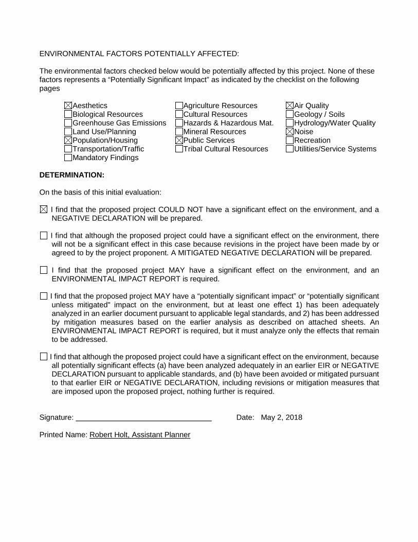
ENVIRONMENTAL FACTORS POTENTIALLY AFFECTED: The environmental factors checked below would be potentially affected by this project. None of these factors represents a “Potentially Significant Impact” as indicated by the checklist on the following pages Aesthetics Agriculture Resources Air Quality Biological Resources Cultural Resources Geology / Soils Greenhouse Gas Emissions Hazards & Hazardous Mat. Hydrology/Water Quality Land Use/Planning Mineral Resources Noise Population/Housing Public Services Recreation
Transportation/Traffic Tribal Cultural Resources Utilities/Service Systems Mandatory Findings
DETERMINATION: On the basis of this initial evaluation:
I find that the proposed project COULD NOT have a significant effect on the environment, and a NEGATIVE DECLARATION will be prepared.
I find that although the proposed project could have a significant effect on the environment, there will not be a significant effect in this case because revisions in the project have been made by or agreed to by the project proponent. A MITIGATED NEGATIVE DECLARATION will be prepared.
I find that the proposed project MAY have a significant effect on the environment, and an ENVIRONMENTAL IMPACT REPORT is required.
I find that the proposed project MAY have a “potentially significant impact” or “potentially significant unless mitigated" impact on the environment, but at least one effect 1) has been adequately analyzed in an earlier document pursuant to applicable legal standards, and 2) has been addressed by mitigation measures based on the earlier analysis as described on attached sheets. An ENVIRONMENTAL IMPACT REPORT is required, but it must analyze only the effects that remain to be addressed.
I find that although the proposed project could have a significant effect on the environment, because all potentially significant effects (a) have been analyzed adequately in an earlier EIR or NEGATIVE DECLARATION pursuant to applicable standards, and (b) have been avoided or mitigated pursuant to that earlier EIR or NEGATIVE DECLARATION, including revisions or mitigation measures that are imposed upon the proposed project, nothing further is required.
Signature: Date: May 2, 2018 Printed Name: Robert Holt, Assistant Planner

3
Explanation of Environmental Checklist I. AESTHETICS.
Would the project: Potentially
Significant Impact
Less than Significant Impact with Mitigation
Incorporation
Less than Significant
Impact No Impact
a. Have a substantial adverse effect on a scenic vista?
b. Substantially damage scenic resources, including, but not limited to, trees, rock outcroppings, and historic buildings within a state scenic highway?
c. Substantially degrade the existing visual character or quality of the site and its surroundings?
d. Create a new source of substantial light or glare that would adversely affect day or nighttime views in the area?
Discussion: The project will not affect a scenic vista and will not have an overall adverse visual impact on the immediate area. The project will not affect a scenic highway, and will not have an overall adverse visual impact on any scenic resources. The project would result in some sources of light, including the installation of street lights, and future residential development will add additional sources of light
a. No Impacts. The project will not result in the obstruction of federal, state or locally classified scenic areas, historic properties, community landmarks, or formally classified scenic resources such as a scenic highway, national scenic area, or state scenic area. The project will not have a substantial adverse effect on a scenic vista. The City of Madera is located in a predominantly agricultural area near the base of the Sierra Nevada Mountain Range, which provides for aesthetically pleasing views and open spaces. By developing land within the City’s sphere of influence, the proposed project will reduce development pressure on rural lands.
b. No Impacts. The project will not damage scenic resources, including, but not limited to, rock
outcroppings, and historic buildings within a state scenic highway.
c. No Impacts. The project would not substantially degrade the existing visual character or quality of the site and surroundings under examination. The proposed project would not alter the landforms, view sheds, and overall character of the area.
d. Less than Significant Impacts. There will be an increase in light and glare and other aesthetic
impacts associated with urban development as a result of the project, although it will be a less than significant impact when City standards are implemented.

4
II. AGRICULTURE RESOURCES. In determining whether impacts to agricultural resources are significant environmental effects, lead agencies may refer to the California Agricultural Land Evaluation and Site Assessment Model (1997) prepared by the California Dept. of Conservation as an optional model to use in assessing impacts on agriculture and farmland.
Would the project:
Potentially Significant
Impact
Less than Significant Impact with Mitigation
Incorporation
Less than Significant
Impact No Impact
a. Convert Prime Farmland, Unique Farmland, or Farmland of Statewide Importance (Farmland), as shown on the maps prepare pursuant to the Farmland Mapping and Monitoring Program of the California Resources Agency, to non-agricultural use.
b. Conflict with existing zoning for agricultural use, or a Williamson Act contract?
c. Involve other changes in the existing environment which, due to their location or nature, could result in conversion of Farmland, to non-agricultural use?
Discussion: The project area is located on land identified as Urban and Built-Up Land within the 2016 California Farmland Mapping and Monitoring Program.
a. No Impacts. The project would not convert prime farmland, unique farmland, or farmland of statewide importance (as shown on the maps prepared pursuant to the farmland mapping and monitoring program of the California resources agency) to non-agricultural use. The project site is identified as Urban and Built-Up Land on the 2016 Madera County Important Farmland Map. The project site has been identified for urban uses within the City of Madera General Plan, and the land has not being utilized for any agricultural purposes for an extended length of time.
b. No Impacts. The project would not conflict with existing zoning for agricultural use and there
are no Williamson Act contracts in the affected territory. The City of Madera General Plan identifies this site for commercial uses.
c. No Impacts. The creation of this subdivision will not influence surrounding properties to convert
from farmland to non-agricultural uses since this property is surrounded by property designated for residential development, consistent with the Madera General Plan.

5
III. AIR QUALITY. Where available, the significance criteria established by the applicable air quality management or air pollution control district may be relied upon to make the following determinations.
Would the project:
Potentially Significant
Impact
Less than Significant Impact with Mitigation
Incorporation
Less than Significant
Impact No Impact
a. Conflict with or obstruct implementation of the applicable air quality plan?
b. Violate any air quality standard or contribute substantially to an existing or projected air quality violation?
c. Result in a cumulatively considerable net increase of any criteria pollutant for which the project region is non-attainment under an applicable federal or state ambient air quality standard (including releasing emissions that exceed quantitative thresholds for ozone precursors)?
d. Expose sensitive receptors to substantial pollutant concentrations?
e. Create objectionable odors affecting a substantial number of people?
Discussion: The project area is located within the San Joaquin Valley Air Basin (SJVAB). Air quality conditions in the SJVAB are regulated by San Joaquin Valley Air Pollution Control District (SJVAPCD). The region is classified as a State and Federal non-attainment area for PM10 (airborne particulate matter with an aerodynamic diameter of less than 10 microns), and ozone (O3). Air quality is determined primarily by the type and amount of contaminants emitted into the atmosphere, the size and topography of the Basin, and its meteorological conditions. National and state air quality standards specify the upper limits of concentrations and duration in the ambient air for O3, CO, nitrogen dioxide (NO2), PM10, sulfur dioxide (SO2) and lead (Pb). These are “criteria pollutants.” The SJVAPCD also conducts monitoring for two other state standards: sulfate and visibility. The State of California has designated the project area as being a severe non-attainment area for 1-hour O3, a non-attainment area for PM10, and an attainment area for CO. The EPA has designated the project area as being an extreme non-attainment area for 1-hour O3, a serious non-attainment area for 8-hour O3, a serious non-attainment area for PM10, and a moderate maintenance for CO. The project will not conflict with or obstruct the implementation of applicable Regional Air Quality Control Plans. The SJVAPCD has determined that project specific emissions are not expected to exceed District significance thresholds of 10 tons/year NOX, 10 tons/year ROG, and 15 tons/year PM10. Therefore, the District concludes that project specific criteria pollutant emissions would have no significant adverse impact on air quality.

6
The type of proposed development is not subject to Rule 9510 (Indirect Source Review) by the SJVAPCD because the project would develop less than fifty (50) residential units. The project would not create substantial air emissions or deterioration of ambient air quality, and any future development would be subject to SJVAPCD review. Construction equipment will produce a small amount of air emissions from internal combustion engines and dust. The project will not violate any air quality standard or substantially contribute to an existing or projected air quality violation. The project will not result in a considerable net increase in non-attainment pollutants in this area. The project will not expose sensitive receptors to any significant amount of pollutants. The project will not create any objectionable odors. The project will be required to comply with all applicable rules and regulations of the SJVAPCD, including but not limited to Rules 4102, 4601 and 4641.
a. Less than Significant Impacts. The proposed project would not conflict with or obstruct implementation of the applicable air quality plan.
b. Less than Significant Impacts. The proposed project would not violate any air quality standard
or contribute substantially to an existing or projected air quality violation.
c. Less than Significant Impacts. The project will not result in a cumulatively considerable net increase of any criteria pollutant for which the project region is non-attainment under an applicable federal or state ambient air quality standard, including releasing emissions which exceed quantitative thresholds for ozone precursors.
d. No Impacts. The proposed project would not expose sensitive receptors to substantial pollutant
concentrations.
e. No Impacts. The proposed project would not create any new/permanent objectionable odors affecting a substantial number of people.

7
IV. BIOLOGICAL RESOURCES. Would the project: Potentially
Significant Impact
Less than Significant Impact with Mitigation
Incorporation
Less than Significant
Impact No Impact
a. Have a substantial adverse effect, either directly or through habitat modifications, on any species identified as a candidate, sensitive, or special status species in local or regional plans, policies or regulations, or by the California Department of Fish and Game or U.S. Fish and Wildlife Service?
b. Have a substantial adverse effect on any riparian habitat or other sensitive natural community identified in local or regional plans, policies, or regulations or by the California Department of Fish and Game or US Fish and Wildlife Service?
c. Have a substantial adverse effect on federally protected wetlands as defined by Section 404 of the Clean Water Act (including, but not limited to, marsh, vernal pool, coastal, etc.) through direct removal, filling, hydrological interruption, or other means?
d. Interfere substantially with the movement of any native resident or migratory fish or wildlife species or with established native resident or migratory wildlife corridors, or impede the use of native wildlife nursery sites?
e. Conflict with any local policies or ordinances protecting biological resources, such as a tree preservation policy or ordinance?
f. Conflict with the provisions of an adopted Habitat Conservation Plan, Natural community Conservation Plan, or other approved local, regional, or state habitat conservation plan?
Discussion: With the preparation of the City of Madera General Plan, no threatened or endangered species were identified in the project area. The project area has been subjected to urbanization in the

8
past, resulting in a highly maintained and disturbed habitat. There is no record of special-status species in this project area. Development of the project area is consistent with the urbanization of the Madera area, as evaluated in the General Plan and its EIR; therefore, impacts in this category are not anticipated to exceed the impacts addressed in those documents.
a. No Impacts. The project would not have a substantial adverse effect, either directly or through habitat modifications, on any species identified as a candidate, sensitive, or special status species in local or regional plans, policies, or regulations, or by the California Department of Fish and Game or U.S. Fish and Wildlife Service.
b. No Impacts. The proposed project would not have a substantial adverse effect on any riparian
habitat or other sensitive natural community identified in local or regional plans, policies, and regulations or by the California Department of Fish and Game or US Fish and Wildlife Service.
c. No Impacts. The project would not have a substantial adverse effect on federally protected
wetlands as defined by Section 404 of the Clean Water Act, including, but not limited to, marsh, vernal pool, coastal, etc., through direct removal, filling, hydrological interruption, or other means.
d. No Impacts. The project would not interfere with the movement of any native resident or
migratory fish or wildlife species or with established native resident or migratory wildlife corridors, or impede the use of native wildlife nursery sites.
e. No Impacts. The project would not conflict with any local policies or ordinances protecting
biological resources, such as a tree preservation policy or ordinance.
f. No Impacts. The project would not conflict with the provisions of an adopted Habitat Conservation Plan, Natural Community Conservation Plan, or other approved local, regional or state habitat conservation plan.
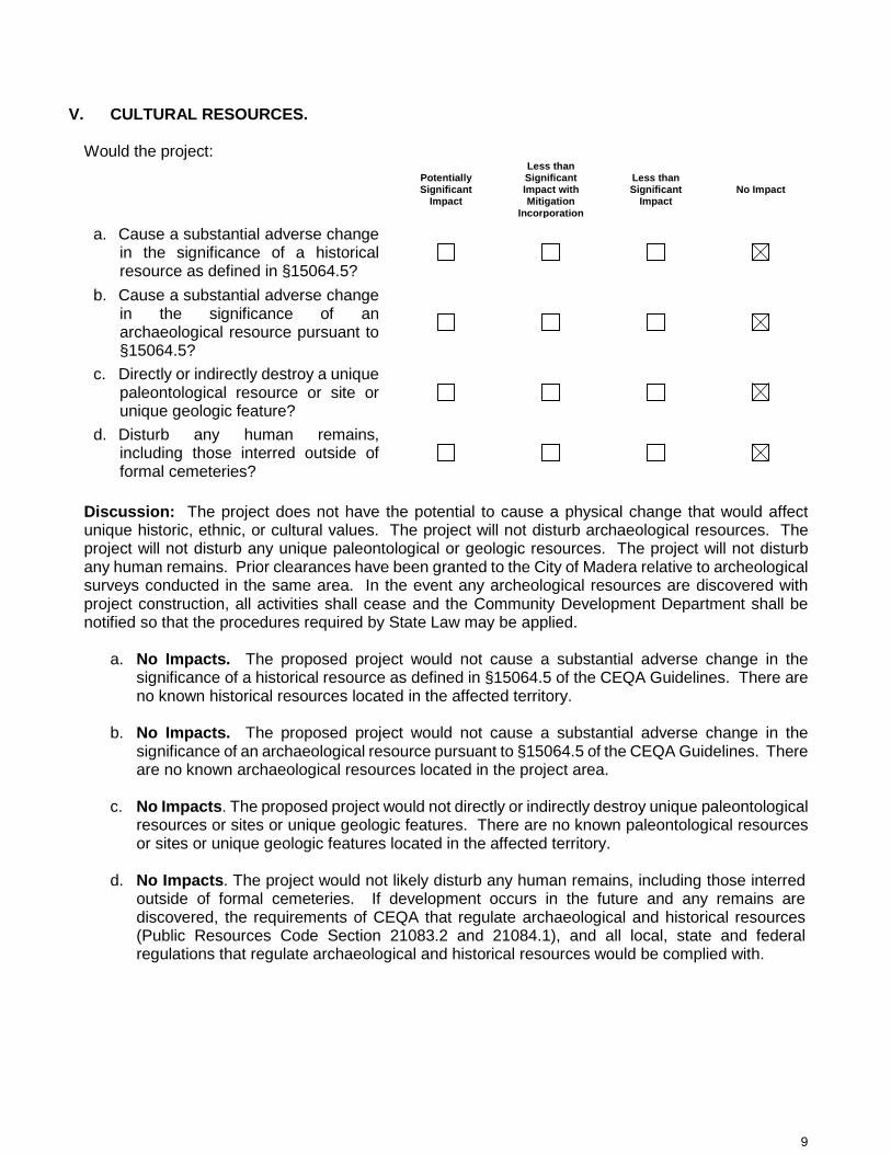
9
V. CULTURAL RESOURCES. Would the project: Potentially
Significant Impact
Less than Significant Impact with Mitigation
Incorporation
Less than Significant
Impact No Impact
a. Cause a substantial adverse change in the significance of a historical resource as defined in §15064.5?
b. Cause a substantial adverse change in the significance of an archaeological resource pursuant to §15064.5?
c. Directly or indirectly destroy a unique paleontological resource or site or unique geologic feature?
d. Disturb any human remains, including those interred outside of formal cemeteries?
Discussion: The project does not have the potential to cause a physical change that would affect unique historic, ethnic, or cultural values. The project will not disturb archaeological resources. The project will not disturb any unique paleontological or geologic resources. The project will not disturb any human remains. Prior clearances have been granted to the City of Madera relative to archeological surveys conducted in the same area. In the event any archeological resources are discovered with project construction, all activities shall cease and the Community Development Department shall be notified so that the procedures required by State Law may be applied.
a. No Impacts. The proposed project would not cause a substantial adverse change in the significance of a historical resource as defined in §15064.5 of the CEQA Guidelines. There are no known historical resources located in the affected territory.
b. No Impacts. The proposed project would not cause a substantial adverse change in the
significance of an archaeological resource pursuant to §15064.5 of the CEQA Guidelines. There are no known archaeological resources located in the project area.
c. No Impacts. The proposed project would not directly or indirectly destroy unique paleontological
resources or sites or unique geologic features. There are no known paleontological resources or sites or unique geologic features located in the affected territory.
d. No Impacts. The project would not likely disturb any human remains, including those interred
outside of formal cemeteries. If development occurs in the future and any remains are discovered, the requirements of CEQA that regulate archaeological and historical resources (Public Resources Code Section 21083.2 and 21084.1), and all local, state and federal regulations that regulate archaeological and historical resources would be complied with.

10
VI. GEOLOGY AND SOILS. Would the project:
Potentially Significant
Impact
Less than Significant Impact with Mitigation
Incorporation
Less than Significant
Impact No Impact
a. Expose people or structures to potential substantial adverse effects, including the risk of loss, injury, or death involving:
i. Rupture of a known earthquake fault, as delineated on the most recent Alquist-Priolo Earthquake Fault Zoning Map issued by the State Geologist for the area or based on other substantial evidence of a known fault?
ii. Strong seismic ground shaking?
iii. Seismic-related ground failure, including liquefaction?
iv. Landslides?
b. Result in substantial soil erosion or the loss of topsoil?
c. Be located on a geologic unit or soil that is unstable, or that would become unstable as a result of the project, and potentially result in on- or off-site landslide, lateral spreading, subsidence, liquefaction or collapse?
d. Be located on expansive soil, as defined in Table 18-1-B of the Uniform Building Code (1994), creating substantial risks to life or property?
e. Have soils incapable of adequately supporting the use of septic tanks or alternative waste disposal systems where sewers are not available for the disposal of wastewater?
Discussion: There are no known faults on the project site or in the immediate area. The project site is subject to relatively low seismic hazards compared to many other parts of California. Potential ground shaking produced by earthquakes generated on regional faults lying outside the immediate vicinity in the project area may occur. Due to the distance of the known faults in the region, no significant ground shaking is anticipated on this site. Seismic hazards on the built environment are addressed in The Uniform Building Code that is utilized by the Madera Building Division to monitor safe construction in the City.

11
a.
i. No Impacts. No known faults with evidence of historic activity cut through the valley soils in the project vicinity. The major active faults and fault zones occur at some distance to the east, west, and south of the project site. Due to the geology of the project area and its distance from active faults, the potential for loss of life, property damage, ground settlement, or liquefaction to occur in the project vicinity is considered minimal.
ii. No Impacts. Ground shaking generally decreases with distance and increases with the
depth of unconsolidated alluvial deposits. The most likely source of potential ground shaking is attributed to the San Andreas, Owens Valley, and the White Wolf faults. Based on this premise, and taking into account the distance to the causative faults, the potential for ground motion in the vicinity of the project site is such that a minimal risk can be assigned.
iii. No Impacts. Liquefaction describes a phenomenon in which a saturated soil loses strength
during an earthquake as a result of induced shearing strains. Lateral and vertical movement of the soil mass combined with loss of bearing usually results. Loose sand, high groundwater conditions (where the water table is less than 30 feet below the surface), higher intensity earthquakes, and particularly long duration of ground shaking are the requisite conditions for liquefaction. There is no evidence of the presence of these requisite conditions.
iv. No Impacts. The project will not result in or expose people to potential impacts from
landslides or mudflows. b. No Impacts. Construction of urban uses would create changes in absorption rates, drainage
patterns, and the rate and amount of surface runoff on the selected project site. Standard construction practices that comply with City of Madera ordinances and regulations, the California Building Code, and professional engineering designs approved by the Madera Engineering Division will mitigate any potential impacts from future urban development, if any.
c. No Impacts. The project site would not be located on a geologic unit or soil that is unstable, or that
would become unstable as a result of the project, and potentially result in off-site landslide, lateral spreading, subsidence, liquefaction or collapse.
d. No Impacts. The project will not result in or expose people to potential impacts from expansive
soils. e. No Impacts. Should urban uses be approved in the project area, the City of Madera would provide
necessary sewer and water systems.
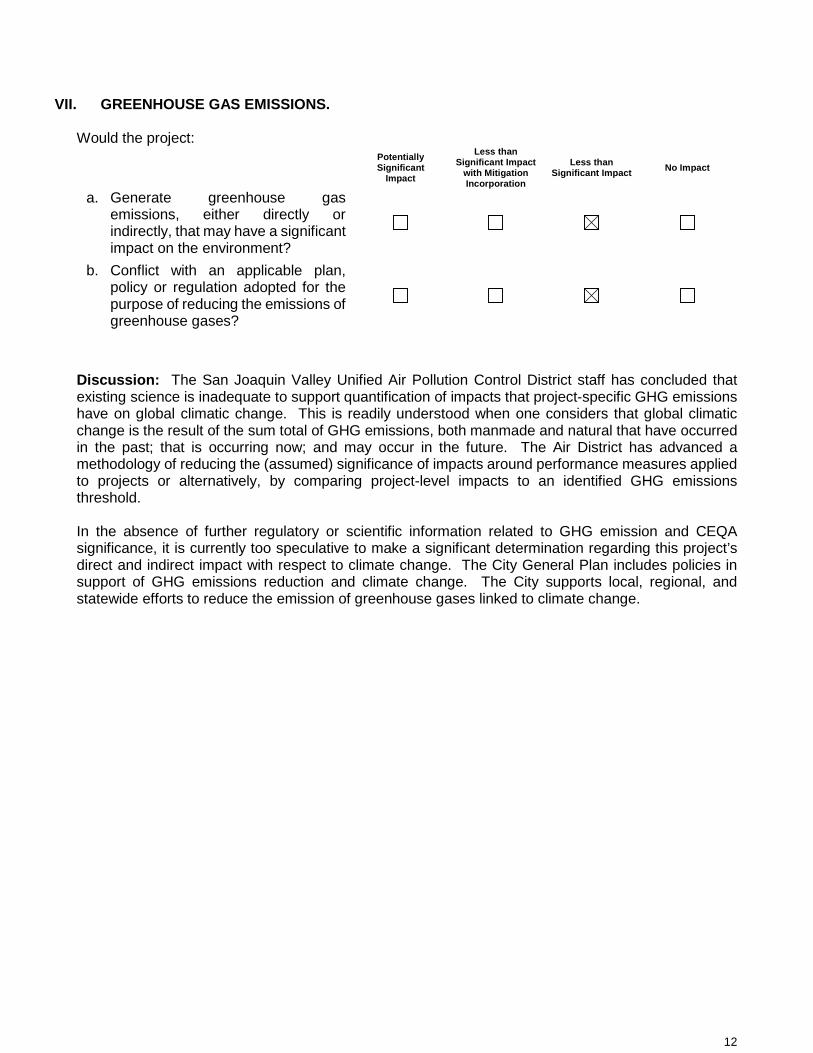
12
VII. GREENHOUSE GAS EMISSIONS. Would the project:
Potentially Significant
Impact
Less than Significant Impact
with Mitigation Incorporation
Less than Significant Impact No Impact
a. Generate greenhouse gas emissions, either directly or indirectly, that may have a significant impact on the environment?
b. Conflict with an applicable plan, policy or regulation adopted for the purpose of reducing the emissions of greenhouse gases?
Discussion: The San Joaquin Valley Unified Air Pollution Control District staff has concluded that existing science is inadequate to support quantification of impacts that project-specific GHG emissions have on global climatic change. This is readily understood when one considers that global climatic change is the result of the sum total of GHG emissions, both manmade and natural that have occurred in the past; that is occurring now; and may occur in the future. The Air District has advanced a methodology of reducing the (assumed) significance of impacts around performance measures applied to projects or alternatively, by comparing project-level impacts to an identified GHG emissions threshold. In the absence of further regulatory or scientific information related to GHG emission and CEQA significance, it is currently too speculative to make a significant determination regarding this project’s direct and indirect impact with respect to climate change. The City General Plan includes policies in support of GHG emissions reduction and climate change. The City supports local, regional, and statewide efforts to reduce the emission of greenhouse gases linked to climate change.
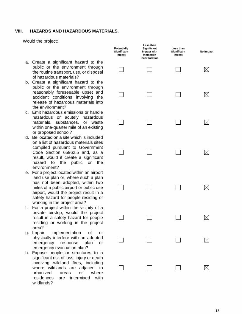
13
VIII. HAZARDS AND HAZARDOUS MATERIALS. Would the project:
Potentially Significant
Impact
Less than Significant Impact with Mitigation
Incorporation
Less than Significant
Impact No Impact
a. Create a significant hazard to the public or the environment through the routine transport, use, or disposal of hazardous materials?
b. Create a significant hazard to the public or the environment through reasonably foreseeable upset and accident conditions involving the release of hazardous materials into the environment?
c. Emit hazardous emissions or handle hazardous or acutely hazardous materials, substances, or waste within one-quarter mile of an existing or proposed school?
d. Be located on a site which is included on a list of hazardous materials sites compiled pursuant to Government Code Section 65962.5 and, as a result, would it create a significant hazard to the public or the environment?
e. For a project located within an airport land use plan or, where such a plan has not been adopted, within two miles of a public airport or public use airport, would the project result in a safety hazard for people residing or working in the project area?
f. For a project within the vicinity of a private airstrip, would the project result in a safety hazard for people residing or working in the project area?
g. Impair implementation of or physically interfere with an adopted emergency response plan or emergency evacuation plan?
h. Expose people or structures to a significant risk of loss, injury or death involving wildland fires, including where wildlands are adjacent to urbanized areas or where residences are intermixed with wildlands?

14
Discussion: The project will not bring about a direct increase in the risk of accidental explosion or release of hazardous substances. The project site has not been identified as a hazardous material site. The project will not result in a substantial air safety hazard for people residing in the area or future residents of the project. The project will not emit hazardous emissions or handle hazardous materials to the existing Martin Luther King, Jr. Middle School adjacent to the east/northeast of the project site. The project will not result in any hazards to air traffic or be a substantial air safety hazard. The project will not interfere with any emergency response or evacuation plans. Truck traffic generated with construction of the project is expected to be insignificant. Traffic generated with development is not expected to be substantially higher that current volumes. The project will not bring about an increase in fire hazards in areas from flammable brush, grass, or trees. a. No Impacts. The proposed project would not create any hazards to the public or the environment
through the routine transport, use, or disposal of hazardous materials. b. No Impacts. The proposed project would not create any hazards to the public or the environment
through reasonably foreseeable upset and accident conditions involving the release of hazardous materials into the environment.
c. No Impacts. The project would not emit hazardous emissions or require the handling of hazardous
or acutely hazardous materials, substances, or waste within one-quarter mile of the existing Martin Luther King, Jr. Middle School.
d. No Impacts. The land within the project site is not included on a list of hazardous materials sites.
The Department of Toxic Substances Control's Hazardous Waste and Substances Site List (Cortese List) does not list any hazard waste and substance sites within the City of Madera (www.dtsc.ca.gov/database/Calsites/Cortese_List.cfm).
e. No Impacts. The project site is not located within an airport land use plan or, within two miles of a
public airport or public use airport. The proposed project would not bring about a safety hazard related to an airport or aviation activities for people residing or working in the project area.
f. No Impacts. The project site is not located within the vicinity of a private airstrip, and would not
result in a safety hazard for people residing or working in the project vicinity related to an airstrip or aviation activities.
g. No Impacts. The proposed project would not impair implementation of, or physically interfere with,
an adopted emergency response plan or emergency evacuation plan. h. No Impacts. The proposed project would not expose people or structures to a significant risk of
loss, injury or death involving wildland fires.

15
IX. HYDROLOGY AND WATER QUALITY. Would the project:
Potentially Significant
Impact
Less than Significant Impact with Mitigation
Incorporation
Less than Significant
Impact No Impact
a. Violate any water quality standards or waste discharge requirements?
b. Substantially deplete groundwater supplies or interfere substantially with groundwater recharge such that there would be a net deficit in aquifer volume or a lowering of the local groundwater table level (e.g., the production rate of pre-existing nearby wells would drop to a level which would not support existing land uses or planned uses for which permits have been granted)?
c. Substantially alter the existing drainage pattern of the site or area, including through the alteration of the course of a stream or river, in a manner which would result in substantial erosion or siltation on- or off-site?
d. Substantially alter the existing drainage pattern of the site or area, including through the alteration of the course of a stream or river, or substantially increase the rate or amount of surface runoff in a manner that would result in flooding on- or off-site?
e. Create or contribute runoff water which would exceed the capacity of existing or planned stormwater drainage systems or provide substantial additional sources of polluted runoff?
f. Otherwise substantially degrade water quality?
g. Place housing within a 100-year flood hazard area as mapped on a federal Flood Hazard Boundary or Flood Insurance Rate Map or other flood hazard delineation map?
h. Place within a 100-year flood hazard area structures that would impede or redirect flood flows?

16
i. Expose people or structures to a significant risk of loss, injury or death involving flooding, including flooding as a result of the failure of a levee or dam?
j. Inundation by seiche, tsunami, or mudflow?
Discussion: The proposed project would not violate any water quality standards or waste discharge requirements. There will not be a significant reduction in the amount of groundwater otherwise available for public water supplies as a result of this project. Services will be provided in accordance with the City’s Master Plans. The project will not change any drainage patterns or stream courses, or the source or direction of any water movement. During construction, the project site may be exposed to increased soil erosion from wind and water. Dust control will be used during construction. With completion, the project will not bring about erosion, significant changes in topography or unstable soil conditions. The project will not expose people or property to water related hazards. During future construction, the project site may be exposed to increased soil erosion from wind and water. Dust control will be used during any future construction. With completion, the project will not bring about erosion, significant changes in topography or unstable soil conditions. Standard construction practices and compliance with City ordinances and regulations, The Uniform Building Code, and adherence to professional engineering design approved by the Madera Engineering Department will mitigate any potential impacts from this project. This development will be required to comply with all City ordinances and standard practices which will assure that storm water will be adequately drained into the approved storm water system. The project will not create any impacts on water quality. Based on a review of the City’s FEMA maps, the site is within Zone X, and the project will not place housing or other land uses in a 100-year flood hazard area. These are areas outside of the 500-year flood area. The project will not expose people or structures to a significant risk because of dam or levee failure. The project will not expose people or structures to a significant risk because of a seiche, mudflow, or tsunami.
a. No Impacts. Development of the project site would be required to comply with all City of Madera
ordinances and standard practices which assure proper grading and storm water drainage into the approved storm water systems. Any development would also be required to comply with all local, state, and federal regulations to prevent any violation of water quality standards or waste discharge requirements.
b. No Impacts. The proposed project will not substantially deplete groundwater supplies or
interfere substantially with groundwater recharge such that there would be a net deficit in aquifer volume or a lowering of the local groundwater table level.
c. No Impacts. The proposed project would not alter the existing drainage pattern of the site or
area through the alteration of the course of a stream or river, in a manner which would result in substantial erosion or siltation on- or off-site.
d. No Impacts. The proposed project would not alter the existing drainage pattern of the site or
area, including through the alteration of the course of a stream or river, or substantially increase the rate or amount of surface runoff in a manner that would result in flooding on or off-site.
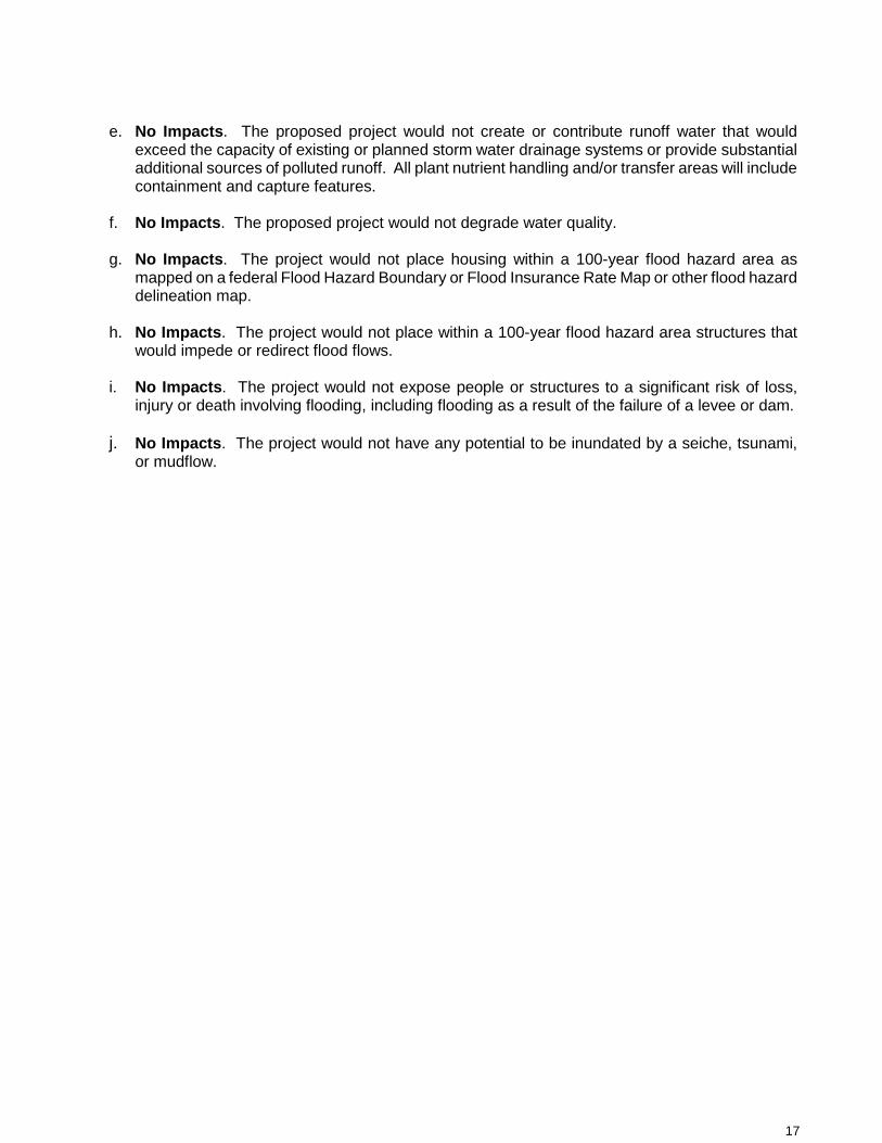
17
e. No Impacts. The proposed project would not create or contribute runoff water that would
exceed the capacity of existing or planned storm water drainage systems or provide substantial additional sources of polluted runoff. All plant nutrient handling and/or transfer areas will include containment and capture features.
f. No Impacts. The proposed project would not degrade water quality.
g. No Impacts. The project would not place housing within a 100-year flood hazard area as
mapped on a federal Flood Hazard Boundary or Flood Insurance Rate Map or other flood hazard delineation map.
h. No Impacts. The project would not place within a 100-year flood hazard area structures that
would impede or redirect flood flows.
i. No Impacts. The project would not expose people or structures to a significant risk of loss, injury or death involving flooding, including flooding as a result of the failure of a levee or dam.
j. No Impacts. The project would not have any potential to be inundated by a seiche, tsunami,
or mudflow.
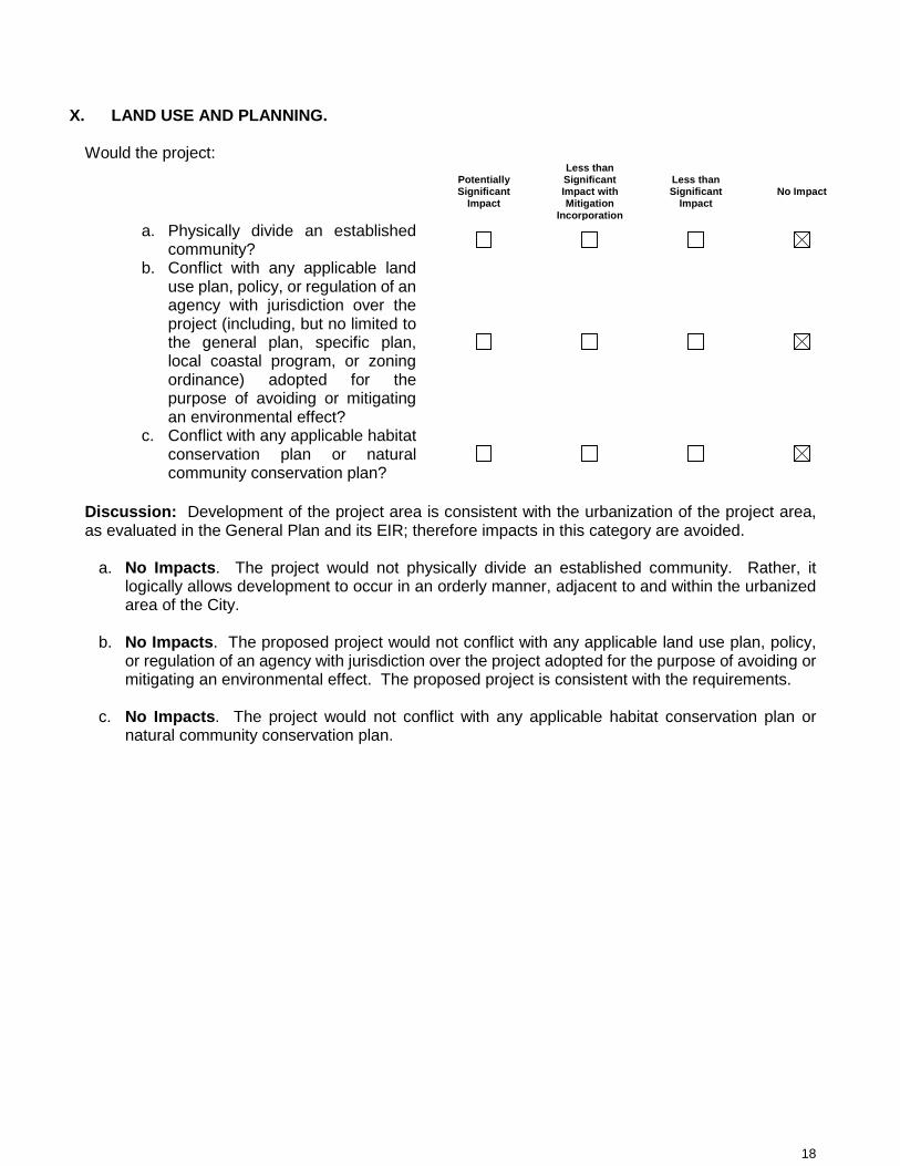
18
X. LAND USE AND PLANNING. Would the project:
Potentially Significant
Impact
Less than Significant Impact with Mitigation
Incorporation
Less than Significant
Impact No Impact
a. Physically divide an established community?
b. Conflict with any applicable land use plan, policy, or regulation of an agency with jurisdiction over the project (including, but no limited to the general plan, specific plan, local coastal program, or zoning ordinance) adopted for the purpose of avoiding or mitigating an environmental effect?
c. Conflict with any applicable habitat conservation plan or natural community conservation plan?
Discussion: Development of the project area is consistent with the urbanization of the project area, as evaluated in the General Plan and its EIR; therefore impacts in this category are avoided.
a. No Impacts. The project would not physically divide an established community. Rather, it logically allows development to occur in an orderly manner, adjacent to and within the urbanized area of the City.
b. No Impacts. The proposed project would not conflict with any applicable land use plan, policy,
or regulation of an agency with jurisdiction over the project adopted for the purpose of avoiding or mitigating an environmental effect. The proposed project is consistent with the requirements.
c. No Impacts. The project would not conflict with any applicable habitat conservation plan or
natural community conservation plan.

19
XI. MINERAL RESOURCES. Would the project:
Potentially Significant
Impact
Less than Significant Impact with Mitigation
Incorporation
Less than Significant
Impact No Impact
a. Result in the loss of availability of a known mineral resource that would be of value to the region and the residents of the state?
b. Result in the loss of availability of a locally important mineral resource recovery site delineated on a local general plan, specific plan or other land use plan?
a. No Impacts. The project would not result in the loss or availability of mineral resources.
b. No Impacts. The proposed project would not result in the loss of availability of any locally
important mineral resource recovery sites.

20
XII. NOISE. Would the project result in:
Potentially Significant
Impact
Less than Significant Impact with Mitigation
Incorporation
Less than Significant
Impact No Impact
a. Exposure of persons to or generation of noise levels in excess of standards established in the local general plan or noise ordinance, or applicable standards of other agencies?
b. Exposure of persons to or generation of excessive groundborne vibration or groundborne noise levels?
c. A substantial permanent increase in ambient noise levels in the project vicinity above levels existing without the project?
d. A substantial temporary or periodic increase in ambient noise levels in the project vicinity above levels existing without the project?
e. For a project located within an airport land use plan or, where such a plan has not been adopted, within two miles of a public airport or public use airport, would the project expose people residing or working in the project area to excessive noise levels?
f. For a project within the vicinity of a private airstrip, would the project expose people residing or working in the project area to excessive noise levels?
Discussion: These potential impacts were addressed in the General Plan EIR, and goals and mitigation measures were adopted to reduce potential impacts to a less than significant level. Development of the project area is consistent with the urbanization of the Madera area, as evaluated in the General Plan, and its EIR; therefore impacts in this category are not anticipated to exceed the impacts addressed in those documents.
a. No Impacts. The proposed project would not result in exposure of persons to or the generation of noise.
b. No Impacts. The proposed project would not result in exposure of persons to or generation of
excessive ground-borne vibration or ground-borne noise levels.

21
c. No Impacts. The proposed project would not result in a substantial permanent increase in ambient noise levels in the project vicinity above levels existing without the project.
d. Less than Significant Impacts. The proposed project may result in some temporary increase in
ambient noise levels in the project vicinity during construction of the site.
e. No Impacts. The proposed project site is not located within an airport land use plan or within two miles of a public airport or public use airport.
f. No Impacts. The project will is not located within the vicinity of a private airstrip.

22
XIII. POPULATION AND HOUSING. Would the project:
Potentially Significant
Impact
Less than Significant Impact with Mitigation
Incorporation
Less than Significant
Impact No Impact
a. Induce substantial population growth in an area, either directly (for example, by proposing new homes and businesses) or indirectly (for example, through extension of roads or other infrastructure)?
b. Displace substantial numbers of existing housing, necessitating the construction of replacement housing elsewhere?
c. Displace substantial numbers of people, necessitating the construction of replacement housing elsewhere?
Discussion: The proposed project will not induce additional substantial growth in this area. The property involved does not have any existing residential uses and the project would not displace any housing. Likewise, the project would not displace substantial numbers of people, necessitating the construction of replacement housing elsewhere.
a. Less than Significant Impacts. The proposed project will provide employment opportunities which may induce a minimal growth in population by individuals and/or families who move to Madera in response to opportunities for employment. Roads and other infrastructure will be improved to handle the proposed development.
b. No Impacts. The proposed project would not displace any existing housing, thereby necessitating
the construction of replacement housing elsewhere, since the site is vacant.
c. No Impacts. The proposed project would not displace any people.

23
XIV. PUBLIC SERVICES.
Potentially Significant
Impact
Less than Significant Impact with Mitigation
Incorporation
Less than Significant
Impact No Impact
a. Would the project result in substantial adverse physical impacts associated with the provision of new or physically altered governmental facilities, need for new or physically altered governmental facilities, the construction of which could cause significant environmental impacts, in order to maintain acceptable service ratios, response times or other performance objectives for any of the public services:
i. Fire protection? ii. Police protection? iii. Schools? iv. Parks? v. Other public facilities?
Discussion: The project will not result in substantial adverse physical impacts from new or altered public facilities. As development occurs, there will be a resultant increase in job opportunities, and a greater demand placed upon services, such as fire and police protection, and additional park and school facilities. There will be an increase in street, and water and sewer system maintenance responsibility because of this project. However, based on the nature of the proposal, the increase in manpower requirements for the Public Works Department will be minimal. The project will not bring about the need for new wastewater treatment facilities. The project will not significantly increase the demand on water supplies. There will not be a significant reduction in the amount of groundwater otherwise available for public water supplies as a result of this project. The project will not increase the need for additional storm water drainage facilities beyond the existing and master planned drainage basin facilities that are available to serve the project. The project area will be required to provide additional facilities within the development, and comply with the City’s Master Plan, Ordinances, and standard practices. The project will not bring about a significant increase in the demand for solid waste disposal services and facilities.
i. Fire protection. Less than significant Impacts. The proposed project would not result
in substantial adverse physical impacts to fire protection services.
ii. Police protection. Less than significant Impacts. The proposed project would not result in substantial adverse physical impacts associated with the provision of police protection.
iii. Schools. Less than significant Impacts. The Madera Unified School District levies a
school facilities fee to help defray the impact of residential development. The proposed project would not generate a significant impact to the schools in Madera.
24
iv. Parks. Less than Significant Impacts. The proposed project would not generate a
significant impact to the park facilities in Madera.
v. Other public facilities. Less than significant Impacts. The proposed project would not have any impacts on other public facilities.
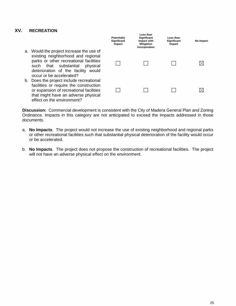
25
XV. RECREATION
Potentially Significant
Impact
Less than Significant Impact with Mitigation
Incorporation
Less than Significant
Impact No Impact
a. Would the project increase the use of existing neighborhood and regional parks or other recreational facilities such that substantial physical deterioration of the facility would occur or be accelerated?
b. Does the project include recreational facilities or require the construction or expansion of recreational facilities that might have an adverse physical effect on the environment?
Discussion: Commercial development is consistent with the City of Madera General Plan and Zoning Ordinance. Impacts in this category are not anticipated to exceed the impacts addressed in those documents. a. No Impacts. The project would not increase the use of existing neighborhood and regional parks
or other recreational facilities such that substantial physical deterioration of the facility would occur or be accelerated.
b. No Impacts. The project does not propose the construction of recreational facilities. The project
will not have an adverse physical effect on the environment.

26
XVI. TRANSPORTATION/TRAFFIC. Would the project:
Potentially Significant
Impact
Less than Significant Impact with Mitigation
Incorporation
Less than Significant
Impact No Impact
a. Cause an increase in traffic that is substantial in relation to the existing traffic load and capacity of the street system (i.e., result in a substantial increase in either the number of vehicle trips, the volume to capacity ratio on roads, or congestion at intersections)?
b. Exceed, either individually or cumulatively, a level of service standard established by the county congestion management agency for designated roads or highways?
c. Result in a change in traffic patterns, including either an increase in traffic levels or a change in location that results in substantial safety risks?
d. Substantially increase hazards due to a design feature (e.g., sharp curves or dangerous intersections) or incompatible uses (e.g., farm equipment)?
e. Result in inadequate emergency access?
f. Result in inadequate parking capacity? g. Conflict with adopted policies, plans, or
programs supporting alternative transportation (e.g., bus turnouts, bicycle racks)?
Discussion: The project site was included in the General Plan and its accompanying EIR and the potential traffic generated from the eventual development of this land is considered. The goals and policies of the General Plan serve to mitigate traffic impacts that occur as a result of new development.
a. No Impacts. The proposed project would not cause an increase in traffic that is substantial in relation to the existing traffic load and capacity of the street system that would result in a substantial increase in either the number of vehicle trips, the volume to capacity ratio on roads, or congestion at intersections.
b. No Impacts. The project would not exceed, either individually or cumulatively, a level of service
standard established by the county congestion management agency for designated roads or highways.

27
c. No Impacts. The proposed project would not result in a change in traffic patterns, including either an increase in traffic levels or a change in location that results in substantial safety risks.
d. No Impacts. The proposed project would not increase hazards to transportation systems due
to design features such as sharp curves, dangerous intersections, or incompatible uses.
e. No Impacts. The proposed project would not result in inadequate emergency access.
f. No Impacts. The proposed project would not result in inadequate parking capacity.
g. No Impacts. The project will not conflict with adopted policies, plans, or programs supporting alternative transportation.

28
XVII. TRIBAL CULTURAL RESOURCES
Potentially Significant
Impact
Less than Significant Impact with Mitigation
Incorporation
Less than Significant
Impact No Impact
a. Would the project cause a substantial adverse change in the significance of a tribal cultural resource, defined in the Public Resources Code Section 21074 as either a site, feature, place, cultural landscape that is geographically defined in terms of the size and scope of the landscape, sacred place or object with cultural value to a California Native American tribe, and that is;
i. Listed or eligible for listing in the California Register of Historical Resources, or in a local register of historical resources as defined in Public Resources Code Section 5020.1(k), or
ii. A resource determined by the lead agency, in its discretion and supported by substantial evidence, to be significant pursuant to criteria set forth in subdivision (c) of Public Resources Code Section 5024.1. In applying the criteria set forth in subdivision (c) of Public Resources Code Section 5024.1, the lead agency shall consider the significance of the resource to a California Native American tribe.
Discussion: The project site location is not listed or eligible for listing in the California Register of Historical Resources. It does not provide any significance of resource to a California Native American tribe. Cumulatively, the project proposal and site will not cause a substantial adverse change in the significance of a tribal cultural resource, as defined in the Public Resources Code Section 21074.
a. No Impacts. The project will not cause a substantial adverse change in the significance of a tribal cultural resource. As defined in the Public Resources Code Section 21074, the project site is not a site, feature, place, cultural landscape that is geographically defined in terms of the size and scope of the landscape, sacred place or object with cultural value to a California Native American tribe.

29
i. No Impacts. The proposed project site is not listed or eligible for listing in the California Register of Historical Resources, or in a local register of historical resources, as defined in Public Resources Code Section 5020.1(k).
a) No Impacts. The proposed project is not a resource that is of significance to a California
Native American tribe, as defined in Public Resources Code 5024.1(c).

30
XVIII. UTILITIES AND SERVICE SYSTEMS. Would the project:
Potentially Significant
Impact
Less than Significant Impact with Mitigation
Incorporation
Less than Significant
Impact No Impact
a. Exceed wastewater treatment requirements of the applicable Regional Water Quality Control Board?
b. Require or result in the construction of new water or wastewater treatment facilities or expansion of existing facilities, the construction of which could cause significant environmental effects?
c. Require or result in the construction of new storm water drainage facilities or expansion of existing facilities, the construction of which could cause significant environmental effects?
d. Have sufficient water supplies available to serve the project from existing entitlements and resources, or are new or expanded entitlements needed?
e. Result in a determination by the wastewater treatment provider that serves or may serve the project that it has adequate capacity to serve the project’s projected demand in addition to the provider’s existing commitments?
f. Be served by a landfill with sufficient permitted capacity to accommodate the project’s solid waste disposal needs?
g. Comply with federal, state, and local statutes and regulations related to solid waste?
Discussion: The City’s community sewage disposal system will continue to comply with Discharge Permit requirements. The project will not bring about the need for new wastewater treatment facilities. The project will not significantly increase the demand on water supplies, adequate domestic water and fire flows should be available to the property. There will not be a significant reduction in the amount of groundwater otherwise available for public water supplies as a result of this project. The project will not increase the need for additional storm water drainage facilities beyond the existing and master planned drainage basin facilities that are available to serve the project. The project area will be required to comply with the City’s Master Plan, Ordinances, and standard practices. The project will not bring about a significant increase in the demand for solid waste disposal services and facilities.
31
a) No Impacts. The project will not exceed wastewater treatment requirements of the applicable
Regional Water Quality Control Board.
b) No Impacts. The proposed project would not require or result in the construction of new water or wastewater treatment facilities or expansion of existing facilities, the construction of which could cause significant environmental effects.
c) No Impacts. The proposed project would not require or result in the construction of new storm
water drainage facilities or expansion of existing facilities, the construction of which could cause significant environmental effects.
d) No Impacts. There will be sufficient water supplies available to serve the project.
e) No Impacts. The project would not require a determination by a wastewater treatment
provider.
f) No Impacts. The project would be served by a landfill with sufficient permitted capacity to accommodate the project’s solid waste disposal needs.
g) No Impacts. Any development project that might be proposed on the project site would be
required to comply with federal, state, and local statutes as well as regulations related to solid waste by the City of Madera.

32
XIX. MANDATORY FINDINGS OF SIGNIFICANCE.
Potentially Significant
Impact
Less than Significant Impact with Mitigation
Incorporation
Less than Significant
Impact No Impact
a. Does the project have the potential to degrade the quality of the environment, substantially reduce the habitat of a fish or wildlife species, cause a fish or wildlife population to drop below self-sustaining levels, threaten to eliminate a plant or animal community, reduce the number or restrict the range of a rare or endangered plant or animal, or eliminate important examples of the major periods of California history or prehistory?
b. Does the project have impacts that are individually limited, but cumulatively considerable? (“Cumulatively considerable” means that the incremental effects of a project are considerable when viewed in connection with the effects of past projects, the effects of other current projects, and the effects of probable future projects)?
c. Does the project have environmental effects that will cause substantial adverse effects on human beings, either directly or indirectly?
Determination: Based upon staff analysis and comments from experts, it has been determined that the proposed project could generate some limited adverse impacts in the areas of Aesthetics, Air Quality, Greenhouse Gas Emissions, Noise, Population and Housing and Public Services. The potential impacts identified in this Initial Study are considered to be less than significant since they will cease upon completion of construction or do not exceed a threshold of significance. Therefore, a Negative Declaration is the appropriate level of documentation for this project.
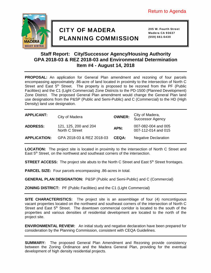
CITY OF MADERA PLANNING COMMISSION
Staff Report: City/Successor Agency/Housing Authority GPA 2018-03 & REZ 2018-03 and Environmental Determination
Item #4 - August 14, 2018 PROPOSAL: An application for General Plan amendment and rezoning of four parcels encompassing approximately .86-acre of land located in proximity to the intersection of North C Street and East 5th Street. The property is proposed to be rezoned from the PF (Public Facilities) and the C1 (Light Commercial) Zone Districts to the PD-1500 (Planned Development) Zone District. The proposed General Plan amendment would change the General Plan land use designations from the P&SP (Public and Semi-Public) and C (Commercial) to the HD (High Density) land use designation. APPLICANT: City of Madera OWNER: City of Madera,
Successor Agency ADDRESS: 121, 125, 200 and 204
North C Street APN: 007-082-004 and 005 007-112-014 and 015
APPLICATION: GPA 2018-03 & REZ 2018-03 CEQA: Negative Declaration LOCATION: The project site is located in proximity to the intersection of North C Street and East 5th Street, on the northwest and southeast corners of the intersection. STREET ACCESS: The project site abuts to the North C Street and East 5th Street frontages. PARCEL SIZE: Four parcels encompassing .86-acres in total. GENERAL PLAN DESIGNATION: P&SP (Public and Semi-Public) and C (Commercial) ZONING DISTRICT: PF (Public Facilities) and the C1 (Light Commercial) SITE CHARACTERISTICS: The project site is an assemblage of four (4) noncontiguous vacant properties located on the northwest and southeast corners of the intersection of North C Street and East 5th Street. The downtown commercial corridor is located to the south of the properties and various densities of residential development are located to the north of the project site. ENVIRONMENTAL REVIEW: An initial study and negative declaration have been prepared for consideration by the Planning Commission, consistent with CEQA Guidelines.
SUMMARY: The proposed General Plan Amendment and Rezoning provide consistency between the Zoning Ordinance and the Madera General Plan, providing for the eventual development of high density residential projects.
205 W. Fourth Street Madera CA 93637 (559) 661-5430
Return to Agenda
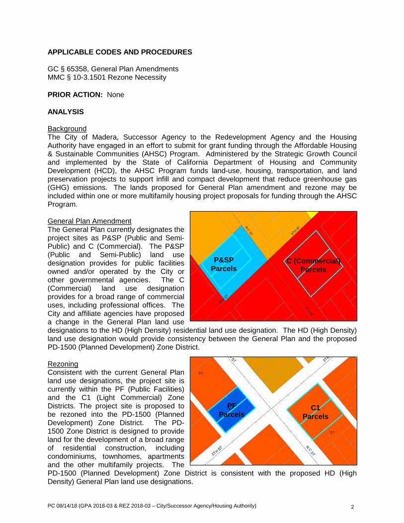
PC 08/14/18 (GPA 2018-03 & REZ 2018-03 – City/Successor Agency/Housing Authority) 2
APPLICABLE CODES AND PROCEDURES GC § 65358, General Plan Amendments MMC § 10-3.1501 Rezone Necessity PRIOR ACTION: None ANALYSIS Background The City of Madera, Successor Agency to the Redevelopment Agency and the Housing Authority have engaged in an effort to submit for grant funding through the Affordable Housing & Sustainable Communities (AHSC) Program. Administered by the Strategic Growth Council and implemented by the State of California Department of Housing and Community Development (HCD), the AHSC Program funds land-use, housing, transportation, and land preservation projects to support infill and compact development that reduce greenhouse gas (GHG) emissions. The lands proposed for General Plan amendment and rezone may be included within one or more multifamily housing project proposals for funding through the AHSC Program. General Plan Amendment The General Plan currently designates the project sites as P&SP (Public and Semi-Public) and C (Commercial). The P&SP (Public and Semi-Public) land use designation provides for public facilities owned and/or operated by the City or other governmental agencies. The C (Commercial) land use designation provides for a broad range of commercial uses, including professional offices. The City and affiliate agencies have proposed a change in the General Plan land use designations to the HD (High Density) residential land use designation. The HD (High Density) land use designation would provide consistency between the General Plan and the proposed PD-1500 (Planned Development) Zone District. Rezoning Consistent with the current General Plan land use designations, the project site is currently within the PF (Public Facilities) and the C1 (Light Commercial) Zone Districts. The project site is proposed to be rezoned into the PD-1500 (Planned Development) Zone District. The PD-1500 Zone District is designed to provide land for the development of a broad range of residential construction, including condominiums, townhomes, apartments and the other multifamily projects. The PD-1500 (Planned Development) Zone District is consistent with the proposed HD (High Density) General Plan land use designations.
P&SP Parcels
C (Commercial) Parcels
PF Parcels
C1 Parcels
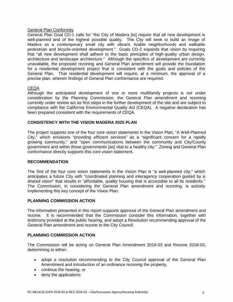
PC 08/14/18 (GPA 2018-03 & REZ 2018-03 – City/Successor Agency/Housing Authority) 3
General Plan Conformity General Plan Goal CD-1 calls for “the City of Madera [to] require that all new development is well-planned and of the highest possible quality. The City will seek to build an image of Madera as a contemporary small city with vibrant, livable neighborhoods and walkable pedestrian and bicycle-oriented development.” Goals CD-2 expands that vision by requiring that “all new development shall adhere to the basic principles of high-quality urban design, architecture and landscape architecture.” Although the specifics of development are currently unavailable, the proposed rezoning and General Plan amendment will provide the foundation for a residential development project that is consistent with the goals and policies of the General Plan. That residential development will require, at a minimum, the approval of a precise plan, wherein findings of General Plan conformance are required. CEQA Although the anticipated development of one or more multifamily projects is not under consideration by the Planning Commission, the General Plan amendment and rezoning currently under review act as first steps in the further development of the site and are subject to compliance with the California Environmental Quality Act (CEQA). A negative declaration has been prepared consistent with the requirements of CEQA. CONSISTENCY WITH THE VISION MADERA 2025 PLAN The project supports one of the four core vision statements in the Vision Plan, “A Well-Planned City,” which envisions “providing efficient services” as a “significant concern for a rapidly growing community,” and “open communications between the community and City/County government and within those governments [as] vital to a healthy city.” Zoning and General Plan conformance directly supports this core vision statement. RECOMMENDATION The first of the four core vision statements in the Vision Plan is “a well-planned city,” which anticipates a future City with “coordinated planning and interagency cooperation guided by a shared vision” that results in “affordable, quality housing that is accessible to all its residents.” The Commission, in considering the General Plan amendment and rezoning, is actively implementing this key concept of the Vision Plan. PLANNING COMMISSION ACTION The information presented in this report supports approval of the General Plan amendment and rezone. It is recommended that the Commission consider this information, together with testimony provided at the public hearing, and adopt a Resolution recommending approval of the General Plan amendment and rezone to the City Council. PLANNING COMMISSION ACTION The Commission will be acting on General Plan Amendment 2018-03 and Rezone 2018-03, determining to either;
• adopt a resolution recommending to the City Council approval of the General Plan Amendment and introduction of an ordinance rezoning the property,
• continue the hearing, or • deny the applications
PC 08/14/18 (GPA 2018-03 & REZ 2018-03 – City/Successor Agency/Housing Authority) 4
Any action by the Commission approving or denying the application is subject to appeal to the City Council within 15 calendar days of the Commission’s action. Motion 1a: Move to adopt a Negative Declaration prepared, for the project consistent with the requirements of the California Environmental Quality Act, with the findings as stated: Findings - An initial study and negative declaration have been prepared pursuant to the California
Environmental Quality Act that determine that there is no substantial evidence that the project will have a significant effect on the environment, and that the document reflects the independent judgment of the Planning Commission of the City of Madera after considering all of the information in the entire record before it, and is hereby adopted in accordance with the California Environmental Quality Act.
- The initial study and negative declaration address the future construction of high density residential development projects on the subject property.
Motion 1b: Move to adopt a resolution recommending to the City Council approval of the requested General Plan amendment and introduction of an ordinance rezoning the subject property, with the findings as stated below: Findings
- The proposed General Plan Amendment will provide consistency between the General Plan and Zoning Ordinance.
- The proposed rezoning will zone project site in a manner consistent with the existing and proposed land use.
- Development of the project site will be consistent with the General Plan, confirmed through the approval of a precise plan.
(OR) Motion 2: Move to continue the public hearing on General Plan Amendment 2018-03 and Rezone 2018-03 to the September 11, 2018 Planning Commission meeting. (OR) Motion 3: Move to deny the application for General Plan Amendment 2018-03 and Rezone 2018-03, based on the following findings: (specify) ATTACHMENTS Aerial Map General Plan Map Zoning Map Resolution of Recommendation to the City Council Exhibit A – General Plan Land Use Map
Exhibit B – Zoning Map Draft Ordinance Exhibit A - Zoning Map Negative Declaration

PC 08/14/18 (GPA 2018-03 & REZ 2018-03 – City/Successor Agency/Housing Authority) 5
Aerial Photo

PC 08/14/18 (GPA 2018-03 & REZ 2018-03 – City/Successor Agency/Housing Authority) 6
General Plan Map
P&SP (Public and Semi-Public) C (Commercial)

PC 08/14/18 (GPA 2018-03 & REZ 2018-03 – City/Successor Agency/Housing Authority) 7
Zoning Map

RESOLUTION NO. 1831
RESOLUTION OF THE PLANNING COMMISSION OF THE CITY OF MADERA RECOMMENDING TO THE CITY COUNCIL OF THE CITY OF MADERA APPROVAL OF AMENDMENT OF THE GENERAL PLAN CHANGING THE LAND USE DESIGNATION OF APPROXIMATELY .86-ACRE OR LAND LOCATED ON THE NORTHWEST AND SOUTHEAST CORNERS OF THE INTERSECTION OF NORTH C STREET AND EAST 5TH STREET FROM THE P&SP (PUBLIC AND SEMI-PUBLIC) AND C (COMMERCIAL) LAND USE DESIGNATIONS TO THE HD (HIGH DENSITY) LAND USE DESIGNATION AND APPROVAL OF AN ORDINANCE REZONING THE LAND FROM THE PF (PUBLIC FACILITIES) AND THE C1 (LIGHT COMMERCIAL) ZONE DISTRICTS TO THE PD-1500 (PLANNED DEVELOPMENT) ZONE DISTRICT
WHEREAS, State Law requires that local agencies adopt General Plans containing
specific mandatory elements; and
WHEREAS, the City of Madera has adopted a Comprehensive General Plan Update and
Environmental Impact Report, and the City of Madera is currently in compliance with State
mandates relative to Elements of the General Plan; and
WHEREAS, State law also provides for periodic review, updates, and amendments of its
various plans; and
WHEREAS, the City has initiated an amendment to the Madera General Plan amending
the land use designations of four parcels of land encompassing .86-acre located on the northwest
and southeast corners of the intersection of North C Street and East 5th Street from the P&SP
(Public and Semi-Public) and C (Commercial) land use designations to the HD (High Density)
land use designation; and
WHEREAS, the City has initiated a rezoning of the property from the PF (Public Facilities)
and the C1 (Light Commercial) Zone Districts to the PD-1500 (Planned Development) Zone
District to provide consistency with the proposed General Plan land use designation; and
WHEREAS, the City of Madera, acting as the Lead Agency, prepared an initial study and
negative declaration for the project in compliance with the California Environmental Quality Act;
and
WHEREAS, the negative declaration, the General Plan amendment and rezoning were
distributed for public review and comment to various local agencies and groups; and
WHEREAS, public notice of this public hearing was given by mailed and published notice
in accordance with the applicable State and Municipal Codes and standard practices; and
WHEREAS, the Planning Commission has completed its review of the staff report and
documents submitted for the proposed project, evaluated the information and considered
testimony received as a part of the public hearing process.
NOW THEREFORE BE IT RESOLVED BY THE PLANNING COMMISSION OF THE CITY
OF MADERA AS FOLLOWS:
1. The above recitals are true and correct.
2. The Planning Commission hereby recommends that the Madera General Plan land
use map be amended as specified in attached Exhibit “A”.
3. The proposed amendment to the Land Use Map is hereby found consistent with
all elements of the Madera General Plan.
4. The proposed rezoning is hereby found to be consistent with all elements of the
General Plan, including the land use map as amended by this resolution.
5. The Planning Commission hereby recommends the City Council adopt an
ordinance rezoning property as specified within the attached Exhibit “B”.
6. This resolution is effective immediately.
* * * * *
Passed and adopted by the Planning Commission of the City of Madera this 14th day of August, 2018, by the following vote: AYES: NOES: ABSTENTIONS: ABSENT: _____________________________
Robert Gran Jr. Planning Commission Chairperson
Attest: ___________________________________ Christopher F. Boyle Planning Manager
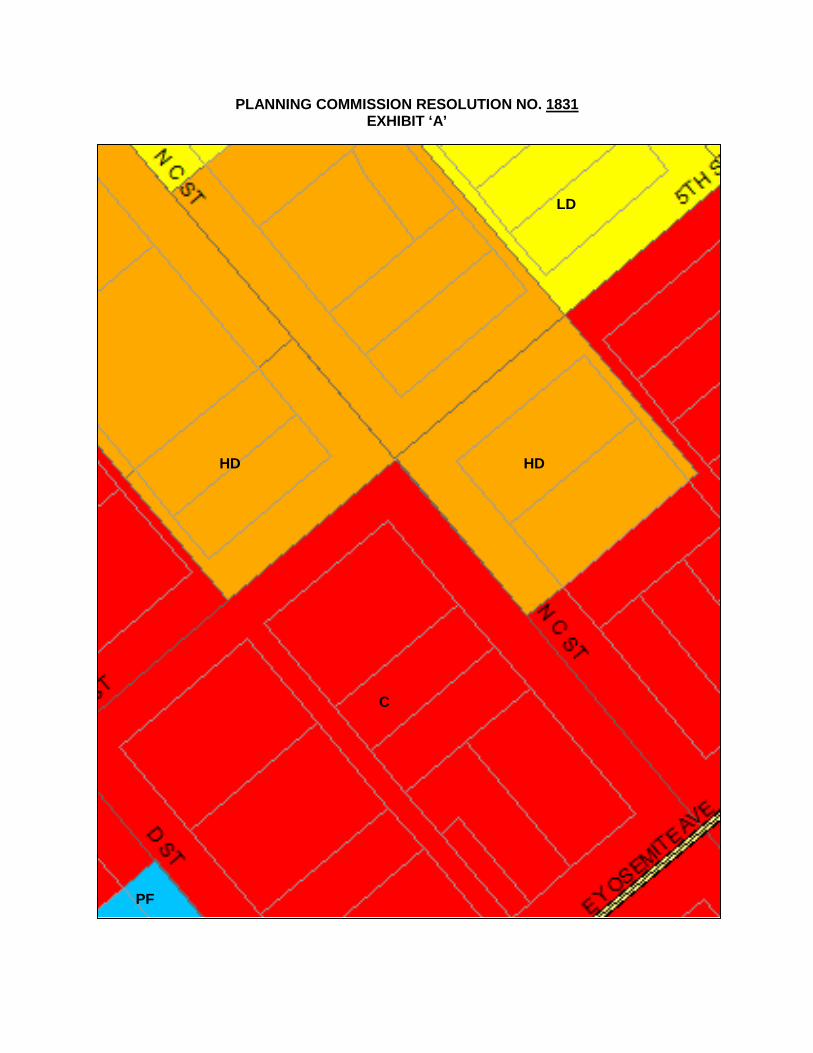
PLANNING COMMISSION RESOLUTION NO. 1831 EXHIBIT ‘A’
HD HD
LD
C
PF
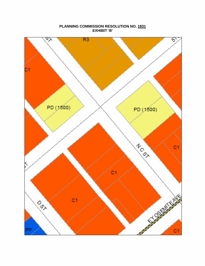
PLANNING COMMISSION RESOLUTION NO. 1831 EXHIBIT ‘B’
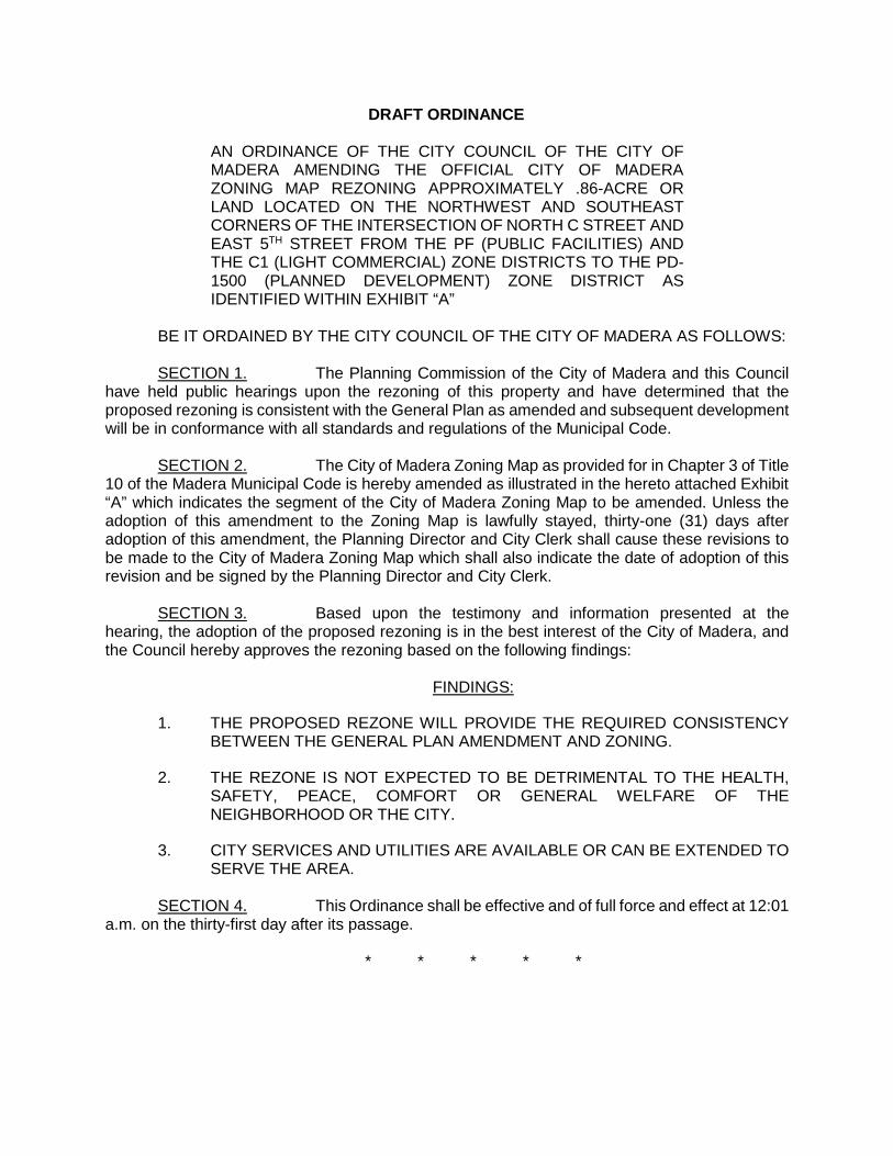
DRAFT ORDINANCE
AN ORDINANCE OF THE CITY COUNCIL OF THE CITY OF MADERA AMENDING THE OFFICIAL CITY OF MADERA ZONING MAP REZONING APPROXIMATELY .86-ACRE OR LAND LOCATED ON THE NORTHWEST AND SOUTHEAST CORNERS OF THE INTERSECTION OF NORTH C STREET AND EAST 5TH STREET FROM THE PF (PUBLIC FACILITIES) AND THE C1 (LIGHT COMMERCIAL) ZONE DISTRICTS TO THE PD-1500 (PLANNED DEVELOPMENT) ZONE DISTRICT AS IDENTIFIED WITHIN EXHIBIT “A”
BE IT ORDAINED BY THE CITY COUNCIL OF THE CITY OF MADERA AS FOLLOWS: SECTION 1. The Planning Commission of the City of Madera and this Council
have held public hearings upon the rezoning of this property and have determined that the proposed rezoning is consistent with the General Plan as amended and subsequent development will be in conformance with all standards and regulations of the Municipal Code.
SECTION 2. The City of Madera Zoning Map as provided for in Chapter 3 of Title
10 of the Madera Municipal Code is hereby amended as illustrated in the hereto attached Exhibit “A” which indicates the segment of the City of Madera Zoning Map to be amended. Unless the adoption of this amendment to the Zoning Map is lawfully stayed, thirty-one (31) days after adoption of this amendment, the Planning Director and City Clerk shall cause these revisions to be made to the City of Madera Zoning Map which shall also indicate the date of adoption of this revision and be signed by the Planning Director and City Clerk.
SECTION 3. Based upon the testimony and information presented at the hearing, the adoption of the proposed rezoning is in the best interest of the City of Madera, and the Council hereby approves the rezoning based on the following findings:
FINDINGS:
1. THE PROPOSED REZONE WILL PROVIDE THE REQUIRED CONSISTENCY BETWEEN THE GENERAL PLAN AMENDMENT AND ZONING.
2. THE REZONE IS NOT EXPECTED TO BE DETRIMENTAL TO THE HEALTH, SAFETY, PEACE, COMFORT OR GENERAL WELFARE OF THE NEIGHBORHOOD OR THE CITY.
3. CITY SERVICES AND UTILITIES ARE AVAILABLE OR CAN BE EXTENDED TO SERVE THE AREA.
SECTION 4. This Ordinance shall be effective and of full force and effect at 12:01
a.m. on the thirty-first day after its passage.
* * * * *

DRAFT ORDINANCE - EXHIBIT A
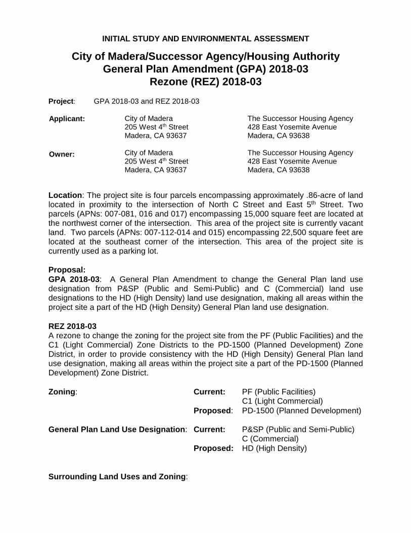
INITIAL STUDY AND ENVIRONMENTAL ASSESSMENT
City of Madera/Successor Agency/Housing Authority General Plan Amendment (GPA) 2018-03
Rezone (REZ) 2018-03 Project: GPA 2018-03 and REZ 2018-03 Applicant: Owner:
City of Madera 205 West 4th Street Madera, CA 93637
The Successor Housing Agency 428 East Yosemite Avenue Madera, CA 93638
City of Madera 205 West 4th Street Madera, CA 93637
The Successor Housing Agency 428 East Yosemite Avenue Madera, CA 93638
Location: The project site is four parcels encompassing approximately .86-acre of land located in proximity to the intersection of North C Street and East 5th Street. Two parcels (APNs: 007-081, 016 and 017) encompassing 15,000 square feet are located at the northwest corner of the intersection. This area of the project site is currently vacant land. Two parcels (APNs: 007-112-014 and 015) encompassing 22,500 square feet are located at the southeast corner of the intersection. This area of the project site is currently used as a parking lot. Proposal: GPA 2018-03: A General Plan Amendment to change the General Plan land use designation from P&SP (Public and Semi-Public) and C (Commercial) land use designations to the HD (High Density) land use designation, making all areas within the project site a part of the HD (High Density) General Plan land use designation. REZ 2018-03 A rezone to change the zoning for the project site from the PF (Public Facilities) and the C1 (Light Commercial) Zone Districts to the PD-1500 (Planned Development) Zone District, in order to provide consistency with the HD (High Density) General Plan land use designation, making all areas within the project site a part of the PD-1500 (Planned Development) Zone District. Zoning: Current: PF (Public Facilities) C1 (Light Commercial)
Proposed: PD-1500 (Planned Development) General Plan Land Use Designation: Current: P&SP (Public and Semi-Public)
C (Commercial) Proposed: HD (High Density)
Surrounding Land Uses and Zoning:

South – Downtown commercial corridor North – Varying densities of residential development West – Downtown commercial corridor East – Downtown commercial corridor
Responsible or Interested Agencies: San Joaquin Valley Air Pollution Control District
Madera Irrigation District Madera Unified School District

ENVIRONMENTAL FACTORS POTENTIALLY AFFECTED: The environmental factors checked below would be potentially affected by this project. None of these factors represents a “Potentially Significant Impact” as indicated by the checklist on the following pages. Aesthetics Agriculture Resources Air Quality Biological Resources Cultural Resources Geology /Soils Hazards & Hazardous Mat. Hydrology / Water Quality Land Use / Planning Mineral Resources Noise Population / Housing Public Services Recreation Transportation/Traffic
Utilities / Service Systems Greenhouse Gas Emissions Mandatory Findings of Significance
DETERMINATION: On the basis of this initial evaluation:
I find that the proposed project COULD NOT have a significant effect on the environment, and a NEGATIVE DECLARATION will be prepared.
I find that although the proposed project could have a significant effect on the environment, there will not be a significant effect in this case because revisions in the project have been made by or agreed to by the project proponent. A MITIGATED NEGATIVE DECLARATION will be prepared.
I find that the proposed project MAY have a significant effect on the environment, and an ENVIRONMENTAL IMPACT REPORT is required.
I find that the proposed project MAY have a “potentially significant impact” or “potentially significant unless mitigated" impact on the environment, but at least one effect 1) has been adequately analyzed in an earlier document pursuant to applicable legal standards, and 2) has been addressed by mitigation measures based on the earlier analysis as described on attached sheets. An ENVIRONMENTAL IMPACT REPORT is required, but it must analyze only the effects that remain to be addressed.
I find that although the proposed project could have a significant effect on the environment, because all potentially significant effects (a) have been analyzed adequately in an earlier EIR or NEGATIVE DECLARATION pursuant to applicable standards, and (b) have been avoided or mitigated pursuant to that earlier EIR or NEGATIVE DECLARATION, including revisions or mitigation measures that are imposed upon the proposed project, nothing further is required.
Signature Date: ____________________ Printed Name: Christopher Boyle, Planning Manager

4
Explanation of Environmental Checklist I. AESTHETICS. Would the project:
Less Than Significant Potentially With Less Than Significant Mitigation Significant No
Impact Incorporation Impact Impact
a. Have a substantial adverse effect on a scenic vista?
b. Substantially damage scenic resources, including, but not limited to, trees, rock outcroppings, and historic buildings within a state scenic highway?
c. Substantially degrade the existing visual character or quality of the site and its surroundings?
d. Create a new source of substantial light or glare that would adversely affect day or nighttime views in the area?
Discussion: The project site is four parcels encompassing approximately .86-acre of land located in proximity to the intersection of North C Street and East 5th Street. Two parcels (APNs: 007-081, 016 and 017) encompassing 15,000 square feet are located at the northwest corner of the intersection. This area of the project site is currently vacant land. Two parcels (APNs: 007-112-014 and 015) encompassing 22,500 square feet are located at the southeast corner of the intersection. This area of the project site is currently used as a parking lot. A General Plan amendment and rezoning are currently proposed. The General Plan Amendment proposes to change the General Plan land use designation from P&SP (Public and Semi-Public) and C (Commercial) land use designations to the HD (High Density) land use designation, making all areas within the project site a part of the HD (High Density) General Plan land use designation. The rezone proposes to change the zoning for the project site from the PF (Public Facilities) and the C1 (Light Commercial) Zone Districts to the PD-1500 (Planned Development) Zone District, in order to provide consistency with the HD (High Density) General Plan land use designation, making all areas within the project site a part of the PD-1500 (Planned Development) Zone District. Eventual development of the properties would require that a precise plan be approved by the Planning Commission. The HD (High Density) land use designation would allow for the development of high density multifamily residential development on the project site, with as many as fifty dwelling units. The Precise Plan would also provide for supporting development standards for the project, while implementing the Community Design element of the General Plan. The site is in generally in poor condition and generally lacking visual character. The proposal will not affect a scenic vista or have an overall adverse visual impact on the immediate area. The project will not affect a scenic highway, and will not have an overall adverse visual

5
impact on any scenic resources. The project would result in some sources of light, including the addition of new street lights, and the anticipated residential development will add additional sources of light. The proposed General Plan amendment and rezone, and the subsequent development of the subject properties that may occur, will conform with and incorporate General Plan policies and requirements. No additional analysis is required. a) No Impacts. The project will not result in the obstruction of federal, state or locally classified scenic areas, historic properties, community landmarks, or formally classified scenic resources such as a scenic highway, national scenic area, or state scenic area. The project will not have a substantial adverse effect on a scenic vista. b) No Impacts. The project will not damage scenic resources, including, but not limited to, rock outcroppings, and historic buildings within a state scenic highway. c) No Impacts. The project would not degrade the existing visual character or quality of the site and surroundings under examination. The proposed project would not alter the landforms, view sheds, and overall character of the area. d) Less Than Significant Impacts. There will be an increase in light and glare and other aesthetic impacts associated with urban development as a result of the project, although it will be a less than significant impact when City standards are implemented. In that the site is located in the downtown area of the city, the overall impact of additional light and glare will be minimal.

6
II. AGRICULTURE RESOURCES. In determining whether impacts to agricultural resources are significant environmental effects, lead agencies may refer to the California Agricultural Land Evaluation and Site Assessment Model (1997) prepared by the California Dept. of Conservation as an optional model to use in assessing impacts on agriculture and farmland. Would the project:
Less Than Significant Potentially With Less Than Significant Mitigation Significant No
Impact Incorporation Impact Impact
a. Convert Prime Farmland, Unique Farmland, or Farmland of Statewide Importance (Farmland), as shown on the maps prepare pursuant to the Farmland Mapping and Monitoring Program of the California Resources Agency, to non-agricultural use.
b. Conflict with existing zoning for agricultural use, or a Williamson Act contract?
c. Involve other changes in the existing environment which, due to their location or nature, could result in conversion of Farmland, to non-agricultural use?
Discussion: The project area is located on land identified as Vacant or Disturbed Land within the 2014 California Farmland Mapping and Monitoring Program. a.) No Impacts. The project would not convert prime farmland, unique farmland, or farmland of statewide importance (as shown on the maps prepared pursuant to the farmland mapping and monitoring program of the California resources agency) to non-agricultural use. The project site is identified as Urban and Built-Up Land on the 2014 Madera County Important Farmland 2016 Map. The project site has been identified for residential uses within the City of Madera General Plan, and the land is not currently being utilized for agricultural purposes. b.) No Impacts. The project would not conflict with existing zoning for agricultural use and there are no Williamson Act contracts affecting the subject property. The site is identified as urban and built up land, located in the downtown core of the city. c.) No Impacts. Surrounding properties are urbanized and currently in residential and commercial use. Any development consistent with the proposed General Plan and zoning for the project site won’t contribute towards the desire of nearby property owners to convert to non-agricultural uses. The project site is centrally located in the center of Madera and nearby properties are already developed.

7
III. AIR QUALITY. Where available, the significance criteria established by the applicable air quality management or air pollution control district may be relied upon to make the following determinations. Would the project:
Less Than Significant Potentially With Less Than Significant Mitigation Significant No
Impact Incorporation Impact Impact
a. Conflict with or obstruct implementation of the
applicable air quality plan?
b. Violate any air quality standard or contribute
substantially to an existing or projected air quality violation?
c. Result in a cumulatively considerable net increase of any criteria pollutant for which the project region is non-attainment under an applicable federal or state ambient air quality standard (including releasing emissions that exceed quantitative thresholds for ozone precursors)?
d. Expose sensitive receptors to substantial pollutant concentrations?
e. Create objectionable odors affecting a substantial number of people?
Discussion: The project area is located within the San Joaquin Valley Air Basin (SJVAB). Air quality conditions in the SJVAB are regulated by San Joaquin Valley Unified Air Pollution Control District (SJVUAPCD). The region is classified as a State and Federal non-attainment area for PM10 (airborne particulate matter with an aerodynamic diameter of less than 10 microns), and ozone (O3). Air quality is determined primarily by the type and amount of contaminants emitted into the atmosphere, the size and topography of the Basin, and its meteorological conditions. National and state air quality standards specify the upper limits of concentrations and duration in the ambient air for O3, CO, nitrogen dioxide (NO2), PM10, sulfur dioxide (SO2) and lead (Pb). These are “criteria pollutants.” The SJVUAPCD also conducts monitoring for two other state standards: sulfate and visibility. The State of California has designated the project area as being a severe non-attainment area for 1-hour O3, a non-attainment area for PM10, and an attainment area for CO. The EPA has designated the project area as being an extreme non-attainment area for 1-hour O3, a serious non-attainment area for 8-hour O3, a serious non-attainment area for PM10, and a moderate maintenance for CO. The current project would not conflict with or obstruct the implementation of applicable Regional Air Quality Control Plans. Project specific emissions of criteria pollutants from

8
future development will be dependent on the nature and intensity of the uses which are ultimately proposed. Similarly, future projects will be evaluated to determine required compliance with District Rule 9510, which is intended to mitigate a project’s impact on air quality through project design elements or by payment of applicable off-site mitigation fees. Any applicant subject to District Rule 9510 is required to submit an Air Impact Assessment (AIA) application to the District no later than applying for final discretionary approval, and to pay any applicable off-site mitigation fees before issuance of the first building permit. Demonstration of compliance with District Rule 9510, including payment of all applicable fees before issuance of the first building permit, would be made a condition of project approval. Short-term construction impacts on air quality, principally from dust generation, will be mitigated through watering. The project would not create substantial air emissions or deterioration of ambient air quality, and any future development would be subject to Air Pollution Control District review. Construction equipment will produce a small amount of air emissions from internal combustion engines and dust. The project will not violate any air quality standard or substantially contribute to an existing or projected air quality violation. The project will not result in a considerable net increase in non-attainment pollutants in this area. The project will not expose sensitive receptors to any significant amount of pollutants. The project will not create any objectionable odors. The proposed General Plan amendment and rezoning for the project site, and the eventual development of the subject properties, will not create impacts beyond those analyzed and addressed through the General Plan Update and the accompanying environmental impact report. All phases of site development will conform with and incorporate General Plan policies and requirements. All phases of development will similarly conform with and implement regional air quality requirements. No additional analysis is required. Any unique features or project impacts which are identified as specific projects are proposed within the project area will be evaluated and addressed on a project-by-project basis. a) Less Than Significant Impacts. The proposed project would not conflict with or obstruct implementation of the applicable air quality plan. b) Less Than Significant Impacts. The proposed project would not violate any air quality standard or contribute substantially to an existing or projected air quality violation. c) Less Than Significant Impacts. The project will not result in a cumulatively considerable net increase of any criteria pollutant for which the project region is non-attainment under an applicable federal or state ambient air quality standard, including releasing emissions which exceed quantitative thresholds for ozone precursors. d) No Impacts. The proposed project would not expose sensitive receptors to substantial pollutant concentrations. e) No Impacts. The proposed project would not create any new/permanent objectionable odors affecting a substantial number of people.

9
IV. BIOLOGICAL RESOURCES. Would the project: Less Than Significant Potentially With Less Than Significant Mitigation Significant No
Impact Incorporation Impact Impact
a. Have a substantial adverse effect, either
directly or through habitat modifications, on any species identified as a candidate, sensitive, or special status species in local or regional plans, policies or regulations, or by the California Department of Fish and Game or U.S. Fish and Wildlife Service?
b. Have a substantial adverse effect on any riparian habitat or other sensitive natural community identified in local or regional plans, policies, or regulations or by the California Department of Fish and Game or US Fish and Wildlife Service?
c. Have a substantial adverse effect on federally protected wetlands as defined by Section 404 of the Clean Water Act (including, but not limited to, marsh, vernal pool, coastal, etc.) through direct removal, filling, hydrological interruption, or other means?
d. Interfere substantially with the movement of any native resident or migratory fish or wildlife species or with established native resident or migratory wildlife corridors, or impede the use of native wildlife nursery sites?
e. Conflict with any local policies or ordinances protecting biological resources, such as a tree preservation policy or ordinance?
f. Conflict with the provisions of an adopted Habitat Conservation Plan, Natural Community Conservation Plan, or other approved local, regional, or state habitat conservation plan?
Discussion: With the preparation of the City of Madera General Plan, no threatened or endangered species were identified in the project area. The project area has been subjected to urbanization in the past, and although currently underutilized land, the location in the heart of the downtown corridor has resulted in a highly maintained and disturbed habitat. There is no record of special-status species in this project area. Development of the project area is consistent with the urbanization of the Madera area, as evaluated in the General Plan and its EIR; therefore impacts in this category are not anticipated to exceed the impacts addressed in those documents.

10
The approximately .86-acre project site is void of any natural features such as seasonal drainages, riparian or wetland habitat, rock outcroppings, or other native habitat or associated species. Development of the site will not conflict with any local policies or ordinances protecting biological resources, or conflict with the provisions of an adopted Habitat Conservation Plan, Natural Community Conservation Plan, or other approved local, regional, or state habitat conservation plan. a) No Impacts. The proposed project would not have a substantial adverse effect, either directly or through habitat modifications, on any species identified as a candidate, sensitive, or special status species in local or regional plans, policies, or regulations, or by the California Department of Fish and Game or U.S. Fish and Wildlife Service. b) No Impacts. The proposed project would not have a substantial adverse effect on any riparian habitat or other sensitive natural community identified in local or regional plans, policies, and regulations or by the California Department of Fish and Game or US Fish and Wildlife Service. c) No Impacts. The project would not have a substantial adverse effect on federally protected wetlands as defined by Section 404 of the Clean Water Act, including, but not limited to, marsh, vernal pool, coastal, etc., through direct removal, filling, hydrological interruption, or other means. d) No Impacts. The project would not interfere with the movement of any native resident or migratory fish or wildlife species or with established native resident or migratory wildlife corridors, or impede the use of native wildlife nursery sites. e) No Impacts. The project would not conflict with any local policies or ordinances protecting biological resources, such as a tree preservation policy or ordinance. f) No Impacts. The project would not conflict with the provisions of an adopted Habitat Conservation Plan, Natural Community Conservation Plan, or other approved local, regional or state habitat conservation plan.

11
V. CULTURAL RESOURCES. Would the project: Less Than Significant Potentially With Less Than Significant Mitigation Significant No
Impact Incorporation Impact Impact
a. Cause a substantial adverse change in the
significance of a historical resource as defined in §15064.5?
b. Cause a substantial adverse change in the significance of an archaeological resource pursuant to §15064.5?
c.
Directly or indirectly destroy a unique paleontological resource or site or unique geologic feature?
d. Disturb any human remains, including those interred outside of formal cemeteries?
Discussion: The project does not have the potential to cause a physical change that would affect unique historic, ethnic, or cultural values. The project will not disturb archaeological resources. The project will not disturb any unique paleontological or geologic resources. The project will not disturb any human remains. In the event any archeological resources are discovered with project construction, all activities shall cease and the Community Development Department shall be notified so that the procedures required by State Law may be applied. a) No Impacts. The proposed project would not cause a substantial adverse change in the significance of a historical resource as defined in §15064.5 of the CEQA Guidelines. There are no known historical resources located in the affected territory. b) No Impacts. The proposed project would not cause a substantial adverse change in the significance of an archaeological resource pursuant to §15064.5 of the CEQA Guidelines. There are no known archaeological resources located in the project area. c) No Impacts. The proposed project would not directly or indirectly destroy any unique paleontological resources or sites or unique geologic features. There are no known paleontological resources or sites or unique geologic features located in the affected territory. d) No Impacts. The project would not likely disturb any human remains, including those interred outside of formal cemeteries. If development occurs in the future and any remains are discovered, the requirements of CEQA that regulate archaeological and historical resources (Public Resources Code Section 21083.2 and 21084.1), and all local, state and federal regulations that regulate archaeological and historical resources would be complied with.

12
VI. GEOLOGY AND SOILS. Would the project: Less Than Significant Potentially With Less Than Significant Mitigation Significant No
Impact Incorporation Impact Impact
a. Expose people or structures to potential
substantial adverse effects, including the risk of loss, injury, or death involving:
i) Rupture of a known earthquake fault, as delineated on the most recent Alquist-Priolo Earthquake Fault Zoning Map issued by the State Geologist for the area or based on other substantial evidence of a known fault?
i) Strong seismic ground shaking?
iii) Seismic-related ground failure, including liquefaction?
iv) Landslides?
b. Result in substantial soil erosion or the loss of topsoil?
c. Be located on a geologic unit or soil that is unstable, or that would become unstable as a result of the project, and potentially result in on- or off-site landslide, lateral spreading, subsidence, liquefaction or collapse?
d. Be located on expansive soil, as defined in Table 18-1-B of the Uniform Building Code (1994), creating substantial risks to life or property?
e. Have soils incapable of adequately supporting
the use of septic tanks or alternative waste disposal systems where sewers are not available for the disposal of wastewater?
Discussion: There are no known faults on the project site or in the immediate area. The project site is subject to relatively low seismic hazards compared to many other parts of California. Potential ground shaking produced by earthquakes generated on regional faults lying outside the immediate vicinity in the project area may occur. Due to the distance of the known faults in the region, no significant ground shaking is anticipated on this site. Seismic hazards on the built environment are addressed in The Uniform Building Code that is utilized by the Madera Building Division to monitor safe construction in the City. ai.) No Impacts. No known faults with evidence of historic activity cut through the valley soils in the project vicinity. The major active faults and fault zones occur at some distance to the east, west, and south of the project site. Due to the geology of the project area and its

13
distance from active faults, the potential for loss of life, property damage, ground settlement, or liquefaction to occur in the project vicinity is considered minimal. aii) No Impacts. Ground shaking generally decreases with distance and increases with the depth of unconsolidated alluvial deposits. The most likely source of potential ground shaking is attributed to the San Andreas, Owens Valley, and the White Wolf faults. Based on this premise, and taking into account the distance to the causative faults, the potential for ground motion in the vicinity of the project site is such that a minimal risk can be assigned. aiii) No Impacts. Liquefaction describes a phenomenon in which a saturated, soil loses strength during an earthquake as a result of induced shearing strains. Lateral and vertical movement of the soil mass, combined with loss of bearing usually results. Loose sand, high groundwater conditions (where the water table is less than 30 feet below the surface), higher intensity earthquakes, and particularly long duration of ground shaking are the requisite conditions for liquefaction. There is no evidence of the presence of these requisite conditions. aiv) No Impacts. The project will not result in or expose people to potential impacts from landslides or mudflows. b) No Impacts. Construction of urban uses would create changes in absorption rates, drainage patterns, and the rate and amount of surface runoff on the selected project site. Standard construction practices that comply with City of Madera ordinances and regulations, The California Building Code, and professional engineering designs approved by the Madera Engineering Division will mitigate any potential impacts from future urban development, if any. c) No Impacts. The project site would not be located on a geologic unit or soil that is unstable, or that would become unstable as a result of the project, and potentially result in off-site landslide, lateral spreading, subsidence, liquefaction or collapse. d) No Impacts. The project will not result in or expose people to potential impacts from expansive soils. e) No Impacts. Should urban uses be approved in the project area, the City of Madera would provide necessary sewer and water systems.
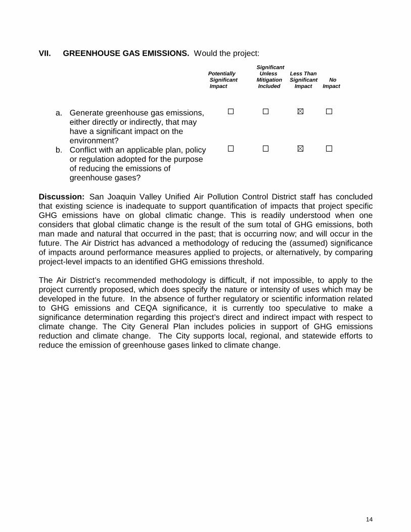
14
VII. GREENHOUSE GAS EMISSIONS. Would the project: Significant Potentially Unless Less Than Significant Mitigation Significant No Impact Included Impact Impact
a. Generate greenhouse gas emissions, either directly or indirectly, that may have a significant impact on the environment?
b. Conflict with an applicable plan, policy or regulation adopted for the purpose of reducing the emissions of greenhouse gases?
Discussion: San Joaquin Valley Unified Air Pollution Control District staff has concluded that existing science is inadequate to support quantification of impacts that project specific GHG emissions have on global climatic change. This is readily understood when one considers that global climatic change is the result of the sum total of GHG emissions, both man made and natural that occurred in the past; that is occurring now; and will occur in the future. The Air District has advanced a methodology of reducing the (assumed) significance of impacts around performance measures applied to projects, or alternatively, by comparing project-level impacts to an identified GHG emissions threshold. The Air District’s recommended methodology is difficult, if not impossible, to apply to the project currently proposed, which does specify the nature or intensity of uses which may be developed in the future. In the absence of further regulatory or scientific information related to GHG emissions and CEQA significance, it is currently too speculative to make a significance determination regarding this project’s direct and indirect impact with respect to climate change. The City General Plan includes policies in support of GHG emissions reduction and climate change. The City supports local, regional, and statewide efforts to reduce the emission of greenhouse gases linked to climate change.
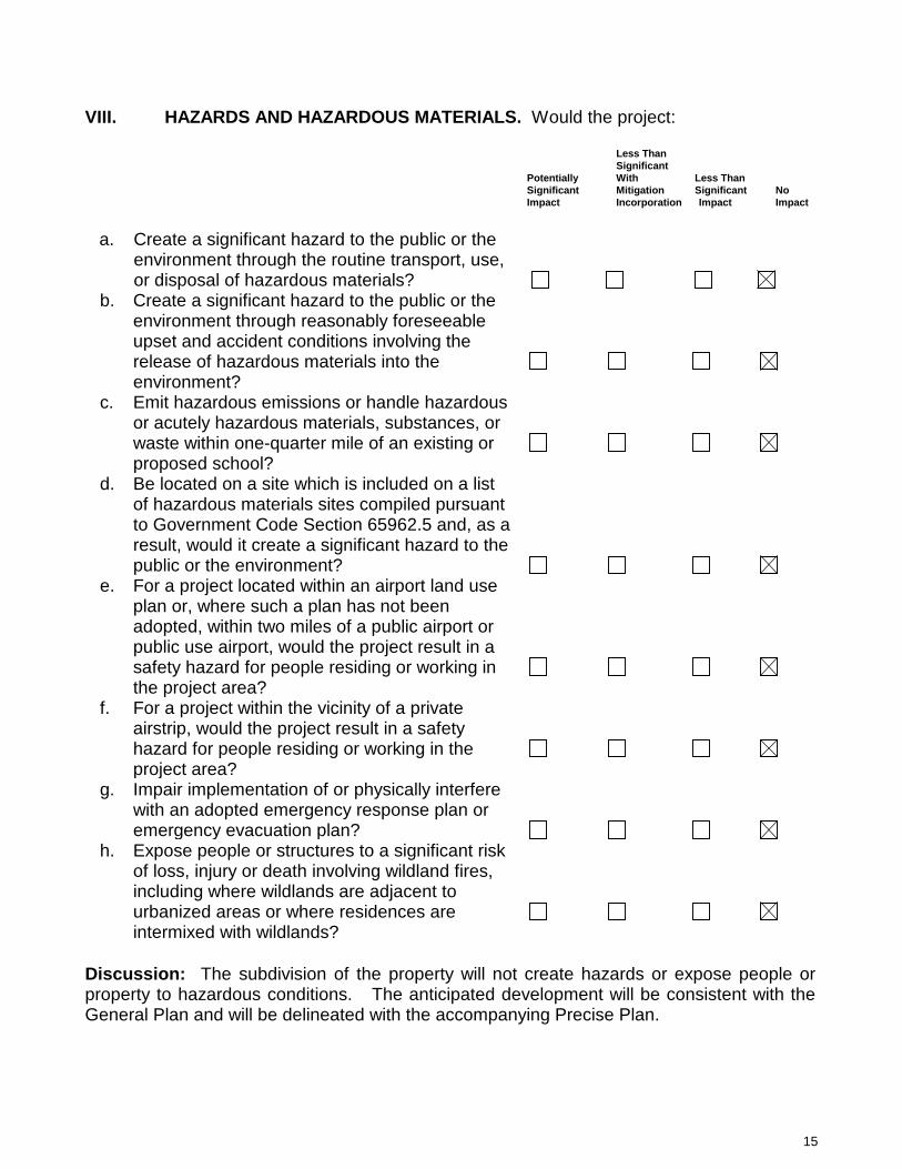
15
VIII. HAZARDS AND HAZARDOUS MATERIALS. Would the project: Less Than Significant Potentially With Less Than Significant Mitigation Significant No
Impact Incorporation Impact Impact
a. Create a significant hazard to the public or the
environment through the routine transport, use, or disposal of hazardous materials?
b. Create a significant hazard to the public or the
environment through reasonably foreseeable upset and accident conditions involving the release of hazardous materials into the environment?
c. Emit hazardous emissions or handle hazardous or acutely hazardous materials, substances, or waste within one-quarter mile of an existing or proposed school?
d. Be located on a site which is included on a list of hazardous materials sites compiled pursuant to Government Code Section 65962.5 and, as a result, would it create a significant hazard to the public or the environment?
e. For a project located within an airport land use
plan or, where such a plan has not been adopted, within two miles of a public airport or public use airport, would the project result in a safety hazard for people residing or working in the project area?
f. For a project within the vicinity of a private airstrip, would the project result in a safety hazard for people residing or working in the project area?
g. Impair implementation of or physically interfere with an adopted emergency response plan or emergency evacuation plan?
h. Expose people or structures to a significant risk
of loss, injury or death involving wildland fires, including where wildlands are adjacent to urbanized areas or where residences are intermixed with wildlands?
Discussion: The subdivision of the property will not create hazards or expose people or property to hazardous conditions. The anticipated development will be consistent with the General Plan and will be delineated with the accompanying Precise Plan.
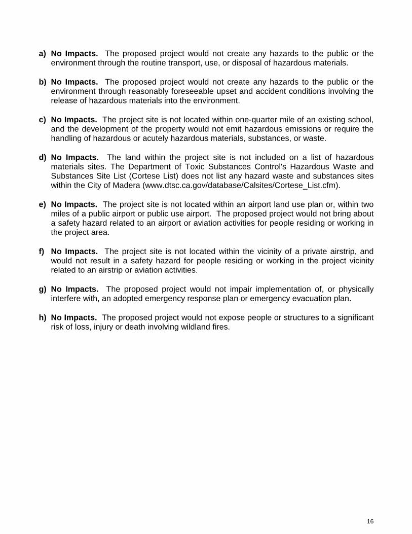
16
a) No Impacts. The proposed project would not create any hazards to the public or the environment through the routine transport, use, or disposal of hazardous materials.
b) No Impacts. The proposed project would not create any hazards to the public or the
environment through reasonably foreseeable upset and accident conditions involving the release of hazardous materials into the environment.
c) No Impacts. The project site is not located within one-quarter mile of an existing school,
and the development of the property would not emit hazardous emissions or require the handling of hazardous or acutely hazardous materials, substances, or waste.
d) No Impacts. The land within the project site is not included on a list of hazardous
materials sites. The Department of Toxic Substances Control's Hazardous Waste and Substances Site List (Cortese List) does not list any hazard waste and substances sites within the City of Madera (www.dtsc.ca.gov/database/Calsites/Cortese_List.cfm).
e) No Impacts. The project site is not located within an airport land use plan or, within two
miles of a public airport or public use airport. The proposed project would not bring about a safety hazard related to an airport or aviation activities for people residing or working in the project area.
f) No Impacts. The project site is not located within the vicinity of a private airstrip, and
would not result in a safety hazard for people residing or working in the project vicinity related to an airstrip or aviation activities.
g) No Impacts. The proposed project would not impair implementation of, or physically
interfere with, an adopted emergency response plan or emergency evacuation plan. h) No Impacts. The proposed project would not expose people or structures to a significant
risk of loss, injury or death involving wildland fires.
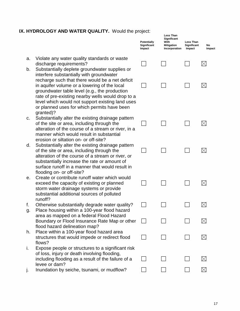
17
IX. HYDROLOGY AND WATER QUALITY. Would the project: Less Than Significant Potentially With Less Than Significant Mitigation Significant No
Impact Incorporation Impact Impact
a. Violate any water quality standards or waste
discharge requirements?
b. Substantially deplete groundwater supplies or
interfere substantially with groundwater recharge such that there would be a net deficit in aquifer volume or a lowering of the local groundwater table level (e.g., the production rate of pre-existing nearby wells would drop to a level which would not support existing land uses or planned uses for which permits have been granted)?
c. Substantially alter the existing drainage pattern of the site or area, including through the alteration of the course of a stream or river, in a manner which would result in substantial erosion or siltation on- or off-site?
d. Substantially alter the existing drainage pattern of the site or area, including through the alteration of the course of a stream or river, or substantially increase the rate or amount of surface runoff in a manner that would result in flooding on- or off-site?
e. Create or contribute runoff water which would exceed the capacity of existing or planned storm water drainage systems or provide substantial additional sources of polluted runoff?
f. Otherwise substantially degrade water quality? g. Place housing within a 100-year flood hazard
area as mapped on a federal Flood Hazard Boundary or Flood Insurance Rate Map or other flood hazard delineation map?
h. Place within a 100-year flood hazard area structures that would impede or redirect flood flows?
i. Expose people or structures to a significant risk of loss, injury or death involving flooding, including flooding as a result of the failure of a levee or dam?
j. Inundation by seiche, tsunami, or mudflow?

18
Discussion: The proposed project would not violate any water quality standards or waste discharge requirements. There will not be a significant reduction in the amount of groundwater otherwise available for public water supplies as a result of this project. Services will be provided in accordance with the City’s Master Plans. The project will not change any drainage patterns or stream courses, or the source or direction of any water movement. During construction, the project site may be exposed to increased soil erosion from wind and water. Dust control will be used during construction. With completion, the project will not bring about erosion, significant changes in topography or unstable soil conditions. The project will not expose people or property to water related hazards. During future construction, the project site may be exposed to increased soil erosion from wind and water. Dust control will be used during any future construction. With completion, the project will not bring about erosion, significant changes in topography or unstable soil conditions. Standard construction practices and compliance with City ordinances and regulations, The Uniform Building Code, and adherence to professional engineering design approved by the Madera Engineering Department will mitigate any potential impacts from this project. This development will be required to comply with all City ordinances and standard practices which will assure that storm water will be adequately drained into the approved storm water system. The project will not create any impacts on water quality. Based on a review of the City’s FEMA maps, the site in is a Zone X, and the project will not place housing or other land uses in a 100-year flood hazard area. These are areas outside of the 500-year flood area. The project will not expose people or structures to a significant risk because of dam or levee failure. The project will not expose people or structures to a significant risk because of a seiche, mudflow, or tsunami.
a) No Impacts. Development of the project site would be required to comply with all City of Madera ordinances and standard practices which assure proper grading and storm water drainage into the approved storm water systems. Any development would also be required to comply with all local, state, and federal regulations to prevent any violation of water quality standards or waste discharge requirements. b) No Impacts. The proposed project will not substantially deplete groundwater supplies or interfere substantially with groundwater recharge such that there would be a net deficit in aquifer volume or a lowering of the local groundwater table level. c) No Impacts. The proposed project would not alter the existing drainage pattern of the site or area through the alteration of the course of a stream or river, in a manner which would result in substantial erosion or siltation on or off-site. d) No Impacts. The proposed project would not alter the existing drainage pattern of the site or area, including through the alteration of the course of a stream or river, or substantially increase the rate or amount of surface runoff in a manner that would result in flooding on or off-site.
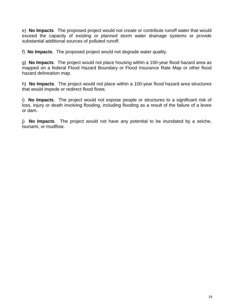
19
e) No Impacts. The proposed project would not create or contribute runoff water that would exceed the capacity of existing or planned storm water drainage systems or provide substantial additional sources of polluted runoff. f) No Impacts. The proposed project would not degrade water quality. g) No Impacts. The project would not place housing within a 100-year flood hazard area as mapped on a federal Flood Hazard Boundary or Flood Insurance Rate Map or other flood hazard delineation map. h) No Impacts. The project would not place within a 100-year flood hazard area structures that would impede or redirect flood flows. i) No Impacts. The project would not expose people or structures to a significant risk of loss, injury or death involving flooding, including flooding as a result of the failure of a levee or dam. j) No Impacts. The project would not have any potential to be inundated by a seiche, tsunami, or mudflow.

20
IX. LAND USE AND PLANNING. Would the project: Less Than Significant Potentially With Less Than Significant Mitigation Significant No
Impact Incorporation Impact Impact
a. Physically divide an established community? b. Conflict with any applicable land use plan,
policy, or regulation of an agency with jurisdiction over the project (including, but no limited to the general plan, specific plan, local coastal program, or zoning ordinance) adopted for the purpose of avoiding or mitigating an environmental effect?
c. Conflict with any applicable habitat conservation plan or natural community conservation plan?
Discussion: Development of the project area is consistent with the urbanization of the project area, as evaluated in the General Plan and its EIR; therefore impacts in this category are avoided. a) No Impacts. The project would not physically divide an established community. Rather, it logically allows development to occur in an orderly manner, adjacent to urban development. b) No Impacts. The proposed project would not conflict with any applicable land use plan, policy, or regulation of an agency with jurisdiction over the project adopted for the purpose of avoiding or mitigating an environmental effect. c) No Impacts. The project would not conflict with any applicable habitat conservation plan or natural community conservation plan.
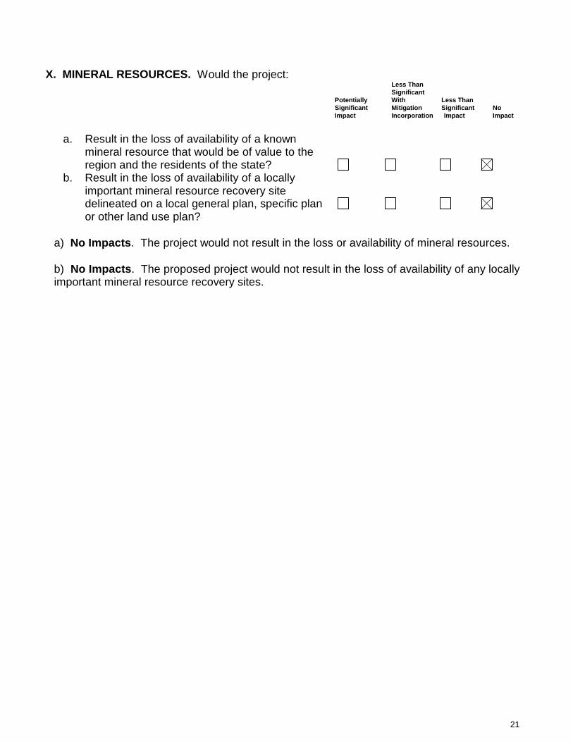
21
X. MINERAL RESOURCES. Would the project: Less Than Significant Potentially With Less Than Significant Mitigation Significant No
Impact Incorporation Impact Impact
a. Result in the loss of availability of a known
mineral resource that would be of value to the region and the residents of the state?
b. Result in the loss of availability of a locally
important mineral resource recovery site delineated on a local general plan, specific plan or other land use plan?
a) No Impacts. The project would not result in the loss or availability of mineral resources. b) No Impacts. The proposed project would not result in the loss of availability of any locally important mineral resource recovery sites.

22
XI. NOISE. Would the project result in: Less Than Significant Potentially With Less Than Significant Mitigation Significant
Impact Incorporation Impact Impact
a. Exposure of persons to or generation of noise
levels in excess of standards established in the local general plan or noise ordinance, or applicable standards of other agencies?
b. Exposure of persons to or generation of
excessive ground borne vibration or ground borne noise levels?
c. A substantial permanent increase in ambient noise levels in the project vicinity above levels existing without the project?
d. A substantial temporary or periodic increase in
ambient noise levels in the project vicinity above levels existing without the project?
e. For a project located within an airport land use plan or, where such a plan has not been adopted, within two miles of a public airport or public use airport, would the project expose people residing or working in the project area to excessive noise levels?
f. For a project within the vicinity of a private airstrip, would the project expose people residing or working in the project area to excessive noise levels?
Discussion: These potential impacts were addressed in the General Plan EIR, and goals and mitigation measures were adopted to reduce potential impacts to a less than significant level. Development of the project area is consistent with the urbanization of the Madera area, as evaluated in the General Plan, and its EIR; therefore impacts in this category are not anticipated to exceed the impacts addressed in those documents. a) No Impacts. The proposed project would not result in exposure of persons to or the
generation of noise. b) No Impacts. The proposed project would not result in exposure of persons to or
generation of excessive ground-borne vibration or ground-borne noise levels. c) Less than significant impact. The proposed project would result in a permanent
increase in ambient noise levels in the project vicinity above levels existing without the project. These noise levels were anticipated as part of the development of the project site, consistent with the Madera General Plan.
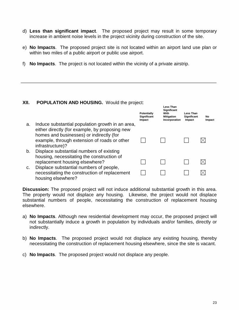
23
d) Less than significant impact. The proposed project may result in some temporary increase in ambient noise levels in the project vicinity during construction of the site.
e) No Impacts. The proposed project site is not located within an airport land use plan or
within two miles of a public airport or public use airport. f) No Impacts. The project is not located within the vicinity of a private airstrip. XII. POPULATION AND HOUSING. Would the project:
Less Than Significant Potentially With Less Than Significant Mitigation Significant No
Impact Incorporation Impact Impact a. Induce substantial population growth in an area,
either directly (for example, by proposing new homes and businesses) or indirectly (for example, through extension of roads or other infrastructure)?
b. Displace substantial numbers of existing housing, necessitating the construction of replacement housing elsewhere?
c. Displace substantial numbers of people,
necessitating the construction of replacement housing elsewhere?
Discussion: The proposed project will not induce additional substantial growth in this area. The property would not displace any housing. Likewise, the project would not displace substantial numbers of people, necessitating the construction of replacement housing elsewhere. a) No Impacts. Although new residential development may occur, the proposed project will
not substantially induce a growth in population by individuals and/or families, directly or indirectly.
b) No Impacts. The proposed project would not displace any existing housing, thereby
necessitating the construction of replacement housing elsewhere, since the site is vacant. c) No Impacts. The proposed project would not displace any people.
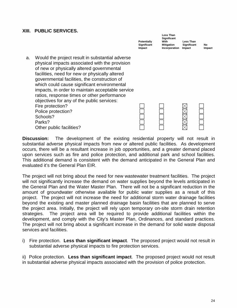
24
XIII. PUBLIC SERVICES. Less Than Significant Potentially With Less Than Significant Mitigation Significant No
Impact Incorporation Impact Impact
a. Would the project result in substantial adverse physical impacts associated with the provision of new or physically altered governmental facilities, need for new or physically altered governmental facilities, the construction of which could cause significant environmental impacts, in order to maintain acceptable service ratios, response times or other performance objectives for any of the public services:
Fire protection? Police protection? Schools? Parks? Other public facilities?
Discussion: The development of the existing residential property will not result in substantial adverse physical impacts from new or altered public facilities. As development occurs, there will be a resultant increase in job opportunities, and a greater demand placed upon services such as fire and police protection, and additional park and school facilities. This additional demand is consistent with the demand anticipated in the General Plan and evaluated it’s the General Plan EIR. The project will not bring about the need for new wastewater treatment facilities. The project will not significantly increase the demand on water supplies beyond the levels anticipated in the General Plan and the Water Master Plan. There will not be a significant reduction in the amount of groundwater otherwise available for public water supplies as a result of this project. The project will not increase the need for additional storm water drainage facilities beyond the existing and master planned drainage basin facilities that are planned to serve the project area. Initially, the project will rely upon temporary on-site storm drain retention strategies. The project area will be required to provide additional facilities within the development, and comply with the City’s Master Plan, Ordinances, and standard practices. The project will not bring about a significant increase in the demand for solid waste disposal services and facilities. i) Fire protection. Less than significant impact. The proposed project would not result in
substantial adverse physical impacts to fire protection services. ii) Police protection. Less than significant impact. The proposed project would not result in substantial adverse physical impacts associated with the provision of police protection.

25
iii) Schools. Less than significant impact. The Madera Unified School District levies a school facilities fee to help defray the impact of commercial/industrial development. The proposed project would not generate a significant impact to the schools in Madera. iv) Parks. Less than significant impact. The proposed project would not generate a significant impact to the park facilities in Madera. v) Other public facilities. Less than significant impact. The proposed project would not have any impacts on other public facilities. XIV. RECREATION
Less Than Significant Potentially With Less Than Significant Mitigation Significant No
Impact Incorporation Impact Impact
a. Would the project increase the use of existing neighborhood and regional parks or other recreational facilities such that substantial physical deterioration of the facility would occur or be accelerated?
b. Does the project include recreational facilities or require the construction or expansion of recreational facilities that might have an adverse physical effect on the environment?
Discussion: Residential development is consistent with the City of Madera General Plan and Zoning Ordinance. Impacts in this category are not anticipated to exceed the impacts addressed in those documents. a) No Impacts. The project would not increase the use of existing neighborhood and regional parks or other recreational facilities such that substantial physical deterioration of the facility would occur or be accelerated. b) No Impacts. The project does not include recreational facilities or facilities which might have an adverse physical effect on the environment.
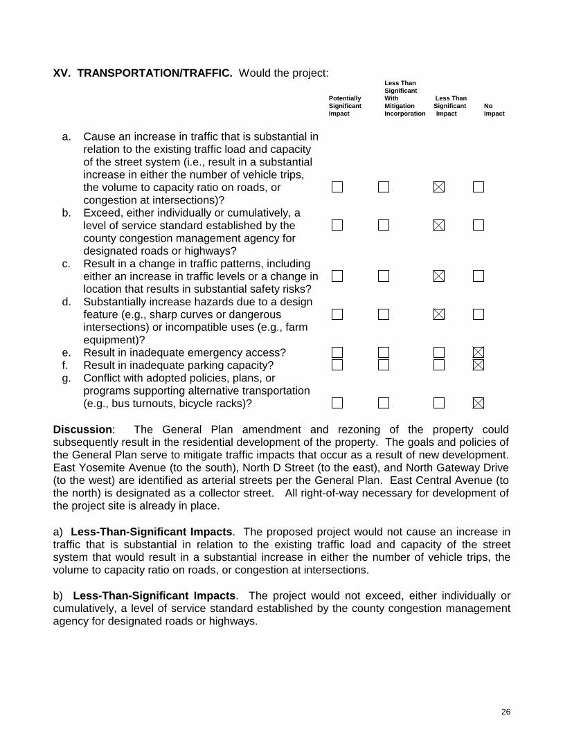
26
XV. TRANSPORTATION/TRAFFIC. Would the project: Less Than Significant Potentially With Less Than Significant Mitigation Significant No
Impact Incorporation Impact Impact
a. Cause an increase in traffic that is substantial in
relation to the existing traffic load and capacity of the street system (i.e., result in a substantial increase in either the number of vehicle trips, the volume to capacity ratio on roads, or congestion at intersections)?
b. Exceed, either individually or cumulatively, a level of service standard established by the county congestion management agency for designated roads or highways?
c. Result in a change in traffic patterns, including either an increase in traffic levels or a change in location that results in substantial safety risks?
d. Substantially increase hazards due to a design feature (e.g., sharp curves or dangerous intersections) or incompatible uses (e.g., farm equipment)?
e. Result in inadequate emergency access? f. Result in inadequate parking capacity? g. Conflict with adopted policies, plans, or
programs supporting alternative transportation (e.g., bus turnouts, bicycle racks)?
Discussion: The General Plan amendment and rezoning of the property could subsequently result in the residential development of the property. The goals and policies of the General Plan serve to mitigate traffic impacts that occur as a result of new development. East Yosemite Avenue (to the south), North D Street (to the east), and North Gateway Drive (to the west) are identified as arterial streets per the General Plan. East Central Avenue (to the north) is designated as a collector street. All right-of-way necessary for development of the project site is already in place. a) Less-Than-Significant Impacts. The proposed project would not cause an increase in traffic that is substantial in relation to the existing traffic load and capacity of the street system that would result in a substantial increase in either the number of vehicle trips, the volume to capacity ratio on roads, or congestion at intersections. b) Less-Than-Significant Impacts. The project would not exceed, either individually or cumulatively, a level of service standard established by the county congestion management agency for designated roads or highways.

27
c) Less-Than-Significant Impacts. The proposed project would not result in a change in traffic patterns, including either an increase in traffic levels or a change in location that results in substantial safety risks. d) Less-Than-Significant Impacts. The proposed project would not increase hazards to transportation systems due to design features such as sharp curves, dangerous intersections, or incompatible uses. e) No Impacts. The proposed project would not result in inadequate emergency access. f) No Impacts. The proposed project would not result in inadequate parking capacity. Any development of the project site will include parking sufficient to serve the proposed project. g) No Impacts. The project will not conflict with adopted policies, plans, or programs supporting alternative transportation.
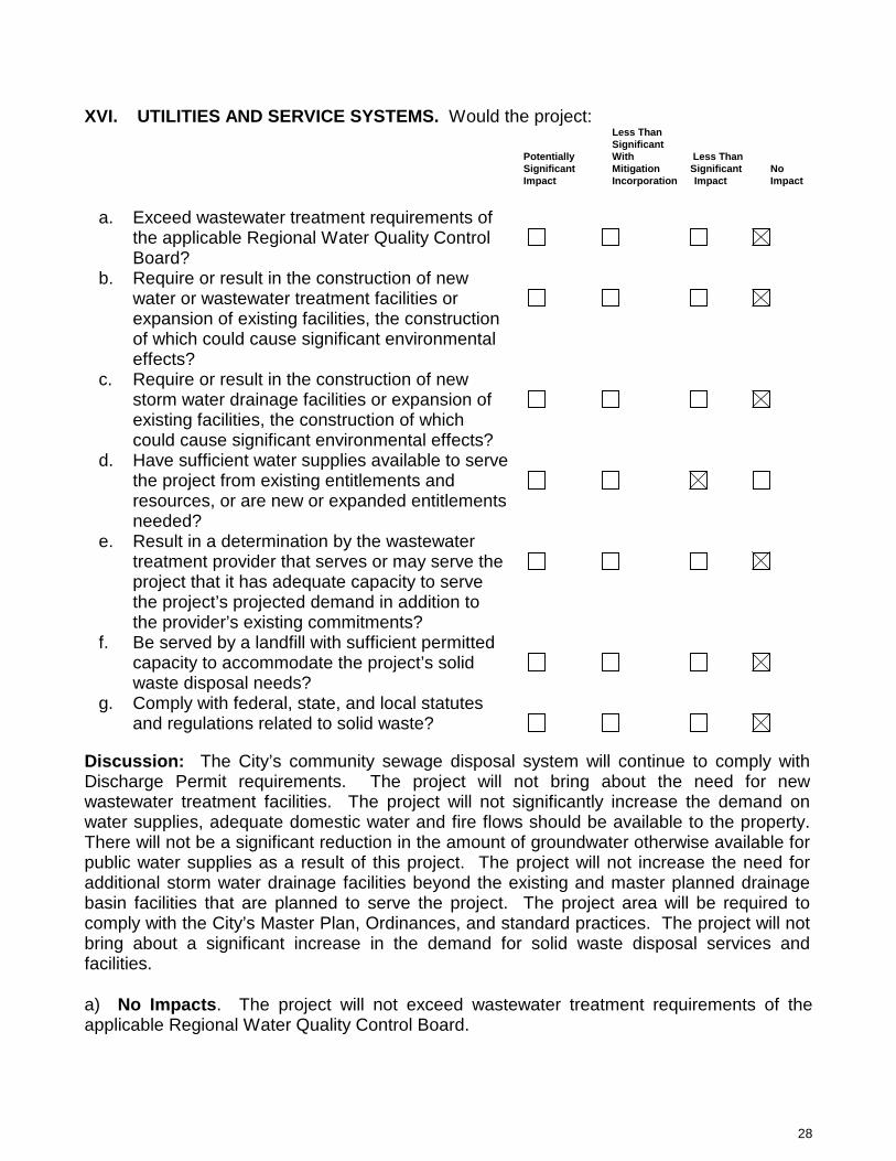
28
XVI. UTILITIES AND SERVICE SYSTEMS. Would the project: Less Than Significant Potentially With Less Than Significant Mitigation Significant No
Impact Incorporation Impact Impact
a. Exceed wastewater treatment requirements of
the applicable Regional Water Quality Control Board?
b. Require or result in the construction of new water or wastewater treatment facilities or expansion of existing facilities, the construction of which could cause significant environmental effects?
c. Require or result in the construction of new storm water drainage facilities or expansion of existing facilities, the construction of which could cause significant environmental effects?
d. Have sufficient water supplies available to serve the project from existing entitlements and resources, or are new or expanded entitlements needed?
e. Result in a determination by the wastewater treatment provider that serves or may serve the project that it has adequate capacity to serve the project’s projected demand in addition to the provider’s existing commitments?
f. Be served by a landfill with sufficient permitted capacity to accommodate the project’s solid waste disposal needs?
g. Comply with federal, state, and local statutes and regulations related to solid waste?
Discussion: The City’s community sewage disposal system will continue to comply with Discharge Permit requirements. The project will not bring about the need for new wastewater treatment facilities. The project will not significantly increase the demand on water supplies, adequate domestic water and fire flows should be available to the property. There will not be a significant reduction in the amount of groundwater otherwise available for public water supplies as a result of this project. The project will not increase the need for additional storm water drainage facilities beyond the existing and master planned drainage basin facilities that are planned to serve the project. The project area will be required to comply with the City’s Master Plan, Ordinances, and standard practices. The project will not bring about a significant increase in the demand for solid waste disposal services and facilities. a) No Impacts. The project will not exceed wastewater treatment requirements of the applicable Regional Water Quality Control Board.
29
b) No Impacts. The proposed project would not require or result in the construction of new water or wastewater treatment facilities or expansion of existing facilities, the construction of which could cause significant environmental effects. c) No Impacts. The proposed project would not require or result in the construction of new storm water drainage facilities or expansion of existing facilities, the construction of which could cause significant environmental effects. d) Less-Than-Significant Impacts. There will be sufficient water supplies available to serve the project. e) No Impacts. The project would not require a determination by a wastewater treatment provider. f) No Impacts. The project would be served by a landfill with sufficient permitted capacity to accommodate the project’s solid waste disposal needs. g) No Impacts. The project will be required to comply with federal, state, and local statutes as well as regulations related to solid waste by the City of Madera.
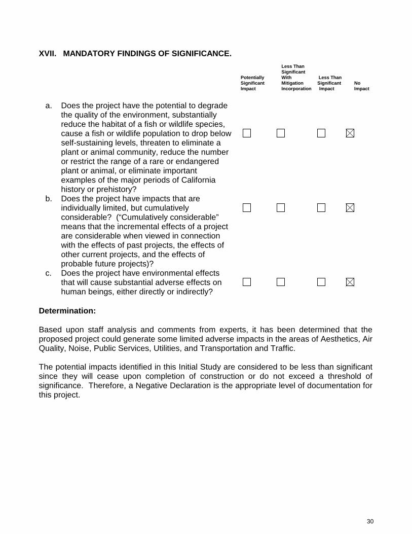
30
XVII. MANDATORY FINDINGS OF SIGNIFICANCE.
Less Than Significant Potentially With Less Than Significant Mitigation Significant No
Impact Incorporation Impact Impact
a. Does the project have the potential to degrade
the quality of the environment, substantially reduce the habitat of a fish or wildlife species, cause a fish or wildlife population to drop below self-sustaining levels, threaten to eliminate a plant or animal community, reduce the number or restrict the range of a rare or endangered plant or animal, or eliminate important examples of the major periods of California history or prehistory?
b. Does the project have impacts that are individually limited, but cumulatively considerable? (“Cumulatively considerable” means that the incremental effects of a project are considerable when viewed in connection with the effects of past projects, the effects of other current projects, and the effects of probable future projects)?
c. Does the project have environmental effects that will cause substantial adverse effects on human beings, either directly or indirectly?
Determination: Based upon staff analysis and comments from experts, it has been determined that the proposed project could generate some limited adverse impacts in the areas of Aesthetics, Air Quality, Noise, Public Services, Utilities, and Transportation and Traffic. The potential impacts identified in this Initial Study are considered to be less than significant since they will cease upon completion of construction or do not exceed a threshold of significance. Therefore, a Negative Declaration is the appropriate level of documentation for this project.

CITY OF MADERA PLANNING COMMISSION
Staff Report: Brar Interim Agriculture CUP 2013-14 MOD and Environmental Determination
Item #5 – August 14, 2018
PROPOSAL: An application for a conditional use permit to allow for an extension of agricultural activities on an interim basis. APPLICANT: Lakhwinder Brar OWNER: Lakhwinder Brar ADDRESS: SWC of Pecan Avenue and
Road 28¼ APN: 012-490-002
APPLICATION: CUP 2013-14 CEQA: Negative Declaration LOCATION: The property is located at the southwest corner of Pecan Avenue and Road 28¼. STREET ACCESS: The site has access to Pecan Avenue and Road 28¼. PARCEL SIZE: Approximately 136.92 acres GENERAL PLAN DESIGNATION: LD (Low Density), MD (Medium Density), and P&SP (Public and Semi Public) ZONING DISTRICT: PD (Planned Development) and PF (Public Facilities) SITE CHARACTERISTICS: The project site is currently planted with almond trees. The State Route 99 freeway corridor is immediately east. Single family residential and an elementary school are to the west. Rural residential properties are to the north. Agricultural activity is located to the south beyond the City limits. ENVIRONMENTAL REVIEW: An initial study and a negative declaration were adopted by the Planning Commission in May of 2014. The activities considered within this request for extension were contemplated within the approved negative declaration. SUMMARY: The allowance for agricultural activities on an interim basis was approved for a period not to exceed five years with additional extensions of time requiring amendment of the use permit. The applicant has made application for amendment, requesting a five-year extension to the existing allowance for interim agricultural activities.
205 W. Fourth Street Madera CA 93637 (559) 661-5430
Return to Agenda

PC 08/14/18 (CUP 2013-14 MOD – Brar Interim Agriculture) 2
APPLICABLE CODES AND PROCEDURES MMC § 10-3.421 Interim Agriculture MMC § 10-3.1301 Use Permits MMC § 10-3.406 Nonconforming Building and Uses The General Plan designates the project site as LD (Low Density), MD (Medium Density), and P&SP (Public and Semi Public) property. The project site is located in the PD-3000 (Planned Development), PD-4500 (Planned Development), PD-6000 (Planned Development) and PF (Public Facilities) Zone Districts. All General Plan land use designations and zoning districts are consistent with the Ventana Specific Plan. MMC § 10-3.421 allows for the establishment of “Interim Agriculture” in all residential, commercial, and industrial zone districts subject to the approval of a use permit by the Planning Commission. Interim agriculture is allowed in the PF (Public Facilities) Zone District subject to the issuance of a conditional use permit. In all cases, interim agriculture may be granted for a period not to exceed five years, with subsequent extensions allowed only by Planning Commission approval of an amendment to the original use permit. If the Commission cannot make the appropriate findings, the use should be denied. Conditions may be attached to the approval of the use permit to ensure compatibility. Project design may be altered and on or off-site improvements required in order to make the project compatible with nearby uses. In addition, the application may be subject to further review, modification or revocation by the Commission as necessary. PRIOR ACTION In anticipation of annexation into the City, the Planning Commission approved the Ventana development project on February 13, 2007. The project included a General Plan amendment, adoption of a specific plan, pre-zoning in support of the proposed annexation, approval of two tentative subdivision maps and certification of an Environmental Impact Report. On April 10, 2007, the Planning Commission approved a precise plan and a vesting tentative subdivision map. Annexation of the project area was approved by the Local Agency Formation Commission (LAFCO) on June 12, 2007. An application to allow for interim agriculture was submitted on June 3, 2013. The Planning Commission approved the request for interim agriculture on May 13, 2014, allowing for the continued farming of an existing non-permitted almond orchard currently planted on the property until April 8, 2019. Recently, the Planning Commission approved Tentative Subdivision Maps 2018-01 and 02, which reestablished the subdivision of the property consistent with the Ventana Specific Plan, zoning, and the General Plan. ANALYSIS Background In October of 2013, in response to a languishing economy, the City adopted ordinance which allows for agricultural activities on an interim basis. The ordinance states that; “In all residential, commercial, and industrial zone districts in the City, when various factors combine to make the development of a property infeasible for a period of time anticipated to be in excess of five years, a use permit may be granted by the Planning Commission to allow for agricultural

PC 08/14/18 (CUP 2013-14 MOD – Brar Interim Agriculture) 3
activities on an interim basis, until such time as development consistent with the underlying zone district becomes viable.” At that time, the development of the Ventana Specific Plan area had proven difficult with the stagnant development conditions prevalent during the Great Recession. With the development of the Ventana residential project considered infeasible, and the adoption of the interim agriculture ordinance having been adopted, the Planning Commission approved CUP 2013-14, which allowed for interim agriculture on approximately 140 acres of land within the Ventana Specific Plan area for a period not to exceed five years. That use permit will expire on April 8, 2019. In 2013, the applicant expressed that it was his intent to eventually begin construction of the Ventana project, at such time as market conditions improved. Thus, at such time that market conditions warranted, the applicant would remove the almond orchard and develop the property consistent with the Ventana Specific Plan. Interim Agriculture Extension Request The City’s Zoning Ordinance allows for the granting of a use permit for Interim Agriculture by the Planning Commission subject to the Planning Commission being able to make the following findings:
(1) The establishment, maintenance or operation of the interim agricultural use will not, under the circumstances of the particular case, be detrimental to the health, safety, peace, morals, comfort and general welfare of persons residing or working in the neighborhood of such proposed use or be detrimental or injurious to property and improvements in the neighborhood or general welfare of the city.
(2) The interim agricultural use will not be detrimental or injurious to the infrastructure of the City. Interim agriculture shall use techniques to maximize water efficiency and minimize erosion. All grading and/or excavation shall be compatible with the City’s Storm Drain Master Plan.
Additionally, the interim agriculture ordinance requires provision of the following information:
(1) a justification of necessity for interim agricultural use; (2) a total acreage calculation; (3) a description of what crops will be grown and what their water usage will be; (4) a description of irrigation technique(s) to be implemented on the subject property;
and (5) a plan for eventual conversion of the property to its planned use.
Whereas the information associated with the project parcel related to acreage, crop and irrigation methodologies has not changed, the applicant has provided a new justification statement which includes a general timeline for conversion of the property to its planned use. The applicant requests an additional five years so as the either sell the project in whole or in part, or begin the development of the property privately. Current Factors In 2013, in the depths of the Great Depression, the viability of the Ventana project was significantly limited. The city had over one thousand fully improved residential lots that were not under construction. In most cases, those lots were not even held by a developer, instead having been purchased out of bankruptcies by investment groups. Only 58 homes had been built in the City in 2012 and residential construction would see only a slight improvement in 2013, with 72 homes constructed. Homes that were constructed were being sold at reduced prices. It was in those economic conditions that Conditional Use Permit 2013-14 was approved by the Planning

PC 08/14/18 (CUP 2013-14 MOD – Brar Interim Agriculture) 4
Commission. The CUP provided relief during a period where a 954 home residential development was not financially feasible in a depressed housing market. Such is not the case today. The inventory of buildable lots in the City, including the 120 lots recently recorded as part of the Varbella subdivision map, is approximately 300 lots in total. Demand for residential development is strong. Inventory is low. The viability residential development of the interim agriculture project area was recently enhanced when Tentative Subdivision Maps 2018-01 and 02 were approved by the Planning Commission on June 12, 2018, reestablishing the tentative maps for the Ventana project and refreshing conditions of approval such that the ability to develop was ever more viable, especially for the northern one-third of the project and its 329 residential lots. Conditions provided greater specificity to the requirements for construction and essentially promoted development of the northern area in expectation that agricultural activities would begin to be phased out within the Ventana Specific Plan area. The Subdivision Map Act provides the applicant two years to record the tentative maps. Staff anticipated that, with the new maps in place, development consistent with the Ventana Specific Plan was in the not too distant future. There are other potential consequences of not moving forward with conversion of the interim agricultural use to residential development and implementation of the Ventana Specific Plan. The agricultural use acts as an impediment to continued growth of the city toward and including the Avenue 12/Highway 99 interchange and beyond. The failure of the subdivision to develop results in master planned utility not being installed across the project site, further impeding the development of points beyond because of the need to extend those utilities across the interim agricultural lands. Conclusions The inventory of available lots in the city is limited and demand for residential lots is strong. To allow for an additional five years of agricultural activity without any initiation of development is detrimental to the logical development of the city and findings in support of a five year extension cannot be made. Because the Subdivision Map Act provides two years to record final maps for the project area, development should be able to commence in no less than two years. A precise plan is required in order to confirm that development is consistent with the zoning applicable to the property, the Ventana Specific Plan, and the goals and policies of the General Plan. The precise plan should be completed in advance of development on the site. At a minimum, mapping of the northern one-third of the Ventana subdivision maps should be recorded as a first phase of development within two years. Staff recommends that a two year extension be provided from the current expiration date of April 8, 2019. Conditions of approval require the following performance standards:
1.) Recordation of a first phase of Tentative Subdivision Map 2018-02, to be Lots 1 thru 7 of Tentative Subdivision Map 2018-02. Recordation should occur before June 12, 2020.
2.) Recordation of a first phase of Tentative Subdivision Map 2018-01, to be the 329 lots in TSM 2018-01 located within Lots 1 thru 6 of Tentative Subdivision Map 2018-02. Recordation should occur before June 12, 2020.
3.) One or more precise plan(s) for development on recorded lots shall be approved by the Planning Commission prior to expiration of Conditional Use Permit 2013-14 MOD, before April 8, 2021.
It is imperative that development consistent with the Ventana Specific Plan and the prior mentioned precise plan(s) be actively occurring on the subject property within the next two years. An additional extension of interim agricultural activity for undeveloped components of the

PC 08/14/18 (CUP 2013-14 MOD – Brar Interim Agriculture) 5
subject property will require approval of a new extension request prior to the proposed April 8, 2021 expiration. CONSISTENCY WITH THE VISION MADERA 2025 PLAN Though approval of an allowance for an extension of interim agriculture is not specifically addressed in the vision or action plans, the overall project will further the core vision statements in the Vision Plan of “a well-planned city” by incorporating “best zoning practices.” RECOMMENDATION The information presented in this report supports conditional approval of an extension of the use permit. PLANNING COMMISSION ACTION The Planning Commission will be acting on Conditional Use Permit 2013-14 MOD. Motion 1: Move to approve Conditional Use Permit 2013-14 MOD, based on and subject to the following findings and conditions of approval: Findings
- The Planning Commission adopted a negative declaration, consistent with Section
15070(a) of the California Environmental Quality Act on May 13, 2014. The activities under review as part of the request for extension of Conditional Use Permit 2013-14 were anticipated and addressed within the previously approved negative declaration.
- The establishment, maintenance or operation of the interim agricultural use will not, under the circumstances of the particular case and as conditioned herein, be detrimental to the health, safety, peace, morals, comfort and general welfare of persons residing or working in the neighborhood of such proposed use or be detrimental or injurious to property and improvements in the neighborhood or general welfare of the city.
- The interim agricultural use will not, under the circumstances of the particular case and as conditioned herein, be detrimental or injurious to the infrastructure of the City.
- As conditioned, interim agriculture will be compatible with surrounding properties. CONDITIONS OF APPROVAL General Conditions 1. Project approval is conditioned upon acceptance of the conditions of approval contained
herein, as evidenced by receipt in the Planning Department of the applicant’s signature upon an Acknowledgement and Acceptance of Conditions within thirty days of the date of approval for this use permit.
2. The use permit may be made null and void without any additional public notice or hearing at any time upon both the possessor of the use permit and owners of the property voluntarily submitting to the City a written request to permanently extinguish the conditional use permit.

PC 08/14/18 (CUP 2013-14 MOD – Brar Interim Agriculture) 6
3. The applicant’s failure to utilize this use permit within one year following the date of this approval shall render the conditional use permit null and void unless a written request for extension has been submitted to and approved by the Planning Commission.
4. Conditional Use Permit 2013-14 MOD will expire and be rendered null and void if the use is discontinued for a twelve month period unless a written request for extension has been submitted to and approved by the Planning Commission.
5. This use permit shall be subject to periodic reviews and inspection by the City to determine compliance with the conditions of approval and applicable codes. If at any time, the use is determined by Staff to be in violation of the conditions of approval, Staff may schedule a public hearing before the Planning Commission within 45 days of the violation to consider revocation of the permit.
6. It shall be the responsibility of the property owner to ensure that any required permits, inspections and approvals from any regulatory agency shall be obtained from the concerned agency prior to establishment of the use.
7. The conditions of approval for Conditional Use Permit 2013-14 MOD replace, in their entirety, the previous approval of interim agriculture approved within Conditional Use Permit 2013-14, which will expire and be rendered null and void on April 8, 2019.
Engineering Department General 8. Nuisance on-site lighting shall be redirected as requested by City Engineer within 48
hours of notification. Fire Department 9. Open agricultural burning must be done in compliance with the California Fire Code and
the SJVAPCD requirements.
10. Storage of chemical, pesticides and farm equipment fuel must be in accordance with the California Fire Code.
Planning Department 11. The allowance for interim agriculture on the 136.92 acre project site was allowed for an
initial period of five years, which expires on April 8, 2019. Conditional Use Permit 2013-14 MOD provides a two-year extension, expiring on April 8, 2021, subject to the following performance standards: • The applicant shall record at least a first phase of Tentative Subdivision Map 2018-
02. The Phase 1 shall include Lots 1 thru 7 of Tentative Subdivision Map 2018-02. Recordation shall occur before June 12, 2020.
• The applicant shall record at least a first phase of Tentative Subdivision Map 2018-01. The Phase 1 shall include no less than the 329 lots corresponding to Lots 1 thru 6 of Tentative Subdivision Map 2018-02. Recordation shall occur before June 12, 2020.
• One or more precise plan(s) for development on recorded lots shall be approved by the Planning Commission prior to expiration of Conditional Use Permit 2013-14 MOD, before April 8, 2021.
PC 08/14/18 (CUP 2013-14 MOD – Brar Interim Agriculture) 7
12. It is imperative that development consistent with the Ventana Specific Plan and the
aforementioned precise plan(s) be actively occurring on the subject property prior to April 8, 2021. An additional extension of interim agricultural activity for undeveloped components of the subject property will require approval of a new extension request by the Planning Commission prior to the proposed April 8, 2021 expiration.
13. The existing agricultural well shall be abandoned as a component of recordation of the required final maps. An alternative water source, such as water deliveries from the Madera Irrigation District or from existing agricultural wells on adjoining agricultural property, may be utilized in support of interim agricultural activities on the project property.
14. All water delivery drip systems to be utilized for orchard water delivery shall be
maintained at all times in order to ensure water conservation.
15. The applicant shall operate in a manner that does not generate significant noise, odor or vibration that adversely affects any adjacent properties.
16. Vandalism and graffiti shall be corrected per the Madera Municipal Code. 17. The property owner, operator and manager shall keep the property clear of all trash,
rubbish and debris at all times; and dumping of refuse shall be promptly removed by the property owner.
18. Construction of any structure(s) shall require the approval of an application for Site Plan Review by the Planning Department.
19. The applicant shall comply with all federal, state and local laws. Material violation of any
applicable laws concerning the use will be cause for revocation of this permit.
20. Any signage shall be in compliance with the Madera Municipal Code at all times. No signage is approved as a part of this permit.
(OR) Motion 2: Move to continue the application for Conditional Use Permit 2013-14 MOD to the September 11, 2018 Planning Commission hearing for the following reasons or in order for the following information to be provided: (specify) (OR) Motion 3: Move to deny the application for Conditional Use Permit 2013-14 MOD, based on and subject to the following findings: (specify) ATTACHMENTS Aerial Photo Justification Letter (received via email – 4/23/18)

PC 08/14/18 (CUP 2013-14 MOD – Brar Interim Agriculture) 8
Aerial Photo
PIQ 136.92 acres
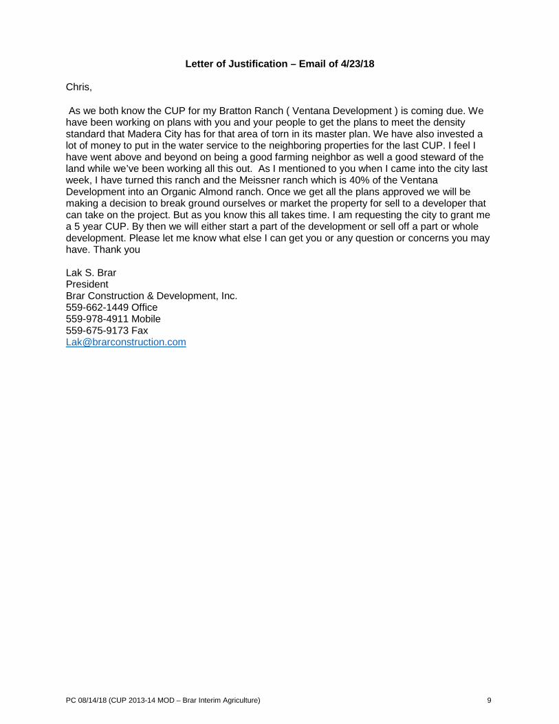
PC 08/14/18 (CUP 2013-14 MOD – Brar Interim Agriculture) 9
Letter of Justification – Email of 4/23/18 Chris, As we both know the CUP for my Bratton Ranch ( Ventana Development ) is coming due. We have been working on plans with you and your people to get the plans to meet the density standard that Madera City has for that area of torn in its master plan. We have also invested a lot of money to put in the water service to the neighboring properties for the last CUP. I feel I have went above and beyond on being a good farming neighbor as well a good steward of the land while we’ve been working all this out. As I mentioned to you when I came into the city last week, I have turned this ranch and the Meissner ranch which is 40% of the Ventana Development into an Organic Almond ranch. Once we get all the plans approved we will be making a decision to break ground ourselves or market the property for sell to a developer that can take on the project. But as you know this all takes time. I am requesting the city to grant me a 5 year CUP. By then we will either start a part of the development or sell off a part or whole development. Please let me know what else I can get you or any question or concerns you may have. Thank you Lak S. Brar President Brar Construction & Development, Inc. 559-662-1449 Office 559-978-4911 Mobile 559-675-9173 Fax [email protected]

CITY OF MADERA PLANNING COMMISSION
Staff Report: Arco Gas Station & Car Wash Modification CUP 2016-36 MOD & Environmental Determination
Item #6 - August 14, 2018 PROPOSAL: An application to amend conditions of approval concerning the sale of beer and wine for off-site consumption in conjunction with the operations of a mini mart to be constructed as part of the operation of an Arco gas station mini-mart. APPLICANT: Millennium Acquisition LLC OWNER: Millennium Acquisition LLC ADDRESS: NEC of Pecan and Madera Ave. APN: 012-133-039 APPLICATION: CUP 2016-36 MOD CEQA: Previously Approved
Mitigated Negative Declaration
LOCATION: The property is located on the northeast corner of the intersection at Pecan Avenue and Madera Avenue (State Route 145). STREET ACCESS: The site proposes access to Pecan Avenue and Madera Avenue. PARCEL SIZE: Approximately 2.16 acres. GENERAL PLAN DESIGNATION: C (Commercial) ZONING DISTRICT: C2 (Heavy Commercial) SITE CHARACTERISTICS: The site is adjacent to vacant commercial land to the north and two (2) gas stations to the west and south. Further north is a Dollar General and the Madera County Office of Education offices. Single family neighborhoods are located east and west of the project site. ENVIRONMENTAL REVIEW: An initial study and Mitigated Negative Declaration have been prepared for consideration by the Commission in conformity with the California Environmental Quality Act (CEQA) guidelines. SUMMARY: The applicant has requested an amendment to the conditions of approval for Conditional Use Permit 2016-36, which require that the off-sale liquor license (Type 20) necessary for the sale of beer and wine in conjunction with the operation of a convenience store be obtained as a transfer license only. The applicant’s search for the required transfer license has been unsuccessful, resulting in a request for an allowance to purchase a new license. The consistent recommendation from City staff has been to uphold the state’s moratorium on the issuance of new Type 20 licenses in Madera County due to oversaturation. The applicant proposes to surrender the allowance to serve beer and wine for on-site consumption in the approved
205 W. Fourth Street Madera CA 93637 (559) 661-5430
Return to Agenda

PC 08/14/18 (CUP 2016-36 MOD – Arco Alcohol Sales) 2
restaurant in order to allow for a new Type 20, necessary to facilitate the development of the project. APPLICABLE CODES AND PROCEDURES MMC § 10-3.901 Heavy Commercial Zones MMC § 10-3.405 Uses MMC § 10-3.1301 Use Permits MMC § 10-3.4.0102 Site Plan Review Applicability The City’s Zoning Ordinance allows for the granting of a use permit by the Planning Commission subject to the Planning Commission being able to make findings that the establishment, maintenance or operation of the use or building will not, under the circumstances of the particular case, be detrimental to the health, safety, peace, morals, comfort and general welfare of persons residing or working in the neighborhood of the use, or be detrimental or injurious to property and improvements in the neighborhood or to the general welfare of the City. If the Commission cannot make the appropriate findings, the use should be denied. Conditions may be attached to the approval of the use permit to ensure compatibility. Project design may be altered and on or off-site improvements required in order to make the project compatible with nearby uses. In addition, the application may be subject to further review, modification or revocation by the Commission as necessary. PRIOR ACTION The Planning Commission took positive action on Conditional Use Permit (CUP) 2016-35, 36, and 37, along with Site Plan Review (SPR) S016-57 at the December 12, 2017 meeting. The three conditional use permits allowed for the sale of beer and wine for on-site consumption in conjunction with a restaurant (Type 41), the sale of beer and wine for off-site consumption in conjunction with a mini mart (Type 20), and a drive-thru car wash. The site plan review accompanied the use permits and guided development of the gas station, mini mart, two quick serve restaurants and drive-thru car wash. The Planning Commission also took positive action on CUP 2017-35, which allowed for the sale of tobacco and tobacco products in conjunction with the operation of the convenience store, at the January 9, 2018 meeting. ANALYSIS Amendment Request Conditional Use Permit 2016-36 was approved as a component of the overall allowance to develop a gas station, convenience store, restaurant and a drive-thru car wash at the northeast corner of Pecan Avenue and Madera Avenue (SR145). In conjunction with the allowance for the sale of beer and wine for off-site consumption, Condition of Approval No. 67 states: “Conditional Use Permit 2016-36 allows for the off-site consumption of beer and wine in conjunction with a mini mart. This entitlement requires a Type 20 ABC license to be obtained as a transfer license only. The license shall only be transferred from another location within the boundaries of Madera County. Modification of the license type requires amendment of Conditional Use Permit 2016-36.” The applicant states that they were not successful in their search for an available existing Type 20 license to purchase and transfer to the project site. In their request for amendment, the applicant states: “After due diligence, Applicant is unable to acquire an existing beer and wine license, and by this application, the Applicant proposes that it be allowed to purchase a new license.” Per Condition No. 67, such an allowance requires amendment of CUP 2016-36.
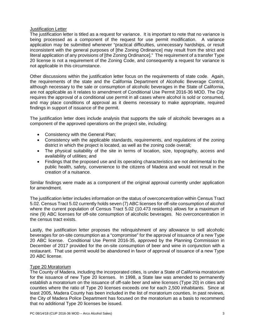
PC 08/14/18 (CUP 2016-36 MOD – Arco Alcohol Sales) 3
Justification Letter The justification letter is titled as a request for variance. It is important to note that no variance is being processed as a component of the request for use permit modification. A variance application may be submitted whenever “practical difficulties, unnecessary hardships, or result inconsistent with the general purposes of [the Zoning Ordinance] may result from the strict and literal application of any provisions of [the Zoning Ordinance].” The requirement of a transfer Type 20 license is not a requirement of the Zoning Code, and consequently a request for variance is not applicable in this circumstance. Other discussions within the justification letter focus on the requirements of state code. Again, the requirements of the state and the California Department of Alcoholic Beverage Control, although necessary to the sale or consumption of alcoholic beverages in the State of California, are not applicable as it relates to amendment of Conditional Use Permit 2016-36 MOD. The City requires the approval of a conditional use permit in all cases where alcohol is sold or consumed, and may place conditions of approval as it deems necessary to make appropriate, required findings in support of issuance of the permit. The justification letter does include analysis that supports the sale of alcoholic beverages as a component of the approved operations on the project site, including:
• Consistency with the General Plan; • Consistency with the applicable standards, requirements, and regulations of the zoning
district in which the project is located, as well as the zoning code overall; • The physical suitability of the site in terms of location, size, topography, access and
availability of utilities; and • Findings that the proposed use and its operating characteristics are not detrimental to the
public health, safety, convenience to the citizens of Madera and would not result in the creation of a nuisance.
Similar findings were made as a component of the original approval currently under application for amendment. The justification letter includes information on the status of overconcentration within Census Tract 5.02. Census Tract 5.02 currently holds seven (7) ABC licenses for off-site consumption of alcohol where the current population of Census Tract 5.02 (10.473 residents) allows for a maximum of nine (9) ABC licenses for off-site consumption of alcoholic beverages. No overconcentration in the census tract exists. Lastly, the justification letter proposes the relinquishment of any allowance to sell alcoholic beverages for on-site consumption as a “compromise” for the approval of issuance of a new Type 20 ABC license. Conditional Use Permit 2016-35, approved by the Planning Commission in December of 2017 provided for the on-site consumption of beer and wine in conjunction with a restaurant. That use permit would be abandoned in favor of approval of issuance of a new Type 20 ABC license. Type 20 Moratorium The County of Madera, including the incorporated cities, is under a State of California moratorium for the issuance of new Type 20 licenses. In 1998, a State law was amended to permanently establish a moratorium on the issuance of off-sale beer and wine licenses (Type 20) in cities and counties where the ratio of Type 20 licenses exceeds one for each 2,500 inhabitants. Since at least 2005, Madera County has been included in the list of moratorium counties. In past reviews, the City of Madera Police Department has focused on the moratorium as a basis to recommend that no additional Type 20 licenses be issued.
PC 08/14/18 (CUP 2016-36 MOD – Arco Alcohol Sales) 4
The Police Department was consulted in conjunction with the applicant’s current request to utilize a new Type 20 license. In a change from past practices, the current recommendations of the Police Department place a greater emphasis on the proposed location and the compatibility of the use within its surroundings as a primary factor in determining the merit of any allowance for the sale and/or consumption of alcohol. This includes situations where either on or off-sale licenses are proposed. After evaluating the characteristics associated with the Arco gas station mini-mart, no unique concerns were identified and the Police Department noted that they had objection to the applicant’s proposal for a new Type 20 license.
State of California Approval of New Type 20 License During Moratorium Although the State ABC initiated the moratorium on issuance of new off-sale (Type 20) licenses, the ABC does provide a process wherein new off-sale licenses can be issued subject to approval of a letter of Public Convenience and Necessity (PCN). If the State approves a PCN in conjunction with an application for a new off-sale license, the moratorium is essentially set aside in the interest of public convenience and necessity. Under this scenario, the State considers and approves the PCN. Notwithstanding any action taken by the State on a PCN, in all cases within the City, a CUP must be approved by the Planning Commission for the sale of alcohol to be allowed. Conclusions For approximately the past decade, staff’s recommendation has been to maintain the state-mandated moratorium on the approval/issuance of new Type 20 ABC licenses. As a general rule, applicants have been required to secure an existing Type 20 license, which was then transferred onto the desired property. Many applicants have successfully located and transferred existing Type 20 licenses. This has not been the directive of the City Council though. The Council policy has been to review each approval on a case by case basis. The Planning Commission has denied issuance of new licenses in the past not so much on the basis of a desire for a new license, but on the overall merit of the project and the relative compatibility of the use within its surroundings. To approve a new Type 20 license based on the overall merit of this project would not set a precedent, but rather would acknowledge the cumulative merit of the project. The Arco project is an excellent development, consistent with the goals and policies of the General Plan, appropriately located for establishment of the desired uses, at a “gateway” intersection where gas stations and travel related services are ideally situated and not in conflict with good planning practice. If completed, the project would create approximately twenty full time jobs. The applicant has made every effort to comply with the license transfer requirement within Condition No. 67. Failing to secure the desired transfer license, the applicant has proposed to relinquish the ability for on-site consumption of beer and wine associated with a restaurant in an effort to be granted the requested amendment allowing for a new Type 20 license in the city. If the Planning Commission approves the requested amendment, conditions of approval which grant the allowance for on-site consumption will be removed. CONSISTENCY WITH THE VISION MADERA 2025 PLAN Though approval of the sale of beer and wine for off-site consumption is not specifically addressed in the vision or action plans, the overall project does indirectly support Action 115.2 – As a component of the General Plan Update, increase retail outlets and promote Shop Madera …; RECOMMENDATION The information presented in this report provides rationales both in support of and in opposition to approval of the conditional use permit amendment request. It is recommended that the

PC 08/14/18 (CUP 2016-36 MOD – Arco Alcohol Sales) 5
Planning Commission consider the information in this report, as well as testimony in the public hearing, and approve the requested amendment of Conditional Use Permit 2016-36. PLANNING COMMISSION ACTION The Planning Commission will be acting on the application to amend the conditions of approval for Conditional Use Permit 2016-36, determining to either:
• approve the application with or without conditions • continue the hearing, or • deny the application.
Any action by the Commission approving or denying the application is subject to appeal to the City Council within 15 calendar days of the Commission’s action. Motion 1: Move to approve Conditional Use Permit 2016-36 MOD, based on and subject to the findings and conditions of approval: Findings - An initial study and mitigated negative declaration have been prepared pursuant to the
California Environmental Quality Act (CEQA) that determines that there is no substantial evidence that the project will have a significant effect on the environment, and that the document reflects the independent judgement of the Planning Commission of the City of Madera after considering all of the information in the record before it, and have been adopted in accordance with CEQA.
- The sale of beer and wine for off-site consumption in conjunction with a mini mart is
consistent with the purposes of the C (Commercial) General Plan designation and the C2 (Heavy Commercial) Zone District which provide for the use, subject to the issuance of a conditional use permit.
- As conditioned, the development will be compatible with surrounding properties. - As conditioned, the establishment, maintenance or operation of the use will not be
detrimental to the health, safety, peace, morals, comfort and general welfare of persons residing or working in the neighborhood of such proposed use, or be detrimental or injurious to property and improvements in the neighborhood or general welfare of the City. The use is deemed to be a compatible use that is consistent with the zoning for the site.
CONDITIONS OF APPROVAL General Conditions 1. Project approval is conditioned upon acceptance of the conditions of approval contained
herein, as evidenced by receipt in the Planning Department of the applicant’s signature upon an Acknowledgement and Acceptance of Conditions within thirty days of the date of approval for these use permits.
2. The applicant’s failure to utilize any of the use permits within one year following the date
of this approval shall render the conditional use permits null and void unless a written request for extension has been submitted to and approved by the Planning Commission.
PC 08/14/18 (CUP 2016-36 MOD – Arco Alcohol Sales) 6
3. Conditional Use Permits 2016-35, 36 and 37 may be made null and void without any additional public notice or hearing at any time upon both the benefactors of the use permits and owners of the property voluntarily submitting to the City a written request to permanently extinguish the conditional use permit.
4. Conditional Use Permits 2016-35, 36 and 37, and Site Plan Review 2016-57 shall be subject to periodic reviews and inspection by the City to determine compliance with the conditions of approval and applicable codes. If at any time, the use is determined by Staff to be in violation of the conditions, staff may schedule a public hearing before the Planning Commission within 45 days of the violation to revoke the permits or modify the conditions of approval.
5. Site Plan Review 2016-57 will expire one year from date of issuance, unless positive action is taken on the project as provided in the Municipal Code and a request to extend the approval is received before the expiration date (Municipal Code Section 10-3.4.0114, Lapse of Site Plan Approval).
6. Any proposed future modifications to the site, including but not limited to, building exteriors, parking/loading areas, fence/walls, new buildings or landscaping shall require an amendment to Site Plan Review 2016-57.
7. It shall be the responsibility of the property owner and management to ensure that any required permits, inspections and approvals from any regulatory agency shall be obtained from the concerned agency prior to establishment of the use.
8. Except as noted herein, all on- and off-site improvements shall be made prior to issuance
of final occupancy of the structures. Approved entitlements (Conditional Use Permit 2016-35, 36 and/or 37) as part of this project shall not be utilized until final occupancy of the structures has been issued by the Building Department.
Building Department 9. A building permit is required for all improvements. The tenant space and outdoor dining
area must meet the requirements of the California Building Code, California Fire Code, and Americans with Disabilities Act prior to occupancy.
10. Current State of California and federal handicap requirements shall apply to the entire site and all structures and parking thereon. Compliance shall be checked at the permit stage and confirmed at final inspection.
Engineering Department General 11. Nuisance onsite lighting shall be redirected as requested by the City Engineer within 48
hours of notification. 12. Impact fees shall be paid at time of building permit issuance. 13. The developer shall pay all required fees for completion of the project. Fees due may
include, but shall not be limited to, the following: plan review, traffic study review, encroachment permit processing, grant/easement deed acceptance and improvement inspection fees.

PC 08/14/18 (CUP 2016-36 MOD – Arco Alcohol Sales) 7
14. The improvement plans for the project shall be signed and sealed by an engineer and shall be submitted to the Engineering Division in accordance with the submittal process.
15. The improvement plans for the project shall include the most recent version of the City’s
General Notes. 16. In the event archeological resources are unearthed or discovered during any construction
activities on site, construction activities shall cease and the Community Development Director or City Engineer shall be notified so that procedures required by State law can be implemented.
17. Improvements within the City right-of-way shall require an encroachment permit from the
Engineering Division. 18. Improvements within the State of California right-of-way require an encroachment permit
from Caltrans. Sewer 19. New sewer service connection(s) shall be constructed to current City standards. 20. Sewer main connections six inches (6”) and larger in diameter shall require manhole
installation. 21. The developer shall reimburse its fair share cost to the City for the previously constructed
sewer main along the entire project frontage, prior to an Encroachment Permit. 22. The existing sewer system that serves this section of the City is approaching or at capacity
due to a constricted section of the sewer system on Pecan Avenue. The developer shall construct the following master plan improvements to accommodate sewer loads for this development:
• A parallel eighteen (18”) inch sewer main on Pecan Avenue along the project parcel frontage. The sewer line shall be constructed between two manholes spaced at typical City of Madera maximum spacing guidelines and at the elevation necessary to allow for connection to future upstream and downstream portions of the system to be constructed at a later date.
This parallel line is 100% reimbursable from Development Impact Fees. Timing of the reimbursement is subject to availability of funds in the appropriate sewer impact fee account at the time reimbursement is requested. In lieu of constructing this improvement, the developer may submit a cash payment equivalent to the cost of construction that will be used by the City to accelerate construction of the full master plan improvement when additional funds become available. Reimbursement of this cash payment will also be subject to full reimbursement following construction of the full master plan sewer improvements between the project site, and Monterey Street and the project site. Storm Drain 23. Storm runoff from this project site is planned to go to the Abshire Basin located northeast
of this project. The developer shall construct sufficient facilities to convey storm runoff to the existing basin and excavate the basin to an amount equivalent to this project’s impact on the basin.
24. A detailed drainage study shall be provided that identifies available capacity and/or
necessary storm drain improvements to convey site runoff to the Abshire Basin. The study

PC 08/14/18 (CUP 2016-36 MOD – Arco Alcohol Sales) 8
shall support the design of proposed drainage conveyance facilities to be constructed by the developer.
Streets 25. The developer shall make a payment of $294.00 for the traffic study review fee. 26. An Irrevocable Offer of Dedication shall be made to dedicate twenty (20’) feet of right-of-
way along the entire project parcel frontage on Pecan Avenue to provide a half-street width of fifty (50’) feet, north of the center line.
27. An Irrevocable Offer of Dedication or dedication deemed by Caltrans shall be made for
additional right-of-way along Madera Avenue (State Route 145) in accordance with that specified by Caltrans through the traffic study currently under review.
28. In addition to typical half-street dedications on Pecan Avenue, an Irrevocable Offer of
Dedication shall be made to dedicate additional right-of-way as may be required for additional improvements as required from the traffic study that, at present, are anticipated to include a separate west-to-north right turn lane.
29. The developer shall dedicate a Public Utility Easement of ten (10’) feet along the entire
parcel frontage on Pecan Avenue and Madera Avenue. 30. Driveway approach(es), one each, along Pecan Avenue and Madera Avenue shall be
constructed to street type entrance with a minimum face of curb radius of fifteen (15’) feet and be constructed to current City and ADA standards. Driveway approaches shall be located as far as possible from the intersection of Pecan Avenue and Madera Avenue.
31. The developer shall record reciprocal ingress/egress easements acceptable to the City of
Madera across those portions of the site necessary to allow shared driveway access points. The easement shall provide mutual right of access for all future developments located to the east and north of the project parcel. The developer shall pay associated fees to the Engineering Department.
32. Throat length for driveways shall be sufficient in length as to reasonably eliminate the
possibility of vehicles queuing into the City right-of-way. 33. The north half of Pecan Avenue and the east half of Madera Avenue along the entire
project frontage shall be improved to a one-hundred (100’) foot arterial street per City of Madera standards. Adequate transitions with the existing improvements relative to grade and alignment shall be provided. In addition to basic City arterial and Caltrans highway improvements, off-site construction requirements including additional lanes are subject to complying with the mitigation measures provided within the traffic study.
34. Unless otherwise agreed by Caltrans as required by the traffic study and other physical
limitations as may be identified, the developer shall be responsible for the construction of median islands on both the Pecan Avenue and Madera Avenue frontages. Subject to limitations that may be identified, construction of a temporary median on Pecan Avenue along the project frontage will be required.
35. The developer shall construct concrete sidewalk, curb and gutter in its ultimate location
along the entire parcel frontage of Pecan Avenue and Madera Avenue per City standards. An unimpeded ADA path of travel shall be maintained at all times.
PC 08/14/18 (CUP 2016-36 MOD – Arco Alcohol Sales) 9
36. The developer shall relocate the signal pole on the northeast corner of Pecan Avenue and Madera Avenue as may be necessary to accommodate street widening.
37. All public utilities shall be undergrounded, except transformers, which may be mounted on
pads. 38. “No Parking” signs shall be installed along the Pecan Avenue and Madera Avenue project
parcel frontage per City standards. 39. The developer shall install street lights along Pecan Avenue and Madera Avenue
frontages in accordance with current City standards. Street lights shall be LED using Beta Lighting standards or equal in accordance with City of Madera standards.
40. The developer shall annex into and execute the documents that may be required to
participate in Landscape Maintenance District Zone 51 for the purposes of participating in the cost of maintaining landscape improvements within said zone.
41. The developer shall construct an ADA ramp at the northeast corner of Pecan Avenue and
Madera Avenue per City and ADA standards. Water 42. Water service connection(s) shall be constructed to current City standards including an
Automatic Meter Reading (AMR) water meter installed within the City right-of-way and backflow prevention device installed within private property.
43. A separate water meter and backflow prevention device shall be required for landscape
area. 44. The developer shall reimburse its fair share cost to the City for the previously constructed
water main along the entire project frontage, prior to an Encroachment Permit. 45. Existing wells, if any, shall be abandoned as directed and permitted by City of Madera for
compliance with state standards. 46. The developer shall extend the existing twelve (12”) inch water main in Pecan Avenue
along the entire project frontage. Dependent upon water pressure requirements, as determined through a water system analysis, the developer may be required to extend from its current termination point at Madera Avenue to a connection point approximately 760 feet east of Madera Avenue. The water main shall be constructed to current City standards.
47. The developer shall construct a fire hydrant along Pecan Avenue per City standards. The
exact location of the fire hydrant shall be approved by the City Engineer. 48. The difference in cost between the eight (8”) inch and 12” water main is eligible for
reimbursement through the impact fee program, regardless of location; adjacent to or beyond the project site limits. Reimbursement requires entering into a reimbursement agreement with the City of Madera. Timing of the reimbursement is dependent upon availability of funds in the water pipes impact fee account at the time reimbursement is requested.

PC 08/14/18 (CUP 2016-36 MOD – Arco Alcohol Sales) 10
Fire Department
49. All fire lanes shall be identified and posted to comply with current California Fire Code (CFC) standards.
50. Portable 2A10BC-rated fire extinguishers shall be required for the mini mart and quick
serve restaurant areas. 4A40BC-rated fire extinguishers shall be required for the dispensing canopy.
51. Building permits are required for all new construction. 52. The kitchen hood and duct suppression systems may be required for the restaurant uses. 53. Dispensing areas shall be provided with all safety signage required in the CFC. 54. The vapor recovery system for the proposed fuel dispensing shall comply with the CFC. 55. A key box shall be required for the proposed structure. 56. On-site and/or off-site fire hydrants shall be required for protection of the project in
accordance with the CFC Appendices B and C. 57. All buildings shall be independently addressed and the addresses shall be plainly visible
from the road providing access to the property. Planning Department General 58. Vandalism and graffiti shall be corrected per the Madera Municipal Code. 59. The applicant shall operate in a manner that does not generate noise, odor, blight or
vibration that adversely affects any adjacent properties. 60. The property owner, operator and manager shall keep the property clear of all trash,
rubbish and debris at all times; and dumping of refuse shall be restricted to the dumpster and refuse containers owned by the property owner. Outdoor storage of goods or materials shall not be allowed.
61. The applicant shall comply with all federal, state and local laws. Material violation of any
of those laws concerning the use will be cause for revocation of these permits. On-Site Consumption of Alcohol (Restaurant) 62. Conditional Use Permit 2016-35 allows for the on-site consumption of beer and wine in
conjunction with a restaurant. This entitlement requires a Type 41 Alcohol Beverage Control (ABC) license to be obtained. Modification of the license type requires amendment of Conditional Use Permit 2016-35.
63. The applicant shall obtain/maintain a Type 41 license from ABC and shall comply with all
applicable ABC requirements. 64. The sale of alcoholic beverages shall be restricted to on-site consumption only in
conjunction with the restaurant. No sale of alcoholic beverages for off-site consumption shall occur as a component of the restaurant’s operations.

PC 08/14/18 (CUP 2016-36 MOD – Arco Alcohol Sales) 11
65. No outdoor consumption of alcoholic beverages shall be allowed at any time as a component of the restaurant.
66. No outdoor dining shall occur on the site without first securing the approval of a conditional
use permit from the Planning Commission to provide for such activity.
67. As a part of the CUP 2016-36 MOD modification request, the allowance for on-site consumption of alcoholic beverages in association with a restaurant as approved in CUP 2016-35 is rendered null and void. Any future allowance of on-site consumption of alcoholic beverages shall require a new application for conditional use permit, wherein the relative merit of a specific request can be considered by the Planning Commission.
Off-Site Consumption of Alcohol (Mini Mart) 68. Conditional Use Permit 2016-36 allows for the off-site consumption of beer and wine in
conjunction with a mini mart. This entitlement requires a Type 20 ABC license to be obtained from the California Department of Alcoholic Beverage Control. as a transfer license only. The license shall only be transferred from another location within the boundaries of Madera County. Modification of the license type requires amendment of Conditional Use Permit 2016-36.
69. The sale of alcoholic beverages shall be restricted to off-site consumption only in
conjunction with the mini mart. No sale of alcoholic beverages for on-site consumption shall be allowed in or occur as a component of the mini mart.
70. There shall be no exterior advertising or signs of any kind or type placed in the exterior
windows or door of the premises promoting or indicating the availability of alcoholic beverages. Signs promoting alcoholic beverages shall not be visible from the exterior of the structure.
71. All indoor display(s) of alcohol beverages shall be located at least five (5’) feet away from
the store entrance. 72. The applicant shall regularly monitor the area under its control to prevent the loitering of
persons about the premises. 73. The applicant shall post signs in the area under its control prohibiting open containers and
loitering at the location, and stating that no loitering will be tolerated. 74. No promotional signage and/or displays promoting alcohol, tobacco and/or tobacco-
related products shall be utilized in any way. 75. The applicant shall post “No Smoking” signage to the extent required by law. 76. There shall be no coin-operated video or arcade games. No adult magazines or videos
shall be sold. 77. Digital security cameras shall be installed to monitor the interior and exterior of the
premises. Footage shall be maintained in a digital format of no less than thirty (30) days. Footage will be shared with law enforcement upon request.
78. Cooler doors for alcoholic beverage products will be locked during hours when alcoholic
beverages may not be sold.

PC 08/14/18 (CUP 2016-36 MOD – Arco Alcohol Sales) 12
79. The sale of beer shall occur in packs of six or greater. However, 24-ounce bottled imported and/or specialty craft beers not normally sold in multi-package containers may be sold individually.
80. The sale of 32-ounce to 40-ounce beer and malt beverage products shall be prohibited. 81. The sale of wine coolers shall occur in no less than packs of four (4). 82. The sale of wine shall not be sold in containers less than 750 ml. 83. No malt liquor or fortified wine products shall be sold. 84. No display of alcohol shall be made from an ice tub, barrel or similar container. 85. No sale or distribution of alcoholic beverages shall be made from a drive-up or walk-up
window. Car Wash 86. Conditional Use Permit 2016-37 allows for the establishment of a drive-thru car wash use
to include six (6) vacuum stations. The proposed use shall be limited to self-service drive-thru car washing, drying and vacuuming; there shall be no outdoor repairs, storage/display of goods or other services, or vehicles for sale.
87. The drive-thru car wash shall have a reclamation or recycling water system. 88. The vacuum stations shall be incorporate three or fewer complementary colors to the car
wash building and/or signage. Building Colors, Materials and Lighting Considerations 89. The construction of buildings approved as part of Site Plan Review 2016-57 shall be
consistent with the approved colors and materials board and representative color section rendering of the proposed building as reviewed and approved by the Planning Commission. Any alteration shall require Planning Commission approval.
90. Address sign designs shall be approved by the Planning Department prior to issuance of
building permits. 91. The specifications and types of exterior lighting fixtures to be installed on the site shall be
submitted to and approved by the Planning Department as a component of building permit issuance. All exterior lighting shall be directed away from adjoining properties and not interfere with the driving safety of vehicular traffic. Exposed bulbs shall not be permitted.
HVAC and PG&E Utility Placement Considerations/Screening Requirements 92. Prior to the issuance of building permits, the applicant is to identify on the site plan the
following information for Planning Department review and approval: • The location of all natural gas and electrical utility meter locations. • The location of all HVAC (heating, ventilation or air conditioning) equipment. • The location of all compressor equipment, and mechanical and electrical
equipment. 93. All electrical/mechanical equipment shall be located in the interior of the proposed new
structure(s) within an electrical/mechanical service room(s) and/or area(s). Transformers may be mounted on pads, per the approval and direction of the Planning Manager.
94. When HVAC equipment is roof-mounted, all equipment placement shall be completely
PC 08/14/18 (CUP 2016-36 MOD – Arco Alcohol Sales) 13
screened from view and architecturally integrated into the roof using roof wells or continuous building perimeter fascia screening. If ground mounted, all HVAC equipment shall be completely screened by a six foot (6’) enclosure constructed so as to match the primary color and material of the structure.
95. Natural gas meter placement shall be screened from public view per Planning Department
approval. 96. Roof access ladders shall be located within the interior of the building. 97. Future placement of roof-mounted equipment, which is not part of this site plan approval,
may require amendment to Site Plan Review 2016-57. 98. All ducts and vents penetrating roofs shall be directed away from the front of public
entrance side(s) of the building using methods to minimize their appearance and visibility from the street. Placements preferred at rear sides of roof ridges. All roof-mounted ducts and vents to be painted matte black or with a color better suited to minimize their appearance.
99. Fire sprinkler risers shall be located within the interior of the building or located out of
public view. Locations shall be approved by the Planning Department prior to the issuance of building permits.
Fences and Walls 100. The developer shall construct a new trash enclosure in conjunction with the construction
of the mini-mart, quick serve restaurant and drive-thru car wash. The trash enclosure shall be constructed of a stucco exterior and painted to match the primary structure. The location of the trash enclosure shall be consistent with the approved site plan.
Landscaping 101. A detailed landscaping and irrigation plan shall be prepared by a licensed landscape
architect, stamped and submitted to and approved by the Planning Department prior to issuance of building permits. The plan shall include:
• Demonstration of compliance with the State of California’s Model Water Efficient
Landscape Ordinance. • Landscaped areas shall be developed along all street frontages, in undeveloped
areas of the property and within the parking field. • On-site landscaping shall meet the minimum standards of five percent (5%) of the
parking lot in permanent landscaping. • Shade trees shall be planted throughout the parking lot, with a minimum of one
tree per five parking spaces. • Landscaped areas are to be provided with permanent automatic irrigation systems. • Landscaped areas shall be protected by raised six-inch (6”) concrete curbing,
except where a reduced standard is allowed by the Planning Manager. • A detailed planting list for landscaping, with the number, size, spacing (where
applicable) and specie of all plantings shall be included as part of the approved landscaping plan prepared by a licensed landscape architect.
102. The property owner shall maintain all landscaping in a healthy and well-manicured
appearance. This includes, but is not limited to; ensuring irrigation equipment is properly operating at all times, trimming and pruning trees and shrubs and replacing dead or unhealthy vegetation with drought tolerant plantings.

PC 08/14/18 (CUP 2016-36 MOD – Arco Alcohol Sales) 14
Parking 103. All parking and loading areas shall be marked and striped to City standards: Perpendicular
(90 degree) parking spaces shall measure a minimum of nine feet (9’) wide by nineteen feet (19’) deep, or seventeen (17’) feet deep when abutting a landscape planter with a minimum of two (2’) foot overhang. No compact stalls shall be incorporated into the parking field. No wheel stops shall be incorporated into the parking field/parking stall layout except where required for compliance with ADA requirements. Minimum drive aisle is twenty-six (26’) feet for primary drive aisles.
104. On-site parking shall be provided at all times in conformance with the Municipal Code.
Further expansion of the use or additional or accessory uses will require the provision of additional parking spaces in compliance with City standards prior to establishment of the use. All required parking shall be permanently maintained with all parking spaces to be shown on plans submitted for building permits. Any modifications in the approved parking layout shall require amendment of Site Plan Review 2016-57.
105. Bicycle parking facilities shall be provided for patrons and employees in accordance with
plans approved by the Planning Department as to number and location. Signage 106. All on-building signage shall be of pan channel letter quality or better and in compliance
with the Sign Ordinance at all times. All signage is required to have an approved Sign Permit issued by the Planning Department per Madera Municipal Code Chapter 10-6.
Air Quality Measurement Requirements 107. The developer shall comply with Regulation VII (Fugitive PM10 Prohibitions) of the San
Joaquin Valley Air Pollution Control District concerning dust suppression during construction of the project. Methods include, but are not limited to; use of water or chemical stabilizers/suppressants to control dust emissions from disturbed area, stock piles and access ways; covering or wetting materials that are transported off-site; limit construction related speeds to 15 mph on all unpaved areas/washing of construction vehicles before they enter public streets to minimize carryout/track out; and cease grading and earth moving during periods of high winds (20 mph or more).
California Department of Transportation (Caltrans) 108. The applicant shall secure a Caltrans encroachment permit in advance of performing any
work in the Madera Avenue (State Route 145) right-of-way. The applicant shall be responsible for all improvements, impact fees and/or mitigation fees identified by Caltrans at the time of issuance of an encroachment permit.
(OR) Motion 2: Move to continue the application for Conditional Use Permit 2016-36 MOD to the September 11, 2018 Planning Commission hearing, based on and subject to the following (specify): (OR) Motion 3: Move to deny the application for Conditional Use Permit 2016-36 MOD based on and subject to the following findings (specify):

PC 08/14/18 (CUP 2016-36 MOD – Arco Alcohol Sales) 15
ATTACHMENTS Aerial Photo Site Plan Floor Plan Elevations (Mini Mart & Restaurants) Applicant Letter of Justification, June 27, 2018

PC 08/14/18 (CUP 2016-36 MOD – Arco Alcohol Sales) 16
Aerial Photo
Pecan Avenue
Mad
era
Aven
ue
N

PC 08/14/18 (CUP 2016-36 MOD – Arco Alcohol Sales) 17
Site Plan
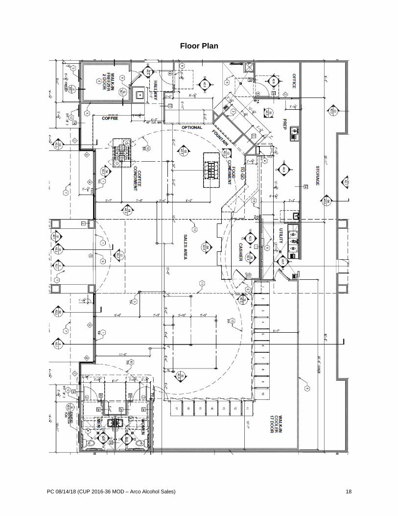
PC 08/14/18 (CUP 2016-36 MOD – Arco Alcohol Sales) 18
Floor Plan

PC 08/14/18 (CUP 2016-36 MOD – Arco Alcohol Sales) 19
Elevations
CITY OF MADERA PLANNING COMMISSION
Staff Report: Mad Fitness #2
CUP 2018-13, SPR 2018-21 & Categorical Exemption Item #7 - August 14, 2018
PROPOSAL: An application for a conditional use permit and site plan review to allow for the establishment of a group fitness training facility and Herbalife café/lounge. APPLICANT: Maria Alvaro OWNER: Niktas John K & Evagelia ADDRESS: 1475 Country Club Drive
Suite103 APN: 003-210-009
APPLICATION: CUP 2018-13 & SPR 2018-21 CEQA: Categorical Exemption
LOCATION: The property is located on the southeast corner of West Clark Street and Country Club Drive. STREET ACCESS: The site has access to West Clark Street and Country Club Drive. PARCEL SIZE: Approximately 0.95 acres GENERAL PLAN DESIGNATION: C (Commercial) ZONING DISTRICT: C1 (Light Commercial) SITE CHARACTERISTICS: The property is a fully improved commercial site. The 8,000 square foot building includes multiple tenant suites. Neighboring tenants include Pizza Hut, a cell phone store, and a hydroponics store. The site is surrounded on all sides by commercial development, most notably Fallas Discount Store to the east. ENVIRONMENTAL REVIEW: The project has been determined to be categorically exempt under the California Environmental Quality Act (CEQA) guidelines, Section 15301, (Existing Facilities). ___________________________________________________________________________ SUMMARY: The fitness component of the Herbalife lounge/café is an evolving piece within the Herbalife business model. The fitness component will include group fitness training much like aerobic/dancing classes. The fitness use would not coincide with the lounge/café use and would subsequently have no impact on the parking required to serve the uses on the site. The proposed use is consistent with the Zoning Ordinance and the General Plan.
205 W. Fourth Street Madera CA 93637 (559) 661-5430
Return to Agenda

PC 08/14/18 (CUP 2018-13 & SPR 2018-21 – Mad Fitness #2) 2
APPLICABLE CODES AND PROCEDURES MMC § 10-3.802 Light Commercial Zones MMC § 10-3.1202, Parking Regulations MMC § 10-3.1301, et seq., Use Permit Procedures The City’s Zoning Ordinance allows for the granting of a use permit by the Planning Commission subject to the Planning Commission being able to make findings that the establishment, maintenance or operation of the use or building will not, under the circumstances of the particular case, be detrimental to the health, safety, peace, morals, comfort and general welfare of persons residing or working in the neighborhood of the use, or be detrimental or injurious to property and improvements in the neighborhood or to the general welfare of the City. If the Commission cannot make the appropriate findings, the use should be denied. Conditions may be attached to the approval of the use permit to ensure compatibility. Project design may be altered and on or off-site improvements required in order to make the project compatible with nearby uses. In addition, the application may be subject to further review, modification or revocation by the Commission as necessary. PRIOR ACTION The existing site was developed in accordance with Site Plan Review 1990-11 which allowed for the development of an 8,000 square foot commercial building that was divided into five (5) suites. A number of use permits have been issued throughout the building’s tenant suites. Although it is unclear whether the project suite has previously been part of an entitlement approval, the building has seen entitlement approvals for the establishment of alcohol sales through for Conditional Use Permit 1992-18 & Conditional Use Permit 2001-10, and arcade uses though Conditional Use Permit 1993-29 and Conditional Use Permit 1997-25. The building suite has also been utilized for a martial arts studio as approved through Conditional Use Permit 1996-10. ANALYSIS Background According to the property owner, the project suite has been vacant for an extended period of two years. In 2015, there was a proposal to utilize the proposed suite as a lingerie store. The entitlement process was discontinued upon the property owner’s request before the scheduled Planning Commission meeting. The site has remained untouched since 2015. Operations The applicant of Mad Fitness #2 is proposing to utilize an existing 1,200 square foot tenant suite for group fitness training and exercises in conjunction with the preparation and sale of Herbalife herbal drinks and shakes. Approximately 576 square feet of the suite’s total square footage will be dedicated for fitness training. The remaining square footage will be dedicated for a lounge area and preparation of Herbalife drinks. The lounge area is proposed to accommodate six (6) guests for post-training patrons. The fitness component will entail hour-long group sessions ranging from 5 and up to 15 patrons per session. Contingent on the demand for sessions, the applicant is proposing up to three sessions per day. Fitness trainees will utilize equipment such as free weights, exercise balls and bands and mats. Other fitness segments will include aerobic exercises/dancing. The applicant is proposing to use a portable speaker for music during sessions at a level that will not

PC 08/14/18 (CUP 2018-13 & SPR 2018-21 – Mad Fitness #2) 3
disturb neighboring tenants. Hours of operation are proposed to occur as early as 5:00 AM and as late as 9:00 PM, seven days a week. The hours of operation and the proposed noise level is not anticipated to be of significant concern for the surrounding commercial developments. The attached recommended conditions of approval will facilitate the compliance of the group fitness training use in conjunction with the sale of Herbalife drinks. Parking The site was developed with thirty-five (35) parking stalls to serve the site including two (2) handicap parking stalls. The parking ordinance requires that the fitness use provide one parking stall for every 200 square feet of gross floor area, or at a rate of one stall per three (3) students, and one (1) stall for every two employees, whichever is greater. The use will require six (6) parking stalls when applying either of the criteria to the suite’s use. Cumulative, there is sufficient parking on the site for all the current uses. Individual parking stall requirements for the various uses are as followed: Business Name Business
Use Parking Ration Total # of Units # of Parking
Stall Required Cricket Wireless Retail 1 stall per 300 sf 3,000 sf 10 Hands-on Hydroponics
Retail 1 stall per 300 sf 1,260 sf 4.2
Mad Fitness #2 Fitness 1 stall per 3 students, 1 stall per 2 employees
1,200 sf 6
Family Cloths Retail 1 stall per 300 sf 1,260 sf 4.2 Pizza Hut Retail/Food 1 stall per 300 sf 1,280 sf 4.2 Total parking stalls required 29 Total parking stalls provided 35 Site Improvements This proposed conditional use permit was reviewed by various City Departments and outside agencies. The responses and recommendations have been incorporated into the recommended conditions of approval included in this report. The recommended improvements will bring the site into compliance with current City standards. CONSISTENCY WITH THE VISION MADERA 2025 PLAN The proposed business will offer residents a place to exercise. Madera 2025 Goal HS-2 states “A healthy and fit population with access to healthcare, healthful food, and places to be active and exercise.” RECOMMENDATION The information presented in this report supports conditional approval of the use permit and site plan review request. PLANNING COMMISSION ACTION The Planning Commission will be acting on the Use Permit and minor Site Plan Review to allow for the establishment of a fitness facility, determining to either:
• approve the applications with or without conditions • continue the hearing, or

PC 08/14/18 (CUP 2018-13 & SPR 2018-21 – Mad Fitness #2) 4
• deny the applications
Any action by the Commission approving or denying the application is subject to appeal to the City Council within 15 calendar days of the Commission’s action. Motion 1: Move to approve Conditional Use Permit 2018-13 and Site Plan Review 2018-21, based on and subject to the findings and conditions of approval: Findings - This project is categorically exempt under Section 15301, Existing Facilities, of
the California Environmental Quality Act (CEQA) since there will be no expansion of the existing structure.
- The establishment of a fitness facility is consistent with the purposes of the C (Commercial) General Plan designation and the C1 (Light Commercial) Zone District which provide for the use, subject to the issuance of a conditional use permit.
- As conditioned, there is adequate parking and site features to allow for the
proposed uses. - As conditioned, the development will be compatible with surrounding properties. - As conditioned, the establishment, maintenance or operation of the use will not
under the circumstances of this particular case, be detrimental to the health, safety, peace, morals, comfort and general welfare of persons residing or working in the neighborhood of such proposed use or be detrimental or injurious to property and improvements in the neighborhood or general welfare of the City.
CONDITIONS OF APPROVAL General Conditions 1. Project approval is conditioned upon acceptance of the conditions of approval contained
herein, as evidenced by receipt in the Planning Department of the applicant’s signature upon an Acknowledgement and Acceptance of Conditions within thirty (30) days of the date of approval for this use permit.
2. The applicant’s failure to utilize Conditional Use Permit 2018-13 within one year
following the date of this approval shall render the conditional use permit null and void unless a written request for an extension has been submitted to and approved by the Planning Department.
3. Conditional Use Permit 2018-13 will expire and be rendered null and void if the use is discontinued for a twelve-month period unless a written request for extension has been submitted to and approved by the Planning Commission.
4. Site Plan Review 2018-21 will expire one year from date of issuance unless positive
action is taken on the project as provided in the Municipal Code or required action is taken to extend the approval before the expiration date (Municipal Code Section 10-3.4.0114, Lapse of Site Plan Approval).

PC 08/14/18 (CUP 2018-13 & SPR 2018-21 – Mad Fitness #2) 5
5. The use permit may be made null and void without any additional public notice or hearing at any time upon both the benefactors of the use permit and owners of the property voluntarily submitting to the City a written request to permanently extinguish the conditional use permit.
6. This use permit shall be subject to periodic reviews and inspection by the City to
determine compliance with the conditions of approval and applicable codes. If at any time, the use is determined by Staff to be in violation of the conditions of approval, Staff may schedule a public hearing before the Planning Commission within 45 days of the violation to consider revocation of the permit.
7. The site or building plans submitted for any building permit applications shall reflect changes required by the herein listed conditions of approval. Any deviation from the approved plan or any condition contained herein shall require, at a minimum, a prior written request by the applicant and approval by the Planning Manager.
8. Any proposed future modifications to the site, including but not limited to building exteriors, parking/loading areas, fence/walls, new buildings or landscaping shall require an amendment to this site plan review.
9. It shall be the responsibility of the property owner and management to ensure that any required permits, inspections and approvals from any regulatory agency shall be obtained from the concerned agency prior to the establishment of the use.
Building Department 10. Site development shall be consistent with the approved site plan and floor plan. The
uses of all rooms and activity areas shall be identified on any plans submitted for issuance of building permits.
11. Current State of California and federal handicap requirements shall apply to the entire
site and all structures and parking thereon. Compliance shall be checked at permit stage, shall be confirmed at final inspection and shall apply to proposed and future development.
12. Additional items identified as not complying with current codes and ordinances which require correction or attention may be identified. Any item not in conformance with current codes and ordinances must be corrected.
Engineering Department General 13. Onsite nuisance lighting be redirected as requested by City Engineer within 48 hours of
notification.
14. The developer shall pay all required fees for completion of project. Fees due may include but shall not be limited to the following: encroachment permit processing and improvement inspection fees.
15. Improvement plans shall be submitted to the Engineering Division in accordance with the submittal process.
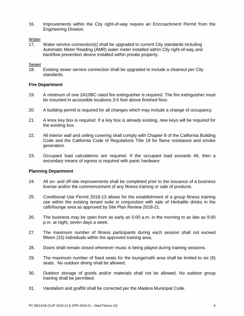
PC 08/14/18 (CUP 2018-13 & SPR 2018-21 – Mad Fitness #2) 6
16. Improvements within the City right-of-way require an Encroachment Permit from the Engineering Division.
Water 17. Water service connection(s) shall be upgraded to current City standards including
Automatic Meter Reading (AMR) water meter installed within City right-of-way and backflow prevention device installed within private property.
Sewer 18. Existing sewer service connection shall be upgraded to include a cleanout per City
standards.
Fire Department 19. A minimum of one 2A10BC rated fire extinguisher is required. The fire extinguisher must
be mounted in accessible locations 3-5 feet above finished floor. 20. A building permit is required for all changes which may include a change of occupancy.
21. A knox key box is required. If a key box is already existing, new keys will be required for
the existing box.
22. All interior wall and ceiling covering shall comply with Chapter 8 of the California Building Code and the California Code of Regulations Title 19 for flame resistance and smoke generation.
23. Occupant load calculations are required. If the occupant load exceeds 49, then a secondary means of egress is required with panic hardware.
Planning Department 24. All on- and off-site improvements shall be completed prior to the issuance of a business
license and/or the commencement of any fitness training or sale of products. 25. Conditional Use Permit 2018-13 allows for the establishment of a group fitness training
use within the existing tenant suite in conjunction with sale of Herbalife drinks in the café/lounge area as approved by Site Plan Review 2018-21.
26. The business may be open from as early as 5:00 a.m. in the morning to as late as 9:00 p.m. at night, seven days a week.
27. The maximum number of fitness participants during each session shall not exceed
fifteen (15) individuals within the approved training area.
28. Doors shall remain closed whenever music is being played during training sessions.
29. The maximum number of fixed seats for the lounge/café area shall be limited to six (6) seats. No outdoor dining shall be allowed.
30. Outdoor storage of goods and/or materials shall not be allowed. No outdoor group
training shall be permitted.
31. Vandalism and graffiti shall be corrected per the Madera Municipal Code.
PC 08/14/18 (CUP 2018-13 & SPR 2018-21 – Mad Fitness #2) 7
32. The abandoned public pay phone on the site shall be removed. 33. The applicant shall operate in a manner that does not generate significant noise, odor or
vibration that adversely affects any adjacent properties. 34. The property owner, operator and manager shall keep the property clear of all trash,
rubbish and debris at all times; and dumping of refuse shall be restricted to the dumpster/refuse containers obtained from the City.
35. The applicant shall comply with all federal, state and local laws. Material violation of any applicable laws concerning the use will be cause for revocation of this permit.
36. The hosting of special events and competitions is not allowed for by this use permit. At
no time shall the occupancy of the space exceed the occupancy load as determined by the Fire Official.
37. On-site parking shall be provided at all times in conformance with the Municipal Code.
All required parking shall be permanently maintained. 38. The property owner shall maintain all landscaping in a healthy and well-manicured
appearance to achieve and maintain the landscaping design that was approved by the City. This includes, but is not limited to, ensuring properly operating irrigation equipment at all times, trimming and pruning of trees and shrubs, and replacing dead or unhealthy vegetation. All unmaintained landscaping on the property shall be rehabilitated.
39. All signage shall be in compliance with the Madera Sign Ordinance. All signage is
required to have an approved Sign Permit issued by the Planning Department per MMC §10-6.
(OR) Motion 2: Move to continue the application for Conditional Use Permit 2018-13 and Site Plan Review 2018-21 to the September 11, 2018 Planning Commission meeting. (OR) Motion 3: Move to deny the application for Conditional Use Permit 2018-13 and Site Plan Review 2018-21, based on the following findings: (specify) ATTACHMENTS Aerial Photo Site Plan as submitted
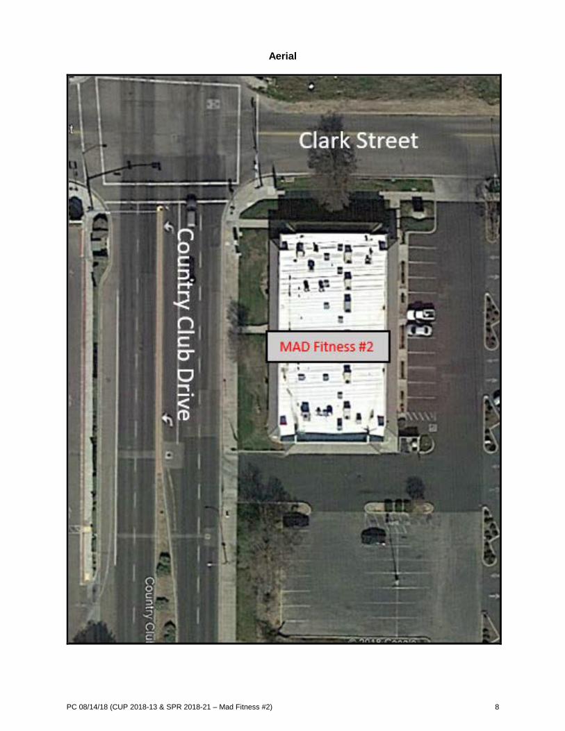
PC 08/14/18 (CUP 2018-13 & SPR 2018-21 – Mad Fitness #2) 8
Aerial
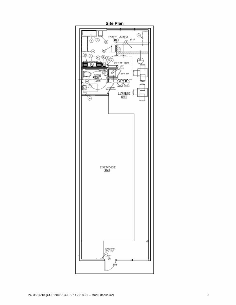
PC 08/14/18 (CUP 2018-13 & SPR 2018-21 – Mad Fitness #2) 9
Site Plan

CITY OF MADERA PLANNING COMMISSION
Staff Report: Walmart Sign Variance VAR 2018-02 and Environmental Determination
Item #8 - August 14, 2018 PROPOSAL: An application for a variance from the sign ordinance of the Madera Municipal Code pertaining to on-building signage for Walmart to allow for 563 square feet of on-building signage where 325 square feet of on-building signage is allowed per the Sign Regulations. APPLICANT: Sarah Smith OWNER: Walmart ADDRESS: 1977 West Cleveland Avenue APN: 013-160-014 APPLICATIONS: VAR 2018-02 CEQA: Categorically Exempt
LOCATION: The project site is located adjacent to the Madera Marketplace shopping center, situated on the northeast corner of the intersection of North Schnoor Avenue and West Cleveland Avenue. STREET ACCESS: Access to the project site is provided from North Schnoor Avenue and West Cleveland Avenue. PARCEL SIZE: One parcel encompassing approximately 12.30 acres. GENERAL PLAN DESIGNATION: C (Commercial) ZONING DISTRICT: C1 (Light Commercial) SITE CHARACTERISTICS: The Madera Marketplace shopping center is substantially surrounded by developed commercial/retail properties, with the Commons at Madera Fairgrounds shopping center to the south and John Deere equipment dealer to the east. ENVIRONMENTAL REVIEW: The project has been determined to be categorically exempt under the California Environmental Quality Act (CEQA) guidelines, Section 15311(a) (Accessory Structures). SUMMARY: Walmart has requested a variance from the sign ordinance of the Madera Municipal Code pertaining to on-building signage in order to allow for a total of 563 square feet of on-building signage where 325 square feet would normally be allowed. Earlier this year, Walmart erroneously received approval of a sign permit for 439 square feet of on-building signage as part of a store remodeling. This overage of signage occurred when staff erroneously applied the Madera Marketplace master sign program when calculating allowable signage. The allowance should have been for a maximum of 325 square feet. The allowance for 563 square feet (238 square feet more than the maximum allowed), requires approval of a variance from the requirements of the sign ordinance of the Madera Municipal Code by the Planning Commission.
205 W. Fourth Street Madera CA 93637 (559) 661-5430
Return to Agenda
PC 08/14/18 (VAR 2018-02 – Walmart Sign Variance) 2
APPLICABLE CODES AND PROCEDURES MMC § 10-3.1401 Variances MMC § 10-6.01 Sign Regulations – Purpose and Intent MMC § 10-6.19 Minor Adjustments and Variances The sign ordinance can have an obvious impact on the character, quality, and economic health of the City of Madera. As a prominent part of the scenery, signs may attract the viewing public, help set the visual tone of the community, and affect the safety of vehicular and pedestrian traffic. Application of the sign ordinance prevents the degradation of the visual quality of the City which can result from the proliferation of excessive amounts of signage, poorly designed signage, inappropriately located signage, and/or signage maintained in a hazardous or unsightly fashion. A sign variance may be granted by the Planning Commission where practical difficulties, unnecessary hardships, or results that are inconsistent with the general purposes of the Zoning Ordinance may result from the strict and literal application of any of the provisions of the ordinance. If the Commission cannot make the appropriate findings, the variance request should be denied. Conditions may be attached to the approval of the variance to ensure compatibility. Project design may be altered and on or off-site improvements required in order to make the project compatible with nearby uses. PRIOR ACTION Since development of the Madera Marketplace shopping center, numerous use permits and zoning administrator permits have been approved to allow outdoor display and sale of merchandise, and outdoor storage of merchandise. Each year for the past few years use permits have been approved for the temporary placement of shipping containers for merchandise storage during the holiday season. ANALYSIS Background The Madera Marketplace shopping center has an approved master sign program (MSP) which, unless otherwise noted within the program, is the lead document for signage requirements for businesses located within the shopping center. The Madera Marketplace MSP allows for 1.5 square feet of on-building signage for each lineal foot of store frontage for all tenant suites and pad tenants, which would result in an allowance for 615 square feet of on-building sign area for Walmart. Walmart recently received approval of a sign permit to allow for 439 square feet of on-building sign area in conjunction with an exterior fascia remodel. Further analysis of the master sign program found that for major tenants, “The provisions of this sign criteria shall not be applicable to identification signs of occupancies designated by the Landlord as major tenants. These tenants may install their standard signage which appears on buildings operated by them in California providing the signs are architecturally compatible and have been approved by the Landlord and the City of Madera.” Because Walmart is a major tenant, the sign requirements of the Master Sign Program are not applicable Walmart signage should comply with the sign ordinance of the Madera Municipal Code and not the Madera Marketplace MSP. The sign ordinance allows for a maximum of two-hundred (200) square feet of on-building signage for businesses in a commercial zone district, and up to an additional one-hundred (100) square feet may be allowed by the Planning Manager for buildings over 100,000 square feet. A bonus of twenty-five (25) square feet is also applicable, bringing the total allowable on-building sign area to 325 square feet. As part of the ongoing remodel of Walmart, staff misinterpreted the MSP and erroneously made an allowance for 439 square feet of on-building signage. Shortly after the sign permit approval, a representative for Walmart provided new exhibits inquiring about increasing the on-building sign area to 563 square feet.
PC 08/14/18 (VAR 2018-02 – Walmart Sign Variance) 3
This proposal nearly doubles the amount of allowable on-building sign area for Walmart, requiring the approval of a variance from the sign ordinance of the MMC. Justification Letter The applicant’s justification letter describes the building size and location of the building as the practical difficulty that should allow for the business to have additional on-building signage. The letter states, “If signs were made smaller in order to accommodate more signage in the allowed amount of sqft, the signs would be too small to be seen from the street and would look disproportional to the large walls that they sit on.” The applicant believes that the sign ordinance is too strict for the size and location of their building. Variance Necessity There are two (2) findings that need to be made in order to be able to grant a variance. The ordinance states those findings as follows:
1. Where practical difficulties, unnecessary hardships, or results inconsistent with the general purposes of this chapter may result from the strict and literal application of any of the provisions of this chapter, a variance may be granted as provided in this subchapter.
2. Variances shall be granted only when, because of special circumstances applicable to the
property, including size, shape, topography, location, or surroundings, the strict application of the zoning regulations deprives such property of privileges enjoyed by other property in the vicinity under identical zoning classifications. Any variance granted shall be subject to such conditions as will assure that the adjustment thereby authorized shall not constitute a grant of special privileges inconsistent with the limitations upon other properties in the vicinity and zone in which such property is located.
Justification for Variance The Walmart building is one of the largest standalone buildings within a commercial shopping center in the City of Madera. Larger signage is expected on larger buildings in order to provide for a proportionately-scaled design that enhances the aesthetics of the building, consistent with the purpose and intent of the sign ordinance. Walmart provides additional services, such as a lawn and garden area, a pharmacy, and pick-up/drop-off area. On-building signage depicting these additional services is typical for a business to promote and they were approved as a component of Walmart’s recently approved sign permit. Although these signs are smaller than the primary Walmart signage, they are large in relation to other business’ signs because of the large size of the building. Walmart’s proposed addition to their recently installed on-building signage is a sign located on the elevation of the building that faces West Cleveland Avenue. It is one of the two primary elevations and it has been a blank wall since Walmart’s original construction. The sign complies with the purpose and intent of the sign ordinance, enhancing the aesthetic value of the building and it is proportionate to the size of the building. Staff supports approval of the variance from the sign ordinance to allow for an additional 238 square foot on-building sign because the limitations for a maximum of 325 square feet of on-building signage for this business would result in signs that are disproportionate to the size of the building providing inconsistency with the purpose and intent of the sign ordinance. RECOMMENDATION The information presented in this report supports approval of the variance. It is recommended that the Planning Commission consider the information in this report, together with testimony provided during the public hearing, and approve Variance 2018-02 subject to the findings and conditions of approval outlined in this report.

PC 08/14/18 (VAR 2018-02 – Walmart Sign Variance) 4
PLANNING COMMISSION ACTION The Planning Commission will be acting on the request for Variance 2018-02, determining to either:
• approve the application with or without conditions • continue the hearing, or • deny the application
Any action by the Commission approving or denying the application is subject to appeal to the City Council within fifteen (15) calendar days of the Commission’s action: Motion 1: Move to approve the application for Variance 2018-02 based on and subject to the findings and conditions of approval as listed. Findings: - This project is categorically exempt under Section 15311(a) (Accessory Structures) of the
California Environmental Quality Act (CEQA) which specifically exempts on-premises signs. - As conditioned, an allowance for additional signage in the C1 (Light Commercial) Zone District
will be compatible with the surrounding properties because its placement will not negatively impact adjoining commercial properties.
- Because the limitations for a maximum of 325 square feet of on-building signage for this business
would result in signs that are disproportionate to the size of the building providing inconsistency with the purpose and intent of the sign ordinance., a variance may be granted to allow for additional signage.
- As conditioned, the establishment, maintenance or operation of the proposed signage will not
under the circumstances of this particular case, be detrimental to the health, safety, peace, morals, comfort and general welfare of persons residing or working in the neighborhood of such proposed use, or be detrimental or injurious to property and improvements in the neighborhood or general welfare of the City.
CONDITIONS OF APPROVAL Planning Department On-Building Signage 1. Signage shall be consistent with the elevations included as part of the application for VAR 2018-02. (OR) Motion 2: Move to continue the public hearing for VAR 2018-02 to the September 11, 2018 Planning Commission hearing, to allow the following information to be provided or for the following reason(s): (specify) (OR) Motion 3: Move to deny the application for Variance 2018-02 based on the following findings: (specify)

PC 08/14/18 (VAR 2018-02 – Walmart Sign Variance) 5
ATTACHMENTS Aerial Imagery Applicant Justification Letter Elevations with Signage

PC 08/14/18 (VAR 2018-02 – Walmart Sign Variance) 6
Aerial Photo
N
Cleveland Avenue

PC 08/14/18 (VAR 2018-02 – Walmart Sign Variance) 7
Applicant Justification Letter

PC 08/14/18 (VAR 2018-02 – Walmart Sign Variance) 8
Applicant Justification Letter (cont.)

PC 08/14/18 (VAR 2018-02 – Walmart Sign Variance) 9
Applicant Justification Letter (cont.)

PC 08/14/18 (VAR 2018-02 – Walmart Sign Variance) 10
Elevations with Signage

PC 08/14/18 (VAR 2018-02 – Walmart Sign Variance) 11
Elevations with Signage (cont.)
CITY OF MADERA PLANNING COMMISSION
Staff Report: Non-Conforming Secondary Structure Setback VAR 2018-03 and Environmental Determination
Item #9 - August 14, 2018 PROPOSAL: An application for a variance from the interior side yard setback standards of the Madera Municipal Code to allow for a two-foot and four-inches (2’-4”) interior side yard setback where a minimum of five (5’) feet is required. APPLICANT: Ken & Linda McCullough OWNER: Ken & Linda McCullough ADDRESS: 201 ½ Stadium Road APN: 012-091-009 APPLICATIONS: VAR 2018-03 CEQA: Categorically Exempt LOCATION: The property is located on the 200 Block of Stadium Road on the northeast intersection of Stadium Road and Maple Street. STREET ACCESS: Stadium Road PARCEL SIZE: Approximately 11,770 square feet GENERAL PLAN DESIGNATION: MD (Medium Density Residential) ZONING DISTRICT: R1 (Residential) SITE CHARACTERISTICS: The property in question was developed with two dwelling units. A Madera Unified School District educational facility is located directly north of the property. Single-family residences are located to the south and east, with multi-family dwelling units located to the west of the property, across Stadium Road. ENVIRONMENTAL REVIEW: The project has been determined to be categorically exempt under the California Environmental Quality Act (CEQA) guidelines, Section 15305 as a “Minor Alterations in Land Use Limitations”. SUMMARY: The applicant is requesting approval of a variance for an existing secondary structure constructed prior to the adoption of the Zoning Ordinance of the Madera Municipal Code and the subsequent development standards for the R1 (Residential) Zone District. The granting of a variance requires findings that unique or unnecessary hardships exist as a result of a strict or literal interpretation of the Zoning Ordinance or when special circumstances applicable to the property exist which do not constitute a special privilege to the applicant.
205 W. Fourth Street Madera CA 93637 (559) 661-5430
Return to Agenda

PC 08/14/18 (VAR 2018-03 – Non-Conforming Secondary Structure) 2
APPLICABLE CODES AND PROCEDURES MMC § 10-3.1401 Variances Necessity MMC § 10-3.1401 Variances Necessary Conditions A variance may be granted by the Planning Commission where practical difficulties, unnecessary hardships, or results that are inconsistent with the general purposes of the Zoning Ordinance may result from the strict and literal application of any of the provisions of the ordinance. Necessary conditions for granting a variance can only occur when, because of special circumstances applicable to the property, including size, shape, topography, location, or surroundings, the strict application of the Zoning Ordinance deprives a property owner of privileges enjoyed by other property in the vicinity under identical zoning classification. If the Commission cannot make the appropriate findings, the variance request should be denied. Conditions may be attached to the approval of the variance to ensure compatibility. Project design may be altered and on or off-site improvements required in order to make the project compatible with nearby uses. PRIOR ACTION Several building permits have been secured throughout the years for general maintenance and repairs with no prior discretionary action being taken on the property. ANALYSIS Requirement for a Variance Current R1 (Residential) Zone District development standards require that interior side yard setbacks be at a minimum of five (5’) feet between a structure and the property line. On a case by case basis, a Zoning Administrator Permit allows for structures to encroach into the required five (5’) foot setback by up-to two (2’) feet which result in a three (3’) foot setback. In this case, a residential structure built prior to the adoption of the Zoning Ordinance was built two-feet and four-inches (2’- 4”) from the interior side yard property line resulting in an existing non-conforming condition. Noting that a Zoning Administrator Permit cannot remedy the non-conformance of the structure, a variance from the current development standards is required to cure the existing non-conforming condition. Request for a Variance When the current property owners took ownership in the early 1990’s, the non-conforming issue with the secondary structure’s setback was not identified. It was not until a request for entitlement information on the property that the secondary structure’s interior side yard setback was discovered to be non-conforming with the current R1 (Residential) Zone District development standards.

PC 08/14/18 (VAR 2018-03 – Non-Conforming Secondary Structure) 3
The property owners are requesting a variance from the R1 (Residential) Zone District development standards to memorialize a two-foot and four-inch (2’- 4”) interior side yard setback where a minimum of five (5’) feet is required. The property owners have indicated interest in selling the property in the near future. Where this might not normally be problematic, it becomes an issue when a house is placed for sale. Since “grandfathered” structures can’t be reconstructed if damaged by greater than 75 percent of appraised value, lenders will not fund loans for the sale of the property. Approval of the variance would remedy the dilemma and allow for a sale transaction to be completed. Justification for Request County Assessor records indicate the property was developed with two units during 1953. The adoption of the City’s Municipal Code which stipulates setback requirements for R1 (Residential) development standards was not adopted until 1961. Therefore, setback requirements during the property’s original construction were not applicable. In addition, with no abutting building in proximity to the structure in question, there was no concern as to the secondary structure’s placement. Cumulatively, there are practical difficulties, unnecessary hardships, and results that are inconsistent with the general purposes of the Zoning Ordinance that validate the request for a variance from the residential setback standard of the Zoning Ordinance. The home’s placement occurred prior to the adoption of the Zoning Ordinance and it would constitute a hardship for the property owner to now have to relocate the structure within the required setbacks. Staff can make findings in support of granting the variance. As a condition of approval, it is recommended that the structure satisfy the requirements of the Building and Fire Code for structures constructed closer than five feet from property lines. It is anticipated that minimal improvements to the structure will be necessary to satisfy code. RECOMMENDATION The information presented in this report supports approval of the variance. It is recommended that the Planning Commission consider this information, together with testimony provided during the public hearing, and make a decision regarding the project. PLANNING COMMISSION ACTION: The Planning Commission will be acting on the variance. Motion 1: Move to approve the application for Variance 2018-03 based on and subject to the findings and conditions of approval as listed. Findings:
- The variance allows for a two-feet and four-inches (2’- 4”) interior side yard setback where a
minimum of five (5’) feet is required per the Municipal Code.
- The use, as conditioned, does not constitute a special privilege not enjoyed by others in the same circumstances.
- At the time of original construction, development standards for interior side yard setbacks had not been adopted. Subsequent the secondary structure was “grandfathered” in as an existing nonconforming structure.
- To relocate the structure now would come at great expense while not providing any additional benefit to the property or surrounding properties.

PC 08/14/18 (VAR 2018-03 – Non-Conforming Secondary Structure) 4
- The granting of a variance from the setback standards of the R (Residential) Zone District resolves practical difficulties and also resolves an unnecessary hardship, providing a result that is consistent with the general purposes of the Zoning Ordinance.
Conditions of Approval:
1.) The structure shall satisfy the requirements of the Building and Fire Code, sufficient to provide the appropriate fire rating for structures constructed closer than five (5’) feet from property lines.
(OR) Motion 2: Move to continue the public hearing for Variance 2018-03 to September 11, 2018, to allow
the following information to be provided or for the following reason(s): (specify) (OR) Motion 3: Move to deny the application for Variance 2018-03 based on the following findings: (specify) ATTACHMENTS Ariel Photo Applicant Justification Letter
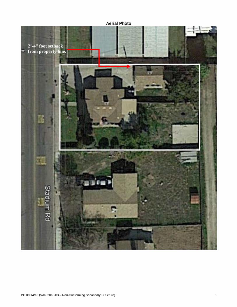
PC 08/14/18 (VAR 2018-03 – Non-Conforming Secondary Structure) 5
Aerial Photo
2’-4” foot setback from property line.

PC 08/14/18 (VAR 2018-03 – Non-Conforming Secondary Structure) 6
Applicant Justification Letter

PC 08/14/18 (VAR 2018-03 – Non-Conforming Secondary Structure) 7

CITY OF MADERA PLANNING COMMISSION
Staff Report: United Rentals Fence Variance VAR 2018-04, SPR 2018-23 and Environmental Determination
Item #10 - August 14, 2018 PROPOSAL: An application for a variance from the Section 10-3.412 (Fences, Walls, and Hedges) of the Madera Municipal Code to allow for a ten (10’) foot tall electrical security fence where only a maximum of six (6’) feet in height is allowed. A site plan review is required to accompany the variance to bring the site up to a current City standard. APPLICANT: Keith Kaneko – Electric Guard Dog OWNER: US Rentals Inc ADDRESS: 750 Madera Avenue APN: 012-133-015 APPLICATIONS: VAR 2018-04 & SPR 2018-23 CEQA: Categorically Exempt
LOCATION: The project site is located at the northwest corner of the intersection of Madera Avenue and West Almond Avenue. STREET ACCESS: Access to the project site is provided from Madera Avenue and West Almond Avenue. PARCEL SIZE: One parcel encompassing approximately 1.39 acres. GENERAL PLAN DESIGNATION: C (Commercial) ZONING DISTRICT: C1 (Light Commercial) SITE CHARACTERISTICS: The project site is generally surrounded by residential uses to the north, and commercial and office uses to the south and east. The project site is adjacent to a ponding basin to the north, a tractor sales store to the south, a gas station to the east and storage yards to the west. ENVIRONMENTAL REVIEW: The project has been determined to be categorically exempt under the California Environmental Quality Act (CEQA) guidelines, Section 15311 (Accessory Structures). SUMMARY: United Rentals proposes to install an electrical fence, ten (10’) feet in height, to deter theft that has occurred on the property over time. The ordinance allows for a maximum of six (6’) feet in height for fences. The location and surroundings of the property create an ease of theft that other properties in the vicinity with identical zoning do not suffer from. The property provides more than one access point as a corner lot and abuts a ponding basin that is secured by a six (6’) foot chain link fence. Recent thefts have occurred on the site because the fence surrounding the ponding basin can be easily compromised, subsequently providing a point of entry onto the project site. Staff believes the electrical component of the fence should be limited along the northern and western property lines and not permitted along the street frontages.
205 W. Fourth Street Madera CA 93637 (559) 661-5430
Return to Agenda

PC 08/14/18 (VAR 2018-04 & SPR 2018-23 – United Rentals Fence Variance) 2
APPLICABLE CODES AND PROCEDURES MMC § 10-3.412 Fences, Walls, and Hedges MMC § 10-3.1401 Variances MMC § 10-3.4.0102 Site Plan Review Applicability MMC § 10-3.1202 Parking Spaces Required A variance may be granted by the Planning Commission where practical difficulties, unnecessary hardships, or results that are inconsistent with the general purposes of the Zoning Ordinance may result from the strict and literal application of any of the provisions of the ordinance. If the Commission cannot make the appropriate findings, the variance request should be denied. Conditions may be attached to the approval of the variance to ensure compatibility. Project design may be altered and on or off-site improvements required in order to make the project compatible with nearby uses. PRIOR ACTION United Rentals received approval of a use permit by the Planning Commission to allow for the outdoor storage of merchandise in 1988. Concurrently, a site plan review was approved to construct their primary office building. In 1998, a variance was approved to allow for the construction of a metal storage building three (3’) feet from the western property line where a minimum of five (5’) feet is required. Most recently, a site plan review was approved in 2000 to construct an addition to the primary office building that included storage space. ANALYSIS Background United Rentals recently experienced two burglaries in 2018. Thieves cut through the fence adjacent to the ponding basin north of the property and subsequently cut through the rear fence of United Rentals’ property and stole high value items out of the existing seatrains (storage containers) that abut the rear fence. Because the seatrains are non-permitted and are generally not allowed as a permanent structure on a commercial site, staff recommends the removal of all seatrains from the site. Although removal of the seatrains may decrease the chance of future burglaries occurring, the existing buildings on the site are constructed of metal material similar to a seatrain. Also, all merchandise stored in the seatrains would most likely be moved into the existing metal storage buildings. This could result in the continuance of theft on the site. In response to the recent burglaries, the applicant is proposing the installation of a ten (10’) foot tall electrical security fence. Section 10-3.412 (Fences, Walls, and Hedges) of the Madera Municipal Code (MMC) allows for a maximum fence height of six (6’) feet. The proposal for a fence ten (10’) feet in height requires approval of a variance from the fence standards of the MMC by the Planning Commission. As a component of an application for a variance, the applicant is required to submit a letter justifying the reason(s) to allow for any proposal that results with any provision of the MMC. The required justification is included as an attachment to this report. It should also be noted that the fence is made of steel material, which is allowed per Section 10-3.412 of the MMC, but there is no specific verbiage for fences with an electrical component. The variance includes the allowance for an electrical fence in addition to the excess fence height.

PC 08/14/18 (VAR 2018-04 & SPR 2018-23 – United Rentals Fence Variance) 3
Electrical Fence The electrical security fence is a low voltage, battery powered, self-contained system with a variety of functions that make it medically safe while also being an effective crime deterrent. The applicant prefers the location of the fence will be between four (4”) and twelve (12”) inches inside of the existing six (6’) foot chain-link perimeter fence around the entire property. The fence has twenty (20) galvanized steel wires that run horizontally placed two (2’) feet apart each. There are three layers of deterrents for the fence, which are:
1. Visual deterrent – Sign that indicates the electrical fence.
2. Audible deterrent – Sirens that sound when wires are cut or if objects are placed on wires. 3. Physical deterrent – Voltage burst that has duration of .00004 seconds.
The voltage burst is equivalent to a slap on the hand from a ruler. In case of an emergency, a Knox switch will be installed to allow entry by first responders. The Police Department has reviewed the proposal and has no objection to the use of the electrical fence. Justification Letter The applicant’s justification letter describes the following issues that create a special circumstance applicable to the property:
• High value of inventory. • Size and nature of inventory cannot be protected within a building. • Impossibility for security guards to monitor the property. • Surrounding properties create ease of access to the project property for thefts. • Dense area of property provides for thieves to steal inventory and leave the property with ease.
The letter also describes that the electrical fence should be ten (10’) feet because it needs to be considerably taller than the six (6’) foot chain link fence to prevent potential thieves from climbing over both fences. Variance Approval Necessity There are two (2) findings that need to be made in order to be able to grant a variance. The ordinance states those findings as follows:
1. Where practical difficulties, unnecessary hardships, or results inconsistent with the general purposes of this chapter may result from the strict and literal application of any of the provisions of this chapter, a variance may be granted as provided in this subchapter.
2. Variances shall be granted only when, because of special circumstances applicable to the
property, including size, shape, topography, location, or surroundings, the strict application of the zoning regulations deprives such property of privileges enjoyed by other property in the vicinity under identical zoning classifications. Any variance granted shall be subject to such conditions as will assure that the adjustment thereby authorized shall not constitute a grant of special privileges inconsistent with the limitations upon other properties in the vicinity and zone in which such property is located.
PC 08/14/18 (VAR 2018-04 & SPR 2018-23 – United Rentals Fence Variance) 4
Justification for Variance The project site suffers from a special circumstance for the ease of theft in its location and surroundings. The property is located on a corner providing more than one point of access for potential thieves and there is a ponding basin that abuts the property to the north. The ponding basin is surrounded by a six (6’) foot tall chain link fence with no further security measures, allowing thieves to cut through or climb the fence with ease, which has happened on multiple occasions over time. Businesses that have outdoor storage or display as a component of their business model typically attract burglary crimes more often than other businesses with indoor storage because the merchandise is stored outdoors providing for an ease of theft to occur. The storage yards to the west and the tractor supply business to the south both have outdoor storage and display and have each had burglary crimes on their properties, creating more influence for theft in the area. Typical security options, such as block walls, barbed wire, new storage buildings, security guards, security cameras and/or security alarm systems, could be implemented in response to the recent thefts that have occurred on the site and in the area. That should not detract from implementing other security solutions, such as a ten (10’) foot tall electrical fence. Security fences with an electrical component are relatively new to protecting commercial businesses and the City should review them on a case-by-case basis. In this case, the electrical fence would be ineffective if it is shorter than ten (10’) feet because potential thieves can maneuver themselves over both the chain link and electrical fence. Because of its location and surroundings causing an ease of theft on the site, the property should be granted a variance to allow for an electrical fence ten (10’) feet in height where a maximum of six (6’) feet in height is allowed. Staff recommends the electrical fence be installed consistent with State of California standards of Civil Code Section 835 of Article 2 (Boundaries). Staff recommends the location of the fence only be allowed along the northern and western property lines. The recent thefts have only occurred at the rear of the site because of the ease of access from the ponding basin property. There have not been any recent thefts that have occurred on the site where access was gained from the street frontages. Staff does not believe the visual impact of the fence and the electrical component is appropriate to be installed along the street frontages of the commercial site, which include a state highway and collector street. RECOMMENDATION The information presented in this report supports approval of the variance. It is recommended that the Planning Commission consider the information in this report, together with testimony provided during the public hearing, and approve Variance 2018-04 and Site Plan Review 2018-23, subject to the findings and conditions of approval outlined in this report. PLANNING COMMISSION ACTION The Planning Commission will be acting on the request for Variance 2018-04 and Site Plan Review 2018-23, determining to either:
• approve the applications with or without conditions • continue the hearing, or • deny the applications
Any action by the Commission approving or denying the application is subject to appeal to the City Council within fifteen (15) calendar days of the Commission’s action: Motion 1: Move to approve the application for Variance 2018-04 and Site Plan Review 2018-23, based on and subject to the findings and conditions of approval as listed.
PC 08/14/18 (VAR 2018-04 & SPR 2018-23 – United Rentals Fence Variance) 5
Findings: - This project is categorically exempt under Section 15311(a) (Accessory Structures) of the
California Environmental Quality Act (CEQA) guidelines. - As conditioned, an allowance for an electrical fence, ten (10’) feet in height, in the C1 (Light
Commercial) Zone District will be compatible with the surrounding properties because its placement will not negatively impact adjoining commercial properties.
- Because of the location of the property on the corner providing more than one point of access,
abutting a ponding basin and being surrounded by other outdoor storage uses creating an ease and attractiveness of theft that other properties with an identical zone district within the vicinity do not suffer from, a variance may be granted to allow for an electrical fence ten (10’) feet in height.
- As conditioned, the establishment, maintenance or operation of the electrical fence will not under
the circumstances of this particular case, be detrimental to the health, safety, peace, morals, comfort and general welfare of persons residing or working in the neighborhood of such proposed use, or be detrimental or injurious to property and improvements in the neighborhood or general welfare of the City.
CONDITIONS OF APPROVAL Engineering Department General 1. Nuisance onsite lighting shall be redirected as requested by the City Engineer within forty-eight
(48) hours of notification. 2. The developer shall pay all required fees for completion of the project. Fees due may include,
but shall not be limited to, the following: encroachment permit processing and improvement inspection fees.
3. Improvement plans shall be submitted to the Engineering Department in accordance with the
submittal process. 4. Improvements within the City’s right-of-way shall require an Encroachment Permit from the
Engineering Department. 5. Improvements within the State of California’s right-of-way require an Encroachment Permit from
Caltrans. Sewer 6. The existing sewer service connection shall be upgraded to include a cleanout per City standards. Streets 7. The driveway along Madera Avenue shall be reconstructed to the extent necessary to provide
ADA accessibility along the entire site frontage. 8. The existing access ramp located at the northwest corner of Madera Avenue and West Almond
Avenue shall be reconstructed/upgraded per current ADA standards. 9. If the applicant believes that a hardship waiver is applicable based on the cost of ADA
improvements in relation to overall project costs, a request for waiver may be submitted for consideration and an ultimate determination by the City.
PC 08/14/18 (VAR 2018-04 & SPR 2018-23 – United Rentals Fence Variance) 6
10. The extent of improvements along Madera Avenue shall be determined by Caltrans as Madera
Avenue is a State Highway. 11. An Offer of Dedication shall be made to dedicate ten (10’) feet of right-of-way along the entirety
of the parcel’s frontage on West Almond Avenue to provide a half-street width of forty (40’) feet, north of the center line, to accommodate for a collector standard roadway.
12. An Offer of Dedication shall be made to dedicate ten (10’) feet of right-of-way along the entirety
of the parcel’s frontage on Madera Avenue to provide a half street width of fifty (50’) feet, west of the center line, to accommodate for an arterial standard roadway.
Water 13. Water service connection(s) shall be upgraded to current City standards including an Automatic
Meter Reading (AMR) water meter installed within the City’s right-of-way and backflow prevention device installed within private property.
Fire Department 14. A key box shall be provided for Fire access, if not already existing. Planning Department General 15. Vandalism and graffiti shall be corrected per the Madera Municipal Code. 16. The applicant shall operate in a manner that does not generate significant noise, odor or vibration
that adversely affects any adjacent properties.
17. The property owner, operator and manager shall keep the property clear of all trash, rubbish and debris at all times; and the dumping of refuse shall be restricted to the dumpster/refuse container.
Fence Variance 18. Variance 2018-04 allows for an electrical security fence with a maximum height of ten (10’) feet. 19. The location of the fence shall be between four (4”) and twelve (12”) inches inside of the existing
six (6’) foot chain link perimeter fence and shall be allowed to be placed along only the northern and western property lines. There shall be no allowance for a fence with a height of over six (6’) feet and/or an electrical component to be installed along the eastern and southern (street frontages) property lines.
20. The installation of the electrical security fence shall comply with all State of California standards
of Civil Code Section 835 of Article 2 (Boundaries). 21. The electrical component of the fence shall be turned off during regular business hours and/or
when the business is open to the public. Only personnel trained to operate the electrical system shall be on-site when the electrical system is on at all times.
22. The existing seatrains (storage containers) located along the northern property line shall be
removed from the site prior to installation of the electrical security fence. No future placement of seatrains will be allowed on the property.

PC 08/14/18 (VAR 2018-04 & SPR 2018-23 – United Rentals Fence Variance) 7
Landscaping 23. The property owner shall maintain all landscaping in a healthy and well-manicured appearance.
This includes, but shall not be limited to, ensuring irrigation equipment is properly operating at all times, the trimming and pruning of trees and shrubs, and replacing dead or unhealthy vegetation with drought tolerant plantings.
Parking 24. The United Rentals business has an existing office building that requires one (1) parking space
for each three-hundred (300) square feet of gross floor area, equating to a minimum of eight (8) parking spaces on the site. The site has provided an adequate number of parking stalls with nine (9), consistent with current City parking stall design standards.
25. On-site parking shall be provided at all times in conformance with the Madera Municipal Code.
Further expansion of the use or additional or accessory uses may require the provision of additional parking spaces in compliance with City standards. All required parking shall be permanently maintained with all parking spaces to be shown on plans submitted for building permits.
Signage 26. All signage shall be in compliance with the Madera Sign Ordinance. All signage is required to
have an approved Sign Permit issued by the Planning Department per MMC § 10-6. State of California Transportation Department (Caltrans) 27. An encroachment permit shall be obtained for all proposed activities for placement of
encroachments within, under or over the State highway rights-of-way. Activity and work planned in the State right-of-way shall be performed to State standards and specifications, at no cost to the State.
(OR) Motion 2: Move to continue the public hearing for Variance 2018-04 and Site Plan Review 2018-23 to the September 11, 2018 Planning Commission hearing, to allow the following information to be provided or for the following reason(s): (specify) (OR) Motion 3: Move to deny the application for Variance 2018-04 and Site Plan Review 2018-23, based on the following findings: (specify) ATTACHMENTS Aerial Imagery Applicant Justification Letter Electrical Fence Examples Civil Code Section 835

PC 08/14/18 (VAR 2018-04 & SPR 2018-23 – United Rentals Fence Variance) 8
Aerial Photo
N
West Almond Avenue
Madera Avenue

PC 08/14/18 (VAR 2018-04 & SPR 2018-23 – United Rentals Fence Variance) 9
Applicant Justification Letter

PC 08/14/18 (VAR 2018-04 & SPR 2018-23 – United Rentals Fence Variance) 10
Applicant Justification Letter (cont.)

PC 08/14/18 (VAR 2018-04 & SPR 2018-23 – United Rentals Fence Variance) 11
Electrical Fence Examples

PC 08/14/18 (VAR 2018-04 & SPR 2018-23 – United Rentals Fence Variance) 12
California Civil Code Section 835
CIVIL CODE - CIV DIVISION 2. PROPERTY [654 - 1422] ( Heading of Division 2 amended by Stats. 1988, Ch. 160, Sec. 13. ) PART 2. REAL OR IMMOVABLE PROPERTY [[755.] - 945.5] ( Part 2 enacted 1872. ) TITLE 3. RIGHTS AND OBLIGATIONS OF OWNERS [818 - 855] ( Title 3 enacted 1872. ) CHAPTER 1. Rights of Owners [818 - 834] ( Chapter 1 enacted 1872. ) ARTICLE 2. Boundaries [829 - 835] ( Article 2 enacted 1872. ) 835. (a) As used in this chapter, “electrified security fence” means any fence, other than an electrified fence described in Section 17151 of the Food and Agricultural Code, that meets the following requirements: (1) The fence is powered by an electrical energizer with both of the following output characteristics: (A) The impulse repetition rate does not exceed 1 hertz (hz). (B) The impulse duration does not exceed 10 milliseconds, or 10/10000 of a second. (2) The fence is used to protect and secure commercial or industrial property. (b) An owner of real property may install and operate an electrified security fence on his or her property subject to all of the following: (1) The property is not located in a residential zone. (2) The fence meets the 2006 international standards and specifications of the International Electrotechnical Commission for electric fence energizers in “International Standard IEC 60335, Part 2-76.” (3) The fence is identified by prominently placed warning signs that are legible from both sides of the fence. At a minimum, the warning signs shall meet all of the following criteria: (A) The warning signs are placed at each gate and access point, and at intervals along the fence not exceeding 30 feet. (B) The warning signs are adjacent to any other signs relating to chemical, radiological, or biological hazards. (C) The warning signs are marked with a written warning or a commonly recognized symbol for shock, a written warning or a commonly recognized symbol to warn people with pacemakers, and a written warning or commonly recognized symbol about the danger of touching the fence in wet conditions. (4) The height of the fence does not exceed 10 feet and is located behind a perimeter fence that is not less than 6 feet in height. (c) An owner of real property shall not install and operate an electrified security fence where a local ordinance prohibits that installation and operation. If a local ordinance allows the installation and operation of an electrified security fence, the installation and operation of the fence shall meet the requirements of that ordinance and the requirements of subdivision (b). (Added by Stats. 2015, Ch. 273, Sec. 1. (SB 582) Effective January 1, 2016.)

Staff Report: Capistrano XVI Precise Plan Modification PPL 2014-01 MOD3 and Environmental Determination
Item #11- August 14, 2018 PROPOSAL: An application for modification of the Capistrano XVI subdivision Precise Plan to allow for the construction of two new home models on the remaining undeveloped lots within the subdivision. APPLICANT: Ubaldo Garcia Hernandez OWNER: Joseph Crown ADDRESS: 245 S Westberry Boulevard APN: Multiple APPLICATIONS: PPL 2014-01 MOD3
CEQA: Negative Declaration
LOCATION: The project site is located approximately 600 feet north of Almond Avenue, on the east side of Westberry Boulevard. STREET ACCESS: Access is provided from S Westberry Boulevard, Timberline Drive, Wolftrap Street and Double Tree Way. PARCEL SIZE: Approximately 19.79 acres GENERAL PLAN DESIGNATION: LD (Low Density) ZONING DISTRICT: PD-4500 (Planned Development) SITE CHARACTERISTICS: The project site is currently under development with single family residences with building permits issued for more than 80% of the 103-lot subdivision. Agricultural land is located to the west of the project site, with single family residential development to the north, south and east. ENVIRONMENTAL REVIEW: A negative declaration was certified by the Planning Commission for the subdivision on the site on October of 2014. The proposed modification is consistent with development anticipated in the Negative Declaration. SUMMARY: The proposed two new home floor plans and elevations are comparable to the previously approved models and, as conditioned, are consistent with the goals and policies of the General Plan.
CITY OF MADERA PLANNING COMMISSION
205 W. Fourth Street Madera CA 93637 (559) 661-5430
Return to Agenda

PC 08/14/18 (PPL 2014-01 MOD3 - Capistrano XVI) 2
APPLICABLE CODES AND PROCEDURES MMC §10-3-4.101, Planned Development Zones MMC §10-3-4.104, Precise Plan California Public Resources Code §21000, California Environmental Quality Act “CEQA”. Precise plans are utilized within the PD (Planned Development) Zone District to establish the specific development and improvement standards for a proposed project. Precise plans address site features such as infrastructure and services, circulation and access, appearance, landscaping and open space. The City’s Zoning Ordinance allows for the granting of an amendment to a precise plan by the Planning Commission subject to the Planning Commission being able to make findings that the establishment, maintenance or operation of the development will not, under the circumstances of the particular case, be detrimental to the health, safety, peace, morals, comfort and general welfare of persons residing or working in the neighborhood of the development, or be detrimental or injurious to property and improvements in the neighborhood or to the general welfare of the city. If the Commission cannot make the appropriate findings, the development should be denied. Conditions may be attached to the approval of the precise plan to ensure compatibility. Project design may be altered and on or off-site improvements required in order to make the project compatible with nearby uses. In addition, the application may be subject to further review, modification or revocation by the Commission as necessary. PRIOR ACTION The project site was originally proposed for subdivision in 2005, but due to the property being under a Williamson Act contract, no subdivision application could be made. In October of 2014, General Plan Amendment 2014-01, Precise Plan 2014-01, and Tentative Subdivision Map 2014-02 were approved, allowing for the development of a 103-lot single family residential subdivision. The precise plan was first modified on January 13, 2015, when a change to approved models and alterations to certain development standards were approved by the Planning Commission. A second modification to the Precise Plan was later approved on November 15, 2016 which replaced the originally approved home models. ANALYSIS Background A previous modification approved five floor plans, each with two different elevations. The floor plans ranged in size from 1,300 to 2,188 square feet. The models also varied from three to four bedrooms and two bathrooms. The standard models included tile roofing, stamped concrete, varying architectural treatments including wall sconces, window shutters, gable decorations and hatched window treatments as standard features. Stone, rock, and brick elevation treatments and upgraded garage doors were offered as optional embellishments to the models. The subdivision is currently under construction with approximately thirteen lots remaining. Request for Modification The applicant is requesting the allowance to include two new home models as options to the previously approved five models within PPL 2014-01 MOD2. The developer has indicated there has been difficulty building out the remainder of the subdivision due to a decrease in market demands. Approval of the two models will allow the developer to offer smaller homes at affordable rates to potential buyers, resulting in a more expedient completion of the subdivision’s development. Although approval of this modification would allow for two new

PC 08/14/18 (PPL 2014-01 MOD3 - Capistrano XVI) 3
models the developer wishes to continue offering the previously approved five model options for buyers. Both proposed models are garage subordinate and are buildable on all of the remaining thirteen lots. Each model will be available in a Spanish, Traditional or Craftsman style with an option in two different roof styles. The models will include standard features similar to the previously approved homes. Standard features will include; tile roofing, stamped concrete, varying architectural treatments including wall sconces, window shutters, gable decorations and hatched window treatments. The proposed new models are as follows: Proposed Home Models
• Urbina 1,393 sq. ft. 3 bedroom, 2 bathroom – Garage subordinate 100% • Sienna 1,777 sq. ft. 4 bedroom, 2 bathroom – Garage subordinate 100%
General Plan Conformance In order to make an overall finding of General Plan conformity, staff proposes conditions of approval which reinforce conformity with all General Plan policies which require garages “subordinate in visual importance to the house itself” (CD 32), “the exterior of residential buildings [to] be varied and articulated to provide visual interest to the streetscape (CD-33) and “reflect attention to detail as necessary to produce high architectural design and construction quality” (CD-34). The precise plan requirements for staggered setbacks, enhanced elevations, and varying model distribution reinforce consistency with the goals and policies of the General Plan. Having two additional models incorporated into an 86% built-out subdivision helps satisfy policies that encourage “visual interest to the streetscape”. CONSISTENCY WITH THE VISION MADERA 2025 PLAN The first of the four core vision statements in the Vision Plan is “a well-planned city”. The Commission, by considering how this development connects to other developments and how the neighborhood and infrastructure can be maintained, is actively implementing this key concept of the Vision Plan. Moreover, approval of the project is specifically consistent with Strategy 131, “Create well-planned neighborhoods throughout Madera that promote connectivity and inclusiveness with a mix of densities and commercial components”. RECOMMENDATION The Precise Plan modification allows for the development of a residential neighborhood in general conformity with the General Plan. The information presented in this report supports a recommendation of approval for the Precise Plan modification, subject to the recommended conditions of approval. It is recommended that the Commission consider this information, together with testimony provided at the public hearing, and approve the modification to the precise plan. PLANNING COMMISSION ACTION The Commission will be acting on Precise Plan 2014-01 MOD3. Motion 1: Move to approve Precise Plan 2014-01 MOD3 to allow for the modification of the precise plan for Capistrano XVI, based on and subject to the findings and conditions of approval: Findings

PC 08/14/18 (PPL 2014-01 MOD3 - Capistrano XVI) 4
- A negative declaration for the subdivision was certified by the Planning Commission in October of 2014. The proposed modification is consistent with development anticipated in the Negative Declaration.
- The modification of Precise Plan 2014-01 is consistent with the purpose and intent of
the PD (Planned Development) Zone District and does not conflict with City standards or other provisions of the code.
- The modification of Precise Plan 2014-01 is consistent with the requirements for Precise Plans per Section 10-3-4.104.
- The modification of Precise Plan 2014-01 is consistent with the goals and policies of the
General Plan. - The modification of Precise Plan 2014-01 continues to implement the tentative map and
conditions of approval for the Capistrano XVI Subdivision. - The proposed modification is compatible with the neighborhood and is not expected to
be detrimental to the health, safety, peace, comfort or general welfare of the neighborhood or the City.
CONDITIONS OF APPROVAL
General Conditions 1. The conditions of approval for Tentative Subdivision Map 2014-01 shall remain effective
and are not revised in any way, except as modified herein.
2. The conditions of approval for Precise Plan 2014-01 MOD2 shall be replaced and superseded in their entirety by the following conditions of approval for Precise Plan 2014-01 MOD3.
3. All conditions of approval shall be the sole financial responsibility of the applicant/owner, except where specifically noted in the conditions or mandated by statutes.
4. Any minor deviation from the approved plan or any condition contained herein shall
require prior written request by the applicant and approval by the Planning Manager. 5. Any substantial future modifications to the site involving, but not limited to, building
exteriors, parking/loading areas, fence/walls, new buildings or landscaping shall require an amendment to the Precise Plan.
6. It shall be the responsibility of the property owner to ensure that any required permits,
inspections and approvals from any regulatory agency shall be obtained from the concerned agency prior to establishment of the use.
7. The project shall be developed in accordance with the operational statement, site plan
and elevation drawings as reviewed and approved with the Precise Plan. Minor modifications to the Precise Plan necessary to meet regulatory or engineering constraints may be made with approval of the Planning Manager.
Planning Department Conditions 8. Two (2) additional models are approved as part of Precise Plan 2014-01 MOD3. These
can be constructed upon any of the remaining lots encompassed within the Capistrano

PC 08/14/18 (PPL 2014-01 MOD3 - Capistrano XVI) 5
XVI subdivision. They are as follows:
• Urbina 1,393 sq. ft. 3 bedroom, 2 bathroom – Garage subordinate • Sienna 1,777 sq. ft. 4 bedroom, 2 bathroom – Garage subordinate
9. Each proposed model shall include the following features as standard elements of
construction:
• tile roofing • stamped/stained concrete driveways/walkways • three-color exterior painting • architectural treatments, including wall sconces, window shutters, gable
decorations, decorative moldings, wood corbels and hatched window treatments consistent with the elevation submittals for each model
• front yard landscaping and irrigation 10. Except when included as a standard feature, each proposed model shall offer the
following features as optional elements of construction:
• stone, rock, and brick elevation treatments • upgraded garage doors • third-car garages (where possible) • front-yard courtyards.
11. For corner and reverse corner lots, where side and/or rear exterior elevations of
residential buildings are visible from any street or public rights-of-way, they shall incorporate architectural treatments in keeping with the front (primary) elevation.
12. All standards for location and design of buildings (including accessory structures) and
fences which are not specifically included in the Precise Plan, as amended by these conditions of approval, shall conform to R1 (Residential) zoning standards.
13. Minor adjustments in the width of corner lots may be approved by the Community
Development Director in order to comply with these precise plan requirements. 14. A ten percent (10%) minor variation for the interior side yard and rear yard setbacks
may be granted with approval by the Community Development Director when deemed necessary.
15. Rear yard wood fencing shall be required for all single-family homes. Any retaining
walls greater than 18 inches in height shall be split block masonry. Residential fencing shall have a gate that will allow for easy access by an automated solid waste container provided by the City. The width of the gate shall be a minimum of 36 inches.
16. Lots 36, 63, 64, 77, 84, and 97 are reverse corner lots. Street side yard setbacks on reverse corner lots shall be fifteen (15’) feet from property line for both structure and fencing.
17. Street side yard fencing on Lots 47 and 48 shall be constructed of decorative split-faced masonry block of a design approved by the Planning Manager. The fences shall be constructed outside of and immediately adjacent to the ten (10’) foot public utility easement. The wall shall be constructed to a point twenty-five (25’) feet from the front property line of the lots.

PC 08/14/18 (PPL 2014-01 MOD3 - Capistrano XVI) 6
18. The rear yard structural setback for the lots located north of Gamay Avenue and west of Timberline Drive (Lots 44, 45, 46 and 47) shall be ten (10’) feet.
19. The development of any temporary construction trailer and/or materials storage yard on the project site requires the approval of a Zoning Administrator Permit in advance of installation/placement.
20. The development of any model home sales center on the project site requires the approval of a Zoning Administrator Permit.
21. Front yard and street side yard landscaping and irrigation shall be installed in conjunction with construction of all single-family homes. At least one City approved street tree shall be planted in each front yard. Landscape and irrigation plans prepared by a licensed landscape architect consistent with the State of California Model Water Efficient Landscape Ordinance shall be submitted as a component of submittal for plan check.
22. Along Westberry Boulevard and the entrance section of Gamay Street, frontage
landscaping shall include a minimum of one City approved street tree every fifty (50’) feet, along with root guards. Two City approved street trees shall be planted in the street side yards of Lots 47 and 48. No trees shall be planted within thirty (30’) feet of any streetlight or five (5’) feet from any fire hydrant. Each street tree shall be planted with a City approved root barrier.
23. Front and street side yard landscaping and irrigation systems shall be installed in
accordance with the landscaping and irrigation plans approved as a component of submittal for plan check before the final building inspection of any residential units. All maintenance shall be by the individual homeowner.
24. Trees should be carefully selected and located to shade the structures during the hot
summer months. This measure should be implemented on southern and western exposures. Deciduous trees should be preferentially considered since they provide shade in the summer and allow the sun to reach the residences during winter months.
25. If fireplaces are installed, they must be either gas-burning or EPA certified wood-
burning. Natural gas and electric outlets are recommended to be installed in the back yard for barbecues. Outside electric outlets are recommended in the front and rear yards of the units to facilitate the use of electric lawn mowers, edgers, etc. Electric or low nitrogen oxide (NOX) emitting gas-fired water heaters should be installed.
26. HVAC units shall be ground mounted. No roof mounted air conditioning and heating
ventilation units shall be allowed. 27. Except as noted above, all driveways and encroachments shall conform to City
standards for setbacks from adjacent property lines, and near intersections. All approaches shall conform to City standards.
28. The floor plans of all units shall be reversible and driveway approaches on corner lots
shall be located on the interior side of the property. All units shall have a minimum of a two-car garage.
29. The following criteria shall be applied to the location of homes on individual lots:
• The appearance of a home is affected by at least three (3) primary features,
including:

PC 08/14/18 (PPL 2014-01 MOD3 - Capistrano XVI) 7
home plan alternative elevations for each plan color
• Homes built on side-by-side lots shall not repeat more than one of these primary home features. The model floor plans shall not be repeated on more than two consecutive lots.
29. The minimum front setback for all lots shall be:
• 20 feet minimum depth to garage • 15 feet minimum to living space • 12 feet minimum to porch
30. The front structural setback shall vary from the minimum of 15 feet to a maximum of 24
feet, with at least a one-foot variation amongst any two adjacent lots, and a five foot variation over any five consecutive lots, regardless of home model.
31. The existing home located on the proposed Lot 52 shall be reconditioned to appear as a cohesive element of the Capistrano XVI subdivision, or removed in favor of new construction as allowed in Precise Plan 2014-01.
Fire Department 32. All residential properties are required to be equipped with automatic fire sprinkler
protection. Permits must be obtained prior to the framing inspection of each dwelling, as said dwelling is constructed.
33. A minimum of two point of access for the Fire Department are required. 34. Fire flow in the roadway shall meet the City of Madera Engineering Standards. 35. Complete improvement plans showing the placement of public fire hydrants are required
before final tract map approval. 36. All fire hydrants must be identified in accordance with the CFC and City of Madera
Engineering Standards. (OR) Motion 2: Move to continue the public hearing on Precise Plan 2014-01 MOD3 to allow for the modification of the precise plan for Capistrano XVI, to the September 11, 2018 Planning Commission hearing, for the following reasons: (specify) (OR) Motion 3: Move to deny the application for Precise Plan 2014-01 MOD3 to allow for the modification of the precise plan for Capistrano XVI, based on the following findings: (specify) ATTACHMENTS Aerial Map Precise Plan Exhibits
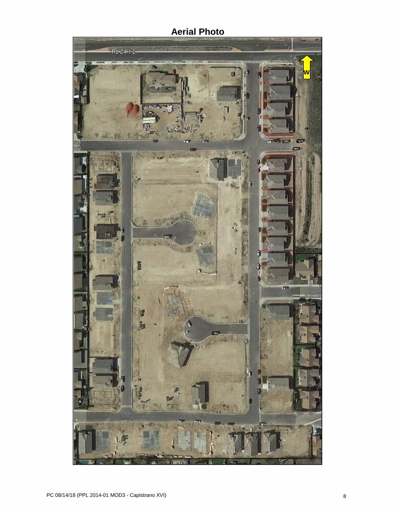
PC 08/14/18 (PPL 2014-01 MOD3 - Capistrano XVI) 8
Aerial Photo
W
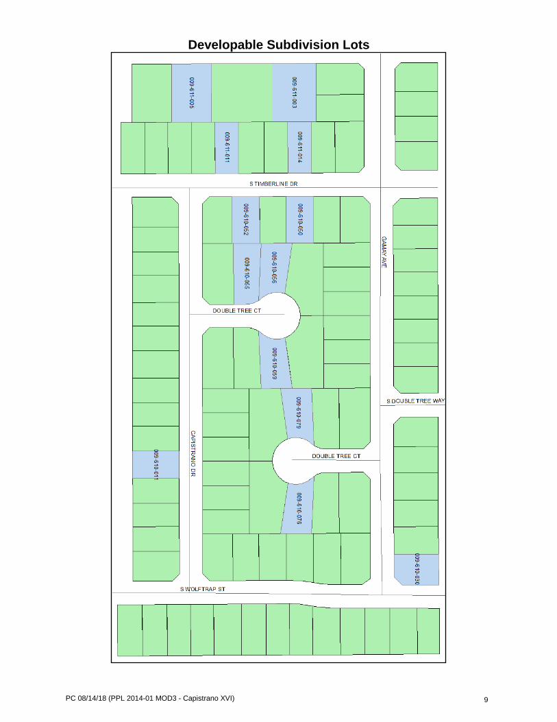
PC 08/14/18 (PPL 2014-01 MOD3 - Capistrano XVI) 9
Developable Subdivision Lots
CITY OF MADERA PLANNING COMMISSION
Staff Report: Manriquez Large Family Daycare
CUP 2018-12 & Categorical Exemption Item #12 - August 14, 2018
PROPOSAL: An application for a conditional use permit to allow for the establishment of a large family daycare in a PD 4500 (Planned Development) Zone District. APPLICANT: Biviana Manriquez OWNER: Manriquez Angel & Biviana ADDRESS: 639 Macadamia Avenue APN: 012-350-019 APPLICATION: CUP 2018-12 CEQA: Categorical Exemption
LOCATION: The property is located on the north side of Macadamia Avenue approximately 170 feet west of Hickory Avenue. STREET ACCESS: The site has access to Macadamia Avenue. PARCEL SIZE: Approximately 5,944 square feet GENERAL PLAN DESIGNATION: LD (Low-Density Residential) ZONING DISTRICT: PD 4500 (Planned Development) SITE CHARACTERISTICS: There are single family residences to the south, east, and west and a storm water basin located to the north of the project site. ENVIRONMENTAL REVIEW: The project has been determined to be statutorily exempt under the California Environmental Quality Act (CEQA) guidelines, Section 15274, (Family Day Care Homes). ___________________________________________________________________________ SUMMARY: The applicant is requesting approval of a use permit to expand an existing small family daycare into a large family daycare home. The State allows for large family daycares when the expansion is consistent with local ordinance and the General Plan. Use permits for large family daycares are typically nondiscretionary (as mandated by the State) unless an objection or appeal to a discretionary body is requested. During the initial noticing period, a concerned citizen requested that the expansion request of the Manriquez daycare be reviewed by the Planning Commission for possible impacts on the neighborhood. Concerns include the hours of operation, the safety of child loading and unloading, parking and circulation on the neighborhood. The letter detailing the concerns has been attached as an exhibit. Approval of the use permit would allow for the large family daycare to accommodate up to 14 children.
205 W. Fourth Street Madera CA 93637 (559) 661-5430
Return to Agenda
PC 08/14/18 (CUP 2018-12 Manriquez Large Family Daycare) 2
APPLICABLE CODES AND PROCEDURES MMC § 10-3.802 Light Commercial Zones MMC § 10-3.1202, Parking Regulations MMC § 10-3.1301, et seq., Use Permit Procedures The City’s Zoning Ordinance allows for the granting of a use permit by the Planning Commission subject to the Planning Commission being able to make findings that the establishment, maintenance or operation of the use or building will not, under the circumstances of the particular case, be detrimental to the health, safety, peace, morals, comfort and general welfare of persons residing or working in the neighborhood of the use, or be detrimental or injurious to property and improvements in the neighborhood or to the general welfare of the City. If the Commission cannot make the appropriate findings, the use should be denied. Conditions may be attached to the approval of the use permit to ensure compatibility. Project design may be altered and on or off-site improvements required in order to make the project compatible with nearby uses. In addition, the application may be subject to further review, modification or revocation by the Commission as necessary. PRIOR ACTION An application for a conditional use permit to allow for the expansion of a small family daycare into large family daycare facility was submitted on June 20, 2018. Property owners within 300 feet of the project site were noticed. During the noticing period, the Planning Department received a letter with concerns regarding the expansion of the daycare. ANALYSIS Background Family daycare providers are licensed and regulated by the State’s Department of Social Services. The City’s permitting process for daycare facilities only includes large family daycares which is consistent with the State ordinance. The State mandates that when a daycare provider requests to expand from a small daycare to a large daycare facility, local agencies must issue a nondiscretionary use permit when the use is consistent with local ordinance and the General Plan. However, whenever there is opposition to the large family daycare use permit, the approving agency must schedule a hearing in advance to any decision being made. Current Operation The Manriquez daycare facility currently operates as a small family daycare consistent with the State of California Health and Safety Code, providing childcare for no more than eight (8) children at any given time. Drop-off and pick-up times do vary on occasion due to work schedules or unplanned circumstances. The first drop-off occurs as early as 3:30 AM and the latest pick-up time is at 11:00 PM. Early drop-off times are typical for agriculture working families who are pressed for early work hours. The late pick-up times are due to parents working evening shifts. All other drop-off and pick-up times are consistent with standard school and business hours. The table below reflects a routine list of families utilizing the daycare’s services.

PC 08/14/18 (CUP 2018-12 Manriquez Large Family Daycare) 3
No. of Children Drop-Off Pick-Up Frequency Family #1 2 3:30 AM 1:45 PM 6 x per week Family #2 1 6:30 AM 4:00 PM 5 x per week Family #3 2 8:00 AM 5:00 PM 5 x per week Family #4 1 6:00 PM 11:00 PM 1 x per week The daycare has operational procedures that provide for parking during drop-off and pick-up times. Guardians are required to walk up to the main door to sign off at every visit to the daycare. The daycare operator has a daily itinerary of activities for the children, all of which have not been of any concern to the neighbors. A “Daily Activity List” is attached as an exhibit. Utilization of daycare areas are inspected and certified by the Fire Marshal for California Fire Code compliance prior to any license issuance from the Community Care Licensing Division (CCLD). Expansion Request With the current cap on eight (8) children, the daycare provider is unable to accommodate families with children that exceed the current permitted number of children. The proposed expansion would allow the Manriquez daycare to accommodate up to a maximum of 14 children as permitted by the State of California Department of Social Services. The applicant is proposing to continue with the current hours of operation, with no proposal to add children to the earliest drop-off time or the latest pick-up time. All daily activities are proposed to remain the same. There may be additional daycare supervision required by the CCLD as a component of the expansion. The Manriquez family is anticipating the oldest college age daughter will be able to assist during daycare hours resulting in no impact on the availability of parking at the home. Affected Neighbor Concerns During the initial noticing period for the daycare expansion request, the Planning Department received a concern and objection letter. The letter generally addressed concerns with the hours of operation that included a proposed 3:00 am drop-off time and a 1:00 am pick-up time. There was some sentiment expressed regarding the loading and unloading of children on the site and whether the dark hours of operation would play a role in the safety of the patrons to the daycare. Other concerns included circulation and traffic caused by the increase in children and whether the home had sufficient space to accommodate additional children. Dialogue with the concerned citizen concluded with “a daycare facility should not be in a residential area with single family dwellings”. The concerned citizen opted to have the request reviewed by the Planning Commission. The letter is attached as an exhibit. Analysis of Concerns The family daycare has been in operation since December of 2004 with no prior incidents or complaints being recorded by the Community Care Licensing Division. Although there is a proposal to expand daycare services from 8 to 14 children, there is no proposal to change the current hours of operation. Since the initial noticing period the applicant rescinded the late pick-up request. Mindful of the unconventional daycare hours, the Manriquez daycare has practices in place that provide parking for patrons during drop-offs and pick-ups as to avoid inconveniencing neighbors. Parking on the home’s driveway also reinforces the safety concerns during the loading and unloading of children. With no prior incidents being recorded, it is anticipated the hours of operation will have minimal to no significant safety impact to the neighborhood during dawn/dusk hours. Although approval of a large family daycare allows for up to 14 children, the number can be less, as determined by the Community Care Licensing Division. Furthermore, prior to any expansion of the daycare, a State Fire Marshal must inspect and provide clearance of the home
PC 08/14/18 (CUP 2018-12 Manriquez Large Family Daycare) 4
prior to any issuance of a license from the Community Care Licensing Division. The Community Care Licensing Division conducts annual inspections to ensure the daycare is compliant with all child safety regulations set forth by applicable codes. Currently, the daycare generates approximately 8 trips per day (2 trips per family) when a small daycare could potentially generate 16 trips per day. Expansion into a large family daycare with 14 children could result in 28 possible trips per day. The applicant has indicated the daycare focuses services on families with multiple children, thus reducing the total number of possible trips generated by the daycare. The home is accessible from a local street with a neighborhood speed limit of 25 miles per hour. The City Engineer estimates the additional traffic generated by the daycare will result in minimal circulation impact on the surrounding neighborhood. All other concerns not addressed within the staff report have been addressed within the recommended standard conditions of approval. As previously mentioned, in order provide approval of a large family daycare, the use has to be consistent with the City’s Municipal Code and the General Plan in addition to other regulatory requirements set forth by the California Health and Safety Code and the State’s Department of Social Services. Noting that the appellant does not “believe daycare facilities should not be in residential areas”, it is the State’s intent to facilitate child care services in proximity to the needs of families which does not adversely impact neighborhoods. This proposed conditional use permit was reviewed by various City Departments and outside agencies. The responses and recommendations have been incorporated into the recommended conditions of approval included in this report. CONSISTENCY WITH THE VISION MADERA 2025 PLAN The Commission, by considering how this service contributes to the safety and stainabilities of citywide childcare needs, is implementing a key concept of the Vision Plan. Moreover, approval of the daycare use is specifically consistent with Strategy 338, “Ensure safe and affordable childcare is available to all Maderan families”. RECOMMENDATION The information presented in this report supports conditional approval of the use permit request to allow for the expansion of family daycare. PLANNING COMMISSION ACTION The Planning Commission will be acting on the Use Permit to allow for the expansion of small family daycare into a large family daycare, determining to either:
• approve the applications with or without conditions • continue the hearing, or • deny the applications
Any action by the Commission approving or denying the application is subject to appeal to the City Council within 15 calendar days of the Commission’s action. Motion 1: Move to approve Conditional Use Permit 2018-12 based on and subject to the findings and conditions of approval:

PC 08/14/18 (CUP 2018-12 Manriquez Large Family Daycare) 5
Findings
- The use is consistent with the Madera General Plan and zoning on the site. - The project has been determined to be statutorily exempt under the California
Environmental Quality Act (CEQA) guidelines, Section 15274, (Family Day Care Homes).
- The use can be allowed in the zoning district with an approved use permit pursuant to
Madera Municipal Code Section 10-3.1312 and Section 1597.46 of the Health & Safety Code.
- The operation, as conditioned, can be expected to be compatible with the neighborhood
and not be detrimental to the health, safety, peace, morals, comfort or general welfare of the neighborhood and the City.
CONDITIONS OF APPROVAL General Conditions 1. Project approval is conditioned upon acceptance of the conditions of approval contained
herein, as evidenced by the receipt in the Planning Department of the applicant’s signature thereon within thirty days of the date of approval for this use permit. Please note this conditional use permit (CUP 2018-12) will expire one year from date of issuance unless positive action is taken on the project as provided in the Municipal Code or the required action is taken to extend the approval before the aforementioned expiration date (MMC § 10-3.1311 Termination and Revocation).
2. The project shall comply with Madera Municipal Code section 10.3.1312. 3. All appropriate licenses, permits, inspections, and approvals for a large family daycare
home shall be secured and maintained during the entire time the residence is utilized as a large family daycare home. A business license with the City must be maintained at all times.
4. No more than the permitted fourteen (14) children shall be enrolled in the daily program at the large family daycare home, provided all requirements of the California Health and Safety Code are met.
5. The applicant shall live in the home and the home shall be the applicant's legal principal
residence. The applicant shall provide adequate written evidence of residency. 6. The use of the home as a large family daycare shall be clearly incidental and secondary
to the primary residential use of the home and property. 7. The property and home shall not be altered or structurally changed in a way which is
adverse to the residential character or appearance of the neighborhood. 8. The standard hours of the large family daycare home shall be limited to 3:00 a.m. to
12:00 a.m.; Monday through Saturday, notwithstanding circumstances beyond the operator’s/patron’s control.

PC 08/14/18 (CUP 2018-12 Manriquez Large Family Daycare) 6
9. No daycare related outdoor recreational activities shall occur prior to 9:00 a.m. or after 6:00 p.m.
10. No signs or other advertisement identifying the residence as a large family daycare
home shall be visible from the right-of-way. 11. The applicant shall not allow smoking within the residence when any of the children
being cared for are present in the residence. 12. During the hours when the daycare is in operation, all vehicles owned or operated by the
applicant or other tenants living at the property shall be parked in the required covered parking in the garage or in available uncovered parking spaces in the driveway.
13. The applicant shall maintain one covered parking stall available at all times to park one
car, as required by the Municipal Code. 14. The property’s frontage on the Macadamia Avenue public right-of-way shall be kept
clear during all hours of operation for usage as a pick-up and drop off zone for patrons of the large family daycare.
15. Daycare patrons should use the Macadamia Avenue public right-of-way directly in front
of the residence and available parking spaces in the driveway for parking (loading and unloading of children) at all times.
16. Daycare patrons and employees shall drive safely, follow all traffic regulations and shall
be mindful of adjacent property owner concerns when driving to and from the site. 17. Daycare patrons and employees shall not park in the neighboring driveways, nor shall
they make U-turns within the public right-of-way or any other maneuvers that would obstruct the flow of traffic.
18. Under no circumstances shall daycare patrons or operators double park, park in the
middle of the street or park the wrong way on Monterey Street or within the surrounding neighborhood.
19. The large family daycare shall not create noise levels in excess of those allowed in
single-family residential areas in the Noise Element of the General Plan or in excess of those allowed in residential property as outlined in Title III, Chapter 11 of the Madera Municipal Code.
20. The applicant’s site shall be maintained in a neat and litter-free manner at all times.
Landscaping shall be maintained by the property owner to provide an acceptable appearance that is compatible with adjacent uses and consistent with the intent and purpose of the Residential Zone. No additional hardscape or other improvements shall be added in the front yard which would act to negatively impact the aesthetic nature of the residential property.
Engineering
21. The applicant shall prepare a plan to accommodate drop-off and pick-up traffic with the least impact on traffic safety as reasonably as possible. Patrons shall be advised of the recommended practices. Should pick-up and drop-off operations result in an observed safety concern, the daycare entitlement shall be reviewed for modifications and or possible revocation.

PC 08/14/18 (CUP 2018-12 Manriquez Large Family Daycare) 7
Fire Department 22. A minimum of one, 2A10BC rated fire extinguisher is required. The fire extinguisher
shall be mounted in an accessible location, 3-5 feet above the finished floor.
23. A fire alarm mounted to the structure and powered by the buildings wiring system shall be provided.
24. The location of the secondary means of egress (door) must be shown which must be 6’8” by 36”.
25. An evacuation plan shall be posted at the residence.
26. A carbon monoxide alarm shall be installed.
27. Smoke alarms shall be required in all areas to be used for sleeping purposes. (OR) Motion 2: Move to continue the application for Conditional Use Permit 2018-12 to the September 11, 2018 Planning Commission meeting. (OR) Motion 3: Move to deny the application for Conditional Use Permit 2018-12, based on the following findings: (specify) ATTACHMENTS Aerial Photo Objection & Concerns Letter Daily Activity List

PC 08/14/18 (CUP 2018-12 Manriquez Large Family Daycare) 8
Aerial

PC 08/14/18 (CUP 2018-12 Manriquez Large Family Daycare) 9
Objection & Concerns Letter
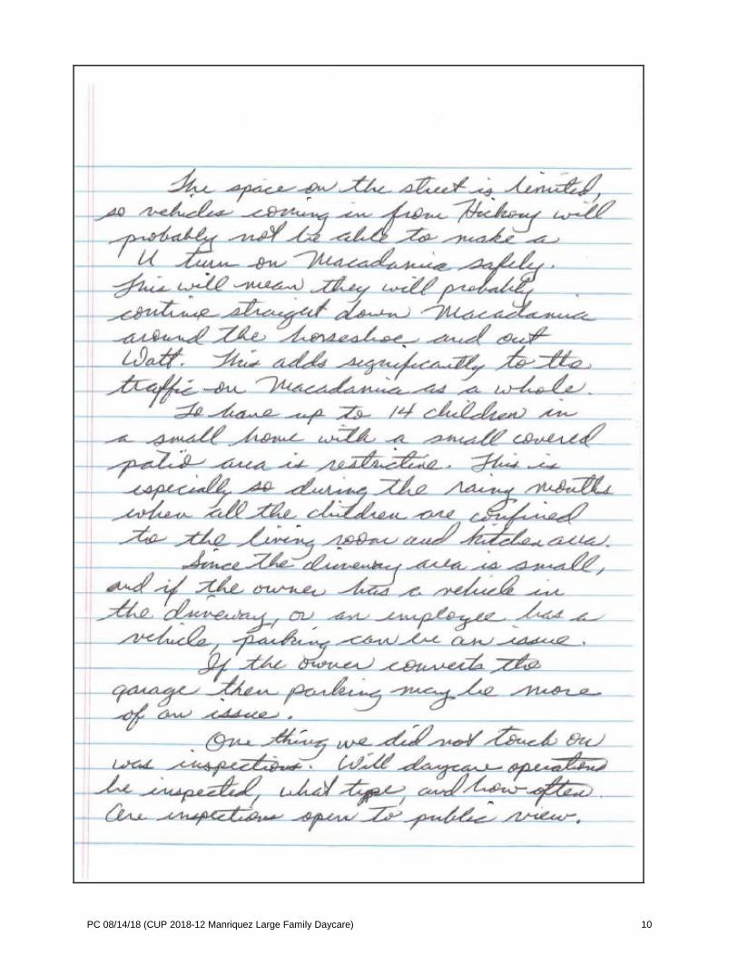
PC 08/14/18 (CUP 2018-12 Manriquez Large Family Daycare) 10

PC 08/14/18 (CUP 2018-12 Manriquez Large Family Daycare) 11
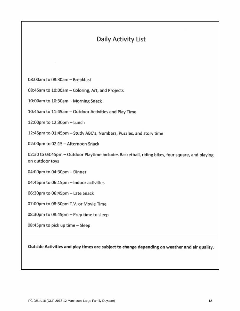
PC 08/14/18 (CUP 2018-12 Manriquez Large Family Daycare) 12