regular inspection report - acmua · regular inspection report ... the spillway at the centerline...
TRANSCRIPT

REGULAR INSPECTION REPORT
KUEHNLE POND DAM
NJDEP Dam File No. 36-009
ATLANTIC CITY UTILITIES AUTHORITY ATLANTIC COUNTY, NEW JERSEY
SEPTEMBER 2014
Alaimo Group 200 High Street
Mount Holly, New Jersey 08060 609-267-8310
Our File: A-1130-0011-000
Q:\Projects\A11300011000\Reports\Kuehnle\Kuehnle Dam cover_TOC.docx
TABLE OF CONTENTS
NARRATIVE SUMMARY Page a
VISUAL INSPECTION CHECKLIST
Type of Inspection Page 1
General Information Page 2
Examination of Embankment Page 3
Examination of Spillway Page 6
Examination of Other Features Page 10
Conclusion Page 11
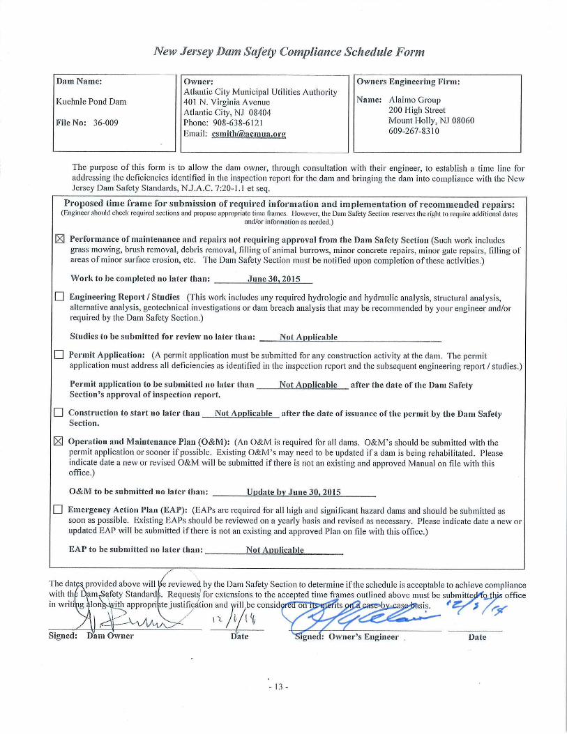
Compliance Schedule Page 13
Appendix A Location Map
Appendix B Photographs

NARRATIVE SUMMARY
Kuehnle Pond Dam (NJ File No. 36-009) is a Class II, Significant Hazard Dam and is located in Egg Harbor Township in Atlantic County, New Jersey. The dam impounds Kuehnle Pond and provides stream flow regulation as well as a water supply source for the Authority. The dam consists of an earth embankment with a clay core, concrete spillway, and a sheet pile seepage barrier constructed across the South Branch of Absecon Creek. The dam is about 650 feet long with a maximum height of about 14 feet. The crest of the dam is maintained by a concrete wall (top of wall elevation is + 31.0 feet). A 30 foot long ungated overflow spillway is located near the center of the dam embankment at El. +25.0 feet (crest), which is the normal operating pool level of the Kuehnle Pond.
The low level outlet for the dam consists of two 24 inch diameter pipes which conveys water through the dam embankment from a concrete intake structure located within the reservoir. The outlet pipes are controlled by sluices gates which can be operated from the top of the intake structures. There is a two (2) lane access road that runs along the crest of the embankment. The original bridge over the spillway was replaced by a single span bridge in 2010.
The following deficiencies were found: potholes in stone/soil road on the crest; concrete spall on crest parapet; gaps in joint caulk on crest parapet; loose closure plate at base of chute has broken bolt.
Owner will purchase a vibrating wire readout (i.e. Geokon GK-404 or other) for use by Consultants when required or for formal inspections. Consultants will have unit calibrated prior to use.
No existing or potential safety deficiencies were observed that would compromise acceptable performance of the dam under all applicable loading conditions. Therefore, the dam is considered SATISFACTORY.
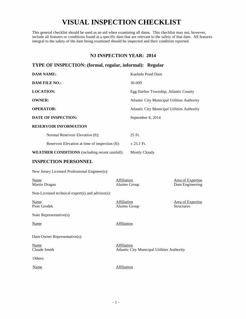
VISUAL INSPECTION CHECKLIST This general checklist should be used as an aid when examining all dams. This checklist may not, however, include all features or conditions found at a specific dam that are relevant to the safety of that dam. All features integral to the safety of the dam being examined should be inspected and their condition reported.
NJ INSPECTION YEAR: 2014
TYPE OF INSPECTION: (formal, regular, informal): Regular
DAM NAME: Kuehnle Pond Dam
DAM FILE NO.: 36-009
LOCATION: Egg Harbor Township, Atlantic County
OWNER: Atlantic City Municipal Utilities Authority
OPERATOR: Atlantic City Municipal Utilities Authority
DATE OF INSPECTION: September 8, 2014
RESERVOIR INFORMATION
Normal Reservoir Elevation (ft): 25 Ft.
Reservoir Elevation at time of inspection (ft): ± 25.1 Ft.
WEATHER CONDITIONS (including recent rainfall): Mostly Cloudy
INSPECTION PERSONNEL
New Jersey Licensed Professional Engineer(s):
Name Affiliation Area of Expertise Martin Dragan Alaimo Group Dam Engineering
Non-Licensed technical expert(s) and advisor(s):
Name Affiliation Area of Expertise Piotr Grodek Alaimo Group Structures
State Representative(s):
Name Affiliation
Dam Owner Representative(s):
Name Affiliation Claude Smith Atlantic City Municipal Utilities Authority
Others:
Name Affiliation
- 1 -
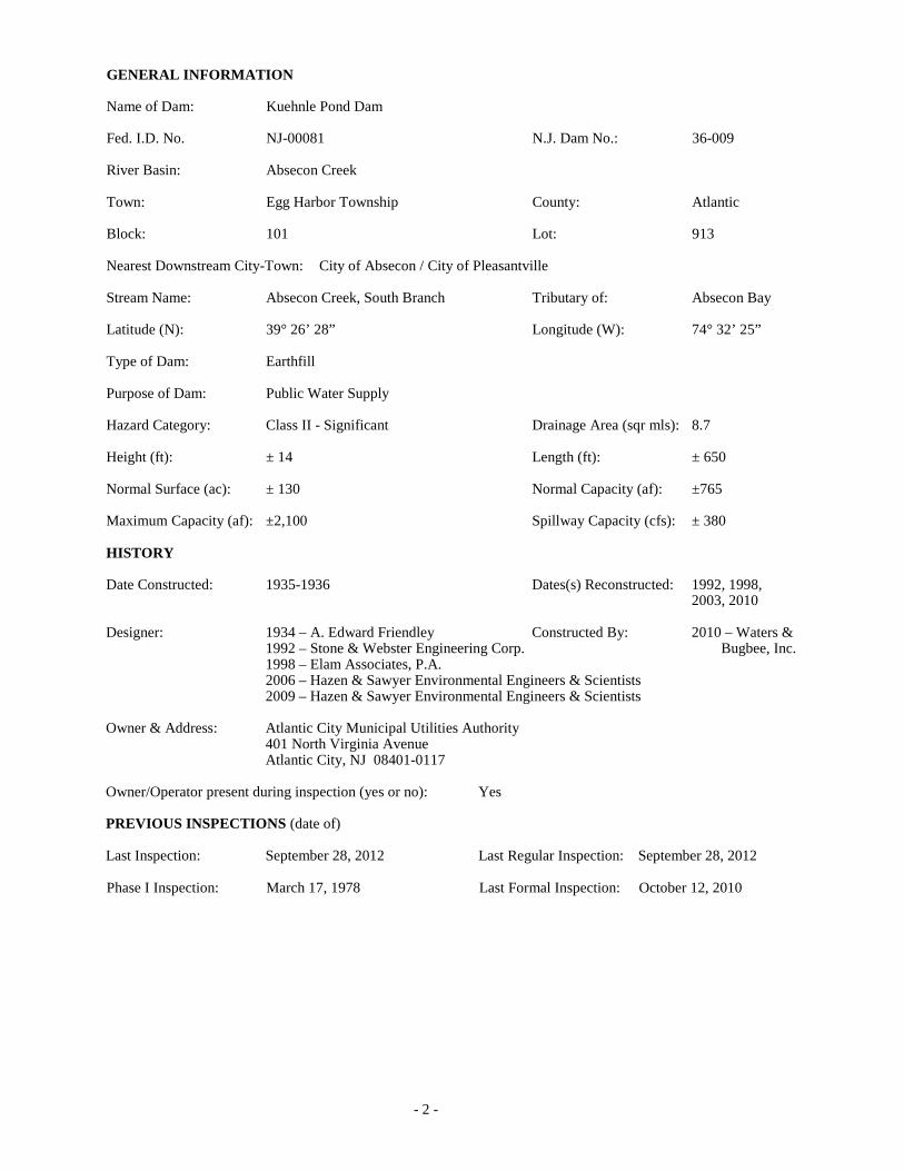
GENERAL INFORMATION Name of Dam: Kuehnle Pond Dam Fed. I.D. No. NJ-00081 N.J. Dam No.: 36-009 River Basin: Absecon Creek Town: Egg Harbor Township County: Atlantic Block: 101 Lot: 913 Nearest Downstream City-Town: City of Absecon / City of Pleasantville Stream Name: Absecon Creek, South Branch Tributary of: Absecon Bay Latitude (N): 39° 26’ 28” Longitude (W): 74° 32’ 25” Type of Dam: Earthfill Purpose of Dam: Public Water Supply Hazard Category: Class II - Significant Drainage Area (sqr mls): 8.7 Height (ft): ± 14 Length (ft): ± 650 Normal Surface (ac): ± 130 Normal Capacity (af): ±765 Maximum Capacity (af): ±2,100 Spillway Capacity (cfs): ± 380 HISTORY Date Constructed: 1935-1936 Dates(s) Reconstructed: 1992, 1998, 2003, 2010 Designer: 1934 – A. Edward Friendley Constructed By: 2010 – Waters & 1992 – Stone & Webster Engineering Corp. Bugbee, Inc. 1998 – Elam Associates, P.A. 2006 – Hazen & Sawyer Environmental Engineers & Scientists 2009 – Hazen & Sawyer Environmental Engineers & Scientists Owner & Address: Atlantic City Municipal Utilities Authority 401 North Virginia Avenue Atlantic City, NJ 08401-0117 Owner/Operator present during inspection (yes or no): Yes PREVIOUS INSPECTIONS (date of) Last Inspection: September 28, 2012 Last Regular Inspection: September 28, 2012 Phase I Inspection: March 17, 1978 Last Formal Inspection: October 12, 2010
- 2 -

EMERGENCY ACTION PLAN (Required for all Class I and Class II dams)
Date of Approved Plan: 2013
Date of Plan Revision: December 2011
Is the notification flowchart complete and current? Yes (If the notification flow chart is not complete and current, all modifications, corrections, and additions must be made and replacement pages submitted with this report)
Is inundation mapping or a description included? Yes
Are emergency materials and equipment identified? Yes
When was the plan last tested? Unknown
DOWNSTREAM HAZARD CLASSIFICATIONS
Present Hazard Classification: Class II, Significant
Changes in Downstream Land Use and Habitation: None observed
Is present classification appropriate? Yes
OPERATION AND MAINTENANCE
Date of Operation and Maintenance Plan: June 24, 2013.
Are instructions adequate? No. Does not provide instructions about when to read and analyze piezometer data or information on valves or remote operators.
Do operating personnel follow instructions? Yes
What are operating personnel capabilities? ACMUA personnel are capable of routine operation and maintenance.
EXAMINATION OF EMBANKMENT DAMS AND DIKESDESCRIPTION OF STRUCTURE
Embankment Material: Earth embankment dam.
Cutoff Type: Steel sheet pile cutoff wall through primary spillway.
Impervious Core: Clay core wall.
Internal Drainage System: Two (2) six-inch diameter perforated pipe toe drains are located on either side of the spillway along the downstream slope. Both drains outlet into the exit channel through the training walls on either side of the primary spillway.
Movement (Horizontal and Vertical Alignment): None observed.
Junctions with Abutments or Embankments: Appeared normal.
Miscellaneous: Not applicable.
- 3 -

CREST
Vertical Alignment: No defects observed.
Horizontal Alignment: No defects observed.(Photo 1&2)
Surface Cracks: No defects observed.
Settlement: None observed.
Unusual Conditions: Several potholes in stone/soil road. (Photo 3) Gaps in caulked joints in concrete parapet (Photo 4). Spall on parapet 2 SF (Photo 5). The wall has some shrinkage cracks but old cracks are patched.
UPSTREAM SLOPE
Slope (Estimate) (H:V): Approximately 3H:1V.
Trees, Undesirable Growth or Debris, Minor vegetation observed between the joints of the upstream Animal Burrows: concrete slope protection and the concrete crest wall.
Sloughing, Subsidence or Depressions: None observed.
Slope Protection: The upstream slope is covered with a concrete slab. The slab is generally in good condition; some minor cracking is observed. Older portion of concrete slab has a deteriorated headwall. Concrete spall 3 SF. (Photo 6)
Surface Cracks or Movement at Toe: None observed.
Unusual Conditions: None observed.
DOWNSTREAM SLOPE
Slope (Estimate) (H:V): Approximately 2H:1V. The downstream slope of the dam is covered with riprap. (Photo 7)
Trees, Undesirable Growth or Debris, None observed. Animal Burrows:
Sloughing, Subsidence or Depressions: None observed.
Surface Cracks or Movement at Toe: None observed.
Seepage: Some minor seepage (not measurable) was observed in the vicinity of the right spillway training wall, near the toe at the exit channel. (Photo 8)
External Drainage System No problems noted. The six inch toe drain at the right side of (Ditches, Trenches, Blanket): the spillway was flowing ± 2 gpm (Photo 9). The left toe
drain was not flowing at the time of the inspection.
Condition Around Outlet Structure: No problems noted.
Unusual Conditions: None observed.
- 4 -
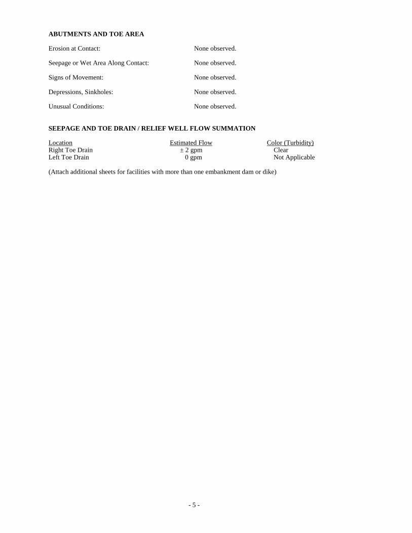
ABUTMENTS AND TOE AREA
Erosion at Contact: None observed.
Seepage or Wet Area Along Contact: None observed.
Signs of Movement: None observed.
Depressions, Sinkholes: None observed.
Unusual Conditions: None observed.
SEEPAGE AND TOE DRAIN / RELIEF WELL FLOW SUMMATION
Location Estimated Flow Color (Turbidity) Right Toe Drain ± 2 gpm Clear Left Toe Drain 0 gpm Not Applicable
(Attach additional sheets for facilities with more than one embankment dam or dike)
- 5 -

EXAMINATION OF SPILLWAYS AND OUTLET WORKS
TYPE(S) AND DESCRIPTION OF SPILLWAY(S)
Primary: Uncontrolled concrete overflow crest with a bridge over the spillway crest.
Secondary (auxiliary): Not Applicable.
Emergency: Not Applicable.
Other: Not Applicable.
FOR EACH SPILLWAY THE FOLLOWING ASPECTS MUST BE EXAMINED WHERE APPROPRIATE
ENTRANCE CHANNEL
Description: Not Applicable – flow enters spillway directly from the Kuehnle Pond.
Vegetation (Trees, Bushes):
Debris:
Channel Side-Slope Stability:
Slope Protection/Erosion:
Unusual Conditions:
SPILLWAY CREST
Description: A 24 foot long uncontrolled broad-crested weir. Records indicate that this area has been resurfaced with shotcrete or gunite. (Photo 10 & 11).
Condition of Material: Appeared normal. A steel sheet pile cutoff wall was installed through the spillway at the centerline of the dam embankment in 2010. The area beneath the concrete spillway slab was also grouted in 2010.
Signs of Movement: None observed.
Joints: No problems noted.
Unusual Conditions: None observed.
DROP BOX
Description: Not applicable. There is no Drop Box.
Condition of Material:
Signs of Movement:
Joints:
Floor:
Unusual Conditions:
- 6 -
SPILLWAY WING WALLS
Description: The original concrete walls have been covered by shotcrete according to records.
Condition of Material: Minor deterioration, no structural concerns.
Signs of Movement: None observed.
Joints: Minor spalling of the concrete was observed between the upstream concrete slope protection and the training walls which extend upstream into the pond. (Photo 12)
Drains: None observed.
Unusual Conditions: None observed.
DOWNSTREAM APRON
Description: Concrete apron; replaced during 1998 rehabilitation. (Photo 13)
Condition of Material: No significant deterioration observed.
Signs of Movement: None observed.
Unusual Conditions: A chain link fence extends across the downstream apron near the exit channel.
CULVERTS
Description: Not applicable – No Culverts.
Condition of Material:
Joints:
Signs of Movement:
Seepage:
Location Estimated Flow Turbidity
Unusual Conditions:
TRASH RACKS
Description: Not Applicable – No Trash Racks.
Condition of Material:
Unusual Conditions:
- 7 -

CHUTES Description: Flow is conveyed into the exit channel between concrete training walls via a concrete slab. (Photo 12) Condition of Material: Appeared normal. Significant algae growth covers the concrete surface. Signs of Movement: None Unusual Conditions: Significant algae growth on the concrete chute surface; the spillway does not appear to be impacted. Pressure Relief Drain Closure plate at base of chute has broken bolt and is loose. (Photo 14 & 15) STILLING BASIN Description: Concrete slab with concrete baffle blocks at the toe near the exit channel. Condition of Material: Appeared normal; submerged at the time of inspection. Signs of Movement: None observed. Erosion: None observed. Unusual Conditions: None observed. EXIT CHANNEL Vegetation (Trees, Bushes): Hydrophilic vegetation noted approximately 100 feet downstream in the stream channel beneath the Garden State Parkway bridge overpass. Has grown in thicker since 2012 inspection. Blocks 60% of channel width. (Photo 16) Debris: Sediment mound noted downstream beneath the Garden State Parkway bridge overpass. Channel Side-Slope Stability: Concrete side walls exhibit some staining due to adjacent wetland area. Staining does not appear to be related to the dam. Erosion: No problems noted. Unusual Conditions: LOW LEVEL OUTLET Description: Two (2) concrete inlet structures constructed in the lake to invert El ± 13.0. Both inlet structures have trash racks on the upstream, left and right sides to prevent debris from being caught in the outlet pipes. Gate operators are located on the top of both concrete intake structures to control the release of water. Two (2) 24-inch diameter pipes extend from the concrete inlet structures through the dam embankment beneath the primary spillway structure. The pipes outlet through the concrete headwall on the downstream side of the primary spillway structure. Flow from the low level outlet pipes are discharged into the primary exit channel. Condition: The low level outlet structure concrete and operators appears to be in good condition. (Photo 17 & 18) Trash Rack: The exposed trash racks exhibit signs of minor corrosion, however no section loss is evident.
- 8 -

Leakage:
Location Estimated Flow Left side outlet Unknown, partly submerged.
Unusual Conditions:
Was the low level outlet operated during the inspection? No
Were there difficulties operating the low level outlet? Not Applicable.
When was the low level outlet last operated and did The low level outlets are routinely used by ACMUA this conform with the Operation and Maintenance staff to make releases downstream. procedures?
Miscellaneous:
STILLING BASIN FOR LOW LEVEL OUTLET
Description: Not Applicable. The low level outlet discharges directly into the exit channel.
Condition of Material:
Signs of Movement:
Erosion:
Unusual Conditions:
EXIT CHANNEL FOR LOW LEVEL OUTLET
Description (Trees, Bushes): Same as Primary Spillway exit channel; see description above.
Debris:
Channel Side-Slope Stability:
Slope Protection Erosion:
Unusual Conditions:
- 9 -

EXAMINATION OF OTHER FEATURES
INSTRUMENTATION (Monumentation/Surveys, Observation Wells, Weirs, Piezometers, Etc.) location, condition:
Two (2) vibrating wire piezometers were installed beneath the primary spillway as part of the 2010 rehabilitation. PVC pipe used to protect piezometer wire in center of spillway dislodged at joint from adjacent pipe section. (Photo 20)
(A separate report including instrument readings, condition of instruments, observations, and conclusions based upon the collected data should be attached.)
Owner does not have the device to read the piezometers and taking readings not included in O & M Manual.
Unusual Conditions which affect Dam: None observed.
Unusual Conditions: None observed.
RESERVOIR
Slopes: Concrete walls surround the majority of the perimeter of the reservoir. Slopes approximately 3H:IV. (Photo 21)
Sedimentation: None observed.
Unusual Conditions Which Affect Dam: None observed.
Unusual Conditions: None observed.
APPURTENANT STRUCTURES (Power House, Gatehouse, Penstocks, Water Supply, Other)
Description and Condition of each: Not applicable.
- 10 -

CONCLUSION
DAM INSPECTION PROGRAM GUIDELINES
The following new guidelines have been established by the NJDEP Bureau of Dam Safety & Flood Control to help meet the requirements of the National Inventory of Dams condition assessment of existing dam structures. Please follow the guidelines/definitions below and select the appropriate checkbox.
SATISFACTORY No existing or potential dam safety deficiencies are recognized. Acceptable performance is expected under all applicable loading conditions (static, hydrologic, seismic) in accordance with the applicable regulatory criteria. Minor maintenance items may be required.
FAIR Acceptable performance is expected under all required loading conditions (static, hydrologic, seismic) in accordance with the applicable dam safety regulatory criteria. Minor deficiencies may exist that require remedial action and/or secondary studies or investigations.
POOR A dam safety deficiency is recognized for any required loading condition (static, hydrologic, seismic) in accordance with the applicable dam safety regulatory criteria. Remedial action is necessary. POOR also applies when further critical studies or investigations are needed to identify any potential dam safety deficiencies.
UNSATISFACTORY Considered unsafe. A dam safety deficiency is recognized that requires immediate or emergency remedial action for problem resolution. Reservoir restrictions may be necessary.
I Certify that the dam structure referenced herein was personally inspected by me and was found to be in the following condition. (select only one):
SATISFACTORY
FAIR
POOR
UNSATISFACTORY
- 11 -

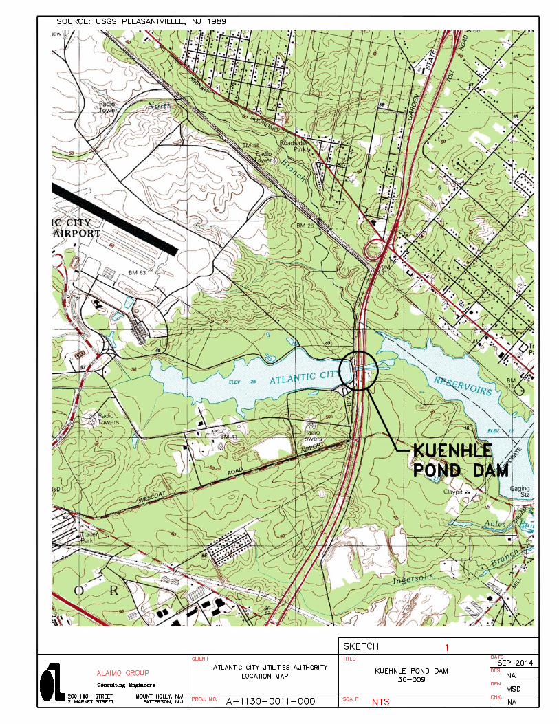
APPENDIX A
LOCATION MAP

APPENDIX B
PHOTOGRAPHS
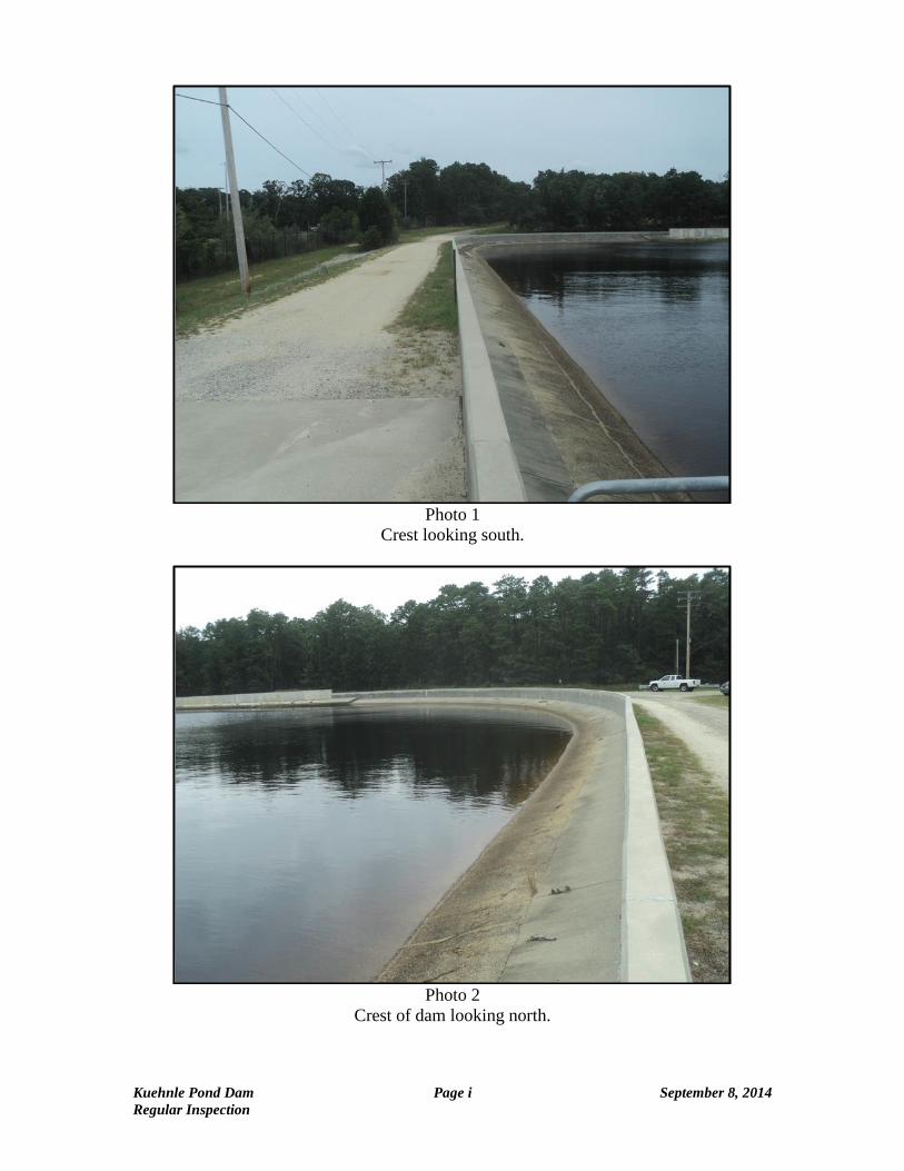
Photo 1 Crest looking south.
Photo 2 Crest of dam looking north.
Kuehnle Pond Dam Page i September 8, 2014 Regular Inspection
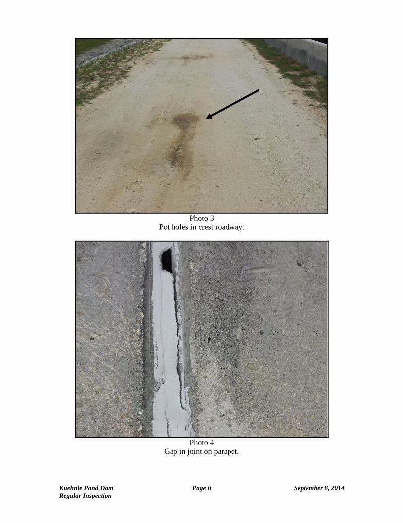
Photo 3
Pot holes in crest roadway.
Photo 4
Gap in joint on parapet.
Kuehnle Pond Dam Page ii September 8, 2014 Regular Inspection

Photo 5 Spall on parapet.
Photo 6 Upstream slope. Spall & cracked apron
Kuehnle Pond Dam Page iii September 8, 2014 Regular Inspection

Photo 7
Downstream slope.
Photo 8
Seepage near base on downstream slope at right wingwall.
Kuehnle Pond Dam Page iv September 8, 2014 Regular Inspection
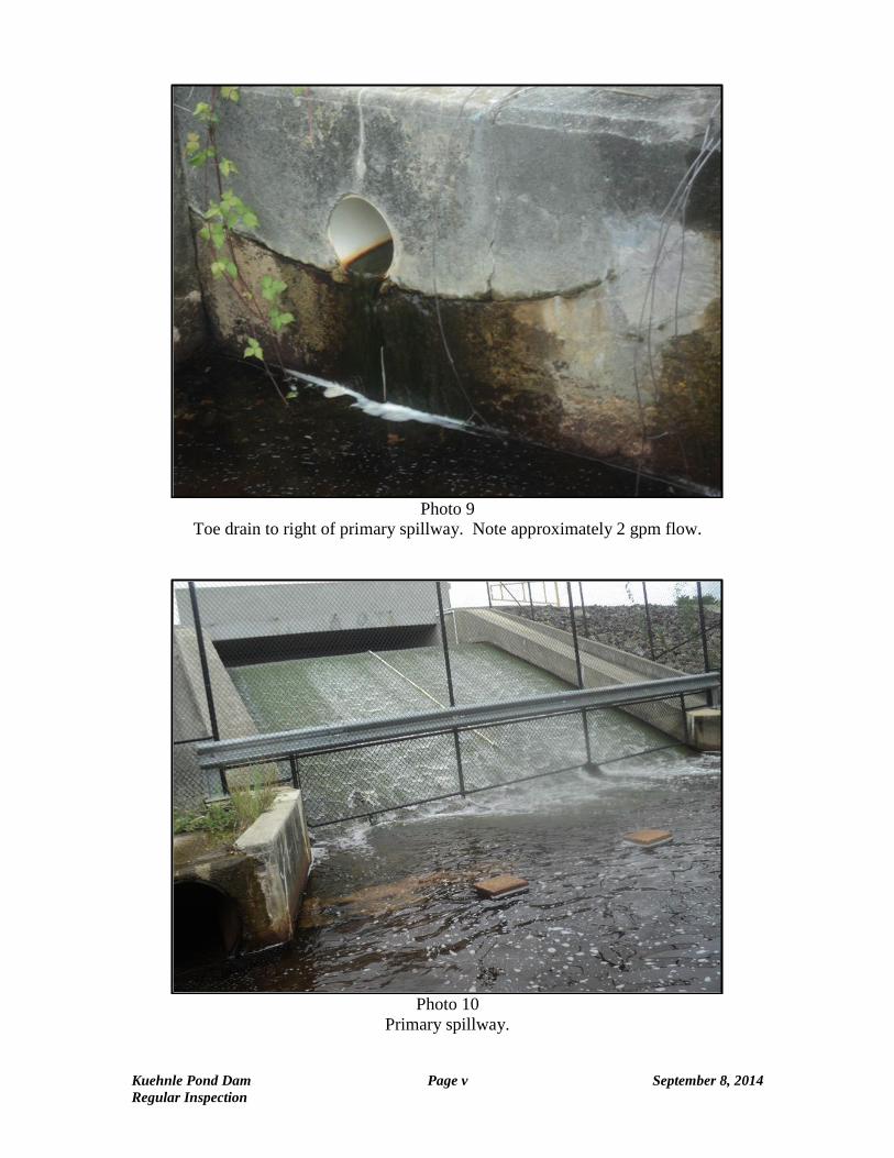
Photo 9 Toe drain to right of primary spillway. Note approximately 2 gpm flow.
Photo 10 Primary spillway.
Kuehnle Pond Dam Page v September 8, 2014 Regular Inspection
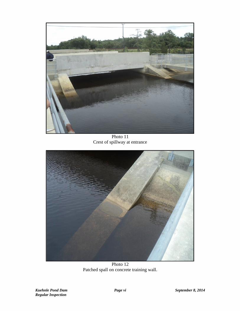
Photo 11 Crest of spillway at entrance
Photo 12 Patched spall on concrete training wall.
Kuehnle Pond Dam Page vi September 8, 2014 Regular Inspection

Photo 13
Downstream apron and baffle blocks.
Photo 14
Top of concrete spillway and bridge. Note Piezometer conduit damaged a joint.
Kuehnle Pond Dam Page vii September 8, 2014 Regular Inspection
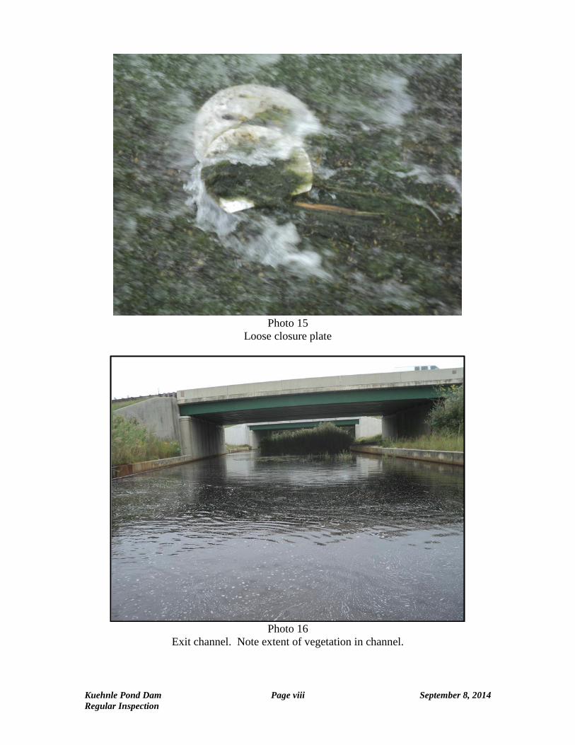
Photo 15
Loose closure plate
Photo 16
Exit channel. Note extent of vegetation in channel.
Kuehnle Pond Dam Page viii September 8, 2014 Regular Inspection

Photo 17
Low level outlet structure.
Photo 18
Low level outlet operator.
Kuehnle Pond Dam Page ix September 8, 2014 Regular Inspection

Photo 19
Monitoring well at toe of downstream slope.
Photo 20
Vibrating wire Piezometer Terminal Box on parapet of bridge requires GK-404 readout to take measurements.
Kuehnle Pond Dam Page x September 8, 2014 Regular Inspection

Photo 21 Concrete wall along reservoir deteriorated.
Kuehnle Pond Dam Page xi September 8, 2014 Regular Inspection

I. Emergency Notification
KUEHNLE POND DAM (NJDEP #36-009)
EMERGENCY NOTIFICATION FLOWCHART
EMERGENCY OBSERVER
Refer to Notification Information Form (Page 5)
OWNER/OPERATOR Ernest R. Gratz Name: Atlantic City Municipal Utilities Authority Phone: 609-641-0024 24 hr: 609-641-0024 E-mail: [email protected] 1151 N. Main Street Pleasantville, NJ 08232
CONTRACTOR
Refer to Section 6
OWNER’S ENGINEER Name: Richard A. Alaimo Engineering Company Phone: 609-267-8310
MUNICIPAL OEMS Town: Galloway Township Name: Michael Brandenburger Phone: 609-652-3700, ext. 268 24 Hr: 609-652-3705, ext. 206 E-Mail: [email protected] Town: Egg Harbor Township Name: Frank Sutton Phone: 609-926-4027 24 Hr: 609-926-5200 E-Mail: [email protected] [email protected] Town: Absecon City Name: James Eberwine Phone: 609-641-0663 24 Hr: 609-641-0667 E-Mail: [email protected]
COUNTY OEMS County: Atlantic County OEM Coord: Vincent Jones Phone: 609-272-9495 24 Hr: E-Mail: [email protected]
NJ – OEM STATE POLICE OEM
24 Hr 609-963-6900
NJ – DSS DAM SAFETY Phone 609-984-0859 24 Hr 877-WARNDEP 927-6337
3
4
2 1
Rev 11/26/2014
Q:\Projects\A11300011000\Reports\Kuehnle\Emergency Notification Flowchart.docx