redwood city safe routes to school report · redwood city safe routes to school report ... school...
TRANSCRIPT

Redwood CitySafe Routes to School ReportAugust 2013
PREPARED BY:Alta Planning + Design
REDWOOD CITY SC
HO
OL D
ISTR
ICT Redwood City School District


Redwood City
Safe Routes to School Report
Prepared for:
City of Redwood City
Redwood City 2020
Redwood City School District
Prepared by:
Alta Planning and Design
In Partnership with:
Parisi Transportation Consulting
Jungle Communications


Table of Contents
Safe Routes to School Report | i
Table of Contents
1. Introduction ................................................................................................................................. 1-1
1.1. How to Use this Report ............................................................................................................................... 1-2
2. Adelante Spanish Immersion School.......................................................................................... 2-1
2.1. School Information ....................................................................................................................................... 2-1
2.2. Issues and Recommendations ................................................................................................................... 2-2
2.3. Recommended Programs ........................................................................................................................... 2-11
3. Fair Oaks Community School Recommendations ..................................................................... 3-1
3.1. School Information ....................................................................................................................................... 3-1
3.2. Issues and Recommendations ................................................................................................................... 3-2
3.3. Recommended Programs ........................................................................................................................... 3-10
4. Hawes Community School Recommendations .......................................................................... 4-1
4.1. School Information ....................................................................................................................................... 4-1
4.2. Issues and Recommendations ................................................................................................................... 4-2
4.3. Recommended Programs ........................................................................................................................... 4-11
5. John Gill Elementary Recommendations ................................................................................... 5-1
5.1. School Information ....................................................................................................................................... 5-1
5.2. Issues and Recommendations ................................................................................................................... 5-2
5.3. Recommended Programs ........................................................................................................................... 5-10
6. Roosevelt Elementary School Recommendations ..................................................................... 6-1
6.1. School Information ....................................................................................................................................... 6-1
6.2. Issues and Recommendations ................................................................................................................... 6-2
6.3. Recommended Programs ........................................................................................................................... 6-10
7. Roy Cloud School Recommendations ........................................................................................ 7-1
7.1. School Information ....................................................................................................................................... 7-1
7.2. Issues and Recommendations ................................................................................................................... 7-2
7.3. Recommended Programs ............................................................................................................................ 7-11
8. Citywide Collision Analysis ......................................................................................................... 8-1
Appendix A - Example Engineering Devices .......................................................................................... A-1

Table of Contents
ii | Redwood City
List of Figures
Figure 2-1: Adelante Spanish Immersion School Enrollment Map .............................................................................. 2-3
Figure 2-2: Adelante Area Youth Involved Pedestrian and Bicycle Collisions, 2006-2011 ..................................... 2-4
Figure 2-3: Adelante Spanish Immersion School Improvement Plan ......................................................................... 2-13
Figure 3-1: Fair Oaks Community School Enrollment Map ........................................................................................... 3-3
Figure 3-2: Fair Oaks Area Youth Involved Pedestrian and Bicycle Collisions, 2006-2011 .................................... 3-4
Figure 3-3: Fair Oaks Community School Improvement Plan ..................................................................................... 3-13
Figure 4-1: Hawes Community School Enrollment Map ................................................................................................ 4-3
Figure 4-2: Hawes Area Youth Involved Pedestrian and Bicycle Collisions, 2006-2011 ......................................... 4-4
Figure 4-3: Hawes Community School Improvement Plan ......................................................................................... 4-13
Figure 5-1: John Gill Elementary Enrollment Map ........................................................................................................... 5-3
Figure 5-2: John Gill Area Youth Involved Pedestrian and Bicycle Collisions, 2006-2011 ..................................... 5-4
Figure 5-3: John Gill Elementary Improvement Plan ..................................................................................................... 5-13
Figure 6-1: Roosevelt Elementary Enrollment Map ......................................................................................................... 6-3
Figure 6-2: Roosevelt School Area Pedestrian and Bicycle Collisions, 2006-2011 .................................................... 6-4
Figure 6-3: Roosevelt School Improvement Plan............................................................................................................. 6-13
Figure 7-1: Roy Cloud School Enrollment Map ................................................................................................................ 7-3
Figure 7-2: Roy Cloud Area Youth Involved Pedestrian and Bicycle Collisions, 2006-2011 .................................. 7-4
Figure 7-3: Roy Cloud School Improvement Plan ........................................................................................................... 7-13
Figure 8-1: Citywide Youth Involved Pedestrian and Bicycle Collisions, 2006-2011 ............................................... 8-2
List of Tables
Table 2-1: Adelante Spanish Immersion School Recommended Improvements ....................................................... 2-9
Table 3-1: Fair Oaks Community School Recommended Improvements ................................................................... 3-8
Table 4-1: Hawes Community School Recommended Improvements ........................................................................ 4-8
Table 5-1: John Gill Elementary Recommended Improvements ................................................................................... 5-8
Table 6-1: Roosevelt School Recommended Improvements .......................................................................................... 6-8
Table 7-1: Roy Cloud Recommended Improvements ...................................................................................................... 7-8

Introduction
Safe Routes to School Report | 1-1
1. Introduction
The City of Redwood City, County of San Mateo, Redwood City School District, and Redwood City 2020 all
encourage safe access and active transportation to school. The purpose of this report is twofold:
To identify potential infrastructure projects and education and encouragement programs that could
improve student safety and support walking and biking to school.
To identify and promote suggested walking and biking routes for students and parents to and from
school.
The Redwood City School District (RCSD) has been supported by Redwood City 2020 in the initiation and
implementation of a Safe Routes to School (SRTS) program since the middle of the 2009-10 school year. Since
the inception of the program, the effort has grown to include 10 of the 16 District schools. SRTS strategies
have been customized to meet the needs of each school with the basic foundation of increasing students
walking and cycling safely to school. Programs include walking school buses, establishing parking areas near
school that permits students to walk from the parking to the school in cases where walking is too difficult and
educational programming for parents and students. Additionally, the City of Redwood City in collaboration
with RWC 2020 has successfully competed for an estimated $2.0 million in SRTS infrastructure and non-
infrastructure grants to support the program.
An overall goal for the District SRTS program is to promote safety, wellness, school community building and
reduction in environmental impacts of vehicular student transportation.
This report presents recommendations to improve bicyclist & pedestrian safety and access to six schools in
the Redwood City School District:
Adelante Spanish Immersion School
Fair Oaks Community School
Hawes Community School
John Gill Elementary School
Roosevelt School
Roy Cloud School
School site walking audits were conducted at each school either during the morning drop-off or afternoon
pick-up periods. Audit teams included Alta Planning + Design staff, City or County staff, school principals,
Redwood City 2020, and parents. Each visit began with a discussion of current challenge areas and what
types of issues observers should pay attention to. The team then observed student access and reviewed the
area near each school for quality of sidewalks, curb ramps, signage, as well as other engineering elements and
behaviors of pedestrians, bicyclists, and drivers. Based on the observations and input provided by school staff
and parents, the project team developed a report of potential recommendations which are presented for each
school in a narrative and graphical format.

Introduction
1-2 | Redwood City
This report includes the following sections:
2. Adelante Spanish Immersion School ................................................................................................ 2-1
3. Fair Oaks Elementary Recommendations ........................................................................................ 3-1
4. Hawes Community School Recommendations ................................................................................ 4-1
5. John Gill Elementary Recommendations ......................................................................................... 5-1
6. Roosevelt School Recommendations ............................................................................................... 6-1
7. Roy Cloud School Recommendations ............................................................................................... 7-1
8. Citywide Collision Analysis ................................................................................................................ 8-1
This report is a step in providing improvements around Redwood City Schools. All recommendations in this
report are contingent upon available funding, secured either through the City or the School District. Most
recommended improvements (especially those needing significant engineering and construction) will be
contingent upon winning federal, state, or regional grants. This report provides a blueprint for competitive
grant applications, which may fund recommended improvements in future years.
1.1. How to Use this Report At the heart of every successful Safe Routes to School program is a coordinated effort by parent volunteers,
school and District staff, City and County staff, and law enforcement personnel.
For each school within this report, potential engineering recommendations are presented in graphic
improvement plans with accompanying tables that identify the agency intended to implement the
recommendation. Some recommendations are on school district property, while other recommendations in
City or County right-of-way must be implemented by the respective agency.
Parents can use this report to understand the conditions at their children’s school and to become familiar
with the ways the Safe Routes program can work to make walking and biking safer and easier.
School District and School staff can use this report to prioritize potential improvements identified on
District property and develop programs that educate and encourage students and parents to seek alternatives
to single family automobile commutes to school. In many cases, education and encouragement programs
require dedicated parent volunteers to carry them out.
City and County staff can use this report to identify issues and opportunities related to walking and biking
and to prioritize potential short-term and long-term infrastructure improvements. Staff can also use this
report to support Safe Routes to School funding opportunities such as:
California Active Transportation Program (ATP) grants
Office of Traffic Safety (OTS) grants
One Bay Area (OBAG) grants
Highway Safety Improvement Program (HSIP) grants
Law Enforcement staff can use this report to understand issues related to walking and biking to school and
to plan for and prioritize enforcement activities that may make it easier and safer for students to walk and
bike to school.

Adelante Spanish Immersion School
Safe Routes to School Report | 2-1
2. Adelante Spanish Immersion School
2.1. School Information Principal: Linda Montes
Enrollment: 567 Students, K-6
School Arrival: Kindergarten Early: – 8:15 AM
Kindergarten Late: – 9:45 AM
Kindergarten Th: – 8:05 AM
1st – 6th Grade: – 8:05 AM
School Dismissal: Kindergarten Early: – 1:00 PM
Kindergarten Late: – 2:30 PM
Kindergarten Th: – 1:00 PM
1st – 6th Grade: – 2:30 PM
1st – 6th Grade Th: – 1:30 PM
2.1.1. Layout
Adelante Spanish Immersion School is located in southwestern Redwood City, flush against the border with
the community of Woodside to the south. The school is sited in a hilly residential area. While the
neighborhood to the north of the school (within Redwood City limits) has sidewalks, the streets across the
border in Woodside do not. There is a loading zone for automobile drivers in front of the school off of Granger
Way; just south of the loading loop is diagonal parking for the adjacent playing fields. Staff and visitor
parking are accessed via the back of the loading loop.
School access points include the main entrance via the loading loop on Granger Way and a sidewalk from the
playing fields to the south, which ends at Harcross Road.
A significant challenge for walking and biking to Adelante Spanish Immersion School is that it is a magnet
school, with students enrolled from all over Redwood City.
2.1.2. Loading Zones
There is one official off-street loading zone, accessed from Granger Way along the southeast side of the school.
Parent volunteers operate a “kiddie valet” in the loading zone to assist students out of cars and keep traffic
moving. In the afternoon, arriving parents put a nameplate in their car window with their students’ name,
which a volunteer relays by walkie-talkie to assembled students outside the loading zone.
The primary parking lot for the school is sited at the rear of this loading zone. A second access point directly
south of the loading zone exit contains a small number of parking spaces, including one designated for the
winner of a parent auction. The exit from the loading zone is at an elbow in the road where Granger Way
curves to the south. In addition, parents frequently drop off their children in the adjacent neighborhood on
Granger Way in advance of the school.
Adelante School
Adelante Spanish Immersion School
2-2 | Redwood City
2.1.3. Crossing Guard Location
There are no crossing guards for Adelante Spanish Immersion School.
2.1.4. Existing Programs
The school had two walking school buses, but the program was discontinued after two months. Wednesdays
are “park and walk” days, where parents are encouraged to park on Granger Way and Mitchell Way. The
school holds a monthly “Walk to School Day” and participated in a district-wide walk to school day event.
The first Walk to School Day had 78 students participate, while 53 students participated in the second.
During the district-wide Walk to School Day during Earth Day, 65 students walked to school, representing a
seven percent increase over a normal school day.
Adelante Spanish Immersion School in the past school year provided 10 bicycle and pedestrian educational
courses to students, contracted through an expert bicycle & pedestrian safety educator. Two parent
education workshops were also provided, focusing on safe driving habits near schools, pedestrian safety, and
the benefits of walking and biking to school. The workshops also provided information on how to form
walking school buses or conduct other encouragement programs. Adelante Spanish Immersion School also has
a website for parents to arrange carpools (http://adelanteschool.org/carpool.html). The carpool tool is not well
used currently, and school staff plans to promote the tool more heavily with parents in the coming school year.
2.2. Issues and Recommendations
2.2.1. Feasibility of Walking, Biking, and Ridesharing to School
The National Center for Safe Routes to School predicts that the majority of students who live within 1.35
miles should be able to walk to and from school, while the majority of students within 2.6 miles should be able
to bicycle.1
Adelante Spanish Immersion School, as a magnet school, draws students from across Redwood City. The
school’s enrollment map, Figure 2-1, shows that the majority of students live to the east of the school,
clustered between Woodside Road, Jefferson Avenue, and El Camino Real. More than half of the students at
Adelante Spanish Immersion School live more than two miles away from the school, while less than five
percent of students live within half a mile. Moreover, students walking or biking to school from the east must
cross major roadways such as Alameda de Las Pulgas and Fernside Street in order to reach the school.
Adelante is an excellent candidate for ridesharing programs due to the longer distances families live from
school and the density of families who live near each other.
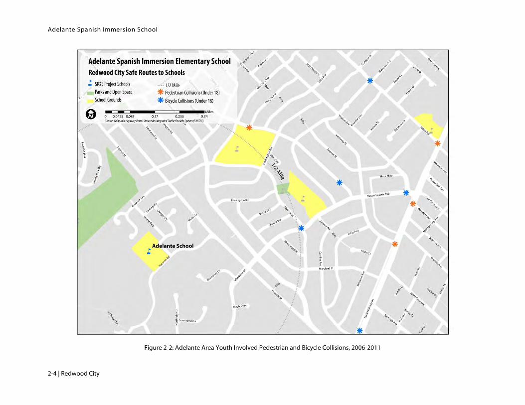
2.2.2. Collisions
From 2006-2011, there were nine reported pedestrian / bicycle collisions involving youth under age 18 east of
Adelante School, shown in Figure 2-2. Three of the four pedestrian collisions were reported at crossings of
State Highway 84, while two bicycle collisions occurred on Massachusetts Avenue/Woodside Drive. None of
the reported collisions took place within close vicinity of the School. All collisions occurred on weekdays.
1 This is based on the finding that people are generally willing to travel about 30 minutes each way, regardless of travel mode. Assuming a student walking speed of 2.7 miles per hour and a bicycling speed of 8 mph, a child can travel 1.35 miles by foot or 4 miles via bicycle in 30 minutes. However, accounting for stop light interruptions, hilly terrain, and other factors, the National Center recommends a student bicycling distance target of 2.6 miles. http://www.saferoutesinfo.org/program-tools/what-distances-are-reasonable-expect-elementary-school-students-bike-school

Adelante Spanish Immersion School
Safe Routes to School Report | 2-3
Figure 2-1: Adelante Spanish Immersion School Enrollment Map
Adelante Spanish Immersion School
2-4 | Redwood City
Figure 2-2: Adelante Area Youth Involved Pedestrian and Bicycle Collisions, 2006-2011

Adelante Spanish Immersion School
Safe Routes to School Report | 2-5
2.2.3. Potential Engineering Improvements
Potential engineering recommendations are shown and mapped in Figure 2-3. Improvement identification
numbers reference numbers on the figure.
Adelante Loading Loop
The main passenger loading zone appears to work well, aided by parent volunteers running the “kiddie valet.”
Parents, however, reported that the exit is difficult for drivers because of the bend in the road on Granger
Way where the exit driveway lets out. The narrow curve in the road makes it difficult for two cars to pass
when one is exiting from the loading loop. Furthermore, parents noted that drivers waiting to turn left from
the loading loop exit can cause backups.
Recommendations (ID #1)
Consider installing a “No Left Turn” sign at the exit to the loading loop, routing drivers south to
Harcross Road. Consider whether routing traffic through Harcross Road to the south will create
additional traffic impacts on local roadways.
Adelante Bicycle Parking
The school has a small amount of bicycle parking on campus, located in the staff/visitor parking lot adjacent to
the loading loop. The racks are few and outdated (allowing only a single point of contact between the rack
and the bicycle and limiting use of more secure u-locks), and are located in an area not immediately visible
from the school office.
Recommendations (ID #2)
Upgrade existing bike racks with U-racks or similar racks that can accommodate two points of
contact with the bicycle frame. Consider providing an all-weather covering for the bicycle parking.
Relocate the bicycle parking to be clearly visible from the school office windows.
Granger Way, Alongside the School
Granger Way has two high-visibility yellow crosswalks, one immediately before the loading loop entrance
and one immediately after the loading loop exit. The first crosswalk is north/south-oriented while the second
crosswalk is east/west-oriented, respectively, before and after the right angle turn Granger Way makes at
Adelante Spanish Immersion School. There are curb ramps on Granger Way before the loading loop, but to
the east of the existing north/south crosswalk.
The crosswalk to the south of the loading loop exit has a narrow width (less than seven feet wide, compared
to the twelve-foot wide north/south-oriented crosswalk). It has outdated Assembly B signage, and lacks
advance crossing Assembly D signage for northbound drivers. The crosswalk has no curb ramps at both ends,
and the SLOW SCHOOL XING pavement markings are laid out such that the “XING” portion is located to
the north of the crosswalk.
The east side of Granger Way has no pedestrian facilities and there are a number of “No Parking” signs;
however, during the audit parents were observed parking on the east side and in many cases letting their
children cross the exiting school traffic at uncontrolled locations.

Adelante Spanish Immersion School
2-6 | Redwood City
The staff parking driveway immediately south of the loading loop exit (which is also the school fire lane), is
often blocked by parent drivers during drop-off and pickup. There is a white transverse crosswalk across this
driveway from the sidewalks along the playing fields to a walkway between the driveway and the loading loop
that leads to the school.
Recommendations (ID #3 & #4)
Relocate the northern crosswalk further east to utilize existing curb ramps.
Restripe the southern crosswalk at a width equal to the northern crosswalk and construct curb
ramps at both ends of the crosswalk. This may require additional engineering and construction of the
sidewalk on the western end of the crosswalk due to the constrained configuration of adjacent
parking lot spaces
Restripe the SLOW SCHOOL XING pavement markings for northbound drivers so that all markings
come before the southern crosswalk.
Update all Assembly B & D signage, as necessary. Install an Assembly D sign for northbound drivers
in advance of the southern crosswalk.
Upgrade the white transverse crosswalk across the school fire lane to high-visibility yellow. Install
yellow tactile dome strips at both ends of this crosswalk.
Enforce no parking on the east side of Granger Way.
Neighborhood to the North
Mitchell Way and Granger Way experience high volumes of vehicle traffic during drop-off and pickup, as they
are some of the limited access points to the school. Parents reported visibility issues at the Mitchell Way and
Granger Way intersection. Many parents park on these streets and walk their students to school. The
neighbors have expressed concerns with speeding drivers, but consensus is divided on installing stop control
devices. Recently, a speed hump was installed on Mitchell Way to deter speeding and a new high-visibility
crosswalk was installed at the intersection of Mitchell Way and Sterling Way.
Recommendations (ID #5 & #6)
City staff should consider installing a 15 mph School Zone on both Mitchell Way and Granger Way,
contingent upon a City ordinance adopting 15 mph School Zone.
Stripe red curb at the Mitchell Way – Granger Way intersection to improve visibility.
The school district should develop Park-and-Walk route maps that encourage parents to either park
and walk, or drop off students, on Goodwin Avenue and on Mitchell Way north of Sterling Way.
This would allow drivers leaving the school to exit via Sterling Way, reducing congestion closer to
the school grounds.
Fernside Street
The intersection of Fernside Street at Goodwin Avenue is slightly askew from a 90 degree angle, with wide
curb radii in the northwestern and southeast corners. At these corners, the crosswalk has to extend to reach
the curb. The intersection is stop-controlled for east/west traffic, with free-flowing north/south traffic. The
northern and southern crosswalks are high-visibility yellow and the western and eastern crosswalks are
transverse yellow. The intersection of Carson Way at Fernside Street, immediately to the north, is stop-
controlled for north/south traffic, with free-flowing traffic on Carson Way. A temporary speed hump has

Adelante Spanish Immersion School
Safe Routes to School Report | 2-7
recently been installed on Fernside Street. The principal has noted this intersection as a particular safety
concern.
The intersection of Sterling Way at Fernside Street is uncontrolled in all directions. Audit observers noted a
large amount of pedestrian traffic crossing Sterling Way at this intersection on their way to the crosswalk at
Goodwin Avenue.
Recommendations (ID #7)
Consider constructing curb extensions in the northwest and southeast corners of the intersection of
Goodwin Avenue at Fernside Street, reducing excessive curb radii. If costs are deemed prohibitive,
consider providing pavement markings and raised bollards in place of the curb extension.
Stripe the eastern and western crosswalks as high-visibility.
City to evaluate data for additional speed humps both north and south of the existing temporary
humps.
Consider converting Fernside Street at Goodwin Avenue to an all-way stop intersection and
converting Carson Way at Fernside Street to stop-controlled for east/west traffic. This
recommendation will require a traffic study.
Consider installing a stop sign for traffic on Sterling Way at Fernside Street. If a stop sign is
warranted, also stripe a stop bar behind the existing curb ramps.
Harcross Road
Harcross Road is the border between Redwood City and the community of Woodside. The street has no
sidewalks and is used heavily by parents driving to and from Adelante. Some parents drop off students on
Harcross Road near the playing fields south of the school. At the intersection of Granger Way at Harcross
Road, there is a yellow transverse crosswalk, although it doesn’t link to a sidewalk on either end.
The intersection of Harcross Road at Fernside Street is uncontrolled for traffic on Fernside Street. There are
no marked crosswalks of Fernside Street for a quarter mile in both directions. There are curb ramps on both
sides of Fernside Street on the western side of this intersection.
Recommendations (ID #8 & 9)
Consider working with the community of Woodside to construct a sidewalk or a pathway along the
north side of Harcross Road from Fernside Street to Adelante Spanish Immersion School.
Replace the existing yellow transverse crosswalk across Granger Way at Harcross Road with a high-
visibility yellow crosswalk, with curb ramps on both ends. May require paving over a portion of the
landscaping at this intersection.
Post “No Parking” signs along Harcross Road in proximity to the crosswalk at Granger Way to
improve visibility.
Stripe a high-visibility white crosswalk in western leg of Fernside Street at Harcross Road, using
existing curb ramps. Outfit curb ramps with tactile dome strips. Install crossing signage for the
crosswalk and stripe PED XING pavement markings in advance of the crossing.
Adelante Spanish Immersion School
2-8 | Redwood City
Alameda de Las Pulgas at Maddux Drive
The intersection of Alameda de Las Pulgas at Maddux Drive was identified by parents as a key crossing for
students walking from the east. The intersection has no crosswalks and is not stop-controlled on Alameda de
Las Pulgas.
Recommendation (ID #10)
Consider evaluating the intersection for an all-way stop and crosswalks.
Potential Engineering Improvement Summary
Table 2-1 lists the recommended potential improvements to address circulation issues around Adelante
Spanish Immersion School and Figure 2-3 presents an improvement plan of these recommendations. The
project identification numbers in Table 2-1 corresponds to those in Figure 2-3. The table shows the identified
concerns, the proposed improvement, the agency likely to lead project implementation, and the recommended
priority level for implementation. The “lead agency” is determined by on whose property/right-of-way the
proposed improvement is located. The priority level is based on the anticipated safety and circulation benefit,
the feasibility of implementation, and the projected cost.

Adelante Spanish Immersion School
Safe Routes to School Report | 2-9
Table 2-1: Adelante Spanish Immersion School Recommended Improvements
ID Location Issues Observed Recommendations Lead
Agency
Priority
Level
1 Adelante Loading Loop
Drivers wanting to make left turns cause back-up in loading loop.
Curve in Granger Way makes it difficult for left-turning car from the load loop to negotiate with oncoming traffic.
Consider installing No Left Turn signage at exit from loading zone. Consider impact on local roads by diverting all exiting traffic south to Harcross Road.
District Low
2 Adelante Bicycle Parking
Bicycle parking has poor visibility and is located within the parking lot.
Upgrade existing bicycle parking to U-racks, or similar, that provides 2 points of contact with bicycle.
Relocate bicycle parking in location more visible to school offices.
District Medium
3 Crosswalks on Granger Way
Southern crosswalk on Granger Way is non-standard and is missing curb ramps.
Pavement markings are improperly placed with regards to the southern crosswalk.
The northern crosswalk does not meet this existing curb ramps on Granger Way nearby.
The southern crosswalk is missing Assembly D signage in advance of the crossing.
Relocate northern crosswalk further east to meet existing curb ramps.
Restripe southern crosswalk at a width equal to the northern crosswalk. Consider installing curb ramps and tactile dome strips at both ends of the crosswalk.
Restripe SLOW SCHOOL XING pavement markings so all markings are in advance of the southern crosswalk for northbound drivers.
Update all Assembly B & D signage at both crosswalks.
Enforce no parking on the east side of Granger Way.
City High
4 Staff Parking Lot Entrance
Crosswalk across the driveway is often encroached upon by drivers.
Upgrade existing white transverse crosswalk in parking lot to high-visibility yellow.
Install tactile dome strips at each end of the crosswalk.
District Medium
5 Community to the North
Excessive speeding by parent drivers on Mitchell Way and Granger Way.
Consider installing 15 mph SCHOOL ZONE signage, contingent upon adoption of signage citywide.
City Medium
6 Park & Walk Zones
Excessive school congestion on Mitchell Way and Granger Way to the south of Sterling Way.
Encourage parents to park and walk on Goodwin Ave and Mitchell Way, north of Sterling Way, allowing parents to exit via Sterling Way and avoid congestion on Granger Way.
District Medium

Adelante Spanish Immersion School
2-10 | Redwood City
ID Location Issues Observed Recommendations Lead
Agency
Priority
Level
7 Fernside Street at Goodwin Avenue
Priority intersection for principal Montes.
Key pedestrian & bicyclist access point from neighborhoods east of the Hetch Hetchy right-of-way.
Speeding on Fernside Street.
Drivers making high-speed turns at the intersection.
Consider constructing curb extensions in the northwest and southeast corners, aligning the curb with the existing crosswalks. Consider alternative treatments if cost is prohibitive.
Stripe the eastern and western crosswalks as high-visibility yellow.
City to evaluate data for additional speed humps both north and south of existing temporary humps.
Consider converting Fernside Street at Goodwin Avenue to an all-way stop intersection and converting Carson Way at Fernside Street to stop-controlled for east/west traffic. This recommendation will require a traffic study.
Consider installing a stop sign for traffic on Sterling Way at Fernside Street. If a stop sign is warranted, also stripe a stop bar behind the existing curb ramps.
City High
8 Harcross Road
No dedicated pedestrian space on Harcross Road.
Parking near intersection at Granger Way, increasing difficulty for turning drivers at intersection.
Drop-off on far side of Harcross at the school.
Consider working with the Community of Woodside to construct a sidewalk or pathway on the north side of Harcross Road to Adelante Spanish Immersion School.
Replace the existing yellow transverse crosswalk at Harcross Road and Granger Way with high-visibility yellow.
Install “No Parking” signs in proximity to the crosswalk at Granger Way
City, Woodside
Medium
9 Harcross Road at Fernside Street
High-speed turns by drivers.
No marked crossing of Fernside Street between Woodside Drive and Goodwin Avenue.
Stripe high-visibility white crosswalk on the west side of the intersection.
Outfit existing curb ramps with tactile dome strips.
Install crossing signage in both directions, including PED XING markings.
City Low
10 Alameda de Las Pulgas at Maddux Drive
Intersection on parent-identified walking route from the east
Consider evaluating intersection for an all-way stop and crosswalks.
City Low

Adelante Spanish Immersion School
Safe Routes to School Report | 2-11
2.3. Recommended Programs The five “E’s” of Safe Routes to School planning includes:
Engineering
Education
Encouragement
Enforcement
Evaluation
The potential infrastructure improvements presented on the previous pages address the recommended
engineering improvements. The other four “E’s” are related to programs. Programs will complement
engineering improvements such as sidewalk and crosswalk improvements by giving students and parents the
tools they need to safely and confidently get to school. All of the Five E’s work together to enhance the school
commute. The following section presents recommended programs to support safer school access.
The recommended programs were developed based on review of existing programs and community identified
need.
Student Education Workshops
Student education programs are an essential component of a Safe Routes to School effort. Students are taught
traffic safety skills that help them understand basic traffic laws and safety rules. Example pedestrian
education curriculum elements include traffic sign identification and how to use a crosswalk. Typical bicycle
education curriculum elements include helmet and bike fit, hand signals, and riding safely with traffic.
Adelante Spanish Immersion School conducted 10 bicycle and pedestrian education classes in the previous
school year.
Recommendation: Adelante Spanish Immersion School should continue their current program of bicycle and
pedestrian education courses. Because many families park-and-walk to campus, it is recommended the
education curriculum program include a significant focus on pedestrian traffic safety. The education
workshops should occur on an annual basis.
Parent Education Workshops
Parent education programs are also an essential component of a Safe Routes to School effort by helping
parents lead by good example. Parents are taught key traffic safety skills they can practice with their children
anytime they walk or bicycle as a family. Example parent education curriculum elements include basic
pedestrian safety skills such as “look left, right, left,” obeying crossing guards, bicycle hand signals, and riding
safely with traffic. The curriculum may also include safe driving behaviors, which is especially important in
school zones.
Two driver behaviors and safety workshop were conducted for Adelante parents this past school year.
Recommendation: The school should continue to provide safety workshops to parents. It is recommended
that parent traffic safety education workshops be held on an annual basis. The workshops should cover safe
driving, walking, and bicycling behaviors.
Adelante Spanish Immersion School
2-12 | Redwood City
Park-and-Walk
The school already encourages parents to park on Mitchell Way between Granger Way and Goodwin Avenue.
The benefit of this program is reduced traffic congestion at the school and encouraging student physical
activity.
Recommendation: It is recommended that the school formalize the program with Park-and Walk maps that
are posted on the school website. The maps should be distributed in back to school packets and be available
in the school office. School newsletters or related school news should remind parents of this program.
Kiddie Valet
Adelante hosts an existing Kiddie Valet program where staff and students assist with student loading on the
loading area loop.
Recommendation: It is recommended Adelante continue the Kiddie Valet program.
Monthly Walk to School Day Events
The school currently hosts monthly Walk to School Day events with student incentives.
Recommendation: It is recommended the school continue the monthly Walk to School Day events. Outreach
should include notices in the school newsletter or related school news to remind parents of this monthly
event. Outreach should include advertisement of the Park-and Walk maps a week before each Walk to
School Day event.
SchoolPool – CarPool
Carpooling complements walking and biking modes by reducing vehicle congestion and increasing pedestrian
and bicyclist safety at schools, and by providing a greener transportation alternative for families who live
further away from school, as many Adelante families do. Adelante has a website for parents to arrange
carpools (http://adelanteschool.org/carpool.html). The carpool tool is not well used currently, and school staff
plans to promote the tool more heavily with parents in the coming school year.
Recommendation: It is recommended Adelante continue promotion of their online carpool tool and work
with the parent community to promote informal off-line carpooling. Outreach for the online tool and the
event can include tabling during school arrival and dismissal and meet and greet sessions. Carpool outreach
should also consider parents without internet access.
A Car Pool to School Day event toolkit is available through Redwood City 2020.
Trash Collection
Parents expressed concern about students bicycling to school on route where trash collection occurs in the
morning.
Recommendation: The City should work with their waste management contractor to minimize trash
collection during before-school and after-school hours on identified walking and biking routes to schools.
The City should use the suggested walking route maps to help identify key routes and streets for
consideration.

Adelante Spanish Immersion School
Safe Routes to School Report | 2-13
Figure 2-3: Adelante Spanish Immersion School Improvement Plan

Adelante Spanish Immersion School
2-14 | Redwood City
This page intentionally left blank.

Fair Oaks Community School
Safe Routes to School Report | 3-1
3. Fair Oaks Community School Recommendations
3.1. School Information Principal: Guadalupe Guzman
Enrollment: 405, K-5
Arrival: All grades – 8:15 AM
Dismissal: K – 1:30 PM
K, Early Dismissal – 1:10 PM
Grades 1-3 – 2:30 PM
Grades 1-3, Early Dismissal – 1:25 PM
Grades 4-5 – 2:35 PM
Grades 4-5, Early Dismissal – 1:30 PM
3.1.1. Layout
Fair Oaks Community School is located in the Fair Oaks neighborhood, unincorporated San Mateo County
south of Redwood City. The school is fronted on three sides by Fair Oaks Avenue, Oakside Avenue, and
Hampshire Avenue. Staff parking lots are located off of Fair Oaks Avenue and Hampshire Avenue. A charter
school, opening in the coming school year, will share the campus with Fair Oaks and will be accessed via
Oakside Avenue. Parents pick up and drop off along all three streets, though the school will discourage
parents at Fair Oaks from using Oakside Avenue in the coming year to make room for charter school parents.
There are pedestrian and bicycle access points to the school on all three streets. On the south end of the
school complex is a soccer field that is run by the City, used by members of the public during the weekend.
3.1.2. Loading Zone
The official loading zone for the school is on-street on Fair Oaks Avenue and Hampshire Avenue and off-street
in the parking lot on Hampshire Avenue. The parking lot on Fair Oaks Avenue is coned off by the school and
is reserved exclusively for teacher parking. The curb in front of the staff parking lot on Fair Oaks Avenue is
striped yellow (commercial loading) and the curb in front of the parking lot on Hampshire Avenue is striped
green (twenty minute parking).
SamTrans bus stops are located on Fair Oaks Avenue on both sides of the street adjacent to the school.
3.1.3. Crossing Guard Location
Two crossing guards serve Fair Oaks Community School, one at the intersection of Fair Oaks Avenue at
Barron Avenue and one at the intersection of Fair Oaks Avenue at Second Avenue. The crossing at Barron
Avenue is uncontrolled.
Fair Oaks Community School

Fair Oaks Community School
3-2 | Redwood City
3.1.4. Existing Programs
Fair Oaks has a walking school bus program that walks to school together once every week. The school also
holds Walk to School Day events every month on two concurrent days. The school has also participated in
district wide events during International Walk & Bike to School Day and on Earth Day. During Monthly
Walk to School Day, the school recorded 137 participating students. On International Walk to School Day,
the school recorded 194 participating students, a twenty five percent increase over a normal day.
This past school year, Fair Oaks held 12 pedestrian and bicycle safety workshops with students. One
workshop was held with parents to teach safe driving habits and awareness of pedestrians. Workshops also
provided information on starting up a walking school bus or other encouragement activities.
3.2. Issues and Recommendations
3.2.1. Feasibility of Walking, Biking, and Ridesharing to School
The National Center for Safe Routes to School predicts that the majority of students who live within 1.35
miles should be able to walk to and from school, while the majority of students within 2.6 miles should be able
to bicycle.2
Figure 3-1 shows the area of Fair Oaks’ student enrollment. As shown in Figure 3-1, almost two thirds of
students live within a quarter mile of the school and almost ninety five percent of students live within one
mile of the school. This school is an excellent candidate for programs and infrastructure that encourage
walking and biking to school. The enrollment map shows that the majority of the school enrollment is located
immediately to the south, though there is a small concentration of students living half a mile away around
Second Avenue. While ridesharing could be an option for this school, the close proximity families live to the
school suggests programs encouraging walking or biking to school a better investment.
3.2.2. Collisions
Between 2006 and 2011, two bicycle and five pedestrian collisions involving youth under age 18 were reported
near Fair Oaks Elementary School, shown in Figure 3-2. Two pedestrians were struck on Spring Street—one
at 4th Avenue and one at 5th Avenue. Two collisions were recorded between 8:00am and 8:30am, while three
others occurred between 3:00pm and 6:00pm. All but two collisions occurred on weekdays.
2 This is based on the finding that people are generally willing to travel about 30 minutes each way, regardless of travel mode. Assuming a student walking speed of 2.7 miles per hour and a bicycling speed of 8 mph, a child can travel 1.35 miles by foot or 4 miles via bicycle in 30 minutes. However, accounting for stop light interruptions, hilly terrain, and other factors, the National Center recommends a student bicycling distance target of 2.6 miles. http://www.saferoutesinfo.org/program-tools/what-distances-are-reasonable-expect-elementary-school-students-bike-school

Fair Oaks Community School
Safe Routes to School Report | 3-3
Figure 3-1: Fair Oaks Community School Enrollment Map

Fair Oaks Community School
3-4 | Redwood City
Figure 3-2: Fair Oaks Area Youth Involved Pedestrian and Bicycle Collisions, 2006-2011

Fair Oaks Community School
Safe Routes to School Report | 3-5
3.2.3. Potential Engineering Improvements
Potential engineering recommendations are shown and mapped in Figure 3-3: Fair Oaks Community School
Improvement Plan. Improvement identification numbers reference numbers on the figure.
Fair Oaks Avenue
The intersection of Fair Oaks Avenue at Barron Avenue, immediately adjacent to the staff parking lot, is
uncontrolled for traffic on Fair Oaks Avenue. There is a yellow transverse crosswalk across Fair Oaks Avenue
that is staffed by a crossing guard. This crosswalk has an automated flashing beacon accompanying Assembly
B signage. Assembly D signage is missing or outdated for this crosswalk. Despite the advanced treatments at
this crossing, parents and staff still listed speeding drivers as a major concern.
There are yellow transverse crosswalks in the south leg of at Fair Oaks Avenue at Warrington Avenue,
Hampshire Avenue, and Oakside Avenue. There is no red curb in advance of crosswalks, and drivers were
observed encroaching on the crosswalk when parking, reducing the visibility of crossing pedestrians.
There are yellow transverse crosswalks in the southern, western, and eastern legs of the intersection of Fair
Oaks Avenue at Second Avenue. A crossing guard is stationed at this intersection. The curb ramps at all
corners of this intersection are not ADA compliant.
There is a SamTrans bus stop on the north side of the street just west of this intersection. There is no
dedicated curb space for the bus and parents frequently park where the bus would otherwise alight. Parents
at Fair Oaks expressed interest in closing the parking on Fair Oaks to improve traffic flow in the mornings.
There is no Assembly A school zone signage on Fair Oaks Avenue in either direction.
Recommendation (ID #1, #2 & #3)
Consider installing a raised crosswalk at Fair Oaks Avenue at Barron Avenue to reduce driver speed.
Update Assembly D signage for the crosswalk at Barron Avenue.
Stripe red curb on Fair Oaks Avenue for the westbound SamTrans bus stop.
Consider a pilot closure of the parking lot on Fair Oaks Ave during morning drop off.
Restripe yellow curb on Fair Oaks Avenue as white curb for loading.
Restripe existing yellow transverse crosswalks on Fair Oaks Avenue at Oakside Avenue, Hampshire
Avenue, and Warington Avenue as high-visibility and stripe red curb in advance of crosswalks to
improve visibility.
Restripe all legs of the intersection of Fair Oaks Avenue at Second Avenue as high-visibility yellow.
Stripe stop bars in the west, south, and east legs of the intersection.
Ensure all curb ramps at all crosswalks are ADA compliant.
Install Assembly A signage in both directions on Fair Oaks Avenue.
Pavement Markings Near School Grounds
There are multiple uncontrolled crosswalks on the north, west, and east sides of the school grounds. Each of
these crosswalks have SLOW SCHOOL XING pavement markings that are in various states of disrepair.
Recommendation (ID #4)
Refresh SLOW SCHOOL XING pavement markings on Fair Oaks Avenue, Hampshire Avenue,
Oakside Avenue, and Warrington Avenue.

Fair Oaks Community School
3-6 | Redwood City
Hampshire Avenue
Hampshire Avenue has one uncontrolled crosswalk between the railroad to the south and Fair Oaks Avenue
to the north, at Halsey Avenue. This crosswalk is striped as yellow transverse. Observers noticed many
speeding drivers and many pedestrians jaywalking nearby the school parking lot, where the pedestrian access
point is for the school. The curb between the parking lot’s two driveways is striped green and signed for 20-
minute parking. Parents at Fair Oaks expressed a strong desire for traffic calming on Hampshire Avenue.
Recommendation (ID #5)
Replace the existing green curb with white curb and sign for loading only.
Consider installing a mid-block crosswalk just south of the parking lot driveway entrance to provide
a direct route to a school pedestrian access point. Stripe red curb in advance of the crosswalk and
install Assembly D & B signage.
Upgrade the existing yellow transverse crosswalk at Hampshire Avenue at Halsey Avenue to high-
visibility yellow. Consider options that reduce driver speeds and improve pedestrian visibility when
crossing, such as curb extensions or an in-pavement yield paddle. Update Assembly D & B signage.
Consider installation of temporary speed humps or other traffic calming devices on Hampshire
Avenue, pending a traffic study by the county.
Ensure all curb ramps are ADA compliant.
Oakside Avenue
The intersection of Oakside Avenue with Fair Oaks Avenue has a standard yellow crosswalk across the
western leg of the intersection. Parents and audit participants noted that drivers often block the crosswalk.
There is one mid-block crosswalk on Oakside Avenue, near a pedestrian access point. The crosswalk is
transverse yellow and its west end is at a driveway into the school grounds. There is no crossing signage
erected at this crosswalk. Parents at Fair Oaks expressed a strong desire for traffic calming on Oakside
Avenue.
Recommendations (ID #6)
Restripe midblock crosswalk as high-visibility yellow. Install Assembly D & B signage.
Ensure all curb ramps are ADA compliant.
Consider installation of temporary speed humps on Oakside Avenue, pending a traffic study by the
county.
Soccer Field
The County-owned soccer field immediately south of Fair Oaks Elementary has a porta potty in lieu of
permanent bathroom facilities. Parents expressed concern that the porta potty was not regularly serviced and
could become a health hazard for students.
Recommendation (ID #7)
Work with the County Parks Department to either service the porta potty more frequently, relocate
it to another area of the soccer field, or construct permanent bathroom facilities.

Fair Oaks Community School
Safe Routes to School Report | 3-7
Fair Oaks Elementary Bicycle Parking
The designated space for bicycle parking at Fair Oaks is in the northern area of the school grounds, near the
staff parking lot. Observers reported that bicycles in the past had been stolen by passersby on Fair Oaks
Avenue, who can look directly into the bicycle parking area.
Recommendations (ID #8)
Upgrade existing bicycle parking to U-racks or similar, allowing two points of contact with bike.
Install additional screening from the street to reduce theft.
Consider installing an all-weather covering over the bicycle parking.
Second Avenue
Second Avenue is the most direct route across the railroad tracks to the south. At the railroad crossing at
Second Street to the south of the school, there is no defined pedestrian space, but instead asphalt.
Recommendations (ID #8)
Consider working with railroad operator to construct sidewalks on both sides of Second Avenue at
the railroad crossing and to install pedestrian gates for crossing trains.
Stripe a white transverse crosswalk at the intersection of Second Avenue at Northside Avenue.
Ensure all curb ramps are ADA compliant.
Engineering Improvement Summary
Table 3-1 lists the recommended improvements to address circulation issues around Fair Oaks Elementary
and Figure 3-3 presents an improvement plan of these recommendations. The project IDs in Table 3-1
correspond to those in Figure 3-3. The table shows the identified concerns, the proposed improvement, the
agency likely to lead project implementation and the recommended priority level for implementation. The
“lead agency” is determined by on whose property/right-of-way the proposed improvement is located. The
priority level is based on the anticipated safety and circulation benefit, the feasibility of implementation, and
the projected cost.

Fair Oaks Community School
3-8 | Redwood City
Table 3-1: Fair Oaks Community School Recommended Improvements
ID Location Issues Observed Recommendations Lead
Agency
Priority
Level
1 Fair Oaks Avenue at Barron Avenue
Drivers failing to yield to students at crosswalk when crossing guard not on duty (afternoon & pick-up)
Speeding on Fair Oaks Avenue
Non-compliant curb ramps
Drivers park in SamTrans bus stop
Yellow curb striped in front of the school is for commercial loading
Consider installation of a raised crosswalk/speed table at location of current crosswalk.
Update Assembly D signage in advance of crosswalk in both directions on Fair Oaks Avenue.
Ensure all curb ramps are ADA compliant.
Stripe red curb for SamTrans bus stop on Fair Oaks Avenue. Restripe yellow curb along school frontage as white curb loading zone.
Consider a pilot closure of the school parking lot during drop-off.
County High
2 West of Barron Avenue
Drivers encroach on crosswalk.
Cars parked right up to intersection reduce pedestrian visibility.
Upgrade existing yellow transverse crosswalks at Hampshire Avenue and Warrington Avenue to high-visibility.
Stripe red curb in advance of crosswalk to improve visibility.
Install Assembly A signage for eastbound traffic near Hurlingame Avenue.
County Low
3 East of Barron Avenue
Existing crosswalks are faded.
Drivers on Second Street observed rolling through intersection without stopping.
Non-compliant curb ramps
Upgrade all existing yellow transverse crosswalks to high-visibility.
Install additional high-visibility yellow crosswalk in northern leg of intersection.
Stripe stop bars in west, south, and east legs.
Ensure all curb ramps are ADA compliant.
Install Assembly A sign for westbound traffic near Third Avenue.
County Medium
4 Pavement markings near school grounds
Faded SLOW SCHOOL XING pavement markings at uncontrolled crosswalks
Refresh SLOW SCHOOL XING markings at Fair Oaks Avenue, Oakside Avenue, Hampshire Avenue, and Warrington Avenue.
County Medium

Fair Oaks Community School
Safe Routes to School Report | 3-9
ID Location Issues Observed Recommendations Lead
Agency
Priority
Level
5 Hampshire Avenue
Speeding on Hampshire Avenue
Parents and students observed crossing mid-block between Halsey Ave and Fair Oaks Ave for direct route to school access point.
Parents park and walk at green curb on Hampshire Avenue, reducing utility as a loading zone.
High driver speeds on Hampshire Ave
Replace existing green curb along school frontage with white curb loading zone.
Consider constructing a mid-block crosswalk south of the teacher parking lot entrance. Would include curb ramps, Assembly B & D signage and advance red curb.
Upgrade existing yellow transverse crosswalk at Halsey Avenue to high-visibility. Consider additional measures, such as curb extensions or in-pavement yield paddles. Update Assembly B & D signage.
Consider installation of temporary speed humps on Hampshire Avenue, pending a traffic study.
County High
5 Oakside Avenue Crosswalks
Vehicles parked in the crosswalk.
Drivers failed to yield to pedestrians in the crosswalk.
High driver speeds on Oakside Ave
Upgrade existing yellow transverse crosswalk to high-visibility. Install Assembly B & D signage.
Ensure all curb ramps are ADA compliant.
Consider installation of temporary speed humps on Oakside Avenue, pending a traffic study.
County Low
6 Soccer Field Parent concern about porta-potty health hazard
Work with County to either relocate porta-potty or replace with permanent bathroom facilities
County Low
7 Fair Oaks Elementary Bicycle Parking
Passersby have stolen parts off of bikes parked at school by reaching over the fence from the street.
Upgrade existing bicycle parking facilities, screening parked bicycles from view on Fair Oaks Avenue to reduce theft.
Consider all-weather covering over bicycle parking.
District Medium
8 Second Avenue Railroad Crossing
Primary route to school for the neighborhood to the north.
Work with railroad operator to pave sidewalks
across tracks and install pedestrian gates at crossing.
Stripe white transverse crosswalk in the western leg of Second Avenue at Northside Avenue.
Ensure all curb ramps are ADA compliant.
County & Rail
Operator
Low

Fair Oaks Community School
3-10 | Redwood City
3.3. Recommended Programs The five “E’s” of Safe Routes to School planning includes:
Engineering
Education
Encouragement
Enforcement
Evaluation
The potential infrastructure improvements presented on the previous pages address the recommended
engineering improvements. The other four “E’s” are related to programs. Programs will complement
engineering improvements such as sidewalk and crosswalk improvements by giving students and parents the
tools they need to safely and confidently get to school. All of the Five E’s work together to enhance the school
commute. The following section presents recommended programs to support safer school access.
The recommended programs were developed based on review of existing programs and community identified
need.
Community Traffic Safety Campaign
Many of the concerns raised by parents at Fair Oaks Elementary had to do with the behavior of either
members of the community or residents who conduct business near to the school, whether it was the mobile
home park nearby, the adjacent auto-repair businesses, or the taco-truck vendors who do business in the area.
Many of those issues cannot be addressed solely through engineering recommendations, but instead require
constant reinforcement to change behaviors in a lasting, long-term way.
Recommendation: It is recommended that the parents and staff at Fair Oaks Elementary organize a
neighborhood traffic safety campaign. Funding through the County Department of Public Health may be
available to augment such a campaign. Such a campaign can take the form of street banners, mailers sent out
to the neighborhood, community meetings, or door-to-door outreach. Organizing parents around behavioral
issues they care about can help to empower this community to achieve many of the changes they currently
seek.
Student Education Workshops
Student education programs are an essential component of a Safe Routes to School effort. Students are taught
traffic safety skills that help them understand basic traffic laws and safety rules. Example pedestrian
education curriculum elements include traffic sign identification and how to use a crosswalk. Typical bicycle
education curriculum elements include helmet and bike fit, hand signals, and riding safely with traffic.
Fair Oaks held twelve bicycle and pedestrian safety courses for students over the previous school year.
Recommendation: Because many families walk to school, it is recommended that future education
curriculum program include a significant focus on pedestrian traffic safety. The current education workshops
should continue on an annual basis.

Fair Oaks Community School
Safe Routes to School Report | 3-11
Parent Education Workshops
Parent education programs are also an essential component of a Safe Routes to School effort by helping
parents lead by good example. Parents are taught key traffic safety skills they can practice with their children
anytime they walk or bicycle as a family. Example parent education curriculum elements include basic
pedestrian safety skills such as “look left, right, left,” obeying to crossing guards, bicycle hand signals, and
riding safely with traffic. The curriculum may also include safe driving behaviors, which is especially
important in school zones.
Fair Oaks held one parent workshop in the prior school year, focused on driver safety and providing parents
with tools to establish walking school buses.
Recommendation: It is recommended parent traffic safety education workshops continue on an annual basis.
The workshops should cover safe driving, walking, and bicycling behaviors as well as tools for encouraging
more bicycling and walking.
Traffic Safety Patrol
School traffic safety patrols are comprised of trained staff, parent or student volunteers responsible for
enforcing drop-off and pickup procedures. School traffic safety patrols may also assist with street crossing;
they do not stop vehicular traffic, but rather look for openings and then direct students to cross.
Recommendation: It is recommended Fair Oaks implement a Traffic Safety Patrol at the loading area on Fair
Oaks Avenue. Those who staff the loading area should discourage parking and street side loading while
directing parents to open spaces.
Monthly Walk to School Day Events
The school currently hosts monthly Walk to School Day events with student incentives.
Recommendation: It is recommended the school continue the monthly Walk to School Day events. Outreach
should include notices in the school newsletter or related school news to remind parents of this monthly
event. Outreach should include advertisement of the Suggested Routes to School maps a week before each
Walk to School Day event.
Weekly Walking School Bus
The school hosts a weekly walking school bus.
Recommendation: Fair Oaks should continue and promote the Weekly Walking School Bus events.
Crossing Guards
The effectiveness of a crossing guard can be the deciding factor in a parent feeling comfortable enough to let
their child walk or bike to school. Parents at Fair Oaks expressed a desire for uniform levels of training and
effort between the two current crossing guards.
Recommendation: Provide standardized, district-wide crossing guard training according to best practices.
Trash Collection
Parents expressed concern about students bicycling to school on route where trash collection occurs in the
morning.

Fair Oaks Community School
3-12 | Redwood City
Recommendation: The County should work with their waste management contractor to minimize trash
collection during before-school and after-school hours on identified walking and biking routes to schools.
The County should use the suggested walking route maps to help identify key routes and streets for
consideration.

Fair Oaks Community School
Safe Routes to School Report | 3-13
Figure 3-3: Fair Oaks Community School Improvement Plan

Fair Oaks Community School
3-14 | Redwood City
This page intentionally left blank.
Hawes Community School
Safe Routes to School Report | 4-1
4. Hawes Community School Recommendations
4.1. School Information Principal: Antonio Perez
Enrollment: 419, K-5
Arrival: All Grades – 8:15 AM
Late Kindergarten – 9:00 AM
Dismissal: Early Kindergarten – 12:50 PM
Late Kindergarten – 1:35 PM
Grades 1-5 – 2:40 PM
Early K, Early Dismissal – 12:40 PM
Late K & Grades 1-5, Early Dismissal – 1:25 PM
4.1.1. Layout
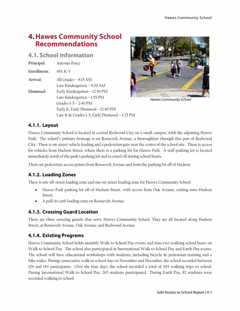
Hawes Community School is located in central Redwood City on a small campus, with the adjoining Hawes
Park. The school’s primary frontage is on Roosevelt Avenue, a thoroughfare through this part of Redwood
City. There is on-street vehicle loading and a pedestrian gate near the center of the school site. There is access
for vehicles from Hudson Street, where there is a parking lot for Hawes Park. A staff parking lot is located
immediately north of the park’s parking lot and is coned off during school hours.
There are pedestrian access points from Roosevelt Avenue and from the parking lot off of Hudson.
4.1.2. Loading Zones
There is one off-street loading zone and one on-street loading zone for Hawes Community School:
Hawes Park parking lot off of Hudson Street, with access from Oak Avenue, exiting onto Hudson
Street.
A pull-in curb loading zone on Roosevelt Avenue.
4.1.3. Crossing Guard Location
There are three crossing guards that serve Hawes Community School. They are all located along Hudson
Street, at Roosevelt Avenue, Oak Avenue, and Redwood Avenue.
4.1.4. Existing Programs
Hawes Community School holds monthly Walk to School Day events and runs two walking school buses on
Walk to School Day. The school also participated in International Walk to School Day and Earth Day events.
The school will have educational workshops with students, including bicycle & pedestrian training and a
bike rodeo. During consecutive walk to school days in November and December, the school recorded between
129 and 143 participants. Over the four days, the school recorded a total of 545 walking trips to school.
During International Walk to School Day, 265 students participated. During Earth Day, 82 students were
recorded walking to school.
Hawes Community School

Hawes Community School
4-2 | Redwood City
Hawes conducted 12 pedestrian and bicycle safety courses with students over the previous school year. The
school held one parent workshop focused on driver education.
4.1.5. Hudson Street Bike/Ped Grant Application
Redwood City, in the most recent SMCTA Call For Projects, submitted a grant application for the Hudson
Street corridor. The grant would install shared-lane markings (sharrows) for bicyclists along 1.7 miles from
Whipple Street to Woodside Road. Signalized intersections would receive bicycle-sensitive loop detectors.
On Hudson Street, the intersections at Roosevelt Avenue, Oak Avenue, and Redwood Avenue would all
receive curb extensions according the terms of the grant application. The proposed elements for Hudson
Street in the grant application are contained within the following proposed improvements for Hawes
Community School.
4.2. Issues and Recommendations
4.2.1. Feasibility of Walking, Biking, and Ridesharing to School
The National Center for Safe Routes to School predicts that the majority of students who live within 1.35
miles should be able to walk to and from school, while the majority of students within 2.6 miles should be able
to bicycle.3
Figure 4-1 shows that most students at Hawes are located very close to the school, primarily in
neighborhoods immediately to the east and north. While only 20% of students live within a quarter mile of
the school, over 80% of students live within a half mile. This is an excellent distance for both biking and
walking to school, and improvements should be made to facilitate both modes. The positioning of the three
crossing guards at Hawes serves well the density of students around the school. While ridesharing could be
an option for this school, the close proximity families live to the school suggests programs encouraging
walking or biking to school a better investment. Ridesharing should be promoted among families either living
to the east of El Camino Real or to the south of Woodside Road.
4.2.2. Collisions
Between 2006 and 2011, twenty-six collisions involving youth under age 18 walking or biking were reported
near Hawes Community School, shown in Figure 4-2. Eleven of these collisions occurred within a half-mile
of the Hawes campus. Bicyclists riding on the wrong side of the road were a collision factor in two crashes
reported nearest to Hawes Elementary that involved youth under age 18. One was a 2009 crash at Hudson
Street and Oak Avenue, which occurred at 8:17am on a weekday. The other crash occurred at 5:49pm on a
weekday at Redwood Drive and Ebener Street.
Collisions involving bicyclists and pedestrians near Hawes Community School occurred during morning and
afternoon school commute hours. Nine of the 26 collisions were recorded between 7:30am and 8:30am, while
thirteen of the remaining collisions were recorded in the afternoon and early evening hours between 2:00pm
and 7:30pm. All but four collisions occurred on weekdays.
3 This is based on the finding that people are generally willing to travel about 30 minutes each way, regardless of travel mode. Assuming a student walking speed of 2.7 miles per hour and a bicycling speed of 8 mph, a child can travel 1.35 miles by foot or 4 miles via bicycle in 30 minutes. However, accounting for stop light interruptions, hilly terrain, and other factors, the National Center recommends a student bicycling distance target of 2.6 miles. http://www.saferoutesinfo.org/program-tools/what-distances-are-reasonable-expect-elementary-school-students-bike-school

Hawes Community School
Safe Routes to School Report | 4-3
Figure 4-1: Hawes Community School Enrollment Map

Hawes Community School
4-4 | Redwood City
Figure 4-2: Hawes Area Youth Involved Pedestrian and Bicycle Collisions, 2006-2011
Hawes Community School
Safe Routes to School Report | 4-5
4.2.3. Potential Engineering Improvements
Potential engineering recommendations are shown and mapped in Figure 4-3: Hawes Community School
Improvement Plan. Improvement identification numbers reference numbers on the figure.
Roosevelt Avenue
Roosevelt Avenue functions both as a key collector street through central Redwood City and as one of the two
loading zones for students at Hawes Community School. There are no marked crosswalks across Roosevelt
Avenue between Hudson Street in the north and Sanchez Way in the south, a distance of over a quarter mile.
Participants observed many students and parents crossing a multiple points between these two crosswalks on
the day of the audit.
There are landscaped bulb-outs on Roosevelt Avenue on the block where Hawes Community School is
located. There is a bus bay pull-out on the northern side of Roosevelt Avenue across from the school, but
parents often parked in the bus bay during loading periods. There is a pedestrian gate into Hawes from
Roosevelt Avenue that faces the intersection at Iris Street, but there is not a marked crossing for pedestrians
as this intersection. Students bicycling from the west and north were observed riding their bicycles through
this gate and onto school grounds.
The Red Morton Community Park is located southwest of the school, but students walking to the park must
either cross to the north at Hudson Street or far to the south at Sanchez Way.
Recommendations (ID #1, #2 & #3)
Promote Red Morton Community Center as a “park and walk” remote drop-off location to reduce
congestion on the streets surrounding Hawes, pending discussions between the City and the School
District.
Stripe a high visibility crosswalk at the intersection of Roosevelt Avenue at King Street to provide
direct access to the park, including Assembly D & B signage.
Consider striping a high visibility crosswalk at the intersection of Roosevelt Avenue at Iris Street in
the southwest leg. A crosswalk in this location would require constructing a curb extension at the
southern end to avoid conflicting with existing utility grates in the sidewalk. Study driver yield rate
after installation of uncontrolled crosswalk and consider additional treatments, such as a Rapid
Rectangular Flashing Beacon (RRFB) if driver yield rates are unsatisfactorily low.
Stripe the loading zone curb white (temporary loading) if the school reports problems with parent
compliance during drop off and pick up periods.
Stencil “DISMOUNT HERE” for bicyclists at the gate onto school grounds.
Replace the existing yellow transverse crosswalks at Roosevelt Avenue at Hudson Street with high-
visibility yellow crosswalks. Install a curb extension in the northern corner of this intersection, per
the Hudson Street bike/ped grant application. Assess other locations for curb extensions within the
Hudson Street project area.
Ensure all curb ramps at crosswalks are ADA compliant.
Install Assembly A school zone signage on Roosevelt westbound at Ebener Street.
Hawes Bicycle Parking
The current bicycle parking at Hawes Community School is located in the northern area of the school
grounds, near to the pedestrian gate at the street. The bike racks are well used, but are outdated.

Hawes Community School
4-6 | Redwood City
Recommendations (ID #4)
Consider upgrading all bicycle racks to U-racks or similar that provides two points of contact with
the bike frame. Consider providing all-weather covering over the bike racks.
Hawes Park Parking Loop
The Hawes Park parking lot is a one-way loop from Oak Avenue out onto Hudson Street. Immediately north
of the exit from the park’s parking lot on Hudson Street is the driveway for the staff parking lot. Students
dropped off in the parking loop walk through the staff parking lot to reach a pedestrian gate. The staff
parking lot is coned-off during school hours, though observers reported parents moving the cones. Students
riding their bicycles to school were observed riding through this parking lot to reach the school’s back gate,
and failing to dismount once reaching school grounds.
While the operations within the parking lot loop work fairly smoothly, traffic can back up when an exiting
driver attempts to make a left turn.
There is a speed feedback sign on Hudson Street for northbound drivers, opposite the parking lot, but it was
not working on the day of the walk audit.
Recommendation (ID # 5)
Stencil “in” arrows and post “ENTRANCE ONLY” signage at the entry on Oak Avenue.
Stencil “DISMOUNT HERE” for bicyclists at the entrance to school grounds from the parking lot.
Consider installing “No left turn” signage at the exit, in effect during drop-off and pick-up, first
considering impacts to circulation on local streets.
Ensure the speed feedback sign on Hudson Street is operational.
Consider striping curb on Hudson adjacent to the parking lot white for loading, or erect loading zone
signage in effect only during drop-off and pick-up periods.
Oak Avenue
Oak Avenue also saw high volumes of pedestrian and vehicle traffic on the day of the walk audit. At the
intersection of Oak Avenue at Hudson Street, observers reported high volumes of crossing pedestrians and
turning traffic, with many drivers and bicyclists failing to come to a complete stop at the stop sign. In the
northwest approach to the intersection on Hudson Avenue, there is a painted buffer in the roadway along the
curb, delineated by raised pavement markers.
There is an uncontrolled high-visibility crosswalk across Oak Avenue at Reese Street further to the west.
There is no advance Assembly D signage in the northbound direction for this crosswalk.
Recommendations (ID # 6 & #7)
Replace the existing yellow transverse crosswalks at Oak Avenue at Hudson Street with high-
visibility crosswalks. Construct curb extensions in all corners of the intersection, per the Hudson
Street bike/ped grant application.
Install Assembly D signage in advance of the crosswalk across Oak Avenue at Reese Street in the
westbound direction and update existing Assembly D signage in the eastbound direction
Ensure all curb ramps are ADA compliant.

Hawes Community School
Safe Routes to School Report | 4-7
Hudson Street at Redwood Avenue
This intersection is offset, with Hudson Street jogging 10 feet to the east on the south side of the intersection.
There are yellow transverse crosswalks in all legs of the intersection. Due to its offset nature, the intersection
is very wide, and the crosswalk in the northeast leg travels diagonally to a triangle of pavement in the middle
of Hudson Street marked off with paint and “chatter bars”, meeting the southeast crosswalk mid-way across
the street.
Recommendation (ID # 8)
Replace all existing yellow transverse crosswalks with high-visibility crosswalks.
Install raised pedestrian refuge island in triangle of roadway on Hudson Avenue currently delineated
with paint and wheel stops, per the Hudson Street bike/ped grant application.
Construct curb extensions in all corners of the intersection, per the Hudson Street bike/ped grant
application.
Redwood Avenue
Redwood Avenue is an important corridor for pedestrian travel to school. Audit participants noted it is part
of a walking to school route west of Hudson Street, the route crosses Redwood Avenue at Regent Street. The
eastern end of Redwood Avenue between Ebener and Clinton Streets includes higher density housing but no
marked crossings.
Recommendation (ID # 9)
Install high visibility crosswalks across Redwood Avenue at Regent Street, Ebener Street, and
Addison Street, including pedestrian crossing signage.
After installation of crosswalk, study driver yielding rates and whether enhanced crossing treatments,
such as RRFB’s or in-pavement yield paddles, are necessary.
Engineering Improvement Summary
Table 4-1 lists the recommended improvements to address safety and circulation issues around Hawes
Community School and Figure 4-3 presents an improvement plan of these recommendations. The project
identification numbers in Table 4-1 corresponds to those in Figure 4-3. The table shows the identified
concerns, the proposed improvement, the agency likely to lead project implementation and the recommended
priority level for implementation. The “lead agency” is determined by on whose property/right-of-way the
proposed improvement is located. The priority level is based on the anticipated safety and circulation benefit,
the feasibility of implementation, and the projected cost.

Hawes Community School
4-8 | Redwood City
Table 4-1: Hawes Community School Recommended Improvements
ID Location Issues Observed Recommendations Lead
Agency
Priority
1 Roosevelt Avenue at King Street
No marked crossings of Roosevelt Avenue between Hudson Street and Sanchez Way.
Heavy drop-off congestion on Roosevelt Avenue.
Promote Red Morton Community Center as “park-and-walk” location to reduce congestion around school grounds, pending discussion between the City and District.
Stripe high-visibility crosswalk in southwest corner of intersection, providing access to Red Morton Community Park
Install Assembly B signage in both directions at the crossing and Assembly D signage in the northeast bound direction
Place SLOW SCHOOL XING pavement markings in advance of the crossing.
City Low
2 Roosevelt Avenue at
Iris Street
Parents and students observed crossing mid-block to reach the pedestrian gate.
Curb ramps missing tactile dome strips.
Parents park in the loading zone on Roosevelt Avenue.
Students ride bikes on school grounds once through gate.
Consider striping a new high-visibility crosswalk in southwest corner of intersection; install curb extension at southern end of crosswalk.
Study impact of crosswalk to determine need for additional crossing treatments such as RRFBs or in-pavement yield paddle.
Ensure all curb ramps are ADA compliant.
Install Assembly B signage in both directions at the crossing and Assembly D signage in the southwest bound direction.
Consider striping white curb along loading zone on Roosevelt Avenue, pending a request by the school.
Stencil “DISMOUNT HERE” for bicyclists at the school gate entrance from Roosevelt Avenue.
City High

Hawes Community School
Safe Routes to School Report | 4-9
ID Location Issues Observed Recommendations Lead
Agency
Priority
3 Roosevelt Avenue at Hudson Street
High volume intersection for pedestrian traffic.
Curb ramps missing tactile dome strips.
Replace existing transverse crosswalks with high-visibility yellow crosswalks. Ensure all curb ramps are ADA compliant.
Construct curb extension in northern corner, per the Hudson Street bike/ped grant application.
Consider other corners of the intersection for additional curb extensions.
Install Assembly A sign for westbound drivers on Roosevelt Avenue at Ebener Street.
City Medium
4 Hawes Bicycle Parking
Existing bike parking has a short fence, visible from the street.
Upgrade existing bicycle parking.
Consider providing all-weather covering.
District Medium
5 Hawes Park Parking Lot Loop
Drivers turning left at Hudson Street exit cause backup in parking lot.
Speed feedback sign was not working on the day of the walk audit.
Heavy congestion in parking lot loop.
Drivers attempt to leave via the entry-only driveway on Oak Avenue.
Students ride bikes on school grounds after entering through parking lot.
Stencil “in” arrows at driveway on Oak Avenue.
Post “ENTRANCE ONLY” signage at driveway on Oak Avenue.
Stencil “DISMOUNT HERE” for bicyclists at school entrance from parking lot.
Consider installing no-left-turn sign at exit on Hudson Street, enforced during drop-off and pick-up.
Ensure speed feedback sign on Hudson Street is operational.
Consider striping Hudson Street curb white for loading.
City & District
Medium
6 Oak Avenue at Hudson Street
High volumes of pedestrians at intersection.
Replace existing transverse crosswalks with high-visibility yellow crosswalks.
Construct curb extensions in all corners of the intersection, per the Hudson Street bike/ped grant application.
City High
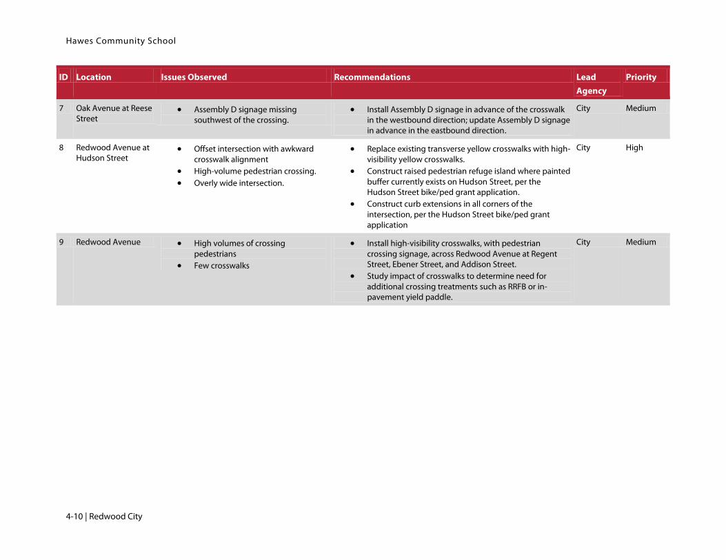
Hawes Community School
4-10 | Redwood City
ID Location Issues Observed Recommendations Lead
Agency
Priority
7 Oak Avenue at Reese Street
Assembly D signage missing southwest of the crossing.
Install Assembly D signage in advance of the crosswalk in the westbound direction; update Assembly D signage in advance in the eastbound direction.
City Medium
8 Redwood Avenue at Hudson Street
Offset intersection with awkward crosswalk alignment
High-volume pedestrian crossing.
Overly wide intersection.
Replace existing transverse yellow crosswalks with high-visibility yellow crosswalks.
Construct raised pedestrian refuge island where painted buffer currently exists on Hudson Street, per the Hudson Street bike/ped grant application.
Construct curb extensions in all corners of the intersection, per the Hudson Street bike/ped grant application
City High
9 Redwood Avenue High volumes of crossing pedestrians
Few crosswalks
Install high-visibility crosswalks, with pedestrian crossing signage, across Redwood Avenue at Regent Street, Ebener Street, and Addison Street.
Study impact of crosswalks to determine need for additional crossing treatments such as RRFB or in-pavement yield paddle.
City Medium

Hawes Community School
Safe Routes to School Report | 4-11
4.3. Recommended Programs The five “E’s” of Safe Routes to School planning includes:
Engineering
Education
Encouragement
Enforcement
Evaluation
The potential infrastructure improvements presented on the previous pages address the recommended
engineering improvements. The other four “E’s” are related to programs. Programs will complement
engineering improvements such as sidewalk and crosswalk improvements by giving students and parents the
tools they need to safely and confidently get to school. All of the Five E’s work together to enhance the school
commute. The following section presents recommended programs to support safer school access.
The recommended programs were developed based on review of existing programs and community identified
need.
Student Education Workshops
Student education programs are an essential component of a Safe Routes to School effort. Students are taught
traffic safety skills that help them understand basic traffic laws and safety rules. Example pedestrian
education curriculum elements include traffic sign identification and how to use a crosswalk. Typical bicycle
education curriculum elements include helmet and bike fit, hand signals, and riding safely with traffic.
The school has conducted twelve bicycle and pedestrian safety courses with students over the previous school
year.
Recommendation: Because many families walk to school, it is recommended the future education curriculum
program include a significant focus on pedestrian traffic safety. The education workshops should continue to
occur on an annual basis.
Parent Education Workshops
Parent education programs are also an essential component of a Safe Routes to School effort by helping
parents lead by good example. Parents are taught key traffic safety skills they can practice with their children
anytime they walk or bicycle as a family. Example parent education curriculum elements include basic
pedestrian safety skills such as “look left, right, left,” obeying to crossing guards, bicycle hand signals, and
riding safely with traffic. The curriculum may also include safe driving behaviors, which is especially
important in school zones.
Hawes parents received one driver behavior and safety workshop this year, with additional emphasis on tools
to start up a walking school bus.
Recommendation: It is recommended parent traffic safety education workshops continue to be held on an
annual basis. The workshops should cover safe driving, walking, and bicycling behaviors.
Monthly Walk to School Day Events
The school currently hosts monthly Walk to School Day events with student incentives.

Hawes Community School
4-12 | Redwood City
Recommendation: It is recommended the school continue the monthly Walk to School Day events. Outreach
should include notices in the school newsletter or related school news to remind parents of this monthly
event. Outreach should include advertisement of the Suggested Routes to School maps a week before each
Walk to School Day event.
Walking School Bus
While a walking school bus program was proposed and not implemented during previous outreach efforts,
this program can help with traffic congestion around the school, help develop healthy habits, and build
community.
Recommendation: It is recommended Hawes develop a Walking School Bus program. The program may be
organized through outreach including tabling, meet and greet sessions, and through school communications.
Meet and greet sessions may bring parents together and instill a sense of comfort with parents leading the
Walking School Bus.
Crossing Guards
The effectiveness of a crossing guard can be the deciding factor in a parent feeling comfortable enough to let
their child walk or bike to school. Parents at Hawes expressed a desire for uniform levels of training and effort
between the three current crossing guards.
Recommendation: Provide standardized, district-wide crossing guard training according to best practices.
Trash Collection
Parents expressed concern about students bicycling to school on route where trash collection occurs in the
morning.
Recommendation: The City should work with their waste management contractor to minimize trash
collection during before-school and after-school hours on identified walking and biking routes to schools.
The City should use the suggested walking route maps to help identify key routes and streets for
consideration.
T

Hawes Community School
Safe Routes to School Report | 4-13
Figure 4-3: Hawes Community School Improvement Plan

Hawes Community School
4-14 | Redwood City
This page intentionally left blank.

John Gill Elementary School
Safe Routes to School Report | 5-1
John Gill Elementary School
5. John Gill Elementary Recommendations
5.1. School Information Principal: Josh Griffith
Enrollment: 484 Students, K-5
Arrival: All Grades – 8:20 AM
Dismissal: Kindergarten – 11:40 AM
Grades 1-5 – 2:40 PM
Minimum Days – 1:30 PM
5.1.1. Layout
John Gill Elementary is located on a hillside in central Redwood City. The school looks down the hillside onto
Jefferson Avenue, an arterial east/west roadway through Redwood City. The school also has frontage along
Avenida Del Ora to the west and Myrtle Street to the east. To the north, the school is fronted by homes on
either Harrison Avenue or Eagle Hill Terrace.
Students can access the school grounds via Avenida Del Ora and Myrtle Street.
5.1.2. Loading Zones
There are two on-street loading zones for John Gill Elementary, on Avenida Del Ora and on Myrtle Street.
Avenida Del Ora has two pull-out bays for loading. One of those bays is designated for student buses only.
Teachers and yard duty staff monitor both of these loading bays. Avenida Del Ora also has access to two
parking lots; the lower lot is used for student loading while the upper lot is reserved for staff.
Myrtle Street has curbside loading that is monitored by staff. This curb has signs indication times for loading-
only.
5.1.3. Crossing Guard Location
There is one school staffer crossing guard, stationed at the intersection of South Place at Avenida Del Ora.
There are crossing guards on Jefferson Avenue at Cleveland Street to the northeast.
5.1.4. Existing Programs
John Gill Elementary has a “Bi-Monthly Pedi-Pledge Program” where families pledge to walk a certain number
of times every month. Students who fulfill their pledge are entered in a raffle to win a small prize. The average
participation is around 140 students. During the 2011-2012 school year, five walking school buses operated at
John Gill Elementary. All walking school buses, however, did not continue in the 2012-2013 school year due to
the parent champions moving their children to other schools.
Students received four bicycle and pedestrian safety assemblies over the previous school year.

John Gill Elementary School
5-2 | Redwood City
5.1.5. Other Improvement Plans
In the spring of 2011, students at Stanford University conducted a walk audit at John Gill Elementary as part
of an urban studies course. They developed recommendations primarily for Myrtle Street and its intersection
at Jefferson Avenue. Some recommendations, such as erecting “No U-turn” signage on Myrtle and “Right turn
only” signage where Myrtle Street meets Jefferson Avenue, were adopted by the City. Other
recommendations, such as relocating the adjacent stoplight at Jefferson Street at Hawes Street, were not
adopted by the City. The report’s recommendations were centered around reducing traffic congestion and
improving driver behavior on Myrtle Street during loading periods.
The City has submitted a grant application in the most recent SMCTA Call for Projects to enhance bicycle
and pedestrian safety on Hudson Street from Whipple Avenue to Woodside Road. This project will pass to
the northeast of the school area for John Gill Elementary. The project will include shared lane markings for
bicyclists, signage, and curb extensions in the area of Hawes Community School.
5.2. Issues and Recommendations
5.2.1. Feasibility of Walking, Biking, and Ridesharing to School
The National Center for Safe Routes to School predicts that the majority of students who live within 1.35
miles should be able to walk to and from school, while the majority of students within 2.6 miles should be able
to bicycle.4
As shown in Figure 5-1, just under 30% of students live within half a mile of school and over 80% of students
live a mile from school. The overwhelming majority of these students live to the northeast of John Gill
Elementary, in areas of Redwood City that are fairly flat. The primary barrier to students walking and
bicycling from these neighborhoods to John Gill Elementary is the difficulty of crossing major streets. If major
roadways separating John Gill Elementary from these neighborhoods, such as Jefferson Avenue, were more
bicycle and pedestrian friendly, it might encourage more students and families to walk and bike to school.
John Gill is an excellent candidate for ridesharing programs due to the longer distances families live from
school and the density of families who live near each other.
5.2.2. Collisions
Between 2006 and 2011, nine collisions involving youth under age 18 walking or biking were reported near
John Gill Elementary School, shown in Figure 5-2. Five collisions occurred within a half mile of
the school. One of the three bicycle collisions in the area and two of the six pedestrian collisions occurred on
Jefferson Avenue.
As with the other schools areas in this report, collisions involving bicyclists and pedestrians near John Gill
generally occurred during morning and afternoon school commute hours. Three of the 9 collisions were
recorded between 7:30am and 8:00am; the six other collisions were recorded in the afternoon and early
evening hours between 2:00pm and 7:00pm. All collisions occurred on weekdays.
4 This is based on the finding that people are generally willing to travel about 30 minutes each way, regardless of travel mode. Assuming a student walking speed of 2.7 miles per hour and a bicycling speed of 8 mph, a child can travel 1.35 miles by foot or 4 miles via bicycle in 30 minutes. However, accounting for stop light interruptions, hilly terrain, and other factors, the National Center recommends a student bicycling distance target of 2.6 miles. http://www.saferoutesinfo.org/program-tools/what-distances-are-reasonable-expect-elementary-school-students-bike-school
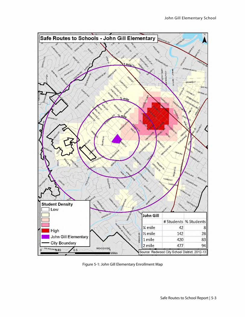
John Gill Elementary School
Safe Routes to School Report | 5-3
Figure 5-1: John Gill Elementary Enrollment Map

John Gill Elementary School
5-4 | Redwood City
Figure 5-2: John Gill Area Youth Involved Pedestrian and Bicycle Collisions, 2006-2011

John Gill Elementary School
Safe Routes to School Report | 5-5
5.2.3. Potential engineering Improvements
Potential engineering recommendations are shown and mapped in Figure 5-3. Improvement identification
numbers reference numbers on the figure.
Avenida Del Ora Loading Zone
The on-street loading zones on Avenida Del Ora are currently overseen by teachers and yard duty staff. There
are two pull-outs used for loading, separated by landscaped curb extensions. The loading zone closer to South
Place is used for bus loading. During the walk audit, participants observed drivers parking in the bus loading
area. Drivers were also observed making U-turns on Avenida Del Ora after dropping off students.
Recommendations (ID #1)
Recruit student and parent volunteers to assist teachers in loading zones.
Consider installing “No U-Turn” signage on Avenida Del Ora.
Jefferson Avenue
Jefferson Avenue is a four-lane arterial roadway through Redwood City. The current roadway configuration is
not conducive to walking and bicycling: no dedicated bicycle infrastructure, high driver speeds, narrow
sidewalks, and few controlled street crossings for pedestrians. Stretches of Jefferson Avenue have no street
parking, placing 30 mph traffic directly adjacent to pedestrians on narrow sidewalks.
Where Jefferson Avenue fronts the school grounds, the sidewalks are narrow (approximately 5-6 feet wide),
with no street parking to buffer pedestrians from moving traffic. Dirt from the hillside spills out onto the
sidewalk, further diminishing the usable pedestrian space.
The intersection of Jefferson Avenue at Hawes Street is signalized, with yellow transverse crosswalks in the
southern and eastern legs. There is a small pedestrian island in the center of Jefferson Avenue with a
pedestrian-phase push button, but the island is not wide enough to meet current standards for pedestrian
islands. The wide curb radii at this intersection leave little space at which to wait before using the crosswalk.
The intersection of Jefferson Avenue at St. Francis Street is uncontrolled and has two high-visibility yellow
crosswalks across Jefferson Street and a yellow transverse crosswalk in the northern leg of the intersection.
Recommendations (ID #2, #3, #4 & #5)
Consider a road diet project on Jefferson Avenue to reduce the number of travel lanes and provide
bike lanes on Jefferson Avenue. Additional traffic, engineering, and feasibility studies will be needed
for such a project. Design considerations must take into account existing raised and landscaped
medians. A road diet in this location could improve comfort and safety for bicyclists by providing
dedicated on-street facilities and for pedestrians by reducing the number lanes pedestrians must
cross. Where feasible, consider sidewalk widening as part of a road diet project.
Consider widening the sidewalk along the northern side of Jefferson Avenue between Myrtle Street
and Avenida Del Ora. Study whether travel lanes can be narrowed, or if the project can be
incorporated into the proposed road diet, before considering cutting into the hillside to accommodate
wider sidewalks.
Upgrade the existing yellow transverse crosswalks at Jefferson Avenue at Hawes Street to high-
visibility. Stripe advance stop bars for traffic on Jefferson Avenue at this intersection.

John Gill Elementary School
5-6 | Redwood City
Consider constructing a curb extension in the eastern corner of the intersection to reduce crossing
distance on Jefferson and improve pedestrian visibility. Ensure the curb extension does not interfere
with storm drain on Hawes Street.
Consider expanding the existing median to meet current standards, including protective curbing on
both sides of the crosswalk; ensure that construction works in tandem with the potential road diet on
Jefferson Avenue.
Ensure vegetation on Jefferson Avenue is trimmed back from the sidewalk to maximize pedestrian
space and ensure visibility.
Consider additional treatments to improve driver yield rates at the crosswalks across Jefferson
Avenue at St. Francis Street, such as advance yield pavement markings, a rapid rectangular flashing
beacon (RRFB), pedestrian refuge islands, or in-pavement yield paddles.
Ensure all curb ramps are ADA compliant at crosswalks on Jefferson Avenue at St. Francis Street,
Avenida Del Ora, Hawes Street, Myrtle Street, and King Street. Develop a prioritization matrix for
curb ramp construction that gives added weight to established and identified walking routes to
schools.
Avenida Del Ora
Participants observed drivers on Avenida Del Ora traveling at high speeds. This was especially the case for
drivers coming downhill on Quartz Street and eastbound on Avenida Del Ora towards Jefferson Avenue.
There is a landscaped triangle where the two streets meet; downhill traffic on Quartz Street merges into
Avenida Del Ora at an oblique angle on the south side of the landscaped triangle, allowing high-speed turns.
There is a perpendicular intersection on the north end of the landscaped triangle that can accommodate traffic
moving in all directions, making the oblique merge on the southern side of the triangle unecessary. There are
two driveways that access the street via this angled merge area.
Recommendations (ID #6)
Consider closing the angled merge on Quartz Street to traffic, either by extending the landscaped
triangle or with bollards and pavement striping. Convert part of this angled merge into a cul-de-sac
to maintain access for the two adjacent homes. Route all traffic to the perpendicular intersection on
the north side of the landscaped triangle.
Evaluate installing a stop sign and striping a stop bar for traffic on Quartz Street.
This improvement requires study of traffic and emergency vehicle access impacts.
Consider a three-way stop sign at the intersection of Avenida Del Ora at South Place; if infeasible,
update existing Assembly D & A signage in all directions.
Hetch-Hetchy Right-of-Way
The path of the Hetch-Hetch aqueduct travels right by John Gill Elementary, with an uninterrupted strip of
open space from South Place in the east to Harding Avenue in the west. As the easement for this right-of-way
does not allow building construction, this could be an opportunity to construct a Class I pathway, providing
access to students living west of John Gill Elementary. Similar Class I pathways have been built along the
Hetch-Hetchy right-of-way in Mountain View.
Recommendations (ID #7)
John Gill Elementary School
Safe Routes to School Report | 5-7
Consider working with the SF Water Department to construct a Class I pathway from South Place to
Harding Avenue, with high-visibility crosswalks, ADA compliant curb ramps, and appropriate
crossing signage at each cross-street.
Bicycle Parking
Standard bicycle parking is located nearby the gate to Myrtle Street. The principal expressed interest in
bicycle parking for students approaching on Avenida Del Ora.
Recommendations (ID #8)
Install updated bicycle parking on the southwest side of school grounds.
James Avenue at Grand Street
Parents identified a need for a crosswalk in the southern leg of this intersection.
Recommendation (ID #9)
Stripe a yellow transverse crosswalk in the southern leg of the intersection (within 600’ of MIT
school).
Jefferson Avenue at Cleveland Street
Parents identified this uncontrolled crosswalk as a key area of concern. The crosswalk is high-visibility yellow
in the western leg of the intersection, with accompanying signage and pavement markings. The crosswalk has
a crossing guard.
Recommendation (ID #10)
Evaluate the intersection for improved crossing enhancements. This may include a signal warrant for
the intersection, or enhancements for the uncontrolled crosswalk such as RRFBs or a pedestrian
median refuge island.
Engineering Improvement Summary
Table 5-1 lists the recommended improvements to address circulation issues around John Gill Elementary and
Figure 5-3 presents an improvement plan of these recommendations. The project IDs in
Table 5-1 corresponds to those in Figure 5-3. The table shows the identified concerns, the proposed
improvement, the agency likely to lead project implementation and the recommended priority level for
implementation. The “lead agency” is determined by on whose property/right-of-way the proposed
improvement is located. The priority level is based on the anticipated safety and circulation benefit, the
feasibility of implementation, and the projected cost.

John Gill Elementary School
5-8 | Redwood City
Table 5-1: John Gill Elementary Recommended Improvements
ID Location Issues Observed Recommendations Lead
Agency
Priority
Level
1 Avenida Del Ora Loading Zone
U-turns on Avenida Del Ora
Poor driver behavior at loading zones
Recruit student and parent volunteers to act as loading zone valets. Outfit valets with reflective vests.
Consider installing “No U-turn” signage on Avenida Del Ora.
District, City Medium
2 Jefferson Avenue
No on-street bicycling facilities
Narrow sidewalks
Difficult pedestrian crossings
High driver speeds
Consider a road diet project for Jefferson Avenue to provide dedicated on-street facilities for bicyclists, improve the pedestrian experience on the street, and improve conditions for crossing pedestrians. Requires additional traffic, engineering, and feasibility studies, especially in locations with existing raised and/or landscaped medians.
Prioritize ADA compliant curb ramps at Myrtle Street, Avenida Del Ora, St. Francis Street and King Street.
Ensure vegetation is trimmed back from sidewalk on Jefferson Avenue to maximize pedestrian space.
City High
3 Jefferson Avenue Sidewalk
Narrow sidewalk with no buffer from vehicle traffic
Consider widening sidewalk along the northwest side of Jefferson Avenue, from Myrtle Street to Avenida Del Ora. Attempt to incorporate into potential road diet project. Do not expand into hillside where utility boxes and utility poles preclude construction.
City Medium
4 Jefferson Avenue at Hawes Street
Faded crosswalk
Pedestrian refuge island is too narrow to meet current standards
Wide curb radii
Upgrade yellow transverse crosswalks to high-visibility. Ensure all curb ramps are ADA compliant.
Stripe advance stop bars for traffic on Jefferson Avenue.
Consider constructing a curb extension in the southeastern corner. Curb extension cannot obstruct storm drain on Hawes Street.
Consider expanding existing median to a standard pedestrian refuge, including curbing on both sides of the crosswalk.
City High

John Gill Elementary School
Safe Routes to School Report | 5-9
ID Location Issues Observed Recommendations Lead
Agency
Priority
Level
5 Jefferson Avenue at St Francis Street
Existing high-visibility crossing could use additional treatments
Consider treatments to improve driver yield rates for pedestrians crossing Jefferson Avenue, such as advance yield pavement markings, rapid rectangular flashing beacons (RRFBs), pedestrian refuge islands, or in-pavement yield paddles.
City Medium
6 Avenida Del Ora
High driver speeds on Avenida Del Ora from drivers exiting Quartz Street
Angled merge at landscaped triangle facilitates high driving speeds.
High driver speeds headed towards Jefferson Avenue.
Consider closing southern outlet of Quartz Street to traffic, routing all traffic through the perpendicular intersection on Avenida Del Ora. Maintain driveway access to homes south of the outlet closure via a cul-de-sac accessed from Avenida Del Ora.
Evaluate a stop sign at intersection for traffic on Quartz Street.
Study impacts to traffic and emergency vehicle access.
Consider 3-way stop sign at Avenida Del Ora at South Place; if infeasible update Assembly D & A signage.
City Medium
7 Hetch-Hetchy Right-of-Way
Right of way would make excellent pathway for students living to the west of the school
Consider constructing a Class I shared use pathway along the Hetch-Hetchy right-of-way, from Avenida Del Ora in the east to Harding Avenue in the west.
Consider installing high-visibility crosswalks with appropriate crossing signage at each cross street.
City, SF Dept of Water
Medium
8 Additional Bicycle Parking
Bicycle parking is only available at Myrtle Street gate.
Install additional bicycle parking on the west side of the school.
District Low
9 James Avenue at Grand Street
Regular walking route missing crosswalk in southern leg
Stripe yellow transverse crosswalk in southern leg City Low
10 Jefferson Avenue at Cleveland Street
Uncontrolled high visibility crosswalk used by many students from many schools in the area.
Evaluate crossing enhancements, such as a signal warrant, median pedestrian refuge island, or RRFBs
City High

John Gill Elementary School
5-10 | Redwood City
5.3. Recommended Programs The five “E’s” of Safe Routes to School planning includes:
Engineering
Education
Encouragement
Enforcement
Evaluation
The potential infrastructure improvements presented on the previous pages address the recommended
engineering improvements. The other four “E’s” are related to programs. Programs will complement
engineering improvements such as sidewalk and crosswalk improvements by giving students and parents the
tools they need to safely and confidently get to school. All of the Five E’s work together to enhance the school
commute. The following section presents recommended programs to support safer school access.
The recommended programs were developed based on review of existing programs and community identified
need.
Student Education Workshops
Student education programs are an essential component of a Safe Routes to School effort. Students are taught
traffic safety skills that help them understand basic traffic laws and safety rules. Example pedestrian
education curriculum elements include traffic sign identification and how to use a crosswalk. Typical bicycle
education curriculum elements include helmet and bike fit, hand signals, and riding safely with traffic.
John Gill Elementary has conducted four bicycle and pedestrian safety assemblies with students in the
previous school year.
Recommendation: It is recommended John Gill not only continue to host student education workshops, but
also to increase the number of workshops provided each school year. While most families walk to school, a
bicycle education component should be added to the curriculum. Bicycle education lessons will benefits the
students beyond their commute to school and teach them valuable bicycle traffic safety skills. The education
workshops should occur on an annual basis.
Parent Education Workshops
Parent education programs are also an essential component of a Safe Routes to School effort by helping
parents lead by good example. Parents are taught key traffic safety skills they can practice with their children
anytime they walk or bicycle as a family. Example parent education curriculum elements include basic
pedestrian safety skills such as “look left, right, left,” obeying to crossing guards, bicycle hand signals, and
riding safely with traffic. The curriculum may also include safe driving behaviors, which is especially
important in school zones.
There were no parent workshops conducted in the past school year at John Gill Elementary.
Recommendation: It is recommended a parent traffic safety education workshop be held on an annual basis.
The workshops should cover safe driving, walking, and bicycling behaviors.
John Gill Elementary School
Safe Routes to School Report | 5-11
Monthly Pedi-Pledge Program
Students pledge to walk to school a number of times a month. The program includes incentives.
Recommendation: Continue the Monthly Pedi-Pledge Program.
Park-and-Walk
A Park-and-Walk program can reduce traffic congestion at the school and encouraging student physical
activity.
Recommendation: It is recommended that the school develop a Park-and-Walk program with maps of
recommended parking areas that are posted on the school website. The maps should be distributed in back to
school packets and be available in the school office. School newsletters or related school news should remind
parents of this program. A potential park-and-walk site is the Red Morton Community Park to the southeast.
Walking School Bus
While a walking school bus program was implemented but discontinued due to loss of parent champions, this
program can help with traffic congestion around the school, help develop healthy habits, and build
community.
Recommendation: It is recommended John Gill reinstate a Walking School Bus program. The program may
be organized through outreach including tabling, meet and greet sessions, and through school
communications. Meet and greet sessions may bring parents together and instill a sense of comfort with
parents leading the Walking School Bus.
Monthly Walk to School Day Events
Monthly Walk to School Day events help advertise walking to school and related programs such as Park-and-
Walk, Walking School Buses and the Pedi-Pledge Program.
The school currently hosts monthly Walk to School Day events with student incentives.
Recommendation: It is recommended the school continue the monthly Walk to School Day events. Outreach
should include notices in the school newsletter or related school news to remind parents of this monthly
event. Outreach should include advertisement of the Suggested Routes to School maps a week before each
Walk to School Day event.
SchoolPool – CarPool
Carpooling complements walking and biking modes by reducing vehicle congestion and increasing pedestrian
and bicyclist safety at schools, and by providing a greener transportation alternative for families who live
further away from school, as many John Gill families do. There is a high concentration of families living
between one-half and one mile from school to the east near El Camino Real. Families in this area are ideal
candidates for a carpool program.
Recommendation: It is recommended John Gill participate in an online carpooling tool,, work with the
parent community to promote informal off-line carpooling, and host a Car Pool to School day early in the
school year. Outreach for the online tool and the event can include tabling during school arrival and dismissal
and meet and greet sessions. Examples of such websites are at (www.carpoolassist.com) and
(www.carpooltoschool.com). Carpool outreach should also consider parents without internet access.
John Gill Elementary School
5-12 | Redwood City
A Car Pool to School Day event toolkit is available through Redwood City 2020.
Crossing Guards
The effectiveness of a crossing guard can be the deciding factor in a parent feeling comfortable enough to let
their child walk or bike to school.
Recommendation: Provide standardized, district-wide crossing guard training according to best practices.
Trash Collection
Parents expressed concern about students bicycling to school on route where trash collection occurs in the
morning.
Recommendation: The City should work with their waste management contractor to minimize trash
collection during before-school and after-school hours on identified walking and biking routes to schools.
The City should use the suggested walking route maps to help identify key routes and streets for
consideration.

John Gill Elementary School
Safe Routes to School Report | 5-13
Figure 5-3: John Gill Elementary Improvement Plan

Chapter 5
5-14 | Redwood City
This page intentionally left blank.

Roosevelt Elementary School
Safe Routes to School Report | 6-1
6. Roosevelt Elementary School Recommendations
6.1. School Information Principal: Patricia Girardi
Enrollment: 553 Students, K-8
Arrival: K-6 – 7:58 AM
Dismissal: Early Kindergarten – 12:40 PM
Late Kindergarten – 1:50 PM
Grades 1-3 – 2:00 PM
Grades 4-8 – 2:20 PM
Grades 1-3, Early Dismissal – 1:00 PM
Grades 4-8, Early Dismissal – 1:20 PM
6.1.1. Layout
Roosevelt School is an elementary school that is in the process of expanding from a K-5 school to a K-8 school
over three years. The school is located in western Redwood City. While the neighborhoods to the east are
fairly flat, the neighborhoods to the west are quite hilly. Roosevelt School itself is located on a hillside. Two
major arterials in Redwood City are in close proximity to the school, with Alameda de Las Pulgas to the west
and Jefferson Avenue to the north. The school has frontage on Vera Avenue, Upton Street, and Euclid Avenue.
There is access to school from a parking lot and loading area off-street from McGarvey Avenue.
Students access the school site from:
Two gates on Vera Avenue
Gates on the corner of school grounds on Upton Street
Euclid Avenue, beside the library
A pedestrian path from the parking lot off of McGarvey Avenue
The school location presents challenges for walking and bicycling, especially from the hilly neighborhoods to
the west. There are bike lanes on Alameda de Las Pulgas and McGarvey Avenue has Class III shared lane
markings from Chesterton Avenue to Jefferson Avenue.
6.1.2. Loading Zones
There are three official loading zones for the school, one on Vera Avenue and in a parking lot off of McGarvey
Avenue. One new loading zone has been recently installed on Euclid Avenue. Many parents also drop off
students on McGarvey Avenue and in the shopping center parking lot opposite the school on Euclid Avenue.
Roosevelt School

Roosevelt Elementary School
6-2 | Redwood City School District
6.1.3. Crossing Guard Location
There are two crossing guards serving Roosevelt School. One crossing guard is at the uncontrolled crosswalk
at the intersection of Vera Avenue at Windsor Way, which is at the school’s main entrance. The second
crossing guard is at the intersection of Upton Street at Roosevelt Avenue, which is a signalized intersection.
6.1.4. Existing Programs
There is no formal walking or bicycling programming currently in place at Roosevelt School.
6.2. Issues and Recommendations
6.2.1. Feasibility of Walking, Biking, and Ridesharing to School
The National Center for Safe Routes to School predicts that the majority of students who live within 1.35
miles should be able to walk to and from school, while the majority of students within 2.6 miles should be able
to bicycle.5
As shown in Figure 6-1, half of students live at least a mile away from school, and only 20% live within half a
mile. The largest concentration of students is in central Redwood City to the east, along Redwood Avenue
and Roosevelt Avenue. Student concentrations are much lower to the west. Roosevelt is an excellent
candidate for ridesharing programs due to the longer distances families live from school and the density of
families who live near each other.
6.2.2. Collisions
Between 2006 and 2011, one collision involving youth under age 18 walking or biking was reported near
Roosevelt Elementary School, shown in Figure 6-2. This pedestrian collision occurred near Connecticut
Avenue and Oregon Avenue on a weekday just before 8:00am.
5 This is based on the finding that people are generally willing to travel about 30 minutes each way, regardless of travel mode. Assuming a student walking speed of 2.7 miles per hour and a bicycling speed of 8 mph, a child can travel 1.35 miles by foot or 4 miles via bicycle in 30 minutes. However, accounting for stop light interruptions, hilly terrain, and other factors, the National Center recommends a student bicycling distance target of 2.6 miles. http://www.saferoutesinfo.org/program-tools/what-distances-are-reasonable-expect-elementary-school-students-bike-school

Roosevelt Elementary School
Safe Routes to School Report | 6-3
Figure 6-1: Roosevelt Elementary Enrollment Map

Roosevelt Elementary School
6-4 | Redwood City School District
Figure 6-2: Roosevelt School Area Pedestrian and Bicycle Collisions, 2006-2011

Roosevelt Elementary School
Safe Routes to School Report | 6-5
6.2.3. Potential Engineering Improvements
Potential engineering recommendations are shown and mapped in Figure 6-3: Roosevelt School
Improvement Plan. Improvement identification numbers reference numbers on the figure.
Vera Avenue at Alameda de Las Pulgas
The intersection of Alameda de Las Pulgas at Vera Avenue is a key access point for the Roosevelt School
loading zone on Vera Avenue. Alameda de Las Pulgas has bike lanes and a raised median (north of Vera
Avenue). The intersection is set on a hillside and has wide curb radii. There is a SamTrans bus stop
immediately after the intersection on Alameda de Las Pulgas. There are white transverse crosswalks in all legs
of the intersection despite being within 600 feet of the school grounds (cities may stripe crosswalks yellow
only within 600 feet of a school, denoting a School Zone). Participants observed many drivers failing to come
to a complete stop at the intersection.
Recommendations (ID #1)
Restripe the white transverse crosswalks as yellow high-visibility.
Consider curb extensions at all corners of the intersection to reduce curb radii. Build curb extensions
into the parking lane space on Alameda de Las Pulgas, but ensure that curb extensions do not
encroach upon the existing bike lanes. Accommodate the existing storm drains when designing curb
extensions. Consider reduced curb extensions in the northeast and southwest corners to facilitate
SamTrans bus operations at adjacent stops.
If curb extensions are installed, consider striping additional red curb at SamTrans bus stops to
provide a longer bus zone.
Vera Avenue at Windsor Way
Vera Avenue functions as the primary loading zone for Roosevelt School, with a section of white curb
between Alameda de Las Pulgas and the school entrance. The street widens at the school entrance to
accommodate perpendicular parking stalls. There is an uncontrolled high-visibility yellow crosswalk at Vera
Avenue at Windsor Way, managed by a crossing guard. Immediately east of the crosswalk, the street narrows
again to its original width. The curb is striped red between the crosswalk and where it narrows to the east.
Parents identified drivers making U-turns to return to Alameda de Las Pulgas after dropping off students as a
safety issue on this street.
Recommendations (ID #2)
Consider constructing a curb extension on the southern end of the crosswalk to bring the curb even
to the street width further to the east, reducing the crossing distance for pedestrians and increasing
their visibility. Use striping and raised bollards in place of curb extensions if cost is prohibitive.
Ensure curb extension still allows emergency vehicle access to school maintenance gate.
Ensure all curb ramps are ADA compliant.
Upton Street
Upton Street runs along the eastern edge of the school grounds, by the playing fields. There are gates at the
intersections of Upton Street at Vera Avenue and at Euclid Avenue. The intersection of Upton Street at Vera
Avenue is stop controlled in all directions and has faded yellow transverse crosswalks in all legs. The

Roosevelt Elementary School
6-6 | Redwood City School District
intersection of Upton Street at Euclid Avenue is stop controlled for Euclid Avenue only, with a high-visibility
uncontrolled crosswalk in the western leg and a yellow transverse crosswalk in the southern leg.
Recommendations (ID #3)
Upgrade all existing crosswalks at Upton Street at Vera Avenue to high-visibility yellow. Update
Assembly A signage on Vera Avenue in advance of the crosswalk to the east.
Ensure all curb ramps at crosswalks on Upton Street at Vera Avenue, Euclid Avenue, and Roosevelt
Avenue are ADA compliant.
Euclid Avenue
A Redwood City Public library is located on Euclid Avenue, adjacent to school grounds. Bicycle parking is
located on school grounds nearby the library. Many parents park in the shopping center parking lot across
Euclid Avenue and cross the street mid-block, despite the lack of a crosswalk.
Recommendations (ID #4)
Consider installing a mid-block high-visibility yellow crosswalk at Euclid Avenue, providing access
to Roosevelt School and the public library. Install Assembly D & B signage in both directions. Install
crosswalk only if there is adequate visibility.
Stripe red curb on the east side of Euclid Avenue from the parking lot driveway to the crosswalk to
improve pedestrian visibility.
Roosevelt School Downhill Parking Lot
There is an off-street parking lot for Roosevelt School, accessible via McGarvey Avenue. There is a sidewalk
on the western side of the lot from the street up to a pedestrian pathway at the northern end of the parking
lot. Parents expressed concern about cross the driveway entrance to reach the walking path and about
reaching the walking path once parked in the parking lot. There are pavement markings at the parking lot
exit directing drivers to turn right only, but they are faded.
Recommendations (ID #5)
Consider constructing a walking path on the east side of the lot from McGarvey Avenue, reducing
pedestrian conflicts with entering/exiting vehicles.
Consider restricting the use of this parking lot to lower grade or kindergarten drop-off to reduce
congestion in the parking lot/driveway.
Refresh the pavement markings at the parking lot exit directing drivers to turn right on McGarvey
Avenue.
Install tactile dome strips at the driveway path across the sidewalk.
Euclid Avenue at McGarvey Avenue
At the intersection of McGarvey Avenue at Euclid Avenue is all-way stop controlled and there are crosswalks
in all legs but the western one. This, however, is the leg of the intersection most used by families traveling to
Roosevelt School.

Roosevelt Elementary School
Safe Routes to School Report | 6-7
Recommendations (ID #6)
Consider striping a new crosswalk in the eastern leg of McGarvey Avenue at Euclid Avenue. Remove
the railing at that leg of the intersection. Review history of railing installation before moving forward
with removal.
Ensure all curb ramps are ADA compliant.
Roosevelt Avenue at McGarvey Avenue
This intersection is stop-controlled only for traffic on McGarvey Avenue. There are white transverse
crosswalks in the eastern and western legs of the intersection and white high-visibility crosswalks in the
northern and southern legs of the intersection. There are “PED XING” pavement markings on Roosevelt in
advance of the crosswalk in both directions, but no signage or other crossing treatments. Parents of younger
students walking from the east regularly use this crossing to reach the school.
Recommendation (ID #7)
Install advance yield pavement markings on Roosevelt Avenue. Consider additional advanced
treatments if driver yield rate does not improve.
Scooter and Skateboard Storage
Multiple parents expressed the opinion that they would be more willing to let their child walk/bike to school
if there were a safe location for them to store their skateboards or scooters once they arrived at school.
Recommendation (ID #8)
Roosevelt School should provide secure storage space for scooters and skateboards. Consider either a
storage room or a dedicated locker space.
Engineering Improvement Summary
Table 6-1 lists the recommended improvements to address circulation issues around Roosevelt School and
Figure 6-3 presents an improvement plan of these recommendations. The project IDs in Table 6-1 correspond
to those in Figure 6-3. The table shows the identified concerns, the proposed improvement, the agency likely
to lead project implementation and the recommended priority level for implementation. The “lead agency” is
determined by on whose property/right-of-way the proposed improvement is located. The priority level is
based on the anticipated safety and circulation benefit, the feasibility of implementation, and the projected
cost.

Roosevelt Elementary School
6-8 | Redwood City School District
Table 6-1: Roosevelt School Recommended Improvements
ID Location Issues Observed Recommendations Lead Agency
Priority Level
1 Vera Avenue at Alameda de Las Pulgas
White crosswalks within school zone
Wide curb radii
Drivers failing to come to complete stop, especially when making right turns
Restripe crosswalks as high-visibility yellow.
Consider constructing curb extensions at all corners of intersection into the parking lanes on Alameda de Las Pulgas. Do not encroach on bike lanes with curb extensions. Accommodate existing storm drains when designing curb extensions. Reduce size of curb extensions in northeast and southwest corners to accommodate adjacent SamTrans bus stops.
If curb extensions are built, consider striping additional red curb north of the intersection on Alameda de Las Pulgas to accommodate a longer SamTrans bus stop.
City Medium
2 Vera Avenue at Windsor Way
Crosswalk overly wide Consider constructing a curb extension on south side of crosswalk, in line with landscaping strip to the east.
Ensure all existing curb ramps are ADA compliant.
City High
3 Upton Street High-volume pedestrian intersection
School Zone signage missing
Upgrade existing yellow transverse crosswalks to high-visibility.
Ensure all existing curb ramps are ADA compliant.
Update Assembly A School Zone sign on Vera Avenue east of the intersection.
City Medium
4 Euclid Avenue Families crossing mid-block on Euclid from shopping center parking lot
Consider installing a mid-block crosswalk. Install Assembly D & B signage along Euclid Avenue. Install crosswalk only if there is adequate visibility for oncoming drivers.
Stripe red curb on east side of the street from crosswalk to parking lot driveway.
City Medium

Roosevelt Elementary School
Safe Routes to School Report | 6-9
ID Location Issues Observed Recommendations Lead Agency
Priority Level
5 Roosevelt School Downhill Parking Lot
Drivers behaving poorly at parking lot exit
Pedestrians coming from the east must cross driveway to access walking path
Consider constructing a walking path on the east side of the parking lot and driveway, reducing pedestrian conflict at the driveway entrance/exit.
Refresh pavement markings at the exit directing cars to only turn right.
Install tactile dome strips on the sidewalk on either side of the driveway.
School, City
Low
6 Euclid Avenue at McGarvey Avenue
Families using western leg of intersection to cross and get to school.
Consider striping a new crosswalk in the western leg of the intersection. Consider removing the railing from the crosswalks directing pedestrians to the eastern crosswalk. Review history of railing installation before moving forward with removal.
Ensure all curb ramps are ADA compliant.
City Medium
7 Roosevelt Avenue at McGarvey Avenue
Parents of younger students coming from the east often cross at this uncontrolled crosswalk
Stripe advance yield pavement markings on Roosevelt Avenue.
Consider additional crossing enhancements if driver yield rate is considered to be too low.
City Medium
8 Scooter and skateboard storage
Parents would allow children to get to school by scooter if safe storage was available.
Create safe storage for skateboards and scooters, possibly as lockers.
School Low

Roosevelt Elementary School
6-10 | Redwood City School District
6.3. Recommended Programs The five “E’s” of Safe Routes to School planning includes:
Engineering
Education
Encouragement
Enforcement
Evaluation
The potential infrastructure improvements presented on the previous pages address the recommended
engineering improvements. The other four “E’s” are related to programs. Programs will complement
engineering improvements such as sidewalk and crosswalk improvements by giving students and parents the
tools they need to safely and confidently get to school. All of the Five E’s work together to enhance the school
commute. The following section presents recommended programs to support safer school access.
The recommended programs were developed based on review of existing programs and community identified
need.
Student Traffic Safety Education Workshops
Student education programs are an essential component of a Safe Routes to School effort. Students are taught
traffic safety skills that help them understand basic traffic laws and safety rules. Example pedestrian
education curriculum elements include traffic sign identification and how to use a crosswalk. Typical bicycle
education curriculum elements include helmet and bike fit, hand signals, and riding safely with traffic.
No educational workshops were held with students in the previous school year.
Recommendation: It is recommended Roosevelt host student traffic safety education workshops. While few
families walk or bicycle to school, the Safe Routes to School program hopes into increase the number who do.
Additionally, the skills taught in these lessons are valuable beyond getting to school. Nearly all students walk
and bicycle. The education workshops should occur on an annual basis.
Parent Traffic Safety Education Workshops
Parent education programs are also an essential component of a Safe Routes to School effort by helping
parents lead by good example. Parents are taught key traffic safety skills they can practice with their children
anytime they walk or bicycle as a family. Example parent education curriculum elements include basic
pedestrian safety skills such as “look left, right, left,” obeying to crossing guards, bicycle hand signals, and
riding safely with traffic. The curriculum may also include safe driving behaviors, which is especially
important in school zones.
No parent workshops were held in the previous school year.
Recommendation: It is recommended a parent traffic safety education workshop be held on an annual basis.
The workshops should cover safe driving, walking, and bicycling behaviors.
Park-and-Walk
A Park-and-Walk program can reduce traffic congestion at the school and encouraging student physical
activity.

Roosevelt Elementary School
Safe Routes to School Report | 6-11
Recommendation: It is recommended that the school develop a Park-and-Walk program with maps of
suggested locations that are posted on the school website. The maps should be distributed in back to school
packets and be available in the school office. School newsletters or related school news should remind parents
of this program. A potential park-and-walk site is the Red Morton Community Park to the northeast of the
school.
Walking School Bus
While a walking school bus program was implemented but discontinued due to loss of parent champions, this
program can help with traffic congestion around the school, help develop healthy habits, and build
community.
Recommendation: It is recommended Roosevelt reinstate a Walking School Bus program. The program may
be organized through outreach including tabling, meet and greet sessions, and through school
communications. Meet and greet sessions may bring parents together and instill a sense of comfort with
parents leading the Walking School Bus.
Monthly Walk to School Day Events
Monthly Walk to School Day events help advertise walking to school and related programs such as Park-and-
Walk.
Recommendation: It is recommended the school host monthly Walk to School Day events. Outreach should
include notices in the school newsletter or related school news to remind parents of this monthly event.
Outreach should include advertisement of the Suggested Routes to School maps a week before each Walk to
School Day event.
SchoolPool – CarPool
Carpooling complements walking and biking modes by reducing vehicle congestion and increasing pedestrian
and bicyclist safety at schools, and by providing a greener transportation alternative for families who live
further away from school, as many Roosevelt families do. There is a high concentration of families living
approximately one mile from school to the east near El Camino Real. Families in this area are ideal candidates
for a carpool program.
Recommendation: It is recommended Roosevelt participate in an online carpooling tool, work with the
parent community to promote informal off-line carpooling, and host a Car Pool to School day early in the
school year. Outreach for the online tool and the event can include tabling during school arrival and dismissal
and meet and greet sessions. Carpool outreach should also consider parents without internet access.
A Car Pool to School Day event toolkit is available through Redwood City 2020.
Crossing Guards
The effectiveness of a crossing guard can be the deciding factor in a parent feeling comfortable enough to let
their child walk or bike to school. Parents at Roosevelt expressed a desire for uniform levels of training and
effort between the two current crossing guards.
Recommendation: Provide standardized, district-wide crossing guard training according to best practices.

Roosevelt Elementary School
6-12 | Redwood City School District
Trash Collection
Parents expressed concern about students bicycling to school on route where trash collection occurs in the
morning.
Recommendation: The City should work with their waste management contractor to minimize trash
collection during before-school and after-school hours on identified walking and biking routes to schools.
The City should use the suggested walking route maps to help identify key routes and streets for
consideration.

Roosevelt Elementary School
Safe Routes to School Report | 6-13
Figure 6-3: Roosevelt School Improvement Plan

Roosevelt Elementary School
6-14 | Redwood City School District
This page intentionally left blank.

Roy Cloud School
Safe Routes to School Report | 7-1
7. Roy Cloud School Recommendations
7.1. School Information Principal: Gregory Land
Enrollment: 809, K-8
Arrival: All Grades –8:16 AM
Dismissal: Kindergarten – 1:30 PM
Grades 1-2 – 2:25 PM
Grades 3-8 – 2:50 PM
7.1.1. Layout
Roy Cloud School is located in the hills of western Redwood City. The school is adjacent to unincorporated
San Mateo County. The school only has frontage on Jefferson Avenue, fronted by single family homes on the
other three sides. Farm Hill Boulevard, an east/west arterial, is located downhill to the east. Students access
the school from:
The main school entrance on Jefferson Avenue
A pedestrian pathway from Emerald Hills Road
A pedestrian pathway from Red Oak Way
The hilly nature of the surrounding community makes walking and biking challenging for students.
7.1.2. Loading Zones
The school has two official loading zones. One loading area is in a parking lot loop accessed from Jefferson
Avenue. The other loading area is off of Red Oak Way in the school parking lot.
7.1.3. Crossing Guard Location
There are two crossing guards for Roy Cloud School. One is located at the intersection of Jefferson Avenue at
Seminole Way and the other is located at the intersection of Emerald Hills Road at Red Oak Way.
7.1.4. Existing Programs
Roy Cloud School hosts a walking program, encouraging students and parents to walk to school. Students
walking on Thursday or Friday are entered into a raffle (http://www.rcsd.k12.ca.us/domain/877). In March of
2013, the school established a Park & Walk program, recommending parents park on Bret Harte Drive. The
school has a walking school bus program and participates in citywide walking and biking events. On
International Walk to School Day, three hundred fourteen students at Roy Cloud participated, a twenty seven
percent increase over a normal day.
Students at Roy Cloud Elementary received a single bicycle/pedestrian safety assembly in the past school year.
There were no workshops for parents offered.
Roy Cloud School

Roy Cloud School
7-2 | Redwood City School District
7.1.5. Planned Projects
Roy Cloud School is scheduled for upcoming improvements. These include the City installing a painted bulb-
out and red curb at the intersection of Jefferson Avenue at Emerald Hills Road, improving school zone signage
on Jefferson Avenue uphill from the school, and installing a crosswalk at the five-point intersection on
Jefferson Avenue northwest of the school.
The County is currently considering improvement to Jefferson Avenue that would improve walking
conditions between Lakeview Way and Emerald Hills Road. While Jefferson Avenue is not currently a
suggested walking route to school, the district should reconsider the street as a key walking route once the
County has made improvements. The district and City should work with the County to develop improvement
plans that would best serve the safety and comfort of students walking to Roy Cloud School.
7.2. Issues and Recommendations
7.2.1. Feasibility of Walking, Biking, and Ridesharing to School
The National Center for Safe Routes to School predicts that the majority of students who live within 1.35
miles should be able to walk to and from school, while the majority of students within 2.6 miles should be able
to bicycle.6 The hilly setting of Roy Cloud School, however, reduces the viability of walking or biking from
such distances.
As shown in Figure 7-1, Roy Could School draws students evenly from the community around the school.
Approximately 40% of students live within half a mile and more than three quarters live within a mile. While
most of the students are evenly spread around the school in all directions, there is a concentration of students
living to the northeast of the school over a mile away. Roy Cloud is an excellent candidate for ridesharing
programs due to the longer distances families live from school, the topography surrounding the school, and the
density of families who live near each other.
7.2.2. Collisions
Between 2006 and 2011, one collision involving youth under age 18 walking or biking was reported within a
half-mile of Roy Cloud School, shown in Figure 7-2. This bicycle collision occurred near Farm Hill Boulevard
and McGarvey Avenue on a Saturday just after 10:00pm.
6 This is based on the finding that people are generally willing to travel about 30 minutes each way, regardless of travel mode. Assuming a student walking speed of 2.7 miles per hour and a bicycling speed of 8 mph, a child can travel 1.35 miles by foot or 4 miles via bicycle in 30 minutes. However, accounting for stop light interruptions, hilly terrain, and other factors, the National Center recommends a student bicycling distance target of 2.6 miles. http://www.saferoutesinfo.org/program-tools/what-distances-are-reasonable-expect-elementary-school-students-bike-school
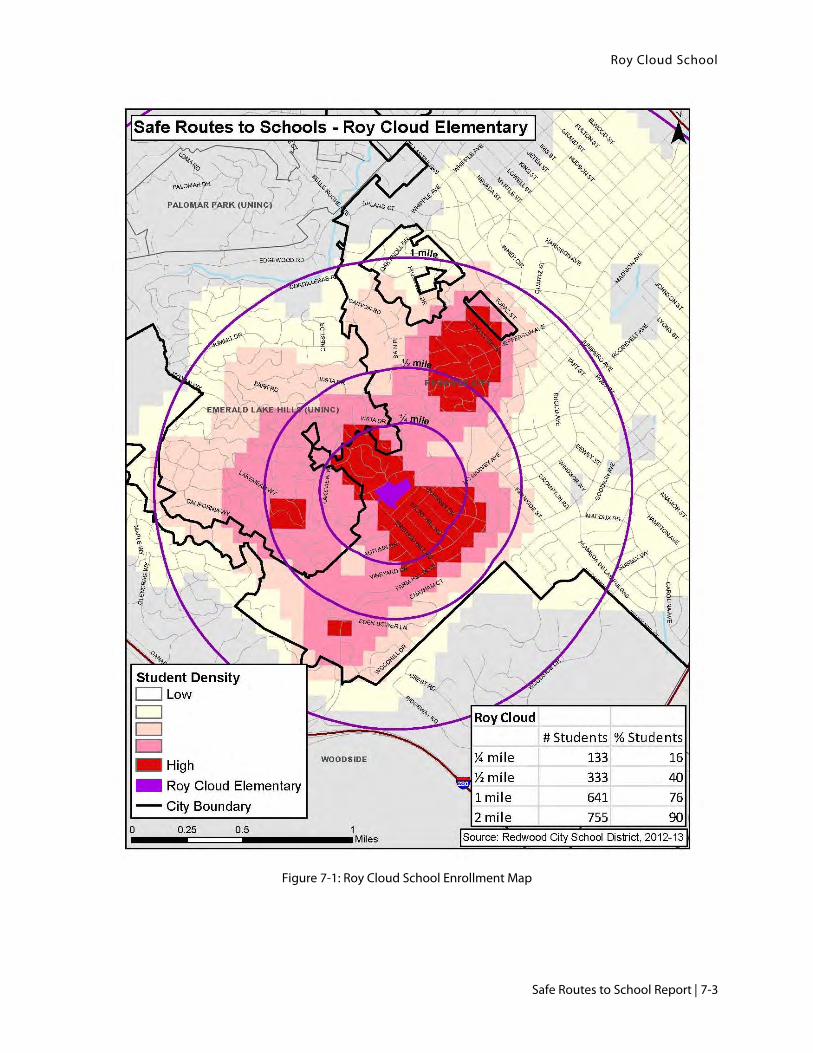
Roy Cloud School
Safe Routes to School Report | 7-3
Figure 7-1: Roy Cloud School Enrollment Map

Roy Cloud School
7-4 | Redwood City School District
Figure 7-2: Roy Cloud Area Youth Involved Pedestrian and Bicycle Collisions, 2006-2011

Roy Cloud School
Safe Routes to School Report | 7-5
7.2.3. Potential Engineering Improvements
Potential engineering recommendations are shown and mapped in Figure 7-3: Roy Cloud School
Improvement Plan. Improvement identification numbers reference numbers on the figure.
Jefferson Avenue
Jefferson Avenue is the main access point for Roy Cloud School. Not only is a loading area located on
Jefferson, but most families approaching from the north enter the school here. At the intersection of Jefferson
Avenue at Seminole Way is an uncontrolled high-visibility yellow crosswalk managed by a crossing guard.
Seminole Way meets Jefferson Avenue at an angle, and has a wide curb radii for drivers turning right, across
the crosswalk, on to Jefferson. The nearby Citrus Court has no crosswalk at its intersection with Jefferson
Avenue.
Recommendations (ID #1)
Stripe a high-visibility yellow crosswalk across Citrus Court, moving the stop sign back from the
intersection to accommodate the crosswalk.
Consider constructing a curb extension in the northwest corner of Jefferson Avenue at Seminole Way
to reduce pedestrian crossing distance, reduce curb radii, and provide more waiting space for
pedestrians. This creates a more perpendicular intersection with Jefferson Avenue. Consider other
low-cost alternatives such as pavement striping or raised bollards.
Enforce “no parking” restrictions on Jefferson Avenue to the west during loading periods to provide
additional on-street walking space for students. Work with the Sherriff’s Department for increased
enforcement.
Jefferson Avenue Parking Loop
The parking loop off of Jefferson is the key loading zone for the school. The loop has a sidewalk on its west
side from the street to the school grounds. Around the rest of the loop is a painted yellow buffer guiding the
loop. There is no dedicated pedestrian space on the east side of the loop and participants observed families
walking up the east side of the loop and slipping through a gap in the fence. Parents expressed interest in
having the loading loop closed to vehicle traffic during morning drop-off to reduce the congestion of exiting
drivers on Jefferson Avenue.
Recommendations (ID #2)
Consider constructing a sidewalk on the east side of the parking loop from Jefferson Avenue to the
schoolyard. Open a gate at the fence.
Recruit parent and student volunteers to act as loading loop valets.
Consider a pilot closure of the loading loop on a day with anticipated low driver volumes, such as
International Walk to School Day. If this pilot closure is successful, consider closing the loading loop
permanently.

Roy Cloud School
7-6 | Redwood City School District
Bicycle Parking
The principal expressed interest in creating a new bicycle Secure Parking Area (aka “SPA”), accessible from
the pedestrian path leading to Emerald Hills Road. He suggested a bike cage.
Recommendations (ID #3)
Consider installing covered, secure bicycle parking adjacent to the Emerald Hills Road pedestrian
pathway.
Emerald Hills Road
At the intersection of Emerald Hills Road at Red Oak Way are yellow high-visibility crosswalks in the
southern and eastern legs, with the southern crosswalk uncontrolled. The vegetation on the northeast corner
is overgrown and limits visibility. The City recently installed a transverse yellow crosswalk in the eastern leg
of the intersection of Emerald Hills Road at Bret Harte Drive. There is an uncontrolled high-visibility white
crosswalk in the east leg of Emerald Hills Road at Country Club Drive. There are PED XING markings in
advance on Country Club Drive, but no crossing signage. The crosswalks on Emerald Hills Road do not have
ADA-compliant curb ramps.
Parents expressed strong concern over the speeds of downhill drivers on Emerald Hills Road. They also
expressed interest in moving the crosswalk across Emerald Hills Road at Red Oak Way to the north side of
the intersection; this proved infeasible due to the existence of a driveway on the west side of Emerald Hills
Road where the new crosswalk would need to be located. Parents also asked that a new crosswalk be placed
on Bret Harte Drive for students walking on the west side of Emerald Hills Road.
Recommendations East (ID #4)
Restripe existing yellow transverse crosswalk at Bret Harte Drive as high visibility crosswalks.
Stripe a new high-visibility yellow crosswalk in the western leg of the intersection of Emerald Hills
Road at Bret Harte Drive, including new curb ramps.
Install curb ramps at all crosswalks.
Trim vegetation on the northeastern corner of Emerald Hills Road and Red Oak Way.
Consider a traffic study on Emerald Hills Road with the purpose of implementing traffic calming
where appropriate and feasible.
Install pedestrian crossing signage at crosswalk across Country Club Drive.
Red Oak Way
There is a mid-block high-visibility yellow crosswalk across Red Oak Way where the school walkway meets
the street. There are no curb ramps at either end and the crossing has no Assembly D signage.
Recommendations (ID #5)
Construct curb ramps at both ends of the crosswalk.
Install Assembly D sign for westbound traffic on Red Oak Way.
Bret Harte Drive
Parents identified Bret Harte Drive as a preferred location for remote drop-off and a possible location for a
walking school bus stop.

Roy Cloud School
Safe Routes to School Report | 7-7
Recommendation (ID #6)
Designate Bret Harte Drive as a remote loading zone in school maps and promote the formation of a
walking school bus that travels through this area.
Glennan Drive
Glennan Drive has yellow high-visiblity crosswalks at Red Oak Way and white high-visibility crosswalks at
Bret Harte Drive. Both intersections have pavement markings in advance of uncontrolled crosings, but no
signage. Glennen Drive is the route used to reach Farm Hill Boulevard to the southeast. The intersections on
Glennan Drive are mising curb ramps.
Recommendations (ID #7)
Install Assembly B signage for all three crosswalks at Glennan Drive at Red Oak Way; install
Assembly D signage for eastbound and northbound traffic.
Install pedestrian crossing signage for crosswalks across Glennan Drive at Bret Harte Drive.
Install curb ramps on Glennan Drive at Red Oak Way, Bret Harte Drive, Castle Hill Road, Country
Club Drive and Farm Hill Boulevard.
Farm Hill Boulevard
Farm Hill Boulevard is a 4 lane roadway with street parking. There is no infrastructure for bicycling on this
street and it can be a daunting street to cross for pedestrians. To the east, Farm Hill Boulevard becomes
Jefferson Avenue.
The intersection of Emerald Hills Road at Farm Hill Boulevard was one of strong parent concern. The
intersection is stop-controlled with a white transverse crosswalk in the eastern leg. A stop sign is placed in
the center of the street on Farm Hill Boulevard in each direction, with chatter bars before and after to separate
directions of traffic.
Recommendations (ID #8)
Consider a 4-to-3 road diet project on Farm Hill Road, creating bike lanes and a center turn lane. This
helps reduce driver speeds, creates on-street facilities for bicyclists, and improves crossings for
pedestrians. A road diet on Farm Hill Boulevard could continue the road diet proposed for Jefferson
Avenue at John Gill Elementary.
In conjunction with the road diet concept for Farm Hill Boulevard, reconfigure the intersection at
Emerald Hills Road. Replace existing crosswalks with high-visibility crosswalks and consider
striping an additional crosswalk in the western leg of the intersection. Consider implementation of
curb extensions, especially in the northeast and northwest corners of the intersection.
Engineering Improvement Summary
Table 7-1 lists the recommended improvements to address circulation issues around Roy Cloud School and
Figure 7-3 presents an improvement plan of these recommendations. The project IDs in Table 7-1 correspond
to those in Figure 7-3. The table shows the identified concerns, the proposed improvement, the agency likely
to lead project implementation and the recommended priority level for implementation. The “lead agency” is
determined by on whose property/right-of-way the proposed improvement is located. The priority level is
based on the anticipated safety and circulation benefit, the feasibility of implementation, and the projected
cost.

Roy Cloud School
7-8 | Redwood City School District
Table 7-1: Roy Cloud Recommended Improvements
ID Location Issues Observed Recommendations Lead Agency
Priority Level
1 Jefferson Avenue
Difficulty crossing Citrus Court
Wide radii on Seminole Way
Difficulty crossing Jefferson at Seminole
Drivers on Seminole encroaching on crosswalk
Little room for walking on Jefferson Avenue west of the school
Stripe a yellow high-visibility crosswalk across Citrus Court, including moving the stop bar further back from the intersection.
Consider constructing a curb extension in the northwest corner of Seminole Way at Jefferson Avenue to create a perpendicular intersection and discourage direct vehicle travel from the parking lot exit to Seminole Way. Consider other low-cost alternatives such as pavement striping or raised bollards.
Enforce “no parking” restrictions on Jefferson Avenue to the west of school during loading periods to provide additional on-street walking space for students. Work with Sherriff’s Department for increased enforcement.
City High
2 Jefferson Avenue Loading Loop
Families walking up eastern side of loading loop to access school
Congestion in loading loop
Consider constructing a separated pathway along the eastern edge of the loading loop, install a gate at the eastern end of the fence.
Recruit parent and student volunteers to act as loading valets.
Consider pilot closure of loading loop to study traffic impacts on Jefferson Avenue.
District High
3 Bicycle Parking
No easy bicycle parking access from west/south of school grounds
Consider installing a covered, secure bicycle parking facility near the pedestrian path from Emerald Hills Road.
District Medium

Roy Cloud School
Safe Routes to School Report | 7-9
ID Location Issues Observed Recommendations Lead Agency
Priority Level
4 Emerald Hills Road
Crossing points missing curb ramps
Visibility issues at crossings
Speeding on Emerald Hills Road
Restripe existing yellow transverse crosswalk on Bret Harte Drive as high-visibility.
Install curb ramps at all crosswalks.
Trim vegetation on NE corner of Emerald Hills Rd and Red Oak Way.
Stripe new crosswalk at western leg of Emerald Hills Road at Bret Harte Drive.
Conduct traffic study to determine appropriate traffic calming measures for Emerald Hills Road.
Install pedestrian crossing signage at Country Club Drive.
City Low
5 Red Oak Way at Pedestrian Walk Way
Crosswalk missing curb ramps
Signage out of date/missing
Install curb ramps at both ends of the existing crosswalk.
Install Assembly D sign for westbound traffic.
City
Medium
6 Bret Harte Drive
Parents prefer this location for remote drop-off
Encourage “park & walk” and remote drop off activities on Bret Harte Drive. Consider forming a walking school bus for this location.
7 Glennan Drive
Crosswalk missing curb ramps
Signage missing for crosswalks at Red Oak Way & Bret Harte Drive
Install Assembly B signage for all three crosswalks at Red Oak Way; install Assembly D signage for northbound and eastbound traffic.
Install pedestrian crossing signage for crosswalks across Glennan Drive at Bret Harte Drive.
Install curb ramps at Red Oak Way, Bret Harte Drive, Castle Hill Road, Country Club Drive, and Farm Hill Boulevard.
City
Low

Roy Cloud School
7-10 | Redwood City School District
ID Location Issues Observed Recommendations Lead Agency
Priority Level
8 Farm Hill Boulevard
Street is difficult to cross as pedestrian
No on-street facilities for bicyclists
Crosswalk missing curb ramps
Intersection at Emerald Hills Road is problematic.
Consider a 4-to-3 road diet project on Farm Hill Road, creating bike lanes and a center turn lane. This helps reduce driver speeds, creates on-street facilities for bicyclists, and improves crossings for pedestrians. A road diet on Farm Hill Boulevard could continue the road diet proposed for Jefferson Avenue at John Gill Elementary.
Replace existing crosswalk at Emerald Hills Road with high-visibility white; stripe additional crosswalk in western leg; consider curb extensions in two northern corners.
City
High

Roy Cloud School
Safe Routes to School Report | 7-11
7.3. Recommended Programs The five “E’s” of Safe Routes to School planning includes:
Engineering
Education
Encouragement
Enforcement
Evaluation
The potential infrastructure improvements presented on the previous pages address the recommended
engineering improvements. The other four “E’s” are related to programs. Programs will complement
engineering improvements such as sidewalk and crosswalk improvements by giving students and parents the
tools they need to safely and confidently get to school. All of the Five E’s work together to enhance the school
commute. The following section presents recommended programs to support safer school access.
The recommended programs were developed based on review of existing programs and community identified
need.
Student Traffic Safety Education Workshops
Student education programs are an essential component of a Safe Routes to School effort. Students are taught
traffic safety skills that help students understand basic traffic laws and safety rules. Example pedestrian
education curriculum elements include traffic sign identification and how to use a crosswalk. Typical bicycle
education curriculum elements include helmet and bike fit, hand signals, and riding safely with traffic.
Roy Cloud School held one bicycle and pedestrian safety assembly for students in the previous school year.
Recommendation: Because many families park-and-walk and walk to campus and the high participation in
the International Walk to School Day event, it is recommended the education curriculum program include a
significant focus on pedestrian traffic safety. The education workshops should occur on an annual basis.
Parent Traffic Safety Education Workshops
Parent education programs are also an essential component of a Safe Routes to School effort by helping
parents lead by good example. Parents are taught key traffic safety skills they can practice with their children
anytime they walk or bicycle as a family. Example parent education curriculum elements include basic
pedestrian safety skills such as “look left, right, left,” obeying to crossing guards, bicycle hand signals, and
riding safely with traffic. The curriculum may also include safe driving behaviors, which is especially
important in school zones. There were no parent workshops held in the previous school year.
Recommendation: It is recommended parent traffic safety education workshops be held on an annual basis.
The workshops should cover safe driving, walking, and bicycling behaviors
Park-and-Walk
A Park-and-Walk program can reduce traffic congestion at the school and encouraging student physical
activity. Such a program was implemented in March 2013.
Recommendation: It is recommended that the school continue to support the Park-and-Walk program and
develop maps that are posted on the school website, especially promoting park-and-walk along Bret Harte

Roy Cloud School
7-12 | Redwood City School District
Drive. The maps should be distributed in back to school packets and be available in the school office. School
newsletters or related school news should remind parents of this program.
Monthly Walk to School Day Events
Monthly Walk to School Day events help advertise walking to school and related programs such as Park-and-
Walk.
Recommendation: It is recommended the school host monthly Walk to School Day events. The school can
build on the high participation of International Walk to School Day. Outreach should include notices in the
school newsletter or related school news to remind parents of this monthly event. Outreach should include
advertisement of the Suggested Routes to School maps a week before each Walk to School Day event.
SchoolPool – CarPool
Carpooling complements walking and biking modes by reducing vehicle congestion and increasing pedestrian
and bicyclist safety at schools, and by providing a greener transportation alternative for families who live
further away from school, as many Roy Cloud families do. There is a high concentration of families living
approximately one mile away east of Alameda De Las Pulgas. Families in this area are ideal candidates for a
carpool program.
Recommendation: It is recommended Roy Cloud participate in an online carpooling tool, work with the
parent community to promote informal off-line carpooling, and host a Car Pool to School day early in the
school year. Outreach for the online tool and the event can include tabling during school arrival and dismissal
and meet and greet sessions. A Car Pool to School Day event toolkit is available through Redwood City 2020.
Carpool outreach should also consider parents without internet access.
Crossing Guards
The effectiveness of a crossing guard can be the deciding factor in a parent feeling comfortable enough to let
their child walk or bike to school. Parents at Roy Cloud expressed a desire for uniform levels of training and
effort between the two current crossing guards.
Recommendation: Provide standardized, district-wide crossing guard training according to best practices.
Trash Collection
Parents expressed concern about students bicycling to school on route where trash collection occurs in the
morning.
Recommendation: The City should work with their waste management contractor to minimize trash
collection during before-school and after-school hours on identified walking and biking routes to schools.
The City should use the suggested walking route maps to help identify key routes and streets for
consideration.
Enforcement
Parents at Roy Cloud expressed a strong preference for additional enforcement on Emerald Hills Road and
Jefferson Avenue.
Recommendation: Work with Sherriff’s Department to identify key enforcement locations.

Roy Cloud School
Safe Routes to School Report | 7-13
Figure 7-3: Roy Cloud School Improvement Plan

Roy Cloud School
7-14 | Redwood City School District
This page intentionally left blank.

Citywide Collision Analysis
Safe Routes to School Report | 8-1
8. Citywide Collision Analysis
Between January 2006 and December 2011, there were 58 reported pedestrian collisions in San Mateo County
involving youth under the age of 18. 40 percent of pedestrian collisions occurred in a marked crosswalk at an
intersection. Slightly more (43 percent) occurred as the pedestrian crossed the street not using a marked crosswalk.
Ten percent of all pedestrian collisions in this period were severe. Pedestrians sustained visible injuries in 52
percent of collisions.
In the same time period, there were 41 recorded collisions involving bicyclists. Automobile right of way was
deemed the primary collision factor in 32 percent of crashes; riding on the wrong side of the road was the
primary collision factor in 27 percent. Five percent of injuries reported were severe, while 42 percent of those
reported were other visible injuries. The remaining 54 percent were the least severe category of injury –
complaint of pain.
Of the 99 collisions involving bicyclists and pedestrians, 23 occurred between 7:15 and 8:30am. Twenty-five
collisions occurred between 2:00pm and 5:00pm.
The months with the most bicycle and pedestrian crashes among youth under age 18 were November,
September, October, and March. Weekdays accounted for 83 percent of all crashes. The vast majority of
crashes (77 percent) occurred in the daylight; of the crashes occurring at dusk or at night, 16 percent occurred
at night on streets with street lights.
Of all the primary roadways where vehicular crashes involving pedestrians and bicycles were reported, El
Camino Real was the most common roadway with 12 percent of all crashes. Woodside Road and Hudson
Street were the next most common streets, at 8 percent and 4 percent respectively.
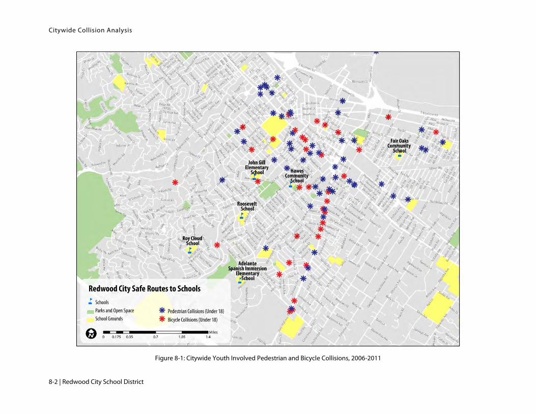
Citywide Collision Analysis
8-2 | Redwood City School District
Figure 8-1: Citywide Youth Involved Pedestrian and Bicycle Collisions, 2006-2011

Example Engineering Devices and Cost Assumptions
A-1 | Safe Routes to School Report
Appendix A - Example Engineering Devices
Design of the physical environment around schools are integral to a comprehensive Safe Routes to School
Program that ensures walking, biking, and other “green” forms of travel are easy and safe. The engineering
improvements presented in this report follow the standards set forth by the California Department of
Transportation (Caltrans). Most of the proposed signage and striping improvements are relatively simple and
cost effective to install when compared to more intensive engineering devices, such as curb extensions and
paths.
In accordance with Caltrans and industry standard terms, “shall” “should” or “may” are used to denote when
to install the example engineering devices. Shall is used when an improvement is required to be installed
under pre-defined conditions. May is used when an improvement installation is optional under pre-defined
conditions. Should is used when an improvement supports the effectiveness of required improvements.

Appendix A
A-2 | Redwood City School District
A-1: Signage
School related signage warns motorists of a school zone or crosswalk and regulates their movements to ensure
the safest conditions possible for pedestrians and bicyclists.
Warning Signs
Assembly A Assembly B Assembly D In-Pavement Yield Paddle
May be installed up to 500
feet in advance of a school.
Shall be installed at an
uncontrolled crosswalk
(no stop sign).
Shall be installed 100 feet in
advance of an uncontrolled
crosswalk.
May be installed in an
uncontrolled crosswalk
Regulatory Signs
No Turn No U-Turn Loading Zone School Speed Limit
No Right and Left Turn signs
are typically used to improve
circulation and reduce queue
lengths.
No U-Turn signs are typically
used to reduce conflicts with
pedestrians and motorists.
Loading zones designate a pick
up/drop off location and may
include a plaque allowing
parking during off-loading times.
May be installed up to 500
feet in advance of a school
and is installed with a time
sensitive flashing beacon.
Engineers determine the
posted speed.

Example Engineering Devices and Cost Assumptions
A-3 | Safe Routes to School Report
A-2: Striping
School related striping includes crosswalks and curb colors. Bicycle lane striping and markings can be also
considered school related. Bicycle-related striping improvements are only recommended in this report where
they align with the Hudson Street bike/ped grant submitted by the City. Thermoplastic is recommended for
striping improvements.
Curb Colors
School Loading Zone curbs are white.
Freight/Bus Loading Zone curbs are yellow.
Accessible curbside parking curbs are blue.
No Parking Zone curbs are red.
Crosswalks
Crosswalks connect one corner of a street to the opposite side and do not have to be marked with paint or
thermoplastic unless where no corner exists (mid-block crosswalk). In California, yellow crosswalks can be
used on roadways where students frequently cross. Caltrans standard is for all crosswalks contiguous to
schools to be yellow. Crosswalk may also be yellow if within 600 feet of a school or school grounds. White
crosswalks are used in all other areas.
High Visibility Crosswalk Transverse Crosswalk Lighted Crosswalk
High visibility crosswalks have
longitudinal and latitudinal lines.
Transverse crosswalks have latitudinal
lines.
Pedestrian activated lights may be
installed on a sign and/or in the
pavement.

Appendix A
A-4 | Redwood City School District
A-3: Curb Extensions
There are a range of devices that work to reduce motorist speeds. This report recommends curb extensions in
many locations, most of which are skewed intersections (where streets do not intersect at 90 degree angles).
Curb extensions are recommended where the radius of a corner could be increased to reduce the speed of
turning vehicles, discourage U-turns, and/or reduce crosswalk distance.
Curb Extension
Curb extensions reduce the width of a roadway.