reconstructing moita do sebastião, the first steparts.uwaterloo.ca/~mkjackes/jackes_alvim.pdf ·...
TRANSCRIPT

Reconstructing Moita do Sebastião, the first step
Mary Jackes and Pedro Alvim
Abstract The bulldozing of the mound at Moita do Sebastião could be regarded as the tragic destruction of one of the great European archaeological sites. It did, nevertheless, allow for an unprecedented exploration of the spatial organization of the burial and other features. The relationship of the 1950s excavations to those undertaken in the 1880s must be established before we have a clear idea of the site as a whole in order to assess how much information was lost to the bulldozers. In this paper we present a reconstruction of the original topography of the mound and place the 1880s and 1950s excavations within that topography, both vertically and horizontally, using documentary and photographic evidence. Burial placement is established with a fair degree of accuracy, so that it is possible to speculate that burials were placed in a horse-shoe shaped area south-east, east and north-east of the high point of the mound prior to destruction. Burials lay at about 21 metres ASL on the basal sands, on the same level as numerous negative features which lay in a specific relationship to the burials. Introduction The history of Cabeço da Arruda, Muge, Portugal has recently been summarized as part of a reassessment of the palaeodemography (Jackes and Meiklejohn, in press). For a satisfactory palaeodemographical study it is necessary to have a clear idea of the number of skeletons that have been excavated from a site and their curatorial history. It is also essential to be able to assess whether the site has been fully excavated, or whether the portion that has been excavated is likely to have provided an unbiased sample of those buried within the whole burial area. Arruda has been only half excavated and many of the skeletons that were found have been destroyed. Those that remain are mixed. The site of Moita do Sebastião, in close proximity to Arruda, also provides difficult problems for demography. While Arruda has been incompletely excavated, Moita has been destroyed. We must “reconstruct” Moita in order to assess whether all skeletons were recovered and retained. How much of Moita was actually excavated and recorded? Moita was destroyed, but there was a positive aspect to this, in that the removal of the top of the mound during the winter of 1951-52 provided an opportunity for an exploration of the entire surface over three seasons of excavation from 1952 to 1954. Thus our view of Moita can encompass the whole area of the midden and allow us a clearer picture of the relationship of features to each other. Of especial interest is the opportunity to test whether the burials were placed at random throughout the midden deposits, or whether burial was patterned and related to specific features. The Abbé Roche, the twentieth century excavator of Moita do Sebastião, came increasingly frequently to write on “the spatial organization” of elements within the site (e.g., Roche, 1982, 1989). It was his opinion that there had been some sort of domestic shelter at Moita. Roche

(1989, p. 610) wrote of: “A habitation zone – comprising a hut and other structures necessary for everyday life.” Whether the sizes and positions of the apparent post holes indicate a built structure that could withstand the elements is open to question (Alvim, in prep.). The relationship of the burials to the “habitation zone” is of some importance to our understanding of the structure and function of Moita and the other Mesolithic sites in its immediate vicinity. The first step in seeking to understand Moita is to locate the various excavated areas in relation to the original topography and to estimate how much of the original midden deposit was destroyed by bulldozing. From this we can make an attempt at locating the burials and we can discuss whether burials were destroyed without being recorded. A major problem in trying to reconstruct Moita is the contradiction in text and diagrams from one Roche publication to the next (e.g. the grids differ between Roche and Veiga Ferreira, 1967, Fig. 2 and Roche, 1972a, Fig. 5) and there is the added difficulty of a lack of congruence between Roche’s diagrams and an unpublished plot by Veiga Ferreira (Cardoso and Rolão, 1999/2000, Fig. 25 ). In this paper, however, we are concerned with the overall picture. Details will be examined elsewhere (Alvim and Jackes, in prep.). The history of the excavation of Moita do Sebastião is simpler than that of Arruda, since it can be encompassed within five campaigns of excavation. Perreira da Costa (1865, p.11, contra Newell et al. 1979, p.149) said that no human remains were found on the surface near the Amoreira bridge (meaning Moita, the cabeço beside the Fonte da Burra and near the bridge to Amoreira), and no further work was done there in the 1860s. Carlos Ribeiro dug in 1880 - the field work being undertaken by Manuel Roque d’Oliveira who was a collector for the Serviços Geológicos until his death in July 1882 (Anon., 1899). Roque began his survey at Moita in mid-May 1880 and was still working there in late June (Alvim, Jackes and Lubell, in prep.). Paula e Oliveira excavated further in 1885, Ribeiro having died in November 1882 (Anon., 1899). For the 1950s, diagrams are available (Roche and Veiga Ferreira, 1967, Fig. 2; Roche, 1972a, Fig. 5) which outline the phases of excavation of the remaining portions of the Moita midden up to the final excavation in 1954. From these we get a clear picture of the two earliest trenches of 1952 crossing at what Veiga Ferreira said was the centre of the midden (Cardoso and Rolão, 1999/2000, p. 181). The excavation history summarized in these diagrams also included a reconstruction of the trench from the 1880s. The initial questions to be answered are, then, the relationship of the 1950s trenches to the mound as a whole and the exact location of the 1880 excavation. Evidence on the nineteenth century excavations Our first task is to examine evidence for the placement of the 1880s trench. Evidence comes from a series of papers on Moita and Arruda which were contained in the Geological Services of Portugal archives in Lisbon in 1989 (Alvim, Jackes and Lubell, in prep.). Whether they had been there prior to 1989 is unknown. Searches for Muge field notes were undertaken by Carlos Penalva on our behalf in 1984 and were continued in 1985-6 when Jackes and Meiklejohn were working on Muge human skeletal material in the collections of the Geological Services of Portugal. All attempts to find archival material were unsuccessful until the end of June 1989

when Lubell was able to photocopy a number of papers with sketches and survey figures from 1880. The quality of reproductions published here is compromised by the need to base the figures on copies. The originals are no longer in the Geological Services of Portugal archives in Lisbon. A search was undertaken for them in September, 2004 (Lubell, pers. com.) to confirm that they were removed to the Instituto Geológico e Mineiro archives as seems likely (Brandão, pers com.). They are still being accessioned at the Instituto Geológico e Mineiro.
Figure 1 caption: Sketch map from the 1880 excavation at Moita do Sebastião. A note written by Roque and keyed to the diagrammatic skeletons reads: “indication of skulls; individual skeletons cannot be plotted separately because they are all piled together; the feet are generally to the north”. The hatched area represents the 1.5 metre high back dirt pile from the excavation. Figure 1 was a rough sketch map in ink with some indication of scale. It is of an irregular area of excavation (around 8 metres by 4.5 metres), with the excavated earth piled to one side, exposing a series of skeletons. There are 16 obvious skulls. Documentary evidence from early June 1880 (Roque d’Oliveira, 1880 see Alvim, Jackes and Lubell, in prep.) describes skeletons packed so closely together that the skulls lay on the knees of other individuals and the excavators were unable to determine how to separate the individual skeletons. Roque was obviously describing the situation plotted in Figure 1. North is indicated on the plot and we assume this to be magnetic north which varies over time.
Even diurnal variations are possible, but the general trajectory of the trend back to 1900 can be calculated from data available on-line (National Geophysical Data Center, 2004). It is possible to check that our rotation of the 1880s sketch maps by 20 degrees to align them with cartographic north, using features of an ortho photo map (Instituto Geográfico Português, 1999), accords very well with an estimate derived from non-linear regression (cubic or quadratic) of 19.4 to 20.5 decimal degrees (99% confidence interval). Records are available for the 1950s, so that we can, for example, know with certainty that the north declination for early April 1953 is 10 degrees 50 minutes or 10.83 decimal degrees west (National Geophysical Data Center, 2004, calculated for latitude: 39 deg, 6 min, 39 sec; longitude: -8 deg, 40 min, 55 sec; 20 m ASL).
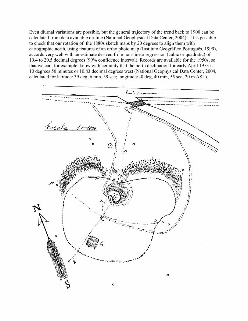
Figure 2 caption: After an 1880 sketch map of the mound at Moita do Sebastião showing its relation to the Muge River. A key in Roque’s handwriting draws attention to cork oak trees, three of them serving as end points of transect lines, to the high point of the mound at “a”, and to a quarry pit at “b”. The outline is of the cabeço, no doubt extending beyond the archaeological deposits. Several pencil marks have been removed from the image; they showed Veiga Ferreira’s speculations on the locations of the 1880s excavations. The location of the 1880 excavation shown in Figure 1 in relation to the entire site can be judged from a second sketch which was published by Roche (1972a, Fig. 3) redrawn and with a definitive scale. This scale was, in fact, estimated. The original plot (Figure 2) was not quite accurately drawn, but because the measurements along the dotted lines were recorded, we know the exact distance between the highest point of the mound and the edge of the excavated area. That distance of 16 metres appears to be represented on Figure 2 as something close to a straight line. We can see the mound and its relation to the Muge River in the north, to the drainage channel to the east, and to the roads and paths. The Muge River main channel and the course of the drainage canal can be readily identified on and aligned with their counterparts on aerial and satellite images (Instituto Geográfico do Exército 1947; Instituto Geográfico Português, 1956, 1999; Centro Nacional de Informação Geográfica, 1995). We have a clear picture of the mound, especially the side facing the Muge, with steep edges curving away from a passage up to the top of the mound. Cork oaks below the excavation and those used as datum points are represented by dots. An open question is whether the paths encircling the 1880 excavation area were detours around a specific feature, perhaps a hollow, which drew the attention of the excavators, so that they decided to dig in exactly that location. It is to be noted that Roche (1972, p. 29) emphasized that the surface of Moita in 1951 was much more disturbed than that of the neighbouring middens, with a variety of holes, the surface layers being extensively reworked. The path and the cork oaks have now disappeared, but we have photographic evidence of the path in Roche (1972a, Plate 1.1 published reversed; printed correctly in Roche, 1985, Fig. 2). The photograph demonstrates that the northern edge of Moita remained in the early 1950s exactly as in the 1880 sketch map with the gentle slope of the paths below the brow of the midden and crossing a terrace before reaching the Muge flats. One particularly marked erosional scarp, evident in the 1950s photographs next to the paths, survives today (September, 2004) and can also be clearly seen in aerial and satellite photos to be discussed below.

Figure 3 caption: A. Section derived from the figures recorded by Roque for the south to north transect (e’f) through the high point of the mound at Moita do Sebastião. The low point of the transect is determined to be 5 metres above sea level by reference to the contours associated with the 1999 ortho photo map (Instituto Geográfico Português, 1999). The dots joined by the grey line represent the modern 5 metre contours. The area of the 1880 excavation with the backdirt pile to the north is shown. The midden is in grey at 21m ASL and above. B. Section derived from the figures recorded by Roque in 1880 for the northwest to southeast (dc) elevation through the high point of the mound at Moita do Sebastião. The y axis is determined from 5 metres above sea level by reference to the contours associated with the 1999 ortho photo map (Instituto Geográfico Português, 1999). The midden is in grey at the 21m ASL and above. Roche and Veiga Ferreira (1957, Fig. 1) published a copy of the elevation shown in Figure 3A, based on a sketch roughed in, in pencil, over the 1880 original sketch of the plotted distance and height figures measured by Roque. The pencilled sketch implies that Veiga Ferreira envisaged Skeletons 1 and 2 to lie below the highest point of the mound at exactly the same level as the 1880 skeletons. However, their “midden centre” lay 14-15 metres southeast of the original highest point of the mound. The scale is inaccurate on the published copy of the drawing and there is no indication in the publication that this elevation is actually derived from work done 70 years before the midden was bulldozed away. The published figure and the scribbled pencil sketch done directly onto the 1880 elevation plot allow us to know what Roche understood to be the relationship between the 1880 excavation and the 1950s excavation, as well as the level of the skeletons. It is especially fortunate that the data associated with the e’f transect survived in the archives of the Geological Services of Portugal. With these figures we can reconstruct the mound profile and estimate the mound height above sea level (Figure 3A). The zero point of the 1880 data is the lowest level on the north-south line near the old bridge, which we estimate at 5 m above sea level on the basis of contours associated with the 1999 ortho photo map (Instituto Geográfico Português, 1999). Figure 3A demonstrates a fair reconciliation of the two sets of data, from 1880

and 1999, but it shows reconfiguring of the contours, consistent with the removal of the trees and the paths. The two points that are different represent the top and the bottom of the old path from the mound to the river flats. A Landsat image, summer 1995, ortho-rectified using 1:25 000 Serviços Cartográficos do Exército maps (Centro Nacional de Informação Geográfica, 1995), as well as recent visits to the site, allow us to confirm that the north and north-west faces of the midden have been reshaped as suggested by Figure 3A. Figure 3A shows the north-south unexcavated portion of the midden to be consistent with the length of the north-south excavation by Roche and Veiga Ferreira (Figure 4). The 1950s north-south section covers 40 metres. In order to estimate the amount of deposit removed from over the section illustrated by Roche, we need to refer to the dc elevation (Figure 3B) which we can base, again, on the measurements made by Manuel Roque. We can estimate that around two and a half metres would have been removed at this point from above the breccia shown in solid grey in Figure 4. Notes by Veiga Ferreira (Cardoso and Rolão, 1999/2000, p.238) confirm that it was the hardness of the breccia (i.e. that shown in grey in Figure 4) which made the bulldozer drivers stop their work. About 3 metres would have been bulldozed from the highest point of the mound which lay to the west of the section illustrated in Figure 4.
Figure 4 caption: North south elevation of trench 1, partially excavated in 1952 and completed in 1954 (after Roche, 1972a, Fig. 6). The fine-hatched area to the right (north) is part of an 1880s excavation trench, though not identified as such in the publication (Roche, 1972a). Each numbered section is 2.5 metres in length.

Figure 5 caption: A. Aerial photograph (unrectified) taken in 1947 at 1:30 000 scale (Instituto Geográfico do Exército, 1947). The photograph is oriented to approximate cartographic north (up). B. Aerial photograph (unrectified) taken in 1956 at 1:10 000 scale (Instituto Geográfico Português, 1956). The photograph is oriented to approximate cartographic north (up).
C. The 1880 sketch is adjusted to accord with the transect measurements and lain over the 1947

aerial photograph. D. The 1880 sketch is adjusted to accord with the transect measurements and lain over the 1956 aerial photograph. From a 1956 aerial photograph (Figure 5B), it is evident that trees were removed from the upper left quadrant, that soil removed from the top of the mound was pushed into that quadrant and that the steep slope (shown on the 1880 plot) was obliterated. The south-east face of the mound seems to remain as plotted in 1880. The trees and the path down to the river have now been removed and the northern slope is reshaped, as suggested by the contour reconstruction diagram (Figure 3A). A photograph published by Roche (1960, Pl. I) again shows these features and confirms that the northwestern edge of the mound was smoothed, presumably by bulldozing the top deposits over the edge, and confirms that the changes in the northern face deduced from the 1956 aerial photograph were in place by the mid 1950s. Despite the changes, we can reconstruct the placement of the 1880 excavation from the plot made at the time, together with data from the transect measurements, using the aerial photographs (Figure 5C and D). The drainage channel, which had been altered by 1995 (Centro Nacional de Informação Geográfica, 1995), allows alignment of the 1880 plot, as does the location of the quarry pit. While traces on the aerial photographs also indicate the probable location of the 1880 work and further excavation trenches in the 1880s, confirmation comes from the twentieth century investigations. Evidence from the twentieth century excavations We have a good deal of evidence of the location of the 1950s excavations. For example, a photograph taken on the last day of excavation in 1952 (Cardoso and Rolão, 1999/2000, Fig.27) shows the location of the trees below the brow of the midden, and their relation to the crossing of the first two trenches at the point Veiga Ferreira had defined as “the centre of the midden”. The photograph includes the skulls of Skeletons 1 and 3, whose location was plotted twice by Veiga Ferreira (Cardoso and Rolão, 1999/2000, Figs. 26,40) and whose skulls were retained at the museum of the Geological Services of Portugal in Lisbon. There they were studied in detail by Meiklejohn in 1969 and again in 1984. A photograph of Skeleton 3 was also published by Roche (1972a, Plate 4 figure 2). Skull 1 is very clearly shown in another photograph taken upon the same occasion (Cardoso, 1999, Fig. 10). The identity of the skulls and the location of the photograph is therefore firm. However, the destruction of the mound and the placement of foundations for a building during the early 1950s complicates our attempt to understand how much of the mound was actually excavated. In view of the changes which we have mentioned, the bulldozing of around three metres of deposit from the highest point of the mound, the flattening of the surface to about 22 metres above sea level (Instituto Geográfico Português, 1999), the reconfiguring of the northern and western faces of the mound, is it possible to determine the relationship of the various excavations? Two factors help: 1. We have indications from plots of the footprint of the buildings which were erected in the first half of the 1950s (Cardoso and Rolão 1999/2000, Fig.
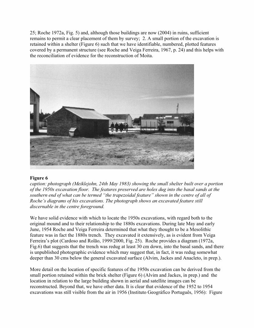
25; Roche 1972a, Fig. 5) and, although those buildings are now (2004) in ruins, sufficient remains to permit a clear placement of them by survey; 2. A small portion of the excavation is retained within a shelter (Figure 6) such that we have identifiable, numbered, plotted features covered by a permanent structure (see Roche and Veiga Ferreira, 1967, p. 24) and this helps with the reconciliation of evidence for the reconstruction of Moita.
Figure 6 caption: photograph (Meiklejohn, 24th May 1983) showing the small shelter built over a portion of the 1950s excavation floor. The features preserved are holes dug into the basal sands at the southern end of what can be termed “the trapezoidal feature” shown in the centre of all of Roche’s diagrams of his excavations. The photograph shows an excavated feature still discernable in the centre foreground. We have solid evidence with which to locate the 1950s excavations, with regard both to the original mound and to their relationship to the 1880s excavations. During late May and early June, 1954 Roche and Veiga Ferreira determined that what they thought to be a Mesolithic feature was in fact the 1880s trench. They excavated it extensively, as is evident from Veiga Ferreira’s plot (Cardoso and Rolão, 1999/2000, Fig. 25). Roche provides a diagram (1972a, Fig.6) that suggests that the trench was redug at least 30 cm down, into the basal sands, and there is unpublished photographic evidence which may suggest that, in fact, it was redug somewhat deeper than 30 cms below the general excavated surface (Alvim, Jackes and Anacleto, in prep.). More detail on the location of specific features of the 1950s excavation can be derived from the small portion retained within the brick shelter (Figure 6) (Alvim and Jackes, in prep.) and the location in relation to the large building shown in aerial and satellite images can be reconstructed. Beyond that, we have other data. It is clear that evidence of the 1952 to 1954 excavations was still visible from the air in 1956 (Instituto Geográfico Português, 1956): Figure

7 demonstrates that some of the dark features represent excavation traces. The excavation outline provided in Figure 7 is that of Veiga Ferreira (Cardoso and Rolão, 1999/2000, Fig. 25) which is in perfect congruence with some distinctive soil traces on the aerial photograph. It appears, however, that Veiga Ferreira placed the foundations of the building very slightly too far to the north and we have made an adjustment to compensate for that error. The accuracy of our reconstruction has been tested by the addition to the plot of features still retained within the brick shelter (the post holes features are derived from Roche, 1972b, Fig. 23).
Figure 7 caption: A. Detail of 1956 aerial photograph (Instituto Geográfico Português, 1956). B. The outline of the 1950s excavations as plotted by Veiga Ferreira (Cardoso and Rolão, 1999/2000, Fig. 25) with the major features included (solid white line), in relation to the traces evident on the 1956 aerial photograph (Instituto Geográfico Português, 1956). Skulls of burials are represented by the black-encircled white dots. The placement of the 1880s trenches (dashed black line) is adjusted to accord with the recent survey of the remaining buildings (solid black line). The pits within the brick shelter are shown in order to confirm the placement of the plot over the aerial photograph. Evidence on the nineteenth century trenches from the twentieth century records The 1880 excavation must be considered - based on Figure 5D - to be located within the undefined area beyond the dashed black line to the north-west of the 1880s trench shown in Figure 7. Further evidence on the location of the 1880 excavation derives by extrapolation from the notebooks of Veiga Ferreira (Cardoso and Rolão, 1999/2000, p. 194-195). Roche and Veiga Ferreira were excavating north-west from the modern building starting on 13th May 1954 in an area which had previously been considered to be a Mesolithic hut floor (see Cardoso and Rolão,

1999/2000, Fig. 25). Work went fast, since this was, to all intents and purposes, a salvage excavation and the men were working with hand-held picks and long-handled shovels. By 24th May they had reached what seemed to them the bottom. On 2nd June, they began to think that they might actually be redigging an 1880s trench. But they continued on with their work, until abandoning it on 7th June, 1954. By 5th June they were completely convinced that they were within the old excavations when they came across the remains of breccia which had contained excavated skeletons. It is most likely that they were, by then, within the area of the excavation shown in detail in Figure 1. Examination (September, 2004) of the soil along the centre of the northern edge of the mound shows that it is derived from disturbed midden deposits, grey and heavily charged with fragments of Scrobicularia plana, oyster and breccia. The surface appears to consist entirely of flattened back dirt deposits. In the 1950s, sieves were placed on the east and west sides of the excavation, not the north. Based on photographic evidence, the main sieving areas were on the west side in 1952 (Cardoso and Rolão, 1999/2000, Fig. 34) and on the east side in 1952 (Roche 1972a, Plate 2.1), 1953 (Cardoso and Rolão, 1999/2000, Fig. 37) and again the east side in 1954 (Cardoso and Rolão, 1999/2000, Fig. 31). The north central area may then represent the dispersed 1880 back dirt pile. What then was the trench extending from the area of the 1880 excavation, east to the new building erected in the early 1950s? Further work was done at Moita in 1884 and 1885, after the death of both Ribeiro and his excavator, Roque. And the clue as to what happened comes from the skeletons. Estimating the number of skeletons found at Moita do Sebastião The number of skeletons actually uncovered is difficult to estimate (cf. Jackes and Meiklejohn, in press for a discussion of reconciling excavation and laboratory skeletal numbers for Arruda). We propose that the total excavated from Moita was close to 100: we suggest that something over 16 were found in 1880, that none, or at most one or two, were found in 1884, and that 39 were found in 1885. The number for the 1950s did not exceed 34. The 1880 trench must have been extended west along the midden face a short way and also to the south of the concentration of skeletons in order to expose the limits of the burial area. Pencilled markings over the original of the Figure 2 sketch suggest that Veiga Ferreira outlined what seemed to him to be extensions of the 1880 excavation shown in Figure 2. Indeed, Roque reported to Ribeiro in late June, 1880 that they were opening a trench along the mound (Alvim, Jackes and Lubell, in prep.). Although more skeletons were reported to have been found the next day after the sketch (Figure 1) was sent off to Ribeiro, it is unlikely that many further skeletons were found beyond the 16 sketched in. No more human skeletons are mentioned in the letters other than the finding of nine skeletons at Arruda, although extensions of the trench at Moita are mentioned on both the 21st and the 26th June, 1880. The 1880 excavations were undertaken to provide a field trip for attendees at the International Prehistoric Anthropology and Archaeology Congress that was held in Lisbon in that year. Despite what appears to have been a dramatic find at Moita, all the emphasis in the descriptions and photographs of that year and that event is placed on Cabeço da Arruda. To our knowledge, the present paper constitutes the first published

notice of the Moita skeletal concentration found in 1880: it is puzzling that more attention was not paid to the Moita skeletons. We do not know how many skeletons were excavated from Moita in 1880 – Ribeiro said 120 were excavated from Moita and Arruda together (1880, p. 285). We only know that at least 16 came from Moita (for a discussion on Arruda, see Jackes and Meiklejohn, in press). Paula e Oliveira (1889) said the total number of skeletons excavated in 1884 and 1885 was 52, but some of the skeletons might have come from Arruda or Amoreira rather than Moita (unfortunately this was never specified). In June 1884 “13 human skeletons, some in truth very damaged, of individuals of various ages” and in June 1885 “the remains of 39 individuals for the most part in a very good state of preservation” (Paula e Oliveira, 1889, p. 59) were discovered. The 1884 skeletons most probably came from Arruda. However, it is very unlikely that any of the 1885 skeletons came from Arruda. Paula e Oliveira indicated that “I barely got one skeleton in bad shape” from Arruda in 1885 (Paula e Oliveira, 1889, p. 59). Besides Paula e Oliveira’s published comments, an archival letter dated 4th June 1885 from Paula e Oliveira to Nery Delgado (Alvim, Jackes and Lubell, in prep.) suggests that all the human material excavated in 1885 came from Moita, neither Arruda nor Amoreira having produced results. Thus we can assume that work at other sites in 1885 was unproductive and that 39 skeletons were found at Moita in June 1885. Furthermore, we can assume that they were found close to those excavated in 1880. Paula e Oliveira (1889, p. 58) had the benefit of having an 1880 surveyor working with him in 1884-5, so he could easily have located the previous excavation if there were any doubts. Furthermore, he would have worked quickly since he had 11 men working for him at Moita (Paula e Oliveira, 1885: Alvim and Jackes, in prep.). One other piece of documentary evidence exists - it is that Paula e Oliveira (1889, p.74) said quite clearly that the skeletons at Moita were buried in the north-east part of the mound. In this he contrasted Moita with Arruda, where the skeletons were found along the south-east side of the mound. The Arruda skeletons were also on the side which faced the Muge River (the only side excavated) and they also, in general, lay on a specific level just above the basal sands (see Jackes and Meiklejohn, in press; Alvim, Jackes and Lubell, in prep.). The fact that Paula e Oliveira said the Moita skeletons were buried in the north-east quadrant of the mound suggests that he knew that there were none along the north-west face, indicating that the trench had been extended north-west, as well as north-east, from the 1880 excavation. However, we have no evidence of that, other than the apparent trace of different coloured soil extending beyond the point where Roche and Veiga Ferreira’s 1954 re-excavation petered out (Figure 7).

Figure 8 caption: A. The 1947 aerial photograph (Instituto Geográfico do Exército, 1947) is overlain by the broken line of the 1880 skeleton level reconstructed contour for 21 ASL. The solid lines represent the known and reconstructed locations of burial groupings, with the 1950s skulls being indicated by black dots. B. The 1956 aerial photograph (Instituto Geográfico Português, 1956) is overlain by the broken line of the 1880 skeleton level reconstructed contour for 21 ASL. The solid lines represent the known and reconstructed locations of burial groupings, with the 1950s skulls being indicated by black dots. We have argued above that the additional areas excavated in 1880 (besides that plotted in Figures 1 and 2) and in 1884 at Moita yielded very few other skeletons unaccounted for here. Further evidence for this comes from the numbers of extant Moita skeletons. In the 1980s it was not possible to count definitively more than close to 80 Moita skeletons in total, based on dentitions and infant bones. Thus the total recorded here has having been excavated from Moita - close to 100 (16+a few more in 1880+39 in 1885+34 in the 1950s) - is entirely plausible. The nineteenth century excavated area at Moita was not extensive, based on Roche and Veiga Ferreira’s re-excavation of the north face of the mound (and on the apparent traces, both positive for the back dirt and negative for the trenches, on the aerial photographs), so it appears that the 1885 skeletons were grouped together quite closely. This is entirely consistent with what we know from the work done in the 1950s. Despite all the uncertainties regarding the Roche excavation records (Alvim and Jackes, in prep.), we can be sure that the skeletons were grouped, with Skeleton No. 31 the only real outlier. But we can also be sure that Skeleton No. 31 lay not far south of the area of the 1885 trench (Alvim, Jackes and Anacleto, in prep.), so No. 31 may be linked with the group of skeletons found within a circumscribed area in June, 1885.

Figure 8 suggests that there was a rough semi-circle of burials along the eastern margin of the mound, generally all at the same level and so probably buried at 20-21 metres above sea level. This is the level of contact between the midden deposits and the underlying Pliocene sands. Reference to the numerous published photographs of the excavations (e.g. in Roche, 1952; Roche, 1972a; Cardoso and Rolão, 1999/2000) will confirm that the skeletons excavated in the early 1950s lay on a more or less plane surface. Roche and Veiga Ferreira excavated to the edge of the deposits on the east of the mound, indicating that Ribeiro’s mound went too far in encompassing the steep eastern slope. How much of the rest of the mound in other directions was lost to the bulldozers? Only the south-west quadrant might have provided more information, since there appear to have been unplotted pits there, but in that area the bulldozers had already exposed the basal sands. This is suggested by the elevation published by Roche (Figure 3). The plot by Veiga Ferreira (Cardoso and Rolão, 1999/2000, Fig. 25 and see Figure 7 above) shows that the exploratory test trench was actually pushed 15 metres further, so that the western sector was reasonably well explored. It seems very unlikely that the bulldozer workers would have ignored a concentration of human skeletons. Furthermore, examination of the skeletons from Moita indicates that burial outside the brecciated areas was very rare and there appears to have been no breccia in that direction. The most likely area in which skeletons would have been lost to us would be the north-west quadrant, but Paula e Oliveira’s comment that the skeletons in Moita lay in a different quadrant from those in Arruda indicates that he knew there were no skeletons there to the north-west. There must have been excavation in that direction and the aerial photograph allows us to suggest the considerable extent of the 1880s excavations to the north-west. It seems very likely that we have a good idea of the placement of burials at Moita do Sebastião and that, of those at the general level of burials, very few are likely to have been lost. Conclusions Several points are of major importance: 1. the 1880s excavations extended along the north face of Moita do Sebastião and the 1880s excavators must have examined the western as well as the eastern part of the north face - skeletons were found in the central and eastern portions of the north face at around 21 metres above sea level; 2. the 1950s excavations included the central part of the mound at the level which contained skeletons, that is, around 21 metres above sea level; 3. it is reasonable to suggest, therefore, we have identified the areas where skeletons would have been found; 4. while the cabeço top was bulldozed away, the level of most of the skeletons was left to be
excavated (since the skeletons were likely to have been - in general - concentrated in

groups at 20-21ASL, based on the 1880 record, and also arguing from the pattern demonstrated by the 1880 Arruda records).
If those statements are true and can be supported by documentary, published and photographic records, then we can make statements about the disposition of the burials, the organization of the mound, and the palaeodemography of those who were buried at Moita do Sebastião. Our conclusion is that we do have sufficient evidence to begin a discussion of the nature of Moita do Sebastião and its burials. To this point, we can say that the majority of burial locations was patterned, placed formally in a horseshoe-shape which was open to a central area lying generally beneath the nineteenth century high point of the mound. It was in this central area that a complex of negative features was found, features which were dug into the basal sands from around the same level as the skeletons.
Acknowledgements Dr. M. M. Ramalho, now Vice-Presidente Área Técnico-Científica Instituto Geológico e Mineiro Portugal, authorized access to Muge skeletal collections and the Serviços Geológicos archives in the 1980s. Dr. J. Brandão, Conservador do Museu Geológico, Lisboa, facilitated continued access to the Muge skeletons, and his colleague José António Anacleto has provided invaluable assistance. Dr. J. Rolão, Universidade Autonoma de Lisboa, through his archival work, by taking us to Moita do Sebastião and by permitting us to participate in a symposium on Muge, made essential contributions to this project. We thank David Lubell and Christopher Meiklejohn for their support in many areas of our work. Meiklejohn’s work on Muge materials in 1969 was supported by a Canada Council Doctoral Fellowship. The work of Lubell, Jackes and Meiklejohn in the 1980s was supported by two Social Sciences and Humanities Research Council of Canada grants (410-84-0030 and 410-86-2017). We are especially grateful to the Instituto Geográfico Português (www.igeo.pt) for the supply of cartographic information and for permission to use the IGP 1956 aerial photograph (under the Fornecimento de Informação Geográfica para Investigação, Ensino e Edição (FIGIEE) programme). Tenente Coronel António Pereira kindly provided permission for use of the Instituto Geográfico do Exército 1947 aerial photograph. We are grateful to Dra. Paula Serrano, the archive coordinator at the Instituto Geológico e Mineiro and to Fatima Moreira and Marisa Marques for help with locating nineteenth century documentary material on the Muge archaeological investigations. Rafael Henriques and Nuno Flores are thanked for assistance with image preparation and with site surveying at Moita do Sebastião.
Bibliography ALVIM, P. (in prep.) - Moita do Sebastião 1952: the nucleus of a Muge midden. ALVIM, P. and JACKES, M. (in prep.) - Reconstructing Moita do Sebastião, the second step. ALVIM, P., JACKES, M and ANACLETO, J.A. (in prep.) - New photographic evidence on the 1954 excavations at Moita do Sebastião. ALVIM, P., JACKES, M and LUBELL, D. (in prep.) - Documentary evidence on the Muge
excavations between 1880 and 1885. ANON. (1899) - Les Services Géologiques du Portugal de 1857 á 1899. Comunicações dos Serviços Geológicos de Portugal. Tomo 4 Fasc I. p. vii-xxi. CARDOSO J.L. (1999) - O professor Mendes Corrêa e a arqueologia portuguesa. Al-Madan, II Série, 8. Almada: Centro de Arqueologia de Almada. CARDOSO J.L., ROLÃO J.M. (1999/2000) -. Prospeçcões e escavações nos concheiros mesolíticos de Muge e de Magos (Salvaterra de Magos): contribuição para a história dos trabalhos arqueológicos efectuados. Câmara Municipal de Oeiras. Estudos Arqueológicos de Oeiras 8:83-240. CENTRO NACIONAL DE INFORMAÇÃO GEOGRÁFICA (1995) - Landsat image, ortho-rectified using 1:25 000 Serviços Cartográficos do Exército map. http://ortos.igeo.pt/ortofotos/indexp.html INSTITUTO GEOGRÁFICO DO EXÉRCITO (1947) - Extracto da fotografia aérea 03 - Rolo nº 80, vôo RAF 1947. Original scale 1:30 000. Lisbon. Secção de Fotografia Cartográfica. IgeoE.INSTITUTO GEOGRÁFICO PORTUGUÊS (1956) - Extracto da fotografia aérea, vôo de 1956. Rolo 56.10, Fiada 20W. Fotografia 831. Enlargement to 1:1600 approximate scale; 1:10 000 original scale. Lisbon. IGP. INSTITUTO GEOGRÁFICO PORTUGUÊS (1960) - Map at 1:2 000 scale. Lisbon. IGP.
INSTITUTO GEOGRÁFICO PORTUGUÊS (1999) - Extracto de ortofotomapa, vôo de 1999. 150/235 [overlaid 5m contours] scale 1:10 000. Lisbon. IGP. JACKES, M. and MEIKLEJOHN, C. (in press) - Building a method for the study of the Mesolithic-Neolithic transition in Portugal Documenta Praehistorica XXXI. JACKES, M. and MEIKLEJOHN, C. (in prep.) The demography of Moita do Sebastião. NATIONAL GEOPHYSICAL DATA CENTER (2004) - Paleomagnetic Data from NGDC / WDC Boulder, Boulder, Colorado, http://www.ngdc.noaa.gov/seg/geomag/paleo.shtml NEWELL R.R., CONSTANDSE-WESTERMANN T.S., MEIKLEJOHN C. (1979) - The skeletal remains of Mesolithic man in Western Europe: an evaluative catalogue. Journal of Human Evolution 8:1-228. PAULA E OLIVIERA F. (1889) - Nouvelles fouilles faites dans les kioekkenmoeddings de la vallée du Tage (posthumous publication). Comunicações da Commissão dos Trabalhos Geologicos II (i): 57-81. PAULA E OLIVIERA F. (1885) - Letter to Nery Delgado, 4th June 1885. Archives, Instituto Geológico e Mineiro, Alfragide (IGM-INETI). PEREIRA DA COSTA F.A. (1865) - Da existencia do homem em epochas remotas no valle do Tejo Primeiro opusculo Noticia sobre os esqueletos humanos descobertos no Cabeço da Arruda. Imprensa Nacional. Lisbon RIBEIRO C. (1880) - Les kioekkenmoeddings de la vallée du Tage Congrès International d’Anthropologie et d’Archéologie Prehistoriques Neuvième Session: 279-291. ROCHE, J. (1952) - Les fouilles des amas coquilliers de Muge Boletim da Sociedade Geológica de Portugal X:145-150.

ROCHE, J. (1960) - Le gisement mésolithique de Moita do Sebastião. Muge, Portugal. Vol. I. Instituto de Alta Cultura. Lisbon. ROCHE, J. (1972a) - Le gisement mésolithique de Moita do Sebastião Muge Portugal I Archéologie. Instituto de Alta Cultura. Lisbon. ROCHE, J. (1972b) - Les amas coquilliers (concheiros) mésolithique de Muge (Portugal) Die Anfänge des Neolithikums vom Orient bis Nordeuropa Westliches Mittelmeergebiet und Britische Inseln. Fundamenta 8:72-107. ROCHE, J. (1982) - A organização do espaço numa estação mesolíthica portuguesa: Moita do Sebastião, Muge. Arqueologia 6, p. 4-10. ROCHE, J. (1985) - Curriculum vitae and publications. Arqueologia 12, p. 3-13. ROCHE, J. (1989) - Spatial organization in the Mesolithic sites of Muge, Portugal. In BONSALL, C., ed. - The Mesolithic in Europe. Papers presented at the third International Symposium. John Donald. Edinburgh, p. 607-613. ROCHE, J. and FERREIRA, O. DA VEIGA (1957) - Nota sobre a estratigrafia dos concheiros de Muge. Comunicações dos Serviços Geológicos, 38-2, p. 263-267. ROCHE, J. and FERREIRA, O. DA VEIGA (1967) - Les fouilles récentes dans les amas coquilliers mésolithiques de Muge (1962-1965). O Arqueólogo Português 1, p. 19-41. ROQUE D’OLIVEIRA, M. (1880) - Letters to Ribeiro, May to June, 1880. Archives, Instituto Geológico e Mineiro, Alfragide (IGM-INETI).