reconnaissance report pdf - summerville, sc
TRANSCRIPT

Summervilletown of
vision Planreconnaissance rePortadoPted: 7.9.2014

Reconnaissance Report
Town of Summervillemadelyn robinson, AiCPDirector of Planning & economic Development, town of Summerville
Jessi Shuler, AiCPZoning Administrator, town of Summerville
lisa wallaceDirector of Administrative Services, town of Summerville
russ Cornette, Pe, Cfmtown engineer, town of Summerville
Consultant Team Craig lewismanaging Principal, lawrence Group
monica Carney Holmes Project manager, lawrence Group
Carolyn reidAssistant Project manager, lawrence Group
Scott CurryAssociate (Planner/urban Designer), lawrence Group
Keihly moorePlanner/urban Designer, lawrence Group

Table of Contents
1 PurPose & Background 1
1.0: PurPoSe 1
1.1: BACKGrounD 2
1.2: frAmeworK 4
1.3: Downtown 8
1.4: SHeeP iSlAnD PArKwAy interCHAnGe 10
1.5: oAKBrooK 12
1.6: Summerville GloSSAry (A-Z) 14
2 comPrehensive Plan review 19
2.0: overview 19
2.1: future lAnD uSe 19
2.2: trAnSPortAtion SyStem 26
2.3: Priority inveStment AreAS 32
2.4: PoPulAtion 36
2.5: nAturAl reSourCeS 36
2.6: enerGy 36
2.7: HouSinG 37
2.8: Community fACilitieS 39
2.9: eConomiC DeveloPment 40
2.10: CulturAl reSourCeS 43
3 other Plans & studies 45
3.0: overview 45
3.1: ProPoSeD inDePenDent 60-unit Hotel mArKet StuDy 45
3.2: Convention/CiviC Center feASiBility StuDy 47
3.3: imPeDimentS to fAir HouSinG StuDy 48
3.4: DorCHeSter County retAil mArKet StuDy AnD mArKetinG StrAteGy 50
3.5: ComPreHenSive trAnSPortAtion PlAn 53
3.6: ASHley SCeniC river mAnAGement PlAn 56
4 Planning Process 59
4.0: overview 59
4.1: meDiA outreACH 60
4.2: StAKeHolDer feeDBACK 62
4.3: tHe CHArrette 64

This page was intentionally left blank.

A Vision Plan for Summerville’s future
1 PurPose & Background
1.0: PurposeBefore the Vision Plan process began, the only planning that the Town of Summerville had completed were updates to the state-mandated comprehensive plan. While comprehensive planning is important, it is a very broad tool and often difficult to implement. The Vision Plan provides the next level of detail to the comprehensive plan by outlining a specific set of actionable policies at the town, district, neighborhood, and parcel scales.
The Vision Plan sets forth a civic growth framework for the whole town of Summerville with recommendations for infrastructure investments including street improvements, trail enhancements and extensions, new and improved parks and civic building opportunities. Additionally, the plan proposes detailed development recommendations for three high-priority redevelopment and growth districts: Downtown, Oakbrook, and the new Sheep Island Parkway interchange.
The Vision Plan recommendations were developed during a week-long design charrette, but several months of preparatory work were completed, as this report details.

6 Reconnaissance Report
1.1: BackgroundSummerville Vitals Ð Population (2013 est.): 46,0741
Ð Size: 19.0 square miles/12,140 acres
Ð County: Dorchester, Berkeley, and Charleston Counties
Ð Median Income (2012): $54,6772
1 American Community Survey, 2008-2012 estimates2 ibid
Vision Plan Core Strengths Ð Family/Education: Many families choose to
locate in Summerville because of the high-quality schools in Dorchester County and Berkeley County. Residents want Summerville to be a family-friendly town.
Ð Buildings/Business: Summerville residents value the downtown area and its mix of small local businesses. Residents would like to see more high-quality entertainment (i.e. restaurants) and hospitality (i.e. hotels and bed and breakfasts) options.
Ð Location/Transportation: Many residents are attracted to Summerville’s location in the Charleston metropolitan area and a relatively-low cost of living. This has also meant that the town functions largely as a bedroom community for Charleston, with a large number of commuters leaving town each day. The transportation network relies heavily on a small number of arterial roads that connect to the interstate and state highways. Residents consistently rank traffic congestion as the town’s greatest issue.
Ð Natural Resources/Recreation: Residents value the temperate climate and the opportunities for recreation that it allows. Azalea Park, the Sawmill Branch Trail, Jessen Boat Landing, and the sports complex at Gahagan Park are all popular local activity destinations.
Ð Civic Leadership: The town’s leadership and service departments are well-regarded and generally considered a positive aspect of living in Summerville.

71 Purpose & Background1.1: Background
Town of Summerville
Vision Plan Focus Areas
County Lines
Vision Plan Study Area: The plan creates a town-wide framework for growth and provides more specific, parcel-level recommendations for the three focus areas: Downtown, Oakbrook, and the Sheep Island Parkway interchange.
Sheep Is land

8 Reconnaissance Report
1.2: FrameworkThe items below are addressed in the Vision Plan at the framework level, meaning that specific recommendations are made for infrastructure and policy throughout the Town of Summerville.
TransportationAddress the general lack of connectivity between the interstate and neighborhoods.
Ð Needs: Evaluate new route options in combination with capacity increases on existing network.
Ð Needs: Potential street section improvements for Miles Jamison Road, Boone Hill Road, Central Avenue, 5th North Street (78), Orangeburg Road, Main Street (US-78A)
Ð Long Term Needs: Potential for new interchange at Royle Road over I-26
Ð Needs: Evaluate the access for development on Berlin G. Myers Parkway.
Ð Needs: Assess street section at new interchange on Sheep Island Gateway to include vehicles, pedestrians and cyclists.
Ð Needs: Evaluate transit to/from Charleston and potential circulator route around Summerville
Ð Needs: Evaluate bike/pedestrian facilities and recommend connections/improvements to Sawmill Branch Canal Trail. Find gaps in bike/pedestrian facilities for quick wins, including greenway expansion across river and I-26
Park & Recreation FacilitiesThe current focus is on athletics and maintaining the existing parks and resources.
Ð Needs: More athletic fields (soccer, baseball, tennis)
Ð Needs: New small parks in growth areas including a splash pad, dog park, and/or water amenity
Ð Needs: Indoor recreation facility that could include basketball courts and small meeting facilities
Ð Needs: Better utilize Colonial Dorchester State Park and link to Ashley River and other natural amenities with Visitor’s Center and/or reconstructed buildings
StormwaterThe current fees in town support only maintenance and emergency flooding
Ð Needs: Improve outfall systems and add more storage with new development, including infill
Ð Needs: Street sections that can accommodate swales and less piping to reduce demand on system and quality measures
Civic BuildingsFocus cultural institutions downtown and find locations for emergency service expansion.
Ð Needs: Consider new police station (Court might/might not be included - 10,000sf ) - at either of two locations: Between Berlin G. Myers & Gum St at 6th S. St or 9th St N & Gum St
Ð Needs: Consider new fire stations at the following locations: 1: Miles-Jamison Road, 2: Limehouse Crossroads, 3: Near Jedburg Road/I-26
Employment and JobsFind opportunities to expand employment base.
Ð Needs: Build on the new medical center development at I-26 and Nexton
Ð Needs: Build the regional sector of the software development industry
Ð Needs: Identify locations to grow higher education facilities
Development ActivityConsider ongoing development projects in infrastructure needs assessment (see next page).
Activity CentersIn addition to the plan focus areas (Downtown, Oakbrook, and the Sheep Island Parkway Interchange, discussed in 1.4-1.6), address the infrastructure needs of other activity centers.

91 Purpose & Background1.2: Framework
Town of Summerville
County Lines
Development Projects
Under Construction
Preliminary Plan
Unbuilt (approved)
Development Activity Map: Recent development applications that have been submitted to the town are shown on the map above

10 Reconnaissance Report
HerITage sQuare
BroWnsVILLe
knIgHTsVILLe
ParkWaY eXTensIon
PIne Trace
Town of Summerville
Vision Plan Focus Areas
County Lines
Activity Centers: In addition to the three focus areas, the Vision Plan also considers the town-wide infrastructure needs of other activity centers. These centers are further outlined and described on page 12 in the Growth Framework.
Sheep Is land

111 Purpose & Background1.2: Framework
Heritage Square• Dead shopping center with new plans for redevelopment with a
sportsman store including indoor shooting range and police training
• Opportunities for development of outparcels
• Opposite corner of Highway 78 and Berlin G. Myers Parkway likely will be a large retail development
Knightsville• Major commercial is only partially in town, how do more properties
annex?
• Major residential growth area in recent years (White Gables)
• Connections to I-26 and employment is critical to future success
Brownsville• Historically African-American neighborhood
• Lacks sidewalks
• Many houses in poor condition
• Proponents of development, but not gentrification
Pine Trace Property• New elementary school planned on county-owned land on the
south side of Miles Jamison Road
• New connection planned from school site to Beverly Drive
• Planning for future county park and residential development (currently in negotiations)
Berlin G. Myers Parkway Extension• Parkway to be extended along Sawmill Branch Canal to meet
Orangeburg Road
• Most of the surrounding land is environmentally-sensitive, except for connection with Limehouse Plantation property

12 Reconnaissance Report
1.3: DowntownPublic Space Ð Hutchinson Square and Doty Park
Infrastructure Ð Streetscaping and sidewalk deficiencies
Ð Traffic calming needs on Main Street
Ð A lack of connections to Sawmill Branch Trail
Housing Ð Historic houses and cottages
Character Ð Main Street shops, historic homes, “church district”
Organizations Ð Downtown organization is DREAM - working to
promote downtown businesses
Hutchinson Square on Main Street
“Short Central” Pedestrian PlazaHistoric Home
Timrod Library and Bethany United Methodist Church
First Impressions: Define the vision of Downtown - is it a business center, a mixed use neighborhood, or a historic retail district?
Needs: Connect Downtown Boutique Hotel site with Short Central and Little Main Street shopping areas
Needs: Find locations for fine dining restaurants and family restaurants
Needs: Better connect the parking garage and improve perception of safety downtown
Needs: Redesign Hutchinson Square for usability and aesthetics
Needs: Assess parking availability and enforcement
Needs: Look at redevelopment on Post Office block and NE quad-rant of downtown for businesses
Needs: Assess future development between downtown and Berlin G. Myers Parkway including new possible connections (9th Street option)
Needs: Assess the possibility for a Business Improvement District or other financing mechanism to help with improvements

131 Purpose & Background1.3: Downtown
Downtown Study Area

14 Reconnaissance Report
1.4: Sheep Island Parkway InterchangeDevelopment Ð Frontage road development includes hotels, retail
and housing
Infrastructure Ð Limited wetlands on undeveloped land
Ð Frontage road that connects to Jedburg Road Intersection
Character Ð Greenfield site
Ð Weatherstone subdivision on southeast side
First Impressions: New intersection is currently zoned “flex” in the County which allows for most uses except for single family; will likely sell land surrounding future intersection as one parcel, with future developer to potentially annex into Summerville
Needs: Identify potential land uses with possibilities of a mix of uses (industrial to the north, town center development, residential)
Needs: Design new gateway into Summerville
Needs: Provide adequate connections to both areas to the north/west and south/east
Needs: Design appropriate road sections for Sheep Island, Bear Island and other new connecting roads to accommodate all users
Weatherstone Subdivision
Azalea Square Shopping Center (back entrance) Sheep Island Road
Current Sheep Island Road bridge over I-26 (to be removed)

151 Purpose & Background1.4: Sheep Island Parkway Interchange
WeaTHersTone
Sheep Island Parkway Interchange Study Area:

16 Reconnaissance Report
Oakbrook Village Apartments Kmart on Ladson Road
Commercial Strip on Dorchester Road Single-Family Neighborhood east of Ladson Road
1.5: OakbrookInfrastructure Ð 4-6 lane existing road network with additional road
widening
Ð Limited accessibility for cyclists and pedestrians
Ð Water quality issues and some flooding adjacent to the Sawmill Branch and the Ashley River
Housing Ð Variety of single- and multifamily housing types
along Travelers Boulevard, Crosscreek Drive, and Springview Lane
Character Ð Aging strip/big box commercial, eclectic housing
mix with several multifamily options
Ð Natural beauty and history at both Colonial Dorchester State Park and Jessen Boat Landing
First Impressions: Oakbrook needs to reinvent itself. Area is already over retailed, with Wal-Mart absorbing a good deal of the retail market
Needs: Design gateway to Summerville on Dorchester Road
Needs: Design quality multifamily housing including senior housing and introduce other uses (medical office, office)
Needs: Link neighborhoods and commercial development to state park and the boat landing
Needs: Visual connection to the Ashley River from development in Oakbrook and Dorchester Road
Needs: Identify properties along the Ashley River for conservation
Needs: Connect Lord Ashley’s original trade post across the river to Oakbrook
Needs: Identify appropriate height for area (4-5 story buildings already approved)
Needs: Provide opportunities for ownership consolidation for redevelopment
Needs: Potential for adjacent parcel to river/boat landing to be park/commercial/restaurant

171 Purpose & Background1.5: Oakbrook
Oakbrook Study Area

18 Reconnaissance Report
1.6: Summerville Glossary (A-Z)Ashley RiverLocated at the southern edge of Summerville, the Ashley River is the only natural body of water in the town. Summerville’s portion of the river falls within the state-designated 22-mile Ashley Scenic River Corridor. There is a public boat landing ( Jessen Boat Landing) south of Dorchester Road and Old Trolley Road. Colonial Dorchester State Park (west of Jessen Boat Landing) also fronts the river.
Azalea ParkAzalea Park is at the heart of the historic district and is also the site of the annual Flowertown Festival the first weekend of April.
Azalea Square Shopping CenterThe Target-anchored regional retail center located on North Main Street just off of Exit 199 of I-26.
Berlin G. Myers ParkwayInitially conceptualized several decades ago, Berlin G. Myers Parkway is a limited-access Main Street bypass. The planned extension along Sawmill Branch Canal to Orangeburg Road is currently stalled by FEMA permitting requirements. The parkway’s namesake was mayor of Summerville for 45 years; he lives in town and runs Berlin G. Myers Lumber Corp.
Colonial Dorchester State ParkThis state park on the Ashley River with access via Dorchester Road is the site of the original settlers of the area in 1695. The park contains archaeological remains of the settlement including an iconic church tower and Fort Dorchester.
Daniel’s OrchardLocated on the north side of North 5th Street at Laurel Avenue, this is a small New Urbanist-style master-planned community that fell victim to the recession. A few streets of houses are complete, but the commercial portion (to face 5th Street) is undeveloped.
Detmold PlanThe town’s streets were originally laid out in 1832 by a civil engineer named C.E. Detmold without using any monuments to align the boundaries to the terrain. The Detmold Plan refers to this originally-platted part of the town, centered around Main Street and the railroad. Many lots in the downtown area were deeded based on these uncertain boundaries, but surveying rectified the property lines in the 1990’s (information from the Detmold Base Line Committee Final Report, 1998).
East EdistoEast Edisto is the name for 76,800-acres of land on the east side of the Edisto River owned by MeadWestvaco and located southwest of Summerville. MeadWestvaco is developing a portion of this land, to be called “Summers Corner” located off of 17A and Beech Hill Road/61.
suMMers corner

191 Purpose & Background1.6: Summerville Glossary (A-Z)
Exit 197 (see“Sheep Island Parkway Interchange”)
Heritage SquareThis is a dead shopping center located at E. 5th North Street/US 78 and Berlin G. Myers Parkway. There are plans to redevelop the old K-Mart portion of the strip as an outdoor store, indoor shooting range and training facility by the Palmetto Armory group. The parking lot was used as a Park-and-Ride at one point.
Hutchinson Square
Historic square in Downtown Summerville. Used for celebrations, third Thursdays, and holidays. Square was replanted following Hurricane Hugo in 1989.
Jessen Boat Landing (see Ashley River)
NextonNexton is a 4,500-acre master-planned community that is being developed by MeadWestVaco on the northeast
side of I-26. This development was the impetus for creating Exit 197, which will connect directly to the community’s first residential village. The portion nearest to I-26 will be within Summerville, and the northern portions will be in unincorporated Berkeley County. Construction has begun on Phase 1 commercial/office development off of Exit 199, and tenants include a new MeadWestvaco office building, two new hotels (Courtyard Marriott and Residence Inn), a South Carolina Research Authority facility, and a 320-unit luxury apartment development.
OakbrookLocated at Old Trolley Road and Dorchester Road at the southeast edge of Summerville across from the Ashley River, Oakbrook is an aged strip-commercial area. A Walmart located just east of Oakbrook in Dorchester County may have contributed to the area’s decline.

20 Reconnaissance Report
Pine Trace PropertyThis Dorchester County-owned property is located within the Town of Summerville on the south side of Miles Jamison Road. 25 acres of the site have been given to the school district for a new elementary school, which is approved to begin construction this spring. The remainder of the property was originally going to be turned into a park and age-restricted community. Current conceptual plans include single-family housing.
Sawmill Branch TrailA 7.5-mile multi-use path that runs along the Sawmill Branch Canal from Richardson Avenue east of Main Street to the YMCA north of Dorchester Road. There are planned extensions at both ends.
Sheep Island Parkway Interchange (see “Exit 197”)Exit 197 is the new I-26 interchange project led by Berkeley County which will connect to Sheep Island Parkway on the southwest side and to Nexton on the northeast side. Right-of-way acquisition is currently underway, and construction is scheduled to begin in mid-2015. In conjunction with the interchange, the town is also completing the following projects:
1. A new connection to US-78/W. 5th North Street via N. Maple Street with multiuse paths on both sides;
2. Improvements to N. Maple Street from US-78/W. 5th North Street to West Richardson Avenue, and a new connection to Parsons Road; and
3. Improvements to Berkeley Circle where Berlin G. Myers Parkway terminates at US-17A/Main Street in front of Azalea Square Shopping Center, and a new connection to the interchange via Sheep Island Road, Bear Island Road, and the new N. Maple Street Extension.
New Exit 197 I-26Exit 199
Shee
p Isla
nd P
kwy
N. Maple St
N. Ma
in St/
17A
Bear Island Rd
F U T U R E N E x T o N D E V E L o P M E N T
Holiday Drive
Sheep Island Rd
US 78/5th N. St
Berlin
G. M
yers
Pkwy
W E AT H E R S T o N E N E I G H B o R H o o D
A z A L E A S q U A R E

211 Purpose & Background1.6: Summerville Glossary (A-Z)
Summers Corner (see “East Edisto”)
Sweet Tea TrailSummerville finalized the trademark “Birthplace of Sweet Tea” in 2013 based on receipts from a soldier’s reunion in 1890 that showed the group had ordered “600 pounds of sugar and 880 gallons of iced tea.” The chamber started marketing a “Sweet Tea Trail” with local shops and restaurants that participate as “stops.”(Source: W. Peper, July 6, 2013. “It’s Official: Summerville birthed sweet tea.” The Post & Courier.)

22 Reconnaissance Report
This page was intentionally left blank.

2.0: OverviewThe Town of Summerville’s current Comprehensive Plan was adopted in 2009 and updated in 2011. This section summarizes the ten elements of the Comprehensive Plan as they relate to the Vision Plan and the zoning and development ordinances (ZDO). Progress in implementing the recommendations from the Comprehensive Plan and additional questions to be addressed through the Vision Plan process are noted as well.
The town’s Comprehensive Plan addresses land within the town and unincorporated areas at the periphery that are part of Dorchester, Berkeley, and Charleston Counties (“Planning Area”). Relevant portions of the Comprehensive Plans of each of these counties are also discussed as necessary.
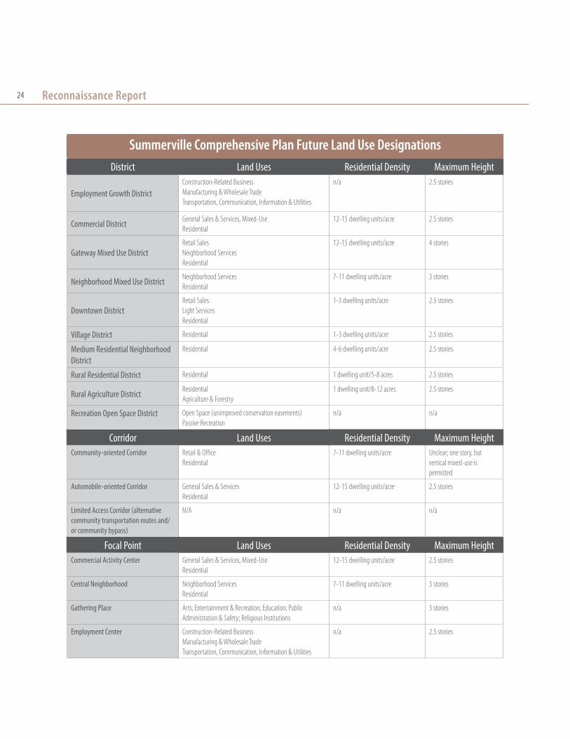
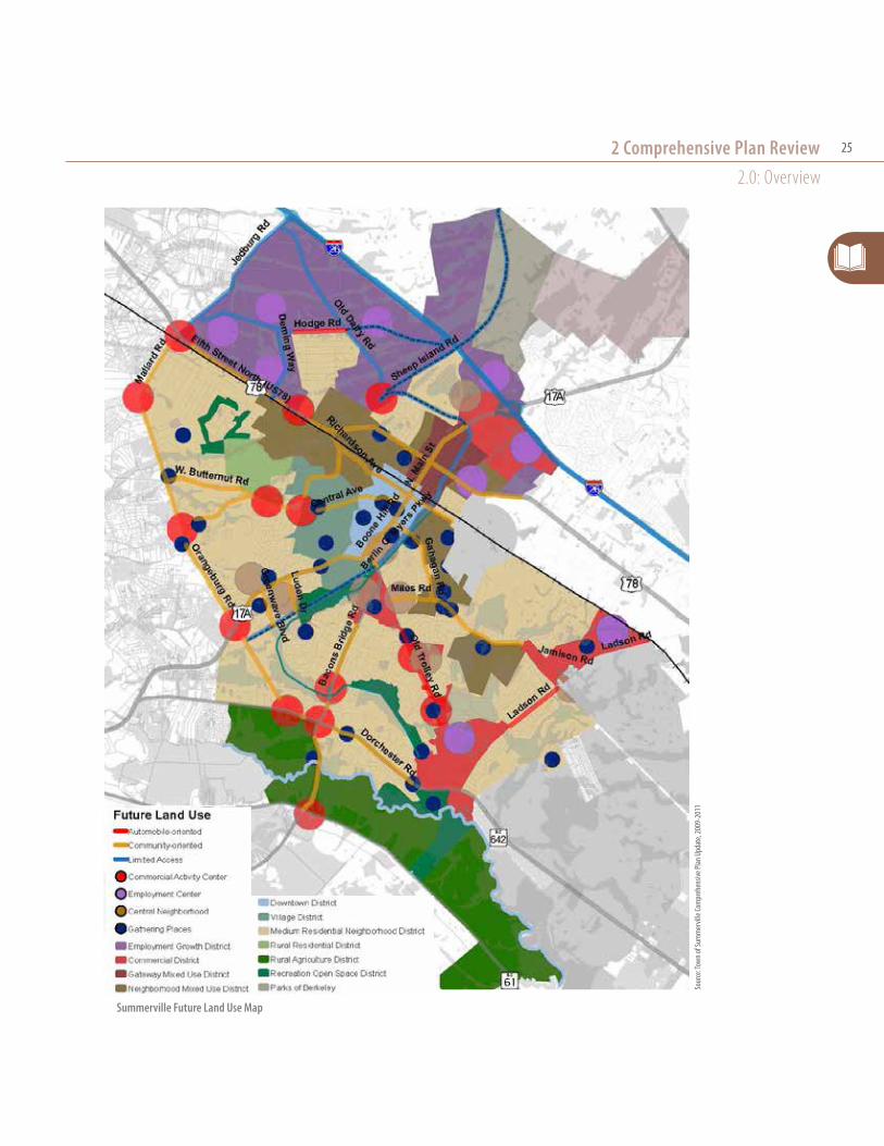
2.1: Future Land Use2.1.1: Town Future Land Use Plan
The plan designates three types of future land use elements within the planning area: districts, corridors,
A high-level vision of Summerville’s future
2 Comprehensive plan review
Town of SummervilleTown Planning AreaTown of LincolnvilleCity of Goose CreekCity of North Charleston
Planning Area: Summerville’s Comprehensive Plan includes specified areas from surrounding counties
Sour
ce: T
own o
f Sum
mer
ville
Com
preh
ensiv
e Plan
Upd
ate,
2009
-201
1
Reconnaissance Report24
Summerville Comprehensive Plan Future Land Use DesignationsDistrict Land Uses Residential Density Maximum Height
Employment Growth DistrictConstruction-Related BusinessManufacturing & Wholesale TradeTransportation, Communication, Information & Utilities
n/a 2.5 stories
Commercial District General Sales & Services, Mixed-UseResidential
12-15 dwelling units/acre 2.5 stories
Gateway Mixed Use DistrictRetail SalesNeighborhood ServicesResidential
12-15 dwelling units/acre 4 stories
Neighborhood Mixed Use District Neighborhood ServicesResidential
7-11 dwelling units/acre 3 stories
Downtown DistrictRetail SalesLight ServicesResidential
1-3 dwelling units/acre 2.5 stories
Village District Residential 1-3 dwelling units/acre 2.5 stories
Medium Residential Neighborhood District
Residential 4-6 dwelling units/acre 2.5 stories
Rural Residential District Residential 1 dwelling unit/5-8 acres 2.5 stories
Rural Agriculture District ResidentialAgriculture & Forestry
1 dwelling unit/8-12 acres 2.5 stories
Recreation Open Space District Open Space (unimproved conservation easements)Passive Recreation
n/a n/a
Corridor Land Uses Residential Density Maximum HeightCommunity-oriented Corridor Retail & Office
Residential7-11 dwelling units/acre Unclear; one story, but
vertical mixed-use is permitted
Automobile-oriented Corridor General Sales & ServicesResidential
12-15 dwelling units/acre 2.5 stories
Limited Access Corridor (alternative community transportation routes and/or community bypass)
N/A n/a n/a
Focal Point Land Uses Residential Density Maximum HeightCommercial Activity Center General Sales & Services, Mixed-Use
Residential12-15 dwelling units/acre 2.5 stories
Central Neighborhood Neighborhood ServicesResidential
7-11 dwelling units/acre 3 stories
Gathering Place Arts, Entertainment & Recreation; Education; Public Administration & Safety; Religious Institutions
n/a 3 stories
Employment Center Construction-Related BusinessManufacturing & Wholesale TradeTransportation, Communication, Information & Utilities
n/a 2.5 stories
2 Comprehensive Plan Review2.0: Overview
25
Summerville Future Land Use Map
Sour
ce: T
own o
f Sum
mer
ville
Com
preh
ensiv
e Plan
Upd
ate,
2009
-201
1

Reconnaissance Report26
and focal points, as shown in the table and map on the preceding pages. These three land use elements identify general uses and development densities.
According to the town’s future land use designations, the Gateway Mixed-Use District at North Main Street and North Fifth Street (also designated a Priority Investment Area referred to as “North Main”) should have the highest density with zero lot-line buildings up to four stories. The Neighborhood Mixed-Use District, located along corridors close to downtown, is a less-intense version of Gateway Mixed-Use with building heights up to three stories, which is more density and diversity of uses for both of these mixed-use districts than for downtown. The plan proposes the use of form-based coding to implement both of these mixed-use districts.
2.1.2: County Future Land Use Plans
The three county jurisdictions that overlap Summerville’s town boundaries each show future land use designations for the town and surrounding areas, as shown on the maps on the following pages and summarized in the table below. The table below summarizes the county designations.
County Comprehensive Plan Future Land Use Designations
CountyDesignated Land
Uses (in town)Other Recommendations and Considerations
Conflicts with Town Land Use
Dorchester
EmploymentCommercialCivic Housing
Ì Completed in tandem with town Comprehensive Plan; fairly aligned Ì Shows northwest edge and Jedburg portions of the Summerville Planning Area as “Constrained Growth” areas that should be developed as conservation communities
Ì Shows natural resource conservation areas to north and west sides of town following the Ashley River
Ì County shows Bacon’s Bridge Road/Dorchester Road as a Gateway District
Charleston
Suburban Residential/Residential Low DensityIndustrialCommercial
Ì Urban Growth Boundary follows county line in Summerville Ì Designates Summerville/Lincolnville area as a “Special Planning Area,” meaning it is “experiencing immediate development pressures and require[s] further study regarding land use issues”
Ì Shows only low-density residential development and no focal points
Berkeley
Low Density Suburban Ì Summerville is considered a “Town Center” within the Berkeley County framework Ì Shows North Main Street/17A as a commercial corridor Ì Designates Employment Centers along I-26 at Cypress Campground Road, Jedburg Road, Ladson Road, all just outside town boundaries
Ì Apart from “town center” designation, shows only as low-density suburban
VISION PLAN QUESTIONS » How much residential density should be permitted
downtown? The proposal of 1-3 dwelling units per acre may not be realistic for attracting more retail and enlivening the downtown.
» What is downtown’s role in Summerville’s future? The town’s historic growth pattern assumed that downtown was the central business district; the proposal of new, higher-intensity districts changes this relationship.
» What tools can the town use to make future development conform with the plan’s vision for focal points, districts, and corridors?
» Where should the western gateways to town be? The Dorchester County Land Use plan shows significant development along Dorchester Road/SC-642 and Boone Hill Road/17A.
» How can Summerville’s economic development strategy complement planned regional employment centers along I-26?
» How should Summerville designate conservation corridors that tie into a regional conservation strategy?
» How should Summerville mix uses to achieve target densities in a corridor district, creating focal points?

2 Comprehensive Plan Review2.1: Future Land Use
27Palm
etto
Comm
erce
Pkwy.
Glenn M
cConnell
Beech Hill Rd.
County Line Rd.
SC-165
SC-61
SC-642
Ladson Rd.
AshleyPhosphateRd.
US-17
SC-642
US-78
Lincolnville Rd.
Tro
lley
Rd.
US-17A
I-26
US-17A
SC-61
SC-2
7
SC-2
7
I-26US-78
Wire Rd.
I-26
US-178
US-78SC-4
53US-15
I-26
I-95
US-178
US-78
I-95
US-15
Ridge Rd.
Ora
ngeb
urg
Rd.
Norfolk Southern Railroad
No
rfolk So
uth
ern
Railro
ad
Legend
Transportation RoutesExisting Road
Existing Minor Road
Road to Be Widened
New Road (Approximate Route)
Railroad
CorridorsAutomobile-oriented (General Commercial)
Community-oriented (Mixed Use)
Land-use NodesEmployment
Commmercial
Civic
Housing
Growth AreasEmployment
Managed
Constrained
Restricted - Rural
Restricted - Conservation
Natural ResourcesWater Course
Forested Wetlands
Non-forested Wetlands
Protected Land
Greenbelt
ProposedExit 197
Watson Hill
Middleton Place
Poplar Grove
ClubhouseCorners
Cooks Crossroads
AshleyRidge
HS
Ft. Dorch.
HS
SummervilleHS
Givhans
Givhans FerryState Park
Dorchester
Rosinville
Grover
Dorange
SUMMERVILLE
RIDGEVILLE
Brosnan Forest
HARLEYVILLEST. GEORGE
REEVESVILLE
Jedburg
Knightsville
Brownsville
NORTHCHARLESTON
SummervilleGatewayDistricts
GatewayDistrict
GatewayDistrict
possible commuter rail
station locationsFr
anci
s B
eid
ler F
ore
st
Four Holes SwampEdis
to R
iver
Edis
to R
iver
Gre
at C
ypre
ss S
wam
p
Ash
ley River
possible commuterrail station location
Town/County Gateway District &possible commuter rail station location
WoodlandHS
Indi
an
Field
Swam
p railro
ad
RAVENEL
Geddisville
CoachmansCorner
I-95 weighstation
Byrds
Badham
ShadyGrove
Texas
Pregnall
Brosnan Forest
Po
lk Swam
p
DelemarsCrossroads
Cattle
Cre
ekSw
amp
COLLETONCOUNTY
ORANGEBURGCOUNTY
BERKELEYCOUNTY
CHARLESTONCOUNTY
CHARLES-TON
Dorchester County Airport
St. GeorgeMunicipal Airport
GatewayDistrict
Dorchester CountyFuture Land Use
2008-2030 Data sources: Dorchester County GIS Department,SCDOT, SCDHEC-OCRM, The Nature Conservancy, US Census Bureau TIGER Files, BCDCOG Path - C:/Projects/Dorchester Comp Plan 07/DorCoFLUM.ai Created 8/14/07, revised 10/9, 11/28, 12/11/07 (awb3)
Dorchester County Future Land Use Map (from the county Comprehensive Plan, adopted 2008)
Palmetto
Comm
erce
Pkwy.
Glenn M
cConnell
Beech Hill Rd.
County Line Rd.
SC-165
SC-61
SC-642
Ladson Rd.
AshleyPhosphateRd.
US-17
SC-642
US-78
Lincolnville Rd.
Tro
lley
Rd.
US-17A
I-26
US-17A
SC-61
SC-2
7
SC-2
7
I-26US-78
Wire Rd.
I-26
US-178
US-78
SC-453US-15
I-26
I-95
US-178
US-78
I-95
US-15
Ridge Rd.
Ora
ngeb
urg
Rd.
Norfolk Southern Railroad
No
rfolk So
uth
ern
Railro
ad
Legend
Transportation RoutesExisting Road
Existing Minor Road
Road to Be Widened
New Road (Approximate Route)
Railroad
CorridorsAutomobile-oriented (General Commercial)
Community-oriented (Mixed Use)
Land-use NodesEmployment
Commmercial
Civic
Housing
Growth AreasEmployment
Managed
Constrained
Restricted - Rural
Restricted - Conservation
Natural ResourcesWater Course
Forested Wetlands
Non-forested Wetlands
Protected Land
Greenbelt
ProposedExit 197
Watson Hill
Middleton Place
Poplar Grove
ClubhouseCorners
Cooks Crossroads
AshleyRidge
HS
Ft. Dorch.
HS
SummervilleHS
Givhans
Givhans FerryState Park
Dorchester
Rosinville
Grover
Dorange
SUMMERVILLE
RIDGEVILLE
Brosnan Forest
HARLEYVILLEST. GEORGE
REEVESVILLE
Jedburg
Knightsville
Brownsville
NORTHCHARLESTON
SummervilleGatewayDistricts
GatewayDistrict
GatewayDistrict
possible commuter rail
station locations
Fran
cis
Bei
dle
r Fo
rest
Four Holes Swamp
Edisto
Riv
er
Edis
to R
iver
Gre
at C
ypre
ss S
wam
p
Ash
ley River
possible commuterrail station location
Town/County Gateway District &possible commuter rail station location
WoodlandHS
Indi
an
Field
Swam
p railro
ad
RAVENEL
Geddisville
CoachmansCorner
I-95 weighstation
Byrds
Badham
ShadyGrove
Texas
Pregnall
Brosnan Forest
Po
lk Swam
p
DelemarsCrossroads
Cattle
Cre
ekSw
amp
COLLETONCOUNTY
ORANGEBURGCOUNTY
BERKELEYCOUNTY
CHARLESTONCOUNTY
CHARLES-TON
Dorchester County Airport
St. GeorgeMunicipal Airport
GatewayDistrict
Dorchester CountyFuture Land Use
2008-2030 Data sources: Dorchester County GIS Department,SCDOT, SCDHEC-OCRM, The Nature Conservancy, US Census Bureau TIGER Files, BCDCOG Path - C:/Projects/Dorchester Comp Plan 07/DorCoFLUM.ai Created 8/14/07, revised 10/9, 11/28, 12/11/07 (awb3)
Palmetto
Comm
erce
Pkwy.
Glenn M
cConnell
Beech Hill Rd.
County Line Rd.
SC-165
SC-61
SC-642
Ladson Rd.
AshleyPhosphateRd.
US-17
SC-642
US-78
Lincolnville Rd.
Tro
lley
Rd.
US-17A
I-26
US-17A
SC-61
SC-2
7
SC-2
7
I-26US-78
Wire Rd.
I-26
US-178
US-78
SC-453US-15
I-26
I-95
US-178
US-78
I-95
US-15
Ridge Rd.
Ora
ngeb
urg
Rd.
Norfolk Southern Railroad
No
rfolk So
uth
ern
Railro
ad
Legend
Transportation RoutesExisting Road
Existing Minor Road
Road to Be Widened
New Road (Approximate Route)
Railroad
CorridorsAutomobile-oriented (General Commercial)
Community-oriented (Mixed Use)
Land-use NodesEmployment
Commmercial
Civic
Housing
Growth AreasEmployment
Managed
Constrained
Restricted - Rural
Restricted - Conservation
Natural ResourcesWater Course
Forested Wetlands
Non-forested Wetlands
Protected Land
Greenbelt
ProposedExit 197
Watson Hill
Middleton Place
Poplar Grove
ClubhouseCorners
Cooks Crossroads
AshleyRidge
HS
Ft. Dorch.
HS
SummervilleHS
Givhans
Givhans FerryState Park
Dorchester
Rosinville
Grover
Dorange
SUMMERVILLE
RIDGEVILLE
Brosnan Forest
HARLEYVILLEST. GEORGE
REEVESVILLE
Jedburg
Knightsville
Brownsville
NORTHCHARLESTON
SummervilleGatewayDistricts
GatewayDistrict
GatewayDistrict
possible commuter rail
station locations
Fran
cis
Bei
dle
r Fo
rest
Four Holes Swamp
Edisto
Riv
er
Edis
to R
iver
Gre
at C
ypre
ss S
wam
p
Ash
ley River
possible commuterrail station location
Town/County Gateway District &possible commuter rail station location
WoodlandHS
Indi
anField
Swam
p railro
ad
RAVENEL
Geddisville
CoachmansCorner
I-95 weighstation
Byrds
Badham
ShadyGrove
Texas
Pregnall
Brosnan Forest
Po
lk Swam
p
DelemarsCrossroads
Cattle
Cre
ekSw
amp
COLLETONCOUNTY
ORANGEBURGCOUNTY
BERKELEYCOUNTY
CHARLESTONCOUNTY
CHARLES-TON
Dorchester County Airport
St. GeorgeMunicipal Airport
GatewayDistrict
Dorchester CountyFuture Land Use
2008-2030 Data sources: Dorchester County GIS Department,SCDOT, SCDHEC-OCRM, The Nature Conservancy, US Census Bureau TIGER Files, BCDCOG Path - C:/Projects/Dorchester Comp Plan 07/DorCoFLUM.ai Created 8/14/07, revised 10/9, 11/28, 12/11/07 (awb3)
Palmetto
Comm
erce
Pkwy.
Glenn M
cConnell
Beech Hill Rd.
County Line Rd.
SC-165
SC-61
SC-642
Ladson Rd.
AshleyPhosphateRd.
US-17
SC-642
US-78
Lincolnville Rd.
Tro
lley
Rd.
US-17A
I-26
US-17A
SC-61
SC-2
7
SC-2
7
I-26US-78
Wire Rd.
I-26
US-178
US-78
SC-453US-15
I-26
I-95
US-178
US-78
I-95
US-15
Ridge Rd.
Ora
ngeb
urg
Rd.
Norfolk Southern Railroad
No
rfolk So
uth
ern
Railro
ad
Legend
Transportation RoutesExisting Road
Existing Minor Road
Road to Be Widened
New Road (Approximate Route)
Railroad
CorridorsAutomobile-oriented (General Commercial)
Community-oriented (Mixed Use)
Land-use NodesEmployment
Commmercial
Civic
Housing
Growth AreasEmployment
Managed
Constrained
Restricted - Rural
Restricted - Conservation
Natural ResourcesWater Course
Forested Wetlands
Non-forested Wetlands
Protected Land
Greenbelt
ProposedExit 197
Watson Hill
Middleton Place
Poplar Grove
ClubhouseCorners
Cooks Crossroads
AshleyRidge
HS
Ft. Dorch.
HS
SummervilleHS
Givhans
Givhans FerryState Park
Dorchester
Rosinville
Grover
Dorange
SUMMERVILLE
RIDGEVILLE
Brosnan Forest
HARLEYVILLEST. GEORGE
REEVESVILLE
Jedburg
Knightsville
Brownsville
NORTHCHARLESTON
SummervilleGatewayDistricts
GatewayDistrict
GatewayDistrict
possible commuter rail
station locations
Fran
cis
Bei
dle
r Fo
rest
Four Holes Swamp
Edisto
Riv
er
Edis
to R
iver
Gre
at C
ypre
ss S
wam
p
Ash
ley River
possible commuterrail station location
Town/County Gateway District &possible commuter rail station location
WoodlandHS
Indi
an
Field
Swam
p railro
ad
RAVENEL
Geddisville
CoachmansCorner
I-95 weighstation
Byrds
Badham
ShadyGrove
Texas
Pregnall
Brosnan Forest
Po
lk Swam
p
DelemarsCrossroads
Cattle
Cre
ekSw
amp
COLLETONCOUNTY
ORANGEBURGCOUNTY
BERKELEYCOUNTY
CHARLESTONCOUNTY
CHARLES-TON
Dorchester County Airport
St. GeorgeMunicipal Airport
GatewayDistrict
Dorchester CountyFuture Land Use
2008-2030 Data sources: Dorchester County GIS Department,SCDOT, SCDHEC-OCRM, The Nature Conservancy, US Census Bureau TIGER Files, BCDCOG Path - C:/Projects/Dorchester Comp Plan 07/DorCoFLUM.ai Created 8/14/07, revised 10/9, 11/28, 12/11/07 (awb3)

Reconnaissance Report28
Charleston County Future Land Use Map (from the county Comprehensive Plan, adopted 2008)
ashley river rd
Bees Ferry rdGlenn mcConnell pkwy
rivers ave
University Blvd
Dorchester rd

2 Comprehensive Plan Review2.1: Future Land Use
29
Berkeley County Future Land Use Map (from the county Comprehensive Plan, adopted 2010)

Reconnaissance Report30
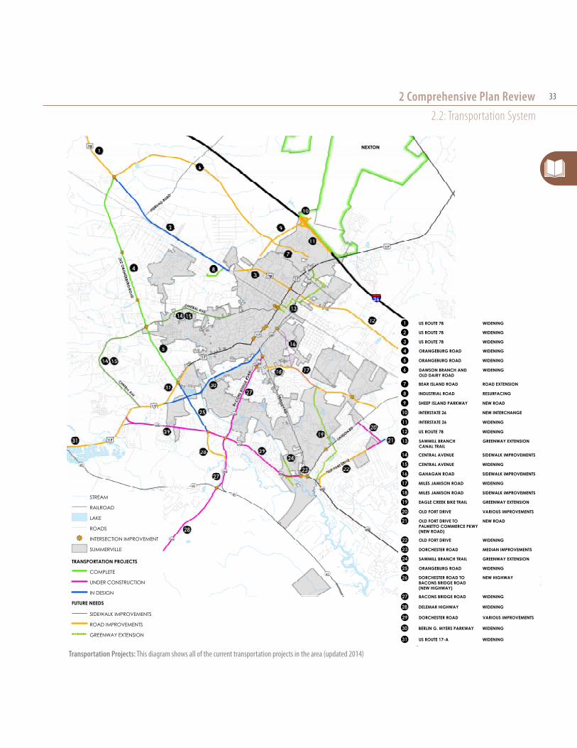
2.2: Transportation System2.2.1: Street Network
One objective of the transportation element is to “provide an interconnected network of local roads” through a Modified Street Grid or Neighborhood Unit approach (Goal Two-Community System Design). The plan assigns the ZDO as the implementation tool. Additionally, the Conceptual Road Types Map also shows three new street connections (apart from the Berlin G. Myers Parkway extension, discussed below) as black dashed lines, but does not name these projects or discuss any design or implementation details.
Update: All three new connections are near the new interchange, and the lines appear to be close to the planned Sheep Island Parkway connections.
Conceptual Road Types
Road Type ContextTravel Lanes
Design Speed
Planting Strip/
Median
Bicycle Facilities
Pedestrian Facilities
ParkingBuilding
Siting
Avenue
Commercial Activity CentersGathering PlacesCentral Neighborhoods
2-4 lanes; 11 ft wide or 15ft with sharrows
20-30 mph Planting strip 5-10 ft; 6-ft median
Sharrows in outer 15-ft lane
Sidewalks 8 ft minimumCrossings every 1/8 mile
Parallel or angled in Commercial Activity Centers; Off-street parking located to side or rear of fronting buildings
Maximum Front Setback: 15 feet
Boulevard
Medium Residential Neighborhood District
2-4 lanes; 11 ft wide or 15ft with sharrows
30-35 mph Planting strip 5-10 ft;Landscaped median 15-20 ft
Sharrows in outer 15-ft lanes or separated bike lanes of 5-6 ft
Sidewalks 5 ft minimum
Parallel parking permitted;Off-street parking may be located in front of buildings
Fronting buildings face perpendicular streets
Thoroughfare
Between communities or community bypass
2-4 lanes; 12 ft wide
40-50 mph;Rural only: 55 mph
Planting strip 10 ft minimum with multi-use trail
Multi-use trail at 14 ft (one-way) or 20 ft (two-way)
No on-street parking;Off-street parking screened from travel lanes
Fronting buildings face perpendicular streets
2.2.2: Conceptual Road Types
The plan designates three conceptual road types: avenues, boulevards, and thoroughfares (summarized in the accompanying table) that are matched with future land use designations. The map on the following page assigns two-, four-, and six-lane versions of these three road types for the major streets in the planning area.
2.2.3: Bicycle Friendly Community
In addition to the bicycle facility accommodations recommended through the conceptual road types, the plan states the goal of achieving Bicycle Friendly Community status from the League of American Bicyclists.
2.2.4: Road Widening Projects
The plan reaffirms the implementation of 22 road widening projects around Dorchester County, many of

2 Comprehensive Plan Review2.2: Transportation System
31
Conceptual Road Types Map: Note the four new street connections shown on this map marked by the black dashed line.
Sour
ce: T
own o
f Sum
mer
ville
Com
preh
ensiv
e Plan
Upd
ate,
2009
-201
1

Reconnaissance Report32
which have already been completed. It highlights the four projects below as essential to “alleviating traffic congestion.”
Update: The following summaries of the four noted projects are from the Dorchester County project status website:1
Ð Berlin G. Myers Parkway: Project will extend the road to provide a new connection. Construction starting date to be determined: “Final design & right-of-way acquisition in progress - working on permit issues.”
Ð Bacons Bridge Road (SC Route 165): Project will widen road from two to four lanes and add a planted median. Under construction: “Clearing for project is 90% complete. Utility relocations at SC 61 intersection should be completed by end of May 2013. Earthwork south of the Ashley River is 70% complete.”
Ð 5th North Street (US-78): Project will widen road from two to four lanes and add a planted median. “Phase 1 - From St. George to near US 178 – Completed; Phase 2 - From US 178 to near Ridgeville - 2014; Phase 3 - From near Ridgeville to Summerville - 2015.” This project has not been finalized for all phases and could include only intersection improvements in future phases.
Ð Dorchester Road: Project provides a new extension to US-17A; realigns the intersection at US-17A; widens from two to five lanes with the addition of a 10-foot multiuse sidewalk in portions; and lengthens the culvert at Sawmill Branch. Under Construction: “delayed due to the weather and utility relocations.”
1 Dorchester County Penny Sales Tax Transportation Authority (http://www.dorchesterroadstax.org/ProjectStatus/ProjectStatus.htm)
Sour
ce: D
orch
este
r Cou
nty P
enny
Sales
Tax T
rans
porta
tion A
utho
rity,
http
://ww
w.do
rches
terro
adsta
x.org
/Bac
onsB
ridge
/Bac
onsB
ridge
Phot
os.h
tm
Bacons Bridge Road: Under construction
Bacons Bridge Road: Before road widening project
VISION PLAN QUESTIONS » How should the town match road types to land
development? The plan specifically notes that road-type assignments should be implemented incrementally by guiding future land development along the designated corridors.
» How can the town reconcile the proposed conceptual road types with its goals to develop higher-density walkable focal points and to become a Bicycle Friendly Community?
» What is the town’s strategy for becoming a Bicycle Friendly Community?
2 Comprehensive Plan Review2.2: Transportation System
33
Transportation Projects: This diagram shows all of the current transportation projects in the area (updated 2014)
PREPARED BY:Stantec Consulting Services Inc.4969 Centre Pointe Drive, Suite 200North Charleston, SC 29418Tel. 843.740.7700www.stantec.com
PROJECT NO:178420618
Ë0 2,000 4,0001,000
Feet
1 inch = 2000 feet
DATE:1/21/2014
NEXTONNEXTON
LEGEND:STREAM
RAILROAD
LAKE
ROADS
kj INTERSECTION IMPROVEMENT
SUMMERVILLE
TRANSPORTATION PROJECTS
UNDER CONSTRUCTION
IN DESIGN
FUTURE NEEDS
SIDEWALK IMPROVEMENTS
GREENWAY EXTENSION
ROAD IMPROVEMENTS
COMPLETE
TRANSPORTATION PROJECTSTRANSPORTATION PROJECTSID ROUTE DESCRIPTION
OOO US ROUTE 17-A WIDENING
OOO BERLIN G. MYERS PARKWAY WIDENING
OOO DORCHESTER ROAD VARIOUS IMPROVEMENTS
OOO DELEMAR HIGHWAY WIDENING
OOO BACONS BRIDGE ROAD WIDENING
OOO DORCHESTER ROAD TO BACONS BRIDGE ROAD (NEW HIGHWAY)
NEW HIGHWAYOOO ORANGEBURG ROAD WIDENINGOOO SAWMILL BRANCH TRAIL GREENWAY EXTENSIONOOO DORCHESTER ROAD MEDIAN IMPROVEMENTSOOO OLD FORT DRIVE WIDENING
OOO OLD FORT DRIVE VARIOUS IMPROVEMENTSOOO EAGLE CREEK BIKE TRAIL GREENWAY EXTENSIONOOO MILES JAMISON ROAD SIDEWALK IMPROVEMENTSOOO MILES JAMISON ROAD WIDENINGOOO GAHAGAN ROAD SIDEWALK IMPROVEMENTSOOO CENTRAL AVENUE WIDENINGOOO CENTRAL AVENUE SIDEWALK IMPROVEMENTS
OOO ORANGEBURG ROAD WIDENINGOOO ORANGEBURG ROAD WIDENINGOOO US ROUTE 78 WIDENINGOOO US ROUTE 78 WIDENINGOOO US ROUTE 78 WIDENING
OOO DAWSON BRANCH AND OLD DAIRY ROAD
WIDENING
OOO BEAR ISLAND ROAD ROAD EXTENSION
OOO INDUSTRIAL ROAD RESURFACING
OOO SHEEP ISLAND PARKWAY NEW ROAD
OOO INTERSTATE 26 NEW INTERCHANGE
OOO INTERSTATE 26 WIDENING
OOO US ROUTE 78 WIDENING
OOO SAWMILL BRANCHCANAL TRAIL
GREENWAY EXTENSION
OOO NEW ROADOLD FORT DRIVE TO PALMETTO COMMERCE PKWY(NEW ROAD)

Reconnaissance Report34
2.2.5: Express Bus Service
The transportation plan proposes expanded express bus service (limited stops to regional destinations) and additional park and ride lots to serve new routes. When the plan was completed, the town had one park and ride lot at Heritage Square serving Express Route 1 North Charleston to James Island and Route 10 Rivers Avenue from Trident Medical Center/Health South to Charleston Visitors Center. The plan’s proposed express bus route on Dorchester Road with a park and ride lot located at Dorchester Village Shopping Center has been implemented (Express Route 3).
2.2.6: Commuter Rail
A number of studies have been completed or are underway regarding the feasibility of commuter rail or other high-quality transit service along I-26 between Summerville and Charleston (http://i26alt.org/project-overview/). These include using the Norfolk-Southern Railroad corridor parallel to I-26 for commuter rail.
RecommendationsThe town has proposed three potential stops at park and ride lots to support future commuter rail:
Ð Near the intersection of Berlin G. Myers Parkway and US-78 (Fifth Street North) in the Town of Summerville;
Ð Along US-78 (Fifth Street North) at the intersection of SC-165 in the Brownsville community; and
Ð Along US-78 at the intersection of Jedburg Road.
EXPRESS
Park & Ride at:• K-Mart - Rivers Avenue• Citadel Mall - West Ashley• Wal Mart - Oakland Plantation• K-Mart - Mt. Pleasant• Wal Mart - James Island• Dorchester Village
Shopping Center -Dorchester/Trolley Summerville
843.724.7420ridecarta.com
Rt. 1 James Island - North Charleston
Rt. 2 Mt. Pleasant - West Ashley
Rt. 3 Dorchester Rd. - Summerville
Send Comments and Complaints to CARTA:36 John St., Charleston, SC 29403 (843) 724-7420
For Scheduling Information call (843) 747-0922For Lost and Found call (843) 747-0922
ridecarta.com
FARE INFORMATIONExact change only, please. Drivers cannot make change.
REGULAR FIXED ROUTE FARE - $1.75EXPRESS FARE - $3.00
TRANSFER - $.30 Available only on original boarding. Transfers accepted for se direction travel at points where routes intersect.
SENIOR CITIZENS (55+): Weekdays 9 a.m.-3:30 p.m. and after 6:00 p.m. Monday through Friday and all day Weekends and Holidays. You must show a valid ID for the discount rate – a Medicare card or ID card with a date of birth - $.85
CHILDREN: Age six and under ride free provided they are accompanied by a paying customer.
DISABLED FARE: $.50 all day, everyday.
BUS PASS INFORMATIONAll passes good on fixed routes.
All day pass (available on all CARTA vehicles) - $6.003 day pass - $12.0031 day pass - $50.0010 trips - $14.0040 trips – $49.00Express Monthly Pass - $88.00 (also good on all fixed routes)Students Pass per semester - $70.00
GENERAL INFORMATIONArrive at your stop at least five minutes before the bus is scheduled. Make sure you have the correct fare or ticket/pass ready to show the driver before on board. When you see your bus, signal the driver to stop for you. Check the destination sign before you board.
BUS SAFETY
It is our desire to furnish you with a safe ride and a dependable schedule.You may help us accomplish this by:
• Please take your seat as soon as possible. Do not change seats unless absolutely necessary. Allow senior citizens and people with disabilities to use the seats designated as “Priority Seating.”
• Get your transfer when you first board your CARTA Bus unless the driver specifies a certain place to obtain your transfer. Transfers are good only at approved transfer points.
• Exit from the center door when leaving a CARTA Bus. This minor effort allows boarding passengers to use the front door and helps to keep the Bus on schedule.
• Please do not carry open cans or bottles on CARTA Vehicles.
• Playing individual radios on CARTA Vehicles distracts the driver and other passengers, for this reason we ask you to please turn off your radio when you are on the Bus or Trolley.
• CARTA Buses, DASH Trolleys, and Tel-A-Ride Vehicles are non-smoking areas.
• Alcoholic beverages are not allowed on CARTA Vehicles.
• Please do not use profanity on CARTA Vehicles.
Wheelchair Accessibility and CARTA Buses: All of CARTA’s vehicles are wheelchair accessible. CARTA is a member of the “Access Charleston” Program.
Remember: Please allow senior citizens and people with disabilities to use the seats designated for them. “Priority Seating” signs are posted above these seats. The driver may direct non-disabled riders to move in order to allow senior/disabled riders the use of the designated seats and/or wheelchair securement devices.
HOLIDAY SCHEDULES
CARTA is operated 365 days a year. DASH shuttles do not operate, and all other routes follow a Sunday schedule on the following days: New Year’s Day, Fourth of July, Labor Day, Thanksgiving Day, and Christmas Day.
HOW TO RIDE EXPRESSRiding Express is easy! Just follow these steps:
1. To learn about the Express routes, call our information line at 724-7420, or visit our website at www.ridecarta.com.
2. Look for the signs indicating Express parking areas.
3. Please try to arrive at the bus stop at least 5 minutes before scheduled pick-up times.
4. Please be prepared to board CARTA Express quickly and find your seat.
5. Cost to ride is only $3.00 per ride. Please have exact change; bus drivers are unable to make change.
6. Each Express route features just a handful of convenient route stops—please be prepared to exit the bus as your stop approaches, stay seated until the bus comes to a stop.
PARKING FOR CARTA EXPRESSFor commuters who would prefer to use CARTA to get to work, but don’t want to walk to the bus stop, parking lots adjacent to the Express stops provide an essential service – a place to leave the car.
All parking lot locations are served by CARTA Express routes with service every half hour in the morning and afternoon peak periods.
• K-Mart parking lot on Rivers Avenue in North Charleston
• Citadel Mall parking lot near Orleans Road at the CARTA Bus Shelter
• K-Mart parking lot on Highway 17 Bypass in Mt. Pleasant
• Wal Mart at Oakland Plantation in Mt. Pleasant
• Wal Mart on Folly Road
• Visitor Center Parking Garage at Mary Street in Downtown Charleston (Paid Parking)
• Dorchester Village Shopping Center at the corner of Dorchester Rd. and Trolley Rd.
CARTA assumes no liability for vehicles left at these locations. Parking is at your own risk.
All Express buses are also equipped with bike racks, should you wish to take your bike with you. Please know that a maximum of two bikes can fit onto the front of a CARTA bus at any time.
CHARLESTON
NorthwoodsMall
Wal Mart
Wild Dunes
Dorchester Rd.
Folly Rd.
Ft. Johnson Rd.
Meeting St.
Isle of Palms Connector
Rifle Range Rd.
Palm Blvd.
61
526
17
17
517
703
52
526
526
26
Calhoun St.
International Blvd.
James Island
Connector
78
52
Ashley Phosphate Rd.
NORTHCHARLESTON
JAMESISLAND
FOLLYBEACH
MORRISISLAND
MOUNTPLEASANT
DANIELISLAND
WESTASHLEY
SULLIVAN’SISLAND
ISLE OFPALMS
COOPER RIVER
COOPER RIVER
WANDO R
IVER
WAPOO CREEK
STONO RIVER
STONO RIVER
FOLLY RIVER
STONO INLET
ASHLEY RIVER
ASHLEY RIVER
Ladson R
d.
SUMMERVILLE
Old
Trolley
Rd.
Dorchester Village
Shopping Center Dorchester Rd.
WEEKDAYS día laborable
START1 21 3 4 5 6 7 8 9 10
END10
END9
END8
END7
END6
END5
END4
END3
END2
Join
t B
ase
Ch
arle
sto
n
2 3 4 751
SOUTHBOUND con rumbo al sur
Bo
sch
Co
rp.
Bo
ein
g
Vis
ito
rs C
ente
r
Cal
ho
un
St.
/ Jo
nat
han
Lu
cas
St.
5:15 5:45 6:15 7:02 7:32 8:02
—2:55
— 4:19 4:50 5:28 6:17 6:47 7:19
5:31 6:01 6:31 7:18 7:48 8:18
—3:06
—4:30 5:01 5:39 6:28 6:57 7:29
5:39 6:09 6:39 7:26 7:56 8:26
—3:11
— 4:35 5:06 5:44 6:33 7:01 7:33
5:47 6:17 6:47 7:34 8:04 8:34
—3:19
—4:43 5:14 5:52 6:41
——
6:05 6:35 7:05 7:52 8:22 8:52
3:06 3:37 4:15 5:03 5:34 6:09 6:56
——
6:10 6:40 7:10 7:57 8:27 8:57
3:11 3:42 4:20 5:08 5:39 6:14 7:01
——
a.m.
p.m.
ridecarta.com
Dorchester Rd./ Summerville
EXPRESS
Do
rch
este
r Vill
age
Sho
pp
ing
Cen
ter
CHARLESTON
NorthwoodsMall
Wal Mart
Wild Dunes
Dorchester Rd.
Folly Rd.
Ft. Johnson Rd.
Isle of Palms Connector
Rifle Range Rd.
Palm Blvd.
61
526
17
17
517
703
52
526
526
26
Bee St.
International Blvd.
Courtney St.
Septima C
lark
Pkwy.
Dorchester Village
Shopping Center
78
Ladson R
d.
Old
Trolley
Rd.
Ashley Phosphate Rd.
SUMMERVILLE52
Dorchester Rd.NORTH
CHARLESTON
JAMESISLAND
FOLLYBEACH
MORRISISLAND
MOUNTPLEASANT
DANIELISLAND
WESTASHLEY
SULLIVAN’SISLAND
ISLE OFPALMS
COOPER RIVER
COOPER RIVER
WANDO R
IVER
WAPOO CREEKSTONO RIVER
STONO RIVER
FOLLY RIVER
STONO INLET
ASHLEY RIVER
ASHLEY RIVER
WEEKDAYS día laborable
START1 21 3 4 5 6 7 8 9 10
END10
END9
END8
END7
END6
END5
END4
END3
END2
2 3 4 651
NORTHBOUND en dirección norte
Co
urt
nay
St.
/ B
ee S
t.
Bo
ein
g
Bo
sch
Co
rp.
Do
rch
este
r Vill
age
Sho
pp
ing
Cen
ter
6:16 6:46 7:16 8:03 8:33 9:03
— 3:17 3:48 4:26 5:15 5:45 6:20 7:07
6:20 6:50 7:20 8:07 8:37 9:07
—3:21 3:52 4:30 5:19 5:49 6:24 7:11
6:35 7:05 7:35 8:22 8:52
—
2:20 3:41 4:12 4:50 5:39 6:09 6:44 7:31
6:41 7:11 7:41 8:28 8:58
—
2:30 3:51 4:22 5:00 5:49 6:19 6:54 7:41
6:46 7:16 7:46 8:33 9:03
—
2:38 3:59 4:30 5:08 5:57 6:27 7:02 7:49
6:577:277:57
———
2:53 4:14 4:45 5:23 6:12 6:42 7:17 8:04
a.m.
p.m.
ridecarta.com
Join
t B
ase
Ch
arle
sto
n
Dorchester Rd./ Summerville
EXPRESS
Cal
ho
un
St.
/ Jo
nat
han
Lu
cas
St.
6:15 6:45 7:15 8:02 8:32 9:02
3:15 3:46 4:24 5:13 5:43 6:18 7:05
——
6
Cal
ho
un
St.
/St
. Ph
illip
St.
3 3
Effective May 5th, 2013
Sour
ce: C
ARTA
http
://ww
w.rid
ecar
ta.co
m/w
p-co
nten
t/uplo
ads/2
013/
05/C
ARTA
Expr
ess-R
oute
s-effe
c-May
-5-2
013.p
df

2 Comprehensive Plan Review2.2: Transportation System
35
Sour
ce: T
own o
f Sum
mer
ville
Com
preh
ensiv
e Plan
Upd
ate,
2009
-201
1
Proposed Transit Map from the Summerville Comprehensive Plan Update

Reconnaissance Report36
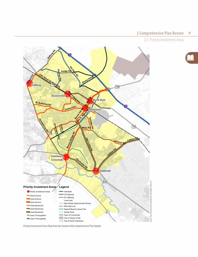
2.3: Priority Investment Areas2.3.1: Purpose
The Priority Investment Areas Element of the Comprehensive Plan is required by South Carolina Code of Laws Section 6-29-510:
Analyzes the likely federal, state, and local funds available for public infrastructure and facilities during the next ten years, and recommends the projects for expenditure of those funds during the next ten years for
needed public infrastructure and facilities such as water, sewer, roads, and schools. The recommendation of those projects for public expenditure must be done through coordination with adjacent and relevant jurisdictions and agencies.
2.3.2: Designated Priority Investment Areas
The plan identifies six Priority Investment Areas as shown on the accompanying map. Four of these areas are located in the town, and the recommendations are summarized in the table below. The other two areas
Priority Investment AreasPriority
Investment Area
Location Proposed Improvements and Considerations
North Main
US-17A and US-78
Ì Draw upon activity generated by the County Services Building at 500 North Main Street Ì Undertake regulatory changes and infrastructure improvements to increase private property values, such as height increases and an improved Fifth Street North (US-78) corridor
Ì Potential commuter rail station at the edge of North Main
Brownsville
US-78 and SC-165
Ì Planned around the possibility that Kapstone will cease operations at its facility by 2030 Ì Opportunity for a commuter rail station and transit-oriented development Ì With planned Exit 197 on Interstate Highway 26, Brownsville will have convenient access to the highway. Ì Near a current, growing economic development district, allowing future residents short, in-town commutes
Downtown
South Main Street and East Richardson Avenue
Ì Anchored by the new Town Hall annex and parking garage Ì Completed upgrades for South Main Street/Richardson Avenue intersection include decorative mast arm intersection signals, lighting, and street lamps
Ì Stamped concrete has been installed along South Main Street from the railroad tracks to 2nd Street South Ì On-street parking spaces are provided along Central Avenue towards the intersection of Richardson Avenue Ì Pedestrian signage and pavement markings have been constructed; bicycle and pedestrian scale amenities are planned including additional pavement markings and bicycle racks
Ì Should analyze opportunities to replace existing overhead power lines with underground utilities Ì Should continue replacing existing stop and street light fixtures with new decorative mast arms Ì Potential commuter rail site within the area adjacent to the NSX rail line Ì Possible addition of a performing arts center (also discussed for other locations such as Heritage Square Shopping Center and Oakbrook Shopping Center)
Oakbrook
Ladson Road/Trolley Road/Dorchester Road Intersection
Ì Encourage public and private partnerships as an employment/commercial center. Ì Support the large residential, low-income populations and the senior residents Ì Pedestrian friendly mixed use development should be encouraged along the Midland Parkway and Dorchester Road area Ì Pursue connection between the Sawmill Branch Trail and North Charleston’s bike pedestrian trail along Dorchester Road Ì Support growing medical cluster Ì New Express Route 3 with a park and ride lot located at Dorchester Village Shopping Center provides access to Downtown Charleston
Ì Explore intra-city bus connections to the Historic District and Azalea Square Ì Cooperate with county in the mixed governed area of Trolley Road Ì Continue to research and plan for potential recreational opportunities
* Bold statements are projects that are in process or completed.
2 Comprehensive Plan Review2.3: Priority Investment Areas
37
Priority Investment Areas Map from the Summerville Comprehensive Plan Update
tu78
?ò
?Ì
!"a$
tu17A
tu17A
!"a$
tu78
Boone
Hill Rd
Hodge Rd
OldDairy Rd
Sheep Island Rd
Jedb
urg Rd
Berlin
G. Mye
rs P
kwy
Ladson Rd
Dorchester Rd
N.M
ain
St
Richardson Ave
Gahagan R
d
Dem
ingW
ayJamison Rd
W. Butternut Rd
Central Ave
Orangeburg Rd
Miles Rd
Fifth Street North (US78)
Old
TrolleyRd
Mal
lard
Rd
LudenD
r
Baco
nsBr
idge
Rd
Greenw
aveBlvd
Ladson Rd
Priority Investment Areas
2-lane Avenue
4-lane Avenue
6-lane Avenue
2-lane Boulevard
4-lane Boulevard
6-lane Boulevard
2-lane Thoroughfare
4-lane Thoroughfare
InterstateUS HighwaySC HighwayLocal roadNew Roads (Approximate Route)NSX Rail LineSawmill Branch Canal TrailAshley RiverTown of LincolnvilleCity of Goose CreekCity of North Charleston
Priority Investment Areas Legend
0 1 20.5Miles
Town of Summerville Planning AreaPriority Investment Areas ‐ Map # 6
¯2009‐2030
tu78
?ò
?Ì
!"a$
tu17A
tu17A
!"a$
tu78
Boone
Hill Rd
Hodge Rd
OldDairy Rd
Sheep Island Rd
Jedb
urg Rd
Berlin
G. Mye
rs P
kwy
Ladson Rd
Dorchester Rd
N.M
ain
St
Richardson Ave
Gahagan R
d
Dem
ingW
ay
Jamison Rd
W. Butternut Rd
Central Ave
Orangeburg Rd
Miles Rd
Fifth Street North (US78)
Old
TrolleyRd
Mal
lard
Rd
LudenD
r
Baco
nsBr
idge
Rd
Greenw
aveBlvd
Ladson Rd
Priority Investment Areas
2-lane Avenue
4-lane Avenue
6-lane Avenue
2-lane Boulevard
4-lane Boulevard
6-lane Boulevard
2-lane Thoroughfare
4-lane Thoroughfare
InterstateUS HighwaySC HighwayLocal roadNew Roads (Approximate Route)NSX Rail LineSawmill Branch Canal TrailAshley RiverTown of LincolnvilleCity of Goose CreekCity of North Charleston
Priority Investment Areas Legend
0 1 20.5Miles
Town of Summerville Planning AreaPriority Investment Areas ‐ Map # 6
¯2009‐2030
north main
oakbrook
Downtown
Brownsville
limehouse Crossroads
Jedburg
Sour
ce: T
own o
f Sum
mer
ville
Com
preh
ensiv
e Plan
Upd
ate,
2009
-201
1

Reconnaissance Report38
( Jedburg and Limehouse Crossroads) are located in Dorchester County; neither the town nor the county provide recommendations for these areas in their respective Comprehensive Plans.
The plan discusses road improvements, commuter rail stations, and construction of new public schools as priority investments. These are not directly tied to the Priority Investment Areas in the plan. The road improvements and commuter rail station recommendations are repeated from the transportation element (see Section 2.2 of this report).
2.3.3: Financing Mechanisms for Proposed Investments
The plan discusses the following mechanisms to fund public projects including road improvements, commuter rail stations, and schools.
Ð Transportation Impact Fees: These fees have been implemented as part of a comprehensive development impact fee ordinance revised by the town in 2010. At this time, the fee is set at $0. (Summerville Code of Ordinances Section 20-4).
Ð Tax-Increment Financing (TIF): The plan proposes TIFs for three new street connections: US-78 (College Park Road to Berlin G. Myers Parkway); US-17A (Berlin G. Myers Parkway to Clubhouse Road); and Fifth Street North /US-78 (Berlin G. Myers Parkway to Jedburg Road).
Ð Municipal Improvement District (MID): The plan proposes MIDs to fund “vertical facilities” or Commuter Rail Station facilities.
Ð Residential Improvement District (RID): The plan mentions using RIDs to fund new schools.
Update: The town has not implemented any TIFs, MIDs, or RIDs.
2.3.4: Proposed School Investments
During the planning process, Dorchester County projected the need for future school facilities throughout the county, including four new elementary schools, three new middle schools, and one new high school. Dorchester County passed a $179 million referendum to pay for the new schools in 2012.
RecommendationsAccording to the plan, the town supports the construction of schools within the town and proposes the use of development agreements, planned developments, and RIDs to facilitate this goal.
Update: More recent information from Dorchester School District Two shows that new school facilities are planned as follows.2
Ð Elementary school #1 at Pine Trace near the Coastal Center: The school is in the design phase; will be located in Summerville off of Miles Jamison Road.Construction is planned to begin in March 2014.
Ð Elementary school #2 and new middle school of the arts (on shared campus) located in the Summers Corner area off of Hwy #61 on land donated by MeadWestVaco. These schools will be located in unincorporated Dorchester County. The middle school for the arts is moving from its current location in Summerville just south of downtown.
Ð Elementary school #3 located on US-78, adjacent to Alston Middle School; will be located in Summerville.
All schools are planned to be occupied by 2015.
2 Dorchester School District Two, http://www.dorchester2.k12.sc.us/

2 Comprehensive Plan Review2.3: Priority Investment Areas
39
2.3.5: Conservation – Transfer of Development Rights (TDR) program
Recommendations Ð Develop a TDR program in concert with
Dorchester County and the Town of Ridgeville to protect areas such as the Ashley River Road Historic Overlay District, the Edisto River floodplain, the Great Cypress Swamp, and the Four Holes Swamp. It proposes these as “sending” areas, but has not proposed receiving areas.
Update: The town has not implemented a TDR program. All three county plans also propose the use of TDRs, but none have implemented one.
VISION PLAN QUESTIONS » How can the goals of the priority investment areas
be incorporated into the focus area plans in the Vision Plan?
» How can TIFs, BIDs, MIDs, and RIDs be incorporated into a public investment strategy?
» What impacts will the new schools have on the town?
» What level of density are residents willing to accept as part of a TDR program?
» What other South Carolina communities have implemented TDR programs, and what can Summerville learn from them?
» Where should workforce housing be located? What should the design and density of workforce housing be?
Ashley River
2.3.6: Workforce Housing
Recommendations Ð Incentivize workforce housing (affordable to those
earning 80-120 Area Median Income (AMI)) by fast-tracking permits and/or the development review process for projects that include these housing products.
Ð Encourage workforce housing in those areas designated on the Future Land Use map as: Central Neighborhoods, Gateway Mixed Use, Neighborhood Mixed Use Districts, and areas along Community-Oriented Corridors.
Ð Revise the zoning of these districts to allow a variety of housing types.
Update: No workforce housing initatives have been implemented.

Reconnaissance Report40
2.4: Population Ð Summerville is a high-growth area, with a relatively-
high median household income compared to the region.
Ð As of the 2000 census, 9% of residents live below the poverty line; of this population, 10% were children and 12% were seniors.
Ð The population is 78% white, 20% African-American, and 2% other race.
Ð The town’s population includes a large percentage of baby boomers, as well as those of child-bearing age, and a growing child/teen population.
2.5: Natural ResourcesA 22-mile section of the Ashley River was designated as a State Scenic River by the state in 1998, a portion of which is located at the western edge of the Summerville Planning Area. The Ashley Scenic River Management Plan was completed by the South Carolina Department of Natural Resources and approved in 2003 (it is reviewed in section 3.6).
The plan proposes a range of options for improving water quality, mostly through land use development strategies to conserve sensitive land and require compact development. Only a small portion of the town (near the Ashley River) is located in the floodplain, but significant areas of impervious surfaces have caused flash-flooding.
Recommendations Ð Use passive stormwater mitigation techniques such
as rain gardens and green roofs.
Ð Conserve forestlands near the Ashley River and a farm adjacent to I-26 on the southeast side of town through annexation or an extraterritorial jurisdiction arrangement with adjacent counties.
2.6: EnergyStrategies to improve energy sustainability that are related to the built environment include promoting compact, mixed-use development forms, and improving accommodations for pedestrians and bicyclists. These reflect more specific recommendations discussed in other parts of the plan.
VISION PLAN QUESTIONS » How should the town’s development strategy
respond to the area demographics?
» How will the town work with Dorchester County and Berkeley County to require passive stormwater mitigation techniques?
Stormwater Retention: An example of a stormwater retention area in Knightsville

2 Comprehensive Plan Review2.7: Housing
41
2.7: Housing2.7.1:Housing Stock
The following facts about the town’s housing stock are excerpted from the Housing Element of the Comprehensive Plan.
Ð “As of 2008, approximately 64% of residences within the Town limits of Summerville were owner-occupied, 28% of residences were renter-occupied, and approximately 8% of homes were vacant.”
Ð As of 2008, there were 14,770 housing units in the town; 62.7% were single-family detached, 27.7% were multifamily or single-family attached, and 9.5% were mobile home or other.
Ð “Approximately 27% of all housing in the Town of Summerville has been built since 2000… Approximately 10% of the housing in the town was built before 1950.”
Ð Based on median mortgage cost and rent in 2008, homeownership and renting would be viable options for households making the median income level, requiring approximately 30% of income and 19.5% of income, respectively.
2.7.2: Recession Effects
The Great Recession affected both recent development and foreclosure rates in Summerville.
Ð As of 2010, the town had approved nearly 4,900 homes that were not yet built. These include single-family detached and attached, and multifamily units. The majority of these units are in White Gables, Nexton, and Limehouse Plantation.
Ð As of 2010, there were 864 homes in the Summerville area that were at some point in the
foreclosure process. Of these homes, approximately 454 homes were in pre-foreclosure, 335 homes were owned by the banks, and 75 homes were being advertised for sale at auction by the local sheriff ’s departments.”
2.7.3: Housing Priorities
Recommendations Ð Revise the ZDO to permit a variety of housing types
by right.
Ð Revise the ZDO to permit accessory dwelling units throughout town.
Update: These changes have not been made to the ZDO.
VISION PLAN QUESTIONS » How and where should the town allow a diversity of
housing types?
» What design guidelines should be used to ensure that infill housing fits into the context of existing neighborhoods?
APPROVED HOUSING UPDATE(Information provided by town staff; see map on following page)
Single-Family Housing: » 5,189 total approved (including 589 attached units)
» 41% (2,111 units) complete
Multifamily Housing: » 1,110 approved units in 4 developments
» 0% complete
» Arbor Village Apartments (240 units) under construction

Reconnaissance Report42
Town of Summerville
County Lines
Housing Developments
In Progress
Planned Only
Planned Housing Developments

2 Comprehensive Plan Review2.8: Community Facilities
43
2.8: Community Facilities2.8.1: Utilities
The town’s sewer and water systems are working well below capacity; as of 2010, the town was using 60 percent of its wastewater treatment capacity and 46 percent of its water filtration capacity.
The town has a separate Stormwater Management Plan, and has a Stormwater Department funded through a stormwater fee.
Recommendations Ð Use private funding and grants to relocate utilities
underground, especially in the historic district.
Update: Utilities have not been relocated because of cost limitations.
2.8.2: Recreation Facilities
Recreation facilities owned and maintained by the town include: eight baseball/softball fields, one football field, six tennis courts, and two parks with playground equipment. The Dorchester County Parks and Recreation Master Plan (2009) evaluated the provision of recreation facilities in Summerville (Park District 4), and found a deficit of basketball courts, swimming pools, volleyball courts, and picnic shelters. The town has not completed a parks master plan.
2.8.3: Schools
“According to recent statistics, the District is the fastest growing school district in South Carolina, serving (as of the 2009-2010 school year) over 22,000 students. District 2 is comprised of 22 schools, including 11 elementary schools, 6 middle schools, 3 high schools, an alternative program for students in grades 6 through 12, and an adult/community education program that
serves residents from pre-school age through adulthood. District 2 is also the second largest employer in Dorchester County.” (Community Facilities Element, p. 15)
For recommendations and updated plans, see 2.3.4.
2.8.4: Annexation
The Planning Area includes several unincorporated areas of the three counties, and there are several county islands entirely surrounded by the town.
Recommendations Ð Develop an annexation plan that prioritizes filling
existing gaps in the town’s boundary, focusing on those areas designated as part of the Planning Area for the Comprehensive Plan.
Ð Prioritize land that can be used for industrial and office development.
Ð Develop incentives for annexation and penalties for using town services without annexing.
Update: The town has prioritized annexation with strategies further oulined as part of the Vision Plan.
VISION PLAN QUESTIONS » How important is it to relocate utilities downtown?
» Are the town’s current stormwater issues a hindrance to infill development?
» How should new park and recreation facilities be designated and constructed in conjunction with new development?

Reconnaissance Report44
Summerville Resident Employment by Sector: ACS 2005-2008.
2.9: Economic Development2.9.1: Resident Employment Trends
Ð The unemployment rate in Summerville was 13.5% in 2010, the latest data from the Bureau of Labor Statistics shows that the unemployment rate for the Charleston-North Charleston-Summerville MSA is 6.9%(as of August 2013).
Ð 60% of Summerville residents work outside of their home county (ACS 2005-2008).
Ð Summerville residents commute an average of 28 minutes each way to work (ACS 2005-2008).
Ð 84.8% of Summerville residents drive alone to work (ACS 2005-2008).
Ð 60% of Summerville residents work in Sales & Office or Management & Professional occupations (ACS 2005-2008; see below).
2.9.2: Summerville Employer Trends
Ð The largest employment sectors are Retail Trade and Accommodation/Food Service (2007 Economic Census; see table).
Ð The two biggest employers are Wal-Mart Supercenter and Summerville Medial Center; each have 500 employees (BCDCOG).
Ð Ten employers in a variety of industrial and manufacturing trades with multiple facilities are headquartered in Summerville (Charleston Metro Chamber of Commerce; see table below).
Businesses with Headquarters in SummervilleName Business TypeASWA/Bumper to Bumper Auto Parts
Arborgen Forestry Genetics
Bunch Transport Trucking and Transport
American LaFrance Fire Trucks
Giant Cement Holding Cement Manufacture
Gyrotrac (USA) Inc. Industrial Machinery
Knights Corporation Construction Materials and Services
Lauscha Fiber International Microfiber Manufacturing
Thrace-LINQ Petroleum Based Textiles
Zodiac of North America Rigid Hull Inflatable BoatsSource: Charleston Metro Chamber of Commerce Center for Business Research
Ð “KFR Services, a local computer software and services business…opened up part of its location in the Oakbrook area [as a] business incubator” in 2009. According to its website, KFR Services currently houses four businesses.
2.9.3: Commercial & Industrial Real Estate
Ð Summerville does not have large office complexes. Most office buildings are smaller in size and would be considered Class B office space.
Sour
ce: T
own o
f Sum
mer
ville
Com
preh
ensiv
e Plan
Upd
ate,
2009
-201
1

2 Comprehensive Plan Review2.9: Economic Development
45
Ð As of 2008, Summerville had 13 office facilities larger than 10,000 square feet. The largest is 301 E. 5th North Street (27,328 square feet), and it is currently leased by Seacoast Church.
Ð As of 2010, Summerville had 2.6 million square feet of retail space, with a 9.3% vacancy rate. Most of the retail space is considered neighborhood or community center, selling convenience goods to local consumers.
Ð Summerville has two power centers: North Main Center (anchored by Wal-mart Supercenter, Belk, and Lowe’s Home Improvement), and Azalea Square (anchored by Target, Kohl’s, Best Buy, and Regal Cinemas).
Ð As of 2010, there were 511,000 square feet of approved but unbuilt office, retail, and storage space, and 300 hotel rooms proposed within the town.
Ð Recommendations from a retail market study completed for all of Dorchester County in 2010 are shown in the accompanying table.
Ð As of 2010, there were 7,015,192 square feet of industrial space in Summerville, with a 22.9% vacancy rate.
2.9.4: Commercial Development
Recommendations for new commercial and mixed-use development follow the future land use element of the plan, and provide more direction for design. The main goal of this section is to “encourage current and future business development to utilize quality building design and site design techniques.”
2010 Retail Market Study RecommendationsType of Retail RecommendationsFurniture and Home Furnishings
Focus on small scale home furnishings retailers, art dealers, and related businesses, preferably in the downtown area.
Grocery Stores and Specialty Foods
Higher end general grocer (Whole Foods/Earth Fare/Fresh Market) in I-26/Alt. US 17 area and smaller scale specialty shops (wine shop, cheese shop, greengrocer, butcher, etc) in the downtown area .Some of this may be done by expansion of Farmers Market vendors into permanent storefronts.
Clothing and Clothing Accessory stores
Concentrate on cultivating independently owned merchants, tie into the downtown area.
Gift Shops, Book Stores, and SpecialtyRetail
Expansion of existing specialty retail district in downtown district area. Could also expand on existing needlework stores in downtown district area to create a home craft cluster.
Full Service Specialty Restaurants
While there are some in the downtown district, there is a niche for locally owned restaurants with a “Summerville” feel near Interstate 26 that could complement the existing chain restaurants located here.
Source: “A Retail Market Study and Marketing Strategy for Dorchester County SC: Including Strategies for St. George and Summerville.”
Recommendations Ð Revise the ZDO regulations for site design,
landscaping, and tree protection requirements. This could include elements of Form-Based Code.
Ð Research ways to encourage neighborhood commercial development adjacent to existing neighborhoods within the Summerville Planning Area.
Ð Create and implement a development plan for other Priority Investment Areas in the Summerville Planning Area.
Ð Improve and create awareness of design guidelines/stylebook for development throughout the Summerville Planning Area.
Update: The Vision Plan highlights a development plan for Oakbrook, Downtown, and Sheep Island.

Reconnaissance Report46
2.9.5: Downtown
The town has completed several placemaking projects to keep downtown competitive in the last few years, including the designation of a section of “Short” Central Avenue as a pedestrian-only area, the installation of public art throughout downtown, and completion of a parking garage. The plan also acknowledges the need to redevelop vacant areas of downtown, and proposes catalyst projects that will enhance visitor appeal of downtown.
VISION PLAN QUESTIONS » What areas of downtown are suitable for new housing?
» How is the downtown parking garage utilized?
» Where should the farmer’s market permanent location be?
Recommendations Ð Develop a Master Plan that will provide a blueprint
for future improvements and enhancements to the Downtown District.
Ð Review zoning code and remove barriers to infill development.
Ð Issue Requests for Proposal for redevelopment of key publicly owned sites within and adjoining the Downtown District.
Update: The town’s RFQ process for a boutique hotel (see section 3.1) takes the first step.
Ð Encourage the construction of new housing in the Downtown District including live-work housing to provide locations for small companies while encouraging residential development in the area.
Ð Create a permanent location for the town’s Farmers Market.
Downtown Summerville

2 Comprehensive Plan Review2.10: Cultural Resources
47
2.10: Cultural Resources2.10.1: Historic Properties
Summerville has a historic district, listed on the National Register, that covers the downtown area. There are also a number of other historic sites listed on the National Register, and other properties that may be eligible .
Recommendations Ð Expand the Historic District to include adjacent
areas and other scattered sites of importance in the Summerville Planning Area based on the recommendations of the Dorchester County Historic Resources Survey of 1997.
Update: Town is currently working on this.
Ð Create a historic preservation plan and pass a historic preservation ordinance for the Summerville Planning Area.
2.10.2: Arts & Culture
Ð Summerville hosts two regionally-significant cultural events: the Flowertown Festival in April and Sculpture in the South art show in May. Both events are held downtown in Azalea Park.
Ð Summerville has several active and popular performing arts groups: the Flowertown Players, Summerville Community Orchestra, and the Singers of Summerville.
Ð The Arts, Business and Civic Coalition was formed in 2008 to encourage the creation of a civic center facility with a performing arts venue.
Recommendations Ð Expand the existing arts/arts education/
entertainment district in the “Short” Central/ Richardson Avenue area.
Ð Create a performance center for Summerville-based performing arts groups that could serve as a civic center for other events. (Note: The comprehensive plan designates the old National Guard Armory as the preferred site).
Update: A feasibility study was completed and shows that the Armory is not ideal (see 3.2 for details).
Timrod Library: Established in 1897, this library is a historic downtown building located on Central Avenue

Reconnaissance Report48
VISION PLAN QUESTIONS » Where are scenic setbacks appropriate?
» What types of businesses would locate along scenic corridors?
» What requirements should be made for open space set-asides in conjunction with new development?
2.10.3: Scenic Areas
The plan discusses both developed and undeveloped public spaces as scenic areas where nature should be preserved and enhanced. Urban areas include Azalea Park, Hutchinson Square, and winding tree-lined roadways in the Old Town area. The Ashley River area off of Bacons Bridge Road is also mentioned (see 2.5 and 3.5).
Recommendations Ð Ensure that future generations are able to gain access
to the Ashley River for recreation, including boating and fishing.
Ð Review and revise the ZDO to protect designated areas through the use of scenic road setback requirements, landscape buffers, and other elements.
Ð Review and revise the ZDO to require the provision
of open space in large developments within the Summerville Planning Area.
Hutchinson Square

3.0: OverviewPast plans and studies provide recommendations for a range of development-related concerns, and will be considered as the Vision Plan is created.
Ð 3.1: Proposed Independent 60-Unit Hotel Market Study (October 2013)
Ð 3.2: Dorchester County Retail Market Study and Marketing Strategy (2010)
Ð 3.3: Impediments to Fair Housing Study (2011)
Ð 3.4: Comprehensive Transportation Plan (2007)
Ð 3.5: Ashley Scenic River Management Plan (2003)
3.1: Proposed Independent 60-Unit Hotel Market Study
PKF Consulting completed a market study for Raines Development Group, Inc in October 2013 regarding
From the market to the river, past studies provide direction
3 Other Plans & studies
Sour
ce: P
KF Co
nsult
ing, O
ctobe
r 201
3. “P
ropo
sed I
ndep
ende
nt 60
-unit
Hot
el, So
uth C
edar
St
reet
, Sum
mer
ville,
Sout
h Car
olina
.
the feasibility of developing a 60-unit boutique hotel on a town-owned property on South Cedar Street in downtown. The study used a preliminary site plan that assumed 8,000 square feet of meeting space and a full-service restaurant in addition to 60 guest rooms.
The study compared the hotel proposal to its potential competitors: the four national brand hotels located at Exit 199 (Comfort Suites, Country Inn & Suites, Holiday Inn Express, and Hampton Inn). There are also three new hotels planned which the study took
Conceptual rendering for a boutique hotel downtown

Reconnaissance Report50
into consideration. Two new hotels are proposed in Nexton: a Courtyard by Marriott under construction to open May 2014, and a Residence Inn to open April 2016. Additionally, a new Hampton Inn & Suites on the southeast side of Exit 199 is slated to open January 2016.
Conclusions
Based on the outcomes of the study (summarized below), the town solicited bids and is currently in discussions with a potential developer.
The subject location should be attractive to both leisure and corporate travelers due to the eclectic nature of the downtown area and the broad array of support amenities. The property’s meeting space appears to fill a current void in the market, particularly relative to social events. The subject is expected to achieve penetration levels above its fair market share in the leisure and group segments. However, the site’s removed location relative to I-26 and
its lack of branding will likely limit its penetration of the corporate segment. The overall RevPAR [Revenue per available room] penetration is expected to stabilize at approximately 92 percent. – from Proposed Independent 60-Unit Hotel Market Study, p. I-4
Ð Summerville’s hospitality market is growing: The regional market–especially the tourism and manufacturing industries–are strong and growing quickly. Currently, North Charleston is capturing a large portion of the outer-Charleston market because the hotel stock is new. An increasing supply of hotels in Summerville will help to induce local hotel demand. Additionally, the three strong new brands at Exit 199 will raise the average room rate ceiling, allowing the proposed hotel to charge higher rates than otherwise expected.
Ð Business travelers will stay at Exit 199: Commercial travelers tend to be loyal to national brands and will prefer the location near I-26 over a new independent hotel in downtown.
Ð Leisure travelers will be attracted to downtown: While the study indicates that the proposed location a block away from Main Street is a disadvantage, the relative proximity to shops, restaurants, and the James F. Dean Theatre will allow the hotel to draw more tourists than the Exit 199 hotels.
Ð Group travelers will be attracted to high-quality meeting space: The proposed hotel will include 8,000 square feet of high-quality, flexible meeting space. There is currently no such space in Summerville, and groups currently use local churches to host functions. This amenity is expected to attract a large number of corporate groups, local organizations, and social groups.
s Ced
ar st
Central aVe
W 2nd s st
W riChardsOn aVe
Location of town-owned property for potential boutique hotel
Vision Plan Questions » Does a boutique hotel fit into the vision of
downtown? Are there other uses that should be included?

3 Other Plans & Studies3.2: Convention/Civic Center Feasibility study
51
ideal Facilitysize that summerville could support
» 650-1,000 person capacity for banquet
» 28,000-40,000 square feet
Square Footage Breakdown for FacilityMulti-Purpose 10,000-15,000 sf
Meeting 4,000-5,000 sf
support 14,000-20,000 sf
Total 28,000-40,000 sf
Features » Permanent (fixed) stage in a multipurpose space
» Portable telescopic seating for multipurpose space
» support space with restrooms, lobbies, offices, kitchen, loading docks
» several smaller event rooms with higher-quality finishes
» High-quality food & beverage
» ample parking
n hickory
st
n laurel
st
W 2nd n st
W 4th n stW 3rd n st
dOty Park
arMOry
Armory Location
3.2: Convention/Civic Center Feasibility Study
This study, completed in 2012 by Strategic Advisory Group, evaluated the potential market demand for a convention or civic center with a performing arts venue in Summerville. The analysis considered two scenarios: reusing the armory facility, or new construction. Six different types of potential uses were evaluated; the market is generally limited because of facilities in Charleston and North Charleston that already absorb the regional market demand.
Ð Conventions: Limited potential of 1-2 conventions per year. This would be most successful adjacent to a full-service hotel.
Ð Tradeshows: Limited potential of 1-2 small trade shows per year.
Ð Consumer Shows: Limited potential to attract 5-10 smaller consumer shows per year.
Ð Corporate Meetings/Events: Limited potential to attract 10-15 corporate events per year.
Ð Concerts/Spectator Events: Potential to attract 20-40 events per year; with focused marketing for sports league events, could attract up to 100 events per year.
Ð Banquets/Special Events: Largest potential demand for up to 400 events per year with marketing to focus on local parties, wedding events, church services, etc.
Based on the size and space types necessary to make the facility feasible, the study determined that the armory (approx. 12,000 square feet) would not be suitable.
Vision Plan Questions » Is there another ideal location for a civic center?
» What other uses should be included in the center?

Reconnaissance Report52
Residential Building Permit Locations, 2006-2010
Sour
ce: Im
pedim
ents
to Fa
ir Hou
sing S
tudy
, 201
1
3.3: Impediments to Fair Housing Study
3.3.1: Housing Analysis
Prepared for the Town of Summerville by the Berkeley Charleston Dorchester Council of Governments (BCDCOG) in 2011, this study provides a profile of residents’ demographics and an analysis of the current housing stock and regulations. The study makes recommendations for addressing current obstacles to providing housing opportunities to all residents.
Ð Housing Types: As of 2009, 64.4% of housing units in Summerville were within single-family detached structures.
Ð Housing and Transportation Costs: As of 2011, a Summerville household making the area median income ($53,469) would pay an average of $836 monthly for a two-bedroom apartment, or make a $945 average monthly mortgage payment. The same household would pay $1,495 per month for transportation costs. As a percentage of total income, these combined housing and transportation costs are considered unaffordable for all households making 120 percent or less of the area median income. (A total housing plus transportation cost of more than 45 percent of a household’s income is considered unaffordable.)
Ð Residential Building Permits: A total of 1,521 residential building permits were issued from 2006 to 2008; of these permits 92 percent were for single-family detached homes.

3 Other Plans & Studies3.3: impediments to Fair Housing study
53
3.3.2: Fair Housing Recommendations
Ð Create an agency to address housing issues in Summerville. The small portion of Summerville that is located in Charleston County is covered by that county’s housing agency, but the town, Berkeley County, and Dorchester County do not currently have the capacity to apply for or manage available federal funding sources. While Summerville is eligible for CDBG funding, it has not pursued these in the past because of the absence of such an agency.
Dwelling Units by Type in the Town of Summerville
Typical Single-Family Home, Gahagan neighborhood
Typical Single-Family Home, Pine Forest Neighborhood Mobile Home, Renau Road
Affordable Senior Housing, Oakbrook Towers, Springview Lane
Apartments, near Downtown
Ð Update land use regulations to increase housing options in the town, including permitting accessory dwelling units in more districts.
Housing in suMMerVille
Sour
ce: 2
005-
2009
Amer
ican C
omm
unity
Surv
ey, fr
om
Impe
dimen
ts to
Fair H
ousin
g Stu
dy, 2
011.
Vision Plan Questions » Where is multi-family/attached housing appropriate?
» Where should new mixed income housing be located?

Reconnaissance Report54
3.4: Dorchester County Retail Market Study and Marketing Strategy
3.4.1: Market Analysis
Dorchester County Economic Development hired a consultant to prepare a county retail study with specific strategies for Summerville and St. George in 2010.
Seventeen Summerville merchants participated in a 10-day customer survey to determine shopper origins; the results showed that only 27% of customers live in Summerville, though another 30% have a Summerville zipcode outside the town limits.
The survey also showed that Summerville’s primary trade area is the Summerville 29483 and 29485 zipcodes, while the secondary trade area includes Ladson and Moncks Corner. Based on the spending by residents within this trade area, Summerville
is “leaking” retail sales of $381.8 million a year to competing areas and online sales. The leakage analysis indicated that Summerville’s biggest growth opportunities are in the following industries:
Ð Furniture and Home Furnishings
Ð Grocery Stores and Specialty Food
Ð Clothing and Clothing Accessory Stores
Ð Gift Stores, Book Stores, and Specialty Retail; and
Ð Full Service Specialty Restaurants
Summerville’s Primary Market Area
Goog
le M
aps,
2014
Primary Market Area Segmentation: Data from Neilson/Claritas PRIZM® shows “family life groups” living within Summerville’s primary market area.
“Mainstream Families: Comprising 25% of all households in the Summerville primary trade area, members of this family life group have at least one child under 18, and tend to living in modestly priced homes. In terms of consumption, Mainstream Families spend money on sports, electronics, bulk groceries, and television. This group has a median household income of $41,000.”Source: “A Retail Market Study and Marketing Strategy for Dorchester County, SC,” August 2010.
“A Re
tail M
arke
t Stu
dy an
d Mar
ketin
g Stra
tegy
for D
orch
este
r Cou
nty,
SC,”
Augu
st 20
10.
57% of downtown shoppers
are from the summerville area

3 Other Plans & Studies3.4: Dorchester County retail Market study and Marketing strategy
55
3.4.2: Marketing Strategy Recommendations
The first set of strategies are intended to further develop and brand Downtown Summerville as a specialty retail destination.
Ð Launch Summerville brand icon
Ð Host brand launch event
Update: These two items completed in 2011-2012.
Ð Deploy brand in all websites
Ð Implement branded wayfinding sign and banner system
Ð Incorporate brand in all collateral and marketing material
Update: These items have not yet been completed.
The consultants that prepared the report, Arnett Muldrow & Associates, subsequently worked with the town to develop a brand identity. This work resulted in the “Sweet Tea Trail” marketing materials, an associated “Sweet Tea Trail of Antiques” (antique shops serve
Sour
ce: W
ill Ri
zzo f
rom
“A Re
tail M
arke
t Stu
dy an
d Mar
ketin
g Stra
tegy
for
Dorch
este
r Cou
nty,
SC,” A
ugus
t 201
0.
The strategy recommends the installation of wayfinding signs and banners along North Main Street at Exit 199 to guide visitors from the highway to downtown.
Sour
ce: w
ww.vi
sitsu
mm
ervil
le.co
m
The Sweet Tea Trail map on the Summerville and Dorchester County official tourism site (visitsummerville.com) shows participating destinations.
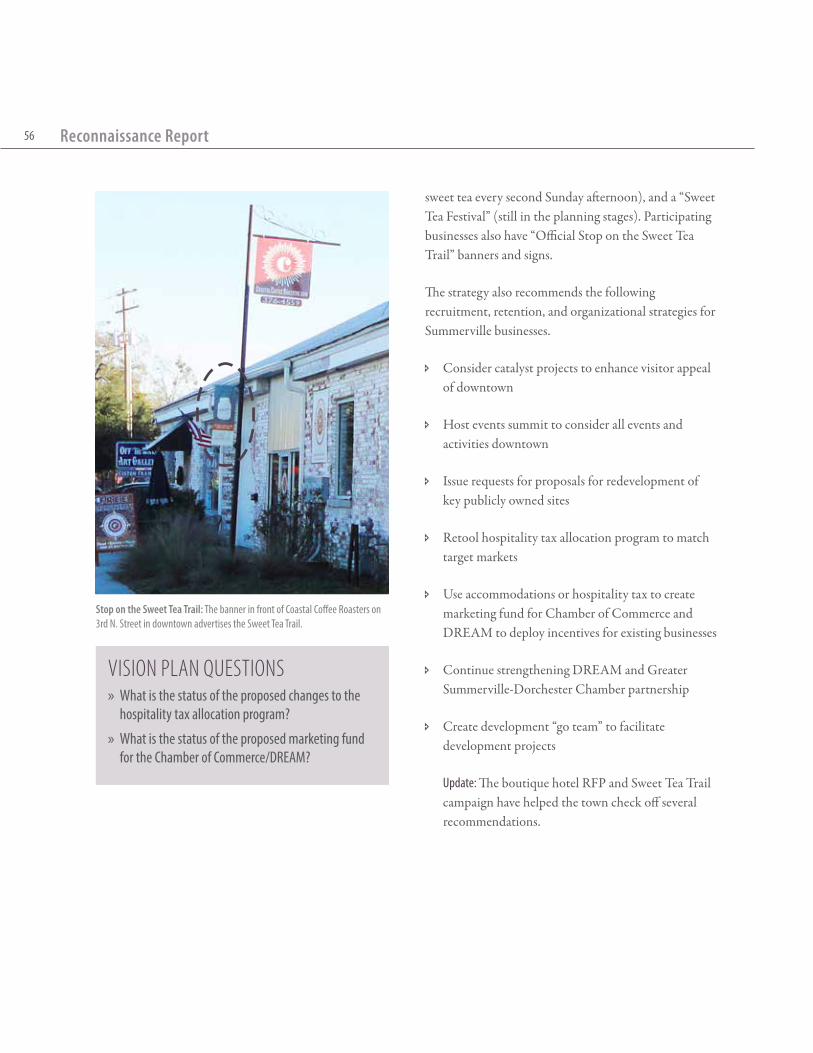
Reconnaissance Report56
sweet tea every second Sunday afternoon), and a “Sweet Tea Festival” (still in the planning stages). Participating businesses also have “Official Stop on the Sweet Tea Trail” banners and signs.
The strategy also recommends the following recruitment, retention, and organizational strategies for Summerville businesses.
Ð Consider catalyst projects to enhance visitor appeal of downtown
Ð Host events summit to consider all events and activities downtown
Ð Issue requests for proposals for redevelopment of key publicly owned sites
Ð Retool hospitality tax allocation program to match target markets
Ð Use accommodations or hospitality tax to create marketing fund for Chamber of Commerce and DREAM to deploy incentives for existing businesses
Ð Continue strengthening DREAM and Greater Summerville-Dorchester Chamber partnership
Ð Create development “go team” to facilitate development projects
Update: The boutique hotel RFP and Sweet Tea Trail campaign have helped the town check off several recommendations.
Stop on the Sweet Tea Trail: The banner in front of Coastal Coffee Roasters on 3rd N. Street in downtown advertises the Sweet Tea Trail.
Vision Plan Questions » What is the status of the proposed changes to the
hospitality tax allocation program?
» What is the status of the proposed marketing fund for the Chamber of Commerce/DREAM?

3 Other Plans & Studies3.5: Comprehensive transportation Plan
57
3.5: Comprehensive Transportation Plan
Completed in 2007, before the comprehensive plan update, the Comprehensive Transportation Plan contains many of the recommendations detailed in Section 2.2 of this report. This plan was also completed before the new I-26 interchange at Exit 197 was proposed in conjunction with the new development at Nexton, which significantly changed the transportation network plans for the town. The three maps on the following pages provide an overview of the plan
recommendations, which focus on widening existing streets and adding two new streets: the Berlin G. Myers Parkway extension (currently stalled by federal permitting), and the Maple Street extension (planned to be completed by the town in conjunction with the new Exit 197 interchange. Two traffic calming projects are also proposed, and have not yet been completed:
Ð One-way pair on Carolina Avenue (see diagram);
Ð Prohibit through-traffic on Pine Grove Street.
Recommended Roadway Improvements from the 2007 Comprehensive Transportation Plan
Sour
ce: T
own o
f Sum
mer
ville
Com
preh
ensiv
e Tra
nspo
rtatio
n Plan
, 200
7
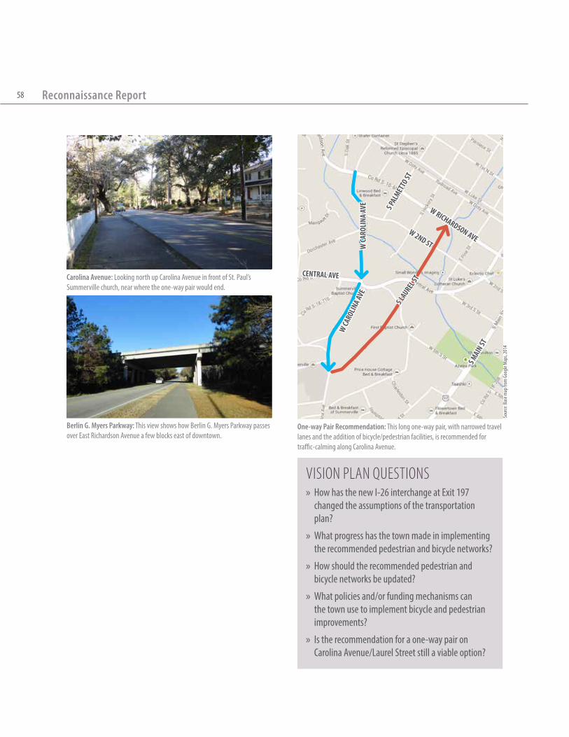
Reconnaissance Report58
Vision Plan Questions » How has the new I-26 interchange at Exit 197
changed the assumptions of the transportation plan?
» What progress has the town made in implementing the recommended pedestrian and bicycle networks?
» How should the recommended pedestrian and bicycle networks be updated?
» What policies and/or funding mechanisms can the town use to implement bicycle and pedestrian improvements?
» Is the recommendation for a one-way pair on Carolina Avenue/Laurel Street still a viable option?
W Ca
rOlin
a aVe
W Ca
rOli
na aV
e
s laurel
st
W 2nd st
W riChardsOn aVe
s Mai
n st
Central aVe
s Pal
MettO
st
One-way Pair Recommendation: This long one-way pair, with narrowed travel lanes and the addition of bicycle/pedestrian facilities, is recommended for traffic-calming along Carolina Avenue.
Berlin G. Myers Parkway: This view shows how Berlin G. Myers Parkway passes over East Richardson Avenue a few blocks east of downtown.
Carolina Avenue: Looking north up Carolina Avenue in front of St. Paul’s Summerville church, near where the one-way pair would end.
Sour
ce: B
ase m
ap fr
om G
oogle
Map
s, 20
14

3 Other Plans & Studies3.5: Comprehensive transportation Plan
59
Sour
ce: T
own o
f Sum
mer
ville
Com
preh
ensiv
e Tra
nspo
rtatio
n Plan
, 200
7
Recommended Pedestrian Network from the 2007 Comprehensive Transportation Plan
Sour
ce: T
own o
f Sum
mer
ville
Com
preh
ensiv
e Tra
nspo
rtatio
n Plan
, 200
7
Recommended Bicycle Network from the 2007 Comprehensive Transportation Plan

Reconnaissance Report60
3.6: Ashley Scenic River Management Plan
The Ashley Scenic River Management Plan (ASRMP)was prepared by the Ashley Scenic River Advisory Council following the designation of 22 miles of the Ashley River, from Highway 17-A at Sland’s Bridge to the I-526 crossing, as a State Scenic River in 1999. As part of the designation, the South Carolina Department of Natural Resources (SCDNR) administers the river management plan which was adopted in 2003 following a public planning process. The ASRMP addresses water quality, recreational use and access, preservation and conservation, and land management and development.
In general, the largest issue that the plan seeks to address is the inherent tension between the need to improve water quality in the Ashley River and the development pressure within the watershed that continues to degrade it. Many of the recommendations rely on education and voluntary stewardship by landowners.
In terms of specific projects, the plan proposes a conceptual plan for a new public park at Bacon’s Bridge Road (in Dorchester County). The land for this park, an 83-acre site with 3,000 feet of riverfront access that was previously approved for residential development, was purchased by Dorchester County in 2010.1
1 B. Petersen, June 21, 2012. “Dorchester County’s new park could be historic treasure.” The Post & Courier. http://www.postandcourier.com/article/20120621/PC16/120629810
Sour
ce: D
orch
este
r Cou
nty f
rom
B. Pe
terse
n, Ju
ne 21
, 201
2. “D
orch
este
r Cou
nty’s
new
park
could
be hi
storic
trea
sure.
” The
Post
& Co
urier
Conceptual Plan for Ashley River Park in Dorchester County at Bacon’s Bridge Road

3 Other Plans & Studies3.6: ashley scenic river Management Plan
61
3.6.1: Policy Recommendations
Ð Track wastewater permits, stormwater plans, and stormwater permits to monitor and reduce potential development impacts on water quality.
Ð Present conservation tools to owners of the 25-40 undeveloped parcels along the Ashley Scenic River corridor (as of 2003). Tools should include: conservation easements, purchasing development rights, tax incentives and other incentive-based options, limited development/maximum yield, setback and buffer guidelines, and deed restrictions.
Ð Incentivize and/or fund the dedication of conservation easements to preserve wildlife habitats along the river.
Ð Do not permit any new public or community boat ramps or private marinas; there are already facilities
Sour
ce: S
C Dep
artm
ent o
f Nat
ural
Reso
urce
s fro
m th
e ASR
MP,
2003
Ashley River Watershed
to accommodate motor boats. Any new recreational facilities should have carry-in boat access.
3.6.2: Recommended Development Regulations
Ð Development within the Ashley River watershed (including all of the Town of Summerville) should be designed to minimize impervious surface, and establish and/or restore vegetative buffers along all river, creek, and marsh boundaries.
Ð Require low-impact access facilities with limited parking, carry-in access for small boats, and installation of gates to restrict access at night.
Ð Create landscape guidelines for future development along the river that includes preservation of vegetation and 50- to 100-foot vegetative buffers along the river (see diagrams).
Ð Allow no more than one community dock per development, and develop design guidelines for dock structures to prevent detracting from nearby historical resources.
Ð Utility structures should be constructed and/or screened to limit visual impact along the riverway.
Vision Plan Questions » How should the ashley river scenic Management Plan
be incorporated in the Vision Plan recommendations for the oakbrook area?
» How do the recommendations relate to ideas about ecotourism for the area?

Reconnaissance Report62
hiGh Water
riVer Marsh 50’ “nO tOuCh” BuFFer 50’ restriCted ClearaBleCliPPinG BuFFer
OCrM CritiCal
line
VeGetatiVe BuFFer
≤ 10’
≤ 20’ ≤ 20’
PaVed Or struCtured
Cleared Cleared
VeGetatiVe BuFFer
River Access through Buffer: According to the plan recommendations, “even within the buffer zone, clearing for access would be permitted. For each 100 feet of bank frontage, 20 feet can be cleared for paths, boardwalks, or docks to the river edge. The walk itself could be up to 10 feet wide.” The plan also suggests adding curves to paths to limit visual impact of cleared areas.
Proposed Voluntary Buffers: The plan proposes a100-foot buffer. “The first 50 feet will be a ‘No Touch’ buffer extending inland from the OCRM critical line. The next 50 feet of the buffer will allow for selective clearance to create views to the river. Anything farther inland could be cleared.”
Sour
ce: B
ill Eu
bank
s and
Mor
gan B
ultm
an fr
om th
e ASR
MP,
2003
Sour
ce: B
ill Eu
bank
s and
Mor
gan B
ultm
an fr
om th
e ASR
MP,
2003

4.0: OverviewIn addition to background research, the planning team engaged Summerville residents, business-owners, and leaders through several forums to guide the Vision Plan recommendations. Many of these outreach efforts–including assembling an advisory committee, conducting key stakeholder interviews, and issuing a public online survey–were completed in preparation for the week-long design charrette.
The charrette, held February 24-28, 2014 at the Community Center in Azalea Park, was the main forum for public input and feedback. This five-day open workshop allowed the public a dialogue with the planning team as they performed analysis of the existing infrastructure and development patterns and sketched potential recommendations. (See 4.4 for details about the charrette).
A planning process led by Summerville’s aspirations
4 Planning Process

Reconnaissance Report64
4.1: Media OutreachInternetTown staff created a new Summerville Vision Plan subpage on the town’s website to act as a clearinghouse for all plan-related events, documents, and updates. Additionally, an email account was created specifically for all questions and comments related to the plan. The planning team also created a short video with a brief overview of the planning process that encouraged members of the public to get involved. This video was shown at several local meetings and posted on the town’s website.
NewspaperIn addition to digital media, the planning team also worked with the town to create an eight-page newspaper ,The Summerville Voice, that explained the goals and process of the charrette. The town printed 15,000 copies of the paper and distributed them throughout town at popular gathering spaces, events, and in the Summerville Journal Scene.
Vision Plan Video. See it online under the master plan page at www.summerville.sc.us
Town of Summerville Website

4 Planning Process4.1: Media Outreach
65
The Summerville VoiceWhat is a Vision Plan?What will attract future residents to Summerville? How will the road network accommodate growing numbers of commuters? Will there be jobs in Summerville for the chil-dren growing up here today? How will the construction of the Nex-ton community affect downtown?
These are the types of questions that the Summerville Vision Plan will address. The final plan will provide a prioritized program of public in-frastructure investments, policy revisions, and private development opportunities to be completed over the next 20 years. These recommen-dations will be based on the realities of current and projected market de-mand, public agency budgets, and existing state and local regulations.
By Mayor Bill Collins
Summerville is among the fastest grow-ing towns in South Carolina. During the last census it moved from the 14th largest town in the state to the 7th.
New people and new businesses are moving here at an unprecedented pace.
If we are to maintain the special small-town atmosphere Summerville has enjoyed for 166 years, we must find a plan to manage this growth.
In the 30 months I have served as may-or, I have cut ribbons for dozens of new businesses and been privy to multiple discussions on economic development projects for our town. Late last year, town council approved a contract for The Lawrence Group to conduct a Master Plan that will examine housing, transportation, infrastructure, parks, playgrounds and business develop-ment and recruitment in Summerville.
Over the next several months their team will interview land owners, service pro-viders, developers, elected officials, business professionals and citizens to develop consensus on a path for-ward for Summerville. As part of this process, in February they will stage a charrette —that’s a fancy French word for a planning and design work-shop—that will be open to the public and last for a week. It will be held at the Cuthbert Center in Azalea Park and you will have an opportunity to see and comment on sketches of build-ings, parks, and pedestrian paths pro-posed for various locations in our town.
Once their research and input from stakeholders and citizens is com-
pleted, The Lawrence Group will prepare a report and a schedule for implementing its recommendations.
This will not be just another report to be put on the shelf to collect dust. I plan to use it as a handy roadmap for our fu-ture and plan to work with council to make those recommendations a reality.
I want Summerville to be the best place to live in South Carolina. I want our young people to like it so much that they want to stay here, work here and raise families here. I want corpo-rations to provide job opportunities for our citizens so they don’t have to leave town to go work. I want retir-ees to find us user friendly and I want tourists to spend their money here.
Summerville has been blessed with nat-ural beauty—live oaks, towering pines, camellias, azaleas and dogwoods—and by a temperate year-round climate. The railroad interest in 1838 commis-sioned the Detmold Plan for the town which laid out and named streets from 9th North Street to 6th South Street on either side of the railroad tracks.
This new Master Plan will enhance what we have and provide sug-gestions for steps we can take go-ing forward on development.
I ask you to give this process your at-tention, your input and your support. Together we can make this happen and manage what happens to our community.
Why the Vision Plan is Important to Summerville Issue 1February 2014
“I want Summerville to be the best place to live in South Carolina.”
The Bell Tower of St. George’s Anglican Church, erected in 1751 by some of the area’s first settlers, still stands today in Colonial Dorchester State Park. Summerville was shaped by the decisions of people living hun-dreds of years ago. How will our decisions affect future generations?
In this Issue...Meet the Team ..........................2Charrette Dictionary .................2What is a Charrette anyway? ...3Key Charrette Principles ..........3D.R.E.A.M.: Downtown Summerville over the years .....4Exit 197: A New Entrance to Flowertown ..............................4
Message from the Advisory Committee Chair ......................5Mayor’s Institute: Ecotourism in Summerville .............................5What in the World is Going On? How shifting demographics are changing the way we live. ........6Kids’ Corner .............................7Charrette Schedule ...................8Project Map ..............................8
Front Page: The Summerville Voice

Reconnaissance Report66
4.2: Stakeholder FeedbackAdvisory CommitteeMayor Bill Collins assembled a 12-person advisory committee to lead the Vision Plan process and vet the recommendations. The committee members represent a range of prominent local organizations and businesses, and provided critical information and feedback throughout the plan process.
SurveyThe planning team developed a ten-minute online survey for Summerville residents to provide input about the general state of the town and the types of improvements they would like to see implemented. Nearly 300 people took the survey over the course of the planning process; based on the town’s population, this sample translates to an error rate of less than five percent. (See appendix for full survey results).
Stakeholder InterviewsThe planning team met individually with stakeholders from the public and private sectors in preparation
Survey Results: A few of the results from the online survey are shown above. The survey results (as a PDF) are in the appendix.
Online Survey: During the charrette, computers were set up for members of the public to complete the online survey.

4 Planning Process4.2: Stakeholder Feedback
67
District One Civic Association Meeting
Downtown Walking Tour
Downtown Walking Tour
for the design charrette. These included town staff, members of the Board of Commissioners, and private developers and landowners.
District One Civic Association MeetingPrior to the design charrette, planning team members participated in a public meeting for the District One Civic Association held at the Depot Building in Doty Park. Team members solicited information from this well-attended meeting that engendered a lively discussion.
Downtown Walking TourOn Saturday morning, February 22, 2014, the planning team led several dozen Summerville residents on a walking tour of downtown. The walk included a number of stops, such as at the armory building in Doty Park and crossing the railroad on Cedar Street, for the group to discuss possible improvements to these sites and issues that they would like for the Vision Plan to address.
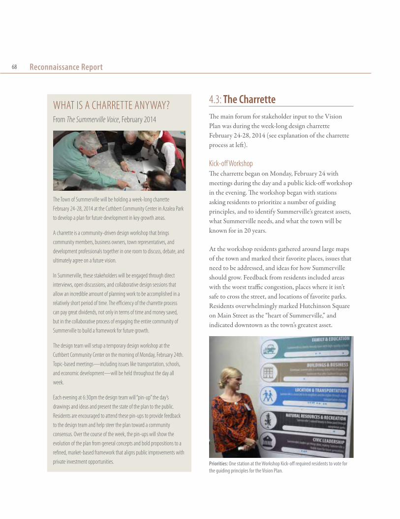
Reconnaissance Report68
4.3: The CharretteThe main forum for stakeholder input to the Vision Plan was during the week-long design charrette February 24-28, 2014 (see explanation of the charrette process at left).
Kick-off WorkshopThe charrette began on Monday, February 24 with meetings during the day and a public kick-off workshop in the evening. The workshop began with stations asking residents to prioritize a number of guiding principles, and to identify Summerville’s greatest assets, what Summerville needs, and what the town will be known for in 20 years.
At the workshop residents gathered around large maps of the town and marked their favorite places, issues that need to be addressed, and ideas for how Summerville should grow. Feedback from residents included areas with the worst traffic congestion, places where it isn’t safe to cross the street, and locations of favorite parks. Residents overwhelmingly marked Hutchinson Square on Main Street as the “heart of Summerville,” and indicated downtown as the town’s greatest asset.
WhAT IS A ChArreTTe ANyWAy?From The Summerville Voice, February 2014
The Town of Summerville will be holding a week-long charrette February 24-28, 2014 at the Cuthbert Community Center in Azalea Park to develop a plan for future development in key growth areas.
A charrette is a community-driven design workshop that brings community members, business owners, town representatives, and development professionals together in one room to discuss, debate, and ultimately agree on a future vision.
In Summerville, these stakeholders will be engaged through direct interviews, open discussions, and collaborative design sessions that allow an incredible amount of planning work to be accomplished in a relatively short period of time. The efficiency of the charrette process can pay great dividends, not only in terms of time and money saved, but in the collaborative process of engaging the entire community of Summerville to build a framework for future growth.
The design team will setup a temporary design workshop at the Cuthbert Community Center on the morning of Monday, February 24th. Topic-based meetings—including issues like transportation, schools, and economic development—will be held throughout the day all week.
each evening at 6:30pm the design team will “pin-up” the day’s drawings and ideas and present the state of the plan to the public. residents are encouraged to attend these pin-ups to provide feedback to the design team and help steer the plan toward a community consensus. Over the course of the week, the pin-ups will show the evolution of the plan from general concepts and bold propositions to a refined, market-based framework that aligns public improvements with private investment opportunities. Priorities: One station at the Workshop Kick-off required residents to vote for
the guiding principles for the Vision Plan.

4 Planning Process4.3: The Charrette
69
SuMMervIlle NEEDS...
Fill-in-the-Blank Results: The word clouds above show the collected responses from stakeholders throughout the charrette. The size of the word indicates the popularity of the response.
Fill-in-the-Blank: One of the stations at the Workshop Kick-off asked residents to complete phrases about Summerville’s future.

Reconnaissance Report70
Topical Stakeholder Meetings Over the course of the week there were 16 topical meetings held during the day (see the schedule at the end of this chapter for a list of the meetings). Stakeholders came out to voice their concerns and interests and hear others’ views.
Pin-upsEach evening during the charrette, the planning team put all of the work-in-progress on boards and presented the current state of ideas for the plan to the public. This allowed stakeholders to come back each day and see how the potential recommendations were changing in response to their feedback.
Closing PresentationThe week following the charrette there was an hour-long presentation to unveil the preliminary recommendations that came out of the charrette process. The presentation included diagrams for the overall town growth framework, illustrative plans showing potential buildout within the three focus areas, and photo simulations of how specific improvements might look.
Stakeholder Meetings: During the charrette, topic-based meetings were open to the public for discussion of issues such as transportation and economic development
Stakeholder Meetings: Residents, business-owners, and local organizations participated in discussions that informed the planning team’s recommendations
Pin-up: The planning team presents the day’s ideas at a pin-up session during the charrette.

4 Planning Process4.3: The Charrette
71
Closing Presentation: The charrette concluded formally with a standing room only presentation at Town Hall.
iN 20 yEARS, SuMMervIlle WIll be KNOWN FOr...

Reconnaissance Report72
ChArreTTe SCheDuleSaturday, February 229:00AM Downtown Walking Tour
Monday, February 2410:30AM environmental Protection & Sustainability1:00PM Parks, recreation, and youth2:30PM Sidewalks, Greenways, Pedestrians, and bicycles 4:00PM residential building and Development 6:30PM Public Kick-Off Workshop
Tuesday, February 259:00AM Marketing, events, and Parking in Downtown10:30AM Downtown Development Opportunities1:00PM Job Growth and economic Development2:30PM exit 199/17A/Main Street Commercial Development 4:00PM Marketing6:30PM Daily Project update
Wednesday, February 269:00AM hospital Area and Wellness 1:00PM Implementation and Funding 2:30PM Public Safety 4:00PM Oakbrook revitalization 6:30PM Daily Project update
Thursday, February 279:00AM Zoning and Commercial building Design10:30AM Signage and landscape Standards 1:00PM Civic Groups and Grassroots Projects 2:30PM-5:00PM Open Studio6:30PM Daily Project update
Friday, February 289:00AM-Noon Open Studio1:00PM Daily Project update
Thursday, March 66:30PM Closing Presentation
SuMMervIlle’S gREATEST ASSETS Are...

