recent progresses of active fault research in china
TRANSCRIPT

地学雑誌
Journal of Geography 112 (3) 489-520 2003
Recent Progresses of Active Fault Research in China
Honglin HE* and Eikichi TSUKUDA*
Abstract
This paper provides a brief overview regarding the history and major advances in research
on active faults in China. Active fault research in China has progressed through three
periods. The initial period, covering the former half of last century, was characterized by descriptions of the relationship between faults and strong earthquakes. In the second period,
reconnaissance surveys on active faults were carried out along major historically seismic zones
during the 1960's to 1970's. The third period, characterized by quantitative studies on active
faults, started in the early 1980's. Researches were focused on fault slip rates, earthquake
surface rupture and coseismic displacements, paleoearthquakes and earthquake recurrence
intervals, fault geometry and segmentation, and seismic hazard assessment on the basis of
these quantitative data of active faults. Based on the characteristic tectonic differences in the
Quaternary, the China continent is divided into 5 active tectonic provinces: Tibet (TTP) , Xinjiang-Uygur (XUTP) , Northeast China (NETP), North China (NTP) , and South China
(STP). Major progress in paleoseismology and fault segmentation in China include the
application of new techniques and concepts as follows : large-scale and three-dimension
trenches, paleoseismic rupture behavior and recurrence of large earthquakes along several
major fault zones, regional paleoearthquake recurrence behavior, and the stability of
segmentation and persistency of segment boundary, gradation of segmentation and multi-
rupture.
Key words : China, active tectonic province, active fault research, paleoseismology, activity
history, segmentation
I. Introduction
An active fault is generally defined as a
fault activated in the Quaternary, or in the
Late Pleistocene (100 - 120 Ka), and will
activate in the future (e.g., Wood, 1916; Willis,
1923; Research Group for Active Fault of
Japan, 1991) . Considering that the recur-
rence interval of an intra-continental earth-
quake usually exceeds thousands of years, it is more reasonable to take the Late Pleisto-
cene (100-120 Ka) to present as the time scale
of active faults (Deng, 1996) . Although
research on active faults is almost a century
old with Lawson (1908) firstly proposing the
concept of active fault, active fault research
principally developed in the latter half of the last century as an independent discipline. The
* Active Fault Research Center , National Institute of Advanced Industrial Science and Technology (Site 7, 1-1-1 Higashi, Tsukuba, Ibaraki 305-8567, Japan)
489
mapping works of active faults in California
(Jenning, 1975) and in Japan (Research Group
for Active Fault of Japan, 1980) are two
examples of the early research. Since the late
1970's and 1980's, the research of active
faults has turned into a new period character-
ized by quantitative analysis. In this period,
new study methods, techniques and concepts
were developed, such as paleoseismology,
fault segmentation, blind thrust earthquake,
marine active fault, and probability analysis
of seismic risk (e.g., Wallace, 1970; Sieh, 1978;
Yonekura, 1983; Schwartz and Coppersmith,
1984; Stein and King, 1984; Working Group
on California Earthquake Probabilities, 1988) .
In addition, since the 1990's the research of
active faults and paleoseismology has been
brought into the ILP program, such as the
World map of active fault (Trifonov, 1995) and
Task Group 11-5 of ILP Paleoseismology
Section (Yeats, 1996) .
Research on active faults in China, almost
keeping step with international research, has
gone through three periods : (1) description of the relationship between faults and strong
earthquakes, (2) reconnaissance on active
faults and (3) quantitative study. In this paper
we intend to make a brief overview of the
history and advances of active fault research
in China, including characteristics of active
faults in different active tectonic provinces,
and progresses in paleoseismology and fault
segmentation. We hope this paper can help
researchers outside China to understand the
status of active fault research in China.
II. History of Active Fault Research
in China
The investigation of the surface rupture of
the 1920 Haiyuan earthquake of M 8.1 con-
ducted by Weng (1922) was the first study of
active fault in China. From that time to the
early 1960's, the initial period of active fault
research in China occurred. During that time
several large earthquakes and their relation-
ship to faults were investigated. The field
investigation of the 1923 M 7.3 Daofu
earthquake on the Xianshuihe fault (XSHF)
Conducted by a German scientist in 1930 is
Well outside China (Heim, 1934) .
Chang (1938) and Chan (1938) Conducted
an investigation of the 1933 M 7.5 Diexi
earthquake in Sichuan and the 1936 M 6.7
Lingshan earthquake in Guangxi, respec-
tively. In the first symposium on neotectonics,
convened by the China Academy of Science in
1957, some theoretical problems of neotecton-
ics and active fault were firstly discussed
(Geosicence Division of China Academy of
Science, 1957) . Other important researches
Concerning active faults and neotectonics in
dam construction sites had also been done
such as Sanxia in Sichuan Province, Danjiang-
kou in Hubei Province and Xinfengjiang in
Guangdong Province (Li, P., 1994) .
From the late 1960's to the 1970's, several
large earthquakes occurred on the China
continent, including the well-predicted 1975
M 7.4 Haicheng earthquake and the 1976 M
7.8 Tangshan earthquake that caused more
than 240,000 deaths. Damage caused by these
earthquakes forced China to pay more
attention to earthquakes and associated
disciplines. In this period, active fault
research focused primarily on seismic predic-
tion and seismic zonation ; reconnaissance
survey of many active faults in major seismic
zones was carried out. One representative
work is the reconnaissance survey of seismoge-
ologic settings of large earthquakes in South-
west China led by Li (Survey Team of Seismic
Intensity in Southwest China, 1977 and
490

1979) . The "Map of Active Faults and
Distribution of Strong Earthquakes in China
(1: 3,000,000) " (State Seismological Bureau,
1976) , " Seismotectonic Map of China
(1: 4,000,000) " (Institute of Geology, State
Seismological Bureau, 1979) , and the first
symposium on active faults and paleoearth-
quakes convened by Seismogeological Commit-tee of Chinese Seismological Society (Seismo-
geological Committee of Chinese Seismological Society, 1982) are examples of active fault
research in the second period.
The separation of the State Seismological
Bureau as an independent institution from
the Chinese Academy of Science in 1978
greatly promoted the research of active faults. Since 1980's, the quantitative research of
active faults in China, such as slip rate,
seismic recurrence interval based on histori-
cal and paleo-earthquake data, etc., has kept
pace with other countries. Mapping and
quantitative studies of major active faults in Western China began during this period. It
was during period that Li and his research
group made a comprehensive study of the
Xianshuihe-Xiaojiang fault zone (KDF) from
1981 to 1988 (Li, P., 1993) . The Seismological
Bureau of Xinjiang Uygur Autonomous Region
(1985) completed a synthetic study of the
rupture of the 1931 M 8 Fuyun earthquake
and Keketuohai-Ertai fault (KEF) in 1981.
Institute of Geology, State Seismological
Bureau and Seismological Bureau of Ningxia
Hui Autonomous Region (1989 and 1990)
carried out the study and mapping of Haiyuan
fault from 1981 to 1987. In the time period
from 1984 to 1986, a research group from the
State Seismological Bureau chaired by Wang
and Deng made a study of the active fault
system around Ordos Massif (Research Group
on "Active fault system around Ordos massif",
State Seismological Bureau, 1988) . From
1983 to 1987, Chinese scientists led by Ding
took part in Project IGCP-206 : Comparison of
Major Active Faults in the World, and
published the " Atlas of Active Fault in
China", including 6 major active faults in
China (Chinese Working Group of the Project
IGCP-206, 1989) . A working group in the
State Seismological Bureau led by Deng
conducted a project of similar synthetic
studies on approximately 20 other major
active faults in the China in 1990's. These
major active faults include almost all of the
well-known fault zones in China, such as the
Altyn Tagh fault zone, the Red River fault
zone, and the Xianshuihe fault zone.
As a result, several research monographs,
bulletins and 1: 50,000 maps of these faults
were published (e.g., Institute of Geology,
State Seismological Bureau, 1992 ; Working
Group of Altun (Altyn Tagh) Fault Zone of
State Seismological Bureau, 1992 ; Seismologi-
cal Bureau of Shaanxi Province, 1996 ; Li, T.
et al., 1997; Song et al., 1998; Deng et al.,
2000; Guo, 2001) . Quantitative research on
these major active fault zones covered almost
all aspects of an active fault, usually in-
cluding the geometry and structure of the
fault zone, moving sense, slip rate in the
Quaternary or in the Holocene, paleoseismol-ogy and the recurrence interval of large
earthquakes, surface rupture and coseismic
displacement, segmentation and rupture
process, deformation mechanism and dynam-ics, and seismic risk analysis.
As a summary of the research results of
active tectonics in the past 20 years, the "Active Tectonics Map of China (1: 4,000,000) "
and "An Introduction to Active Tectonics of
China" have been compiled and will be
published. In addition large earthquakes,
491

active volcanoes, active folds, active basins
and active blocks, more than 800 active faults
and 80 earthquake surface ruptures are also
delineated on the map. The map includes
more than 400 slip rates for more than 200
active faults, and more than 150 coseismic
displacements for more than 70 earthquake
ruptures (Deng et al., 2002) . The active faults
presented on the map are divided into five
groups : (1) Late Pleistocene-Holocene (100-120 Ka) active faults with geomorphic and geo-
logic evidence, and dating data; (2) Quater-
nary active faults that become active in the
Quaternary with unclear activity in the Late Pleistocene, or lacking geomorphic and geo-
logic evidence ; (3) Active faults in the Qinghai-
Tibetan Plateau interpreted mainly based on
satellite imagery and regionally geologic and
geomorphic data; (4) Active faults that lie under plains or basins ; (5) Active faults in
marine areas covered by a body of water.
Earthquake ruptures identified on the map
are placed in two categories, one caused by
historical and contemporary earthquakes, and
another caused by paleoearthquakes (Deng et
al., 2002). In China, earthquakes recorded in
historical data are termed as historical
earthquakes. The earliest earthquake re-
corded in China is the BC 1831 Taishan
earthquake of M7 near Mt. Taishan in
Shandong Province.
In recent years, several large earthquakes
occurred in major cities causing terrible
catastrophes, such as the 1995 Kobe earth-
quake in Japan, the 1999 Jiji earthquake in Taiwan, China and the 1999 Izmit earthquake
in Turkey. The movement along active faults
under major cities is the main contributing
factor in these disasters. Therefore, clearly
identifying the distribution of active faults in
urban areas is very important to earthquake
hazard mitigation. According to the tenth
five-year plan which started in 2002, new
researches of active fault in urban areas are
programed. Besides continuing the theoreti-cal research on active faults, reconnaissance
survey of active faults in urban areas is an
important goal for Chinese scientists in the
tenth five-year. Comprehensive works are to
be carried out in more than 20 major cities in
China.
III. Characteristics of Active Faults in
Active Tectonic Provinces of China
The continental crust of China is highly
active tectonic area located at the southeast-
ern part of the Eurasian plate and surrounded
by the Indian plate, Pacific plate and
Philippine plate. It consists of several crustal
blocks with different tectonic activities, such
as Tarim massif, and Ordos massif. The
relative movement of these massif blocks is
the basic tectonic feature of the intra-plate of
China. The active tectonics of China, thus,
presents obviously provinces (Zhang, W., 1984; Ma, 1987; Ding, G., 1991; Deng et al., 1994a;
Zhang, P., 1999) . Based on the characteristic
differences in tectonic activities in the
Quaternary, China can be divided into 5 active tectonic provinces : Tibet (TTP), Xinjiang-
Uygur (XUTP), Northeast China (NETP),
North China (NTP), and South China (STP)
(high to low in gray scale, insets in Figs. 1
and 2: Xu and Yonekura, 1995; Deng et al.,
2002) . We discuss the characteristics of active
faults in and around these five tectonic
provinces.
1) Tibet tectonic province (TTP)
The Tibet Tectonic Province covers all of the
Tibetan Plateau (Fig. 1) . The continuing
northward indentation of the Indian plate
into the inhomogeneous Tibetan crust after
492
the collision between the Indian and Eurasian
plates induced uplift and deformation of the
Tibetan Plateau. Deformtion extends 1,600
km to the north reaching the northern margin
of Mt. Qilianshan and the Hexi Corrider basin
zone. This continuing northward indentation
has also resulted in three types of tectonic
deformation : convergence zones surrounding
the plateau, strike-slip fault zones associated
with the laterally extruding crustal blocks in
the eastern plateau, and extensional basins in
the southern plateau.
1. Convergence zones
Two types of convergence zones have been
recognized around the plateau. The Himala-
yan and West Kunlun (WKT) convergence
zones, which occur on the southern and
northern margins of the plateau, respectively,
are formed directly due to the indentation of
India against Eurasia. They extend roughly
perpendicular to the indenting direction. The
Longmenshan (LMT) , Liupanshan (LPT) and
Qilianshan-Hexi Corridor (Q-HT) thrust zones
along the northeastern margin of the plateau
exemplify the second type of convergence
zones. They are formed as a response to the
eastward lateral extrusion of the Tibetan
crust.
The Himalayan convergence zone on the
southern flank of the Himalayan arc (Fig. 1)
extends from the Lesser Himalayas to south
of the Siwalik Hills, including the Main
Central Thrust (MCT) , the Main Boundary
Thrust (MBT) and the Main Frontal Thrust
(MFT) (Arita and Ganzawa, 1997) . A conver-
gence rate of about 20 •} 10 mm/yr has been
reported for this zone (Armijo et al., 1986;
Avouac and Tapponnier, 1993) . The slip rate
of the MFT in the Holocene is 15-18 mm/yr
(Love and Avouac, 2000) , while across the
MBT and MFT, the slip rate has been inferred
to be 10-13 mm/yr (Zhang, P. et al., 2002a) , or
15 - 16 mm/yr (Bilham et al., 1997; Larson et
al., 1999) based on GPS data. The West
Kunlun thrust zone (WKT) develops between
Mt. West Kunlun and Tarim massif. Mt.
West Kunlun forms an east-west trending
mountain range on the northwestern margin
of the plateau. Tarim massif to the north of
the plateau is currently a sedimentary basin
with Cenozoic sediments measuring up to
10,000 m thick.
The Longmenshan thrust zone (LMT) mai-
nly consists of three thrusts and associated
fault-propagation folds, thrusting southeast-
ward over the Sichuan rigid massif. This zone
is approximately 60 km wide, and constitutes
the topographic boundary between the east-
ern Tibetan Plateau and the Sichuan basin.
The total vertical slip rate is about 1-2 mm/yr,
and thus the convergence rate across the
thrust zone is inferred to be 4-6 mm/yr (Deng
et al., 1994b) . This inferred convergence rate
is consistent with 4-8 mm/yr (Zhang, P. et al.,
2002b) or 6.7 •} 3.0 mm/yr (Wang, Q. et al.,
2001) based on GPS data.
The Liupanshan thrust zone (LPT) is located
on the northeastern margin of the Tibetan
Plateau between the plateau and Ordos
massif. This thrust zone absorbs a fraction of
the eastward lateral slip along the Haiyuan
fault (HYF) , which changes its strike from
NWW to NW and NS, and transforms to a fold-
and-thrust structure. Based on the displace-
ment of river terraces, the vertical slip rate in
the Late Pleistocene (50-60 Ka) of the Liupan-
shan reverse fault has been estimated to be
0.5 - 0.6 mm/yr (Ikeda et al., 1998) . The
amount of convergence during the Quaternary
has been estimated to be 11.4-15.4 km for this
thrust zone based on the balanced geological
cross-section method (Zhang, P. et al., 1991) .
493

Fig. 1 Map of active faults in Western China.
494

Fig. 2 Map of active faults in Eastern China.
495

The northwest trending Qilianshan-Hexi
Corridor thrust zone (Q-HT) extends along the
northeast boundary of the plateau between
the plateau and Alxa massif. It consists of
alternately distributed parallel mountain
chains and valleys, and has a total width of
200-300 km (Institute of Geology and Lanz-
hou Seismological Institute, State Seismologi-
cal Bureau, 1993) . By reconstructing the
volume of sediments deposited in the Qai-
dam and Hexi Corridor basins since •` 35 Ma,
Metivier et al. (1998) claimed that this thrust
zone resulted from the northeastward migra-
tion of over-thrusting and uplift south of the
NE termination of the Altyn Tagh fault. The
rate of horizontal convergence on major faults
is estimated to be 4 - 5 mm/yr, while the
convergence rate across the entire zone is
estimated to be 15 mm/yr (Avouac and
Tapponnier, 1993) . However, based on GPS
data, Zhang, P. et al. (2002a) proposed that the
convergence rates across Mt. Qilainshan and
Hexi Corridor basin in the orientation of
N30•‹ E are 6.5-10 mm/yr and 3.5-5.5 mm/yr,
respectively. Moreover, the horizontal slip
rate and vertical slip rate along the north
marginal fault of Mt. Qilianshan in the
Holocene are estimated to be 2.0 mm/yr and
0.8 - 2.1 mm/yr, respectively (Institute of
Geology and Lanzhou Institute of Seismology,
State Seismological Bureau, 1993).
2. Extensional basins
Seven NS-trending normal fault zones
(indicated by thick lines with teeth in Fig. 1)
and associated graben basins have been
documented in southern Tibet, situated appro-
ximately south of the Bangonghu-Nujiang
suture zone (indicated by a gray dashed line in
Fig. 1: Han, 1987; Institute of Geology, State
Seismological Bureau, 1992) . Although no
field investigation on most of these normal
fault zones and associated basins has been
occurred, the horizontal and vertical slip rates
of the Yadong-Gulu fault (YGF) and faulted
basin zone have been estimated to be 3.5 - 7.5
mm/yr and 1 - 3.5 mm/yr, respectively (Insti-
tute of Geology, State Seismological .Bureau,
1992) . The Quaternary extension rate, is
approximately 1 % Ma-1 along an 1,100-km-
long ESE traverse across southern Tibet as
estimated by Armijo et al. (1986), while
approximately 18 •} 9 mm/yr as deduced from
contemporary earthquake records by Molnar
and Lyon-Caen (1989) . The newest estima-
tion of the extension rate across southern
Tibet is 21.28 •} 1.5 mm/yr based on GPS data
(Zhang, P. et al., 2002b), which is similar to
that deduced from contemporary earthquake
records. Moreover, southern Tibet is signifi-
cantly different from northern Tibet in terms
of the thermal state of their crust ; the crust is
hotter in the south and colder in the north.
Southern Tibet is characterized by a high
terrestrial heat flow and a high geothermal
gradient (Shen, X. et al., 1990). The high
geothermal anomaly in the crust could be
closely related to the east-west extension in
southern Tibet.
3. Strike-slip fault zones
The strike-slip faults in the Tibetan Plateau
can be classified into two categories. The first
category, consists of the left-slip Altyn Tagh
fault zone (ATF) and the right-slip Karakorum-
Jiali fault zone (KJF) . These fault zones are
usually considered to be boundaries for the
eastward extrusion of the entire northern
Tibetan crust. The strike-slip faults in the
second category occur within eastern Tibet,
such as the East Kunlun fault zone (EKF) and
the Kangding fault zone (KDF) . These faults
divide the eastward extruding Tibetan Pla-
teau into several sub-crustal blocks.
496

The Altyn Tagh fault zone (ATF) is one of
the most prominent geological features attri-
buted to the India-Eurasia collision (Molnar
and Tapponnier, 1975). This fault zone is an
active, predominantly left-slip fault system
extending in a NEE direction for about 1,600
km from the Mt. West Kunlun to the Mt.
Qilianshan. Although it has long been re-
cognized that the Altyn Tagh fault has a very
long history of geologic evolution, left-slip
faulting could have initiated as late as the
late Tertiary and is currently active today
(Working Group of Altun (Altyn Tagh) Fault
Zone of State Seismological Bureau, 1992).
The left lateral slip rate and thrust rate on
the Altyn Tagh fault in the Holocene are
about 4.4 - 6.8 mm/yr and 0.7 - 1.8 mm/yr,
respectively (Working Group of Altun (Altyn
Tagh) Fault Zone of State Seismological
Bureau, 1992). Although some other resear-
ches reported the slip rate of Altyn Tagh fault
to be up to 20 mm/yr (Peltzer et al., 1989) or 30
mm/yr (Avouac and Tapponnier, 1993), recent
GPS observation supports the results of
Chinese researchers. Based on GPS data, the
left lateral slip rate along the Altyn Tagh
fault has been inferred to be less than 10
mm/yr (Bendick et al., 2000), 5.1 •} 2.0 or 9 •}
2 mm/yr (Shen, Z. et al., 2001; Wang, Q. et al.,
2001) . The sinistral rate of relative movement
between Mt. Qilianshan and the Alxa massif
of 7.5 •} 1.5 mm/yr is also based on GPS data
(Zhang, P. et al., 2002a).
Along the Bangonghu-Nujiang suture zone
occurs a structure zone composed of active, en
echelon right-slip faults, called the Kara-
korum-Jiali fault zone (KJF). This fault zone,
first recognized and described in detail by
Armijo et al. (1989), comprises the hypotenuse
of the Himalayan arc and divides the Tibetan
Plateau into northern and southern parts. It
consists of three segments with a diverse
history of evolution. In the west, the fault
zone follows the northwest segment of the
Karakorum right-slip fault (KRF), of which
right-lateral slip rate reaches 30 mm/yr
(Avouac et al., 1993). The middle segment
consists of several en echelon faults, in which
Gelincuo, Bengcuo and Jiali faults dextrally
slip varying between 2-12 mm/yr (Institute of
Geology, State Seismological Bureau, 1992;
Shen, J. et al., 2000). Moreover, the slip rate
on the Jiali fault has also been estimated to
be 15 •} 7 mm/yr by Armijo et al. (1989).
At the eastern end, the fault zone splays into
the eastern and western branches along the
Parlung river valley (PL) and the Po-Qu valley
(PQ), respectively (Molnar and Tapponnier,
1978). To the south, the western branch is
connected with the Sagaing fault (SGF) ,
while several en echelon faults, extending
across the steep gorges of the Nujiang and
Lancangjiang rivers, bridge the •`100-km-
wide gap between the eastern branch (Parlung
fault) and the Red River fault (RRF).
The East Kunlun fault zone (EKF) extends
about 2,000 km along the southern boundary
of the Qaidam basin. It is an important left
lateral slip fault in the eastern plateau,
controlling eastward extrusion of crustal sub-
blocks. The slip rate along the fault zone is
relatively higher in the Tibetan Plateau,
measures up to 8-10 mm/yr (Seismological
Bureau of Qinghai Province and Institute of
Crustal Dynamics, China Seismology Bureau,
1999). The Holocene slip rate of 10 mm/yr has
been estimated on the basis of the offset of
drainage along the Xidatan segment (Ren et
al., 1993). This fault zone has been divided
into 7 segments based on the geometric
features, distribution of slip rate, and rup-
tures of historical and pre-historical earth-
497

quakes. Four large earthquakes of M•¬7 have
occurred on the fault zone since the 1930's,
including the 1997 Mani earthquake of M 7.7
and the 2001 Kunlun earthquake of M 8.1.
The Kangding fault zone (KDF) is another
major left lateral slip fault zone in the eastern
plateau. It extends about 1,400 km from
southern Yunnan Province, through Sichuan
Province, and into Qinghai Province. This
fault zone consists of five major faults (the
Ganzi (GZF), Xianshuihe (XSHF), Anninghe
(ANF), Zemuhe (ZMF), and Xiaojiang (XJF)
faults) connected to each other by large bends
or en echelon steps. Each segment of the fault
zone has been the locus of at least one major
earthquake according to historic records.
During the last century, six earthquakes of M
〓7had occurred along the fault system, and
at least twenty-one such events have occurred
since AD 624 (Gu, 1983). The Kangding fault
zone divides the eastward-extruded Tibetan
crust into two parts (Fig. 1). North of the
fault zone, the eastward-extruded crustal
block (the Northeastern Tibetan Block) encoun-
ters resistance from the Sichuan rigid
massifs, which has led to the formation of the
Longmenshan thrust zone on the leading edge
of the extruding crustal block. South of the
fault zone, the crustal block (the Southeastern
Tibetan Block) extrudes eastward or south-
eastward at a faster rate than the Northeast-
ern Tibetan Block (He and Ikeda, 2001). The
sinistral strike-slip rates are about 6-10
mm/yr (Zhao, 1985) and 15 •} 5 mm/yr (Allen
et al., 1991) along the Xianshuihe fault, 6-10
mm/yr along the Anninghe fault, 5.8 - 8.5
mm/yr along the Zemuhe fault, and 13.0-16.5
mm/yr along the Xiaojiang fault (He, 2000),
respectively.
The Red River fault (RRF) extends south-
eastward through Vietnam into the South
China Sea. During the early-mid Tertiary it
was a left-lateral shear zone (Tapponnier et
al., 1990), which converted to a right-slip
fault in the late Tertiary (Briais et al., 1993).
The late Quaternary slip rate along this fault
is 2-3 mm/yr (Allen et al., 1984) or 2.6-4 mm/yr
(Guo, 2001), much less than those of other
strike-slip faults in eastern Tibet. Moreover,
these estimated slip rates are all based on the
data taken from the northwestern portion of
the fault zone. Almost no sound evidence of
activity in late Quaternary has been con-
firmed from the southeastern portion of the
fault. An alternate explanation is that the
activity on the southeastern portion of the
fault zone has transferred to the Shiping-
Jianshui fault zone (SPF) , which extends
southeasterly to the north of and parallel to
the Red River fault zone. The dextral slip
rate of the Shiping-Jianshui fault zone has
been estimated to be 3 - 6 mm/yr (Han and
Mao, 1993), and several earthquakes of M •¬ 6
have been recorded for this fault zone.
In addition to the major strike-slip faults
mentioned above, there are several other
active faults within and around the Tibetan
Plateau, such as the Haiyuan left-slip fault
(HYF) and the West Qinling northern pied-
mont left-slip fault (WQF). The former has a
slip rate of 7-8 mm/yr (Zhang, P. et al., 1988;
Institute of Geology, State Seismological
Bureau and Seismological Bureau of Ningxia
Hui Autonomous Region, 1990), and the
latter has a slip rate of about 1.9 mm/yr (Teng
et al., 1991) .
2) Xinjiang-Uygur tectonic province
(XUTP)
The Xinjiang-Uygur tectonic province is a
Cenozoic regenerated orogenic belt character-
ized by depressed basins, reverse faults,
active folds, and large strike slip faults. The
498

Tarim and Dzungaria massifs are two uniform
active blocks. Mt. Tianshan is a typical
Cenozoic regenerated orogenic belt located
between the two massifs. An active reverse
fault-fold belt in the foreland basin, and the
intermountane-depressed basin characterize
the late Quaternary tectonic activities in the
XUTP. The horizontal shortening rates across
the reverse fault-fold belts in the foreland
depression of Kuche and Ulumuchi are 10.4
mm/yr and 5.8 mm/yr, respectively, while the
shortening rate of Turpan basin is 3.4 - 4.1
mm/yr. The total horizontal shortening rate of
crust across Mt. Tianshan has been calculated
using the balanced geological cross-section
method : 15 mm/yr near Kuche, 10 mm/yr
near Kuerle, and 7 mm/yr near Turpan (Deng
et al., 2000). Using GPS data the horizontal
shortening rate across Mt. Tianshan has been
estimated 20 mm/yr for areas west of Kashi,
13 mm/yr for areas east of Kashi, 7 mm/yr
near Kuche, and 2 mm/yr at Kuerle (Abd-
rakhmatov et al., 1996; Zhang, P. et al.,
2002a). Both the results induced by the
balanced geological cross-section method and
GPS observation indicate that the shortening
rate decreases eastward. In addition, in the
area north of the Dzungaria massif the
vertical slip rate across the frontal reverse
fault of Mt. Altai is 1-2.3 mm/yr (Shen, J. et
al., 1998a) .
Furthermore, the faulting along the NW
striking faults obliquely crossing Mt. Altai
and Mt. Tianshan generally present right
lateral strike slip. The Keketuohai-Ertai fault
(KEF) is the seismogenic fault of the 1931 M 8
Fuyun earthquake (Seismological Bureau of
Xinjiang Uygur Autonomous Region, 1985) ,
and the lateral slip rate is 3.7 mm/yr (Bai et
al., 1996). The lateral slip rate along the Bolu-
okenu fault(BKF), which obliquely crosses Mt.
Tianshan, is estimated to be 4.7 mm/yr (Yang
and Shen, 2000) .
3) North China tectonic province (NTP)
The North China tectonic province (Fig. 2,
NTP) is an extensional province, mainly
pieced together by normal faults, normal
strike-slip faults, and graben or half-graben
basins. The western part of the tectonic
province consists of the stable Ordos massif,
while the eastern part consists of several fault
blocks.
In the Ordos massif there are no obvious
active faults or relative movements. GPS
data observed in the massif have shown that
this massif moves eastward at an approxi-
mate uniform rate of 8 •} 1 mm/yr (Zhang, P.
et al., 2002a) . In contrast, strong tectonic
activity occurs in the extensional shear belts
around this massif (Research Group on "Active
fault system around Ordos massif", State
Seismological Bureau, 1988) . East of the
Ordos massif is Shaanxi fault depression belt
(SXDB) , an extensional dextral shear belt
consisting of tens of down-faulted basins and
associated normal faults, and normal strike-
slip faults. In the middle section of this belt,
NNE-trending faults of normal dextral slip
develop with a horizontal slip rate of 1.3-5.68
mm/yr and a vertical slip rate of 0.15 - 0.69
mm/yr. In the northern and southern ends of
the belt, extensional range-basin tectonic
zones are controlled by ENE-trending normal
faults with vertical slip rate of 0.12-1.48
mm/yr (Shentu et al., 1990; Xu and Deng,
1990; Liu et al., 1991; Ran et al., 1991; Deng
et al., 1994c; Dou et al., 1995; Cheng and
Yang, 1996). West of the Ordos massif is
Yingchuan - Jilantai fault depression belt
(YJDB). The horizontal and vertical slip rates
on the NNE-trending normal dextral faults in
this belt vary from 2.58 to 4.37 mm/yr and
499

from 0.23 to 2.1 mm/yr, respectively (Research
Group on "Active fault system around Ordos
massif ", State Seismological Bureau, 1988;
Deng and Liao, 1996; Liao et al., 2000). To
the south of the Ordos massif, the Weihe fault
depression zone (WHDB) is controlled by a
series of EW-trending normal sinistral faults.
The normal slip component is usually larger
for these controlling faults. The normal-slip
rates on the range-front faults of Mt.
Huashan and Mt. Qingling are 2-3 mm/yr and
1.5 - 2.2 mm/yr, respectively (Research Group
on"Active fault system around Ordos massif",
State Seismological Bureau, 1988; Li, Y.,
1992; Seismological Bureau of Shaanxi
Province, 1996) . To the north of the Ordos
massif extends the EW-trending Hetao fault
depression zone (HTDB). The vertical slip
rate along the controlling normal faults of the
depression zone, the range-front faults of Mt.
Daqingshan, Mt. Wulashan and Mt. Seerteng,
vary from 2.2 to 6.47 mm/yr, while the
sinistral slip rate along the range-front fault
of Mt. Daqingshan is about 5 mm/yr (Research
Group on "Active fault system around Ordos
massif", State Seismological Bureau, 1988; Li,
K. et al., 1994; Wu et al., 1996; Jiang et al.,
2000) . Moreover, in the four fault-depression
belts mentioned above, three earthquakes of
M 8 and 30 earthquakes of M 6-7.5 have
occurred since the Christian era.
The eastern part of the tectonic province is
more complex, consisting of several blocks.
The North China Plain block (NCP) is the
center block, surrounded by the Taihangshan
uplift block (THU) to the west, the Yingshan-
Yanshan uplift block (YYU) to the north, the
Jiaoliao uplift block (JLU) to the east and
Hehuai Plain block (HHP) to the south. Among
these blocks, NW-trending sinistral strike-
slip and NE-trending dextral strike-slip faults
exist. Of these faults, The Tancheng-Lujiang
fault zone (TLF) is one of well-known fault
zones in China (Institute of Geology, State
Seismological Bureau, 1987). It serves as the
boundary between North China Plain and
Jiaoliao uplift blocks, and has obvious
segmentation. The northern segment is a
normal dextral slip fault, while the southern
segment shows reverse dextral slip with
horizontal slip rate of 2.3 mm/yr. The 120 km
long surface rupture and 7-9 m coseismic
displacement of the 1668 M 8.5 Tancheng
earthquake have been found along the
southern segment (Li, J. et al., 1994). In the
North China Plain, a group of conjugate faults
of NNE-trending and NWW-trending devel-
oped. The 1976 M 7.8 Tangshan earthquake
and 1679 M 8 Sanhe-Pinggu earthquake
originated on the NNE -trending dextral
faults, while the 1975 M 7.5 Haicheng earth-
quake occurred on one of the NWW-trending
sinistral faults. The Bohai Sea in the east of
the North China Plain may be an active pull-
apart basin (Deng et al., 2001).
4) South China tectonic province (STP)
The South China tectonic province (Fig. 2 :
STP) is a province of less tectonic activity.
Active faulting is mainly located in the middle
and downstream basin areas of the Yangtze
River and the southeastern coast regions.
Even in the most active southeastern coast
regions, the vertical slip rate along the NE-
trending faults is 0.4-2.3 mm/yr, and horizon-
tal and vertical slip rates on the NW-trending
sinistral slip faults only vary from 1.1 to 3.2
mm/yr and from 0.4 to 1.7 mm/yr, respectively
(Ding, X. et al., 1999; Wang, Y. et al., 2001) .
The distribution of velocity in this tectonic
province based on GPS date presents no obvious change or gradient. This suggests
that the tectonic deformation in the tectonic
500

province is of a decreased magnitude (Zhang, P. et al., 2002a) .
5) Northeast China tectonic province
(NETP)
The tectonic activity and earthquakes of the
Northeast China tectonic province (Fig. 2,
NETP) are more subdued than that in other
tectonic provinces. The deep-focus earthquake
caused by subduction of the Pacific Plate
under the Asian Plate is characteristic in this
tectonic province. The activity of faults in this
province is somewhat related to volcano activity.
IV. Paleoseismology and Fault Segme-
ntation
Both paleoseismology and fault segmenta-
tion are very active frontiers in the field of
active fault research. In order to make the
advance of research of active faults in China
well understood, it is necessary to introduce
in more detail progresses in these two
important aspects in China.
1) Paleoseismology
A paleoearthquake is a pre-historic event or
historic event without clear historical record.
Although paleoearthquake research is over a
century old, the modern paleoseismology
initiated in the 1970's, when researchers
(Clark et al., 1972; Sieh, 1978) applied
trenching and radiocarbon dating techniques
to researching paleoearthquake fault. Paleo-
seismology in China started in the late 1970's
when the understanding of paleoseismology
began with paleo-landslide, paleo-liquefaction,
and paleo-fissure evidence. Zhu et al. (1979)
excavated the earliest trenches in China
aiming at revealing the traces of paleoearth-
quakes, and began modern paleoseismology research in China.
Since the late of 1980's, the study of
paleoseismology in China has progressed in
an international arena. Using trenching to
directly study the paleo-rupture events and
the recurrence interval of paleoearthquakes
has resulted in many achievements. Deng et
al. (1984) first used the term "colluvial wedge"
to recognize and divide the paleoearthquake
sequences exposed by trenches in China.
Wang and Li (1984) excavated and studied the
seismogenic fault of the 1976 M 7.8 Tangshan
earthquake, and concluded that the recur-
rence interval of events with the same
magnitude is about 7,500 years. Ran et al.
(1988) dated the paleoearthquakes on the
Heihekou fault (HHKF) , Hexi Corridor, using
fault scarp morphology, soil-chronology, Radio-
carbon-14, and thermoluminescence to reveal
the periodicity of paleoearthquakes during
late Quaternary.
Since the 1990's, paleoseismology research
in China has made great progresses, mainly
in increasing the accuracy of paleoearthquake
location, filling in the paleoearthquake hi-
story, and applying paleoearthquake data to
make mid- to long-term earthquake predic-
tion and assess seismic hazard. Trenching
technology is one of the main methods used in
paleoseismology research. The application of
large-scale trench group and the three-dimen-
sion trench has increased the accuracy of
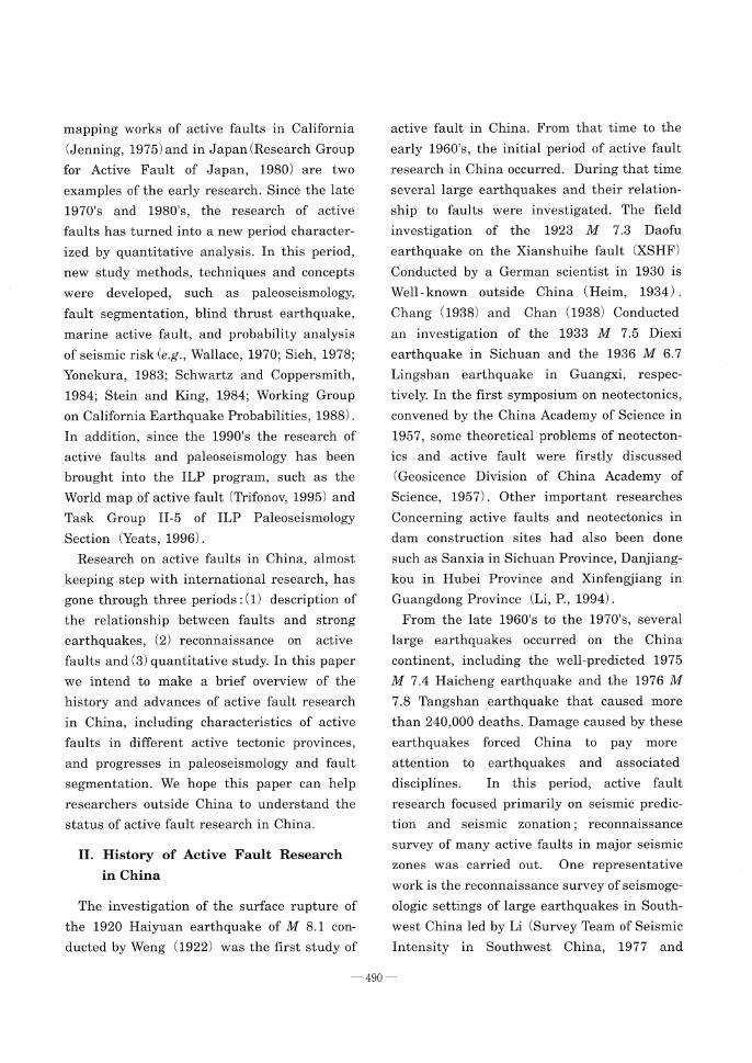
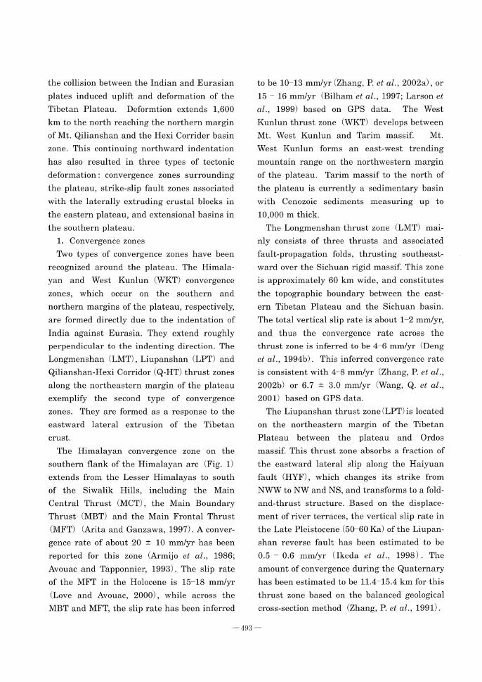
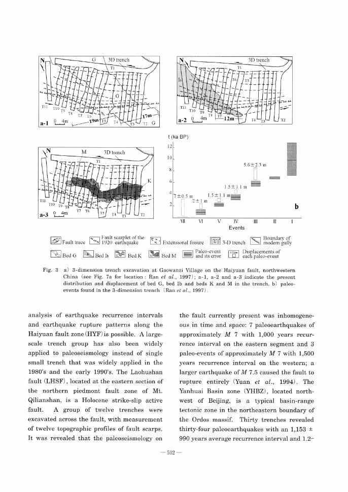
paleoearthquake parameters. The first appli-cation of the three-dimension trench not only
revealed at least seven paleoearthquakes in
the Holocene, but also measured coseismic
horizontal displacements of five paleo-events
at the trench on the Haiyuan fault (Fig. 3; Ran
et al., 1997) . Combined with information
collected from 35 other trenches (Institute of
Geology, State Seismological Bureau and
Seismological Bureau of Ningxia Hui Autono-
mous Region, 1990; Min, 1998) , more reliable
501
a-1a-2
a-3
b
analysis of earthquake recurrence intervals
and earthquake rupture patterns along the
Haiyuan fault zone (HYF) is possible. A large-
scale trench group has also been widely
applied to paleoseismology instead of single
small trench that was widely applied in the
1980's and the early 1990's. The Laohushan
fault (LHSF) , located at the eastern section of
the northern piedmont fault zone of Mt.
Qilianshan, is a Holocene strike-slip active
fault. A group of twelve trenches were
excavated across the fault, with measurement
of twelve topographic profiles of fault scarps.
It was revealed that the paleoseismology on
the fault currently present was inhomogene-
ous in time and space: 7 paleoearthquakes of
approximately M 7 with 1,000 years recur-
rence interval on the eastern segment and 3
paleo-events of approximately M 7 with 1,500
years recurrence interval on the western; a larger earthquake of M 7.5 caused the fault to
rupture entirely (Yuan et al., 1994) . The
Yanhuai Basin zone (YHBZ) , located north-
west of Beijing, is a typical basin-range
tectonic zone in the northeastern boundary of
the Ordos massif. Thirty trenches revealed
thirty-four paleoearthquakes with an 1,153 ±
990 years average recurrence interval and 1.2-
Fig. 3 a) 3-dimension trench excavation at Gaowanzi Village on the Haiyuan fault, northwestern
China (see Fig. 7a for location : Ran et al., 1997); a-1, a-2 and a-3 indicate the present
distribution and displacement of bed G, bed Ib and beds K and M in the trench. b) paleo-
events found in the 3-dimension trench (Ran et al., 1997) .
502
2.2 m coseismic displacement on four normal
faults in this basin zone (Ran, 1997; Ran et
al., 1998) . The piedmont fault of Mt. Daqing-
shan is the northern boundary fault of the
eastern part of Hetao basin, the northern
boundary of the Ordos massif. A trench
group, consisting of two trenches of 36 m and
25 m long, and 9 m and 5 m deep, revealed
four paleoearthquakes with a recurrence
interval of proximately 2 - 5 Ka (Wu et al.,
1995) .
Furthermore, many trenches excavated
across different portions of a fault make it
possible that more events may be revealed and complete history of earthquake activity of
the fault may be discovered. However, it does
not mean that the more trenches there are,
the less the uncertainty of the information on
paleoearthquake events is. Because of the
dating uncertainty of paleoearthquake events,
one paleoearthquake event may be inter-
preted as different events in different trenches. For example, a paleoearthquake which occu-
rred on an active fault is revealed in two
different trenches, but radiocarbon samples
taken from the two trenches dated different
ages for the same event. In cases where
dating data are lacking, the same event is
usually interpreted as two or more events.
Mao and Zhang (1995) proposed use of the
progressive constraining method to decrease
this kind of uncertainty due to complicated
trench data. For events revealed in any trench
we can determine either its upper bound, or
lower bound, or its time interval. When all of
the events revealed in each trench along the
same fault are plotted, it is possible to
identify the same event revealed in different
trenches by upper bound, lower bound and
time interval constrains. If an event is
discovered in more than two trenches, we can
use different upper and lower bounds to
constrain the occurrence time of paleoearth-
quake and to reduce the uncertainty associ-
ated with dating. Figure 4 shows how to
determine paleoearthquakes based on data
from several trenches using progressive
constraining.
Besides the trenching technology, there are
several other methods applied to recognizing
paleoearthquake in recent years. Li, T. et al.
(1994) made a research of 62 sag ponds along
the Xianshuihe fault (XSHF) , and found that
6 depositional cycles of these sag ponds re-
present 6 paleoearthquake events during past 20 Ka near Luhuo County. The Xiadian fault
(XDF) is the seismogenic fault of the 1679 M
8 Sanhe-Pinggu earthquake. Comparison of
two stratigraphic logs of drills on both sides of
the fault showed different deposition on both
sides of the fault in the last 26 Ka. By
analyzing the offsets of sediments and
stratigraphic marks, Xu et al. (2000) identified
11 paleoearthquakes. Moreover, microstruc-
tural observation on invisible or die-out faults
can assist in the determination of the age and
recurrence intervals of paleoearthquakes more
accurately. Invisible faults or concealed faults
often lead to complexity and uncertainties in
paleoearthquake research. Confirming or
negating the existence of concealed faults and
tracing the terminated levels of die-out faults
by microstructural observation can assist in
recognizing paleoearthquakes more accurately.
Chao et al. (2000) analyzed microstructures of
original-state directional samples taken from
several typical paleoearthquake trenches to
conclude this knowledge.
The research of paleoseismology in the last
10 years has helped us understand paleoseis-
mic rupture behavior, and recurrence behav-
ior along several major fault zones or in an
503

active region. A group of trenches, consisting
of 3 main trenches and 3 auxiliary trenches,
was excavated across the Hohhot segment of
the piedmont fault of Mt. Daqingshan. A
complete paleoseismological history of the
fault during the period time since 19 Ka BP
was revealed. The paleoseismic recurrence
pattern shown by the complete paleoearth-
quake record follows a quasi-periodic recur-
rence model with an average recurrence
interval of 2,375 •} 432 years (Ran et al.,
2002) . Based on paleoearthquake data from a
3-D trench (Ran et al., 1997) and 35 other
trenches (Institute of Geology, State Seismol-
ogical Bureau and Seismological Bureau of
Ningxia Hui Autonomous Region, 1990; Min,
1998) , we can identify two temporal clusters
during the last 7 Ka paleoearthquake history :
the first cluster occurs approximately 4.6 - 6.4
Ka and the second 1 - 2.8 Ka (Ran and Deng,
1998; Min et al., 2001; Zhang, P. et al., 2001) .
Furthermore, the ruptures affect each other
in segments not only along an active fault
zone but also in an active region. Between the
northeastern margin of the Tibetan Plateau
and the North China tectonic province, many
active faults, including the Haiyuan fault
zone and faults in the southern part of the
YJDB exist (Fig. 5a) . In addition to 5 large
earthquakes of M •¬ 7 in the last 400 years
(1561, 1622, 1709, 1739 and 1920) , there
hane been 19 paleoearthquakes in this area
(Min, 1998; Research Group on "Active fault
system around Ordos massif", State Seismol-
ogical Bureau, 1988; Wang, Y. et al., 1990) .
Min et al. (2000) analyzed these earthquakes
to conclude that : (1) the average recurrence
interval along an individual fault is usually 1
2 Ka, and earthquakes along faults in the
NTP seem to have quasi-periodic recurrence
intervals, while those along faults in the
northeastern margin of the Tibetan Plateau
Fig. 4 Illustration diagram showing the progressive constraining method in
paleoseismological studies (Mao and Zhang, 1995) .
504

a
b-1, b-2 b-3
b-4 b-5 b-6
have no regular recurrence interval; (2)
regional earthquakes clearly show a temporal
clustering pattern, and the mitigation of
earthquakes within a cluster follows a certain
pattern, usually starting to the south, then migrating to north and back to south (Fig. 5) .
In addition, paleoseismological research along
the Xiaojiang fault (XJF) shows that the
recurrence interval of a characteristic earth-
quake based on paleoearthquake data is longer than that deduced from the average
slip rate and maximum displacement of a
major earthquake, even when subtracting
10% creep slip (Wallace et al., 1984). Shen, J.
et al. (1998b) proposed the new concept of "relative creep"
, which means that the total
displacement is caused by all earthquakes
other than the characteristic earthquake, and
determined a formula for calculating slip rate
of "relative creep" . Comparing the slip rate of
relative creep and paleoearthquake data, we
can obtain a more reliable recurrence interval
for the characteristic earthquake.
2) Fault segmentation
Fault segmentation is a fundamental con-
cept to earthquake research. The segmenta-
tion of many large faults on the basis of
geometric, structural and active features has been known for decades. Allen (1967) des-
cribed five zones of the San Andreas fault
based on seismic activity, three strong active
zones and two weak active or inactive zones,
and divided this fault into four segments.
Wallace (1970) divided the San Andreas fault
into nine segments, and described their active
features in detail. The contemporary fault
Fig. 5 Between the northeastern margin of the Tibetan Plateau and North China tectonic province (a) , 24 paleoearthquakes and historic earthquakes have been recognized, which show temporal clustering pattern. Earthquakes within a cluster migrate according to a certain pattern, usually starting at south, then migrating to north and come back to south (b) (Min et al., 2000) .
505

segmentation theory with the concept of
seismic rupture behavior, an important con-
tribution of paleoseismology, only developed
in the 1980's. On the basis of paleoseismologi-
cal data for the Wasatch and San Andreas
fault zones, Schwartz and Coppersmith (1984)
proposed that a large fault zone is usually divided into several segments, and that each
segment tends to generate essentially the
same magnitude or characteristic earthquake
having a relatively narrow range of magni-
tude near the maximum. In China, segmenta-
tion of a large fault zone based on geometric,
structural and active features had been done
for decades, while fault segmentation associ-
ated with earthquake rupture behavior and
prediction of seismic risk has only started since the mid 1980's. Major research work
has been done on the Xianshuihe fault (XSHF)
in eastern Tibet (Wen, 1993; Wen et al., 2002) ,
the Anninghe fault (ANF) in southwestern
China (Tang et al., 1989; Wen, 2000) , the
Xiangshan-Tianjingshan fault (XTF) in north-
central China (Wang, Y. et al., 1990) , the
Tancheng-Lujiang fault (TLF) in eastern China
(Gao and Zheng, 1991) , and the Haiyuan fault
(HYF) in north-central China (Institute of
Geology, State Seismological Bureau and
Seismological Bureau of Ningxia Hui Autono-
mous Region, 1990; Zhang, P. et al., 2001) , etc.
Generally, fault segmentation can be gene-
rated in four ways : 1) geometric segmenta-
tion, 2) structural segmentation, 3) active
segmentation and 4) rupture segmentation. Of
them, geometric and structural features are
the basis of fault segmentation, while the
distribution, process, and history of rupture
are the essence of segmentation. Neverthe-
less, most of the completed segmentation
research is usually based on the difference of
active feature, associated with geometric and
structural, because of the lack of paleoseismol-
ogical data. After approximately ten years of
fault segmentation research, some useful
segmentation criteria and methods have been
summarized (Ding, G., 1992; Ding, G. et al.,
1993; Deng and Zhang, 1995) . Based on the
results of segmentation researches on three
faults that have been regarded internation-
ally as the most reliable for fault segmenta-
tion, Zhang, P. et al. (1998) summed up six
segmentation methods (geotectonic, geophys-
ical, geomorphologic, geometric, active charac-
teristic, and paleoseismological) , and thirty
segmentation features.
The Nankou piedmont fault (NKPF) in west
Beijing is one of the northeastern trending
normal faults developing in the Beijing area
(Huang et al., 1991) . He and Fang (1995)
divided this fault into four segments based on
the differences in geometry, geomorphology
and Quaternary activity. It was proposed that
segmentation of the fault is caused by
differential movement of the depressed blocks
in the southeastern side of the fault rather
than the discontinuities along the fault. The
eastern piedmont fault of Mt. Liupanshan is
an active reverse fault due to the eastward
extrusion of the Tibetan crust. Based on the
change of geometric features, active history
and active characteristics, Xiang et al. (1998)
divided this reverse fault into a north, middle
and south segment. The faulting along the
northern segment indicates mainly sinistral
slip, while faulting in the middle and
southern segments is principally reverse slip.
The active period of the northern segment is
younger than that of the southern segment, and the horizontal slip is greater in the north
than in the south.
Cheng and Yang (1996) divided the southern
marginal fault zone of Datong-Yangyuan basin
506

(DYB) located in the Shaanxi fault depression
zone (SXDB) into northeast and southwest
segments. This segmentation was based on
the differences in tectonic geomorphology: (1)
the height of the fault scarp along the
northeastern segment is larger than that
along the southwestern segment, and the
height of the fault scarp is greatest in the
center and deceases gradually toward two
ends along both the segments; (2) 0.34 mm/yr
slip rate, 0.9 m average coseismic displace-
ment from an earthquake event, and 900 -
1,000 years recurrence interval along the
southwestern segment, while 0.99 mm/yr, 3.1
m and 1,800 years along the northeastern
segment.
In addition to such standard methods as
geometry, geologic structure, geophysical field
and active history, some other features have
been developed for segmenting active faults.
Preferred orientation and fabric of minerals
have a close relationship to the mode of slip
along a fault. The fabric analysis of gouge in
the Xiangshan-Tianjingshan fault (XTF) by an
X-ray method with a Textrete-Goniometer
showed that this fault could be divided into
three segments. The illite fabric in the middle
segment has no orientation due to strike slip
faulting, while the maximum density area in
the eastern and western segments is caused
by sinistral-shear creep (Zhang, B., 1997).
The fabric feature of fault gouge shows that
the eastern piedmont fault of Mt Liupanshan
is composed of three segments as Xiang et al.
(1998) divided based on change of geometric
and active features (Zhang, B. et al., 2000) .
The sinistral slip along the northern segment
has made the local strong deformation,
traction fold, Riedel shear angle of 11•‹ - 26•‹ ,
P foliation and randomly preferred orienta-
tion of illite mineral developed within fault
gouge. The creep slip and reverse slip along
the middle and southern segments are ide-
ntified by general deformation, a Riedel shear
angle of 11•‹ or less, banded fold, ptygmatic
structure and polygemic preferred orientation
of illite mineral developed within fault gouge
(Zhang, B. et al., 2000). The deep circulation
of hot spring water can strongly weaken an
active fault and its wall rock, and the
weakening increases as the circulation depth
increases. Based on observations of 14 hot
springs along the northern section of the Red
River fault zone, Lin (1993) segmented the
northern section of the Red River fault zone
into four segments : Jianchuan, Eryuan, Dali
and Midu. The earthquake activity on the
Eryuan segment is lower because of deeper
circulation of hot spring water, while earth-
quake activity of the other segments is higher
because of shallower circulation of hot spring
water.
In recent years, the stability of segmenta-
tion, the persistence of a segment boundary,
the gradation of segmentation, and the multi-
rupture scenarios have received much focus in
research. The extent of a segment is com-
monly used to estimate the potential earth-
quake size, and the segment boundary plays
an important role in arresting earthquake
rupture from event to event. The means to
identify persistent discontinuities is very
important to eliminate the uncertainties in
fault segmentation and prediction of potential
earthquake sizes. Studies of the geometric
pattern of five well-documented historic
earthquake ruptures in the Basin and Range
Province revealed three important relation-
ships between rupture termination and the
size of structural discontinuities : (1) termina-
tions of normal faulting earthquakes are
associated with structural discontinuities ; (2)
507
508
the sizes of inter-rupture discontinuities that
significantly stop or impede the propagating
rupture are larger than the intra-rupture
discontinuities that have been ruptured
through by the earthquake ; (3) the sizes of
inter-rupture discontinuities that stopped the
earthquake rupture appear to scale with the
length and displacement of the surface
rupture (Zhang, P. et al., 1999). In spite of the
lack of a quantitative relationship between
discontinuity size and segment length, these
three relations mentioned above are useful to
identify persistent discontinuities.
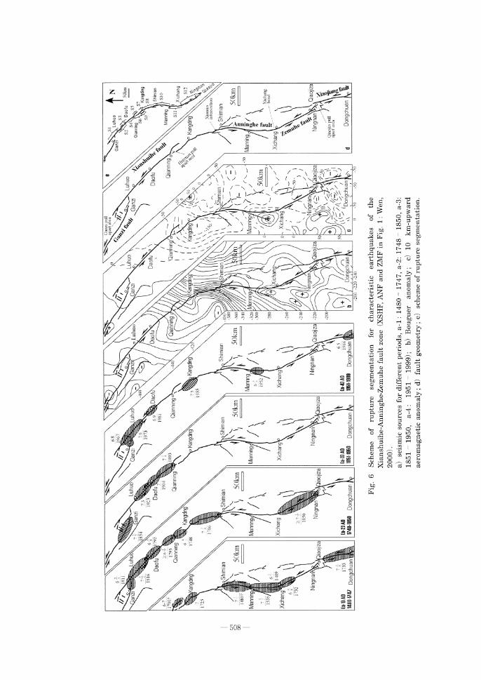
The Xianshuihe - Anninghe - Zemuhe fault
zone (XSHF-ANF-ZMF) , located in the nor-
thern-central section of the Kangding fault
zone (KDF) , is one of the well-segmented
faults in China. Wen (2000) delineated the
fault zone into 12 rupture segments using
geometric structure, active features, geophysi-cal data, crustal deformation, historic earth-
quake data and research results of paleo-earthquakes (Fig. 6) . The following knowledge
of segmentation on strike-slip fault zone was
also concluded. (1) The persistent and impor-
tant boundaries are generally larger geomet-
ric discontinuities, structural barriers, and
transition areas of Quaternary active behav-
ior of faults, which terminate the propagation
of earthquake ruptures by partly change in
volume; (2) Approximately 50% of the historic
earthquake ruptures terminated without ob-
vious geometric discontinuities or structural
barriers, suggesting that identifying such non-
persistent boundaries on the strike-slip fault
is as important as persistent boundaries ; (3)
The non-persistent boundaries can be identi-
fied by earthquake rupture and the recur-
rence behavior, spatial difference of current
active behavior, composition of small geomet-
ric discontinuities, and release barriers.
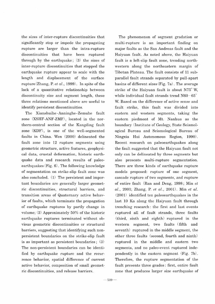
The phenomenon of segment gradation or
multi-rupture is an important finding on
major faults as the San Andreas fault and the
Haiyuan fault. As noted above, the Haiyuan
fault is a left-slip fault zone, trending north-
western along the northeastern margin of
Tibetan Plateau. The fault consists of 11 sub-
parallel fault strands separated by pull-apart
basins of different sizes (Fig. 7a) . The average
strike of the Haiyuan fault is about N75•‹ W,
while individual fault strands trend N60 - 65•‹
W. Based on the difference of active sense and
fault strike, this fault was divided into
eastern and western segments, taking the
eastern piedmont of Mt. Nanhua as the
boundary (Institute of Geology, State Seismol-
ogical Bureau and Seismological Bureau of
Ningxia Hui Autonomous Region, 1990) .
Recent research on paleoearthquakes along
the fault suggested that the Haiyuan fault not
only can be delineated by three segments but
also presents multi-rupture segmentation.
There are three kinds of earthquake rupture
models proposed: rupture of one segment,
cascade rupture of two segments, and rupture
of entire fault (Ran and Deng, 1998 ; Min et
al., 2001; Zhang, P. et al., 2001). Min et al.
(2001) identified ten paleoearthquakes in the
last 10 Ka along the Haiyuan fault through
trenching research : the first and last events
ruptured all of fault strands, three faults
(third, sixth and eighth) ruptured in the
western segment, two faults (fifth and
seventh) ruptured in the middle segment, the
other three faults (second, fourth and ninth)
ruptured in the middle and eastern two
segments, and no paleo-event ruptured inde-
pendently in the eastern segment (Fig. 7b).
Therefore, the rupture segmentation of the
fault presents three grades : first, entire fault
zone that produces larger size earthquake of
509

M•¬8; second, two segments (middle and
eastern) that produces smaller size earth-
quake of M•¬7; third, one segment that also
produces smaller size earthquake of M•¬7.
Furthermore, because paleoseismology and
fault segmentation are very useful to under-
stand the rupture process of faulting and
predict the place and magnitude of potential earthquake, the paleoseismology and fault
segmentation have been applied to seismologi-
cal engineering, analysis of seismic risk and
seismic zonation (He and Zhou, 1993; Zhang,
a
b
Fig. 7 Segmentation of the Haiyuan fault (Min et al., 2001) .
a) The geometric pattern of three segments of the Haiyuan
fault, trench locations across the fault indicated by short
bars ; b) the history of large ruptures on the Haiyuan fault
based upon paleoseismic data from trenches.
510

P. et al., 1998). When applying paleoseismol-
ogy and fault segmentation, we should pay
more attention to uncertainty and incomplete-
ness of paleoseismology, and segment grada-
tion or multi-rupture. Zhang, P. et al. (1998)
suggested following points of view when fault
segmentation is used in seismic safety
assessment : (1) Sufficient and concrete evi-
dence is necessary for fault segmentation ; (2)
uncertainties associated with fault segmenta-
tion require comprehensive segmentation
features, (3) in order to increase reliability of
fault segmentation, reliable features should
be used as much as possible; (4) it is important
to pay attention to the persistent nature of
fault segmentation boundary.
V. Remarks
In this paper, we presented a brief review of
active fault research in China on : (1) research
history, (2) the characteristics of active faults
in different active tectonic provinces, and (3)
major progresses in paleoseismology and fault
segmentation. Although many foreign resear-
chers conducted research works in China,
especially in the Tibetan Plateau, we focused
on work done by Chinese researchers. More-
over, the Institute of Geology, China Seismol-
ogical Bureau, independent from Chinese
Academy of Science in 1978, is the major
institution engaged in active fault research in
China. There are other institutions and
universities have engaged in active fault
research, however, most of active fault
research in China have been done by China
Seismological Bureau and associated local
seismological bureaus. This review paper is
made principally based on the research work
done by the Institute of Geology, China
Seismological Bureau and associated local
seismological bureaus. Since last year, China
Seismological Bureau has begun a major five-
year project to detect active faults under more than 20 selected major cities. The Institute of
Geology and some local seismological bureaus
will participate in this project. We are
confident that this project will contribute to
active fault research in China and throughout
the world.
Acknowledgments
Thanks to Qidong DENG, Peizhen ZHANG,
Rongkan RAN and Bengang ZHOU of Institute of
Geology, China Seismological Bureau for their
helpful suggestions and useful references. Thanks
are also due to Eric CANNON from Colorado
University, USA for his reviews that improved the
English expression of this paper.
References
Abdrakhmatov, K.Y., Aldazhanov, S.A., Hager, B.H., Hamburger, M.W., Herring, T.A., Kalabaev, K.B., Kalabayev, K.B., Makarov, V.I., Molnar, P., Panasyuk, S.V., Prilepin, M.T., Relinger, R.E., Sadybakasov, I.S., Souter, B.J., Trapeznikov, Y.A., Tsurkov, V.Y. and Zubovich, A.V. (1996): Rela-tively recent construction of the Tianshan inferred from GPS measurements of present-day crustal deformation rates. Nature, 384, 450-453.
Allen, C.R. (1967): The tectonic environment of seismically active and inactive areas along the San Andreas fault system. Stanford Univ. Pubs. Geol. Science, 11, 70-82.
Allen, C.R. Han, Y., Sieh, K.E., Zhang, B. and Zhu, C. (1984) : Red River and associated faults, Yunnan Province, China: Quaternary geology, slip rate, and seismic hazard. Geol. Soc. Am. Bull., 95, 686-700.
Allen, C.R. Luo Z., Qian, H., Wen, X., Zhou, H. and Huang, W. (1991): Field study of a highly active fault zone: The Xianshuihe fault of southwestern China. Geol. Sco. Am. Bull., 103, 1178-1199.
Arita, K. and Ganzawa, Y. (1997): Thrust tectonics and uplift process of the Nepal Himalaya revealed from fission-track ages. J. Geography, 106, 156-167. (in Japanese)
Armijo, R., Tapponnier, P., Mercier, J.L. and Han T. (1986): Quaternary extension in Southern Tibet: Field observations and tectonic implications. J. Geophys. Res., 91(B14), 13803-13872.
Armijo, R., Tapponnier, P. and Han, T. (1989): Late
511

Cenozoic right-lateral strike-slip faulting in southern Tibet. J. Geophys. Res., 94 (B3) , 2787 -2838.
Avouac, J.P. and Tapponnier, P. (1993) : Kinematic model of active deformation in central Asia. Geophys. Res. Lett., 20 (10) , 895-898.
Avouac, J.P., Tapponnier, P., Bai, M. and Wang, G. (1993) : Active thrusting and folding along the northern Tian Shan and late Cenozoic rotation of the Tarim relative to Dzungeria and Kazakhstan. J. Geophys. Res., 98, 6755-6804.
Bai, M., Luo, F. and Yin, G. (1996): Keketuohai-Ertai active fault zone, Xinjiang. Inland Earth-
quake, 10 (4) , 319-329. (in Chinese) Bendick, R., Bilham, R., Freymuller, J.T., Larson,
K. and Yin, G.(2000): Geodetic evidence for a low slip rate in the Altyn Tagh fault system. Nature, 404, 69-72.
Bilham, R., Larson, K., Freymuller, J., Jouanne, F., Lefort, P., Leturmy, P., Mugnier, J., Gamond, J., Glot, J., Martinod, J., Chaudury, N., Chitrakar, G., Gautam, U., Koirala, B., Pandey, M., Ranabhat, R., Thakuri, M., Timilsina, U., Tiwari, D., Vidal, G., Vigny, C., Galy, A. and de Voogd, B. (1997): GPS measurement of present-day conver-gence across the Nepal Himalaya. Nature, 336, 61-64.
Briais, A., Patriat, P. and Tapponnier, P. (1993): Updated interpretation of magnetic anomalies and seafloor spreading stages in the South China Sea: Implication for the Tertiary tectonics of Southeast Asia. J. Geophys. Res., 98 (B4), 6299-6328.
Chan, Kuota (1938): Lingshan earthquake of April 1, 1936, in Guangxi province. Geological Review, 3 (4) , 427-447. (in Chinese)
Chang, L.C. (1938): Investigation of Diexi earth-quake in Sichuan Province. Geological Review, 3 (3) , 251-292. (in Chinese)
Chao, H., Deng, Q., Li, J., Wang, Z. and Man, H. (2000): Characteristics of microstructures of the invisible faults in Quaternary unconsolidated sediments. Seismology and Geology, 22(2) , 147 -154. (in Chinese with English abstract)
Cheng, S. and Yang, G. (1996): Late Quaternary segmentation and segmented variations in tectonic geomorphology of southern marginal fault zone of Datong-Yangyuan basin. Seismology and Geology, 18(4) , 289-300. (in Chinese with English abstract)
Chinese Working Group of the Project IGCP-206 (1989): Atlas of Aactive Fault in China. Seismol-ogical Press, Beijing, and Xi'an Cartographic Publishing House, Xi'an.
Clark, M.M., Grantz, A. and Rubin, M. (1972): Holocene activity of the Coyote Creek fault as recorded in sediments of Lake Cahuilla. U.S.
Geol. Surv. Prof Pap., 787, 112-130. Deng, Q. (1996) : Active tectonics in China. Geologi-
cal Review, 42 (4) , 295-299. (in Chinese with English abstract)
Deng, Q. and Liao, Y. (1996) : Paleoseismology along the range-front fault of Helan Mountains, North Central China. J. Geophys. Res., 101 (B3) , 5873-5893.
Deng, Q. and Zhang, P. (1995) : Principles and methods of segmentation of active fault (1) . Researches on Contemporary Crustal Movement, 6, 196-207. (in Chinese)
Deng, Q., Wang, Y. and Liao, Y. (1984) : Fault scarps, colluvial wedges on the frontal fault of Mt. Helan and its active history during Holocene. Chinese Science Bull., 9, 557. (in Chinese)
Deng, Q., Xu, X. and Yu, G. (1994a) : Provincial characteristics of active faults in Chinese continent and its contributing factors. In State Seismological Bureau eds. : Research of Active Fault in China. Seismological Press, Beijing, 1 -14. (in Chinese)
Deng, Q., Chen, S. and Zhao, X. (1994b): Tectonics, seismicity and dynamics of Longmenshan Moun-tains and its adjacent regions. Seismology and Geology, 16 (4) , 387-403. (in Chinese with English abstract)
Deng, Q., Yonekura, N., Xu, X., Suzuki, Y., Wang, C., Takeuchi, A., Su, Z. and Wang, Y. (1994c): Study on the late Quaternary kinematics of the northern piedmont fault of the Liuleng Mountain. Seismology and Geology, 16 (4) , 339-343. (in Chinese with English abstract)
Deng, Q., Feng, X., Zhang, P., Xu, X., Yang, X., Peng, S. and Li, J. (2000): Active Tectonics in Tianshan Mountains. Seismological Press, Bei-
jing. (in Chinese with English abstract) Deng, Q., Min, W. and Chao, H. (2001): Tectonics in
the Cenozoic and seismicity in Bohai Sea region. In Lu, Y. (Chief-editor): Neotectonics and Envi-ronment. Seismological Press, Beijing, 218 - 233. (in Chinese)
Deng, Q., Zhang, P., Ran, Y., Yang, X., Min, W. and Chu, Q. (2002): Basic characteristics of active tectonics in China. Science in China ( D) , 32 (12), 1020-1030. (in Chinese with English abstract)
Ding, G. (Chief-editor) (1991): An Introduction on Lithospheric Dynamics of China. Seismological Press, Beijing. (in Chinese)
Ding, G. (1992): Several problems regarding the segmentation of active fault. Earthquake Re-search in China, 8(2), 1-10. (in Chinese with English abstract)
Ding, G., Tian, Q., Kong, F., Xie, X., Zhang, L. and Wang, L. (1993): Segmentation of Active Fault -Principles, Methods and Application. Seismologi-cal Press, Beijing. (in Chinese)
512

Ding, X., Wang, Y. and Ye, S. (1999) : Active Faults and Earthquakes in Southeastern Coast Region of Fujian Province. Scientific Press of Fujian, Fuzhou. (in Chinese)
Dou, S., Yu, S., Liu, G., Xu, Y., Liang, H. and Yan, F. (1995) : Geometric structure and activity of the Xizhoushan Mountain piedmont fault in Shanxi Province. Research on Active Fault, 4, 104 - 115. (in Chinese with English abstract)
Gao, W. and Zheng, L. (1991) : Active fault seg-mentation and the identification of potential seismic zones along the Tanlu fault. Earthquake Research in China, 7 (4) , 87-91. (in Chinese with English abstract)
Geosicence Division of China Academy of Science (1957): 1st Symposium on Neotectonic Movement in China, China Academy of Science. Scientific Press, Beijing. (in Chinese)
Gu, G. (1983): Earthquake Catalog of China. Scientific Press, Beijing. (in Chinese)
Guo, S. (Chief-editor) (2001): Honghe (Red River) Active Fault Zone. Ocean Press, Beijing. (in Chinese with English abstract)
Han, T. (1987): Active Tectonics of Tibet. Geological Memoirs of Ministry of Geology and Mineral Resources, People's Republic of China, Series 5: Structural Geology and Geomechanics, No.4, Geological Publishing House, Beijing. (in Chinese with English abstract)
Han, X. and Mao, Y. (1993): Seismic risk analysis to Shiping-Jianshui fault zone in the next 30 years. J. Seismological Research, 16(1), 52-59. (in Chinese with English abstract)
He, H. (2000): Quaternary Tectonic Deformation in the Southeastern Margin of the Tibetan Plateau. Ph. D. Dissertation, Department of Geography, University of Tokyo.
He, H. and Fang, Z. (1995): Fault block movement and segmentation of active fault. Seismology and Geology, 17(1), 1 - 6. (in Chinese with English abstract)
He, H. and Ikeda, Y. (2001): Strike-slip rate of the Kangding fault system: Implications of regional tectonic evolution of the Tibetan Plateau. EOS. Trans. AGU, Fall Meet. Suppl., Abstract, THE 0884.
He, H. and Zhou, B. (1993): Segmentation of seismo-active faults and the potential maximum earthquake magnitude on the segment. Seismol-ogy and Geology, 15 (4) , 333-340. (in Chinese with English abstract)
Heim, A. (1934): Earthquake region of Daofu. Geol. Sco. Am. Bull., 45, 1057-1049.
Huang, X., Wang, L., Xu, J., Fang, Z., Zhang, F., Xiang, J. and Wang, H. (1991): Characteristics of neotectonic movement in Beijing area. Seismol-ogy and Geology, 13(1), 43 - 51. (in Chinese with
English abstract) Ikeda, Y., He, H., Xiang, H., Guo, S., Zhang, W. and
Zhang, B. (1998) : Quaternary activity of the Liupanshan fault along the northeastern margin of the Tibetan Plateau. J. Geography, 107, 542 -548. (in Japanese)
Institute of Geology and Lanzhou Seismological Institute, State Seismological Bureau (1993): The Qilian Mountain-Hexi Corridor Active Fault System. Seismological Press, Beijing. (in Chinese)
Institute of Geology, State Seismological Bureau (1979): Seismotectonic Map of China ( 1:4,000,000) and Its Summary Instruction. Cartographic Publishing House, Beijing. (in Chinese with English abstract)
Institute of Geology, State Seismological Bureau (Chief-editor, Fang, Z.) (1987) : Tancheng-Luji-ang Fault Zone. Seismological Press, Beijing. (in Chinese)
Institute of Geology, State Seismological Bureau (Chief-editor, Wu, Z.) (1992): Active Fault in the Central Tibet. Seismological Press, Beijing. (in Chinese with English abstract)
Institute of Geology, State Seismological Bureau and Seismological Bureau of Ningxia Hui Autonomous Region (Chief- editor, Deng, Q.) (1989): Geological Map of Haiyuan Active Fault ( 1:50,000) . Seismological Press, Beijing. (in Chinese)
Institute of Geology, State Seismological Bureau and Seismological Bureau of Ningxia Hui Autonomous Region ( Chief - editor, Deng, Q. ) (1990): Haiyuan Active Fault. Seismological Press, Beijing. (in Chinese)
Jenning, C.W. (1975): Fault Map of California with Locations of Volcanoes, Thermal Springs and Thermal Wells ( 1:750,000) . California geologic data map series, California Division of Mine and Geology.
Jiang, W., Xiao, Z. and Wang, H. (2000): Sinistral strike-slip along western end of the piedmont active fault of Daqingshan Mountain, Inner Mongolia, China. Earthquake Research in China, 16 (3) , 203 - 212. (in Chinese with English abstract)
Larson, K., Burgmann, R., Bilham, R. and Freymueller, J. (1999): Kinematics of the India-Eurasia collision zone from GPS measurement. J. Geophys., Res., 104, 1077-1093.
Lawson, A.C. (1908): The California Earthquake of April 18, 1906-Report of the State Earthquake Investigation Commission, 1. Parts 1, 2. Carnegie Institution of Washington, Publication, 87.
Li, J., Chao, H., Cui, Z. and Zhao, Q. (1994): Segmentation of active fault along the Tancheng-Lujiang fault zone and evaluation of strong earthquake risk. Seismology and Geology, 16(2),
513

121-126. (in Chinese with English abstract) Li, K., Wu, W. and Yang, F. (1994) : Segmentation
research of piedmont active fault of Mt. Da-
qingshan. In State Seismological Bureau eds. : Research of Active Fault in China. Seismological Press, Beijing, 102-113. (in Chinese)
Li, P. (Chief editor) (1993) : Xianshuihe-Xiaojiang Fault Zone. Seismological Press, Beijing. (in Chinese)
Li, P. (1994) : Research of Seismology in Sanxia and Danjiangkou Regions. Seismological Press, Bei-jing. (in Chinese)
Li, T., Du, Q., Zhang, C. and You, Z. (1994): Study on paleoearthquakes based on sag ponds and associated sediment along the Xianshuihe fault zone. Research on Active Fault, 3, 126 - 134. (in Chinese with English abstract)
Li, T., Du, Q., You, Z. and Zhang, C. (1997): Xianshuihe Active Fault and Seismic Hazard Assessment. Chengdu Cartographic Publishing House, Chengdu. (in Chinese)
Li, Y. (Chief-editor) (1992): Study of Ground Fi-ssures in Xi'an and Active Fault in Weihe Basin. Seismological Press, Beijing. (in Chinese)
Liao, Y., Chai, Z., Zhang, W. and Xu, W. (2000): The active features and slip rate of Lingwu faults in late Quaternary. Earthquake Research in China, 16 (2) , 158-165.
Lin, Y. (1993): A discussion on the relation of circulation depth of hot spring water to seismic activity on the northern segment of the Honghe fault zone. Seismology and Geology, 15 (3) , 200 -206.
Liu, G., Yu, S., Zhang, S., Dou, S., Xu, Y. and Fan, Z. (1991): The north Wutaishan piedmont fault zone in Shanxi. Research on Active Fault, 1, 118 -130. (in Chinese with English abstract)
Love, J. and Avouac, J.P. (2000): Active folding of fluvial terraces across the Sirvolike Hills, Himalayas of Central Nepal. J. Geophys. Res., 105, 5735-5770.
Ma, X. (Chief-editor) (1987): Lithospheric Dynam-ics Atlas of China. China Cartographic Publish-ing House, Beijing. (in Chinese)
Mao, F. and Zhang, P. (1995): Progressive constrain-ing method in paleoseismic study and paleoearth-
quakes along the major active faults in Northern Xinjiang. Research on Active Fault, 4, 153 - 164. (in Chinese with English abstract)
Metivier, F., Gaudemer, Y., Tapponnier, P. and Meyer, B. (1998): Northeastward growth of the Tibet plateau deduced from balanced reconstruc-tion of two depositional areas: The Qaidam and Hexi Corridor basins, China. Tectonics, 17, 823-842.
Min, W. (1998): Study on Regional Paleoseismology. Ph.D. Dissertation, Institute of Geology, China
Seismological Bureau. (in Chinese with English abstract)
Min, W., Zhang, P. and Deng, Q. (2000) : Primary study on regional paleoearthquake recurrence behavior. Acta Seismologica Sinica, 13 (2) , 180 -188.
Min, W., Zhang, P., Deng, Q. and Mao, F. (2001): Detailed study of Holocene paleoearthquakes of the Haiyuan active fault. Geological Review, 47 (1) , 1-7. (in Chinese with English abstract)
Molnar, P. and Lyon-Caen, H. (1989) : Fault plane solution of earthquakes and active tectonics of Tibetan Plateau and its margins. Geophys. J. Int., 99, 23-153.
Molnar, P. and Tapponnier, P. (1975) : Cenozoic tectonics of Asia : Effects of a continental collision. Science, 189, 419-426.
Molnar, P. and Tapponnier, P. (1978) : Active tectonics of Tibet. J. Geophys. Res., 83 (B11) , 5361-5375.
Peltzer, G., Tapponnier, P. and Armijo, R. (1989): Magnitude of late Quaternary left-lateral dis-placements along the north edge of Tibet. Science, 246, 1285-1289.
Ran, Y. (1997): Detailed Research of Paleoearth-quakes at Several Typical Regions in China and Exploration of Recurrence Behavior of Large Earthquakes. Ph.D. Dissertation, Institute of Geology, China Seismological Bureau. (in Chinese with English abstract)
Ran, Y. and Deng, Q. (1998): Paleoearthquakes along Haiyuan fault and discussion of grading on rupture of large earthquakes. Quaternary Sci-ence, 3, 272 - 278. (in Chinese with English abstract)
Ran, Y., Li, Z., You, H. and Zhu, X. (1988): Research and dating of paleoearthquake along Heihekou fault in Hexi Corridor. Seismology and Geology, 10 (4) , 118-126. (in Chinese with English abstract)
Ran, Y., Fang, Z., Li, Z., Wang, J. and Li, R. (1991): Characteristics of active faults around Huailai-Zhuolu basin. Research on Active Fault, 1, 140 -155. (in Chinese with English abstract)
Ran, Y., Duan, R. and Deng, Q. (1997): 3-D trench excavation and paleoseismology at Gaowanzi of the Haiyuan fault. Seismology and Geology, 19 (2) , 97-107. (in Chinese with English abstract)
Ran, Y., Fang, Z., Duan, R., Li, Z., Wang, J., Yang, Z., Ji, F. and Li, J. (1998): Recurrence model of paleoearthquakes along Baying segment of the northern marginal fault of Fanshan basin in Hebei Province. Earthquake Research in China, 14 (1) , 47-58. (in Chinese with English abstract)
Ran, Y., Zhang, P., Hu, B. and Guo, W. (2002): Paleoseismic activity on the Hohhot segment of Daqingshan piedmont fault in the late Quater-nary history. Earthquake Research in China, 18
514

(1) , 15-27. (in Chinese with English abstract) Ren, J., Wang, Y., Wu, Z. and Ye, J. (1993):
Holocene earthquake deformation zones and their displacement and slip rates along the Xidatan-Dongdatan of Kusaihu-Maqu fault in northern Qinghai-Xizhang Plateau. Seismology and Geology, 15 (3) , 285 - 288. (in Chinese with English abstract)
Research Group for Active Fault of Japan (1980): Active Faults in Japan. University of Tokyo Press, Tokyo. (in Japanese)
Research Group for Active Fault of Japan (1991): Active Faults in Japan : Sheet Maps and Inventories (Revised Edition) . University of Tokyo Press, Tokyo. (in Japanese)
Research Group on "Active fault system around Ordos massif", State Seismological Bureau (Chief-editor, Wang, Y. and Deng, Q.) (1988): Active Fault System Around Ordos Massif. Seismologi-cal Press, Beijing. (in Chinese)
Schwartz, D.P. and Coppersmith, K.J. (1984): Fault behavior and characteristic earthquake: Example from the Wasatch and San Andreas fault zones. J. Geophys. Res., 89 (B7) , 5681-5698.
Seismological Bureau of Qinghai Province, Insti-tute of Crustal Dynamics, China Seismological Bureau (1999): Eastern Kunlun Fault Zone. Seis-mological Press, Beijing. (in Chinese)
Seismological Bureau of Shaanxi Province (1996): Active Fault of the Northern Piedmont of Qingling Mountains. Seismological Press, Beijing. (in Chinese)
Seismological Bureau of Xinjiang Uygur Autono-mous Region (Chief-editor, Ding, G.) (1985): The Fuyun Earthquake Fault Zone in Xijiang, China. Seismological Press, Beijing. (in Chinese)
Seismogeological Committee of Chinese Seismologi-cal Society (1982): Active Faults in China. Seis-mological Press, Beijing. (in Chinese)
Shen, J., Wang, Y. and Li, M. (1998a): Preliminary study of active fault along the western Altai Mountains. Research on Active Fault, 6, 109-120. (in Chinese with English abstract)
Shen, J., Wang, Y., Song, F. and Li, Y. (1998b): Relative creep rate and characteristic earthquake recurrence interval-Example from the Xiaojiang fault zone in Yunnan, China. Seismology and Geology, 20 (4) , 328-331. (in Chinese with English abstract)
Shen, J., Ren, J. and Wang, Y. (2000): Study of right lateral slip on Jiali fault zone in late
Quaternary. Research on Active Fault, 8, 150-159. (in Chinese with English abstract)
Shen, X., Zhang, W., Yang, S., Guan, J. and Jin, X. (1990): Heat flow evidence for the differentiated crust-mantle thermal structures of the northern and southern terranes of the Qinghai-Xizang
Plateau. Bulletin of the Chinese Academy of Geological Science, 21, 203-214. (in Chinese)
Shen, Z., Wang, M., Li, Y., Jackson, D., Yin, A., Dong, D. and Fang, P. (2001) : Crustal deforma-tion along the Altyn Tagh fault system, western China, from GPS. J. Geophys. Res., 106, 30607 -30621.
Shentu, B., Xu, Y. and Wang, Y. (1990) : Preliminary study of active features and paleoearthquake relics on the Hancheng fault. North China Earthquake Sciences, 8 (1) , 1-10. (in Chinese with English abstract)
Sieh, K.R. (1978) : Pre-historic large earthquake produced by slip on the San Andreas fault at Pallett Creek, California. J. Geophys. Res., 83, 3909-3939.
Song, F., Wang, Y., Yu, W., Cao, Z., Shen, X. and Shen, J. (1998): Xiaojiang Active Fault. Seismol-ogical Press, Beijing. (in Chinese)
State Seismological Bureau (1976): Map of Active Faults and Distribution of Strong Earthquakes in China ( 1:3,000,000) . State Seismological Bureau, Beijing. (in Chinese)
Stein, R.S. and King, G.C.P. (1984): Seismic
potential revealed by surface folding, 1983 Coalinga, California Earthquake. Science, 224, 869-872.
Survey Team of Seismic Intensity in Southwest China (Chief-editor, Li, P.) (1977): Studies of Seismogeology and Intensity Zonation in South-west China. Seismological Press, Beijing. (in Chinese)
Survey Team of Seismic Intensity in Southwest China (Chief-editor, Li, P.) (1979): Bulletin of Seismogeologic Investigation of Large Earthquake Areas in Sichuan and Yunnan. Seismological Press, Beijing. (in Chinese)
Tang, R., Huang, Z., Wen, D. and Xia, D. (1989): Study of segmentation and earthquake activity along the Anninghe fault. J. Seismological Research, 12 (4), 337-346. (in Chinese)
Tapponnier, R, Lacassin, R., Leloup, P.H., Scharer, U., Zhong, D., Wu, H., Liu, X., Ji, S., Zhang, L. and Zhong, I. (1990): The Ailaoshan/Red River metamorphic belt: Tertiary left-lateral shear between Indochina and South China. Nature, 343 (6257), 431-437.
Teng, R., Jin, Y., Li, X. and Su, X. (1991): Relation between episodes of faulting and recurrence of earthquakes along the Huangxianggou fault in the northern margin fault zone of the western
Qiling. Research on Active Fault, 1, 96 - 104. (in Chinese with English abstract)
Trifonov, V.G. (1995) : World map of active faults (preliminary results of studies). Quaternary International, 25, 3-12.
Wang, Q., Zhang, R, Niu, Z., Freymuller, J.T., Lai,
515

X., Li, Y., Zhu, W., Liu, J., Bilham, R. and Larson, K.M. (2001) : Contemporary crustal movement and tectonic deformation in China continent. Science in China ( Series D) , 31 (7) , 529-536. (in Chinese)
Wang, T. and Li, J. (1984) : Recurrence interval of large earthquakes in Tangshan, Heibei Province. Seismology and Geology, 6 (3) , 76. (in Chinese with English abstract)
Wang, Y., Song, F., Li, Z., You, H. and An, P. (1990): Study on recurrence intervals of great earth-quakes in Xiangshan-Tianjingshan faults in Ningxia. Earthquake Research in China, 6(2), 15-24. (in Chinese with English abstract)
Wang, Y., Song, F., Huang, Q. and Chen, W. (2001): Geomorphic evidence for and rate of sinistral strike-slip movement along northwest-trending faults in Chaoshan Plain. Earthquake Research in China, 17 (1) , 35-43. (in Chinese with English abstract)
Wallace, R.E. (1970): Earthquake recurrence inter-vals on the San Andreas fault. Geol. Sco. Am. Bull., 5, 190-205.
Wallace, R.E., Davis, J.F. and McNally K.C. (1984): Terms for expressing earthquake potential pre-diction and probability. Bull. Seism. Soc. Am., 74, 1819-1825.
Wen, X. (1993): Rupture segmentation and assess-ment of probabilities of seismic potential on the Xianshuihe fault zone. Acta Seiemologia Sinica, 6 (4) , 993-1004. (in Chinese with English abstract)
Wen, X. (2000): Character of rupture segmentation of the Xianshuihe-Anninghe-Zemuhe fault zone, Western Sichuan. Seismology and Geology, 22 (3) , 239-249. (in Chinese with English abstract)
Wen, X., Yi, G., Zhang, P. and Xu, X. (2002): Time-dependent seismic hazard assessment for the eastern-boundary fault zone of the Sichuan-Yunnan block, China. Proceedings of the First China-Japan Workshop on Earthquake Disaster Mitigation, Sept., 2001, Beijing, China, 141-154.
Weng, W. (1922): The earthquake of December 16, 1920, in Gansu Province. Science, 7 (2) , 105 - 114. (in Chinese)
Willis, B. (1923): A fault map of California. Seismol. Sco. Amer. Bull., 13, 1-12.
Wood, H.O. (1916): The earthquake problem in the western United States. Seismol. Sco. Amer. Bull., 6, 181-217.
Working Group of Altun (Altyn Tagh) Fault Zone of State Seismological Bureau (1992): The Altun (Altyn Tagh) Active Fault Zone. Seismological Press, Beijing. (in Chinese)
Working Group on California Earthquake Probabili-ties (1988): Probabilities of large earthquakes occurring in California on the San Andreas fault. U.S. Geological Survey Open-file Report, 88-398.
Wu, W., Li, K., Ma, B., Yang, F. and Guo, W. (1995):
Research on Holocene paleoearthquakes using
large combinative trench along the piemont fault
of Mt. Daqingshan, Inner Mongolia. Research on
Active Fault, 4, 123-132. (in Chinese with English
abstract)
Wu, W., Nie, Z., Xu, G., Zhang, J, Jiang, W. and
Yang, F. (1996) : Research on the active fault of
western segment of the piedmont fault of Mt.
Seerteng. Research on Active Fault, 5, 113 - 124.
(in Chinese with English abstract)
Xiang, H., Guo, S., Zhang, B., Zhang, W., Ikeda, Y.
and He, H. (1998) : Active features of the eastern
Liupanshan piedmont fault zone since late
Quaternary. Seismology and Geology, 20 (4) , 321 -
327. (in Chinese with English abstract)
Xu, X. and Deng, Q. (1990): The features of late
Quaternary activity of the piedmont fault of Mt.
Huoshan, Shaanxi Province and 1303 Hongdong
earthquake (Ms = 8). Seismology and Geology, 12
(1) , 21-30. (in Chinese with English abstract)
Xu, X. and Yonekura, N. (1995): Geological setting
for M•¬7 historical earthquakes and future
seismic risk areas in China. J. Geodetic Society of
Japan, 41(2) , 139-160.
Xu, X., Ji, F., Yu, G., Chen, W. and Wang, F. (2000):
Reconstruction of paleoearthquakes sequence
using stratigraphic records from drill logs: A
study at the Xiadian fault, Beijing. Seismology
and Geology, 22 (1) , 9-19. (in Chinese with
English abstract)
Yang, X. and Shen, J. (2000): Late Quaternary
activity of Jinghe-Alashankou section of the
Boluokenu fault, interior Tianshan. Seismology
and Geology, 22 (3) , 305-315. (in Chinese with
English abstract)
Yeats, R.S. (1996): Introduction of special section:
Paleoseismology. J. Geophy. Res., 101 (B3) , 5847-
5853.
Yonekura, N. (1983): Active deformation of the
continental margin along the Nankai and Suruga
troughs, Southwest Japan. Bull. Dept. Geogr.
Univ. Tokyo, 15, 47-62.
Yuan, D., Liu, B., Lu, T., Liu, J., He, W. and Liu, X.
(1994): Research on paleoearthquakes along the
Laohushan active fault zone. Research on Active
Fault, 3, 160 - 169. (in Chinese with English
abstract)
Zhang, B. (1997): Application of X-ray method with
Textret-Goniometer to active fault studies. Seis-
mology and Geology, 19 (1), 68 - 70. (in Chinese
with English abstract)
Zhang, B., Xiang, H., Guo, S. and Zhang, W. (2000):
The fabric of fault gouge from the eastern
Liupanshan piedmont fault zone and their
implication. Seismology and Geology, 22(1) , 47 -
52. (in Chinese with English abstract)
516

Zhang, P., Molnar, P., Burchfiel, B.C., Royden, L., Wang, Y., Deng, Q., Song, F., Zhang, W. and Jiao, D. (1988): Bounds on the Holocene slip rate of the Haiyuan fault, north Central China. Quaternary Research, 30, 151-164.
Zhang, P., Burchfiel, B.C., Molnar, P., Zhang, W., Jiao, D., Deng, Q., Wang, Y., Royden, L. and Song, F. (1991): Amount and style of late Cenozoic deformation in the Liupanshan area, Ningxia Autonomous Region, China. Tectonics, 10, 1111 -1129.
Zhang, P., Mao F. and Chang, X. (1998): The criteria for active fault segmentation in seismic safety assessment of major engineering. Seismol-ogy and Geology, 20 (4) , 289-301. (in Chinese with English abstract)
Zhang, P., Mao, F. and Slemmons, D.B. (1999): Rupture terminations and sizes of segment boundaries from historical earthquake ruptures in the Basin and Range Province. Tectonophysics, 308, 37-52.
Zhang, P. (1999): Latest neotectonic deformation of continental lithosphere in China and earthquake disaster. Quaternary Research, 5, 404-411.
Zhang, P., Min, W. and Mao, F. (2001): Paleoseismic rupture behavior and recurrence of great earth-quakes along the Haiyuan fault, north-central China. Report of "Study of Active Behavior of
Fault, Paleoseismology and Recurrence Interval of Large Earthquakes" , Institute of Geology, China Seismological Bureau, Project of United Seismol-ogical Fund, 95087421.
Zhang, P., Wang, Q. and Ma, Z. (2002a): GPS velocity field of contemporary tectonic movement and active blocks in China continent. Earth Science Frontiers, 9 (2) , 430-438. (in Chinese)
Zhang, P., Wang, Q. and Ma, Z. (2002b): Features of contemporary tectonic deformation and GPS velocity field in Qinghai-Tibetan Plateau. Earth Science Frontiers, 9 (2) , 442-450. (in Chinese)
Zhang, W. (1984): An Introduction of Fault-Block Tectonics. Petroleum Industrial Press, Beijing. (in Chinese)
Zhao, X. (1985): Multiphase faulting along the Kangding fault. In Sichuan Seismological Bureau ed.: Symposium of the Seismology on the Xian-shuihe Fault. Seismological Press, Beijing, 41-47. (in Chinese)
Zhu, H., Zhu, S., Wang, L. and Chen, J. (1979): An ancient earthquake profile in Zhongning County, Ningxia Hui Autonomous Region. Seismology and Geology, 1(4) , 26. (in Chinese)
(Received, November 12, 2002; Accepted, March 24, 2003)
517

Appendix: 地 名 の 英 漢 対 照 表.
List of place name
List of Mountains
518

List of active faults and tectonic zones
Bangonghu-Nujiang suture zone 班公-怒江縫合線
Altyn Tagh (Altun) fault zone (ATF) 阿尓金断層
Anninghe fault (ANF) 安寧河断層
Boluokenu fault (BKF) 博羅可努断層
Datong-Yangyuan basin (DYB) 大 同-陽原盆地帯
East Kunlun fault zone (EKF) 東昆侖断層帯
Ganzi fault (GZF) 甘孜断層
Haiyuan fault (HYF) 海原 断層
Hehuai Plain block (HHP) 河准平原地塊
Heihekou fault (HHKF) 黒河 口断層
Hetao fault depression zone (HTDB) 河套断層沈降帯
Jiaoliao uplift block (JUT) 肢遼隆起地塊
Kangding fault zone (Xianshuihe-Xiaojiang fault zone) (KDF) 康 定断層帯 (鮮水河-小 江 断層帯)
Karakorum fault (KRF) 喀喇昆倫断層
Karakorum-Jiali fault zone (KJF) 喀喇昆侖-嘉黎断層帯
Keketuohai-Ertai fault (KEF) 可可托 海-二 台断層
Laohushan fault (LHSF) 老虎山断層
Liupanshan thrust zone (LPT) 六盤山衝上断層帯
Longmenshan thrust zone (LMT) 龍門山衝上 断層帯
Nankou piedmont fault (NKPF) 南口山麓断層
Northeast China tectonic province (NETP) 東北活動構造区
North China Plain block (NCP) 華北平原地塊
North China tectonic province (NTP) 華北活動構 造区
Qilianshan-Hexi Corridor thrust zone (Q-HT) 祁 連山-河 西走廊衝上断層帯
Red River fault zone (RRF) 紅河断層帯
Sagaing fault (SGF) 石階断層
Shaanxi fault depression belt (SXDB) 山西断層沈降帯
Shiping-Jianshui fault zone (SPF) 石屏-建水断層帯
South China tectonic province (STP) 華南活動構造区
Taihangshan uplift block (THU) 太江山隆起地塊
Tancheng-Lujiang fault zone (TLF) 郊城-芦江断層帯
Tibet tectonic province (TTP) 青蔵活動構造区
Weihe fault depression zone (WHDB) 滑河断層沈降帯
West Kunlun thrust zone (WKT) 西昆倫衝上断層帯
West Qinling northern piedmont fault (WQF) 西秦嶺北 山麓断層
Xiadian fault (XDF) 夏旬断層
Xiangshan-Tianjingshan fault (XTF) 香 山一天景 山断層
Xianshuihe fault (XSHF) 鮮水河断層
Xinjiang-Uygur tectonic zone (XUTP) 新彊-維吾圷活動構造区
Xiaojiang fault (XJF) 小江断層
Yadong-Gulu fault (YGF) 亜東-谷露断層
Yanhuai Basin zone (YHBZ) 延懐盆地帯
Yingchuan-Jilantai fault depression belt (YJDB) 銀川-吉蘭泰断層沈降帯
Yingshan-Yanshan uplift block (YYU) 陰山-燕 山隆起 地塊
Zemuhe fault (ZMF) 則木河断層
519

近年の中国活断層研究の進展
何 宏 林* 佃 栄 吉*
本論文では中国における活断層研究の歴史及び
近年の主な進展状況を簡潔にとりまとめた。中国
の活断層研究の歴史は以下の三つの段階に分けら
れる:1)20世 紀前半の第一段階では,活 断層研
究は大地震 と断層の関係の定性的な記述が中心;
2)1960年 代から1970年 代に至る第二段階では,
重要な地震帯における活断層について全面的な調
査を実施;3)1980年 代初期からの第三段階では,
下記のような定量的な研究を実施:断 層変位速度,
地震断層と変位量分布,古 地震調査 と地震再来周
期,断 層幾何学とセグメンテーション,地 震危険
度の評価 など。中国大陸は第四紀の構造運動の差
異によって,五 つの活構造区に分けられる。即ち,
チベ ット活動構造区(TTP),新 彊ウイグル活動構
造 区(XUTP),東 北活動構造区(NETP),華 北
活動構造区(NTP),華 南活動構造区(NTP)で
ある。これらの各活動構造区内と境界に分布する
活断層について本小論では主に議論 した。また,
最近大きく進展 してきた古地震及び断層セグメン
テーションを中心とす る研究について検討 した。
即ち,大 規模 トレンチ調査や三次元 トレンチ調査
が適用され,主 な断層帯に沿っての古地震の活動
履歴,断 層セグメントとセグメント境界の持続性,
及び断層セグメンテーションの等級と断層の多重
破壊 との関係などに関する研究を紹介 した。これ
らの資料は,中 国大陸地震危険度の高精度化に役
立てられると期待 される。
キ ー ワ ー ド: 中 国,活 構 造 区,活 断 層研 究,古 地 震,活 動履 歴,セ グ メ ンテ ー シ ョ ン
* 独立行政法人産業技術総合研究所 ・活断層研究センター
520