real-time low-flow forecast system (lffs) for the …€¦ · real-time low-flow forecast system...
TRANSCRIPT
Real-Time Low-Flow Forecast System (LFFS)
for the Potomac River Basin
Cherie Schultz1, Ross Mandel, and Sarah Ahmed1
Interstate Commission on the Potomac River Basin (ICPRB)1Section for Cooperative Water Supply Operations on the Potomac (CO-OP)
Ian Maycumber and Michael ThiemannRiverside Technology, inc
AWRA Annual MeetingNovember 6, 2014
Reston, Virginia

Overview
Developing Low Flow Forecast System (LFFS) to support Washington metropolitan area water supply drought operations Project partners ICPRB Riverside Technology, inc.
With assistance from Middle Atlantic River
Forecast Center (MARFC) Chesapeake Bay Program
(CBP)

Background
Washington metro area has 3 major water suppliers75% of supply from
Potomac RiverSuppliers cooperate
during droughts joint funding of storage
in upstream reservoirs coordinated operations assistance from ICPRB
CO-OP Section
Potomac intakes
Washington
PA
MD
VA
WV

Need
Upstream reservoirs augment Potomac River flow during droughtsTravel times for releases
are significant 8 – 9 days from far
upstream reservoirs 1 – 1 ½ days from local
reservoirRiver flow is highly
variableBetter flow forecasts –
better system efficiency
Washington
PA
MD
VA
WVLittle Seneca
Reservoir
Jennings Randolph Reservoir
Savage Reservoir
Potomac intakes

Goals
Construct a real-time flow forecast tool use CBP Watershed
Model to predict flows
use available real-time meteorological data
Enhance the model’s predictive capabilities for low flows
Map of upper Potomac River basin, showing Oct 28-29 precipitation data from the National Severe Storm Laboratory (NSSL)

CBP Watershed Model
Open source
HSPF-based
Used for Bay TMDL
Key summer-time inputs
Precipitation
Temperature
ET
Chesapeake Bay

CHPS/FEWS(Community Hydrologic Prediction System/Flood Emergency Warning System)
Based on Deltares open interface modeling platform – FEWS
Customized by the National Weather Service – CHPS
In use by NWS River Forecast Centers
Designed to foster collaboration

Metro area withdrawals• Recent• Future scenarios
Chesapeake Bay Program
Watershed Model
CHPS/FEWS (Community Hydrologic
Prediction System)
Meteorological data• Recent• Forecasted
Reservoir releases• Actual/simulated• Future scenarios
LFFS Components
Potomac Riverflow forecasts

LFFSObserved Meteorological Data
MARFC (including multi-sensor precipitation estimates)
NASA’s North American Land Data Assimilation System (NLDAS)
National Severe Storm Laboratory (NSSL)
NWS’s HydrometeorologicalAutomated Data System (HADS)

LFFSForecasted Meteorological Data
MARFC’s 3-day quantitative precipitation forecasts (QPFs)
National Digital Forecast Database (NDFD) 3-day QPFs
Weather Prediction Center (WPC) 7-day QPFs
Global Ensemble Forecast System (GEFS) 15-day forecasts

LFFSMerged Meteorological Data Inputs
Meteorological inputs are hourly by Watershed Model “land segments”
Riverside’s “prioritization” scheme selects data based on:
availability
quality

LFFSOther Data Inputs
USGS real-time streamflow data
Hourly WMA supplier withdrawals
Monthly upstream withdrawals & discharges
Releases from reservoirs
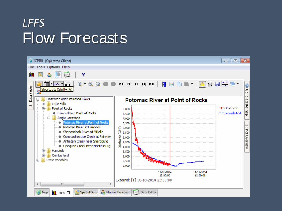
LFFSFlow Forecasts

LFFSFlow Forecasts

LFFSVisual Tools

LFFS Status
First version completed April 2014
“Live” model Updating continuously on ICPRB’s Linux server Accessible on multiple PC’s via “Operator-Client” user interface
“Stand-alone” models Independent copies of LFFS that can be run manually
Can be used for research and development
ICPRB conducting tests & evaluations

ICPRB’s First Impressions
CHPS/FEWS robust
flexible & modifiable (based on xml & python files)
may facilitate info exchange with River Forecast Centers
Real-time meteorological data & forecasts wide array of products
constantly evolving
Real-time use of CPB Watershed Model CHPS/FEWS visual tools valuable
summer 2014 raw flow predictions disappointing

Future Directions
Short-term Compare performance of various precipitation datasets
Implement access to MARFC’s new streamflow ensemble forecasts
Longer-term Develop “data assimilation” algorithms
Improve reservoir release simulations
Investigation of low-flow sensitivitiesWater withdrawal & discharge inputs
Groundwater discharge algorithm (see JAWRA – Sep 2014)
Surface evaporation/riparian ET Channel routing