r&d technical report
TRANSCRIPT

R&D No.RD/2016/919
TECHNICAL REPORT
AIR & DDI
PRASAR BHARATI RESEARCH DEPARTMENT
ALL INDIA RADIO & DOORDARSHAN
Reception survey for assessment of coverage area for satisfactory reception of
HPT (TV) Transmitter (Analogue) Located
at Agra (Uttar Pradesh)

Reception survey for assessment of coverage area for satisfactory reception of
HPT (TV) Transmitter (Analogue) Located
at Agra (Uttar Pradesh)
(Survey Period: 25/07/2016 to 02/08/2016)

Field Strength Measurement/Reception Survey Team
PROPAGATION LAB
Team Leader : Sh. G.P.Srivastava (AE)
Team Members : Sh. Bani Singh (AE)
Sh. Kartar Singh (Sr.Tech)
Sh. Chandraballabh (Sr.Tech)
Assisted By : Md. Javed Shams (AE)
Staff Car Drivers : Sh. H.N. Mishra (SCD)
Guided By : Sh. Deepak Kumar (DDG)
Inspired By : Mrs. Anuradha Agarwal (ADG)

Table of Content Sr.No Particulars Page
1 Introduction 1 2 Objective of survey 1 3 Measuring Instrument Used 1 4 Basic data & transmitter details 2 5 System Configuration 3 8 Measurement set up 3 9 Selection of sites for measurement 4 10 Measurement Methodology 4 11 TV Broadcast signal propagation 5 12 Collection of field strength data 5 13 Broadcast service area 6 14 Interpretation of the collected data along radials 7 15 Conclusion 8 16 Scope of further study 8 17 Acknowledgement 8 18 Table-1 (Direction: North,Radial-1) 9 19 Table-2,( Direction: North-East, Radial-2) 10 20 Table-3,( Direction: East, Radial-3) 11 21 Table-4,( Direction: South-East, Radial-4) 12 22 Table-5,( Direction: South, Radial-5) 13 23 Table-6,(Direction: South-West, Radial-6) 14 24 Table-7,(Direction: West, Radial-7) 15 25 Table-8 (Direction: North-West, Radial-8) 16 26 Table-9, Coverage contour for satisfactory reception of DVB-T2 Transmission 17 28 Annexure-I, Radial route map originating from the location of the transmitter 18 29 Annexure-II, Contour map for primary coverage 19 30 Annexure-III, Variation of Field Strength & MER with distance along North & North-East Directions 20 31 Annexure-IV, Variation of Field Strength & MER with distance along East & South-East Directions 21 32 Annexure-V, Variation of Field Strength & MER with distance along South & South-West Directions 22 33 Annexure-III, Variation of Field Strength & MER with distance along West & North-West Directions 23
1
Introduction:
A decade ago most of the TV transmitters in India were either valve based or semi-solid state based. Later on valve based transmitters were replaced with new solid state transmitters which are more power efficient, robust & easy to manage them. In this process one of the transmitter located at historical city Agra carrying DD National Programme was replaced with new R&S make solid state VHF TV transmitter in December 2014 however another one carrying DD NEWS Programme are through NEC make transmitter. Both the transmitters are of 10kW rated power which combines in a combiner & thus using single radiator mounted at a height of 150 meter concrete TV tower. In respect of the new R&S transmitter coverage of satisfactory reception is to be predicted. This task was given to Propagation Lab unit of The Research Department. A four member survey team was constituted & deployed for carrying out field strength survey for assessment of coverage area. The survey work was carried out during the period 26/07/2016 to 02/08/2016.The scope of this field trial was to assess the primary coverage area of R&S make TV transmitter broadcasting DD National Programme. The survey was carried out for fixed antenna reception mode mounted at a height of 10 Meters
Objective:
1. Ascertaining the coverage area for satisfactory reception of DVB-T2 Transmission.
2. To envisage minimum field strength value for satisfactory reception. Equipment Used:
1. Spectrum Analyzer(Make: Anritsu, Model: MS 2035B & MS 2013E)
2. VHF Dipole antenna(Make: Anritsu, Model: MP534B)
3. GPS Navigator(Make: Garmin, Model: Montana 650)
4. LED TV Receiver(Make: Sony, )
5. Survey Van fitted with 10 Meters Mast & Portable Generator etc)

2
Basic Data and Transmitter details
Transmitters Details: 1. Name of Station : HPT(TV) Tower, Agra(UP)
2. Location of the Transmitters : LAT- N 27° 07'05.5" (In 6 figure coordinates) LON- E 78° 03'00.4"
MSL-169 Meter
3. Description of terrain around the : Urban, Moderate Traffic, Transmitters
4. Classification(Large city/urban/rural) : Urban 5. Rated power of the Transmitter : 10.0kW 6. Forward radiated Power : 9.41kW 7. Reflected Power : 0.0W 8. VSWR : 1.10 9. Transmission Mode : Analogue(PAL) 10. Make : Rohde & Schwarz 11. Model No. : NM850 X E/V 12. Frequency of operation : Vision:203.2396 (CH#9)
Aural: 208.7396 Offset (-)
13. Date of Commissioning : December-2014 :
Transmitting Antenna Details: 1. Make : Dielectric 2. Type /Model of Antenna : Turnstile Pol/Air Dielectric 3. Antenna Gain : 12.5dB 4. Height of Tower : 210 Meter 5. Effective height of antenna(Midbay) : Not available 6. Type of Polarization : Horizontal 7. Tower : RCC &SS
3
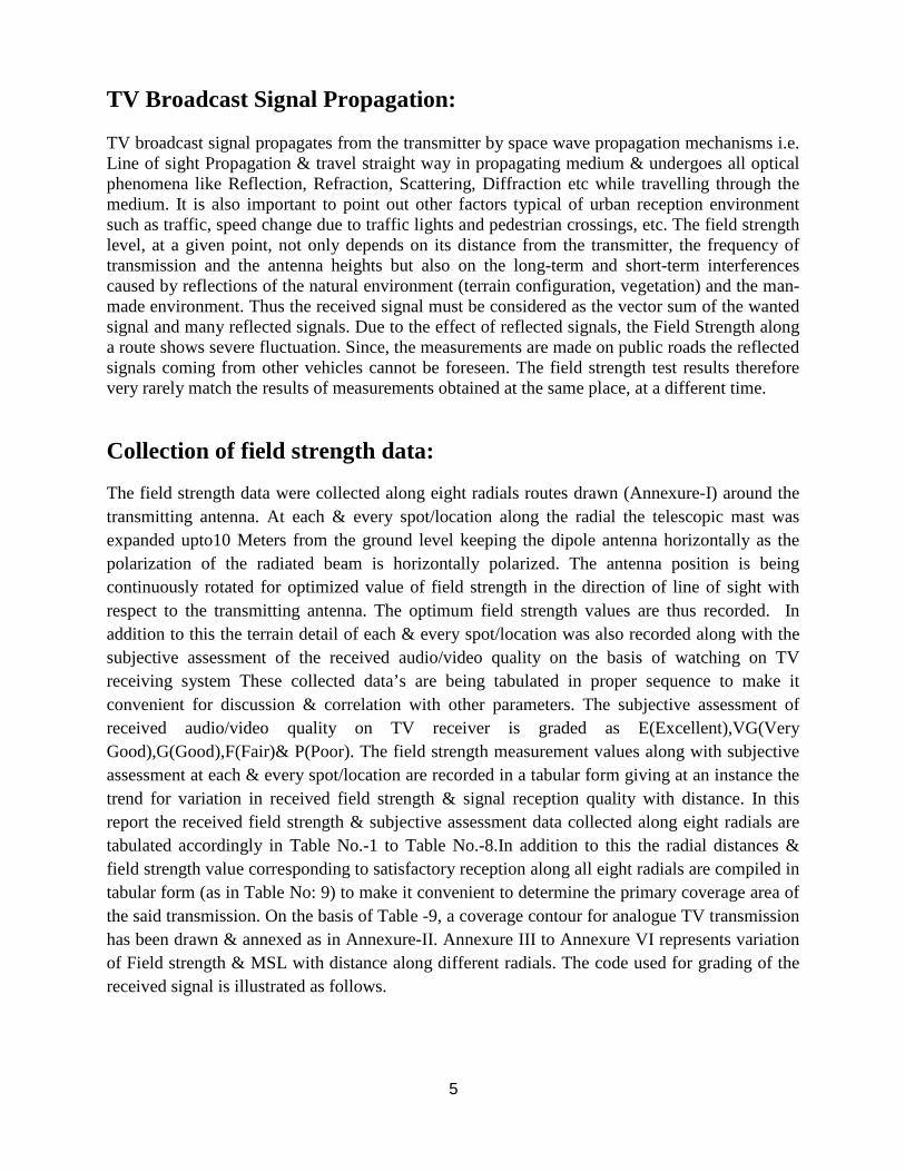
System configuration: The field trials system mainly consists of field strength measuring equipment, standard calibrated VHF Dipole antenna & Yagi receiving antenna for receiving horizontally polarized TV Broadcast signal, Portable Generator, 10 Meters electromechanically operated telescopic mast housed in a customized Survey Van of Research Department. A pictorial diagram is given below.
Measurement Set Up:
The field trials were carried out by utilizing mobile survey van of Research Department having 10 meter pneumatic telescopic mast. Field strength measurement was carried out, using Anritsu make Spectrum Analyzer & VHF Dipole Antenna. The whole system was assembled in a mobile van with power generating system (portable generator set). The two main components of the reception set up are analogue TV receiving system and field strength measuring system (Spectrum Analyzer). A calibrated VHF dipole antenna is used to receive the signal whereas for subjective assessment of the received signal was performed by using Sony makes LED TV. In addition to this Garmin make GPS navigator was used for determination of the spot/location co-ordinate in six figures & radial distance from the transmitter location.
Spectrum Analyzer
TV Receiver
LED TV
Standard Dipole Antenna VHF Yagi Antenna

4
Selection of sites for measurement: As far as practicable an open & safe spot/ location (overhead power and telephone cables, trees and other hazards were avoided) was chosen for the measurement of received field strength. Instead of cluster measurement (measurement at four to five spot for a given location), single sample method in this survey is preferred, because of the additional time that may be taken in making cluster measurements (due to the frequent raising or lowering of the receiving antenna & insufficient space along the motor able road side), or because of the hazards in moving the measuring vehicle while the antenna is fully erected. High tension overhead wires, close to high raise buildings & elevated flyovers/underpasses were avoided while collecting field strength data along a radial route.
Measurement Methodology: A map of the largest available scale was used to mark the location of the transmitters. From the transmitter location eight radials are drawn passing through the transmitter location along North, East, South, West, North-East, North-West, South East & South West directions. For prediction of the coverage area, field strength measurement along a radial is carried out by employing mobile survey van having 10Mtrs telescopic mast with rotor & tilt facility. For field strength measurement the survey vehicle was mostly parked in open space, raising the telescopic mast up to the required height of 10 meters & then rotating the antenna to align it along the direction of transmission source for getting optimum value of field strength. While taking static reception measurement LAT/LONG, MSL & radial distance of each & every location was also recorded. Once all measurements have been undertaken, mast is fully retracted & then driven away for the next location. Since the purpose of the survey was to determine the primary coverage area for satisfactory reception so the measurement was carried out in static condition along motorable roads. The same procedures for field strength measurement/reception survey are adopted along all other eight radials. After data collection is over the FSM data are tabulated & interpreted on the basis of the findings.The quality of received audio/video was also analyzed by using SONY make receiver under given terrain conditions. The environment classification criteria are: Rural Areas with scarce isolated buildings, open fields. Suburban Small towns; residential areas with low building density and buildings
not higher than two stories; wide roads or streets between buildings. Urban Big to medium sized cities, residential areas with high density of
buildings; areas where buildings are higher than two stories and close distances between them
Large Cities Densely populated cities having cluster of township with high rise building & skyscrapers
5
TV Broadcast Signal Propagation: TV broadcast signal propagates from the transmitter by space wave propagation mechanisms i.e. Line of sight Propagation & travel straight way in propagating medium & undergoes all optical phenomena like Reflection, Refraction, Scattering, Diffraction etc while travelling through the medium. It is also important to point out other factors typical of urban reception environment such as traffic, speed change due to traffic lights and pedestrian crossings, etc. The field strength level, at a given point, not only depends on its distance from the transmitter, the frequency of transmission and the antenna heights but also on the long-term and short-term interferences caused by reflections of the natural environment (terrain configuration, vegetation) and the man-made environment. Thus the received signal must be considered as the vector sum of the wanted signal and many reflected signals. Due to the effect of reflected signals, the Field Strength along a route shows severe fluctuation. Since, the measurements are made on public roads the reflected signals coming from other vehicles cannot be foreseen. The field strength test results therefore very rarely match the results of measurements obtained at the same place, at a different time.
Collection of field strength data:
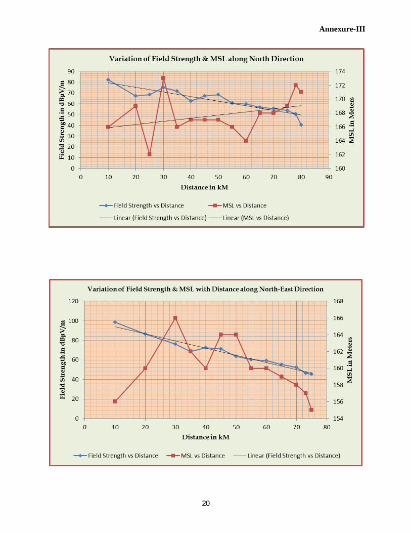
The field strength data were collected along eight radials routes drawn (Annexure-I) around the transmitting antenna. At each & every spot/location along the radial the telescopic mast was expanded upto10 Meters from the ground level keeping the dipole antenna horizontally as the polarization of the radiated beam is horizontally polarized. The antenna position is being continuously rotated for optimized value of field strength in the direction of line of sight with respect to the transmitting antenna. The optimum field strength values are thus recorded. In addition to this the terrain detail of each & every spot/location was also recorded along with the subjective assessment of the received audio/video quality on the basis of watching on TV receiving system These collected data’s are being tabulated in proper sequence to make it convenient for discussion & correlation with other parameters. The subjective assessment of received audio/video quality on TV receiver is graded as E(Excellent),VG(Very Good),G(Good),F(Fair)& P(Poor). The field strength measurement values along with subjective assessment at each & every spot/location are recorded in a tabular form giving at an instance the trend for variation in received field strength & signal reception quality with distance. In this report the received field strength & subjective assessment data collected along eight radials are tabulated accordingly in Table No.-1 to Table No.-8.In addition to this the radial distances & field strength value corresponding to satisfactory reception along all eight radials are compiled in tabular form (as in Table No: 9) to make it convenient to determine the primary coverage area of the said transmission. On the basis of Table -9, a coverage contour for analogue TV transmission has been drawn & annexed as in Annexure-II. Annexure III to Annexure VI represents variation of Field strength & MSL with distance along different radials. The code used for grading of the received signal is illustrated as follows.
6
Criteria for grading of received signal on the basis of subjective assessment:
Signal
E Excellent No impairment in received audio/video quality.
VG Very Good Near to excellent with antenna direction
G Good Light grains on screen but irritable of nature
F Fair Moderate grains on TV screen but tolerable
P Poor Huge grains causing irritation & intolerable
Broadcast Service Area:
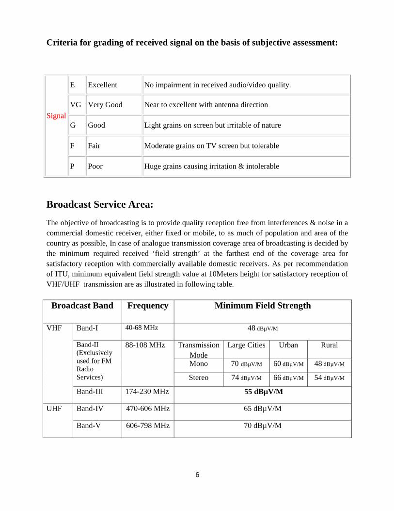
The objective of broadcasting is to provide quality reception free from interferences & noise in a commercial domestic receiver, either fixed or mobile, to as much of population and area of the country as possible, In case of analogue transmission coverage area of broadcasting is decided by the minimum required received ‘field strength’ at the farthest end of the coverage area for satisfactory reception with commercially available domestic receivers. As per recommendation of ITU, minimum equivalent field strength value at 10Meters height for satisfactory reception of VHF/UHF transmission are as illustrated in following table.
Broadcast Band Frequency Minimum Field Strength
VHF Band-I 40-68 MHz 48 dBµV/M
Band-II (Exclusively used for FM Radio Services)
88-108 MHz Transmission Mode
Large Cities Urban Rural
Mono 70 dBµV/M 60 dBµV/M 48 dBµV/M
Stereo 74 dBµV/M 66 dBµV/M 54 dBµV/M
Band-III 174-230 MHz 55 dBµV/M
UHF Band-IV 470-606 MHz 65 dBµV/M
Band-V 606-798 MHz 70 dBµV/M

7
Interpretation of the collected data along radials:
In this report efforts are being made for the interpretation & analysis of the collected FSM data along a radial & then a coverage contour based on compiled Table-9 for satisfactory reception of DVB-T2 transmission was drawn on a map.
1. Radial-1(North): Along this radial field strength measurement done at location like Khandauli-Sadabad-Mitai-Hathras-Samamai Ruhal-Hashimpur- Mainath & Aligarh up to a radial distance of 80kM .Satisfactory reception of HPT(TV) Transmission was observed to be up to a radial distance of 75kM (Mainath near Aligarh Toll Plaza)
2. Radial-2 (North-East): Along this radial field strength measurement done at location like Chhalesar- Nagla Raiya-Tundla-Ummergarh-Awagarh-Sawant Khera-Chamkari & Etah up to a radial distance of 75 kM . Satisfactory reception of HPT(TV)Transmission was observed to be up to a radial distance of 65kM (Sawant Khera,10 kM before Etah)
3. Radial-3(East): Along this radial field strength measurement done at location like
Raja Ka Tal-Dabrai-Nagla Bhudha (Aronj)-Shikohabad-Mandai-Baijuakhas & Ghiror(Mainpuri) up to a radial distance of 75 kM . Satisfactory reception of HPT (TV) Transmission was observed to be up to a radial distance of 55kM (Shikohabad).
4. Radial-4(South- East): Along this radial field strength measurement done at location like Mutawai-Rasulpur(Fatehabad)-Basai Arela-Bhadrauli-Bah-Rooppura & Gadhia Pratappura up to a radial distance of 80 kM . Satisfactory reception of HPT(TV) Transmission was observed to be up to a radial distance of 60kM (Bah)
5. Radial-5(South): Along this radial field strength measurement done at location like Hirner
Newadakhera-Mithawali-Sahajpur-Dholpur-Jaitpur(Chambal)-Sikrauda-Morena & Chonda up to a radial distance of 75 kM . Satisfactory reception of HPT (TV) Transmission was observed to be up to a radial distance of 65kM (Sikrauda).
6. Radial-6(South-West):Along this radial field strength measurement done at location like Bad-Sarenda-Ata-Patparganj-Mewla-Deori-Tantpur-Kot-Jaisora&Bayana(Jaisora) up to a radial distance of 75 kM . Satisfactory reception of HPT (TV) Transmission was observed to be up to a radial distance of 73kM (Jaisora).
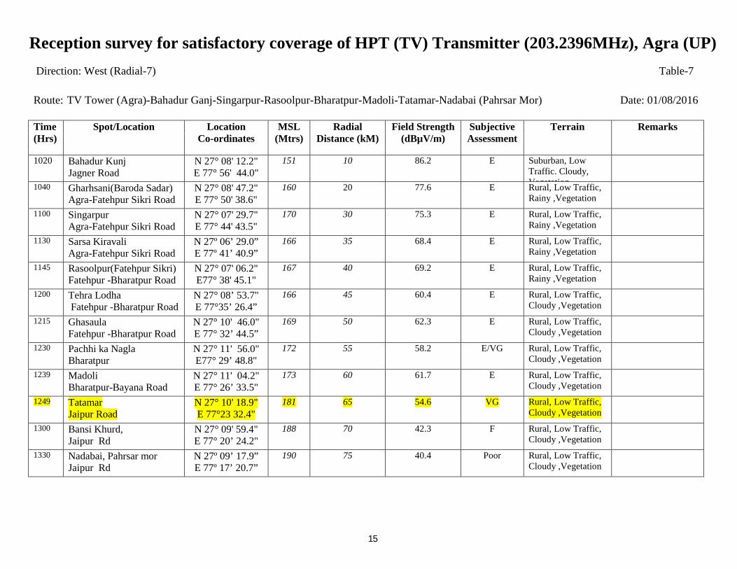
7. Radial-7(West): Along this radial field strength measurement done at location like Bahadur Ganj-Singarpur-Rasoolpur-Bharatpur-Madoli-Tatamar & Nadabai (Pahrsar Mor) up to a radial distance of 75 kM . Satisfactory reception of HPT (TV) Transmission was observed to be up to a radial distance of 65kM (Tatamar).
8. Radial-8(North-West): Along this radial field strength measurement done at location like Jawahar Nagar-Shehzadpur Pauri-Mahuan-Mathura-Jait-Ajhai Kalan-Akbarpur & Chhata up to a radial distance of 85 kM . Satisfactory reception of HPT (TV) Transmission was observed to be up to a radial distance of 75kM (IVS Polytechnic, Akbarpur).

8
Conclusion:
On the basis of received field strength values & subjective assessment of the video quality at various spot/location along eight radials & coverage contour(Annexure-II) drawn on the basis of table prepared/compiled for satisfactory reception of analogue TV transmission following conclusions can be stipulated.
1. The coverage along North, South-West & North-West direction is up to a radial distance of 73-75 kM. In North-East, South & West direction coverage is up to 65 kM whereas along East & South-East direction it is up to a radial distance of 55 kM & 60 kM respectively.
2. The coverage along East & South-East direction is the least .This shrinkage in coverage is mainly due to the existence of pockets of low level land. The MSL level along these direction goes down up to 150-140 Meters beyond 40-50 kM radial distance from the location of HPT (TV) transmitting tower. This leads to variation in field strength due to height gain or loss. However along South-West direction beyond 50 kM from the HPT (TV) tower variation in field strength was observed mainly due to existence of hilly terrain.
3. Predicted coverage contour (Annexure-II) reveals that reception is satisfactory within the predicted coverage area (up to 55-75 kM) all around HPT (TV) Tower Agra with fixed roof top antenna mounted at a height of 10Mtrs from the ground.
4. No interference of unwanted signal in reception of analogue transmission has been
observed within its coverage area. .
Acknowledgement:
The propagation studies presented in this document are carried out by the Propagation Lab of Research Department of All India Radio & Doordarshan, New Delhi. The field trial was successfully done & the entire team acknowledges the sincere support, contribution & cooperation of the shift duty staff of HPT (TV) Tower, Agra (UP). Survey team also extends their gratitude to Sh. S.P.Jaiswal (DDE) who has extended all possible help to the survey team of research department. The survey team expresses their deepest sense of gratitude to Mrs. Anuradha Agarwal (ADG) & Sh. Deepak Kumar (DDG) whose enthusiastic supervision, motivation, suggestion & cooperation at every step helped in the successful completion of the survey.

Reception survey for satisfactory coverage of HPT (TV) Transmitter (203.2396MHz), Agra (UP)
9
Direction: North (Radial-1) Table-1 Route: TV Tower (Agra) - Khandauli-Sadabad-Mitai-Hathras-Samamai Ruhal-Hashimpur- Mainath-Aligarh Date: 26/07/2016
Time (Hrs)
Spot/Location
Location Co-ordinates
MSL (Mtrs)
Radial Distance (kM)
Field Strength (dBµV/m)
Subjective Assessment
Terrain Remarks
1230
Foundary Nagar Hathras Road
N 27°13’44.6” E 78°02’45.2”
166 10 82.3 E Suburban, Vegetation, Low Traffic. Cloudy,
1330 Khandauli Khandauli-Baldeo Road
N27°19’00.7” E78°01’42.0”
169 20 67.2 E Rural, Vegetation, Low Traffic, Cloudy.
1515 Bohare (Jarau) Kursanda-Sadabad Road
N27°21’43.3” E78°01’58.4”
162 25 68.5 E Rural, Vegetation, Low Traffic. , Cloudy.
1625 Kuktai (Wedai) Kursanda-Sadabad Road
N27°24’22.1 E78°02’16.6”
173 30 75.1 E Rural, Vegetation, Low Traffic. , Cloudy.
1700 Sadabad Sadabad-Hathras Road
N27°27’06.2” E78°02’25.7”
166 35 71.8 E Rural, Vegetation, Low Traffic. , Cloudy.
1726 Santikara Sadabad-Hathras Road
N27º29’55.5” E78°02’48.6”
167 40 62.4 E Rural, Vegetation, Low Traffic. , Cloudy.
1740 Mitai Hathras Bypass Road
N27º32’28.3” E78°02’42.8”
167 45 67.3 E Rural, Vegetation, Low Traffic. , Cloudy.
1810 Khonda Hajari Hathras Bypass Road
N27º35’01.0” E78°01’12.8”
167 50 68.4 E Rural, Vegetation, Low Traffic. , Cloudy.
1830 Nagla Ummed, Hathras Hathras Bypass Road
N27º37’57.7” E78°03’34.4”
166 55 60.5 VG Rural, Vegetation, Low Traffic. , Cloudy.
1900 Kanya Gurkul Sasni Hathras-Aligarh Road
N27°40’33.4” E78°04’19.1”
164 60 59.7 VG Rural, Vegetation, Low Traffic. , Cloudy.
1915 Samamai Ruhal Hathras-Aligarh Road
N27°43’18.5” E78°05’11.0”
168 65 56.8 VG Rural, Vegetation, Low Traffic. , Cloudy.
1930 Hashimpur Hathras-Aligarh Road
N27°45’50.7” E78°05’16.1”
168 70 55.6 VG Rural, Vegetation, Low Traffic. , Cloudy.
1945 Mainath Near Aligarh Toll Plaza
N27°48’37.8 E78°05’11.5”
169 75 53.8 VG Rural, Vegetation, Low Traffic. , Cloudy.
2000 Rustampur Sakatkhan Near Aligarh
N27°50’09.4” E78°04’46.5”
172 78 50.4 G Rural, Vegetation, Low Traffic. , Cloudy.
2030 R.K.Puram (Sasni Gate) ,Aligarh
N27°51’34.0” E78°04’32.3”
171 80 40.3 F/P Urban, Moderate Traffic, cloudy

Reception survey for satisfactory coverage of HPT (TV) Transmitter (203.2396MHz), Agra (UP)
10
Direction: North- East (Radial-2) Table-2 Route: TV Tower (Agra)-Chhalesar- Nagla Raiya-Tundla-Ummergarh-Awagarh-Sawant Khera-Chamkari-Etah Date: 27/07/2016
Time (Hrs)
Spot/Location
Location Co-ordinates
MSL (Mtrs)
Radial Distance (kM)
Field Strength (dBµV/m)
Subjective Assessment
Terrain Remarks
1300 Chhalesar(Kuberpur) Firozabad road
N27°12’59.8” E78°05’17.1”
156 10 98.8 E Rural , Heavy Traffic, Cloudy
1415 Satauli (Tundla) Firozabad road
N27°13’54.8” E78°13’11.0”
160 20 86.5 E Rural , Heavy Traffic, Cloudy
1525 Nagla raiya ( Tundla )
166 30 76.2 E Rural, Vegetation, Cloudy.
1600 Radau Pahar Pur Tundla-Etah Road
N27°19’21.3” E78°19’50.2”
162 35 68.5 E Rural, Vegetation, Cloudy.
1615 Ummergarh Tundla-Etah Road
N27°21’31.3” E78°22’21.0”
160 40 72.4 E Rural, Vegetation, Cloudy.
1630 Jarani Hanspur, Chauki Tundla-Etah Road
N27°23’10.4” E78°24’14.5”
164 45 71.3 E Rural, Vegetation, Cloudy.
1700 Churthara Tundla-Etah Road
N27°25’04.6” E78°26’48.4”
164 50 63.6 E Rural, Vegetation, Cloudy.
1730 Awagarh Tundla-Etah Road
N27° 26’25.5” E78°29’02.8”
160 55 60.4 E Rural, Vegetation, Cloudy.
1745 Nawali Tundla-Etah Road
N27°28’04.0” E78° 31’28.5”
160 60 59.4 VG Rural, Vegetation, Cloudy.
1800 Sawant Khera Tundla-Etah Road
N27°29’55.9” E78°33’52.1”
159 65 55.4 VG/G Rural, Vegetation, Cloudy.
1830 Jawara Tundla-Etah Road
N27°31’34.1” E78°36’14.3”
158 70 52.2 G Rural, Vegetation, Cloudy.
1845 Chamkari Tundla-Etah Road
N27°32’40.0” E78°37’52.1”
157 73 46.3 F Suburban, Low Traffic, Cloudy.
1950 Mhila Thanaa (Etah ) Tundla-Etah Road
N27°33’17.7” E78°38’46.0”
155 75 45.4 F/P Urban, Low Traffic, Cloudy

Reception survey for satisfactory coverage of HPT (TV) Transmitter (203.2396MHz), Agra (UP)
11
Direction: East (Radial-3) Table-3 Route: TV Tower (Agra)-Raja Ka Tal-Dabrai-Nagla Bhudha (Aronj)-Shikohabad-Mandai-Baijuakhas-Ghiror Date: 28/07/2016
Time (Hrs)
Spot/Location
Location Co-ordinates
MSL (Mtrs)
Radial Distance (kM)
Field Strength (dBµV/m)
Subjective Assessment
Terrain Remarks
1300 Dhirpur ( Tundla ) Link Road
N27°08’50.7” E78°17’02.4”
155 23 80.2 E Rural, Vegetation Low Traffic Cloudy
1340 Alinagar Kenjra Raaja ka Taal Road
N27°11’11.9” E78°20’41.5”
159 30 72.0 E Rural, Vegetation Low Traffic Cloudy
1425 Nagla Mirza Bara Firozabad Bypass Road
N27°09’17.3” E78°24’23.0”
164 35 63.6 E Urban, Heavy Traffic, Cloudy
1445 Dabrai Firozabad-Shikohabad Rd
N27°07’30.7” E78°27’27.0”
161 40 72.4 E Suburban, Moderate Traffic, Cloudy
1500 Mohammdpur Nawada Firozabad-Shikohabad Rd
N27°07’23.8” E78°30’24.4”
161 45 61.7 E Rural, Vegetation Low Traffic Cloudy
1600 Nagla Bhuda (Aronj) Firozabad-Shikohabad Rd
N27°06’58.7” E78°33’14.3”
153 50 61.3 E Rural, Vegetation Low Traffic Cloudy
1625 Shikohabad Shikohabad Bypass Road
N27°06’16.8” E78°36’12.6”
154 55 54.7 VG/G Rural, Vegetation Low Traffic Cloudy
1645 Mandai Mainpuri Link Road
N27°07’43.7” E78°39’24.1”
152 60 47.5 F Rural, Vegetation Low Traffic Cloudy
1700 Baijuakhas Mainpuri Road N 27°07’00.1” E78°42’16.6”
149 65 45.4 F Rural, Vegetation Low Traffic Cloudy
1715 Bharaul Mainpuri Road
N 27°10’05.6” E78°45’ 18.5”
146 70 44.1 P Rural, Vegetation Low Traffic Cloudy
1745 Ghiror (Mainpuri) N 27°11’24.4” E78° 48’ 19.8”
149 75 42.4 P Urban, Moderate Traffic.

Reception survey for satisfactory coverage of HPT (TV) Transmitter (203.2396MHz), Agra (UP)
12
Direction: South-East (Radial-4) Table-4 Route: TV Tower (Agra)- Mutawai-Rasulpur(Fatehabad)-Basai Arela-Bhadrauli-Bah-Rooppura-Gadhia Pratappura Date: 29/07/2016
Time (Hrs)
Spot/Location
Location Co-ordinates
MSL (Mtrs)
Radial Distance (kM)
Field Strength (dBµV/m)
Subjective Assessment
Terrain Remarks
1330 Kachhpura , Kundol Fatehabad Road
N27°06’25.1” E78°08’53.7”
160 10 90.5 E Rural Low Traffic. Cloudy, Vegetation
1400 Mutawai Fatehabad Road
N27°03’36.0” E78°14’09.0”
155 20 84.3 E Rural Low Traffic. Cloudy, Vegetation
1515 Rasulpur (Fatehabad) Fatehabad-Arnota Road
N27°00’34.3” E78°19’10.9”
157 30 71.4 E Rural Low Traffic. Cloudy, Vegetation
1530 Nayapura (Khandar) Fatehabad-Arnota Road
N26°58’28.2” E78°21’21.7”
157 35 68.2 E Rural Low Traffic. Cloudy, Vegetation
1555 Basai Arela Arnota-Bah Road
N26°56’25.4” E78° 23’29.3”
160 40 62.5 E Rural Low Traffic. Cloudy, Vegetation
1645 Sutahari Arnota-Bah Road
N26°54’55.5” E78°26’16.0”
155 45 58.2 E Rural Low Traffic. Cloudy, Vegetation
1715 Bhadrauli Arnota-Bah Road
N26°53’54.1” E78°28’52.8”
150 50 56.6 E Rural Low Traffic. Cloudy, Vegetation
1730 Pharaira Arnota-Bah Road
N26°53’01.2” E78°31’47.6”
146 55 56.2 VG Rural Low Traffic. Cloudy, Vegetation
1740 Bah Arnota-Bah Road
N26°52’20.0” E78°34’51.8”
145 60 54.6. VG Rural Low Traffic. Cloudy, Vegetation
1800 Badagaon Bah-Udi Road
N26° 51’24.4” E78° 37’41.4”
146 65 50.7 G Rural Low Traffic. Cloudy, Vegetation
1830 Rooppura Bah-Udi Road
N26°50’17.5” E78°40’ 27.1”
144 70 45.6 G/F Rural Low Traffic. Cloudy, Vegetation
1900 Pyarampura Bah-Udi Road
N26°49’26.1” E78°43’15.5”
144 75 46.2 G/F Rural Low Traffic. Cloudy, Vegetation
1920 Gadhia Pratappura Bah-Udi Road
N26°48’23.6” E78°46’12.2”
142 80 37.4 Poor Rural Low Traffic. Cloudy, Vegetation
Ch#12(DD NEWS)-Good

Reception survey for satisfactory coverage of HPT (TV) Transmitter (203.2396MHz), Agra (UP)
13
Direction: South (Radial-5) Table-5 Route: TV Tower (Agra)-Hirner Newadakhera-Mithawali-Sahajpur-Dholpur-Jaitpur Chambal-Sikrauda-Morena-Chonda Date: 30/07/2016
Time (Hrs)
Spot/Location
Location Co-ordinates
MSL (Mtrs)
Radial Distance (kM)
Field Strength (dBµV/m)
Subjective Assessment
Terrain Remarks
1030 Hirner Newadakhera Agra-Shamsabad Road
N27°03’18.3” E78°06’10.0”
158 10 87.7 E Rural, Vegetation, Cloudy
1100 Thana Shankar Dwari Chandipura Road
N26°57’21.9” E78°06’06.5”
150 20 75.2 E Rural, Vegetation, Cloudy
1600 Mithawali RajaKhera-Dholpur Road
N26°52’11.7” E78° 07’31.6”
162 30 72.2 E Rural, Vegetation, Low Traffic, Rainy
1645 Pahari RajaKhera-Dholpur Road
N26°48’54.2” E78°03’06.5”
166 35 69.4 E Rural, Vegetation, Low Traffic, Rainy
Rajasthan
1725 Sahajpur RajaKhera-Dholpur Road
N26°46’04.7” E77°59’27.2”
168 40 65.9 E Rural, Vegetation, Low Traffic, Rainy
Rajasthan
1800 Kharagpura RajaKhera-Dholpur Road
N26°44’09.9” E77°55’15.2”
171 45 65.2 E Rural, Vegetation, Low Traffic, Rainy
Rajasthan
1830 Dholpur Agra-Dholpur Road
N26°41’47.3” E77°53’27.5”
174 50 57.5 VG Urban, Flyover, Heavy Traffic,
Rajasthan
1850 Jaitpur Chambal Dholpur-Morena Road
N26°38’59.2” E77°54’41.2”
149 55 59.6 E Rural, Vegetation, Low Traffic, Rainy
M.P
1900 Bandha Dholpur-Morena Road
N26°35’39.2” E77°56’29.9”
168 60 58.7 VG Rural, Vegetation, Low Traffic, Rainy
M.P
1930 Sikrauda (Hingona Khurd) Dholpur-Morena Road
N26°32’58.2” E77°57’22.0”
166 65 55.3 VG Rural, Vegetation, Low Traffic, Rainy
M.P
1945 Morena Dholpur-Morena Road
N26°30’05.8” E77°58’31.8”
166 70 45.7 F Urban ,Moderate Traffic, Cloudy
M.P
2030 Chonda (Toll Plaza Morena)
N26° 28’0.07” E78°00’30.7”
170 75 44.2 Poor Rural, Moderate Traffic, Cloudy
M.P

Reception survey for satisfactory coverage of HPT (TV) Transmitter (203.2396MHz), Agra (UP)
14
Direction: South-West (Radial-6) Table-6 Route: TV Tower (Agra)-Bad-Sarenda- Ata-Patparganj-Mewla-Deori-Tantpur- Kot-Jaisora-Bayana(Jaisora) Date: 31/07/2016
Time (Hrs)
Spot/Location
Location Co-ordinates
MSL (Mtrs)
Radial Distance (kM)
Field Strength (dBµV/m)
Subjective Assessment
Terrain Remarks
1020 Bad Agra-Mumbai NH-44
N27°03'42.1" E77°58'55.4"
154 10 92.4 E Suburban, Moderate Traffic. Vegetation Cloudy
1100 Gahara Khurd, Agra-Jagner Road
N27°02'47.7" E77°52'06.8"
158 20 82.2 E Rural, Low traffic Vegetation, Cloudy
1130 Nagla Vishnu (Sarenda) Agra-Jagner Road
N26°59'07.2" E77°47'14.1"
160 30 63.8 E Rural.. Low Traffic. Vegetation, Cloudy
U.P
1200 Kolua (Ata) Agra-Jagner Road
N26°57'16.2" E77°45'00.4"
164 35 72.5 E Rural.. Low Traffic. Vegetation, Cloudy
Rajasthan
1230 Naripura (Patparganj) Agra-Jagner Road
N26°56'06.0" E77°42'26.2"
169 40 65.4 E Rural.. Low Traffic. Vegetation, Cloudy
Rajasthan
0100 Nangla Imli Agra-Jagner Road
N26°54’35.8" E77°39’30.7”
168 45 64.2 E Rural.. Low Traffic. Vegetation, Cloudy
Rajasthan
1330 Chaprai Estate (Mewla) Agra-Jagner Road
N26°52'52.3" E77°37’22.5”
174 50 55.4 VG Rural.. Low Traffic. Vegetation, Cloudy
Rajasthan
1400 Deori Jagner-Tantpur Road
N26°51' 27.1" E77°35’03.1"
178 55 57.2 VG Rural.. Low Traffic. Vegetation, Cloudy
Rajasthan
1415 Nayagaon Jagner-Tantpur Road
N26°50'47.2" E77°31’57.3"
186 60 61.6 E Rural, Hilly Cloudy Vegetation
Rajasthan
1430 Tantpur Jagner-Tantpur Road
N26°50'21.0" E77°28’28.0"
206 65 60.7 E Rural, Hilly Cloudy Vegetation
Rajasthan
1500 Bangra ( Kot) N26°48'57.3" E77°26’05.0"
231 70 57.1 VG Rural, Hilly Cloudy Vegetation
1515 Jaisora Khatnawli-Jheel Road
N26º46’37.9” E77º25’41.1”
214 73 55.2 VG Rural, Hilly Cloudy Vegetation
1530 Bayaana (Jaisora) Khatnawli-Jheel Road
N26º45’20.6” E77º25’41.5”
220 75 52.4 Good Rural, Hilly Cloudy Vegetation
Reception survey for satisfactory coverage of HPT (TV) Transmitter (203.2396MHz), Agra (UP)
15
Direction: West (Radial-7) Table-7 Route: TV Tower (Agra)-Bahadur Ganj-Singarpur-Rasoolpur-Bharatpur-Madoli-Tatamar-Nadabai (Pahrsar Mor) Date: 01/08/2016
Time (Hrs)
Spot/Location
Location Co-ordinates
MSL (Mtrs)
Radial Distance (kM)
Field Strength (dBµV/m)
Subjective Assessment
Terrain Remarks
1020 Bahadur Kunj Jagner Road
N 27° 08' 12.2" E 77° 56' 44.0"
151 10 86.2 E Suburban, Low Traffic. Cloudy, Vegetation
1040 Gharhsani(Baroda Sadar) Agra-Fatehpur Sikri Road
N 27° 08' 47.2" E 77° 50' 38.6"
160 20 77.6 E Rural, Low Traffic, Rainy ,Vegetation
1100 Singarpur Agra-Fatehpur Sikri Road
N 27° 07' 29.7" E 77° 44' 43.5"
170 30 75.3 E Rural, Low Traffic, Rainy ,Vegetation
1130 Sarsa Kiravali Agra-Fatehpur Sikri Road
N 27º 06’ 29.0” E 77º 41’ 40.9”
166 35 68.4 E Rural, Low Traffic, Rainy ,Vegetation
1145 Rasoolpur(Fatehpur Sikri) Fatehpur -Bharatpur Road
N 27° 07' 06.2" E77° 38' 45.1"
167 40 69.2 E Rural, Low Traffic, Rainy ,Vegetation
1200 Tehra Lodha Fatehpur -Bharatpur Road
N 27° 08’ 53.7" E 77°35’ 26.4”
166 45 60.4 E Rural, Low Traffic, Cloudy ,Vegetation
1215 Ghasaula Fatehpur -Bharatpur Road
N 27° 10' 46.0" E 77° 32’ 44.5”
169 50 62.3 E Rural, Low Traffic, Cloudy ,Vegetation
1230 Pachhi ka Nagla Bharatpur
N 27° 11' 56.0" E77° 29’ 48.8"
172 55 58.2 E/VG Rural, Low Traffic, Cloudy ,Vegetation
1239 Madoli Bharatpur-Bayana Road
N 27° 11' 04.2" E 77° 26’ 33.5"
173 60 61.7 E Rural, Low Traffic, Cloudy ,Vegetation
1249 Tatamar Jaipur Road
N 27° 10' 18.9" E 77°23 32.4"
181 65 54.6 VG Rural, Low Traffic, Cloudy ,Vegetation
1300 Bansi Khurd, Jaipur Rd
N 27° 09' 59.4" E 77° 20’ 24.2"
188 70 42.3 F Rural, Low Traffic, Cloudy ,Vegetation
1330 Nadabai, Pahrsar mor Jaipur Rd
N 27º 09’ 17.9” E 77º 17’ 20.7”
190 75 40.4 Poor Rural, Low Traffic, Cloudy ,Vegetation

Reception survey for satisfactory coverage of HPT (TV) Transmitter (203.2396MHz), Agra (UP)
16
Direction: North-West (Radial-8) Table-8 Route: TV Tower (Agra) - Jawahar Nagar-Shehzadpur Pauri-Mahuan-Mathura-Jait-Ajhai Kalan-Akbarpur-Chhata Date: 02/08/2016
Time (Hrs)
Spot/Location
Location Co-ordinates
MSL (Mtrs)
Radial Distance (kM)
Field Strength (dBµV/m)
Subjective Assessment
Terrain Remarks
1010 Jawahar Nagar Mathura Bypass Road
N 27°12' 39.8" E 77°59' 48.8"
161 10 75.8 E Urban. High Traffic. ,Cloudy, Vegetation
1045 Runkata Mathura Road (NH-19)
N27°14' 00.4" E77°53' 44.9"
162 20 67.5 E Suburban,. Low, Traffic Vegetation,
1115 Shehzadpur Pauri Mathura Road
N27°17' 11.3" E77°47' 44.5"
162 30 74.2 E Suburban,. Low, Traffic Vegetation,
l d
1145 Farah Mathura Road (NH-19)
N27°19' 06.4" E77°45' 37.6"
166 35 72.4 E Rural, Low, Traffic Vegetation, Cloudy
1200 Mahuan Mathura Road
N27°21' 04.0" E77°43' 26.3"
171 40 68.3 E Rural, Low, Traffic Vegetation, Cloudy
1215 Refinery (Maoli Khadar) Mathura Road
N27°23 05.9" E77°41’34.6”
170 45 61.4 E Rural, Low, Traffic Vegetation, Cloudy
1330 Techman Nilgiri Mathura Road (NH-19)
N27°26' 54.0" E77°41’11.9”
172 50 63.2 E Rural, Low, Traffic Vegetation, Cloudy
1400 Mandi Samiti Mathura Delhi Road (NH-19)
N27°29' 08.8" E77°39’21.5"
170 55 52.6 G Rural, Low, Traffic Vegetation, Cloudy
1525 Village Kota , Mathura-Palwal Road
N27°33' 24.9" E77°38’52.3"
168 60 53.5 G Rural, Low, Traffic Vegetation, Cloudy
1325 Jait Mathura-Palwal Road
N27°34'30.2" E77°36’54.4"
179 65 57.1 VG Rural, Low, Traffic Vegetation, Cloudy
1600 Ajhai Kalan Mathura-Palwal Road
N27°36' 46.2" E77°35’08.8"
179 70 55.6 VG Rural, Low, Traffic Vegetation, Cloudy
1615 I V S Polytechnic, Akbarpur , Delhi Road
N27º38’53.4” E77º33’16.1”
179 75 54.4 VG Rural, Low, Traffic Vegetation, Cloudy
1625 Semri Mathura-Palwal Road
N27º41’01.9” E77º31’23.1”
179 80 51.2 G Rural, Low, Traffic Vegetation, Cloudy
1639 Chhata Mathura-Palwal Road
N27º43’34.3” E77º30’00.4”
180 85 48.3 Fair Rural, Low, Traffic Vegetation, Cloudy

Reception survey for satisfactory coverage of HPT (TV) Transmitter (203.2396MHz), Agra (UP)
17
Table for satisfactory coverage of analogue TV Transmitter Table-9
Direction Spot/Location Location Co-ordinates
Radial Distance (kM)
Field Strength (dBµV/m)
MSL (Meters)
Subjective Assessment
North Mainath Near Aligarh Toll Plaza
N27°48’37.8” E78°05’11.5”
75 53.8 169 VG
North-East Sawant Khera) Tundla-Etah Road
N27°29’55.9” E78°33’52.1”
65 55.4 159 VG
East Shikohabad Shikohabad Bypass Road
N27°06’16.8” E78°36’12.6”
55 54.7 154 VG
South-East Bah Arnota-Bah Road
N26°52’20.0” E78°34’51.8”
60 54.6 145 VG
South Sikrauda(Hingona Khurd) Dholpur-Morena Road
N26°32’58.2” E77°57’22.0”
65 55.3 166 VG
South-West Jaisora Khatnawli-Jheel Road
N26º46’37.9” E77º25’41.1”
73 55.2 214 VG
West Tatamar Jaipur Road
N27°10'18.9" E77°23 32.4"
65 54.6 181 VG
North-West I V S Polytechnic, Akbarpur , Delhi Road
N27º38’53.4” E77º33’16.1”
75 54.4 179 VG

Annexure-I
Radial Route Map originating from HPT (TV) Tower, Agra (Uttar Pradesh) 18

Annexure-II
Coverage Contour Map Analogue HPT (TV) Transmitter, Agra (Uttar Pradesh) 19
Annexure-III
20

Annexure-IV
21

Annexure-V
22

Annexure-VI
23