radiometric calibration of multi-wavelength airborne laser
TRANSCRIPT

RADIOMETRIC CALIBRATION OF MULTI-WAVELENGTH AIRBORNE LASER
SCANNING DATA
Christian Briese a,b *, Martin Pfennigbauer c, Hubert Lehnera, Andreas Ullrich c, W. Wagner a, N. Pfeifer a
a Institute of Photogrammetry and Remote Sensing of the Vienna University of Technology, Austria
b LBI for Archaeological Prospection and Virtual Archaeology, Vienna, Austria
c RIEGL Laser Measurement Systems GmbH, Horn, Austria
Commission VII, WG VII/7
KEY WORDS: Airborne, Laser scanning, LIDAR, Mapping, Radiometry, Calibration
ABSTRACT:
Airborne laser scanning (ALS) is a widely used technique for the sampling of the earth’s surface. Nowadays a wide range of ALS
sensor systems with different technical specifications can be found. One parameter is the laser wavelength which leads to a
sensitivity for the wavelength dependent backscatter characteristic of sensed surfaces. Current ALS sensors usually record next to the
geometric information additional information on the recorded signal strength of each echo. In order to utilize this information for the
study of the backscatter characteristic of the sensed surface, radiometric calibration is essential. This paper focuses on the
radiometric calibration of multi-wavelength ALS data and is based on previous work on the topic of radiometric calibration of
monochromatic (single-wavelength) ALS data. After a short introduction the theory and whole workflow for calibrating ALS data
radiometrically based on in-situ reference surfaces is presented. Furthermore, it is demonstrated that this approach for the
monochromatic calibration can be used for each channel of multi-wavelength ALS data. The resulting active multi-channel
radiometric image does not have any shadows and from a geometric viewpoint the position of the objects on top of the terrain
surface is not altered (the result is a multi-channel true orthophoto). Within this paper the approach is demonstrated by three
different single-wavelength ALS data acquisition campaigns (532nm, 1064nm and 1550nm) covering the area of the city Horn
(Austria). The results and practical issues are discussed.
* Corresponding author, [email protected].
1. INTRODUCTION
Airborne laser scanning (ALS resp. airborne LIDAR) has
established itself as a widely used technique for obtaining the
geometry of the earth’s surface. Next to the widely used
geometric information, ALS systems typically provide
additional information about the recorded signal strength of
each echo. In order to utilize this information for the study of
the backscatter characteristic of the sensed surface, radiometric
calibration is essential (Höfle and Pfeifer, 2007). Relative
radiometric calibration that tries to minimise radiometric
differences within a strip and its neighbouring strips can be
distinguished from absolute radiometric calibration where
radiometric in-situ measurements (acting as control elements)
are essential (Briese et al., 2008; Kaasalainen et al., 2009). In
order to perform an absolute radiometric calibration the ALS
observations that are affected by several influencing factors
(e.g. range, atmosphere, incidence angle, etc.) have to be
transformed into mission independent physical parameters.
Nowadays, a wide range of ALS sensor systems can be found.
They differ in the typical measurement range, measurement rate,
the instrument size, and the echo determination possibilities
(discrete echo vs. full-waveform recording). Furthermore,
dependent on the different application areas (topography,
hydrography, or glaciography), different laser wavelengths are
utilised (Pfennigbauer and Ullrich, 2011) and the selected
wavelength leads to a certain wavelength dependent backscatter
characteristic of the sensed surface.
This paper focuses on the radiometric calibration of multi-
wavelength ALS data and is based on previous step-by-step
extended research on the topic of radiometric calibration of
monochromatic (single-wavelength) ALS data (cf. Wagner et
al., 2006; Briese et al., 2008; Lehner and Briese, 2010; Roncat
et al., 2011 and Lehner et al., 2011). In the following section
the basic theory and practical workflow for the calibration of
monochromatic ALS data based on in-situ reference surfaces is
presented. Subsequently, it is demonstrated that this approach
for the practical mission independent calibration can be used for
each channel of multi-wavelength ALS data. Based on the
calibrated backscatter per echo a radiometric image for each
ALS wavelength can be calculated. In order to practically
investigate multi-wavelength radiometric calibration, ALS data
from three different single-wavelength ALS sensors (utilizing
1550 nm, 1064 nm, and 532 nm lasers) covering the area of the
city Horn (Austria) was acquired (cf. section 3). Next to the
ALS data acquisition, in-situ radiometric field measurements
were realised in order to allow an absolute radiometric
calibration (cf. section 3.4). Section 4 provides next to the study
of the three individual monochromatic calibration results the
calibrated multi-wavelength reflectance image of the city of
Horn. Finally, section 5 provides a short conclusion.
2. RADIOMETRIC CALIBRATION
Physical basis for the proposed radiometric monochromatic
calibration of ALS data is the radar equation (Jelalian, 1992),
the sought quantity is the calibration constant. Its calculation is
ISPRS Annals of the Photogrammetry, Remote Sensing and Spatial Information Sciences, Volume I-7, 2012 XXII ISPRS Congress, 25 August – 01 September 2012, Melbourne, Australia
335

presented in Section 2.1 the practical workflow for absolute
radiometric calibration based on in-situ reference is given in
2.2.
2.1 Theory
The relation of the transmitted laser power Pt and the detected
power of its echo Pr for extended targets i is given by the radar
equation (Jelalian, 1992, Wagner, 2010):
isysatm
i
rt
rR
DPP
2
2
16 (1)
with the diameter of the receiver aperture Dr, the range between
sensor and target Ri, the backscattering coefficient of the surface
i as well as transmission factors for the atmosphere atm and the
ALS system sys (Wagner, 2010; Lehner et al., 2011). The
backscattering coefficient is normalised to the laser’s
transverse area and thus independent of R and the beam
divergence of the ALS system. Assuming that all targets i are
diffuse (due to the typically short ALS wavelength for most
surfaces justifiable) and reflecting according to the Lambertian
law, the diffuse backscattering coefficient d depends only on
the diffuse reflectance d of the target surface and the angle of
incidence (Lehner, 2011):
iidid cos4 ,, (2)
In order to determine the backscattering coefficient or
subsequently the diffuse reflectance measure d for each
observed ALS target surface the unknown factors in equation
(1) have to be estimated. The amount of unknown factors
depends on the knowledge of the atmospheric conditions and
the sensor specific available observations. While in the case of a
modern full-waveform ALS system Pt and Pr can be determined
in the post-processing of the digitised full-waveform signal,
information about Dr and sys is typically not available. In order
to solve equation (1) for all echoes, the unknown parameters
can be combined in the so-called calibration constant Ccal and
the combined value can be derived with the help of in-situ
reference targets. This strategy also works for discrete return
ALS systems where Pt usually is unknown and/or in projects
where no knowledge about the atmospheric conditions is
available. The only precondition is that all combined values in
Ccal can be assumed to be constant for a certain flight mission.
Depending on the knowledge of the ALS sensor and the flight
mission Ccal might combine the following parameters:
atmsysrt
calDP
C
2
16 (3)
2.2 Practical radiometric calibration workflow
As mentioned in the previous subsection, depending on the
knowledge of the ALS system and the ALS mission the amount
of observables and unknowns might vary. In the following the
standard processing workflow for the radiometric calibration of
full-waveform ALS data is presented step-by-step. Due to
missing knowledge, some of the steps might not be executable
for a certain dataset. This increases the summarised unknowns
in Ccal and leads to a value that might depend on the actual ALS
mission (e.g. Pt and atm). However, using an in-situ reference
target leads to an absolute calibration and inter-mission
comparable results. Further differentiating the unknowns in Ccal
and increasing the number of reference measurements tends to
provide more accurate results.
The practical workflow based on full-waveform ALS data
consists of the following steps:
1. Selection of the in-situ reference targets based on the ALS
flight plan
2. Determination of the incidence angle dependent
reflectance d of the reference surfaces utilising a
spectrometer or reflectometer (cf. Briese et al., 2008) that
operates at the same ALS wavelength
3. Recording of meteorological data (aerosol type, visibility,
water vapour, etc. for the estimation of an atmospheric
model) during the flight mission in order to estimate the
atmospheric transmission factor
4. Full-waveform decomposition (echo extraction and
estimation of echo parameters)
5. Direct georeferencing of the ALS echoes and maybe strip
adjustment in order to get an advanced relative and
absolute georeferencing of the ALS data
6. Estimation of the local surface normal in order to consider
the local incidence angle
7. Estimation of Ccal based on the ALS echoes within the in-
situ reference targets (e.g. defined by a polygon area)
8. Radiometric calibration of all echoes based on the
determined value of Ccal
At the end of this workflow, that can be realised with the
program package OPALS (Opals, 2012), each ALS echo has
assigned the additional calibrated diffuse reflectance measure
that can be used in the further radiometric analysis of the ALS
data. For the radiometric study of multi-channel ALS the above
workflow has to be repeated for each channel and in-situ
reference targets for all ALS wavelengths have to be
determined.
Based on the radiometric attributes per echo a regular 2D raster
can be interpolated (e.g. based on the first or last echo data).
The result is an active radiometric image of the respective
monochromatic ALS wavelength. The individual image pixel
represents physical quantities that are independent of the
illumination of the sun and ideally represent only the
backscattering characteristics of the sensed (assumed extended
target) surface. Multi-wavelength ALS images can be created by
the combination of the individual monochromatic bands to
multi-channel images.
3. DATA SETS
Currently, due to several technical and commercial restrictions,
no compact multi-wavelength ALS system is commercially
available (cf. Pfennigbauer and Ullrich, 2011). Therefore, in
order to practically test the suggested procedure for the
radiometric calibration of multi-channel ALS data, three
different ALS sensor systems were utilised: RIEGL VQ-820-G,
RIEGL VQ-580, and RIEGL LMS-Q680i operating at laser
wavelengths of 532nm, 1064 nm, and 1550nm, respectively
(for further instrument details, see RIEGL, 2012). Due to the
limited mounting capabilities of the available aircrafts and the
sensor availability, data was acquired within several
independent flight missions. All three flights were performed
based on the same flight plan. The selected study area is the city
area of Horn (Austria) with its rural surrounding. In the
following subsections a brief description of the individual flight
missions and the in-situ reference measurements is provided.
Figure 1 provides the boundaries of each acquired ALS strip
colour coded per ALS system and furthermore gives an
overview about the areas with in-situ reference surfaces.
ISPRS Annals of the Photogrammetry, Remote Sensing and Spatial Information Sciences, Volume I-7, 2012 XXII ISPRS Congress, 25 August – 01 September 2012, Melbourne, Australia
336

For all flights echo digitization with subsequent full-waveform
decomposition or online waveform processing, determination of
the echo attributes (amplitude and echo width of the emitted
pulse and the received echo) as well as the direct georeferencing
and strip adjustment was performed with RIEGL ALS software
products (RIEGL, 2012).
Figure 1. 2D overview of the study area Horn (Austria);
boundaries of the ALS strips: RIEGL VQ-820-G (blue); RIEGL
VQ-580 (green); RIEGL LMS-Q680i (red); areas with in-situ
reference surfaces (black).
3.1 Airborne Laser Scanning Missions
Flight 1: RIEGL VQ-820-G: The flight with the RIEGL
VQ820-G (532nm) sensor was performed on the 31st of August
2011. All in all 6 flight strips were flown in two main directions
and crossing over the city centre of Horn. The median point
density (last echo) of this flight was 9.3 points/m². Due to an
optimised scan pattern for hydrographical data acquisition (see
Riegl, 2012) the begin and end of each ALS strip is, in contrast
to the strip boundaries of the two other ALS systems, a curved
boundary line section (cf. blue boundaries in Fig. 1).
Flight 2: RIEGL LMS-Q680i: The flight with the RIEGL
LMS-Q680i (1550nm) instrument was performed on the 22nd of
September 2011. A similar strip layout over the city of Horn
was chosen (cf. Fig. 1). Median point density (last echo) of this
flight was 11.8 points/m².
Flight 3: RIEGL VQ-580: The data with the third ALS sensor
RIEGL VQ-580 (1064nm) was acquired on 4th December 2011.
The strip layout corresponds to the previous flight missions (see
Fig. 1). The median point density (last echo) of this flight was
3.8 points/m².
3.2 In-situ radiometric measurements
The in-situ radiometric field measurements of reference surfaces
were performed on the 5th December 2011 (see black areas in
Fig. 1). All in all 4 different reflecting surface types were
chosen (see Table 1). They were all measured under dry
condition (no visible water on top of the solid surfaces). All
areas were measured multiple times (on slightly different
locations) at zero angle of incidence (observation of the surface
in normal direction) and the resulting median was selected as
representative reflectivity value. For the following processing it
is assumed that the reflectance of these reference surfaces
follows the rule of Lambert.
The measurements for 1064 nm and 1550 nm were performed
with two Riegl reflectometer instruments (see Briese et al.,
2008), while for the measurements of the reflectance at 532nm
the spectrometer GER 1500 of the company Spectra Vision
Corporation (SVC, 2012) was utilised.
ID Surface type Reflectivity d for
532/ 1064 / 1550 nm
STP1
Stone (pavement)
0.1590 / 0.2282 / 0.2538
0.1247 / 0.1958 / 0.2358
0.1183 / 0.3025 / 0.3612
0.1004 / 0.2303 / 0.2624
STP2 Asphalt (road)
STP3 Red stone (pavement)
STP4 Asphalt (road)
Table 1. In-situ measured reflectivity for 532nm, 1065nm and
1550nm at an incidence angle of zero (observation of the
surface in normal direction) for the selected reference targets.
4. RESULTS AND DISCUSSION
The aim of the paper is the radiometric calibration of multi-
wavelength ALS data. Based on the calibrated multi-wavelength
ALS data a radiometric multi-channel image can be determined.
For this aim in a first step, based on the presented theory
(subsection 2.1) and the proposed practical workflow
(subsection 2.2), the ALS data of each flight is separately
calibrated with the software package OPALS (OPALS, 2012).
In the following three subsections, the radiometric calibration
results of the three flight missions are presented. Due to the
different time gap between the ALS data acquisition and the in-
situ field measurements the polygons that represent the
reference targets had to be adapted per flight mission in order to
overcome problems with temporal changing objects on the
reference surfaces (e.g. parking or driving cars).
The presented workflow leads to an absolute radiometrically
calibrated monochromatic ALS data set per flight mission with
assigned physical reflectance values (backscatter cross section,
backscatter coefficient and diffuse reflectance measure) per
echo. These additional quantities allow a monochromatic
radiometric interpretation of the observed target. For the
subsequent analysis and visualisation the diffuse reflectance
measure per echo was selected. Furthermore, the aim of the
paper is the determination of multi-wavelength radiometric
quantities based on ALS observations. This can be achieved by
the combination of different monochromatic reflectance images.
This process and the results for the study site Horn are
presented in subsection 4.4.
4.1 Radiometric Calibration of Flight 1: RIEGL
VQ-820-G
The processing for the radiometric calibration of the 532nm
ALS data was performed according to the workflow of
subsection 2.2. The resulting reflectance values compared to the
ISPRS Annals of the Photogrammetry, Remote Sensing and Spatial Information Sciences, Volume I-7, 2012 XXII ISPRS Congress, 25 August – 01 September 2012, Melbourne, Australia
337

stored echo amplitude information can be inspected in figure 2.
Furthermore, figure 3 provides a histogram of the resulting
calibrated reflectance values. Due to a sensor specific behaviour
the amplitudes are too low in close proximity to the strip
boundary (Eq. 1 is too simple for large scan angles). Therefore,
the resulting reflectance image was limited to a smaller area
across the flight direction. All in all, this radiometric image is
quite dark (median: 0.07) with maximum reflectance values of
slightly above 0.25.
Figure 2. Upper image: amplitude image of the 532nm ALS
data of the study area (linear scale from 0 (black) to 1000
(white)); Lower image: Calibrated radiometric reflectance at
532nm (linear scale from 0 (black) to 1 (white)).
Figure 3. Histogram of the calibrated radiometric reflectance
values displayed in the lower part of figure 2.
4.2 Radiometric Calibration of Flight 2: RIEGL LMS-
Q680i
Flight 2 (1550nm ALS data) was processed with the adapted
polygons of the reference surfaces in the same manner than
flight 1. The resulting reflectance values and the histogram of
the resulting calibrated reflectance values can be inspected in
figure 4. In contrast to the 532nm reflectance visualisation in
figure 2, the image is significantly brighter which is also clearly
visible by the comparison of both histograms. Most reflectance
values ate in-between 0 and 0.75, the median is at a reflectance
of 0.33.
Figure 4. Upper image: Calibrated radiometric reflectance at
1550nm (linear scale from 0 (black) to 1 (white)); Lower image:
Histogram of calibrated radiometric reflectance values.
4.3 Radiometric Calibration of Flight 3: RIEGL VQ-580
With the further usage of OPALS the same radiometric
calibration procedure was applied to the ALS data of flight 3
(1064nm). The resulting calibrated reflectance values together
with the respective histogram can be found in figure 5.
Compared to the other histograms the result for the VQ-580
ALS system (1064nm) is much brighter (median: 0.49) and
even approx. 15% of the reflective values are bigger than 1.0.
The higher reflectance values, especially those higher than 1.0,
might be the result of the rather wet begin of December 2011.
Just on the 5th of December were the field measurements were
performed a short time gap of approx. 3 hours offered dry
surface conditions. Wetness on December the 4th might have led
to significantly more specular reflecting targets, provoking
calibrated reflectance values to exceed the diffuse reflectance
maximum of 1.
ISPRS Annals of the Photogrammetry, Remote Sensing and Spatial Information Sciences, Volume I-7, 2012 XXII ISPRS Congress, 25 August – 01 September 2012, Melbourne, Australia
338
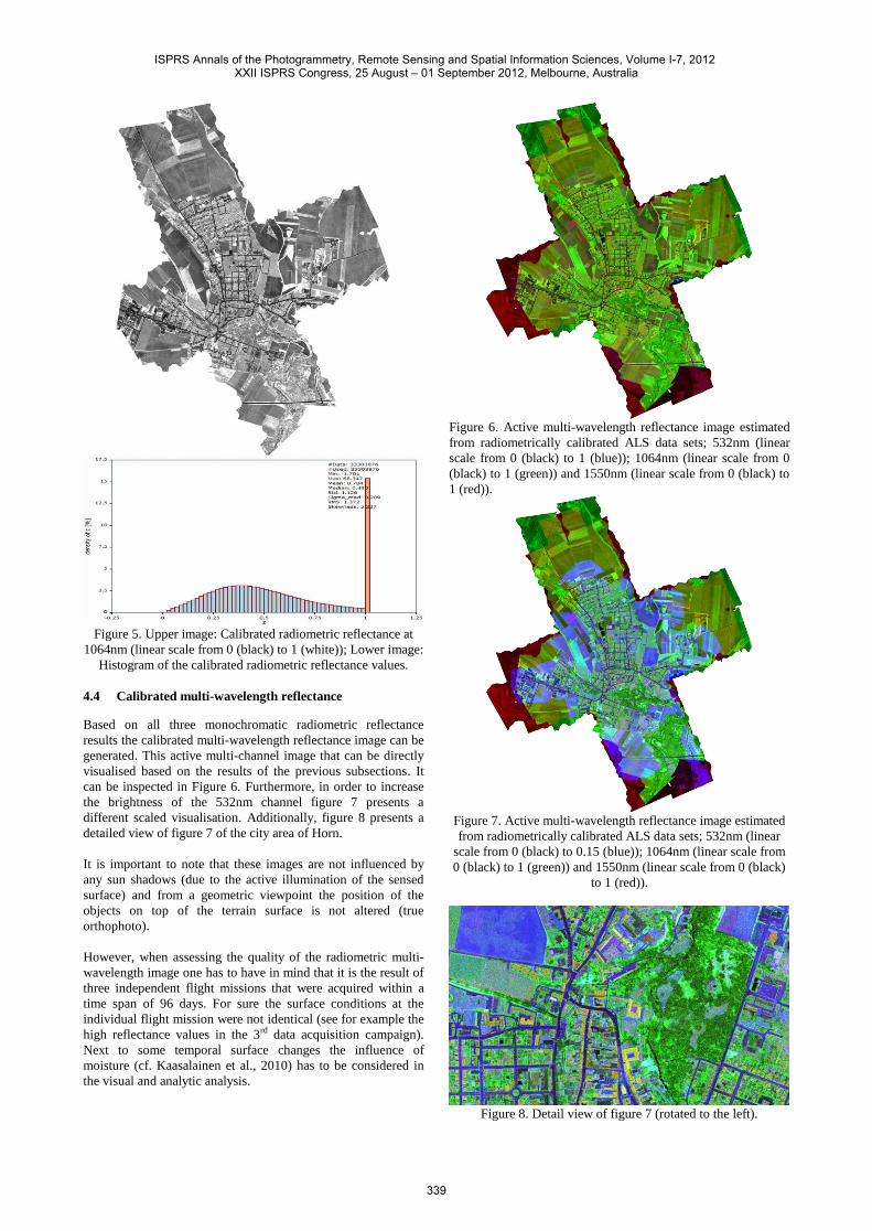
Figure 5. Upper image: Calibrated radiometric reflectance at
1064nm (linear scale from 0 (black) to 1 (white)); Lower image:
Histogram of the calibrated radiometric reflectance values.
4.4 Calibrated multi-wavelength reflectance
Based on all three monochromatic radiometric reflectance
results the calibrated multi-wavelength reflectance image can be
generated. This active multi-channel image that can be directly
visualised based on the results of the previous subsections. It
can be inspected in Figure 6. Furthermore, in order to increase
the brightness of the 532nm channel figure 7 presents a
different scaled visualisation. Additionally, figure 8 presents a
detailed view of figure 7 of the city area of Horn.
It is important to note that these images are not influenced by
any sun shadows (due to the active illumination of the sensed
surface) and from a geometric viewpoint the position of the
objects on top of the terrain surface is not altered (true
orthophoto).
However, when assessing the quality of the radiometric multi-
wavelength image one has to have in mind that it is the result of
three independent flight missions that were acquired within a
time span of 96 days. For sure the surface conditions at the
individual flight mission were not identical (see for example the
high reflectance values in the 3rd data acquisition campaign).
Next to some temporal surface changes the influence of
moisture (cf. Kaasalainen et al., 2010) has to be considered in
the visual and analytic analysis.
Figure 6. Active multi-wavelength reflectance image estimated
from radiometrically calibrated ALS data sets; 532nm (linear
scale from 0 (black) to 1 (blue)); 1064nm (linear scale from 0
(black) to 1 (green)) and 1550nm (linear scale from 0 (black) to
1 (red)).
Figure 7. Active multi-wavelength reflectance image estimated
from radiometrically calibrated ALS data sets; 532nm (linear
scale from 0 (black) to 0.15 (blue)); 1064nm (linear scale from
0 (black) to 1 (green)) and 1550nm (linear scale from 0 (black)
to 1 (red)).
Figure 8. Detail view of figure 7 (rotated to the left).
ISPRS Annals of the Photogrammetry, Remote Sensing and Spatial Information Sciences, Volume I-7, 2012 XXII ISPRS Congress, 25 August – 01 September 2012, Melbourne, Australia
339
5. CONCLUSION
These first results show the applicability of calibrating multi-
wavelength radiometric imagery from ALS data and provide an
insight into the challenges of radiometric processing and
exploitation of multi-wavelength ALS data. Based on the
resulting multi-wavelength reflectance information spectral
analysis of the radiometric behaviour of the sensed surfaces at
the three different wavelengths is possible. However, within the
present multi-wavelength data set the three different data
acquisition times have to be considered.
In the future a detailed quality analysis of the resulting
reflectance values is essential. Next to improved data
acquisition setups (contemporary data acquisition of the multi-
wavelength ALS data with similar sampling density) further
studies on the analysis of several influence factors (atmosphere,
sensor stability, etc.) have to be performed. This might lead to a
refined model of the measurement process and might allow to
increase the radiometric reliability and accuracy. Future
research will be necessary to further analyse the practical
application of calibrated active radiometric information from
ALS data.
ACKNOWLEDGEMENTS
The Ludwig Boltzmann Institute for Archaeological
Prospection and Virtual Archaeology (archpro.lbg.ac.at) is
based on an international cooperation of the Ludwig Boltzmann
Gesellschaft (A), the University of Vienna (A), the Vienna
University of Technology (A), the Austrian Central Institute for
Meteorology and Geodynamic (A), the office of the provincial
government of Lower Austria (A), Airborne Technologies
GmbH (A), RGZM-Roman- Germanic Central Museum Mainz
(D), RAÄ-Swedish National Heritage Board (S), IBM VISTA-
University of Birmingham (GB) and NIKU-Norwegian Institute
for Cultural Heritage Research (N). The authors thank Prof.
Geert Verhoeven and Martin Wieser for the acquisition and
processing of the spectrometer resp. reflectometer data.
REFERENCES
Briese, C., Höfle, B., Lehner, H., Wagner, W., Pfennigbauer,
M., Ullrich, A., 2008. Calibration of full-waveform airborne
laser scanning data for object classification. In: Turner, M.D.,
Kamerman, G.W. (Eds.), Proceedings of SPIE Laser Radar
Technology and Applications XIII, vol. 6950, pp. 0H1–0H8.
Höfle, B., Pfeifer, N., 2007. Correction of laser scanning
intensity data: Data and model-driven approaches. ISPRS
Journal of Photogrammetry and Remote Sensing 62(6).
Jelalian, A. V., 1992. Laser Radar Systems. Artech House,
Boston.
Kaasalainen, S., Hyyppa, H., Kukko, A., Litkey, P., Ahokas, E.,
Hyyppa, J., Lehner, H., Jaakkola, A., Suomalainen, J., Akujarvi,
A., Kaasalainen, M., Pyysalo, U., 2009. Radiometric calibration
of lidar intensity with commercially available reference targets.
IEEE Transactions on Geoscience and Remote Sensing 47(2),
pp. 588-598.
Kaasalainen, S., Niittymaki, H., Krooks, A., Koch, K.,
Kaartinen, H., Vain, A., Hyyppa, H., 2010, Effect of Target
Moisture on Laser Scanner Intensity, IEEE Transactions on
Geoscience and Remote Sensing 48(4), pp. 2128-2136.
Lehner, H., 2011. Radiometric calibration of airborne laser
scanner data. Master thesis, Institut für Photogrammetrie und
Fernerkundung der Technischen Universität Wien.
Lehner, H. and Briese, C., 2010. Radiometric calibration of full-
waveform airborne laser scanning data based on natural
surfaces. In: ISPRS Technical Commission VII Symposium
2010: 100 Years ISPRS – Advancing Remote Sensing Science.
International Archives of the Photogrammetry, Remote Sensing
and Spatial Information Sciences 38 (Part 7B), Vienna,
Austria, pp. 360– 365.
Lehner, H., Kager, H., Roncat, A., Zlinszky, A., 2011,
Consideration of laser pulse fluctuations and automatic gain
control in radiometric calibration of airborne laser scanning
data, in: "Proceedings of 6th ISPRS Student Consortium and
WG VI/5 Summer School", 6 pages.
OPALS, 2012. www.ipf.tuwien.ac.at/opals. Homepage of the
software OPALS, accessed: January 2012.
Pfennigbauer, M., Ullrich, A., 2011. Multi-Wavelength
Airborne Laser Scanning. ILMF 2011, New Orleans, February
7-9, 2011.
Riegl, 2011. www.riegl.com. Homepage of the company RIEGL
Laser Measurement Systems GmbH, accessed: January 2012.
Roncat, A., Lehner, H., Briese, C., 2011, Laser Pulse Variations
And Their Influence On Radiometric Calibration Of Full-
Waveform Laser Scanner Data, Talk: ISPRS Workshop Laser
Scanning 2011, Calgary, Canada; 2011-08-29 - 2011-08-31,,
International Archives of the Photogrammetry, Remote Sensing
and Spatial Information Sciences 38, (Part 5) / W12, ISSN:
1682-1777; 6 pages.
SVC, 2012. Spectrometer GER 1500 of the company Spectra
Vista Corporation, http://www.spectravista.com/1500.html,
accessed: January 2012.
Wagner, W., 2010. Radiometric calibration of small footprint
full-waveform airborne laser scanner measurements: Basic
physical concepts. ISPRS Journal of Photogrammetry and
Remote Sensing 65 (6 (ISPRS Centenary Celebration Issue)),
pp. 505–513. International Archives of Photogrammetry,
Remote Sensing and Spatial Information Sciences 38, Part 7B,
pp. 360-365.
Wagner, W., Ullrich, A., Ducic, V., Melzer, T. and Studnicka,
N., 2006. Gaussian decomposition and calibration of a novel
small-footprint full-waveform digitising airborne laser scanner.
ISPRS Journal of Photogrammetry and Remote Sensing 60(2),
pp. 100–112.
ISPRS Annals of the Photogrammetry, Remote Sensing and Spatial Information Sciences, Volume I-7, 2012 XXII ISPRS Congress, 25 August – 01 September 2012, Melbourne, Australia
340