radio aids to marine navigation (pacific and western arctic) aids to... · radio aids to marine...
TRANSCRIPT
RADIO AIDS TO MARINE NAVIGATION (Pacific and Western Arctic)
Radio Aids to Marine Navigation 2013 Annual Publication
Canadian Coast Guard Marine Communications and Traffic Services
Important: Radio Aids to Marine Navigation 2013 is revised on a monthly basis, when required, through Notices to Mariners, Section 3
DFO 5471
TO ALL USERS OF RADIO AIDS TO MARINE NAVIGATION 2013
Radio Aids to Marine Navigation website: http://www.ccg-gcc.gc.ca/eng//_Radio_Aids Important: Radio Aids to Marine Navigation2013 is revised on a monthly basis, when required, through
Notices to Mariners , Section 3. NOTMAR website: http://www.notmar.gc.ca/privacy.php We welcome your comments and suggestions on the contents and the format of Radio Aids to Marine Navigation 2013. Please forward your comments to: CANADIAN COAST GUARD
FISHERIES AND OCEANS CANADA 200 KENT STREET OTTAWA, ON K1A 0E6
CANADA Note: Cette publication est aussi disponible en français
The United Kingdom Hydrographic Office These VTS diagrams are for the sole purpose of inclusion in Radio Aids to Marine Navigation 2013 and no further copying, selling or distributing of the copyright material, or any part of it, is permitted. The United Kingdom Hydrographic Office makes the accompanying data available to the Canadian Coast Guard, Marine Communications and Traffic Services, under the terms of Licence Agreement HO 829/121030/10. © Crown Copyright and database rights 2012. Some Vessel Traffic Services diagrams are reproduced from the Admiralty List of Radio Signals Volume 6 by permission of the Controller of Her Majesty’s Stationery Office and the United Kingdom Hydrographic Office (http://www.ukho.gov.uk). NOT TO BE USED FOR NAVIGATION
Latitude and longitude positions given in this publication are in NAD 83 unless otherwise indicated.
Minister of Fisheries and Oceans Canada 2013 Catalogue No. Fs151-8/2013E-PDF
ISSN: 1702-269X Ottawa, Canada
Radio Aids to Marine Navigation 2013 has been revised to December 31, 2012 and supersedes Radio Aids To Marine Navigation 2012
Any inquiries as to the contents of this publication or reports of errors or omissions should be directed to the nearest regional office as indicated at the end of Part 1 of this publication. The information in this volume is grouped in five parts:
Part 1: Foreword (includes advance notices, legend, frequency listing and Marine Communications and Traffic Services telephone and address information) Part 1 provides mariners with advance information on proposed changes to facilities and services. It includes the Canadian Maritime Mobile Safety and Public Correspondence communication frequencies, a legend for centre listings and the telephone/facsimile/telex directory of Marine Communications and Traffic Services centres along with the Regional offices’ addresses. Part 2: Pacific Coast, Western Arctic (includes Athabasca-Mackenzie Watershed) Part 2 lists, in tabular form, detailed operational information about individual facilities in each of the areas covered. Marine Communications and Traffic Services centres provide continuous year round communications and special services except as noted. Part 3: Vessel Traffic Services Part 3 provides consolidated information concerning Vessel Traffic Services. Part 4: General Part 4 describes the various procedures, services and systems available, together with general observations or directions for their use. This part also refers to radiotelephone procedures for the benefit of vessels equipped with radiotelephone but not carrying radio operators. The proper use of radio frequencies and procedures is essential to minimize congestion and delays on the channels available for communication. Part 5: Environment Canada Part 5 provides all relative information concerning Environment Canada's services in marine meteorology that are delivered by the Canadian Coast Guard.
The main purpose of Radio Aids to Marine Navigation 2013 is to present, in a convenient form, information on radio communications and radio navigational aids services provided in Canada by the Canadian Coast Guard. Radio facilities of other government agencies that contribute to the safety of ships in Canadian waters are also included. Radio Aids to Marine Navigation 2013 is published in two editions: one for the Atlantic Coast, Gulf and St. Lawrence River to Montréal, Eastern Arctic (including Hudson Bay and Strait), the Great Lakes (including St. Lawrence River to Montréal) and Lake Winnipeg; the other for the Pacific Coast, Western Arctic and the Athabasca-Mackenzie Watershed area. Each edition is also available in French. Radio Aids to Marine Navigation 2013 is published each April. Amendments are advertised by radio broadcast (Notices to Shipping) and/or in Notices to Mariners, Section 3. Every ship station fitted on a Canadian ship or on a non-Canadian ship engaged in the coasting trade of Canada, pursuant to the Ship Station (Radio) Regulations 1999, and all ships in waters under Canadian jurisdiction, pursuant to the Charts and Nautical Publications Regulations, 1995, are required to carry the most recent applicable edition of Radio Aids to Marine Navigation.
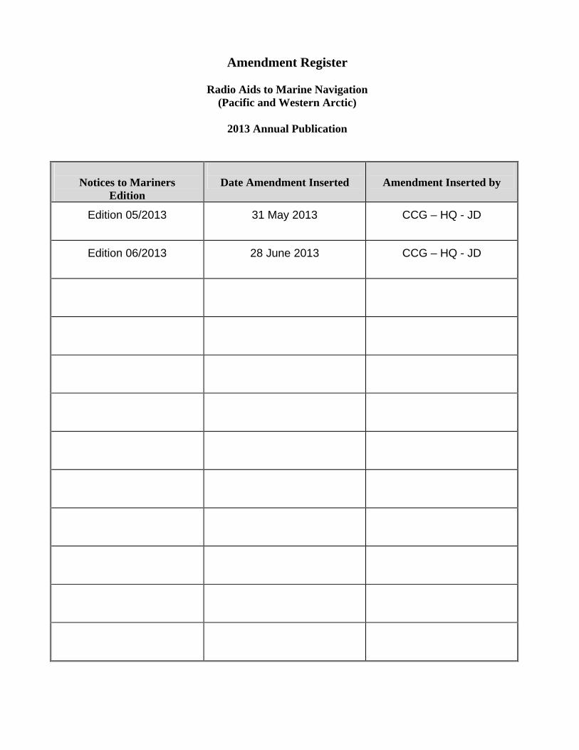
Amendment Register
Radio Aids to Marine Navigation (Pacific and Western Arctic)
2013 Annual Publication
Notices to Mariners
Edition
Date Amendment Inserted
Amendment Inserted by
Edition 05/2013 31 May 2013 CCG – HQ - JD
Edition 06/2013 28 June 2013 CCG – HQ - JD
i
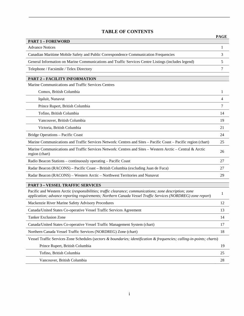
TABLE OF CONTENTS PAGE
PART 1 – FOREWORD
Advance Notices 1
Canadian Maritime Mobile Safety and Public Correspondence Communication Frequencies 3
General Information on Marine Communications and Traffic Services Centre Listings (includes legend) 5
Telephone / Facsimile / Telex Directory 7
PART 2 – FACILITY INFORMATION
Marine Communications and Traffic Services Centres
Comox, British Columbia 1
Iqaluit, Nunavut 4
Prince Rupert, British Columbia 7
Tofino, British Columbia 14
Vancouver, British Columbia 19
Victoria, British Columbia 21
Bridge Operations – Pacific Coast 24
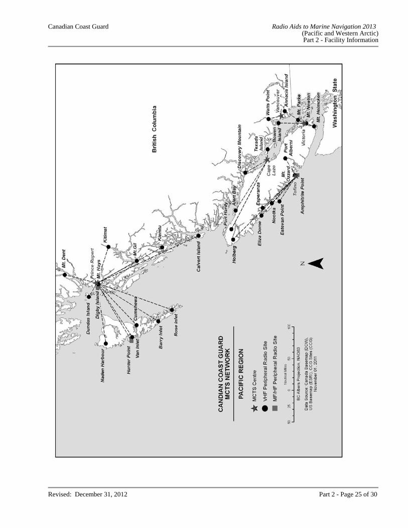
Marine Communications and Traffic Services Network: Centres and Sites – Pacific Coast – Pacific region (chart) 25
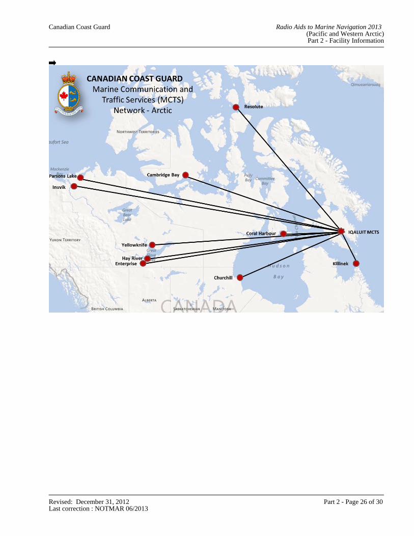
Marine Communications and Traffic Services Network: Centres and Sites – Western Arctic – Central & Arctic region (chart)
26
Radio Beacon Stations – continuously operating – Pacific Coast 27
Radar Beacon (RACONS) – Pacific Coast – British Columbia (excluding Juan de Fuca) 27
Radar Beacon (RACONS) – Western Arctic – Northwest Territories and Nunavut 29
PART 3 – VESSEL TRAFFIC SERVICES
Pacific and Western Arctic (responsibilities; traffic clearance; communications; zone description; zone application; advance reporting requirements; Northern Canada Vessel Traffic Services (NORDREG) zone report)
1
Mackenzie River Marine Safety Advisory Procedures 12
Canada/United States Co-operative Vessel Traffic Services Agreement 13
Tanker Exclusion Zone 14
Canada/United States Co-operative Vessel Traffic Management System (chart) 17
Northern Canada Vessel Traffic Services (NORDREG) Zone (chart) 18
Vessel Traffic Services Zone Schedules (sectors & boundaries; identification & frequencies; calling-in-points; charts)
Prince Rupert, British Columbia 19
Tofino, British Columbia 25
Vancouver, British Columbia 28
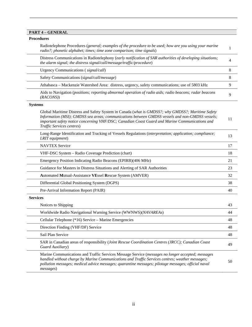
ii
PART 4 – GENERAL
Procedures
Radiotelephone Procedures (general; examples of the procedure to be used; how are you using your marine radio?; phonetic alphabet; times; time zone comparison; time signals)
1
Distress Communications in Radiotelephony (early notification of SAR authorities of developing situations; the alarm signal; the distress signal/call/message/traffic/procedure)
4
Urgency Communications ( signal/call) 8
Safety Communications (signal/call/message) 8
Athabasca – Mackenzie Watershed Area: distress, urgency, safety communications; use of 5803 kHz 9
Aids to Navigation (positions; reporting abnormal operation of radio aids; radio beacons; radar beacons (RACONS))
9
Systems
Global Maritime Distress and Safety System in Canada (what is GMDSS?; why GMDSS?; Maritime Safety Information (MSI); GMDSS sea areas; communications between GMDSS vessels and non-GMDSS vessels; important safety notice concerning VHF/DSC; Canadian Coast Guard and Marine Communications and Traffic Services centres)
11
Long-Range Identification and Tracking of Vessels Regulations (interpretation; application; compliance; LRIT equipment)
13
NAVTEX Service 17
VHF-DSC System – Radio Coverage Prediction (chart) 18
Emergency Position Indicating Radio Beacons (EPIRB)(406 MHz) 21
Guidance for Masters in Distress Situations and Alerting of SAR Authorities 23
Automated Mutual-Assistance VEssel Rescue System (AMVER) 32
Differential Global Positioning System (DGPS) 38
Pre-Arrival Information Report (PAIR) 40
Services
Notices to Shipping 43
Worldwide Radio Navigational Warning Service (WWNWS)(NAVAREAs) 44
Cellular Telephone (*16) Service – Marine Emergencies 48
Direction Finding (VHF/DF) Service 48
Sail Plan Service 48
SAR in Canadian areas of responsibility (Joint Rescue Coordination Centres (JRCC); Canadian Coast Guard Auxiliary)
49
Marine Communications and Traffic Services Message Service (messages no longer accepted; messages handled without charge by Marine Communications and Traffic Services centres; weather messages; pollution messages; medical advice messages; quarantine messages; pilotage messages; official naval messages)
50
iii
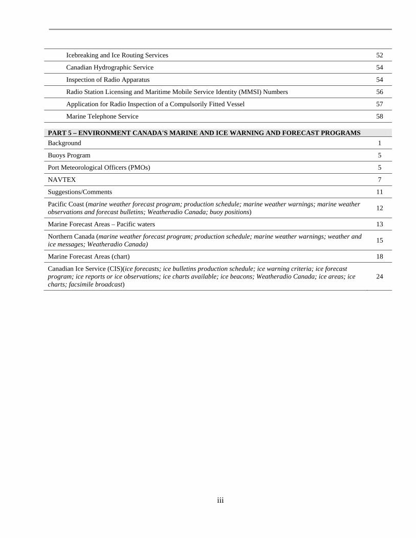
Icebreaking and Ice Routing Services 52
Canadian Hydrographic Service 54
Inspection of Radio Apparatus 54
Radio Station Licensing and Maritime Mobile Service Identity (MMSI) Numbers 56
Application for Radio Inspection of a Compulsorily Fitted Vessel 57
Marine Telephone Service 58
PART 5 – ENVIRONMENT CANADA'S MARINE AND ICE WARNING AND FORECAST PROGRAMS
Background 1
Buoys Program 5
Port Meteorological Officers (PMOs) 5
NAVTEX 7
Suggestions/Comments 11
Pacific Coast (marine weather forecast program; production schedule; marine weather warnings; marine weather observations and forecast bulletins; Weatheradio Canada; buoy positions)
12
Marine Forecast Areas – Pacific waters 13
Northern Canada (marine weather forecast program; production schedule; marine weather warnings; weather and ice messages; Weatheradio Canada)
15
Marine Forecast Areas (chart) 18
Canadian Ice Service (CIS)(ice forecasts; ice bulletins production schedule; ice warning criteria; ice forecast program; ice reports or ice observations; ice charts available; ice beacons; Weatheradio Canada; ice areas; ice charts; facsimile broadcast)
24
Canadian Coast Guard Radio Aids to Marine Navigation 2013 (Pacific and Western Arctic)
Part 1 - Foreword
Revised: December 31, 2012 Part 1 - Page 1 of 8
PART 1
FOREWORD
ADVANCE NOTICES In order that mariners may have advance knowledge of proposed changes to existing facilities to be provided, additions, deletions and changes to such facilities under the jurisdiction of the Canadian Coast Guard are listed hereunder. Effective dates of changes and dates for the commissioning of new facilities are, however, extremely hard to forecast owing to difficulties in obtaining materials and subject to the provision of necessary funds. Every effort will be made to amend dates as far in advance as possible. In every case of changes to facilities and commissioning new facilities, an appropriate Notice to Mariners will be issued. 1. The Radio Aids To Marine Navigation Annual Publications
Effective April 1, 2013, the Canadian Coast Guard will cease the printing of its "Radio Aids to Marine Navigation" annual publications which include the "Atlantic, St. Lawrence, Great Lakes, Lake Winnipeg and Eastern Arctic" edition as well as the "Pacific and Western Arctic" edition. The publications will continue to be available online, free of charge, at: http://www.ccg-gcc.gc.ca/eng/CCG/Information_for_Mariners. The "Radio Aids to Marine Navigation" annual publications are updated each April. Amendments will continue to be advertised by radio broadcast (Notices to Shipping) and/or issued on a monthly basis, when required, in "Notices to Mariners", Section 3. The "Notices to Mariners" publication is available online, free of charge, at: http://www.notmar.gc.ca. Every ship station fitted on a Canadian ship or on a non-Canadian ship engaged in the coasting trade of Canada, pursuant to the Ship Station (Radio) Regulations 1999, and all ships in waters under Canadian jurisdiction, pursuant to the Charts and Nautical Publications Regulations, 1995, are required to carry the most recent applicable edition of "Radio Aids to Marine Navigation". 2. Consolidation of the Inuvik and Iqaluit Marine Communications and Traffic Services Centres As of the end of the 2012 Arctic navigation season, the Canadian Coast Guard has permanently closed the Inuvik Marine Communications and Traffic Services Centre. Commencing with the 2013 Arctic navigation season, all services are provided remotely by Iqaluit Marine Communications and Traffic Services Centre. 3. Responsibility for the Operation of the Transmit and Receive Facilities Located at Churchill,
Manitoba Effective July 1, 2012, the responsibility for the operation of the transmit and receive facilities located at Churchill, Manitoba has been transferred from Thunder Bay Marine Communication and Traffic Services Centre to Iqaluit Marine Communications and Traffic Services Centre.
Canadian Coast Guard Radio Aids to Marine Navigation 2013 (Pacific and Western Arctic)
Part 1 - Foreword
Revised: December 31, 2012 Part 1 - Page 2 of 8
4. Ship Radio Inspections Owners and masters of Canadian vessels are advised that Transport Canada has delegated the authority to issue radio inspection certificates to Recognized Organizations under the Delegation Statutory Inspection Program. Vessels enrolled in the Delegation Statutory Inspection Program, as well as classed ships, are encouraged to contact a Recognized Organization for their radio inspection required by regulations under the Canada Shipping Act, 2001. Currently, the Recognized Organizations are: the American Bureau of Shipping; Bureau Veritas; Det Norske Veritas; Germanischer Lloyd; and, Lloyd’s Register. This is in addition to the Canadian Coast Guard, who continue to also have delegated authority for this function. 5. VHF-DSC Test Calls Effective January 2011, the Canadian Coast Guard VHF Digital Selective Calling (DSC) network controlled by Marine Communications and Traffic Services centres was upgraded to include a “Test Call” feature, providing mariners whose marine radio meets standards identified in ITU M 493-11 (or higher) DSC Systems for use in Maritime Mobile Service, with a means to verify the functionality of these radios. The VHF-DSC equipment at Marine Communications and Traffic Services centres has been configured to automatically acknowledge VHF-DSC test calls within seconds of receipt provided that the Marine Communications and Traffic Services centre is not processing higher priority DSC calls. Consult Part 2 – Facilities Information for the Maritime Mobility Service Identity (MMSI) numbers required to make a digital test call to an Marine Communications and Traffic Services centre. 6. The Canadian Forces Fleet MetOc Broadcast Service The Canadian Forces Fleet MetOc Broadcast service (radioteletype and radiofacsimile) was placed in abeyance effective September 2, 2010. The Canadian Forces Fleet MetOc Broadcast may be reinstated and ceased without warning as necessitated by military operational requirements. When notified, Marine Communications and Traffic Services will issue a Notice to Shipping concerning reinstatement or cessation of this service. 7. Northern Canada Vessel Traffic Services (NORDREG) Zone As of July 1, 2010, the Northern Canada Vessel Traffic Services (NORDREG) Zone reporting system is mandatory for certain vessels. The NORDREG Zone, which covers Canada’s northern waters, has also been extended to the outer limit of the exclusive economic zone of Canada. The following vessels are required to report information to NORDREG:
Vessels of 300 tons gross tonnage or more; Vessels that are engaged in towing or pushing a vessel, if the combined gross tonnage of the vessel and the
vessel being towed or pushed is 500 tons gross tonnage or more; and Vessels carrying as cargo a pollutant or dangerous goods, or engaged in towing or pushing a vessel
carrying as cargo a pollutant or dangerous goods. The above vessels destined for the NORDREG Zone or navigating within the zone should contact NORDREG CANADA or the nearest Canadian Coast Guard Marine Communications and Traffic Services centre for full information on how to comply with the new requirements.
Canadian Coast Guard Radio Aids to Marine Navigation 2013 (Pacific and Western Arctic)
Part 1 - Foreword
Revised: December 31, 2012 Part 1 - Page 3 of 8
8. Automatic Identification System (AIS) - Installation of AIS Equipment in Eastern Canada In 2012, the Canadian Coast Guard will commence Full Operational Condition (FOC) Automatic Identification System service. The Canadian Coast Guard Automatic Identification System will cover most of Eastern Canada from the Strait of Belle Isle to the Bay of Fundy, most of the Gulf of St. Lawrence, the St. Lawrence River and the Canadian Great Lakes. Automatic Identification System service is now available at the following Marine Communications and Traffic Services centres:
Comox Prince Rupert Tofino Vancouver
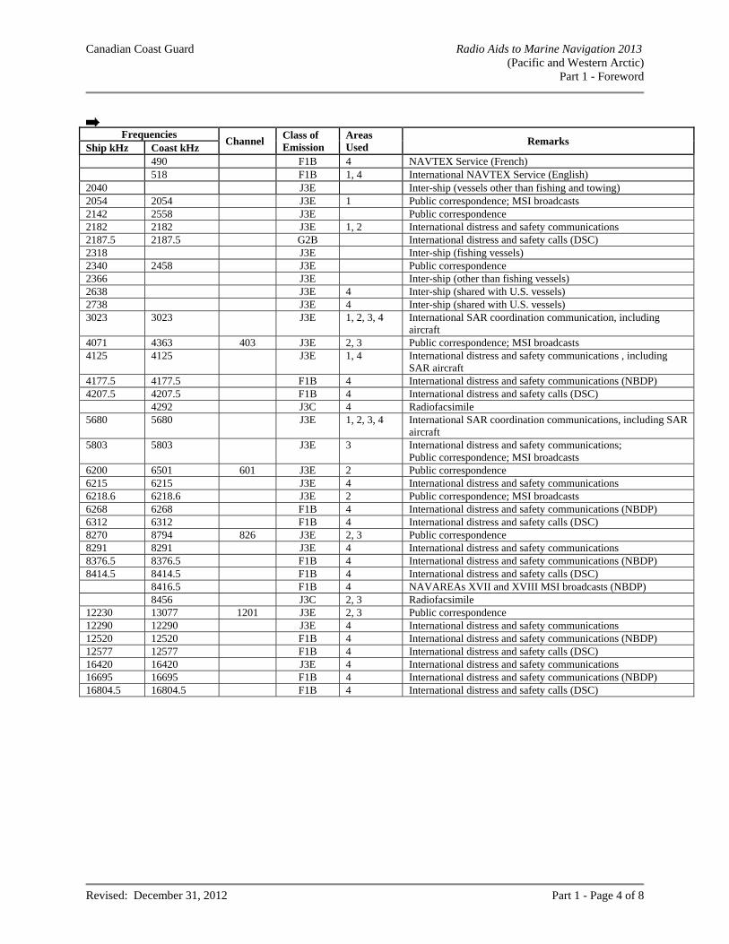
Victoria Marine Communications and Traffic Services centres are able to receive dynamic information (position, heading and speed), static information (vessel description) and voyage information as transmitted by the vessel’s Automatic Identification System equipment. The date of commissioning of Automatic Identification System service for each Marine Communications and Traffic Services centre will be advertised through Notices to Shipping. Although Marine Communications and Traffic Services centres will be able to receive Automatic Identification System ship safety messages, this service should only be used when other methods to communicate with an Marine Communications and Traffic Services centre fail. Automatic Identification System binary message services are currently unavailable. Automatic Identification System equipment is to be operated in accordance with the Annex to Resolution A.917 (22), IMO guidelines for the onboard operational use of shipborne Automatic Identification System and in conformity with the Navigation Safety Regulations (SOR/2005-134). CANADIAN MARITIME MOBILE SAFETY AND PUBLIC CORRESPONDENCE COMMUNICATION FREQUENCIES The frequencies listed on the following pages are those in general use by ships in Canadian waters for inter-ship communications and for ship/shore communications with Marine Communications and Traffic Services centres operated by the Canadian Coast Guard. Part 2 of this publication contains individual listings for Marine Communications and Traffic Services centres operated by the Canadian Coast Guard, giving details of the communication and special services provided to ships. On the following pages are frequency lists, including the geographical areas of use:
1. Pacific Coast; 2. Western Arctic; 3. Athabasca & Mackenzie Inland waterways; and 4. Eastern Arctic.
Canadian Coast Guard Radio Aids to Marine Navigation 2013 (Pacific and Western Arctic)
Part 1 - Foreword
Revised: December 31, 2012 Part 1 - Page 4 of 8
Frequencies
Channel Class of Emission
Areas Used
Remarks Ship kHz Coast kHz 490 F1B 4 NAVTEX Service (French) 518 F1B 1, 4 International NAVTEX Service (English) 2040 J3E Inter-ship (vessels other than fishing and towing) 2054 2054 J3E 1 Public correspondence; MSI broadcasts 2142 2558 J3E Public correspondence 2182 2182 J3E 1, 2 International distress and safety communications 2187.5 2187.5 G2B International distress and safety calls (DSC) 2318 J3E Inter-ship (fishing vessels) 2340 2458 J3E Public correspondence 2366 J3E Inter-ship (other than fishing vessels) 2638 J3E 4 Inter-ship (shared with U.S. vessels) 2738 J3E 4 Inter-ship (shared with U.S. vessels) 3023 3023 J3E 1, 2, 3, 4 International SAR coordination communication, including
aircraft 4071 4363 403 J3E 2, 3 Public correspondence; MSI broadcasts 4125 4125 J3E 1, 4 International distress and safety communications , including
SAR aircraft 4177.5 4177.5 F1B 4 International distress and safety communications (NBDP) 4207.5 4207.5 F1B 4 International distress and safety calls (DSC) 4292 J3C 4 Radiofacsimile 5680 5680 J3E 1, 2, 3, 4 International SAR coordination communications, including SAR
aircraft 5803 5803 J3E 3 International distress and safety communications;
Public correspondence; MSI broadcasts 6200 6501 601 J3E 2 Public correspondence 6215 6215 J3E 4 International distress and safety communications 6218.6 6218.6 J3E 2 Public correspondence; MSI broadcasts 6268 6268 F1B 4 International distress and safety communications (NBDP) 6312 6312 F1B 4 International distress and safety calls (DSC) 8270 8794 826 J3E 2, 3 Public correspondence 8291 8291 J3E 4 International distress and safety communications 8376.5 8376.5 F1B 4 International distress and safety communications (NBDP) 8414.5 8414.5 F1B 4 International distress and safety calls (DSC) 8416.5 F1B 4 NAVAREAs XVII and XVIII MSI broadcasts (NBDP) 8456 J3C 2, 3 Radiofacsimile 12230 13077 1201 J3E 2, 3 Public correspondence 12290 12290 J3E 4 International distress and safety communications 12520 12520 F1B 4 International distress and safety communications (NBDP) 12577 12577 F1B 4 International distress and safety calls (DSC) 16420 16420 J3E 4 International distress and safety communications 16695 16695 F1B 4 International distress and safety communications (NBDP) 16804.5 16804.5 F1B 4 International distress and safety calls (DSC)
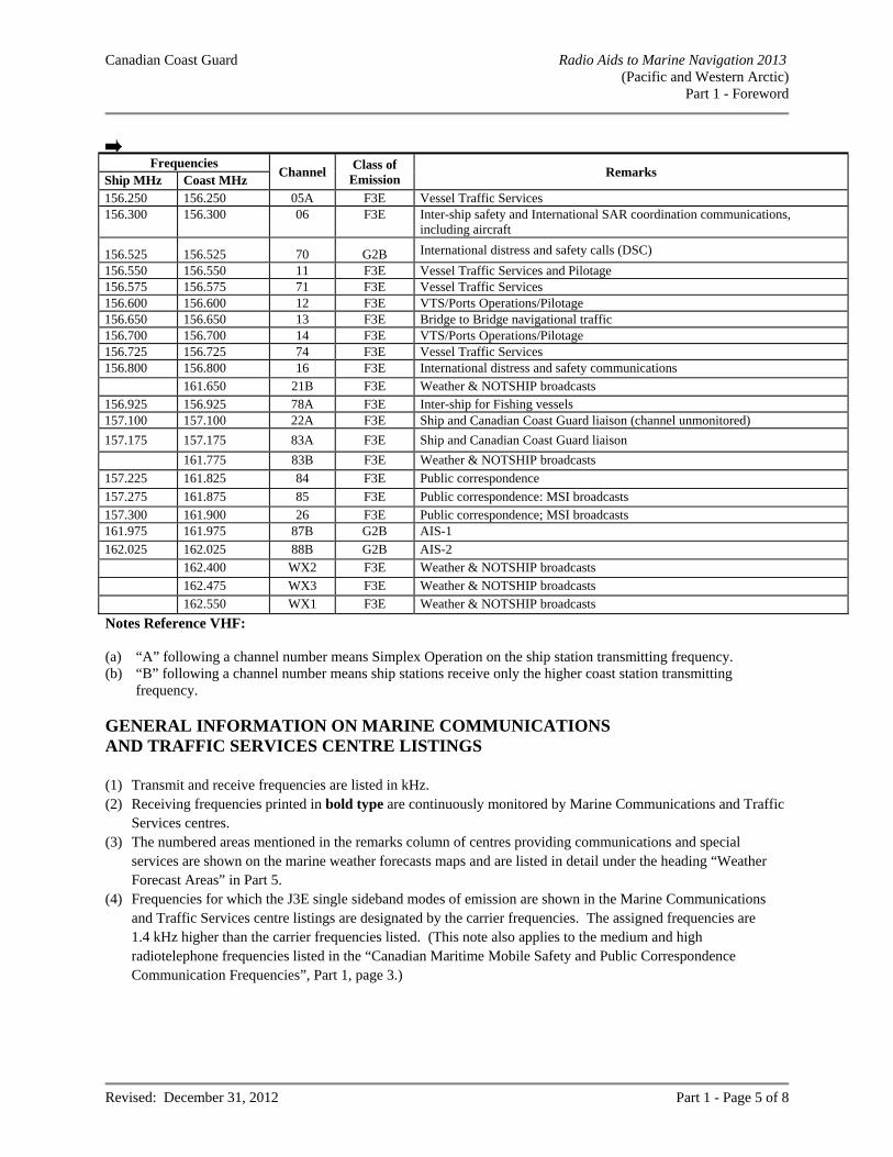
Canadian Coast Guard Radio Aids to Marine Navigation 2013 (Pacific and Western Arctic)
Part 1 - Foreword
Revised: December 31, 2012 Part 1 - Page 5 of 8
Frequencies
Channel Class of
Emission Remarks
Ship MHz Coast MHz 156.250 156.250 05A F3E Vessel Traffic Services 156.300 156.300 06 F3E Inter-ship safety and International SAR coordination communications,
including aircraft
156.525 156.525 70 G2B International distress and safety calls (DSC)
156.550 156.550 11 F3E Vessel Traffic Services and Pilotage 156.575 156.575 71 F3E Vessel Traffic Services 156.600 156.600 12 F3E VTS/Ports Operations/Pilotage 156.650 156.650 13 F3E Bridge to Bridge navigational traffic 156.700 156.700 14 F3E VTS/Ports Operations/Pilotage 156.725 156.725 74 F3E Vessel Traffic Services 156.800 156.800 16 F3E International distress and safety communications 161.650 21B F3E Weather & NOTSHIP broadcasts 156.925 156.925 78A F3E Inter-ship for Fishing vessels 157.100 157.100 22A F3E Ship and Canadian Coast Guard liaison (channel unmonitored)
157.175 157.175 83A F3E Ship and Canadian Coast Guard liaison
161.775 83B F3E Weather & NOTSHIP broadcasts
157.225 161.825 84 F3E Public correspondence
157.275 161.875 85 F3E Public correspondence: MSI broadcasts 157.300 161.900 26 F3E Public correspondence; MSI broadcasts 161.975 161.975 87B G2B AIS-1
162.025 162.025 88B G2B AIS-2 162.400 WX2 F3E Weather & NOTSHIP broadcasts
162.475 WX3 F3E Weather & NOTSHIP broadcasts 162.550 WX1 F3E Weather & NOTSHIP broadcasts
Notes Reference VHF: (a) “A” following a channel number means Simplex Operation on the ship station transmitting frequency. (b) “B” following a channel number means ship stations receive only the higher coast station transmitting
frequency. GENERAL INFORMATION ON MARINE COMMUNICATIONS AND TRAFFIC SERVICES CENTRE LISTINGS (1) Transmit and receive frequencies are listed in kHz. (2) Receiving frequencies printed in bold type are continuously monitored by Marine Communications and Traffic
Services centres. (3) The numbered areas mentioned in the remarks column of centres providing communications and special
services are shown on the marine weather forecasts maps and are listed in detail under the heading “Weather Forecast Areas” in Part 5.
(4) Frequencies for which the J3E single sideband modes of emission are shown in the Marine Communications and Traffic Services centre listings are designated by the carrier frequencies. The assigned frequencies are 1.4 kHz higher than the carrier frequencies listed. (This note also applies to the medium and high radiotelephone frequencies listed in the “Canadian Maritime Mobile Safety and Public Correspondence Communication Frequencies”, Part 1, page 3.)
Canadian Coast Guard Radio Aids to Marine Navigation 2013 (Pacific and Western Arctic)
Part 1 - Foreword
Revised: December 31, 2012 Part 1 - Page 6 of 8
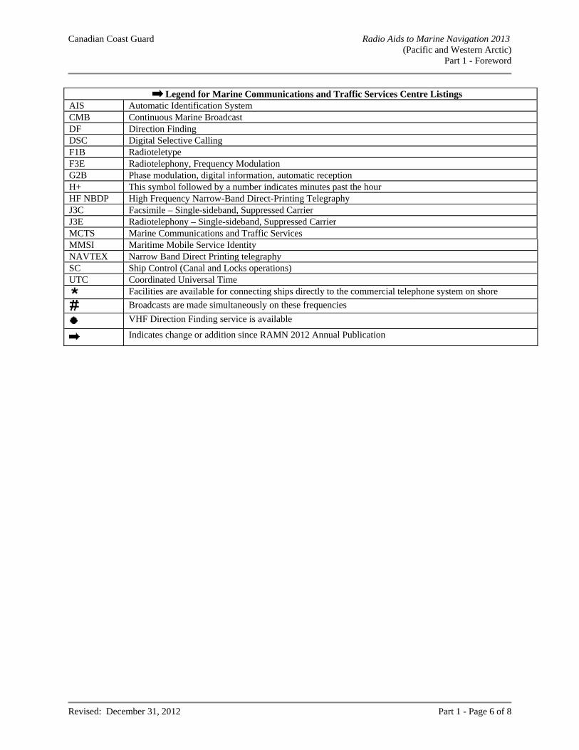
Legend for Marine Communications and Traffic Services Centre Listings AIS Automatic Identification System CMB Continuous Marine Broadcast DF Direction Finding DSC Digital Selective Calling F1B Radioteletype F3E Radiotelephony, Frequency Modulation G2B Phase modulation, digital information, automatic reception H+ This symbol followed by a number indicates minutes past the hour HF NBDP High Frequency Narrow-Band Direct-Printing Telegraphy J3C Facsimile – Single-sideband, Suppressed Carrier J3E Radiotelephony – Single-sideband, Suppressed Carrier MCTS Marine Communications and Traffic Services MMSI Maritime Mobile Service Identity NAVTEX Narrow Band Direct Printing telegraphy SC Ship Control (Canal and Locks operations) UTC Coordinated Universal Time
Facilities are available for connecting ships directly to the commercial telephone system on shore
Broadcasts are made simultaneously on these frequencies
VHF Direction Finding service is available
Indicates change or addition since RAMN 2012 Annual Publication
Canadian Coast Guard Radio Aids to Marine Navigation 2013 (Pacific and Western Arctic)
Part 1 - Foreword
Revised: December 31, 2012 Part 1 - Page 7 of 8
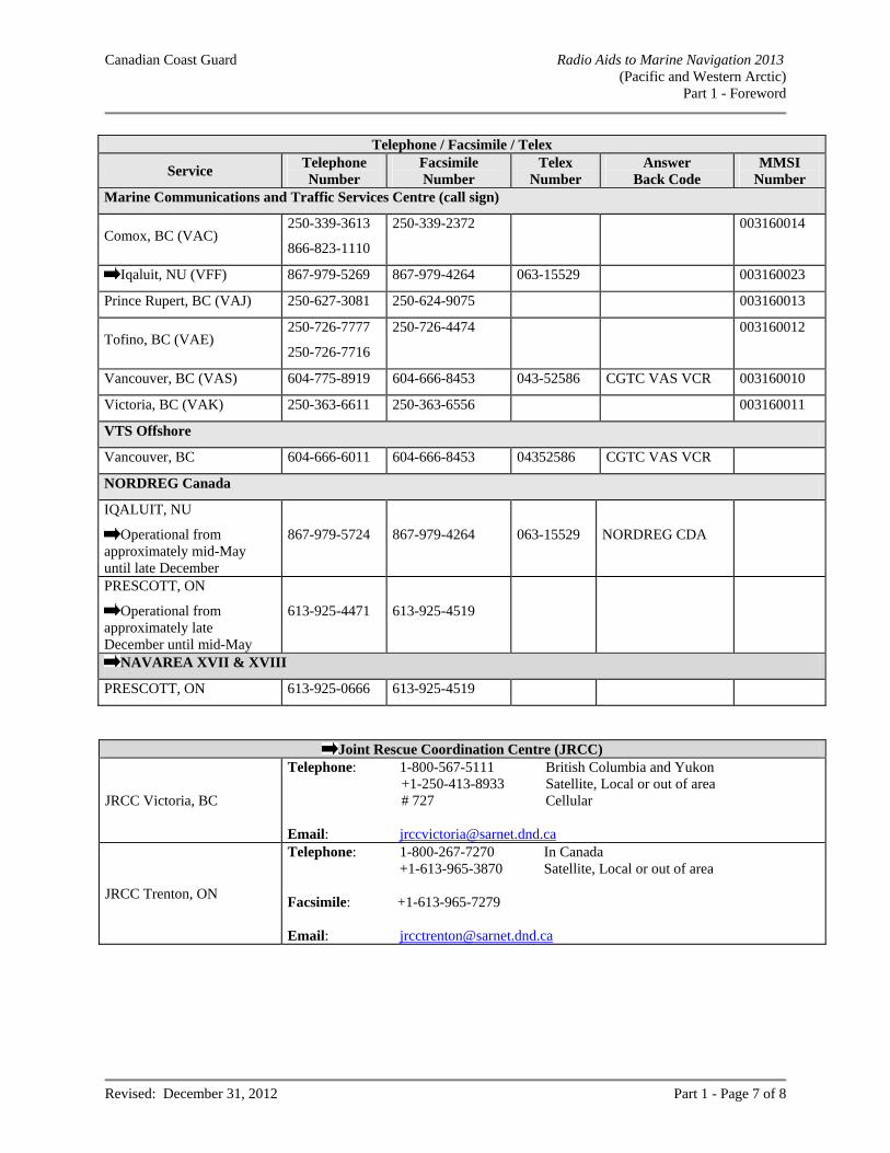
Telephone / Facsimile / Telex
Service Telephone Number
Facsimile Number
Telex Number
Answer Back Code
MMSI Number
Marine Communications and Traffic Services Centre (call sign)
Comox, BC (VAC) 250-339-3613
866-823-1110
250-339-2372 003160014
Iqaluit, NU (VFF) 867-979-5269 867-979-4264 063-15529 003160023
Prince Rupert, BC (VAJ) 250-627-3081 250-624-9075 003160013
Tofino, BC (VAE) 250-726-7777
250-726-7716
250-726-4474 003160012
Vancouver, BC (VAS) 604-775-8919 604-666-8453 043-52586 CGTC VAS VCR 003160010
Victoria, BC (VAK) 250-363-6611 250-363-6556 003160011
VTS Offshore
Vancouver, BC 604-666-6011 604-666-8453 04352586 CGTC VAS VCR
NORDREG Canada
IQALUIT, NU
Operational from approximately mid-May until late December
867-979-5724 867-979-4264 063-15529 NORDREG CDA
PRESCOTT, ON
Operational from approximately late December until mid-May
613-925-4471 613-925-4519
NAVAREA XVII & XVIII
PRESCOTT, ON 613-925-0666 613-925-4519
Joint Rescue Coordination Centre (JRCC)
JRCC Victoria, BC
Telephone: 1-800-567-5111 British Columbia and Yukon +1-250-413-8933 Satellite, Local or out of area # 727 Cellular
Email: [email protected]
JRCC Trenton, ON
Telephone: 1-800-267-7270 In Canada +1-613-965-3870 Satellite, Local or out of area Facsimile: +1-613-965-7279 Email: [email protected]
Canadian Coast Guard Radio Aids to Marine Navigation 2013 (Pacific and Western Arctic)
Part 1 - Foreword
Revised: December 31, 2012 Part 1 - Page 8 of 8
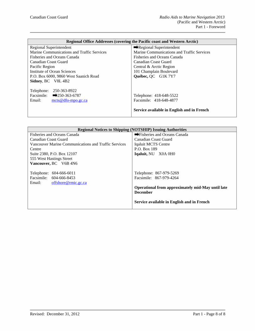
Regional Office Addresses (covering the Pacific coast and Western Arctic)
Regional Superintendent Marine Communications and Traffic Services Fisheries and Oceans Canada Canadian Coast Guard Pacific Region Institute of Ocean Sciences P.O. Box 6000, 9860 West Saanich Road Sidney, BC V8L 4B2 Telephone: 250-363-8922 Facsimile: 250-363-6787 Email: [email protected]
Regional Superintendent Marine Communications and Traffic Services Fisheries and Oceans Canada Canadian Coast Guard Central & Arctic Region 101 Champlain Boulevard Québec, QC G1K 7Y7 Telephone: 418-648-5522 Facsimile: 418-648-4877 Service available in English and in French
Regional Notices to Shipping (NOTSHIP) Issuing Authorities
Fisheries and Oceans Canada Canadian Coast Guard Vancouver Marine Communications and Traffic Services Centre Suite 2380, P.O. Box 12107 555 West Hastings Street Vancouver, BC V6B 4N6 Telephone: 604-666-6011 Facsimile: 604-666-8453 Email: [email protected]
Fisheries and Oceans Canada Canadian Coast Guard Iqaluit MCTS Centre P.O. Box 189 Iqaluit, NU X0A 0H0 Telephone: 867-979-5269 Facsimile: 867-979-4264 Operational from approximately mid-May until late December Service available in English and in French
Canadian Coast Guard Radio Aids to Marine Navigation 2013 (Pacific and Western Arctic) Part 2 - Facility Information
Revised: December 31, 2012 Part 2 - Page 1 of 30
PART 2
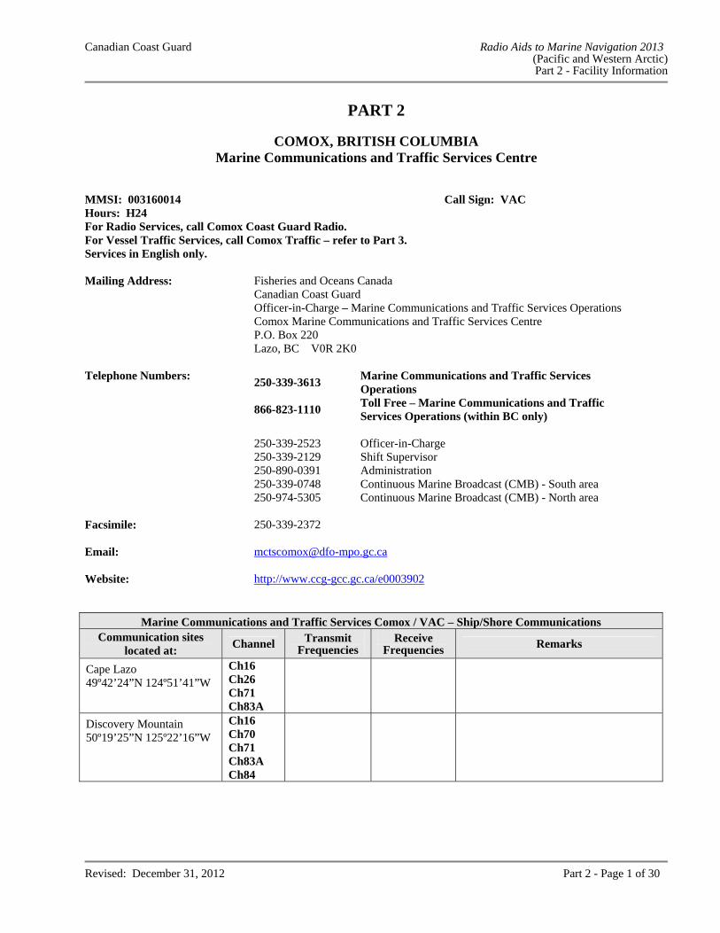
COMOX, BRITISH COLUMBIA Marine Communications and Traffic Services Centre
MMSI: 003160014 Call Sign: VAC Hours: H24 For Radio Services, call Comox Coast Guard Radio. For Vessel Traffic Services, call Comox Traffic – refer to Part 3. Services in English only. Mailing Address: Fisheries and Oceans Canada
Canadian Coast Guard Officer-in-Charge – Marine Communications and Traffic Services Operations Comox Marine Communications and Traffic Services Centre P.O. Box 220 Lazo, BC V0R 2K0
Telephone Numbers:
250-339-3613 Marine Communications and Traffic Services Operations
866-823-1110
Toll Free – Marine Communications and Traffic Services Operations (within BC only)
250-339-2523 Officer-in-Charge 250-339-2129 Shift Supervisor 250-890-0391 Administration 250-339-0748 Continuous Marine Broadcast (CMB) - South area 250-974-5305 Continuous Marine Broadcast (CMB) - North area Facsimile: 250-339-2372 Email: [email protected] Website: http://www.ccg-gcc.gc.ca/e0003902
Marine Communications and Traffic Services Comox / VAC – Ship/Shore CommunicationsCommunication sites
located at: Channel Transmit
Frequencies Receive
Frequencies Remarks
Cape Lazo 49º42’24”N 124º51’41”W
Ch16 Ch26 Ch71 Ch83A
Discovery Mountain 50º19’25”N 125º22’16”W
Ch16 Ch70 Ch71 Ch83A Ch84
Canadian Coast Guard Radio Aids to Marine Navigation 2013 (Pacific and Western Arctic) Part 2 - Facility Information
Revised: December 31, 2012 Part 2 - Page 2 of 30
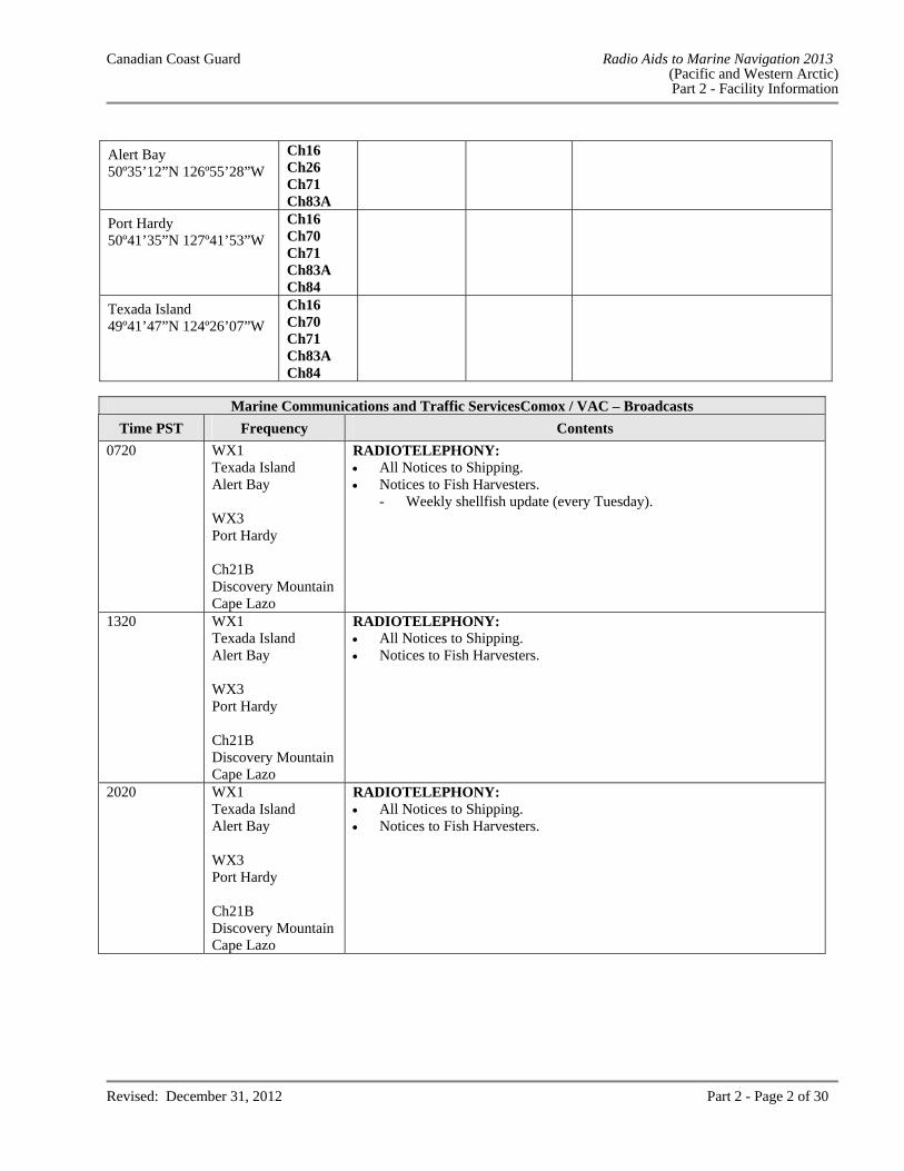
Alert Bay 50º35’12”N 126º55’28”W
Ch16 Ch26 Ch71 Ch83A
Port Hardy 50º41’35”N 127º41’53”W
Ch16 Ch70 Ch71 Ch83A Ch84
Texada Island 49º41’47”N 124º26’07”W
Ch16 Ch70 Ch71 Ch83A Ch84
Marine Communications and Traffic ServicesComox / VAC – Broadcasts
Time PST Frequency Contents
0720 WX1 Texada Island Alert Bay WX3 Port Hardy Ch21B Discovery Mountain Cape Lazo
RADIOTELEPHONY: All Notices to Shipping. Notices to Fish Harvesters. - Weekly shellfish update (every Tuesday).
1320 WX1 Texada Island Alert Bay WX3 Port Hardy Ch21B Discovery Mountain Cape Lazo
RADIOTELEPHONY: All Notices to Shipping. Notices to Fish Harvesters.
2020 WX1 Texada Island Alert Bay WX3 Port Hardy Ch21B Discovery Mountain Cape Lazo
RADIOTELEPHONY: All Notices to Shipping. Notices to Fish Harvesters.
Canadian Coast Guard Radio Aids to Marine Navigation 2013 (Pacific and Western Arctic) Part 2 - Facility Information
Revised: December 31, 2012 Part 2 - Page 3 of 30
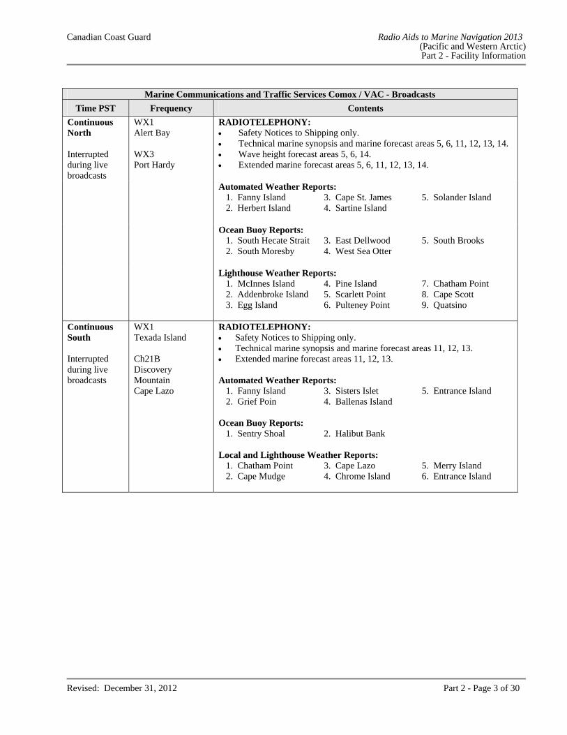
Marine Communications and Traffic Services Comox / VAC - Broadcasts
Time PST Frequency Contents
Continuous North Interrupted during live broadcasts
WX1 Alert Bay WX3 Port Hardy
RADIOTELEPHONY: Safety Notices to Shipping only. Technical marine synopsis and marine forecast areas 5, 6, 11, 12, 13, 14. Wave height forecast areas 5, 6, 14. Extended marine forecast areas 5, 6, 11, 12, 13, 14. Automated Weather Reports:
1. Fanny Island 3. Cape St. James 5. Solander Island 2. Herbert Island 4. Sartine Island
Ocean Buoy Reports: 1. South Hecate Strait 3. East Dellwood 5. South Brooks 2. South Moresby 4. West Sea Otter
Lighthouse Weather Reports: 1. McInnes Island 4. Pine Island 7. Chatham Point 2. Addenbroke Island 5. Scarlett Point 8. Cape Scott 3. Egg Island 6. Pulteney Point 9. Quatsino
Continuous South Interrupted during live broadcasts
WX1 Texada Island Ch21B Discovery Mountain Cape Lazo
RADIOTELEPHONY: Safety Notices to Shipping only. Technical marine synopsis and marine forecast areas 11, 12, 13. Extended marine forecast areas 11, 12, 13. Automated Weather Reports:
1. Fanny Island 3. Sisters Islet 5. Entrance Island 2. Grief Poin 4. Ballenas Island
Ocean Buoy Reports:
1. Sentry Shoal 2. Halibut Bank Local and Lighthouse Weather Reports:
1. Chatham Point 3. Cape Lazo 5. Merry Island 2. Cape Mudge 4. Chrome Island 6. Entrance Island
Canadian Coast Guard Radio Aids to Marine Navigation 2013 (Pacific and Western Arctic) Part 2 - Facility Information
Revised: December 31, 2012 Part 2 - Page 4 of 30
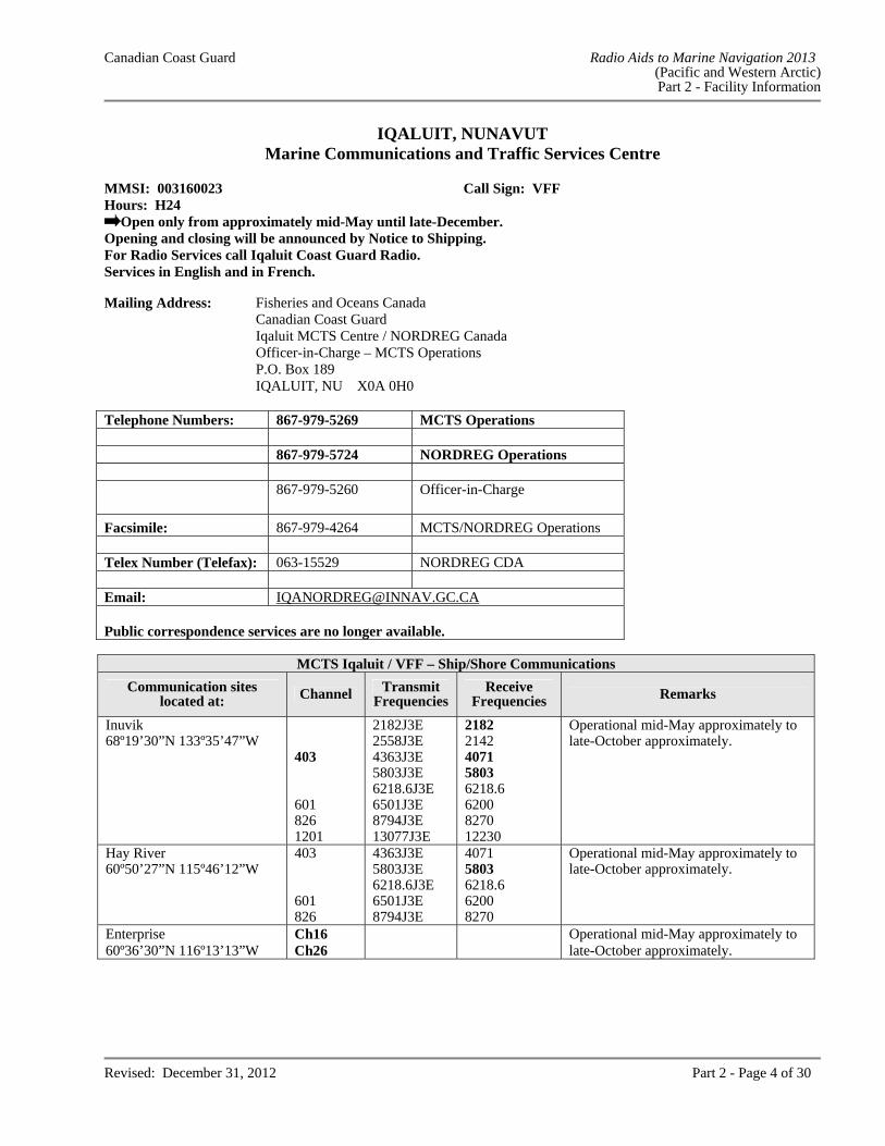
IQALUIT, NUNAVUT Marine Communications and Traffic Services Centre
MMSI: 003160023 Call Sign: VFF Hours: H24
Open only from approximately mid-May until late-December. Opening and closing will be announced by Notice to Shipping. For Radio Services call Iqaluit Coast Guard Radio.Services in English and in French. Mailing Address: Fisheries and Oceans Canada Canadian Coast Guard Iqaluit MCTS Centre / NORDREG Canada Officer-in-Charge – MCTS Operations P.O. Box 189 IQALUIT, NU X0A 0H0
Telephone Numbers: 867-979-5269 MCTS Operations 867-979-5724 NORDREG Operations
867-979-5260 Officer-in-Charge
Facsimile: 867-979-4264 MCTS/NORDREG Operations Telex Number (Telefax): 063-15529 NORDREG CDA Email: [email protected] Public correspondence services are no longer available.
MCTS Iqaluit / VFF – Ship/Shore Communications
Communication sites located at: Channel Transmit
Frequencies Receive
Frequencies Remarks
Inuvik 68º19’30”N 133º35’47”W
403 601 826 1201
2182J3E2558J3E 4363J3E 5803J3E 6218.6J3E 6501J3E 8794J3E 13077J3E
21822142 4071 5803 6218.6 6200 8270 12230
Operational mid-May approximately to late-October approximately.
Hay River 60º50’27”N 115º46’12”W
403 601 826
4363J3E5803J3E 6218.6J3E 6501J3E 8794J3E
40715803 6218.6 6200 8270
Operational mid-May approximately to late-October approximately.
Enterprise 60º36’30”N 116º13’13”W
Ch16 Ch26
Operational mid-May approximately to late-October approximately.
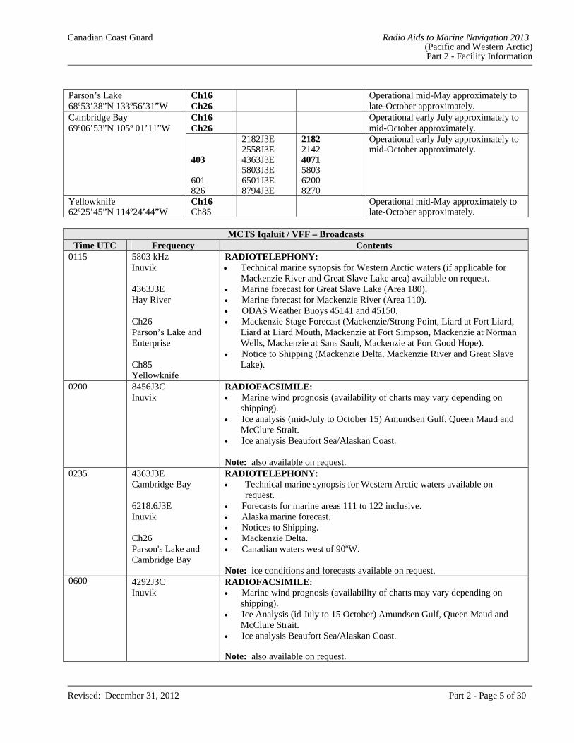
Canadian Coast Guard Radio Aids to Marine Navigation 2013 (Pacific and Western Arctic) Part 2 - Facility Information
Revised: December 31, 2012 Part 2 - Page 5 of 30
Parson’s Lake 68º53’38”N 133º56’31”W
Ch16 Ch26
Operational mid-May approximately to late-October approximately.
Cambridge Bay 69º06’53”N 105º 01’11”W
Ch16 Ch26
Operational early July approximately to mid-October approximately.
403 601 826
2182J3E2558J3E 4363J3E 5803J3E 6501J3E 8794J3E
21822142 4071 5803 6200 8270
Operational early July approximately to mid-October approximately.
Yellowknife 62º25’45”N 114º24’44”W
Ch16 Ch85
Operational mid-May approximately to late-October approximately.
MCTS Iqaluit / VFF – Broadcasts
Time UTC Frequency Contents 0115 5803 kHz
Inuvik 4363J3E Hay River Ch26 Parson’s Lake and Enterprise Ch85 Yellowknife
RADIOTELEPHONY: Technical marine synopsis for Western Arctic waters (if applicable for
Mackenzie River and Great Slave Lake area) available on request. Marine forecast for Great Slave Lake (Area 180). Marine forecast for Mackenzie River (Area 110). ODAS Weather Buoys 45141 and 45150. Mackenzie Stage Forecast (Mackenzie/Strong Point, Liard at Fort Liard,
Liard at Liard Mouth, Mackenzie at Fort Simpson, Mackenzie at Norman Wells, Mackenzie at Sans Sault, Mackenzie at Fort Good Hope).
Notice to Shipping (Mackenzie Delta, Mackenzie River and Great Slave Lake).
0200 8456J3C Inuvik
RADIOFACSIMILE: Marine wind prognosis (availability of charts may vary depending on
shipping). Ice analysis (mid-July to October 15) Amundsen Gulf, Queen Maud and
McClure Strait. Ice analysis Beaufort Sea/Alaskan Coast. Note: also available on request.
0235 4363J3E Cambridge Bay 6218.6J3E Inuvik Ch26 Parson's Lake and Cambridge Bay
RADIOTELEPHONY: Technical marine synopsis for Western Arctic waters available on
request. Forecasts for marine areas 111 to 122 inclusive. Alaska marine forecast. Notices to Shipping. Mackenzie Delta. Canadian waters west of 90ºW. Note: ice conditions and forecasts available on request.
0600 4292J3C Inuvik
RADIOFACSIMILE: Marine wind prognosis (availability of charts may vary depending on
shipping). Ice Analysis (id July to 15 October) Amundsen Gulf, Queen Maud and
McClure Strait. Ice analysis Beaufort Sea/Alaskan Coast. Note: also available on request.
Canadian Coast Guard Radio Aids to Marine Navigation 2013 (Pacific and Western Arctic) Part 2 - Facility Information
Revised: December 31, 2012 Part 2 - Page 6 of 30
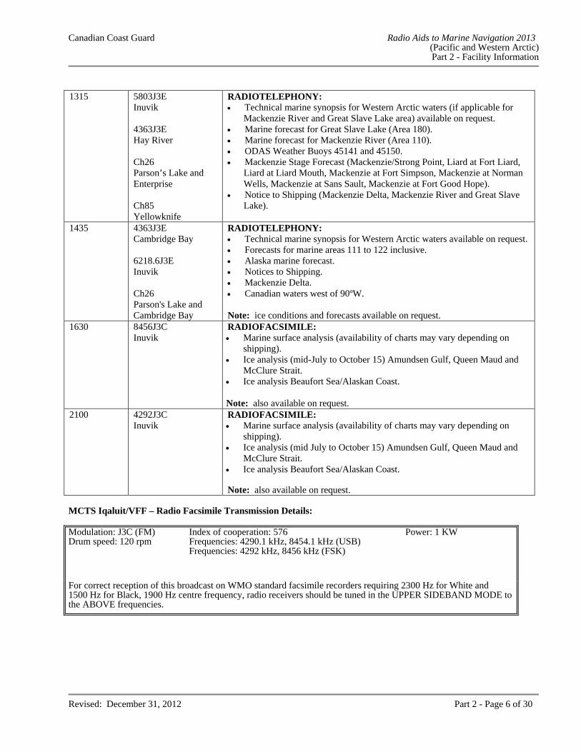
1315 5803J3E
Inuvik 4363J3E Hay River Ch26 Parson’s Lake and Enterprise Ch85 Yellowknife
RADIOTELEPHONY: Technical marine synopsis for Western Arctic waters (if applicable for
Mackenzie River and Great Slave Lake area) available on request. Marine forecast for Great Slave Lake (Area 180). Marine forecast for Mackenzie River (Area 110). ODAS Weather Buoys 45141 and 45150. Mackenzie Stage Forecast (Mackenzie/Strong Point, Liard at Fort Liard,
Liard at Liard Mouth, Mackenzie at Fort Simpson, Mackenzie at Norman Wells, Mackenzie at Sans Sault, Mackenzie at Fort Good Hope).
Notice to Shipping (Mackenzie Delta, Mackenzie River and Great Slave Lake).
1435 4363J3E Cambridge Bay 6218.6J3E Inuvik Ch26 Parson's Lake and Cambridge Bay
RADIOTELEPHONY: Technical marine synopsis for Western Arctic waters available on request. Forecasts for marine areas 111 to 122 inclusive. Alaska marine forecast. Notices to Shipping. Mackenzie Delta. Canadian waters west of 90ºW. Note: ice conditions and forecasts available on request.
1630 8456J3C Inuvik
RADIOFACSIMILE: Marine surface analysis (availability of charts may vary depending on
shipping). Ice analysis (mid-July to October 15) Amundsen Gulf, Queen Maud and
McClure Strait. Ice analysis Beaufort Sea/Alaskan Coast. Note: also available on request.
2100 4292J3C Inuvik
RADIOFACSIMILE: Marine surface analysis (availability of charts may vary depending on
shipping). Ice analysis (mid July to October 15) Amundsen Gulf, Queen Maud and
McClure Strait. Ice analysis Beaufort Sea/Alaskan Coast. Note: also available on request.
MCTS Iqaluit/VFF – Radio Facsimile Transmission Details: Modulation: J3C (FM) Index of cooperation: 576 Power: 1 KW Drum speed: 120 rpm Frequencies: 4290.1 kHz, 8454.1 kHz (USB) Frequencies: 4292 kHz, 8456 kHz (FSK)
For correct reception of this broadcast on WMO standard facsimile recorders requiring 2300 Hz for White and 1500 Hz for Black, 1900 Hz centre frequency, radio receivers should be tuned in the UPPER SIDEBAND MODE to the ABOVE frequencies.
Canadian Coast Guard Radio Aids to Marine Navigation 2013 (Pacific and Western Arctic) Part 2 - Facility Information
Revised: December 31, 2012 Part 2 - Page 7 of 30
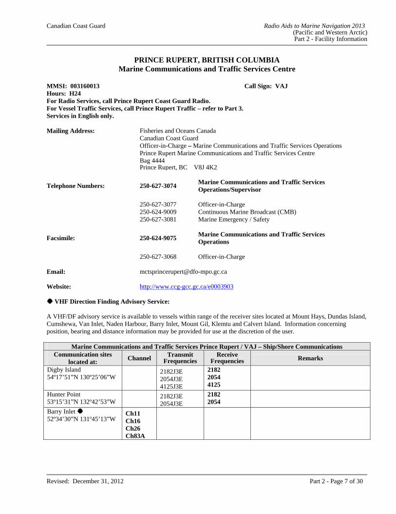
PRINCE RUPERT, BRITISH COLUMBIA Marine Communications and Traffic Services Centre
MMSI: 003160013 Call Sign: VAJ Hours: H24 For Radio Services, call Prince Rupert Coast Guard Radio.For Vessel Traffic Services, call Prince Rupert Traffic – refer to Part 3.Services in English only. Mailing Address: Fisheries and Oceans Canada
Canadian Coast Guard Officer-in-Charge – Marine Communications and Traffic Services Operations Prince Rupert Marine Communications and Traffic Services Centre Bag 4444 Prince Rupert, BC V8J 4K2
Telephone Numbers: 250-627-3074 Marine Communications and Traffic Services Operations/Supervisor
250-627-3077 Officer-in-Charge 250-624-9009 Continuous Marine Broadcast (CMB) 250-627-3081 Marine Emergency / Safety
Facsimile: 250-624-9075 Marine Communications and Traffic Services Operations
250-627-3068 Officer-in-Charge Email: [email protected] Website: http://www.ccg-gcc.gc.ca/e0003903
VHF Direction Finding Advisory Service: A VHF/DF advisory service is available to vessels within range of the receiver sites located at Mount Hays, Dundas Island, Cumshewa, Van Inlet, Naden Harbour, Barry Inlet, Mount Gil, Klemtu and Calvert Island. Information concerning position, bearing and distance information may be provided for use at the discretion of the user.
Marine Communications and Traffic Services Prince Rupert / VAJ – Ship/Shore Communications Communication sites
located at: Channel
Transmit Frequencies
Receive Frequencies Remarks
Digby Island 54º17’51”N 130º25’06”W
2182J3E 2054J3E 4125J3E
2182 2054 4125
Hunter Point 53º15’31”N 132º42’53”W
2182J3E 2054J3E
2182 2054
Barry Inlet
52º34’30”N 131º45’13”W Ch11 Ch16 Ch26 Ch83A
Canadian Coast Guard Radio Aids to Marine Navigation 2013 (Pacific and Western Arctic) Part 2 - Facility Information
Revised: December 31, 2012 Part 2 - Page 8 of 30
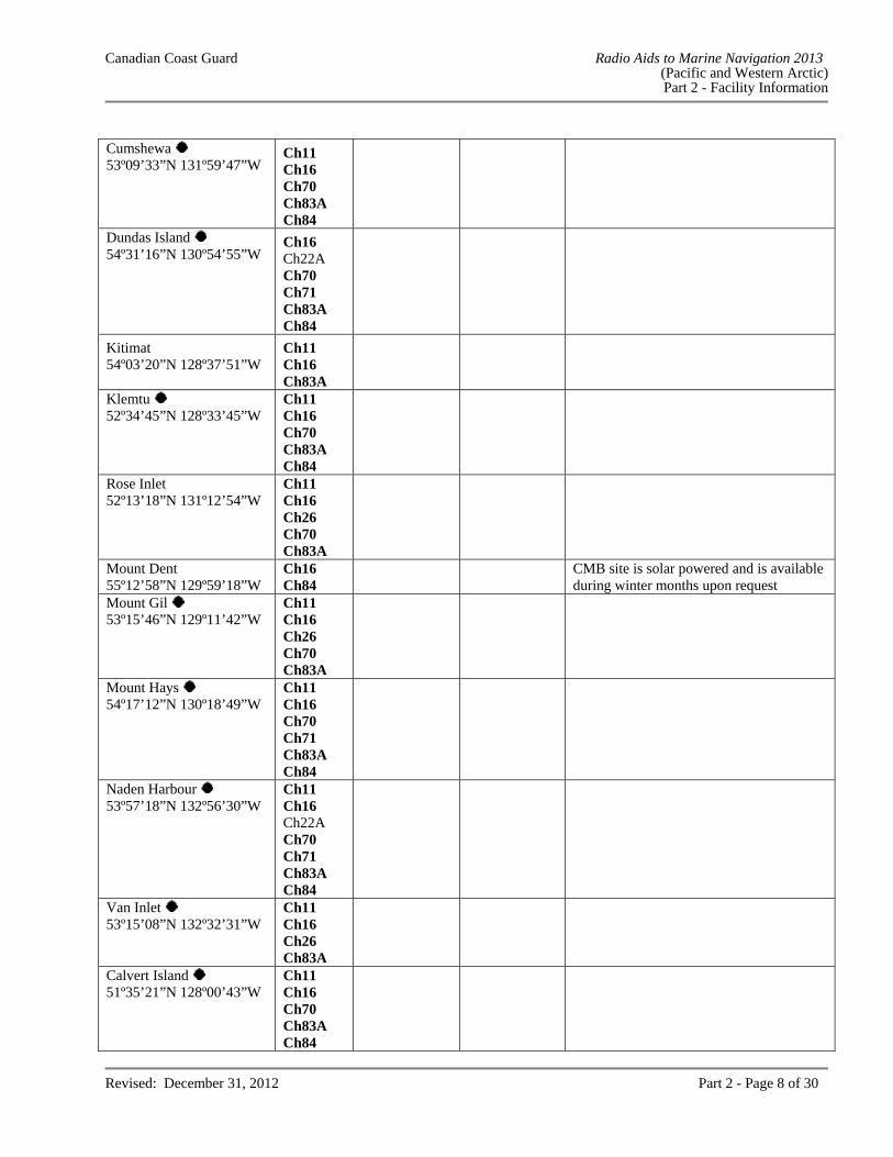
Cumshewa
53º09’33”N 131º59’47”W Ch11 Ch16 Ch70 Ch83A Ch84
Dundas Island
54º31’16”N 130º54’55”W Ch16 Ch22A Ch70 Ch71 Ch83A Ch84
Kitimat 54º03’20”N 128º37’51”W
Ch11 Ch16 Ch83A
Klemtu 52º34’45”N 128º33’45”W
Ch11 Ch16 Ch70 Ch83A Ch84
Rose Inlet 52º13’18”N 131º12’54”W
Ch11 Ch16 Ch26 Ch70 Ch83A
Mount Dent 55º12’58”N 129º59’18”W
Ch16 Ch84
CMB site is solar powered and is available during winter months upon request
Mount Gil
53º15’46”N 129º11’42”W Ch11 Ch16 Ch26 Ch70 Ch83A
Mount Hays
54º17’12”N 130º18’49”W Ch11 Ch16 Ch70 Ch71 Ch83A Ch84
Naden Harbour
53º57’18”N 132º56’30”W Ch11 Ch16 Ch22A Ch70 Ch71 Ch83A Ch84
Van Inlet
53º15’08”N 132º32’31”W Ch11 Ch16 Ch26 Ch83A
Calvert Island
51º35’21”N 128º00’43”W Ch11 Ch16 Ch70 Ch83A Ch84
Canadian Coast Guard Radio Aids to Marine Navigation 2013 (Pacific and Western Arctic) Part 2 - Facility Information
Revised: December 31, 2012 Part 2 - Page 9 of 30
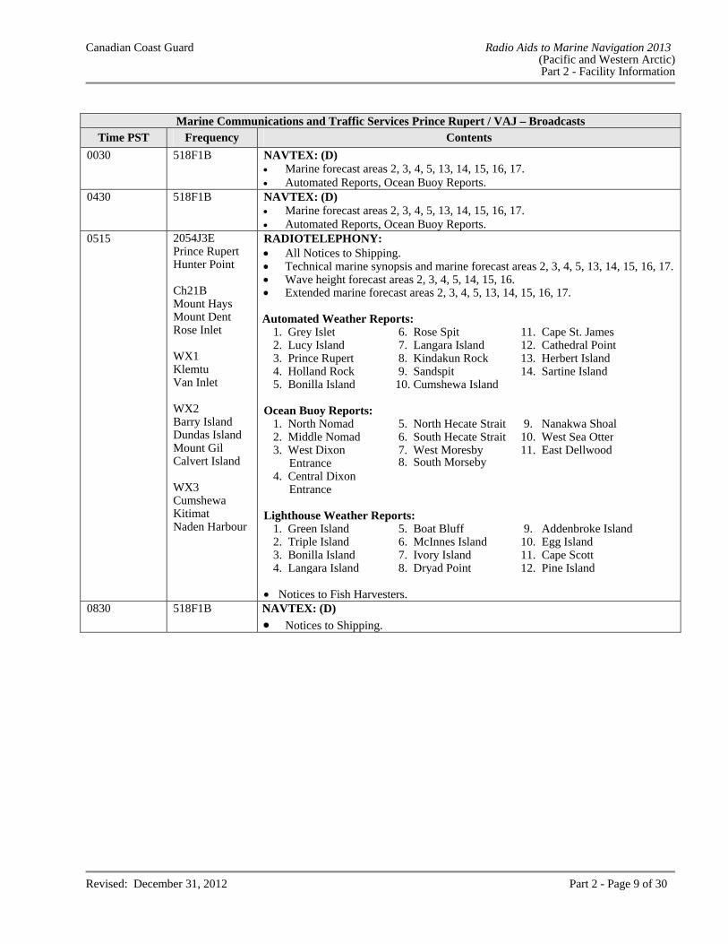
Marine Communications and Traffic Services Prince Rupert / VAJ – Broadcasts
Time PST Frequency Contents
0030 518F1B NAVTEX: (D) Marine forecast areas 2, 3, 4, 5, 13, 14, 15, 16, 17. Automated Reports, Ocean Buoy Reports.
0430 518F1B NAVTEX: (D) Marine forecast areas 2, 3, 4, 5, 13, 14, 15, 16, 17. Automated Reports, Ocean Buoy Reports.
0515
2054J3E Prince Rupert Hunter Point Ch21B Mount Hays Mount Dent Rose Inlet WX1 Klemtu Van Inlet WX2 Barry Island Dundas Island Mount Gil Calvert Island WX3 Cumshewa Kitimat Naden Harbour
RADIOTELEPHONY: All Notices to Shipping. Technical marine synopsis and marine forecast areas 2, 3, 4, 5, 13, 14, 15, 16, 17. Wave height forecast areas 2, 3, 4, 5, 14, 15, 16. Extended marine forecast areas 2, 3, 4, 5, 13, 14, 15, 16, 17.
Automated Weather Reports:
1. Grey Islet 6. Rose Spit 11. Cape St. James 2. Lucy Island 7. Langara Island 12. Cathedral Point 3. Prince Rupert 8. Kindakun Rock 13. Herbert Island 4. Holland Rock 9. Sandspit 14. Sartine Island 5. Bonilla Island 10. Cumshewa Island
Ocean Buoy Reports: 1. North Nomad 5. North Hecate Strait 9. Nanakwa Shoal 2. Middle Nomad 6. South Hecate Strait 10. West Sea Otter 3. West Dixon
Entrance7. West Moresby
8. South Morseby 11. East Dellwood
4. Central Dixon Entrance
Lighthouse Weather Reports:
1. Green Island 5. Boat Bluff 9. Addenbroke Island 2. Triple Island 6. McInnes Island 10. Egg Island 3. Bonilla Island 7. Ivory Island 11. Cape Scott 4. Langara Island 8. Dryad Point 12. Pine Island Notices to Fish Harvesters.
0830 518F1B NAVTEX: (D)
Notices to Shipping.
Canadian Coast Guard Radio Aids to Marine Navigation 2013 (Pacific and Western Arctic) Part 2 - Facility Information
Revised: December 31, 2012 Part 2 - Page 10 of 30
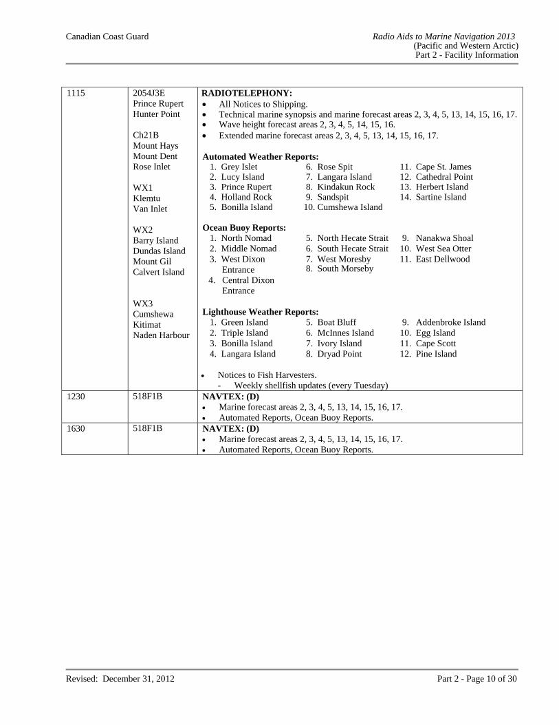
1115 2054J3E
Prince Rupert Hunter Point Ch21B Mount Hays Mount Dent Rose Inlet WX1 Klemtu Van Inlet WX2 Barry Island Dundas Island Mount Gil Calvert Island WX3 Cumshewa Kitimat Naden Harbour
RADIOTELEPHONY: All Notices to Shipping. Technical marine synopsis and marine forecast areas 2, 3, 4, 5, 13, 14, 15, 16, 17. Wave height forecast areas 2, 3, 4, 5, 14, 15, 16. Extended marine forecast areas 2, 3, 4, 5, 13, 14, 15, 16, 17. Automated Weather Reports:
1. Grey Islet 6. Rose Spit 11. Cape St. James 2. Lucy Island 7. Langara Island 12. Cathedral Point 3. Prince Rupert 8. Kindakun Rock 13. Herbert Island 4. Holland Rock 9. Sandspit 14. Sartine Island 5. Bonilla Island 10. Cumshewa Island
Ocean Buoy Reports:
1. North Nomad 5. North Hecate Strait 9. Nanakwa Shoal 2. Middle Nomad 6. South Hecate Strait 10. West Sea Otter 3. West Dixon
Entrance 4. Central Dixon
Entrance
7. West Moresby 8. South Morseby
11. East Dellwood
Lighthouse Weather Reports:
1. Green Island 5. Boat Bluff 9. Addenbroke Island 2. Triple Island 6. McInnes Island 10. Egg Island 3. Bonilla Island 7. Ivory Island 11. Cape Scott 4. Langara Island 8. Dryad Point 12. Pine Island
Notices to Fish Harvesters.
- Weekly shellfish updates (every Tuesday) 1230 518F1B NAVTEX: (D)
Marine forecast areas 2, 3, 4, 5, 13, 14, 15, 16, 17. Automated Reports, Ocean Buoy Reports.
1630 518F1B NAVTEX: (D) Marine forecast areas 2, 3, 4, 5, 13, 14, 15, 16, 17. Automated Reports, Ocean Buoy Reports.
Canadian Coast Guard Radio Aids to Marine Navigation 2013 (Pacific and Western Arctic) Part 2 - Facility Information
Revised: December 31, 2012 Part 2 - Page 11 of 30
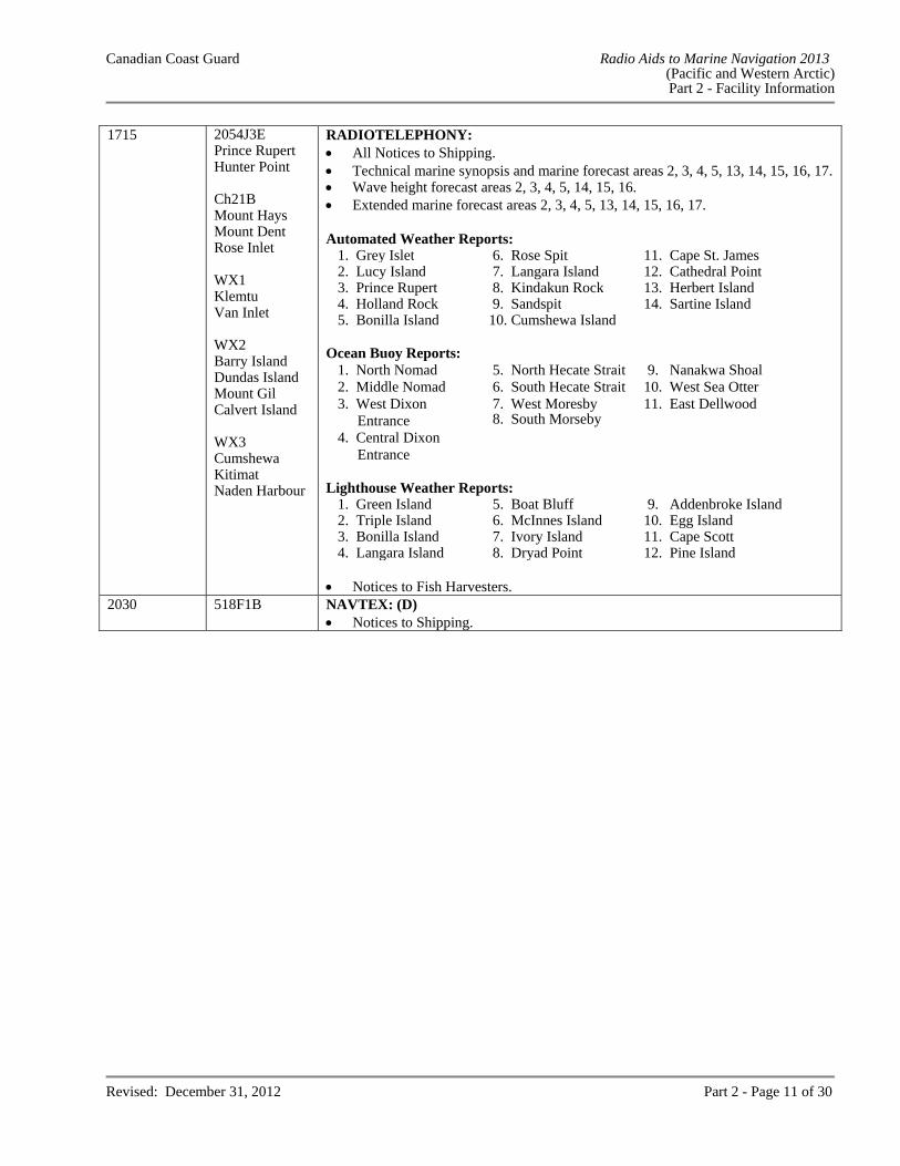
1715 2054J3E Prince Rupert Hunter Point Ch21B Mount Hays Mount Dent Rose Inlet WX1 Klemtu Van Inlet WX2 Barry Island Dundas Island Mount Gil Calvert Island WX3 Cumshewa Kitimat Naden Harbour
RADIOTELEPHONY: All Notices to Shipping. Technical marine synopsis and marine forecast areas 2, 3, 4, 5, 13, 14, 15, 16, 17. Wave height forecast areas 2, 3, 4, 5, 14, 15, 16. Extended marine forecast areas 2, 3, 4, 5, 13, 14, 15, 16, 17. Automated Weather Reports:
1. Grey Islet 6. Rose Spit 11. Cape St. James 2. Lucy Island 7. Langara Island 12. Cathedral Point 3. Prince Rupert 8. Kindakun Rock 13. Herbert Island 4. Holland Rock 9. Sandspit 14. Sartine Island 5. Bonilla Island 10. Cumshewa Island
Ocean Buoy Reports:
1. North Nomad 5. North Hecate Strait 9. Nanakwa Shoal 2. Middle Nomad 6. South Hecate Strait 10. West Sea Otter 3. West Dixon
Entrance 7. West Moresby 8. South Morseby
11. East Dellwood
4. Central Dixon Entrance
Lighthouse Weather Reports:
1. Green Island 5. Boat Bluff 9. Addenbroke Island 2. Triple Island 6. McInnes Island 10. Egg Island 3. Bonilla Island 7. Ivory Island 11. Cape Scott 4. Langara Island 8. Dryad Point 12. Pine Island Notices to Fish Harvesters.
2030 518F1B NAVTEX: (D) Notices to Shipping.
Canadian Coast Guard Radio Aids to Marine Navigation 2013 (Pacific and Western Arctic) Part 2 - Facility Information
Revised: December 31, 2012 Part 2 - Page 12 of 30
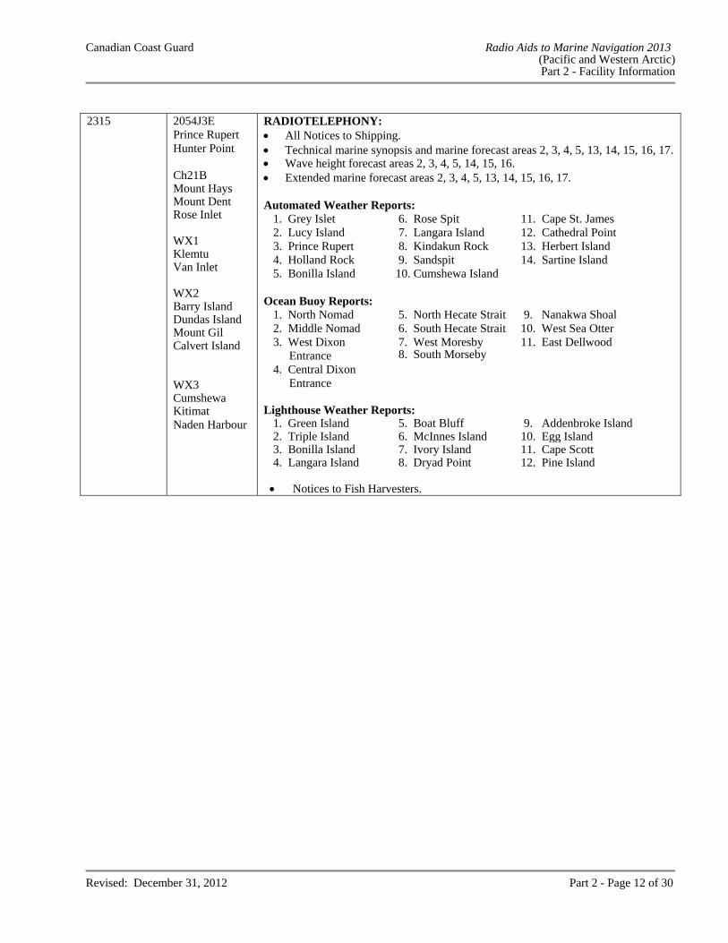
2315
2054J3E Prince Rupert Hunter Point Ch21B Mount Hays Mount Dent Rose Inlet WX1 Klemtu Van Inlet WX2 Barry Island Dundas Island Mount Gil Calvert Island WX3 Cumshewa Kitimat Naden Harbour
RADIOTELEPHONY: All Notices to Shipping. Technical marine synopsis and marine forecast areas 2, 3, 4, 5, 13, 14, 15, 16, 17. Wave height forecast areas 2, 3, 4, 5, 14, 15, 16. Extended marine forecast areas 2, 3, 4, 5, 13, 14, 15, 16, 17. Automated Weather Reports:
1. Grey Islet 6. Rose Spit 11. Cape St. James 2. Lucy Island 7. Langara Island 12. Cathedral Point 3. Prince Rupert 8. Kindakun Rock 13. Herbert Island 4. Holland Rock 9. Sandspit 14. Sartine Island 5. Bonilla Island 10. Cumshewa Island
Ocean Buoy Reports:
1. North Nomad 5. North Hecate Strait 9. Nanakwa Shoal 2. Middle Nomad 6. South Hecate Strait 10. West Sea Otter 3. West Dixon
Entrance 7. West Moresby 8. South Morseby
11. East Dellwood
4. Central Dixon Entrance
Lighthouse Weather Reports:
1. Green Island 5. Boat Bluff 9. Addenbroke Island 2. Triple Island 6. McInnes Island 10. Egg Island 3. Bonilla Island 7. Ivory Island 11. Cape Scott 4. Langara Island 8. Dryad Point 12. Pine Island
Notices to Fish Harvesters.
Canadian Coast Guard Radio Aids to Marine Navigation 2013 (Pacific and Western Arctic) Part 2 - Facility Information
Revised: December 31, 2012 Part 2 - Page 13 of 30
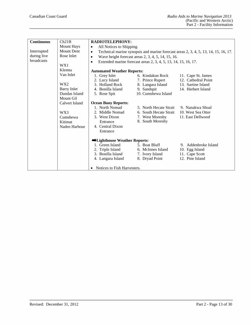
Continuous Interrupted during live broadcasts
Ch21B Mount Hays Mount Dent Rose Inlet WX1 Klemtu Van Inlet WX2 Barry Inlet Dundas Island Mount Gil Calvert Island WX3 Cumshewa Kitimat Naden Harbour
RADIOTELEPHONY: All Notices to Shipping. Technical marine synopsis and marine forecast areas 2, 3, 4, 5, 13, 14, 15, 16, 17. Wave height forecast areas 2, 3, 4, 5, 14, 15, 16. Extended marine forecast areas 2, 3, 4, 5, 13, 14, 15, 16, 17. Automated Weather Reports:
1. Grey Islet 6. Kindakun Rock 11. Cape St. James 2. Lucy Island 7. Prince Rupert 12. Cathedral Point 3. Holland Rock 8. Langara Island 13. Sartine Island 4. Bonilla Island 9. Sandspit 14. Herbert Island 5. Rose Spit 10. Cumshewa Island
Ocean Buoy Reports:
1. North Nomad 5. North Hecate Strait 9. Nanakwa Shoal 2. Middle Nomad 6. South Hecate Strait 10. West Sea Otter 3. West Dixon
Entrance 7. West Moresby 8. South Moresby
11. East Dellwood
4. Central Dixon Entrance
Lighthouse Weather Reports:
1. Green Island 5. Boat Bluff 9. Addenbroke Island 2. Triple Island 6. McInnes Island 10. Egg Island 3. Bonilla Island 7. Ivory Island 11. Cape Scott 4. Langara Island 8. Dryad Point 12. Pine Island
Notices to Fish Harvesters.
Canadian Coast Guard Radio Aids to Marine Navigation 2013 (Pacific and Western Arctic) Part 2 - Facility Information
Revised: December 31, 2012 Part 2 - Page 14 of 30
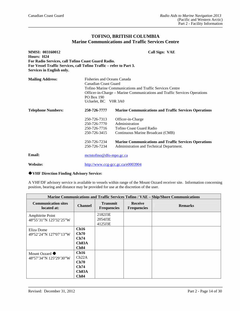
TOFINO, BRITISH COLUMBIA Marine Communications and Traffic Services Centre
MMSI: 003160012 Call Sign: VAE Hours: H24 For Radio Services, call Tofino Coast Guard Radio.For Vessel Traffic Services, call Tofino Traffic – refer to Part 3.Services in English only. Mailing Address: Fisheries and Oceans Canada
Canadian Coast Guard Tofino Marine Communications and Traffic Services Centre Officer-in-Charge – Marine Communications and Traffic Services Operations PO Box 190 Ucluelet, BC V0R 3A0
Telephone Numbers: 250-726-7777 Marine Communications and Traffic Services Operations 250-726-7313 Officer-in-Charge 250-726-7770 Administration 250-726-7716 Tofino Coast Guard Radio 250-726-3415 Continuous Marine Broadcast (CMB) 250-726-7234 Marine Communications and Traffic Services Operations 250-726-7234 Administration and Technical Department. Email: [email protected] Website: http://www.ccg-gcc.gc.ca/e0003904
VHF Direction Finding Advisory Service: A VHF/DF advisory service is available to vessels within range of the Mount Ozzard receiver site. Information concerning position, bearing and distance may be provided for use at the discretion of the user.
Marine Communications and Traffic Services Tofino / VAE – Ship/Shore Communications
Communication sites located at:
Channel Transmit
Frequencies Receive
Frequencies Remarks
Amphitrite Point 48º55’31”N 125º32’25”W
2182J3E 2054J3E 4125J3E
Eliza Dome 49º52’24”N 127º07’13”W
Ch16 Ch70 Ch74 Ch83A Ch84
Mount Ozzard 48º57’34”N 125º29’30”W
Ch16 Ch22A Ch70 Ch74 Ch83A Ch84
Canadian Coast Guard Radio Aids to Marine Navigation 2013 (Pacific and Western Arctic) Part 2 - Facility Information
Revised: December 31, 2012 Part 2 - Page 15 of 30
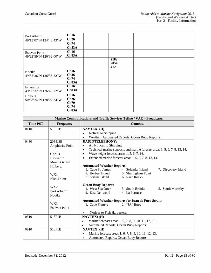
Port Alberni 49º13’07”N 124º48’43”W
Ch16 Ch26 Ch74 Ch83A
Estevan Point 49º22’59”N 126º32’00”W
Ch16 Ch83A 2182
2054 4125
Nootka 49º35’36”N 126º36’52”W
Ch16 Ch26 Ch74 Ch83A
Esperanza 49º50’32”N 126º48’22”W
Ch16 Ch83A
Holberg 50º38’24”N 128º07’34”W
Ch16 Ch26 Ch70 Ch74 Ch83A
Marine Communications and Traffic Services Tofino / VAE – Broadcasts
Time PST Frequency Contents
0110 518F1B NAVTEX: (H) Notices to Shipping. Weather: Automated Reports, Ocean Buoy Reports.
0450 2054J3E Amphitrite Point Ch21B Esperanza Mount Ozzard Holberg WX1 Eliza Dome WX2 Port Alberni Nootka WX3 Estevan Point
RADIOTELEPHONY: All Notices to Shipping. Technical marine synopsis and marine forecast areas 1, 5, 6, 7, 8, 13, 14. Wave height forecast areas 1, 5, 6, 7, 14. Extended marine forecast areas 1, 5, 6, 7, 8, 13, 14.
Automated Weather Reports:
1. Cape St. James 4. Solander Island 7. Discovery Island 2. Herbert Island 5. Sheringham Point 3. Sartine Island 6. Race Rocks
Ocean Buoy Reports:
1. West Sea Otter 3. South Brooks 5. South Moresby 2. East Dellwood 4. La Perouse
Automated Weather Reports for Juan de Fuca Strait:
1. Cape Flattery 2. “JA” Buoy Notices to Fish Harvesters.
0510 518F1B NAVTEX: (H) Marine forecast areas 1, 6, 7, 8, 9, 10, 11, 12, 13. Automated Reports, Ocean Buoy Reports.
0910 518F1B NAVTEX: (H) Marine forecast areas 1, 6, 7, 8, 9, 10, 11, 12, 13. Automated Reports, Ocean Buoy Reports.
Canadian Coast Guard Radio Aids to Marine Navigation 2013 (Pacific and Western Arctic) Part 2 - Facility Information
Revised: December 31, 2012 Part 2 - Page 16 of 30
Marine Communications and Traffic Services Tofino / VAE – Broadcasts
Time PST Frequency Contents
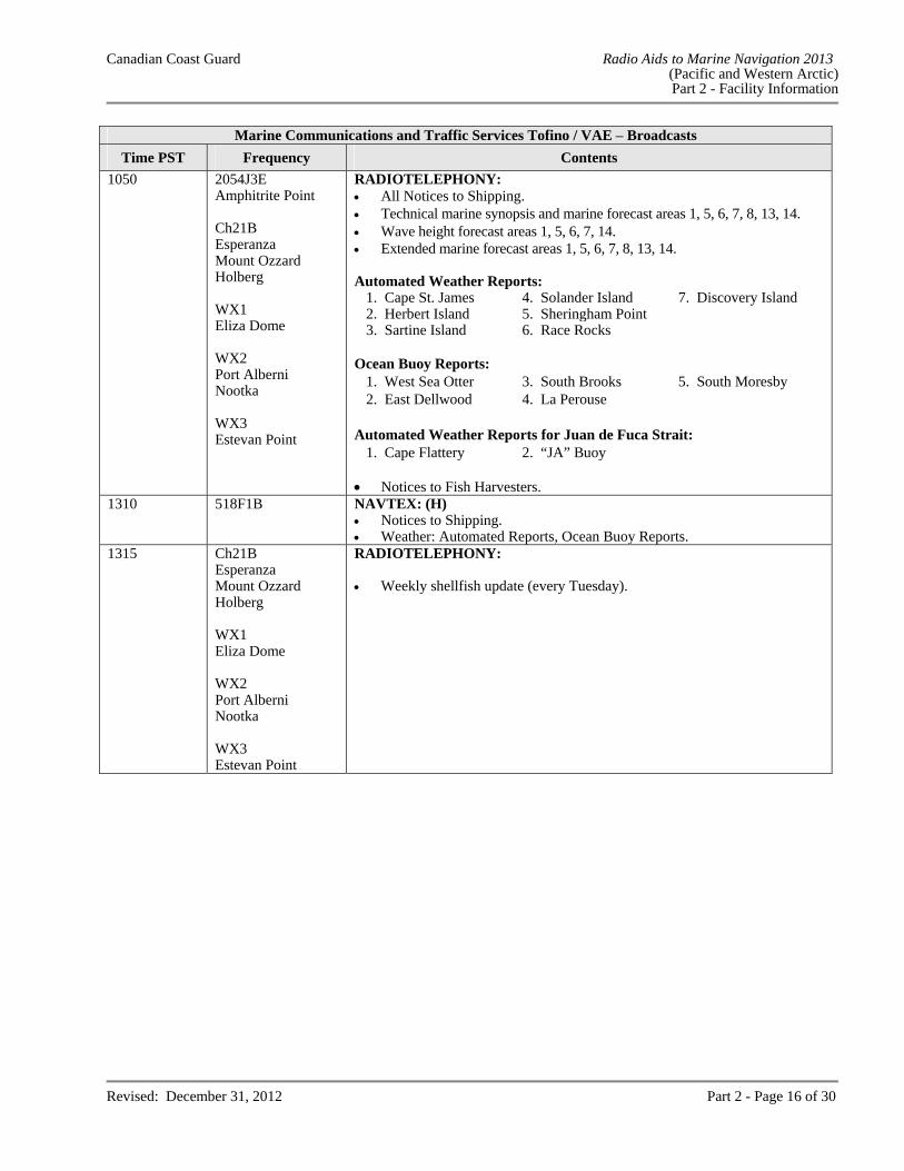
1050 2054J3E Amphitrite Point Ch21B Esperanza Mount Ozzard Holberg WX1 Eliza Dome WX2 Port Alberni Nootka WX3 Estevan Point
RADIOTELEPHONY: All Notices to Shipping. Technical marine synopsis and marine forecast areas 1, 5, 6, 7, 8, 13, 14. Wave height forecast areas 1, 5, 6, 7, 14. Extended marine forecast areas 1, 5, 6, 7, 8, 13, 14.
Automated Weather Reports: 1. Cape St. James 4. Solander Island 7. Discovery Island 2. Herbert Island 5. Sheringham Point 3. Sartine Island 6. Race Rocks
Ocean Buoy Reports:
1. West Sea Otter 3. South Brooks 5. South Moresby 2. East Dellwood 4. La Perouse
Automated Weather Reports for Juan de Fuca Strait:
1. Cape Flattery 2. “JA” Buoy Notices to Fish Harvesters.
1310 518F1B NAVTEX: (H) Notices to Shipping. Weather: Automated Reports, Ocean Buoy Reports.
1315
Ch21B Esperanza Mount Ozzard Holberg WX1 Eliza Dome WX2 Port Alberni Nootka WX3 Estevan Point
RADIOTELEPHONY: Weekly shellfish update (every Tuesday).
Canadian Coast Guard Radio Aids to Marine Navigation 2013 (Pacific and Western Arctic) Part 2 - Facility Information
Revised: December 31, 2012 Part 2 - Page 17 of 30
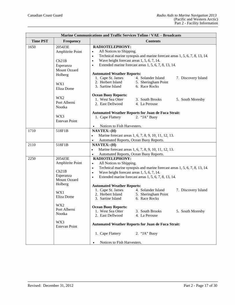
Marine Communications and Traffic Services Tofino / VAE – Broadcasts
Time PST Frequency Contents
1650 2054J3E Amphitrite Point Ch21B Esperanza Mount Ozzard Holberg WX1 Eliza Dome WX2 Port Alberni Nootka WX3 Estevan Point
RADIOTELEPHONY: All Notices to Shipping. Technical marine synopsis and marine forecast areas 1, 5, 6, 7, 8, 13, 14. Wave height forecast areas 1, 5, 6, 7, 14. Extended marine forecast areas 1, 5, 6, 7, 8, 13, 14. Automated Weather Reports:
1. Cape St. James 4. Solander Island 7. Discovery Island 2. Herbert Island 5. Sheringham Point 3. Sartine Island 6. Race Rocks
Ocean Buoy Reports:
1. West Sea Otter 3. South Brooks 5. South Moresby 2. East Dellwood 4. La Perouse
Automated Weather Reports for Juan de Fuca Strait:
1. Cape Flattery 2. “JA” Buoy Notices to Fish Harvesters.
1710 518F1B NAVTEX: (H) Marine forecast areas 1, 6, 7, 8, 9, 10, 11, 12, 13. Automated Reports, Ocean Buoy Reports.
2110 518F1B NAVTEX: (H) Marine forecast areas 1, 6, 7, 8, 9, 10, 11, 12, 13. Automated Reports, Ocean Buoy Reports.
2250 2054J3E Amphitrite Point Ch21B Esperanza Mount Ozzard Holberg WX1 Eliza Dome WX2 Port Alberni Nootka WX3 Estevan Point
RADIOTELEPHONY: All Notices to Shipping. Technical marine synopsis and marine forecast areas 1, 5, 6, 7, 8, 13, 14. Wave height forecast areas 1, 5, 6, 7, 14. Extended marine forecast areas 1, 5, 6, 7, 8, 13, 14. Automated Weather Reports:
1. Cape St. James 4. Solander Island 7. Discovery Island 2. Herbert Island 5. Sheringham Point 3. Sartine Island 6. Race Rocks
Ocean Buoy Reports:
1. West Sea Otter 3. South Brooks 5. South Moresby 2. East Dellwood 4. La Perouse
Automated Weather Reports for Juan de Fuca Strait:
1. Cape Flattery 2. “JA” Buoy Notices to Fish Harvesters.
Canadian Coast Guard Radio Aids to Marine Navigation 2013 (Pacific and Western Arctic) Part 2 - Facility Information
Revised: December 31, 2012 Part 2 - Page 18 of 30
Marine Communications and Traffic Services Tofino / VAE – Broadcasts
Time PST Frequency Contents
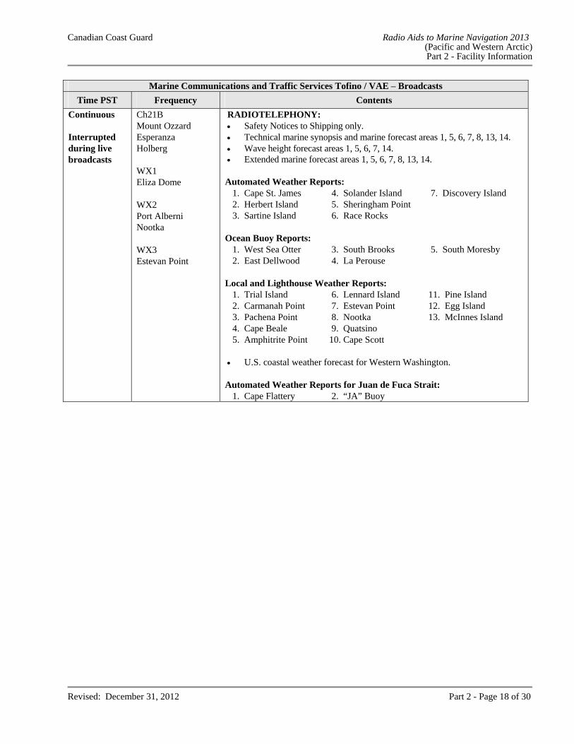
Continuous Interrupted during live broadcasts
Ch21B Mount Ozzard Esperanza Holberg WX1 Eliza Dome WX2 Port Alberni Nootka WX3 Estevan Point
RADIOTELEPHONY: Safety Notices to Shipping only. Technical marine synopsis and marine forecast areas 1, 5, 6, 7, 8, 13, 14. Wave height forecast areas 1, 5, 6, 7, 14. Extended marine forecast areas 1, 5, 6, 7, 8, 13, 14.
Automated Weather Reports: 1. Cape St. James 4. Solander Island 7. Discovery Island 2. Herbert Island 5. Sheringham Point 3. Sartine Island 6. Race Rocks
Ocean Buoy Reports:
1. West Sea Otter 3. South Brooks 5. South Moresby 2. East Dellwood 4. La Perouse
Local and Lighthouse Weather Reports:
1. Trial Island 6. Lennard Island 11. Pine Island 2. Carmanah Point 7. Estevan Point 12. Egg Island 3. Pachena Point 8. Nootka 13. McInnes Island 4. Cape Beale 9. Quatsino 5. Amphitrite Point 10. Cape Scott
U.S. coastal weather forecast for Western Washington.
Automated Weather Reports for Juan de Fuca Strait: 1. Cape Flattery 2. “JA” Buoy
Canadian Coast Guard Radio Aids to Marine Navigation 2013 (Pacific and Western Arctic) Part 2 - Facility Information
Revised: December 31, 2012 Part 2 - Page 19 of 30
VANCOUVER, BRITISH COLUMBIA Marine Communications and Traffic Services Centre
MMSI: 003160010 Call Sign: VAS Hours: H24 For Radio Services, call Vancouver Coast Guard Radio.For Vessel Traffic Services, call Vancouver Traffic – refer to Part 3. Services in English only. Mailing Address: Fisheries and Oceans Canada
Canadian Coast Guard Vancouver Marine Communications and Traffic Services Centre Officer-in-Charge – Marine Communications and Traffic Services Operations 555 West Hastings Street Suite 2380 P.O. Box 12107 Vancouver, BC V6B 4N6
Telephone Numbers: 604-775-8919 Marine Communications and Traffic Services
Operations Centre/Shift Supervisor 604-666-1004 Officer-in-Charge 604-666-1003 Administration 604-666-6011 Regional Marine Information Centre 604-775-8920 Emergency Phone to Safety Position 604-666-3655 Continuous Marine Broadcast (CMB) Facsimile: 604-666-8453 Telex Number: 043-52586 CGTC VAS VCR Email: [email protected] Website: www.ccg-gcc.gc.ca/e0003905
Marine Communications and Traffic Services Vancouver / VAS – Ship/Shore Communications
Communication sites located at:
Channel Transmit
Frequencies Receive
Frequencies Remarks
Vancouver 49º17’05”N 123º06’44”W
Ch12 Ch16 Ch26 Ch83A
Watts Point (Howe Sound) 49º38’54”N 123º12’36”W
Ch12 Ch16 Ch26 Ch70 Ch83A
Canadian Coast Guard Radio Aids to Marine Navigation 2013 (Pacific and Western Arctic) Part 2 - Facility Information
Revised: December 31, 2012 Part 2 - Page 20 of 30
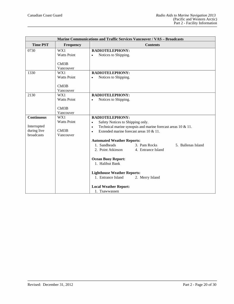
Marine Communications and Traffic Services Vancouver / VAS – Broadcasts
Time PST Frequency Contents
0730 WX1 Watts Point Ch83B Vancouver
RADIOTELEPHONY: Notices to Shipping.
1330 WX1 Watts Point Ch83B Vancouver
RADIOTELEPHONY: Notices to Shipping.
2130 WX1 Watts Point Ch83B Vancouver
RADIOTELEPHONY: Notices to Shipping.
Continuous Interrupted during live broadcasts
WX1 Watts Point Ch83B Vancouver
RADIOTELEPHONY: Safety Notices to Shipping only. Technical marine synopsis and marine forecast areas 10 & 11. Extended marine forecast areas 10 & 11.
Automated Weather Reports:
1. Sandheads 3. Pam Rocks 5. Ballenas Island 2. Point Atkinson 4. Entrance Island
Ocean Buoy Report:
1. Halibut Bank Lighthouse Weather Reports:
1. Entrance Island 2. Merry Island Local Weather Report:
1. Tsawwassen
Canadian Coast Guard Radio Aids to Marine Navigation 2013 (Pacific and Western Arctic) Part 2 - Facility Information
Revised: December 31, 2012 Part 2 - Page 21 of 30
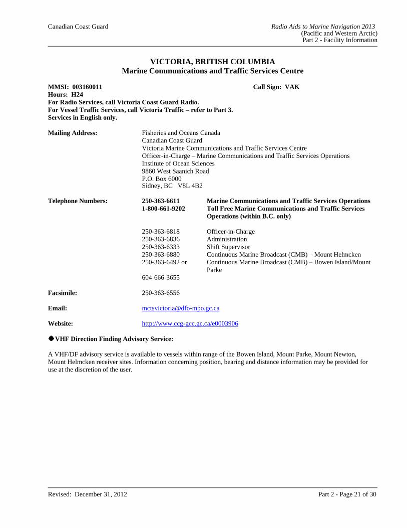
VICTORIA, BRITISH COLUMBIA Marine Communications and Traffic Services Centre
MMSI: 003160011 Call Sign: VAK Hours: H24 For Radio Services, call Victoria Coast Guard Radio.For Vessel Traffic Services, call Victoria Traffic – refer to Part 3.Services in English only. Mailing Address: Fisheries and Oceans Canada
Canadian Coast Guard Victoria Marine Communications and Traffic Services Centre Officer-in-Charge – Marine Communications and Traffic Services Operations Institute of Ocean Sciences 9860 West Saanich Road P.O. Box 6000 Sidney, BC V8L 4B2
Telephone Numbers: 250-363-6611 Marine Communications and Traffic Services Operations 1-800-661-9202 Toll Free Marine Communications and Traffic Services
Operations (within B.C. only) 250-363-6818 Officer-in-Charge 250-363-6836 Administration 250-363-6333 Shift Supervisor 250-363-6880 Continuous Marine Broadcast (CMB) – Mount Helmcken
250-363-6492 or Continuous Marine Broadcast (CMB) – Bowen Island/Mount
Parke 604-666-3655 Facsimile: 250-363-6556 Email: [email protected] Website: http://www.ccg-gcc.gc.ca/e0003906
VHF Direction Finding Advisory Service: A VHF/DF advisory service is available to vessels within range of the Bowen Island, Mount Parke, Mount Newton, Mount Helmcken receiver sites. Information concerning position, bearing and distance information may be provided for use at the discretion of the user.
Canadian Coast Guard Radio Aids to Marine Navigation 2013 (Pacific and Western Arctic) Part 2 - Facility Information
Revised: December 31, 2012 Part 2 - Page 22 of 30
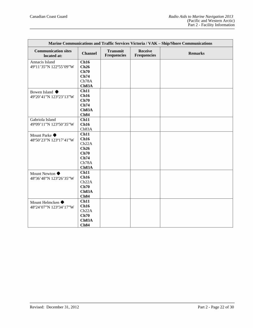
Marine Communications and Traffic Services Victoria / VAK – Ship/Shore Communications
Communication sites located at:
Channel Transmit
Frequencies Receive
Frequencies Remarks
Annacis Island 49º11’35”N 122º55’09”W
Ch16 Ch26 Ch70 Ch74 Ch78A Ch83A
Bowen Island 49º20’41”N 123º23’13”W
Ch11 Ch16 Ch70 Ch74 Ch83A Ch84
Gabriola Island 49º09’11”N 123º50’35”W
Ch11 Ch16 Ch83A
Mount Parke 48º50’23”N 123º17’41”W
Ch11 Ch16 Ch22A Ch26 Ch70 Ch74 Ch78A Ch83A
Mount Newton 48º36’48”N 123º26’35”W
Ch11 Ch16 Ch22A Ch70 Ch83A Ch84
Mount Helmcken 48º24’07”N 123º34’17”W
Ch11 Ch16 Ch22A Ch70 Ch83A Ch84
Canadian Coast Guard Radio Aids to Marine Navigation 2013 (Pacific and Western Arctic) Part 2 - Facility Information
Revised: December 31, 2012 Part 2 - Page 23 of 30
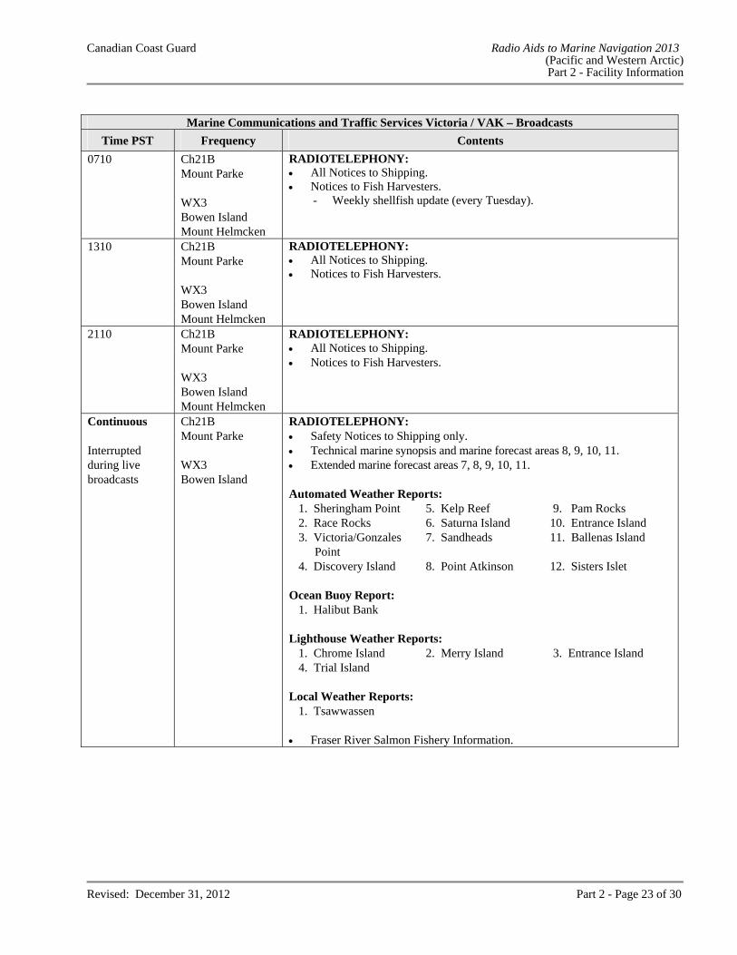
Marine Communications and Traffic Services Victoria / VAK – Broadcasts
Time PST Frequency Contents
0710 Ch21B Mount Parke WX3 Bowen Island Mount Helmcken
RADIOTELEPHONY: All Notices to Shipping. Notices to Fish Harvesters. - Weekly shellfish update (every Tuesday).
1310 Ch21B Mount Parke WX3 Bowen Island Mount Helmcken
RADIOTELEPHONY: All Notices to Shipping. Notices to Fish Harvesters.
2110 Ch21B Mount Parke WX3 Bowen Island Mount Helmcken
RADIOTELEPHONY: All Notices to Shipping. Notices to Fish Harvesters.
Continuous Interrupted during live broadcasts
Ch21B Mount Parke WX3 Bowen Island
RADIOTELEPHONY: Safety Notices to Shipping only. Technical marine synopsis and marine forecast areas 8, 9, 10, 11. Extended marine forecast areas 7, 8, 9, 10, 11.
Automated Weather Reports:
1. Sheringham Point 5. Kelp Reef 9. Pam Rocks 2. Race Rocks 6. Saturna Island 10. Entrance Island 3. Victoria/Gonzales
Point 7. Sandheads 11. Ballenas Island
4. Discovery Island 8. Point Atkinson 12. Sisters Islet Ocean Buoy Report:
1. Halibut Bank Lighthouse Weather Reports:
1. Chrome Island 2. Merry Island 3. Entrance Island 4. Trial Island
Local Weather Reports:
1. Tsawwassen Fraser River Salmon Fishery Information.
Canadian Coast Guard Radio Aids to Marine Navigation 2013 (Pacific and Western Arctic) Part 2 - Facility Information
Revised: December 31, 2012 Part 2 - Page 24 of 30
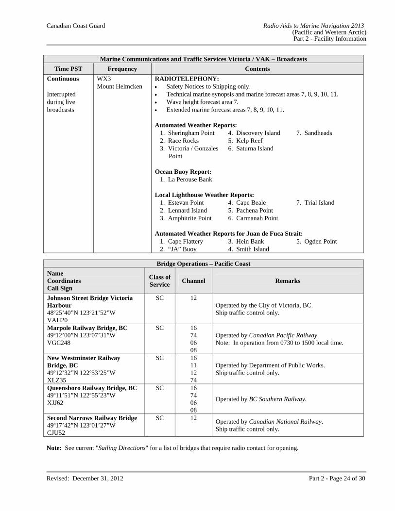
Marine Communications and Traffic Services Victoria / VAK – Broadcasts
Time PST Frequency Contents
Continuous Interrupted during live broadcasts
WX3 Mount Helmcken
RADIOTELEPHONY: Safety Notices to Shipping only. Technical marine synopsis and marine forecast areas 7, 8, 9, 10, 11. Wave height forecast area 7. Extended marine forecast areas 7, 8, 9, 10, 11. Automated Weather Reports:
1. Sheringham Point 4. Discovery Island 7. Sandheads 2. Race Rocks 5. Kelp Reef 3. Victoria / Gonzales
Point 6. Saturna Island
Ocean Buoy Report:
1. La Perouse Bank Local Lighthouse Weather Reports:
1. Estevan Point 4. Cape Beale 7. Trial Island 2. Lennard Island 5. Pachena Point 3. Amphitrite Point 6. Carmanah Point
Automated Weather Reports for Juan de Fuca Strait:
1. Cape Flattery 3. Hein Bank 5. Ogden Point 2. “JA” Buoy 4. Smith Island
Bridge Operations – Pacific Coast
Name Coordinates Call Sign
Class of Service
Channel Remarks
Johnson Street Bridge Victoria Harbour 48º25’40”N 123º21’52”W VAH20
SC 12 Operated by the City of Victoria, BC. Ship traffic control only.
Marpole Railway Bridge, BC 49º12’00”N 123º07’31”W VGC248
SC 16 74 06 08
Operated by Canadian Pacific Railway. Note: In operation from 0730 to 1500 local time.
New Westminster Railway Bridge, BC 49º12’32”N 122º53’25”W XLZ35
SC 16 11 12 74
Operated by Department of Public Works. Ship traffic control only.
Queensboro Railway Bridge, BC 49º11’51”N 122º55’23”W XJJ62
SC 16 74 06 08
Operated by BC Southern Railway.
Second Narrows Railway Bridge 49º17’42”N 123º01’27”W CJU52
SC 12 Operated by Canadian National Railway. Ship traffic control only.
Note: See current "Sailing Directions" for a list of bridges that require radio contact for opening.
Canadian Coast Guard Radio Aids to Marine Navigation 2013 (Pacific and Western Arctic) Part 2 - Facility Information
Revised: December 31, 2012 Part 2 - Page 25 of 30
Canadian Coast Guard Radio Aids to Marine Navigation 2013 (Pacific and Western Arctic) Part 2 - Facility Information
Revised: December 31, 2012 Part 2 - Page 26 of 30 Last correction : NOTMAR 06/2013
Canadian Coast Guard Radio Aids to Marine Navigation 2013 (Pacific and Western Arctic) Part 2 - Facility Information
Revised: December 31, 2012 Part 2 - Page 27 of 30
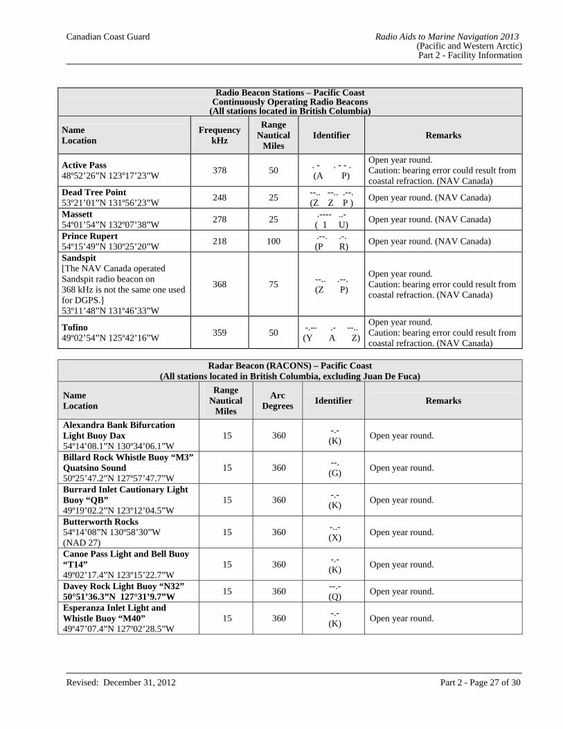
Radio Beacon Stations – Pacific Coast
Continuously Operating Radio Beacons (All stations located in British Columbia)
Name Location
Frequency kHz
Range Nautical
Miles Identifier Remarks
Active Pass 48º52’26”N 123º17’23”W
378 50 . - . - - . (A P)
Open year round. Caution: bearing error could result from coastal refraction. (NAV Canada)
Dead Tree Point 53º21’01”N 131º56’23”W
248 25 --.. --.. .--. (Z Z P )
Open year round. (NAV Canada)
Massett 54º01’54”N 132º07’38”W
278 25 .---- ..- ( 1 U)
Open year round. (NAV Canada)
Prince Rupert 54º15’49”N 130º25’20”W
218 100 .--. .-. (P R)
Open year round. (NAV Canada)
Sandspit [The NAV Canada operated Sandspit radio beacon on 368 kHz is not the same one used for DGPS.] 53º11’48”N 131º46’33”W
368 75 --.. .--. (Z P)
Open year round. Caution: bearing error could result from coastal refraction. (NAV Canada)
Tofino 49º02’54”N 125º42’16”W
359 50 -.-- .- --..(Y A Z)
Open year round. Caution: bearing error could result from coastal refraction. (NAV Canada)
Radar Beacon (RACONS) – Pacific Coast
(All stations located in British Columbia, excluding Juan De Fuca)
Name Location
Range Nautical
Miles
Arc Degrees
Identifier Remarks
Alexandra Bank Bifurcation Light Buoy Dax 54º14’08.1”N 130º34’06.1”W
15 360 -.- (K)
Open year round.
Billard Rock Whistle Buoy “M3” Quatsino Sound 50º25’47.2”N 127º57’47.7”W
15 360 --. (G)
Open year round.
Burrard Inlet Cautionary Light Buoy “QB” 49º19’02.2”N 123º12’04.5”W
15 360 -.- (K)
Open year round.
Butterworth Rocks 54º14’08”N 130º58’30”W (NAD 27)
15 360 -..- (X)
Open year round.
Canoe Pass Light and Bell Buoy “T14” 49º02’17.4”N 123º15’22.7”W
15 360 -.- (K)
Open year round.
Davey Rock Light Buoy “N32” 50°51’36.3”N 127°31’9.7”W
15 360 --.- (Q)
Open year round.
Esperanza Inlet Light and Whistle Buoy “M40” 49º47’07.4”N 127º02’28.5”W
15 360 -.- (K)
Open year round.
Canadian Coast Guard Radio Aids to Marine Navigation 2013 (Pacific and Western Arctic) Part 2 - Facility Information
Revised: December 31, 2012 Part 2 - Page 28 of 30
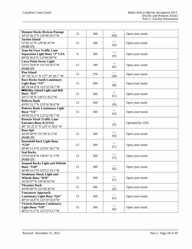
Hanmer Rocks Browns Passage 54º19’26.5”N 130º49’20.3”W
15 360 --
(M) Open year round.
Jacinto Island 52º56’31”N 129º36’43”W (NAD 27)
15 360 --.- (Q)
Open year round.
Juan De Fuca Traffic Lane Separation Light Buoy “J” USA 48º29’36.8’N 125º00’00”W
8 360 --- (O)
Open year round.
Lawn Point Sector Light 53º25’29.8”N 131º54’50.3”W (NAD 27)
15 180 -.- (K)
Open year round.
Pine Island 50° 58' 32.2" N 127° 43' 40.7" W
15 270 - -
(M) Open year round.
Race Rocks South Cautionary Light Buoy “VF” 48°14’04.4”N 123°31’58.7”W
15 360 -… (B)
Open year round.
Ridley Island Light and Bell Buoy "D27" 54º11’56”N 130º21’26.2”W
15 360 --. (G)
Open year round.
Roberts Bank 49º05’15.7”N 123º18’36.9”W
15 360 -.
(N) Open year round.
Roberts Bank Cautionary Light Buoy “TA” 49º04’25.4”N 123º22’50.7”W
15 360 --- (O)
Open year round.
Rosario Strait Traffic Lane Entrance Buoy R (USA) 48° 16' 25.3" N 123° 6' 34.6" W
-
(T) Operated by USA.
Rose Spit 54º09’40”N 131º39’35.2”W (NAD 27)
15 360 --.- (Q)
Open year round.
Rosenfeld Rock Light Buoy “U59” 48º48’11.4”N 123º01’38.7”W
15 360 -.-. (C)
Open year round.
Seal Rocks 53º59’58.8”N 130º47’31.3”W (NAD 27)
15 360 -.-- (Y)
Open year round.
Seapool Rocks Light and Whistle Buoy “Y49” 48º48’53.3”N 125º12’19.1”W
15 360 -.- (K)
Open year round.
Stenhouse Shoal, Light and Whistle Buoy “D59” 54º20’07”N 130º56’03”W
15 360 -.-. (C)
Open year round.
Thrasher Rock 49º09’00”N 123º38’30”W
15 360 -..- (X)
Open year round.
Vancouver Approach Cautionary Light Buoy “QA” 49º16’34.4”N 123º19’18.4”W
15 360 --. (G)
Open year round.
Victoria Harbour Cautionary Light Buoy “VH” 48º22’31.3”N 123º23’33.7”W
15 360 -.- (K)
Open year round.
Canadian Coast Guard Radio Aids to Marine Navigation 2013 (Pacific and Western Arctic) Part 2 - Facility Information
Revised: December 31, 2012 Part 2 - Page 29 of 30
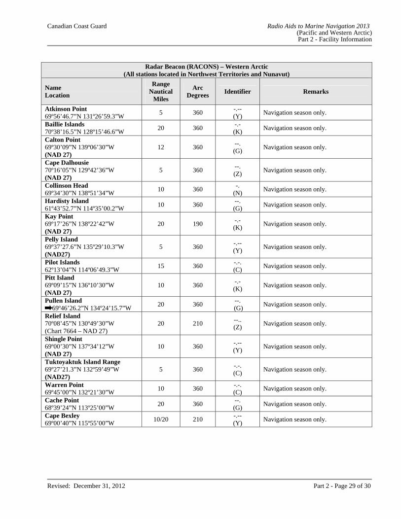
Radar Beacon (RACONS) – Western Arctic
(All stations located in Northwest Territories and Nunavut)
Name Location
Range Nautical
Miles
Arc Degrees
Identifier Remarks
Atkinson Point 69º56’46.7”N 131º26’59.3”W
5 360 -.-- (Y)
Navigation season only.
Baillie Islands 70º38’16.5”N 128º15’46.6”W
20 360 -.- (K)
Navigation season only.
Calton Point 69º30’09”N 139º06’30”W (NAD 27)
12 360 --. (G)
Navigation season only.
Cape Dalhousie 70º16’05”N 129º42’36”W (NAD 27)
5 360 --. (Z)
Navigation season only.
Collinson Head 69º34’30”N 138º51’34”W
10 360 -.
(N) Navigation season only.
Hardisty Island 61º43’52.7”N 114º35’00.2”W
10 360 --. (G)
Navigation season only.
Kay Point 69º17’26”N 138º22’42”W (NAD 27)
20 190 -.- (K)
Navigation season only.
Pelly Island 69º37’27.6”N 135º29’10.3”W (NAD27)
5 360 -.-- (Y)
Navigation season only.
Pilot Islands 62º13’04”N 114º06’49.3”W
15 360 -.-. (C)
Navigation season only.
Pitt Island 69º09’15”N 136º10’30”W (NAD 27)
10 360 -.- (K)
Navigation season only.
Pullen Island 69º46’26.2”N 134º24’15.7”W
20 360 --.
(G) Navigation season only.
Relief Island 70º08’45”N 130º49’30”W (Chart 7664 – NAD 27)
20 210 --.. (Z)
Navigation season only.
Shingle Point 69º00’30”N 137º34’12”W (NAD 27)
10 360 -.-- (Y)
Navigation season only.
Tuktoyaktuk Island Range 69º27’21.3”N 132º59’49”W (NAD27)
5 360 -.-. (C)
Navigation season only.
Warren Point 69º45’00”N 132º21’30”W
10 360 -.-. (C)
Navigation season only.
Cache Point 68º39’24”N 113º25’00”W
20 360 --. (G)
Navigation season only.
Cape Bexley 69º00’40”N 115º55’00”W
10/20 210 -.-- (Y)
Navigation season only.
Canadian Coast Guard Radio Aids to Marine Navigation 2013 (Pacific and Western Arctic) Part 2 - Facility Information
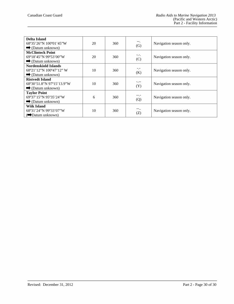
Revised: December 31, 2012 Part 2 - Page 30 of 30
Delta Island 68º35’26”N 100º01’45”W
(Datum unknown) 20 360
--. (G)
Navigation season only.
McClintock Point 69º18’45”N 99º53’00”W
(Datum unknown) 20 360
-.-. (C)
Navigation season only.
Nordenskiold Islands 68º21’12”N 100º47’12” W
(Datum unknown) 10 360
-.- (K)
Navigation season only.
Ristvedt Island 68º30’51.8”N 97º15’13.9”W
(Datum unknown) 10 360
-.-- (Y)
Navigation season only.
Taylor Point 69º37’15”N 95º35’24”W
(Datum unknown) 6 360
--.- (Q)
Navigation season only.
Wiik Island 68º31’24”N 99º33’07”W ( Datum unknown)
10 360 --.. (Z)
Navigation season only.
Canadian Coast Guard Radio Aids to Marine Navigation 2013 (Pacific and Western Arctic)
Part 3 - Vessel Traffic Services
Revised: December 31, 2012 Part 3 - Page 1 of 35
PART 3
VESSEL TRAFFIC SERVICES
PACIFIC AND WESTERN ARCTIC The purpose of Part 3 is to describe to shipboard personnel the ship reporting procedures to be followed by vessels within or intending to enter a Vessel Traffic Services (VTS) zone. RESPONSIBILITIES There is no intention on the part of the Canadian Coast Guard to attempt to navigate or manoeuvre ships from a shore station and nothing in this publication overrides the authority of the master of his responsibility for the safe navigation of his ship. Information passed to the master is intended to assist him in the safe conduct of his ship. An MCTS officer may, with respect to any vessel of a prescribed class that is about to enter or is within a VTS zone: (a) grant a clearance to the vessel to enter, leave or proceed within the VTS zone; (b) direct the master, pilot or person in charge of the deck watch of the vessel to provide any pertinent information
in respect of that vessel that may be specified in the direction; (c) direct the vessel to use any radio frequencies in communications with coast stations or other vessel that may be
specified in the direction; and (d) direct the vessel at the time, between the times or before or after any event that may be specified in the
direction;
to leave a VTS zone, to leave or refrain from entering any area within a VTS zone that may be specified in the direction, or to proceed to or remain at any location within a VTS zone that may be specified in the direction.
A vessel, as well as the master, pilot or person in charge of the deck watch of a vessel, shall comply with a direction given to it or them by an MCTS officer. Notwithstanding, the master, pilot or person in charge of the deck watch may take any action that may be required to ensure the safety of life, the ship or any other ship. The master of a ship shall ensure that before the ship enters a VTS zone the ship’s radio equipment is capable of receiving and transmitting radio communications on the appropriate VTS sector frequency. TRAFFIC CLEARANCE A "traffic clearance" is an authorization for a ship to proceed subject to such conditions as may be included in the authorization. The traffic clearance is predicated upon ship report information and known waterway/traffic conditions. A traffic clearance does not eliminate the need for other authorizations required by legislation or by-laws. Should any factor upon which the traffic clearance is predicated alter to the detriment of safe navigation, the traffic clearance may be delayed or other conditions may be attached to the traffic clearance.
Canadian Coast Guard Radio Aids to Marine Navigation 2013 (Pacific and Western Arctic)
Part 3 - Vessel Traffic Services
Revised: December 31, 2012 Part 3 - Page 2 of 35
A traffic clearance is required prior to: entering a VTS zone; commencing a departure manoeuvre; commencing a manoeuvre that may be detrimental to safe navigation; and proceeding after being stranded, stopped due to breakdown of main propulsion machinery or steering gear, or
involved in a collision. COMMUNICATIONS Radiotelephone procedures used in communicating with an MCTS centre are those specified by the International Telecommunications Union in the "Manual for Use by the Maritime Mobile and Maritime Mobile Satellite Services". A continuous listening watch shall be maintained on the appropriate VTS sector frequency on radio equipment located:
at any place on board the ship, where the ship is at anchor or moored to a buoy; and in the vicinity of the ship’s conning position, where the ship is underway.
A continuous listening watch may be suspended if an MCTS officer directs the ship to communicate with coast stations and/or other ship stations on a different VHF radio frequency. All times given in local VTS zone reports should be in local time and in accordance with the 24-hour clock system. Navigation safety calls on designated VTS sector frequencies should be kept to the minimum consistent with the safety requirement of the situation. Communication Difficulties Where a ship, for any reason other than ship board radio equipment failure is unable to obtain the required traffic clearance or, after receiving a traffic clearance, is unable to maintain direct communication with the appropriate MCTS centre, the master may nevertheless proceed on his route, but shall take all reasonable measures to communicate with the appropriate MCTS centre as soon as possible and to obtain the specified clearance. Ship Board Radio Equipment Malfunction In the event of a ship board radio equipment failure, where the ship is unable to obtain the required traffic clearance or after receiving a traffic clearance is unable to maintain direct communication with the appropriate MCTS centre, the vessel shall: (a) if it is in a port or anchorage where repairs can be made, remain in the port until the vessel is able to establish
communications in accordance with the Canada Shipping Act, 2001, Part 5, Section 6(a); or
(b) if it is not in a port or anchorage where repairs can be made, proceed to the nearest reasonably safe port or anchorage on its route and remain there until the vessel is able to establish communications in accordance with the Canada Shipping Act, 2001, Part 5, Section 6(b).
Canadian Coast Guard Radio Aids to Marine Navigation 2013 (Pacific and Western Arctic)
Part 3 - Vessel Traffic Services
Revised: December 31, 2012 Part 3 - Page 3 of 35
English Language All communications with Tofino, Seattle, Prince Rupert, Comox, Vancouver or Victoria Traffic must be made in clear, unbroken English. At least one person capable of conducting two-way radio communications using the English language must be present on the bridge at all times within the Co-operative VTS area. When language problems do arise, communications may be preceded by using message markers as found in the International Maritime Organisation Standard Marine Communication Phrases (SMCP). ZONE DESCRIPTION Western Canada VTS zones in Western Canada include all Canadian waters on the west coast of Canada as described in the VTS zone schedules of this Part and referred to in the Vessel Traffic Services Zones Regulations. Northern Canada The Northern Canada VTS (NORDREG) zone consists of: (a) the shipping safety control zones prescribed by the Shipping Safety Control Zones Order;1 (b) the waters of Ungava Bay, Hudson Bay and Kugmallit Bay that are not in a shipping safety control zone; (c) the waters of James Bay; (d) the waters of Koksoak River from Ungava Bay to Kuujjuaq; (e) the waters of Feuilles Bay from Ungava Bay to Tasiujaq; (f) the waters of Chesterfield Inlet that are not within a shipping safety control zone and the waters of Baker Lake;
and (g) the waters of Moose River from James Bay to Moosonee. ZONE APPLICATION Western Canada – Offshore With respect to the Western Canada VTS zones, the Vessel Traffic Services Zones Regulations require a report to be made at least 24 hours before the ship enters a VTS zone from seaward including Alaska, or as soon as possible where the estimated time of arrival at that VTS zone is less than 24 hours after the ship departs from the last port of call, where the ship is: a) of 500 tons gross tonnage or more; b) engaged in towing or pushing a vessel, where the combined tonnage of the ship and the vessel being towed or
pushed is 500 tons gross tonnage or more; or c) carrying a pollutant or dangerous goods, or engaged in towing or pushing a vessel carrying a pollutant or
dangerous goods as prescribed in the; i) International Maritime Dangerous Goods (IMDG) Code, and ii) Vessel Pollution and Dangerous Chemicals Regulations.
1 The Shipping Safety Control zones cover Canada’s coastal northern waters within the area enclosed by the 60th parallel of north latitude, the 141st meridian of west longitude and the outer limit of the exclusive economic zone; however, where the international boundary between Canada and Greenland is less than 200 nautical miles from the baselines of the territorial sea of Canada, the international boundary shall be substituted for that outer limit.
Canadian Coast Guard Radio Aids to Marine Navigation 2013 (Pacific and Western Arctic)
Part 3 - Vessel Traffic Services
Revised: December 31, 2012 Part 3 - Page 4 of 35
Local VTS Zones For vessels within or about to enter a Western Canada VTS zone, the Vessel Traffic Services Zones Regulations apply in respect of: a) every ship twenty metres or more in length; b) every ship engaged in towing or pushing any vessel or object, other than fishing gear, where;
i) the combined length of the ship and any vessel or object towed or pushed by the ship is forty-five metres or more in length, or
ii) the length of the vessel or object being towed or pushed by the ship is twenty metres or more in length. For vessels within or about to enter a Western Canada VTS zone, the Vessel Traffic Services Zones Regulations do not apply in respect of: a ship engaged in towing or pushing any vessel or object within a log booming ground; a pleasure yacht that is less than 30 metres in length; and a fishing vessel that is less than 24 metres in length and not more than 150 tons gross tonnage. Participation is mandatory. Northern Canada VTS (NORDREG) Zone With respect to the Northern Canada VTS (NORDREG) zone, the Northern Canada Vessel Traffic Services Zone Regulations apply to the following classes of vessels: (a) vessels of 300 tons gross tonnage or more; (b) vessels that are engaged in towing or pushing another vessel, if the combined gross tonnage of the vessel and
the vessel being towed or pushed is 500 tons gross tonnage or more; and (c) vessels that are carrying as cargo, a pollutant or dangerous goods, or that are engaged in towing or pushing a
vessel that is carrying as cargo a pollutant or dangerous goods. Participation is mandatory. ADVANCE REPORTING REQUIREMENTS VTS Offshore Report The Vessel Traffic Services Zones Regulations require all vessels greater than 500 tons gross tonnage to file a VTS Offshore Report 24 hours prior to entering a Canadian VTS zone from seaward, or as soon as practical where the estimated time of arrival of the ship to a Canadian VTS zone is less than 24 hours after the time the ship departed its last port of call. Send VTS Offshore Reports to one of the following:
Email: [email protected] Telephone: 604-666-6011 Facsimile: 604-666-8453 Telex: 04352586 Telex Answerback: CGTC VAS VCR Or via a Canadian Coast Guard MCTS centre, free of charge.
Canadian Coast Guard Radio Aids to Marine Navigation 2013 (Pacific and Western Arctic)
Part 3 - Vessel Traffic Services
Revised: December 31, 2012 Part 3 - Page 5 of 35
If bound for a United States Port: Notice of Arrival A 96-hour Notice of Arrival (NOA) must be filed in accordance with the 33 Code of Federal Regulations (CFR) Part 160 (dated February 28, 2003) directly to the United States Coast Guard National Vessel Movement Center (NVMC) via one of the following methods: Email: [email protected] Telephone: 1-800-708-9823 Facsimile: 1-800-547-8724 The electronic Notice of Arrival/Departure (e-NOA/D) can be found at the NVMC website: http://www.nvmc.uscg.gov/NVMC/default.aspx. Western Canada – VTS Offshore Report Information Required (a) the name of the ship; (b) the radio call sign of the ship; (c) the name of the master of the ship; (d) the position of the ship; (e) the time (UTC) the ship arrived at the position; (f) the course of the ship, if any; (g) the speed of the ship, if any; (h) the prevailing weather conditions; (i) the estimated time (UTC) that the ship will enter the VTS zone; (j) the name of the VTS zone the ship intends to enter; (k) the destination of the ship; (l) the estimated time (UTC) of arrival of the ship at the destination; (m) the intended route of the ship; (n) the name of the last port of call of the ship; (o) the draught of the ship; (p) any dangerous goods, listed by class, or pollutant, that is carried on board the ship or the vessel being towed or
pushed by the ship; (q) any defect in the ship's hull, main propulsion systems or steering systems, radars, compasses, radio equipment,
anchors or cables; (r) any discharge, or threat of discharge, into the water, of a pollutant from the ship or the vessel being towed or
pushed by the ship, and any damage to the ship or vessel that may result in the discharge of a pollutant from the ship or vessel into the water;
(s) the name of the Canadian or United States agent of the ship; and (t) the date of expiration of a certificate referred to in Article VII of the International Convention on Civil Liability
for Oil Pollution Damage, 1969/1992, the International Oil Pollution Prevention Certificate, the International Pollution Prevention Certificate for the Carriage of Noxious Liquid Substances in Bulk, the Certificate of Fitness and the Certificate of Compliance, if any issued to the ship. (The following is also requested: the date and expiration of the ISM Safety Management Certificate, the ISM document of compliance, and the International Convention on Civil Liability for Bunker Oil Pollution Damage, 2001 Certificate (known as Bunkers Convention Certificate), if any, issued to the ship.)
Canadian Coast Guard Radio Aids to Marine Navigation 2013 (Pacific and Western Arctic)
Part 3 - Vessel Traffic Services
Revised: December 31, 2012 Part 3 - Page 6 of 35
Western Canada - Local VTS Zone Report With respect to the Western Canada VTS zones, the Vessel Traffic Services Zones Regulations specify that the master of a ship shall report to an MCTS officer in accordance with the following requirements. Information Required Dependent upon the reporting requirement, the following information shall be required to be reported: (a) the name of the ship; (b) the radio call sign of the ship; (c) the position of the ship; (d) the estimated time that the ship will enter the VTS zone; (e) the destination of the ship; (f) the estimated time that the ship will arrive at its destination; (g) whether any pollutant or dangerous goods cargo is carried on board the ship or any vessel or object being
towed or pushed by the ship; (h) the estimated time that the ship will depart the berth; and (i) the estimated time at which the ship will next arrive at a location requiring a report. Entering a Zone At least 15 minutes before a ship intends to enter a VTS zone, a report shall be made specifying the information listed in (a), (b), (c), (d), (e), (f) and (g). Exception: Ships already in possession of a valid Traffic Clearance issued by ECAREG, NORDREG or another VTS zone are not required to provide this report Arrival at a Calling-In-Point When a ship arrives at a Calling-In-Point (CIP) a report shall be made specifying the information listed in (a), (c) and (i). Arrival at a Berth As soon as practicable after a ship arrives at a berth, a report shall be made specifying the information listed in (a) and (c). Departure Manoeuvre A departure manoeuvre is defined as an operation during which a vessel leaves a berth and gets safely underway: immediately before commencing a departure manoeuvre, a report shall be made specifying the information
listed in (a), (b), (c), (e), (f), (g) and (h); immediately after completing the departure manoeuvre, a report shall be made specifying the information listed
in (a), (c) and (i).
Canadian Coast Guard Radio Aids to Marine Navigation 2013 (Pacific and Western Arctic)
Part 3 - Vessel Traffic Services
Revised: December 31, 2012 Part 3 - Page 7 of 35
Manoeuvres A traffic clearance is required 15 minutes prior to commencing any manoeuvre such as:
i) a compass adjustment; ii) the calibration and servicing of navigational aids; iii) a sea trial; iv) a dredging operation; v) the laying, picking up and servicing of submarine cables or any other manoeuvre that may be
detrimental to safe navigation.
Prior to commencing a manoeuvre, a report shall be made specifying the information listed in (a) and (c), plus a description of the intended manoeuvre. As soon as practical after the manoeuvre is completed, a report describing the manoeuvre just completed shall be made. Change in Information A report shall be made whenever a significant change occurs in the information previously provided in any report made pursuant to the Vessel Traffic Services Zones Regulations. Non-Routine Reports Pursuant to the Vessel Traffic Services Zones Regulations a report indicating the vessel’s name, position and a description of the incident shall be made as soon as the master becomes aware of any of the following conditions:
i) the occurrence on board the ship of any fire; ii) the involvement of the ship in a collision, grounding or striking; iii) any defect in the ship's hull, main propulsion systems or steering systems, radars, compasses, radio
equipment, anchors or cables; iv) any discharge or probable discharge of a pollutant from the ship into the water; v) another ship in apparent difficulty; vi) any obstruction to navigation; vii) any aid to navigation that is functioning improperly, damaged, off-position or missing; viii) the presence of any pollutant in the water; ix) the presence of a ship that may impede the movement of other ships; and x) any ice and weather conditions that are detrimental to safe navigation.
Notes (1) Items (vi), (vii) and (viii) are not required if the information has been previously promulgated by a Notice
to Shipping.
(2) Mariners are encouraged to provide, on a voluntary basis, any information pertaining to charts and publications which may not be on board so that arrangements can be made to embark the necessary items.
Variations from Requirements Ferries and other vessels on regularly scheduled voyages may be exempted from making routine reports. Formal variations to reporting procedures will be granted only where alternate arrangements to provide essential information are made and where the equivalent procedure or practice is deemed to be as safe as that required in the regulations.
Canadian Coast Guard Radio Aids to Marine Navigation 2013 (Pacific and Western Arctic)
Part 3 - Vessel Traffic Services
Revised: December 31, 2012 Part 3 - Page 8 of 35
Formal variations may be obtained by submitting a written request to the appropriate Regional MCTS Superintendent, Canadian Coast Guard (see Part 1, page 8). In circumstances other than those described above, informal variations may be granted from time to time on a one-time-only basis by an MCTS officer where the procedure or practice requested is deemed to be as safe as that required in the regulations. NORDREG Zone Reports Format NORDREG reports shall be addressed to NORDREG CANADA and communicated either directly to NORDREG CANADA or to the nearest Canadian Coast Guard MCTS centre. The master of a ship shall ensure that these reports are made in accordance with the stated requirements. The information requested from the ships is derived from the standard reporting format shown in International Maritime Organization resolution A.851(20) – General Principles for Ship Reporting Systems and Ship Reporting Requirements, Including Guidelines for Reporting Incidents Involving Dangerous Goods, Harmful Substances and/or Marine Pollutants. Every report shall begin with the term "NORDREG" (system identifier) and be followed by whichever of the following two letters corresponds to the report:
(a) "SP", in the case of a sailing plan report; (b) "PR", in the case of a position report; (c) "FR", in the case of a final report; (d) "DR", in the case of a deviation report.
The report must include the applicable designators followed by the information required in accordance with the table at Part 3, page 10. Content and Time and Geographical Position for Submitting Reports Vessels shall send a report as follows, and provide the information required in accordance with the table at Part 3, page 10 and that corresponds to the designators specified. When the Vessel is About to Enter the NORDREG Zone A sailing plan (SP) report shall be provided when the vessel is about to enter the NORDREG zone and must include the following designators: A, B, either C or D, E, F, G, H, I, L, O, P, Q, S, T, W and X. Note: Designators O, Q, T are not required when entering directly from the ECAREG zone. Vessels about to enter the NORDREG zone should provide the sailing plan report 24 hours in advance of entering the zone, or as soon as possible after leaving a port that is less than 24 hours from the NORDREG zone. This ensures vessels are not delayed in obtaining a clearance from MCTS and enables MCTS to assess current conditions and to prepare relevant safety information for the vessel.2
2 Vessels must obtain a clearance from MCTS before entering the NORDREG zone.
Canadian Coast Guard Radio Aids to Marine Navigation 2013 (Pacific and Western Arctic)
Part 3 - Vessel Traffic Services
Revised: December 31, 2012 Part 3 - Page 9 of 35
Departing a Berth/Anchorage A sailing plan report shall be provided more than one hour but not more than two hours before a vessel departs from a berth within the NORDREG zone, unless the vessel is moving to another berth in the same port. The sailing plan report must include the following designators: A, B, either C or D, H, I, L, O, P, Q, S, T, W and X. Note: designators O, P, Q, S, T, W, X are not required if the corresponding information has not changed since the previous sailing plan report. Getting Underway After an Incident A sailing plan report shall be provided immediately before a vessel gets underway within the NORDREG zone if the vessel has been stranded, has stopped as a result of a breakdown in the main propulsion system or steering system or has been involved in a collision. The sailing plan report must include the following designators: A, B, either C or D, I, L, O, P, Q, S, T, W and X. Note: designators O, P, Q, S, T, W, X are not required if the corresponding information has not changed since the previous sailing plan report. Entering at Zone Boundary A position report (PR) shall be provided immediately after a vessel enters the NORDREG zone and must include the following designators: A, B, either C or D, E, F and S. Daily A position report shall be provided daily at 1600 UTC, unless the vessel is transmitting Long-Range Identification and Tracking of Vessels (LRIT) information. The position report shall include the following designators: A, B, either C or D, E, F and S. Other Situations A position report shall be provided with designators A, B, either C or D, E, F, S and X as soon as feasible after a vessel’s master becomes aware of any of the following: - another vessel in apparent difficulty; - any obstruction to navigation; - any aid to navigation that is not functioning properly or is damaged, out of position or missing; - any ice or weather conditions that are hazardous to safe navigation; - a pollutant in the water. Arrival at Berth/Anchorage A final report (FR) shall be provided on the arrival of a vessel at a berth within the NORDREG zone and include the following designators: A and K. Exiting the Zone A final report shall be provided immediately before a vessel exits the NORDREG zone and include the following designators: A and K.
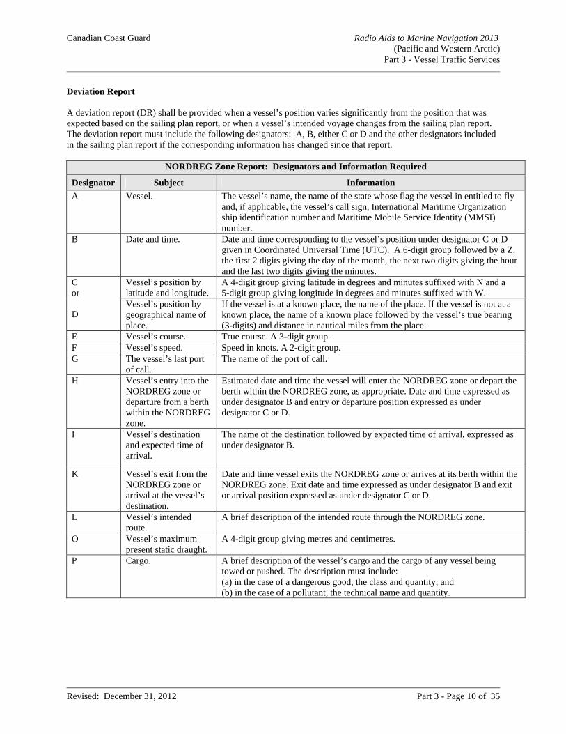
Canadian Coast Guard Radio Aids to Marine Navigation 2013 (Pacific and Western Arctic)
Part 3 - Vessel Traffic Services
Revised: December 31, 2012 Part 3 - Page 10 of 35
Deviation Report A deviation report (DR) shall be provided when a vessel’s position varies significantly from the position that was expected based on the sailing plan report, or when a vessel’s intended voyage changes from the sailing plan report. The deviation report must include the following designators: A, B, either C or D and the other designators included in the sailing plan report if the corresponding information has changed since that report.
NORDREG Zone Report: Designators and Information Required
Designator Subject Information
A Vessel. The vessel’s name, the name of the state whose flag the vessel in entitled to fly and, if applicable, the vessel’s call sign, International Maritime Organization ship identification number and Maritime Mobile Service Identity (MMSI) number.
B Date and time. Date and time corresponding to the vessel’s position under designator C or D given in Coordinated Universal Time (UTC). A 6-digit group followed by a Z, the first 2 digits giving the day of the month, the next two digits giving the hour and the last two digits giving the minutes.
C or D
Vessel’s position by latitude and longitude.
A 4-digit group giving latitude in degrees and minutes suffixed with N and a 5-digit group giving longitude in degrees and minutes suffixed with W.
Vessel’s position by geographical name of place.
If the vessel is at a known place, the name of the place. If the vessel is not at a known place, the name of a known place followed by the vessel’s true bearing (3-digits) and distance in nautical miles from the place.
E Vessel’s course. True course. A 3-digit group. F Vessel’s speed. Speed in knots. A 2-digit group. G The vessel’s last port
of call. The name of the port of call.
H Vessel’s entry into the NORDREG zone or departure from a berth within the NORDREG zone.
Estimated date and time the vessel will enter the NORDREG zone or depart the berth within the NORDREG zone, as appropriate. Date and time expressed as under designator B and entry or departure position expressed as under designator C or D.
I Vessel’s destination and expected time of arrival.
The name of the destination followed by expected time of arrival, expressed as under designator B.
K Vessel’s exit from the NORDREG zone or arrival at the vessel’s destination.
Date and time vessel exits the NORDREG zone or arrives at its berth within the NORDREG zone. Exit date and time expressed as under designator B and exit or arrival position expressed as under designator C or D.
L Vessel’s intended route.
A brief description of the intended route through the NORDREG zone.
O Vessel’s maximum present static draught.
A 4-digit group giving metres and centimetres.
P Cargo. A brief description of the vessel’s cargo and the cargo of any vessel being towed or pushed. The description must include: (a) in the case of a dangerous good, the class and quantity; and (b) in the case of a pollutant, the technical name and quantity.
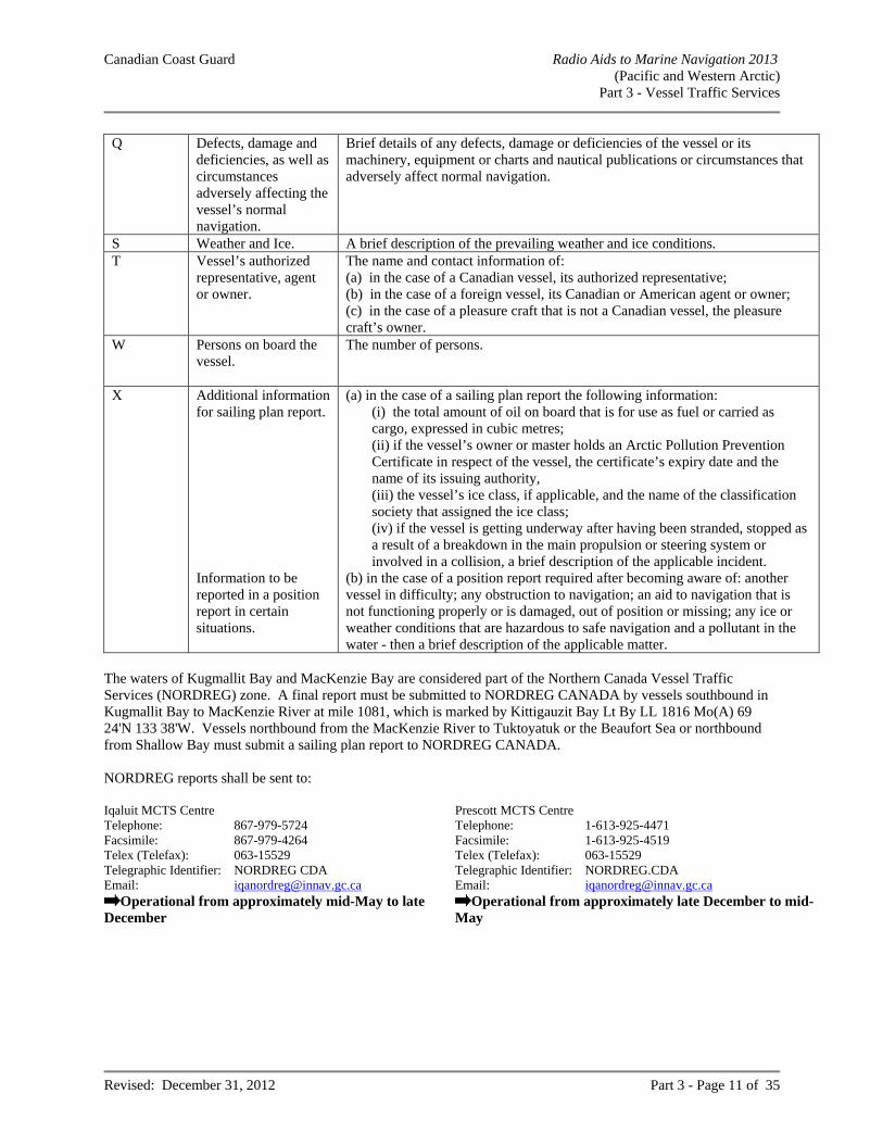
Canadian Coast Guard Radio Aids to Marine Navigation 2013 (Pacific and Western Arctic)
Part 3 - Vessel Traffic Services
Revised: December 31, 2012 Part 3 - Page 11 of 35
Q Defects, damage and deficiencies, as well as circumstances adversely affecting the vessel’s normal navigation.
Brief details of any defects, damage or deficiencies of the vessel or its machinery, equipment or charts and nautical publications or circumstances that adversely affect normal navigation.
S Weather and Ice. A brief description of the prevailing weather and ice conditions. T Vessel’s authorized
representative, agent or owner.
The name and contact information of: (a) in the case of a Canadian vessel, its authorized representative; (b) in the case of a foreign vessel, its Canadian or American agent or owner; (c) in the case of a pleasure craft that is not a Canadian vessel, the pleasure craft’s owner.
W Persons on board the vessel.
The number of persons.
X Additional information for sailing plan report. Information to be reported in a position report in certain situations.
(a) in the case of a sailing plan report the following information: (i) the total amount of oil on board that is for use as fuel or carried as cargo, expressed in cubic metres; (ii) if the vessel’s owner or master holds an Arctic Pollution Prevention Certificate in respect of the vessel, the certificate’s expiry date and the name of its issuing authority, (iii) the vessel’s ice class, if applicable, and the name of the classification society that assigned the ice class; (iv) if the vessel is getting underway after having been stranded, stopped as a result of a breakdown in the main propulsion or steering system or involved in a collision, a brief description of the applicable incident.
(b) in the case of a position report required after becoming aware of: another vessel in difficulty; any obstruction to navigation; an aid to navigation that is not functioning properly or is damaged, out of position or missing; any ice or weather conditions that are hazardous to safe navigation and a pollutant in the water - then a brief description of the applicable matter.
The waters of Kugmallit Bay and MacKenzie Bay are considered part of the Northern Canada Vessel Traffic Services (NORDREG) zone. A final report must be submitted to NORDREG CANADA by vessels southbound in Kugmallit Bay to MacKenzie River at mile 1081, which is marked by Kittigauzit Bay Lt By LL 1816 Mo(A) 69 24'N 133 38'W. Vessels northbound from the MacKenzie River to Tuktoyatuk or the Beaufort Sea or northbound from Shallow Bay must submit a sailing plan report to NORDREG CANADA. NORDREG reports shall be sent to: Iqaluit MCTS Centre Telephone: 867-979-5724 Facsimile: 867-979-4264 Telex (Telefax): 063-15529 Telegraphic Identifier: NORDREG CDA Email: [email protected]
Operational from approximately mid-May to late December
Prescott MCTS Centre Telephone: 1-613-925-4471 Facsimile: 1-613-925-4519 Telex (Telefax): 063-15529 Telegraphic Identifier: NORDREG.CDA Email: [email protected]
Operational from approximately late December to mid-May
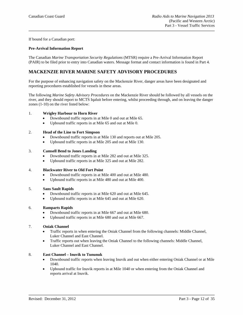
Canadian Coast Guard Radio Aids to Marine Navigation 2013 (Pacific and Western Arctic)
Part 3 - Vessel Traffic Services
Revised: December 31, 2012 Part 3 - Page 12 of 35
If bound for a Canadian port: Pre-Arrival Information Report The Canadian Marine Transportation Security Regulations (MTSR) require a Pre-Arrival Information Report (PAIR) to be filed prior to entry into Canadian waters. Message format and contact information is found in Part 4. MACKENZIE RIVER MARINE SAFETY ADVISORY PROCEDURES For the purpose of enhancing navigation safety on the Mackenzie River, danger areas have been designated and reporting procedures established for vessels in these areas. The following Marine Safety Advisory Procedures on the Mackenzie River should be followed by all vessels on the river, and they should report to MCTS Iqaluit before entering, whilst proceeding through, and on leaving the danger zones (1-10) on the river listed below: 1. Wrigley Harbour to Horn River
Downbound traffic reports in at Mile 0 and out at Mile 65. Upbound traffic reports in at Mile 65 and out at Mile 0.
2. Head of the Line to Fort Simpson
Downbound traffic reports in at Mile 130 and reports out at Mile 205. Upbound traffic reports in at Mile 205 and out at Mile 130.
3. Camsell Bend to Jones Landing
Downbound traffic reports in at Mile 282 and out at Mile 325. Upbound traffic reports in at Mile 325 and out at Mile 282.
4. Blackwater River to Old Fort Point
Downbound traffic reports in at Mile 400 and out at Mile 480. Upbound traffic reports in at Mile 480 and out at Mile 400.
5. Sans Sault Rapids
Downbound traffic reports in at Mile 620 and out at Mile 645. Upbound traffic reports in at Mile 645 and out at Mile 620.
6. Ramparts Rapids
Downbound traffic reports in at Mile 667 and out at Mile 680. Upbound traffic reports in at Mile 680 and out at Mile 667.
7. Oniak Channel
Traffic reports in when entering the Oniak Channel from the following channels: Middle Channel, Luker Channel and East Channel.
Traffic reports out when leaving the Oniak Channel to the following channels: Middle Channel, Luker Channel and East Channel.
8. East Channel – Inuvik to Tununuk
Downbound traffic reports when leaving Inuvik and out when either entering Oniak Channel or at Mile 1040.
Upbound traffic for Inuvik reports in at Mile 1040 or when entering from the Oniak Channel and reports arrival at Inuvik.
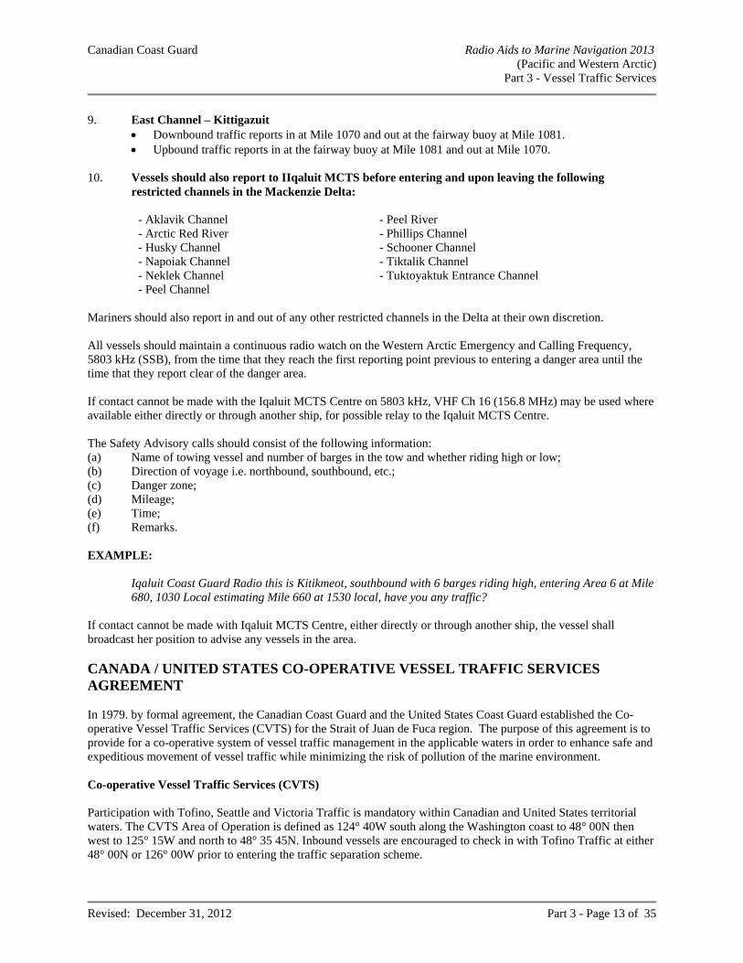
Canadian Coast Guard Radio Aids to Marine Navigation 2013 (Pacific and Western Arctic)
Part 3 - Vessel Traffic Services
Revised: December 31, 2012 Part 3 - Page 13 of 35
9. East Channel – Kittigazuit Downbound traffic reports in at Mile 1070 and out at the fairway buoy at Mile 1081. Upbound traffic reports in at the fairway buoy at Mile 1081 and out at Mile 1070.
10. Vessels should also report to IIqaluit MCTS before entering and upon leaving the following
restricted channels in the Mackenzie Delta:
- Aklavik Channel - Peel River - Arctic Red River - Phillips Channel - Husky Channel - Schooner Channel - Napoiak Channel - Tiktalik Channel - Neklek Channel - Tuktoyaktuk Entrance Channel - Peel Channel
Mariners should also report in and out of any other restricted channels in the Delta at their own discretion. All vessels should maintain a continuous radio watch on the Western Arctic Emergency and Calling Frequency, 5803 kHz (SSB), from the time that they reach the first reporting point previous to entering a danger area until the time that they report clear of the danger area. If contact cannot be made with the Iqaluit MCTS Centre on 5803 kHz, VHF Ch 16 (156.8 MHz) may be used where available either directly or through another ship, for possible relay to the Iqaluit MCTS Centre. The Safety Advisory calls should consist of the following information: (a) Name of towing vessel and number of barges in the tow and whether riding high or low; (b) Direction of voyage i.e. northbound, southbound, etc.; (c) Danger zone; (d) Mileage; (e) Time; (f) Remarks. EXAMPLE:
Iqaluit Coast Guard Radio this is Kitikmeot, southbound with 6 barges riding high, entering Area 6 at Mile 680, 1030 Local estimating Mile 660 at 1530 local, have you any traffic?
If contact cannot be made with Iqaluit MCTS Centre, either directly or through another ship, the vessel shall broadcast her position to advise any vessels in the area. CANADA / UNITED STATES CO-OPERATIVE VESSEL TRAFFIC SERVICES AGREEMENT In 1979. by formal agreement, the Canadian Coast Guard and the United States Coast Guard established the Co-operative Vessel Traffic Services (CVTS) for the Strait of Juan de Fuca region. The purpose of this agreement is to provide for a co-operative system of vessel traffic management in the applicable waters in order to enhance safe and expeditious movement of vessel traffic while minimizing the risk of pollution of the marine environment. Co-operative Vessel Traffic Services (CVTS) Participation with Tofino, Seattle and Victoria Traffic is mandatory within Canadian and United States territorial waters. The CVTS Area of Operation is defined as 124° 40W south along the Washington coast to 48° 00N then west to 125° 15W and north to 48° 35 45N. Inbound vessels are encouraged to check in with Tofino Traffic at either 48° 00N or 126° 00W prior to entering the traffic separation scheme.
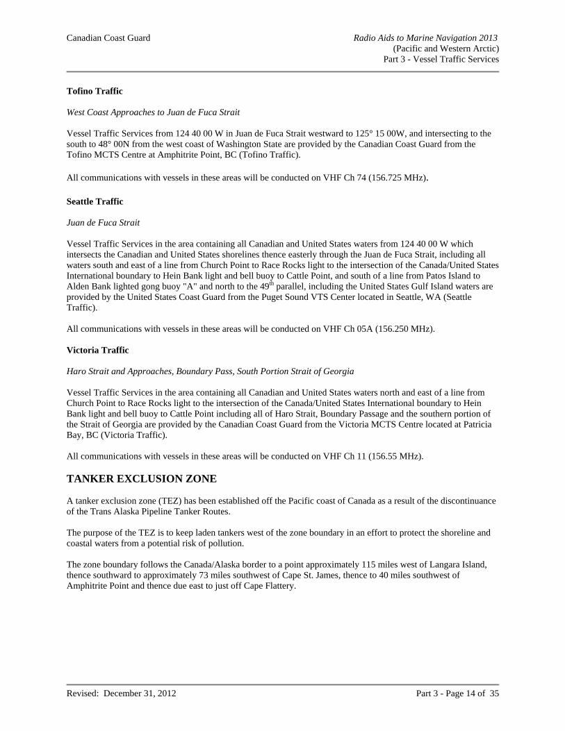
Canadian Coast Guard Radio Aids to Marine Navigation 2013 (Pacific and Western Arctic)
Part 3 - Vessel Traffic Services
Revised: December 31, 2012 Part 3 - Page 14 of 35
Tofino Traffic West Coast Approaches to Juan de Fuca Strait Vessel Traffic Services from 124 40 00 W in Juan de Fuca Strait westward to 125° 15 00W, and intersecting to the south to 48° 00N from the west coast of Washington State are provided by the Canadian Coast Guard from the Tofino MCTS Centre at Amphitrite Point, BC (Tofino Traffic). All communications with vessels in these areas will be conducted on VHF Ch 74 (156.725 MHz). Seattle Traffic Juan de Fuca Strait Vessel Traffic Services in the area containing all Canadian and United States waters from 124 40 00 W which intersects the Canadian and United States shorelines thence easterly through the Juan de Fuca Strait, including all waters south and east of a line from Church Point to Race Rocks light to the intersection of the Canada/United States International boundary to Hein Bank light and bell buoy to Cattle Point, and south of a line from Patos Island to Alden Bank lighted gong buoy "A" and north to the 49th parallel, including the United States Gulf Island waters are provided by the United States Coast Guard from the Puget Sound VTS Center located in Seattle, WA (Seattle Traffic). All communications with vessels in these areas will be conducted on VHF Ch 05A (156.250 MHz). Victoria Traffic Haro Strait and Approaches, Boundary Pass, South Portion Strait of Georgia Vessel Traffic Services in the area containing all Canadian and United States waters north and east of a line from Church Point to Race Rocks light to the intersection of the Canada/United States International boundary to Hein Bank light and bell buoy to Cattle Point including all of Haro Strait, Boundary Passage and the southern portion of the Strait of Georgia are provided by the Canadian Coast Guard from the Victoria MCTS Centre located at Patricia Bay, BC (Victoria Traffic). All communications with vessels in these areas will be conducted on VHF Ch 11 (156.55 MHz). TANKER EXCLUSION ZONE A tanker exclusion zone (TEZ) has been established off the Pacific coast of Canada as a result of the discontinuance of the Trans Alaska Pipeline Tanker Routes. The purpose of the TEZ is to keep laden tankers west of the zone boundary in an effort to protect the shoreline and coastal waters from a potential risk of pollution. The zone boundary follows the Canada/Alaska border to a point approximately 115 miles west of Langara Island, thence southward to approximately 73 miles southwest of Cape St. James, thence to 40 miles southwest of Amphitrite Point and thence due east to just off Cape Flattery.
Canadian Coast Guard Radio Aids to Marine Navigation 2013 (Pacific and Western Arctic)
Part 3 - Vessel Traffic Services
Revised: December 31, 2012 Part 3 - Page 15 of 35
The TEZ is defined as follows: a line from 54°00'00"N 136°17'00"W thence to 51°05'00"N 132°30'00"W thence to 48°32'00"N 126°30'00"W thence to 48°32'00"N 125°09'00"W Loaded TAPS crude oil tankers transiting along the Pacific coast are requested to remain seaward of this zone boundary. TURN POINT – SPECIAL OPERATING AREA The Turn Point Special Operating Area (SOA) has been established to enhance order and predictability, the efficient and safe movement of goods and services, and to further reduce the risk of accidents with respect to vessels transiting the boundary waters of Haro Strait and Boundary Passage in the vicinity of Turn Point on Stuart Island, Washington. The Turn Point SOA consists of those Canadian and United States waters contained within a four (4) sided area connected by the following coordinates:
48 41.324 N 123 14.245 W (Turn Point Light, LL255/US 19790); 48 42.400 N 123 13.967 W; 48 41.087 N 123 17.631 W (Arachne Reef Light, LL254.3); 48 39.732 N 123 16.438 W (Tom Point Light, LL225).
Application These procedures apply to all Canadian and United States VTS participant vessels within or approaching the Turn Point SOA from Boundary Passage, southbound for Haro Strait; and from Haro Strait, northbound for Boundary Passage or Swanson Channel, however, they do not apply to vessels southbound out of Swanson Channel. Movement Procedures a) A VTS participant, if towing astern, do so with as short a hawser as safety and good seamanship permits. b) A VTS participant of 100 metres or more in length (LOA) will make best efforts consistent with safety and
industry practices:
i) not to enter the Turn Point SOA when another VTS participant of 100 metres or more in length is already located within the SOA, unless;
(1) when following astern a minimum .5NM (5 cables) separation is maintained with the vessel ahead, (2) when overtaking in the SOA with the concurrence of MCTS Victoria that there is no opposing traffic
and a CPA of at least .5NM (5 cables) is maintained, (3) if outbound from Boundary Pass and meeting an inbound vessel from Haro Strait already in the SOA,
enter only after the outbound vessel is past the vector heading of the inbound vessel engaged in the turn and maintain at least a .5NM (5 cables) CPA,
(4) if inbound from Haro Strait and meeting an outbound vessel from Boundary Pass already in the SOA, enter only after the outbound vessel has crossed a bearing line between Turn Point and Arachne Reef and maintain at least a .5NM (5 cables) CPA;
ii) maintain a distance off of Turn Point of at least .3 NM (3 cables).
Canadian Coast Guard Radio Aids to Marine Navigation 2013 (Pacific and Western Arctic)
Part 3 - Vessel Traffic Services
Revised: December 31, 2012 Part 3 - Page 16 of 35
All VTS participants approaching the Turn Point SOA are expected to make safe passing arrangements with other VTS participants at either Monarch Head or Blunden Islet southbound; and Lime Kiln Light (LL222/US19695) or Kellett Bluff Light (LL229/US19720) northbound. These arrangements should be made no later than reaching CIP 6 at Gowlland Point (LL253/US19800) southbound and approximately abeam Danger Shoal Light and Horn Buoy (US19775) northbound.
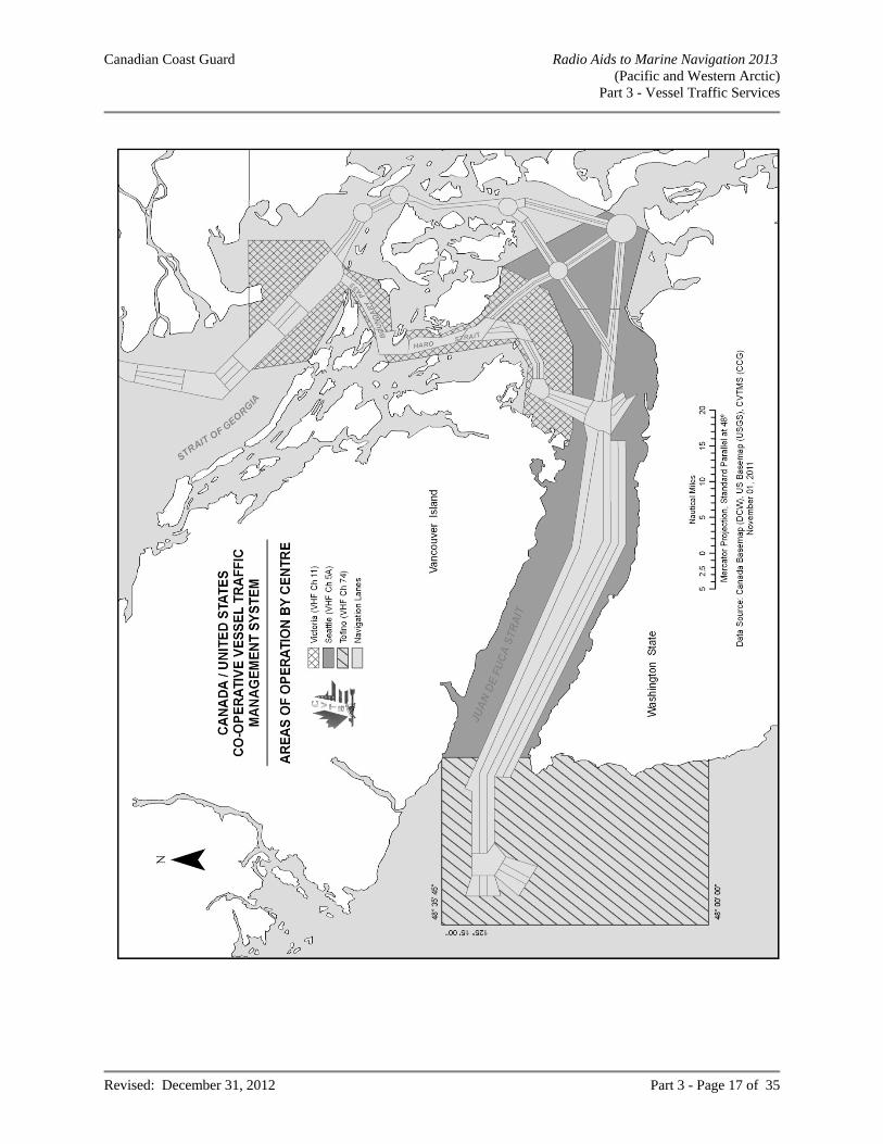
Canadian Coast Guard Radio Aids to Marine Navigation 2013 (Pacific and Western Arctic)
Part 3 - Vessel Traffic Services
Revised: December 31, 2012 Part 3 - Page 17 of 35
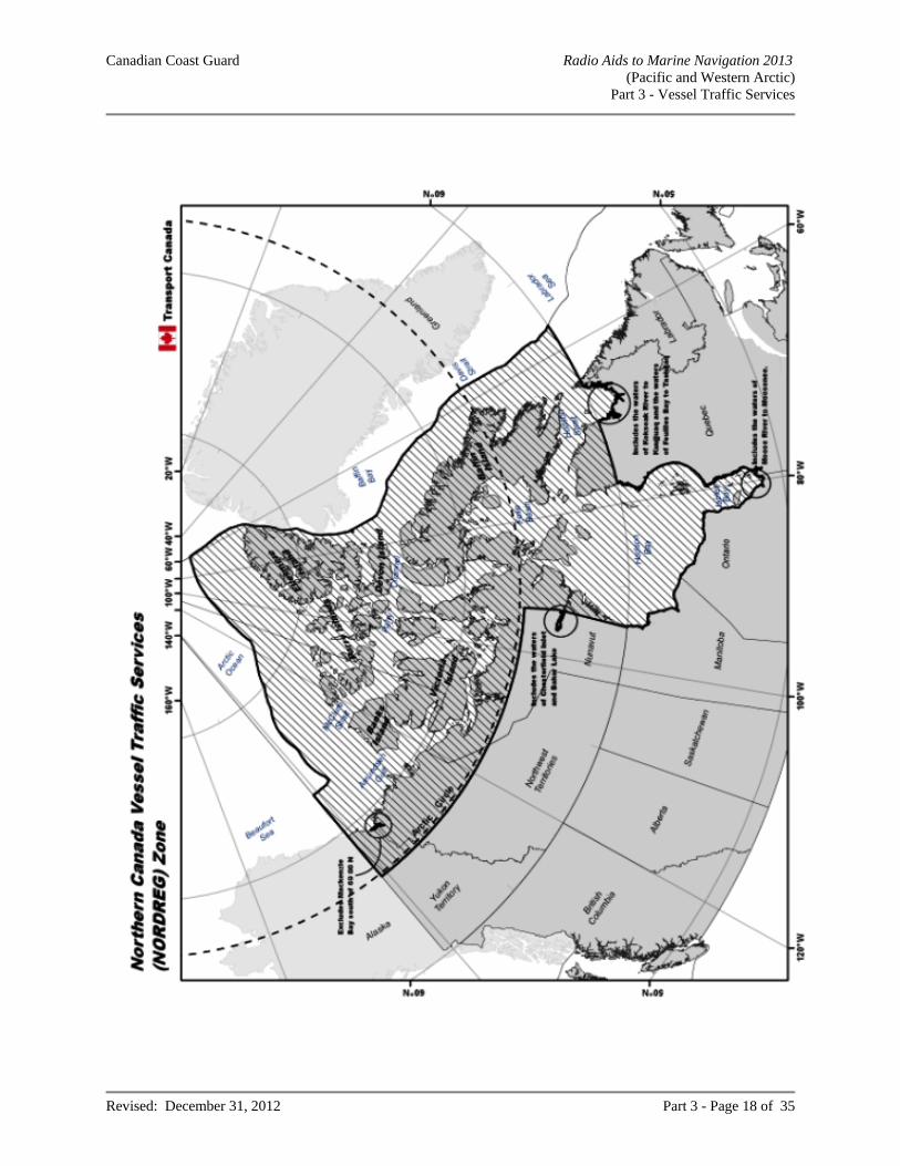
Canadian Coast Guard Radio Aids to Marine Navigation 2013 (Pacific and Western Arctic)
Part 3 - Vessel Traffic Services
Revised: December 31, 2012 Part 3 - Page 18 of 35
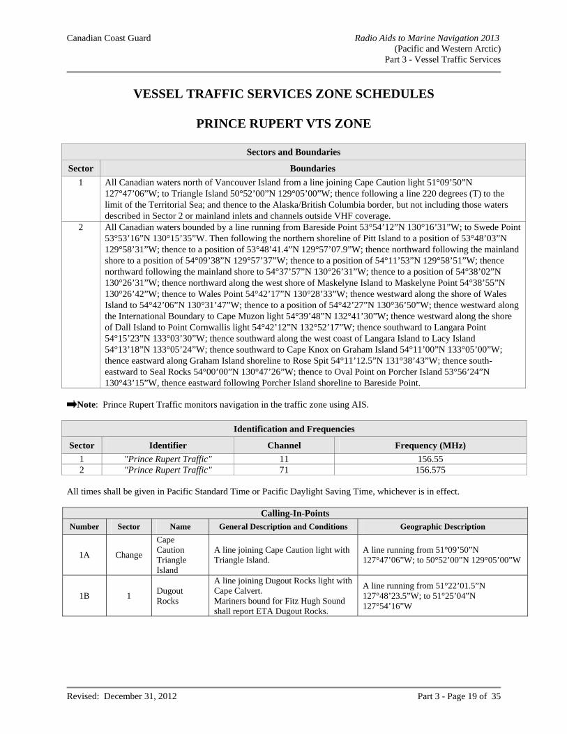
Canadian Coast Guard Radio Aids to Marine Navigation 2013 (Pacific and Western Arctic)
Part 3 - Vessel Traffic Services
Revised: December 31, 2012 Part 3 - Page 19 of 35
VESSEL TRAFFIC SERVICES ZONE SCHEDULES
PRINCE RUPERT VTS ZONE
Sectors and Boundaries
Sector Boundaries
1 All Canadian waters north of Vancouver Island from a line joining Cape Caution light 51°09’50”N 127°47’06”W; to Triangle Island 50°52’00”N 129°05’00”W; thence following a line 220 degrees (T) to the limit of the Territorial Sea; and thence to the Alaska/British Columbia border, but not including those waters described in Sector 2 or mainland inlets and channels outside VHF coverage.
2 All Canadian waters bounded by a line running from Bareside Point 53°54’12”N 130°16’31”W; to Swede Point 53°53’16”N 130°15’35”W. Then following the northern shoreline of Pitt Island to a position of 53°48’03”N 129°58’31”W; thence to a position of 53°48’41.4”N 129°57’07.9”W; thence northward following the mainland shore to a position of 54°09’38”N 129°57’37”W; thence to a position of 54°11’53”N 129°58’51”W; thence northward following the mainland shore to 54°37’57”N 130°26’31”W; thence to a position of 54°38’02”N 130°26’31”W; thence northward along the west shore of Maskelyne Island to Maskelyne Point 54°38’55”N 130°26’42”W; thence to Wales Point 54°42’17”N 130°28’33”W; thence westward along the shore of Wales Island to 54°42’06”N 130°31’47”W; thence to a position of 54°42’27”N 130°36’50”W; thence westward along the International Boundary to Cape Muzon light 54°39’48”N 132°41’30”W; thence westward along the shore of Dall Island to Point Cornwallis light 54°42’12”N 132°52’17”W; thence southward to Langara Point 54°15’23”N 133°03’30”W; thence southward along the west coast of Langara Island to Lacy Island 54°13’18”N 133°05’24”W; thence southward to Cape Knox on Graham Island 54°11’00”N 133°05’00”W; thence eastward along Graham Island shoreline to Rose Spit 54°11’12.5”N 131°38’43”W; thence south-eastward to Seal Rocks 54°00’00”N 130°47’26”W; thence to Oval Point on Porcher Island 53°56’24”N 130°43’15”W, thence eastward following Porcher Island shoreline to Bareside Point.
Note: Prince Rupert Traffic monitors navigation in the traffic zone using AIS.
Identification and Frequencies
Sector Identifier Channel Frequency (MHz)
1 "Prince Rupert Traffic" 11 156.55 2 "Prince Rupert Traffic" 71 156.575
All times shall be given in Pacific Standard Time or Pacific Daylight Saving Time, whichever is in effect.
Calling-In-Points
Number Sector Name General Description and Conditions Geographic Description
1A Change
Cape Caution Triangle Island
A line joining Cape Caution light with Triangle Island.
A line running from 51°09’50”N 127°47’06”W; to 50°52’00”N 129°05’00”W
1B 1 Dugout Rocks
A line joining Dugout Rocks light with Cape Calvert. Mariners bound for Fitz Hugh Sound shall report ETA Dugout Rocks.
A line running from 51°22’01.5”N 127°48’23.5”W; to 51°25’04”N 127°54’16”W
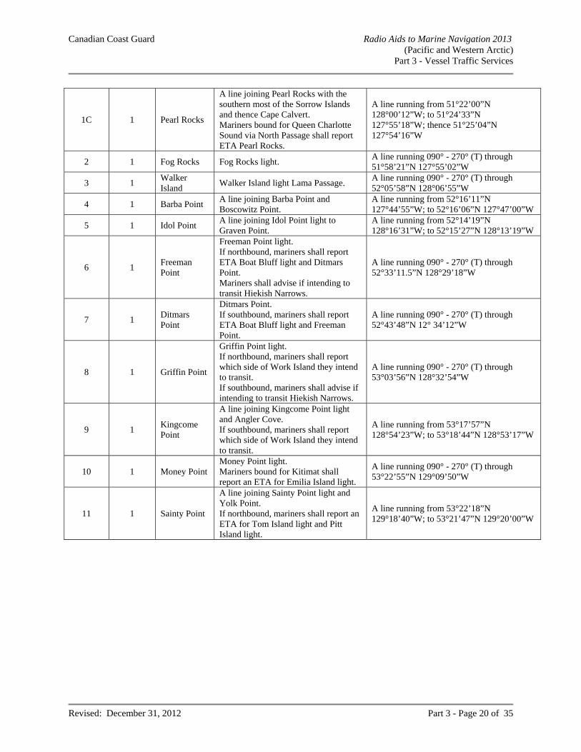
Canadian Coast Guard Radio Aids to Marine Navigation 2013 (Pacific and Western Arctic)
Part 3 - Vessel Traffic Services
Revised: December 31, 2012 Part 3 - Page 20 of 35
1C 1 Pearl Rocks
A line joining Pearl Rocks with the southern most of the Sorrow Islands and thence Cape Calvert. Mariners bound for Queen Charlotte Sound via North Passage shall report ETA Pearl Rocks.
A line running from 51°22’00”N 128°00’12”W; to 51°24’33”N 127°55’18”W; thence 51°25’04”N 127°54’16”W
2 1 Fog Rocks Fog Rocks light. A line running 090° - 270° (T) through 51°58’21”N 127°55’02”W
3 1 Walker Island
Walker Island light Lama Passage. A line running 090° - 270° (T) through 52°05’58”N 128°06’55”W
4 1 Barba Point A line joining Barba Point and Boscowitz Point.
A line running from 52°16’11”N 127°44’55”W; to 52°16’06”N 127°47’00”W
5 1 Idol Point A line joining Idol Point light to Graven Point.
A line running from 52°14’19”N 128°16’31”W; to 52°15’27”N 128°13’19”W
6 1 Freeman Point
Freeman Point light. If northbound, mariners shall report ETA Boat Bluff light and Ditmars Point. Mariners shall advise if intending to transit Hiekish Narrows.
A line running 090° - 270° (T) through 52°33’11.5”N 128°29’18”W
7 1 Ditmars Point
Ditmars Point. If southbound, mariners shall report ETA Boat Bluff light and Freeman Point.
A line running 090° - 270° (T) through 52°43’48”N 12° 34’12”W
8 1 Griffin Point
Griffin Point light. If northbound, mariners shall report which side of Work Island they intend to transit. If southbound, mariners shall advise if intending to transit Hiekish Narrows.
A line running 090° - 270° (T) through 53°03’56”N 128°32’54”W
9 1 Kingcome Point
A line joining Kingcome Point light and Angler Cove. If southbound, mariners shall report which side of Work Island they intend to transit.
A line running from 53°17’57”N 128°54’23”W; to 53°18’44”N 128°53’17”W
10 1 Money Point Money Point light. Mariners bound for Kitimat shall report an ETA for Emilia Island light.
A line running 090° - 270° (T) through 53°22’55”N 129°09’50”W
11 1 Sainty Point
A line joining Sainty Point light and Yolk Point. If northbound, mariners shall report an ETA for Tom Island light and Pitt Island light.
A line running from 53°22’18”N 129°18’40”W; to 53°21’47”N 129°20’00”W
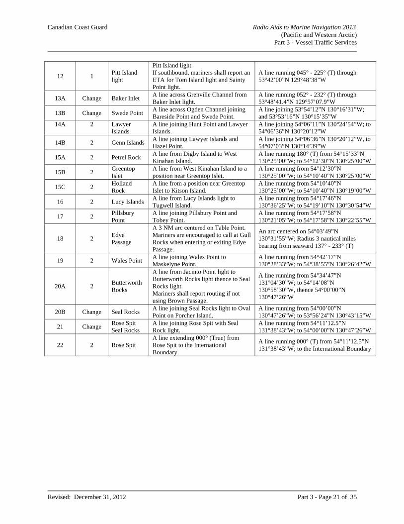
Canadian Coast Guard Radio Aids to Marine Navigation 2013 (Pacific and Western Arctic)
Part 3 - Vessel Traffic Services
Revised: December 31, 2012 Part 3 - Page 21 of 35
12 1 Pitt Island light
Pitt Island light. If southbound, mariners shall report an ETA for Tom Island light and Sainty Point light.
A line running 045° - 225° (T) through 53°42’00”N 129°48’38”W
13A Change Baker Inlet A line across Grenville Channel from Baker Inlet light.
A line running 052° - 232° (T) through 53°48’41.4”N 129°57’07.9”W
13B Change Swede Point A line across Ogden Channel joining Bareside Point and Swede Point.
A line joining 53°54’12”N 130°16’31”W; and 53°53’16”N 130°15’35”W
14A 2 Lawyer Islands
A line joining Hunt Point and Lawyer Islands.
A line joining 54°06’11”N 130°24’54”W; to 54°06’36”N 130°20’12”W
14B 2 Genn Islands A line joining Lawyer Islands and Hazel Point.
A line joining 54°06’36”N 130°20’12”W, to 54°07’03”N 130°14’39”W
15A 2 Petrel Rock A line from Digby Island to West Kinahan Island.
A line running 180° (T) from 54°15’33”N 130°25’00”W; to 54°12’30”N 130°25’00”W
15B 2 Greentop Islet
A line from West Kinahan Island to a position near Greentop Islet.
A line running from 54°12’30”N 130°25’00”W; to 54°10’40”N 130°25’00”W
15C 2 Holland Rock
A line from a position near Greentop Islet to Kitson Island.
A line running from 54°10’40”N 130°25’00”W; to 54°10’40”N 130°19’00”W
16 2 Lucy Islands A line from Lucy Islands light to Tugwell Island.
A line running from 54°17’46”N 130°36’25”W; to 54°19’10”N 130°30’54”W
17 2 Pillsbury Point
A line joining Pillsbury Point and Tobey Point.
A line running from 54°17’58”N 130°21’05”W; to 54°17’58”N 130°22’55”W
18 2 Edye Passage
A 3 NM arc centered on Table Point. Mariners are encouraged to call at Gull Rocks when entering or exiting Edye Passage.
An arc centered on 54°03’49”N 130°31’55”W; Radius 3 nautical miles bearing from seaward 137° - 233° (T)
19 2 Wales Point A line joining Wales Point to Maskelyne Point.
A line running from 54°42’17”N 130°28’33”W; to 54°38’55”N 130°26’42”W
20A 2 Butterworth Rocks
A line from Jacinto Point light to Butterworth Rocks light thence to Seal Rocks light. Mariners shall report routing if not using Brown Passage.
A line running from 54°34’47”N 131°04’30”W; to 54°14’08”N 130°58’30”W, thence 54°00’00”N 130°47’26”W
20B Change Seal Rocks A line joining Seal Rocks light to Oval Point on Porcher Island.
A line running from 54°00’00”N 130°47’26”W; to 53°56’24”N 130°43’15”W
21 Change Rose Spit Seal Rocks
A line joining Rose Spit with Seal Rock light.
A line running from 54°11’12.5”N 131°38’43”W; to 54°00’00”N 130°47’26”W
22 2 Rose Spit A line extending 000° (True) from Rose Spit to the International Boundary.
A line running 000° (T) from 54°11’12.5”N 131°38’43”W; to the International Boundary
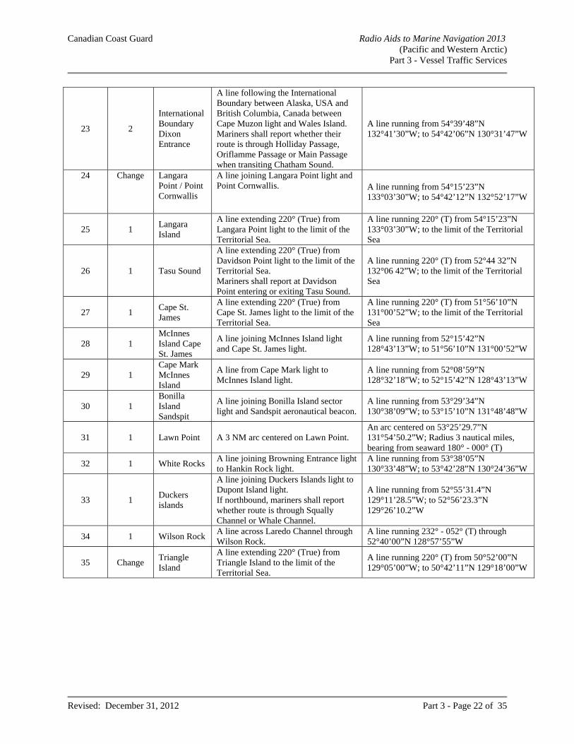
Canadian Coast Guard Radio Aids to Marine Navigation 2013 (Pacific and Western Arctic)
Part 3 - Vessel Traffic Services
Revised: December 31, 2012 Part 3 - Page 22 of 35
23 2
International Boundary Dixon Entrance
A line following the International Boundary between Alaska, USA and British Columbia, Canada between Cape Muzon light and Wales Island. Mariners shall report whether their route is through Holliday Passage, Oriflamme Passage or Main Passage when transiting Chatham Sound.
A line running from 54°39’48”N 132°41’30”W; to 54°42’06”N 130°31’47”W
24 Change Langara Point / Point Cornwallis
A line joining Langara Point light and Point Cornwallis. A line running from 54°15’23”N
133°03’30”W; to 54°42’12”N 132°52’17”W
25 1 Langara Island
A line extending 220° (True) from Langara Point light to the limit of the Territorial Sea.
A line running 220° (T) from 54°15’23”N 133°03’30”W; to the limit of the Territorial Sea
26 1 Tasu Sound
A line extending 220° (True) from Davidson Point light to the limit of the Territorial Sea. Mariners shall report at Davidson Point entering or exiting Tasu Sound.
A line running 220° (T) from 52°44 32”N 132°06 42”W; to the limit of the Territorial Sea
27 1 Cape St. James
A line extending 220° (True) from Cape St. James light to the limit of the Territorial Sea.
A line running 220° (T) from 51°56’10”N 131°00’52”W; to the limit of the Territorial Sea
28 1 McInnes Island Cape St. James
A line joining McInnes Island light and Cape St. James light.
A line running from 52°15’42”N 128°43’13”W; to 51°56’10”N 131°00’52”W
29 1 Cape Mark McInnes Island
A line from Cape Mark light to McInnes Island light.
A line running from 52°08’59”N 128°32’18”W; to 52°15’42”N 128°43’13”W
30 1 Bonilla Island Sandspit
A line joining Bonilla Island sector light and Sandspit aeronautical beacon.
A line running from 53°29’34”N 130°38’09”W; to 53°15’10”N 131°48’48”W
31 1 Lawn Point A 3 NM arc centered on Lawn Point. An arc centered on 53°25’29.7”N 131°54’50.2”W; Radius 3 nautical miles, bearing from seaward 180° - 000° (T)
32 1 White Rocks A line joining Browning Entrance light to Hankin Rock light.
A line running from 53°38’05”N 130°33’48”W; to 53°42’28”N 130°24’36”W
33 1 Duckers islands
A line joining Duckers Islands light to Dupont Island light. If northbound, mariners shall report whether route is through Squally Channel or Whale Channel.
A line running from 52°55’31.4”N 129°11’28.5”W; to 52°56’23.3”N 129°26’10.2”W
34 1 Wilson Rock A line across Laredo Channel through Wilson Rock.
A line running 232° - 052° (T) through 52°40’00”N 128°57’55”W
35 Change Triangle Island
A line extending 220° (True) from Triangle Island to the limit of the Territorial Sea.
A line running 220° (T) from 50°52’00”N 129°05’00”W; to 50°42’11”N 129°18’00”W
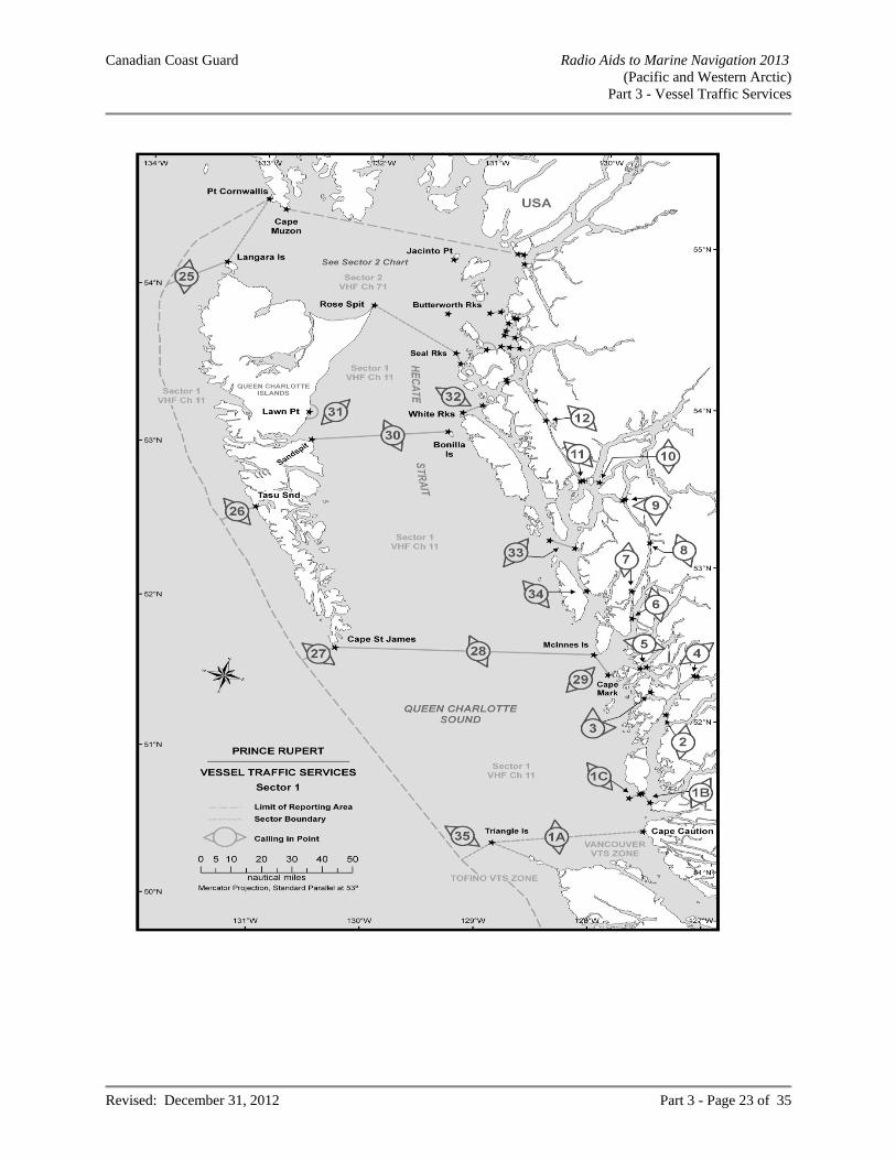
Canadian Coast Guard Radio Aids to Marine Navigation 2013 (Pacific and Western Arctic)
Part 3 - Vessel Traffic Services
Revised: December 31, 2012 Part 3 - Page 23 of 35
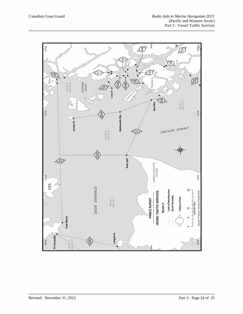
Canadian Coast Guard Radio Aids to Marine Navigation 2013 (Pacific and Western Arctic)
Part 3 - Vessel Traffic Services
Revised: December 31, 2012 Part 3 - Page 24 of 35
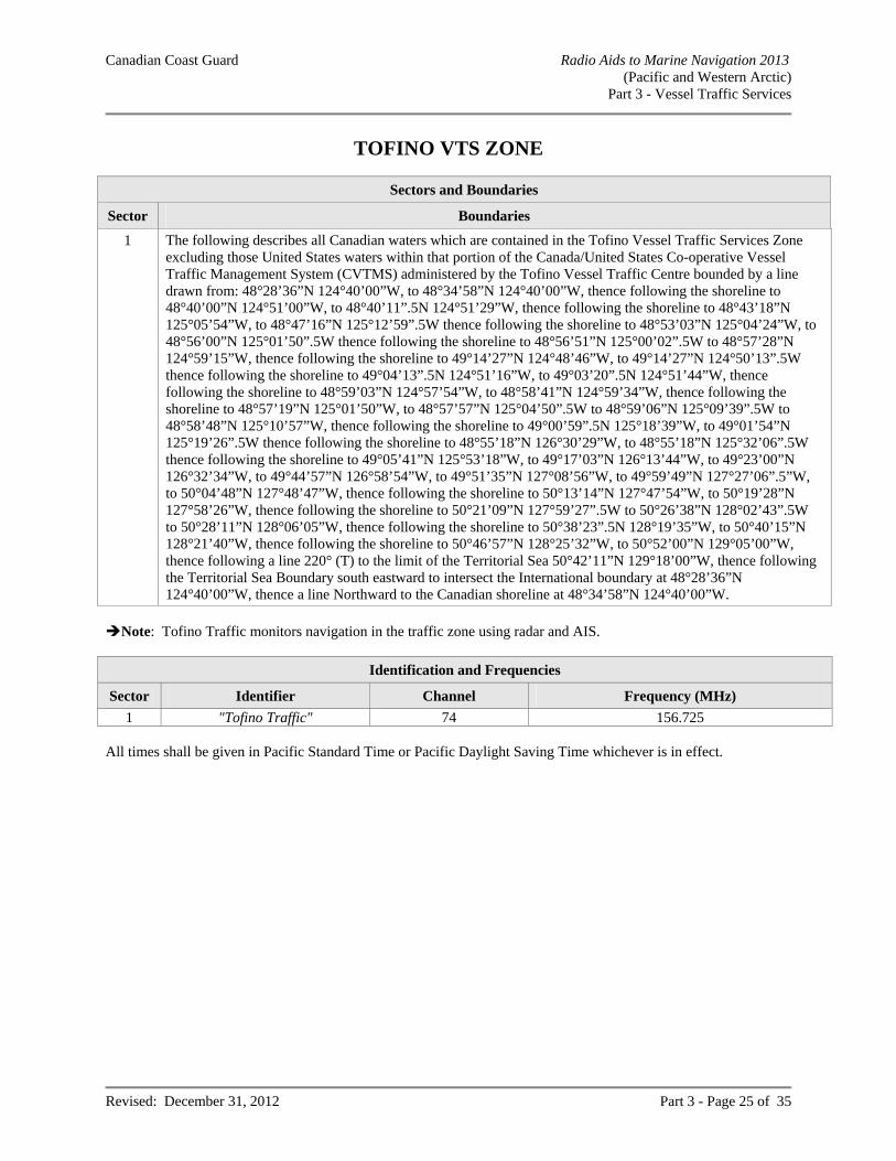
Canadian Coast Guard Radio Aids to Marine Navigation 2013 (Pacific and Western Arctic)
Part 3 - Vessel Traffic Services
Revised: December 31, 2012 Part 3 - Page 25 of 35
TOFINO VTS ZONE
Sectors and Boundaries
Sector Boundaries
1 The following describes all Canadian waters which are contained in the Tofino Vessel Traffic Services Zone excluding those United States waters within that portion of the Canada/United States Co-operative Vessel Traffic Management System (CVTMS) administered by the Tofino Vessel Traffic Centre bounded by a line drawn from: 48°28’36”N 124°40’00”W, to 48°34’58”N 124°40’00”W, thence following the shoreline to 48°40’00”N 124°51’00”W, to 48°40’11”.5N 124°51’29”W, thence following the shoreline to 48°43’18”N 125°05’54”W, to 48°47’16”N 125°12’59”.5W thence following the shoreline to 48°53’03”N 125°04’24”W, to 48°56’00”N 125°01’50”.5W thence following the shoreline to 48°56’51”N 125°00’02”.5W to 48°57’28”N 124°59’15”W, thence following the shoreline to 49°14’27”N 124°48’46”W, to 49°14’27”N 124°50’13”.5W thence following the shoreline to 49°04’13”.5N 124°51’16”W, to 49°03’20”.5N 124°51’44”W, thence following the shoreline to 48°59’03”N 124°57’54”W, to 48°58’41”N 124°59’34”W, thence following the shoreline to 48°57’19”N 125°01’50”W, to 48°57’57”N 125°04’50”.5W to 48°59’06”N 125°09’39”.5W to 48°58’48”N 125°10’57”W, thence following the shoreline to 49°00’59”.5N 125°18’39”W, to 49°01’54”N 125°19’26”.5W thence following the shoreline to 48°55’18”N 126°30’29”W, to 48°55’18”N 125°32’06”.5W thence following the shoreline to 49°05’41”N 125°53’18”W, to 49°17’03”N 126°13’44”W, to 49°23’00”N 126°32’34”W, to 49°44’57”N 126°58’54”W, to 49°51’35”N 127°08’56”W, to 49°59’49”N 127°27’06”.5”W, to 50°04’48”N 127°48’47”W, thence following the shoreline to 50°13’14”N 127°47’54”W, to 50°19’28”N 127°58’26”W, thence following the shoreline to 50°21’09”N 127°59’27”.5W to 50°26’38”N 128°02’43”.5W to 50°28’11”N 128°06’05”W, thence following the shoreline to 50°38’23”.5N 128°19’35”W, to 50°40’15”N 128°21’40”W, thence following the shoreline to 50°46’57”N 128°25’32”W, to 50°52’00”N 129°05’00”W, thence following a line 220° (T) to the limit of the Territorial Sea 50°42’11”N 129°18’00”W, thence following the Territorial Sea Boundary south eastward to intersect the International boundary at 48°28’36”N 124°40’00”W, thence a line Northward to the Canadian shoreline at 48°34’58”N 124°40’00”W.
Note: Tofino Traffic monitors navigation in the traffic zone using radar and AIS.
Identification and Frequencies
Sector Identifier Channel Frequency (MHz)
1 "Tofino Traffic" 74 156.725 All times shall be given in Pacific Standard Time or Pacific Daylight Saving Time whichever is in effect.

Canadian Coast Guard Radio Aids to Marine Navigation 2013 (Pacific and Western Arctic)
Part 3 - Vessel Traffic Services
Revised: December 31, 2012 Part 3 - Page 26 of 35
Calling-In-Points
Number Sector Name General Description and Conditions Geographic Description
1 1 Zone Limit
A line running north along the meridian 124°40'00"W from the International Boundary to the Vancouver Island shoreline. Administered by Seattle and Tofino Traffic (CVTS).
2 1 Cape Beale
A line joining Cape Beale light with Amphitrite Point light. Mariners shall indicate whether their course is through Trevor Channel, Imperial Eagle Channel or Loudoun Channel.
A line joining 48°47’13”N 125°12’51”W; to 48°55’17”N 125°32’23”W
3 1 Chup Point A line joining Chup Point with Mutine Point.
A line joining 48°57’20”N 125°01’37”W; to 48°56’33”N 125°01’06”W
4 1 Ten Mile Point
A line extending 256° (True) from Ten Mile Point light to the opposite shore of Alberni Inlet.
A line extending 256° (T) from 49°03’34”N 124°50’22”W; to 49°03’20.5”N 124°51’44”W
5 1 Dunsmuir Point
A line extending 090° (True) from Dunsmuir Point light to the opposite shore of Alberni Inlet.
A line extending 090° (T) from 49°09’16”N 124°48’26”W; to 49°09’16”N 124°47’42”W
6 1 Amphitrite Point
A line extending 220° (True) from Amphitrite Point light to the limit of the Territorial Sea.
A line extending 220° (T) from 48°55’17”N 125°32’23”W; to 48°46’06”N 125°44’02”W
7 1 Estevan Point A line extending 220° (True) from Estevan Point light to the limit of the Territorial Sea.
A line extending 220° (T) from 49°23’00”N 126°32‘32”W; to 49°13’47”N 126°44’25.5”W
8 1 Nootka Sound A line joining Estevan Point light and Bajo Point.
A line joining 49°23’00”N 126°32’32”W; to 49°37’06”N 126°49’35”W
9 1 Esperanza Inlet
A line joining Ferrer Point and Tatchu Point.
A line joining 49°44’57”N 126°58’54”W; to 49°51’35”N 127°08’56”W
10 1 Solander Island
A line extending 220° (True) from Solander Island light to the limit of the Territorial Sea.
A line extending 220° (T) from 50°06’40.5”N 127°56’17”W; to 49°57’26”N 128°08’16”W
11 1 Kains Island (Quatsino Sound)
A line joining Kwakiutl Point and Cape Parkins.
A line joining 50°21’09”N 127°59’27.5”W; to 50°26’38”N 128°02’43.5”W
12 1 Cape Scott Triangle Island
A line extending 281° (True) from Cape Scott light, passing through Cox and Lanz Islands to Triangle Island.
A line extending 281° (T) from 50°46’57”N 128°25’32”W; to 50°52’00”N 129°05’00”W
13 1 Zone Limit A line extending 220° (True) from Triangle Island to the limit of the Territorial Sea.
A line extending 220° (T) from 50°52’00”N 129°05’00”W; to 50°42’11”N 129°18’00”W
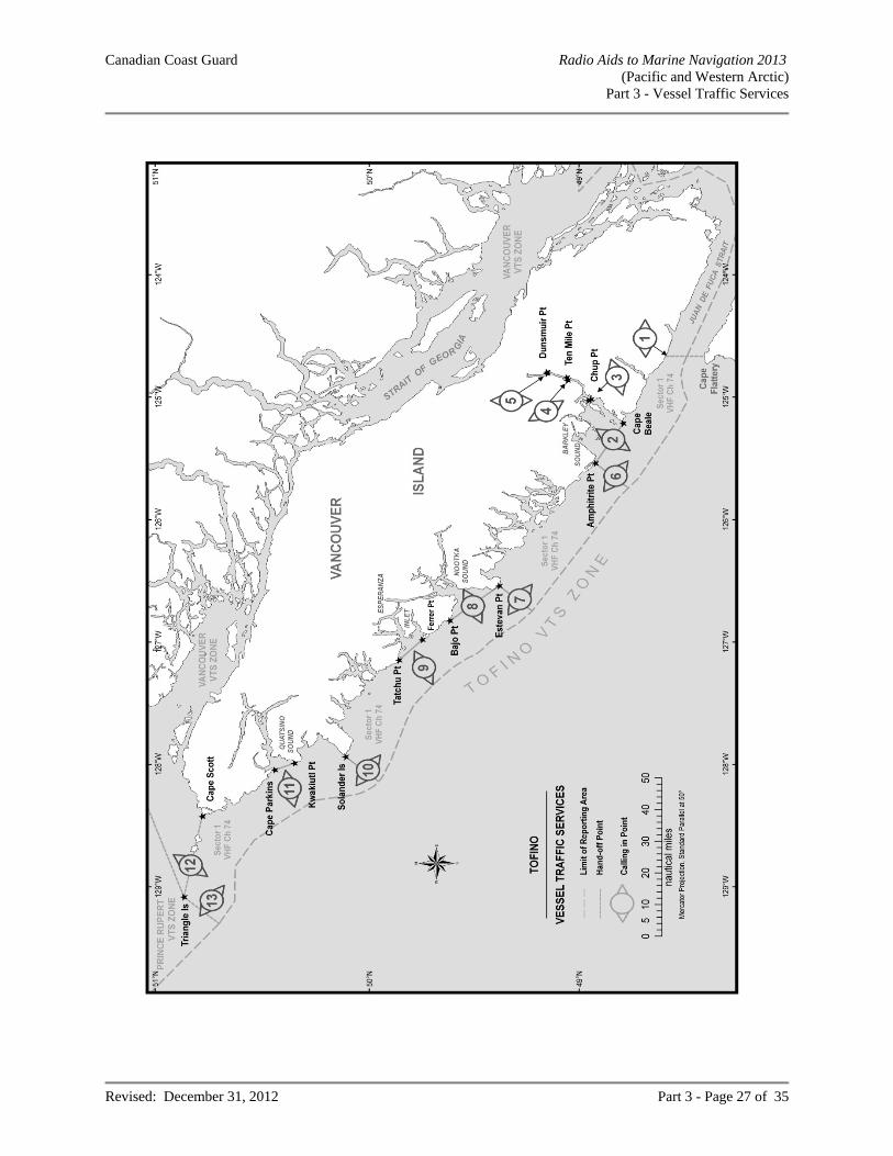
Canadian Coast Guard Radio Aids to Marine Navigation 2013 (Pacific and Western Arctic)
Part 3 - Vessel Traffic Services
Revised: December 31, 2012 Part 3 - Page 27 of 35
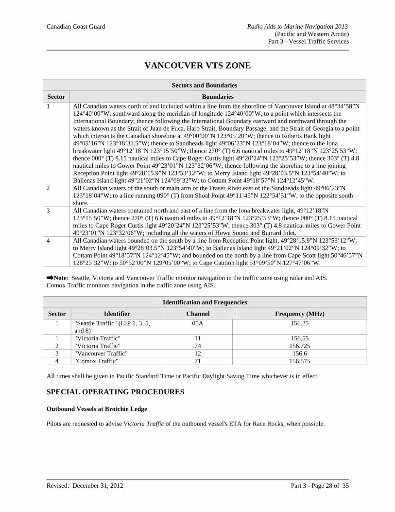
Canadian Coast Guard Radio Aids to Marine Navigation 2013 (Pacific and Western Arctic)
Part 3 - Vessel Traffic Services
Revised: December 31, 2012 Part 3 - Page 28 of 35
VANCOUVER VTS ZONE
Sectors and Boundaries
Sector Boundaries
1 All Canadian waters north of and included within a line from the shoreline of Vancouver Island at 48°34’58”N 124°40’00”W; southward along the meridian of longitude 124°40’00”W, to a point which intersects the International Boundary; thence following the International Boundary eastward and northward through the waters known as the Strait of Juan de Fuca, Haro Strait, Boundary Passage, and the Strait of Georgia to a point which intersects the Canadian shoreline at 49°00’00”N 123°05’20”W; thence to Roberts Bank light 49°05’16”N 123°18’31.5”W; thence to Sandheads light 49°06’23”N 123°18’04”W; thence to the Iona breakwater light 49°12’18”N 123°15’50”W; thence 270° (T) 6.6 nautical miles to 49°12’18”N 123°25 53”W; thence 000° (T) 8.15 nautical miles to Cape Roger Curtis light 49°20’24”N 123°25’53”W; thence 303° (T) 4.8 nautical miles to Gower Point 49°23’01”N 123°32’06”W; thence following the shoreline to a line joining Reception Point light 49°28’15.9”N 123°53’12”W; to Merry Island light 49°28’03.5”N 123°54’40”W; to Ballenas Island light 49°21’02”N 124°09’32”W; to Cottam Point 49°18’57”N 124°12’45”W.
2 All Canadian waters of the south or main arm of the Fraser River east of the Sandheads light 49°06’23”N 123°18’04”W; to a line running 090° (T) from Shoal Point 49°11’45”N 122°54’51”W, to the opposite south shore.
3 All Canadian waters contained north and east of a line from the Iona breakwater light, 49°12’18”N 123°15’50”W; thence 270° (T) 6.6 nautical miles to 49°12’18”N 123°25’53”W; thence 000° (T) 8.15 nautical miles to Cape Roger Curtis light 49°20’24”N 123°25’53”W; thence 303° (T) 4.8 nautical miles to Gower Point 49°23’01”N 123°32’06”W; including all the waters of Howe Sound and Burrard Inlet.
4 All Canadian waters bounded on the south by a line from Reception Point light, 49°28’15.9”N 123°53’12”W; to Merry Island light 49°28’03.5”N 123°54’40”W; to Ballenas Island light 49°21’02”N 124°09’32”W; to Cottam Point 49°18’57”N 124°12’45”W; and bounded on the north by a line from Cape Scott light 50°46’57”N 128°25’32”W; to 50°52’00”N 129°05’00”W; to Cape Caution light 51°09’50”N 127°47’06”W.
Note: Seattle, Victoria and Vancouver Traffic monitor navigation in the traffic zone using radar and AIS.
Comox Traffic monitors navigation in the traffic zone using AIS.
Identification and Frequencies
Sector Identifier Channel Frequency (MHz)
1 "Seattle Traffic" (CIP 1, 3, 5, and 8)
05A 156.25
1 "Victoria Traffic" 11 156.55 2 "Victoria Traffic" 74 156.725 3 "Vancouver Traffic" 12 156.6 4 "Comox Traffic" 71 156.575
All times shall be given in Pacific Standard Time or Pacific Daylight Saving Time whichever is in effect. SPECIAL OPERATING PROCEDURES Outbound Vessels at Brotchie Ledge Pilots are requested to advise Victoria Traffic of the outbound vessel's ETA for Race Rocks, when possible.

Canadian Coast Guard Radio Aids to Marine Navigation 2013 (Pacific and Western Arctic)
Part 3 - Vessel Traffic Services
Revised: December 31, 2012 Part 3 - Page 29 of 35
Point Grey / Point Atkinson Inbound vessels will initiate a broadcast at a line joining Point Grey/Point Atkinson indicating an ETA for First Narrows. (Vancouver Traffic will only respond if there is traffic to report.)
Calling-In-Points
Number Sector Name General Description and Conditions Geographic Description
1 Change Zone Limit
A line running north along the meridian 124 40 00W from the International Boundary to the Vancouver Island shoreline. Administered by Seattle and Tofino Traffic (CVTS).
A line running north from 48°28’36”N 124°40’00”W; to 48°34’58”N 124°40’00”W
3 Change Race Rocks
A line running 090° -270° (True) through Race Rocks light. Administered by Seattle and Victoria Traffic (CVTS).
A line running 090° - 270° (T) through 48°17’54”N 123°31’54”W
4 1 Buoy "VH" A line running 000° -180° (True) through buoy "VH".
A line running 000° -180° (T) through 48°22’32”N 123°23’29”W
5 Change Hein Bank
A line joining Hein Bank with Cattle Point light, San Juan Island. Administered by Seattle & Victoria Traffic (CVTS).
A line running from 48°22’00”N 123°02’01”W, to 48°27’03”N 122°57’45”W
6 1 Turn Point 3 NM before reaching Turn Point light. A circle centered on 48°41’20”N 123°14’10”W, Radius 3 nautical miles
7 1 East Point
A line joining East Point light, Saturna Island with Patos Island light. Mariners are encouraged to call 3NM from East Point light when entering or exiting Boundary Pass.
A line running from 48°47’00”N 123°02’42”W, to 48°47’24”N 122°58’13”W
8 Change Patos Island
A line joining, Patos Island light with Alden Bank light and gong buoy "A". Administered by Seattle & Victoria Traffic (CVTS).
A line running from 48°47’24”N 122°58’13”W, to 48°50’24”N 122°52’32”W
9 1 At Portlock Point
At Portlock Point. A line running 090° - 270° (T) through 48°49’41”N 123°21’02”W
10 1 Peile Point At Peile Point light. A line running 045° - 225° (T) through 48°51’00”N 123°24’14”W
11 1 Active Pass Approaching from the Strait of Georgia, 3NM Northeast of Georgina Point light. Entering Strait of Georgia when clear of Active Pass.
An arc centered on 48°52’24.5”N 123°17’24.5”W Radius 3 nautical miles
12 Change Sandheads At Sandheads light. A line running 000° - 180° (T) through 49°06’23”N 123°18’04”W
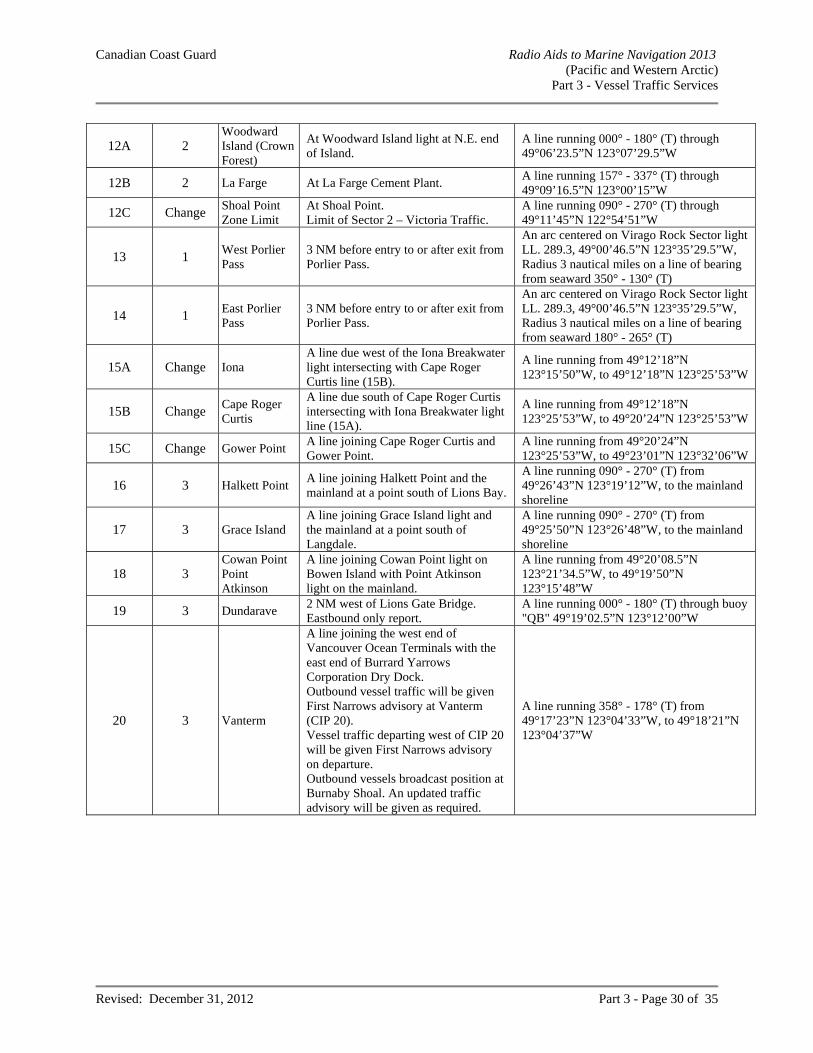
Canadian Coast Guard Radio Aids to Marine Navigation 2013 (Pacific and Western Arctic)
Part 3 - Vessel Traffic Services
Revised: December 31, 2012 Part 3 - Page 30 of 35
12A 2 Woodward Island (Crown Forest)
At Woodward Island light at N.E. end of Island.
A line running 000° - 180° (T) through 49°06’23.5”N 123°07’29.5”W
12B 2 La Farge At La Farge Cement Plant. A line running 157° - 337° (T) through 49°09’16.5”N 123°00’15”W
12C Change Shoal Point Zone Limit
At Shoal Point. Limit of Sector 2 – Victoria Traffic.
A line running 090° - 270° (T) through 49°11’45”N 122°54’51”W
13 1 West Porlier Pass
3 NM before entry to or after exit from Porlier Pass.
An arc centered on Virago Rock Sector light LL. 289.3, 49°00’46.5”N 123°35’29.5”W, Radius 3 nautical miles on a line of bearing from seaward 350° - 130° (T)
14 1 East Porlier Pass
3 NM before entry to or after exit from Porlier Pass.
An arc centered on Virago Rock Sector light LL. 289.3, 49°00’46.5”N 123°35’29.5”W, Radius 3 nautical miles on a line of bearing from seaward 180° - 265° (T)
15A Change Iona A line due west of the Iona Breakwater light intersecting with Cape Roger Curtis line (15B).
A line running from 49°12’18”N 123°15’50”W, to 49°12’18”N 123°25’53”W
15B Change Cape Roger Curtis
A line due south of Cape Roger Curtis intersecting with Iona Breakwater light line (15A).
A line running from 49°12’18”N 123°25’53”W, to 49°20’24”N 123°25’53”W
15C Change Gower Point A line joining Cape Roger Curtis and Gower Point.
A line running from 49°20’24”N 123°25’53”W, to 49°23’01”N 123°32’06”W
16 3 Halkett Point A line joining Halkett Point and the mainland at a point south of Lions Bay.
A line running 090° - 270° (T) from 49°26’43”N 123°19’12”W, to the mainland shoreline
17 3 Grace Island A line joining Grace Island light and the mainland at a point south of Langdale.
A line running 090° - 270° (T) from 49°25’50”N 123°26’48”W, to the mainland shoreline
18 3 Cowan Point Point Atkinson
A line joining Cowan Point light on Bowen Island with Point Atkinson light on the mainland.
A line running from 49°20’08.5”N 123°21’34.5”W, to 49°19’50”N 123°15’48”W
19 3 Dundarave 2 NM west of Lions Gate Bridge. Eastbound only report.
A line running 000° - 180° (T) through buoy "QB" 49°19’02.5”N 123°12’00”W
20 3 Vanterm
A line joining the west end of Vancouver Ocean Terminals with the east end of Burrard Yarrows Corporation Dry Dock. Outbound vessel traffic will be given First Narrows advisory at Vanterm (CIP 20). Vessel traffic departing west of CIP 20 will be given First Narrows advisory on departure. Outbound vessels broadcast position at Burnaby Shoal. An updated traffic advisory will be given as required.
A line running 358° - 178° (T) from 49°17’23”N 123°04’33”W, to 49°18’21”N 123°04’37”W
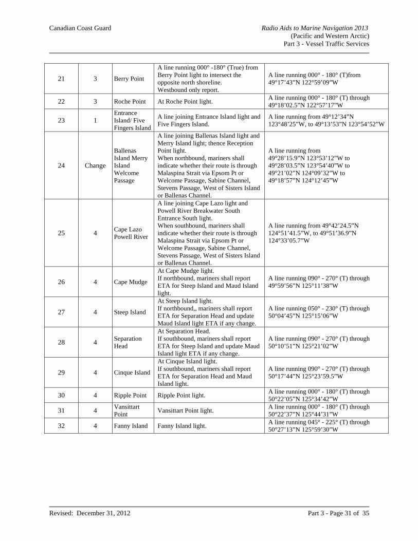
Canadian Coast Guard Radio Aids to Marine Navigation 2013 (Pacific and Western Arctic)
Part 3 - Vessel Traffic Services
Revised: December 31, 2012 Part 3 - Page 31 of 35
21 3 Berry Point
A line running 000° -180° (True) from Berry Point light to intersect the opposite north shoreline. Westbound only report.
A line running 000° - 180° (T)from 49°17’43”N 122°59’09”W
22 3 Roche Point At Roche Point light. A line running 000° - 180° (T) through 49°18’02.5”N 122°57’17”W
23 1 Entrance Island/ Five Fingers Island
A line joining Entrance Island light and Five Fingers Island.
A line running from 49°12’34”N 123°48’25”W, to 49°13’53”N 123°54’52”W
24 Change
Ballenas Island Merry Island Welcome Passage
A line joining Ballenas Island light and Merry Island light; thence Reception Point light. When northbound, mariners shall indicate whether their route is through Malaspina Strait via Epsom Pt or Welcome Passage, Sabine Channel, Stevens Passage, West of Sisters Island or Ballenas Channel.
A line running from 49°28’15.9”N 123°53’12”W to 49°28’03.5”N 123°54’40”W to 49°21’02”N 124°09’32”W to 49°18’57”N 124°12’45”W
25 4 Cape Lazo Powell River
A line joining Cape Lazo light and Powell River Breakwater South Entrance South light. When southbound, mariners shall indicate whether their route is through Malaspina Strait via Epsom Pt or Welcome Passage, Sabine Channel, Stevens Passage, West of Sisters Island or Ballenas Channel.
A line running from 49°42’24.5”N 124°51’41.5”W, to 49°51’36.9”N 124°33’05.7”W
26 4 Cape Mudge
At Cape Mudge light. If northbound, mariners shall report ETA for Steep Island and Maud Island light.
A line running 090° - 270° (T) through 49°59’56”N 125°11’38”W
27 4 Steep Island
At Steep Island light. If northbound,, mariners shall report ETA for Separation Head and update Maud Island light ETA if any change.
A line running 050° - 230° (T) through 50°04’45”N 125°15’06”W
28 4 Separation Head
At Separation Head. If southbound, mariners shall report ETA for Steep Island and update Maud Island light ETA if any change.
A line running 090° - 270° (T) through 50°10’51”N 125°21’02”W
29 4 Cinque Island
At Cinque Island light. If southbound, mariners shall report ETA for Separation Head and Maud Island light.
A line running 090° - 270° (T) through 50°17’44”N 125°23’59.5”W
30 4 Ripple Point Ripple Point light. A line running 000° - 180° (T) through 50°22’05”N 125°34’42”W
31 4 Vansittart Point
Vansittart Point light. A line running 000° - 180° (T) through 50°22’37”N 125°44’31”W
32 4 Fanny Island Fanny Island light. A line running 045° - 225° (T) through 50°27’13”N 125°59’30”W
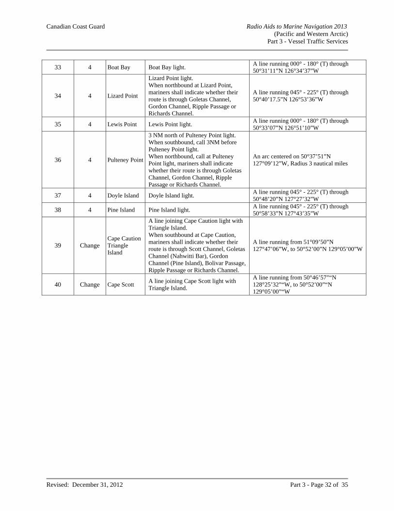
Canadian Coast Guard Radio Aids to Marine Navigation 2013 (Pacific and Western Arctic)
Part 3 - Vessel Traffic Services
Revised: December 31, 2012 Part 3 - Page 32 of 35
33 4 Boat Bay Boat Bay light. A line running 000° - 180° (T) through 50°31’11”N 126°34’37”W
34 4 Lizard Point
Lizard Point light. When northbound at Lizard Point, mariners shall indicate whether their route is through Goletas Channel, Gordon Channel, Ripple Passage or Richards Channel.
A line running 045° - 225° (T) through 50°40’17.5”N 126°53’36”W
35 4 Lewis Point Lewis Point light. A line running 000° - 180° (T) through 50°33’07”N 126°51’10”W
36 4 Pulteney Point
3 NM north of Pulteney Point light. When southbound, call 3NM before Pulteney Point light. When northbound, call at Pulteney Point light, mariners shall indicate whether their route is through Goletas Channel, Gordon Channel, Ripple Passage or Richards Channel.
An arc centered on 50°37’51”N 127°09’12”W, Radius 3 nautical miles
37 4 Doyle Island Doyle Island light. A line running 045° - 225° (T) through 50°48’20”N 127°27’32”W
38 4 Pine Island Pine Island light. A line running 045° - 225° (T) through 50°58’33”N 127°43’35”W
39 Change Cape Caution Triangle Island
A line joining Cape Caution light with Triangle Island. When southbound at Cape Caution, mariners shall indicate whether their route is through Scott Channel, Goletas Channel (Nahwitti Bar), Gordon Channel (Pine Island), Bolivar Passage, Ripple Passage or Richards Channel.
A line running from 51°09’50”N 127°47’06”W, to 50°52’00”N 129°05’00”W
40 Change Cape Scott A line joining Cape Scott light with Triangle Island.
A line running from 50°46’57”“N 128°25’32”“W, to 50°52’00”“N 129°05’00”“W
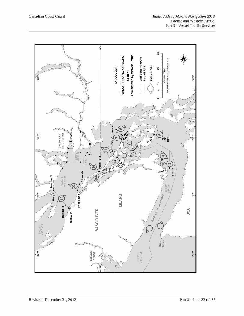
Canadian Coast Guard Radio Aids to Marine Navigation 2013 (Pacific and Western Arctic)
Part 3 - Vessel Traffic Services
Revised: December 31, 2012 Part 3 - Page 33 of 35
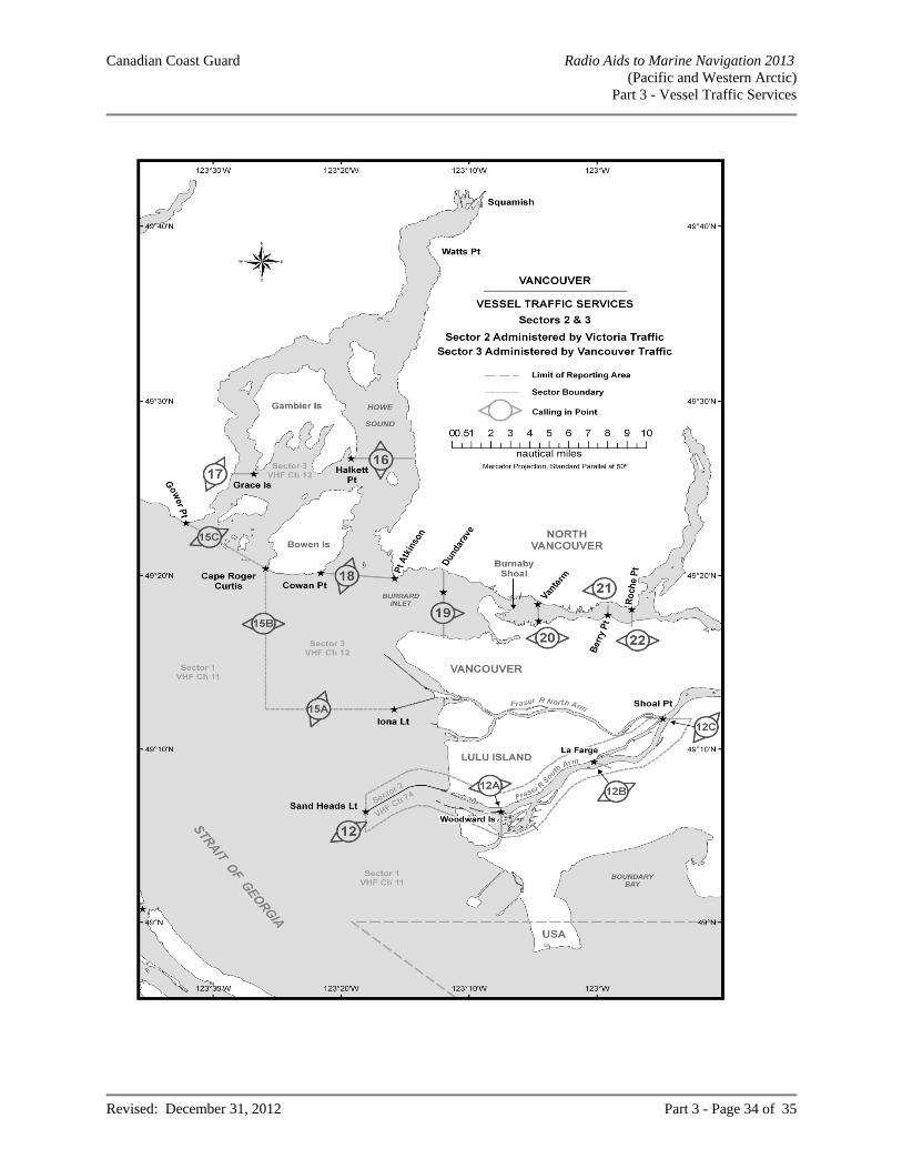
Canadian Coast Guard Radio Aids to Marine Navigation 2013 (Pacific and Western Arctic)
Part 3 - Vessel Traffic Services
Revised: December 31, 2012 Part 3 - Page 34 of 35
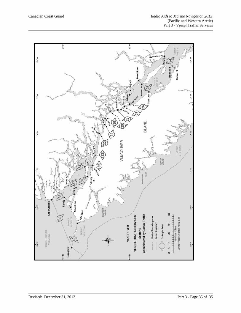
Canadian Coast Guard Radio Aids to Marine Navigation 2013 (Pacific and Western Arctic)
Part 3 - Vessel Traffic Services
Revised: December 31, 2012 Part 3 - Page 35 of 35
Canadian Coast Guard Radio Aids to Marine Navigation 2013 (Pacific and Western Arctic)
Part 4 - General
Revised: December 31, 2012 Part 4 - Page 1 of 58
PART 4 GENERAL
PROCEDURES
RADIOTELEPHONE PROCEDURES General In the interest of safe navigation, and especially during bad weather conditions, masters should ensure that a continuous listening watch is maintained on 2182 kHz. Where practicable, and having due regard for Vessel Traffic Services, a listening watch should be maintained on VHF Ch 16 (156.8 MHz). 2182 kHz AND CH 16 (156.8 MHz) SHALL ONLY BE USED FOR DISTRESS, URGENCY AND SAFETY COMMUNICATIONS AND FOR CALLING PURPOSES. THE CLASS OF EMISSION TO BE USED FOR RADIOTELEPHONY ON THE FREQUENCY 2182 kHz SHALL BE J3E. Make initial calls on any of the VHF working frequencies shown in bold type in the "Receiving" column of the MCTS centre listing. The MCTS centre will then respond on the corresponding frequency shown in the "Transmitting" column. It is necessary to indicate the channel number on the initial call because MCTS officers guard multiple frequencies simultaneously. Before making a call directly on a working frequency, listen for a period long enough to ensure that the channel is not in use. Follow this procedure for radio checks. If difficulty is experienced in establishing contact with the MCTS centre, or if contact is desired with another vessel, the initial call may be made on the calling frequency Ch 16 in which case the station called will reply on the same frequency. As soon as communication has been established a change must be made to an agreed working frequency and all further communications made on that frequency. Masters of compulsorily-fitted ships are reminded that a radio log of all distress and urgency communications and safety communications pertaining to their own ship should be kept and maintained onboard their vessels. The following examples illustrate the procedure to be used: Initial call, when a vessel is attempting to establish communication on a working frequency with a specific station:
Item SpokenName of station called (spoken three times) TOFINO COAST GUARD RADIO The words “THIS IS” THIS IS Type, name, radio call sign of vessel calling (spoken three times)
STEAMER FAIRMOUNT CYLD
and channel CHANNEL 26 Invitation to reply OVER
Initial call, when a vessel wishes to establish communications with any station within range (or within a certain area):
Item SpokenGeneral call (spoken three times). ALL STATIONS (or ALL SHIPS IN JOHNSTONE
STRAIT) The words "THIS IS" THIS IS Type, name and radio call sign of vessel (spoken three times) TANKER IMPERIAL CORNWALL/VCVC Invitation to reply OVER
Canadian Coast Guard Radio Aids to Marine Navigation 2013 (Pacific and Western Arctic)
Part 4 - General
Revised: December 31, 2012 Part 4 - Page 2 of 58
When a station wishes to broadcast information rather than to establish communication, it proceeds with the message instead of giving the invitation to reply. A radio message from a ship consists of several parts, which shall be transmitted on the working frequency in the following order:
(a) Type, name and radio call sign of the originating ship; (b) The date and time the message originated (preferably in UTC. Daylight Saving Time shall not be used)[
Date and time may be sent as one group, the first two figures indicate the date, the last four the time.]; (c) The address; (d) The text or body of the message; (e) The signature.
Note: Items (a) and (b) taken together, are known as the "preamble".
Example of a ship to shore radio message:
MESSAGE: FROM M/V WEST WIND, CALL SIGN V2AG FILED: 071225UTC ADDRESS: NORDREG CANADA TEXT: 1600 UTC REPORT, ANCHORED IN MACKENZIE BAY AWAITING ICEBREAKER SUPPORT SIGNATURE: MASTER
An acknowledgment of receipt of a message shall not be given until the receiving operator is certain that the transmitted information has been received correctly. While it is not practical to lay down precise words and phrases for all radiotelephone procedures, the following should be used where applicable:
Terms MeaningACKNOWLEDGE Let me know that you have received and understood this message. CORRECTION An error has been made in this transmission. The correct version is..... GO AHEAD Proceed with your message. OVER My transmission is ended and I expect a response from you. OUT This conversation is ended and no response is expected. READ BACK After I have given OVER, repeat this entire message back to me exactly as received. ROGER I have received all of your last transmission. RECEIVED NUMBER
Receipt of your message number..... is acknowledged.
STAND BY Wait until you hear further from me. VERIFY Check with the originator and send the correct version. WORDS TWICE As a request - Please send each word twice.
As information - I will send each word twice. How are you using your marine radio? There are over 150 thousand licensed radio stations in British Columbia. Each of these stations is assigned specific frequencies to suit their unique requirements. For the most part, clear and unobstructed communications on the airwaves is possible because most observe the rules that govern radio operation. But, a serious problem has developed in the use of synthesized two-way radio on board vessels on the West Coast. Certain vessel operators are selecting unauthorized channels on synthesized radio. This is causing sever interference to land based municipal services. In such cases, Industry Canada intends to lay charges under the Radiocommunication Act and the Radiocommunication Regulations.
Canadian Coast Guard Radio Aids to Marine Navigation 2013 (Pacific and Western Arctic)
Part 4 - General
Revised: December 31, 2012 Part 4 - Page 3 of 58
Your cooperation in using only assigned marine channels is very important. Your safety, and the safety of others, depends on it. Phonetic Alphabet When it is necessary to spell out call signs, service abbreviations and words whose spelling might be misinterpreted, the following letter spelling table should be used: A - ALFA F - FOXTROT K - KILO O - OSCAR S - SIERRA W - WHISKEY B - BRAVO G - GOLF L - LIMA P - PAPA T - TANGO X - X-RAY C - CHARLIE H - HOTEL M - MIKE Q - QUEBEC U - UNIFORM Y - YANKEE D - DELTA I - INDIA N - NOVEMBER R - ROMEO V - VICTOR Z - ZULU E - ECHO J - JULIET Times Times are expressed in four figures, the first two denoting the hour and the last two the minutes, the day starting at midnight with 0000 and ending at 2400. The standard of time (e.g. UTC) is stated at the head of the appropriate column, or against the figures involved. Time Zone Comparison PST PACIFIC STANDARD TIME To convert from Coordinated Universal Time to Local Standard Time look opposite UTC under the appropriate column. For corresponding Daylight Saving Time, add one hour.
UTC PST 0000 1600 0100 1700 0200 1800 0300 1900 0400 2000 0500 2100 0600 2200 0700 2300 0800 0000 0900 0100 1000 0200 1100 0300 1200 0400 1300 0500 1400 0600 1500 0700 1600 0800 1700 0900 1800 1000 1900 1100 2000 1200 2100 1300 2200 1400 2300 1500
Canadian Coast Guard Radio Aids to Marine Navigation 2013 (Pacific and Western Arctic)
Part 4 - General
Revised: December 31, 2012 Part 4 - Page 4 of 58
Time Signals Canada’s official time is the responsibility of the National Research Council’s Institute for National Measurement Standards, Ottawa, ON. Its short wave radio station CHU, with transmitters located at 45º17’47”N 75 45’22”W is equipped with vertical antennas to give the best possible coverage to the maximum number of Canadian users. The signal is transmitted continuously on 3330 kHz, 7850 kHz and 14670 kHz, upper single-sideband H3E (AM compatible). A cesium atomic clock generates the carrier frequencies (accurate to a part in 10
11) and the UTC
seconds pulses (accurate to 50 microseconds). The start of each UTC second is marked by the start of 300 cycles of a 1000 Hz tone, with certain omissions and identifications. Every half-minute is marked by omitting the preceding tone (for second 29). In the 9 seconds preceding each minute, the second pulses are shortened to “ticks’ to provide a window for the voice announcement, followed by a longer tone. The start of this tone marks the exact minute given by the announcement. This tone is one-half second long, except for the exact hour - when it is one full second long and in this case only is followed by 9 seconds of silence. The bilingual voice announcement which is heard each minute takes the form: “CHU Canada - Coordinated Universal Time -- hours -- minutes -- heures -- minutes” for even minutes, and “CHU Canada - Temps Universel Coordonné -- heures -- minutes -- hours -- minutes” for odd minutes. A small number of the longer time announcements use the abbreviation “UTC” rather than the full form. Following international practice, Canada’s official time is based on Coordinated Universal Time (UTC) which is kept within one second of UT1, the time on the Greenwich meridian as used for celestial navigation. Users interested in the ultimate accuracy of celestial navigation can determine UT1 with an accuracy of 0.1 seconds by decoding the difference DUT1 = UT1 - UTC, as transmitted by CHU in the internationally accepted code. The number of tenths of a second of DUT1 can be decoded by counting the number of emphasized second pulses that follow each minute. If the emphasized pulses occur for any of the seconds 1 to 8, DUT1 is positive; if the emphasized pulses occur for any of the seconds 9 to 16, DUT1 is negative. CHU emphasizes second pulses by splitting them (0.1 s of tone, 0.1 s of silence, 0.1 s of tone) so that a double tone is heard. DISTRESS COMMUNICATIONS IN RADIOTELEPHONY Early Notification of Search and Rescue Authorities of Developing Situations In the interest of ensuring the highest level of safety, mariners should immediately notify the Canadian Coast Guard, through any MCTS centre of any situation which is or may be developing into a more serious situation requiring assistance from the Search and Rescue (SAR) System. The need for the earliest possible alerting of SAR Authorities to potential maritime emergencies cannot be over-emphasized. This advice is given in accordance with IMO Circular MSC/Circ.892 and similar advice found in the ICAO/IMO International Aeronautical and Maritime SAR (IAMSAR) Manual Volume III. Further, there have been similar recommendations arising from serious SAR cases in the Canadian SAR Region where masters have failed to provide this notice until after the situation deteriorated. This notification allows SAR authorities to carry out preliminary and contingency planning that could make a critical difference if the situation worsens. Time lost in the initial stages of a SAR mission may be crucial to its eventual outcome. It is always best to consider the “worst-case scenario” and to alert SAR authorities accordingly. This notification places no obligations upon the master except to advise the Canadian Coast Guard when the situation has been corrected.
Canadian Coast Guard Radio Aids to Marine Navigation 2013 (Pacific and Western Arctic)
Part 4 - General
Revised: December 31, 2012 Part 4 - Page 5 of 58
Canadian MCTS centres provide coverage of all marine distress frequencies, however, each centre does not necessarily guard each frequency (refer to centre listings Part 2). MCTS provides communications between the JRCC/MRSC and the vessel or vessels concerned with the distress. The radiotelephone distress frequencies are: i) 2182 kHz on medium frequency (MF) band; and ii) 156.8 MHz (Ch 16) on very high frequency band (VHF); and iii) any other available frequency on which attention might be attracted if transmissions on 2182 kHz and 156.8
MHz are not possible or successful. The digital selective calling (DSC) frequencies are: i) Ch 70 in the VHF band; ii) 4207.5 kHz; iii) 6312.0 kHz; iv) 8414.5 kHz; v) 12577 kHz; and vi) 16804.5 kHz in the High Frequency (HF) bands. When another craft or person is in distress: i) all transmissions capable of interfering with the distress traffic must be stopped; ii) attention must be concentrated on the distress communications and all information possible intercepted; and iii) a station in the vicinity of the distressed craft must acknowledge receipt of the distress message if received,
giving its own position in relation to that of the craft in distress and stating the action being taken. Distress communications consist of the:
Distress Alert (when using VHF or HF DSC); Distress Signal; Distress Call; Distress Message; and Distress Traffic.
Transmission of a DSC Distress Alert, a Distress Signal and/or a Distress Call announces that the ship, aircraft, other vehicle, or person that is making the transmission is: i) threatened by serious and imminent danger and requires immediate assistance; or ii) aware of another ship, aircraft, other vehicle or person is threatened by serious and imminent danger and
requires immediate assistance. Distress communications should be repeated by the craft in distress until an answer is heard. The DSC Distress Alert will automatically switch marine radios to the associated distress frequency for the subsequent transmission of the distress signal, the distress call and the distress message. The Alarm Signal The radiotelephone Alarm Signal consists of the continuous alternate transmission of two audio tones of different pitch for a period of at least thirty seconds but not to exceed one minute. The sound of this tone is similar to that used by some ambulances.
Canadian Coast Guard Radio Aids to Marine Navigation 2013 (Pacific and Western Arctic)
Part 4 - General
Revised: December 31, 2012 Part 4 - Page 6 of 58
The Alarm Signal is used by Canadian MCTS centres to alert ships: i) that a mayday relay broadcast is about to follow; or ii) that a Tsunami warning, preceded by the Urgency Signal (PAN PAN) is about to follow; or, iii) that the transmission of an urgent cyclone warning, preceded by the Safety Signal (SÉCURITÉ), is about to
follow. The Alarm Signal transmitted by the coast radio station will normally be sent for a period not exceeding thirty (30) seconds and will be followed by a ten (10) second continuous tone. The Distress Signal consists of the word “MAYDAY”. The Distress Call consists of: i) the word “MAYDAY” (spoken three times) ii) the words “THIS IS” followed by iii) the name of the ship in distress (spoken three times) iv) the call sign or other identification, and v) the ship’s MMSI (if a DSC distress alert has been sent). The Distress Call: i) should not be addressed to a particular coast radio station or ship; and ii) has absolute priority over all other transmissions and all coast radio stations and ships that hear this call must
cease any transmissions that will interfere with it and must listen on the frequency used for this call. The Distress Message consists of: i) the word “MAYDAY”; ii) the name of the ship in distress; iii) the call sign or other identification; iv) the ship’s MMSI (if a DSC distress alert has been sent) v) the position of the ship in distress; vi) the nature of the distress; vii) the kind of assistance needed; viii) any other useful information which might assist the rescue; and, ix) the word “OVER”, which is an invitation to acknowledge and reply. The DSC Distress Alert Acknowledgement to an “All Stations” DSC Distress Alert announcement shall normally be made by an MCTS centre. Ship stations may acknowledge receipt of a DSC Distress Alert by radiotelephony on the associated distress and calling frequency after an MCTS centre has had time to initiate contact with the vessel in distress. Distress Traffic consists of all messages about the immediate assistance required by the ship in distress. Prior to the transmission of any Distress Traffic, the Distress Signal “MAYDAY” must be sent once before the call. The control of Distress Traffic is the responsibility of the ship in distress or of the ship or coast radio station sending a Distress Message.
Canadian Coast Guard Radio Aids to Marine Navigation 2013 (Pacific and Western Arctic)
Part 4 - General
Revised: December 31, 2012 Part 4 - Page 7 of 58
A mobile station that learns that another mobile station is in distress may transmit the distress message if: i) the station in distress cannot transmit it; ii) the master or person responsible for the craft carrying the station which intervenes believes that further help is
necessary; iii) although not in a position to render assistance, it has heard a distress message which has not been
acknowledged. In the above situation the distress message relay takes the following form: i) the radiotelephone Alarm Signal if possible; ii) the words “MAYDAY RELAY” (spoken three times); iii) the words, “ALL STATIONS” or specific MCTS centre, as appropriate (spoken three times); iv) the words “THIS IS”; v) the name of the mobile station repeating the distress message (spoken three times); vi) the call sign or other identification of the mobile station repeating the distress message; vii) the MMSI of the mobile station repeating the distress message (if the initial distress alert was sent by DSC) viii) the repetition of the distress message; ix) the word, “OVER” When Distress Traffic has ceased or when silence is no longer necessary the station that has controlled the Distress Traffic must transmit a message on the distress frequency advising that the distress traffic has ceased: i) the word “MAYDAY”; ii) the words “ALL STATIONS” (spoken three times); iii) the words “THIS IS”; iv) the name of the station which has controlled the distress traffic (spoken three times); v) the call-sign or other identification of the station which has controlled the distress traffic; vi) the current Coordinated Universal Time (UTC); vii) the MMSI (if the initial distress alert was sent by DSC) and the name and call sign of the ship that was in
distress and a brief description of the resolution of the distress; viii) the words “SEELONCE FEENEE”; ix) the word “OUT”. Distress Procedure Example Initiate a VHF or HF DSC Distress Alert. Then, on the associated distress and calling frequency, the following distress call and distress message should be spoken slowly and distinctly. Distress Signal “MAYDAY” (three times) the words “THIS IS” name of ship “Nonsuch” (three times) MMSI number “316010115” (if initial distress alert was sent by DSC) Distress Signal “MAYDAY” name of ship “Nonsuch” MMSI number “316010115” (if initial distress alert was sent by DSC) position “Off Iles-St-Marie” nature of distress “Struck rock and taking on water” assistance needed “Require help to abandon ship” other useful information “5 persons on board” invitation to acknowledge and reply “OVER”
Canadian Coast Guard Radio Aids to Marine Navigation 2013 (Pacific and Western Arctic)
Part 4 - General
Revised: December 31, 2012 Part 4 - Page 8 of 58
URGENCY COMMUNICATIONS The DSC Urgency Announcement will automatically switch marine radios to the associated distress frequency for the subsequent transmission of the urgency signal, the urgency call and the urgency message. The Urgency Signal consists of the words “PAN PAN”. The Urgency Call consists of: i) the words “PAN PAN” (spoken three times); ii) the words “ALL STATIONS” or station specific call (spoken three times); iii) the words “THIS IS” followed by; iv) the name of the station making the call (spoken three times); v) the call-sign or other identification; and vi) the ship’s MMSI (if the initial Urgency announcement was sent by DSC). The urgency signal shall be transmitted only on the authority of the master or the person responsible for the ship, aircraft or other vehicle carrying the mobile station. The urgency signal indicates that the calling station has a very urgent message to transmit concerning the safety of a ship, aircraft or other vehicle, or the safety of a person. The urgency signal, the urgency call, and the urgency message shall be sent on the distress frequencies 2182 kHz and Ch 16 (156.8 MHz). If transmission on these frequencies is impossible, any other available frequency on which attention might be attracted should be used. The urgency signal has priority over all other communications, except distress, and all stations which hear it must take care not to interfere with the transmission of the message which follows the urgency signal. Stations which hear the urgency signal must continue to listen for at least three minutes. At the end of this period, if no urgency message has been heard, normal service may be resumed. However, stations which are in communication on frequencies other than those used for transmission of the urgency signal may continue their normal work without interruption provided the urgency message is not addressed “to all stations”. The DSC Urgency Acknowledgement to an “All Stations” DSC Urgency Announcement shall normally be made by an MCTS centre. Ship stations may acknowledge, by radiotelephony, the receipt of a DSC Urgency Announcement on the associated distress and calling frequency after an MCTS centre has had time to initiate contact with the vessel in distress. SAFETY COMMUNICATIONS The Safety Signal consists of the word “SÉCURITÉ”.
The Safety Call consists of: i) the word “SÉCURITÉ” (spoken three times); ii) the words “ALL STATIONS” (spoken three times); iii) the words “THIS IS” followed by; iv) the name of the station making the call (spoken three times); v) the call-sign or other identification; vi) the station’s MMSI (if the initial announcement was sent by DSC); vii) a brief description of the context of the “Safety Message”; viii) the channel or frequency for the Safety broadcast; ix) the word “OUT”.
Canadian Coast Guard Radio Aids to Marine Navigation 2013 (Pacific and Western Arctic)
Part 4 - General
Revised: December 31, 2012 Part 4 - Page 9 of 58
The safety signal indicates that the station is about to transmit an important navigational or meteorological warning. The safety message should be sent on a working frequency, which is announced at the end of the call.
The safety call is transmitted on the distress frequencies 2182 kHz and Ch 16 (156.8 MHz). If transmission on these frequencies is impossible, any other available frequency on which attention might be attracted shall be used.
A ship station which receives an “All Stations” DSC Safety Announcement shall not acknowledge receipt. All stations hearing the safety signal shall shift to the working frequency indicated in the call and listen to the safety message until satisfied it does not concern them.
The Safety Message format consists of: i) the word “SÉCURITÉ”; ii) the words “ALL STATIONS” (spoken three times); iii) the words “THIS IS” followed by; iv) the name of the station making the call (spoken three times); v) the call sign or other identification of the transmitting station; vi) the MMSI of the transmitting station (if the initial announcement was sent by DSC); vii) the details of the safety message; viii) the word “OUT”. ATHABASCA – MACKENZIE WATERSHED AREA: DISTRESS, URGENCY, SAFETY COMMUNICATIONS – USE OF 5803 kHz The frequency 5803 kHz is the distress and calling frequency for the Athabasca – Mackenzie inland waterways. This frequency should be carried on all commercial vessels and should be monitored at all times when the vessel is in active operation on the waterways. This frequency will not be used for any type of communication other than distress, urgency and safety communications and for the purpose of establishing initial radio contact with another vessel or shore station. After initial contact is made, for other than distress or emergency communication, the vessel and/or shore station involved will immediately transfer to an established working frequency.
For the provision of relay or assistance in communication to a land station or other vessel, the Canadian Coast Guard will provide, during the shipping season, 24 hour receive and transmit facilities on 5803 kHz from MCTS Iqaluit/VFF. AIDS TO NAVIGATION Positions All positions expressed in latitude and longitude of the radio aids to navigation listed in this publication are approximate and are taken from the largest scale Canadian Hydrographic Service charts, where available, or British Admiralty charts of the vicinity. Mariners should bear in mind when plotting the position of any given aid that it is preferable to use a chart with the aid already located on it than to plot it from a position given in latitude and longitude.
Canadian Coast Guard Radio Aids to Marine Navigation 2013 (Pacific and Western Arctic)
Part 4 - General
Revised: December 31, 2012 Part 4 - Page 10 of 58
Reporting Abnormal Operation of Radio Aids A marine radio aid observed to be operating abnormally should be reported, as soon as possible to an MCTS centre. Reports shall be as complete as possible, giving full details including time, date, the position from which the observation was made, and details and description of conditions, such as weather and reception, prevailing at the time of the observation. It is also requested that ships report abnormal MCTS centre operation, such as poor quality of marine telephone calls, unreadability of broadcasts, failure to answer calls, etc. To ensure prompt corrective action, such reports must include the date, time and position of ship when the observation was made, together with details of prevailing weather and reception conditions. Radio Beacons Marine radio beacons generally operate in the 285 - 325 kHz. Radio beacon service enables ships fitted with direction finding equipment to take a bearing or to take several consecutive bearings which will provide a fix. See Part 2 for details on individual listings. Radar Beacons (RACONS) Radar beacons (Racons) may be established at lighthouses, on buoys or at other specific charted locations ashore or afloat to enhance identification and detection range of these features by radar. Some Racons operate only in the X band 9320-9500 MHz, whilst others are dual band X/S, X band plus S band of 2920-3100 MHz. It should also be noted that the slow sweep (SS) type of Racon will give a response every 72-120 seconds, whilst the frequency agile Racon (FAR) will respond more frequently. The Racon signal appears on the radar display as a line commencing at the approximate range of the Racon and extending outwards along its line of bearing from the ship toward the limit of the display. The signal displayed may be a solid line or it may be broken into a code consisting of a series of dots and dashes as shown in relevant publications.
Canadian Coast Guard Radio Aids to Marine Navigation 2013 (Pacific and Western Arctic)
Part 4 - General
Revised: December 31, 2012 Part 4 - Page 11 of 58
SYSTEMS GLOBAL MARITIME DISTRESS AND SAFETY SYSTEM IN CANADA (GMDSS) What is GMDSS? The Global Maritime Distress and Safety System (GMDSS) is an international system using improved terrestrial and satellite technology and ship-board radio systems. It ensures rapid alerting of shore-based rescue and communications authorities in the event of an emergency. In addition, the system alerts vessels in the immediate vicinity and provides improved means of locating survivors. GMDSS was developed through the International Maritime Organization (IMO) and represents a significant change in the way maritime safety communications are conducted. While it is mandatory for all ships subject to the International Convention for the Safety Of Life At Sea (SOLAS) (cargo ships 300 gross tons or greater and all passenger vessels, on international voyages), GMDSS will impact on all radio-equipped vessels, regardless of size. All SOLAS ships are required to fully comply with GMDSS. Why GMDSS? GMDSS was developed to SAVE LIVES by modernizing and enhancing the current radiocommunications system. By utilizing satellite and digital selective calling technology, GMDSS provides a more effective distress alerting system. It improves the current system by: increasing the probability that an alert will be sent when a vessel is in distress; increasing the likelihood that the alert will be received; increasing the ability to locate survivors; improving rescue communications and coordination; and providing mariners with vital maritime safety information. Maritime Safety Information (MSI) Maritime Safety Information broadcasts, which comprise navigational and meteorological warnings, meteorological forecasts and other safety-related messages can be received in four different ways in GMDSS: 1. NAVTEX receivers are fully automatic and receive broadcasts in coastal regions up to 300 nautical miles offshore; 2. INMARSAT-C terminals receive Enhanced Group Call (EGC) – SafetyNET broadcasts for areas outside
NAVTEX coverage; 3. High Frequency narrow-band-direct-printing (HF NBDP) receivers may be used where service is available to promulgate MSI in areas outside Inmarsat coverage. 4. VHF marine radio (Sea Area A1) as a medium for obtaining nav/met MSI. GMDSS Sea Areas – International Although ship-to-ship alerting is still an important function in GMDSS, the emphasis is on two way communications between ships and shore facilities. All GMDSS ships must be capable of communicating with the shore and transmitting a distress alert by two different means. The equipment carried by a GMDSS ship is therefore determined by its area of operation and the availability of shore-based communications services.
Canadian Coast Guard Radio Aids to Marine Navigation 2013 (Pacific and Western Arctic)
Part 4 - General
Revised: December 31, 2012 Part 4 - Page 12 of 58
There are four “Sea Areas” defined in the GMDSS: Sea Area A1 Within range of shore-based VHF/DSC coast station (40 nautical miles) Sea Area A2 Within range of shore-based MF/DSC coast station (excluding sea areas A1)(150 nautical miles) Sea Area A3 Within the coverage of an INMARSAT geostationary satellite (approximately 70°N to 70°S)
(excluding sea areas A1 & A2) Sea Area A4 The remaining areas outside sea areas A1, A2 & A3 (polar regions) GMDSS Sea Areas – Canada In Canada, as a result of consultations with the Canadian marine industry, it has been decided to implement sea areas A1 on the east and west coasts. Outside of A1 will be an A3 sea area with an A4 sea area in the Arctic. Consideration was given to the implementation of an A2 sea area, but due to budgetary constraints and the marine industry’s preference for sea areas A1 and A3, sea area A2 is not being planned at this time. Communications between GMDSS Vessels & Non-GMDSS Vessels Since February 1, 1999, GMDSS larger ships have been maintaining an automated listening watch on VHF/DSC Ch 70 and MF/DSC 2187.5 kHz. This at times creates the situation, where vessels fitted with traditional, non-GMDSS radio equipment, may have had difficulties alerting or contacting a GMDSS ship. The Canadian Coast Guard is addressing this by monitoring both GMDSS and traditional distress frequencies. Furthermore, the Canadian Coast Guard and Transport Canada encourage all vessels to fit VHF/DSC in the interest of increased safety. Important Safety Notice concerning VHF/DSC After having received a distress, urgency or safety broadcast announcement on VHF/DSC Ch 70 the VHF/DSC equipment will automatically switch the DSC radio to VHF Ch 16 for the subsequent voice announcements. Mariners who are required by the VHF Practices and Procedures Regulations to monitor a specific VTS sector frequency should return the radio to the appropriate working frequency after determining, on Ch 16, the impact of the VHF/DSC alert broadcast announcement on their vessel's’ operations. It has been determined that vessels maintaining a listening watch on a VTS sector frequency, per the requirements of the VTS Zone Regulations may, if navigating in congested waters, temporarily discontinue DSC watchkeeping on VHF/DSC Channel 70 until the required manoeuvre has been completed. Vessels inadvertently or accidentally transmitting a distress/urgency/safety broadcast on VHF/DSC must cancel the distress/urgency/safety broadcast on VHF Ch 16. Intentionally sending a false distress alert carries penalties under both the Canada Shipping Act 2001 and the Radiocommunication Act. VHF/DSC equipment must be programmed with the correct Maritime Mobile Service Identity (MMSI) numbers (reference Radio Station licensing and MMSI numbers section in Part 4, also reference Part 1, page 7 for the MCTS centres’ MMSI numbers).

Canadian Coast Guard Radio Aids to Marine Navigation 2013 (Pacific and Western Arctic)
Part 4 - General
Revised: December 31, 2012 Part 4 - Page 13 of 58
Canadian Coast Guard Marine Communications and Traffic Services (MCTS) Centres To help ease the transition to GMDSS and bridge the communication gap between the two systems, Canadian Coast Guard MCTS centres will continue to monitor the current distress and safety channels VHF Ch 16 and MF 2182 kHz for the foreseeable future. Once Canada’s sea areas have all been implemented, lower cost DSC equipment is available, and it is determined that these services are no longer required, these listening watches may be discontinued. This decision will be evaluated at that time.
The Canadian Coast Guard national VHF-DSC (digital selective calling) network controlled by MCTS centres can process VHF-DSC “Test Calls” from vessels provided that the marine radio meets the International Telecommunications Union (ITU) standard Recommendation M.493-11 (or higher) “Digital selective-calling system for use in the maritime mobile service”.
The Canadian Coast Guard VHF-DSC equipment is configured to automatically acknowledge VHF-DSC test calls within seconds of receipt provided that the MCTS centre VHF-DSC equipment is not processing higher priority DSC calls.
To supplement the broadcasting of Maritime Safety Information (MSI) on NAVTEX, INMARSAT, SafetyNET and HF NBDP, MCTS centres will continue MSI broadcasts using the existing VHF continuous marine broadcast system and MF radiotelephonie broadcast at advertised times.
LONG-RANGE IDENTIFICATION AND TRACKING OF VESSELS REGULATIONS (LRIT) INTERPRETATION Definitions
1. (1) The following definitions apply in these Regulations. “cargo vessel”
“cargo vessel” means a vessel that is not a passenger vessel and is of 300 tons gross tonnage or more. “international voyage”
“international voyage” means a voyage between a port in one country and a port in another country, but does not include a voyage solely on the Great Lakes, the St. Lawrence River and their connecting and tributary waters as far east as the lower exit of the St. Lambert Lock at Montréal.
“LRIT equipment”
“LRIT equipment” means information-transmitting equipment for the long-range identification and tracking of a vessel.
“LRIT information”
“LRIT information” means the information referred to in section 5. “Minister”
“Minister” means the Minister of Transport. “passenger vessel”
“passenger vessel” means a vessel that carries more than 12 passengers.
Canadian Coast Guard Radio Aids to Marine Navigation 2013 (Pacific and Western Arctic)
Part 4 - General
Revised: December 31, 2012 Part 4 - Page 14 of 58
“sea area A1”, “sea area A2”, “sea area A3” and “sea area A4”
“sea area A1”, “sea area A2”, “sea area A3” and “sea area A4” have the meanings assigned by regulation 2.1 of Chapter IV of SOLAS.
“SOLAS”
“SOLAS” means the International Convention for the Safety of Life at Sea, 1974, and the Protocol of 1988 relating to the Convention, as amended from time to time.
When vessel is constructed
(2) For the purpose of these Regulations, a vessel is constructed on the earliest of (a) the day on which its keel is laid; (b) the day on which construction identifiable with a specific vessel begins; and (c) the day on which assembly of the vessel reaches the lesser of 50 tonnes and 1% of the estimated mass of all structural material.
APPLICATION
Cargo vessels and passenger vessels
2. (1) These Regulations apply in respect of Canadian vessels everywhere if they (a) are engaged on international voyages; and (b) are cargo vessels or passenger vessels.
Exceptions
(2) These Regulations do not apply in respect of (a) pleasure craft; or (b) government vessels.
COMPLIANCE Authorized representative
3. The authorized representative of a vessel shall ensure that the requirements of sections 4 to 10 are met.
LRIT EQUIPMENT Vessels to be fitted
4. (1) Every vessel shall be fitted with LRIT equipment.
Exception — sea area A1
(2) Subsection (1) does not apply in respect of a vessel that operates exclusively in sea area A1 if it is fitted with
an automatic identification system that meets the requirements of and is operated in accordance with section 65 of the Navigation Safety Regulations.
Canadian Coast Guard Radio Aids to Marine Navigation 2013 (Pacific and Western Arctic)
Part 4 - General
Revised: December 31, 2012 Part 4 - Page 15 of 58
Exception — vessels constructed before December 31, 2008
(3) A vessel constructed before December 31, 2008 is not required to be fitted with LRIT equipment before (a) if the vessel is certified under subsection 51(4) of the Ship Station (Radio) Technical Regulations, 1999 for operation in sea area A1 and sea area A2 or in sea area A1, sea area A2 and sea area A3, the later of the day on which these Regulations come into force and the day on which its radio installation is first inspected after December 31, 2008; or (b) if the vessel is certified under subsection 51(4) of the Ship Station (Radio) Technical Regulations, 1999 for operation in sea area A1, sea area A2, sea area A3 and sea area A4,
(i) while the vessel is operating in sea area A1, sea area A2 or sea area A3, the later of the day on which these Regulations come into force and the day on which its radio installation is first inspected after December 31, 2008, or
(ii) while the vessel is not operating in sea area A1, sea area A2 or sea area A3, the later of the day on which these Regulations come into force and the day on which its radio installation is first inspected after July 1, 2009.
Interpretation
(4) For the purpose of subsection (3), inspection of a vessel’s radio installation occurs when it is inspected as
required by section 51 of the Ship Station (Radio) Technical Regulations, 1999. Automatic transmission
5. The LRIT equipment fitted on a vessel to meet the requirements of section 4 shall automatically transmit the
following information: (a) the vessel’s identity; (b) the vessel’s position, particularly its latitude and longitude; and (c) the date and time of the transmission.
Type approval or certification
6. (1) The LRIT equipment fitted on a vessel to meet the requirements of section 4 shall be type-approved or
certified by the Minister as meeting the performance standards and functional requirements set out in section 4 of the Revised performance standards and functional requirements for the long-range identification and tracking of ships, the annex to International Maritime Organization Resolution MSC.263(84), as amended from time to time. Interpretation
(2) For the purpose of interpreting section 4 of the annex referred to in subsection (1), (a) ”should” shall be read to mean “shall”; and (b) ”Administration” shall be read to mean “Minister”.
Switching off equipment
7. (1) The LRIT equipment fitted on a vessel to meet the requirements of section 4 shall be capable of being
switched off on board.
Canadian Coast Guard Radio Aids to Marine Navigation 2013 (Pacific and Western Arctic)
Part 4 - General
Revised: December 31, 2012 Part 4 - Page 16 of 58
Master
(2) The vessel’s master may switch off the LRIT equipment (a) when international agreements, rules or standards provide for the protection of navigational information; and (b) in exceptional circumstances and for the shortest duration possible when the equipment’s operation is considered by the vessel’s master to compromise the safety or security of the vessel.
Informing authorities
(3) If the master switches off the LRIT equipment in the case provided for by paragraph (2)(b), the master shall (a) without undue delay inform a Marine Communications and Traffic Services centre of the Canadian Coast Guard and, if the vessel is in the waters of a contracting government, the relevant maritime authority of that government; and (b) make an entry, in the record of navigational activities and incidents maintained in accordance with section 85 of the Navigation Safety Regulations, setting out the reasons for the decision and indicating the period during which the equipment was switched off.
Reducing frequency of or temporarily stopping transmission
8. (1) The LRIT equipment fitted on a vessel to meet the requirements of section 4 shall be capable of (a) being configured to transmit the LRIT information at a reduced frequency of once every 24 hours; and (b) temporarily stopping the transmission of LRIT information.
Master
(2) While a vessel is undergoing repairs, modifications or conversions in dry dock or in port or is laid up, the
vessel’s master may, on his or her own initiative, and shall, if directed to do so by the Minister, (a) reduce the frequency of the transmission of LRIT information to once every 24 hours; or (b) temporarily stop the transmission of LRIT information.
Informing authorities
(3) If the master reduces the frequency of or temporarily stops the transmission of LRIT information under
subsection (2), the master shall (a) without undue delay inform a Marine Communications and Traffic Services centre of the Canadian Coast Guard and, if the vessel is in the waters of a contracting government, the relevant maritime authority of that government; and (b) make an entry, in the record of navigational activities and incidents maintained in accordance with section 85 of the Navigation Safety Regulations, indicating the period during which the transmission of LRIT information was reduced in frequency or temporarily stopped, and whether or not the Minister directed the action.
Failure of system
9. If the Minister or the Canadian Coast Guard informs the master of a vessel that any part of the system used to
receive LRIT information from the vessel or to disseminate the information has failed, the master shall make an entry, in the record of navigational activities and incidents maintained in accordance with section 85 of the Navigation Safety Regulations, setting out the date and time the master was informed.
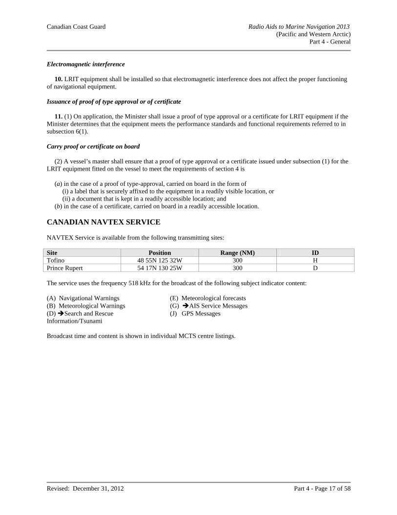
Canadian Coast Guard Radio Aids to Marine Navigation 2013 (Pacific and Western Arctic)
Part 4 - General
Revised: December 31, 2012 Part 4 - Page 17 of 58
Electromagnetic interference
10. LRIT equipment shall be installed so that electromagnetic interference does not affect the proper functioning
of navigational equipment. Issuance of proof of type approval or of certificate
11. (1) On application, the Minister shall issue a proof of type approval or a certificate for LRIT equipment if the
Minister determines that the equipment meets the performance standards and functional requirements referred to in subsection 6(1). Carry proof or certificate on board
(2) A vessel’s master shall ensure that a proof of type approval or a certificate issued under subsection (1) for the
LRIT equipment fitted on the vessel to meet the requirements of section 4 is (a) in the case of a proof of type-approval, carried on board in the form of
(i) a label that is securely affixed to the equipment in a readily visible location, or (ii) a document that is kept in a readily accessible location; and
(b) in the case of a certificate, carried on board in a readily accessible location. CANADIAN NAVTEX SERVICE NAVTEX Service is available from the following transmitting sites: Site Position Range (NM) ID Tofino 48 55N 125 32W 300 H Prince Rupert 54 17N 130 25W 300 D The service uses the frequency 518 kHz for the broadcast of the following subject indicator content: (A) Navigational Warnings (E) Meteorological forecasts (B) Meteorological Warnings (G) AIS Service Messages (D) Search and Rescue Information/Tsunami
(J) GPS Messages
Broadcast time and content is shown in individual MCTS centre listings.
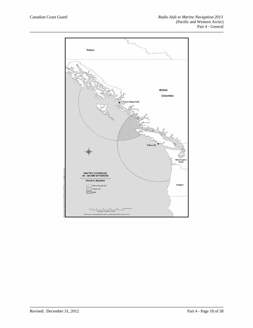
Canadian Coast Guard Radio Aids to Marine Navigation 2013 (Pacific and Western Arctic)
Part 4 - General
Revised: December 31, 2012 Part 4 - Page 18 of 58
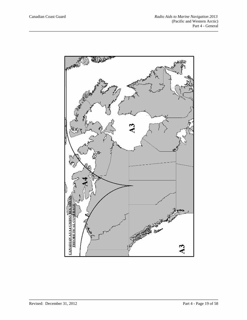
Canadian Coast Guard Radio Aids to Marine Navigation 2013 (Pacific and Western Arctic)
Part 4 - General
Revised: December 31, 2012 Part 4 - Page 19 of 58
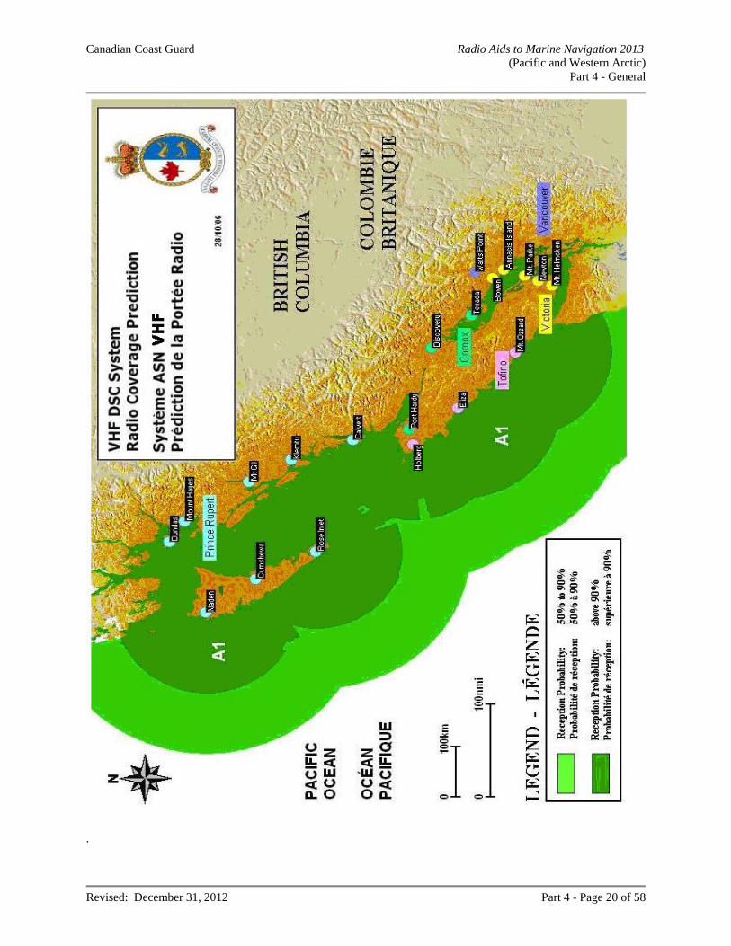
Canadian Coast Guard Radio Aids to Marine Navigation 2013 (Pacific and Western Arctic)
Part 4 - General
Revised: December 31, 2012 Part 4 - Page 20 of 58
.
Canadian Coast Guard Radio Aids to Marine Navigation 2013 (Pacific and Western Arctic)
Part 4 - General
Revised: December 31, 2012 Part 4 - Page 21 of 58
EMERGENCY POSITION INDICATING RADIO BEACONS (406 MHZ)
It is recommended that a float-free EPIRB be carried on board ships and pleasure crafts operating offshore. To be effective, 406 MHz EPIRBs must be registered with the Canadian Beacon Registry by telephone at 1-800-406-7671;facsimile 1-877-406-3298; or, on the Website at: http://www.canadianbeaconregistry.forces.gc.ca/ You may also reach the Canadian Beacon Registry by email at [email protected]. Note: INMARSAT discontinued their monitoring service of INMARSAT “E” EPIRB distress alerts as of December 1, 2006. Mariners should check with INMARSAT for exchange of any currently held INMARSAT ‘E’ EPIRBs. Further, mariners should only purchase and fit COSPAS-SARSAT 406 MHz EPIRBs. Float-free EPIRBs should not be fitted under ledges or structures that would impede their ability to float free.
Do not install the EPIRB with lanyard attached to the superstructure of your vessel. Both manually activated EPIRBs and float-free EPIRBs should be readily accessible so that in the event of an
emergency, it is available for immediate use. EPIRBs should be tested using the "TEST" button, by the operator every 6 months. This test should be recorded
in the radio log. EPIRB battery packs and hydrostatic release units should be replaced per the manufacturer’s recommendations. A list of 406 MHz EPIRBs approved for use in Canada is available on the Website at: http://www.tc.gc.ca/eng/marinesafety/oep-navigation-safety-apci-2298.htm. .
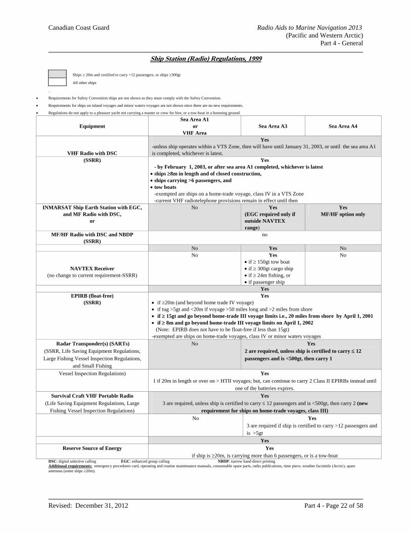
Canadian Coast Guard Radio Aids to Marine Navigation 2013 (Pacific and Western Arctic)
Part 4 - General
Revised: December 31, 2012 Part 4 - Page 22 of 58
Ship Station (Radio) Regulations, 1999
Ships 20m and certified to carry >12 passengers, or ships 300gt
All other ships
.
Requirements for Safety Convention ships are not shown as they must comply with the Safety Convention.
Requirements for ships on inland voyages and minor waters voyages are not shown since there are no new requirements.
Regulations do not apply to a pleasure yacht not carrying a master or crew for hire, or a tow-boat in a booming ground.
Equipment
Sea Area A1 or
VHF Area
Sea Area A3
Sea Area A4
VHF Radio with DSC
Yes -unless ship operates within a VTS Zone, then will have until January 31, 2003, or until the sea area A1 is completed, whichever is latest.
(SSRR)
Yes - by February 1, 2003, or after sea area A1 completed, whichever is latest
ships 8m in length and of closed construction, ships carrying >6 passengers, and tow boats
-exempted are ships on a home-trade voyage, class IV in a VTS Zone -current VHF radiotelephone provisions remain in effect until then
INMARSAT Ship Earth Station with EGC, and MF Radio with DSC,
or
No Yes (EGC required only if outside NAVTEX range)
Yes MF/HF option only
MF/HF Radio with DSC and NBDP (SSRR)
no
No Yes No
NAVTEX Receiver (no change to current requirement-SSRR)
No Yes if 150gt tow boat if 300gt cargo ship if 24m fishing, or if passenger ship
No
Yes EPIRB (float-free)
(SSRR) Yes
if 20m (and beyond home trade IV voyage) if tug >5gt and <20m if voyage >50 miles long and >2 miles from shore if 15gt and go beyond home-trade III voyage limits i.e., 20 miles from shore by April 1, 2001 if 8m and go beyond home-trade III voyage limits on April 1, 2002 (Note: EPIRB does not have to be float-free if less than 15gt) -exempted are ships on home-trade voyages, class IV or minor waters voyages
Radar Transponder(s) (SARTs) (SSRR, Life Saving Equipment Regulations, Large Fishing Vessel Inspection Regulations,
and Small Fishing
No Yes 2 are required, unless ship is certified to carry 12 passengers and is <500gt, then carry 1
Vessel Inspection Regulations) Yes 1 if 20m in length or over on > HTII voyages; but, can continue to carry 2 Class II EPIRBs instead until
one of the batteries expires.
Survival Craft VHF Portable Radio (Life Saving Equipment Regulations, Large
Fishing Vessel Inspection Regulations)
Yes 3 are required, unless ship is certified to carry 12 passengers and is <500gt, then carry 2 (new
requirement for ships on home-trade voyages, class III)
No Yes 3 are required if ship is certified to carry >12 passengers and is >5gt
Yes
Reserve Source of Energy Yes if ship is 20m, is carrying more than 6 passengers, or is a tow-boat
DSC: digital selective calling EGC: enhanced group calling NBDP: narrow band direct printing Additional requirements: emergency procedures card, operating and routine maintenance manuals, consumable spare parts, radio publications, time piece, weather facsimile (Arctic), spare antennas (some ships 20m).
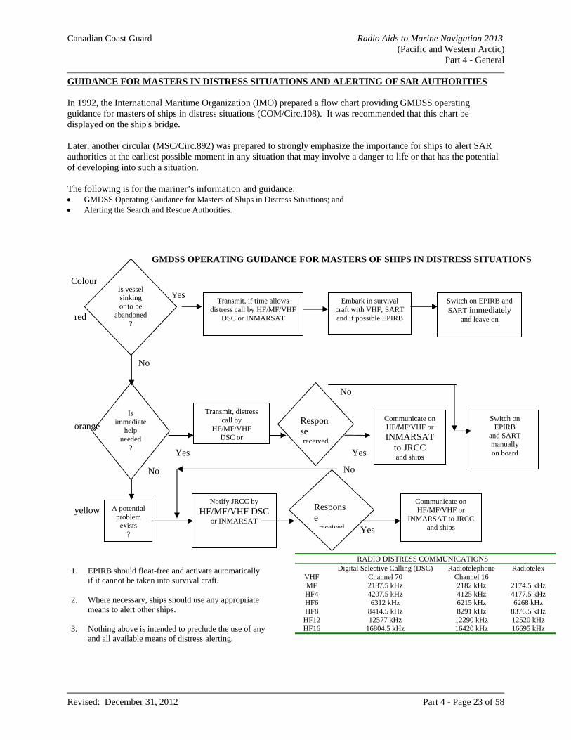
Canadian Coast Guard Radio Aids to Marine Navigation 2013 (Pacific and Western Arctic)
Part 4 - General
Revised: December 31, 2012 Part 4 - Page 23 of 58
GUIDANCE FOR MASTERS IN DISTRESS SITUATIONS AND ALERTING OF SAR AUTHORITIES In 1992, the International Maritime Organization (IMO) prepared a flow chart providing GMDSS operating guidance for masters of ships in distress situations (COM/Circ.108). It was recommended that this chart be displayed on the ship's bridge. Later, another circular (MSC/Circ.892) was prepared to strongly emphasize the importance for ships to alert SAR authorities at the earliest possible moment in any situation that may involve a danger to life or that has the potential of developing into such a situation. The following is for the mariner’s information and guidance: GMDSS Operating Guidance for Masters of Ships in Distress Situations; and Alerting the Search and Rescue Authorities.
red
Yes
Is immediate
help needed
?
orange
No
No
A potential problem
exists ?
yellow Notify JRCC by
HF/MF/VHF DSC or INMARSAT
Yes
Communicate on HF/MF/VHF or
INMARSAT to JRCC and ships
GMDSS OPERATING GUIDANCE FOR MASTERS OF SHIPS IN DISTRESS SITUATIONS
1. EPIRB should float-free and activate automatically if it cannot be taken into survival craft.
2. Where necessary, ships should use any appropriate
means to alert other ships. 3. Nothing above is intended to preclude the use of any
and all available means of distress alerting.
RADIO DISTRESS COMMUNICATIONS Digital Selective Calling (DSC) Radiotelephone Radiotelex
VHF Channel 70 Channel 16 MF 2187.5 kHz 2182 kHz 2174.5 kHz HF4 4207.5 kHz 4125 kHz 4177.5 kHz HF6 6312 kHz 6215 kHz 6268 kHz HF8 8414.5 kHz 8291 kHz 8376.5 kHz HF12 12577 kHz 12290 kHz 12520 kHz HF16 16804.5 kHz 16420 kHz 16695 kHz
Response
received
No
Colour
Switch on EPIRB and SART immediately
and leave on
Embark in survival craft with VHF, SART and if possible EPIRB
Transmit, if time allows distress call by HF/MF/VHF
DSC or INMARSAT
Is vessel sinking or to be
abandoned ?
Transmit, distress call by
HF/MF/VHF DSC or
Response received
Communicate on HF/MF/VHF or
INMARSAT to JRCC and ships Yes Yes
Switch on EPIRB
and SART manually on board
No
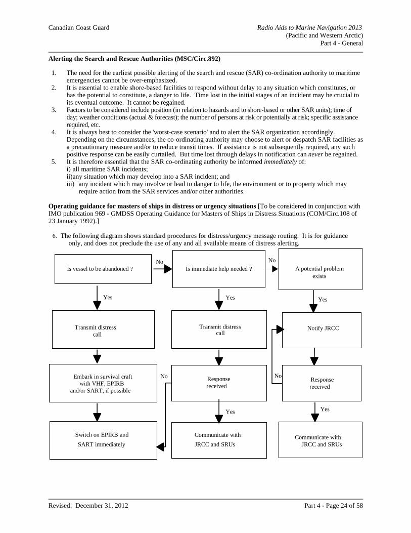
Canadian Coast Guard Radio Aids to Marine Navigation 2013 (Pacific and Western Arctic)
Part 4 - General
Revised: December 31, 2012 Part 4 - Page 24 of 58
Alerting the Search and Rescue Authorities (MSC/Circ.892) 1. The need for the earliest possible alerting of the search and rescue (SAR) co-ordination authority to maritime
emergencies cannot be over-emphasized. 2. It is essential to enable shore-based facilities to respond without delay to any situation which constitutes, or
has the potential to constitute, a danger to life. Time lost in the initial stages of an incident may be crucial to its eventual outcome. It cannot be regained.
3. Factors to be considered include position (in relation to hazards and to shore-based or other SAR units); time of day; weather conditions (actual & forecast); the number of persons at risk or potentially at risk; specific assistance required, etc.
4. It is always best to consider the 'worst-case scenario' and to alert the SAR organization accordingly. Depending on the circumstances, the co-ordinating authority may choose to alert or despatch SAR facilities as a precautionary measure and/or to reduce transit times. If assistance is not subsequently required, any such positive response can be easily curtailed. But time lost through delays in notification can never be regained.
5. It is therefore essential that the SAR co-ordinating authority be informed immediately of: i) all maritime SAR incidents; ii) any situation which may develop into a SAR incident; and iii) any incident which may involve or lead to danger to life, the environment or to property which may
require action from the SAR services and/or other authorities. Operating guidance for masters of ships in distress or urgency situations [To be considered in conjunction with IMO publication 969 - GMDSS Operating Guidance for Masters of Ships in Distress Situations (COM/Circ.108 of 23 January 1992).]
6. The following diagram shows standard procedures for distress/urgency message routing. It is for guidance only, and does not preclude the use of any and all available means of distress alerting.
Switch on EPIRB and
SART immediately
No
Yes Yes
Yes
No
Yes
Yes
No No
Transmit distresscall
Transmit distresscall
Embark in survival craftwith VHF, EPIRB
and/or SART, if possible
Responsereceived
Is immediate help needed ?Is vessel to be abandoned ? A potential problemexists
Notify JRCC
Responsereceived
Communicate with
JRCC and SRUsCommunicate with
JRCC and SRUs
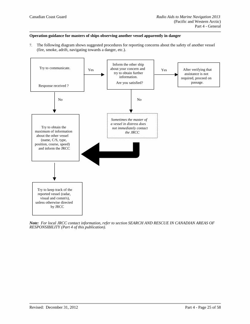
Canadian Coast Guard Radio Aids to Marine Navigation 2013 (Pacific and Western Arctic)
Part 4 - General
Revised: December 31, 2012 Part 4 - Page 25 of 58
Operation guidance for masters of ships observing another vessel apparently in danger 7. The following diagram shows suggested procedures for reporting concerns about the safety of another vessel
(fire, smoke, adrift, navigating towards a danger, etc.).
Try to keep track of thereported vessel (radar,
visual and comm's),unless otherwise directed
by JRCC
Yes
No No
Yes After verifying thatassistance is not
required, proceed onpassage.
Sometimes the master ofa vessel in distress doesnot immediately contact
the JRCC
Try to obtain themaximum of informationabout the other vessel
(name, C/S, type,position, course, speed)
and inform the JRCC
Try to communicate.
Response received ?
Inform the other shipabout your concern and
try to obtain furtherinformation.
Are you satisfied?
Note: For local JRCC contact information, refer to section SEARCH AND RESCUE IN CANADIAN AREAS OF RESPONSIBILITY (Part 4 of this publication).
Canadian Coast Guard Radio Aids to Marine Navigation 2013 (Pacific and Western Arctic)
Part 4 - General
Revised: December 31, 2012 Part 4 - Page 26 of 58
False Distress Alerts and Distress Relay Alerts The GMDSS has been in force for ships on international voyages since February 1, 1999, following its seven-year phase-in. During this time, considerable experience was gained internationally in the operation of the GMDSS. While the GMDSS has proven its overall effectiveness, the high number of accidental distress alert activations and the inappropriate and unintended Digital Selective Calling (DSC) distress relay alerts have detracted from the efficiency of the system. Excessive false alerts and distress relay alerts can create an unnecessary burden and workload for SAR services. They may also cause confusion and undermine mariner’s confidence in the GMDSS. They could potentially have a serious impact on real distress situations. With the aim of minimizing the number of false alerts and distress alert relays, the following information is provided: “Instructions for Mariners and Others on How to Cancel a False Alert” (appendix to IMO Resolution A.814(19)
entitled Guidelines for the Avoidance of False Distress Alerts); “Procedure for Responding to DSC Distress Alerts by Ships” (COMSAR/Cir.25).
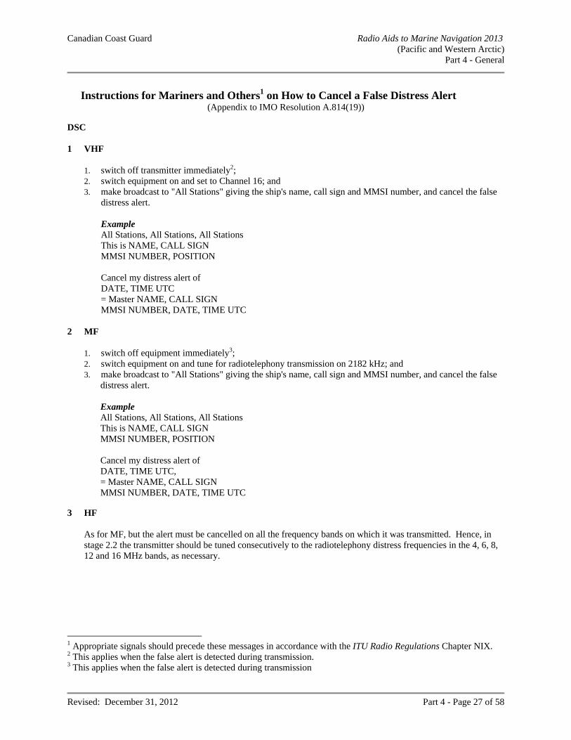
Canadian Coast Guard Radio Aids to Marine Navigation 2013 (Pacific and Western Arctic)
Part 4 - General
Revised: December 31, 2012 Part 4 - Page 27 of 58
Instructions for Mariners and Others1 on How to Cancel a False Distress Alert
(Appendix to IMO Resolution A.814(19)) DSC
1 VHF
1. switch off transmitter immediately2; 2. switch equipment on and set to Channel 16; and 3. make broadcast to "All Stations" giving the ship's name, call sign and MMSI number, and cancel the false
distress alert.
Example All Stations, All Stations, All Stations This is NAME, CALL SIGN MMSI NUMBER, POSITION Cancel my distress alert of DATE, TIME UTC = Master NAME, CALL SIGN MMSI NUMBER, DATE, TIME UTC
2 MF
1. switch off equipment immediately3; 2. switch equipment on and tune for radiotelephony transmission on 2182 kHz; and 3. make broadcast to "All Stations" giving the ship's name, call sign and MMSI number, and cancel the false
distress alert. Example All Stations, All Stations, All Stations This is NAME, CALL SIGN MMSI NUMBER, POSITION Cancel my distress alert of DATE, TIME UTC, = Master NAME, CALL SIGN MMSI NUMBER, DATE, TIME UTC
3 HF
As for MF, but the alert must be cancelled on all the frequency bands on which it was transmitted. Hence, in stage 2.2 the transmitter should be tuned consecutively to the radiotelephony distress frequencies in the 4, 6, 8, 12 and 16 MHz bands, as necessary.
1 Appropriate signals should precede these messages in accordance with the ITU Radio Regulations Chapter NIX. 2 This applies when the false alert is detected during transmission. 3 This applies when the false alert is detected during transmission
Canadian Coast Guard Radio Aids to Marine Navigation 2013 (Pacific and Western Arctic)
Part 4 - General
Revised: December 31, 2012 Part 4 - Page 28 of 58
4 INMARSAT-C
Notify the appropriate JRCC to cancel the alert by sending a distress priority message via the same CES through which the false distress alert was sent.
NAME, CALL SIGN, IDENTITY NUMBER POSITION Cancel my Inmarsat-C distress alert of DATE, TIME UTC = Master +
5 EPIRBs If for any reason an EPIRB is activated accidentally, the ship should contact the nearest coast station or an appropriate coast earth station or JRCC and cancel the distress alert.
6 General 6.1 Notwithstanding the above, ships may use any means available to them to inform the appropriate
authorities that a false distress alert has been transmitted and should be cancelled. 6.2 No action will normally be taken against any ship or mariner for reporting and cancelling a false distress
alert. However, in view of the serious consequences of false alerts, and the strict ban on their transmission, Governments may prosecute in cases of repeated violations.
Canadian Coast Guard Radio Aids to Marine Navigation 2013 (Pacific and Western Arctic)
Part 4 - General
Revised: December 31, 2012 Part 4 - Page 29 of 58
Procedure for Responding to DSC Distress Alerts by Ships
(COMSAR/Circ.25) 1 Introduction
The Sub-Committee on Radiocommunications and Search and Rescue (COMSAR) decided that Digital Selective Calling (DSC) relays of distress alerts on all shipborne DSC equipment should be reduced and prepared a procedure for responding to VHF/MF and HF distress alerts, given in flow diagrams 1 and 2 which follow recommending that it be displayed on the ship's bridge as A4 size posters. It also prepared the following guidance.
2 Distress Relays
2.1 Radio personnel serving on ships should be made aware of the consequences of transmitting a distress relay call and of routing a DSC distress relay alert to other than coast stations (CS).
2.2 The number of unintended activations of DSC distress alerts and DSC distress relay alerts creates extra
work load and confusion to (M) JRCCs and also causing delay in the response-time. The original distress alert from a ship in distress should not be disrupted by other ships, by transmitting a DSC distress relay alert.
2.3 Recommendation ITU-R M.541-8 on Operational procedures for the use of DSC equipment in the Maritime Mobile Service identifies only two situations in which a ship would transmit a distress relay call (distress relay alert):
1. on receiving a distress alert on a HF channel, which is not acknowledged by a coast station within 5
minutes. The distress relay call should be addressed to the appropriate coast station (Annex 1, paragraph 3.4.2 and Annex 3, paragraph 6.1.4); and
2. on knowing that another ship in distress is not itself able to transmit the distress alert and the Master of
the ship considers that further help is necessary. The distress relay call should be addressed to "all ships" or to the appropriate coast station (Annex 3, paragraph 1.4).
2.4 In no case is a ship permitted to transmit a DSC distress relay call on receipt of a DSC distress alert on
either VHF or MF channels. 2.5 Distress relay calls on HF channels should be initiated manually. 2.6 Compliance with operational and technical provisions above would prevent transmissions of inappropriate
distress relay calls.
3 All coast stations call
3.1 Recommendation ITU-R M.493-9 on DSC systems for use in the Maritime Mobile Service provides for "group calls" an address consisting of the characters corresponding to the station's Maritime Mobile Service identity (MMSI) and a number of administrations have already assigned a "group call" MMSI to their coast stations in addition to the coast station's individual MMSI.
Canadian Coast Guard Radio Aids to Marine Navigation 2013 (Pacific and Western Arctic)
Part 4 - General
Revised: December 31, 2012 Part 4 - Page 30 of 58
3.2 By multilateral agreements, a "group call" MMSI could be assigned to all coast stations of a specific
region, e.g., an JRCC area and could comply with IMO's requirement without need of introducing further modifications to GMDSS equipment.
3.3 An alternative method to implement an "all coast stations" call without the need to modify
Recommendation ITU-R M.493-9 could be to define one MMSI world-wide as an address for all coast stations, in accordance with Nos. S19.100 to S19.126 of the ITU Radio Regulations. However, this solution would also require a modification of the setup at each coast station participating in the GMDSS.
4 Authorization
It should be noted that on ships, distress alerts, distress acknowledgements and distress relay calls can only be transmitted with permission of the Master of the ship.
5 Flow diagrams 5.1 The simplified flow diagrams 1 and 2 describe actions to be taken aboard ships upon receipt of distress
alerts from other ships. Administrations should give wide distribution of these flow diagrams to ships and training institutions.
5.2 Member Governments are invited to bring the above guidance and the attached flow diagrams to the
attention of their shipowners, seafarers, coast stations, JRCCs and all others concerned.
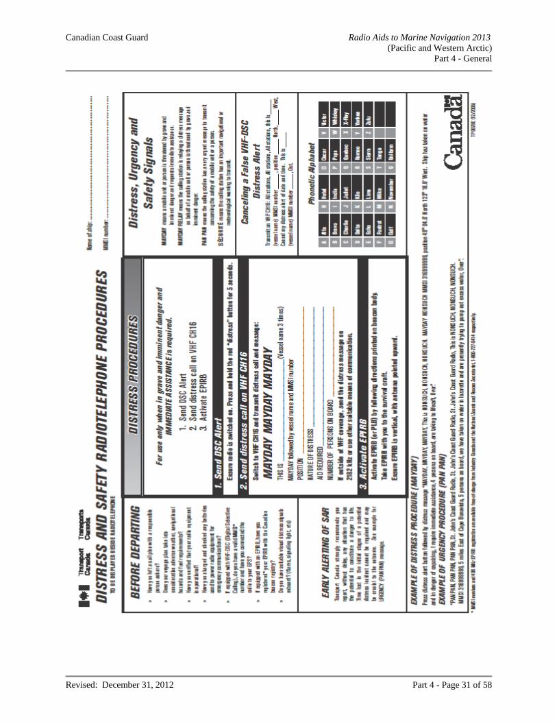
Canadian Coast Guard Radio Aids to Marine Navigation 2013 (Pacific and Western Arctic)
Part 4 - General
Revised: December 31, 2012 Part 4 - Page 31 of 58
Canadian Coast Guard Radio Aids to Marine Navigation 2013 (Pacific and Western Arctic)
Part 4 - General
Revised: December 31, 2012 Part 4 - Page 32 of 58
AMVER – AUTOMATED MUTUAL-ASSISTANCE VESSEL RESCUE SYSTEM Note: A 96-hour pre-arrival report to U.S. ports is required under 33 CFR 160 The Amver System, operated by the United States Coast Guard, is a maritime mutual assistance program that provides important aid to the development and coordination of search and rescue (SAR) efforts in the oceans of the world. Merchant vessels of all nations making offshore passages of more than 24 hours are encouraged to send sail plans and periodic position reports to the Amver Center in Martinsburg, WV. There is no charge for these radio messages when they are sent through MCTS centres. Information from these messages is entered into a computer that generates and maintains dead reckoning positions for participating vessels throughout their voyages. The predicted locations and SAR characteristics of all vessels known to be within a given area are furnished upon request to recognized SAR agencies of any nation for use during an emergency. Predicted vessels’ locations are disclosed only for reasons related to maritime safety. Amver is a free and voluntary program. An Amver participant is under no greater obligation to render assistance during an emergency than a vessel that is not participating. Benefits to shipping include: improved likelihood of rapid aid in emergencies; reduced number of calls for assistance to vessels not favourably located; reduced time lost for vessels responding to calls for assistance. An Amver participant is under no greater
obligation to render assistance during an emergency than a vessel that is not participating. Details of Amver System operations may be obtained from Amver Maritime Relations Office, U.S Coast Guard, Battery Park Building, 1 South Street, New York, NY 10004-1499 (Telephone: 212-668-7764, Fax 212-668-7684). Amver instructions are also available at Coast Guard Captain of the Port and Marine Safety Offices in major United States coastal ports. The instructions are published in the following languages: Chinese, Danish, Dutch, English, French, German, Greek, Italian, Japanese, Norwegian, Polish, Portuguese, Spanish, and Swedish. Requests for instructions should state the language desired if other than English. Amver Website: http://www.amver.com/ Ship Station (Radio) Technical Regulations, 1999 now specify compulsory participation in Amver for certain ships when departing on an offshore voyage of more than 24 hours duration. The provisions apply to all Canadian ships and to all non-Canadian ships engaged in the coasting trade of Canada. Of this group, the following are exempted: fishing vessels engaged in fishing; ships operated by the Canadian government on law enforcement duties; vessels whose voyages will be within the waters of an Arctic Shipping Safety Control Zone, Hudson Bay,
James Bay or Ungava Bay; and vessels in other waters provided their voyages are within VHF or MF coverage areas. It should be noted that the above exemptions do not amount to a prohibition; and that all other ships proceeding on an offshore voyage of more than 24 hours duration are encouraged to participate in Amver.
Canadian Coast Guard Radio Aids to Marine Navigation 2013 (Pacific and Western Arctic)
Part 4 - General
Revised: December 31, 2012 Part 4 - Page 33 of 58
I. To Participate Any merchant vessel of one thousand gross tons or more on a voyage of greater than twenty-four hours to anywhere on the globe is to be part of the Amver system. International participation is voluntary regardless of vessel’s or company’s flag, country of origin, or destination. II. The Information Reported Information voluntarily provided by vessels to Amver is kept strictly confidential and is protected by the Coast Guard. It will be released only for safety purposes. III. What and When You Report A. Sail plan message should be sent on or before departure. B. Position Reports should be sent within twenty-four hours of departure and subsequently no less
frequently than every forty-eight hours until arrival. C. Arrival Reports should be sent immediately prior to or upon arrival at the Port of Destination. D. Reports are to be sent during the Radio Officer’s normal duty hours. E. At the discretion of the vessel, reports may be sent more frequently than the above schedule, as, for
example, in heavy weather or under other adverse conditions. IV. Report Format As previous Amver participants will note, the format described below represents a change which serves two purposes: First, the new format will permit the automated data processing system to enter your information into Amver more accurately and efficiently. Second, the new format conforms with the International Maritime Organization (IMO) proposed standard, thus reducing the number of different formats in use. As other systems also adopt the IMO format, we will have moved closer to a single format worldwide. V. Amver System Communications Network The following methods are recommended for ships to transmit Amver Sail Plan, Position, Deviation and Arrival reports. Details are available on the Amver Website at http://www.amver.com Electronic Mail via the Internet: Amver address is: [email protected] AMVER/SEAS “Compressed Message” via Inmarsat-C viaTELENOR: Amver address: NOAA telephone number entered in the ADDRESSBOOK. For information, please see the instruction sheet for your brand of Inmarsat-C transceiver. AMVER/SEAS software can be downloaded from the Internet at:
http://seas.amverseas.noaa.gov/seas/
or requested from: TELENOR Satellite Services
1101 Wootton Parkway Rockville, Maryland 20852
1-301-838-7800 Email: [email protected]
Canadian Coast Guard Radio Aids to Marine Navigation 2013 (Pacific and Western Arctic)
Part 4 - General
Revised: December 31, 2012 Part 4 - Page 34 of 58
HF Radiotelex Service of U.S. Coast Guard Communications Stations: Full information on how to send Amver messages this way can be found at: http://www.navcen.uscg.gov/
HF Radio at no cost via Coast Guard Contractual Agreements with the following companies:
o Mobile Marine Radio (WLO) o Mobile (WCL) o Marina Del Ray (KNN) o Seattle (KLB)
Telex: Amver Address: (0) 230 127594 AMVERNYK Telefax: To the USCG Operations Systems Center in Martinsburg: 1-304-264-2505 If messages are relayed through Canadian Coast Guard Ships no ship charge will be assessed. All Amver messages forwarded via the stations listed, should be addressed to Amver Vancouver, rather than COAST GUARD New York, to ensure that no charge is applied in delivery. VI. Amver Voyage Report Types There are four types of Amver Reports – Sail, Arrival, Position, and Deviation Reports.
A. Reporting format. Each line of Amver Report text starts with a line identifier. Line identifiers are “Amver” or a single letter. The line identifier and the data items on the line are each separated from each other by a single slash (“/”). Lines are terminated by two slashes (“//”).
B. Reporting data. Amver participants need to be familiar with four types of reports - Sail, Arrival, Position, and Deviation Reports. Note that Amver permits sail plan and departure to be combined into a single report. Amver accepts sail plan information separately - for example, several days prior to departure. Report identifiers are as follows:
AMVER/SP// Sail Plan & Departure AMVER/PR// Position Report AMVER/FR// Final Arrival Report AMVER/DR// Deviation Report
C. Details. Paragraph IX includes a discussion of each report type. Each example is followed by an explanation. Note that not all the lines in the example are necessary for each type of report. The required and optional lines are discussed in each section.
VII. Other Required Information Amver also needs other information which might be useful in an emergency. This includes data such as the ship length, communications equipment, radio watch schedule, speed, rig, and so forth. This information is collected separately once, by completion of the Search and Rescue Questionnaire (SAR-Q) found on the Amver Website at http://www.amver.com/ which is then retained in the automatic data processing system, periodically validated, and used only for search-and-rescue purposes.
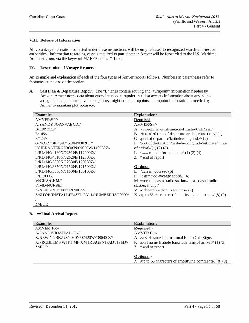
Canadian Coast Guard Radio Aids to Marine Navigation 2013 (Pacific and Western Arctic)
Part 4 - General
Revised: December 31, 2012 Part 4 - Page 35 of 58
VIII. Release of Information All voluntary information collected under these instructions will be only released to recognized search-and-rescue authorities. Information regarding vessels required to participate in Amver will be forwarded to the U.S. Maritime Administration, via the keyword MAREP on the Y-Line. IX. Description of Voyage Reports An example and explanation of each of the four types of Amver reports follows. Numbers in parentheses refer to footnotes at the end of the section. A. Sail Plan & Departure Report. The “L” lines contain routing and “turnpoint” information needed by
Amver. Amver needs data about every intended turnpoint, but also accepts information about any points along the intended track, even though they might not be turnpoints. Turnpoint information is needed by Amver to maintain plot accuracy.
Example: Explanation: AMVER/SP// A/SANDY JOAN//ABCD// B/110935Z// E/145// F/126// G/NORVOROSK/4510N/03820E// I/GIBRALTERGI/3600N/00600W/140730Z// L/RL/140/4130N/02910E/112000Z// L/RL/140/4010N/02620E/112300Z// L/RL/140/3630N/02330E/120330Z// L/RL/140/3650N/01520E/121500Z// L/RL/140/3800N/01000E/130100Z// L/LR/060// M/GKA/GKM// V/MD/NURSE// X/NEXT/REPORT/120900Z// Z/SITOR/INSTALLED/SELCALL/NUMBER/IS/99999// Z//EOR
Required - AMVER/SP// A /vessel/name/International Radio/Call Sign// B /intended time of departure or departure time// (1) G /port of departure/latitude//longitude// (2) I /port of destination/latitude//longitude/estimated time of arrival//(1) (2) (3) L / ...... route information ...// (1) (3) (4) Z // end of report Optional - E /current course// (5) F /estimated average speed// (6) M /current coastal radio station//next coastal radio station, if any// V /onboard medical resources// (7) X /up to 65 characters of amplifying comments// (8) (9)
B. Final Arrival Report.
Example: Explanation: AMVER FR// A/SANDY/JOAN/ABCD// K/NEW YORK/US/4040N/07420W/180600Z// X/PROBLEMS WITH MF XMTR AGENT/ADVISED// Z//EOR
Required - AMVER FR// A /vessel name International Radio Call Sign// K /port name latitude longitude time of arrival// (1) (3) Z // end of report Optional - X /up to 65 characters of amplifying comments// (8) (9)
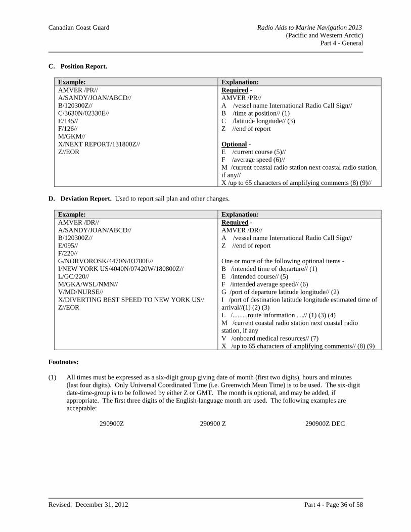
Canadian Coast Guard Radio Aids to Marine Navigation 2013 (Pacific and Western Arctic)
Part 4 - General
Revised: December 31, 2012 Part 4 - Page 36 of 58
C. Position Report.
Example: Explanation: AMVER /PR// A/SANDY/JOAN/ABCD// B/120300Z// C/3630N/02330E// E/145// F/126// M/GKM// X/NEXT REPORT/131800Z// Z//EOR
Required - AMVER /PR// A /vessel name International Radio Call Sign// B /time at position// (1) C /latitude longitude// (3) Z //end of report Optional - E /current course (5)// F /average speed (6)// M /current coastal radio station next coastal radio station, if any// X /up to 65 characters of amplifying comments (8) (9)//
D. Deviation Report. Used to report sail plan and other changes.
Example: Explanation: AMVER /DR// A/SANDY/JOAN/ABCD// B/120300Z// E/095// F/220// G/NORVOROSK/4470N/03780E// I/NEW YORK US/4040N/07420W/180800Z// L/GC/220// M/GKA/WSL/NMN// V/MD/NURSE// X/DIVERTING BEST SPEED TO NEW YORK US// Z//EOR
Required - AMVER /DR// A /vessel name International Radio Call Sign// Z //end of report One or more of the following optional items - B /intended time of departure// (1) E /intended course// (5) F /intended average speed// (6) G /port of departure latitude longitude// (2) I /port of destination latitude longitude estimated time of arrival//(1) (2) (3) L /........ route information ....// (1) (3) (4) M /current coastal radio station next coastal radio station, if any V /onboard medical resources// (7) X /up to 65 characters of amplifying comments// (8) (9)
Footnotes: (1) All times must be expressed as a six-digit group giving date of month (first two digits), hours and minutes
(last four digits). Only Universal Coordinated Time (i.e. Greenwich Mean Time) is to be used. The six-digit date-time-group is to be followed by either Z or GMT. The month is optional, and may be added, if appropriate. The first three digits of the English-language month are used. The following examples are acceptable:
290900Z 290900 Z 290900Z DEC
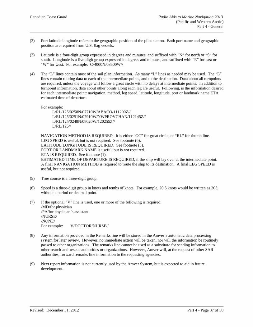
Canadian Coast Guard Radio Aids to Marine Navigation 2013 (Pacific and Western Arctic)
Part 4 - General
Revised: December 31, 2012 Part 4 - Page 37 of 58
(2) Port latitude longitude refers to the geographic position of the pilot station. Both port name and geographic
position are required from U.S. flag vessels. (3) Latitude is a four-digit group expressed in degrees and minutes, and suffixed with “N” for north or “S” for
south. Longitude is a five-digit group expressed in degrees and minutes, and suffixed with “E” for east or “W” for west. For example: C/4000N/03500W//
(4) The “L” lines contain most of the sail plan information. As many “L” lines as needed may be used. The “L”
lines contain routing data to each of the intermediate points, and to the destination. Data about all turnpoints are required, unless the voyage will follow a great circle with no delays at intermediate points. In addition to turnpoint information, data about other points along each leg are useful. Following, is the information desired for each intermediate point: navigation, method, leg speed, latitude, longitude, port or landmark name ETA estimated time of departure.
For example: L/RL/125/0258N/07710W/ABACO/111200Z// L/RL/125/0251N/07910W/NWPROVCHAN/112145Z// L/RL/125/0248N/08020W/120255Z// L/RL/125//
NAVIGATION METHOD IS REQUIRED. It is either “GC” for great circle, or “RL” for rhumb line. LEG SPEED is useful, but is not required. See footnote (6). LATITUDE LONGITUDE IS REQUIRED. See footnote (3). PORT OR LANDMARK NAME is useful, but is not required. ETA IS REQUIRED. See footnote (1). ESTIMATED TIME OF DEPARTURE IS REQUIRED, if the ship will lay over at the intermediate point. A final NAVIGATION METHOD is required to route the ship to its destination. A final LEG SPEED is useful, but not required.
(5) True course is a three-digit group. (6) Speed is a three-digit group in knots and tenths of knots. For example, 20.5 knots would be written as 205,
without a period or decimal point. (7) If the optional “V” line is used, one or more of the following is required: /MD/for physician /PA/for physician’s assistant /NURSE/ /NONE/ For example: V/DOCTOR/NURSE// (8) Any information provided in the Remarks line will be stored in the Amver’s automatic data processing
system for later review. However, no immediate action will be taken, nor will the information be routinely passed to other organizations. The remarks line cannot be used as a substitute for sending information to other search-and-rescue authorities or organizations. However, Amver will, at the request of other SAR authorities, forward remarks line information to the requesting agencies.
(9) Next report information is not currently used by the Amver System, but is expected to aid in future
development.
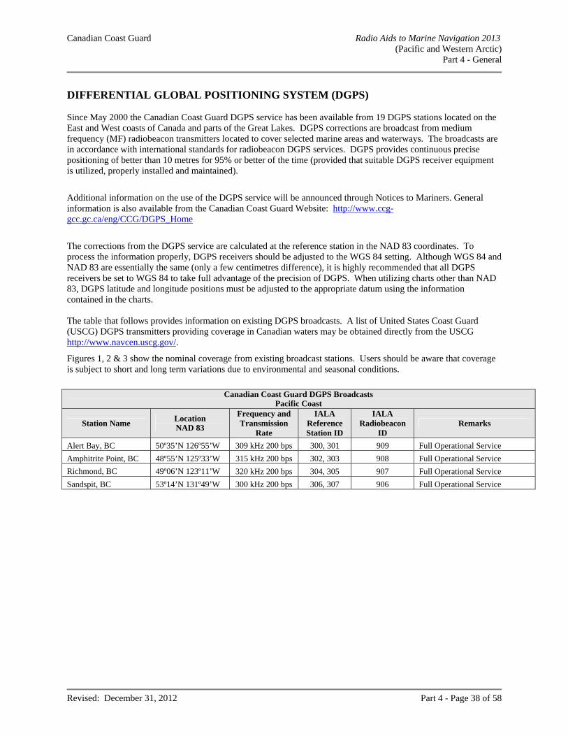
Canadian Coast Guard Radio Aids to Marine Navigation 2013 (Pacific and Western Arctic)
Part 4 - General
Revised: December 31, 2012 Part 4 - Page 38 of 58
DIFFERENTIAL GLOBAL POSITIONING SYSTEM (DGPS) Since May 2000 the Canadian Coast Guard DGPS service has been available from 19 DGPS stations located on the East and West coasts of Canada and parts of the Great Lakes. DGPS corrections are broadcast from medium frequency (MF) radiobeacon transmitters located to cover selected marine areas and waterways. The broadcasts are in accordance with international standards for radiobeacon DGPS services. DGPS provides continuous precise positioning of better than 10 metres for 95% or better of the time (provided that suitable DGPS receiver equipment is utilized, properly installed and maintained).
Additional information on the use of the DGPS service will be announced through Notices to Mariners. General information is also available from the Canadian Coast Guard Website: http://www.ccg-gcc.gc.ca/eng/CCG/DGPS_Home
The corrections from the DGPS service are calculated at the reference station in the NAD 83 coordinates. To process the information properly, DGPS receivers should be adjusted to the WGS 84 setting. Although WGS 84 and NAD 83 are essentially the same (only a few centimetres difference), it is highly recommended that all DGPS receivers be set to WGS 84 to take full advantage of the precision of DGPS. When utilizing charts other than NAD 83, DGPS latitude and longitude positions must be adjusted to the appropriate datum using the information contained in the charts. The table that follows provides information on existing DGPS broadcasts. A list of United States Coast Guard (USCG) DGPS transmitters providing coverage in Canadian waters may be obtained directly from the USCG http://www.navcen.uscg.gov/.
Figures 1, 2 & 3 show the nominal coverage from existing broadcast stations. Users should be aware that coverage is subject to short and long term variations due to environmental and seasonal conditions.
Canadian Coast Guard DGPS Broadcasts
Pacific Coast
Station Name Location NAD 83
Frequency and Transmission
Rate
IALA Reference Station ID
IALA Radiobeacon
ID Remarks
Alert Bay, BC 50º35’N 126º55’W 309 kHz 200 bps 300, 301 909 Full Operational Service
Amphitrite Point, BC 48º55’N 125º33’W 315 kHz 200 bps 302, 303 908 Full Operational Service
Richmond, BC 49º06’N 123º11’W 320 kHz 200 bps 304, 305 907 Full Operational Service
Sandspit, BC 53º14’N 131º49’W 300 kHz 200 bps 306, 307 906 Full Operational Service
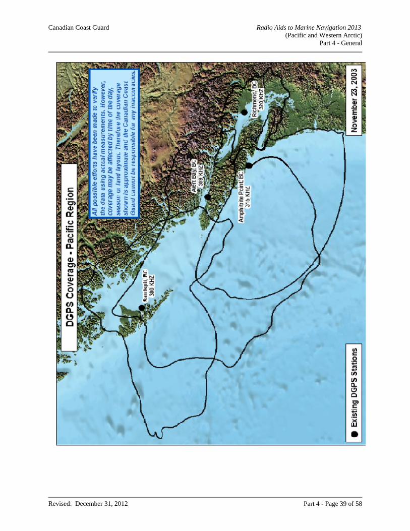
Canadian Coast Guard Radio Aids to Marine Navigation 2013 (Pacific and Western Arctic)
Part 4 - General
Revised: December 31, 2012 Part 4 - Page 39 of 58
Canadian Coast Guard Radio Aids to Marine Navigation 2013 (Pacific and Western Arctic)
Part 4 - General
Revised: December 31, 2012 Part 4 - Page 40 of 58
PRE-ARRIVAL INFORMATION REPORT (PAIR) Note: pursuant to the Marine Transportation Security Regulations, the following pre-arrival information requirement does not apply to vessels operating solely on the Great Lakes or to the portions of a vessel’s voyage on the Great Lakes after pre-arrival information has been given prior to its entrance into the St. Lawrence Seaway, neither, to fishing vessels, pleasure craft and government vessels. The master of the following vessels, engaged on a voyage from a port in one country to a port in another country:
SOLAS vessel of 500 tons gross tonnage or more or is carrying more than 12 passengers; NON-SOLAS vessel that is more than 100 tons gross tonnage, other than a towing vessel; NON-SOLAS vessel that carries more than 12 passengers; or NON-SOLAS vessel that is a towing vessel engaged in towing a barge astern or alongside or pushing
ahead, if the barge is carrying certain dangerous cargoes. shall ensure their vessel does not enter Canadian waters unless the master submits their pre-arrival information to a Canadian Marine Communications and Traffic Services (MCTS) centre before entering Canadian waters. All pre-arrival information must be provided at least 96 hours prior to entering Canadian waters unless the total duration of the voyage before entering Canadian waters is less than 96 hours in which case the notification must be provided at least 24 hours prior to entering Canadian waters. If the duration of the segment of the voyage before entering Canadian waters is less than 24 hours, vessels are required to send a pre-arrival report as soon as practicable before entering Canadian waters but no later than the time of departure from their last port of call. The Pre-Arrival Information must be sent to one of the addresses below:
a) Vessels planning to enter Canadian waters inbound to a Canadian port on the West Coast shall send pre-arrival information to the Canadian Coast Guard Regional Marine Information Centre (RMIC) via one of the following methods listed below:
Email: [email protected]
INMARSAT: telex 04352586 "CGTC VAS VCR" any Canadian Coast Guard MCTS centre, free of charge; or directly to CVTS Offshore by Fax: (604) 666-8453
b) Vessels planning to enter Canadian waters inbound to a Canadian port on the East Coast including a
Canadian or American port in the Great Lakes shall send pre-arrival information to ECAREG Canada via one of the following methods listed below:
St. John's MCTS Centre Facsimile - 709-772-5369 Telegraphic Identifier - CCGTC SNF Email: [email protected]
Halifax MCTS Centre Facsimile - 902-426-4483 Telegraphic Identifier - CCG MRHQ DRT Email: [email protected]
Canadian Coast Guard Radio Aids to Marine Navigation 2013 (Pacific and Western Arctic)
Part 4 - General
Revised: December 31, 2012 Part 4 - Page 41 of 58
c) Vessels planning to enter Canadian waters inbound to a Canadian port within the Canadian Arctic Zone
shall send pre-arrival information to NORDREG Canada via one of the following methods listed below:
Iqaluit MCTS Centre Facsimile: 867-979-5724 Telex (Telefax): 063-15529 Telegraphic Identifier: NORDREG CDA Email: [email protected]
Operational from approximately mid-May to late December
Prescott MCTS Centre Facsimile: 1-613-925-4471 Email: [email protected] Operational from approximately late December to mid-May
It is the responsibility of the Master of the vessel to ensure all information provided to the Government of Canada (Transport Canada) in the pre-arrival information is complete and accurate. Masters of vessels subject to the Marine Transportation Security Regulations (as described above) failing to submit or submitting an incomplete or inaccurate pre-arrival information risk subjecting their vessel to control actions such as, but not limited to: inspection, detention, redirection or expulsion from Canadian waters. Vessels can obtain a blank template of the 96 hour pre arrival report by sending an email to [email protected] The Master of a vessel shall ensure that the following pre-arrival information in respect of the vessel is reported: a) its name; b) its country of registry; c) the name of its registered owner; d) the name of its operator; e) the name of its classification society; f) its international radio call sign; g) its International Ship Security Certificate, Canadian Vessel Security Certificate or ship security compliance document number; h) its International Maritime Organization number, if it is a SOLAS ship; i) the date of issuance, date of expiry and name of the issuing body of its International Ship Security Certificate, Canadian Vessel Security Certificate, or ship security compliance document; j) confirmation that the vessel has an approved vessel security plan; k) the current MARSEC level; l) a statement of when its last 10 declarations of security were completed; m) details of any security threats to the vessel during the last ten calls at marine facilities; n) a statement as to whether the vessel consents to tracking by the Canadian Government; o) details of any deficiencies in its security equipment and systems, including the communication systems, and the way in which the master of the vessel intends to correct them; p) if applicable, the name of it's agent and their 24-hour telephone and facsimile numbers; q) if applicable, the name of the vessel's charterer; r) its position and time at which it reached that position; s) its course and speed; t) its destination and estimated time of arrival at its destination; u) the name of a contact person at the marine facility that it will visit and their 24-hour telephone and facsimile numbers; v) the following information in respect of its last ten marine facilities visited:
i) the receiving facility; ii) the marine facility visited; iii) the city and country; iv) the date and time of arrival, and v) the date and time of departure;
w) a general description of the cargo, including cargo amount; and x) if applicable, the presence and description of any dangerous substances or devices on board.
Canadian Coast Guard Radio Aids to Marine Navigation 2013 (Pacific and Western Arctic)
Part 4 - General
Revised: December 31, 2012 Part 4 - Page 42 of 58
If the master reported pre-arrival information more than 24 hours before entering Canadian waters, the master of a vessel shall ensure that the vessel does not enter Canadian waters unless the master reports any change in that information 24 hours before entering Canadian waters to the MCTS centre in accordance with the instructions set out in the most recent edition of the Canadian Coast Guard Radio Aids to Marine Navigation. It is recommended that a complete copy of the vessel’s Interim International Ship Security Certificate (IISSC), International Ship Security Certificate (ISSC), Interim Canadian Vessel Security Certificate (ICVSC), Canadian Vessel Security Certificate (CVSC) or Ship Security Compliance document, and any pages containing the Endorsement information, is to be included with the Pre Arrival Information Report.
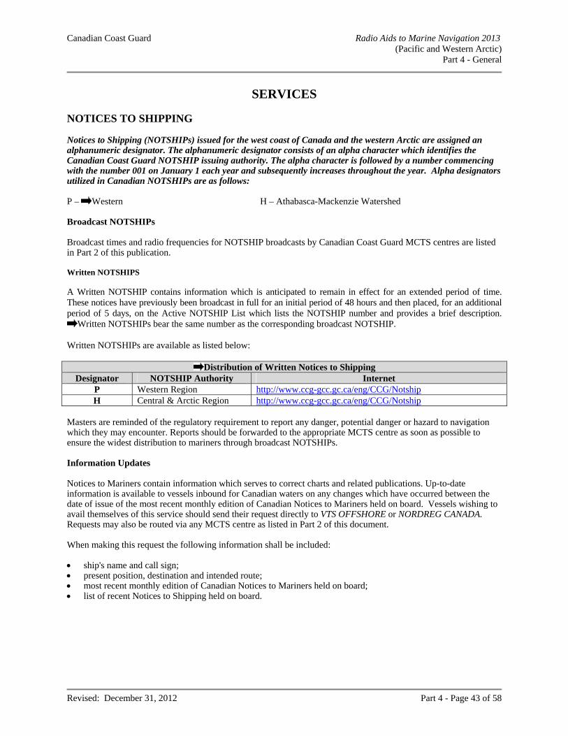
Canadian Coast Guard Radio Aids to Marine Navigation 2013 (Pacific and Western Arctic)
Part 4 - General
Revised: December 31, 2012 Part 4 - Page 43 of 58
SERVICES NOTICES TO SHIPPING Notices to Shipping (NOTSHIPs) issued for the west coast of Canada and the western Arctic are assigned an alphanumeric designator. The alphanumeric designator consists of an alpha character which identifies the Canadian Coast Guard NOTSHIP issuing authority. The alpha character is followed by a number commencing with the number 001 on January 1 each year and subsequently increases throughout the year. Alpha designators utilized in Canadian NOTSHIPs are as follows: P – Western H – Athabasca-Mackenzie Watershed Broadcast NOTSHIPs Broadcast times and radio frequencies for NOTSHIP broadcasts by Canadian Coast Guard MCTS centres are listed in Part 2 of this publication. Written NOTSHIPS A Written NOTSHIP contains information which is anticipated to remain in effect for an extended period of time. These notices have previously been broadcast in full for an initial period of 48 hours and then placed, for an additional period of 5 days, on the Active NOTSHIP List which lists the NOTSHIP number and provides a brief description.
Written NOTSHIPs bear the same number as the corresponding broadcast NOTSHIP. Written NOTSHIPs are available as listed below:
Distribution of Written Notices to Shipping Designator NOTSHIP Authority Internet
P Western Region http://www.ccg-gcc.gc.ca/eng/CCG/Notship H Central & Arctic Region http://www.ccg-gcc.gc.ca/eng/CCG/Notship
Masters are reminded of the regulatory requirement to report any danger, potential danger or hazard to navigation which they may encounter. Reports should be forwarded to the appropriate MCTS centre as soon as possible to ensure the widest distribution to mariners through broadcast NOTSHIPs. Information Updates Notices to Mariners contain information which serves to correct charts and related publications. Up-to-date information is available to vessels inbound for Canadian waters on any changes which have occurred between the date of issue of the most recent monthly edition of Canadian Notices to Mariners held on board. Vessels wishing to avail themselves of this service should send their request directly to VTS OFFSHORE or NORDREG CANADA. Requests may also be routed via any MCTS centre as listed in Part 2 of this document. When making this request the following information shall be included: ship's name and call sign; present position, destination and intended route; most recent monthly edition of Canadian Notices to Mariners held on board; list of recent Notices to Shipping held on board.
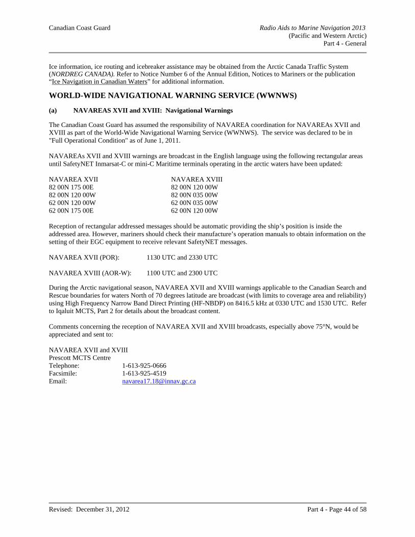
Canadian Coast Guard Radio Aids to Marine Navigation 2013 (Pacific and Western Arctic)
Part 4 - General
Revised: December 31, 2012 Part 4 - Page 44 of 58
Ice information, ice routing and icebreaker assistance may be obtained from the Arctic Canada Traffic System (NORDREG CANADA). Refer to Notice Number 6 of the Annual Edition, Notices to Mariners or the publication “Ice Navigation in Canadian Waters” for additional information. WORLD-WIDE NAVIGATIONAL WARNING SERVICE (WWNWS) (a) NAVAREAS XVII and XVIII: Navigational Warnings The Canadian Coast Guard has assumed the responsibility of NAVAREA coordination for NAVAREAs XVII and XVIII as part of the World-Wide Navigational Warning Service (WWNWS). The service was declared to be in "Full Operational Condition" as of June 1, 2011. NAVAREAs XVII and XVIII warnings are broadcast in the English language using the following rectangular areas until SafetyNET Inmarsat-C or mini-C Maritime terminals operating in the arctic waters have been updated: NAVAREA XVII NAVAREA XVIII 82 00N 175 00E 82 00N 120 00W 82 00N 120 00W 82 00N 035 00W 62 00N 120 00W 62 00N 035 00W 62 00N 175 00E 62 00N 120 00W Reception of rectangular addressed messages should be automatic providing the ship’s position is inside the addressed area. However, mariners should check their manufacture’s operation manuals to obtain information on the setting of their EGC equipment to receive relevant SafetyNET messages. NAVAREA XVII (POR): 1130 UTC and 2330 UTC NAVAREA XVIII (AOR-W): 1100 UTC and 2300 UTC During the Arctic navigational season, NAVAREA XVII and XVIII warnings applicable to the Canadian Search and Rescue boundaries for waters North of 70 degrees latitude are broadcast (with limits to coverage area and reliability) using High Frequency Narrow Band Direct Printing (HF-NBDP) on 8416.5 kHz at 0330 UTC and 1530 UTC. Refer to Iqaluit MCTS, Part 2 for details about the broadcast content. Comments concerning the reception of NAVAREA XVII and XVIII broadcasts, especially above 75°N, would be appreciated and sent to: NAVAREA XVII and XVIII Prescott MCTS Centre Telephone: 1-613-925-0666 Facsimile: 1-613-925-4519 Email: [email protected]
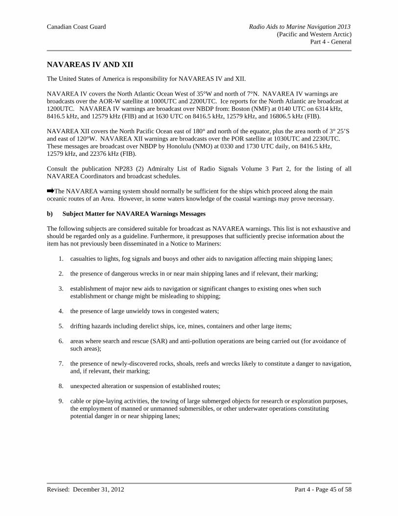
Canadian Coast Guard Radio Aids to Marine Navigation 2013 (Pacific and Western Arctic)
Part 4 - General
Revised: December 31, 2012 Part 4 - Page 45 of 58
NAVAREAS IV AND XII The United States of America is responsibility for NAVAREAS IV and XII. NAVAREA IV covers the North Atlantic Ocean West of 35°W and north of 7°N. NAVAREA IV warnings are broadcasts over the AOR-W satellite at 1000UTC and 2200UTC. Ice reports for the North Atlantic are broadcast at 1200UTC. NAVAREA IV warnings are broadcast over NBDP from: Boston (NMF) at 0140 UTC on 6314 kHz, 8416.5 kHz, and 12579 kHz (FIB) and at 1630 UTC on 8416.5 kHz, 12579 kHz, and 16806.5 kHz (FIB). NAVAREA XII covers the North Pacific Ocean east of 180° and north of the equator, plus the area north of 3° 25’S and east of 120°W. NAVAREA XII warnings are broadcasts over the POR satellite at 1030UTC and 2230UTC. These messages are broadcast over NBDP by Honolulu (NMO) at 0330 and 1730 UTC daily, on 8416.5 kHz, 12579 kHz, and 22376 kHz (FIB). Consult the publication NP283 (2) Admiralty List of Radio Signals Volume 3 Part 2, for the listing of all NAVAREA Coordinators and broadcast schedules.
The NAVAREA warning system should normally be sufficient for the ships which proceed along the main oceanic routes of an Area. However, in some waters knowledge of the coastal warnings may prove necessary. b) Subject Matter for NAVAREA Warnings Messages The following subjects are considered suitable for broadcast as NAVAREA warnings. This list is not exhaustive and should be regarded only as a guideline. Furthermore, it presupposes that sufficiently precise information about the item has not previously been disseminated in a Notice to Mariners:
1. casualties to lights, fog signals and buoys and other aids to navigation affecting main shipping lanes; 2. the presence of dangerous wrecks in or near main shipping lanes and if relevant, their marking;
3. establishment of major new aids to navigation or significant changes to existing ones when such
establishment or change might be misleading to shipping;
4. the presence of large unwieldy tows in congested waters;
5. drifting hazards including derelict ships, ice, mines, containers and other large items;
6. areas where search and rescue (SAR) and anti-pollution operations are being carried out (for avoidance of such areas);
7. the presence of newly-discovered rocks, shoals, reefs and wrecks likely to constitute a danger to navigation,
and, if relevant, their marking; 8. unexpected alteration or suspension of established routes;
9. cable or pipe-laying activities, the towing of large submerged objects for research or exploration purposes,
the employment of manned or unmanned submersibles, or other underwater operations constituting potential danger in or near shipping lanes;
Canadian Coast Guard Radio Aids to Marine Navigation 2013 (Pacific and Western Arctic)
Part 4 - General
Revised: December 31, 2012 Part 4 - Page 46 of 58
10. the establishment of research or scientific instruments in or near shipping lanes;
11. the establishment of offshore structures in or near shipping lanes;
12. significant malfunction of radio-navigation services and shore-based maritime safety information and radio
services;
13. information concerning special operations which might affect the safety of shipping, sometimes over wide areas, e.g. naval exercises, missile firings, space missions, nuclear tests, ordnance dumping zones, etc. It is important that where the degree of hazard is known, this information is included in the relevant warning. Whenever possible, such warnings should be originated not less than five days in advance of the scheduled event and reference may be made to relevant national publications in the warning;
14. acts of piracy and armed robbery against ships;
15. tsunamis and other natural phenomena, such as abnormal changes to sea level;
16. World Heath Organization (WHO) health advisory information; and
17. security-related requirements, in accordance with the requirements of the International Ship and Port
Facility Security Code only.
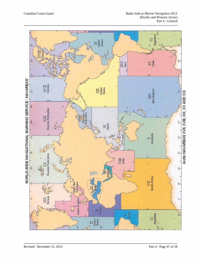
Canadian Coast Guard Radio Aids to Marine Navigation 2013 (Pacific and Western Arctic)
Part 4 - General
Revised: December 31, 2012 Part 4 - Page 47 of 58
Canadian Coast Guard Radio Aids to Marine Navigation 2013 (Pacific and Western Arctic)
Part 4 - General
Revised: December 31, 2012 Part 4 - Page 48 of 58
CELLULAR PHONE (*16) SERVICE – MARINE EMERGENCIES MCTS centres in certain parts of Canada are connected to the cellular telephone network system where cellular telephone users can, in an emergency situation only, dial *16 or #16 (dependant upon the service provider) on their cellular telephone to access an MCTS centre in order to obtain assistance. Mariners are cautioned that a cellular telephone is not a good substitute for a marine radio because the maritime mobile radio safety system in the southern waters of Canada is based principally on VHF communications. Furthermore, VHF has the advantage that a call can be heard by the closest MCTS centre(s) and by ships in the vicinity which could provide immediate assistance. On the other hand, the telephone cellular network is a party-to-party system and the benefit of the broadcast mode in an emergency situation cannot be obtained. Mariners are reminded that the use of marine radio distress frequencies to obtain assistance in an emergency situation is the best option and that cellular phone should be used only as an alternative should the VHF radiotelephone set not be available. Standard distress alerting equipment, such as marine radio and EPIRBs should never be replaced by cellular telephone alone. Note: Details of this service may be obtained by contacting local cellular telephone companies; however, mariners are cautioned that not all cellular telephone companies provide this service. DIRECTION FINDING (VHF/DF) SERVICE MCTS centres in certain parts of Canada are provided with VHF/DF equipment, primarily to determine or confirm the bearing, from a DF facility, of a vessel requiring assistance in a distress or other emergency situation. In addition, an estimated line of position from a DF facility can be provided to vessels that are uncertain of their locations. Location of VHF/DF facilities will be found in the appropriate centre listings in Part 2 of this publication. The intent of this service is not to provide a navigation service. Positions must be regarded as estimates only. Mariners are cautioned that any information provided shall be used at their own discretion. Direction Finding Bearings Any MCTS centre will, on request, transmit signals that will enable a ship to take a radio bearing with its own direction finder. It is pointed out to masters of ships fitted with direction finding equipment employing DF loops that serious error may result in bearings taken if metallic material or equipment (poles, wires, winches, etc.) are erected in proximity to the DF antenna equipment after calibration. Masters of ships are urged to exercise caution in the use of commercial radio broadcasting stations as radio beacons. Bearings taken on such stations may be very inaccurate owing to errors caused by coastal refraction and the calibration of the Direction Finder employed may vary considerably due to the wide difference in frequencies used, (i.e. the standard broadcast band spreads over approximately 1060 kHz). In addition, it is advisable to make certain that the position of the broadcast transmitter (not the studio) is accurately known before using it as a navigation aid.
SAIL PLAN SERVICE All small craft operators, including those making day trips, are encouraged to file a Sail Plan with a responsible person. This person should be instructed to call the Joint Rescue Coordination Centre (JRCC) if the vessel becomes overdue. The telephone number can be found at the front of most telephone books and should be included with the Sail Plan. In circumstances where it is not possible to file a Sail Plan with a responsible person, a Sail Plan may be filed by telephone, radio or in person with any Coast Guard MCTS centre. While at sea, masters/operators who have filed a sail plan with an MCTS centre are encouraged to file a daily position report during long trips. Upon your return, be sure to close (or deactivate) the sail plan you filed earlier. Forgetting to do so can result in an unwarranted search for you.
Canadian Coast Guard Radio Aids to Marine Navigation 2013 (Pacific and Western Arctic)
Part 4 - General
Revised: December 31, 2012 Part 4 - Page 49 of 58
The information to be provided should be in accordance with the listing below: vessel identification (boat’s name and licence number) sail or power vessel size and type colour of hull, deck, and cabin type of engines other distinguishing features radios and channels monitored (MF / HF / VHF; Maritime Mobile Service Identity (MMSI) satellite and/or cellular telephone number description of life rafts or small boats available number and type of flares number of lifejackets, PFDs and/or survival suits other safety equipment name, address, and telephone number of vessel owner other information date and time of departure number of people on board departure point route and stop-over points destination estimated date and time of arrival at destination, and telephone number of an emergency contact person
SEARCH AND RESCUE IN CANADIAN AREAS OF RESPONSIBILITY The Canadian Forces (CF) in co-operation with the Canadian Coast Guard has overall responsibility for coordination of federal aeronautical and maritime Search and Rescue (SAR) activities in Canada, including Canadian waters and the high seas off the coasts of Canada. The CF provides dedicated SAR aircraft in support to marine SAR incidents. The Canadian Coast Guard coordinates maritime SAR activities within this area and provides dedicated maritime SAR vessels in strategic locations. Joint Rescue Coordination Centres (JRCC) are maintained at Victoria, BC, Trenton, ON and Halifax, NS These centres are staffed 24 hours a day by Canadian Forces and Canadian Coast Guard personnel. Each JRCC is responsible for an internationally agreed upon designated area known as a Search and Rescue Region (SRR). In addition, a Maritime Rescue Sub-Centre (MRSC), staffed by Canadian Coast Guard personnel is maintained at Québec, QC to coordinate local marine SAR operations.
Joint Rescue Coordination Centre (JRCC)
JRCC Victoria, BC
Telephone: 1-800-567-5111 British Columbia and Yukon +1 250-413-8933 Satellite, Local or out of area # 727 Cellular
Email: [email protected]
JRCC Trenton, ON
Telephone: 1-800-267-7270 In Canada +1-613-965-3870 Satellite, Local or out of area Facsimile: 613-965-7279 Email: [email protected]
Canadian Coast Guard Radio Aids to Marine Navigation 2013 (Pacific and Western Arctic)
Part 4 - General
Revised: December 31, 2012 Part 4 - Page 50 of 58
Canadian Coast Guard Auxiliary The Canadian Coast Guard Auxiliary (CCGA) is an association of approximately 4500 dedicated volunteers operating close to 1300 vessels to support the Canadian Coast Guard in Marine Search and Rescue. For more information on maritime SAR services in Canada, refer to Section 28 of the Annual Edition of Notices to Mariners, published by the Canadian Coast Guard, Marine Navigation Services. MARINE COMMUNICATIONS AND TRAFFIC SERVICES MESSAGE SERVICE Messages no longer accepted: (a) Ships’ business messages; (b) Private messages. Messages handled without charge by MCTS centres:
(a) Messages pertaining to weather or ice information and ice routing; (b) Messages concerning aids to navigation; (c) AMVER Messages, addressed AMVER HALIFAX; (d) Radiomedical messages; (e) Messages reporting pollution; (f) Messages addressed to a port or a member of the Canadian Coast Guard that involves a report of a
ship movement, position or condition; (g) Messages addressed to a Joint Rescue Co-ordination Centre (JRCC) or Maritime Rescue Sub-Centre
(MRSC); (h) Pilotage messages; (i) Official Naval messages; (j) Quarantine messages addressed to “Quarantine”; (k) Messages requesting a doctor to meet the ship on arrival.
Weather Messages Weather reports in the international meteorological code, made at the standard synoptic hours of 0000, 0600, 1200 and 1800 UTC, are solicited from ships of all nationalities which have been recruited by their own national weather service, or other weather services, to make weather reports on a regular basis. These reports should be made and transmitted to the nearest MCTS centre, irrespective of the ship’s position. In fact, reports made close to, or even within sight of land, are equally important to reports made offshore, due to the greater variability of weather conditions in proximity to a coastline. Pollution Messages All vessels plying Canadian and adjacent waters are requested to report oil slicks or pollution of any type to the nearest MCTS centre. Medical Advice Messages Masters of ships may obtain medical advice by addressing a radiotelegram to “Radiomedical” and routing it via the nearest MCTS centre which will refer the message to the nearest medical authority and transmit the reply to the ship.
Canadian Coast Guard Radio Aids to Marine Navigation 2013 (Pacific and Western Arctic)
Part 4 - General
Revised: December 31, 2012 Part 4 - Page 51 of 58
Quarantine Messages 1. In the following circumstances only, the person in charge of a vessel shall, by radio, at least 24 hours prior
to the vessel’s estimated time of arrival at its port of destination, notify or cause the notification of a quarantine officer at the quarantine station designated in paragraph (3) for that port of the occurrence where, in the course of a voyage of a vessel:
(a) a member of the crew or a passenger on board the vessel exhibits one or more of these signs or
symptoms:
• Appears obviously unwell; • Cough with blood • Fever or chills (profuse sweating, unusually flushed or pale skin, shivering; and • Shortness of breath or difficulty breathing; • Repeated coughing; • Diarrhea • Headache • Recent confusion • Skin Rash; • Bruising or bleeding without injury; • Death
That person(s) should be isolated in order to minimize the exposure of crew and passengers. (b) the person in charge of the vessel is, during the period: i. of four weeks preceding the estimated time of arrival of the vessel, or ii. since he last submitted a declaration of health as required by section 16, whichever is the lesser,
aware of any instance of illness among the crew or passengers that he suspects is of a communicable nature and may lead to the spread of disease,
(c) a certificate establishing that the vessel has been de-ratted or exempted from de-ratting procedures has
expired or is about to expire. 2. At the same time, the person in charge of a vessel shall, by radio, provide the quarantine officer with the following information:
(a) the name and nationality of the vessel; (b) the ports called at during the voyage of the vessel; (c) the nature of the cargo on board the vessel; (d) the number of persons comprising the crew of the vessel; (e) the number of passengers on board the vessel; (f) the port of destination of the vessel and the name of the vessel’s owner or, if the owner is not in Canada, the name of the vessel’s agent in Canada; (g) the condition of all persons on board the vessel and details of any death or illness occurring during the voyage; (h) whether the body of any person is being carried on the vessel; (i) the estimated time of arrival of the vessel at the port of destination; and (j) the date and place of issuance of any de-ratting certificate or de-ratting exemption certificate applicable to the vessel.
Canadian Coast Guard Radio Aids to Marine Navigation 2013 (Pacific and Western Arctic)
Part 4 - General
Revised: December 31, 2012 Part 4 - Page 52 of 58
3. For the purposes of paragraph (1), the quarantine station for vessels bound for a port in the Province of
British Columbia or a port in the Yukon Territories is the Vancouver Quarantine Station at 604-317-1720 (24 hour phone line).
4. The person in charge of a vessel who wishes to change his port of destination after receiving instructions
from the quarantine officer shall notify him of such change and request new instructions. Pilotage Messages For detailed information on Notices to Obtain Pilot, Notices of Departure, Notices of Movage, Optional Notices and Required Information, please refer to Section 23 of the latest Annual Edition of Notices to Mariners, published by the Canadian Coast Guard, Marine Navigation Services. Official Naval Messages For detailed information on Naval Messages to Canadian and Commonwealth ships in Canadian areas, please refer to Section 39 of the latest Annual Edition of Notices to Mariners, published by the Canadian Coast Guard, Marine Navigation Services.
ICEBREAKING AND ICE ROUTING SERVICES Ice Navigation in Canadian Waters The nautical publication “Ice Navigation in Canadian Waters” is published by the Canadian Coast Guard in collaboration with Transport Canada, Canadian Ice Service, and the Canadian Hydrographic Service. The Charts and Nautical Publications Regulations require this publication to be carried on board if the vessel is making a voyage during which ice may be encountered. The publication is available to download, free-of-charge, from http://www.ccg-gcc.gc.ca/Ice_home/Ice_Publications/Ice-Navigation-in-Canadian-Waters
There are a variety of icebreaking and support services available to ships transiting Canadian ice-covered waters. Ice Operations Centres are in operation seasonally as ice conditions dictate. These Centres work in conjunction with Marine Communications and Traffic Services Centres to provide up-to-date ice information, to suggest routes for ships to follow through or around ice, and to co-ordinate icebreaker assistance to shipping.
Ice Operations Centres are in contact with icebreakers at all times and monitor progress of shipping within their area of responsibility. In addition, Environment Canada’s Canadian Ice Service (CIS) has fully qualified Ice Service Specialists and ice reconnaissance aircraft who are involved with Ice Operations Centres on a full-time basis throughout the ice navigation season. The Coast Guard Icebreaking Superintendents have a complete and current picture of the prevailing ice conditions in their area and the anticipated trend of conditions and are therefore well equipped to provide reasoned advice on the best routes to pursue.
To obtain the maximum benefit from the service, it is essential that Masters report to the Canadian Coast Guard before their ships enter waters where ice may be encountered. These initial reports and subsequent position reports from ships will ensure a continuing watch on the ship's progress by the CCG Ice Operations Centres and, in the event icebreaker support becomes necessary, this can be provided with a minimum of delay. There are a limited number of icebreakers available to support shipping. Masters are encouraged to follow the recommended route with which they are provided. They may also assist and support this service by providing reports on the ice they encounter.
Canadian Coast Guard Radio Aids to Marine Navigation 2013 (Pacific and Western Arctic)
Part 4 - General
Revised: December 31, 2012 Part 4 - Page 53 of 58
Canadian Coast Guard Ice Operations Centres: Telephone Facsimile Ice Atlantic 709-772-2078 709-772-5369 Ice Québec For Icebreaker Support 418-648-7290 418- 648-3614 For Ice Information 418-648-2214 418-648-7305 Ice Sarnia For Icebreaker Support 1-800 265-0237 or 519-383-1814 For Ice Information 519-383-1855 519-337-2498 MARINFO Website: http://www.marinfo.gc.ca/en/glaces/index.asp Icebreaking Website: http://www.ccg-gcc.gc.ca/eng/CCG/Ice_Home General Information Email: [email protected] Joint Industry-Government Guidelines Recognizing that special risks of ice damage may exist in certain waters off the East Coast of Canada during winter and spring months and that these may affect safety and contribute to marine pollution, the Joint Industry-Government Guidelines for the Control of Oil Tankers and Bulk Chemical Carriers in Ice Control Zones of Eastern Canada (JIG) – TP15163 were developed and have been in effect since November 1979. These Guidelines apply to all laden oil tankers and to tankers carrying liquid chemicals in bulk when proceeding through an active Ice Control Zone in Eastern Canadian waters and fishing zones south of 60° North. The Canadian Coast Guard may declare any ice control zone to be an active Ice Control Zone and promulgate this information via Notice to Shipping and Notices to Mariners. When proceeding through an active Ice Control Zone, all ships to which the Guidelines apply should have on board a copy of the guidelines and at least one "Ice Advisor", who meets the requirements as prescribed in JIGs. The following may be contacted for information on ice control zones: NEWFOUNDLAND AND LABRADOR REGION Canadian Coast Guard Ice Operations Centre Tel: 709-772-2078 Fax: 709-772-5369 St. John’s MCTS Tel: 709-772-2083/2084 Fax: 709-772-5369 [email protected]
MARITIMES REGION Canadian Coast Guard Ice Operations Centre Tel: 902-426-5664 or 902-426-5665 Fax: 902-426-6073 Halifax MCTS Tel: 902-426-4956 Fax: 902-426-4483 [email protected]
QUÉBEC REGION Canadian Coast Guard Ice Operations Centre Tel: 418-648-7290 / 418-648-5620 Fax: 418-648-7305 Rivière au Renard MCTS Tel: 418-269-3843 Fax: 418-269-5514 [email protected]
CENTRAL & ARCTIC REGION Canadian Coast Guard Ice Operations Centre Tel: 519-383-1814 or 1-800-265-0237 Fax: 519-337-2498
The complete version of JIG TP 15163 B (2011) is available at: http://www.tc.gc.ca/eng/marinesafety/tp-tp15163-menu-4025.htm

Canadian Coast Guard Radio Aids to Marine Navigation 2013 (Pacific and Western Arctic)
Part 4 - General
Revised: December 31, 2012 Last correction: NOTMAR 05/ 2013
Part 4 - Page 54 of 58
CANADIAN HYDROGRAPHIC SERVICE Conversion of charts to North American Datum 1983 (NAD 83) The Canadian Hydrographic Service is converting navigational charts to the North American Datum 1983 (NAD 83). NAD 83 is considered equivalent to the World Geodetic System 1984 (WGS 84) recently adopted as the horizontal datum for world-wide use. The advantage of the new datum is its compatibility with the NAVSTAR (GPS) satellite positioning system. The difference in the position of the same point when quoted on the former NAD 27 and the new NAD 83 is up to 60 metres on the Atlantic coast, about 110 metres on the Pacific coast and almost zero near Chicago although there can be local discrepancies from these approximations. Horizontal positions obtained from satellite receivers are based on NAD 83 (WGS 84) and must be converted to the horizontal chart datum (if not NAD 83) before being used. A note has been added to nearly all existing charts indicating the datum on which the chart is based, and providing the increase or decrease required to convert the latitude and longitude from NAD 83 to the chart datum. New Charts and New Editions being produced are now almost always based on NAD 83. Note: Latitude and longitude positions given in this publication are in NAD 83 unless otherwise indicated. INSPECTION OF RADIO APPARATUS The Canadian Coast Guard, on behalf of Transport Canada, is responsible for the conduct of ship radio inspections pursuant to the Canada Shipping Act, 2001. Queries concerning the standards governing inspections of radio apparatus fitted in ships for safety purposes may be sent to: Program Manager, Ship Radio Inspection Fisheries and Oceans Canada Canadian Coast Guard 200 Kent Street, 7th Floor, Station 7S001 Ottawa, ON K1A 0E6 Telephone: 613-949-7810 Facsimile: 613-998-9258 Email: [email protected] Owners and masters of Canadian ships, that are required to be fitted with a radio installation under the provisions of the Canada Shipping Act, 2001 are reminded that:
The master of a ship, other than a Safety Convention ship, shall ensure that the ship station is inspected by a radio inspector: (a) within the 30 days before the ship puts to sea for the first time, if the ship is
(i) 20 m or more in length, (ii) a tow-boat, or (iii) carrying more than 12 passengers on a voyage any part of which is in a VHF coverage area or more than five miles from shore;
Canadian Coast Guard Radio Aids to Marine Navigation 2013 (Pacific and Western Arctic)
Part 4 - General
Revised: December 31, 2012 Part 4 - Page 55 of 58
(b) at least once every 48 months, in the case of a ship referred to in paragraph (a) that is certified for home-trade voyages, Class IV, or minor waters voyages, Class II; and (c) at least once every 12 months, in the case of a ship referred to in paragraph (a) that is certified for voyages other than a home-trade voyage, Class IV, or a minor waters voyage, Class II.
The master of a ship that is required to be inspected under the Agreement between Canada and the United States of America for Promotion of Safety on the Great Lakes by Means of Radio, 1973 need not comply with paragraphs (1)(b) or (c), but shall ensure that the ship station is inspected by a radio inspector before the ship enters the Great Lakes Basin for the first time and at least once every 13 months thereafter while continuing to navigate in the Great Lakes Basin. A non-Canadian ship which does not have a valid Radio Safety Certificate on board may be detained by a port Customs Officer until a valid certificate has been obtained. A fee for the conduct of ship radio inspections is levied in accordance with the Ship Radio Inspection Fees Regulations. The fee is payable upon completion of the inspection. Applications for radio inspections of Canadian ships should be filed with the Canadian Coast Guard. The form entitled: Application for Radio Inspection, Compulsory Fitted Ships (82-0643) should be used for this purpose. Such request by owners, agents or masters should be received by the Canadian Coast Guard at least three working days in advance of the date requested for inspection. The owners, agents or masters of Canadian ships requiring radio inspection while outside of Canada should make application by fax or letter to:
Transport Canada Director General Marine Safety Directorate Tower C, Place de Ville 330 Sparks Street Ottawa, ON K1A 0N8 Telephone: 613-998-0610 Facsimile: 613-954-1032
Non-Canadian ships (except Liberian ships) may obtain a cargo Ship Safety Radio Certificate (GMDSS) in Canada. Applications should originate with the owners, ship agents or masters of the ships concerned and be supported by confirmation from the Consul or other official representative of the country in which the ship is registered. Confirmation shall be in writing. It is the responsibility of the owner, agent or master to contact the Consul or official representative and arrange to submit the necessary confirmation to the local Canadian Coast Guard inspection office. Where time is limited, a verbal request for an inspection may be accepted from the Consul or official representative (a person who has a document from an Administration giving him the official power to act on their behalf), provided that the confirmation is submitted later. Applications for radio inspections of Canadian ships wintering in US Great Lakes ports should be made by the owners, agents or masters on FCC form 809 and filed directly with the FCC Field Engineering office nearest to the port of which the inspections are desired. Copies of form 809 are available from any of the FCC offices serving the Great Lakes.
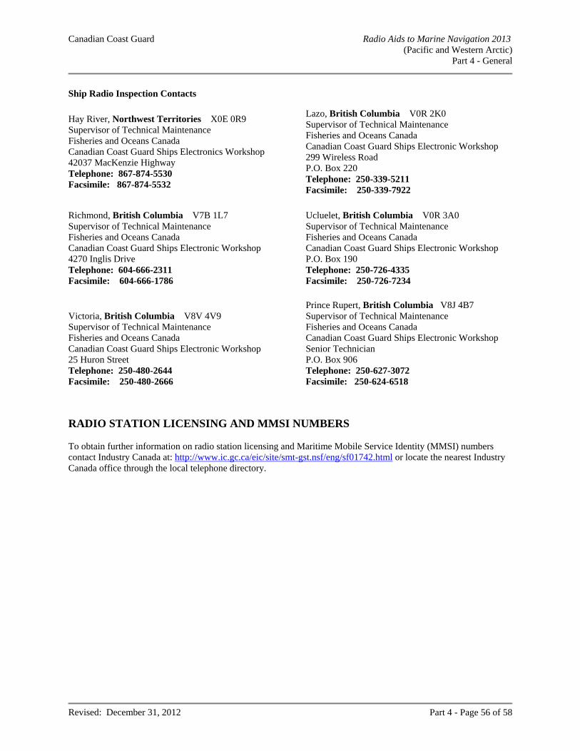
Canadian Coast Guard Radio Aids to Marine Navigation 2013 (Pacific and Western Arctic)
Part 4 - General
Revised: December 31, 2012 Part 4 - Page 56 of 58
Ship Radio Inspection Contacts
Hay River, Northwest Territories X0E 0R9 Supervisor of Technical Maintenance Fisheries and Oceans Canada Canadian Coast Guard Ships Electronics Workshop 42037 MacKenzie Highway Telephone: 867-874-5530 Facsimile: 867-874-5532
Lazo, British Columbia V0R 2K0 Supervisor of Technical Maintenance Fisheries and Oceans Canada Canadian Coast Guard Ships Electronic Workshop 299 Wireless Road P.O. Box 220 Telephone: 250-339-5211 Facsimile: 250-339-7922
Richmond, British Columbia V7B 1L7 Supervisor of Technical Maintenance Fisheries and Oceans Canada Canadian Coast Guard Ships Electronic Workshop 4270 Inglis Drive Telephone: 604-666-2311 Facsimile: 604-666-1786
Ucluelet, British Columbia V0R 3A0 Supervisor of Technical Maintenance Fisheries and Oceans Canada Canadian Coast Guard Ships Electronic Workshop P.O. Box 190 Telephone: 250-726-4335 Facsimile: 250-726-7234
Victoria, British Columbia V8V 4V9 Supervisor of Technical Maintenance Fisheries and Oceans Canada Canadian Coast Guard Ships Electronic Workshop 25 Huron Street Telephone: 250-480-2644 Facsimile: 250-480-2666
Prince Rupert, British Columbia V8J 4B7 Supervisor of Technical Maintenance Fisheries and Oceans Canada Canadian Coast Guard Ships Electronic Workshop Senior Technician P.O. Box 906 Telephone: 250-627-3072 Facsimile: 250-624-6518
RADIO STATION LICENSING AND MMSI NUMBERS To obtain further information on radio station licensing and Maritime Mobile Service Identity (MMSI) numbers contact Industry Canada at: http://www.ic.gc.ca/eic/site/smt-gst.nsf/eng/sf01742.html or locate the nearest Industry Canada office through the local telephone directory.
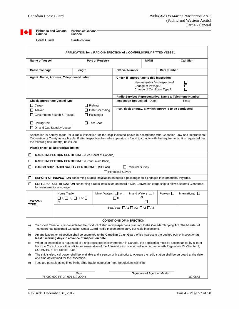
Canadian Coast Guard Radio Aids to Marine Navigation 2013 (Pacific and Western Arctic)
Part 4 - General
Revised: December 31, 2012 Part 4 - Page 57 of 58
APPLICATION for a RADIO INSPECTION of a COMPULSORILY FITTED VESSEL
Name of Vessel
Port of Registry
MMSI Call Sign
Gross Tonnage
Length Official Number IMO Number
Agent: Name, Address, Telephone Number
Check if appropriate to this inspection
New vessel or first inspection? Change of Voyage? Change of Certificate Type?
Radio Services Representative: Name & Telephone Number
Check appropriate Vessel type
Cargo Fishing
Tanker Fish Processing
Government Search & Rescue Passenger
Drilling Unit Tow-Boat
Oil and Gas Standby Vessel
Inspection Requested - Date: Time:
Port, dock or quay, at which survey is to be conducted
Application is hereby made for a radio inspection for the ship indicated above in accordance with Canadian Law and International Convention or Treaty as applicable. If after inspection the radio apparatus is found to comply with the requirements, it is requested that the following document(s) be issued.
Please check all appropriate boxes.
RADIO INSPECTION CERTIFICATE (Sea Coast of Canada)
RADIO INSPECTION CERTIFICATE (Great Lakes Basin)
CARGO SHIP RADIO SAFETY CERTIFICATE (SOLAS) Renewal Survey
Periodical Survey
REPORT OF INSPECTION concerning a radio installation on board a passenger ship engaged in international voyages.
LETTER OF CERTIFICATION concerning a radio installation on board a Non-Convention cargo ship to allow Customs Clearance for an international voyage.
VOYAGE TYPE:
Home Trade
I, II, III or
IV
Minor Waters I or
II
Inland Waters I or
II
Foreign International
Sea Area: A1 A2 A3 A4
CONDITIONS OF INSPECTION:
a) Transport Canada is responsible for the conduct of ship radio inspections pursuant to the Canada Shipping Act. The Minister of Transport has appointed Canadian Coast Guard Radio Inspectors to carry out radio inspections.
b) An application for inspection shall be submitted to the Canadian Coast Guard office nearest to the desired port of inspection at least 3 working days in advance of inspection date.
c) When an inspection is requested of a ship registered elsewhere than in Canada, the application must be accompanied by a letter from the Consul or another official representative of the Administration concerned in accordance with Regulation 13, Chapter 1, SOLAS 1974, or Protocol 1988.
d) The ship’s electrical power shall be available and a person with authority to operate the radio station shall be on board at the date and time determined for the inspection.
e) Fees are payable as outlined in the Ship Radio Inspection Fees Regulations (SRIFR) _______________________ ________________________________________ Date Signature of Agent or Master 76-000-000-PF-JP-001 (12-2004) 82-0643
Canadian Coast Guard Radio Aids to Marine Navigation 2013 (Pacific and Western Arctic)
Part 4 - General
Revised: December 31, 2012 Part 4 - Page 58 of 58
MARINE TELEPHONE SERVICE Radiomedical Calls Mariners may obtain medical advice by calling a Marine Communications and Traffic Services (MCTS) centre and requesting to be connected to a medical professional. The Canadian Coast Guard will connect the vessel to an appropriate medical professional via the Marine Telephone System. For mariners who wish to make their own arrangements for medical advice, radiomedical services are available in numerous languages to vessels flying any flag at any location through the International Radio-medical Centre (CIRM) in Rome, Italy. This centre is staffed 24/7/365 by specially trained physicians and radio operators who also have access to specialists in all medical branches. The CIRM can be contacted via the following means:
Telephone: 39 6 54223045 Mobile: GSM 39 348 3984229 Facsimile: 39 6 5923333 Telex: 043 612068 CIRM I Email: [email protected] Website: http://www.cirm.it/
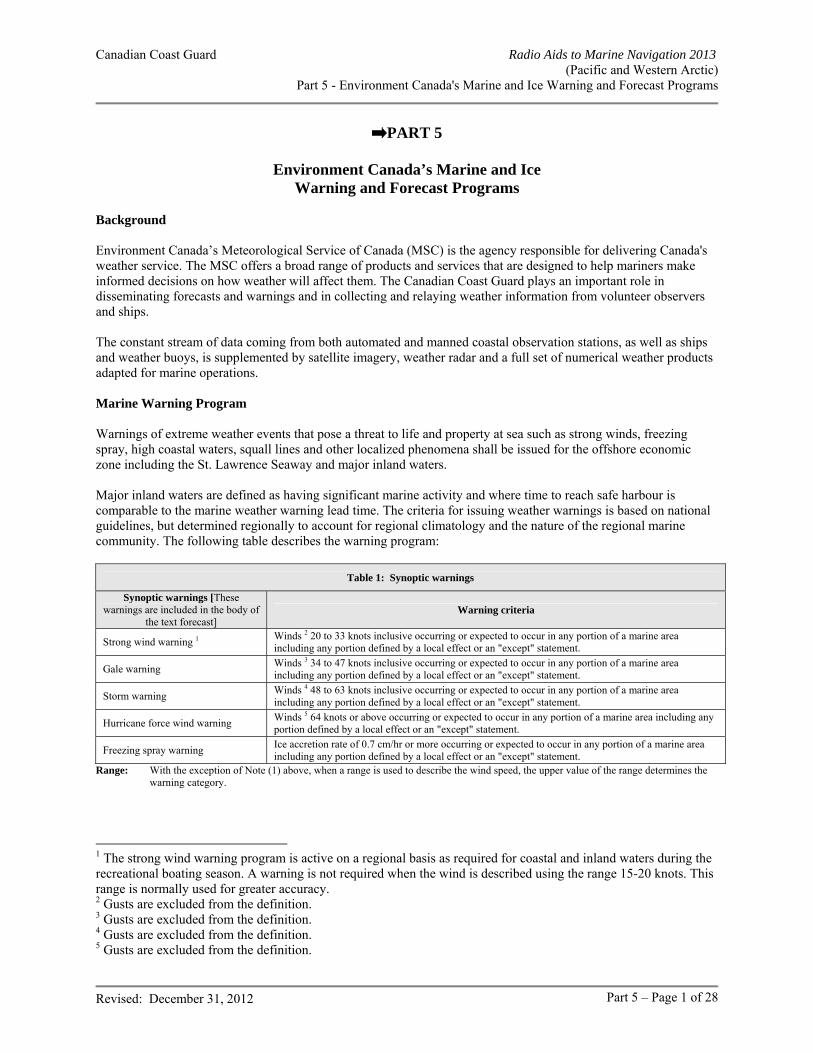
Canadian Coast Guard Radio Aids to Marine Navigation 2013 (Pacific and Western Arctic)
Part 5 - Environment Canada's Marine and Ice Warning and Forecast Programs
Revised: December 31, 2012 Part 5 – Page 1 of 28
PART 5
Environment Canada’s Marine and Ice Warning and Forecast Programs
Background Environment Canada’s Meteorological Service of Canada (MSC) is the agency responsible for delivering Canada's weather service. The MSC offers a broad range of products and services that are designed to help mariners make informed decisions on how weather will affect them. The Canadian Coast Guard plays an important role in disseminating forecasts and warnings and in collecting and relaying weather information from volunteer observers and ships. The constant stream of data coming from both automated and manned coastal observation stations, as well as ships and weather buoys, is supplemented by satellite imagery, weather radar and a full set of numerical weather products adapted for marine operations. Marine Warning Program Warnings of extreme weather events that pose a threat to life and property at sea such as strong winds, freezing spray, high coastal waters, squall lines and other localized phenomena shall be issued for the offshore economic zone including the St. Lawrence Seaway and major inland waters. Major inland waters are defined as having significant marine activity and where time to reach safe harbour is comparable to the marine weather warning lead time. The criteria for issuing weather warnings is based on national guidelines, but determined regionally to account for regional climatology and the nature of the regional marine community. The following table describes the warning program:
Table 1: Synoptic warnings
Synoptic warnings [These warnings are included in the body of
the text forecast] Warning criteria
Strong wind warning 1 Winds 2 20 to 33 knots inclusive occurring or expected to occur in any portion of a marine area including any portion defined by a local effect or an "except" statement.
Gale warning Winds 3 34 to 47 knots inclusive occurring or expected to occur in any portion of a marine area including any portion defined by a local effect or an "except" statement.
Storm warning Winds 4 48 to 63 knots inclusive occurring or expected to occur in any portion of a marine area including any portion defined by a local effect or an "except" statement.
Hurricane force wind warning Winds 5 64 knots or above occurring or expected to occur in any portion of a marine area including any portion defined by a local effect or an "except" statement.
Freezing spray warning Ice accretion rate of 0.7 cm/hr or more occurring or expected to occur in any portion of a marine area including any portion defined by a local effect or an "except" statement.
Range: With the exception of Note (1) above, when a range is used to describe the wind speed, the upper value of the range determines the warning category.
1 The strong wind warning program is active on a regional basis as required for coastal and inland waters during the recreational boating season. A warning is not required when the wind is described using the range 15-20 knots. This range is normally used for greater accuracy. 2 Gusts are excluded from the definition. 3 Gusts are excluded from the definition. 4 Gusts are excluded from the definition. 5 Gusts are excluded from the definition.
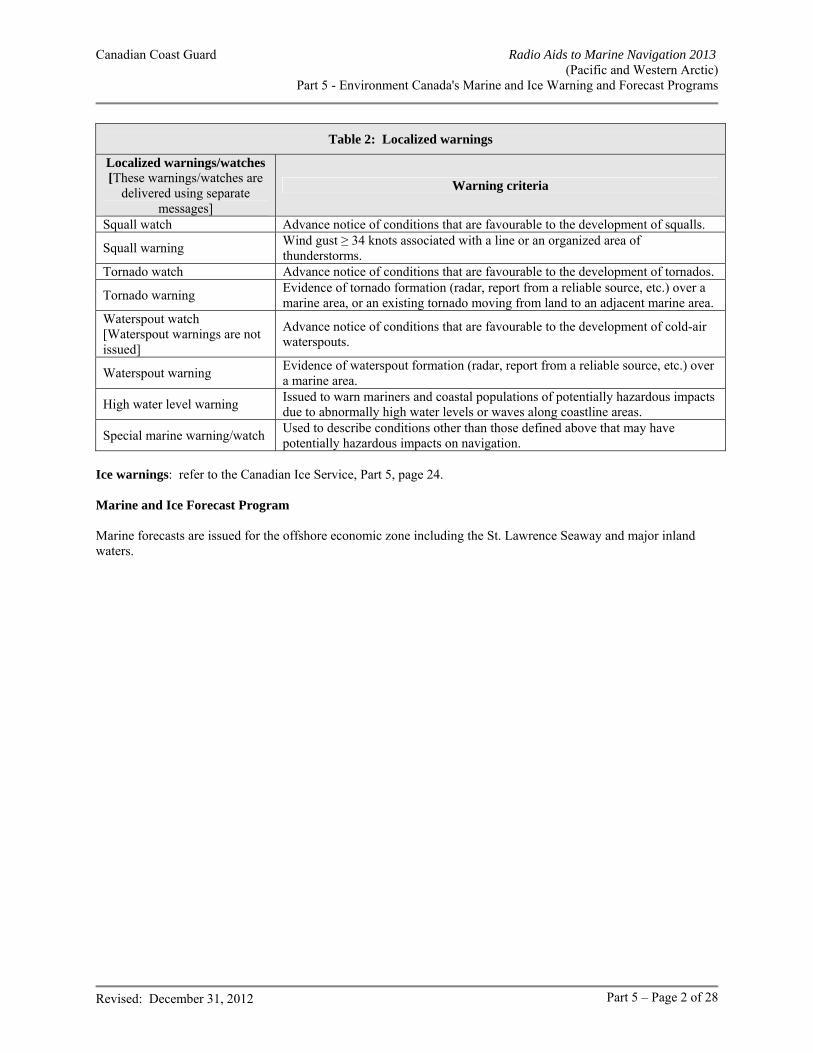
Canadian Coast Guard Radio Aids to Marine Navigation 2013 (Pacific and Western Arctic)
Part 5 - Environment Canada's Marine and Ice Warning and Forecast Programs
Revised: December 31, 2012 Part 5 – Page 2 of 28
Table 2: Localized warnings
Localized warnings/watches [These warnings/watches are
delivered using separate messages]
Warning criteria
Squall watch Advance notice of conditions that are favourable to the development of squalls.
Squall warning Wind gust ≥ 34 knots associated with a line or an organized area of thunderstorms.
Tornado watch Advance notice of conditions that are favourable to the development of tornados.
Tornado warning Evidence of tornado formation (radar, report from a reliable source, etc.) over a marine area, or an existing tornado moving from land to an adjacent marine area.
Waterspout watch [Waterspout warnings are not issued]
Advance notice of conditions that are favourable to the development of cold-air waterspouts.
Waterspout warning Evidence of waterspout formation (radar, report from a reliable source, etc.) over a marine area.
High water level warning Issued to warn mariners and coastal populations of potentially hazardous impacts due to abnormally high water levels or waves along coastline areas.
Special marine warning/watch Used to describe conditions other than those defined above that may have potentially hazardous impacts on navigation.
Ice warnings: refer to the Canadian Ice Service, Part 5, page 24. Marine and Ice Forecast Program Marine forecasts are issued for the offshore economic zone including the St. Lawrence Seaway and major inland waters.
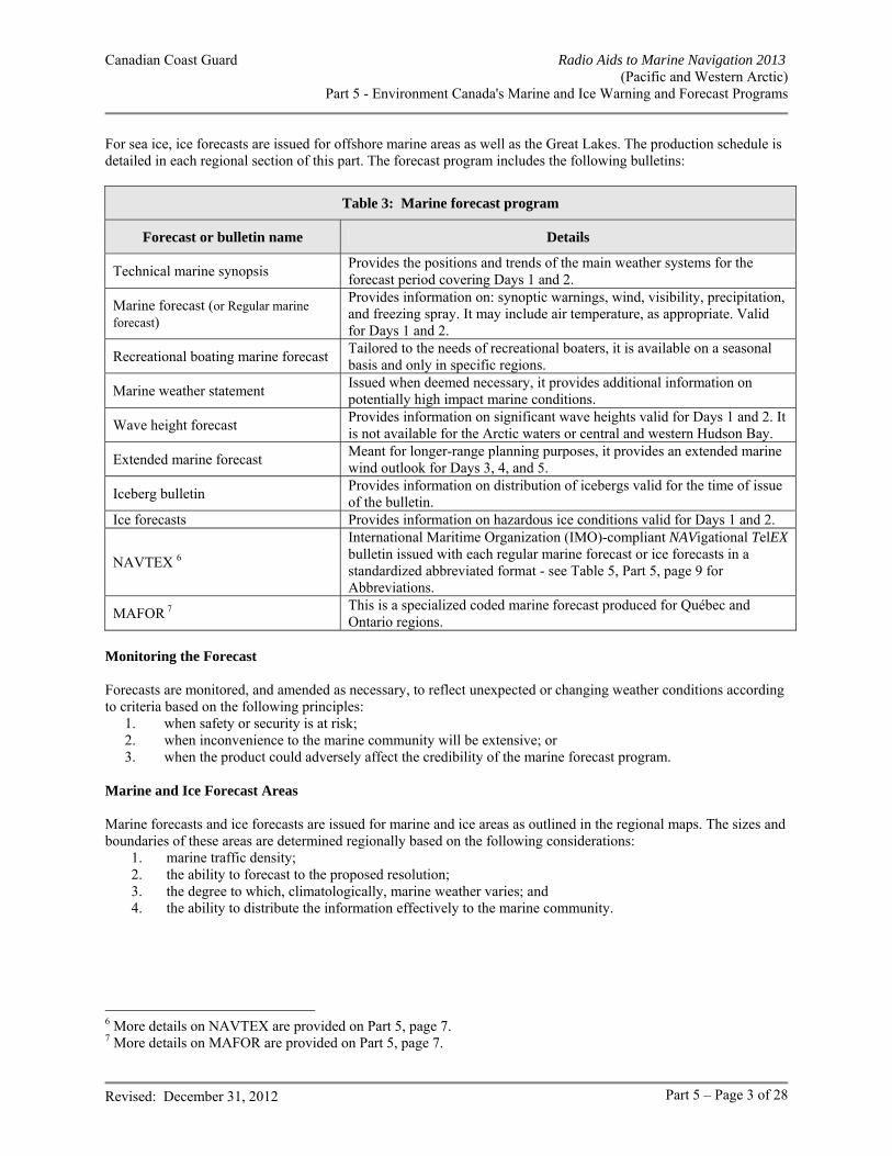
Canadian Coast Guard Radio Aids to Marine Navigation 2013 (Pacific and Western Arctic)
Part 5 - Environment Canada's Marine and Ice Warning and Forecast Programs
Revised: December 31, 2012 Part 5 – Page 3 of 28
For sea ice, ice forecasts are issued for offshore marine areas as well as the Great Lakes. The production schedule is detailed in each regional section of this part. The forecast program includes the following bulletins:
Table 3: Marine forecast program
Forecast or bulletin name Details
Technical marine synopsis Provides the positions and trends of the main weather systems for the forecast period covering Days 1 and 2.
Marine forecast (or Regular marine forecast)
Provides information on: synoptic warnings, wind, visibility, precipitation, and freezing spray. It may include air temperature, as appropriate. Valid for Days 1 and 2.
Recreational boating marine forecast Tailored to the needs of recreational boaters, it is available on a seasonal basis and only in specific regions.
Marine weather statement Issued when deemed necessary, it provides additional information on potentially high impact marine conditions.
Wave height forecast Provides information on significant wave heights valid for Days 1 and 2. It is not available for the Arctic waters or central and western Hudson Bay.
Extended marine forecast Meant for longer-range planning purposes, it provides an extended marine wind outlook for Days 3, 4, and 5.
Iceberg bulletin Provides information on distribution of icebergs valid for the time of issue of the bulletin.
Ice forecasts Provides information on hazardous ice conditions valid for Days 1 and 2.
NAVTEX 6
International Maritime Organization (IMO)-compliant NAVigational TelEX bulletin issued with each regular marine forecast or ice forecasts in a standardized abbreviated format - see Table 5, Part 5, page 9 for Abbreviations.
MAFOR 7 This is a specialized coded marine forecast produced for Québec and Ontario regions.
Monitoring the Forecast Forecasts are monitored, and amended as necessary, to reflect unexpected or changing weather conditions according to criteria based on the following principles:
1. when safety or security is at risk; 2. when inconvenience to the marine community will be extensive; or 3. when the product could adversely affect the credibility of the marine forecast program.
Marine and Ice Forecast Areas Marine forecasts and ice forecasts are issued for marine and ice areas as outlined in the regional maps. The sizes and boundaries of these areas are determined regionally based on the following considerations:
1. marine traffic density; 2. the ability to forecast to the proposed resolution; 3. the degree to which, climatologically, marine weather varies; and 4. the ability to distribute the information effectively to the marine community.
6 More details on NAVTEX are provided on Part 5, page 7. 7 More details on MAFOR are provided on Part 5, page 7.
Canadian Coast Guard Radio Aids to Marine Navigation 2013 (Pacific and Western Arctic)
Part 5 - Environment Canada's Marine and Ice Warning and Forecast Programs
Revised: December 31, 2012 Part 5 – Page 4 of 28
Current Conditions Current weather data is available to Canadians for their local area. The frequency and quality of the data will be consistent with the standards established by the World Meteorological Organization (WMO). The data may include, as appropriate:
- wind speed and direction, - atmospheric pressure, - sky conditions, - precipitation type, - restrictions to visibility, - wave height, - current temperature.
General information on current sea-ice will be provided to the marine community once a week to provide an adequate planning tool for those considering entering ice-encumbered waters. Emergency Response Meteorological support is provided during emergencies and includes the provision of meteorological information and forecasts. In the case of a pollution event, Environment Canada adheres to the “polluter pay” policy for the provision of all services. Where agreements are in place, Environment Canada will make its distribution systems available to transmit vital information during emergency situations. Delivery of Marine Warning and Forecast Services Delivery of marine warning and forecast services to mariners navigating waters within Environment Canada’s forecast areas of responsibility is primarily by mass communication in order to reach the greatest number of mariners through the standard communications technologies available to mariners. The following principles apply, regardless of the specific available technologies: a. Marine forecasts and warnings comprising the meteorological Maritime Safety Information (met MSI) issued
by Environment Canada will be made available to the marine community via the Canadian Coast Guard Marine Communications and Traffic Services according to established procedures within the framework of the Global Maritime Distress and Safety System (see RAMN Part 4, page 11: General Procedures – Systems – GMDSS).
b. Internet access via the World-Wide Web. All forecast and warning information will be found at the following address: http://www.weatheroffice.gc.ca/canada_e.html. Mariners should note, however, that the internet is not part of the Maritime Safety Information system and should never be relied upon as the only means to obtain the latest marine forecasts nd warning information. Access to the internet may be interrupted or updated information delayed without prior notice.
c. Marine and Environmental Advisories, Watches and Warnings are distributed through various mechanisms
including partnerships with national and regional media distributors and local emergency measures organizations.
d. In addition to the aforementioned mediums, basic services to mariners and Canadians in general shall also be
delivered by mass distribution in partnership with media, relying on current and developing technologies in radio, television, newspaper and the Internet. These distribution mechanisms represent the primary methods by which most Canadians receive their weather information, now and in the future.
e. Marine and Environmental Advisories, Watches and Warnings are distributed through various mechanisms
including partnerships with national and regional media distributors and local emergency measures organizations.
Canadian Coast Guard Radio Aids to Marine Navigation 2013 (Pacific and Western Arctic)
Part 5 - Environment Canada's Marine and Ice Warning and Forecast Programs
Revised: December 31, 2012 Part 5 – Page 5 of 28
Voluntary Observing Ship (VOS) Program The VOS program has been discontinued. Environment Canada currently supports the Automated Voluntary Observing Ship program (AVOS) program. Contact your regional PMO for further information. Buoys Program In order to complement the observational network, Environment Canada operates a network of buoys across the country. This data becomes part of the collection of weather reports sent to the distribution network and is used to improve marine forecasting. The location, WMO identifiers and names of the Environment Canada buoys are given in the regional annexes. Mariners are requested to use caution when approaching buoys as mooring chains are normally not detectable from a ship and can be damaged or even severed if there is contact. Such a mishap could possibly result in the buoy going adrift thus requiring a costly effort to recover the platform. Please keep the regional PMO informed of any incidents involving buoys. Buoy Locations: buoy positions are described in each specific regional annex. Port Meteorological Officers (PMOs) In addition to a variety of other duties, PMOs also act as a liaison between Environment Canada and ships involved in the VOS program. This is to encourage vessels to report weather and ice conditions, to instruct observers about procedures and the use of code; to supply observing forms, handbooks (free of charge!); to calibrate equipment; and, in some cases, to install, on loan, meteorological or oceanographic instrumentation. The PMO is also responsible for recruiting new vessels to participate in the VOS program. If a PMO visits your ship, feel free to ask questions about observing and coding, and reporting weather and ice conditions. Inform the PMO of any concerns you may have with forecasts, warnings, or facsimile products, especially if you have specific problems. The PMO will contact the appropriate party for investigation. Keep the PMO informed of your contact information.
Canadian Coast Guard Radio Aids to Marine Navigation 2013 (Pacific and Western Arctic)
Part 5 - Environment Canada's Marine and Ice Warning and Forecast Programs
Revised: December 31, 2012 Part 5 – Page 6 of 28
Table 4: Port Meteorological Officers (PMOs)
Great Lakes Atlantic - Maritimes Atlantic - Newfoundland
Tony Hilton, Superintendent Shawn Rickard, PMO Environment Canada, MSC 100 East Port Boulevard HAMILTON, ON L8H 7S4 Telephone: 905-312-0900 Facsimile: 905-312-0730 Email: [email protected] [email protected]
Derek Cain, PMO Environment Canada, MSC 45 Alderney Drive, 16th floor DARTMOUTH, NS B2Y 2N6 Telephone: 902-426-6616 Cellular: 902-222-6325 Facsimile: 902-426-6404 Email: [email protected]
Andre Dwyer, PMO Environment Canada, MSC 6 Bruce Street. MOUNT PEARL, NL A1N 4T3 Telephone: 709-772-4798 Cellular: 709-689-5787 Facsimile: 709-772-5097 Email: [email protected]
St-Lawrence - Québec Pacific Great Slave Lake / Lake Athabaska/ Western Arctic
Erich Gola, PMO Environment Canada, SMC Canada Place Bonaventure, Portail Nord-Est 800 de la Gauchetière ouest Suite 7810 MONTRÉAL, QC H5A 1L9 Telephone: 514-283-1644 Facsimile: 514-496-1867 Email: [email protected]
Bruce Lohnes, Supervisor Vaughn Williams, PMO Environment Canada, MSC 140 13160 Vanier Place RICHMOND, BC V6V 2J2 Telephone: 604-664-9188 Facsimile: 604-664-4094 Email: [email protected]: [email protected]
Ben Lemon, PMO Rich DeVall, PMO Environment Canada, MSC M.J. Greenwood Centre 9345 - 49 Street EDMONTON, AB T6B 2L8 Telephone: 780-495-6442 Email: [email protected] [email protected]
Manitoba Lakes
Greg Stansfield, PMO Monitoring and Systems Environment Canada, MSC Suite 150, 123 Main Street WINNIPEG, MB R3C 4W2 Telephone: 204-983-6155 Email: [email protected]
Canadian Coast Guard Radio Aids to Marine Navigation 2013 (Pacific and Western Arctic)
Part 5 - Environment Canada's Marine and Ice Warning and Forecast Programs
Revised: December 31, 2012 Part 5 – Page 7 of 28
NAVTEX
MSC will provide Canadian Coast Guard with marine forecast information in NAVTEX format for coastal and offshore areas of responsibility based on IMO standards. Marine forecast information provided will include:
I. Warnings (Winds & ice accretion); II. Synopsis (major features); III. Forecasts (wind, visibility, ice accretion, wave height).
Each bulletin will contain a WMO telecommunication header, a valid period, notes on parameters used within the bulletin, a synopsis section, a weather forecast section and a wave forecast section. Below is a sample of a partial NAVTEX produced for Canadian Coast Guard MCTS Sydney. Note that NAVTEX will make use of abbreviations: this is necessary in order to comply with the physical limitations of the NAVTEX system. In the example, text in superscript indicates how abbreviations are used.
NAVTEX service sample (518 kHz)
Header FQCN34 CWHX 171400 Title(part one) ►
NAVTEX/1 FOR SYDNEY VCO AT 10:00 AM AST FRI Friday 17 NOV November 2006.
Weather forecast Parameters ►
VLD valid period 17/14Z-19/03Z, WND(KT) wind in knots, VIS(NM) visibility in nautical miles ABV above 1 NM UNL IND unless
indicated, FOG IMPLIES VIS 1 NM OR LESS.
Synopsis ►
SYNOPSIS: 17/14Z STRM storm 980 MB OVR SRN NFLD over southern Newfoundland
18/14Z STRM storm 985 MB OVR NRN NFLD over northern Newfoundland
17/14Z RIDG OVR WRN QUE. ridge over western Québec
18/14Z RIDG OVR WRN GU ST LAW. ridge over western Gulf of St Lawrence
Area name ► Warning ► Wind forecast ► Visibility forecast ► End of weather ►
EASTERN SHORE, FOURCHU: WNG warning: NIL. WND: SWsouthwest10-15. 17/18Z SEsoutheast15-20. 18/06Z V15. 18/12Z SWsouthwest15-20. 18/18Z SW20-25. 19/00Z SW15-20. VIS: 17/13Z-19/03Z PTH-FG .fog banks
{… other marine areas } END/
Wave height forecast Parameters WAVES(M) metres VLD 17/09Z-18/10Z.
Canadian Coast Guard Radio Aids to Marine Navigation 2013 (Pacific and Western Arctic)
Part 5 - Environment Canada's Marine and Ice Warning and Forecast Programs
Revised: December 31, 2012 Part 5 – Page 8 of 28
► Area name ►
EASTERN SHORE, SABLE, EAST SCOTIAN SLOPE–N – northern half, FOURCHU, BANQUEREAU:
Height in meters ►
1-2.
End of waves and part one ►
{…. Other marine areas} END/
Header ► FQCN34 CYQX 171330 Title (VCO part two) ►
NAVTEX/2 FOR SYDNEY VCO.
Weather forecast Parameters ► Marine areas ► Warning ► Wind ► Visibility ►
VLD 17/13Z-19/03Z. GULF-PORT AU PORT, SOUTHWEST COAST: WNG: NIL. WND: S10-15G20. 17/23Z S10-15. 18/11Z S15-20. 18/18Z SW20. VIS: 17/12Z-19/02Z FG-PTH.
End of weather ►
{… other marine areas} END/
Wave height forecast Parameters ► Marine areas ► Waves ►
WAVES(M) VLD 17/09Z-18/09Z. GULF PORT AU PORT: 1-2. 18/06Z 0-1.
End of waves and part two ►
{… other marine areas} END/
Canadian Coast Guard Radio Aids to Marine Navigation 2013 (Pacific and Western Arctic)
Part 5 - Environment Canada's Marine and Ice Warning and Forecast Programs
Revised: December 31, 2012 Part 5 – Page 9 of 28
Table 5: Abbreviations used by MSC within NAVTEX Date/Time standards
April APR June JUN September SEP August AUG March MAR Sunday SUN December DEC May MAY Thursday THU February FEB Monday MON today TDY Friday FRI November NOV tonight TNGHT January JAN October OCT Tuesday TUE July JUL Saturday SAT Wednesday WED
Marine Forecast Area dividing standards - eastern half -E - northwestern half -NW - southwestern half -SW - northeastern half -NE - southeastern half -SE - western half -W - northern half -N - southern half -S
Forecast parameters valid VLD unless UNL millibar MB indicated IND knots KT nautical mile NM implies IMPL meters M
Wind elements east E south S west W north N southeast SE light LGT northeast NE southwest SW with gust to G northwest NW variable VRB warning WNG
Freezing spray qualifier
freezing spray FRZ-SPR risk RSK outside the ice edge OUT-EDGE moderate MOD severe SEV over open water OVR-OW at times OCNL
Wave elementsice covered ICE
Weather elementsblizzard BZ hail HL mist patches PTH-MIST blowing snow BS heavy rain HVY-RA rain RA drizzle DZ heavy snow HVY-SN rain and snow mixed MIX-RASN flurries LGT-SN heavy thunderstorm HVY-TSTM scattered SCT fog FG ice fog IFG showers SHWRS fog banks PTH-FG ice pellets IP snow SN freezing drizzle FRZ-DZ light snow LGT-SN thunderstorm TSTM freezing rain FRZ-RA mist MST waterspout WTSPT
Weather/visibility elements (qualifier)at times OCNL as low as 1 mile NR 1 one mile or less 0-1
heavy HVY in precipitation IN-PRECIP above one mile ABV 1
occasional OCNL near zero NR 0 visibility VIS
Trend descriptors (synopsis)building BLDN intensifying INTSF splitting SPLIT
dissipating DISS merging MERG weakening WKN
deepening DPN quasi-stationary QSTNR approaching APCHG
Systems descriptors (synopsis)cold front C-FRONT hurricane HURR ridge RIDG col COL low LOW storm STRM disturbance DISTURB trough TROUGH tropical depression TD flat low FLAT LOW post tropical storm POST-TS tropical storm TS frontal system FRONT high HIGH warm front W-FRONT
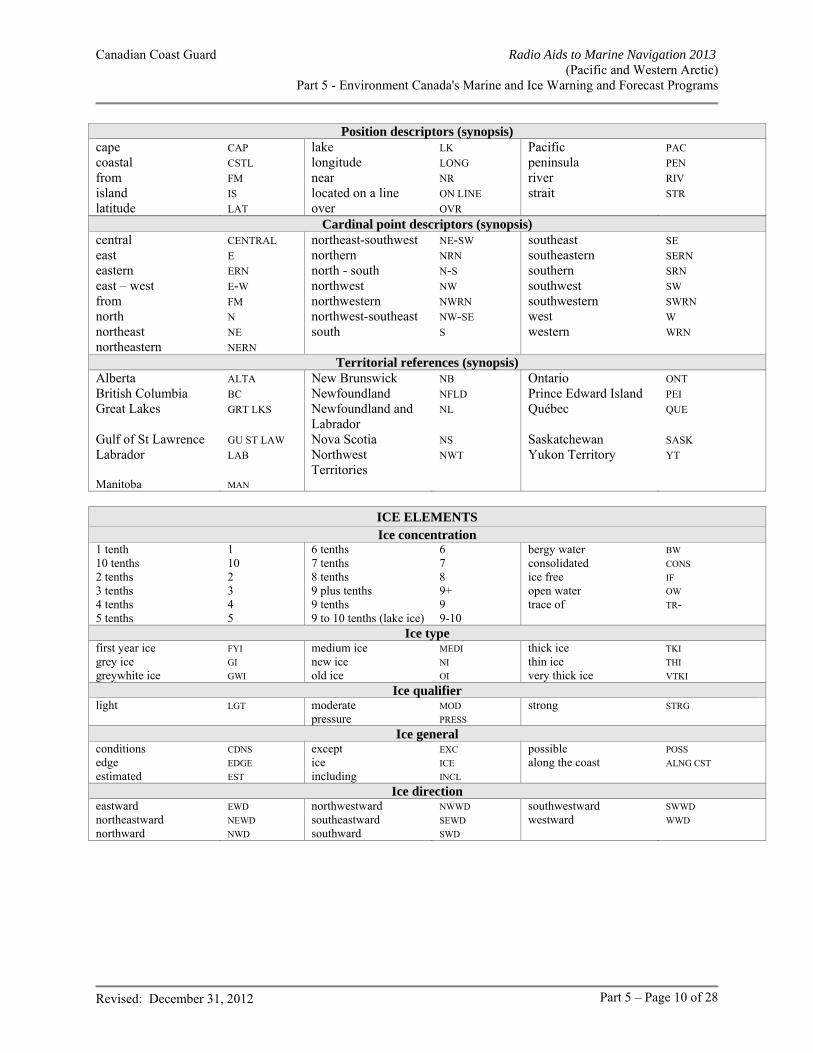
Canadian Coast Guard Radio Aids to Marine Navigation 2013 (Pacific and Western Arctic)
Part 5 - Environment Canada's Marine and Ice Warning and Forecast Programs
Revised: December 31, 2012 Part 5 – Page 10 of 28
Position descriptors (synopsis)cape CAP lake LK Pacific PAC coastal CSTL longitude LONG peninsula PEN from FM near NR river RIV island IS located on a line ON LINE strait STR latitude LAT over OVR
Cardinal point descriptors (synopsis)central CENTRAL northeast-southwest NE-SW southeast SE east E northern NRN southeastern SERN eastern ERN north - south N-S southern SRN east – west E-W northwest NW southwest SW from FM northwestern NWRN southwestern SWRN north N northwest-southeast NW-SE west W northeast NE south S western WRN northeastern NERN
Territorial references (synopsis)Alberta ALTA New Brunswick NB Ontario ONT British Columbia BC Newfoundland NFLD Prince Edward Island PEI Great Lakes GRT LKS Newfoundland and
Labrador NL Québec QUE
Gulf of St Lawrence GU ST LAW Nova Scotia NS Saskatchewan SASK Labrador LAB Northwest
Territories NWT Yukon Territory YT
Manitoba MAN
ICE ELEMENTS Ice concentration
1 tenth 1 6 tenths 6 bergy water BW 10 tenths 10 7 tenths 7 consolidated CONS 2 tenths 2 8 tenths 8 ice free IF 3 tenths 3 9 plus tenths 9+ open water OW 4 tenths 4 9 tenths 9 trace of TR- 5 tenths 5 9 to 10 tenths (lake ice) 9-10
Ice type first year ice FYI medium ice MEDI thick ice TKI grey ice GI new ice NI thin ice THI greywhite ice GWI old ice OI very thick ice VTKI
Ice qualifier light LGT moderate MOD strong STRG pressure PRESS
Ice general conditions CDNS except EXC possible POSS edge EDGE ice ICE along the coast ALNG CST estimated EST including INCL
Ice direction eastward EWD northwestward NWWD southwestward SWWD northeastward NEWD southeastward SEWD westward WWD northward NWD southward SWD
Canadian Coast Guard Radio Aids to Marine Navigation 2013 (Pacific and Western Arctic)
Part 5 - Environment Canada's Marine and Ice Warning and Forecast Programs
Revised: December 31, 2012 Part 5 – Page 11 of 28
Environment Canada Environnement Canada
SUGGESTIONS / COMMENTS / COMMENTAIRES
Help us to serve you: Make us aware of your comments regarding the Environment Canada Marine and Ice Services
Aidez-nous à mieux vous servir : Faites-nous parvenir vos commentaires concernant le programme de prévisions maritimes d’Environnement Canada
Officer / Officier : Return to / Envoyer à :
National Service Operations Division – Marine & Transportation / Division des services opérationnels nationaux – marine et transports Environment Canada / Environnement Canada P.O. Box 370 Gander, NL A1V 1W7 Facsimile : 709-256-6627 Email / Courriel : [email protected]
Ship / Navire :
Position Latitude :
Position Longitude :
Date :
Subject / Détails : . . . . . . . . .
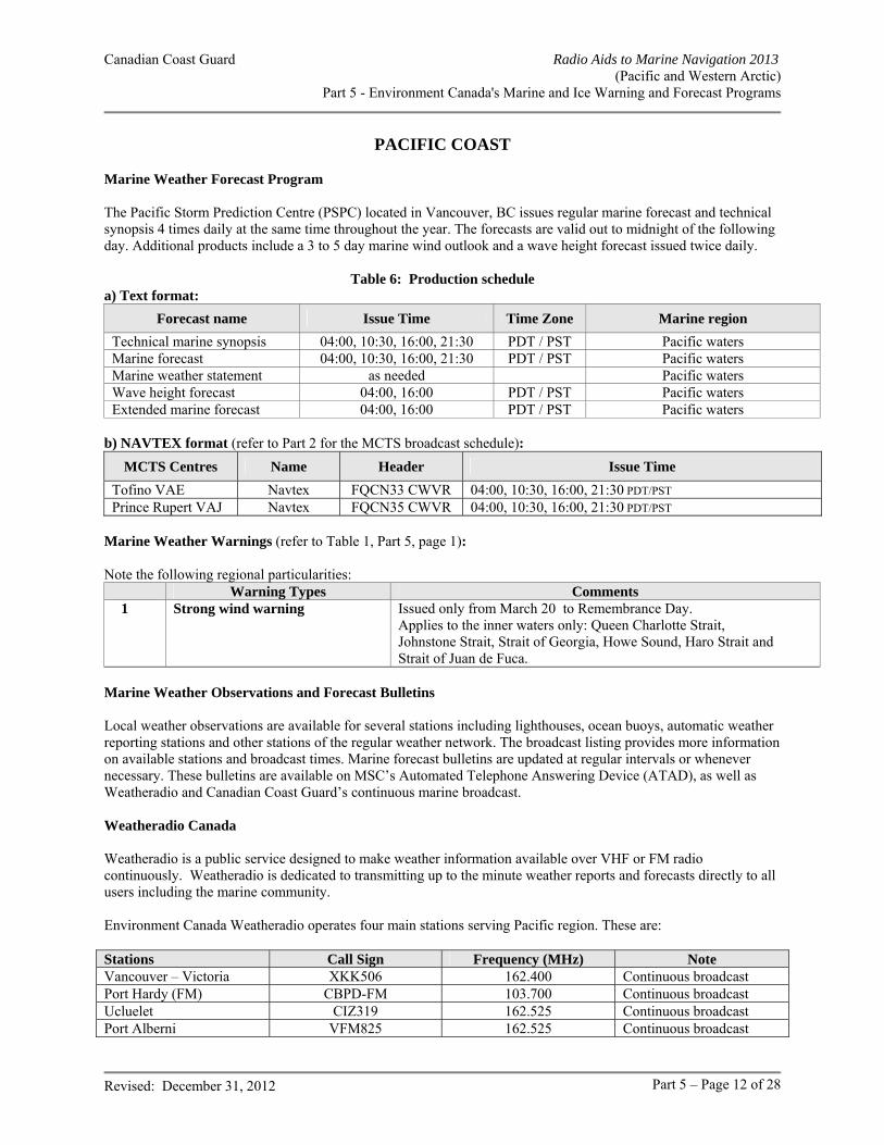
Canadian Coast Guard Radio Aids to Marine Navigation 2013 (Pacific and Western Arctic)
Part 5 - Environment Canada's Marine and Ice Warning and Forecast Programs
Revised: December 31, 2012 Part 5 – Page 12 of 28
PACIFIC COAST Marine Weather Forecast Program The Pacific Storm Prediction Centre (PSPC) located in Vancouver, BC issues regular marine forecast and technical synopsis 4 times daily at the same time throughout the year. The forecasts are valid out to midnight of the following day. Additional products include a 3 to 5 day marine wind outlook and a wave height forecast issued twice daily.
Table 6: Production schedule a) Text format:
Forecast name Issue Time Time Zone Marine region
Technical marine synopsis 04:00, 10:30, 16:00, 21:30 PDT / PST Pacific waters Marine forecast 04:00, 10:30, 16:00, 21:30 PDT / PST Pacific waters Marine weather statement as needed Pacific waters Wave height forecast 04:00, 16:00 PDT / PST Pacific waters Extended marine forecast 04:00, 16:00 PDT / PST Pacific waters
b) NAVTEX format (refer to Part 2 for the MCTS broadcast schedule):
MCTS Centres Name Header Issue Time
Tofino VAE Navtex FQCN33 CWVR 04:00, 10:30, 16:00, 21:30 PDT/PST Prince Rupert VAJ Navtex FQCN35 CWVR 04:00, 10:30, 16:00, 21:30 PDT/PST
Marine Weather Warnings (refer to Table 1, Part 5, page 1): Note the following regional particularities:
Warning Types Comments 1 Strong wind warning Issued only from March 20 to Remembrance Day.
Applies to the inner waters only: Queen Charlotte Strait, Johnstone Strait, Strait of Georgia, Howe Sound, Haro Strait and Strait of Juan de Fuca.
Marine Weather Observations and Forecast Bulletins Local weather observations are available for several stations including lighthouses, ocean buoys, automatic weather reporting stations and other stations of the regular weather network. The broadcast listing provides more information on available stations and broadcast times. Marine forecast bulletins are updated at regular intervals or whenever necessary. These bulletins are available on MSC’s Automated Telephone Answering Device (ATAD), as well as Weatheradio and Canadian Coast Guard’s continuous marine broadcast. Weatheradio Canada Weatheradio is a public service designed to make weather information available over VHF or FM radio continuously. Weatheradio is dedicated to transmitting up to the minute weather reports and forecasts directly to all users including the marine community. Environment Canada Weatheradio operates four main stations serving Pacific region. These are: Stations Call Sign Frequency (MHz) Note Vancouver – Victoria XKK506 162.400 Continuous broadcast Port Hardy (FM) CBPD-FM 103.700 Continuous broadcast Ucluelet CIZ319 162.525 Continuous broadcast Port Alberni VFM825 162.525 Continuous broadcast
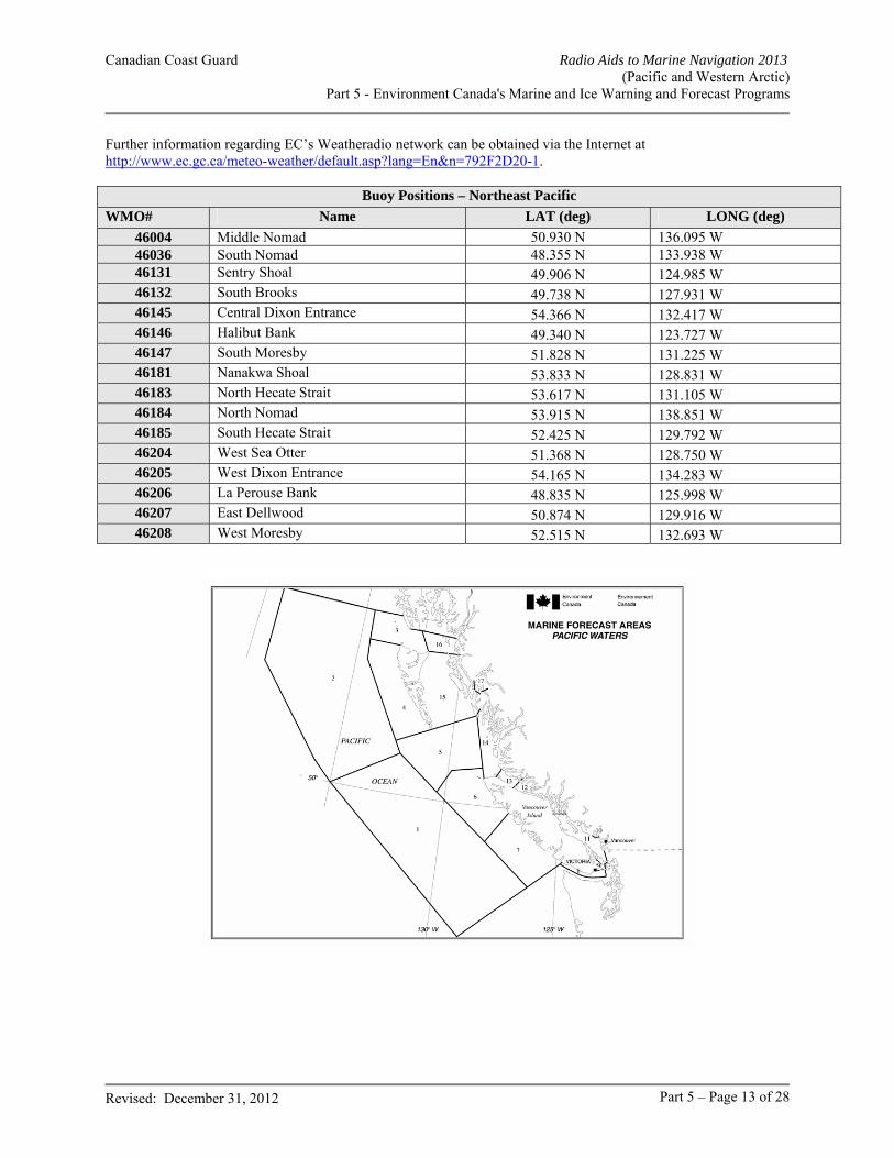
Canadian Coast Guard Radio Aids to Marine Navigation 2013 (Pacific and Western Arctic)
Part 5 - Environment Canada's Marine and Ice Warning and Forecast Programs
Revised: December 31, 2012 Part 5 – Page 13 of 28
Further information regarding EC’s Weatheradio network can be obtained via the Internet at http://www.ec.gc.ca/meteo-weather/default.asp?lang=En&n=792F2D20-1.
Buoy Positions – Northeast Pacific
WMO# Name LAT (deg) LONG (deg)
46004 Middle Nomad 50.930 N 136.095 W 46036 South Nomad 48.355 N 133.938 W 46131 Sentry Shoal 49.906 N 124.985 W 46132 South Brooks 49.738 N 127.931 W 46145 Central Dixon Entrance 54.366 N 132.417 W 46146 Halibut Bank 49.340 N 123.727 W 46147 South Moresby 51.828 N 131.225 W 46181 Nanakwa Shoal 53.833 N 128.831 W 46183 North Hecate Strait 53.617 N 131.105 W 46184 North Nomad 53.915 N 138.851 W 46185 South Hecate Strait 52.425 N 129.792 W 46204 West Sea Otter 51.368 N 128.750 W 46205 West Dixon Entrance 54.165 N 134.283 W 46206 La Perouse Bank 48.835 N 125.998 W 46207 East Dellwood 50.874 N 129.916 W 46208 West Moresby 52.515 N 132.693 W
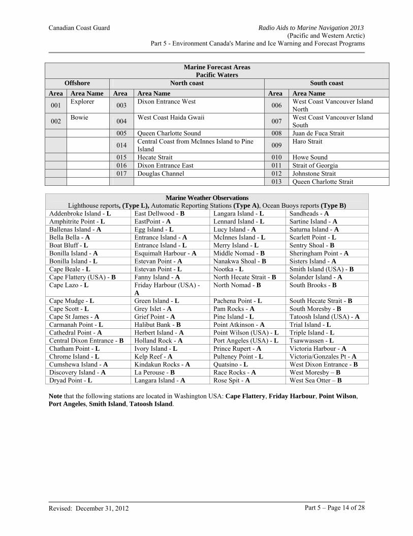
Canadian Coast Guard Radio Aids to Marine Navigation 2013 (Pacific and Western Arctic)
Part 5 - Environment Canada's Marine and Ice Warning and Forecast Programs
Revised: December 31, 2012 Part 5 – Page 14 of 28
Marine Forecast Areas Pacific Waters
Offshore North coast South coast
Area Area Name Area Area Name Area Area Name
001 Explorer
003 Dixon Entrance West
006 West Coast Vancouver Island North
002 Bowie
004 West Coast Haida Gwaii
007 West Coast Vancouver Island South
005 Queen Charlotte Sound 008 Juan de Fuca Strait
014 Central Coast from McInnes Island to Pine Island
009 Haro Strait
015 Hecate Strait 010 Howe Sound 016 Dixon Entrance East 011 Strait of Georgia 017 Douglas Channel 012 Johnstone Strait 013 Queen Charlotte Strait
Marine Weather Observations Lighthouse reports, (Type L), Automatic Reporting Stations (Type A), Ocean Buoys reports (Type B)
Addenbroke Island - L East Dellwood - B Langara Island - L Sandheads - A Amphitrite Point - L EastPoint - A Lennard Island - L Sartine Island - A Ballenas Island - A Egg Island - L Lucy Island - A Saturna Island - A Bella Bella - A Entrance Island - A McInnes Island - L Scarlett Point - L Boat Bluff - L Entrance Island - L Merry Island - L Sentry Shoal - B Bonilla Island - A Esquimalt Harbour - A Middle Nomad - B Sheringham Point - A Bonilla Island - L Estevan Point - A Nanakwa Shoal - B Sisters Island - A Cape Beale - L Estevan Point - L Nootka - L Smith Island (USA) - B Cape Flattery (USA) - B Fanny Island - A North Hecate Strait - B Solander Island - A Cape Lazo - L Friday Harbour (USA) -
A North Nomad - B South Brooks - B
Cape Mudge - L Green Island - L Pachena Point - L South Hecate Strait - B Cape Scott - L Grey Islet - A Pam Rocks - A South Moresby - B Cape St James - A Grief Point - A Pine Island - L Tatoosh Island (USA) - A Carmanah Point - L Halibut Bank - B Point Atkinson - A Trial Island - L Cathedral Point - A Herbert Island - A Point Wilson (USA) - L Triple Island - L Central Dixon Entrance - B Holland Rock - A Port Angeles (USA) - L Tsawwassen - L Chatham Point - L Ivory Island - L Prince Rupert - A Victoria Harbour - A Chrome Island - L Kelp Reef - A Pulteney Point - L Victoria/Gonzales Pt - A Cumshewa Island - A Kindakun Rocks - A Quatsino - L West Dixon Entrance - B Discovery Island - A La Perouse - B Race Rocks - A West Moresby – B Dryad Point - L Langara Island - A Rose Spit - A West Sea Otter – B Note that the following stations are located in Washington USA: Cape Flattery, Friday Harbour, Point Wilson, Port Angeles, Smith Island, Tatoosh Island.
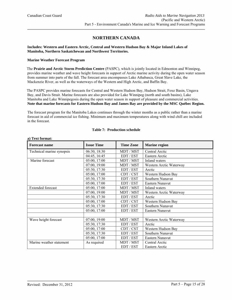
Canadian Coast Guard Radio Aids to Marine Navigation 2013 (Pacific and Western Arctic)
Part 5 - Environment Canada's Marine and Ice Warning and Forecast Programs
Revised: December 31, 2012 Part 5 – Page 15 of 28
NORTHERN CANADA Includes: Western and Eastern Arctic, Central and Western Hudson Bay & Major Inland Lakes of Manitoba, Northern Saskatchewan and Northwest Territories. Marine Weather Forecast Program The Prairie and Arctic Storm Prediction Centre (PASPC), which is jointly located in Edmonton and Winnipeg, provides marine weather and wave height forecasts in support of Arctic marine activity during the open water season from summer into parts of the fall. The forecast area encompasses Lake Athabasca, Great Slave Lake, the Mackenzie River, as well as the waterways of the Western and High Arctic, and Baffin Bay. The PASPC provides marine forecasts for Central and Western Hudson Bay, Hudson Strait, Foxe Basin, Ungava Bay, and Davis Strait. Marine forecasts are also provided for Lake Winnipeg (north and south basins), Lake Manitoba and Lake Winnipegosis during the open water season in support of pleasure and commercial activities. Note that marine forecasts for Eastern Hudson Bay and James Bay are provided by the MSC Québec Region. The forecast program for the Manitoba Lakes continues through the winter months as a public rather than a marine forecast in aid of commercial ice fishing. Minimum and maximum temperatures along with wind chill are included in the forecast.
Table 7: Production schedule a) Text format:
Forecast name Issue Time Time Zone Marine region
Technical marine synopsis 06:30, 18:30 MDT / MST Central Arctic 04:45, 16:45 EDT / EST Eastern Arctic Marine forecast 05:00, 17:00 MDT / MST Inland waters 07:00, 19:00 MDT / MST Western Arctic Waterway 05:30, 17:30 EDT / EST Arctic
05:00, 17:00 CDT / CST Western Hudson Bay 05:30, 17:30 EDT / EST Southern Nunavut 05:00, 17:00 EDT / EST Eastern Nunavut Extended forecast 05:00, 17:00 MDT / MST Inland waters 07:00, 19:00 MDT / MST Western Arctic Waterway 05:30, 17:30 EDT / EST Arctic 05:00, 17:00 CDT / CST Western Hudson Bay 05:30, 17:30 EDT / EST Southern Nunavut 05:00, 17:00 EDT / EST Eastern Nunavut Wave height forecast 07:00, 19:00 MDT / MST Western Arctic Waterway 05:30, 17:30 EDT / EST Arctic 05:00, 17:00 CDT / CST Western Hudson Bay 05:30, 17:30 EDT / EST Southern Nunavut 05:00, 17:00 EDT / EST Eastern Nunavut Marine weather statement As required MDT / MST
EDT / EST Central Arctic Eastern Arctic
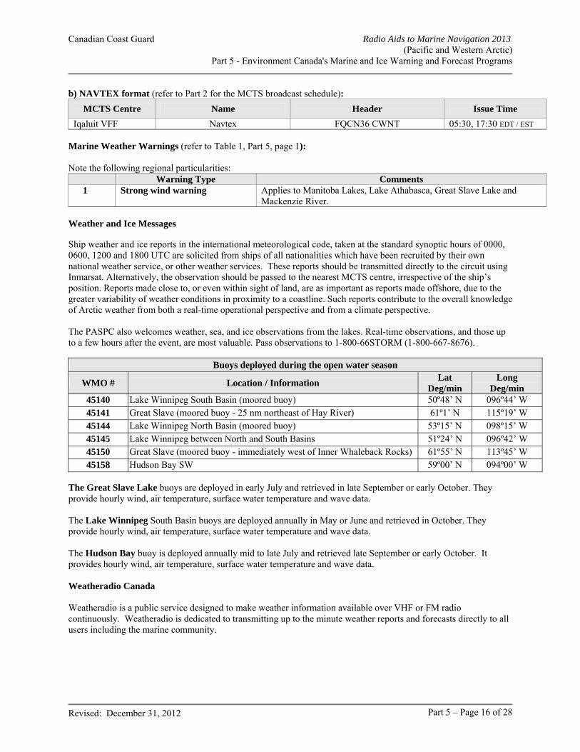
Canadian Coast Guard Radio Aids to Marine Navigation 2013 (Pacific and Western Arctic)
Part 5 - Environment Canada's Marine and Ice Warning and Forecast Programs
Revised: December 31, 2012 Part 5 – Page 16 of 28
b) NAVTEX format (refer to Part 2 for the MCTS broadcast schedule):
MCTS Centre Name Header Issue Time
Iqaluit VFF Navtex FQCN36 CWNT 05:30, 17:30 EDT / EST Marine Weather Warnings (refer to Table 1, Part 5, page 1): Note the following regional particularities:
Warning Type Comments 1 Strong wind warning Applies to Manitoba Lakes, Lake Athabasca, Great Slave Lake and
Mackenzie River. Weather and Ice Messages Ship weather and ice reports in the international meteorological code, taken at the standard synoptic hours of 0000, 0600, 1200 and 1800 UTC are solicited from ships of all nationalities which have been recruited by their own national weather service, or other weather services. These reports should be transmitted directly to the circuit using Inmarsat. Alternatively, the observation should be passed to the nearest MCTS centre, irrespective of the ship’s position. Reports made close to, or even within sight of land, are as important as reports made offshore, due to the greater variability of weather conditions in proximity to a coastline. Such reports contribute to the overall knowledge of Arctic weather from both a real-time operational perspective and from a climate perspective. The PASPC also welcomes weather, sea, and ice observations from the lakes. Real-time observations, and those up to a few hours after the event, are most valuable. Pass observations to 1-800-66STORM (1-800-667-8676).
Buoys deployed during the open water season
WMO # Location / Information Lat
Deg/min Long
Deg/min 45140 Lake Winnipeg South Basin (moored buoy) 50º48’ N 096º44’ W 45141 Great Slave (moored buoy - 25 nm northeast of Hay River) 61º1’ N 115º19’ W 45144 Lake Winnipeg North Basin (moored buoy) 53º15’ N 098º15’ W 45145 Lake Winnipeg between North and South Basins 51º24’ N 096º42’ W 45150 Great Slave (moored buoy - immediately west of Inner Whaleback Rocks) 61º55’ N 113º45’ W 45158 Hudson Bay SW 59º00’ N 094º00’ W
The Great Slave Lake buoys are deployed in early July and retrieved in late September or early October. They provide hourly wind, air temperature, surface water temperature and wave data. The Lake Winnipeg South Basin buoys are deployed annually in May or June and retrieved in October. They provide hourly wind, air temperature, surface water temperature and wave data. The Hudson Bay buoy is deployed annually mid to late July and retrieved late September or early October. It provides hourly wind, air temperature, surface water temperature and wave data. Weatheradio Canada Weatheradio is a public service designed to make weather information available over VHF or FM radio continuously. Weatheradio is dedicated to transmitting up to the minute weather reports and forecasts directly to all users including the marine community.
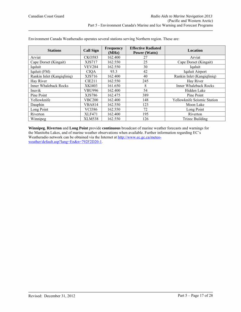
Canadian Coast Guard Radio Aids to Marine Navigation 2013 (Pacific and Western Arctic)
Part 5 - Environment Canada's Marine and Ice Warning and Forecast Programs
Revised: December 31, 2012 Part 5 – Page 17 of 28
Environment Canada Weatheradio operates several stations serving Northern region. These are:
Stations Call Sign Frequency
(MHz) Effective Radiated
Power (Watts) Location
Arviat CKO583 162.400 27 Arviat Cape Dorset (Kingait) XJS717 162.550 25 Cape Dorset (Kingait) Iqaluit VEV284 162.550 30 Iqaluit Iqaluit (FM) CIQA 93.3 42 Iqaluit Airport Rankin Inlet (Kangiqliniq) XJS716 162.400 40 Rankin Inlet (Kangiqliniq) Hay River CIE211 162.550 245 Hay River Inner Whaleback Rocks XKI403 161.650 8 Inner Whaleback Rocks Inuvik VBU996 162.400 54 Hidden Lake Pine Point XJS786 162.475 389 Pine Point Yellowknife VBC200 162.400 148 Yellowknife Seismic Station Dauphin VBA814 162.550 123 Moon Lake Long Point VCI386 162.550 72 Long Point Riverton XLF471 162.400 195 Riverton Winnipeg XLM538 162.550 126 Trizec Building
Winnipeg, Riverton and Long Point provide continuous broadcast of marine weather forecasts and warnings for the Manitoba Lakes, and of marine weather observations when available. Further information regarding EC’s Weatheradio network can be obtained via the Internet at http://www.ec.gc.ca/meteo-weather/default.asp?lang=En&n=792F2D20-1.
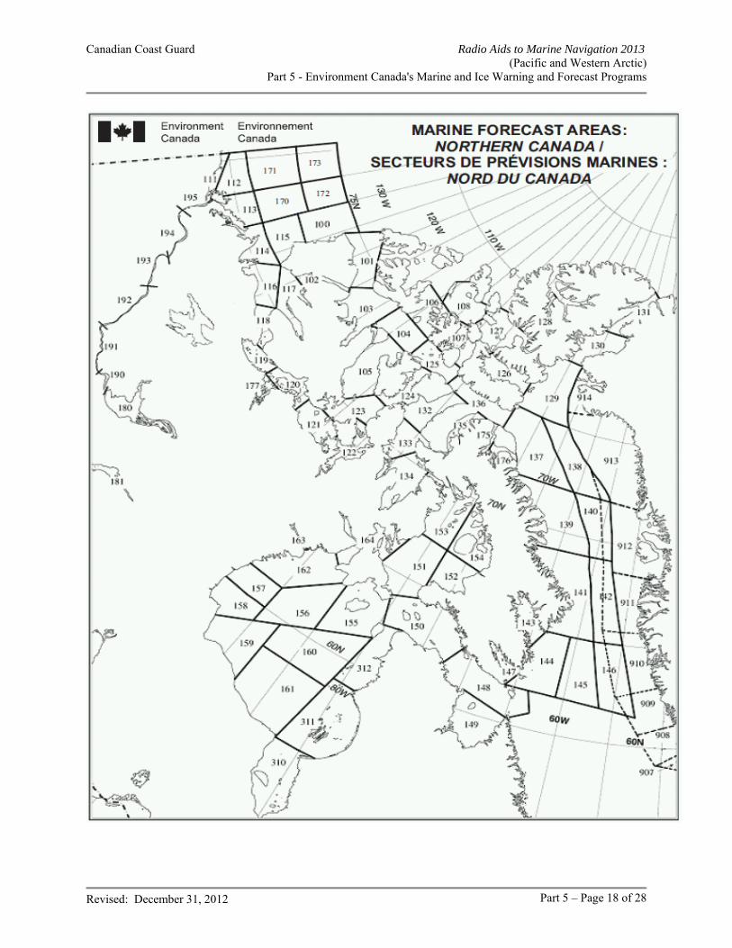
Canadian Coast Guard Radio Aids to Marine Navigation 2013 (Pacific and Western Arctic)
Part 5 - Environment Canada's Marine and Ice Warning and Forecast Programs
Revised: December 31, 2012 Part 5 – Page 18 of 28
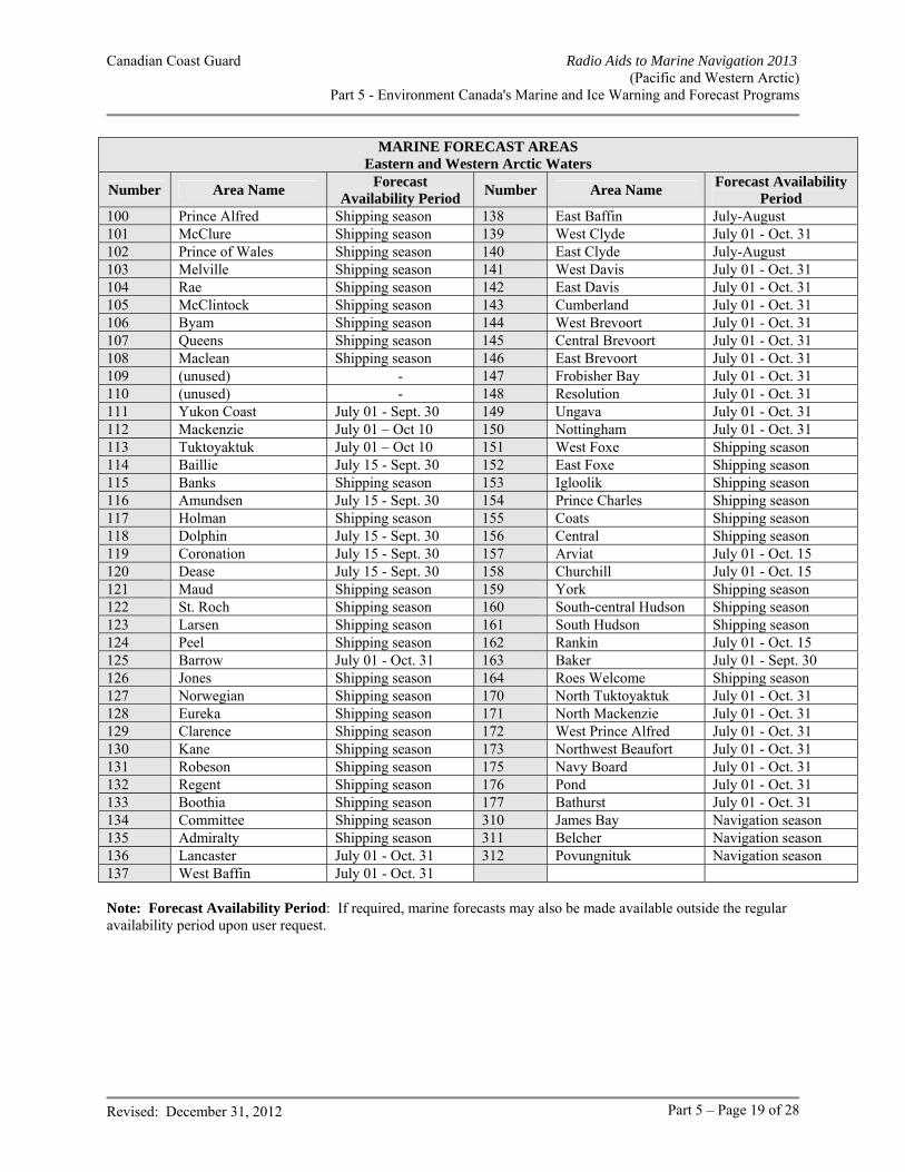
Canadian Coast Guard Radio Aids to Marine Navigation 2013 (Pacific and Western Arctic)
Part 5 - Environment Canada's Marine and Ice Warning and Forecast Programs
Revised: December 31, 2012 Part 5 – Page 19 of 28
MARINE FORECAST AREAS Eastern and Western Arctic Waters
Number Area Name Forecast
Availability Period Number Area Name
Forecast Availability Period
100 Prince Alfred Shipping season 138 East Baffin July-August 101 McClure Shipping season 139 West Clyde July 01 - Oct. 31 102 Prince of Wales Shipping season 140 East Clyde July-August 103 Melville Shipping season 141 West Davis July 01 - Oct. 31 104 Rae Shipping season 142 East Davis July 01 - Oct. 31 105 McClintock Shipping season 143 Cumberland July 01 - Oct. 31 106 Byam Shipping season 144 West Brevoort July 01 - Oct. 31 107 Queens Shipping season 145 Central Brevoort July 01 - Oct. 31 108 Maclean Shipping season 146 East Brevoort July 01 - Oct. 31 109 (unused) - 147 Frobisher Bay July 01 - Oct. 31 110 (unused) - 148 Resolution July 01 - Oct. 31 111 Yukon Coast July 01 - Sept. 30 149 Ungava July 01 - Oct. 31 112 Mackenzie July 01 – Oct 10 150 Nottingham July 01 - Oct. 31 113 Tuktoyaktuk July 01 – Oct 10 151 West Foxe Shipping season 114 Baillie July 15 - Sept. 30 152 East Foxe Shipping season 115 Banks Shipping season 153 Igloolik Shipping season 116 Amundsen July 15 - Sept. 30 154 Prince Charles Shipping season 117 Holman Shipping season 155 Coats Shipping season 118 Dolphin July 15 - Sept. 30 156 Central Shipping season 119 Coronation July 15 - Sept. 30 157 Arviat July 01 - Oct. 15 120 Dease July 15 - Sept. 30 158 Churchill July 01 - Oct. 15 121 Maud Shipping season 159 York Shipping season 122 St. Roch Shipping season 160 South-central Hudson Shipping season 123 Larsen Shipping season 161 South Hudson Shipping season 124 Peel Shipping season 162 Rankin July 01 - Oct. 15 125 Barrow July 01 - Oct. 31 163 Baker July 01 - Sept. 30 126 Jones Shipping season 164 Roes Welcome Shipping season 127 Norwegian Shipping season 170 North Tuktoyaktuk July 01 - Oct. 31 128 Eureka Shipping season 171 North Mackenzie July 01 - Oct. 31 129 Clarence Shipping season 172 West Prince Alfred July 01 - Oct. 31 130 Kane Shipping season 173 Northwest Beaufort July 01 - Oct. 31 131 Robeson Shipping season 175 Navy Board July 01 - Oct. 31 132 Regent Shipping season 176 Pond July 01 - Oct. 31 133 Boothia Shipping season 177 Bathurst July 01 - Oct. 31 134 Committee Shipping season 310 James Bay Navigation season 135 Admiralty Shipping season 311 Belcher Navigation season 136 Lancaster July 01 - Oct. 31 312 Povungnituk Navigation season 137 West Baffin July 01 - Oct. 31 Note: Forecast Availability Period: If required, marine forecasts may also be made available outside the regular availability period upon user request.
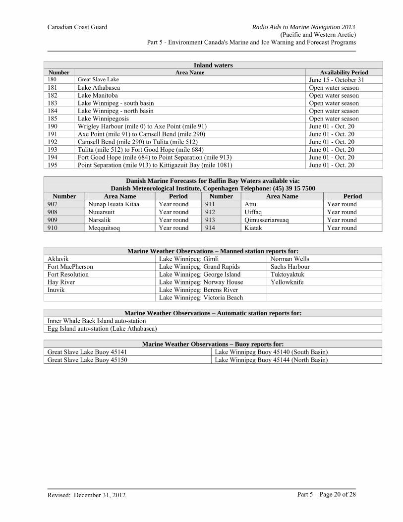
Canadian Coast Guard Radio Aids to Marine Navigation 2013 (Pacific and Western Arctic)
Part 5 - Environment Canada's Marine and Ice Warning and Forecast Programs
Revised: December 31, 2012 Part 5 – Page 20 of 28
Inland watersNumber Area Name Availability Period 180 Great Slave Lake June 15 - October 31 181 Lake Athabasca Open water season 182 Lake Manitoba Open water season 183 Lake Winnipeg - south basin Open water season 184 Lake Winnipeg - north basin Open water season 185 Lake Winnipegosis Open water season 190 Wrigley Harbour (mile 0) to Axe Point (mile 91) June 01 - Oct. 20 191 Axe Point (mile 91) to Camsell Bend (mile 290) June 01 - Oct. 20 192 Camsell Bend (mile 290) to Tulita (mile 512) June 01 - Oct. 20 193 Tulita (mile 512) to Fort Good Hope (mile 684) June 01 - Oct. 20 194 Fort Good Hope (mile 684) to Point Separation (mile 913) June 01 - Oct. 20 195 Point Separation (mile 913) to Kittigazuit Bay (mile 1081) June 01 - Oct. 20
Danish Marine Forecasts for Baffin Bay Waters available via: Danish Meteorological Institute, Copenhagen Telephone: (45) 39 15 7500
Number Area Name Period Number Area Name Period 907 Nunap Isuata Kitaa Year round 911 Attu Year round 908 Nuuarsuit Year round 912 Uiffaq Year round 909 Narsalik Year round 913 Qimusseriarsuaq Year round 910 Meqquitsoq Year round 914 Kiatak Year round
Marine Weather Observations – Manned station reports for: Aklavik Lake Winnipeg: Gimli Norman Wells Fort MacPherson Lake Winnipeg: Grand Rapids Sachs Harbour Fort Resolution Lake Winnipeg: George Island Tuktoyaktuk Hay River Lake Winnipeg: Norway House Yellowknife Inuvik Lake Winnipeg: Berens River Lake Winnipeg: Victoria Beach
Marine Weather Observations – Automatic station reports for: Inner Whale Back Island auto-station Egg Island auto-station (Lake Athabasca)
Marine Weather Observations – Buoy reports for: Great Slave Lake Buoy 45141 Lake Winnipeg Buoy 45140 (South Basin) Great Slave Lake Buoy 45150 Lake Winnipeg Buoy 45144 (North Basin)
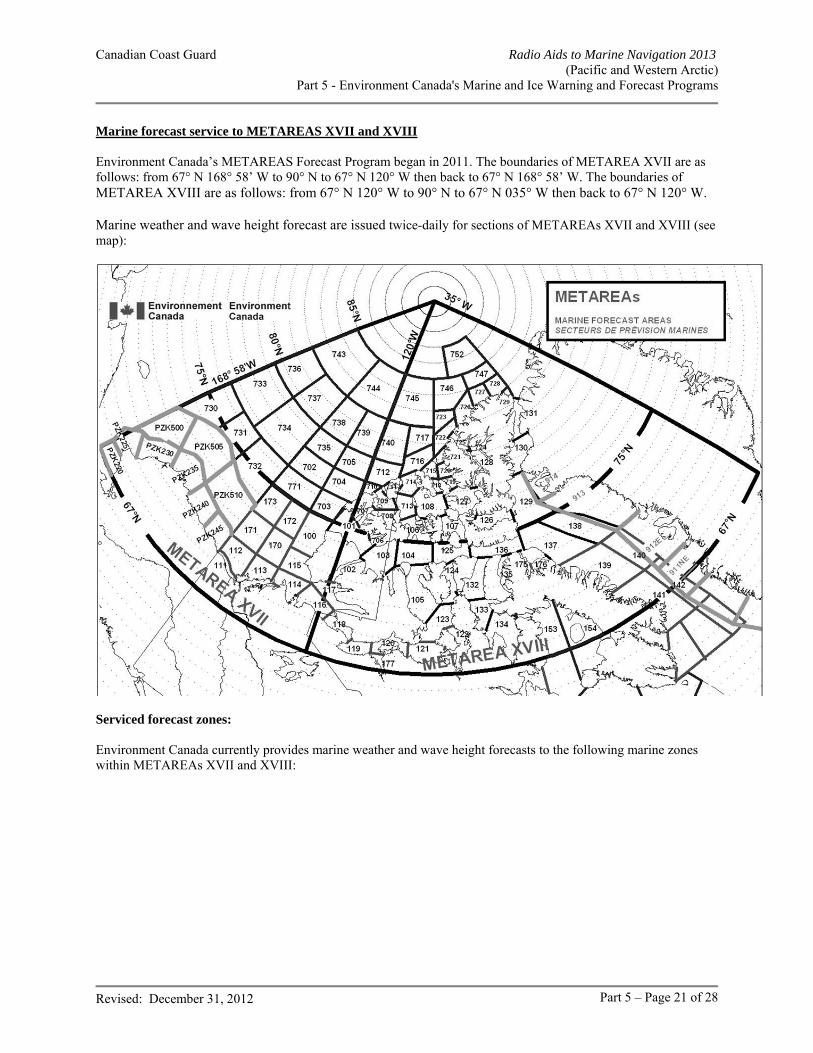
Canadian Coast Guard Radio Aids to Marine Navigation 2013 (Pacific and Western Arctic)
Part 5 - Environment Canada's Marine and Ice Warning and Forecast Programs
Revised: December 31, 2012 Part 5 – Page 21 of 28
Marine forecast service to METAREAS XVII and XVIII Environment Canada’s METAREAS Forecast Program began in 2011. The boundaries of METAREA XVII are as follows: from 67° N 168° 58’ W to 90° N to 67° N 120° W then back to 67° N 168° 58’ W. The boundaries of METAREA XVIII are as follows: from 67° N 120° W to 90° N to 67° N 035° W then back to 67° N 120° W. Marine weather and wave height forecast are issued twice-daily for sections of METAREAs XVII and XVIII (see map):
Serviced forecast zones: Environment Canada currently provides marine weather and wave height forecasts to the following marine zones within METAREAs XVII and XVIII:
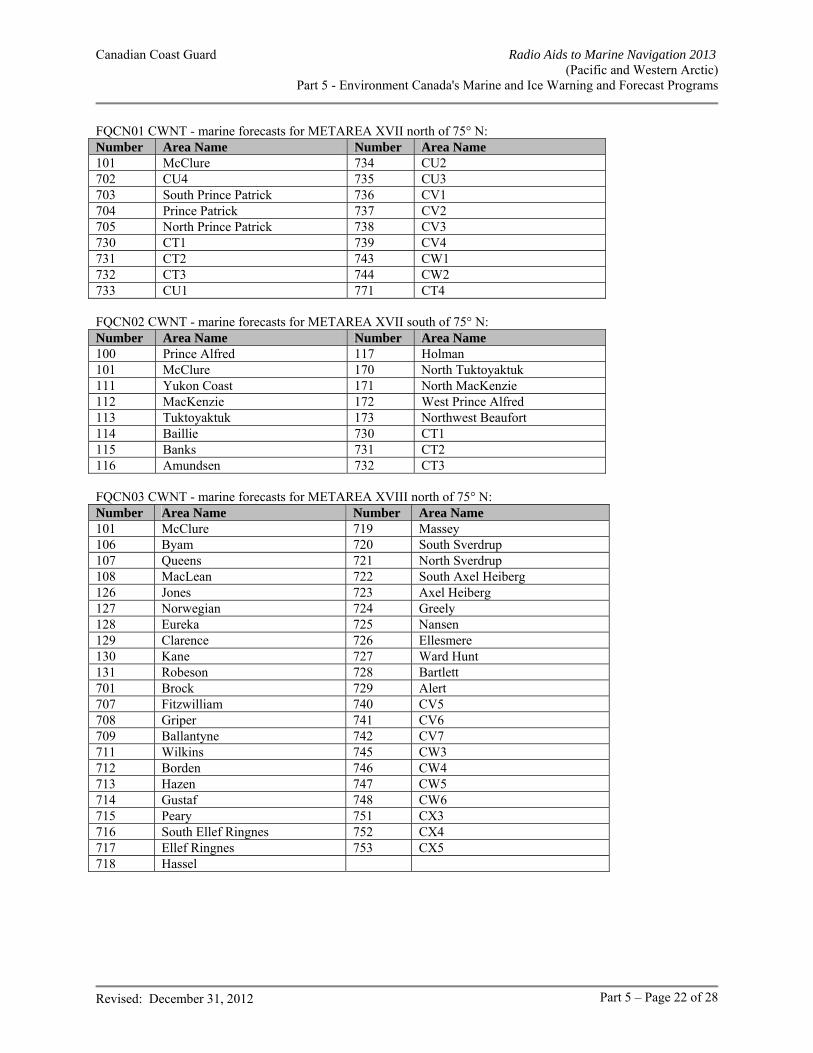
Canadian Coast Guard Radio Aids to Marine Navigation 2013 (Pacific and Western Arctic)
Part 5 - Environment Canada's Marine and Ice Warning and Forecast Programs
Revised: December 31, 2012 Part 5 – Page 22 of 28
FQCN01 CWNT - marine forecasts for METAREA XVII north of 75° N: Number Area Name Number Area Name 101 McClure 734 CU2 702 CU4 735 CU3 703 South Prince Patrick 736 CV1 704 Prince Patrick 737 CV2 705 North Prince Patrick 738 CV3 730 CT1 739 CV4 731 CT2 743 CW1 732 CT3 744 CW2 733 CU1 771 CT4 FQCN02 CWNT - marine forecasts for METAREA XVII south of 75° N: Number Area Name Number Area Name 100 Prince Alfred 117 Holman 101 McClure 170 North Tuktoyaktuk 111 Yukon Coast 171 North MacKenzie 112 MacKenzie 172 West Prince Alfred 113 Tuktoyaktuk 173 Northwest Beaufort 114 Baillie 730 CT1 115 Banks 731 CT2 116 Amundsen 732 CT3 FQCN03 CWNT - marine forecasts for METAREA XVIII north of 75° N: Number Area Name Number Area Name 101 McClure 719 Massey 106 Byam 720 South Sverdrup 107 Queens 721 North Sverdrup 108 MacLean 722 South Axel Heiberg 126 Jones 723 Axel Heiberg 127 Norwegian 724 Greely 128 Eureka 725 Nansen 129 Clarence 726 Ellesmere 130 Kane 727 Ward Hunt 131 Robeson 728 Bartlett 701 Brock 729 Alert 707 Fitzwilliam 740 CV5 708 Griper 741 CV6 709 Ballantyne 742 CV7 711 Wilkins 745 CW3 712 Borden 746 CW4 713 Hazen 747 CW5 714 Gustaf 748 CW6 715 Peary 751 CX3 716 South Ellef Ringnes 752 CX4 717 Ellef Ringnes 753 CX5 718 Hassel
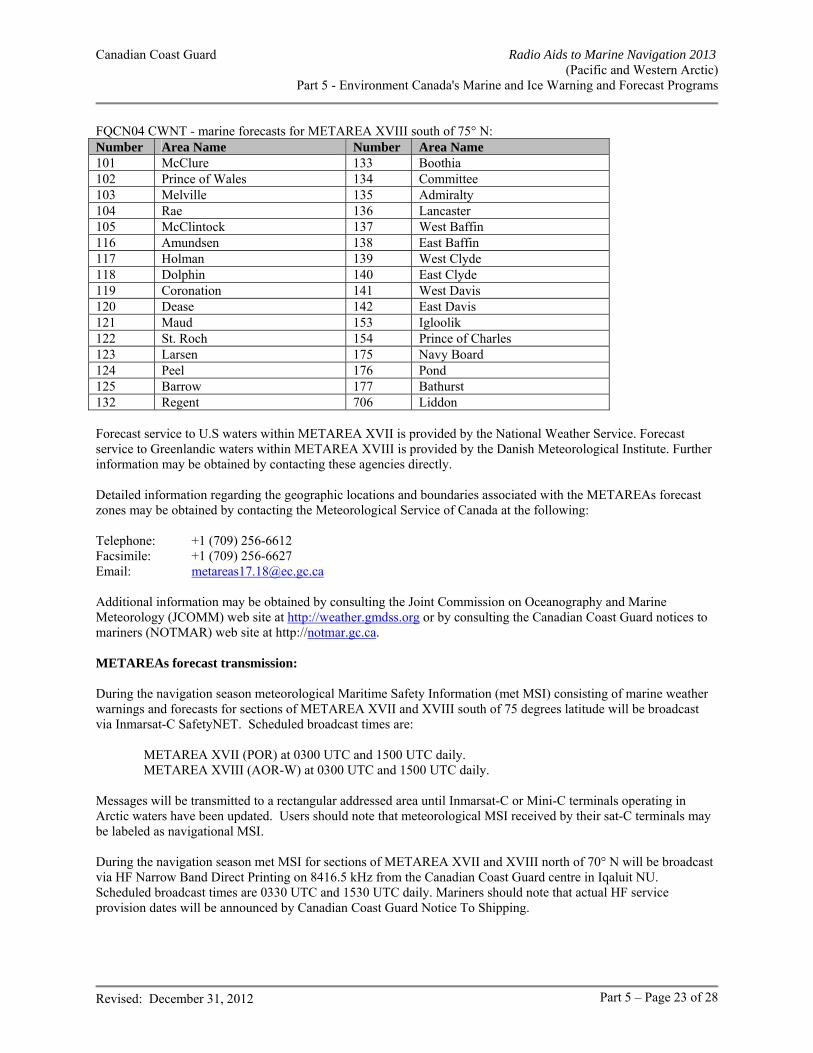
Canadian Coast Guard Radio Aids to Marine Navigation 2013 (Pacific and Western Arctic)
Part 5 - Environment Canada's Marine and Ice Warning and Forecast Programs
Revised: December 31, 2012 Part 5 – Page 23 of 28
FQCN04 CWNT - marine forecasts for METAREA XVIII south of 75° N: Number Area Name Number Area Name 101 McClure 133 Boothia 102 Prince of Wales 134 Committee 103 Melville 135 Admiralty 104 Rae 136 Lancaster 105 McClintock 137 West Baffin 116 Amundsen 138 East Baffin 117 Holman 139 West Clyde 118 Dolphin 140 East Clyde 119 Coronation 141 West Davis 120 Dease 142 East Davis 121 Maud 153 Igloolik 122 St. Roch 154 Prince of Charles 123 Larsen 175 Navy Board 124 Peel 176 Pond 125 Barrow 177 Bathurst 132 Regent 706 Liddon Forecast service to U.S waters within METAREA XVII is provided by the National Weather Service. Forecast service to Greenlandic waters within METAREA XVIII is provided by the Danish Meteorological Institute. Further information may be obtained by contacting these agencies directly. Detailed information regarding the geographic locations and boundaries associated with the METAREAs forecast zones may be obtained by contacting the Meteorological Service of Canada at the following: Telephone: +1 (709) 256-6612 Facsimile: +1 (709) 256-6627 Email: [email protected] Additional information may be obtained by consulting the Joint Commission on Oceanography and Marine Meteorology (JCOMM) web site at http://weather.gmdss.org or by consulting the Canadian Coast Guard notices to mariners (NOTMAR) web site at http://notmar.gc.ca. METAREAs forecast transmission: During the navigation season meteorological Maritime Safety Information (met MSI) consisting of marine weather warnings and forecasts for sections of METAREA XVII and XVIII south of 75 degrees latitude will be broadcast via Inmarsat-C SafetyNET. Scheduled broadcast times are: METAREA XVII (POR) at 0300 UTC and 1500 UTC daily. METAREA XVIII (AOR-W) at 0300 UTC and 1500 UTC daily. Messages will be transmitted to a rectangular addressed area until Inmarsat-C or Mini-C terminals operating in Arctic waters have been updated. Users should note that meteorological MSI received by their sat-C terminals may be labeled as navigational MSI. During the navigation season met MSI for sections of METAREA XVII and XVIII north of 70° N will be broadcast via HF Narrow Band Direct Printing on 8416.5 kHz from the Canadian Coast Guard centre in Iqaluit NU. Scheduled broadcast times are 0330 UTC and 1530 UTC daily. Mariners should note that actual HF service provision dates will be announced by Canadian Coast Guard Notice To Shipping.
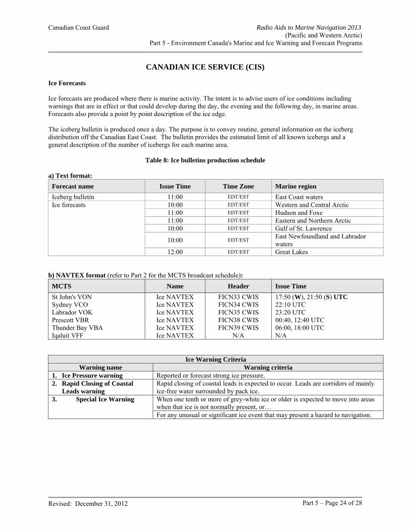
Canadian Coast Guard Radio Aids to Marine Navigation 2013 (Pacific and Western Arctic)
Part 5 - Environment Canada's Marine and Ice Warning and Forecast Programs
Revised: December 31, 2012 Part 5 – Page 24 of 28
CANADIAN ICE SERVICE (CIS) Ice Forecasts Ice forecasts are produced where there is marine activity. The intent is to advise users of ice conditions including warnings that are in effect or that could develop during the day, the evening and the following day, in marine areas. Forecasts also provide a point by point description of the ice edge. The iceberg bulletin is produced once a day. The purpose is to convey routine, general information on the iceberg distribution off the Canadian East Coast. The bulletin provides the estimated limit of all known icebergs and a general description of the number of icebergs for each marine area.
Table 8: Ice bulletins production schedule
a) Text format:
Forecast name Issue Time Time Zone Marine region
Iceberg bulletin 11:00 EDT/EST East Coast waters Ice forecasts 10:00 EDT/EST Western and Central Arctic 11:00 EDT/EST Hudson and Foxe 11:00 EDT/EST Eastern and Northern Arctic 10:00 EDT/EST Gulf of St. Lawrence
10:00 EDT/EST East Newfoundland and Labrador waters
12:00 EDT/EST Great Lakes b) NAVTEX format (refer to Part 2 for the MCTS broadcast schedule):
MCTS Name Header Issue Time
St John's VON Ice NAVTEX FICN33 CWIS 17:50 (W), 21:50 (S) UTC Sydney VCO Ice NAVTEX FICN34 CWIS 22:10 UTC Labrador VOK Ice NAVTEX FICN35 CWIS 23:20 UTC Prescott VBR Ice NAVTEX FICN38 CWIS 00:40, 12:40 UTC Thunder Bay VBA Ice NAVTEX FICN39 CWIS 06:00, 18:00 UTC Iqaluit VFF Ice NAVTEX N/A N/A
Ice Warning Criteria Warning name Warning criteria
1. Ice Pressure warning Reported or forecast strong ice pressure. 2. Rapid Closing of Coastal Leads warning
Rapid closing of coastal leads is expected to occur. Leads are corridors of mainly ice-free water surrounded by pack ice.
3. Special Ice Warning When one tenth or more of grey-white ice or older is expected to move into areas when that ice is not normally present, or… For any unusual or significant ice event that may present a hazard to navigation.
Canadian Coast Guard Radio Aids to Marine Navigation 2013 (Pacific and Western Arctic)
Part 5 - Environment Canada's Marine and Ice Warning and Forecast Programs
Revised: December 31, 2012 Part 5 – Page 25 of 28
Ice Program Ice forecasts are issued for daily, monthly and seasonal time scales. Ice Reports or Observations Ice reports from ships or aircraft are normally relayed through MCTS centres for broadcast. These reports are all assimilated in the daily ice charts produced by CIS. Ice Charts Current ice charts are produced daily. The area covered by the chart depends on the time of season and these charts are normally broadcast at times specified in tables below. Once a week, CIS produces Regional ice charts. These charts are intended to be used as a planning tool rather than a tactical support tool and are available on the CIS Website at http://www.ice-glaces.ec.gc.ca/ and through commercial communication lines. They are not broadcast through MCTS centres. Ice Beacons In order to better track the ice drift or to verify ice models, CIS deploys a few ice beacons yearly. While most beacons are only reporting their positions, a few are equipped with barometric pressure sensors. Weatheradio Canada Ice forecasts and warnings are not broadcast via Weatheradio, however, mariners planning operations in waters impacted by hazardous ice conditions may obtain details regarding ice conditions by consulting the CIS website at http://www.ice-glaces.ec.gc.ca/ or by contacting their regional MCTS centre. Detailed ice information may also be obtained through consultation with an Environment Canada meteorologist using the “Weather One-on-One” ‘1-900’ service at 1-900-565-5555. For cell phone users and credit card billing call 1-888-292-2222. User fees apply.
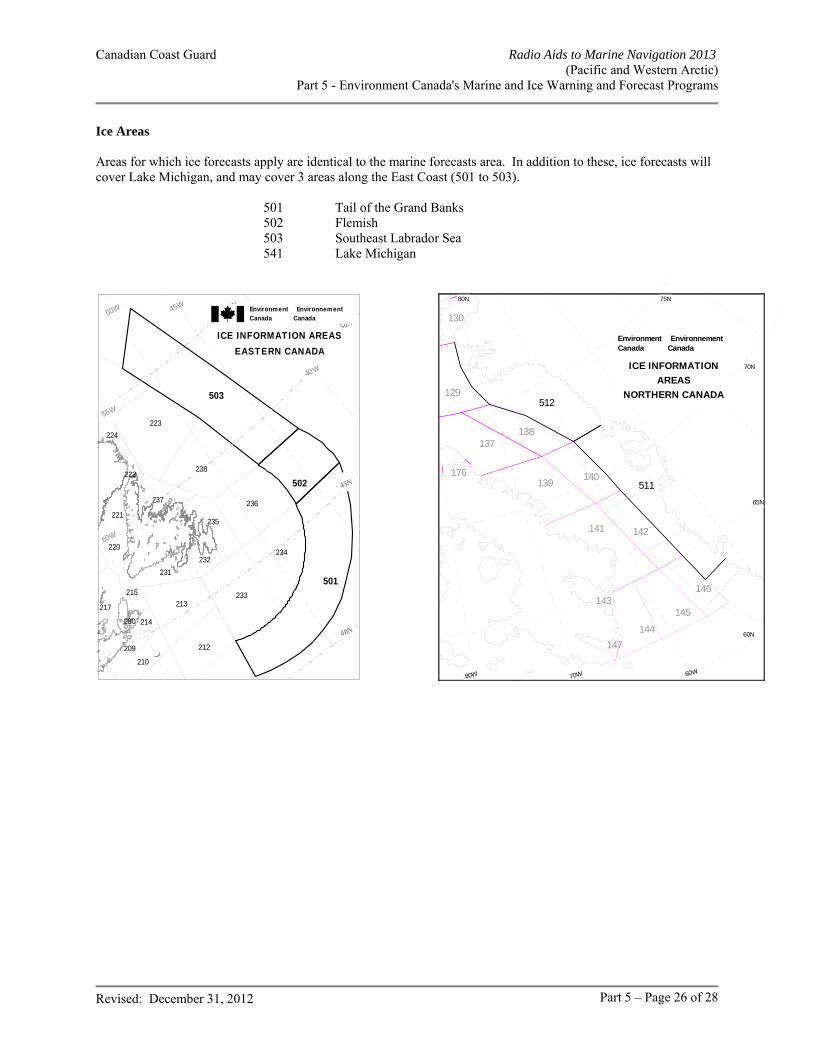
Canadian Coast Guard Radio Aids to Marine Navigation 2013 (Pacific and Western Arctic)
Part 5 - Environment Canada's Marine and Ice Warning and Forecast Programs
Revised: December 31, 2012 Part 5 – Page 26 of 28
Ice Areas Areas for which ice forecasts apply are identical to the marine forecasts area. In addition to these, ice forecasts will cover Lake Michigan, and may cover 3 areas along the East Coast (501 to 503). 501 Tail of the Grand Banks 502 Flemish 503 Southeast Labrador Sea 541 Lake Michigan
40W
45W50W
55W
60W
40N
45N
50N
55N
501
502
503
280
224
238
237 236
235
234
233
232
231
223
222
221
220
217
215
214
213
212
210
209
ICE INFORMATION AREASEASTERN CANADA
Environment EnvironnementCanada Canada
60N
60W
65N
70W80W
70N
75N80N
511
512129
130
137138
176139
140
141 142
143
144
145
146
147
ICE INFORMATION AREAS
NORTHERN CANADA
Environment EnvironnementCanada Canada
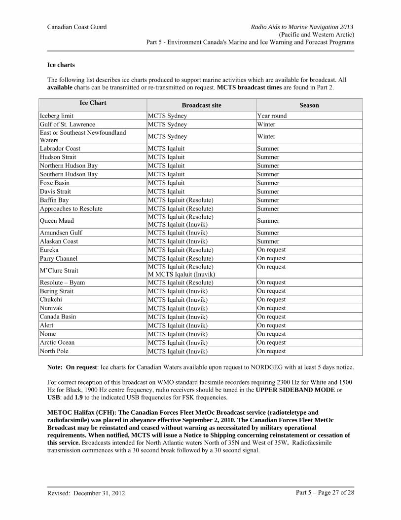
Canadian Coast Guard Radio Aids to Marine Navigation 2013 (Pacific and Western Arctic)
Part 5 - Environment Canada's Marine and Ice Warning and Forecast Programs
Revised: December 31, 2012 Part 5 – Page 27 of 28
Ice charts The following list describes ice charts produced to support marine activities which are available for broadcast. All available charts can be transmitted or re-transmitted on request. MCTS broadcast times are found in Part 2.
Ice Chart Broadcast site Season
Iceberg limit MCTS Sydney Year round Gulf of St. Lawrence MCTS Sydney Winter East or Southeast Newfoundland Waters
MCTS Sydney Winter
Labrador Coast MCTS Iqaluit Summer Hudson Strait MCTS Iqaluit Summer Northern Hudson Bay MCTS Iqaluit Summer Southern Hudson Bay MCTS Iqaluit Summer Foxe Basin MCTS Iqaluit Summer Davis Strait MCTS Iqaluit Summer Baffin Bay MCTS Iqaluit (Resolute) Summer Approaches to Resolute MCTS Iqaluit (Resolute) Summer
Queen Maud MCTS Iqaluit (Resolute) MCTS Iqaluit (Inuvik)
Summer
Amundsen Gulf MCTS Iqaluit (Inuvik) Summer Alaskan Coast MCTS Iqaluit (Inuvik) Summer Eureka MCTS Iqaluit (Resolute) On request Parry Channel MCTS Iqaluit (Resolute) On request
M’Clure Strait MCTS Iqaluit (Resolute) M MCTS Iqaluit (Inuvik)
On request
Resolute – Byam MCTS Iqaluit (Resolute) On request Bering Strait MCTS Iqaluit (Inuvik) On request Chukchi MCTS Iqaluit (Inuvik) On request Nunivak MCTS Iqaluit (Inuvik) On request Canada Basin MCTS Iqaluit (Inuvik) On request Alert MCTS Iqaluit (Inuvik) On request Nome MCTS Iqaluit (Inuvik) On request Arctic Ocean MCTS Iqaluit (Inuvik) On request North Pole MCTS Iqaluit (Inuvik) On request
Note: On request: Ice charts for Canadian Waters available upon request to NORDGEG with at least 5 days notice. For correct reception of this broadcast on WMO standard facsimile recorders requiring 2300 Hz for White and 1500 Hz for Black, 1900 Hz centre frequency, radio receivers should be tuned in the UPPER SIDEBAND MODE or USB: add 1.9 to the indicated USB frequencies for FSK frequencies. METOC Halifax (CFH): The Canadian Forces Fleet MetOc Broadcast service (radioteletype and radiofacsimile) was placed in abeyance effective September 2, 2010. The Canadian Forces Fleet MetOc Broadcast may be reinstated and ceased without warning as necessitated by military operational requirements. When notified, MCTS will issue a Notice to Shipping concerning reinstatement or cessation of this service. Broadcasts intended for North Atlantic waters North of 35N and West of 35W. Radiofacsimile transmission commences with a 30 second break followed by a 30 second signal.
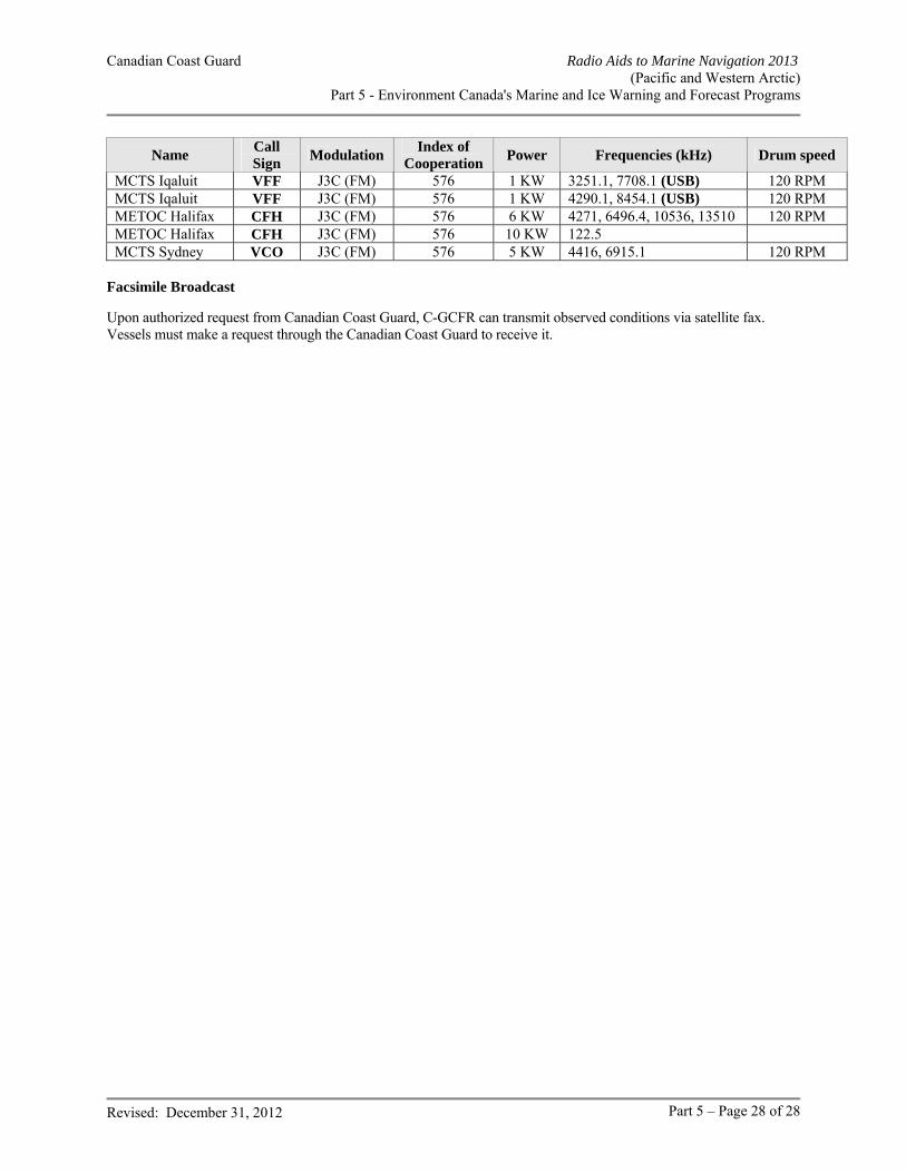
Canadian Coast Guard Radio Aids to Marine Navigation 2013 (Pacific and Western Arctic)
Part 5 - Environment Canada's Marine and Ice Warning and Forecast Programs
Revised: December 31, 2012 Part 5 – Page 28 of 28
Name Call Sign
Modulation Index of
Cooperation Power Frequencies (kHz) Drum speed
MCTS Iqaluit VFF J3C (FM) 576 1 KW 3251.1, 7708.1 (USB) 120 RPM MCTS Iqaluit VFF J3C (FM) 576 1 KW 4290.1, 8454.1 (USB) 120 RPM METOC Halifax CFH J3C (FM) 576 6 KW 4271, 6496.4, 10536, 13510 120 RPM METOC Halifax CFH J3C (FM) 576 10 KW 122.5 MCTS Sydney VCO J3C (FM) 576 5 KW 4416, 6915.1 120 RPM
Facsimile Broadcast Upon authorized request from Canadian Coast Guard, C-GCFR can transmit observed conditions via satellite fax. Vessels must make a request through the Canadian Coast Guard to receive it.