radar observation of precipitation for river management in
TRANSCRIPT

Ministry of Land, Infrastructure, Transport and Tourism
Radar Observation of Precipitation for River Management in Japan
Water and Disaster Management Bureau,Ministry of Land, Infrastructure, Transport and Tourism
September 30, 2013
※XRAIN : X-band polarimetric(multi parameter) RAdar Information Network
Hakodake
PinneshiriMuriyama
Otobedake
Nishidake
Monomiyama
Shiratakayama
Takasuzuyama
Yakushidake
Akagisan
Mitsutouge
Hijiri KougenHoudatsusan
JatougeMiyama
Jougamoriyama
Oowasan
TakashiroyamaRakanzan
MyoujinyamaShakagadake
Kunimiyama
Happongiyama
OogusuyamaGozaisho
Yaedake
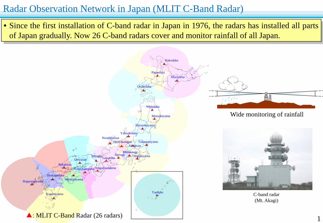
Radar Observation Network in Japan (MLIT C-Band Radar)
▲: MLIT C-Band Radar (26 radars)
• Since the first installation of C-band radar in Japan in 1976, the radars has installed all partsof Japan gradually. Now 26 C-band radars cover and monitor rainfall of all Japan.
C-band radar(Mt. Akagi)
Wide monitoring of rainfall
1

Background of Development the XRAIN
2
• In case of the flood disasters in July, 2008 in Toga River in Kobe City & Asano River in Kanazawa City, water accident and river flooding were caused by localized heavy storm which couldn't observe by conventional radars.
• Recently, such patterns of heavy rainfall are increasing. Also, it is concern that the global warming-led climate change will lead this type of storm to increase in the future.
• To enhance the monitoring capacity for localized heavy rain and torrential downpour, the MLIT has started to develop the XRAIN.
Water Level: -0.33m 14:5014:40
Rise in water level at Kabuto Bridge of Toga River
■Flood damage in Toga River in Kobe City on 28th July, 2008. (Dead:5, Rescued:11, Evacuated:41)
WL rise up to 1.34m
in 10 min
(Captures of River Monitoring Camera by Kobe City)
Water Level: 1.01m
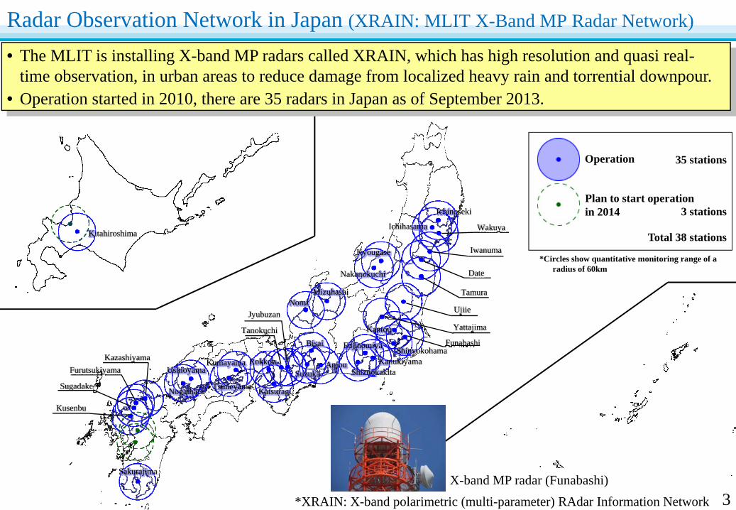
Radar Observation Network in Japan (XRAIN: MLIT X-Band MP Radar Network)
• The MLIT is installing X-band MP radars called XRAIN, which has high resolution and quasi real-time observation, in urban areas to reduce damage from localized heavy rain and torrential downpour.
• Operation started in 2010, there are 35 radars in Japan as of September 2013.
Sakurajima
Kitahiroshima
Operation
*Circles show quantitative monitoring range of a radius of 60km
35 stations
Total 38 stations
Plan to start operation in 2014 3 stations
Kusenbu
Furutsukiyama
Sugadake
Kazashiyama
Nogaihara
Ushioyama
KatsuragiTsuneyama
KumayamaSuzuka
Rokkou
Tanokuchi
Jyubuzan
Anjou
Bisai
NomiMizuhashi
ShizuokakitaKanukiyama
Yattajima
Fujinomiya ShinyokohamaFunabashi
Tamura
Kantou
Ujiie
Nakanokuchi
Kyougase
Date
Iwanuma
WakuyaIchihasama
Ichinoseki
*XRAIN: X-band polarimetric (multi-parameter) RAdar Information NetworkX-band MP radar (Funabashi)
3

*While C-band radar (quantitative monitoring range radius 120km) is suitable to observe rainfall over a wide area, XRAIN (quantitative observation range radius 60km) is able to observe details about localized heavy rain in real time in spite of the small observable area.
Conventional Radar (C-Band Radar)(Spatial resolution: 1km mesh, update cycle: 5 minsTime required to deliver from observation 5-10 mins)
XRAIN (X-Band MP Radar Network)(Spatial resolution: 250m mesh, update cycle: 1 minTime required to deliver from observation 1-2 mins)
・5 times higher frequency
・16 times higher resolution
Comparison of C-Band Radar and XRAIN
4
• XRAIN rainfall information has at a higher frequency (5 times higher) and a higher resolution (16 times higher) compared to conventional radar (C-band radar)
• Delivery takes only 1 to 2 minutes(5 times faster compared to C-band radar).
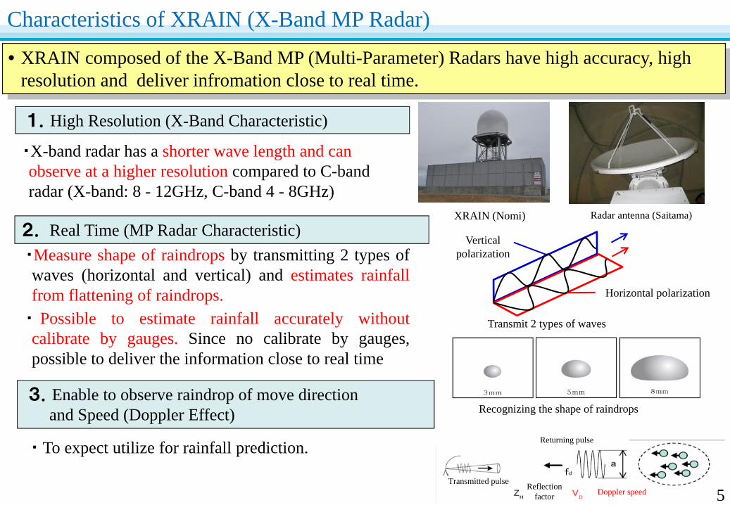
Characteristics of XRAIN (X-Band MP Radar)
5
1.High Resolution (X-Band Characteristic)
2. Real Time (MP Radar Characteristic)
・X-band radar has a shorter wave length and can observe at a higher resolution compared to C-band radar (X-band: 8 - 12GHz, C-band 4 - 8GHz)
・Measure shape of raindrops by transmitting 2 types ofwaves (horizontal and vertical) and estimates rainfallfrom flattening of raindrops.・ Possible to estimate rainfall accurately withoutcalibrate by gauges. Since no calibrate by gauges,possible to deliver the information close to real time
・ To expect utilize for rainfall prediction.
3.Enable to observe raindrop of move directionand Speed (Doppler Effect) Recognizing the shape of raindrops
XRAIN (Nomi) Radar antenna (Saitama)
Vertical polarization
Horizontal polarization
Transmit 2 types of waves
• XRAIN composed of the X-Band MP (Multi-Parameter) Radars have high accuracy, high resolution and deliver infromation close to real time.
Transmitted pulseDoppler speedReflection
factor
Returning pulse
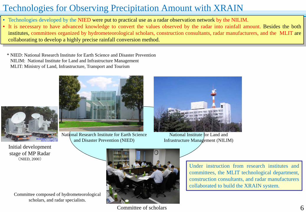
• Technologies developed by the NIED were put to practical use as a radar observation network by the NILIM.• It is necessary to have advanced knowledge to convert the values observed by the radar into rainfall amount. Besides the both
institutes, committees organized by hydrometeorological scholars, construction consultants, radar manufacturers, and the MLIT arecollaborating to develop a highly precise rainfall conversion method.
Technologies for Observing Precipitation Amount with XRAIN
6
Initial development stage of MP Radar
(NIED, 2000)
Committee of scholars
National Institute for Land and Infrastructure Management (NILIM)
National Research Institute for Earth Science and Disaster Prevention (NIED)
Under instruction from research institutes andcommittees, the MLIT technological department,construction consultants, and radar manufacturerscollaborated to build the XRAIN system.
Committee composed of hydrometeorological scholars, and radar specialists.
* NIED: National Research Institute for Earth Science and Disaster PreventionNILIM: National Institute for Land and Infrastructure ManagementMLIT: Ministry of Land, Infrastructure, Transport and Tourism

• When installing a new radar, the MLIT and NILIM consider the location, adjust equipment , and verify theobservation accuracy together with construction consultants, radar manufacturers, and committees of scholars toachieve highly precise observation of precipitation.
From Installing the New XRAIN Radar to Observation of Precipitation
7
Manufacture radars and install at the locations.Make the initial adjustment.
Manufacturing, installation and initial adjustment of
radars
Conversion to rainfall, combine multiple
radars
Verify accuracy
Consider the location of radars to observe target area appropriately.Consider various conditions, such as observation altitude, influences of mountains, and interference with other radio waves.
Location of radars
Configure the algorithm and parameter to convert observed radar values to rainfall amount and combine with other radars.
Compare the value between rain gauges and radar rainfall when it rains.Consolidate the verification result, consult with committees of hydrometeorological researchers, and verify the accuracy of radar rainfall.
Delivery startOperation start
NILIMMLITConstruction Consultants
NILIMMLITRadar Manufacturers
MLITConstruction Consultants
MLITCommittee by scholars
Construction Consultants
NILIM
NILIM

Delivery of Observed XRAIN Data to Citizens
8
• XRAIN information is delivered to public in real time through the MLIT website.
• Applications and contents for mobile devices are developed by the private sector and arewidely used.
Contents and applications for mobile phones developed by the private sector
・ Applications for mobile phones and contents for forecasting information of rainfall are developed by the private sector.
Delivery through MLIT Website
・ XRAIN information is delivered in real time through the MLIT website.
http://www.river.go.jp/xbandradar/
Contents of Japan Weather Association
Time and date
Rainfall of 250m mesh
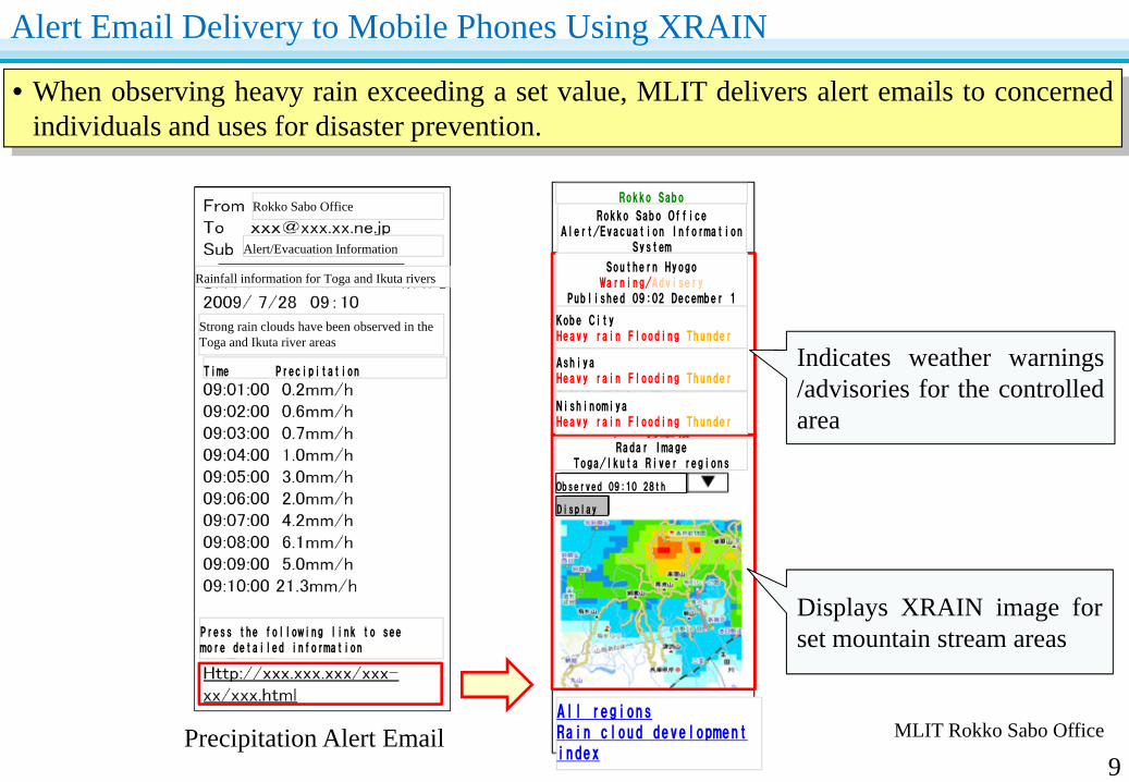
• When observing heavy rain exceeding a set value, MLIT delivers alert emails to concernedindividuals and uses for disaster prevention.
Precipitation Alert Email
Indicates weather warnings/advisories for the controlledarea
Displays XRAIN image forset mountain stream areas
Alert Email Delivery to Mobile Phones Using XRAIN
9MLIT Rokko Sabo Office
Rokko Sabo Office
Alert/Evacuation Information
Rainfall information for Toga and Ikuta rivers
Strong rain clouds have been observed in the Toga and Ikuta river areas
Time Precipitation
Press the following link to see more detailed information
Rokko Sabo
Rokko Sabo Office Alert/Evacuation Information
System
Southern HyogoWarning/Advisery
Published 09:02 December 1
Kobe City Heavy rain Flooding Thunder
AshiyaHeavy rain Flooding Thunder
NishinomiyaHeavy rain Flooding Thunder
Radar ImageToga/Ikuta River regions
Observed 09:10 28th
Display
All regionsRain cloud developmentindex
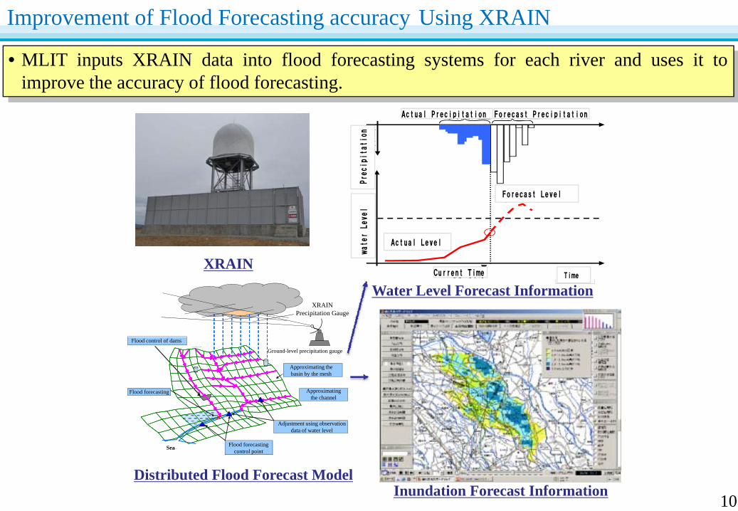
• MLIT inputs XRAIN data into flood forecasting systems for each river and uses it toimprove the accuracy of flood forecasting.
Improvement of Flood Forecasting accuracy Using XRAIN
10
Approximating the basin by the mesh
Approximating the channel
Flood control of dams
Adjustment using observation data of water level
Flood forecasting control point
Flood forecasting
××
Ground-level precipitation gauge
Sea
XRAINPrecipitation Gauge
XRAIN
Distributed Flood Forecast Model
Water Level Forecast Information
Inundation Forecast Information
Text
雨量
予測雨量実績雨量
河川水位
時間現時刻
予測水位
実測水位
waterLevel
Precipitation
Time
Actual Precipitation Forecast Precipitation
Forecast Level
Current Time
Actual Level