pushing standardisation of gnss-based location systems to ... · gnss-based location systems to...
TRANSCRIPT

Pushing standardisation of
GNSS-based Location Systems to support
Terrestrial Applications development
J. Giraud, Thales Alenia Space
M-L. Mathieu, FDC
A. Pomies, FDC
J.P. Boyero Garrido, European Commission
I. Fernandez Hernandez, European Commission
BIOGRAPHIES
Jérémie Giraud, graduated from ISAE, works for
Thales Alenia Space - France, as a system Engineer in the
localization Infrastructure team, developing innovative
positioning technologies for liability critical applications.
He is now in charge of the GNSS performance
standardization activities within Thales Alenia Space in
relation with TAS-F activities in LBS and road
applications domain. He is also in charge of the
development of the Galileo Ground Mission Receivers for
TAS-F. In the past, he was involved in the GIOVE
Mission as responsible for the Experimental Sensor
Station Performance Characterization.
Marie-Laure Mathieu is working at FDC as system
engineer in GNSS. She is graduated as an electronics
engineer from the ENAC (Ecole Nationale de l’Aviation
Civile) and holds a Master Degree in Fundamental
Physics from the French University PARIS XI. She has
been involved in more than 15 R&D projects on EU
GNSS programme for the European Institutions and
Agencies. She is currently coordinating several EC or
GSA projects dealing with GNSS standardization and in
particular the EC SAGITER project for GNSS
standardization in the terrestrial and multimodal domains.
Axelle Pomies, graduated as an aeronautics and
electronics engineer from the Ecole Nationale de
l’Aviation Civile (ENAC), is working at FDC as a system
engineer in GNSS. She is directly involved in technical,
business and institutional studies related to GNSS - from
market analyses (professional, mass market, military
sectors) to standardisation activities (including studies of
GNSS regulatory environment). She currently holds also
the position of permanent representative of the European
non-profit making association Galileo Services involving
about 180 leading companies developing and
manufacturing navigation applications. She also obtained
a master’s degree in “Entrepreneurship” from the French
Paris-Dauphine University.
Juan Pablo Boyero Garrido is since 2012 working at
the European Commission in the definition of the
evolution of the Galileo and EGNOS missions, as well as
in the implementation of the Galileo Search and Rescue
Service. Before he worked for nearly ten years in the
private sector as Navigation Engineer, being part of the
Galileo System Team. During that period he held
responsibilities within the System Performance area,
acting both as System Prime as well as Technical Support
to System Prime. He holds a MSC by the Escuela Técnica
Superior de Ingenieros de Telecomunicación of the
Universidad Politécnica de Madrid. Amongst the post-
graduate educations, he passed the course on Safety
Critical Systems by the University of Oxford, UK.
Ignacio Fernandez Hernandez is currently responsible
for the Galileo Commercial Service at the European
Commission. In the past years he has managed the GNSS
user segment activities at the EC and at the European
GNSS Agency, including R&D grant management, GNSS
standardisation for LBS and rail and co-chairmanship of
the ARAIM U.S.-EU technical group. Before, he worked
in the private sector mainly in the EGNOS program, as
engineer and system test manager, and in several GNSS
R&D projects. He has a MSC in Electronic Engineering
by ICAI, Madrid, and a MBA by London Business
School.
ABSTRACT
The expansion of terrestrial applications including
location-based services and transportation means such as
road or train has fostered the design of complex location
systems to comply with the needs of these applications. In
the frame of the service provision ensured by the
application towards a user or an external entity, these
location systems are in charge of providing a consolidated
information based on the position of one or more mobile
platforms.
The complexity of the information reported depends on
the type of service targeted. It can range from a simple
position reporting in the case of a low end asset
management, to the provision of a reliable information

(e.g. authenticated and with a mastered uncertainty) on
the mobile’s trajectory for liability critical services such
as road charging or Intelligent Transport System (ITS).
This wide spectrum of required technical features calls for
a new and broader concept at location system level taking
into account hybrid solutions in which the use of GNSS
technologies is complemented with other technology
sensors to improve the robustness and the performance of
the solution.
Several standards have been generated by different
dedicated bodies, in order to support the GNSS market
development across the various application domains
mentioned above. For instance, 3GPP Location Services
(LCS) standards provide minimum performance
requirements mainly for Assisted-GNSS in the frame of
terrestrial telecommunications and OMA-LOC LPPe
(LTE Positioning Protocol Extensions) defines a
communication protocol supporting hybridised
positioning.
Nevertheless, there is still a lack of performance
specification for a large number of terrestrial applications
(e.g. electronic fee collection, fleet management,
container tracking …), including multi-modal applications
(i.e. those involving various means of transport), leading
to the development and use of sub-optimal GNSS-based
systems and solutions.
The need to unify the different initiatives by concentrating
the positioning-related standardisation effort for terrestrial
applications within a single dedicated entity was
identified some time ago
Accordingly, an initiative triggered by a number of
industrial and institutional stakeholders materialized in
the frame of the European Telecommunications Standards
Institute (ETSI).This initiative is led by the group Satellite
Communication and Navigation (SCN) of the Technical
Committee Satellite Earth Stations and Systems (TC
SES), the main objective being to elaborate a firm and
common standard for GNSS-based Location systems. Up
to now, the TC-SES has already approved end of 2012
two Technical Reports related to architectures and
application inventory which paved the way for the
technical specifications to be developed.
The present paper provides an overview of this on-going
standardisation work, its objectives and the added-value it
will bring. In addition, the already approved Technical
Specifications will also be presented.
Thus, the structure of the targeted standard encompasses
the four following specifications:
- The location system minimum performance
requirements, which can be considered as the core of
the specification work. These requirements are
determined function of the type of location systems
(i.e. association of technical enablers), the applicable
environmental conditions (depending on the type of
application), and finally the type of features needed
(e.g. accuracy, authentication, anti-spoofing,
robustness to interference).
- The GNSS-based location system reference
architecture including the interface definition, which
is expected to capture a generic and modular
definition of location systems, thus adaptable to all
targeted applications.
- The data exchange protocol at location system level
(covering in particular the handling of the requests
from an external application provider and the
protocol to ensure proper information delivery).
- The test specification (including procedure, scenario
and data), enabling location system validation versus
the previous requirements (protocol and
performance).
The methodology used to define the perimeter of the
above specifications looks for:
- The definition of terrestrial application classes to be
covered by the standard, including the identification
of the key requirements (functional and performance)
applicable for each application.
- The inventory of the technological enablers taken on-
board in the standard. These enablers are understood
as much as sensor technologies (GNSS receivers,
Network sensors, inertial sensors, hybridization
layer), as system layer features allowing Quality of
Service (QoS) improvements (A-GNSS, D-GNSS,
RTK, integrity functions, authentication functions).
- The definition of reference environments, derived
from the applications’ typical use cases, and which
provide the necessary conditions to determine the
minimum performance requirements.
With the ambition to satisfy a wide range of terrestrial
applications, the standard under preparation, once
approved, will surely benefit to other standardization
groups. Indeed, care is being taken to harmonize the work
done under TC SES SCN, with standardisation groups in
other domains. Furthermore, it will also be valuable to
actors from markets whose specificities do not justify the
existence of a dedicated standard. All these stakeholders
will thus benefit from a more important variety of
solutions, components and functions available, all of them
simultaneously compatible to the standard.
INTRODUCTION
BACKGROUND AND OBJECTIVES
European Policy and Market Overview
Seamless and sustainable mobility of persons and
goods are decisive conditions to meet the major objectives
of the EU transport policy, notably more efficient
exchanges in the Single Market, greener transport
modalities and improved economic and societal transport
aspects for the service to EU citizens.
For many years the European Union has been deploying
huge efforts to pave the way for safer, cleaner and
sustainable, more interoperable, secure, efficient and
competitive transport systems. EU initiatives and policies,
such as Intelligent Transport Systems (ITS)1, Single
European Sky Air traffic management Research
(SESAR), European Rail Traffic Management System
(ERTMS), e-Freight, and European Single European
transport area or Trans-European Transport Networks
(TEN-T), well show this will to create pan-European
networks, infrastructures and information flows necessary
to meet these policy objectives.
The creation of such a European mobility network
requires first innovation and standardisation to ensure the
efficiency and interoperability of transport support
systems. In particular, this network must deploy large
scale intelligent and interoperable technologies in each
transport domain (air, maritime and inland waterways,
road, rail, multimodal and pedestrian) to optimise
capacities and use of the infrastructure while avoiding
technological fragmentation detrimental to the global
interoperability and performance of the transport market.
Answering to this main challenge, the EU is creating the
framework conditions to promote the development and
use of intelligent and interoperable systems. The
development of European standards is key to support the
implementation of these European flagship policies.
These conditions apply to the development of GNSS
applications and services, more specifically to the
development of GNSS-based terrestrial applications since
GNSS technology is one of the key technologies able to
meet interoperability requirements in all transport
domains and is available anywhere at any time all over
the world. To this end the EC and its agencies, including
GSA have deployed considerable efforts in the different
application fields (civil aviation, maritime, rail, road,
LBS) through application development projects and
support to standardisation.
The expansion of terrestrial applications including
location-based services in transportation modes like road
or rail has indeed fostered the design of complex location
systems and services sometimes requiring compliance
with safety and reliability requirements (e.g. road user
charging, advanced driver assistance systems). A large
field however remains for mass market LBS applications
with less stringent requirements but with strong needs for
interoperability and harmonized performance which are
decisive features for market uptake in this domain.
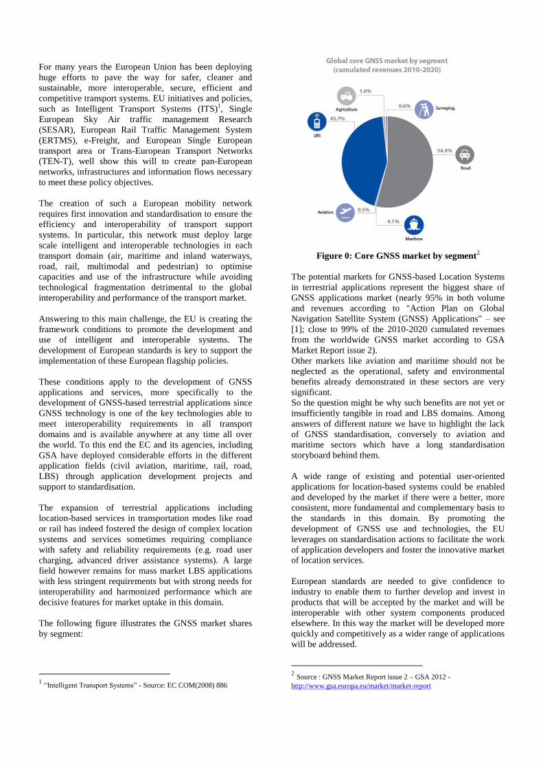
The following figure illustrates the GNSS market shares
by segment:
1 “Intelligent Transport Systems” - Source: EC COM(2008) 886
Figure 0: Core GNSS market by segment
2
The potential markets for GNSS-based Location Systems
in terrestrial applications represent the biggest share of
GNSS applications market (nearly 95% in both volume
and revenues according to "Action Plan on Global
Navigation Satellite System (GNSS) Applications" – see
[1]; close to 99% of the 2010-2020 cumulated revenues
from the worldwide GNSS market according to GSA
Market Report issue 2).
Other markets like aviation and maritime should not be
neglected as the operational, safety and environmental
benefits already demonstrated in these sectors are very
significant.
So the question might be why such benefits are not yet or
insufficiently tangible in road and LBS domains. Among
answers of different nature we have to highlight the lack
of GNSS standardisation, conversely to aviation and
maritime sectors which have a long standardisation
storyboard behind them.
A wide range of existing and potential user-oriented
applications for location-based systems could be enabled
and developed by the market if there were a better, more
consistent, more fundamental and complementary basis to
the standards in this domain. By promoting the
development of GNSS use and technologies, the EU
leverages on standardisation actions to facilitate the work
of application developers and foster the innovative market
of location services.
European standards are needed to give confidence to
industry to enable them to further develop and invest in
products that will be accepted by the market and will be
interoperable with other system components produced
elsewhere. In this way the market will be developed more
quickly and competitively as a wider range of applications
will be addressed.
2 Source : GNSS Market Report issue 2 – GSA 2012 -
http://www.gsa.europa.eu/market/market-report

They should facilitate pan-European applications
deployments that could contribute to the EU Internal
Market and competitiveness objectives.
Existing Standardization Frameworks
Regarding the development of GNSS standards for
services and user equipment in the specific field of
terrestrial transport and multimodal domains, past
activities exhibited a number of limitations in the way
location technologies were addressed by various
standardisation bodies (e.g. inconsistent GNSS-related
requirements from one group to the other, or sub-optimal
requirements resulting from possible lack of GNSS
expertise in in some groups). This was mainly the result
of application-focused standardisation, regardless of the
available location technologies.
Considering the service provision to an end-user or an
external entity, the role of the location system is to
provide consolidated information based on the position of
one or multiple mobile platforms. The complexity of the
information reported depends on the type of targeted
service. It can range from a simple position reporting in
the case of a low end asset management, to the provision
of a reliable information (e.g. authenticated and with a
bounded uncertainty) on the mobile’s trajectory for
liability critical services, such as road charging, or safety
critical applications like Vehicle to Vehicle (V2V) or
Vehicle to Infrastructure (V2I) for Advanced Driver
Assistance Systems (ADAS).
This wide spectrum of required technical features calls for
a new and broader concept at location system level taking
into account hybrid solutions in which the use of GNSS
technologies is complemented by other sensors to
improve the robustness and the performance of the
location solution.
Several standards have been already generated by
different dedicated bodies in order to support the GNSS
market development across the various application
domains mentioned above.
For instance, 3GPP Location Services (LCS) standards
provide minimum performance requirements mainly for
Assisted-GNSS in the frame of terrestrial
telecommunications and OMA-LOC LPPe (LTE
Positioning Protocol Extensions) defines a
communication protocol supporting hybridised
positioning.
In road domain, a number of activities has been
performed on specific areas (e.g. clean and energy-
efficient transport, road congestion, traffic management,
road safety, security of commercial transport operations,
urban mobility) but in a non-optimized coordination
manner since the 1980s. Some issues still need to be
addressed from a European perspective to avoid the
emergence of a patchwork of non-interoperable ITS
applications and services, namely: geographical
continuity, interoperability of services and systems and
component standardisation.
Despite this range of existing standardization initiatives,
there is still a lack of GNSS performance specification for
a large number of terrestrial applications (e.g. electronic
fee collection, fleet management, container tracking …),
including multi-modal applications (i.e. those involving
various modes of transport among which pedestrian).
Thus, OMA and 3GPP standards related to location
services, although widely commended, suffer from a lack
of certain technologies in terminals (e.g. performance
specifications), since they only consider GNSS receivers
and communications modems for location purposes. This
lack is a threat which could lead to the development and
use of sub-optimal GNSS-based systems and solutions.
Identified Standardization Needs
As exhibited in the previous paragraph, the overall
market landscape lacks an unified standard framework in
support of development of location-based applications.
Up to now, this lack tended to lead to a fragmented
standards background, causing each market to adopt
undesirable features of too many proprietary
implementations. Furthermore, some niche markets, not
benefiting from a dedicated and adapted standard, are
bound to rely on technological enablers potentially not
matching their specific needs.
The initiative described in this article aims precisely at
producing such a unified background standard, which will
offer the single solid basis acting as catalyst to develop
user-oriented location-based applications. This could lead
to a set of European Standards.
In addition, by providing a converged standard, all
location business actors will benefit from a more
important variety of solutions, components or functions
available, all simultaneously compatible with this
standard.
Finally, such standard would provide a technological
dictionary made available for any standardization body
willing to include GNSS-related location technology in
their technical specifications.
Task Coordination
The need to unify the different standardisation initiatives
was identified few years ago. In this context, the
European Commission has launched important
complementary initiatives in the frame of the EC M/496
Mandate to European Standardisation Organisations
(ESOs) – see [2]. Addressed to CEN, CENELEC and
ETSI this mandate requires to prepare standards and
specifications for the various elements identified in
different Sectorial Dossiers elaborated during M/415
activities – see [3]. Among them a high priority is given

to “Sectorial dossiers” linked with the Galileo
programme.
In close coordination, the ESOs are currently
implementing this mandate in the field (among others) of
GNSS for terrestrial applications:
- ETSI TC SES/SCN WG deals with extended
terrestrial GNSS applications (road, rail, multimodal,
personal LBS) from architecture and technical point
of view to produce Technical Specifications related
to architecture, Data Exchange Protocols, Minimum
Performance and Tests.
- CEN/CENELEC TC 5 Space WG1 will performed
complementary activities to the ones performed by
ETSI TC SES/SCN. The CEN activities will focus on
mass–market road applications.
The work carried out by ETSI TC SES/SCN targets
indeed location-based applications related to different
domains:
- Transport domain (road, rail) (e.g. guidance, fleet
management, road charging);
- Multimodal domain (applicable to various means of
transport);
- Agriculture domain (in particular for precision
farming);
- Finance domain (time synchronisation of financial
operations across the globe).
This long-term coordination, initiated some years ago,
already allowed the conduction at ETSI level of a study
item, which aimed at demonstrating both the feasibility
and the relevancy of such enterprise. This led to a first
round of industrial stakeholder participation and to the
generation of an ETSI Technical Report (see [4]), which
is one of the starting point of the initiative described here.
For the sake of consistency of the standard production, the
standardisation activities perfomed by ETSI TC SES/SCN
are performed in close cooperation with others
standardisation groups, namely:
- CEN/CENELEC TC5 “Space” WG1;
- 3GPP RAN/GERAN and OMA-LOC: 3GPP and
OMA representing the main market for Galileo
receivers; The work sustained under ETSI TC-
SES/SCN is considered as a federation of the various
GNSS-related standardisation tasks already pursued
in these groups, and with which consistency shall be
ensured;
- TCs responsible for standardisation in Intelligent
Transport System for road: CEN TC278/ISO TC 204
and ETSI TC ITS;
- ETSI TC TETRA producing TETRA (Terrestrial
Truncated Radio) standards, including A-GNSS.
Structure of the Article
The next part of the paper describes the technical stakes
of the standard production. It identifies then the four main
tasks necessary to build the standard and the way they are
formalized within ETSI (Technical Specifications). The
current status of the activities is addressed. Finally, the
next steps of the standard production are presented.
TECHNICAL FRAMEWORK:
MULTI-SENSOR TECHNOLOGY
A wide variety of location-based services exists among
the market: road charging, goods or dangerous cargoes
tracking, emergency calls, fleet management, precision
farming, route guidance, etc…
In the frame of the on-going initiative, the most federating
angle of attack is to consider that these applications are
based on the processing of the location of one or more
mobile targets.
Typical architecture of systems implementing these
services is composed on one hand of an application
module, in charge of interfacing with the user, and on the
other hand of a location system (or sub-system) in charge
of reporting to the application module some navigation
information (mainly position and speed) related to the
mobile target.
The diagram below illustrates the logical architecture
addressed.
Figure 1: Logical Reference Architecture
The focus of the work undertaken is the location system
itself, delimited in the figure above by the dotted line.
It is highlighted here that such system is responsible for
provisioning navigation information related to the mobile
targets. Its external interface towards the application
module therefore only contains location-related
information. The elaboration of further complex
information downhill the processing chain (such as billing
information for charging application, trajectory alarms for
fleet management, or fuel consumption reduction strategy
for precision farming) is left up to the application module,
out of the scope of the work.
Location system structure typically combines GNSS (e.g.
Galileo) and other navigation technologies, in charge of
building the location information, with
telecommunication networks, in charge of establishing a
communication channel, as shown in the diagram below.

Figure 2: Location System Perimeter
The above macroscopic overview of the technical context
enables to draw the main drivers of the needed work.
First, the standard under construction shall propose a
unified vision of the location system architecture. The
vision shared here envisions two main sub-components:
- the positioning terminal, dedicated to be co-localized
with the mobile target mentioned above; this terminal
is equipped with all relevant sensors, and
hybridization modules.
- the system “central facility”, optional according to
the type of application, and in charge of managing
potential fleet of terminals, and implement to a
certain extend some deported target localization
function.
This architecture is compatible with the existing ones, in
particular the widely spread 3GPP reference architecture
(see [5]), but, thanks to its modularity, can also be
adapted to other domains such as transport or fleet
management.
It is highlighted here that the scope of work explicitly
aims at covering multi-sensor positioning technology.
Measurement hybridization, whether it is conducted in the
positioning terminal or in the system central facility, is
indeed considered as a key characteristic of the systems to
be standardized. It is indeed the only way to reach the
level of performance required by complex location
systems in order to satisfy the expansion of location-based
applications in the mass-market
As a result, the definition of a location systems generic
architecture, down to the level of sensors and algorithmic
modules, and their associated interfaces, is one of the
cornerstones of the work undertaken.
Secondly, associated to this reference architecture, a set of
minimum performance requirements applicable to the
location systems shall be established. Based on the
architectural choice made by the system manufacturer,
various levels of performance will be achievable: a
terminal composed of single GNSS receiver might
probably be less robust than a multi-sensor terminal
offering inertial hybridization.
The determination of the performance level function of
the selected architecture will allow the provision to
external stakeholders of valuable information:
- to application developers and standardization bodies
with no navigation background, it provides
discriminating elements for the selection of viable
location system architecture.
- to manufacturers, it provides performance level
targets to comply with a standard which is expected
to be widely adopted.
Third, in order to complete the set of minimum
performance requirements, test procedures need to be
defined, in order to measure the system performance
metrics for selected architecture options and the
associated operational conditions.
Finally, once the system architecture, interfaces and
performances are defined and the associated test
procedures are established, a last fold of the activity
consists in defining the location information data that
shall be exchanged with the application module.
At the end, following these guidelines, the generated
standard will offer a complete set of references available
to most of the location-based services business actors:
- allowing to foster exchanges between domains,
improving variety, quality and interoperability of
technical solutions,
- supporting location-based application development in
reaching a higher level of service,
- and offering the navigation expertise to external
standardization bodies .
TECHNICAL SPECIFICATIONS
In accordance with the above description of the technical
stakes, 4 separate tasks, captured in the ETSI formalism
under 4 separate Work Items, are identified.
It is highlighted that the execution of these tasks was
initiated under ETSI study item leading to the publication
of a Technical Report [4], in the previous phase of the
initiative. These tasks, as they are presented and carried
out here, have been determined after this first round of
feasibility analysis.
Task number 13 deals with the generation of Technical
Specification defining the Minimum Performance
Requirements applicable to Location Systems.
As a preliminary work, the performances subject to
specification, and the way to measure them, shall be
clarified. In the frame of this initiative, previous analysis
concluded on the selection of limited number of
performance, called “performance features”, associated to
their metrics. For instance, accuracy, the main
performance feature, can be measured as Root Mean
Square (RMS) of the horizontal position error.
3 Under ETSI Work Item DTS/SES-00332 “Satellite Earth Stations and
Systems (SES) - GNSS based location systems minimum performance”
(adopted on 18.06.2012).

Further on, specific care shall be brought on the scenarios
associated to the specification:
- Not only the type of the positioning terminal (and the
range of sensors it is equipped with),
- But also any additional algorithmic layer (either at
terminal or central facility level),
- And finally the type of environment and use case in
which the system is used.
The challenge for this activity is clearly to accommodate
this important number of degrees of freedom, and issue
minimum performance requirements for a representative
set of combinations.
Task number 24 covers the definition of the generic
reference architecture, whose macroscopic view is given
in Figure 2 above, and which has already been submitted
to a 1st round of consolidation as reflected in [4].
The definition shall be completed:
- Based on a review of state of the art techniques, in
particular regarding any new type of sensors
considered relevant for the undertaken task and
which shall be added in the reference architecture.
- The reference architecture shall also be defined so
that it allows a modular implementation. Thus,
although the reference architecture is composed of an
exhaustive list of modules, it will be possible to
define additional types of architectures, selecting a
subset of these modules (e.g. type “GNSS stand
alone”, or “GNSS + inertial”). It will then be possible
to identify from the reference architecture which
modules are applicable to a given domain. Thus
several classes of systems will be defined, all
“children” of the same reference architecture.
- Finally, this modular implementation ensures that, as
new technologies or sensors arise (for instance from
new user needs), the reference architecture can be
extended to embed these new equipments.
Task number 35 addresses the definition of the location
data exchange protocols between the positioning terminal
and the location system central facility, and analyses the
interactions between the location system and 3rd
party
application providers (application module in Figure 2).
This aspect has indeed only been briefly tackled in the
preparatory work leading to the redaction of the ETSI
Technical Report [4].
The objective is:
- to carry out an analysis of the existing data exchange
protocols among the various standardisation bodies,
in order to assess their suitability to present
framework. In particular, OMA LOC protocols will
be looked at (see [6]).
- according to the outputs of the analysis either to
identify and trigger the extensions of the existing
4 Under ETSI Work Item DTS/SES-00331 “Earth Stations and Systems
(SES) - GNSS based location systems reference architecture” (adopted on 18.06.2012). 5 Under ETSI Work Item “DTS/SES-00348, Satellite Earth Stations and
Systems (SES) - GNSS based location systems; Requirements for the
location data exchange protocols” (adopted on 13.06.2013).
protocols to the present framework, or to build a new
specification – consistent with the existing ones.
The data planned to be covered in this TS concern mainly
the assistance data exchanged between the terminal and
“location” server (A-GNSS, DGNSS, RTK, etc.), the
location information reported by the terminal, and the
handling of location report requests all through the
system.
Task number 46 covers the generation of the test
procedures to measure the system performance metrics
for selected architecture options and the associated
operational conditions. This allows providing an “end to
end” standard.
The definition of the performance testing methods and
procedures is associated to a number of challenges:
- A first problem to be solved is to build a test
specification allowing the release of a clear procedure
in order to test the various performance features
output from task 2, which suffers from an important
number of degrees of freedom.
This requires a clever solution, which allows to
produce an appealing specification (i.e. limiting the
number of test procedures, synthesizing at most the
tests), but which would still allow the compatibility
with the defined minimum performance standard
(i.e. with the adequate level of coverage).
- The second challenge is related to the simulation of
the test conditions and scenarios. The following
trade-off shall then be considered :
o Basic environment models are easy to
reproduce in test and the performances
easily predictable, but with little
representativeness of actual “real life”
environments (typical example: Multipath
model envisioning 1 single indirect beam).
o Real environments definition will be much
closer to what the terminal will face in
operational deployment conditions, but
they come with important problem in terms
of reproducibility, performance prediction
and proper definition to be included in a
test specification.
CURRENT STATUS
The activities related to Task 3 (Technical Specification
Data Exchange Protocol) and Task 4 (Technical
Specification Test Procedures) have not started yet.
The activities related to Task 1 (Technical Specification
Minimum Performance Requirements) and Task 2
(Technical Specification Architecture) have started. They
are led in parallel following to the methodology described
below.
6 Under ETSI Work Item DTS/SES-00349 “Satellite Earth Stations and
Systems (SES) - GNSS based location systems - Test specification for
system performance metrics” (adopted on 13.06.2013).

The methodology aims at providing a limited number of
reference architecture types for GNSS-based location
systems, to serve as common basis for the elaboration of
the 4 Technical Specifications to be issued. The different
steps, presented on Figure 3, are:
- Application analysis and classification: refinement
of application classes based on the Technical Report
ETSI TR 101 5937 and ETSI TR 103 183
8, issued by
the TC-SES/SCN. The applications are function of
location systems which include terminal types and
central facility.
The analysis of the applications covered by the
standard is the starting point of the definition of
operational environments to be used in order to
specify and test the system performances.
- Definition of application features: identification
and description of key features relevant to the
application classes. Each application class is
described relatively to a set of key features.
- Definition of technical enablers: identification and
selection of the available technical enablers allowing
the technical implementation of the identified key
features.
- The last step consists in crossing application features
and technical enablers in order to derive location
system architecture types.
Figure 3: Main steps for the definition of reference
architectures
Some progress has already been achieved in the definition
of the standard, following the described methodology.
The results are presented in the next sections.
Application Analysis and Classification
The first step led to the inventory of the applications,
which could benefit from location systems designed under
7 Available on ETSI website at:
www.etsi.org/deliver/etsi_tr/101500_101599/101593/01.01.01_60/tr_101593v010101p.pdf 8 Available on ETSI website at:
http://www.etsi.org/deliver/etsi_tr/103100_103199/103183/01.01.01_60/
tr_103183v010101p.pdf
the guidelines fixed by the standard under development.
These applications were gathered in seven classes (see
Tableau 1), function of the key functions requested to the
location system. This classification is provided in the
following table, together with some examples.
Application classes Examples
Location based charging Road user charging
On street parking billing
PAYD charging Pay per use insurance
Inland waterway charges
Cooperative basic geo-localization reporting
Transport on demand
Road & Traffic data collection (V2V & V2I technologies)
Non-cooperative geo-localization reporting
Recovery after theft
Fleet management
Reliable geo-localization E-Call
Reliable vehicle movement sensing
Legal speed enforcement
Eco-driving and Carbon Emission foot printing
Distributed system time synchronization
Telco Ground Infrastructure synchronization
Tableau 1: Application classes
Definition of Application Key Features
Key functions associated to each class are listed here
below:
- Reliability of the detection of virtual gates crossing
(location based charging)
- The billing service unavailability (location based
charging)
- Representativity of the computed distance (PAYD)
- Representativity of the reported trajectory (PAYD)
- Reported position accuracy (cooperative and non-
cooperative geo-localization, reliable geo-
localization)
- Location service availability (cooperative and non-
cooperative geo-localization, reliable geo-
localization)
- Service reliability, including spoofing attempts
detection (non-cooperative geo-localization)
- Confidence level associated to the reported parameter
(reliable geo-localization, reliable vehicle movement
sensing)
- Movement caption accuracy (vehicle movement
sensing)
Based on this classification, a list of technical key
performance features has been built. This list is intended
to cover the needs collected through the range of
application listed above. Note however that, to that stage
of the standard construction, it is not intended to provide
an exhaustive list of potential location system
performance features. The main objective is to limit the
technical perimeter to an area which surely offers a
relevant and exploitable standard for a reasonable set of
stakeholders, but allows the standard publication within
the near future.

The list of key performances intended to be addressed is
provided below.
- Horizontal accuracy which is measured as the error
between the mobile target position reported by the
system, and its actual position. Horizontal accuracy is
the derived 2D position error.
- Availability of required accuracy which is the
probability that the system meet the accuracy
requirement on a given period.
- Time To First Fix which is the time elapsed from
power ON of the positioning terminal, to the
availability of a first position estimate compliant with
the required accuracy.
- GNSS sensitivity which is the ability of the system
to report the terminal position when only low GNSS
signal power is available (typical “in-door” use case).
- Position authentication with Open GNSS signal.
This feature consists in being able to determine if the
mobile target position reported by the system has
been computed through a standard use of the
positioning system of interest. The objective is to
detect user of 3rd
party frauds. Such feature has been
thoroughly described in [7].
- Position integrity – protection level and Time To
Alarm (TTA). This feature, usual in civil aviation
domain, allows the association of a confidence level
to the reported position, for the sake of the
applications seeking for reliability. This is expressed
as a protection level – PL, which shall be exceeded
only in low-probability cases, leading systematically
to an alarm.
- Robustness to interference, which can be
implemented either through beam-forming antenna,
or more simple electro-magnetic interference
blanking (time or frequency).
- Interference localisation. Such feature is proposed
for applications where interference sources are not
only part of the environment, but also part of the
application purpose. This is in particular the case the
military applications, or any location systems
operating under potential harmful intentional
jamming conditions.
- GNSS denied survival, which aims at testing system
(and terminal) ability to put in place appropriate
hybridization in order to cope with momentary cut in
GNSS signals (covered areas use cases).
Definition of Technical Enablers and Location System
Architecture Types
Further to the performance inventory, reference
architecture has been devised, with the objective to
account for a set of technical enablers which will allow
the implementation of the features above. Once again, the
modular architecture proposed might not be exhaustive in
terms sensors, but offers the possibility to be updated
along the standard lifecycle.
Figure 4: Location systems architecture

As mentioned in the introductory sections, the selected
generic architecture envisions a number of additional
sensors able to provide measurements to the navigation
solution through hybridization algorithms.
Among these sensors:
- Telecommunication module is the generic entity
through which the positioning terminal can connect to
the system central facility. It is not only used to open
the communication channel conveying all location-
related information (assistance data, location requests
and reports, or measurements repatriation), but is also
used to provide additional location-related
measurements to the hybridization layer (e.g. in the
3GPP framework, handsets GSM modem is able to
provide cell-ID information or further elaborated
measurement, such as OTDOA measures).
- The possibility to embed a beam forming antenna is
also considered in the generic architecture, enabling
improved interference mitigation functions on-board
the terminal. For architecture not envisioning such
device (i.e. in most cases), a regular passive
omnidirectional antenna is considered.
- Map is also listed in among the technical enablers due
to the need to take on-board map-matching techniques
(hybridization of measurements coming from GNSS
sensor (or other), and information collected from the
geographical map, with the objective to refine the
position estimate).
- An assistance server is also proposed to be
considered – located in the system central facility.
This server is not only in charge of implementing the
usual functions of assistance server (such as
SMLC/SPC in 3GPP/OMA frameworks) but also
provides services related to RTK, DGNSS or PPP.
- A set of algorithmic modules are also considered,
each one dedicated to implementation of a specific
feature: EMI mitigation algorithm processes data
from GNSS sensor and beam forming antenna, in
order to implement mitigation techniques. Note that if
this module can be functionally dissociated, it is more
often physically merged to the GNSS sensor itself.
Additional algorithmic modules related to
interference localization, measurement
hybridization and integrity determination are also
considered, all processing data coming from the
various sensors available on the terminal. Note that
these functions can be implemented on-board the
terminal itself (“on-board function”), or at the central
facility (“centralized function”), in which case sensor
measurements need to be repatriated through the
telecommunication network.
As exposed previously, this generic architecture is
proposed as a basis allowing the construction of typical
architectures, adapted to various domains, selecting a
subset of relevant sensors and modules. Thus, a limited
number of seven typical architectures has been considered
in the scope of the first release of the standard under
development:
- Multi-constellation stand-alone GNSS terminal,
- Road Tolling / PAYD On-board unit / Railway
Location Units,
- 3GPP, including assisted GNSS, and use of NW assets
for ranging information,
- Autonomous Personal Navigation, including car on-
board receiver,
- High precision positioning (farming), including D-
GNSS and RTK,
- TETRA + GNSS module,
- Personal Navigation Device (TomTom-like).
The examples of possible road tolling and 3GPP location
system architectures are proposed below.
Figure 5: Architecture type “Road Tolling Units”
Figure 6: Architecture type 3GPP
Definition of the Operational Environments
Finally, in addition to the performance feature selection
and reference architecture identification, significant
activity has been executed on the definition of the

operational environments to be used in order to specify and
test the system performances.
Thus, the objectives are to determine a set of environment
characteristics driving the performance features, to choose
a model for each of these characteristics, and to tune these
models in order to make them representative of the various
operational environments applicable to the scope of the
undertaken work .
The results shall be a list of “typical” environments, each
of them associated to a given tuning of the physical model.
To that stage of the activities, the models considered
relevant to sufficiently characterize the environment are
the following ones:
- Elevation Mask: the elevation mask corresponds to
the angle between the horizontal at receiver antenna
level and the direct line of sight just beyond the
obstacle height. The GNSS receiver does not receive
the direct line-of-sight signals of satellites located
below the elevation mask, which are obstructed by the
obstacle. The elevation mask can vary with the angle
of azimuth (mainly along and across the lane).
Θ
φ
h
h
φ = azitmuth
Θ = elevation
h = height of Reception Antenna
y
x
z
Figure 7: Elevation Mask
- Signal Attenuation: Signal attenuation refers to any
decrease of GNSS signal power at the level of
reception antenna. The attenuation, expressed in
decibel (dB), corresponds to the rate between the
power of GNSS signal at receiver antenna level and
the nominal GNSS signal power - at the emission.
- Multipath: Signal arrival at a receiver antenna by way
of two or more different paths such as a direct line-of-
sight path and one that includes reflections off nearby
objects. The difference in path lengths causes the
signals to interfere at the antenna and can corrupt the
receiver's pseudorange and carrier-phase
measurements.
- Interference: Interference denotes emission of signals
in bands close to GNSS's, which are disturbing GNSS
signals. These emissions can be transmitted
unintentionally or intentionally.
- User dynamic: User dynamic corresponds to the
dynamic of the mobile target and represents its
attitude. It is characterized by the velocity,
acceleration and jerk of the terminal.
The tuning of the models selected for each of these
characteristics is under process. The objective is to
simulate the following typical operational environments:
- Open area: user is in open area with clear sky view,
with not constraining multipath and interference
conditions.
- Rural area: characterized by the presence of dense
vegetation.
- Suburban area: characterized by small blocking
structures, buildings or natural geographical obstacles
(low risk of multipath and interference).
- Urban area: characterized by high rise structures,
buildings or natural geographical obstacles. It also
corresponds to a densely constructed area. The risk of
multipath is high.
- Covered area: GNSS-denied environment, such as in-
door conditions, tunnels, stations or bridges.
- Industrial area: characterized by the presence of
metallic structures, radio sources, cables, overhead
lines, gantries, catenaries, intentional or un-intentional
jammer. The number of multipath and the related error
are high.
Note that in parallel of this baseline environment
characterization, an alternate approach has also been
investigated. This approach aims at simulating
environment conditions closer to actual the real life
conditions.
Within such approach, the use of RF replay techniques has
been considered. To that day, and based on an inventory of
the use of these techniques among the community, it has
not been considered relevant to take them on-board the
standardization action plan; however, this option is left
open, and it is considered acceptable that, within a next
release of the standard, these new techniques are
introduced in order to issue minimum performance
requirements and associated testing procedures.
NEXT STEPS
The targeted GNSS-based Location system standard will
be composed of four Technical Specifications:
- TS “Location System Reference Architecture”.
- TS “Data Exchange Protocol”.
- TS “Location System Minimum Performances”
- TS “Test Specification, Procedure, Scenario and
Data”.
The issue of the TSs “Location System Reference
Architecture” and “Location System Minimum
Performances” is expected in December 2014, after their
approval at Technical Body level (i.e. ETSI TC-SES).
As far as the architecture related TS is concerned, the
reference generic architecture being well defined, the next

step is to describe the interfaces inside this architecture. To
define standardized interfaces for key modules, such as
GNSS sensors or inertial sensor, is indeed one of the
expected major added values of the standard.
Regarding minimum performance requirement TS, once
the operational environment tuning is executed, most of
the activity will consist in executing simulation and real-
life trial in order to determine achievable performances for
the various system architectures considered.
In parallel the activities related to the development of the
TSs “Data Exchange Protocol” and “Test Specification,
Procedure, Scenario and Data” will start. These TSs are
expected to be ready by April 2015 (idem, after TC-SES
approval).
CONCLUSION
Once realized, the undertaken initiative to elaborate an
unified standard for GNSS-based Location systems will
benefit to various stakeholders at all levels and act as an
enabler to take up the next generation EU challenges.
First, it will act as catalyst to develop user-oriented
location-based applications.
Then, all location business actors will benefit from a more
important variety of available solutions, components or
functions, all simultaneously compatible with this
standard.
Such standard will also provide a technological dictionary
made available for any standardization body willing to
include GNSS-related location technology in their
technical specifications.
Finally, this converged standard will fit the current EU
policy needs and could play an important role in the
creation of a European Mobility Network by enabling the
deployment of pan-European applications – synonym of
the creation of job and wealth in Europe.
Standardization still remains a long and complex process,
but all conditions are there to ensure the successful
completion of this initiative. The first publication of the
GNSS-based Location systems standard is expected in
April 2015 and first results are already visible today.
ACKNOWLEDGMENTS
This work is supported by the European Commission and
the standard development is performed in the frame of the
ETSI; special thanks to them for their contributions.
REFERENCES
[1] EC COM(2010)308 final – 14 June 2010
[2] “Mandate Addressed to CEN, CENELEC and ETSI
to Develop Standardisation Regarding Space Industry”,
M/496,
http://www.etsi.org/images/files/ECMandates/m496.pdf
[3] “Programming Mandate Addressed to CEN,
CENELEC and ETSI to Establish Space Industry
Standards”, M/415
http://www.etsi.org/images/files/ECMandates/m415%20E
N.pdf
[4] ETSI TR 101 593: "Satellite Earth Stations and
Systems (SES); Global Navigation Satellite (GNSS) based
location systems; Minimum Performance and Features".
[5] 3GPP TS 23.271: “Functional stage 2 description of
Location Services (LCS)”, V11.2.0 (2013-03)
[6] “LPP Extensions Specification”, OMA-TS-LPPe–
V1_1-20120314-D
[7] “Authentication of GNSS Position: An Assessment
of Spoofing Detection Methods”, Yves Bardout, Thales
Alenia Space, ION GNSS 2011